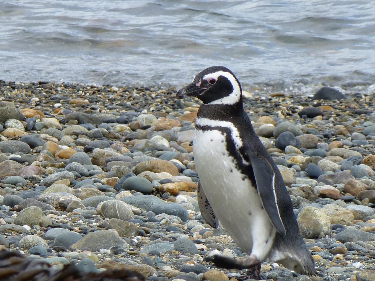
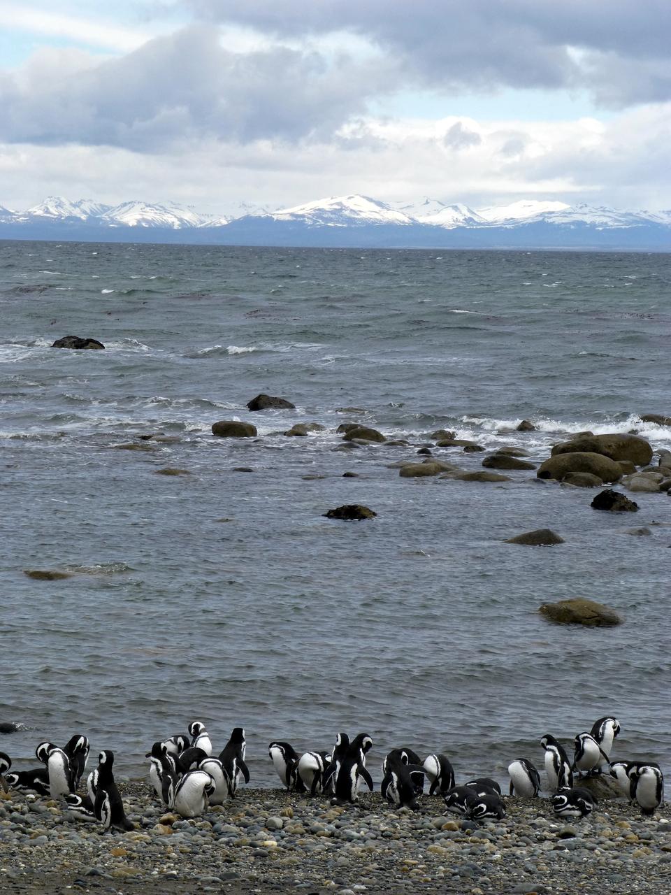
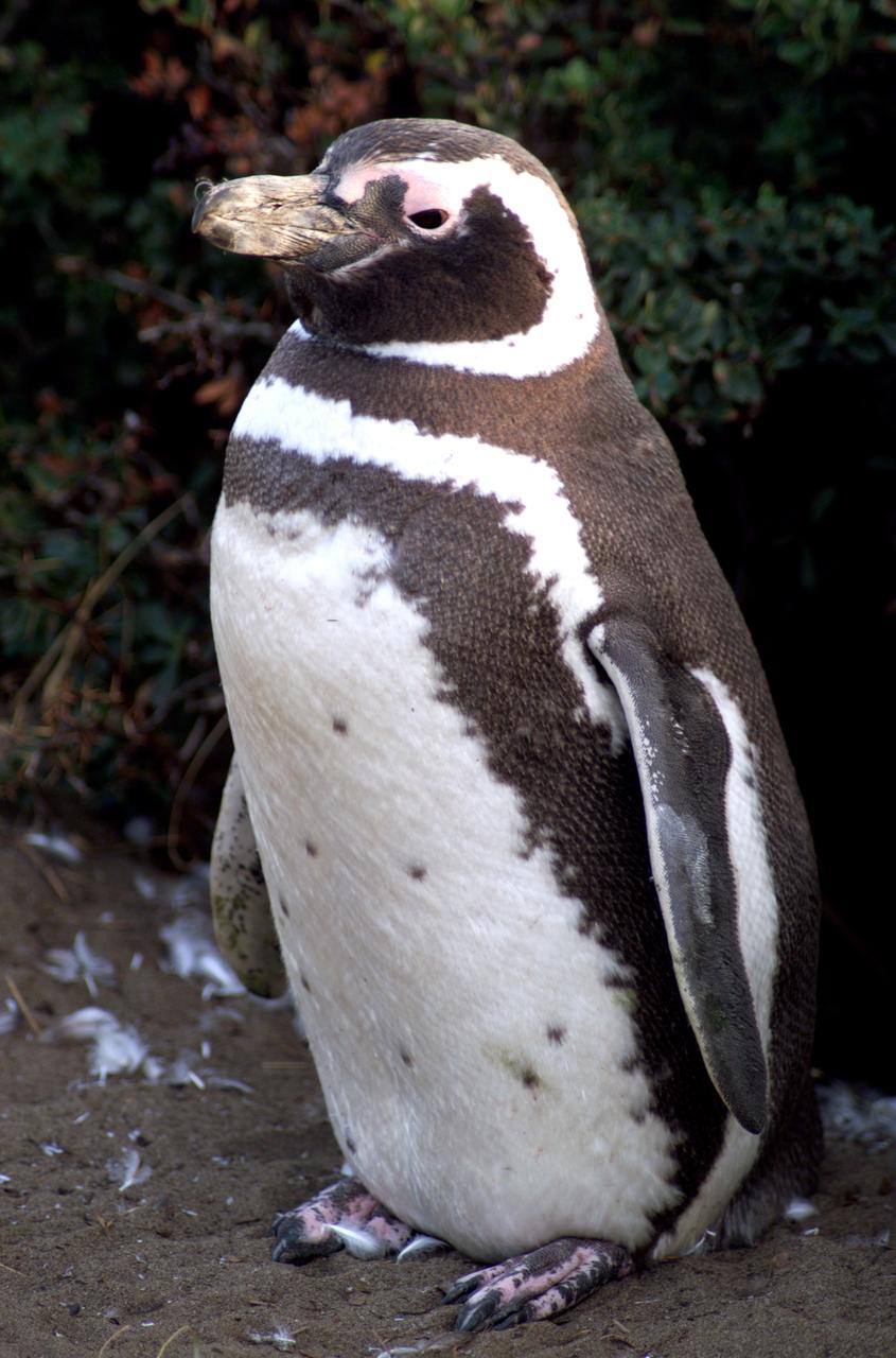
Members of the IceBridge team visited a colony of Magellanic penguins near Punta Arenas on a no-flight day. Credit: NASA/ Maria-Jose Vinas NASA's Operation IceBridge is an airborne science mission to study Earth's polar ice. For more information about IceBridge, visit: <a href="http://www.nasa.gov/icebridge" rel="nofollow">www.nasa.gov/icebridge</a> <b><a href="http://www.nasa.gov/audience/formedia/features/MP_Photo_Guidelines.html" rel="nofollow">NASA image use policy.</a></b> <b><a href="http://www.nasa.gov/centers/goddard/home/index.html" rel="nofollow">NASA Goddard Space Flight Center</a></b> enables NASA’s mission through four scientific endeavors: Earth Science, Heliophysics, Solar System Exploration, and Astrophysics. Goddard plays a leading role in NASA’s accomplishments by contributing compelling scientific knowledge to advance the Agency’s mission. <b>Follow us on <a href="http://twitter.com/NASA_GoddardPix" rel="nofollow">Twitter</a></b> <b>Like us on <a href="http://www.facebook.com/pages/Greenbelt-MD/NASA-Goddard/395013845897?ref=tsd" rel="nofollow">Facebook</a></b> <b>Find us on <a href="http://instagrid.me/nasagoddard/?vm=grid" rel="nofollow">Instagram</a></b>
Members of the IceBridge team visited a colony of Magellanic penguins near Punta Arenas on a no-flight day. Credit: NASA/ Maria-Jose Vinas NASA's Operation IceBridge is an airborne science mission to study Earth's polar ice. For more information about IceBridge, visit: <a href="http://www.nasa.gov/icebridge" rel="nofollow">www.nasa.gov/icebridge</a> <b><a href="http://www.nasa.gov/audience/formedia/features/MP_Photo_Guidelines.html" rel="nofollow">NASA image use policy.</a></b> <b><a href="http://www.nasa.gov/centers/goddard/home/index.html" rel="nofollow">NASA Goddard Space Flight Center</a></b> enables NASA’s mission through four scientific endeavors: Earth Science, Heliophysics, Solar System Exploration, and Astrophysics. Goddard plays a leading role in NASA’s accomplishments by contributing compelling scientific knowledge to advance the Agency’s mission. <b>Follow us on <a href="http://twitter.com/NASA_GoddardPix" rel="nofollow">Twitter</a></b> <b>Like us on <a href="http://www.facebook.com/pages/Greenbelt-MD/NASA-Goddard/395013845897?ref=tsd" rel="nofollow">Facebook</a></b> <b>Find us on <a href="http://instagrid.me/nasagoddard/?vm=grid" rel="nofollow">Instagram</a></b>
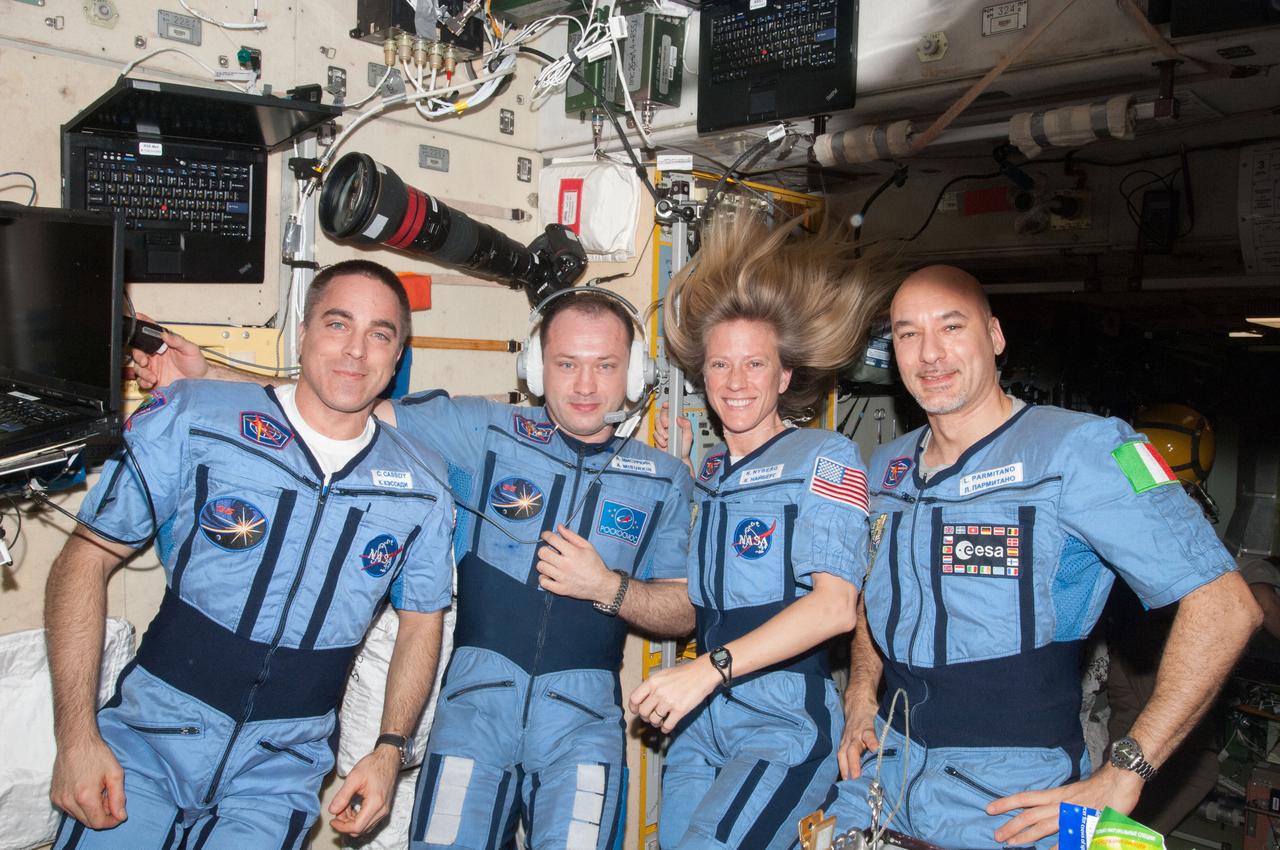
NASA astronaut Chris Cassidy (left), Russian cosmonaut Alexander Misurkin, NASA astronaut Karen Nyberg and European Space Agency astronaut Luca Parmitano (right), all Expedition 36 flight engineers, pose for a portrait in their "Penguin" suits in the Zvezda Service Module of the International Space Station. Also sent as Twitter message.
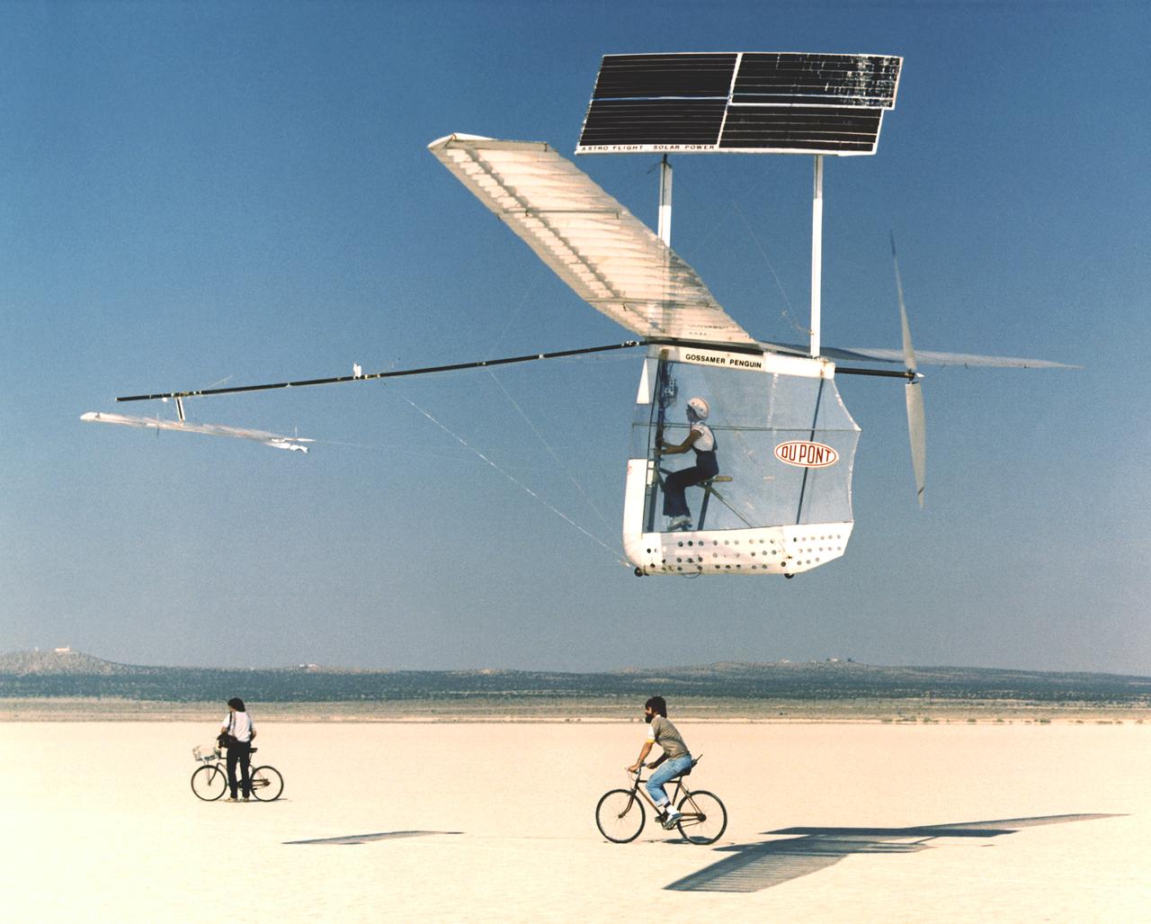
Solar-powered Gossamer Penguin in flight with Janice Brown and Ray Morgan riding chase bicycle.
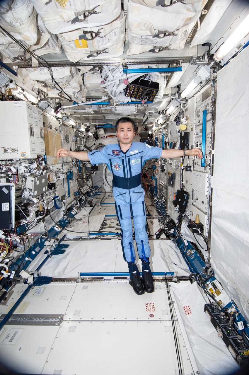
ISS038-E-035476 (24 Jan. 2014) --- Japan Aerospace Exploration Agency astronaut Koichi Wakata, Expedition 38 flight engineer, is pictured wearing the Penguin-3 antigravity pressure/stress suit in the Kibo laboratory of the International Space Station.
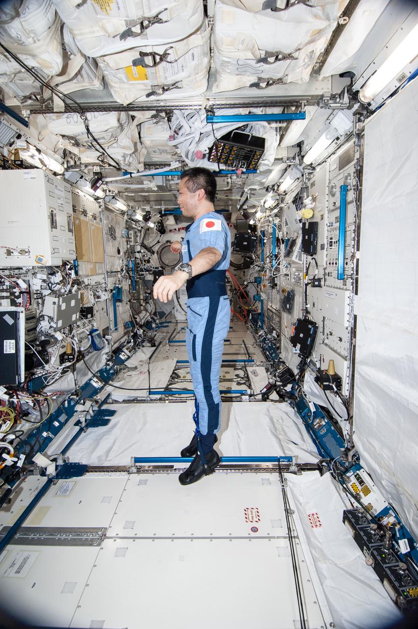
ISS038-E-035470 (24 Jan. 2014) --- Japan Aerospace Exploration Agency astronaut Koichi Wakata, Expedition 38 flight engineer, is pictured wearing the Penguin-3 antigravity pressure/stress suit in the Kibo laboratory of the International Space Station.
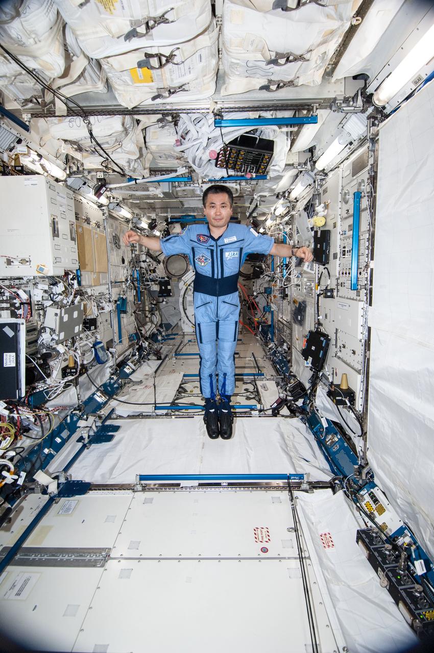
ISS038-E-035473 (24 Jan. 2014) --- Japan Aerospace Exploration Agency astronaut Koichi Wakata, Expedition 38 flight engineer, is pictured wearing the Penguin-3 antigravity pressure/stress suit in the Kibo laboratory of the International Space Station.
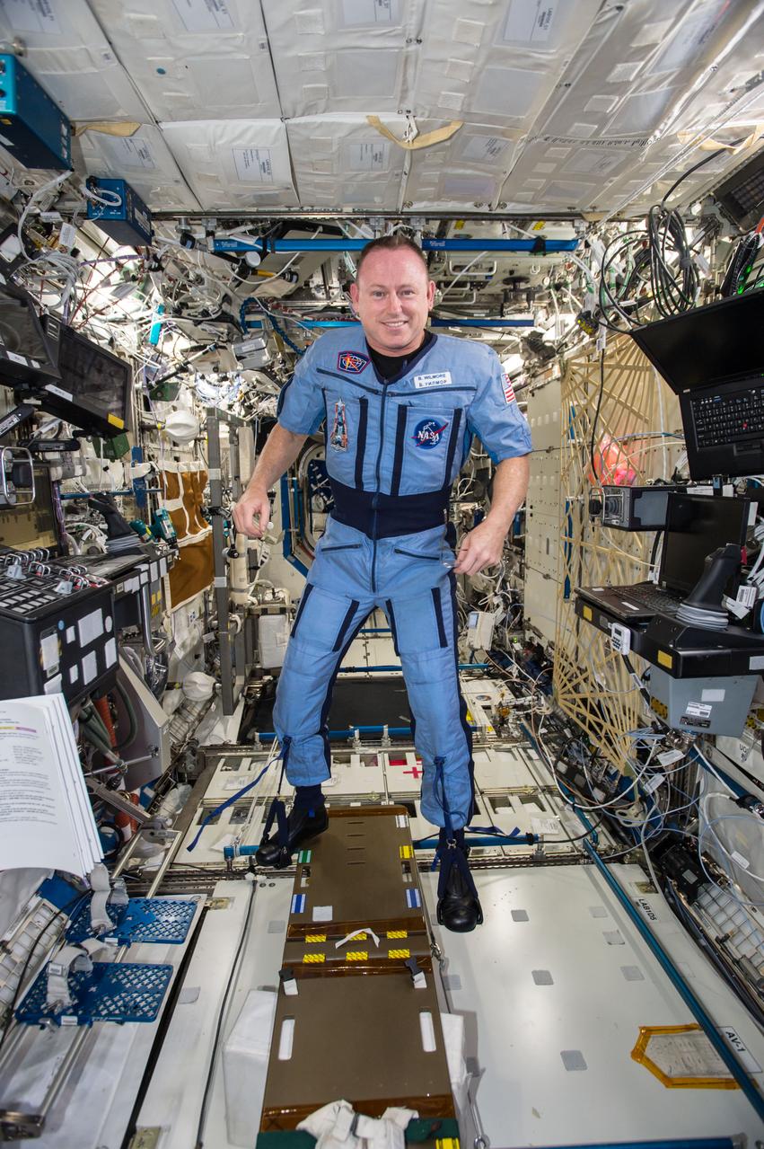
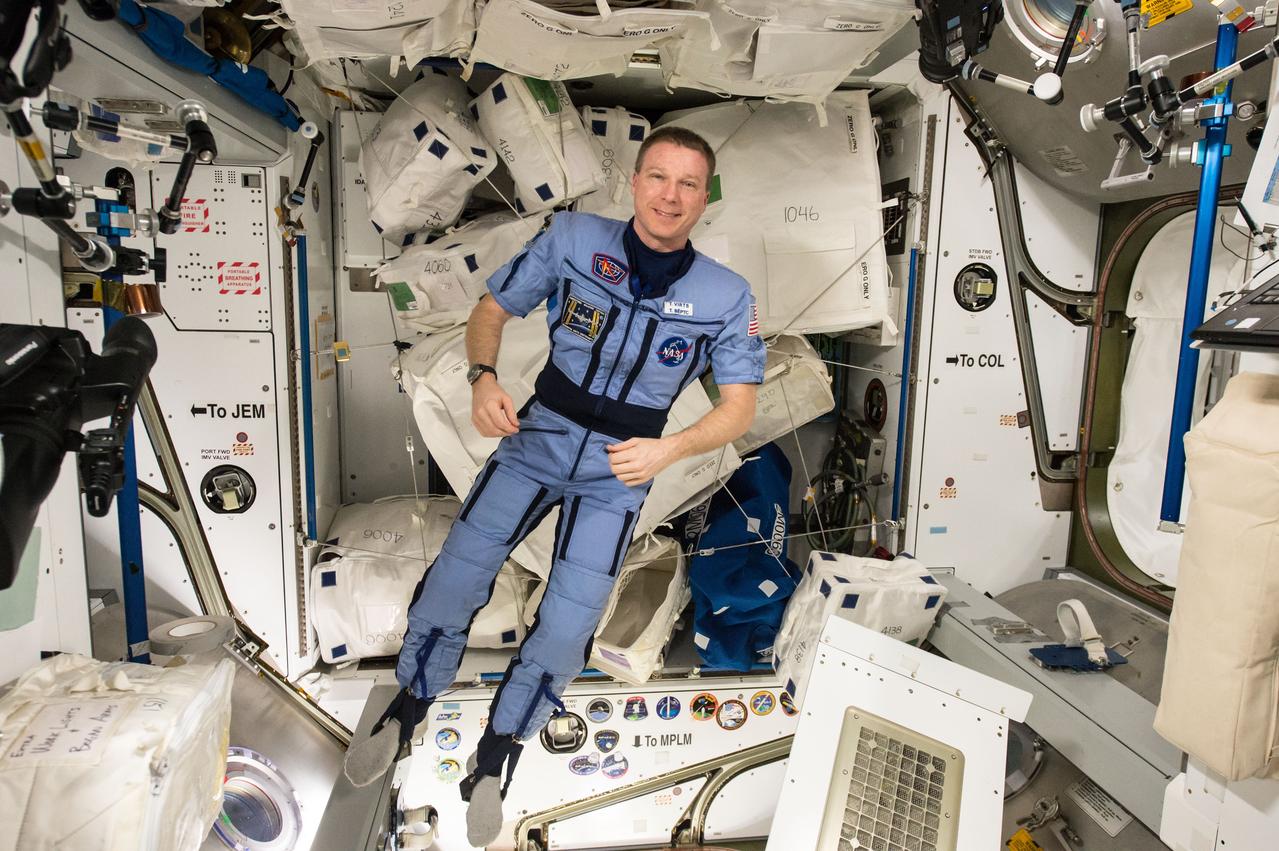
GMT335_13_20_Barry Wilmore_Butch in the Penguin Suit_130
A penguin near Punta Arena, Chile, photographed in its natural summer habitat during NASA's AirSAR 2004 campaign. AirSAR 2004 is a three-week expedition in Central and South America by an international team of scientists that is using an all-weather imaging tool, called the Airborne Synthetic Aperture Radar (AirSAR), located onboard NASA's DC-8 airborne laboratory. Scientists from many parts of the world are combining ground research with NASA's AirSAR technology to improve and expand on the quality of research they are able to conduct.
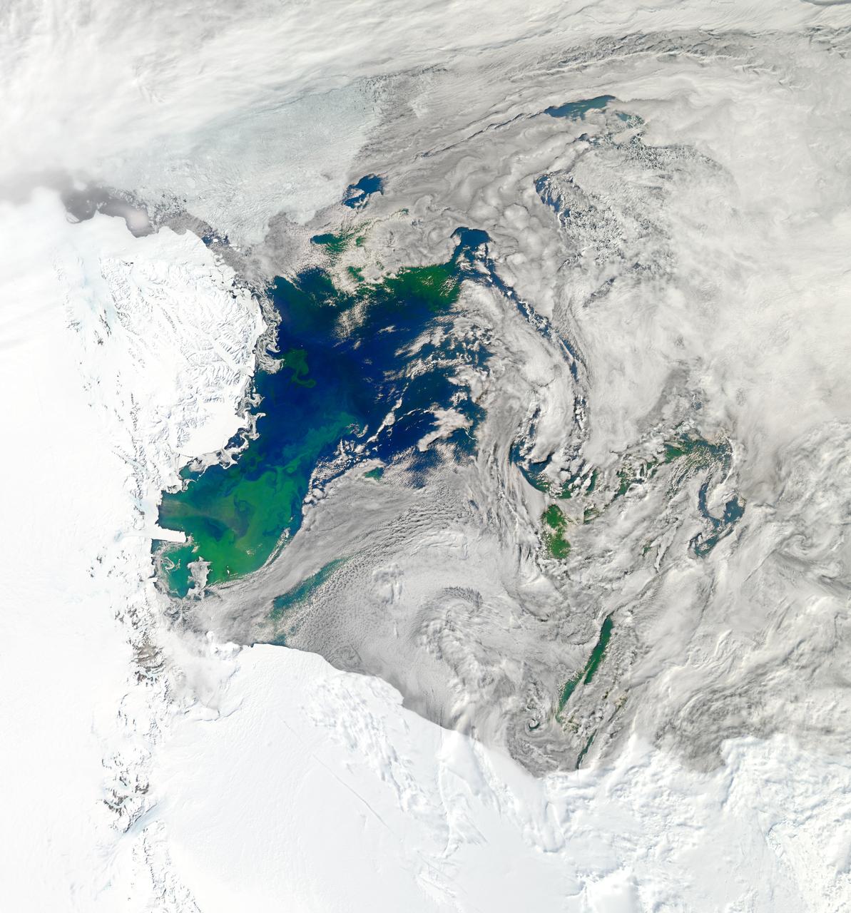
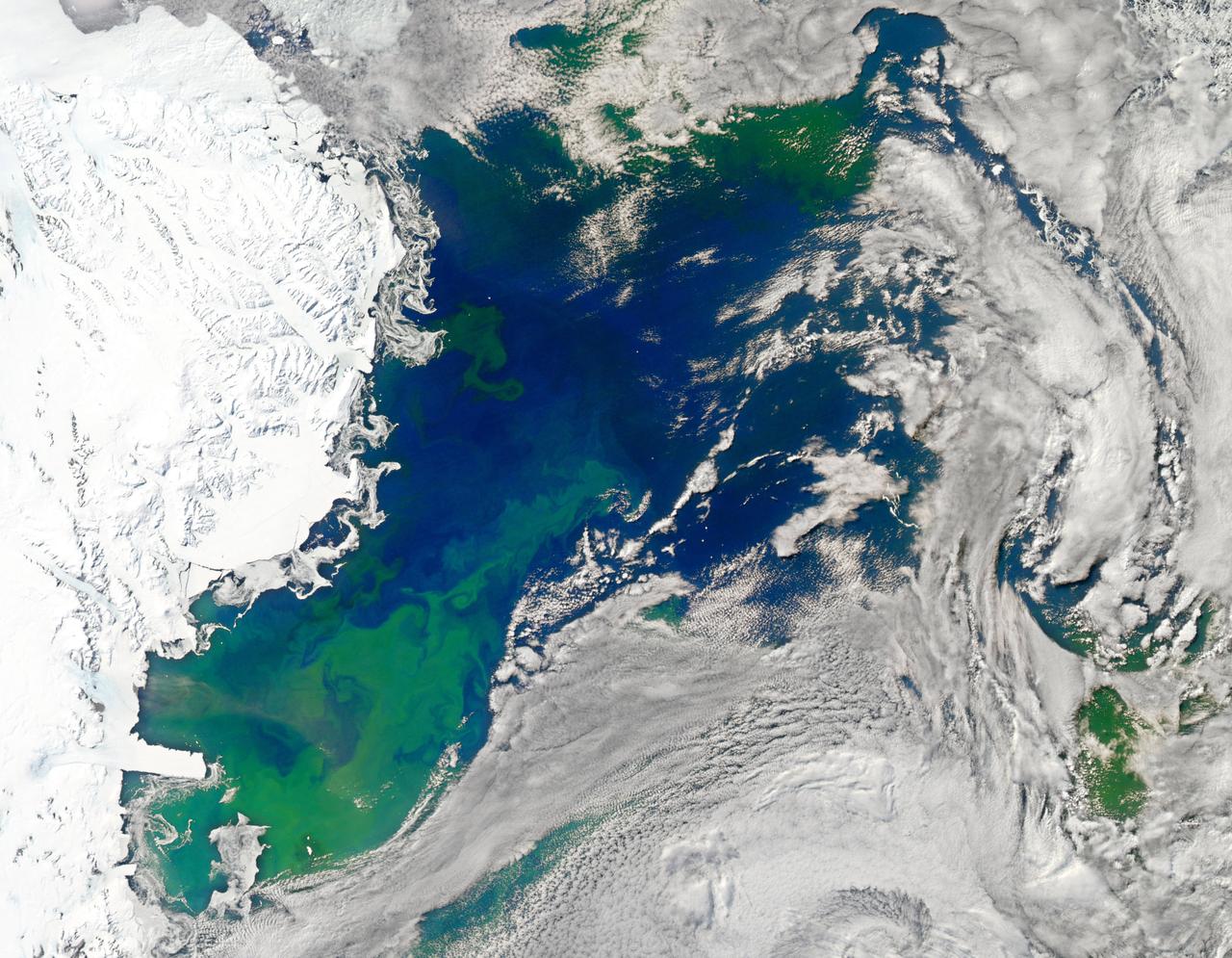
NASA image acquired January 22, 2011 To see a detail of this image go to: <a href="http://www.flickr.com/photos/gsfc/5398237910">www.flickr.com/photos/gsfc/5398237910</a> Every southern spring and summer, after the Sun has risen into its 24-hour circuit around the skies of Antarctica, the Ross Sea bursts with life. Floating, microscopic plants, known as phytoplankton, soak up the sunlight and the nutrients stirring in the Southern Ocean and grow into prodigious blooms. Those blooms become a great banquet for krill, fish, penguins, whales, and other marine species who carve out a living in the cool waters of the far south. This true-color image captures such a bloom in the Ross Sea on January 22, 2011, as viewed by the Moderate Resolution Imaging Spectroradiometer (MODIS) on NASA’s Aqua satellite. Bright greens of plant-life have replaced the deep blues of open ocean water. The Ross Sea is a relatively shallow bay in the Antarctic coastline and due south from New Zealand. As the spring weather thaws the sea ice around Antarctica, areas of open water surrounded by ice—polynyas—open up on the continental shelf. In this open water, sunlight provides the fuel and various current systems provide nutrients from deeper waters to form blooms that can stretch 100 to 200 kilometers (60 to 120 miles). These blooms are among the largest in extent and abundance in the world. Scientists have hypothesized that the Modified Circumpolar Deep Water is the engine behind the blooms, stirring up just the right mix of trace metals and minerals from the deep to sustain plankton growth. This month, researchers aboard the U.S. icebreaking ship Nathaniel B. Palmer are cruising in the Ross Sea in search of the signatures of this current system. NASA image courtesy Norman Kuring, Ocean Color Team at NASA Goddard Space Flight Center. Caption by Mike Carlowicz, with information from Hugh Powell, COSEE-NOW. Instrument: Aqua - MODIS Credit: <b><a href="http://www.earthobservatory.nasa.gov/" rel="nofollow"> NASA Earth Observatory</a></b> <a href="http://earthobservatory.nasa.gov/IOTD/view.php?id=48949" rel="nofollow">earthobservatory.nasa.gov/IOTD/view.php?id=48949</a> <b><a href="http://www.nasa.gov/centers/goddard/home/index.html" rel="nofollow">NASA Goddard Space Flight Center</a></b> enables NASA’s mission through four scientific endeavors: Earth Science, Heliophysics, Solar System Exploration, and Astrophysics. Goddard plays a leading role in NASA’s accomplishments by contributing compelling scientific knowledge to advance the Agency’s mission. <b>Follow us on <a href="http://twitter.com/NASA_GoddardPix" rel="nofollow">Twitter</a></b> <b>Join us on <a href="http://www.facebook.com/pages/Greenbelt-MD/NASA-Goddard/395013845897?ref=tsd" rel="nofollow">Facebook</a></b>
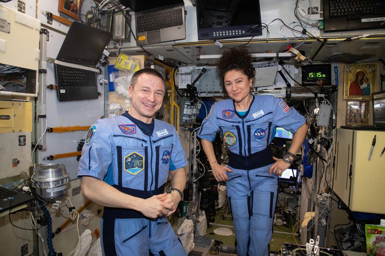
iss062e133028 (March 29, 2020) --- NASA astronauts and Expedition 62 Flight Engineers Andrew Morgan and Jessica Meir pose for a portrait inside the International Space Station's Zvezda service module.
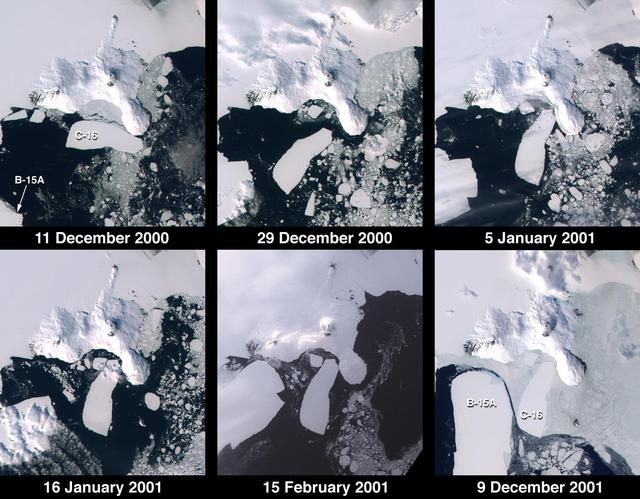
These images from NASA Terra satellite documented iceberg movements and changes in sea ice between December 11, 2000 and December 9, 2001.
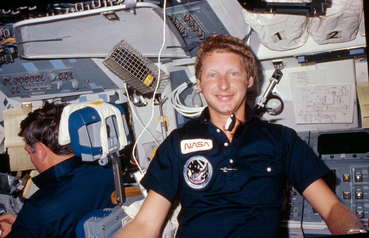
A tiny stuffed penguin floats in front of Mission specialist Steven Hawley as he sits at the mission specialists position behind the pilot on the flight deck.

Michael Polito speaks during the press briefing, "Penguins from Space", Tuesday, December 11, 2018 at the Marriott Marquis in Washington as part of the American Geophysical Union (AGU) annual meeting. Photo Credit: (NASA/Aubrey Gemignani)

Heather Lynch speaks during the press briefing, "Penguins from Space", Tuesday, December 11, 2018 at the Marriott Marquis in Washington as part of the American Geophysical Union (AGU) annual meeting. Photo Credit: (NASA/Aubrey Gemignani)

Casey Youngflesh speaks during the press briefing, "Penguins from Space", Tuesday, December 11, 2018 at the Marriott Marquis in Washington as part of the American Geophysical Union (AGU) annual meeting. Photo Credit: (NASA/Aubrey Gemignani)
NASA image acquired January 22, 2011 To view the full image go to: <a href="http://www.flickr.com/photos/gsfc/5397636843">www.flickr.com/photos/gsfc/5397636843</a> Every southern spring and summer, after the Sun has risen into its 24-hour circuit around the skies of Antarctica, the Ross Sea bursts with life. Floating, microscopic plants, known as phytoplankton, soak up the sunlight and the nutrients stirring in the Southern Ocean and grow into prodigious blooms. Those blooms become a great banquet for krill, fish, penguins, whales, and other marine species who carve out a living in the cool waters of the far south. This true-color image captures such a bloom in the Ross Sea on January 22, 2011, as viewed by the Moderate Resolution Imaging Spectroradiometer (MODIS) on NASA’s Aqua satellite. Bright greens of plant-life have replaced the deep blues of open ocean water. The Ross Sea is a relatively shallow bay in the Antarctic coastline and due south from New Zealand. As the spring weather thaws the sea ice around Antarctica, areas of open water surrounded by ice—polynyas—open up on the continental shelf. In this open water, sunlight provides the fuel and various current systems provide nutrients from deeper waters to form blooms that can stretch 100 to 200 kilometers (60 to 120 miles). These blooms are among the largest in extent and abundance in the world. Scientists have hypothesized that the Modified Circumpolar Deep Water is the engine behind the blooms, stirring up just the right mix of trace metals and minerals from the deep to sustain plankton growth. This month, researchers aboard the U.S. icebreaking ship Nathaniel B. Palmer are cruising in the Ross Sea in search of the signatures of this current system. NASA image courtesy Norman Kuring, Ocean Color Team at NASA Goddard Space Flight Center. Caption by Mike Carlowicz, with information from Hugh Powell, COSEE-NOW. Instrument: Aqua - MODIS For more info go to: <a href="http://earthobservatory.nasa.gov/IOTD/view.php?id=48949" rel="nofollow">earthobservatory.nasa.gov/IOTD/view.php?id=48949</a> Credit: <b><a href="http://www.earthobservatory.nasa.gov/" rel="nofollow"> NASA Earth Observatory</a></b> <b><a href="http://www.nasa.gov/centers/goddard/home/index.html" rel="nofollow">NASA Goddard Space Flight Center</a></b> enables NASA’s mission through four scientific endeavors: Earth Science, Heliophysics, Solar System Exploration, and Astrophysics. Goddard plays a leading role in NASA’s accomplishments by contributing compelling scientific knowledge to advance the Agency’s mission. <b>Follow us on <a href="http://twitter.com/NASA_GoddardPix" rel="nofollow">Twitter</a></b> <b>Join us on <a href="http://www.facebook.com/pages/Greenbelt-MD/NASA-Goddard/395013845897?ref=tsd" rel="nofollow">Facebook</a></b>
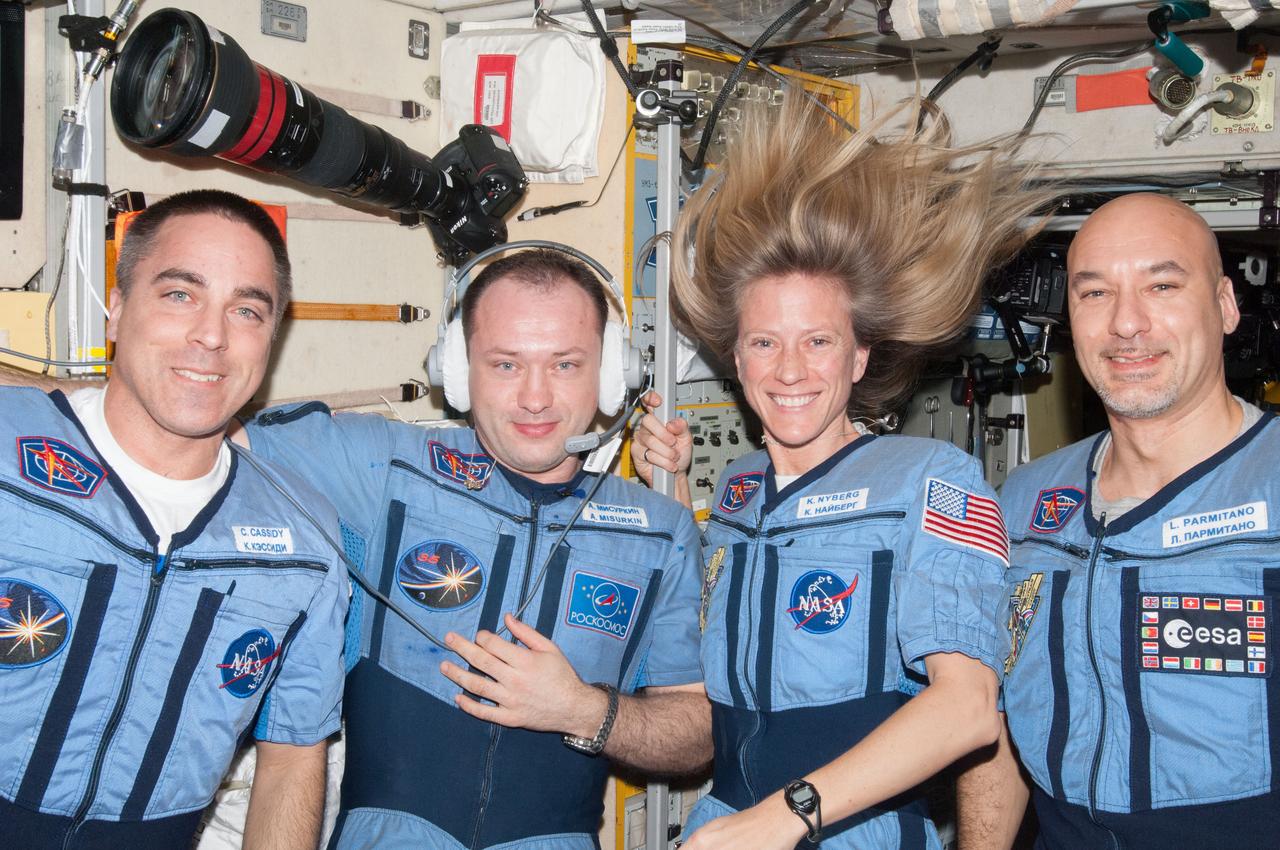
ISS036-E-032944 (15 Aug. 2013) --- NASA astronaut Chris Cassidy (left), Russian cosmonaut Alexander Misurkin, NASA astronaut Karen Nyberg and European Space Agency astronaut Luca Parmitano (right), all Expedition 36 flight engineers, pose for a portrait in the Zvezda Service Module of the International Space Station.
iss073e1047970 (Nov. 2, 2025) --- The western portion of Grand Terre, part of the French Southern and Antarctic Lands, is pictured from the International Space Station as it orbited 270 miles above the Indian Ocean. The largest island in the Kerguelen Archipelago, this UNESCO World Heritage Site is of volcanic origin, features a cold oceanic climate, and is home to king penguins, elephant seals, and albatrosses.
ISS043E188795 (05/12/2015) --- Expedition 43 commander and NASA astronaut Terry Virts shows off a special suit for his preparation process to return to Earth later. Virts tweeted this image with an explanation of the suits purpose on May 12, 2015: “Our "Penguin (пингвин)" suit- it compresses you, to get your body ready for the return to gravity".
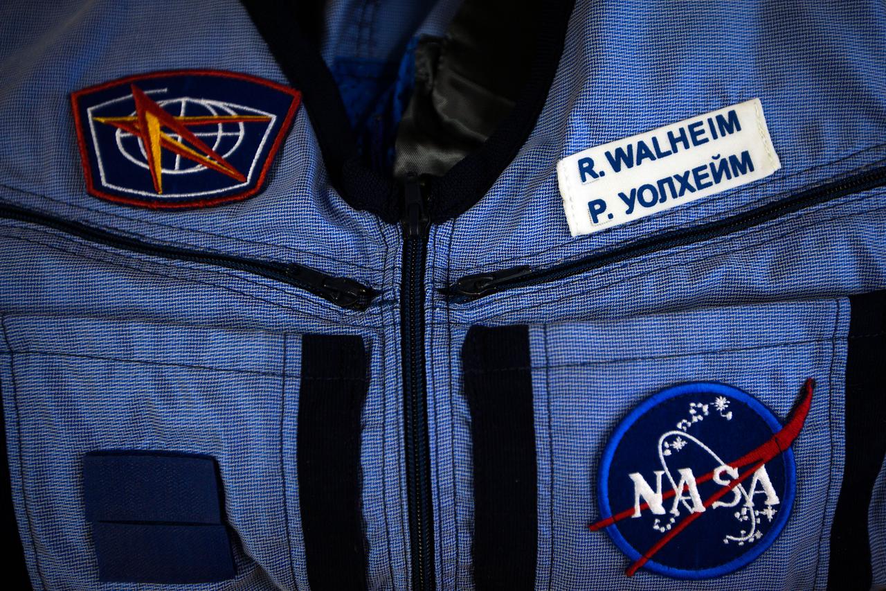
JSC2011-E-040302 (28 March 2011) --- NASA astronaut Rex Walheim's name is seen in both English and Russian on a "Penguin" suit during a suit fit check at the Zvezda facility in Moscow on March 28, 2011. The crew of the final shuttle mission traveled to Moscow for a suit fit check of their Russian Sokol suits which would be required in the event of an emergency. Photo credit: NASA Photo/Houston Chronicle, Smiley N. Pool
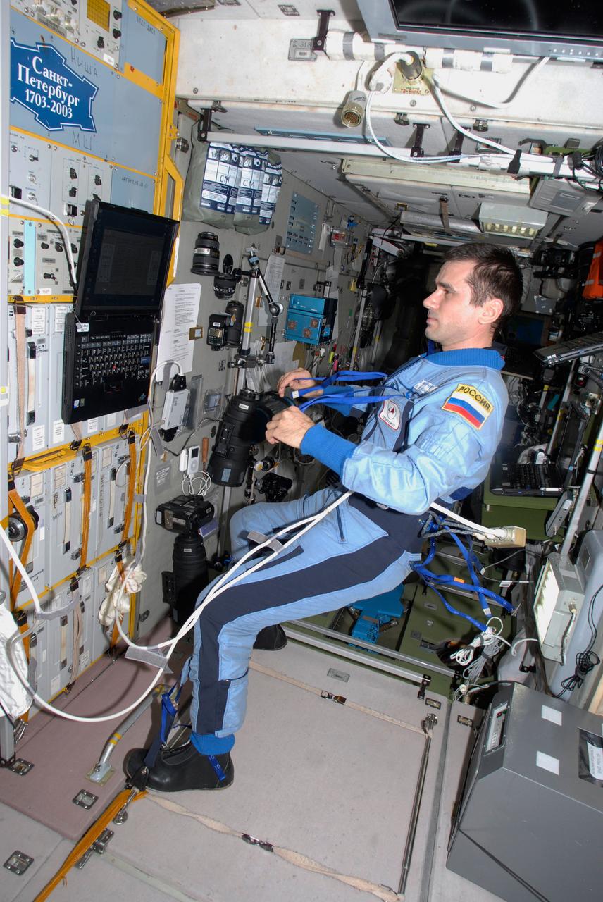
ISS016-E-022540 (13 Jan. 2008) --- Cosmonaut Yuri I. Malenchenko, Expedition 16 flight engineer representing Russia's Federal Space Agency, watches a computer monitor in the Zvezda Service Module of the International Space Station.

ISS016-E-022535 (13 Jan. 2008) --- Cosmonaut Yuri I. Malenchenko, Expedition 16 flight engineer representing Russia's Federal Space Agency, pauses for a photo while working in the Zvezda Service Module of the International Space Station.
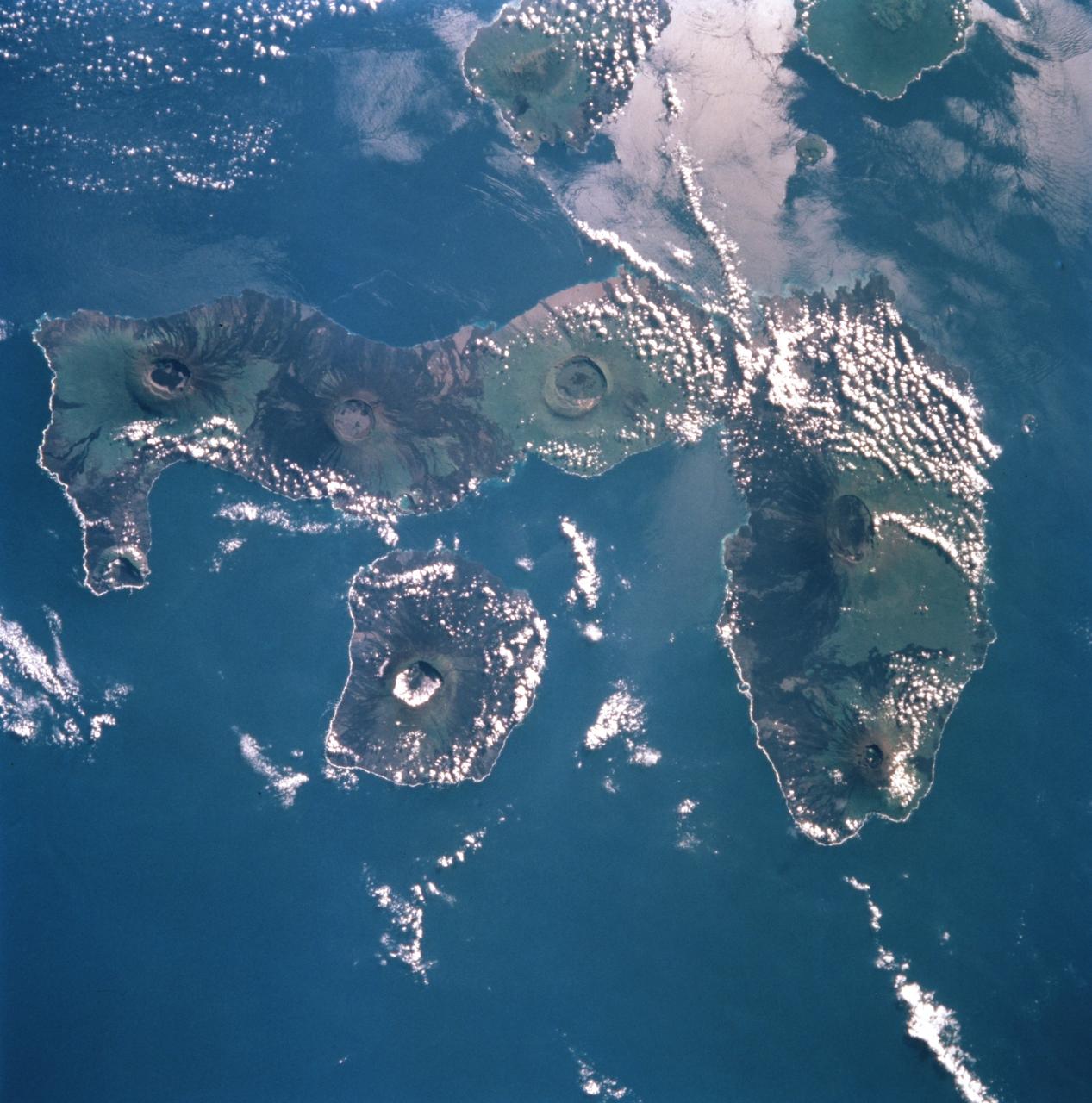
STS099-753-032 (11-22 February 2000) ---This 70mm photograph, photographed from the Space Shuttle Endeavour, centers on the two westernmost Galapagos Islands--seahorse-shaped Isla Isabela and the smaller round Isla Fernandina to its west. All of the 19 islands in the chain are volcanic in origin, and the craters of several of the shield volcanoes are visible as circular features on each of the islands. The two islands shown in this picture contain the most active volcanoes of the Galapagos. Fernandina last erupted in January-February 1995, with red-hot lava pouring into the sea. After 20 years of inactivity, Cerro Azul on Isla Isabela, last erupted in September-October 1998. Cerro Azul is the southwesternmost volcano on Isla Isabela. At 82 miles long, Isla Isabela is the largest of the islands, and comprises half of the land area of the archipelago. The islands are famous for their unique flora and fauna. Charles Darwin's observations of these species in 1835 contributed to the formation of his ideas on natural selection. Some of the most unique species include flightless cormorants, Galapagos penguins, giant land tortoises, and Galapagos finches. The range of Galapagos penguins is restricted to these western islands where upwelling enriches the ocean productivity, and the adaptation of a typically Antarctic bird family to the equator is an ecological marvel. Giant land tortoises are thought to have the oldest lifespans of any animal on Earth, but, scientists say, they have been driven near to extinction. During the most recent eruption of Cerro Azul, one tortoise was killed and many had to be relocated. The 13 species of Galapagos finches on the islands, although varied in form and lifestyle, are the descendants of an ancestor that happened to colonize this isolated archipelago. The human population of the entire archipelago is about 10,000.
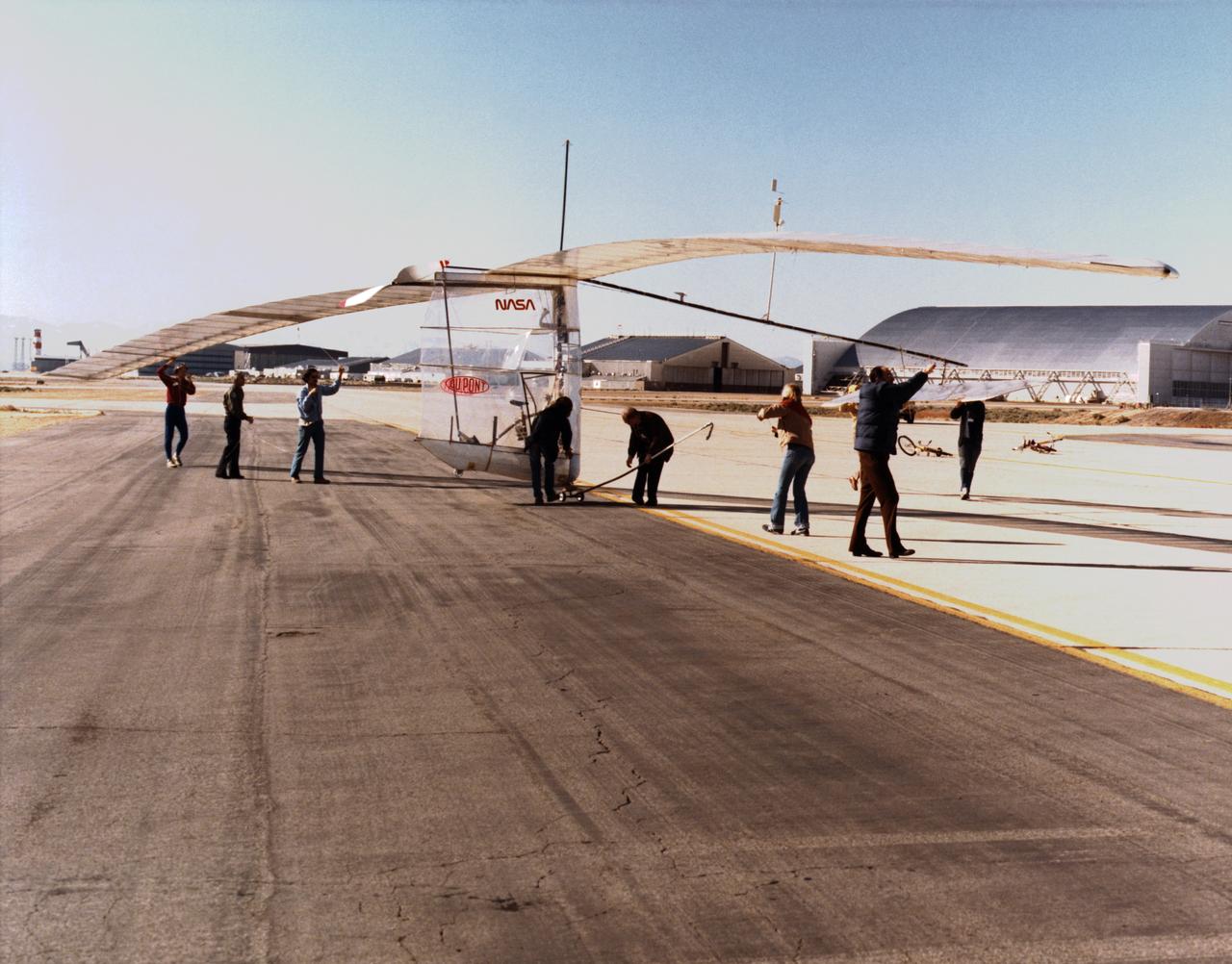
Gossamer Albatross on ramp with crew
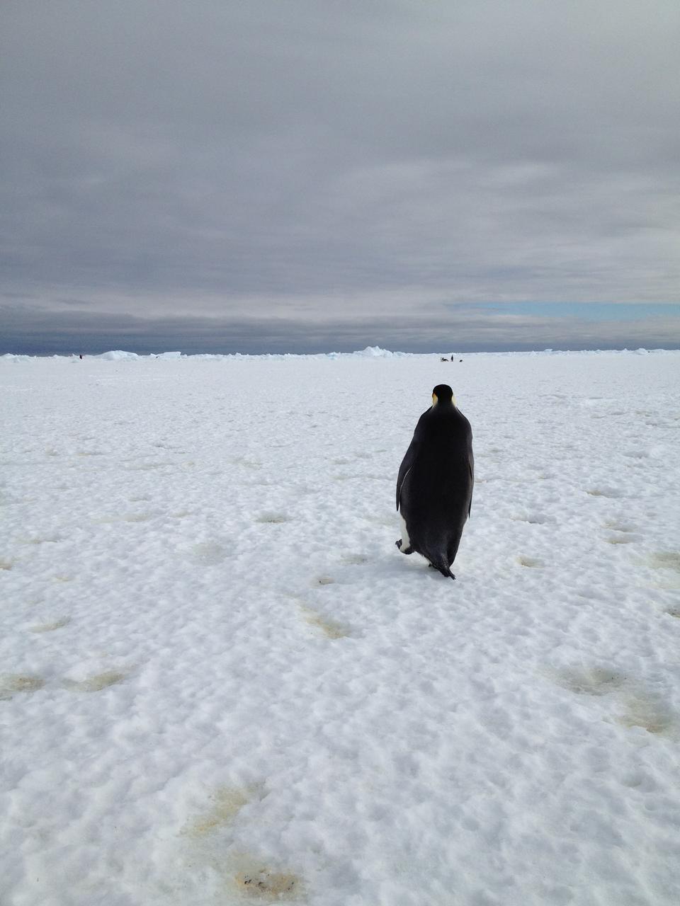
An emperor penguin waddles away on Christmas morning in Antarctica. On Christmas day, the BARREL team visited a penguin colony. Credit: NASA --- In Antarctica in January, 2013 – the summer at the South Pole – scientists launched 20 balloons up into the air to study an enduring mystery of space weather: when the giant radiation belts surrounding Earth lose material, where do the extra particles actually go? The mission is called BARREL (Balloon Array for Radiation belt Relativistic Electron Losses) and it is led by physicist Robyn Millan of Dartmouth College in Hanover, NH. Millan provided photographs from the team’s time in Antarctica. The team launched a balloon every day or two into the circumpolar winds that circulate around the pole. Each balloon floated for anywhere from 3 to 40 days, measuring X-rays produced by fast-moving electrons high up in the atmosphere. BARREL works hand in hand with another NASA mission called the Van Allen Probes, which travels through the Van Allen radiation belts surrounding Earth. The belts wax and wane over time in response to incoming energy and material from the sun, sometimes intensifying the radiation through which satellites must travel. Scientists wish to understand this process better, and even provide forecasts of this space weather, in order to protect our spacecraft. As the Van Allen Probes were observing what was happening in the belts, BARREL tracked electrons that precipitated out of the belts and hurtled down Earth’s magnetic field lines toward the poles. By comparing data, scientists will be able to track how what’s happening in the belts correlates to the loss of particles – information that can help us understand this mysterious, dynamic region that can impact spacecraft. Having launched balloons in early 2013, the team is back at home building the next set of payloads. They will launch 20 more balloons in 2014. <b><a href="http://www.nasa.gov/audience/formedia/features/MP_Photo_Guidelines.html" rel="nofollow">NASA image use policy.</a></b> <b><a href="http://www.nasa.gov/centers/goddard/home/index.html" rel="nofollow">NASA Goddard Space Flight Center</a></b> enables NASA’s mission through four scientific endeavors: Earth Science, Heliophysics, Solar System Exploration, and Astrophysics. Goddard plays a leading role in NASA’s accomplishments by contributing compelling scientific knowledge to advance the Agency’s mission. <b>Follow us on <a href="http://twitter.com/NASA_GoddardPix" rel="nofollow">Twitter</a></b> <b>Like us on <a href="http://www.facebook.com/pages/Greenbelt-MD/NASA-Goddard/395013845897?ref=tsd" rel="nofollow">Facebook</a></b> <b>Find us on <a href="http://instagram.com/nasagoddard?vm=grid" rel="nofollow">Instagram</a></b>
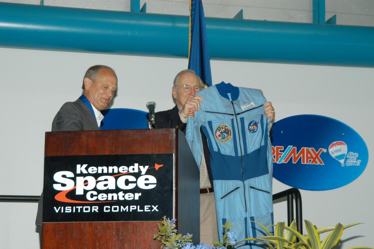
KENNEDY SPACE CENTER, FLA. -- At the Kennedy Space Center Visitor Complex, Dr. Norman E. Thagard (left) is inducted into the U.S. Astronaut Hall of Fame. Thagard was the first American to occupy Russia's Mir space station. Former NASA astronaut James A. Lovell Jr. holds a "penguin suit," the clothing Thagard wore aboard Mir. The suit will be put on display in the Hall of Fame. Also chosen for induction in 2004 are Kathryn D. Sullivan, the first American woman to walk in space; Richard O. Covey, commander of the Hubble Space Telescope repair mission; Frederick D. Gregory, the first African-American to command a space mission; and the late Francis R. "Dick" Scobee, commander of the ill-fated 1986 Challenger mission. The U.S. Astronaut Hall of Fame opened in 1990 to provide a place where space travelers could be remembered for their participation and accomplishments in the U.S. space program. To be eligible for induction, an individual must have been a U.S. citizen, a NASA astronaut, and out of the active astronaut corps at least five years. The five inductees join 52 previously honored astronauts from the ranks of the Gemini, Apollo, Skylab, Apollo-Soyuz, and Space Shuttle programs.
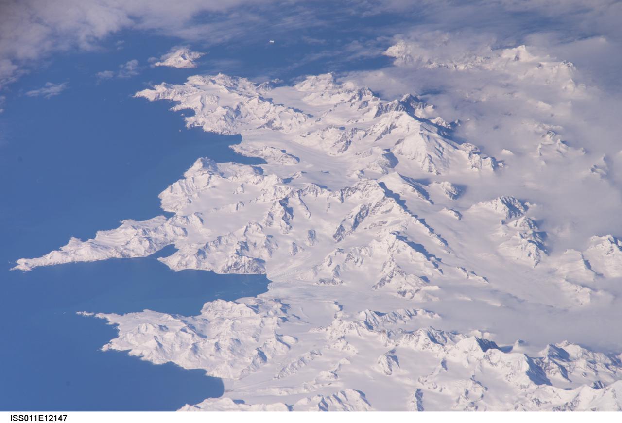
ISS011-E-12147 (26 Aug. 2005) --- South Georgia Island is featured in this image photographed by an Expedition 11 crewmember on the International Space Station. There is no permanent human base on South Georgia Island, a British territory in the South Atlantic Ocean that lies 1300 kilometers east of the Falkland Islands. Using a long lens (800 mm focal length) and positioned for an oblique view, the crew of the international space station was able to capture the rugged and isolated landscape of the northern shore of the island. The high mountains protect the north and eastern coast of the island from the prevailing gales coming from Antarctica and the west. The steep topography also makes deep embayments along the coast that provide habitat for wildlife and anchorages for whaling ships. The island supports major rookeries of penguins and albatrosses, and large seal populations. This view centers on Mt. Paget and Cumberland Bay. The former whaling station Grytviken is located within the bay. The encampment supports the scientific base for the British Antarctic Survey and Bird Island Research Station.
ISS011-E-12148 (26 August 2005) --- South Georgia Island is featured in this image photographed by an Expedition 11 crewmember on the international space station. There is no permanent human base on South Georgia Island, a British territory in the South Atlantic Ocean that lies 1300 kilometers east of the Falkland Islands. Using a long lens (800 mm focal length) and positioned for an oblique view, the crew of the international space station was able to capture the rugged and isolated landscape of the northern shore of the island. The high mountains protect the north and eastern coast of the island from the prevailing gales coming from Antarctica and the west. The steep topography also makes deep embayments along the coast that provide habitat for wildlife and anchorages for whaling ships. The island supports major rookeries of penguins and albatrosses, and large seal populations. This view centers on Mt. Paget and Cumberland Bay. The former whaling station Grytviken is located within the bay. The encampment supports the scientific base for the British Antarctic Survey and Bird Island Research Station.
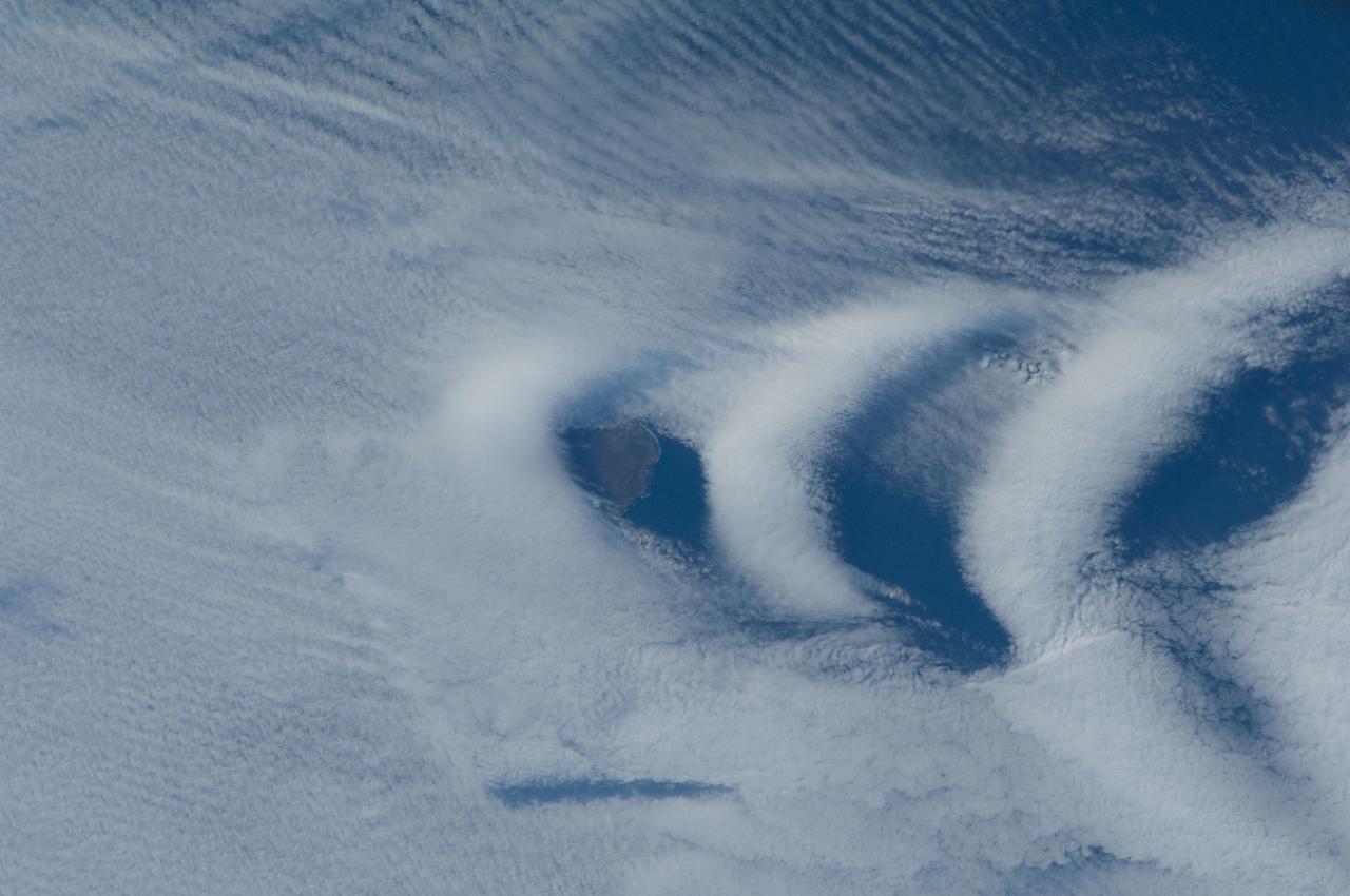
ISS030-E-193144 (25 March 2012) --- Wave clouds near Ile aux Cochons are featured in this image photographed by an Expedition 30 crew member on the International Space Station. This photograph illustrates the formation of wave clouds in the wake—or downwind side—of Ile aux Cochons (“Isle of Pigs”) located in the Southern Indian Ocean. The island is approximately located 3,000 kilometers southeast of the southern tip of the African continent and 2,300 kilometers northwest of Antarctica. The island itself, of which only a part of the eastern coastline is visible at center, is volcanic in origin with a summit elevation of 775 meters above sea level. According to scientists, the Ile aux Cochons stratovolcano is thought to have erupted within the last 12,000 years; however no historical activity has been recorded. The summit elevation is high enough for the land surface to interact with cloud layers and winds flowing past the island. Two major cloud layers are visible; a lower, more uniform layer consists of roughly parallel cloud “streets” that suggest a westerly flow pattern of air. When the air mass encounters the Ile aux Cochons, moisture-laden air rises and cools, causing more water vapor to condense into clouds. As the air mass passes over the summit of Ile aux Cochons and descends, it may encounter alternating moist and dry air layers, enabling the formation of the discontinuous chevron-shaped wave clouds in the wake of the island. While their appearance suggests that the clouds are forming in the wake of the island and moving eastwards, in fact it is the air mass that is moving, with clouds forming in regions of moist air and dissipating in dry regions. Ile aux Cochons is the westernmost of the islands that form the subantarctic Crozet Archipelago (part of the French Southern and Antarctic Lands). Accept for occasional research visits, the island is uninhabited. The island is an important breeding site for seabirds, including the world’s largest King Penguin colony.
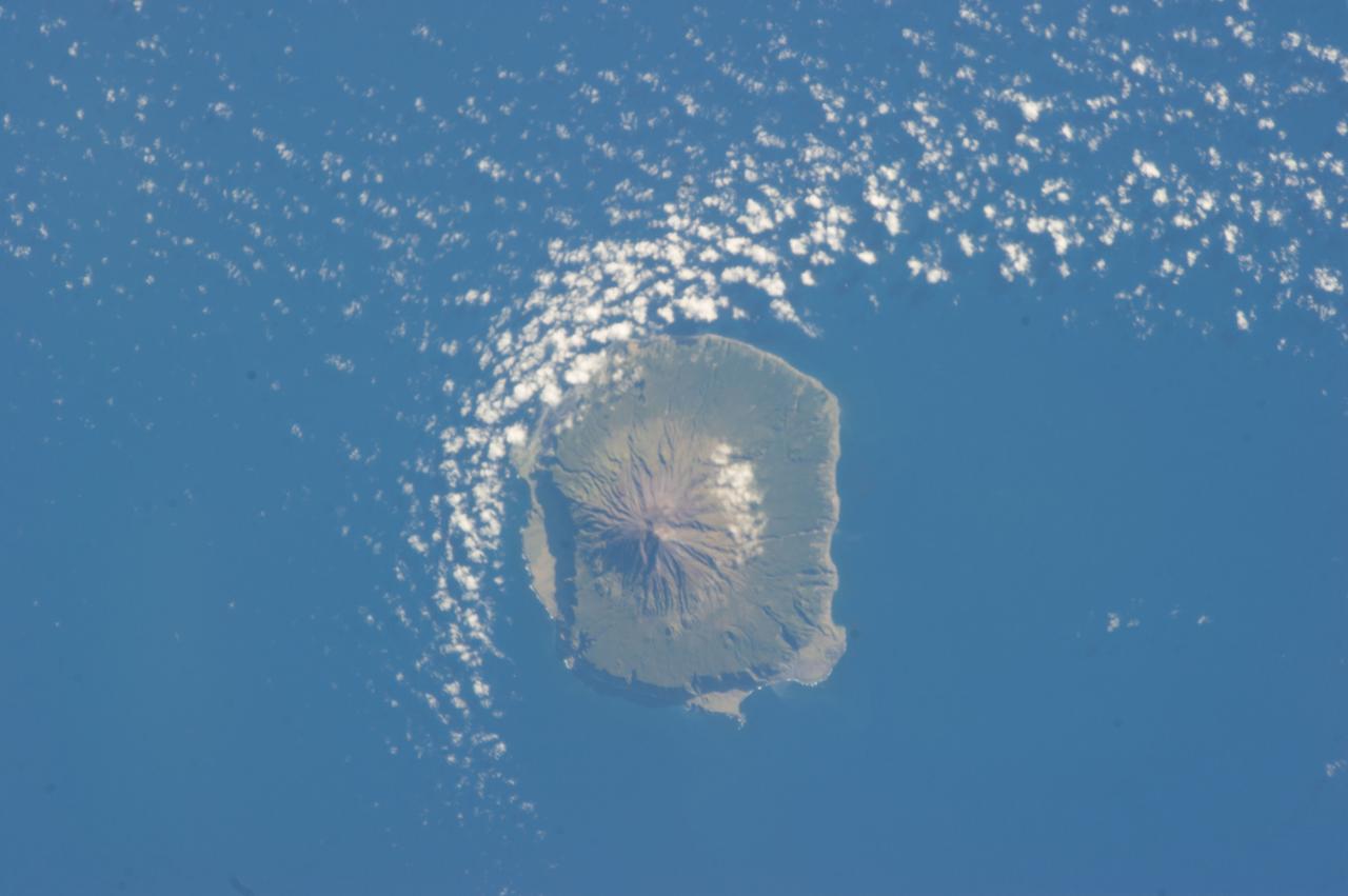
ISS034-E-041528 (6 Feb. 2013) --- Tristan da Cunha is featured in this image photographed by an Expedition 34 crew member on the International Space Station. The island is located in the southern Atlantic Ocean; more than 3,700 kilometers from the northern coastline of Antarctica, approximately 2,800 kilometers to the southern tip of Africa, and more than 3,000 kilometers from the eastern coastline of South America. The island forms part of the British Overseas Territory of Saint Helena, Ascension, and Tristan da Cunha. The shoreline of the 13-kilometer-wide island is marked on most sides by steep cliffs, with lower beach areas on the southern and north-northwestern sides. The island is notable for its bird population, including important breeding grounds for a variety of petrels, albatrosses, penguins and shearwaters. Tristan da Cunha is a shield volcano; a type of volcanic structure usually recognized by a low, broad profile and composed of silica-poor lavas (such as basalt). The upper surface of this low base appears dark green in this photograph. Steeper, brown to tan colored slopes mark the central cone of the volcano at the island?s center. The summit crater, Queen Mary?s Peak, sits at an elevation of 2,060 meters above sea level. While geologic evidence indicates that eruptions have occurred from the central crater, lavas have also erupted from flank vents along the sides of the volcano as well as smaller cinder cones. The last known eruption of Tristan da Cunha took place 1961-1962 and forced evacuation of the only settlement on the island, Edinburgh of the Seven Seas. The settlement is located along the northern coastline of the island (obscured by clouds in this image). This is considered to be the most remote permanent settlement on Earth, with its citizen?s nearest neighbors located 2,173 kilometers to the northeast on the island of St. Helena.
Completed: 07-16-2009 Straddling the equator approximately 1000 kilometers to the west of the South American mainland, the Galapagos Islands lie within the heart of the equatorial current system. Rising from the sea floor, the volcanic islands of the Galapagos are set on top of a large submarine platform. The main portion of the Galapagos platform is relatively flat and less than 1000 meters in depth. The steepest slopes are found along the western and southern flanks of the platform with a gradual slope towards the east. The interactions of the Galapagos and the oceanic currents create vastly different environmental regimes which not only isolates one part of the Archipelago from the other but allows penguins to live along the equator on the western part of the Archipelago and tropical corals around the islands to the north. The islands are relatively new in geologic terms with the youngest islands in the west still exhibiting periodic eruptions from their massive volcanic craters. Please give credit for this item to: NASA/Goddard Space Flight Center, The SeaWiFS Project and GeoEye, Scientific Visualization Studio. NOTE: All SeaWiFS images and data presented on this web site are for research and educational use only. All commercial use of SeaWiFS data must be coordinated with GeoEye (http://www.geoeye.com). To download this video go to: <a href="http://svs.gsfc.nasa.gov/goto?3628" rel="nofollow">svs.gsfc.nasa.gov/goto?3628</a> <b><a href="http://www.nasa.gov/centers/goddard/home/index.html" rel="nofollow">NASA Goddard Space Flight Center</a></b> is home to the nation's largest organization of combined scientists, engineers and technologists that build spacecraft, instruments and new technology to study the Earth, the sun, our solar system, and the universe.
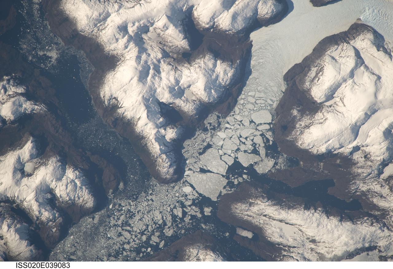
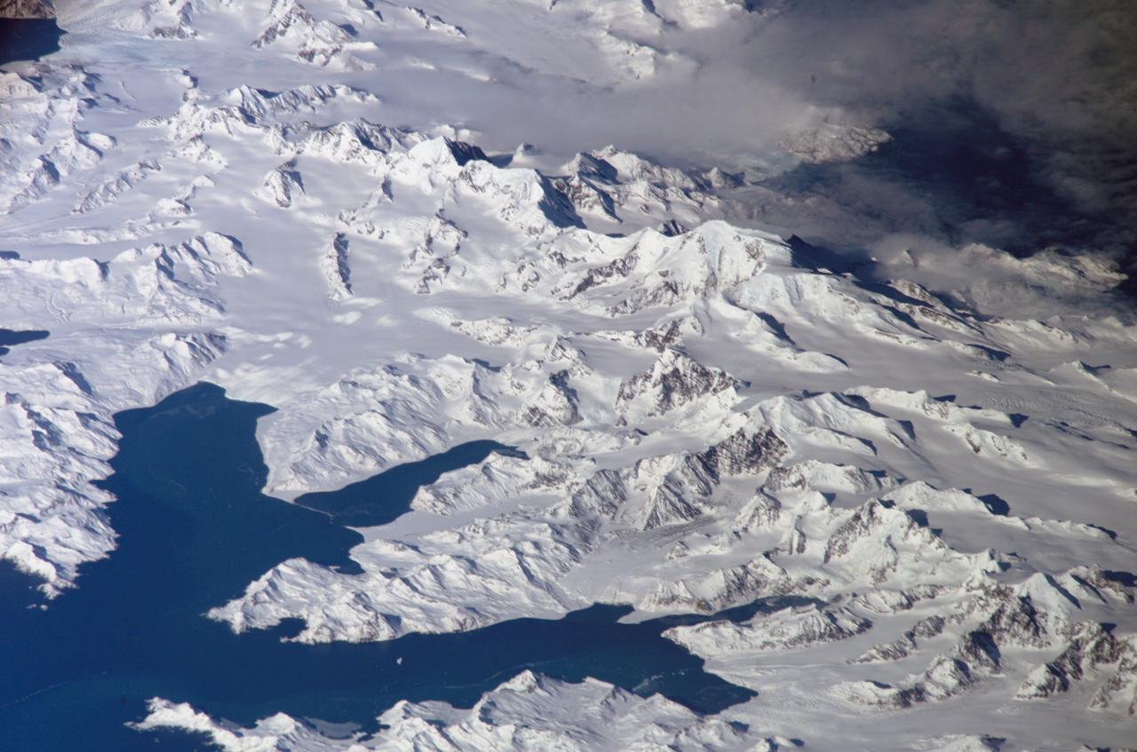
ISS020-E-039083 (6 Sept. 2009) --- Glacier outlet in the Southern Patagonian Ice Field of Chile is featured in this image photographed by an Expedition 20 crew member on the International Space Station. The Southern Patagonian Ice Field of Chile and Argentina hosts a spectacular array of glaciers and associated glacial features within the southern Andes Mountains. Glaciers flowing downhill on the eastern side of the mountains have outlets into several large freshwater lakes. On the western side of the mountains, glaciers release ice into the Pacific Ocean via an intricate network of fjords. Fjords are steep valleys originally cut by glaciers during periods of lower sea level that are now inundated. As glaciers flow into the fjord, ice at the front of the glacier begins to break off and form icebergs that can float out to sea ? a process known as calving. This detailed photograph shows the merged outlet of Penguin Glacier and HPS 19 into a fjord carved into the snow-covered mountains of the southern Andes. The designation HPS stands for Hielo Patagonico Sur (e.g. Southern Patagonian Ice field) and is used to identify glaciers that have no other geographic name. Ice flowing into the fjord begins to break up at center, forming numerous icebergs ? the largest visible in this image is approximately 2 kilometers in width. The large ice masses visible at center have a coarse granular appearance due to variable snow cover, and mixing and refreezing of ice fragments prior to floating free.
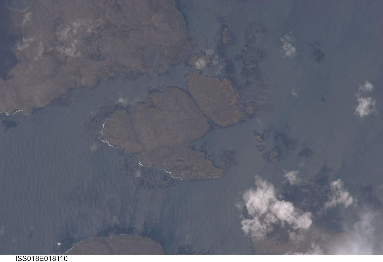
ISS018-E-018110 (6 Jan. 2009) --- Kerguelen Kelp Beds in the Southern Indian Ocean are featured in this image photographed by an Expedition 18 crewmember on the International Space Station. MacMurdo and Howe Islands are two of the 300 islands of the Kerguelen Archipelago, a remote place located in the Southern Indian Ocean that belongs to the French Southern and Antarctic Lands. The Kerguelen Archipelago is also known as the "Desolation Islands". The coastal regions of the islands support low vegetation (mainly genus Acaena), while elevations above 50 meters are rocky. There are no permanent inhabitants of the islands, but there is a permanent settlement (Port aux Francais) that hosts scientists mainly interested in biology, oceanography and earth sciences ? in addition, the settlement maintains a weather station and satellite/rocket tracking station. Latitudinal weather conditions are typical from the ?roaring forties? through the ?furious fifties? - on the day this image was taken, the mean daily temperature was 4.5 degrees Celsius with mean westerly winds of 9 meters per second. A substantial proportion of the coastlines of sub-Antarctic islands, like the Kerguelen Islands, are occupied by highly productive giant kelp beds (Macrocystis pyrifera). One of the largest marine macroalgaes, the species can grow up to 50 meters in length, forming undersea forests in hard-bottom subtidal areas. Fronds can spread out to form a canopy which can totally cover the water surface ? we interpret that the black patches surrounding coastal areas in this astronaut photograph are the offshore kelp beds. These forests serve as a habitat for marine fauna, and due to their large biomass and relatively long turnover act as an efficient sink for atmospheric carbon dioxide. The surface wave pattern traveling southeastward along the gray-blue ocean surface, and through the kelp beds, are visible due to the sunglint from the water surface. This also improves the identification of the kelp beds by creating a different water texture (and therefore a contrast) between the dark vegetation and the ocean surface. Kerguelen Archipelago hosts thousands of marine birds (penguins, albatrosses, and petrels among others) and seals (elephant and Antarctic fur species). Whales (humpback) and dolphins (killer whales and Commerson's dolphin) are very common in the area. Fishing boats also frequent the Archipelago ? including unlicensed, so-called ?pirate? fishing vessels.
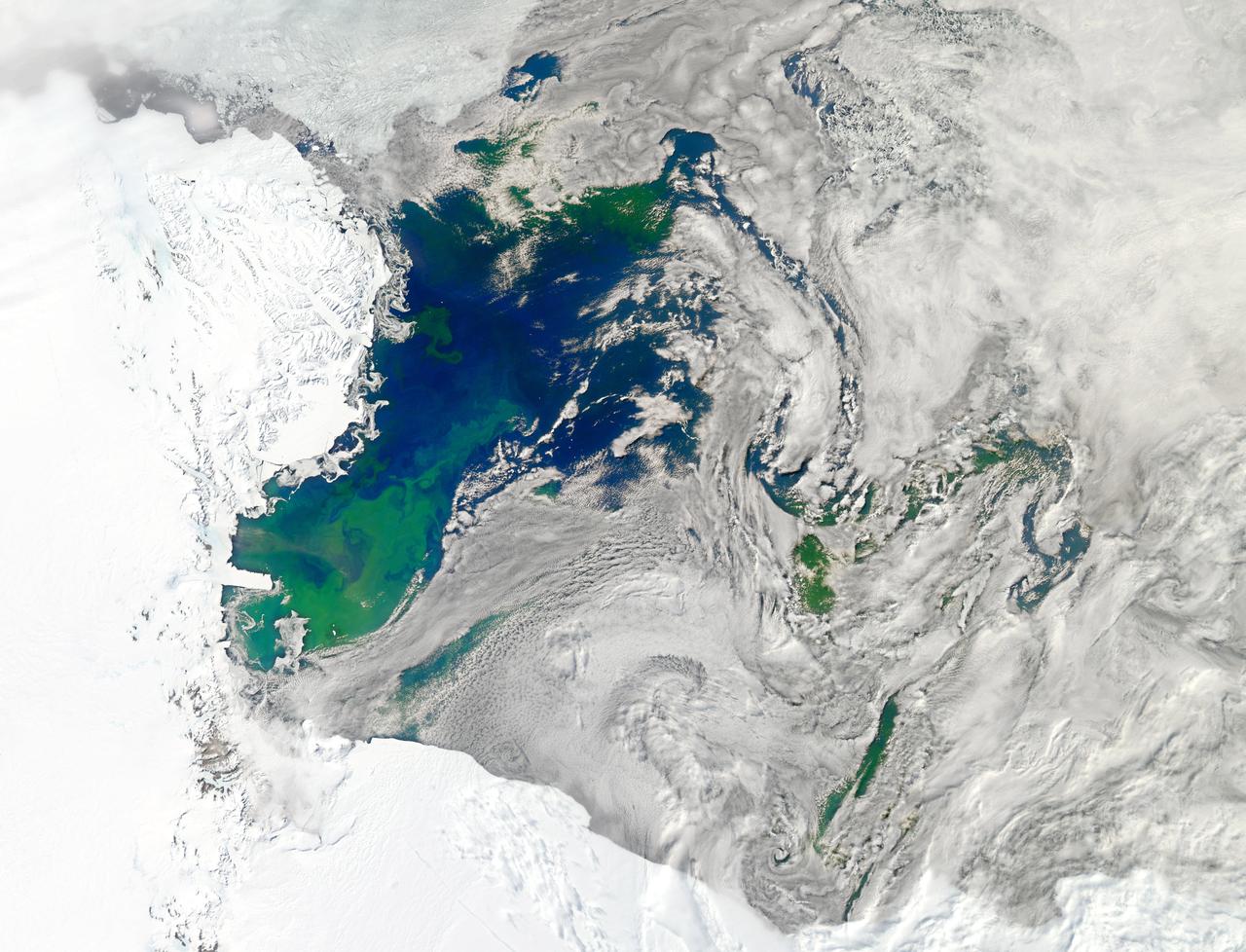
NASA image acquired January 22, 2011 Every southern spring and summer, after the Sun has risen into its 24-hour circuit around the skies of Antarctica, the Ross Sea bursts with life. Floating, microscopic plants, known as phytoplankton, soak up the sunlight and the nutrients stirring in the Southern Ocean and grow into prodigious blooms. Those blooms become a great banquet for krill, fish, penguins, whales, and other marine species who carve out a living in the cool waters of the far south. This true-color image captures such a bloom in the Ross Sea on January 22, 2011, as viewed by the Moderate Resolution Imaging Spectroradiometer (MODIS) on NASA’s Aqua satellite. Bright greens of plant-life have replaced the deep blues of open ocean water. The Ross Sea is a relatively shallow bay in the Antarctic coastline and due south from New Zealand. As the spring weather thaws the sea ice around Antarctica, areas of open water surrounded by ice—polynyas—open up on the continental shelf. In this open water, sunlight provides the fuel and various current systems provide nutrients from deeper waters to form blooms that can stretch 100 to 200 kilometers (60 to 120 miles). These blooms are among the largest in extent and abundance in the world. Scientists have hypothesized that the Modified Circumpolar Deep Water is the engine behind the blooms, stirring up just the right mix of trace metals and minerals from the deep to sustain plankton growth. This month, researchers aboard the U.S. icebreaking ship Nathaniel B. Palmer are cruising in the Ross Sea in search of the signatures of this current system. NASA image courtesy Norman Kuring, Ocean Color Team at NASA Goddard Space Flight Center. Caption by Mike Carlowicz, with information from Hugh Powell, COSEE-NOW. Instrument: Aqua - MODIS Go here to download the full high res file: <a href="http://earthobservatory.nasa.gov/IOTD/view.php?id=48949" rel="nofollow">earthobservatory.nasa.gov/IOTD/view.php?id=48949</a> Credit: <b><a href="http://www.earthobservatory.nasa.gov/" rel="nofollow"> NASA Earth Observatory</a></b> <b><a href="http://www.nasa.gov/audience/formedia/features/MP_Photo_Guidelines.html" rel="nofollow">NASA image use policy.</a></b> <b><a href="http://www.nasa.gov/centers/goddard/home/index.html" rel="nofollow">NASA Goddard Space Flight Center</a></b> enables NASA’s mission through four scientific endeavors: Earth Science, Heliophysics, Solar System Exploration, and Astrophysics. Goddard plays a leading role in NASA’s accomplishments by contributing compelling scientific knowledge to advance the Agency’s mission. <b>Follow us on <a href="http://twitter.com/NASA_GoddardPix" rel="nofollow">Twitter</a></b> <b>Like us on <a href="http://www.facebook.com/pages/Greenbelt-MD/NASA-Goddard/395013845897?ref=tsd" rel="nofollow">Facebook</a></b> <b>Find us on <a href="http://instagrid.me/nasagoddard/?vm=grid" rel="nofollow">Instagram</a></b>

Photographs documenting International Space Station (ISS) Phase One activities at the Russian Space Agency's (RSA) Gagarin Cosmonaut Training Center, Korolov Mission Control Center and Zvezda; and ISS and Soyuz manufacturing at RSA's Khrunichev Design Center and RSC Energiya in Moscow, Russia, the French Space Agency's (CNES) INTESPACE facility in Toulouse, France, and the Italian Space Agency's (ASI) Alenia Spazio facility in Torino, Italy. Photographs were taken by Johnson Space Center Imagery and Publications Office contractors travelling from October 7 to November 4, 1996. Includes: VIEWS FROM RSC ENERGIYA'S SPACE MUSEUM: Room with a Buran model and photographic displays (17372-374). Salyut Space Station mock-up (17376). Russian propulsion engines on display (17377-378). Russian spacecraft on display (17375, 17387-398). Graphic displays (17399-405). VIEWS FROM RSC ENERGIYA MANUFACTURING FACILITIES: Unidentified facility (17379). Mir 24 crew member Michael C. Foale, suited in a Soyuz pressure suit, ingresses the Soyuz TM-26 flight article at RSC Energiya for a fit check (17380-381). Closeups of Foale inside the Soyuz during the fit check (17382-383, 17466-467). Overhead views of RSC Energiya's Building 444 manufacturing floor where docking modules and Soyuz TM spacecraft are built (17495-498). Technicians on the Building 444 manufacturing floor assembling probe and drogue docking modules (17499-500, 17504). Technicians assembling Soyuz spacecraft (17437-439). Views of other Soyuz spacecraft (17440-441). Androgynous Peripheral Docking System (APDS) mock-up (17501-503). Closeups of a control panel, possibly for the APDS mock-up (17519-528). VIEWS FROM ZVEZDA, RSA CONTRACTOR FOR SUIT DESIGN AND SOYUZ SEAT LINERS: Mir 24 crew member Foale dons a "penguin" flight suit for a fit check (17454-456). Zvezda personnel adjust Foale's Soyuz seat and seat liner (17442). Closeup of Foale, suited in a Soyuz pressure suit, sitting on a chair (17444). Zvezda personnel strap pressure-suited Foale into his Soyuz seat (17443, 17445, 17450). Views of Foale in his Soyuz seat during a pressurized pressure suit fit check (17451-453). Views looking into a vacuum chamber where Foale, wearing pressure suit, is strapped into his Soyuz seat (17466-467). Views of Zvezda personnel working at the vacuum chamber control station during the vacuum chamber suit test (17468-471). VIEWS FROM KHRUNICHEV DESIGN CENTER: Views of a green ISS Functional Cargo Block (FGB) test article on the manufacturing floor (17529, 17532-536, 17540-544). Views of an ISS Service Module (SM) test article on the manufacturing floor (17530-531, 17537, 17539). Closeup of the SM test article docking sphere (17538). Views of the FGB flight article on the manufacturing floor during systems tests (17545-548, 17550-567). Views of technicians conducting the FGB systems tests (17549, 17557). VIEWS FROM GAGARIN COSMONAUT TRAINING CENTER: NASA astronauts work out in the cosmonaut gym at Gagarin: Closeup of ISS 2R Expedition Commander William Shepherd on a weight machine (17384). Shepherd and an unidentified man with back to camera work out with dumbbells (17386). Shepherd does pull-ups (17447). Closeup of Foale on an exercise machine (17385). Closeups of Foale exercising arms on a cycle ergometer and a weight machine (17415, 17448-449). Foale exercises on a Nordic Track (17416). Closeup of Mir 23 crew member Jerry Linenger exercising arms (17417). Wendy Lawrence exercises with dumbbells (17418). Closeup of Lawrence in a handstand position (17419). David Wolf works out on a leg press machine (17446). Views of the Mir Space Station mock-up at Gagarin: Interior views of the Mir Base Module mock-up looking toward the transfer compartment (17421-425). Mir Base Module living area mock-up (17420). Overall views of the Base Module mock-up central control station (17426-427, 17505). Closeups of switch panels on the central control station (17428-436, 17506-518). Other views from Gagarin: Personnel work at an unidentified test/trainer control station (17472-473). Linenger sits at a table next to an RSA trainer during a Mir 23 meeting (17475-476). Out-of-focus view of two subjects in the Soyuz trainer (17474). Foale examines a Mir Complex EVA Suit (Orlan) with RSA trainers during an EVA suit training class (17492-494). VIEWS FROM KOROLOV MISSION CONTROL CENTER: Various views of personnel working in the NASA Consulting Room and/or PAO Consulting Room at Korolov Mission Control Center (17457-463). VIEWS FROM INTESPACE: Exterior views of an ISS Mini Pressurized Logistics Module (MPLM) structural test article (STA) during testing at INTESPACE (17406-409, 17477, 17482-484). Technicians install hatch on the MPLM STA (17410-414). Interior views of the MPLM STA (17478-481). VIEWS FROM ALENIA SPAZIO: Closeups of MPLM flight article #1 side panels during milling and refining at Alenia Spazio (17485-488). Workers process MPLM parts at milling machines (17489-491).