
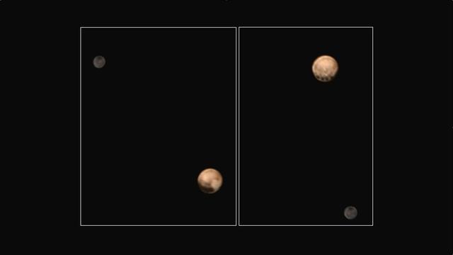
This animation of Pluto and its largest moon, Charon, was taken by NASA New Horizons spacecraft as it raced toward Pluto in July 2014.
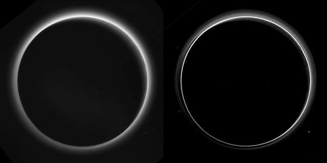
Two different versions of an image of Pluto's haze layers, taken by New Horizons as it looked back at Pluto's dark side nearly 16 hours after close approach, from a distance of 480,000 miles (770,000 kilometers), at a phase angle of 166 degrees. Pluto's north is at the top, and the sun illuminates Pluto from the upper right. These images are much higher quality than the digitally compressed images of Pluto's haze downlinked and released shortly after the July 14 encounter, and allow many new details to be seen. The left version has had only minor processing, while the right version has been specially processed to reveal a large number of discrete haze layers in the atmosphere. In the left version, faint surface details on the narrow sunlit crescent are seen through the haze in the upper right of Pluto's disk, and subtle parallel streaks in the haze may be crepuscular rays- shadows cast on the haze by topography such as mountain ranges on Pluto, similar to the rays sometimes seen in the sky after the sun sets behind mountains on Earth. http://photojournal.jpl.nasa.gov/catalog/PIA19880

These images, taken by NASA's New Horizons' Long Range Reconnaissance Imager (LORRI), show four different "faces" of Pluto as it rotates about its axis with a period of 6.4 days. All the images have been rotated to align Pluto's rotational axis with the vertical direction (up-down) on the figure, as depicted schematically in the upper left. From left to right, the images were taken when Pluto's central longitude was 17, 63, 130, and 243 degrees, respectively. The date of each image, the distance of the New Horizons spacecraft from Pluto, and the number of days until Pluto closest approach are all indicated in the figure.These images show dramatic variations in Pluto's surface features as it rotates. When a very large, dark region near Pluto's equator appears near the limb, it gives Pluto a distinctly, but false, non-spherical appearance. Pluto is known to be almost perfectly spherical from previous data. These images are displayed at four times the native LORRI image size, and have been processed using a method called deconvolution, which sharpens the original images to enhance features on Pluto. Deconvolution can occasionally introduce "false" details, so the finest details in these pictures will need to be confirmed by images taken from closer range in the next few weeks. All of the images are displayed using the same brightness scale. http://photojournal.jpl.nasa.gov/catalog/PIA19686
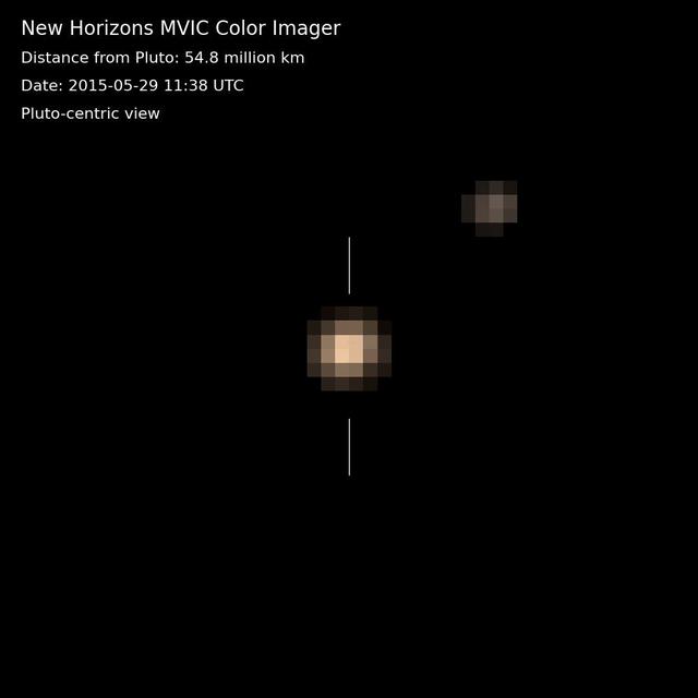
The first color movies from NASA's New Horizons mission show Pluto and its largest moon, Charon, and the complex orbital dance of the two bodies, known as a double planet. A near-true color movie were assembled from images made in three colors -- blue, red and near-infrared -- by the Multispectral Visible Imaging Camera on the instrument known as Ralph. The images were taken on nine different occasions from May 29-June 3, 2015. The movie is "Pluto-centric," meaning that Charon is shown as it moves in relation to Pluto, which is digitally centered in the movie. (The North Pole of Pluto is at the top.) Pluto makes one turn around its axis every 6 days, 9 hours and 17.6 minutes-the same amount of time that Charon rotates in its orbit. Looking closely at the images in this movie, one can detect a regular shift in Pluto's brightness-due to the brighter and darker terrains on its differing faces. http://photojournal.jpl.nasa.gov/catalog/PIA19689
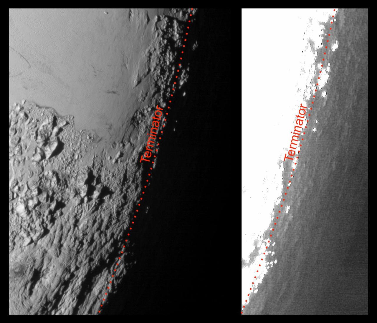
This image of Pluto from NASA's New Horizons spacecraft, processed in two different ways, shows how Pluto's bright, high-altitude atmospheric haze produces a twilight that softly illuminates the surface before sunrise and after sunset, allowing the sensitive cameras on New Horizons to see details in nighttime regions that would otherwise be invisible. The right-hand version of the image has been greatly brightened to bring out faint details of rugged haze-lit topography beyond Pluto's terminator, which is the line separating day and night. The image was taken as New Horizons flew past Pluto on July 14, 2015, from a distance of 50,000 miles (80,000 kilometers). http://photojournal.jpl.nasa.gov/catalog/PIA19931

Imagine a future spacecraft following New Horizons' trailblazing path to Pluto, but instead of flying past its target -- as New Horizons needed to do to explore Pluto and the Kuiper Belt beyond -- the next visitor touches down near the tall mountains on the frozen icy, plains of Pluto's heart. A video produced by New Horizons scientists that offers that very perspective. Made from more than 100 New Horizons images taken over six weeks of approach and close flyby, the video offers a trip in to Pluto -- starting with a distant spacecraft's-eye view of Pluto and its largest moon, Charon, to an eventual ride in for a "landing" on the shoreline of Pluto's informally named Sputnik Planum. The video shows what it would be like to ride aboard an approaching spacecraft and see Pluto grow from a "dot" to become a world, and then to swoop down over Pluto's spectacular terrains. New Horizons scientists had to interpolate some of the frames in the movie based on what they know Pluto looks like to make it as smooth and seamless as possible. After a 9.5-year voyage covering more than three billion miles, New Horizons flew through the Pluto system on July 14, 2015, coming within 7,800 miles (12,500 kilometers) of Pluto itself. Carrying powerful telescopic cameras that could spot features smaller than a football field, New Horizons has sent back hundreds of images of Pluto and its moons that show how dynamic and fascinating their surfaces are - and what great targets they'd make for follow-up mission one day. http://photojournal.jpl.nasa.gov/catalog/PIA20742

This dramatic view of the Pluto system is as NASA's New Horizons spacecraft saw it in July 2015. The animation, made with real images taken by New Horizons, begins with Pluto flying in for its close-up on July 14; we then pass behind Pluto and see the atmosphere glow in sunlight before the sun passes behind Pluto's largest moon, Charon. The movie ends with New Horizons' departure, looking back on each body as thin crescents. http://photojournal.jpl.nasa.gov/catalog/PIA19873

This image-based surface map of Pluto was assembled by computer image processing software from four separate images of Pluto disk taken with the European Space Agency Faint Object Camera aboard NASA Hubble Space Telescope.
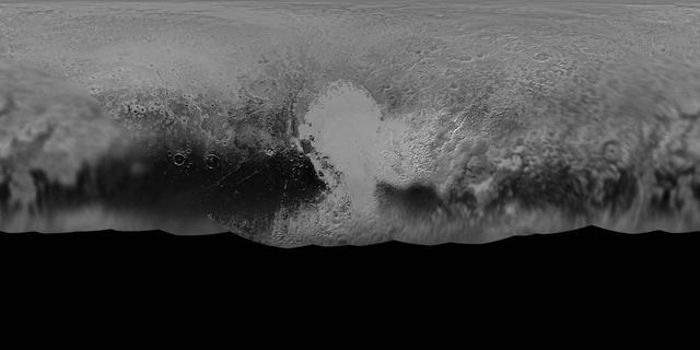
NASA New Horizons mission science team has produced this updated panchromatic black-and-white global map of Pluto. The map includes all resolved images of Pluto surface acquired between July 7-14, 2015.

Pluto nearly fills the frame in this image from NASA New Horizons spacecraft, taken on July 13, 2015. This is the last and most detailed image sent to Earth before the spacecraft closest approach to Pluto on July 14.
The Long Range Reconnaissance Imager on NASA New Horizons acquired images of the Pluto field three days apart in late September 2006, in order to see Pluto motion against a dense background of stars.

This image demonstrates the first detection of Pluto using the high-resolution mode on the NASA New Horizons Long-Range Reconnaissance Imager. The mode provides a clear separation between Pluto and numerous nearby background stars.
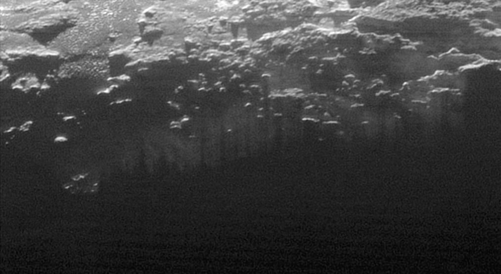
This image of haze layers above Pluto limb was taken by NASA New Horizons spacecraft. About 20 haze layers are seen.

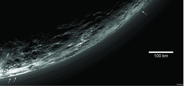
In September, NASA's New Horizons team released a stunning but incomplete image of Pluto's crescent. Thanks to new processing work by the science team, New Horizons is releasing the entire, breathtaking image of Pluto. This image was made just 15 minutes after New Horizons' closest approach to Pluto on July 14, 2015, as the spacecraft looked back at Pluto toward the sun. The wide-angle perspective of this view shows the deep haze layers of Pluto's atmosphere extending all the way around Pluto, revealing the silhouetted profiles of rugged plateaus on the night (left) side. The shadow of Pluto cast on its atmospheric hazes can also be seen at the uppermost part of the disk. On the sunlit side of Pluto (right), the smooth expanse of the informally named icy plain Sputnik Planum is flanked to the west (above, in this orientation) by rugged mountains up to 11,000 feet (3,500 meters) high, including the informally named Norgay Montes in the foreground and Hillary Montes on the skyline. Below (east) of Sputnik, rougher terrain is cut by apparent glaciers. The backlighting highlights more than a dozen high-altitude layers of haze in Pluto's tenuous atmosphere. The horizontal streaks in the sky beyond Pluto are stars, smeared out by the motion of the camera as it tracked Pluto. The image was taken with New Horizons' Multi-spectral Visible Imaging Camera (MVIC) from a distance of 11,000 miles (18,000 kilometers) to Pluto. The resolution is 700 meters (0.4 miles).

As one NASA spacecraft sailed past the distant ice world of Pluto, collecting never-before-seen vistas and invaluable science data, another spacecraft turned its gaze in that direction from its outpost at Saturn. NASA's Cassini spacecraft took a momentary break from its duties to capture this far-off portrait around the time of the New Horizons encounter with Pluto. The image was taken within a few minutes of New Horizons' closest approach to Pluto. After New Horizons, Cassini was the closest spacecraft to Pluto at the time of the flyby. Pluto is the bright dot closest to the center of the field of stars seen in this view. A labeled version of the image, indicating Pluto's position, is also presented here. The four stars identified in the labeled view have visual magnitudes between about 11 and 12. The entire Pluto system -- the dwarf planet and all of its moons -- is below the resolution of this image, thus the small bright specks near the main dot representing Pluto are likely noise (possibly due to what astronomers call the point-spread function). Charon and the other moons would not be resolved at this scale. The image was obtained using the Cassini spacecraft narrow-angle camera on July 14, 2015 at a distance of about 2.4 billion miles (3.9 billion kilometers) from Pluto. http://photojournal.jpl.nasa.gov/catalog/PIA19641

This image of Pluto was taken by New Horizons' Long Range Reconnaissance Imager (LORRI) at 4:18 UT on July 9, 2015, from a range of 3.9 million miles (6.3 million kilometers). It reveals new details on the surface of Pluto, including complex patterns in the transition between the very dark equatorial band (nicknamed "the whale"), which occupies the lower part of the image, and the brighter northern terrain. The bright arc at the bottom of the disk shows that there is more bright terrain beyond the southern margin of the "whale." The side of Pluto that will be studied in great detail during the close encounter on July 14 is now rotating off the visible disk on the right hand side, and will not be seen again until shortly before closest approach. Three consecutive images were combined and sharpened, using a process called deconvolution, to create this view. Deconvolution enhances real detail but can also generate spurious features, including the bright edge seen on the upper and left margins of the disk (though the bright margin on the bottom of the disk is real). The wireframe globe shows the orientation of Pluto in the image: thicker lines indicate the equator and the prime meridian (the direction facing Charon). Central longitude on Pluto is 86°. http://photojournal.jpl.nasa.gov/catalog/PIA19705
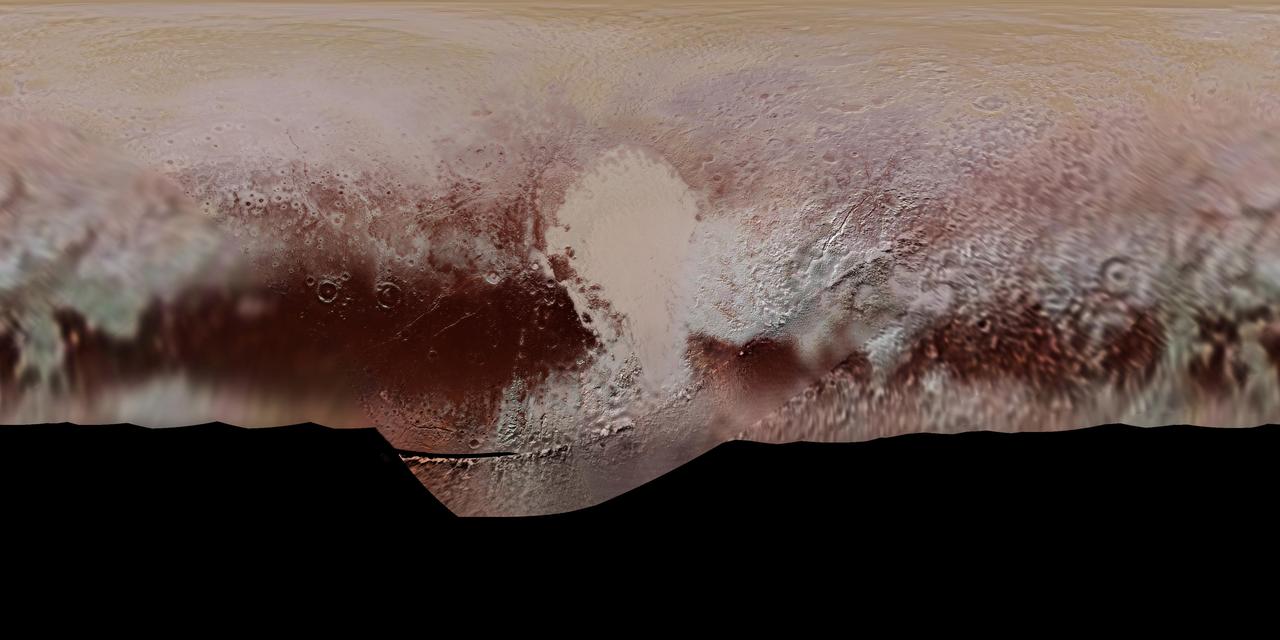
This new, detailed global mosaic color map of Pluto is based on a series of three color filter images obtained by the Ralph/Multispectral Visual Imaging Camera aboard New Horizons during the NASA spacecraft's close flyby of Pluto in July 2015. The mosaic shows how Pluto's large-scale color patterns extend beyond the hemisphere facing New Horizons at closest approach- which were imaged at the highest resolution. North is up; Pluto's equator roughly bisects the band of dark red terrains running across the lower third of the map. Pluto's giant, informally named Sputnik Planitia glacier - the left half of Pluto's signature "heart" feature -- is at the center of this map. http://photojournal.jpl.nasa.gov/catalog/PIA11707
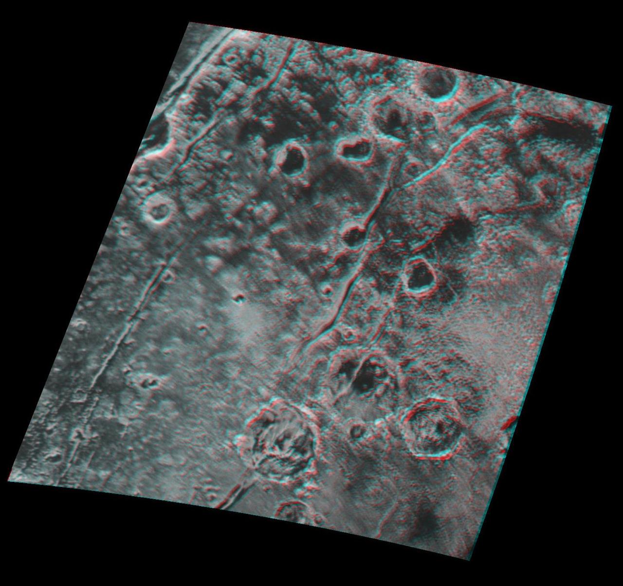
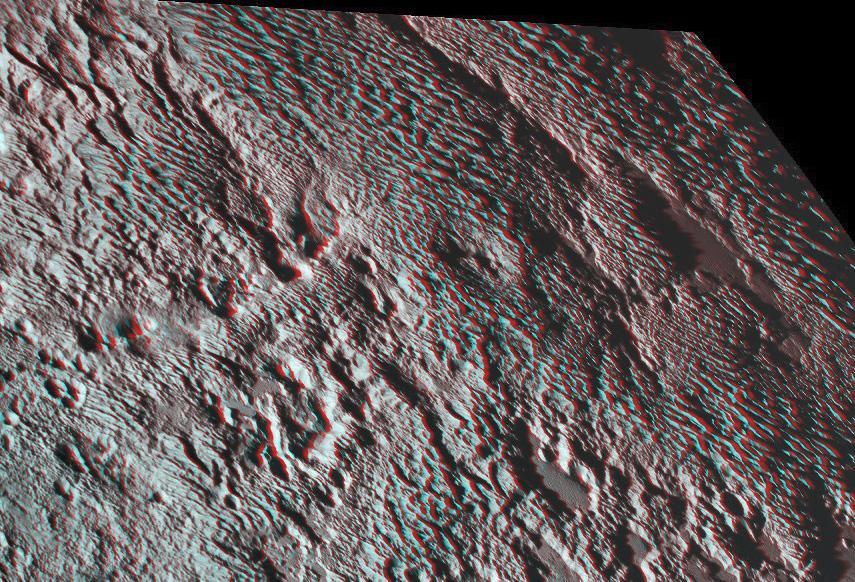
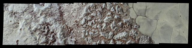
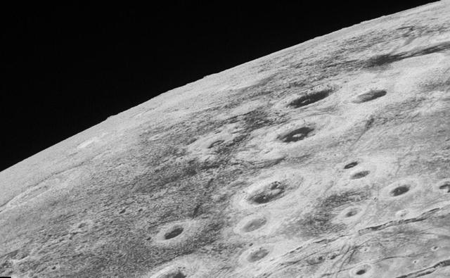
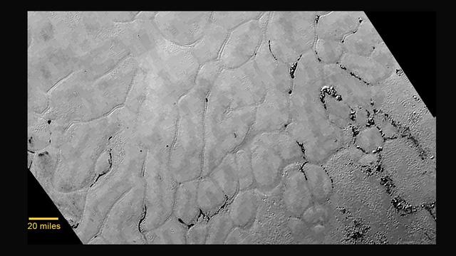
Global stereo mapping of Pluto surface is now possible, as images taken from multiple directions are downlinked from NASA New Horizons spacecraft. Stereo images will eventually provide an accurate topographic map of most of the hemisphere of Pluto seen by New Horizons during the July 14 flyby, which will be key to understanding Pluto's geological history. This example, which requires red/blue stereo glasses for viewing, shows a region 180 miles (300 kilometers) across, centered near longitude 130 E, latitude 20 N (the red square in the global context image). North is to the upper left. The image shows an ancient, heavily cratered region of Pluto, dotted with low hills and cut by deep fractures, which indicate extension of Pluto's crust. Analysis of these stereo images shows that the steep fracture in the upper left of the image is about 1 mile (1.6 kilometers) deep, and the craters in the lower right part of the image are up to 1.3 miles (2.1 km) deep. Smallest visible details are about 0.4 miles (0.6 kilometers) across. You will need 3D glasses to view this image showing an ancient, heavily cratered region of Pluto. http://photojournal.jpl.nasa.gov/catalog/PIA20032
NASA New Horizons spacecraft took this image of Pluto vast nitrogen ice plain informally named Sputnik Planum.

Pluto nearly fills the frame in this image from the Long Range Reconnaissance Imager (LORRI) aboard New Horizons, taken on July 13, 2015, when the spacecraft was 476,000 miles (768,000 kilometers) from the surface. This is the last and most detailed image sent to Earth before the spacecraft's closest approach to Pluto on July 14. The color image has been combined with lower-resolution color information from the Ralph instrument that was acquired earlier on July 13. http://photojournal.jpl.nasa.gov/catalog/PIA20291

Four images from NASA's New Horizons' Long Range Reconnaissance Imager (LORRI) were combined with color data from the Ralph instrument to create this global view of Pluto. (The lower right edge of Pluto in this view currently lacks high-resolution color coverage.) The images, taken when the spacecraft was 280,000 miles (450,000 kilometers) away, show features as small as 1.4 miles (2.2 kilometers), twice the resolution of the single-image view taken on July 13. http://photojournal.jpl.nasa.gov/catalog/PIA19857

This synthetic perspective view of Pluto, based on the latest high-resolution images to be downlinked from NASA's New Horizons spacecraft, shows what you would see if you were approximately 1,100 miles (1,800 kilometers) above Pluto's equatorial area, looking northeast over the dark, cratered, informally named Cthulhu Regio toward the bright, smooth, expanse of icy plains informally called Sputnik Planum. The entire expanse of terrain seen in this image is 1,100 miles (1,800 kilometers) across. The images were taken as New Horizons flew past Pluto on July 14, 2015, from a distance of 50,000 miles (80,000 kilometers). http://photojournal.jpl.nasa.gov/catalog/PIA19937

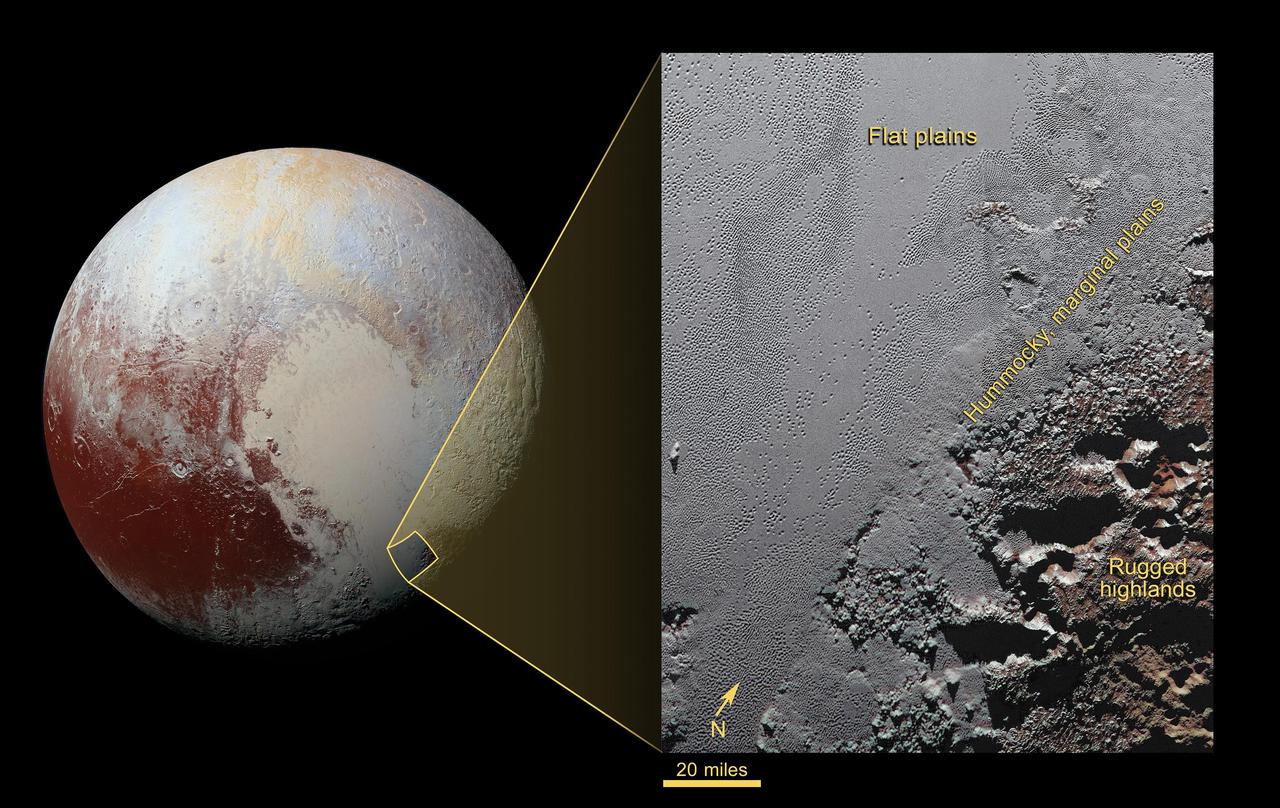
NASA New Horizons scientists believe that the informally named feature Wright Mons, located south of Sputnik Planum on Pluto, and another, Piccard Mons, could have been formed by the cryovolcanic eruption of ices from beneath Pluto surface. Sputnik Planum on Pluto, is an unusual feature that's about 100 miles (160 kilometers) wide and 13,000 feet (4 kilometers) high. It displays a summit depression (visible in the center of the image) that's approximately 35 miles (56 kilometers) across, with a distinctive hummocky texture on its sides. The rim of the summit depression also shows concentric fracturing. http://photojournal.jpl.nasa.gov/catalog/PIA20155
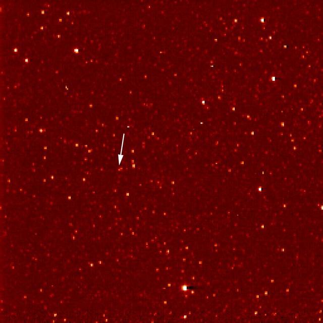
A white arrow marks Pluto in this NASA New Horizons Long Range Reconnaissance Imager picture taken Sept. 21, 2006. Pluto is little more than a faint point of light among a dense field of stars.
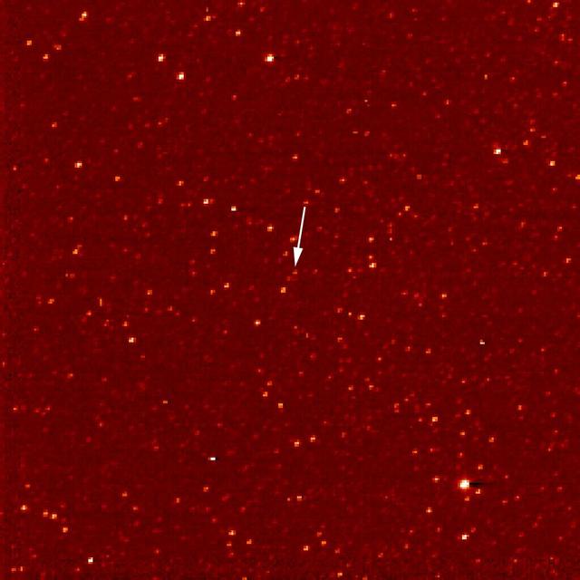
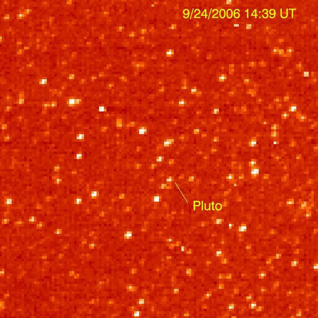
A white arrow marks Pluto in this NASA New Horizons Long Range Reconnaissance Imager picture taken Sept. 24, 2006. Pluto is little more than a faint point of light among a dense field of stars.

NASA's New Horizons spacecraft took this stunning image of Pluto only a few minutes after closest approach on July 14, 2015. The image was obtained at a high phase angle -- that is, with the sun on the other side of Pluto, as viewed by New Horizons. Seen here, sunlight filters through and illuminates Pluto's complex atmospheric haze layers. The southern portions of the nitrogen ice plains informally named Sputnik Planum, as well as mountains of the informally named Norgay Montes, can also be seen across Pluto's crescent at the top of the image. Looking back at Pluto with images like this gives New Horizons scientists information about Pluto's hazes and surface properties that they can't get from images taken on approach. The image was obtained by New Horizons' Ralph/Multispectral Visual Imaging Camera (MVIC) approximately 13,400 miles (21,550 kilometers) from Pluto, about 19 minutes after New Horizons' closest approach. The image has a resolution of 1,400 feet (430 meters) per pixel. Pluto's diameter is 1,475 miles (2,374 kilometers). The inset at top right in the annotated version shows a detail of Pluto's crescent, including an intriguing bright wisp (near the center) measuring tens of miles across that may be a discreet, low-lying cloud in Pluto's atmosphere; if so, it would be the only one yet identified in New Horizons imagery. This cloud -- if that's what it is -- is visible for the same reason the haze layers are so bright: illumination from the sunlight grazing Pluto's surface at a low angle. Atmospheric models suggest that methane clouds can occasionally form in Pluto's atmosphere. The scene in this inset is 140 miles (230 kilometers) across. The inset at bottom right shows more detail on the night side of Pluto. This terrain can be seen because it is illuminated from behind by hazes that silhouette the of the annotated version limb. The topography here appears quite rugged, and broad valleys and sharp peaks with relief totaling 3 miles (5 kilometers) are apparent. This image, made from closer range, is much better than the lower-resolution images of this same terrain taken several days before closest approach. These silhouetted terrains therefore act as a useful "anchor point," giving New Horizons scientists a rare, detailed glimpse at the lay of the land in this mysterious part of Pluto seen at high resolution only in twilight. The scene in this inset is 460 miles (750 kilometers) wide. http://photojournal.jpl.nasa.gov/catalog/PIA20727

In addition to transmitting new high-resolution images and other data on the familiar close-approach hemispheres of Pluto and Charon, NASA's New Horizons spacecraft is also returning images -- such as this one -- to improve maps of other regions. This image was taken by the New Horizons Long Range Reconnaissance Imager (LORRI) on the morning of July 13, 2015, from a range of 1.03 million miles (1.7 million kilometers) and has a resolution of 5.1 miles (8.3 kilometers) per pixel. It provides fascinating new details to help the science team map the informally named Krun Macula (the prominent dark spot at the bottom of the image) and the complex terrain east and northeast of Pluto's "heart" (Tombaugh Regio). Pluto's north pole is on the planet's disk at the 12 o'clock position of this image. http://photojournal.jpl.nasa.gov/catalog/PIA20037
One of the strangest landforms spotted by NASA New Horizons spacecraft when it flew past Pluto last July was the bladed terrain just east of Tombaugh Regio, the informal name given to Pluto large heart-shaped surface feature.
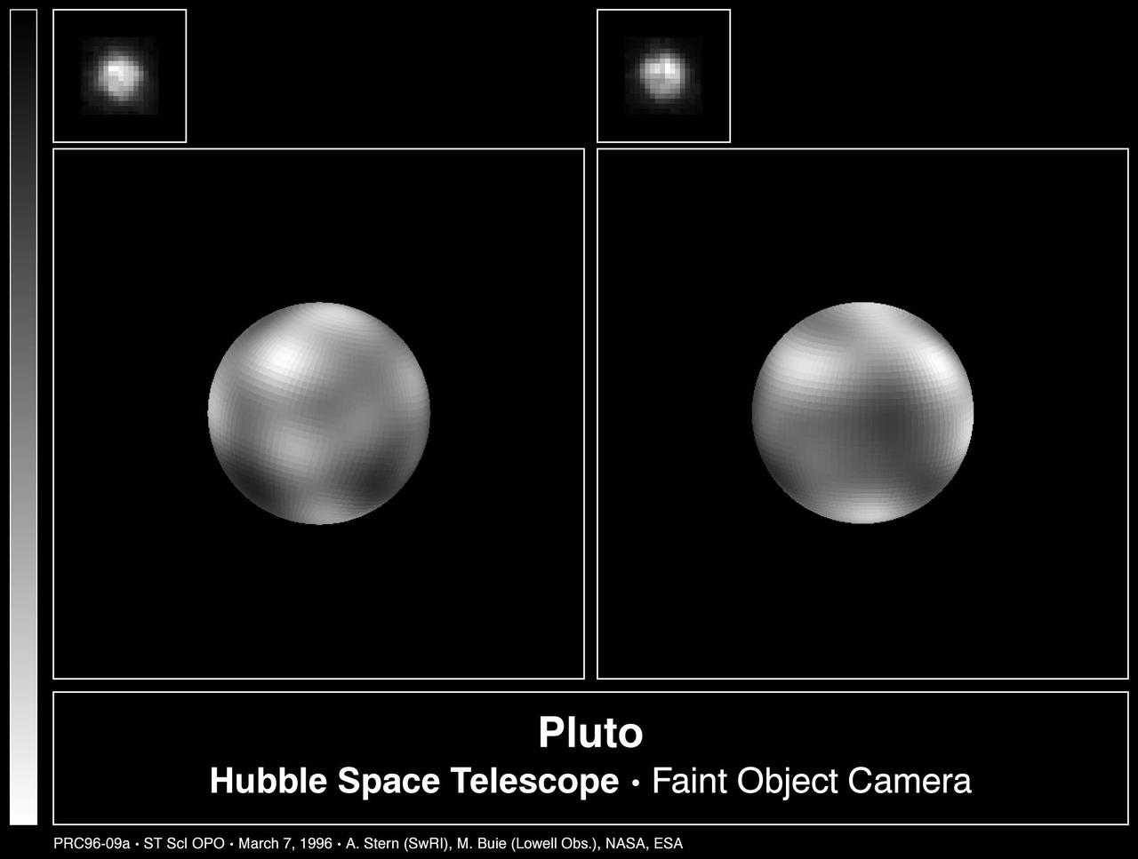
The never-before-seen surface of the distant planet Pluto is resolved in these NASA Hubble Space Telescope pictures, taken with the European Space Agency Faint Object Camera FOC aboard Hubble.
This cylindrical projection map of Pluto, in enhanced, extended color, is the most detailed color map of Pluto ever made by NASA New Horizons. It uses recently returned color imagery from the New Horizons Ralph camera, which is draped onto a base map of images from the NASA's spacecraft's Long Range Reconnaissance Imager (LORRI). The map can be zoomed in to reveal exquisite detail with high scientific value. Color variations have been enhanced to bring out subtle differences. Colors used in this map are the blue, red, and near-infrared filter channels of the Ralph instrument. http://photojournal.jpl.nasa.gov/catalog/PIA19956

This recently received panchromatic image of Pluto's small satellite Nix taken by the Multispectral Visible Imaging Camera (MVIC) aboard New Horizons is one of the best images of Pluto's third-largest moon generated by the NASA mission. Taken on July 14, 2015, at a range of about 14,000 miles (23,000 kilometers) from Nix, the illuminated surface is about 12 miles (19 kilometers) by 29 miles (47 kilometers). The unique perspective of this image provides new details about Nix's geologic history and impact record. http://photojournal.jpl.nasa.gov/catalog/PIA20287

In the early morning hours of July 8, 2015, mission scientists received this new view of Pluto -- the most detailed yet returned by the Long Range Reconnaissance Imager (LORRI) aboard New Horizons. The image was taken on July 7, when the NASA spacecraft was just under 5 million miles (8 million kilometers) from Pluto, and is the first to be received since the July 4 anomaly that sent the spacecraft into safe mode. This view is centered roughly on the area that will be seen close-up during New Horizons' July 14 closest approach. This side of Pluto is dominated by three broad regions of varying brightness. Most prominent are an elongated dark feature at the equator, informally known as "the whale," and a large heart-shaped bright area measuring some 1,200 miles (2,000 kilometers) across on the right. Above those features is a polar region that is intermediate in brightness. http://photojournal.jpl.nasa.gov/catalog/PIA19702
NASA New Horizons spacecraft captured this image of a chain of snow-capped mountains stretching across the dark expanse on Pluto informally named Cthulhu Regio.

New Horizons' Long Range Reconnaissance Imager (LORRI) obtained these three images of Pluto between July 1-3 ,2015, as the spacecraft closed in on its July 14 encounter with the dwarf planet and its moons. The left image shows, on the right side of the disk, a large bright area on the hemisphere opposite Charon; this is the side of Pluto that will be seen in close-up by New Horizons on July 14. The three images together show the full extent of a continuous swath of dark terrain that wraps around Pluto's equatorial region between longitudes 40° and 160°. The western end of the swath, west of longitude 40°, breaks up into a series of striking dark regularly-spaced spots on the anti-Charon hemisphere (right image) that were first noted in New Horizons images taken on Pluto's previous rotation. Intriguing details are beginning to emerge in the bright material north of the dark region, in particular a series of bright and dark patches that are conspicuous just below the center of the disk in the right-hand image. In all three black-and-white views, the apparent jagged bottom edge of Pluto is the result of image processing. http://photojournal.jpl.nasa.gov/catalog/PIA19698
Pluto's bladed terrain as seen from NASA's New Horizons during its July 2015 flyby. https://photojournal.jpl.nasa.gov/catalog/PIA21965
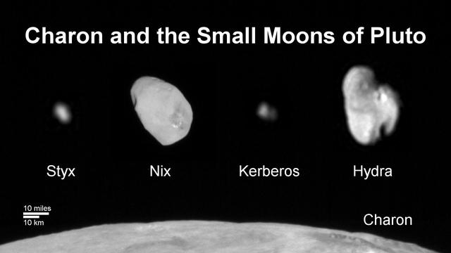
This composite image shows a sliver of Pluto large moon, Charon, and all four of Pluto small moons, as resolved by the Long Range Reconnaissance Imager (LORRI) on the New Horizons spacecraft. All the moons are displayed with a common intensity stretch and spatial scale (see scale bar). Charon is by far the largest of Pluto's moons, with a diameter of 751 miles (1,212 kilometers). Nix and Hydra have comparable sizes, approximately 25 miles (40 kilometers) across in their longest dimension above. Kerberos and Styx are much smaller and have comparable sizes, roughly 6-7 miles (10-12 kilometers) across in their longest dimension. All four small moons have highly elongated shapes, a characteristic thought to be typical of small bodies in the Kuiper Belt. http://photojournal.jpl.nasa.gov/catalog/PIA20033
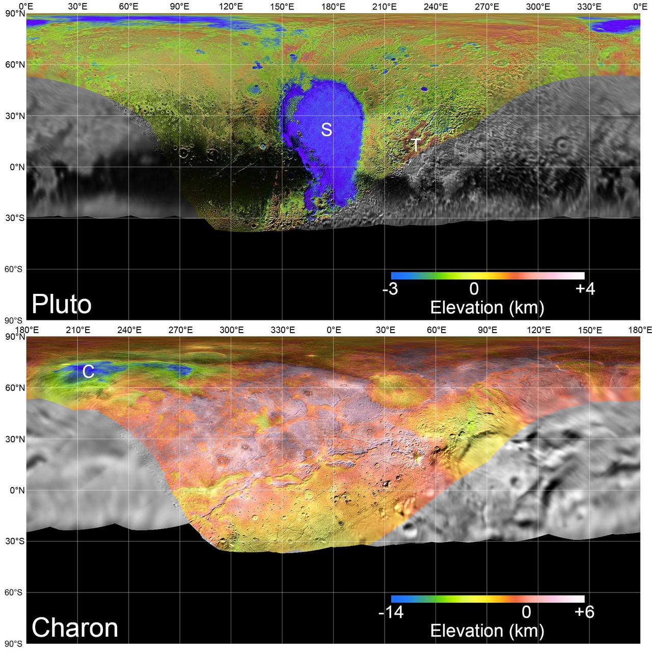
Global mosaics of Pluto and Charon projected at 300 meters (985 feet) per pixel that have been assembled from most of the highest resolution images obtained by the Long-Range Reconnaissance Imager (LORRI) and the Multispectral Visible Imaging Camera (MVIC) onboard New Horizons. Transparent, colorized stereo topography data generated for the encounter hemispheres of Pluto and Charon have been overlain on the mosaics. Terrain south of about 30°S on Pluto and Charon was in darkness leading up to and during the flyby, so is shown in black. "S" and "T" respectively indicate Sputnik Planitia and Tartarus Dorsa on Pluto, and "C" indicates Caleuche Chasma on Charon. All feature names on Pluto and Charon are informal. https://photojournal.jpl.nasa.gov/catalog/PIA21862
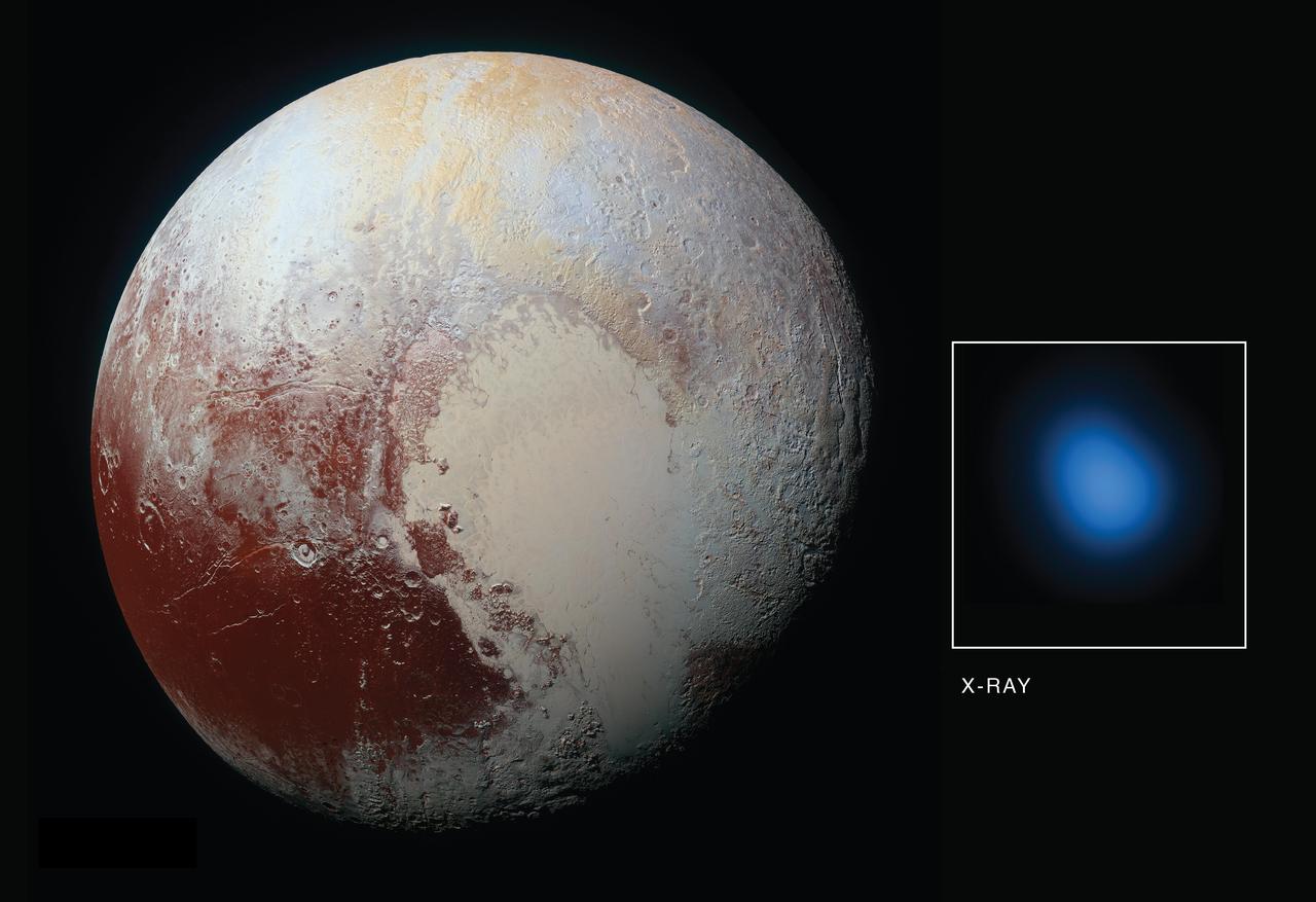
The first detection of Pluto in X-rays has been made using NASA's Chandra X-ray Observatory in conjunction with observations from NASA's New Horizons spacecraft. As New Horizons approached Pluto in late 2014 and then flew by the planet during the summer of 2015, Chandra obtained data during four separate observations. During each observation, Chandra detected low-energy X-rays from the small planet. The main panel in this graphic is an optical image taken from New Horizons on its approach to Pluto, while the inset shows an image of Pluto in X-rays from Chandra. There is a significant difference in scale between the optical and X-ray images. New Horizons made a close flyby of Pluto but Chandra is located near the Earth, so the level of detail visible in the two images is very different. The Chandra image is 180,000 miles across at the distance of Pluto, but the planet is only 1,500 miles across. Pluto is detected in the X-ray image as a point source, showing the sharpest level of detail available for Chandra or any other X-ray observatory. This means that details over scales that are smaller than the X-ray source cannot be seen here. Detecting X-rays from Pluto is a somewhat surprising result given that Pluto - a cold, rocky world without a magnetic field - has no natural mechanism for emitting X-rays. However, scientists knew from previous observations of comets that the interaction between the gases surrounding such planetary bodies and the solar wind - the constant streams of charged particles from the sun that speed throughout the solar system -- can create X-rays. The researchers were particularly interested in learning more about the interaction between the gases in Pluto's atmosphere and the solar wind. The New Horizon spacecraft carries an instrument designed to measure that activity up-close -- Solar Wind Around Pluto (SWAP) -- and scientists examined that data and proposed that Pluto contains a very mild, close-in bowshock, where the solar wind first "meets" Pluto (similar to a shock wave that forms ahead of a supersonic aircraft) and a small wake or tail behind the planet. The immediate mystery is that Chandra's readings on the brightness of the X-rays are much higher than expected from the solar wind interacting with Pluto's atmosphere. The Chandra detection is also surprising since New Horizons discovered Pluto's atmosphere was much more stable than the rapidly escaping, "comet-like" atmosphere that many scientists expected before the spacecraft flew past in July 2015. In fact, New Horizons found that Pluto's interaction with the solar wind is much more like the interaction of the solar wind with Mars, than with a comet. While Pluto is releasing enough gas from its atmosphere to make the observed X-rays, there isn't enough solar wind flowing directly at Pluto at its great distance from the Sun to make them according to certain theoretical models. There are several suggested possibilities for the enhanced X-ray emission from Pluto. These include a much wider and longer tail of gases trailing Pluto than New Horizons detected using its SWAP instrument. Because Pluto is so small compared to the size of a Chandra point source, scientists may be unable to detect such a tail in X-rays. Other possibilities are that interplanetary magnetic fields are focusing more particles than expected from the solar wind into the region around Pluto, or the low density of the solar wind in the outer solar system at the distance of Pluto could allow for the formation of a doughnut, or torus, of neutral gas centered around Pluto's orbit. It will take deeper and higher resolution images of X-rays from Pluto's environment than we currently have from Chandra to distinguish between these possibilities. http://photojournal.jpl.nasa.gov/catalog/PIA21061
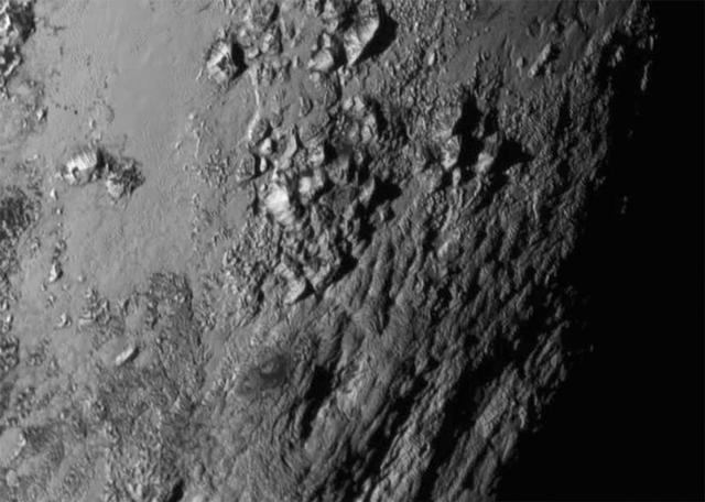
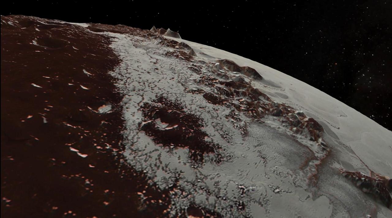
New close-up images of a region near Pluto's equator reveal a giant surprise: a range of youthful mountains rising as high as 11,000 feet (3,500 meters) above the surface of the icy body. The mountains likely formed no more than 100 million years ago -- mere youngsters relative to the 4.56-billion-year age of the solar system -- and may still be in the process of building. That suggests the close-up region, which covers less than one percent of Pluto's surface, may still be geologically active today. The youthful age estimate is based on the lack of craters in this scene. Like the rest of Pluto, this region would presumably have been pummeled by space debris for billions of years and would have once been heavily cratered -- unless recent activity had given the region a facelift, erasing those pockmarks. Unlike the icy moons of giant planets, Pluto cannot be heated by gravitational interactions with a much larger planetary body. Some other process must be generating the mountainous landscape. The mountains are probably composed of Pluto's water-ice "bedrock." Although methane and nitrogen ice covers much of the surface of Pluto, these materials are not strong enough to build the mountains. Instead, a stiffer material, most likely water-ice, created the peaks. The close-up image was taken about 1.5 hours before New Horizons closest approach to Pluto, when the craft was 47,800 miles (770,000 kilometers) from the surface of the planet. The image easily resolves structures smaller than a mile across. http://photojournal.jpl.nasa.gov/catalog/PIA19710
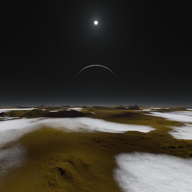
Just how dim is the sunlight on Pluto, some three billion miles away? This artist concept of the frosty surface of Pluto with Charon and our sun as backdrops illustrates that while sunlight is much weaker than it is here on Earth, it isnt as dark as you might expect. http://photojournal.jpl.nasa.gov/catalog/PIA19682
This highest-resolution image from NASA's New Horizons spacecraft shows how erosion and faulting has sculpted this portion of Pluto's icy crust into rugged badlands. The prominent 1.2-mile-high cliff at the top, running from left to upper right, is part of a great canyon system that stretches for hundreds of miles across Pluto's northern hemisphere. New Horizons team members think that the mountains in the middle are made of water ice, but have been modified by the movement of nitrogen or other exotic ice glaciers over long periods of time, resulting in a muted landscape of rounded peaks and intervening sets of short ridges. At the bottom of this 50-mile-wide image, the terrain transforms dramatically into a fractured and finely broken up floor at the northwest margin of the giant ice plain informally called Sputnik Planum. The top of the image is to Pluto's northwest. These images were made with the telescopic Long Range Reconnaissance Imager (LORRI) aboard New Horizons, in a timespan of about a minute centered on 11:36 UT on July 14 -- just about 15 minutes before New Horizons' closest approach to Pluto -- from a range of just 10,000 miles (17,000 kilometers). They were obtained with an unusual observing mode; instead of working in the usual "point and shoot," LORRI snapped pictures every three seconds while the Ralph/Multispectral Visual Imaging Camera (MVIC) aboard New Horizons was scanning the surface. This mode requires unusually short exposures to avoid blurring the images. http://photojournal.jpl.nasa.gov/catalog/PIA20199
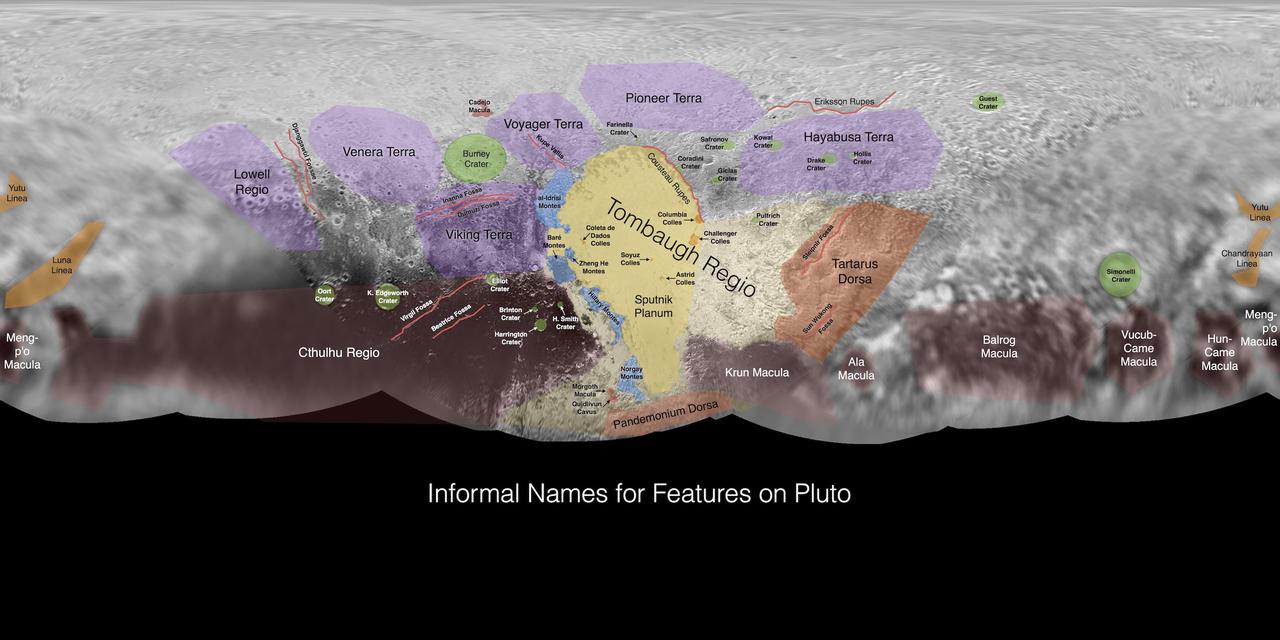
This image contains the initial, informal names being used by NASA's New Horizons team for the features and regions on the surface of Pluto. Names were selected based on the input the team received from the Our Pluto naming campaign. Names have not yet been approved by the International Astronomical Union (IAU). For more information on the maps and feature naming, visit http://www.ourpluto.org/maps. http://photojournal.jpl.nasa.gov/catalog/PIA19863

NASA's New Horizons spacecraft captured this high-resolution enhanced color view of Pluto on July 14, 2015. The image combines blue, red and infrared images taken by the Ralph/Multispectral Visual Imaging Camera (MVIC). Pluto's surface sports a remarkable range of subtle colors, enhanced in this view to a rainbow of pale blues, yellows, oranges, and deep reds. Many landforms have their own distinct colors, telling a complex geological and climatological story that scientists have only just begun to decode. The image resolves details and colors on scales as small as 0.8 miles (1.3 kilometers). http://photojournal.jpl.nasa.gov/catalog/PIA19952

What would it be like to actually land on Pluto? This image is one of more than 100 images taken by NASA's New Horizons spacecraft over six weeks of approach and close flyby in the summer of 2015. A video offers a trip down onto the surface of Pluto -- starting with a distant view of Pluto and its largest moon, Charon -- and leading up to an eventual ride in for a "landing" on the shoreline of Pluto's informally named Sputnik Planitia. After a 9.5-year voyage covering more than three billion miles, New Horizons flew through the Pluto system on July 14, 2015, coming within 7,800 miles (12,500 kilometers) of Pluto. Carrying powerful telescopic cameras that could spot features smaller than a football field, New Horizons sent back hundreds of images of Pluto and its moons that show how dynamic and fascinating their surfaces are. Movies are available at http://photojournal.jpl.nasa.gov/catalog/PIA11709

Pluto has long been a mystery, a dot at our solar system’s margins. The best images, even with NASA’s Hubble Space Telescope, were fuzzy and pixelated. In July 2015, NASA’s New Horizons spacecraft flew past Pluto and captured the sharpest views of the dwarf planet to date. One of the most striking areas, informally named "Sputnik Planum," is a sweeping, frozen plain the size of Texas and ringed by mountains of ice. Its smooth deposits are unmarred by impact craters, a stark contrast to the rest of Pluto’s battered surface. As a result, scientists believe the region formed recently, within the last few hundred million years. This contradicts past depictions of Pluto as an unchanging world. By analyzing images taken during the flyby, scientists hope to unravel more of the dwarf planet’s history. Watch the video for an up-close look at Pluto. Credit: NASA's Goddard Space Flight Center Video courtesy of NASA/Johns Hopkins University Applied Physics Laboratory/Southwest Research Institute/S. Robbins

A pair of small moons photographed by NASA Hubble Space Telescope discovered orbiting Pluto in 2005 now have official names: Nix and Hydra.
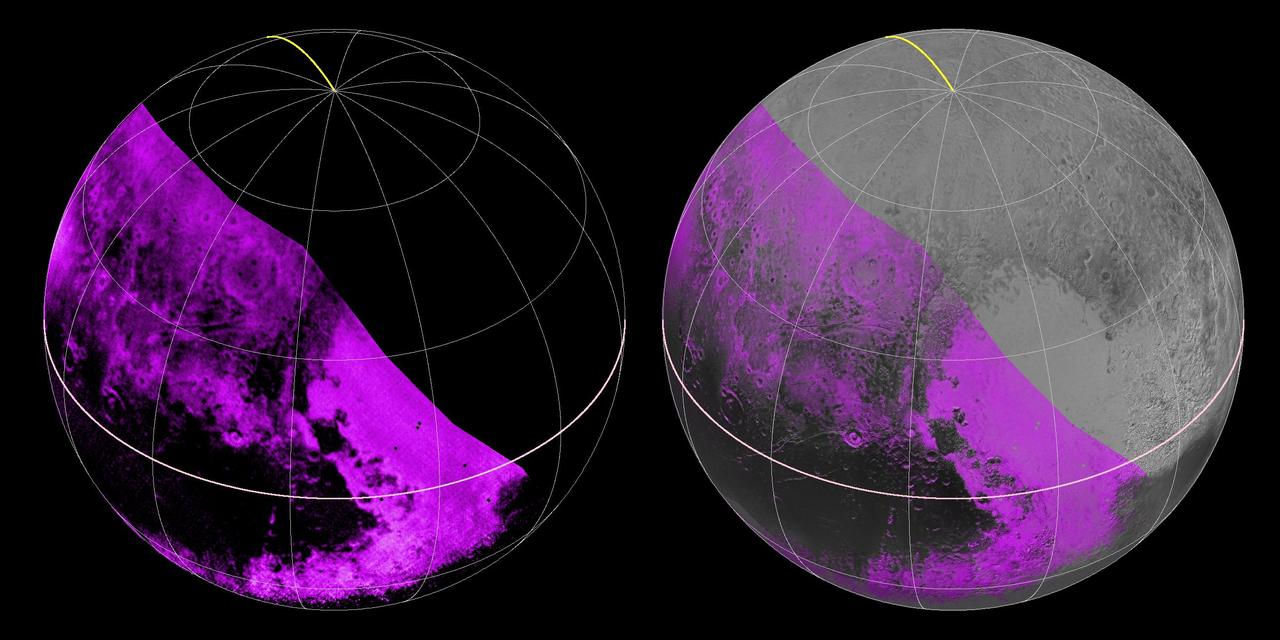
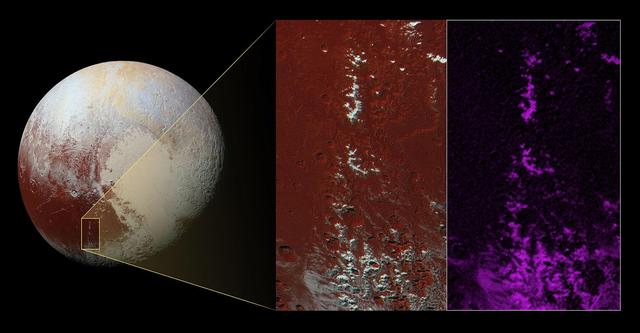
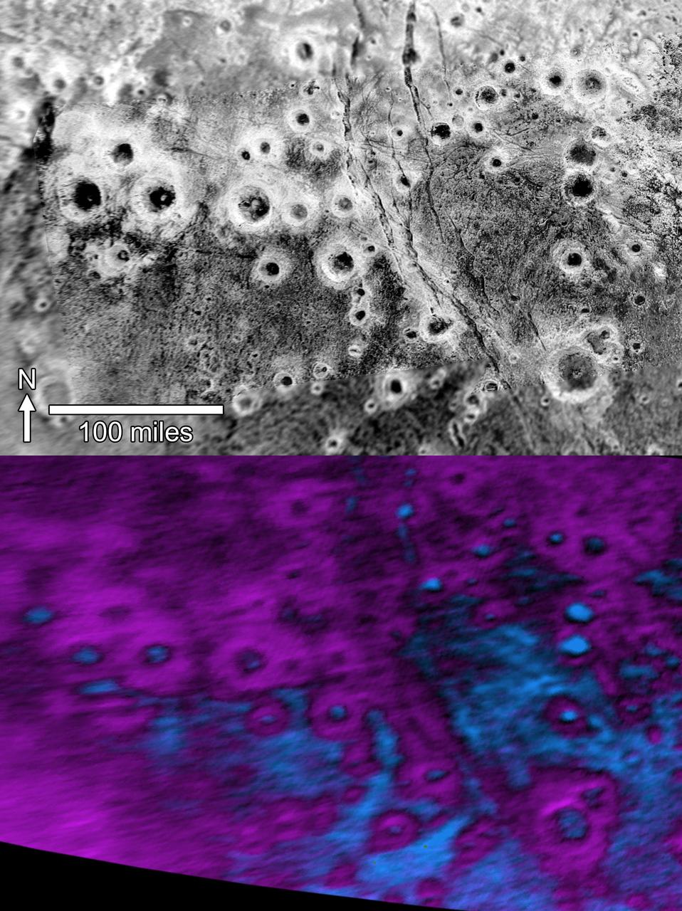
The Ralph/LEISA infrared spectrometer on NASA's New Horizons spacecraft mapped compositions across Pluto's surface as it flew past the planet on July 14, 2015. On the left, a map of methane ice abundance shows striking regional differences, with stronger methane absorption indicated by the brighter purple colors, and lower abundances shown in black. Data have only been received so far for the left half of Pluto's disk. At right, the methane map is merged with higher-resolution images from the spacecraft's Long Range Reconnaissance Imager (LORRI). http://photojournal.jpl.nasa.gov/catalog/PIA19953

Just 15 minutes after its closest approach to Pluto on July 14, 2015, NASA's New Horizons spacecraft looked back toward the sun and captured this near-sunset view of the rugged, icy mountains and flat ice plains extending to Pluto's horizon. The smooth expanse of the informally named icy plain Sputnik Planum (right) is flanked to the west (left) by rugged mountains up to 11,000 feet (3,500 meters) high, including the informally named Norgay Montes in the foreground and Hillary Montes on the skyline. To the right, east of Sputnik, rougher terrain is cut by apparent glaciers. The backlighting highlights more than a dozen layers of haze in Pluto's tenuous but distended atmosphere. The image was taken from a distance of 11,000 miles (18,000 kilometers) to Pluto; the scene is 780 miles (1,250 kilometers) wide. http://photojournal.jpl.nasa.gov/catalog/PIA19948
Within Pluto informally named Vega Terra region is a field of eye-catching craters that looks like a cluster of bright halos scattered across a dark landscape as seen by NASA New Horizons.
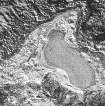
NASA New Horizons spacecraft captured this feature which appears to be a frozen, former lake of liquid nitrogen, located in a mountain range just north of Pluto informally named Sputnik Planum.
NASA New Horizons scientists have spotted an expanse of terrain they describe as fretted bright plains divided into polygon-shaped blocks by a network of dark, connected valleys in Pluto informally named Venera Terra region.

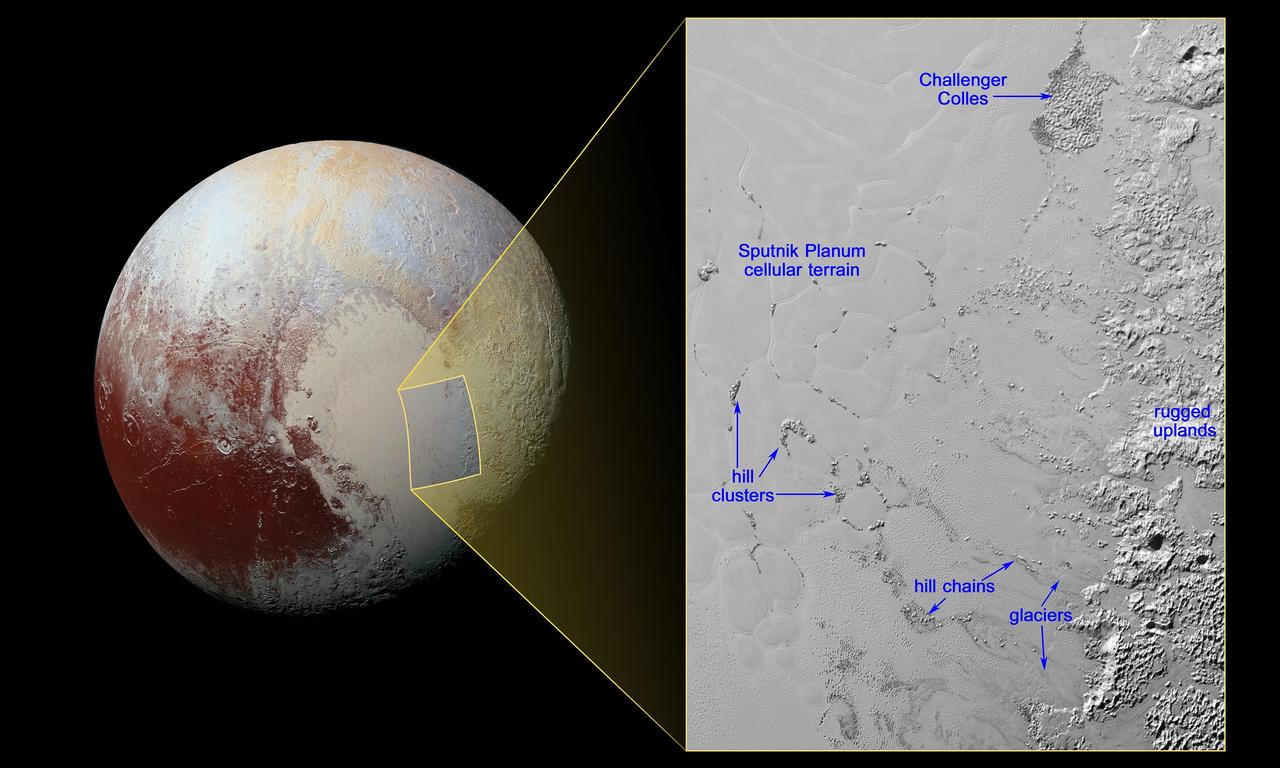
This geological map from NASA New Horizons covers a portion of Pluto surface and includes the vast nitrogen-ice plain informally named Sputnik Planum and surrounding terrain.

An unusual geological feature resembling a giant spider sprawls across Pluto icy landscape in this enhanced color image was obtained by NASA New Horizons spacecraft on July 14, 2015.

The red outline in this global view of Pluto from NASA New Horizons marks the large area of mysterious, bladed terrain extending from the eastern section of the large feature informally named Tombaugh Regio.

Four images from New Horizons Long Range Reconnaissance Imager LORRI were combined with color data from the spacecraft Ralph instrument to create this enhanced color global view of Pluto.

This is the highest-resolution color departure shot of Pluto's receding crescent from NASA's New Horizons spacecraft, taken when the spacecraft was 120,000 miles (200,000 kilometers) away from Pluto. Shown in approximate true color, the picture was constructed from a mosaic of six black-and-white images from the Long Range Reconnaissance Imager (LORRI), with color added from a lower resolution Ralph/Multispectral Visible Imaging Camera (MVIC) color image, all acquired between 15:20 and 15:45 UT -- about 3.5 hours after closest approach to Pluto -- on July 14, 2015. The resolution of the LORRI images is about 0.6 miles (1 kilometer) per pixel; the sun illuminates the scene from the other side of Pluto and somewhat toward the top of this image. The image is dominated by spectacular layers of blue haze in Pluto's atmosphere. Scientists believe the haze is a photochemical smog resulting from the action of sunlight on methane and other molecules in Pluto's atmosphere, producing a complex mixture of hydrocarbons such as acetylene and ethylene. These hydrocarbons accumulate into small haze particles, a fraction of a micrometer in size, which preferentially scatter blue sunlight -- the same process that can make haze appear bluish on Earth. As they settle down through the atmosphere, the haze particles form numerous intricate, horizontal layers, some extending for hundreds of miles around large portions of the limb of Pluto. The haze layers extend to altitudes of over 120 miles (200 kilometers). Pluto's circumference is 4,667 miles (7,466 kilometers). Adding to the beauty of this picture are mountains and other topographic features on Pluto's surface that are silhouetted against the haze near the top of the image. Sunlight casts dramatic and beautiful finger-like shadows from many of these features onto the haze (especially on the left, near the 11 o'clock position), forming crepuscular rays like those often seen in Earth's atmosphere near sunrise or sunset. https://photojournal.jpl.nasa.gov/catalog/PIA21590
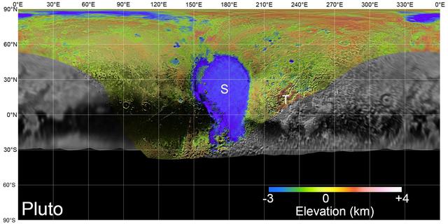
On July 14, 2015, NASA's New Horizons spacecraft made its historic flight through the Pluto system. This detailed, high-quality global mosaic of Pluto was assembled from nearly all of the highest-resolution images obtained by the Long-Range Reconnaissance Imager (LORRI) and the Multispectral Visible Imaging Camera (MVIC) on New Horizons. The mosaic is the most detailed and comprehensive global view yet of Pluto's surface using New Horizons data. It includes topography data of the hemisphere visible to New Horizons during the spacecraft's closest approach. The topography is derived from digital stereo-image mapping tools that measure the parallax -- or the difference in the apparent relative positions -- of features on the surface obtained at different viewing angles during the encounter. Scientists use these parallax displacements of high and low terrain to estimate landform heights. The global mosaic has been overlain with transparent, colorized topography data wherever on the surface stereo data is available. Terrain south of about 30°S was in darkness leading up to and during the flyby, so is shown in black. Examples of large-scale topographic features on Pluto include the vast expanse of very flat, low-elevation nitrogen ice plains of Sputnik Planitia ("P") -- note that all feature names in the Pluto system are informal -- and, on the eastern edge of the encounter hemisphere, the aligned, high-elevation ridges of Tartarus Dorsa ("T") that host the enigmatic bladed terrain, mountains, possible cryovolcanos, canyons, craters and more. https://photojournal.jpl.nasa.gov/catalog/PIA21861
This enhanced color mosaic combines some of the sharpest views of Pluto that NASA's New Horizons spacecraft obtained during its July 14 flyby. The pictures are part of a sequence taken near New Horizons' closest approach to Pluto, with resolutions of about 250-280 feet (77-85 meters) per pixel -- revealing features smaller than half a city block on Pluto's surface. Lower resolution color data (at about 2,066 feet, or 630 meters, per pixel) were added to create this new image. The images form a strip 50 miles (80 kilometers) wide, trending (top to bottom) from the edge of "badlands" northwest of the informally named Sputnik Planum, across the al-Idrisi mountains, onto the shoreline of Pluto's "heart" feature, and just into its icy plains. They combine pictures from the telescopic Long Range Reconnaissance Imager (LORRI) taken approximately 15 minutes before New Horizons' closest approach to Pluto, with -- from a range of only 10,000 miles (17,000 kilometers) -- with color data (in near-infrared, red and blue) gathered by the Ralph/Multispectral Visible Imaging Camera (MVIC) 25 minutes before the LORRI pictures. The wide variety of cratered, mountainous and glacial terrains seen here gives scientists and the public alike a breathtaking, super-high-resolution color window into Pluto's geology. e border between the relatively smooth Sputnik Planum ice sheet and the pitted area, with a series of hills forming slightly inside this unusual "shoreline." http://photojournal.jpl.nasa.gov/catalog/PIA20213

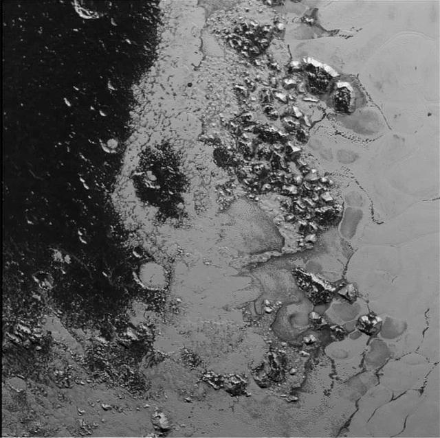
This enhanced color view from NASA's New Horizons spacecraft zooms in on the southeastern portion of Pluto's great ice plains, where at lower right the plains border rugged, dark highlands informally named Krun Macula. Krun Macula -- Krun is the lord of the underworld in the Mandaean religion, and a macula is a dark feature on a planetary surface -- is believed to get its dark red color from tholins, complex molecules found across Pluto. Krun Macula rises 1.5 miles (2.5 kilometers) above the surrounding plain -- informally named Sputnik Planum -- and is scarred by clusters of connected, roughly circular pits that typically reach between 5 and 8 miles (8 and 13 kilometers) across, and up to 1.5 miles (2.5 kilometers) deep. At the boundary with Sputnik Planum, these pits form deep valleys reaching more than 25 miles (40 kilometers) long, 12.5 miles (20 kilometers) wide and almost 2 miles (3 kilometers) deep (almost twice as deep as the Grand Canyon in Arizona), and have floors covered with nitrogen ice. New Horizons scientists think these pits may have formed through surface collapse, although what may have prompted such a collapse is a mystery. This scene was created using three separate observations made by New Horizons in July 2015. The right half of the image is composed of 260 feet- (80 meter-) per-pixel data from the Long Range Reconnaissance Imager (LORRI), obtained at 9,850 miles (15,850 kilometers) from Pluto, about 23 minutes before New Horizons' closest approach. The left half is composed of 410 feet- (125 meter-) per-pixel LORRI data, obtained about six minutes earlier, with New Horizons 15,470 miles (24,900 kilometers) from Pluto. These data respectively represent portions of the highest- and second-highest-resolution observations obtained by New Horizons in the Pluto system. The entire scene was then colorized using 2230 feet- (680 meter-) per-pixel data from New Horizons' Ralph/Multispectral Visual Imaging Camera (MVIC), obtained at 21,100 miles (33,900 kilometers) from Pluto, about 45 minutes before closest approach. http://photojournal.jpl.nasa.gov/catalog/PIA20732
This enhanced color view from NASA's New Horizons spacecraft zooms in on the southeastern portion of Pluto's great ice plains, where at lower right the plains border rugged, dark highlands informally named Krun Macula. Krun Macula -- Krun is the lord of the underworld in the Mandaean religion, and a macula is a dark feature on a planetary surface -- is believed to get its dark red color from tholins, complex molecules found across Pluto. Krun Macula rises 1.5 miles (2.5 kilometers) above the surrounding plain -- informally named Sputnik Planum -- and is scarred by clusters of connected, roughly circular pits that typically reach between 5 and 8 miles (8 and 13 kilometers) across, and up to 1.5 miles (2.5 kilometers) deep. At the boundary with Sputnik Planum, these pits form deep valleys reaching more than 25 miles (40 kilometers) long, 12.5 miles (20 kilometers) wide and almost 2 miles (3 kilometers) deep (almost twice as deep as the Grand Canyon in Arizona), and have floors covered with nitrogen ice. New Horizons scientists think these pits may have formed through surface collapse, although what may have prompted such a collapse is a mystery. This scene was created using three separate observations made by New Horizons in July 2015. The right half of the image is composed of 260 feet- (80 meter-) per-pixel data from the Long Range Reconnaissance Imager (LORRI), obtained at 9,850 miles (15,850 kilometers) from Pluto, about 23 minutes before New Horizons' closest approach. The left half is composed of 410 feet- (125 meter-) per-pixel LORRI data, obtained about six minutes earlier, with New Horizons 15,470 miles (24,900 kilometers) from Pluto. These data respectively represent portions of the highest- and second-highest-resolution observations obtained by New Horizons in the Pluto system. The entire scene was then colorized using 2230 feet- (680 meter-) per-pixel data from New Horizons' Ralph/Multispectral Visual Imaging Camera (MVIC), obtained at 21,100 miles (33,900 kilometers) from Pluto, about 45 minutes before closest approach. http://photojournal.jpl.nasa.gov/catalog/PIA20733
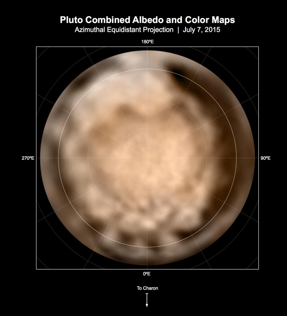
These circular maps shows the distribution of Pluto's dark and bright terrains as revealed by NASA's New Horizons mission prior to July 4, 2015. Each map is an azimuthal equidistant projection centered on the north pole, with latitude and longitude indicated. Both a gray-scale and color version are shown. The gray-scale version is based on 7 days of panchromatic imaging from the Long Range Reconnaissance Imager (LORRI), whereas the color version uses the gray-scale base and incorporates lower-resolution color information from the Multi-spectral Visible Imaging Camera (MVIC), part of the Ralph instrument. The color version is also shown in a simple cylindrical projection in PIA19700. In these maps, the polar bright terrain is surrounded by a somewhat darker polar fringe, one whose latitudinal position varies strongly with longitude. Especially striking are the much darker regions along the equator. A broad dark swath ("the whale") stretches along the equator from approximately 20 to 160 degrees of longitude. Several dark patches appear in a regular sequence centered near 345 degrees of longitude. A spectacular bright region occupies Pluto's mid-latitudes near 180 degrees of longitude, and stretches southward over the equator. New Horizons' closest approach to Pluto will occur near this longitude, which will permit high-resolution visible imaging and compositional mapping of these various regions. http://photojournal.jpl.nasa.gov/catalog/PIA19706

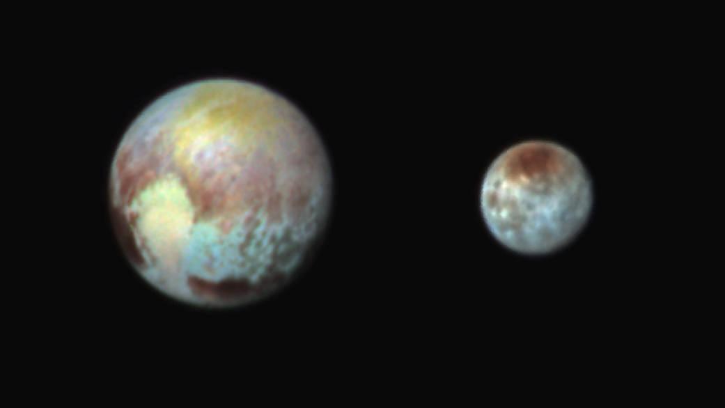
These two images of Pluto and Charon were collected separately by NASA New Horizons during approach on July 13 and July 14, 2015. The relative reflectivity, size, separation, and orientations, and colors are approximated in this composite image, and they are shown in approximate true color. http://photojournal.jpl.nasa.gov/catalog/PIA19717

Pluto's present, hazy atmosphere is almost entirely free of clouds, though scientists from NASA's New Horizons mission have identified some cloud candidates after examining images taken by the New Horizons Long Range Reconnaissance Imager and Multispectral Visible Imaging Camera, during the spacecraft's July 2015 flight through the Pluto system. All are low-lying, isolated small features -- no broad cloud decks or fields -- and while none of the features can be confirmed with stereo imaging, scientists say they are suggestive of possible, rare condensation clouds. http://photojournal.jpl.nasa.gov/catalog/PIA21127
This shaded relief view from NASA New Horizons of the region surrounding the left side of Pluto heart-shaped feature, informally named Sputnik Planum, shows that the vast expanse of its icy surface.
Pluto shows two remarkably different sides in these color images of the planet and its largest moon, Charon, taken by NASA New Horizons on June 25 and June 27, 2015. http://photojournal.jpl.nasa.gov/catalog/PIA20292

This ethereal scene captured by NASA New Horizons spacecraft tells yet another story of Pluto diversity of geological and compositional features-this time in an enhanced color image of the north polar area.
This July 13, 2015, image of Pluto and Charon is presented in false colors to make differences in surface material and features easy to see. It was obtained by the Ralph instrument on NASA's New Horizons spacecraft, using three filters to obtain color information, which is exaggerated in the image. These are not the actual colors of Pluto and Charon, and the apparent distance between the two bodies has been reduced for this side-by-side view. The image reveals that the bright heart-shaped region of Pluto includes areas that differ in color characteristics. The western lobe, shaped like an ice-cream cone, appears peach color in this image. A mottled area on the right (east) appears bluish. Even within Pluto's northern polar cap, in the upper part of the image, various shades of yellow-orange indicate subtle compositional differences. The surface of Charon is viewed using the same exaggerated color. The red on the dark northern polar cap of Charon is attributed to hydrocarbon materials including a class of chemical compounds called tholins. The mottled colors at lower latitudes point to the diversity of terrains on Charon. This image was taken at 3:38 a.m. EDT on July 13, one day before New Horizons' closest approach to Pluto. http://photojournal.jpl.nasa.gov/catalog/PIA19707
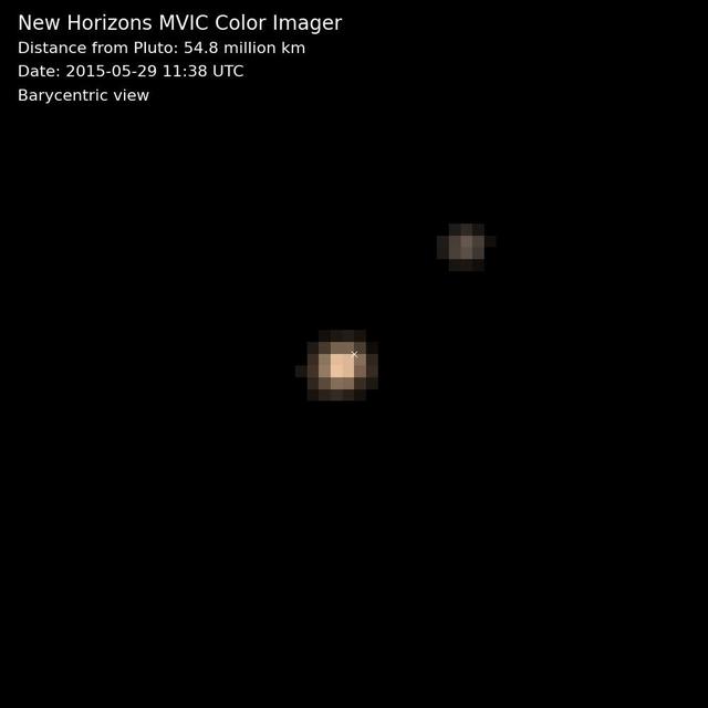
The first color movies from NASA's New Horizons mission show Pluto and its largest moon, Charon, and the complex orbital dance of the two bodies, known as a double planet. A near-true color movie was assembled from images made in three colors -- blue, red and near-infrared -- by the Multispectral Visible Imaging Camera on the instrument known as Ralph. The images were taken on nine different occasions from May 29-June 3, 2015. The movie is barycentric, meaning that both Pluto and Charon are shown in motion around the binary's barycenter -- the shared center of gravity between the two bodies as they do a planetary jig. Because Pluto is much more massive than Charon, the barycenter (marked by a small "x" in the movie) is much closer to Pluto than to Charon. Looking closely at the images in this movie, one can detect a regular shift in Pluto's brightness-due to the brighter and darker terrains on its differing faces. http://photojournal.jpl.nasa.gov/catalog/PIA19688
In July 2015, NASA's New Horizons spacecraft sent home the first close-up pictures of Pluto and its moons. Using actual New Horizons data and digital elevation models of Pluto and its largest moon, Charon, mission scientists created flyover movies that offer spectacular new perspectives of the many unusual features that were discovered and which have reshaped our views of the Pluto system -- from a vantage point even closer than a ride on New Horizons itself. The dramatic Pluto flyover begins over the highlands to the southwest of the great expanse of nitrogen ice plain informally named Sputnik Planitia. (Note that all feature names in the Pluto system are informal.) The viewer first passes over the western margin of Sputnik, where it borders the dark, cratered terrain of Cthulhu Macula, with the blocky mountain ranges located within the planitia seen on the right. The tour moves north past the rugged and fractured highlands of Voyager Terra and then turns southward over Pioneer Terra, which exhibits deep and wide pits, before concluding over the bladed terrain of Tartarus Dorsa in the far east of the encounter hemisphere. The topographic relief is exaggerated by a factor of 2 to 3 in these movies to emphasize topography; the surface colors have also been enhanced to bring out detail. Digital mapping and rendering were performed by Paul Schenk and John Blackwell of the Lunar and Planetary Institute in Houston. A video can be viewed at https://photojournal.jpl.nasa.gov/catalog/PIA21863
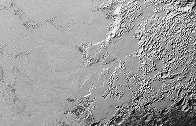
This high-resolution swat of Pluto sweeps over the cratered plains at the west of the New Horizons' encounter hemisphere and across numerous prominent faults, skimming the eastern margin of the dark, forbidding region informally known as Cthulhu Regio, and finally passing over the mysterious, possibly cryovolcanic edifice Wright Mons, before reaching the terminator or day-night line. Among the many notable details shown are the overlapping and infilling relationships between units of the relatively smooth, bright volatile ices from Sputnik Planum (at the edge of the mosaic) and the dark edge or "shore" of Cthulhu. The pictures in this mosaic were taken by the Long Range Reconnaissance Imager (LORRI) in "ride-along" mode with the LEISA spectrometer, which accounts for the 'zigzag' or step pattern. Taken shortly before New Horizons' July 14 closest approach to Pluto, details as small as 500 yards (500 meters) can be seen. http://photojournal.jpl.nasa.gov/catalog/PIA20286
This mosaic is composed of the sharpest views of Pluto that NASA's New Horizons spacecraft obtained during its flyby of the distant planet on July 14, 2015. The pictures are part of a sequence taken near New Horizons' closest approach to Pluto, with resolutions of about 250-280 feet (77-85 meters) per pixel -- revealing features smaller than half a city block on Pluto's diverse surface. The images include a wide variety of spectacular, cratered, mountainous and glacial terrains -- giving scientists and the public alike a breathtaking, super-high resolution window on Pluto's geology. The images form a strip 50 miles (80 kilometers) wide trending from Pluto's jagged horizon about 500 miles (800 kilometers) northwest of the informally named Sputnik Planum, across the al-Idrisi mountains, onto the shoreline of Sputnik Planum and then across its icy plains. They were made with the telescopic Long Range Reconnaissance Imager (LORRI) aboard New Horizons, over a timespan of about a minute centered on 11:36 UT on July 14 -- just about 15 minutes before New Horizons' closest approach to Pluto -- from a range of just 10,000 miles (17,000 kilometers). They were obtained with an unusual observing mode; instead of working in the usual "point and shoot," LORRI snapped pictures every three seconds while the Ralph/Multispectral Visual Imaging Camera (MVIC) aboard New Horizons was scanning the surface. This mode requires unusually short exposures to avoid blurring the images. http://photojournal.jpl.nasa.gov/catalog/PIA20201

This frame from a movie is composed of the sharpest views of Pluto that NASA's New Horizons spacecraft obtained during its flyby of the distant planet on July 14, 2015. The pictures are part of a sequence taken near New Horizons' closest approach to Pluto, with resolutions of about 250-280 feet (77-85 meters) per pixel -- revealing features smaller than half a city block on Pluto's diverse surface. The images include a wide variety of spectacular, cratered, mountainous and glacial terrains -- giving scientists and the public alike a breathtaking, super-high resolution window on Pluto's geology. The images form a strip 50 miles (80 kilometers) wide trending from Pluto's jagged horizon about 500 miles (800 kilometers) northwest of the informally named Sputnik Planum, across the al-Idrisi mountains, onto the shoreline of Sputnik Planum and then across its icy plains. They were made with the telescopic Long Range Reconnaissance Imager (LORRI) aboard New Horizons, over a timespan of about a minute centered on 11:36 UT on July 14 -- just about 15 minutes before New Horizons' closest approach to Pluto -- from a range of just 10,000 miles (17,000 kilometers). They were obtained with an unusual observing mode; instead of working in the usual "point and shoot," LORRI snapped pictures every three seconds while the Ralph/Multispectral Visual Imaging Camera (MVIC) aboard New Horizons was scanning the surface. This mode requires unusually short exposures to avoid blurring the images. http://photojournal.jpl.nasa.gov/catalog/PIA20202

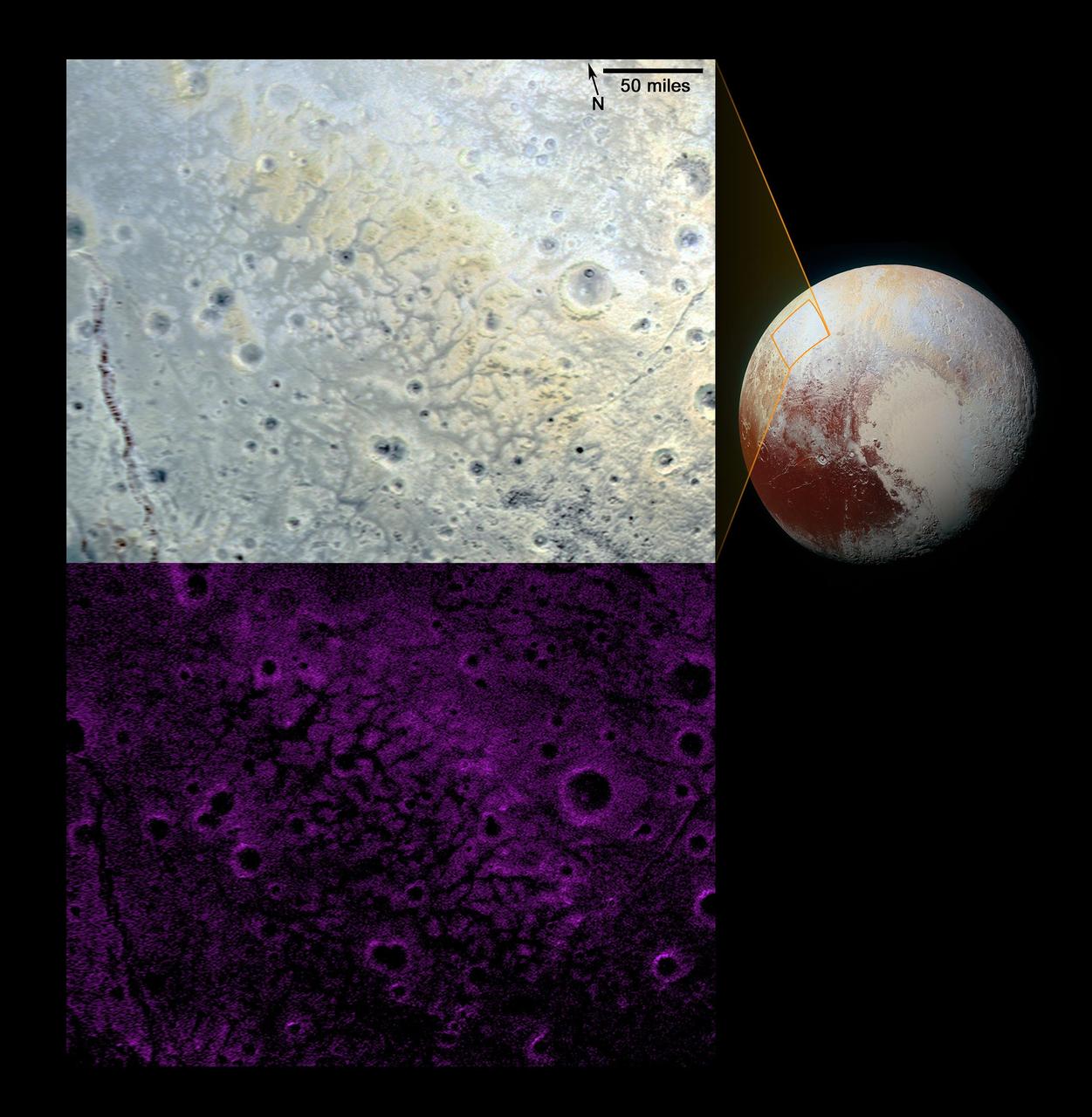
The latest spectra from New Horizons Ralph instrument reveal an abundance of methane ice, but with striking differences from place to place across the frozen surface of Pluto. In the north polar cap, methane ice is diluted in a thick, transparent slab of nitrogen ice resulting in strong absorption of infrared light. In one of the visually dark equatorial patches, the methane ice has shallower infrared absorptions indicative of a very different texture. An Earthly example of different textures of a frozen substance: a fluffy bank of clean snow is bright white, but compacted polar ice looks blue. New Horizons' surface composition team has begun the intricate process of analyzing Ralph data to determine the detailed compositions of the distinct regions on Pluto. This is the first detailed image of Pluto from the Linear Etalon Imaging Spectral Array, part of the Ralph instrument on New Horizons. The observations were made at three wavelengths of infrared light, which are invisible to the human eye. In this picture, blue corresponds to light of wavelengths 1.62 to 1.70 micrometers, a channel covering a medium-strong absorption band of methane ice, green (1.97 to 2.05 micrometers) represents a channel where methane ice does not absorb light, and red (2.30 to 2.33 micrometers) is a channel where the light is very heavily absorbed by methane ice. The two areas outlined on Pluto show where Ralph observations obtained the spectral traces at the right. Note that the methane absorptions (notable dips) in the spectrum from the northern region are much deeper than the dips in the spectrum from the dark patch. The Ralph data were obtained by New Horizons on July 12, 2015. http://photojournal.jpl.nasa.gov/catalog/PIA19712
This frame from a movie, composed of images taken by NASA New Horizons, shows Pluto as it rotates about its axis. The images were taken May 28-June 3, 2015, from distances ranging from approximately 56 million kilometers to 48.5 million kilometers.

This image contains the initial, informal names being used by NASA's New Horizons team for the features on Pluto's Sputnik Planum (plain). Names were selected based on the input the team received from the Our Pluto naming campaign. Names have not yet been approved by the International Astronomical Union (IAU). For more information on the maps and feature naming, visit http://www.ourpluto.org/maps. http://photojournal.jpl.nasa.gov/catalog/PIA19865
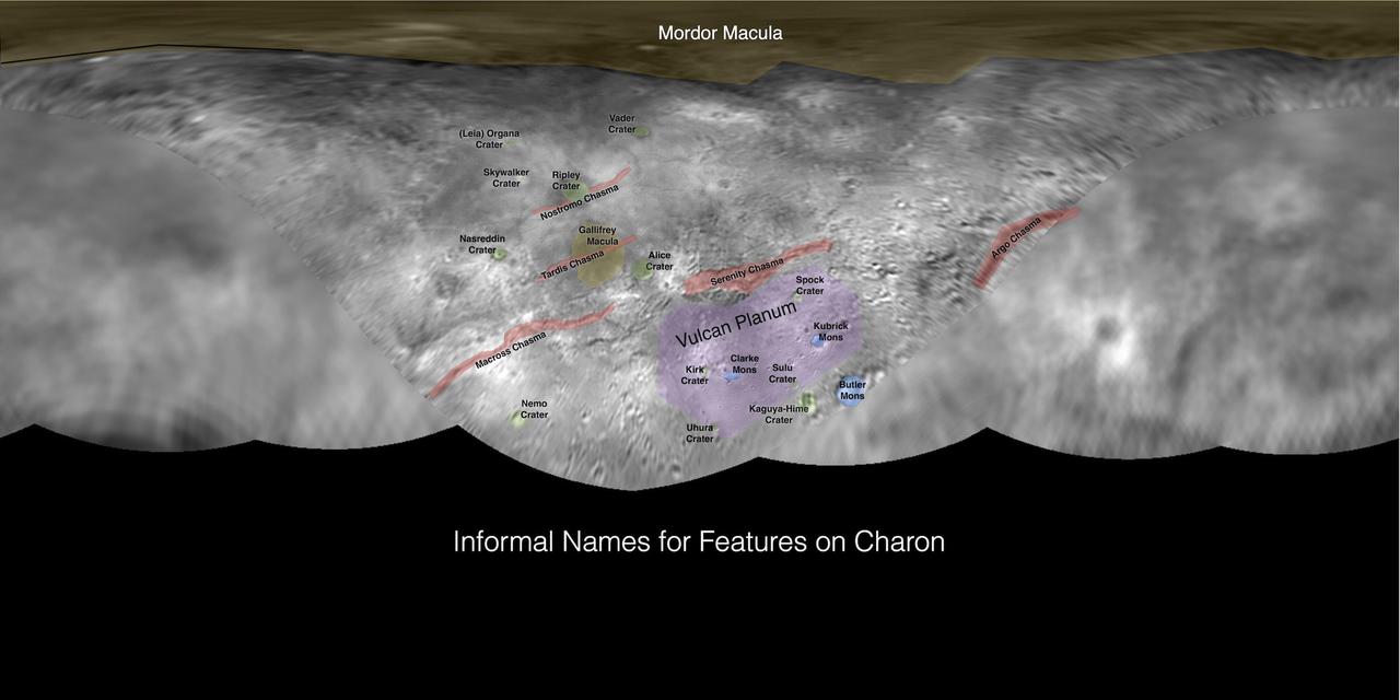
This image contains the initial, informal names being used by NASA's New Horizons team for the features on Pluto's largest moon, Charon. Names were selected based on the input the team received from the Our Pluto naming campaign. Names have not yet been approved by the International Astronomical Union (IAU). For more information on the maps and feature naming, visit http://www.ourpluto.org/maps. http://photojournal.jpl.nasa.gov/catalog/PIA19864

This processed image is the highest-resolution color look yet at the haze layers in Pluto's atmosphere. Shown in approximate true color, the picture was constructed from a mosaic of four panchromatic images from the Long Range Reconnaissance Imager (LORRI) splashed with Ralph/Multispectral Visible Imaging Camera (MVIC) four-color filter data, all acquired by NASA's New Horizons spacecraft on July 14, 2015. The resolution is 1 kilometer (0.6 miles) per pixel; the sun illuminates the scene from the right. Scientists believe the haze is a photochemical smog resulting from the action of sunlight on methane and other molecules in Pluto's atmosphere, producing a complex mixture of hydrocarbons such as acetylene and ethylene. These hydrocarbons accumulate into small particles, a fraction of a micrometer in size, and scatter sunlight to make the bright blue haze seen in this image. As they settle down through the atmosphere, the haze particles form numerous intricate, horizontal layers, some extending for hundreds of miles around Pluto. The haze layers extend to altitudes of over 200 kilometers (120 miles). Adding to the stark beauty of this image are mountains on Pluto's limb (on the right, near the 4 o'clock position), surface features just within the limb to the right, and crepuscular rays (dark finger-like shadows to the left) extending from Pluto's topographic features. http://photojournal.jpl.nasa.gov/catalog/PIA20362

This is the most detailed view to date of the entire surface of the dwarf planet Pluto, as constructed from multiple NASA Hubble Space Telescope photographs taken from 2002 to 2003.
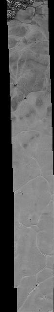
This mosaic strip, extending across the hemisphere that faced the New Horizons spacecraft as it flew past Pluto on July 14, 2015, now includes all of the highest-resolution images taken by the NASA probe.
Ice (probably frozen nitrogen) that appears to have accumulated on the uplands on the right side of this 390-mile (630-kilometer) wide image is draining from Pluto's mountains onto the informally named Sputnik Planum through the 2- to 5-mile (3- to 8- kilometer) wide valleys. The flow front of the ice moving into Sputnik Planum is outlined by the blue arrows. The origin of the ridges and pits on the right side of the image remains uncertain. http://photojournal.jpl.nasa.gov/catalog/PIA19944

Peering closely at the "heart of Pluto," in the western half of what mission scientists have informally named Tombaugh Regio (Tombaugh Region), NASA's New Horizons' Ralph instrument revealed evidence of carbon monoxide ice. The contours indicate that the concentration of frozen carbon monoxide increases towards the center of the "bull's eye." These data were acquired by the spacecraft on July 14 and transmitted to Earth on July 16. http://photojournal.jpl.nasa.gov/catalog/PIA19718
A newly discovered mountain range lies near the southwestern margin of Pluto heart-shaped Tombaugh Regio Tombaugh Region, situated between bright, icy plains and dark, heavily-cratered terrain. This image was acquired by NASA's New Horizons' Long Range Reconnaissance Imager (LORRI) on July 14, 2015, from a distance of 48,000 miles (77,000 kilometers) and sent back to Earth on July 20. Features as small as a half-mile (1 kilometer) across are visible. These frozen peaks are estimated to be one-half mile to one mile (1-1.5 kilometers) high, about the same height as the United States' Appalachian Mountains. The Norgay Montes (Norgay Mountains) discovered by New Horizons on July 15 more closely approximate the height of the taller Rocky Mountains The names of features on Pluto have all been given on an informal basis by the New Horizons team. http://photojournal.jpl.nasa.gov/catalog/PIA19842
At center left of Pluto vast heart-shaped feature "Tombaugh Regio" -- lies a vast, craterless plain that appears to be no more than 100 million years old, and is possibly still being shaped by geologic processes as seen by NASA New Horizons spacecraft. This frozen region is north of Pluto's icy mountains and has been informally named Sputnik Planum (Sputnik Plain), after Earth's first artificial satellite. The surface appears to be divided into irregularly-shaped segments that are ringed by narrow troughs. Features that appear to be groups of mounds and fields of small pits are also visible. This image was acquired by the Long Range Reconnaissance Imager (LORRI) on July 14 from a distance of 48,000 miles (77,000 kilometers). Features as small as one-half mile (1 kilometer) across are visible. The blocky appearance of some features is due to compression of the image. http://photojournal.jpl.nasa.gov/catalog/PIA19841
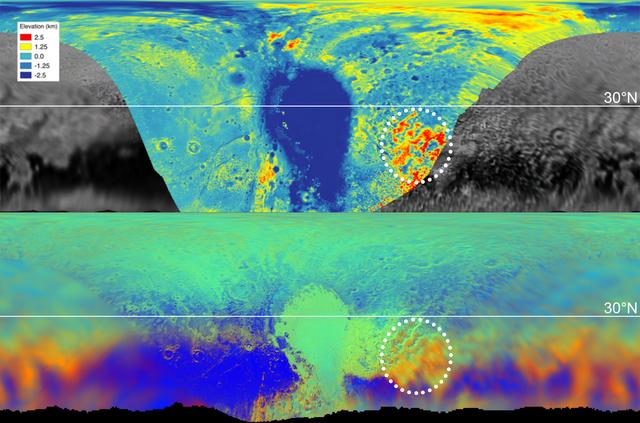
These maps are from New Horizons' data on the topography (top) and composition (bottom) of Pluto's surface. In the high-resolution topographical map, the highlighted red region is high in elevation. The map below, showing the composition, indicates the same section also contains methane, color-coded in orange. One can see the orange features spread into the fuzzier, lower-resolution data that covers the rest of the globe, meaning those areas, too, are high in methane, and therefore likely to be high in elevation. https://photojournal.jpl.nasa.gov/catalog/PIA22036
This color version of NASA's New Horizons Long Range Reconnaissance Imager (LORRI) picture of Pluto taken July 3, 2015, was created by adding color data from the Ralph instrument gathered earlier in the mission. The LORRI image was taken from a range of 7.8 million miles (12.5 million km), with a central longitude of 19°. http://photojournal.jpl.nasa.gov/catalog/PIA19699
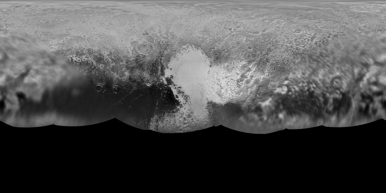
The science team of NASA's New Horizons mission has produced an updated global map of the dwarf planet Pluto. The map includes all resolved images of the surface acquired between July 7-14, 2015, at pixel resolutions ranging from 40 kilometers (24 miles) on the Charon-facing hemisphere (left and right sides of the map) to 400 meters (1,250 feet) on the anti-Charon facing hemisphere (map center). Many additional images are expected in fall of 2015 and these will be used to complete the global map. http://photojournal.jpl.nasa.gov/catalog/PIA19858

Pluto's haze layer shows its blue color in this picture taken by the New Horizons Ralph/Multispectral Visible Imaging Camera (MVIC). The high-altitude haze is thought to be similar in nature to that seen at Saturn's moon Titan. The source of both hazes likely involves sunlight-initiated chemical reactions of nitrogen and methane, leading to relatively small, soot-like particles (called tholins) that grow as they settle toward the surface. This image was generated by software that combines information from blue, red and near-infrared images to replicate the color a human eye would perceive as closely as possible. http://photojournal.jpl.nasa.gov/catalog/PIA19964
In this small section of the larger crescent image of Pluto, taken by NASA's New Horizons just 15 minutes after the spacecraft's closest approach on July 14, 2015, the setting sun illuminates a fog or near-surface haze, which is cut by the parallel shadows of many local hills and small mountains. The image was taken from a distance of 11,000 miles (18,000 kilometers), and the width of the image is 115 miles (185 kilometers). http://photojournal.jpl.nasa.gov/catalog/PIA19946

NASA's New Horizons spacecraft flew within 8,000 miles of dwarf planet Pluto on 14 July 2015. Our view of this cold, previously unexplored world, 4.67 billion miles from Earth, has evolved since its discovery by Clyde W. Tombaugh in 1930. This short clip shows images from Tombaugh, Hubble and New Horizons over the years, arranged to illustrate improvements in resolution. The close-up image at the end of this clip was taken about 1.5 hours before New Horizons closest approach to Pluto, when the craft was 47,800 miles (77,000 kilometers) from the surface of the planet. The image easily resolves structures smaller than a mile across. Credit: NASA/Goddard
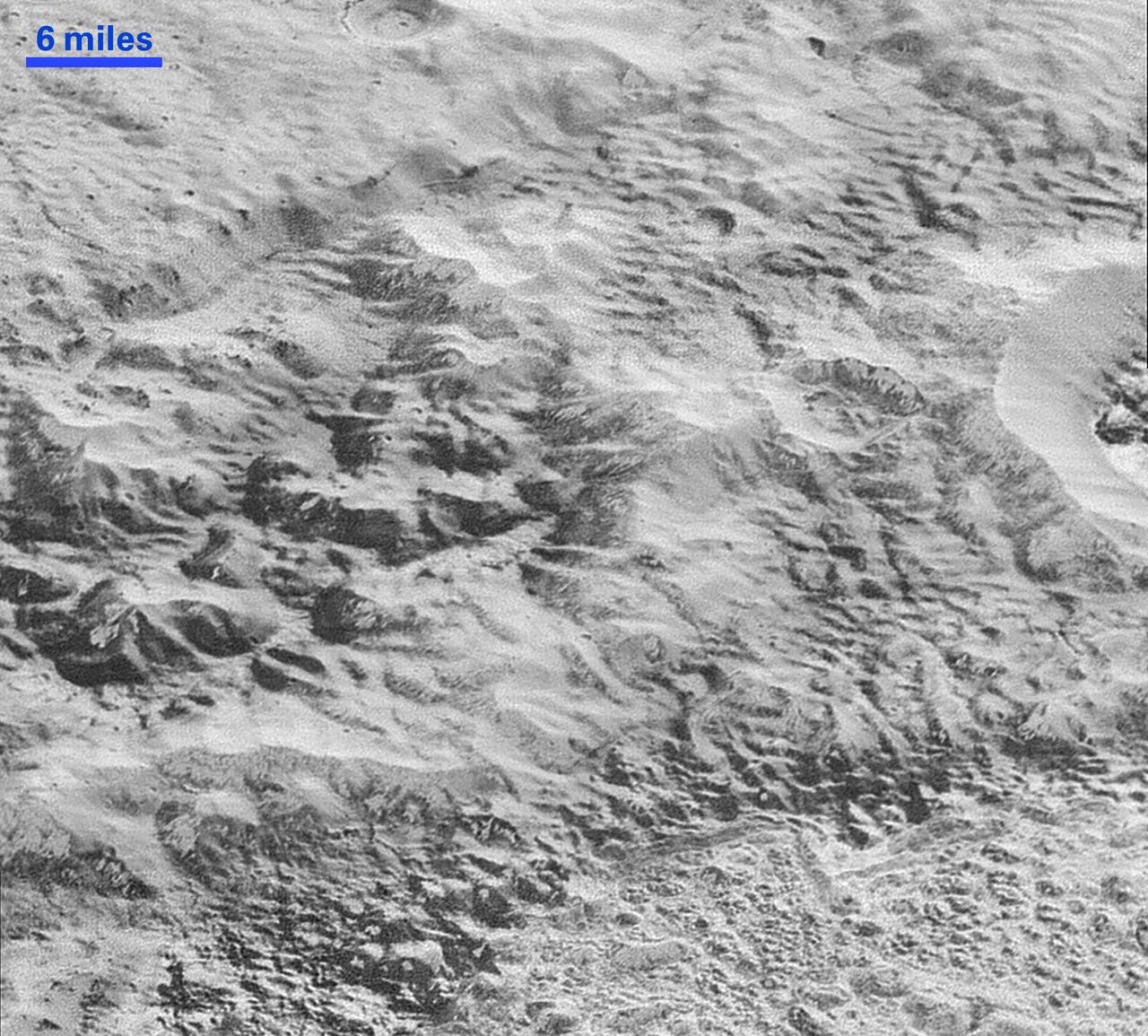
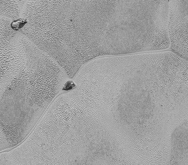
NASA's New Horizons spacecraft continues to transmit the sharpest views of Pluto that it obtained (and recorded) during its flyby of the distant planet on July 14, 2015. The newest image, returned on Dec. 24, 2015, extends New Horizons' highest-resolution swath of Pluto to the very center of the informally named Sputnik Planum, and nearly completes the set of highest-resolution images taken by New Horizons last July. The pictures are part of a sequence taken near New Horizons' closest approach to Pluto, with resolutions of about 250-280 feet (77-85 meters) per pixel -- revealing features smaller than half a city block on Pluto's surface. The images shown here form a strip 50 miles (80 kilometers) wide and more than 400 miles (700 kilometers) long, trending from the northwestern shoreline of Sputnik Planum and out across its icy plains. The images illustrate the polygonal or cellular pattern of the plains, which are thought to result from the convective churning of a deep layer solid, but mobile, nitrogen ice. The surface of Sputnik Planum appears darker toward the shore (at top), possibly implying a change in composition or surface texture. The occasional raised, darker blocks at the cell edges are probably dirty water "icebergs" floating in denser solid nitrogen. The pictures were taken with the telescopic Long Range Reconnaissance Imager (LORRI) aboard New Horizons, from a range of approximately 10,000 miles (17,000 kilometers) over a timespan of about a minute centered on 11:36 UT on July 14 -- just about 15 minutes before New Horizons' closest approach to Pluto. http://photojournal.jpl.nasa.gov/catalog/PIA20336

This is a frame from the first movie created by New Horizons to reveal color surface features of Pluto and its largest moon, Charon. "It's a bit unusual to see so much surface detail at this distance," said New Horizons co-investigator William McKinnon, a member of the mission's Geology and Geophysics Investigation team, from Washington University in Saint Louis. "What's especially noteworthy is the level of detail in both bodies. It's certainly whetting our appetite for what's to come." The images were taken between June 23 and June 29, 2015, as New Horizons' distance to Pluto decreased from a distance of 15 million to 11 million miles (24 million to 18 million kilometers). Six high-resolution black-and-white images from New Horizons' Long-Range Reconnaissance Imager (LORRI) instrument were combined with color data from the Ralph instrument to produce the movie. http://photojournal.jpl.nasa.gov/catalog/PIA19696

Like a cosmic lava lamp, a large section of Pluto's icy surface is being constantly renewed by a process called convection that replaces older surface ices with fresher material. Scientists from NASA's New Horizons mission used state-of-the-art computer simulations to show that the surface of Pluto's informally named Sputnik Planum is covered with churning ice "cells" that are geologically young and turning over due to a process called convection. The scene above, which is about 250 miles (400 kilometers) across, uses data from the New Horizons Ralph/Multispectral Visible Imaging Camera (MVIC), gathered July 14, 2015. Their findings are published in the June 2, 2016, issue of the journal Nature. http://photojournal.jpl.nasa.gov/catalog/PIA20726
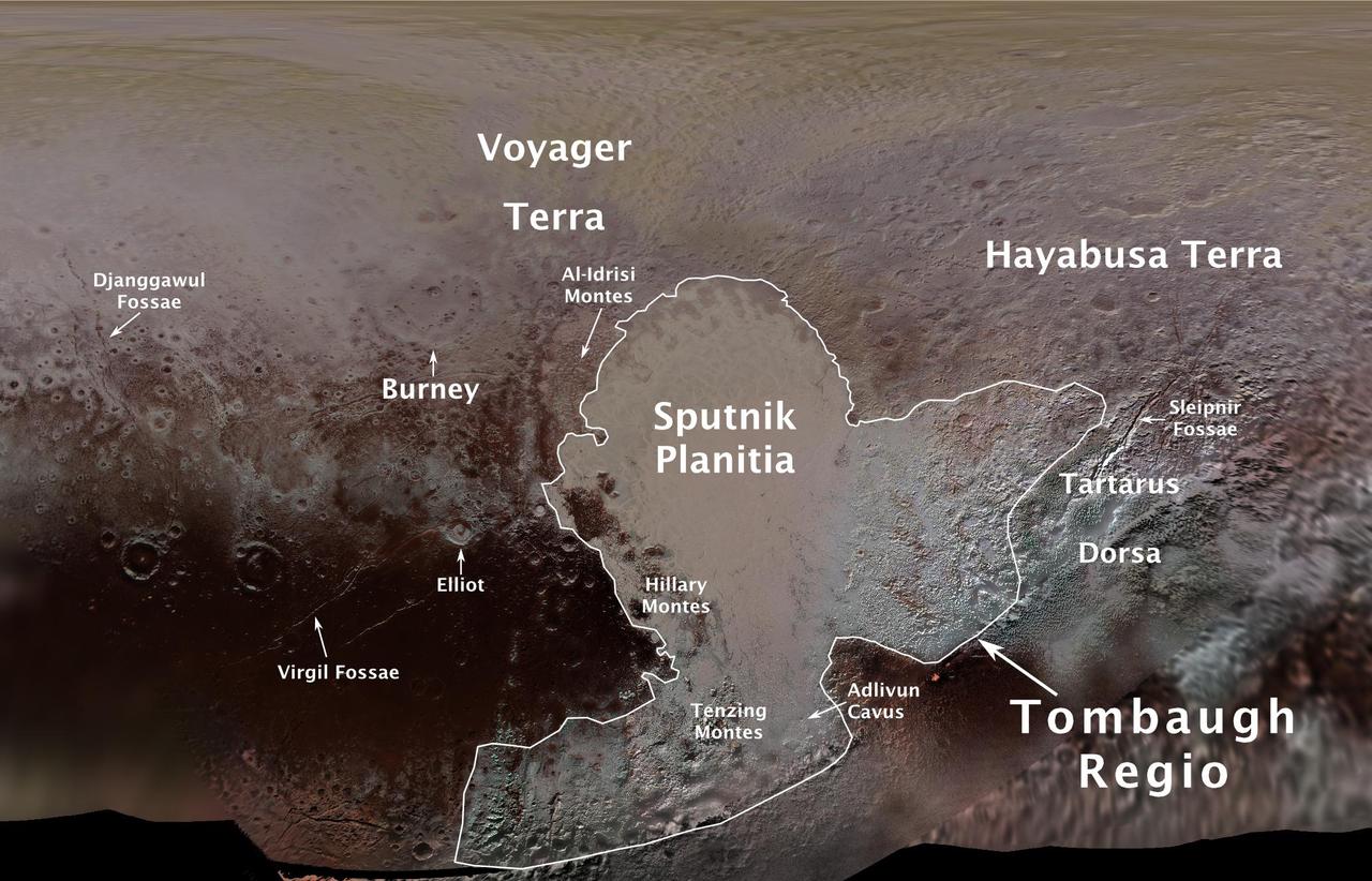
The International Astronomical Union (IAU), the internationally recognized authority for naming celestial bodies and their surface features, approved names of 14 surface features on Pluto in August 2017. The names were proposed by NASA's New Horizons team following the first reconnaissance of Pluto and its moons by the New Horizons spacecraft in 2015. The names, listed below, pay homage to the underworld mythology, pioneering space missions, historic pioneers who crossed new horizons in exploration, and scientists and engineers associated with Pluto and the Kuiper Belt. Tombaugh Regio honors Clyde Tombaugh (1906-1997), the U.S. astronomer who discovered Pluto in 1930 from Lowell Observatory in Arizona. Burney crater honors Venetia Burney (1918-2009), who as an 11-year-old schoolgirl suggested the name "Pluto" for Clyde Tombaugh's newly discovered planet. Later in life she taught mathematics and economics. Sputnik Planitia is a large plain named for Sputnik 1, the first space satellite, launched by the Soviet Union in 1957. Tenzing Montes and Hillary Montes are mountain ranges honoring Tenzing Norgay (1914-1986) and Sir Edmund Hillary (1919-2008), the Indian/Nepali Sherpa and New Zealand mountaineer were the first to reach the summit of Mount Everest and return safely. Al-Idrisi Montes honors Ash-Sharif al-Idrisi (1100-1165/66), a noted Arab mapmaker and geographer whose landmark work of medieval geography is sometimes translated as "The Pleasure of Him Who Longs to Cross the Horizons.†Djanggawul Fossae defines a network of long, narrow depressions named for the Djanggawuls, three ancestral beings in indigenous Australian mythology who traveled between the island of the dead and Australia, creating the landscape and filling it with vegetation. Sleipnir Fossa is named for the powerful, eight-legged horse of Norse mythology that carried the god Odin into the underworld. Virgil Fossae honors Virgil, one of the greatest Roman poets and Dante's fictional guide through hell and purgatory in the Divine Comedy. Adlivun Cavus is a deep depression named for Adlivun, the underworld in Inuit mythology. Hayabusa Terra is a large land mass saluting the Japanese spacecraft and mission (2003-2010) that performed the first asteroid sample return. Voyager Terra honors the pair of NASA spacecraft, launched in 1977, that performed the first "grand tour" of all four giant planets. The Voyager spacecraft are now probing the boundary between the Sun and interstellar space. Tartarus Dorsa is a ridge named for Tartarus, the deepest, darkest pit of the underworld in Greek mythology. Elliot crater recognizes James Elliot (1943-2011), an MIT researcher who pioneered the use of stellar occultations to study the solar system -- leading to discoveries such as the rings of Uranus and the first detection of Pluto's thin atmosphere. https://photojournal.jpl.nasa.gov/catalog/PIA21944

This frame from a movie, which extends across the hemisphere that faced New Horizons spacecraft as it flew past Pluto on July 14, 2015, includes all of the highest-resolution images taken by the NASA probe. With a resolution of about 260 feet (80 meters) per pixel, the movie affords New Horizons scientists and the public the best opportunity to examine the fine details of the various types of terrain the mosaic covers, and determine the processes that formed and shaped them. The view extends from the "limb" of Pluto at the top of the strip, almost to the "terminator" (or day/night line) in the southeast of the encounter hemisphere, seen at the bottom of the strip. The width of the strip ranges from more than 55 miles (90 kilometers) at its northern end to about 45 miles (75 kilometers) at its southern end. The perspective changes greatly along the strip: at its northern end, the view looks out horizontally across the surface, while at its southern end, the view looks straight down onto the surface. This movie pans down the mosaic from top to bottom, offering new views of many of Pluto's distinct landscapes along the way. Starting with hummocky, cratered uplands at top, the view crosses over parallel ridges of the "washboard" terrain; chaotic and angular mountain ranges; the craterless, cellular plains; coarsely "pitted" areas of sublimating nitrogen ice; zones of thin nitrogen ice draped over the topography below; and rugged, dark, mountainous highlands scarred by deep pits. The frames in the movie were obtained by New Horizons' Long Range Reconnaissance Imager (LORRI) approximately 9,850 miles (15,850 kilometers) from Pluto, about 23 minutes before New Horizons' closest approach. LORRI is only capable of obtaining black-and-white images; all color images are made by the Ralph instrument, which has somewhat lower resolution than LORRI. Movies are available at http://photojournal.jpl.nasa.gov/catalog/PIA14457

This image of Pluto and its largest moon, Charon, was taken by the Ralph color imager aboard NASA New Horizons spacecraft on April 9 and downlinked to Earth the following day.

Images of Pluto taken by NASA New Horizons spacecraft before closest approach on July 14, 2015, reveal features as small as 270 yards (250 meters) across, from craters to faulted mountain blocks, to the textured surface of the vast basin informally called Sputnik Planum. Enhanced color has been added from the global color image. This image is about 330 miles (530 kilometers) across. http://photojournal.jpl.nasa.gov/catalog/PIA19955
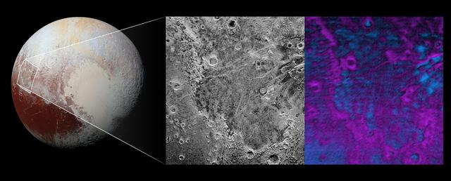
Scientists on NASA's New Horizons mission have discovered what looks like a giant bite-mark on the planet's surface. In this image, north is up. The southern portion of the left inset above shows the cratered plateau uplands informally named Vega Terra (note that all feature names are informal). This terrain is separated from the young, nearly uncratered, mottled plains of Piri Planitia in the center of the image by a generally north-facing jagged scarp called Piri Rupes. The scarp breaks up into isolated mesas in several places. Cutting diagonally across Piri Planitia is the long extensional fault of Inanna Fossa, which stretches eastward 370 miles (600 kilometers) from here to the western edge of the great nitrogen ice plains of Sputnik Planum. Compositional data from the New Horizons spacecraft's Ralph/Linear Etalon Imaging Spectral Array (LEISA) instrument, shown in the right inset, indicate that the plateau uplands south of Piri Rupes are rich in methane ice (shown in false color as purple). Scientists speculate that sublimation of methane may be causing the plateau material to erode along the face of the scarp cliffs, causing them to retreat south and leave the plains of Piri Planitia in their wake. Compositional data also show that the surface of Piri Planitia is more enriched in water ice (shown in false color as blue) than the plateau uplands, which may indicate that Piri Planitia's surface is made of water ice bedrock, on top of which the layer of retreating methane ice had been sitting. Because the surface of Pluto is so cold, the water ice behaves like rock and is immobile. The light/dark mottled pattern of Piri Planitia in the left inset is reflected in the composition map, with the lighter areas corresponding to areas richer in methane – these may be remnants of methane that have not yet sublimated away entirely. The inset at left shows about 650 feet (200 meters) per pixel; the image measures approximately 280 miles (450 kilometers) long by 255 miles (410 kilometers) wide. It was obtained by New Horizons at a range of approximately 21,100 miles (33,900 kilometers) from Pluto, about 45 minutes before the spacecraft's closest approach to Pluto on July 14, 2015.The LEISA data at right was gathered when the spacecraft was about 29,000 miles (47,000 kilometers) from Pluto; best resolution is 1.7 miles (2.7 kilometers) per pixel. http://photojournal.jpl.nasa.gov/catalog/PIA20531

This computer animation illustrates how Pluto's moon Nix changes its spin unpredictably as it orbits the "double planet" Pluto-Charon. The view is from the surface of Pluto as the moon circles the Pluto-Charon system. This is a time-lapse view of the moon, compressing four years of motion into two minutes, with one complete orbit of Pluto-Charon every two seconds. (The apparent star movement rate is greatly slowed down for illustration purposes.) The animation is based on dynamical models of spinning bodies in complex gravitational fields — like the field produced by Pluto and Charon's motion about each other. Astronomers used this simulation to try to understand the unpredictable changes in reflected light from Nix as it orbits Pluto-Charon. They also found that Pluto's moon Hydra also undergoes chaotic spin. The football shape of both moons contributes to their wild motion. The consequences are that if you lived on either moon, you could not predict the time or direction the sun would rise the next morning. (The moon is too small for Hubble to resolve surface features, and so the surface textures used here are purely for illustration purposes.) Credit: NASA, ESA, M. Showalter (SETI Institute), and G. Bacon (STScI) Read more: <a href="http://www.nasa.gov/press-release/nasa-s-hubble-finds-pluto-s-moons-tumbling-in-absolute-chaos" rel="nofollow">www.nasa.gov/press-release/nasa-s-hubble-finds-pluto-s-mo...</a> <b><a href="http://www.nasa.gov/audience/formedia/features/MP_Photo_Guidelines.html" rel="nofollow">NASA image use policy.</a></b> <b><a href="http://www.nasa.gov/centers/goddard/home/index.html" rel="nofollow">NASA Goddard Space Flight Center</a></b> enables NASA’s mission through four scientific endeavors: Earth Science, Heliophysics, Solar System Exploration, and Astrophysics. Goddard plays a leading role in NASA’s accomplishments by contributing compelling scientific knowledge to advance the Agency’s mission. <b>Follow us on <a href="http://twitter.com/NASAGoddardPix" rel="nofollow">Twitter</a></b> <b>Like us on <a href="http://www.facebook.com/pages/Greenbelt-MD/NASA-Goddard/395013845897?ref=tsd" rel="nofollow">Facebook</a></b> <b>Find us on <a href="http://instagrid.me/nasagoddard/?vm=grid" rel="nofollow">Instagram</a></b>

This artist concept shows NASA fleet of observatories busily gathering data before and after July 14, 2015 to help piece together what we know about Pluto, and what features New Horizons data might help explain. What's icy, has "wobbly" potato-shaped moons, and is arguably the world's favorite dwarf planet? The answer is Pluto, and NASA's New Horizons is speeding towards the edge of our solar system for a July 14 flyby. It won't be making observations alone; NASA's fleet of observatories will be busy gathering data before and after to help piece together what we know about Pluto, and what features New Horizons data might help explain. http://photojournal.jpl.nasa.gov/catalog/PIA19703

The Ralph instrument on NASA's New Horizons spacecraft detected water ice on Pluto's surface, picking up on the ice's near-infrared spectral characteristics. (See featured image from Oct. 8, 2015.) The middle panel shows a region west of Pluto's "heart" feature -- which the mission team calls Tombaugh Regio -- about 280 miles (450 kilometers) across. It combines visible imagery from Ralph's Multispectral Visible Imaging Camera (MVIC) with infrared spectroscopy from the Linear Etalon Imaging Spectral Array (LEISA). Areas with the strongest water ice spectral signature are highlighted in blue. Major outcrops of water ice occur in regions informally called Viking Terra, along Virgil Fossa west of Elliot crater, and in Baré Montes. Numerous smaller outcrops are associated with impact craters and valleys between mountains. In the lower left panel, LEISA spectra are shown for two regions indicated by cyan and magenta boxes. The white curve is a water ice model spectrum, showing similar features to the cyan spectrum. The magenta spectrum is dominated by methane ice absorptions. The lower right panel shows an MVIC enhanced color view of the region in the white box, with MVIC's blue, red and near-infrared filters displayed in blue, green and red channels, respectively. The regions showing the strongest water ice signature are associated with terrains that are actually a lighter shade of red. http://photojournal.jpl.nasa.gov/catalog/PIA20030