This image from NASA EarthKAM shows Lisbon, the capital of Portugal. The superb natural harbor at Lisbon is a commercially important European port handling much of the import-export traffic for Portugal and Spain.
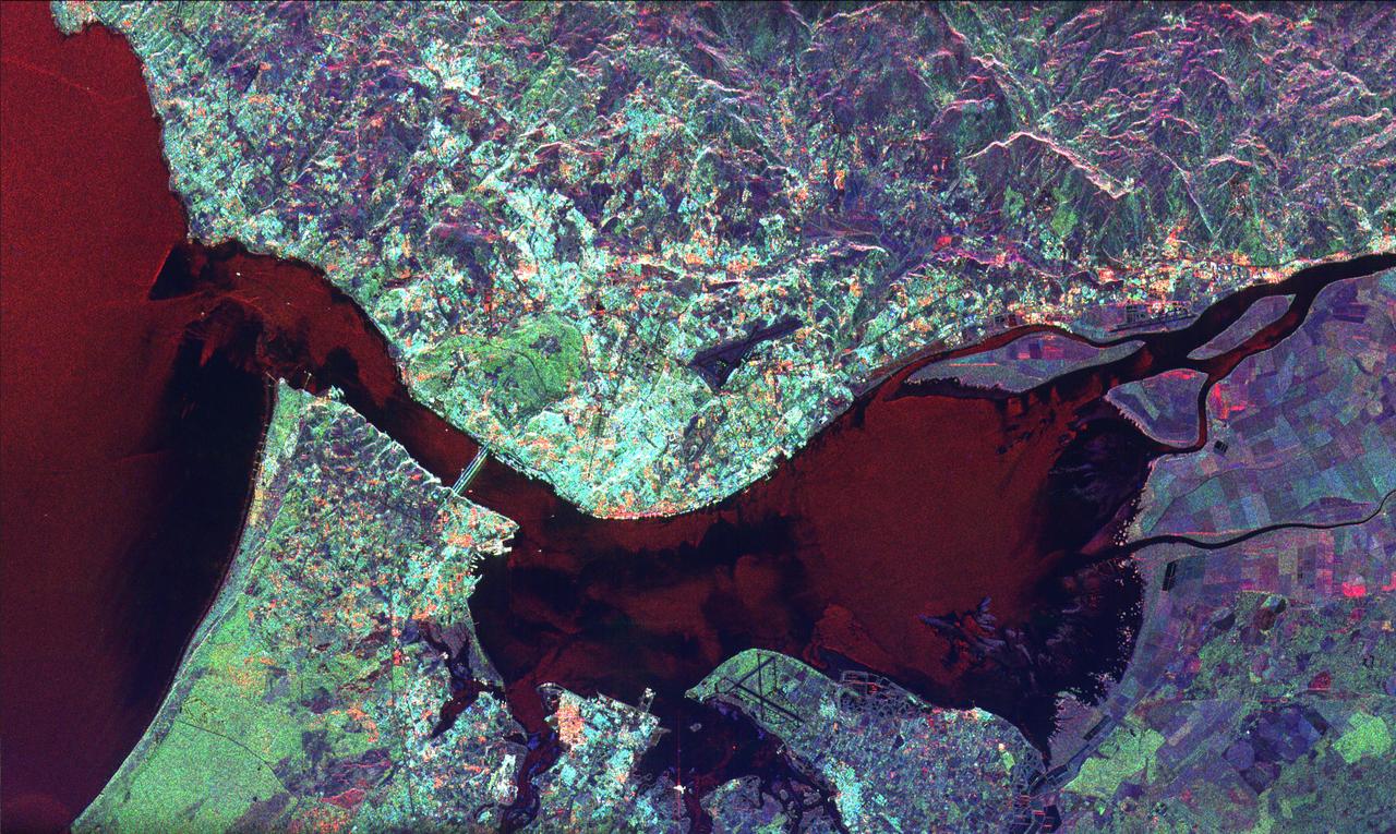
This radar image of Lisbon, Portugal illustrates the different land use patterns that are present in coastal Portugal. Lisbon, the national capital, lies on the north bank of the Rio Tejo where the river enters the Atlantic Ocean.
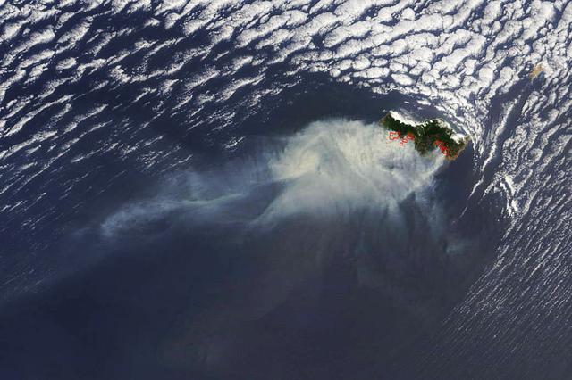
Smoke from several large fires burning on Portugal's Madeira Island were seen blowing over the Atlantic Ocean on Aug. 10 when NASA's Terra satellite passed overhead. Madeira is an archipelago of four islands located off the northwest coast of Africa. They are an autonomous region of Portugal. The Moderate Resolution Imaging Spectroradiometer (MODIS) on NASA’s Terra satellite captured this natural-color image at 8:25 a.m. EDT (12:05 UTC). Places where MODIS detected active fire are located in red. Image Credit: NASA Goddard's Rapid Response Team, Jeff Schmaltz <b><a href="http://www.nasa.gov/audience/formedia/features/MP_Photo_Guidelines.html" rel="nofollow">NASA image use policy.</a></b> <b><a href="http://www.nasa.gov/centers/goddard/home/index.html" rel="nofollow">NASA Goddard Space Flight Center</a></b> enables NASA’s mission through four scientific endeavors: Earth Science, Heliophysics, Solar System Exploration, and Astrophysics. Goddard plays a leading role in NASA’s accomplishments by contributing compelling scientific knowledge to advance the Agency’s mission. <b>Follow us on <a href="http://twitter.com/NASAGoddardPix" rel="nofollow">Twitter</a></b> <b>Like us on <a href="http://www.facebook.com/pages/Greenbelt-MD/NASA-Goddard/395013845897?ref=tsd" rel="nofollow">Facebook</a></b> <b>Find us on <a href="http://instagrid.me/nasagoddard/?vm=grid" rel="nofollow">Instagram</a></b>
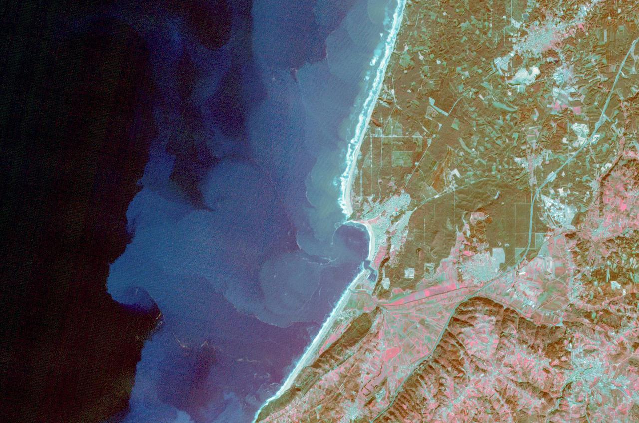
The fishing and tourist village of Nazare, Portugal was practically unknown, until 2000, when surfers first braved its monstrous winter waves. Since then, world records for surviving surfing the 30m+ high waves have fallen, and movies have been made, celebrating the brave (crazy?) surfers willing to risk their lives to challenge the world's tallest waves. Sediment highlights off-shore current patterns in the image. The image was acquired November 24, 2009, covers an area of 18 by 25.7 km, and is located at 39.6 degrees north, 9.1 degrees west. https://photojournal.jpl.nasa.gov/catalog/PIA25121
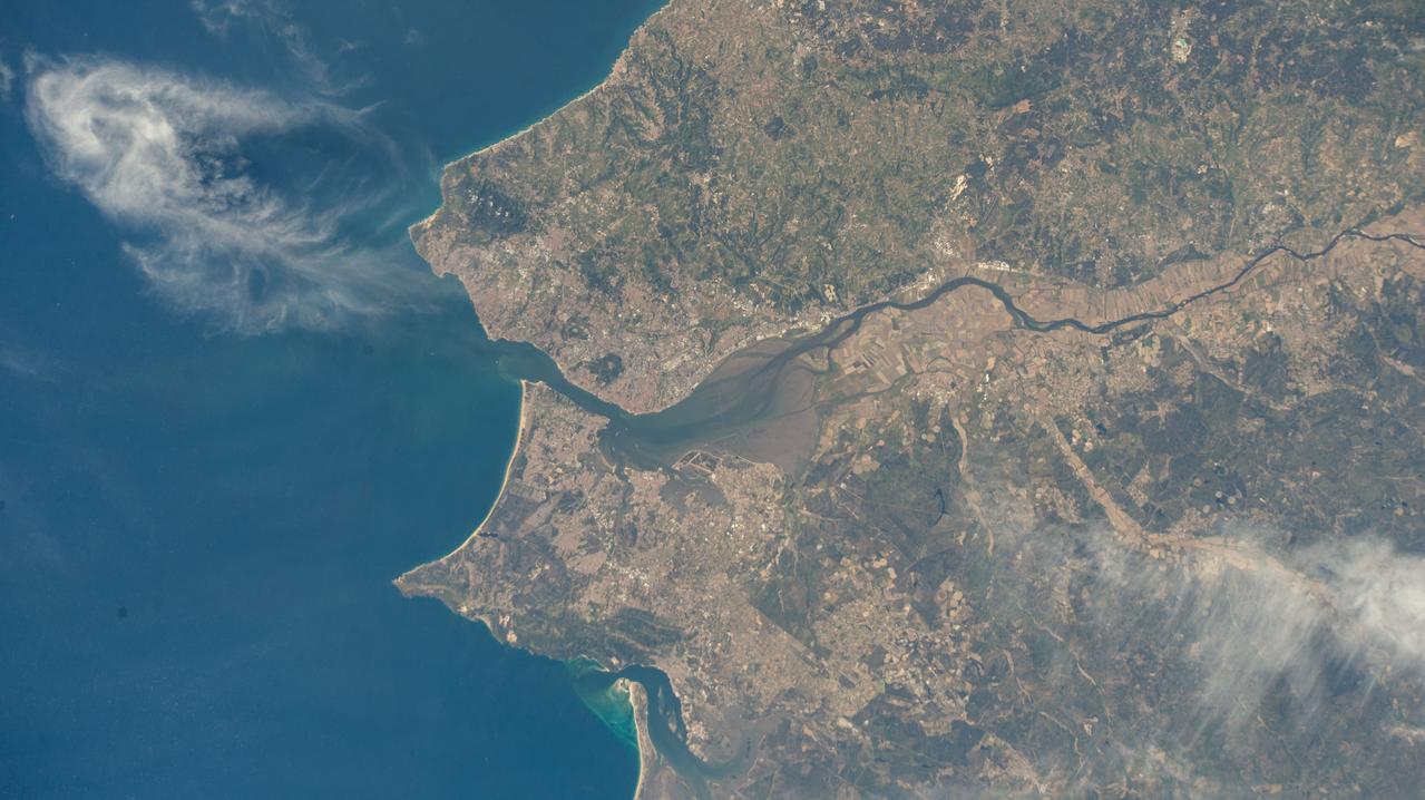
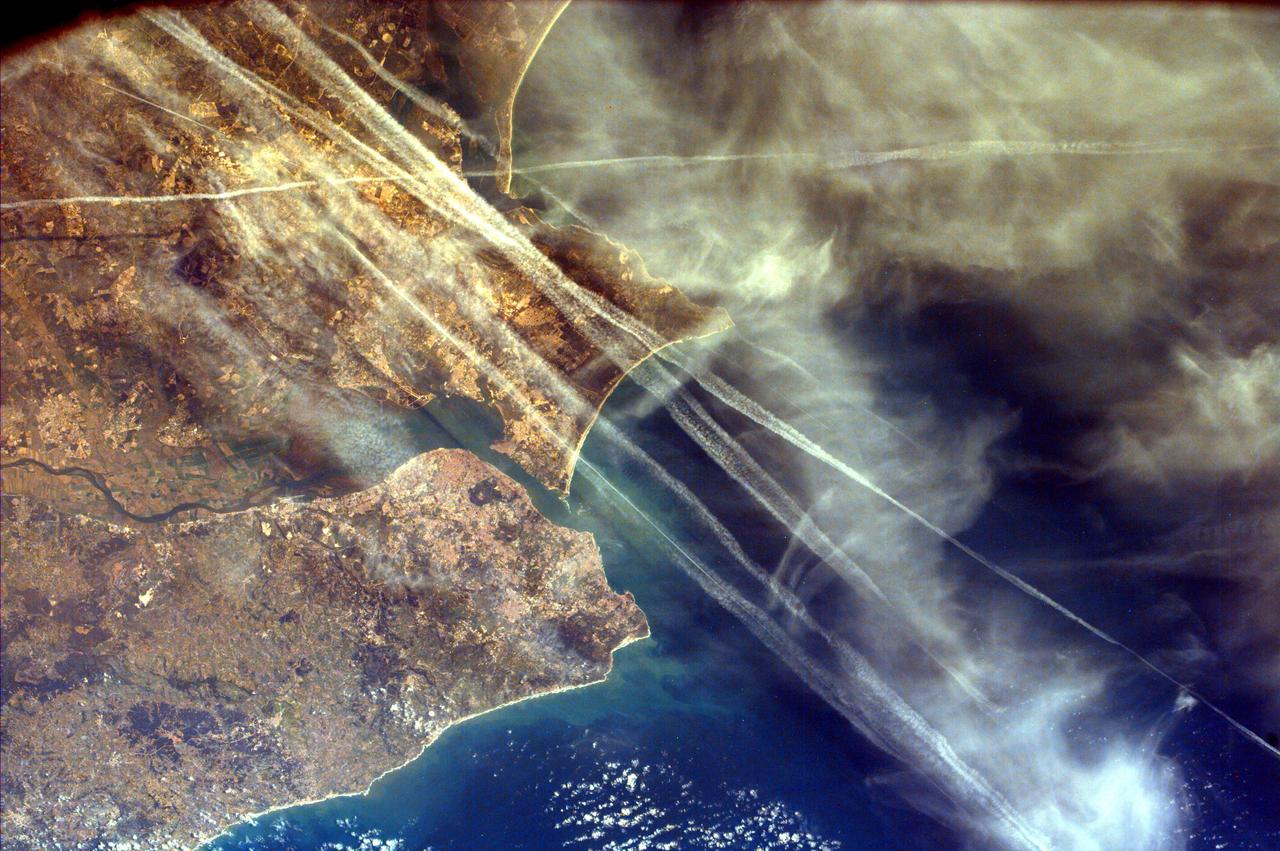
iss073e0078399 (May 22, 2025) --- Lisbon, the capital and largest city of Portugal, and its suburbs on the River Tagus that leads into the Atlantic Ocean are pictured from the International Space Station as it orbited 261 miles above the nation's coast on the Iberian Peninsula.
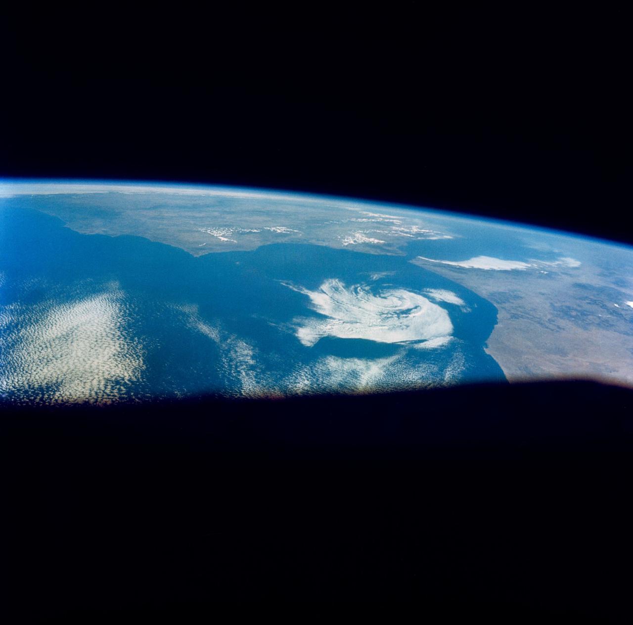
S66-46044 (18-21 July 1966) --- Straits of Gibraltar and Spain ? Portugal (left), Morocco (right), Atlantic Ocean (foreground), and unique vortex, as seen from the Gemini-10 spacecraft. Taken with J.A. Maurer 70mm camera, using Eastman Kodak, Ektachrome, MS (S.O. 217) color film. Photo credit: NASA
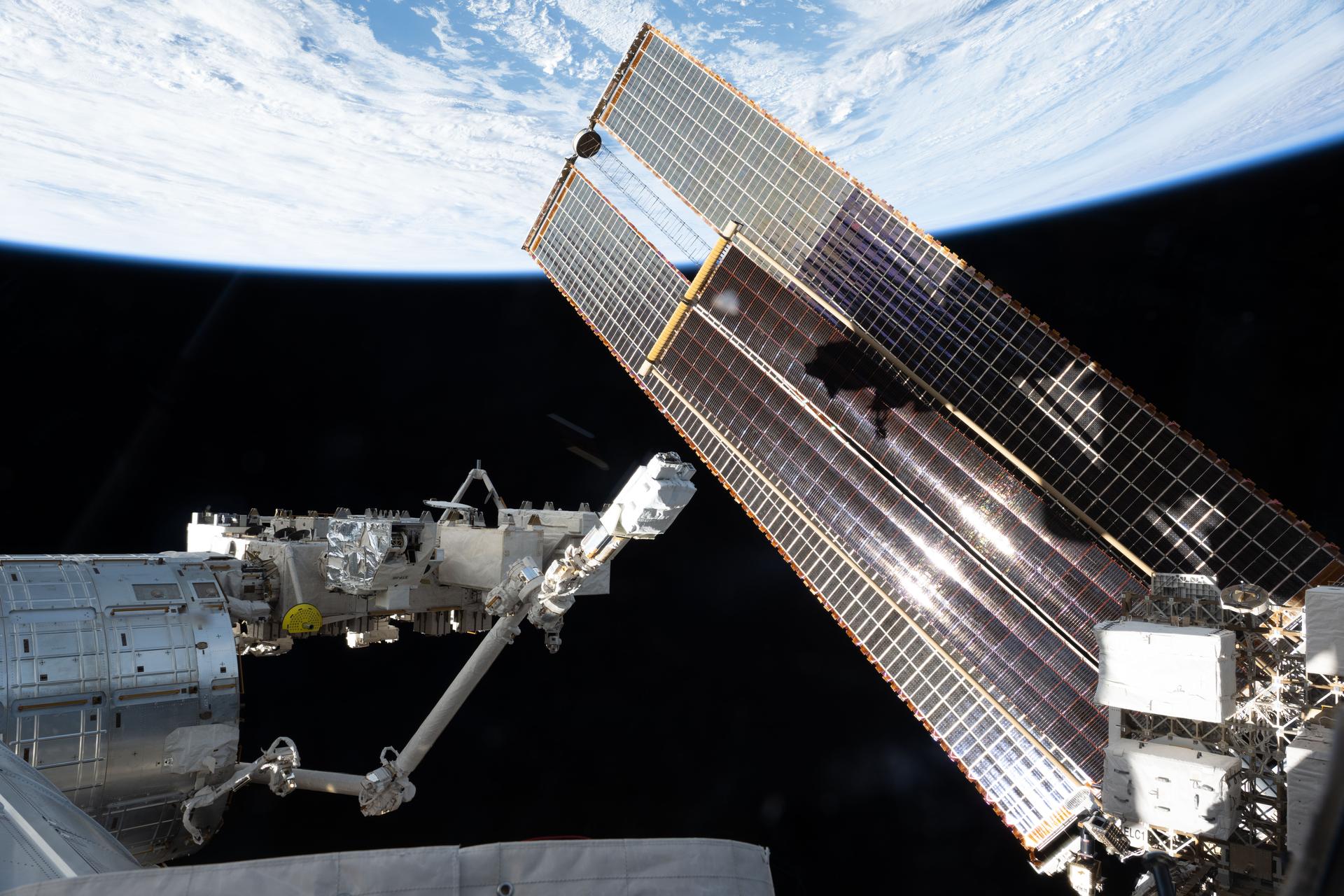
iss073e0869068 (Oct. 10, 2025) --- A set of the International Space Station's main solar arrays, partially overlapped by a smaller set of roll-out solar arrays, stretches across the photograph as the International Space Station orbited 262 miles above the Atlantic Ocean off the coast of Portugal. At left, the Japanese robotic arm with the small satellite orbital deployer attached, extends from the Kibo laboratory module.
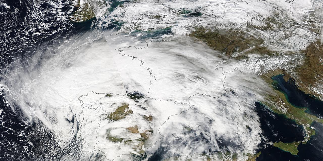
Image acquired February 27, 2010: An extratropical cyclone named Xynthia brought hurricane-force winds and high waves to Western Europe at the end of February 2010, CNN reported. Winds as fast as 200 kilometers (125 miles) per hour reached as far inland as Paris, and at the storm’s peak, hurricane-force winds extended from Portugal to the Netherlands. Hundreds of people had to take refuge from rising waters on their rooftops. By March 1, at least 58 people had died, some of them struck by falling trees. Most of the deaths occurred in France, but the storm also caused casualties in England, Germany, Belgium, Spain, and Portugal. The Moderate Resolution Imaging Spectroradiometer (MODIS) on NASA’s Aqua satellite captured this image of Western Europe, acquired in two separate overpasses on February 27, 2010. MODIS captured the eastern half of the image around 10:50 UTC, and the western half about 12:30 UTC. Forming a giant comma shape, clouds stretch from the Atlantic Ocean to northern Italy. NASA image courtesy MODIS Rapid Response Team at NASA Goddard Space Flight Center. Caption by Michon Scott. Instrument: Aqua - MODIS For more information related to this image go to: <a href="http://earthobservatory.nasa.gov/NaturalHazards/view.php?id=42881" rel="nofollow">earthobservatory.nasa.gov/NaturalHazards/view.php?id=42881</a>
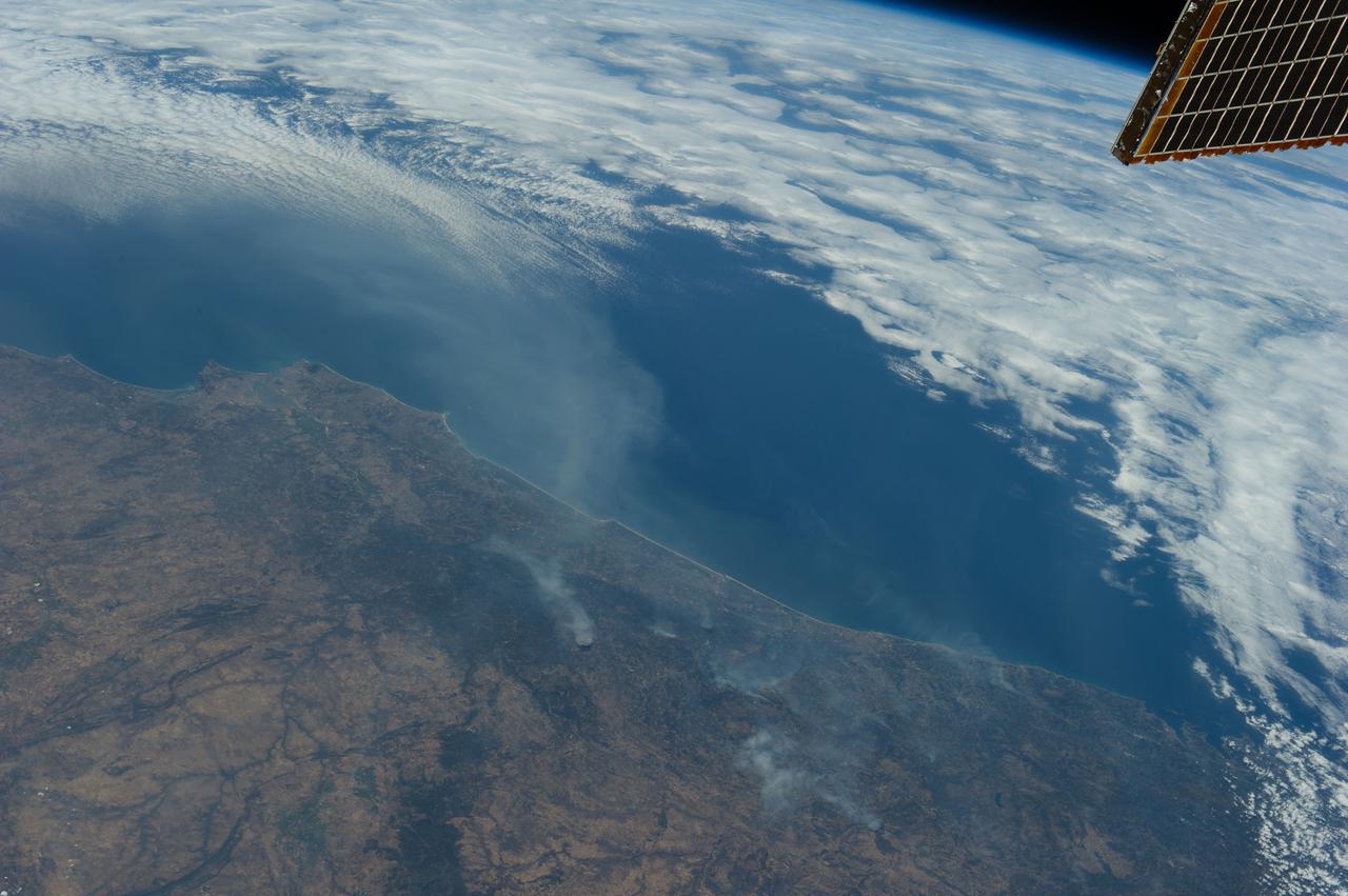
Earth observation taken during a day pass by the Expedition 36 crew. Per Twitter message: Forest fires in Portugal.
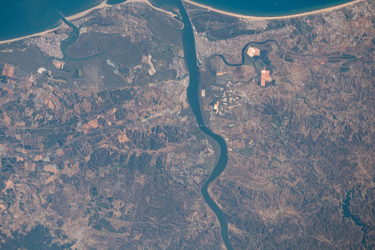
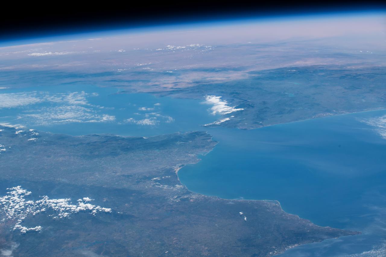
iss063e070330 (Aug. 13, 2020) --- The Guadiana River flows into the Gulf of Cádiz in the Atlantic Ocean and is the border for the southern coastal portions of Portugal (right) and Spain (left)
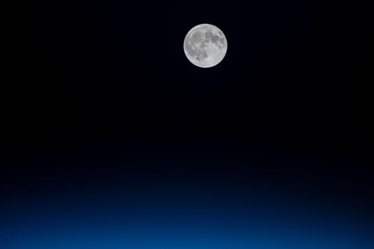
iss064e008767 (Nov. 30, 2020) --- The full Moon is pictured from the International Space Station as it orbited above the Atlantic Ocean off the coast of Portugal.
Earth Observation taken during a day pass by the Expedition 40 crew aboard the International Space Station (ISS). Folder lists this group as: Brazil, Africa, Volcanoes, Gibralter, Spain, Portugal.
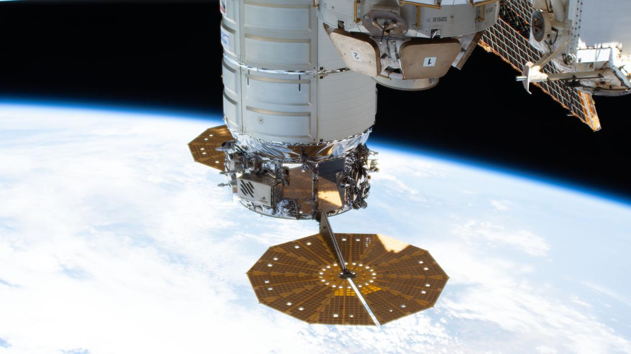
iss067e141211 (June 20, 2022) --- The Cygnus space freighter from Northrop Grumman, with its prominent cymbal-shaped solar arrays, is pictured attached to the International Space Station's Unity module as the orbiting lab flew 263 miles above the coast of Lisbon, Portugal.
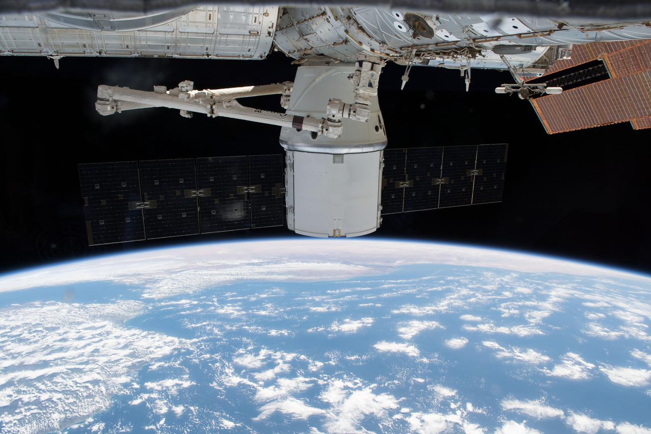
iss055e035437 (April 29, 2018) --- The SpaceX Dragon resupply ship was gripped by the Canadarm2 robotic arm on April 27, 2018 in preparation for its detachment from the Harmony module and its release back to Earth for splashdown and retrieval in the Pacific Ocean. The coasts of Spain and Portugal are seen as the International Space Station orbited over the Atlantic Ocean.
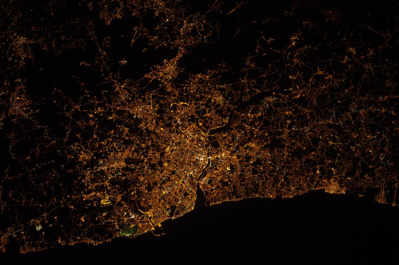
ISS032-E-015055 (5 Aug. 2012) --- One of the Expedition 32 crew members aboard the International Space Station recorded this nighttime image of Portugal featuring Porto (left) and Vila Nova de Gaia (right) astride the Douro River on the northwestern coast. For orientation purposes, the top is almost due east.
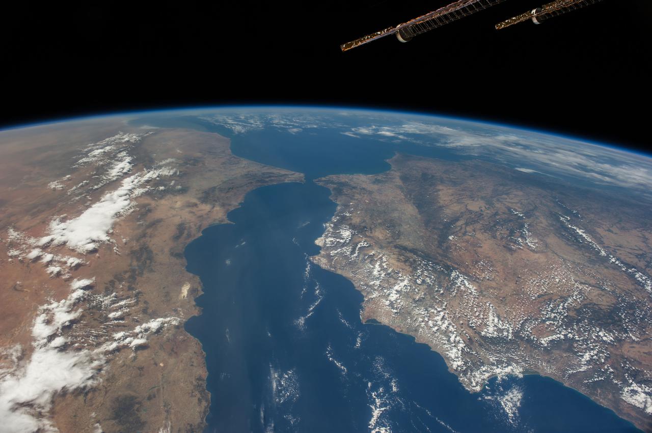
iss062e005579 (Feb. 11, 2020) --- The Strait of Gibraltar connects the Atlantic Ocean with the Mediterranean Sea and separates Spain on the European continent from Morocco on the African continent. The International Space Station was orbiting 265 miles above the Atlantic off the coast of Lisbon, Portugal, when this photograph was taken.
iss059e038134 (April 30, 2019) --- Looking from northwest to southeast (bottom to top), this oblique view shows portions of Western Europe, the Atlantic Ocean, the Mediterranean Sea and North Africa. More specific regions such as Portugal, Spain, the Strait of Gibraltar, Morocco and Algeria are seen as the International Space Station orbited 257 miles above the Atlantic.

Portugal Space Agency President, Dr. Chiara Manfletti, speaks to NASA Administrator Jim Bridenstine during a multilateral meeting of the heads of space agencies at the 70th International Astronautical Congress, Tuesday, Oct. 22, 2019 in Washington. Photo Credit: (NASA/Aubrey Gemignani)
ISS040-E-081305 (26 July 2014) --- One of the Expedition 40 crew members aboard the International Space Station recorded this early evening photo showing part of the Cygnus cargo carrier built by Orbital Sciences Corp. as well as almost the entire Iberian Peninsula (Spain, and Portugal) on July 26, 2014. Part of northern Africa is visible at lower right, and the Strait of Gibraltar can be seen right of center frame.

iss056e127068 (Aug. 6, 2018) --- The International Space Station was orbiting off the coast of Portugal when an Expedition 56 crew member photographed wildfires near its southern coast and the Strait of Gibraltar which separates Spain on the European continent from Morocco on the African continent. The North Atlantic Ocean connects to the Strait of Gibraltar which leads into the Mediterranean Sea.
ISS040-E-105800 (23 Aug. 2014) --- One of the Expedition 40 crew members aboard the International Space Station, flying at an altitude of 220 nautical miles, recorded this oblique panorama showing almost the entire Iberian Peninsula (Spain and Portugal) at right, Morocco and other parts of Africa (left) and the Strait of Gibraltar (top center) on Aug. 23, 2014. A 28mm focal length was used.
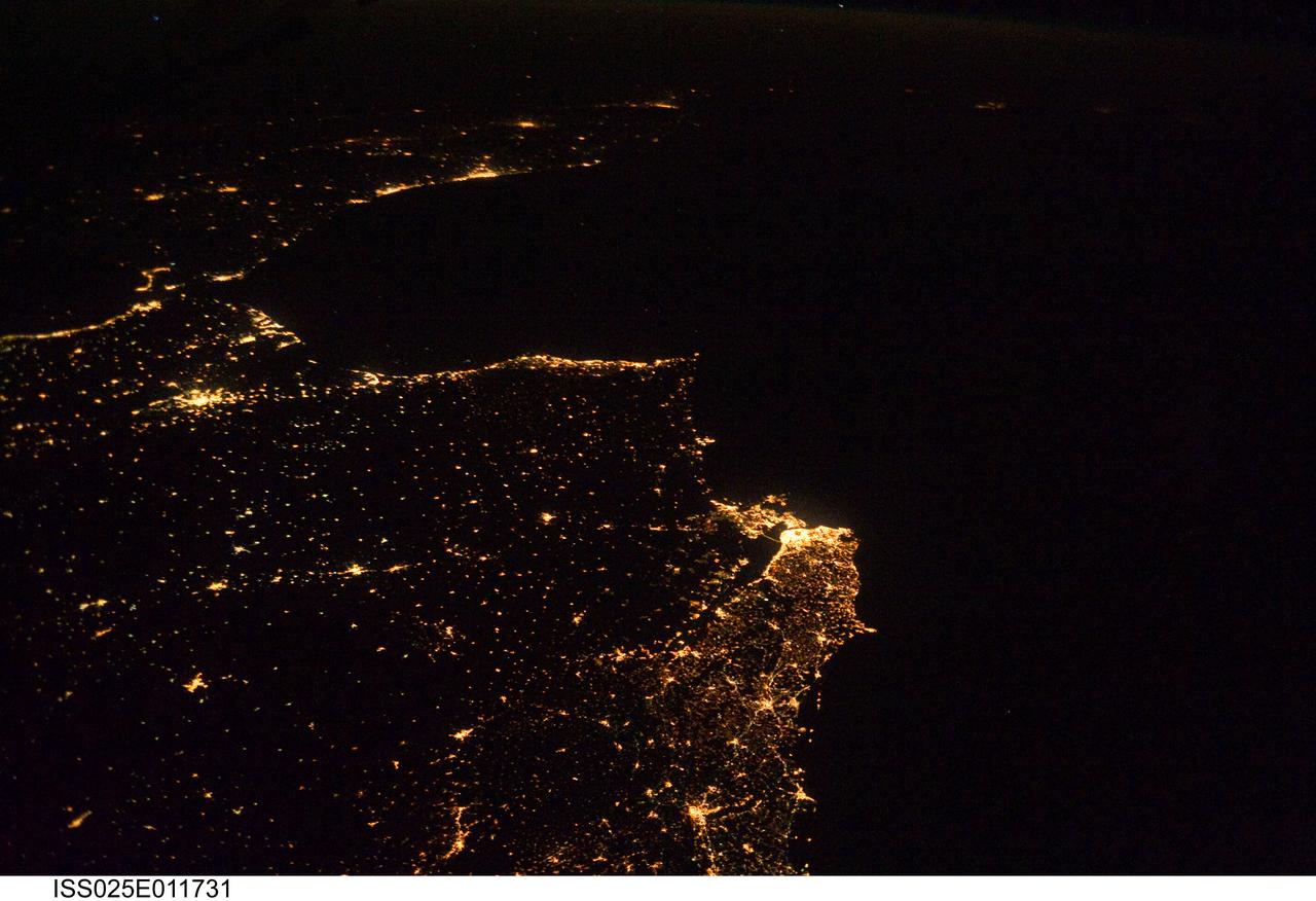
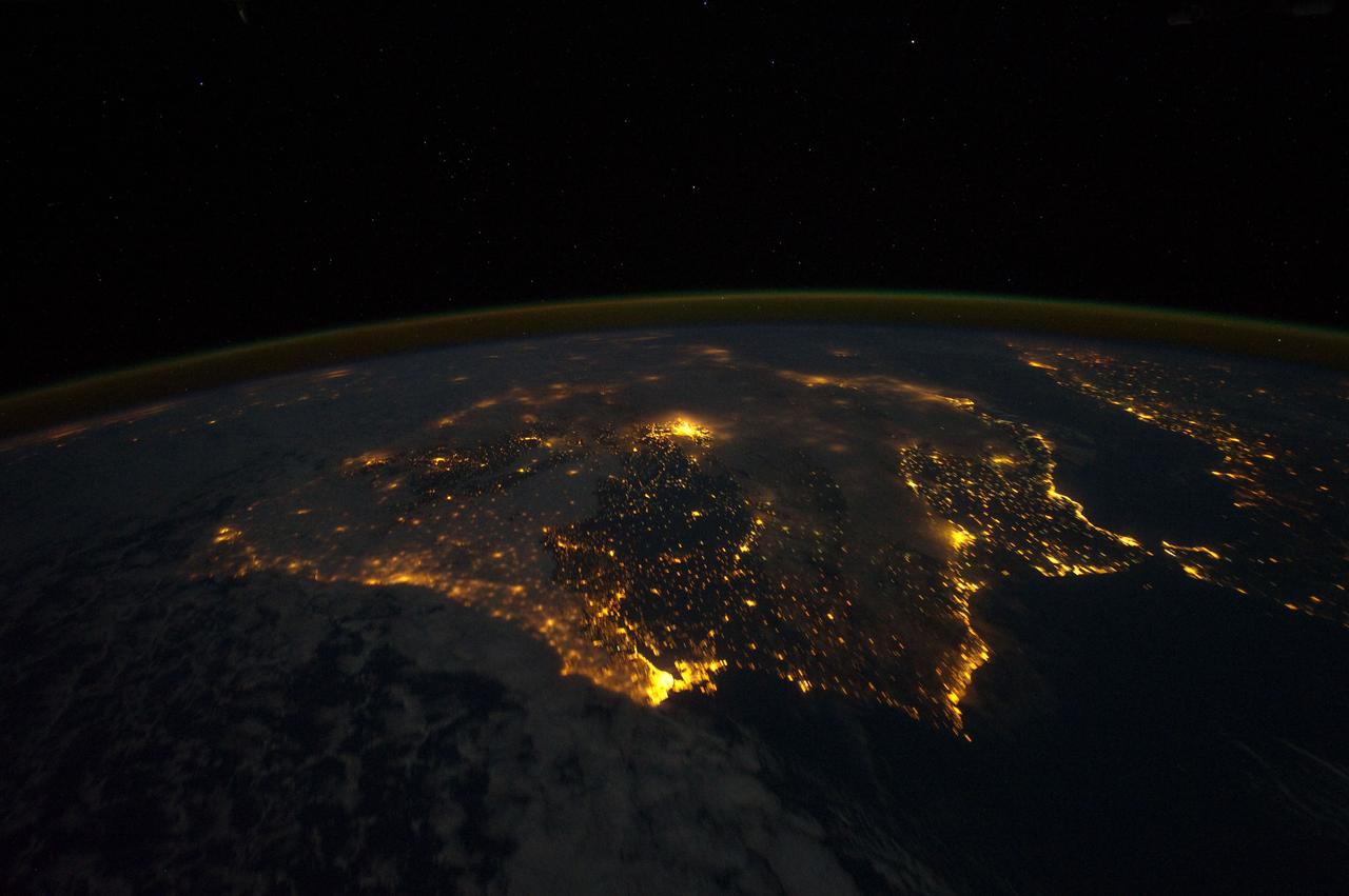
ISS025-E-011731 (5 Nov. 2010) --- One of the Expedition 25 crew members aboard the International Space Station, 220 miles above Earth, took this night time photo, looking south along the Atlantic coast of Europe and into Africa, from Lisbon, Portugal south across the Strait of Gibraltar. The lights can be followed down the coast of Morocco to Casablanca, and beyond.

iss067e378764 (Sept. 19, 2022) --- This night time photograph of the coastal city lights of Portugal, Spain, and France, with the Bay of Biscay in between, was taken from the International Space Station as it orbited 263 miles above the French city of Limoges. In the foreground, is the Soyuz MS-21 crew ship docked to the Prichal docking module which is itself attached to the Nauka multipurpose laboratory module.
ISS040-E-081320 (26 July 2014) --- One of the Expedition 40 crew members aboard the International Space Station recorded this early evening photo of the entire Iberian Peninsula (Spain and Portugal) on July 26, 2014. Part of France can be seen at the top of the image and the Strait of Gibraltar is visible at bottom, with a very small portion of Morocco visible near the lower right corner.
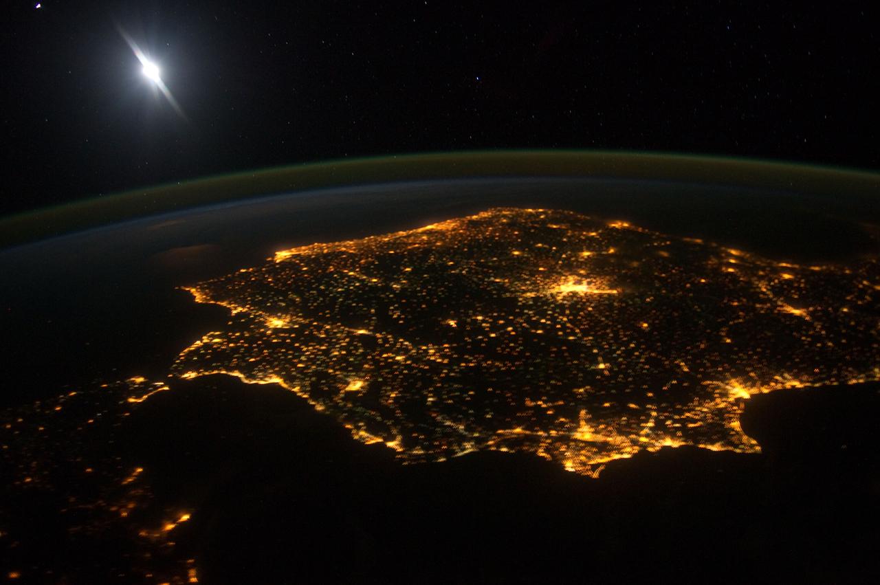
ISS030-E-060478 (30 Jan. 2012) --- The city lights of Madrid (just right of center) stand out in this photograph from the International Space Station. Recorded by one of the Expedition 30 crew members, the view shows almost the entire Iberian Peninsula (both Spain and Portugal) with the Strait of Gibraltar and Morocco appearing at lower left. What is thought to be a blur of the moon appears in upper left corner. The faint gold or brownish line of airglow?caused by ultraviolet radiation exciting the gas molecules in the upper atmosphere?parallels the horizon or Earth limb.
ISS035-E-027420 (23 April 2013) --- One of the Expedition 35 crew members aboard the International Space Station photographed this high oblique image of the Iberian Peninsula on April 23, 2013. This is one of the very few pictures in the history of the decades old NASA-managed human-tended space program that shows the entire peninsula, with Portugal, Spain and Gibraltar. The Strait of Gibraltar (right center) is a narrow strait that connects the Atlantic Ocean to the Mediterranean Sea and separates Gibraltar and Spain in Europe from Morocco (far right center)in Africa. Europe and Africa are separated by 7.7 nautical miles (14.3 kilometers or 8.9 statute miles) of ocean at the strait's narrowest point. A small part of France is barely visible at the horizon (top center).
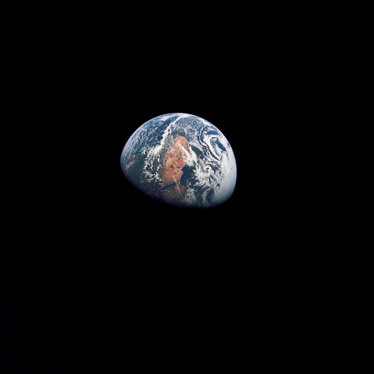
AS10-34-5026 (18-26 May 1969) --- An Apollo 10 photograph of Earth taken from 100,000 miles away. Visible are many areas of Europe and Africa. Among the features and countries identifiable are Portugal, Spain, Italy, the Mediterranean Sea, Greece, Turkey, Bulgaria, the Black Sea, Libya, Egypt, Saudi Arabia, the Sinai Peninsula, the Nile Delta, Lake Chad, and South Africa. The crew members for Apollo 10 are astronauts Thomas P. Stafford, commander; John W. Young, command module pilot; and Eugene E. Cernan, lunar module pilot. Astronaut Young remained in lunar orbit, in the Command and Service Modules (CSM) "Charlie Brown", while astronauts Stafford and Cernan descended to within nine miles of the lunar surface, in the Lunar Module (LM) "Snoopy".
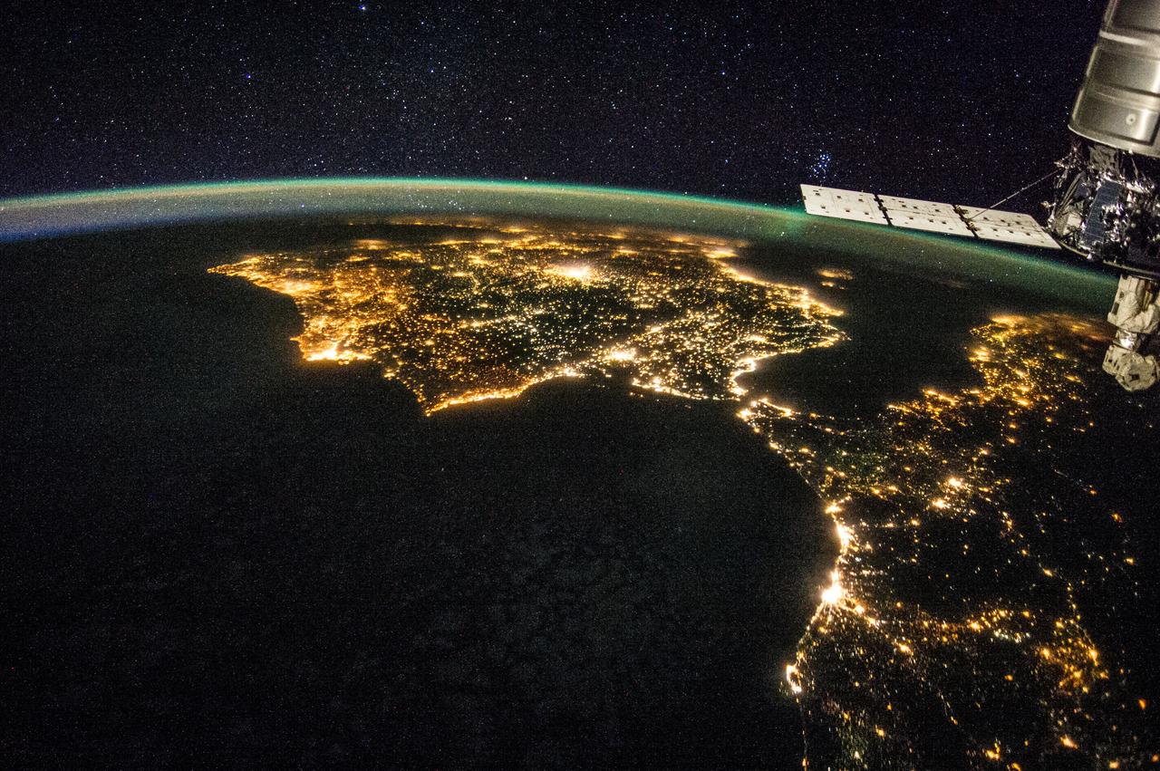
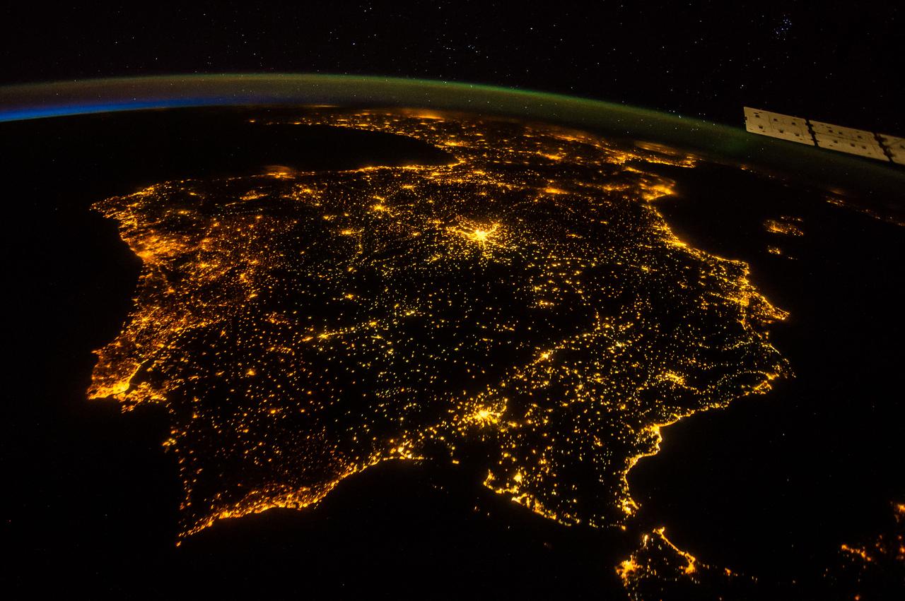
ISS030-E-010008 (4 Dec. 2011) --- One of the Expedition 30 crew members aboard the Earth-orbiting International Space Station photographed this night time scene of the Iberian Peninsula on Dec. 4, 2011. The city lights of Spain and Portugal define the peninsula. Several large metropolitan areas are visible, marked by their relatively large and brightly lit areas, such as two capital cities -- Madrid, Spain, located near the center of the peninsula?s interior, and Lisbon, Portugal, located along the southwestern coastline. Ancient Seville, visible at image right to the north of the approximately 14 kilometer-wide Strait of Gibraltar, is one of the largest cities in Spain. All together, the Principality of Andorra, the Kingdom of Spain and the Portuguese Republic total approximately 590,000 square kilometers of landmass. The peninsula is bounded by the Atlantic Ocean to the northwest, west, and southwest and the Mediterranean Sea to the east. Its northeastern boundary with the rest of continental Europe is marked by the Pyrenees mountain range. The view is looking outwards from the orbital outpost toward the east. The network of smaller cities and towns in the interior and along the coastline attest to the large extent of human presence on the Iberian landscape. Blurring of the city lights is caused by thin cloud cover (image left and center), while the cloud tops are dimly illuminated by moonlight. Though obscured, the lights of France are visible near the horizon line at image upper left, while the lights of northern Africa are more clearly discernable at image right. The gold to green line of airglow, caused by excitation of upper atmosphere gas molecules by ultraviolet radiation, parallels the horizon line (or Earth limb).
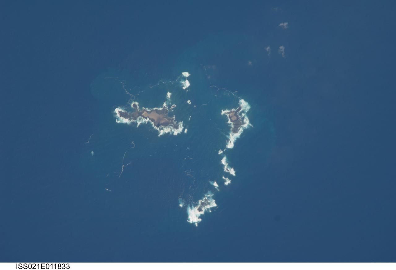
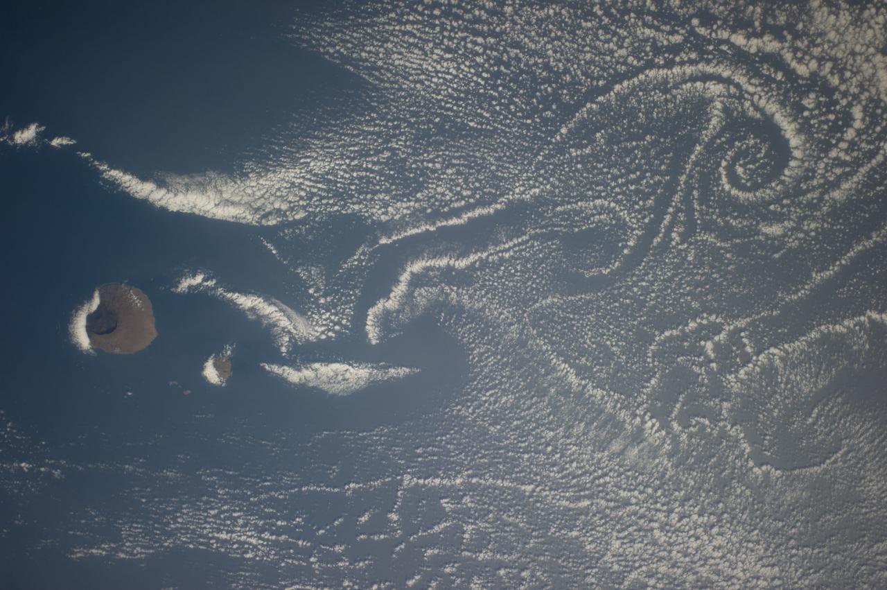
ISS021-E-011833 (22 Oct. 2009) --- The southern Savage Islands in the Atlantic Ocean are featured in this image photographed by an Expedition 21 crew member on the International Space Station. The Savage Islands, or Ilhas Selvagens in Portuguese, comprise a small archipelago in the eastern North Atlantic Ocean between the archipelago of Madeira to the north and the Canary Islands to the south. Like other island groups, the Savage Islands are thought to have been produced by volcanism related to a mantle plume or ?hot spot?. Mantle plumes are relatively fixed regions of upwelling magma that can feed volcanoes on an overlying tectonic plate. Active volcanoes form over the plume, and become dormant as they are carried away on the moving tectonic plate. Scientists believe that over geologic time, this creates a line of older extinct volcanoes, seamounts, and islands extending from the leading active volcanoes that are currently over the plume. This view illustrates the smaller and more irregularly-shaped Ilheus do Norte, Ilheu de Fora, and Selvagem Pequena. Spain and Portugal both claim sovereignty over the Savage Islands. All of the islands of the archipelago are ringed by bright white breaking waves along the fringing beaches. Coral reefs that surround the Savage Islands make it very difficult to land boats there, and there is no permanent settlement on the islands.
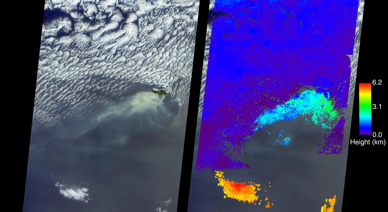
A wildfire spread to the capital city of Funchal on the island of Madeira, an autonomous region of Portugal, over the nighttime hours of Tuesday, Aug. 9, 2016, with three deaths reported and hundreds of others hospitalized. Several homes and a luxury hotel have burned, and a thousand people have been evacuated. The three fatalities are reported to be elderly people who were unable to escape when their homes caught fire. The fire ignited Monday, Aug. 8, after several weeks of scorching temperatures topping 95 degrees Fahrenheit and very dry weather. The entire island is only 30 miles (48 kilometers) from end to end, which naturally makes protecting the island's 270,000 residents and many tourists more difficult. The MISR (Multi-angle Imaging SpectroRadiometer) instrument aboard NASA's Terra satellite passed directly over the island of Madeira on Wednesday, Aug. 10, 2016. The left image is a true-color image taken by MISR's 60-degree forward-pointing camera. This oblique view gives a better view of the smoke than a downward-pointing view. The island of Madeira is the only land within the field of view, and the smoke from the wildfire is being blown to the southwest. The city of Funchal is located on the southeastern coast of the island. MISR's nine cameras, each viewing Earth at a different angle, can be used to determine the height of clouds and smoke above the surface in much the same way that our two eyes, pointing in slightly different directions, give us depth perception. The right-hand image shows MISR's publically available standard cloud top height product. These data show that the main body of clouds is indeed very low, less than 0.6 miles (1 kilometer) above sea level, while the smoke plume is about 1.9 miles (3 kilometers) high at the source, dropping lower as it is blown to the southwest. A stereo "anaglyph" of this scene is also available at PIA20886. As can be seen from both the MISR height product and the 3D anaglyph, the isolated clouds to the south are much higher than either the low clouds or the plume. Interestingly, the low clouds drop to almost sea level and then die out near where the smoke is present. These data were acquired during Terra orbit 88524. http://photojournal.jpl.nasa.gov/catalog/PIA20887