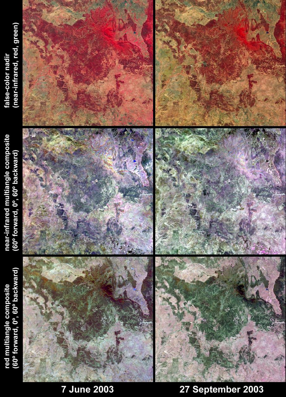
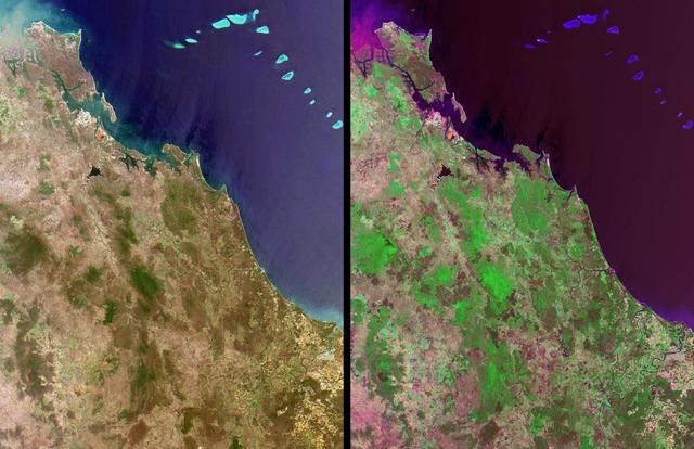
Austral winter and spring in Queensland Brigalow Belt as seen by NASA Terra spacecraft.
Residents of the northeast coast of Queensland, Australia are facing high winds, dangerous tides and very heavy rain between Cape Melville and Cooktown. These hazards will migrate southward for the next few days as the center of the storm remains close to the coast. This image was taken by the Suomi NPP satellite's VIIRS instrument around 0335Z on April11, 2014. Credit: NASA/NOAA via <b><a href="www.nnvl.noaa.gov/" rel="nofollow"> NOAA Environmental Visualization Laboratory</a></b> <b><a href="http://www.nasa.gov/audience/formedia/features/MP_Photo_Guidelines.html" rel="nofollow">NASA image use policy.</a></b> <b><a href="http://www.nasa.gov/centers/goddard/home/index.html" rel="nofollow">NASA Goddard Space Flight Center</a></b> enables NASA’s mission through four scientific endeavors: Earth Science, Heliophysics, Solar System Exploration, and Astrophysics. Goddard plays a leading role in NASA’s accomplishments by contributing compelling scientific knowledge to advance the Agency’s mission. <b>Follow us on <a href="http://twitter.com/NASAGoddardPix" rel="nofollow">Twitter</a></b> <b>Like us on <a href="http://www.facebook.com/pages/Greenbelt-MD/NASA-Goddard/395013845897?ref=tsd" rel="nofollow">Facebook</a></b> <b>Find us on <a href="http://instagram.com/nasagoddard?vm=grid" rel="nofollow">Instagram</a></b>
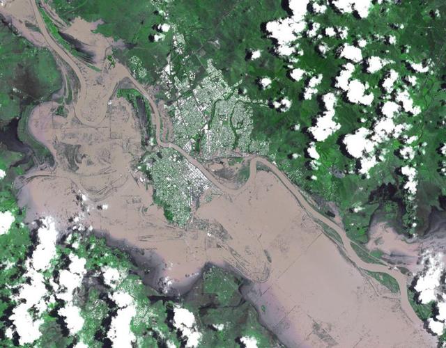
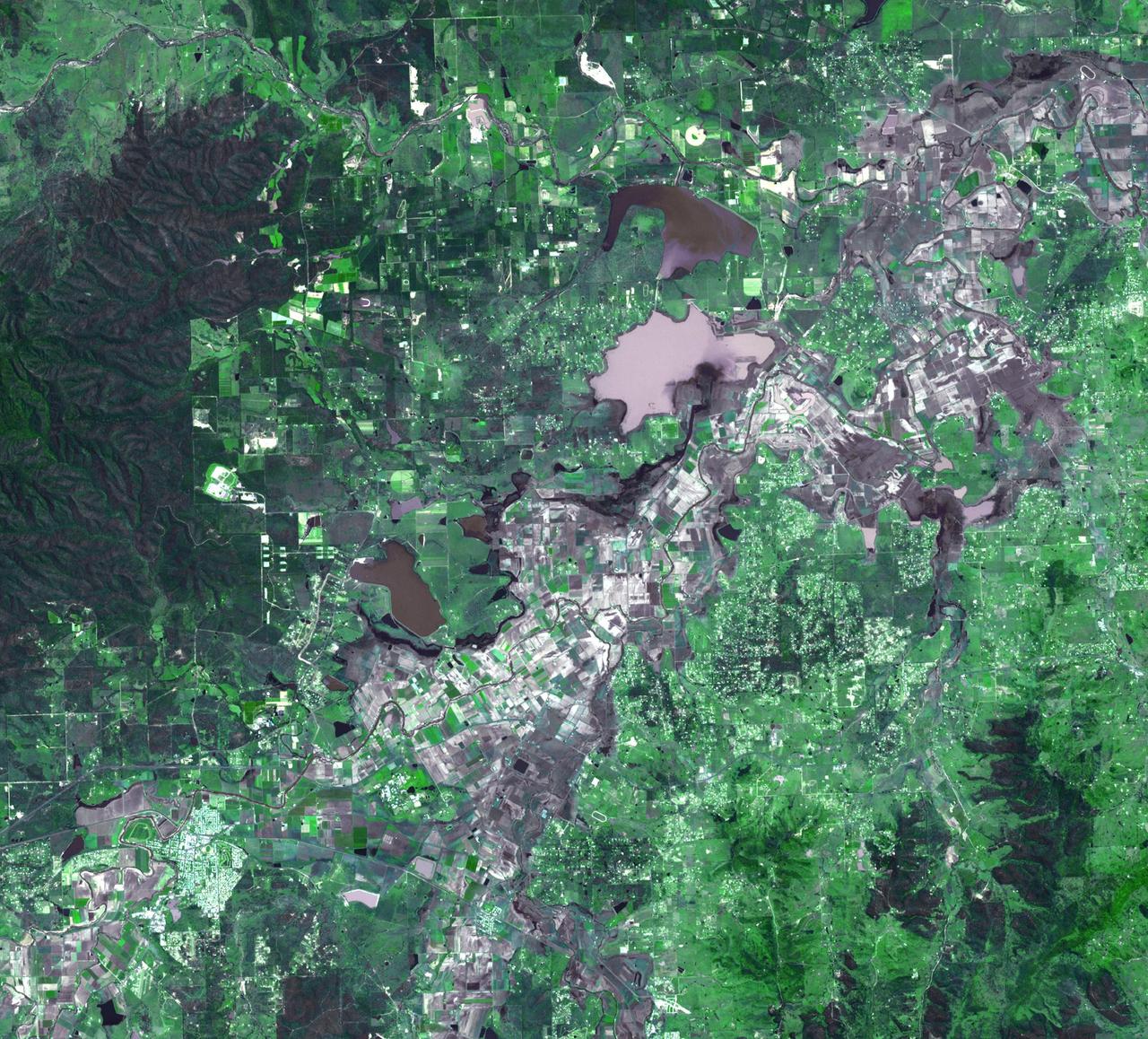
On Jan. 7, 2011, NASA Terra spacecraft captured this image of the inundated city of Rockhampton, Queensland, Australia. Torrential rains in NE Australia caused the Fitzroy River to overflow its banks and flood much of the city.
NASA image acquired January 30, 2011 at 23:20 UTC. Satellite: Terra <b> Click here to see the most recent image captured Feb. 1: <a href="http://www.flickr.com/photos/gsfc/5407540724/">www.flickr.com/photos/gsfc/5407540724/</a></b> Tropical Storm Anthony made landfall in Queensland, Australia this past weekend, and now the residents are watching a larger, more powerful cyclone headed their way. NASA's Terra satellite captured a visible image of the large Tropical Cyclone Yasi late yesterday as it makes its way west through the Coral Sea toward Queensland. The Moderate Resolution Imaging Spectroradiometer (MODIS) instrument that flies aboard NASA's Terra satellite captured an image of Cyclone Yasi on Jan. 30 at 23:20 UTC (6:20 p.m. EST/09:20 a.m., Monday, January 31 in Australia/Brisbane local time). Although the image did not reveal a visible eye, the storm appears to be well-formed and also appears to be strengthening. Warnings and watches are already in effect throughout the Coral Sea. The Solomon Islands currently have a Tropical Cyclone warning for the provinces of Temotu, Rennell & Bellona, Makira and Guadalcanal. The Australian Bureau of Meteorology has already posted a Tropical Cyclone Watch from Cooktown to Yeppoon and inland to between Georgetown and Moranbah in Queensland, Australia. The Australian Bureau of Meteorology expects damaging winds to develop in coastal and island communities between Cooktown and Yeppoon Wednesday morning, and inland areas on Wednesday afternoon. Updates from the Australian Bureau of Meteorology can be monitored at the Bureau's website at <a href="http://www.bom.gov.au" rel="nofollow">www.bom.gov.au</a>. On January 31 at 1500 UTC (10 a.m. EST/ 1:00 a.m. Tuesday February 1, 2011 in Australia/Brisbane local time), Tropical Cyclone Yasi had maximum sustained winds near 90 knots (103 mph/166 kmh). Yasi is a Category Two Cyclone on the Saffir-Simpson Scale. It was centered about 875 miles E of Cairns, Australia, near 13.4 South latitude and 160.4 East longitude. It was moving west near 19 knots (22 mph/35 kmh). Cyclone-force winds extend out to 30 miles (48 km) from the center. Animated infrared satellite imagery, such as that from the Atmospheric Infrared Sounder (AIRS) that flies on NASA's Aqua satellite, showed deep convective (thunderstorm) bands wrapping tighter into the low level circulation center. Wrapping bands of thunderstorms indicate strengthening. Yasi is forecast to move west then southwestward into an area of low vertical wind shear (strong wind shear can weaken a storm). Forecasters at the Joint Typhoon Warning Center (JTWC) expect Yasi to continue strengthening over the next 36 hours. JTWC forecasts a landfall just south of Cairns as a large 100-plus knot (115 mph/185 kmh)n system by Wednesday. Residents along the Queensland coast should now be making preparations now for the storm's arrival. Rob Gutro NASA's Goddard Space Flight Center Credit: NASA/GSFC/Jeff Schmaltz/MODIS Land Rapid Response Team Click here to see more images from <b><a href="http://rapidfire.sci.gsfc.nasa.gov/gallery/?latest" rel="nofollow">MODIS</a></b> <b><a href="http://www.nasa.gov/centers/goddard/home/index.html" rel="nofollow">NASA Goddard Space Flight Center</a></b> enables NASA’s mission through four scientific endeavors: Earth Science, Heliophysics, Solar System Exploration, and Astrophysics. Goddard plays a leading role in NASA’s accomplishments by contributing compelling scientific knowledge to advance the Agency’s mission. <b>Follow us on <a href="http://twitter.com/NASA_GoddardPix" rel="nofollow">Twitter</a></b> <b>Join us on <a href="http://www.facebook.com/pages/Greenbelt-MD/NASA-Goddard/395013845897?ref=tsd" rel="nofollow">Facebook</a></b>

After a 19 month rainfall deficiency, heavy rainfall during January 2004 brought drought relief to much of northern Queensland; these images were acquired by NASA Terra spacecraft.
Queensland, Australia. This image, acquired on November 19, 2001 from NASA Terra satellite, is MISR Mystery Image Quiz #11.
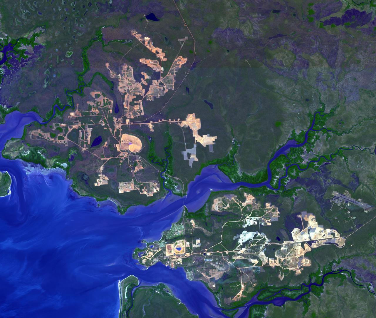
This image from NASA Terra spacecraft shows the world largest bauxite mine found near Weipa, Queensland, Australia. The rich aluminum deposits were first recognized on the end of the Cape York Peninsula in 1955, and mining began in 1960.
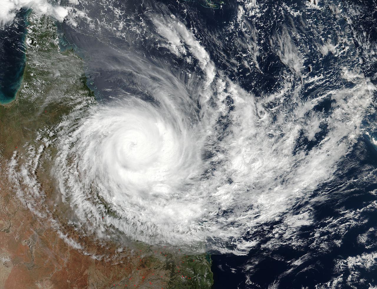
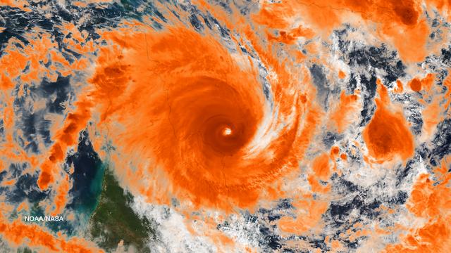
Tropical Cyclone Debbie made landfall in Queensland bringing heavy rainfall, hurricane-force winds, rough seas, and flooding. NASA-NOAA's Suomi NPP satellite provided a visible look at the storm from space while NASA's Aqua satellite analyzed cloud temperatures to determine the location of the strongest storms within. Read more: <a href="https://go.nasa.gov/2o29Sxh" rel="nofollow">go.nasa.gov/2o29Sxh</a> Credit: NASA/NOAA/Suomi NPP <b><a href="http://www.nasa.gov/audience/formedia/features/MP_Photo_Guidelines.html" rel="nofollow">NASA image use policy.</a></b> <b><a href="http://www.nasa.gov/centers/goddard/home/index.html" rel="nofollow">NASA Goddard Space Flight Center</a></b> enables NASA’s mission through four scientific endeavors: Earth Science, Heliophysics, Solar System Exploration, and Astrophysics. Goddard plays a leading role in NASA’s accomplishments by contributing compelling scientific knowledge to advance the Agency’s mission. <b>Follow us on <a href="http://twitter.com/NASAGoddardPix" rel="nofollow">Twitter</a></b> <b>Like us on <a href="http://www.facebook.com/pages/Greenbelt-MD/NASA-Goddard/395013845897?ref=tsd" rel="nofollow">Facebook</a></b> <b>Find us on <a href="http://instagrid.me/nasagoddard/?vm=grid" rel="nofollow">Instagram</a></b>
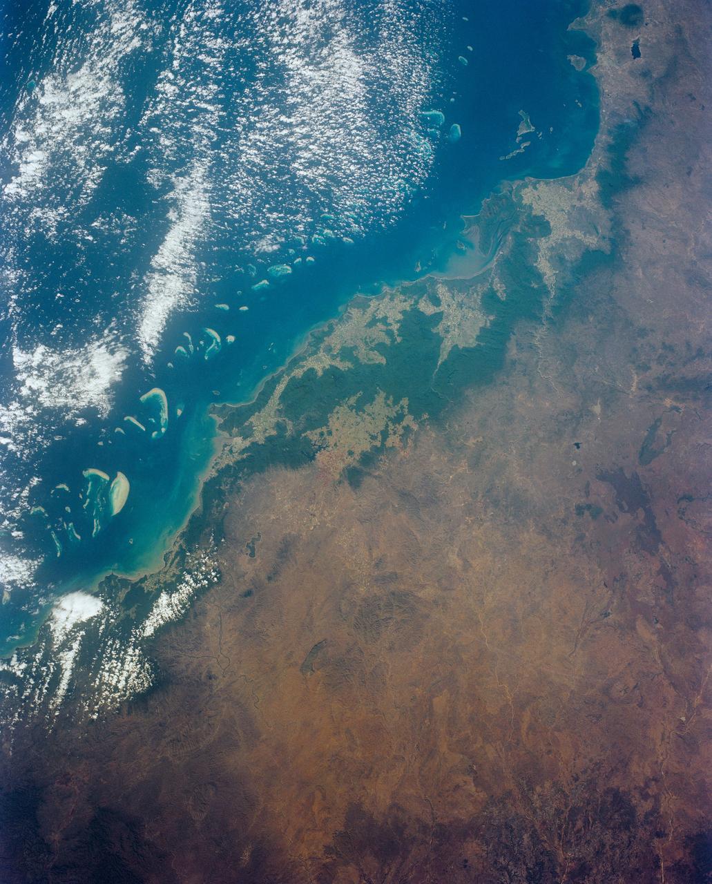
Cairns and Townsville area, on the northeast coast of Queensland, Australia (17.0S, 146.0E) is one of the best sport diving localities in the world where divers can explore the rich and varied flora and fauna of the nearby Great Barrier Reef. Onshore, the timbered foothills of the Great Dividing Range, seen as dark green areas, separate the semi arid interior of Queensland.
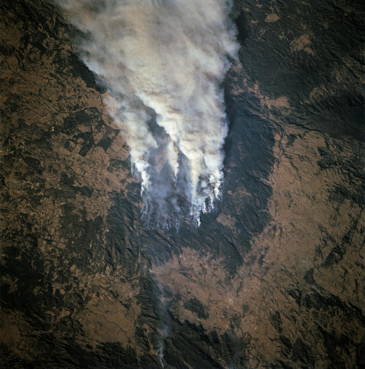
STS068-253-045 (30 September-11 October 1994) --- Forest fires in southeastern Queensland, Australia. The smoke is blowing to the east. This is the southeastern edge of the Darling Downs, a wheat-growing and sheep pasture region just west of the Great Dividing Range, southwest of Brisbane. An extensive summer drought made the forests of the range highly susceptible to wildfire.
NASA's Aqua satellite passed over Tropical Cyclone Ita as it began making landfall on the Eastern Cape York Peninsula of Queensland, Australia, today, April 11, 2014. Ita officially made landfall at Cape Flattery about 9:00 p.m. local AEST time as a Category 4 storm according to reports from the Australian Broadcasting Corporation (ABC). The Moderate Resolution Imaging Spectroradiometer that flies aboard Aqua captured an image of the Category 4 storm on April 11 at 12:00 a.m. EDT (4 a.m. UTC). Satellite imagery indicates the eye is 9.2 miles wide (8 nautical miles, or 14.8 km). Warnings and watches remain in effect as the center of Ita is expected to remain at hurricane strength as it moves in a southerly direction, staying just west of Cairns over the next day. A tropical cyclone warning is in effect between Coen and Innisfail, including Cooktown, Port Douglas, Cairns, extending inland to Kalinga, Palmerville, Mareeba and Chillagoe. A tropical cyclone watch is in effect between Innisfail to Cardwell, extending inland. ABC reported that the strongest maximum sustained winds around the center of circulation were near 142.9 mph (124.2 knots, or 230 kph) and many trees have been downed and homes damaged. According to ABC, preliminary reports suggest that power may be out for a month in some areas. On April 11 at 5 a.m. EDT (9 a.m. UTC), Tropical Cyclone Ita had maximum sustained winds near 143.8 mph (125 knots, or 231.5 kph). It was centered near 14.8 degrees south latitude and 145.3 degrees east longitude, about 168 miles (146 nautical miles, or 288 km) north of Cairns, Australia, and has tracked south-southwestward at 10.3 mph (9 knots, or 16.6 kph). Ita is moving around a subtropical ridge (elongated area) of high pressure and the Joint Typhoon Warning Center expects Ita to start curving to the southeast around that ridge in the next day before heading back out into the Coral Sea. Credit: NASA/GSFC/Jeff Schmaltz/MODIS Land Rapid Response Team Rob Gutro, NASA's Goddard Space Flight Center, Greenbelt, Md. <b><a href="http://www.nasa.gov/audience/formedia/features/MP_Photo_Guidelines.html" rel="nofollow">NASA image use policy.</a></b> <b><a href="http://www.nasa.gov/centers/goddard/home/index.html" rel="nofollow">NASA Goddard Space Flight Center</a></b> enables NASA’s mission through four scientific endeavors: Earth Science, Heliophysics, Solar System Exploration, and Astrophysics. Goddard plays a leading role in NASA’s accomplishments by contributing compelling scientific knowledge to advance the Agency’s mission. <b>Follow us on <a href="http://twitter.com/NASAGoddardPix" rel="nofollow">Twitter</a></b> <b>Like us on <a href="http://www.facebook.com/pages/Greenbelt-MD/NASA-Goddard/395013845897?ref=tsd" rel="nofollow">Facebook</a></b> <b>Find us on <a href="http://instagram.com/nasagoddard?vm=grid" rel="nofollow">Instagram</a></b>
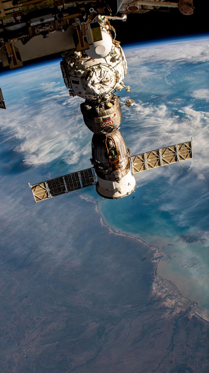
iss069e010174 (May 11, 2023) --- The Soyuz MS-23 crew ship is pictured docked to the Prichal docking module as the International Space Station orbited 264 miles above Queensland, Australia, near the coast of the Gulf of Carpentaria.
iss072e695137 (March 3, 2025) --- Cyclone Alfred nears the coast of Queensland, Australia, on the Coral Sea in this photograph from the International Space Station as it orbited 265 miles above the island continent.
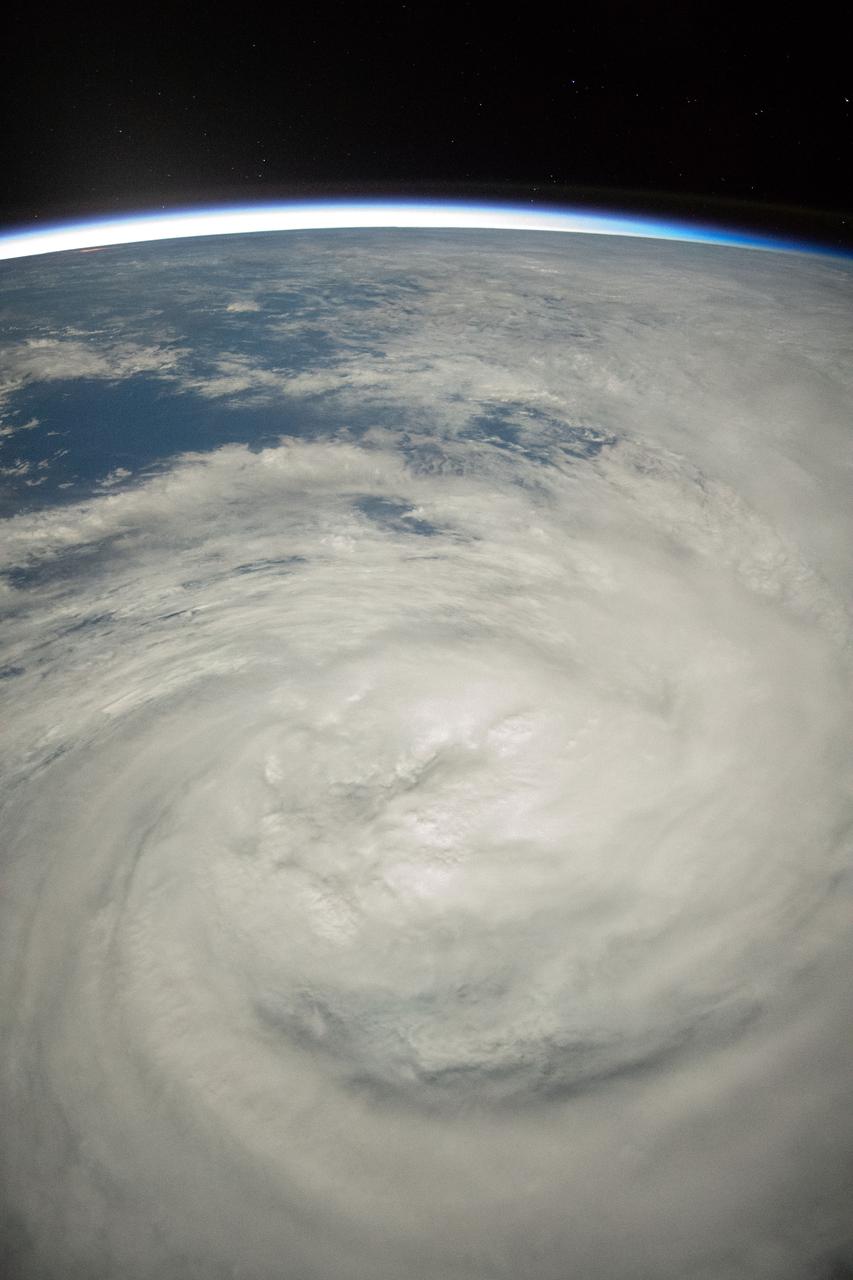
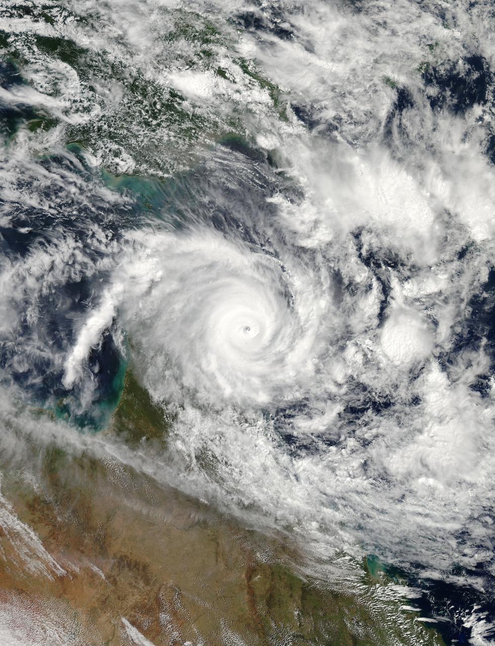
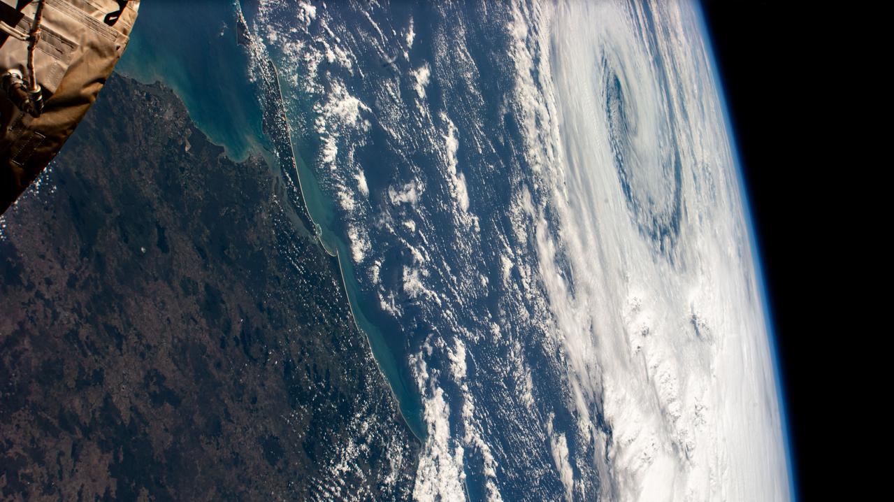
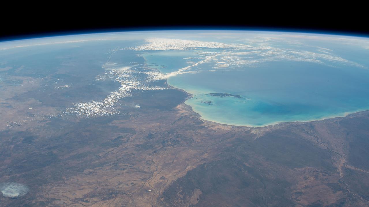
iss058e023922 (Feb. 20, 2019) --- Tropical Cyclone Oma is pictured as the International Space Station orbited 256 miles above the Coral Sea off the coast of Queensland, Australia.
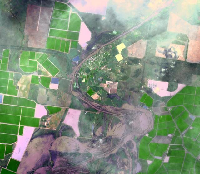
On Jan. 14, 2011, NASA Terra spacecraft captured this image of the inundated city of St. George, Queensland, Australia. Torrential rains in northeastern Australia caused the Balonne River to overflow its banks and flood much of the city.
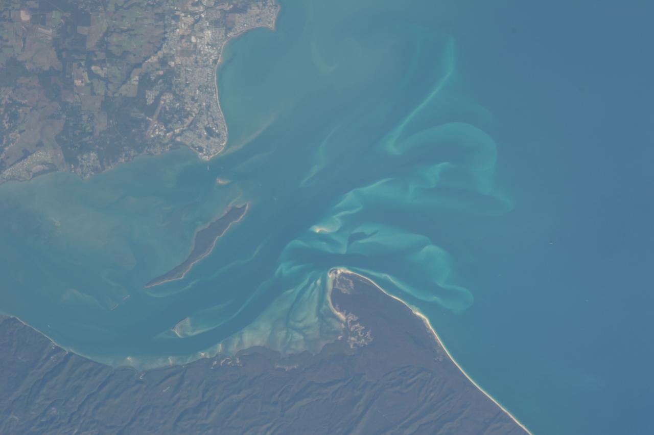
On January 17, 2011, the Advanced Spaceborne Thermal Emission and Reflection Radiometer ASTER instrument on NASA Terra spacecraft captured this image of the inundation west of Brisbane, Queensland, Australia.
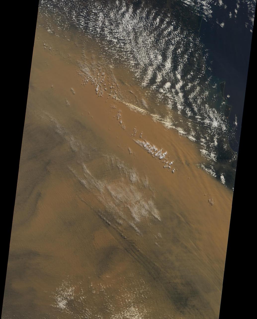
Powerful winds and dry conditions caused a massive blanket of dust from Australia Outback to spread eastward across Queensland and New South Wales. This image was acquired on September 22, 2009 by NASA Terra spacecraft.
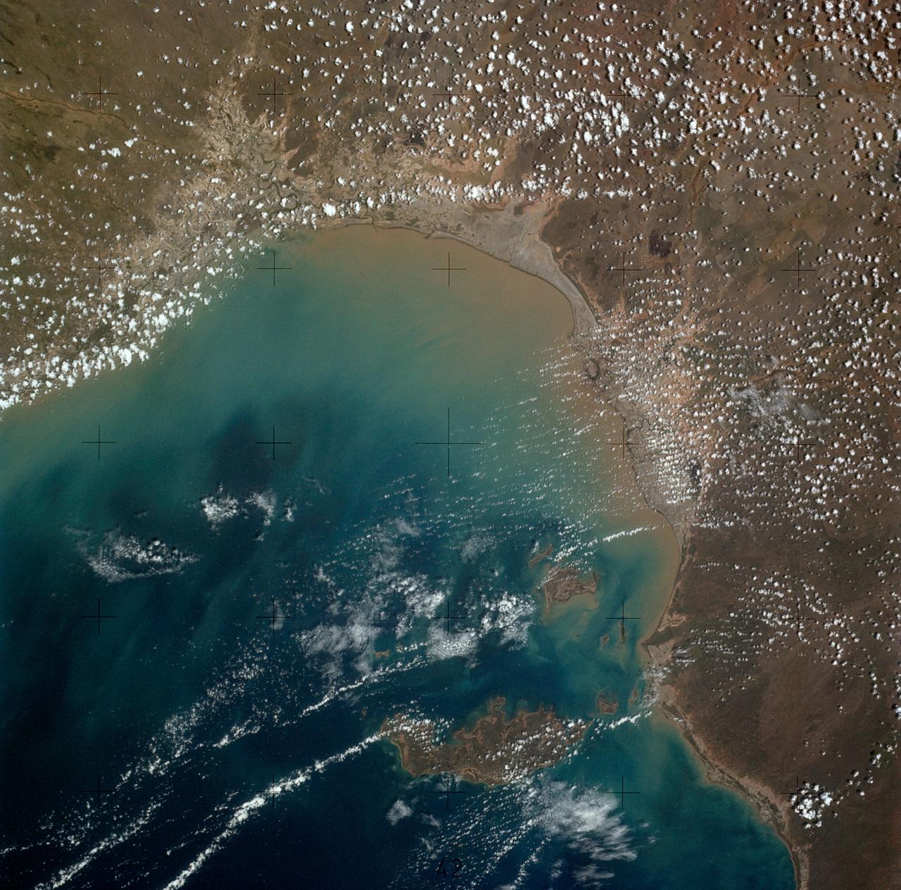
SL4-136-3501 (6 Dec. 1973) --- A vertical view of a portion of the State of Queensland, Australia, as photographed from the Skylab space station in Earth orbit by one of the Skylab 4 crewmen. The camera used was a hand-held 70mm Hasselblad, with SO-368 medium speed Ektachrome film. The body of water is the southeastern part of the Gulf of Carpentaria. This picture was taken in support studies of the north Australian drought region. The largest island seen is Mornington. The town of Normanton can also be seen. Of interest here is the sediment-laden waters at the perimeter of the Gulf showing how rains at the end of the drought are washing the top soil into the sea after the drought killed the covering vegetation. Also noted is that the vegetation patterns tend more toward those of other arid regions (i.e. they follow topographic and hydrographic patterns) rather than those in other parts of Australia (i.e. more convenient and easier to see, rectilinear patterns which are prevalent in less arid areas). Photo credit: NASA
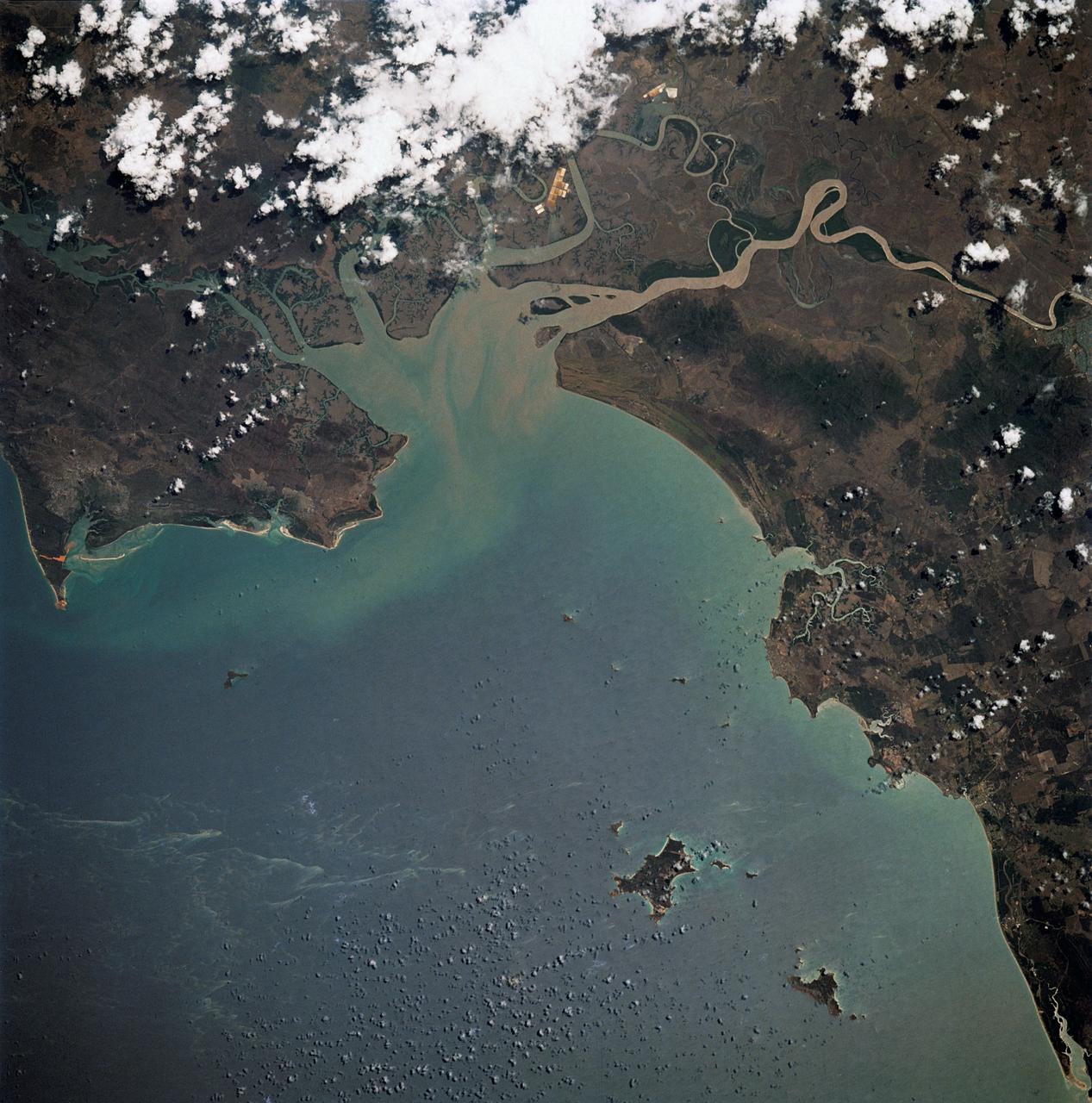
iss067e311283 (Sept. 2, 2022) --- The southeastern portion of the Gulf of Carpentaria on the coast of Queensland, Australia, is pictured from the International Space Station as it orbited 260 miles above.
On Jan. 21, 2011, the NASA Terra spacecraft captured this image of the flooding along the Balonne River and the town of Surat in southeastern Queensland, Australia.
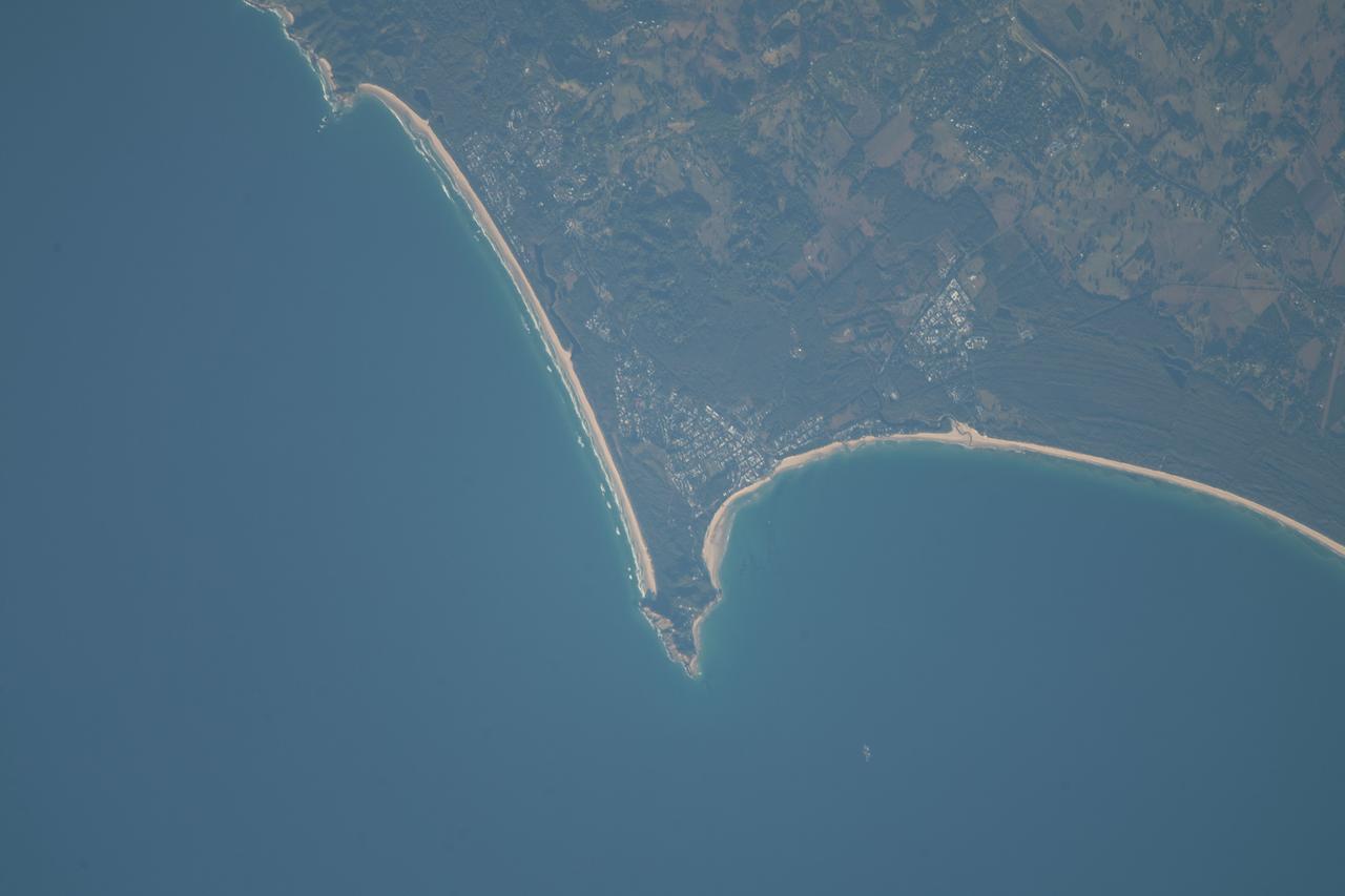
iss069e031173 (July 11, 2023) -- The Sunshine Coast, located in Southern Queensland, Australia, displays its bright sandy beaches and coastal blue waters of the Coral Sea as the International Space Station orbited 264 miles above.
iss068e004262 (Sept. 30, 2022) --- The eastern coast of Queensland, Australia, on the Great Barrier Reef is pictured from the International Space Station as it orbited 261 miles above the island continent.
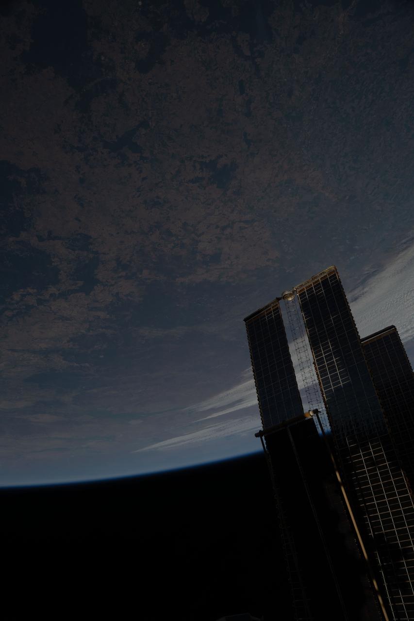
iss073e0457748 (July 4, 2025) --- The International Space Station soared 264 miles above the hot, arid region of Australia's Queensland province. At lower right, is a set of the orbital outpost's main solar arrays and a rollout solar array.
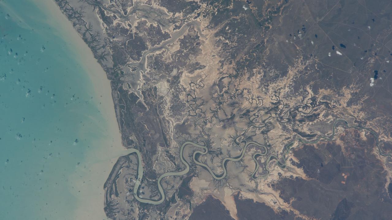
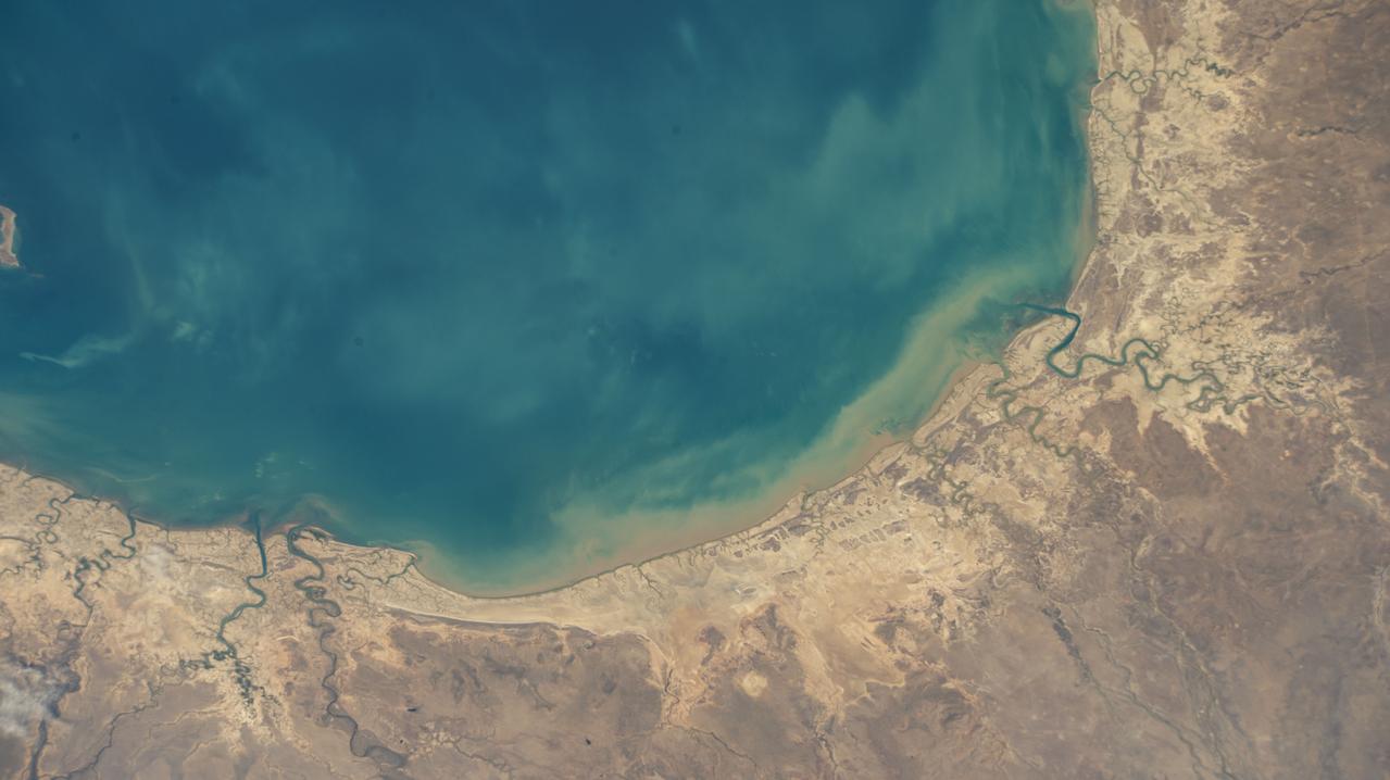
iss070e047310 (Dec. 23, 2023) --- Australia's Norman River leads into the Gulf of Carpentaria in this photograph from the International Space Station as it orbited 262 miles above the province of Queensland.
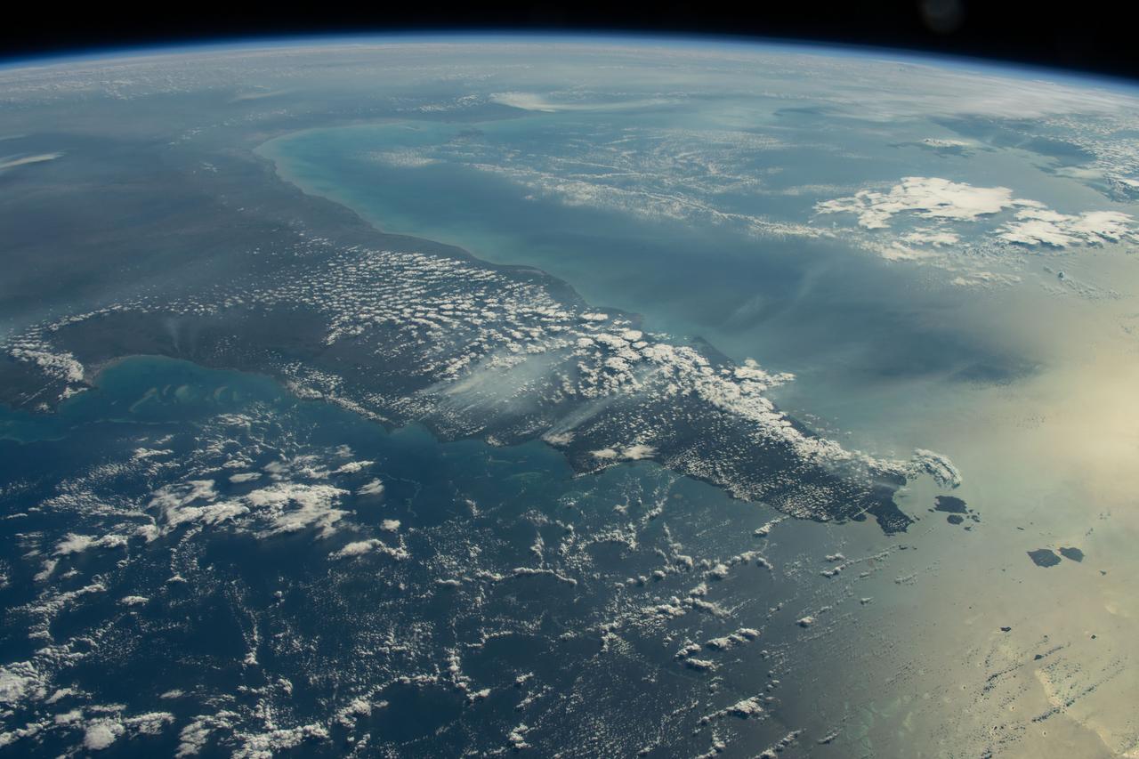
iss070e025882 (Nov. 15, 2023) --- Looking southwest over the Far North region of Queensland, Australia, is the Great Barrier Reef in the Coral Sea and the Gulf of Carpentaria on the other side of the Far North.
iss068e000353 (Sept. 29, 2022) --- A portion of the Lake Eyre Basin in central western Queensland, Australia, is pictured from the International Space Station as it orbited 261 miles above the island continent.
iss070e025826 (Nov. 15, 2023) --- The coast of the Northwest region of Queensland, Australia, on the Gulf of Carpentaria is pictured from the International Space Station as it orbited 263 miles above the continental nation. At lower left, is Mornington Island and the Bountiful Islands.
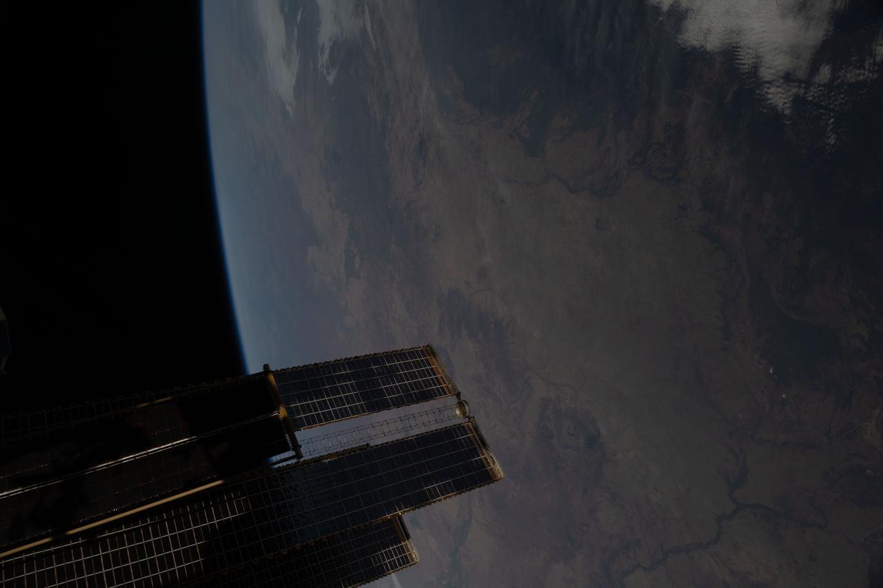
iss073e0457501 (July 4, 2025) --- The International Space Station soared 262 miles above the hot, arid region of Australia's Queensland province. At lower left, is a set of the orbital outpost's main solar arrays and a rollout solar array.
iss071e523514 (Aug. 22, 2024) --- The Gulf of Capentaria in between Australia's provinces of Northern Territory and Queensland is pictured from the International Space Station as it orbited 260 miles above the nation continent.
Heron Island is located in Queensland, Australia, approximately 45 miles (72 kilometers) off the Australian mainland, to the northeast of Gladstone. Part of Australia's Great Barrier Reef, the island is an evergreen coral cay surrounded by Wistari coral reef. Although just 42 acres in size, the island is home to a large resort and the University of Queensland's Heron Island Research Station. The island is famous for diving and snorkeling and is a World Heritage-Listed Marine National Park. It is one of two locations on the Great Barrier Reef that are serving as bases for in-water validation activities for NASA's Coral Reef Airborne Laboratory (CORAL) mission, which is studying the condition and function of the Great Barrier Reef and selected reef systems worldwide using NASA's airborne Portable Remote Imaging Spectrometer (PRISM) instrument from an altitude of 28,000 feet (8,500 meters). The Advanced Spaceborne Thermal Emission and Reflection Radiometer (ASTER) instrument on NASA's Terra spacecraft acquired this image of Heron Island and its surroundings on December 22, 2001. The island appears at the left of the reef (Heron Reef) in the center of the image. Vegetation is red on the image. The image covers an area of 10.3 by 18.6 miles (16.5 by 30.0 kilometers), and is located at 23.5 degrees south, 151.9 degrees east. http://photojournal.jpl.nasa.gov/catalog/PIA20900

NASA image acquired March 18, 2010. Tropical Cyclone Ului persisted south of the Solomon Islands on March 18, 2010. A bulletin from the U.S. Navy’s Joint Typhoon Warning Center (JTWC) issued the same day reported that the cyclone had maximum sustained winds of 80 knots (150 kilometers per hour) and gusts up to 100 knots (185 kilometers per hour). Although still strong, the wind speeds had significantly diminished over the previous few days. The Moderate Resolution Imaging Spectroradiometer (MODIS) on NASA’s Terra satellite captured this true-color image of the storm on March 18, 2010. North of the storm lie the Solomon Islands (shown in the high-resolution image). Southeast of the storm is New Caledonia. Ului’s eye appears to span 100 kilometers (60 miles) and the whole storm spans several hundred kilometers. As of 15:00 UTC on March 18 (2:00 a.m. on March 19 in Sydney, Australia), Ului was roughly 670 nautical miles (1,240 kilometers) east of Cairns, Australia. The JTWC reported that Ului had been moving southward and was expected to turn west and accelerate toward Australia. The JTWC forecast that Ului would make landfall over the northeastern Queensland coast and diminish over land. NASA image courtesy Jeff Schmaltz, MODIS Rapid Response Team at NASA GSFC. Caption by Michon Scott. Instrument: Terra - MODIS To learn more about this image go to: <a href="http://earthobservatory.nasa.gov/NaturalHazards/view.php?id=43180" rel="nofollow">earthobservatory.nasa.gov/NaturalHazards/view.php?id=43180</a>
STS009-46-1856 (28 Nov-8 Dec 1983) --- East of the Australian state of Queensland lies the worlds largest reef. The Great Barrier Reef. A portion of the reef is seen. Although beautiful from space, coral reefs, channels, etc?, has long confounded navigators, mapmakers, and oceanographers.
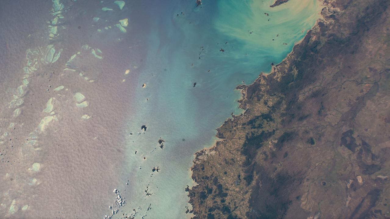
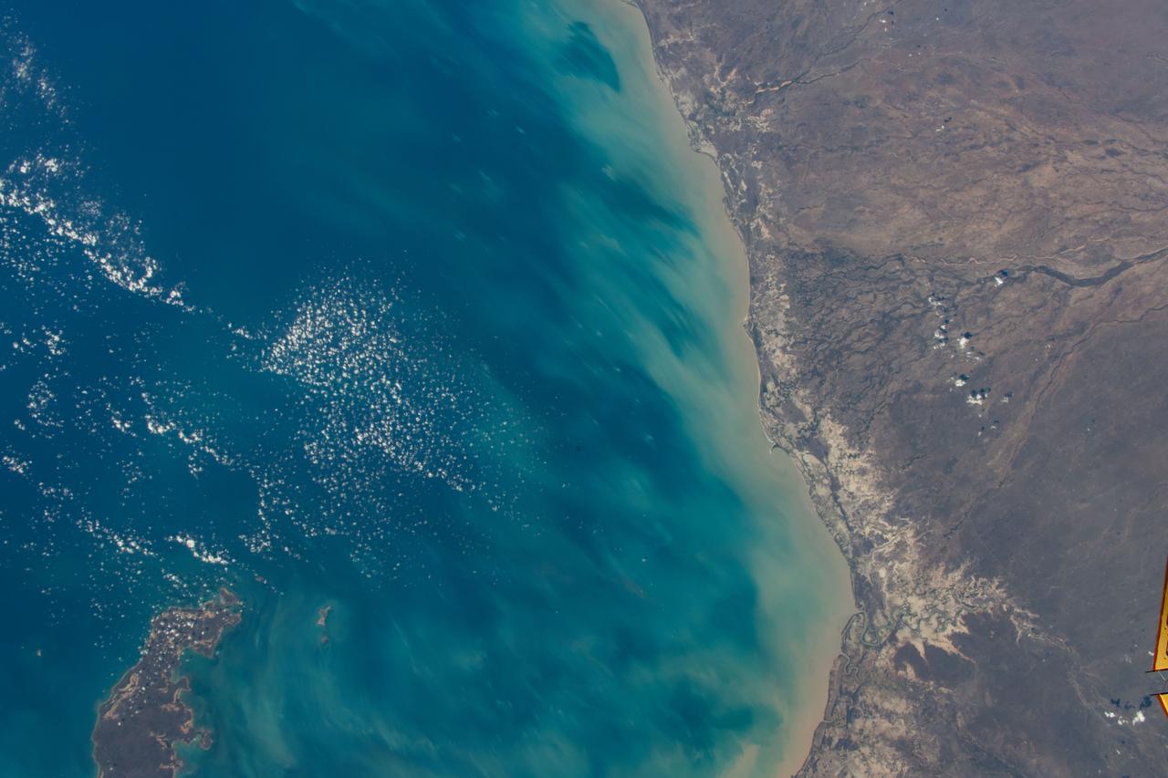
ISS043E256340 (05/26/2015) --- The Crew of Expedition 43 on board the International Space Station took this Earth observation image of Australia that captures the imagination with its brilliant blues and rugged cliffs along the waters edge. The view is of northern Australia, along the eastern Gulf of Carpentaria in Queensland.
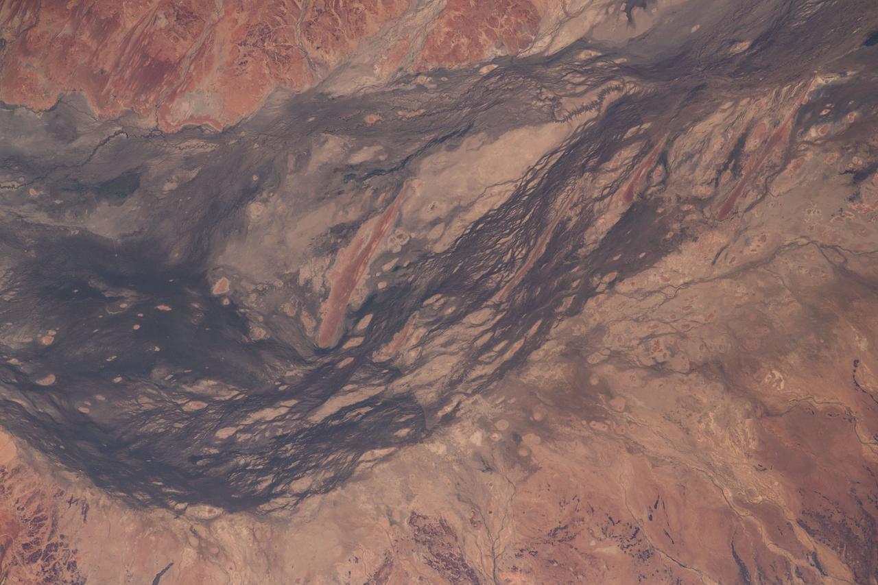
iss066e163491 (March 11, 2022) --- The remote region of Central West Queensland in Australia is pictured from the International Space Station as it orbited 262 miles above. Notable geographical features pictured include the Diamantina River, flowing from upper left to lower right, and Lake Machattie at lower center left.
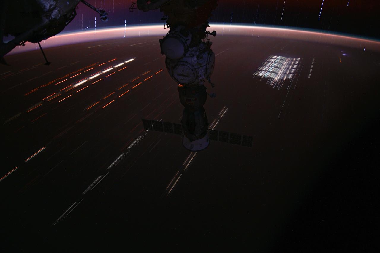
iss071e414590_stk (Aug. 3, 2024) --- This long-duration photograph of the Soyuz MS-25 spacecraft with light trails on Earth below and stars trails above the horizon was taken by NASA astronaut Matthew Dominick as the International Space Station soared 262 miles above a sparsely populated region of Queensland, Australia.
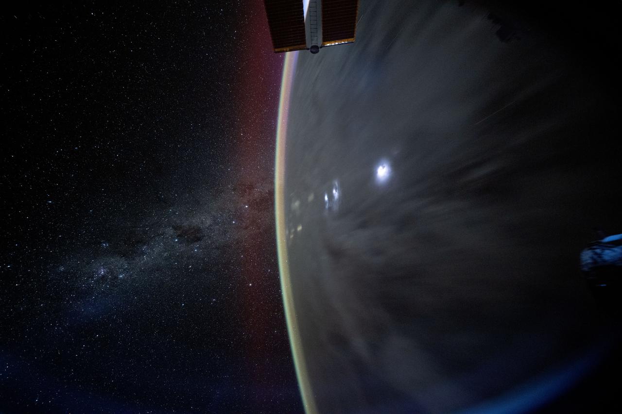
iss072e646033 (Feb. 3, 2025) --- The Milky Way appears beyond Earth's horizon in this celestial photograph captured by NASA astronaut Don Pettit using a camera with low light and long duration settings as the International Space Station orbited 259 miles above the Coral Sea off the coast of Queensland, Australia.
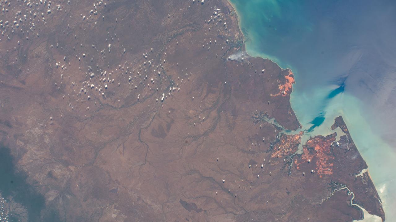
iss072e098244 (Oct. 24, 2024) --- Mission River, a coastal rural locality on the Gulf of Carpenteria in the northern tip and tropical climate of Australia's state of Queensland, is pictured from the International Space Station as it orbited 261 miles above the island continent.
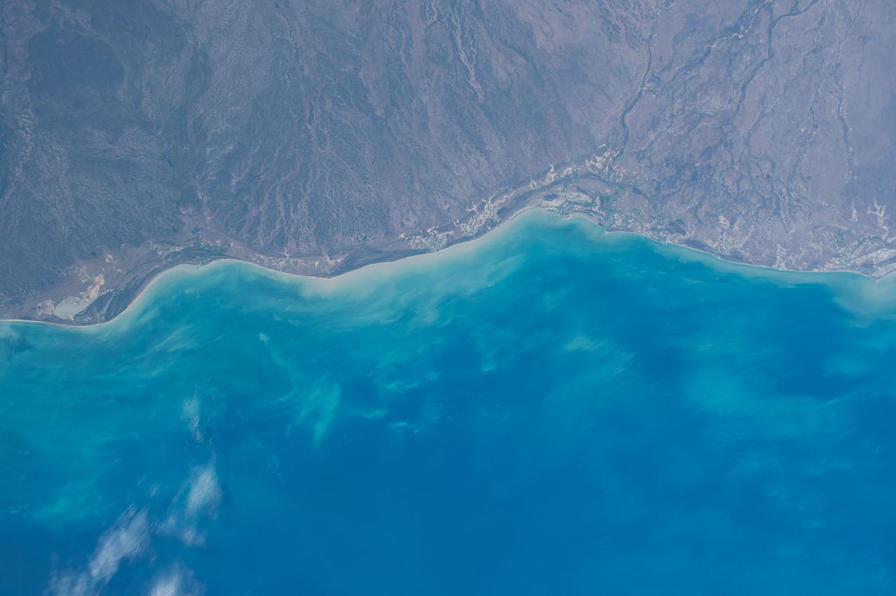
STS032-520-014 (9-20 Jan. 1990) --- STS-32 astronauts took this 70mm scene showing phytoplankton oralgal bloom in the northwest Coral Sea. The Western Coral Sea and the Great Barrier Reef waters offshore Queensland, Australia are the sites of some of the larger concentrations or "blooms" of phytoplankton and algae in the open ocean. In the instance illustrated here, the leading edge of a probable concentration of algae or phytoplankton is seen as a light irregular line and sheen between the offshore Great Barrier Reef and the Queensland coast. Previous phytoplankton concentrations in this area have been reported by ships at sea as having formed floating mats as thick as two meters. This picture was used by the STS-32 astronauts at their Jan. 30, 1990 post-flight press conference.
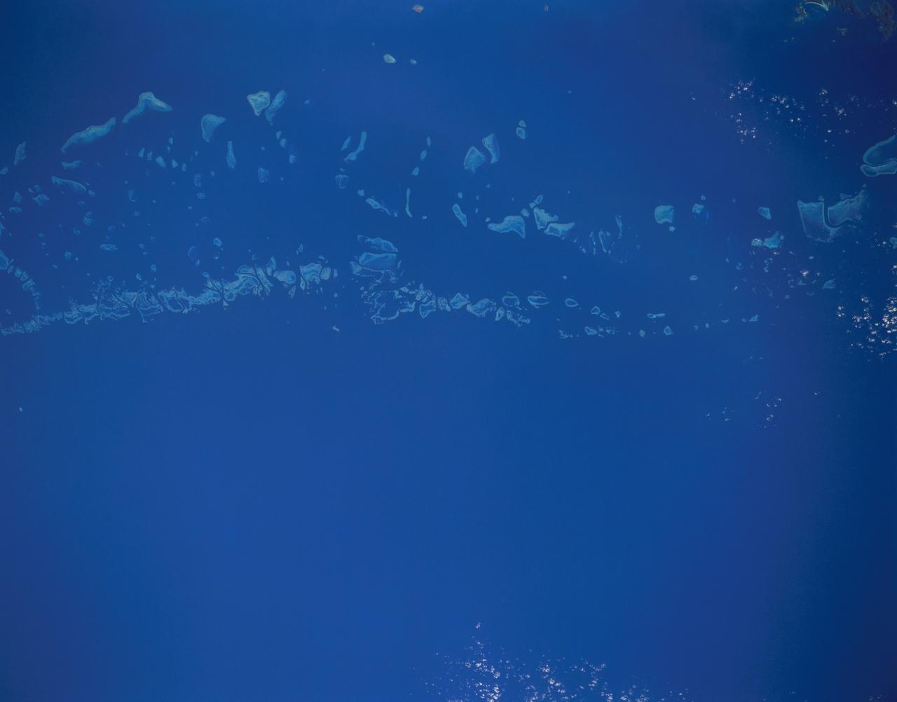
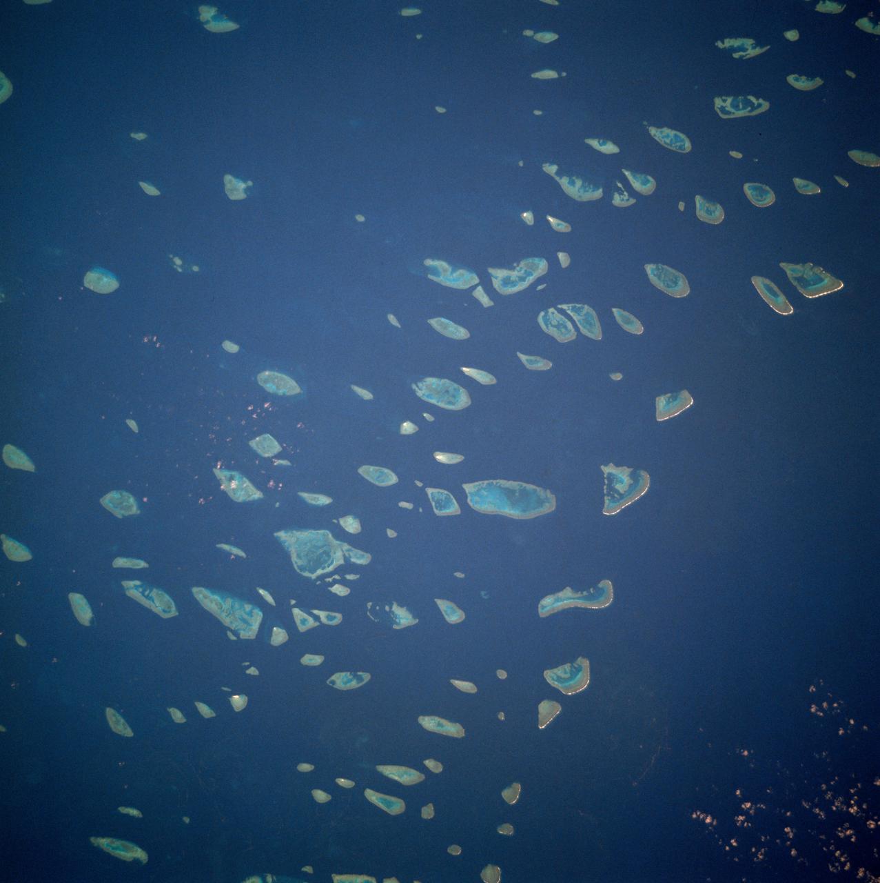
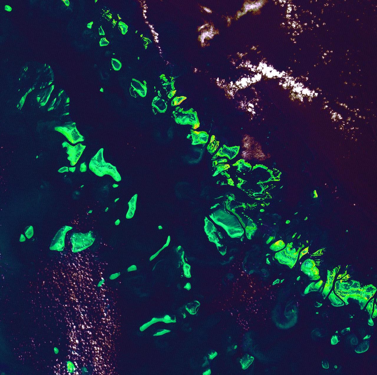
STS048-151-250 (12-18 Sept. 1991) --- The Great Barrier Reef extends for roughly 2,000 kilometers along the northeast coast of Australia. The great Barrier Reef is made up of thousands of individual reefs which define the edge of the continental shelf. The southern part of the feature, called Swain Reef, is seen here. Water depths around the reefs are quite shallow (less than 1 meter to about 36 meters in depth), but only a few kilometers offshore, water depths are roughly 1,000 meters.
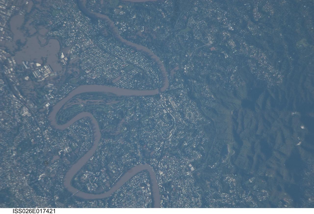
ISS026-E-017421 (13 Jan. 2011) --- Photographed by an Expedition 26 crew member on the International Space Station, this detailed photograph illustrates flooding in suburbs of the Brisbane, Australia metropolitan region. The Brisbane area experienced catastrophic flooding following unusually heavy rainfall on Jan. 10, 2011. With surficial soils already saturated from previous rainfall events, eastward-draining surface flow caused the Brisbane River to flood—inundating an estimated 20,000 homes in suburbs of the capital city of Queensland. Other cities in Queensland have also experienced damaging floods during previous heavy rainfall events this year. The image highlights several suburbs along the Brisbane River in the southern part of the Brisbane metropolitan area. The light-colored rooftops of residences and other structures contrast sharply with green vegetation and brown, sediment laden floodwaters. Most visible low-lying areas are inundated by floodwater, perhaps the most striking being Rocklea at upper left. The suburb of Yeronga (lower left) also has evident regions of flooding, as does a park and golf course located along a bend in the Brisbane River to the south of St. Lucia (center). Flooding becomes less apparent near the higher elevations of Mt. Coot-Tha at right.
ISS036-E-028444 (3 Aug. 2013) --- Hervey Bay, Queensland, Australia is featured in this image photographed by an Expedition 36 crew member on the International Space Station. The northern end of the Great Sandy Strait and Hervey Bay are highlighted in this photograph. The Strait is an estuary that separates the mainland coastline of the state of Queensland, Australia from neighboring Fraser Island. The mainland side of the Strait includes the city of Hervey Bay, visible at top center. Other communities that have become part of the larger metropolitan area include Scarness, Booral, and Urangan. A small vegetated island and shallow sand bars of the Great Sandy Strait are visible at center left, while submerged sands appear as bright blue flowing ribbons at center. A small, bright white exposure of sand is visible above the water level near the center point of the image. While once a major freighting center for the sugar cane industry, the local economy is now largely based on tourism, with whale watching tours a popular attraction. The Great Sandy Strait estuary provides habitat for breeding fish, crustaceans, turtles, and other sea life, as well as a wide variety of birds. Nearby Fraser Island is the world?s largest sand island and a World Heritage site.

STS072-727-085 (11-20 Jan. 1996) --- The northern third of the Great Barrier Reef stretches 650 kilometers (km) along the coast of Queensland from south of Cairns to past Princess Charlotte Bay at the base of the Cape York Peninsula. The predominant westerly waves of the ocean create shallower (lighter-colored) convex-eastward rims to coral atolls along the outer edge of the barrier reef. In contrast, islands within the lagoon show the effect of predominant southerly, more-or-less offshore winds. Arcuate clouds suggest that winds were offshore at the time the photograph was taken.
STS072-721-010 (11-20 Jan. 1996) --- Astronauts aboard the Space Shuttle Endeavour exposed this frame of Brisbane, the third largest city in Australia, as well as the capital of Queensland. The heart of the city is 12 miles from Moreton bay and is located on the Brisbane River. In the photograph this area is clearly visible due to the "W"-shaped bend in the river. Mount Coot-Na Park is the dark area on the upper edge of the frame. This area provides an overlook for the entire city. Moreton Island is the Exclamation shaped island protecting the harbor. Fraser Island is about 150 miles north of Brisbane. The international airport is directly above the river in this view.
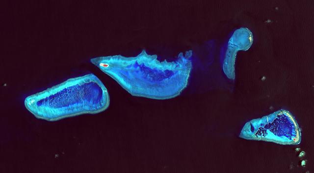
Great Barrier Reef - August 8th, 1999 Description: What might be mistaken for dinosaur bones being unearthed at a paleontological dig are some of the individual reefs that make up the Great Barrier Reef, the world's largest tropical coral reef system. The reef stretches more than 2,000 kilometers (1,240 miles) along the coast of Queensland, Australia. It supports astoundingly complex and diverse communities of marine life and is the largest structure on the planet built by living organisms. Credit: USGS/NASA/Landsat 7 To learn more about the Landsat satellite go to: <a href="http://landsat.gsfc.nasa.gov/" rel="nofollow">landsat.gsfc.nasa.gov/</a> <b><a href="http://www.nasa.gov/centers/goddard/home/index.html" rel="nofollow">NASA Goddard Space Flight Center</a></b> enables NASA’s mission through four scientific endeavors: Earth Science, Heliophysics, Solar System Exploration, and Astrophysics. Goddard plays a leading role in NASA’s accomplishments by contributing compelling scientific knowledge to advance the Agency’s mission. <b>Follow us on <a href="http://twitter.com/NASA_GoddardPix" rel="nofollow">Twitter</a></b> <b>Join us on <a href="http://www.facebook.com/pages/Greenbelt-MD/NASA-Goddard/395013845897?ref=tsd" rel="nofollow">Facebook</a></b>
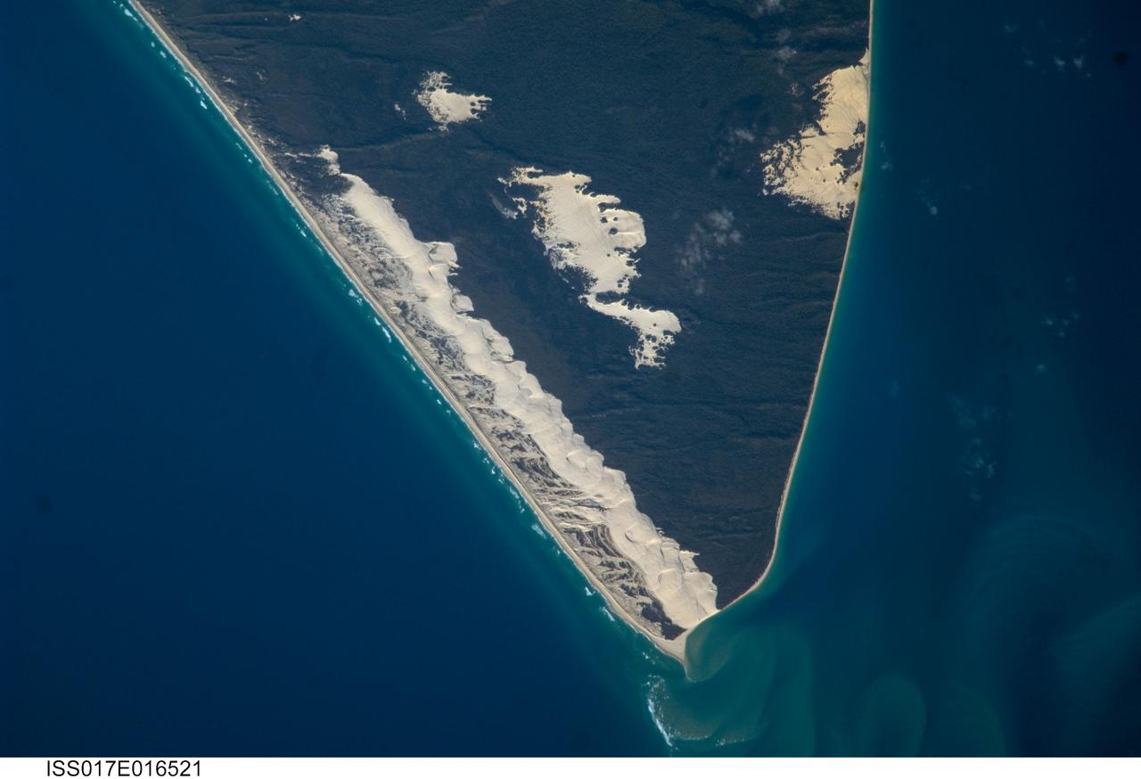
ISS017-E-016521 (15 Sept. 2008) --- Sandy Cape and Fraser Island, Australia are featured in this image photographed by an Expedition 17 crewmember on the International Space Station. Fraser Island, the world's largest sand island, includes Great Sandy National Park and is located along the coastline of Queensland, Australia. The island was designated a World Heritage site in 1992, in part due to its outstanding preservation of geological processes related to sand dune formation. According to scientists, the island's dune fields preserve a record of sand deposition and movement related to sea level rise and fall extending back over 700,000 years. In addition to sand dunes, the island also preserves an interesting range of vegetation -- including vine rainforest, stands of eucalypt trees, and mangroves -- and diverse fauna including crabs, parrots, sugar gliders and flying foxes. This view highlights the northernmost portion of the island, known as Sandy Cape. Active white sand dunes contrast with dark green vegetation that anchors older dune sets. Irregular patches of sand dunes surrounded by vegetation are known as sand blows (or blowouts), formed when the vegetation cover is disturbed -- by wind, fire, or human activities. The exposed underlying sand can then move and form new dunes, sometimes at rates of up to one meter per year. Coastal sand dune fields -- such as the one located along the eastern side of Sandy Cape (center) -- will remain active until anchored by vegetation, or until no more sand is available to form new dunes.