![This graphic shows a new radiation zone surrounding Jupiter, located just above the atmosphere near the equator, that has been discovered by NASA's Juno mission. The new radiation zone is depicted here as a glowing blue area around the planet's middle. This radiation zone includes energetic hydrogen, oxygen and sulfur ions moving at close to the speed of light (referred to as "relativistic" speeds). It resides inside Jupiter's previously known radiation belts. The zone was identified by the mission's Jupiter Energetic Particle Detector Instrument (JEDI), enabled by Juno's unique close approach to the planet during the spacecraft's science flybys (2,100 miles or 3,400 kilometers from the cloud tops). Juno scientists believe the particles creating this region of intense radiation are derived from energetic neutral atoms -- that is, fast-moving atoms without an electric charge -- coming from the tenuous gas around Jupiter's moons Io and Europa. The neutral atoms then become ions -- atoms with an electric charge -- as their electrons are stripped away by interaction with the planet's upper atmosphere. (This discovery is discussed further in an issue of the journal Geophysical Research Letters [Kollmann et al. (2017), Geophys. Res. Lett., 44, 5259-5268].) Juno also has detected signatures of a population of high-energy, heavy ions in the inner edges of Jupiter's relativistic electron radiation belt. This radiation belt was previously understood to contain mostly electrons moving at near light speed. The signatures of the heavy ions are observed at high latitude locations within the electron belt -- a region not previously explored by spacecraft. The origin and exact species of these heavy ions is not yet understood. Juno's Stellar Reference Unit (SRU-1) star camera detects the signatures of this population as extremely high noise in images collected as part of the mission's radiation monitoring investigation. The locations where the heavy ions were detected are indicated on the graphic by two bright, glowing spots along Juno's flight path past the planet, which is shown as a white line. The invisible lines of Jupiter's magnetic field are also portrayed here for context as faint, bluish lines. https://photojournal.jpl.nasa.gov/catalog/PIA22179](https://images-assets.nasa.gov/image/PIA22179/PIA22179~small.jpg)
This graphic shows a new radiation zone surrounding Jupiter, located just above the atmosphere near the equator, that has been discovered by NASA's Juno mission. The new radiation zone is depicted here as a glowing blue area around the planet's middle. This radiation zone includes energetic hydrogen, oxygen and sulfur ions moving at close to the speed of light (referred to as "relativistic" speeds). It resides inside Jupiter's previously known radiation belts. The zone was identified by the mission's Jupiter Energetic Particle Detector Instrument (JEDI), enabled by Juno's unique close approach to the planet during the spacecraft's science flybys (2,100 miles or 3,400 kilometers from the cloud tops). Juno scientists believe the particles creating this region of intense radiation are derived from energetic neutral atoms -- that is, fast-moving atoms without an electric charge -- coming from the tenuous gas around Jupiter's moons Io and Europa. The neutral atoms then become ions -- atoms with an electric charge -- as their electrons are stripped away by interaction with the planet's upper atmosphere. (This discovery is discussed further in an issue of the journal Geophysical Research Letters [Kollmann et al. (2017), Geophys. Res. Lett., 44, 5259-5268].) Juno also has detected signatures of a population of high-energy, heavy ions in the inner edges of Jupiter's relativistic electron radiation belt. This radiation belt was previously understood to contain mostly electrons moving at near light speed. The signatures of the heavy ions are observed at high latitude locations within the electron belt -- a region not previously explored by spacecraft. The origin and exact species of these heavy ions is not yet understood. Juno's Stellar Reference Unit (SRU-1) star camera detects the signatures of this population as extremely high noise in images collected as part of the mission's radiation monitoring investigation. The locations where the heavy ions were detected are indicated on the graphic by two bright, glowing spots along Juno's flight path past the planet, which is shown as a white line. The invisible lines of Jupiter's magnetic field are also portrayed here for context as faint, bluish lines. https://photojournal.jpl.nasa.gov/catalog/PIA22179
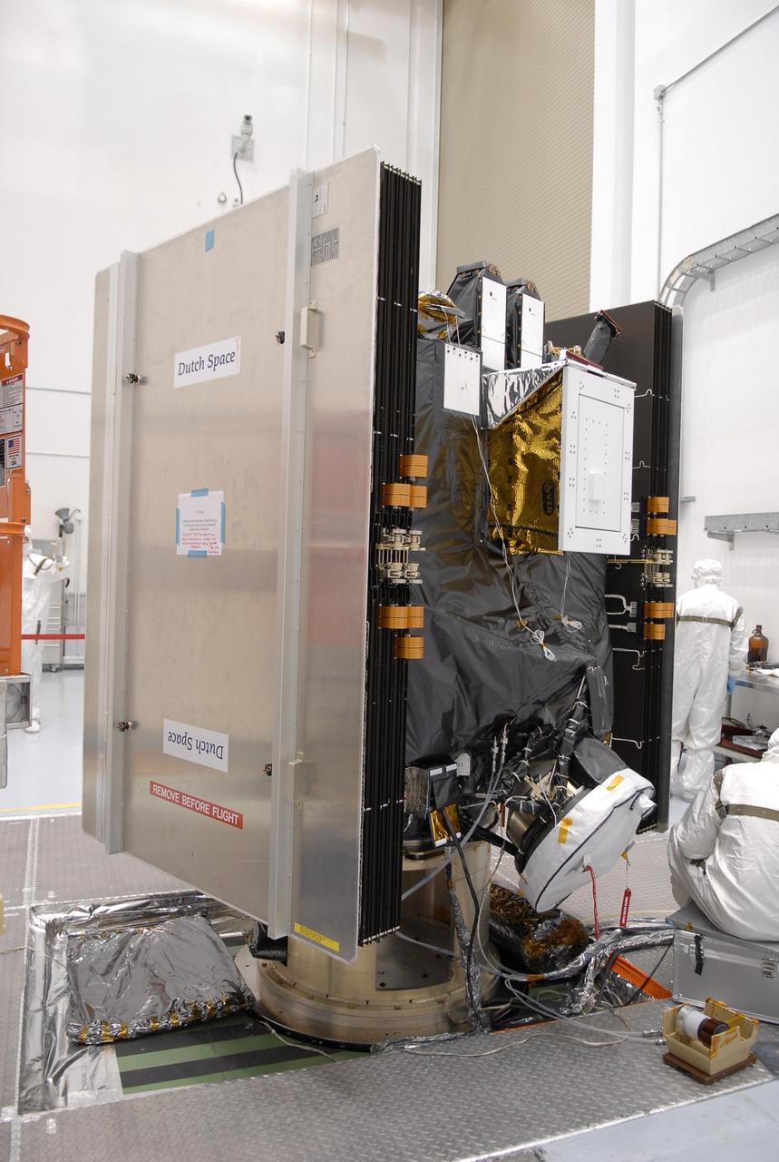
KENNEDY SPACE CENTER, FLA. -- At Astrotech, the Dawn spacecraft is on display for a media showing. On each side are the folded solar array panels. The "box" in the upper center is the visual and infrared mapping spectrometer, which is designed to measure how much radiation of different "colors" is reflected or emitted by an object. At the bottom, under cover, is one of the ion propulsion thrusters. Dawn's goal is to characterize the conditions and processes of the solar system's earliest epoch by investigating in detail the largest protoplanets that have remained intact since their formations: asteroid Vesta and the dwarf planet Ceres. They reside in the extensive zone between Mars and Jupiter together with many other smaller bodies, called the asteroid belt. Photo credit: NASA/Kim Shiflett

ISS013-E-27872 (28 May 2006) --- Considerable sunglint emphasizes features on Lake Erie in this image photographed by an Expedition 13 crewmember on the International Space Station. This detailed, south-looking image shows features on the surface of Lake Erie, about 30 miles west of Cleveland, Ohio. This view shows the Vermilion River in strong sunglint. The angular water bodies along the river are likely marinas. The main part of the image show numerous ship wakes in the zone of partial glint around the disk of the Sun's reflection point. The wakes radiate from the mouth of the Vermilion River, with many of them heading northwest in the direction of Detroit, Michigan.
The two side boosters of the SpaceX Falcon Heavy rocket carrying 24 satellites as part of the Department of Defense's Space Test Program-2 (STP-2) mission are seen as they conduct a boost back burn to return to Landing Zone 1, Tuesday, June 25, 2019 at NASA's Kennedy Space Center in Florida. Four NASA technology and science payloads which will study non-toxic spacecraft fuel, deep space navigation, "bubbles" in the electrically-charged layers of Earth's upper atmosphere, and radiation protection for satellites are among the two dozen satellites that will be put into orbit. Photo Credit: (NASA/Joel Kowsky)
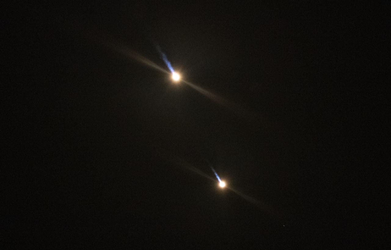
The two side boosters of the SpaceX Falcon Heavy rocket carrying 24 satellites as part of the Department of Defense's Space Test Program-2 (STP-2) mission are seen as they begin their landing burns to return to Landing Zone 1, Tuesday, June 25, 2019 at NASA's Kennedy Space Center in Florida. Four NASA technology and science payloads which will study non-toxic spacecraft fuel, deep space navigation, "bubbles" in the electrically-charged layers of Earth's upper atmosphere, and radiation protection for satellites are among the two dozen satellites that will be put into orbit. Photo Credit: (NASA/Joel Kowsky)

Absorption of solar energy heats up our planet's surface and atmosphere making life for us possible. But the energy carnot stay bound up in the Earth's environment forever. If it did, the Earth would be as hot as the sun. Instead, as the surface and atmosphere warm, they emit thermal long wave radiation, some of which escapes into space and allows the Earth to cool. This false color image of the Earth was produced by the Clouds and the Earth's Radiant Energy System (CERES) instrument flying aboard NASA's Terra spacecraft. The image shows where more or less heat, in the form of long-wave radiation, is emanating from the top of the Earth's atmosphere. As one can see in the image, the thermal radiation leaving the oceans is fairly uniform. The blue swaths represent thick clouds, the tops of which are so high they are among the coldest places on Earth. In the American Southwest, which can be seen in the upper right hand corner of the globe, there is often little cloud cover to block outgoing radiation and relatively little water to absorb solar energy making the amount of outgoing radiation in this area exceeding that of the oceans. Recently, NASA researchers discovered that incoming solar radiation and outgoing thermal radiation increased in the tropics from the 1980s to the 1990s. They believe the unexpected change has to do with apparent change in circulation patterns around the globe, which effectively reduce the amount of water vapor and cloud cover in the upper reaches of the atmosphere. Without the clouds, more sunlight was allowed to enter the tropical zones and more thermal energy was allowed to leave. The findings may have big implications for climate change and future global warming. (Image courtesy NASA Goddard)
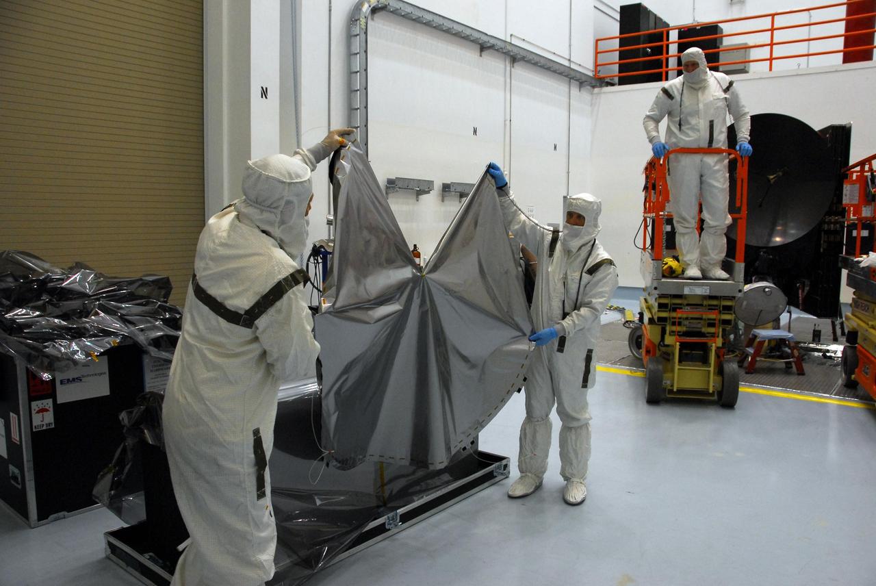
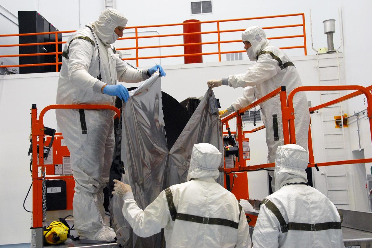
KENNEDY SPACE CENTER, FLA. -- At Astrotech, technicians lift the sun shade to be installed over the high gain antenna on the Dawn spacecraft. Made of germanium kapton, the shade, which is RF transparent, is placed over the sensitive antenna to reflect and emit harmful solar radiation to prevent the antenna from being excessively heated. Dawn is scheduled to launch July 7 from Pad 17-B on Cape Canaveral Air Force Station. Dawn's goal is to characterize the conditions and processes of the solar system's earliest epoch by investigating in detail the largest protoplanets that have remained intact since their formations: asteroid Vesta and the dwarf planet Ceres. They reside in the extensive zone between Mars and Jupiter together with many other smaller bodies, called the asteroid belt. Photo credit: NASA/George Shelton
KENNEDY SPACE CENTER, FLA. -- At Astrotech, a technician looks at the sun shade (foreground) to be installed over the high gain antenna on the Dawn spacecraft. Made of germanium kapton, the shade, which is RF transparent, is placed over the sensitive antenna to reflect and emit harmful solar radiation to prevent the antenna from being excessively heated. Dawn is scheduled to launch July 7 from Pad 17-B on Cape Canaveral Air Force Station. Dawn's goal is to characterize the conditions and processes of the solar system's earliest epoch by investigating in detail the largest protoplanets that have remained intact since their formations: asteroid Vesta and the dwarf planet Ceres. They reside in the extensive zone between Mars and Jupiter together with many other smaller bodies, called the asteroid belt. Photo credit: NASA/George Shelton
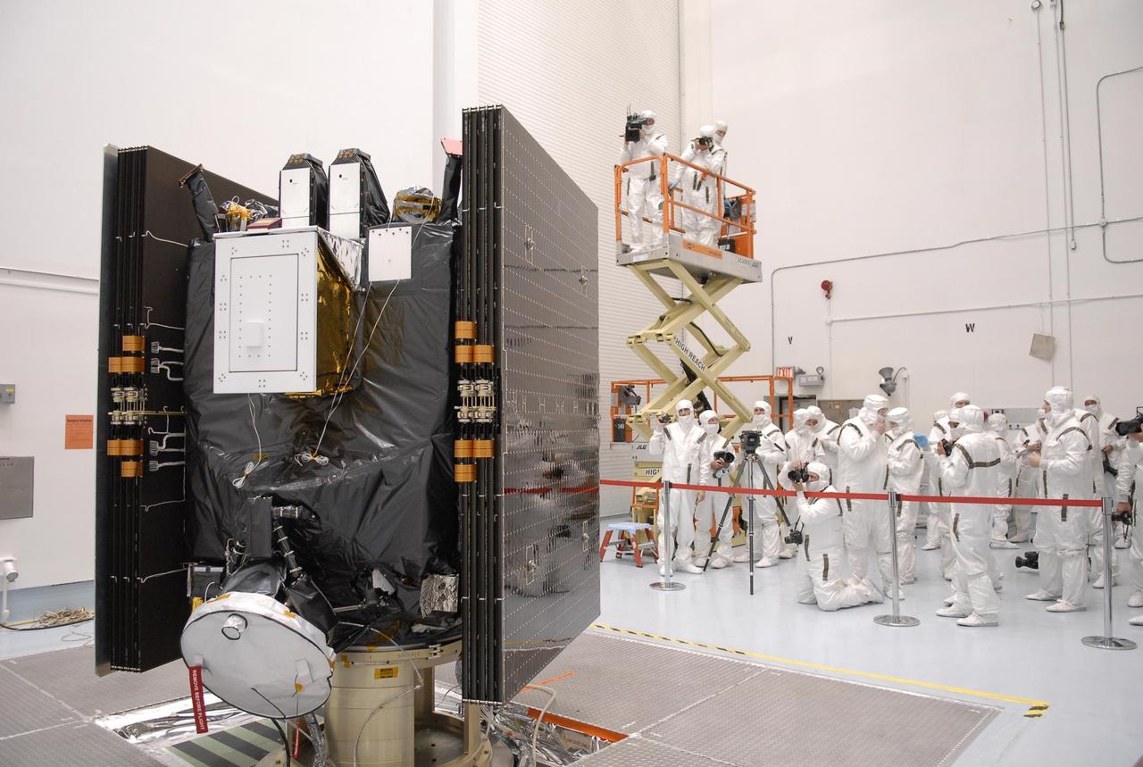
KENNEDY SPACE CENTER, FLA. -- At Astrotech, photographers dressed in clean-room suits are able to shoot the Dawn spacecraft in its entirety before it is prepared for launch. Seen on each side are the folded solar array panels. At the top on the near side is the "box," containing the visual and infrared mapping spectrometer, which is designed to measure how much radiation of different "colors" is reflected or emitted by an object. Above it are the framing cameras, which are the scientific imaging system of the Dawn Mission. Dawn's goal is to characterize the conditions and processes of the solar system's earliest epoch by investigating in detail the largest protoplanets that have remained intact since their formations: asteroid Vesta and the dwarf planet Ceres. They reside in the extensive zone between Mars and Jupiter together with many other smaller bodies, called the asteroid belt. Photo credit: NASA/Kim Shiflett
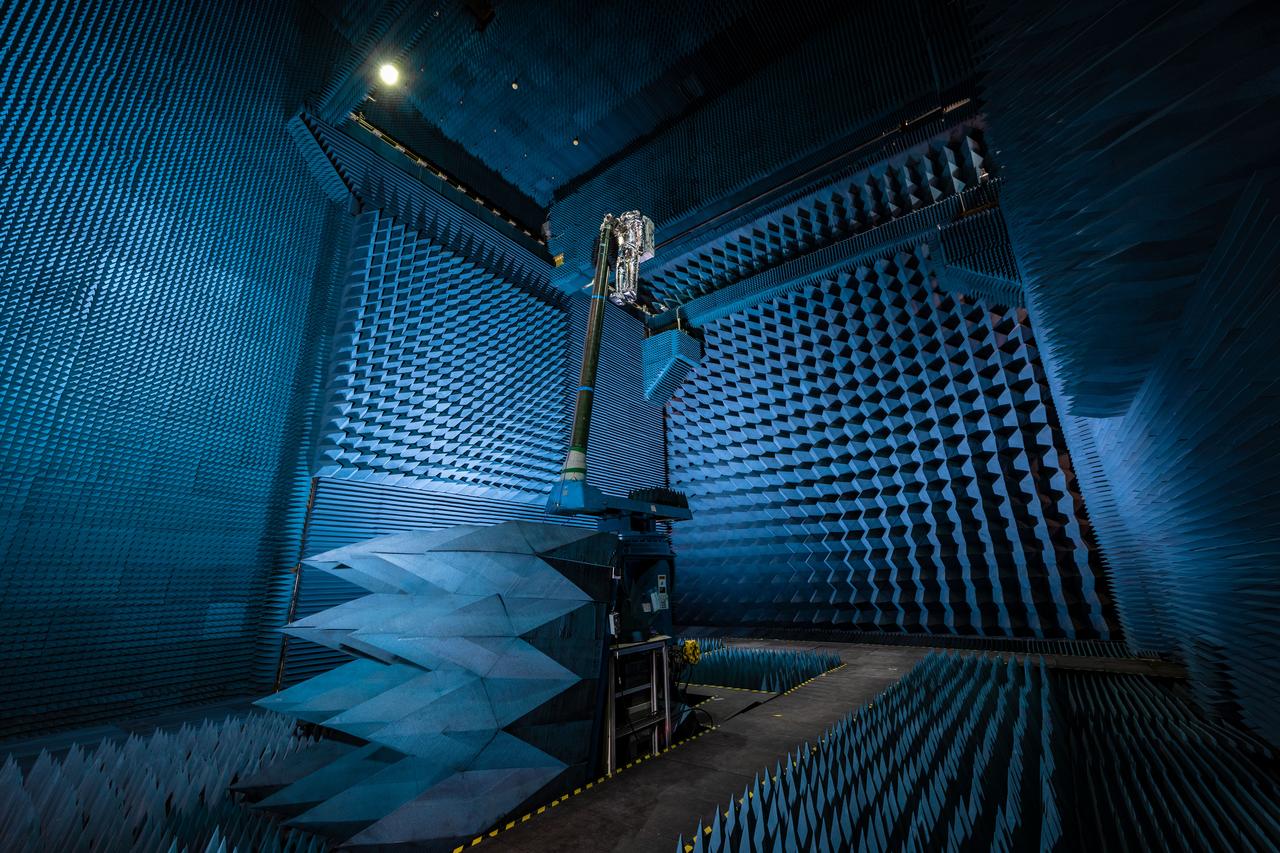
jsc2021e022487 (June 11, 2021) --- NASA’s Exploration Extravehicular Mobility Unit (xEMU) spacesuit undergoes antenna testing in NASA Johnson Space Center’s anechoic chamber to inspect multi-layer insulation keep-out zones for the Wi-Fi and ultra-high-frequency antennas that are part of the spacesuit’s communication system. The xEMU test article is named xGUS, the successor to the Extravehicular Mobility Unit test article (also named GUS), which was named after NASA astronaut Gus Grissom and his iconic silver spacesuit. This image was taken from where the "horn," or source antenna, is located that sends out radio frequency signals to the spacesuit. The anechoic chamber walls are covered with a material that absorbs electromagnetic energy allowing the anechoic chamber to simulate a space environment. The antenna test facility is utilized to test antenna radiation distribution pattern performance for spaceflight applications in electromagnetic environments.

KENNEDY SPACE CENTER, FLA. -- At At Astrotech, the Dawn spacecraft is on display with the recently installed sun shade over the high gain antenna. Made of germanium kapton, the shade, which is RF transparent, is placed over the sensitive antenna to reflect and emit harmful solar radiation to prevent the antenna from being excessively heated. Dawn is scheduled to launch July 7 from Pad 17-B on Cape Canaveral Air Force Station. Dawn's goal is to characterize the conditions and processes of the solar system's earliest epoch by investigating in detail the largest protoplanets that have remained intact since their formations: asteroid Vesta and the dwarf planet Ceres. They reside in the extensive zone between Mars and Jupiter together with many other smaller bodies, called the asteroid belt. Photo credit: NASA/George Shelton
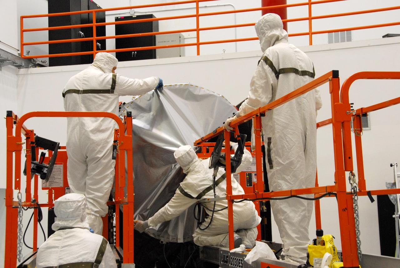
KENNEDY SPACE CENTER, FLA. -- At Astrotech, technicians begin placing the sun shade over the high gain antenna on the Dawn spacecraft. Made of germanium kapton, the shade, which is RF transparent, is placed over the sensitive antenna to reflect and emit harmful solar radiation to prevent the antenna from being excessively heated. Dawn is scheduled to launch July 7 from Pad 17-B on Cape Canaveral Air Force Station. Dawn's goal is to characterize the conditions and processes of the solar system's earliest epoch by investigating in detail the largest protoplanets that have remained intact since their formations: asteroid Vesta and the dwarf planet Ceres. They reside in the extensive zone between Mars and Jupiter together with many other smaller bodies, called the asteroid belt. Photo credit: NASA/George Shelton

jsc2021e022515 (June 11, 2021) --- NASA’s Exploration Extravehicular Mobility Unit (xEMU) spacesuit undergoes antenna testing in NASA Johnson Space Center’s anechoic chamber to inspect multi-layer insulation keep-out zones for the Wi-Fi and ultra-high-frequency antennas that are part of the spacesuit’s communication system. The xEMU test article is named xGUS, the successor to the Extravehicular Mobility Unit test article (also named GUS), which was named after NASA astronaut Gus Grissom and his iconic silver spacesuit. This image was taken from where the "horn," or source antenna, is located that sends out radio frequency signals to the spacesuit. The anechoic chamber walls are covered with a material that absorbs electromagnetic energy allowing the anechoic chamber to simulate a space environment. The antenna test facility is utilized to test antenna radiation distribution pattern performance for spaceflight applications in electromagnetic environments. Pictured in the photo is antenna test engineer Will Bond.
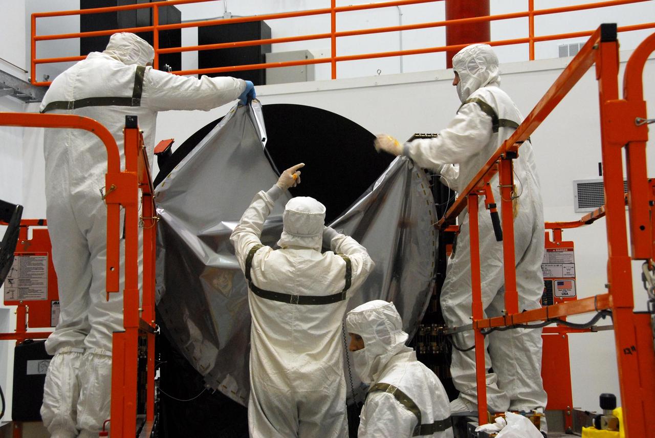
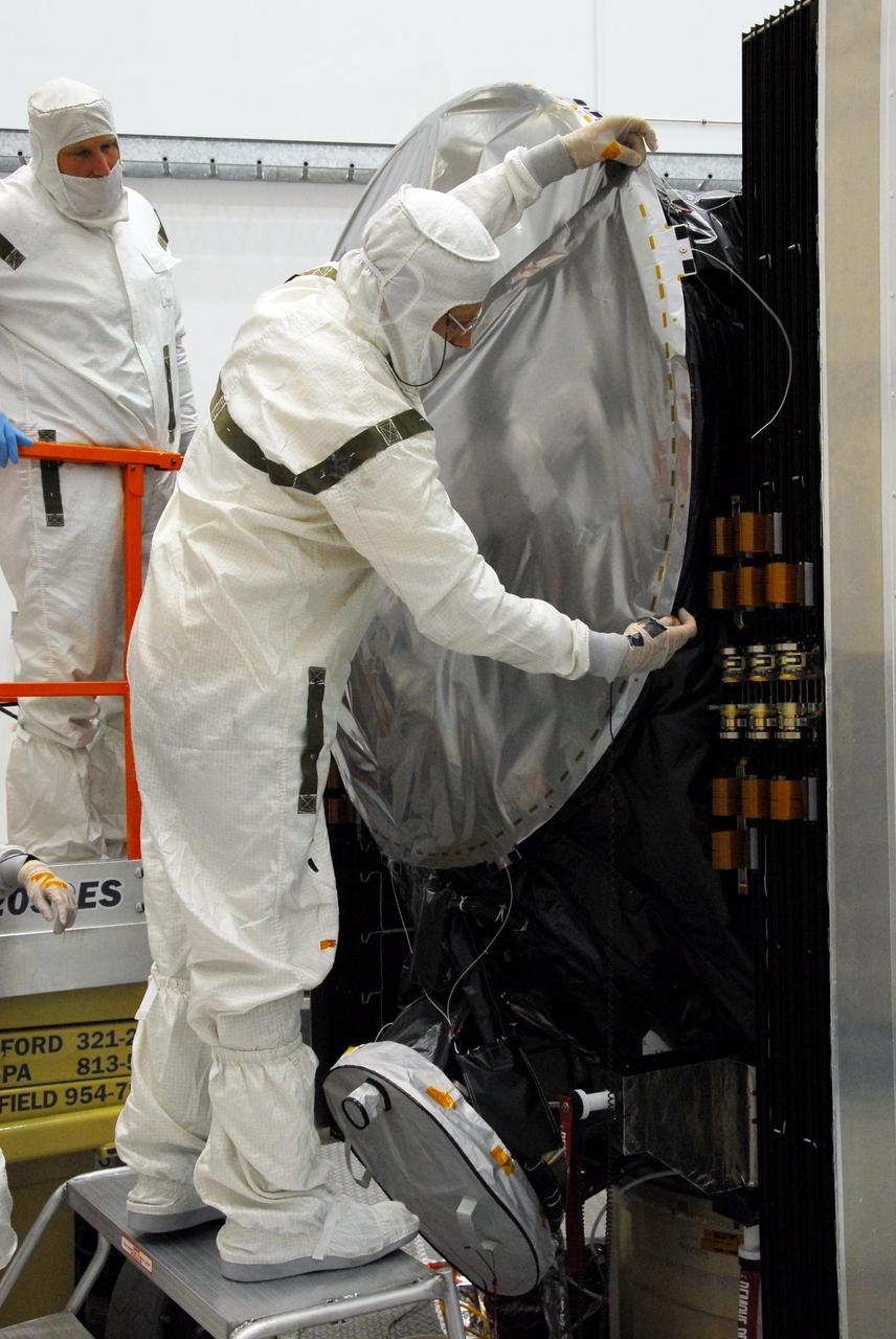
KENNEDY SPACE CENTER, FLA. -- At Astrotech, technicians lift the sun shade toward the Dawn spacecraft to install it on the high gain antenna. Made of germanium kapton, the shade, which is RF transparent, is placed over the sensitive antenna to reflect and emit harmful solar radiation to prevent the antenna from being excessively heated. Dawn is scheduled to launch July 7 from Pad 17-B on Cape Canaveral Air Force Station. Dawn's goal is to characterize the conditions and processes of the solar system's earliest epoch by investigating in detail the largest protoplanets that have remained intact since their formations: asteroid Vesta and the dwarf planet Ceres. They reside in the extensive zone between Mars and Jupiter together with many other smaller bodies, called the asteroid belt. Photo credit: NASA/George Shelton
KENNEDY SPACE CENTER, FLA. -- At Astrotech, a technician secures one side of the sun shade over the high gain antenna on the Dawn spacecraft. Made of germanium kapton, the shade, which is RF transparent, is placed over the sensitive antenna to reflect and emit harmful solar radiation to prevent the antenna from being excessively heated. Dawn is scheduled to launch July 7 from Pad 17-B on Cape Canaveral Air Force Station. Dawn's goal is to characterize the conditions and processes of the solar system's earliest epoch by investigating in detail the largest protoplanets that have remained intact since their formations: asteroid Vesta and the dwarf planet Ceres. They reside in the extensive zone between Mars and Jupiter together with many other smaller bodies, called the asteroid belt. Photo credit: NASA/George Shelton
KENNEDY SPACE CENTER, FLA. -- At Astrotech, technicians are securing the sun shade over the high gain antenna on the Dawn spacecraft. Made of germanium kapton, the shade, which is RF transparent, is placed over the sensitive antenna to reflect and emit harmful solar radiation to prevent the antenna from being excessively heated. Dawn is scheduled to launch July 7 from Pad 17-B on Cape Canaveral Air Force Station. Dawn's goal is to characterize the conditions and processes of the solar system's earliest epoch by investigating in detail the largest protoplanets that have remained intact since their formations: asteroid Vesta and the dwarf planet Ceres. They reside in the extensive zone between Mars and Jupiter together with many other smaller bodies, called the asteroid belt. Photo credit: NASA/George Shelton
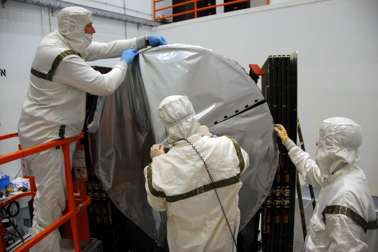
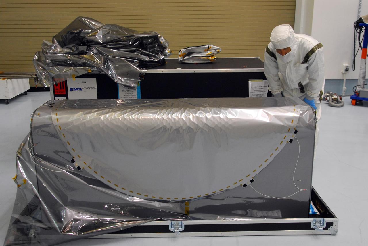
KENNEDY SPACE CENTER, FLA. -- At Astrotech, technicians secure all sides of the sun shade over the high gain antenna on the Dawn spacecraft. Made of germanium kapton, the shade, which is RF transparent, is placed over the sensitive antenna to reflect and emit harmful solar radiation to prevent the antenna from being excessively heated. Dawn is scheduled to launch July 7 from Pad 17-B on Cape Canaveral Air Force Station. Dawn's goal is to characterize the conditions and processes of the solar system's earliest epoch by investigating in detail the largest protoplanets that have remained intact since their formations: asteroid Vesta and the dwarf planet Ceres. They reside in the extensive zone between Mars and Jupiter together with many other smaller bodies, called the asteroid belt. Photo credit: NASA/George Shelton

KENNEDY SPACE CENTER, FLA. -- At Astrotech, a technician secures one side of the sun shade over the high gain antenna on the Dawn spacecraft. Made of germanium kapton, the shade, which is RF transparent, is placed over the sensitive antenna to reflect and emit harmful solar radiation to prevent the antenna from being excessively heated. Dawn is scheduled to launch July 7 from Pad 17-B on Cape Canaveral Air Force Station. Dawn's goal is to characterize the conditions and processes of the solar system's earliest epoch by investigating in detail the largest protoplanets that have remained intact since their formations: asteroid Vesta and the dwarf planet Ceres. They reside in the extensive zone between Mars and Jupiter together with many other smaller bodies, called the asteroid belt. Photo credit: NASA/George Shelton

jsc2021e022488 (June 11, 2021) --- NASA’s Exploration Extravehicular Mobility Unit (xEMU) spacesuit undergoes antenna testing in NASA Johnson Space Center’s anechoic chamber to inspect multi-layer insulation keep-out zones for the Wi-Fi and ultra-high-frequency antennas that are part of the spacesuit’s communication system. The xEMU test article is named xGUS, the successor to the Extravehicular Mobility Unit test article (also named GUS), which was named after NASA astronaut Gus Grissom and his iconic silver spacesuit. This image was taken from where the "horn," or source antenna, is located that sends out radio frequency signals to the spacesuit. The anechoic chamber walls are covered with a material that absorbs electromagnetic energy allowing the anechoic chamber to simulate a space environment. The antenna test facility is utilized to test antenna radiation distribution pattern performance for spaceflight applications in electromagnetic environments. Pictured in the photo is antenna test engineer Will Bond.
KENNEDY SPACE CENTER, FLA. -- At Astrotech, technicians begin securing the sun shade over the high gain antenna on the Dawn spacecraft. Made of germanium kapton, the shade, which is RF transparent, is placed over the sensitive antenna to reflect and emit harmful solar radiation to prevent the antenna from being excessively heated. Dawn is scheduled to launch July 7 from Pad 17-B on Cape Canaveral Air Force Station. Dawn's goal is to characterize the conditions and processes of the solar system's earliest epoch by investigating in detail the largest protoplanets that have remained intact since their formations: asteroid Vesta and the dwarf planet Ceres. They reside in the extensive zone between Mars and Jupiter together with many other smaller bodies, called the asteroid belt. Photo credit: NASA/George Shelton
ISS028-E-029679 (21 Aug. 2011) --- A night time view of India-Pakistan borderlands is featured in this image photographed by an Expedition 28 crew member on the International Space Station. Clusters of yellow lights on the Indo-Gangetic Plain of northern India and northern Pakistan reveal numerous cities both large and small in this photograph. Of the hundreds of clusters, the largest are the metropolitan areas associated with the capital cities of Islamabad, Pakistan in the foreground and New Delhi, India at the top?for scale these metropolitan areas are approximately 700 kilometers apart. The lines of major highways connecting the larger cities also stand out. More subtle but still visible at night are the general outlines of the towering and partly cloud-covered Himalayan ranges immediately to the north (left). A striking feature of this photograph is the line of lights, with a distinctly more orange hue, snaking across the central part of the image. It appears to be more continuous and brighter than most highways in the view. This is the fenced and floodlit border zone between the countries of India and Pakistan. The fence is designed to discourage smuggling and arms trafficking between the two countries. A similar fenced zone separates India?s eastern border from Bangladesh (not visible). This image was taken with a 16-mm lens, which provides the wide field of view, as the space station was tracking towards the southeast across the subcontinent of India. The station crew took the image as part of a continuous series of frames, each frame taken with a one-second exposure time to maximize light collection ? unfortunately, this also causes blurring of some ground features. The distinct, bright zone above the horizon (visible at top) is produced by airglow, a phenomena caused by excitation of atoms and molecules high in the atmosphere (above 80 kilometers, or 50 miles altitude) by ultraviolet radiation from the sun. Part of the ISS Permanent Multipurpose Module, or PMM, and a solar panel array are visible at right.
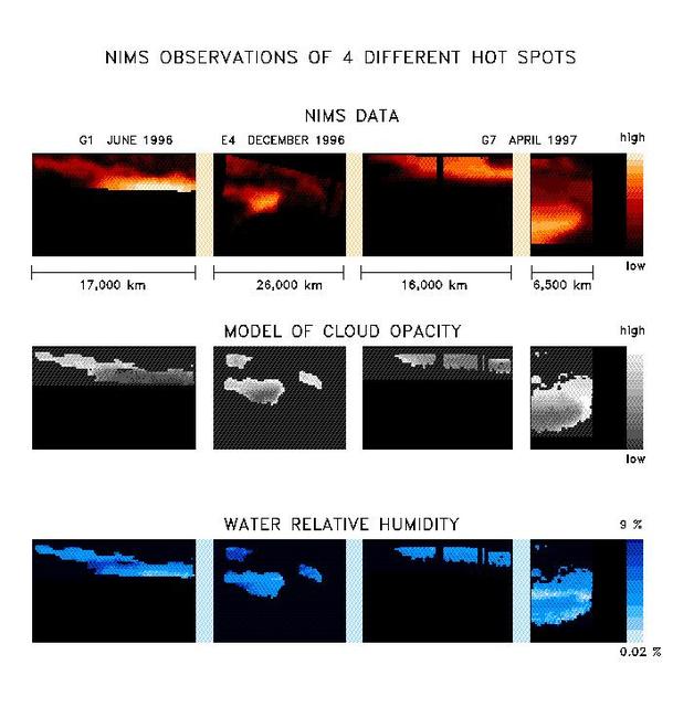
With the NIMS instrument high quality observations are being obtained from all parts of Jupiter. The images in the upper panel are taken at a wavelength of 4.8 microns. At this wavelength thermal radiation from about 100 km deep below the visible cloud deck is escaping, allowing us to study the deep atmospheric region. The overlying cloud deck absorbs a part of the radiation, but there are places where it is thin and more radiation can escape. These are called hot spot regions. Many hotspots regions occur in a zone between the equator and 15 degrees north latitude, the North Equatorial Belt (NEB), but thermal radiation is seen from much of the planet. The uniqueness of NIMS is that it is capable of observing the same spatial region at a maximum of 408 different wavelengths between 0.7 and 5.2 micron simultaneously. Every picture element (pixel) contains a spectrum of up to 408 wavelengths. The gases that compose the atmosphere leave there traces in the spectra. In this particular case, 48 wavelengths were available between 4.6 and 5.2 micron, and we see spectral signatures of water, ammonia, and phosphine. Also, the total amount of radiation is determined by the amount of overlying cloud, characterized by the cloud opacity. By means of model calculations, we can determine the amount of water and the cloud opacity for each individual spectrum. The amount ammonia and phosphine is more difficult to obtain because its influence on the spectra is weaker. The results of these calculations are shown in the form of maps in the next two panels. With NIMS, we can now have a detailed look at the spatial distribution of the water and ammonia amounts and the cloud opacity in the atmosphere. Not all the pixels from the observations have good spectra, so for some data points no reliable determination of the water and cloud opacity could be made. We find that the atmosphere is extremely dry in, and close to, the hot spot, with relative humidities between 0.02 % and 10 %, with the dryest places being inside the hot spot. This corroborates the in-situ Galileo Entry Probe measurements. The Probe entered the atmosphere, on December 5 1995, in a hot spot region. Whereas the Probe obtained only a very localized snapshot, with NIMS we can do observations of larger areas and over longer periods. The spatial distribution of water is more complex than expected. More detailed investigations will be necessary to fully understand these results. http://photojournal.jpl.nasa.gov/catalog/PIA01224

This graph presents measured properties of the seven TRAPPIST-1 exoplanets (labeled b through h), showing how they stack up with one another as well as with Earth and the other inner rocky worlds in our own solar system. The relative sizes of the planets are indicated by the circles. All of the known TRAPPIST-1 planets are larger than Mars, with five of them within 15% of the diameter of Earth. The vertical axis shows the uncompressed densities of the planets. Density, calculated from a planet's mass and volume, is the first important step in understanding its composition. Uncompressed density takes into account that the larger a planet is, the more its own gravity will pack the planet's material together and increase its density. Uncompressed density, therefore, usually provides a better means of comparing the composition of planets. The plot shows that the uncompressed densities of the TRAPPIST-1 planets are similar to one another, suggesting they may have all have a similar composition. The four rocky planets in our own solar system show more variation in density compared to the seven TRAPPIST-1 planets. Mercury, for example, contains a much higher percentage of iron than the other three rocky planets and thus has a much higher uncompressed density. The horizontal axis shows the level of illumination that each planet receives from its host star. The TRAPPIST-1 star is a mere 9% the mass of our Sun, and its temperature is much cooler. But because the TRAPPIST-1 planets orbit so closely to their star, they receive comparable levels of light and heat to Earth and its neighboring planets. The corresponding "habitable zones" — regions where an Earth-like planet could potentially support liquid water on its surface — of the two planetary systems are indicated near the top of the plot. The the two zones do not line up exactly because the cooler TRAPPIST-1 star emitting more of its light in the form of infrared radiation that is more efficiently absorbed by an Earth-like atmosphere. Since it takes less illumination to reach the same temperatures, the habitable zone shifts farther away from the star. The masses and densities of the TRAPPIST-1 planets were determined by measurements of slight variations in the timings of their orbits using extensive observations made by NASA's Spitzer and Kepler space telescopes, in combination with data from Hubble and a number of ground-based telescopes. The latest analysis, which includes Spitzer's complete record of over 1,000 hours of TRAPPIST-1 observations, has reduced the uncertainties of the mass measurements to a mere 3-6%. These are among the most accurate measurements of planetary masses anywhere outside of our solar system. https://photojournal.jpl.nasa.gov/catalog/PIA24371
STS099-355-024 (11-22 February 2000) -- Two separate atmospheric optical phenomena appear in this 35mm photograph captured from the Space Shuttle Endeavour. The thin greenish band above the horizon is airglow; radiation emitted by the atmosphere from a layer about 30-kilometers thick and about 100-kilometers' altitude. The predominant emission in airglow is the green 5577-Angstrom wavelength emission from atomic oxygen atoms, which is also the predominant emission from the aurora. A yellow-orange color is also seen in airglow, which is the emission of the 5800-Angstrom wavelength from sodium atoms. Airglow is always present in the atmosphere; it results from the recombination of molecules that have been broken apart by solar radiation during the day. But airglow is so faint that it can only be seen at night by looking "edge on" at the emission layer, such as the view that astronauts have in Earth orbit. The other phenomenon in the photo appears to be a faint, diffuse red aurora. Red aurora occur from about 200 kilometers to as high as 500 kilometers altitude only in the auroral zones at polar latitudes. They are caused by the emission of 6300- Angstrom wavelength light from oxygen atoms that have been raised to a higher energy level (excited) by collisions with energetic electrons pouring down from the Earth's magnetosphere. The light is emitted when the atoms return to their original unexcited state. With the red light so faint in this picture, scientists are led to believe that the flux density of incoming electrons was small. Also, since there is no green aurora below the red, that indicates that the energy of the incoming electrons was low - higher energy electrons would penetrate deeper into the atmosphere where the green aurora is energized.
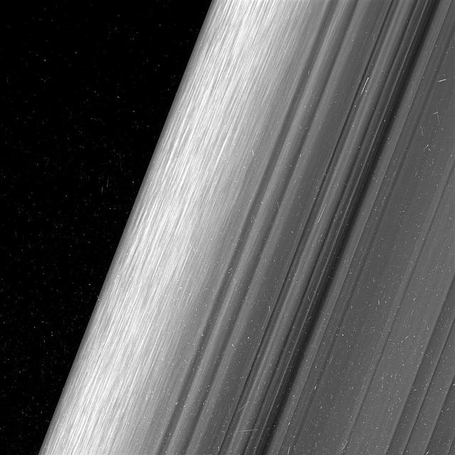
This image shows a region in Saturn's outer B ring. NASA's Cassini spacecraft viewed this area at a level of detail twice as high as it had ever been observed before. The view here is of the outer edge of the B ring, at left, which is perturbed by the most powerful gravitational resonance in the rings: the "2:1 resonance" with the icy moon Mimas. This means that, for every single orbit of Mimas, the ring particles at this specific distance from Saturn orbit the planet twice. This results in a regular tugging force that perturbs the particles in this location. A lot of structure is visible in the zone near the edge on the left. This is likely due to some combination of the gravity of embedded objects too small to see, or temporary clumping triggered by the action of the resonance itself. Scientists informally refer to this type of structure as "straw." This image was taken using a fairly long exposure, causing the embedded clumps to smear into streaks as they moved in their orbits. Later Cassini orbits will bring shorter exposures of the same region, which will give researchers a better idea of what these clumps look like. But in this case, the smearing does help provide a clearer idea of how the clumps are moving. This image is a lightly processed version, with minimal enhancement; this version preserves all original details present in the image. Another other version (Figure 1) has been processed to remove the small bright blemishes due to cosmic rays and charged particle radiation near the planet -- a more aesthetically pleasing image, but with a slight softening of the finest details. The image was taken in visible light with the Cassini spacecraft wide-angle camera on Dec. 18, 2016. The view was obtained at a distance of approximately 32,000 miles (52,000 kilometers) from the rings and looks toward the unilluminated side of the rings. Image scale is about a quarter-mile (360 meters) per pixel. http://photojournal.jpl.nasa.gov/catalog/PIA21057
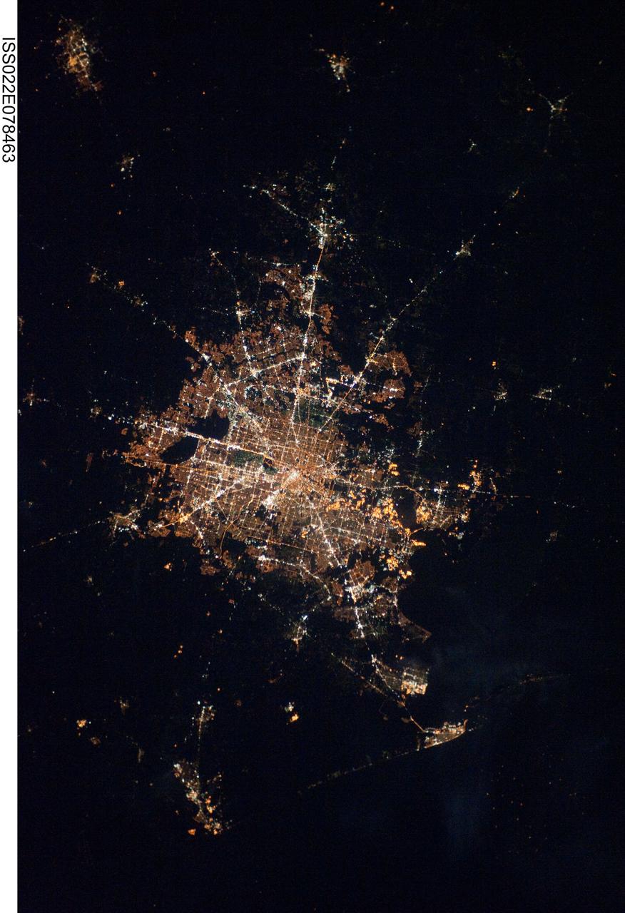
ISS022-E-078463 (28 Feb. 2010) ---The Houston metropolitan area at night is featured in this image photographed by an Expedition 22 crew member on the International Space Station. Houston, Texas has been called the ?energy capital of the world? due to its role as a major hub of the petroleum and other energy resource industries. The image is oriented with north toward the top. The Houston metropolitan area covers almost 2,331,000 hectares (approximately 9,000 square miles) along the southeast Texas coastline, with an average elevation of 13 meters (approximately 43 feet) above sea level and a population of over 5 million (2006 US Census estimate). The Houston metropolitan area is also noteworthy as being the largest in the US without formal zoning restrictions. This has lead to a highly diverse pattern of land use at the neighborhood scale; nevertheless, more general spatial patterns of land use can be recognized in remotely sensed data. This is particularly evident in night time photography of the urban area taken by crew members onboard the space station. The image depicts the roughly 100 kilometers (approximately 62 miles) east-west extent of the Houston metropolitan area. Houston proper is at center, indicated by a ?bull?s-eye? of elliptical white to orange-lighted beltways and brightly lit white freeways radiating outwards from the central downtown area. Suburban and primarily residential urban land use is indicated by both reddish-brown and gray-green lighted regions that reflect a higher proportion of tree cover and lower light density. Petroleum refineries along the Houston Ship Channel are recognized by densely lit areas of golden yellow light. Rural and undeveloped land circles the metropolitan area, and Galveston Bay to the southeast (lower right) provides access to the Gulf of Mexico. Both types of non-urban surface appear dark in the image.