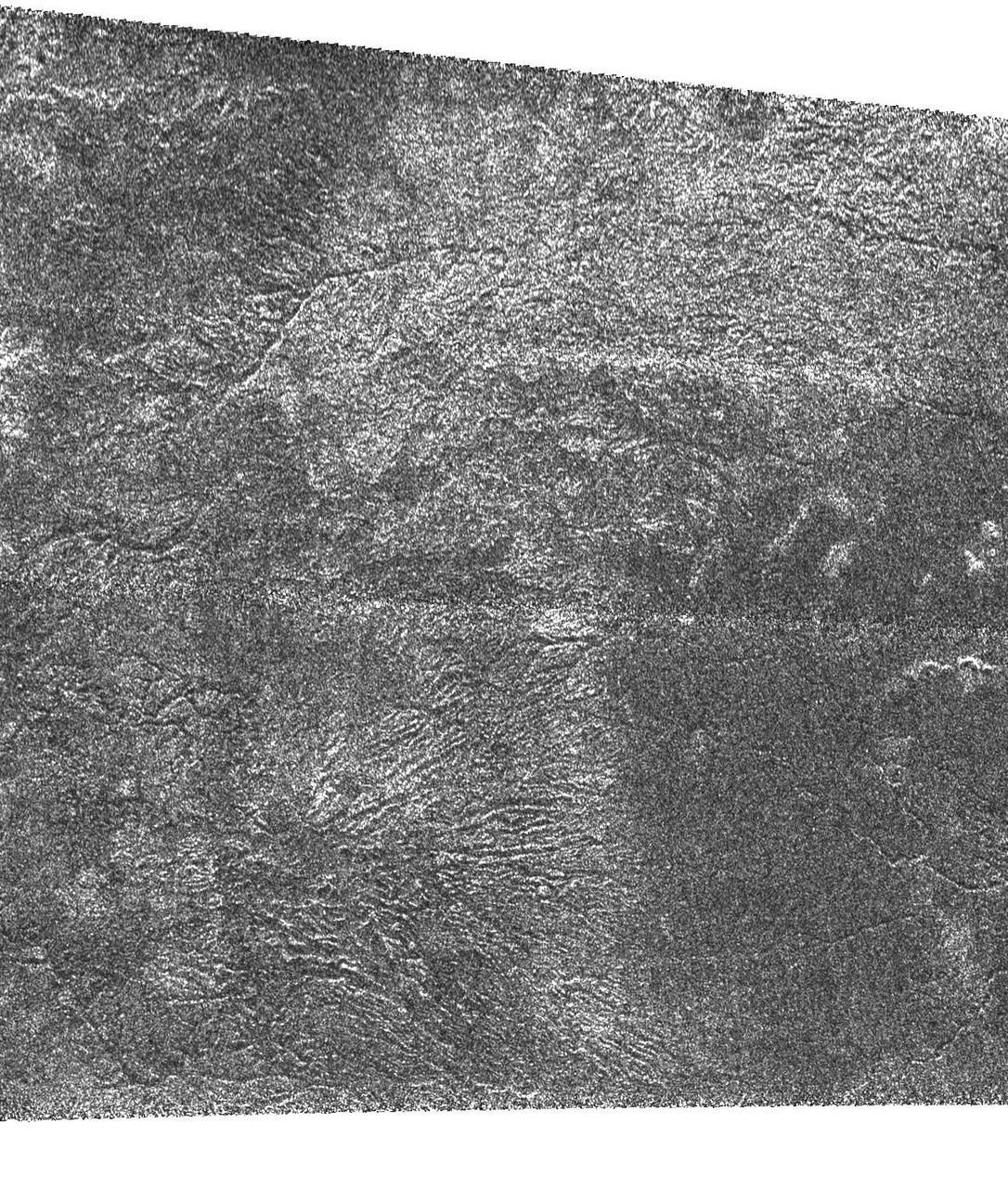
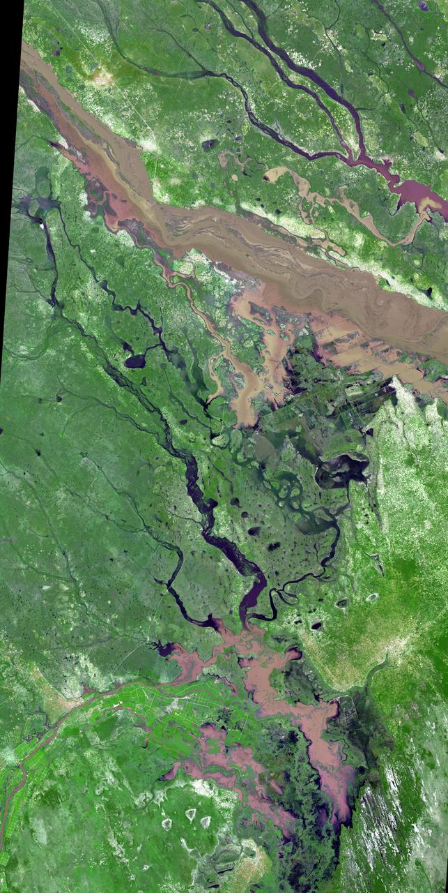
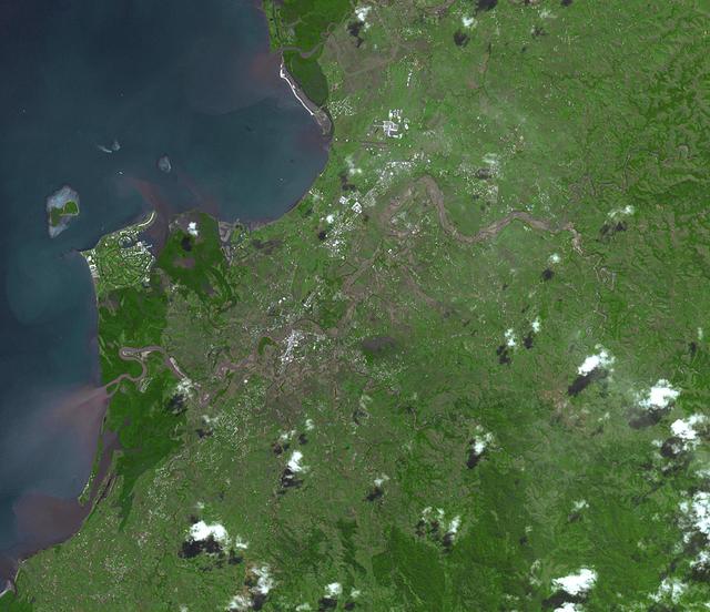
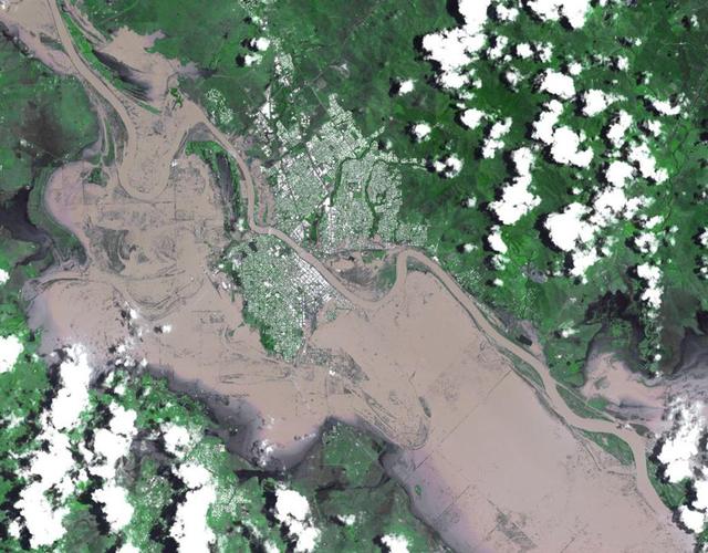
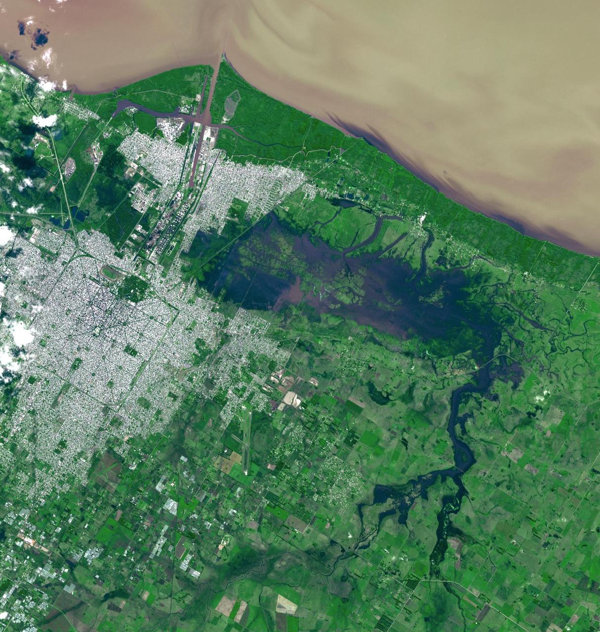
Titan Rain Drains to the Plains
A Hard Rain A-Gonna Fall
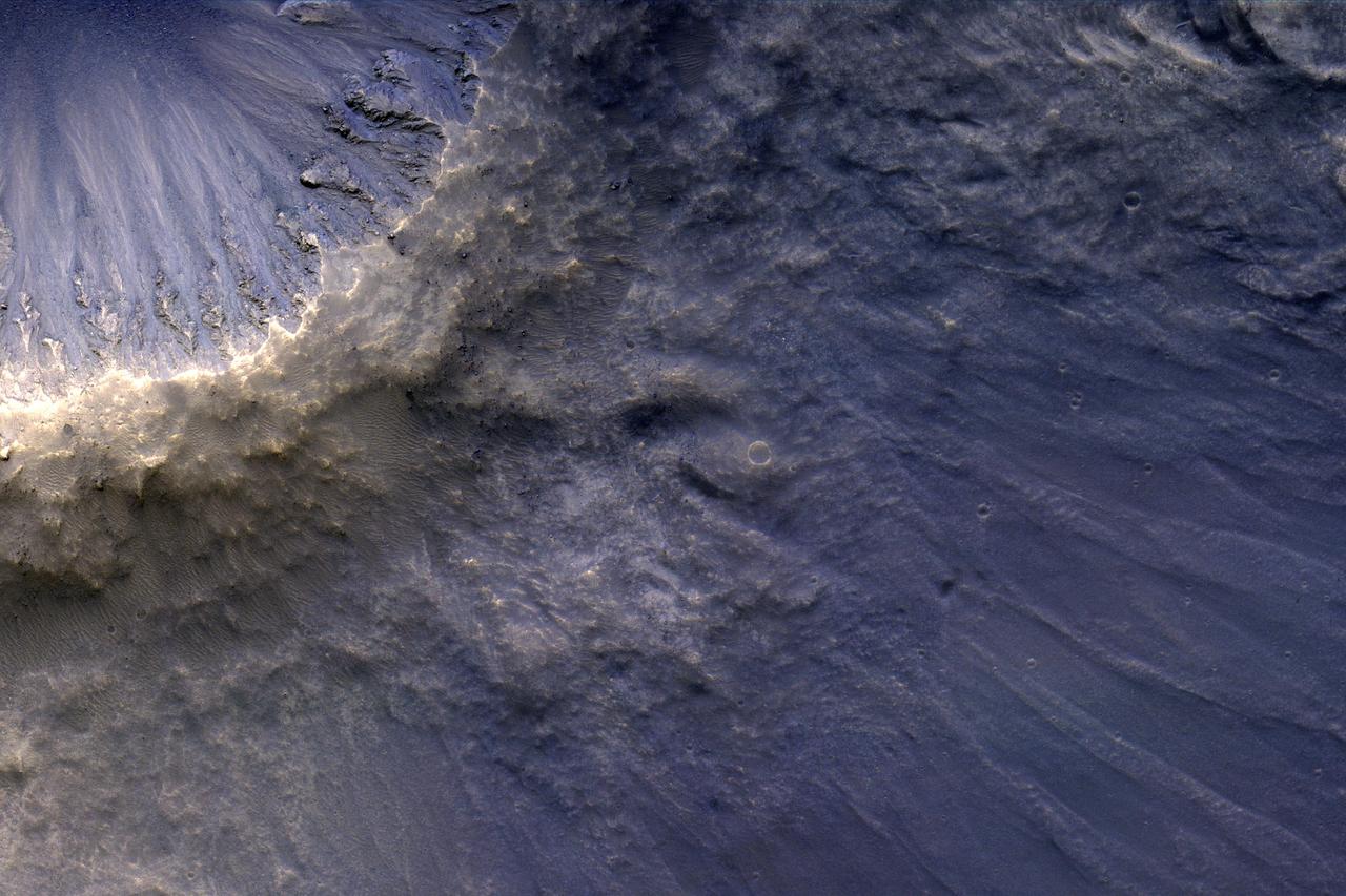
Alluvial Fans in Mojave Crater: Did It Rain on Mars?
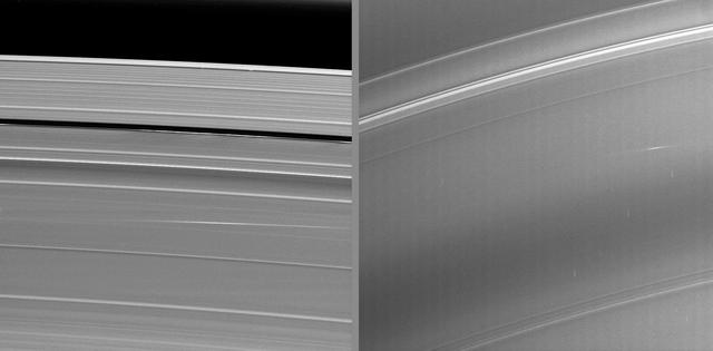
The bright streaks visible in these Cassini images taken during Saturn’s August 2009 equinox are exciting evidence of a constant rain of interplanetary projectiles onto the planet’s rings.
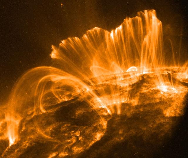
Explanation: In this picture, the Sun's surface is quite dark. A frame from a movie recorded on November 9th by the orbiting TRACE telescope, it shows coronal loops lofted over a solar active region. Glowing brightly in extreme ultraviolet light, the hot plasma entrained above the Sun along arching magnetic fields is cooling and raining back down on the solar surface. Hours earlier, on November 8th, astronomers had watched this particular active region produce a not so spectacular solar flare. Still, the M-class flare spewed forth an intense storm of particles, suddenly showering satellites near the Earth with high energy protons. The flare event was also associated with a large coronal mass ejection, a massive cloud of material which impacted our fair planet's magnetic field about 31 hours later. The result ... a strong geomagnetic storm. Credit: NASA/GSFC/TRACE To learn more go to: <a href="http://nasascience.nasa.gov/missions/trace" rel="nofollow">nasascience.nasa.gov/missions/trace</a> To learn more about NASA's Sun Earth Day go here: <a href="http://sunearthday.nasa.gov/2010/index.php" rel="nofollow">sunearthday.nasa.gov/2010/index.php</a>
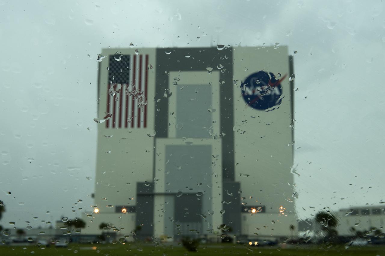
The NASA Vehicle Assembly Building is seen through a rain covered windshield at NASA's Kennedy Space Center in Florida on Friday, July 10, 2009. NASA is set to launch the space shuttle Endeavour with the crew of STS-127 on Saturday. Photo Credit: (NASA/Bill Ingalls)
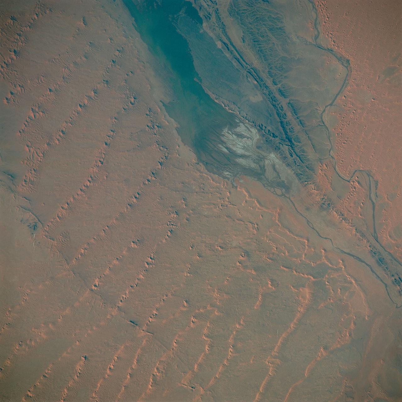
S65-63830 (5 Dec. 1965) --- Algeria, south-southeast of the Colomb Bechar area, as seen from the National Aeronautics and Space Administration's Gemini-7 spacecraft. Sand dunes are 200 to 300 feet high in the Grand Erg Occidental area. The Quod Sacura River can be seen in the upper left corner. The white spot in the middle of the picture is the Sebcha el Malah salt beds. It should be noted that the area had just experienced very heavy rains (first in many years) and the stream and salt flat are inundated. This photograph was taken with a modified 70mm Hasselblad camera, with Eastman Kodak, Ektachrome MS (S.O. 217) color film. Photo credit: NASA
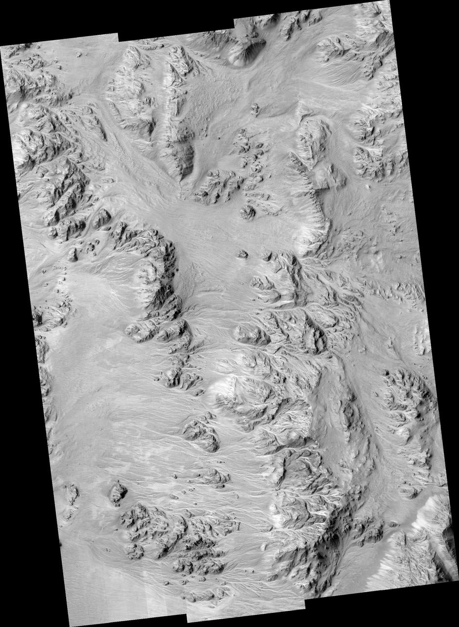
Impact ejecta is material that is thrown up and out of the surface of a planet as a result of the impact of an meteorite, asteroid or comet. The material that was originally beneath the surface of the planet then rains down onto the environs of the newly formed impact crater. Some of this material is deposited close to the crater, folding over itself to form the crater rim, visible here as a yellowish ring. Other material is ejected faster and falls down further from the crater rim creating two types of ejecta: a "continuous ejecta blanket" and "discontinuous ejecta." Both are shown in this image. The blocky area at the center of the image close to the yellowish crater rim is the "continuous" ejecta. The discontinuous ejecta is further from the crater rim, streaking away from the crater like spokes on a bicycle. (Note: North is to the right.) http://photojournal.jpl.nasa.gov/catalog/PIA11180
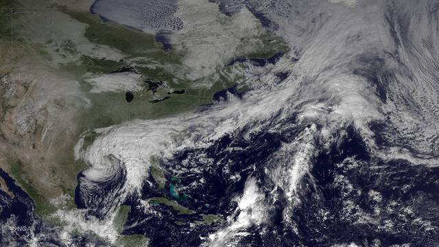
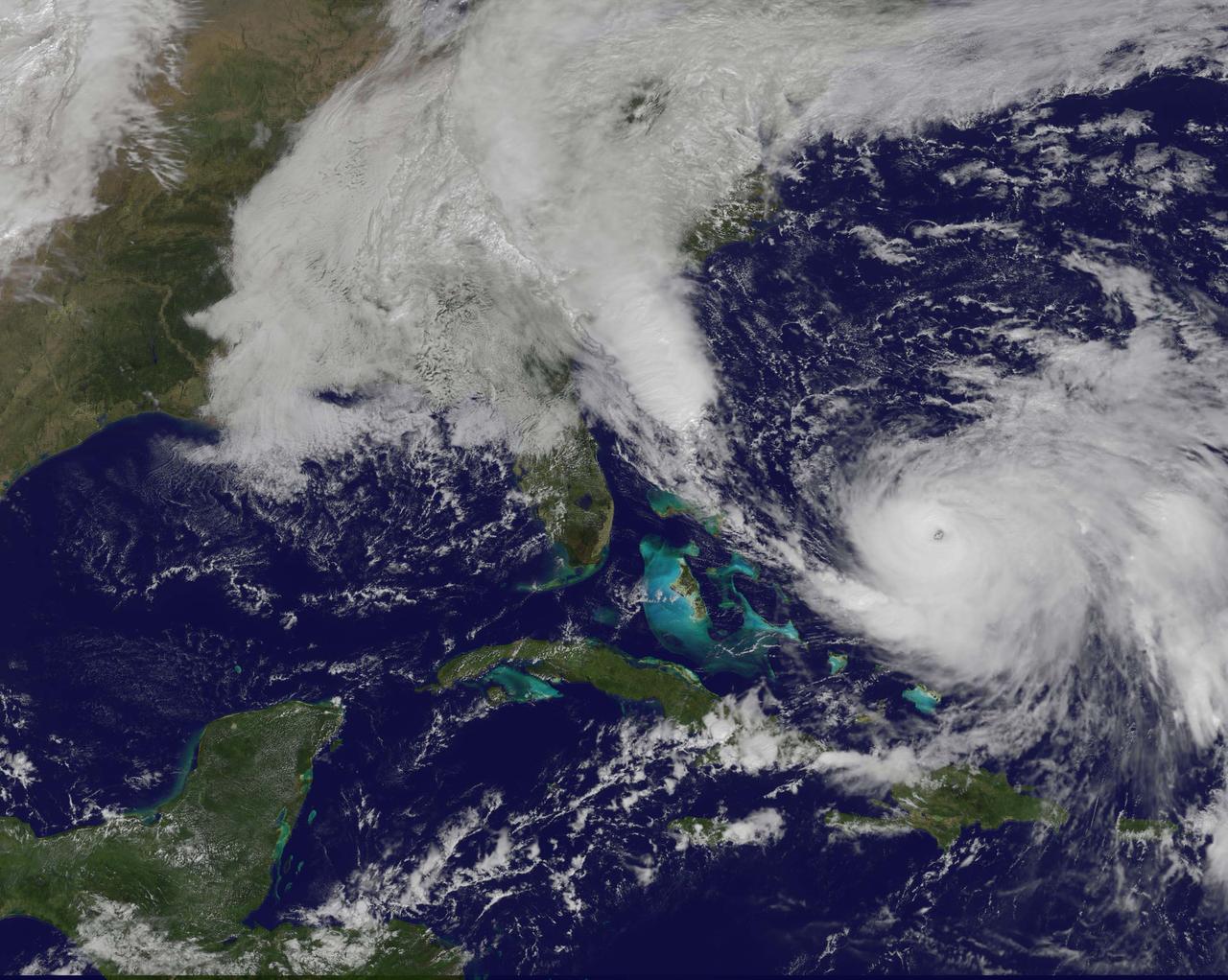
The system that brought heavy rainfall and flash flooding to parts of the southern Plains and western Gulf Coast over the past several days continues to push eastward, with the greatest potential for heavy rain and flash flooding on Monday across parts of the lower Mississippi Valley and Southeast. This image was taken by GOES East at 1515Z on October 26, 2015. <b><a href="http://goes.gsfc.nasa.gov/" rel="nofollow">Credit: NOAA/NASA GOES Project</a></b> Credit: NASA/NOAA via <b><a href="www.nnvl.noaa.gov/" rel="nofollow"> NOAA Environmental Visualization Laboratory</a></b> <b><a href="http://www.nasa.gov/audience/formedia/features/MP_Photo_Guidelines.html" rel="nofollow">NASA image use policy.</a></b> <b><a href="http://www.nasa.gov/centers/goddard/home/index.html" rel="nofollow">NASA Goddard Space Flight Center</a></b> enables NASA’s mission through four scientific endeavors: Earth Science, Heliophysics, Solar System Exploration, and Astrophysics. Goddard plays a leading role in NASA’s accomplishments by contributing compelling scientific knowledge to advance the Agency’s mission. <b>Follow us on <a href="http://twitter.com/NASAGoddardPix" rel="nofollow">Twitter</a></b> <b>Like us on <a href="http://www.facebook.com/pages/Greenbelt-MD/NASA-Goddard/395013845897?ref=tsd" rel="nofollow">Facebook</a></b> <b>Find us on <a href="http://instagrid.me/nasagoddard/?vm=grid" rel="nofollow">Instagram</a></b>
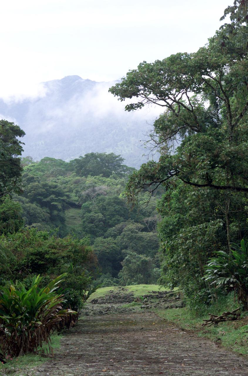
Dense rain forest in the La Selva region of Costa Rica. AirSAR 2004 Mesoamerica is a three-week expedition by an international team of scientists that uses an all-weather imaging tool, called the Airborne Synthetic Aperture Radar (AirSAR) which is located onboard NASA's DC-8 airborne laboratory. Scientists from many parts of the world including NASA's Jet Propulsion Laboratory are combining ground research done in several areas in Central America with NASA's AirSAR technology to improve and expand on the quality of research they are able to conduct. The radar, developed by NASA's Jet Propulsion Laboratory, can penetrate clouds and also collect data at night. Its high-resolution sensors operate at multiple wavelengths and modes, allowing AirSAR to see beneath treetops, through thin sand, and dry snow pack. AirSAR's 2004 campaign is a collaboration of many U.S. and Central American institutions and scientists, including NASA; the National Science Foundation; the Smithsonian Institution; National Geographic; Conservation International; the Organization of Tropical Studies; the Central American Commission for Environment and Development; and the Inter-American Development Bank.

Damaging heavy rains fell on South Carolina in the southeastern United States at the beginning of October 2015. Much of that water had, by mid October, flowed into the Atlantic Ocean bringing with it heavy loads of sediment, nutrients, and dissolved organic material. The above VIIRS image shows the runoff as it interacts with ocean currents on October 15, 2015. Credit: NASA/Goddard/SuomiNPP/VIIRS via NASA's OceanColor
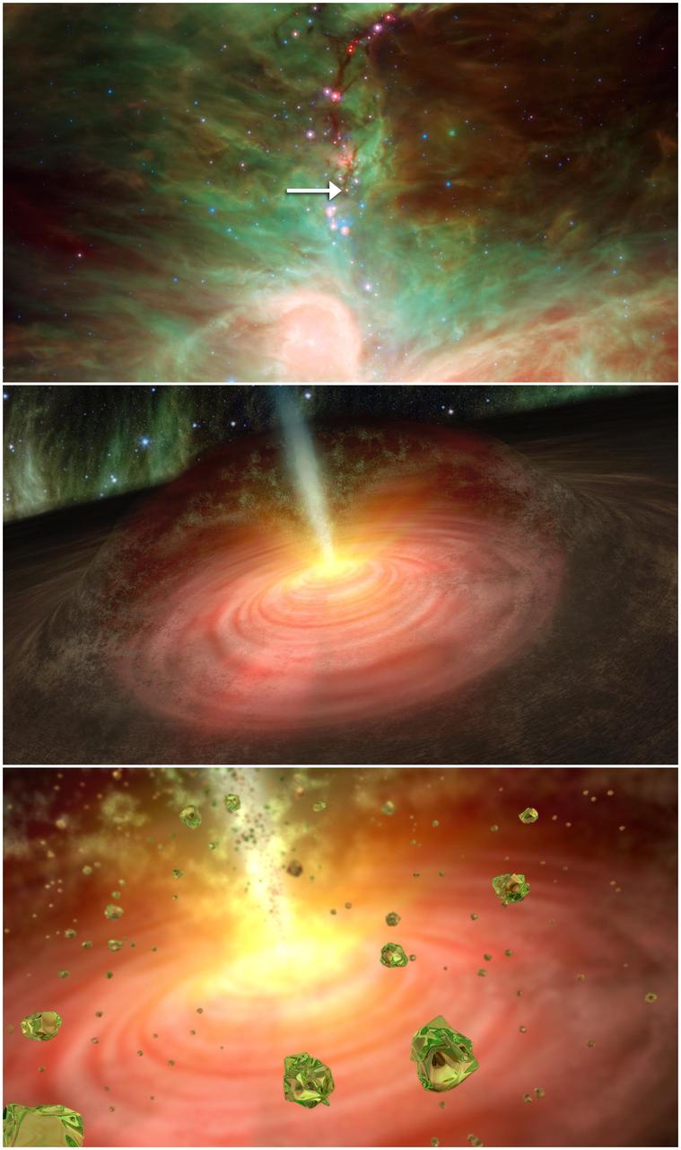
This graphic illustrates a stellar fountain of crystal rain, beginning with a NASA Spitzer picture of the star in question, and ending with an artist concept of what the crystal rain might look like.

A spider photographed during NASA's AirSAR 2004 Mesoamerica campaign in the La Selva region of the Costa Rican rain forest. AirSAR 2004 Mesoamerica is a three-week expedition by an international team of scientists that uses an all-weather imaging tool, called the Airborne Synthetic Aperture Radar (AirSAR) which is located onboard NASA's DC-8 airborne laboratory. Scientists from many parts of the world including NASA's Jet Propulsion Laboratory are combining ground research done in several areas in Central America with NASA's AirSAR technology to improve and expand on the quality of research they are able to conduct. The radar, developed by NASA's Jet Propulsion Laboratory, can penetrate clouds and also collect data at night. Its high-resolution sensors operate at multiple wavelengths and modes, allowing AirSAR to see beneath treetops, through thin sand, and dry snow pack. AirSAR's 2004 campaign is a collaboration of many U.S. and Central American institutions and scientists, including NASA; the National Science Foundation; the Smithsonian Institution; National Geographic; Conservation International; the Organization of Tropical Studies; the Central American Commission for Environment and Development; and the Inter-American Development Bank.
KENNEDY SPACE CENTER, FLA. -- NASA's Comet Nucleus Tour (CONTOUR) spacecraft successfully launches at 2:47:41 a.m. EDT aboard a Boeing Delta II rocket from Cape Canaveral Air Force Station, Fla. Designed and built by The Johns Hopkins University Applied Physics Laboratory (APL) in Laurel, Md., the 2,138-pound (970-kilogram) spacecraft was placed into an elliptical Earth orbit 63 minutes after launch. About 19 minutes later the mission operations team at APL acquired a signal from the spacecraft through the Deep Space Network antenna station in Goldstone, Calif., and by 5:45 a.m. EDT Mission Director Dr. Robert W. Farquhar of the Applied Physics Lab confirmed the craft was operating normally and ready to carry out its early orbit maneuvers. CONTOUR will orbit Earth until Aug. 15, when it is scheduled to fire its main engine and enter a comet-chasing orbit around the sun. The mission's flexible four-year plan includes encounters with comets Encke (Nov. 12, 2003) and Schwassmann-Wachmann 3 (June 19, 2006), though it can add an encounter with a "new" and scientifically valuable comet from the outer solar system, should one be discovered in time for CONTOUR to fly past it. CONTOUR's four scientific instruments will take detailed pictures and measure the chemical makeup of each comet's nucleus -- a chunk of ice and rock -- while analyzing the surrounding gas and dust.
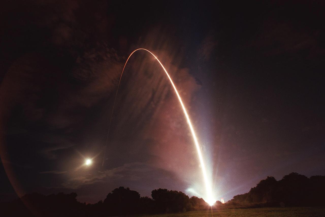
KENNEDY SPACE CENTER, FLA. -- The Boeing Delta II rocket carrying NASA's Comet Nucleus Tour (CONTOUR) spacecraft streaks across the night sky above pad 17-A, Cape Canaveral Air Force Station. The launch took place at 2:47:41 a.m. EDT July 3. Designed and built by The Johns Hopkins University Applied Physics Laboratory (APL) in Laurel, Md., the 2,138-pound (970-kilogram) spacecraft will be placed into an elliptical Earth orbit until Aug. 15, when it is scheduled to fire its main engine and enter a comet-chasing orbit around the sun. The mission's flexible four-year plan includes encounters with comets Encke (Nov. 12, 2003) and Schwassmann-Wachmann 3 (June 19, 2006), though it can add an encounter with a "new" and scientifically valuable comet from the outer solar system, should one be discovered in time for CONTOUR to fly past it. CONTOUR's four scientific instruments will take detailed pictures and measure the chemical makeup of each comet's nucleus -- a chunk of ice and rock -- while analyzing the surrounding gas and dust.
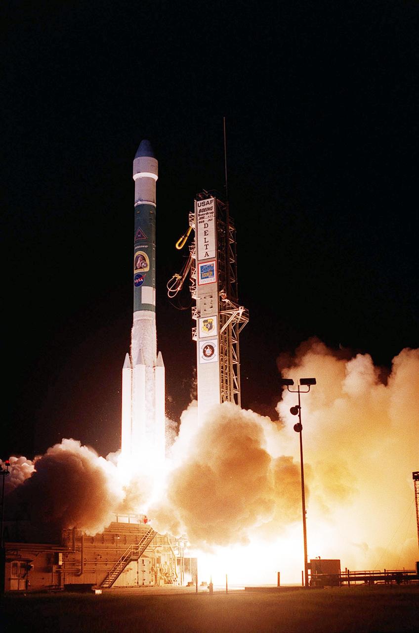
KENNEDY SPACE CENTER, FLA. -- NASA's Comet Nucleus Tour (CONTOUR) spacecraft successfully launches at 2:47:41 a.m. EDT aboard a Boeing Delta II rocket from Cape Canaveral Air Force Station, Fla. Designed and built by The Johns Hopkins University Applied Physics Laboratory (APL) in Laurel, Md., the 2,138-pound (970-kilogram) spacecraft was placed into an elliptical Earth orbit 63 minutes after launch. About 19 minutes later the mission operations team at APL acquired a signal from the spacecraft through the Deep Space Network antenna station in Goldstone, Calif., and by 5:45 a.m. EDT Mission Director Dr. Robert W. Farquhar of the Applied Physics Lab confirmed the craft was operating normally and ready to carry out its early orbit maneuvers. CONTOUR will orbit Earth until Aug. 15, when it is scheduled to fire its main engine and enter a comet-chasing orbit around the sun. The mission's flexible four-year plan includes encounters with comets Encke (Nov. 12, 2003) and Schwassmann-Wachmann 3 (June 19, 2006), though it can add an encounter with a "new" and scientifically valuable comet from the outer solar system, should one be discovered in time for CONTOUR to fly past it. CONTOUR's four scientific instruments will take detailed pictures and measure the chemical makeup of each comet's nucleus -- a chunk of ice and rock -- while analyzing the surrounding gas and dust.
A plant photographed in the La Selva region of the Costa Rican rain forest as part of NASA's AirSAR 2004 Mesoamerica campaign. AirSAR 2004 Mesoamerica is a three-week expedition by an international team of scientists that will use an all-weather imaging tool, called the Airborne Synthetic Aperture Radar (AirSAR) which is located onboard NASA's DC-8 airborne laboratory. Scientists from many parts of the world including NASA's Jet Propulsion Laboratory are combining ground research done in several areas in Central America with NASA's AirSAR technology to improve and expand on the quality of research they are able to do. NASA's AIRSAR technolgy provides two essential elements to the ground-based scientists. First, it tests and provides accurate measurements of the forest structure. Secondly, AirSAR can study a larger area of the forest versus the smaller area that can be tested and plotted by the ground scientists. It also provides a unique one-of-a-kind system of measurement that obtains important information for the scientists, such as where forests are located and what exactly is in them.
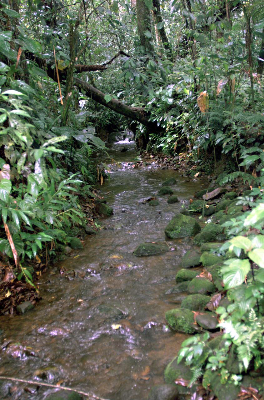
This photograph shows a stream in the La Selva region of the Costa Rican rain forest, taken during NASA's AirSAR 2004 campaign. AirSAR 2004 Mesoamerica is a three-week expedition by an international team of scientists that uses an all-weather imaging tool, called the Airborne Synthetic Aperture Radar (AirSAR) which is located onboard NASA's DC-8 airborne laboratory. Scientists from many parts of the world including NASA's Jet Propulsion Laboratory are combining ground research done in several areas in Central America with NASA's AirSAR technology to improve and expand on the quality of research they are able to conduct. The radar, developed by NASA's Jet Propulsion Laboratory, can penetrate clouds and also collect data at night. Its high-resolution sensors operate at multiple wavelengths and modes, allowing AirSAR to see beneath treetops, through thin sand, and dry snow pack. AirSAR's 2004 campaign is a collaboration of many U.S. and Central American institutions and scientists, including NASA; the National Science Foundation; the Smithsonian Institution; National Geographic; Conservation International; the Organization of Tropical Studies; the Central American Commission for Environment and Development; and the Inter-American Development Bank.

A butterfly photographed in the La Selva region of the Costa Rican rain forest as part of NASA's AirSAR 2004 Mesoamerica campaign. AirSAR 2004 Mesoamerica is a three-week expedition by an international team of scientists that will use an all-weather imaging tool, called the Airborne Synthetic Aperture Radar (AirSAR) which is located onboard NASA's DC-8 airborne laboratory. Scientists from many parts of the world including NASA's Jet Propulsion Laboratory are combining ground research done in several areas in Central America with NASA's AirSAR technology to improve and expand on the quality of research they are able to do. NASA's AIRSAR technolgy provides two essential elements to the ground-based scientists. First, it tests and provides accurate measurements of the forest structure. Secondly, AirSAR can study a larger area of the forest versus the smaller area that can be tested and plotted by the ground scientists. It also provides a unique one-of-a-kind system of measurement that obtains important information for the scientists, such as where forests are located and what exactly is in them.
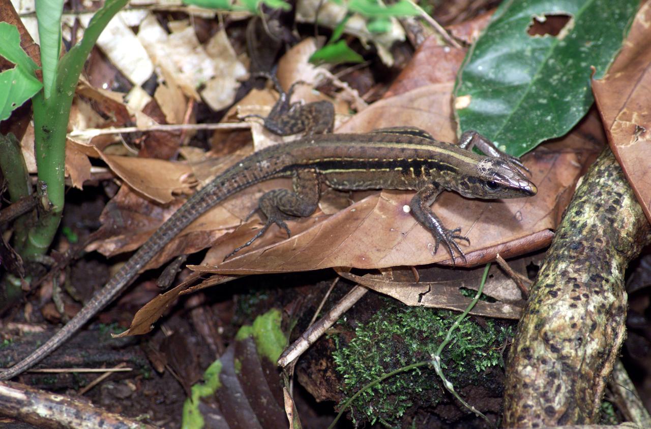
A lizard photographed in the La Selva region of the Costa Rican rain forest as part of NASA's AirSAR 2004 Mesoamerica campaign. AirSAR 2004 Mesoamerica is a three-week expedition by an international team of scientists that will use an all-weather imaging tool, called the Airborne Synthetic Aperture Radar (AirSAR) which is located onboard NASA's DC-8 airborne laboratory. Scientists from many parts of the world including NASA's Jet Propulsion Laboratory are combining ground research done in several areas in Central America with NASA's AirSAR technology to improve and expand on the quality of research they are able to do. NASA's AIRSAR technolgy provides two essential elements to the ground-based scientists. First, it tests and provides accurate measurements of the forest structure. Secondly, AirSAR can study a larger area of the forest versus the smaller area that can be tested and plotted by the ground scientists. It also provides a unique one-of-a-kind system of measurement that obtains important information for the scientists, such as where forests are located and what exactly is in them.
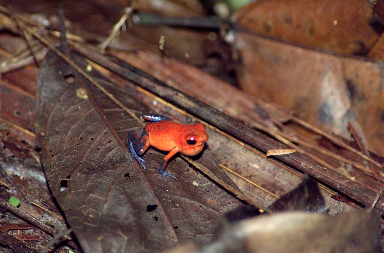
A tree frog photographed in the La Selva region of the Costa Rican rain forest as part of NASA's AirSAR 2004 Mesoamerica campaign. AirSAR 2004 Mesoamerica is a three-week expedition by an international team of scientists that will use an all-weather imaging tool, called the Airborne Synthetic Aperture Radar (AirSAR) which is located onboard NASA's DC-8 airborne laboratory. Scientists from many parts of the world including NASA's Jet Propulsion Laboratory are combining ground research done in several areas in Central America with NASA's AirSAR technology to improve and expand on the quality of research they are able to do. NASA's AIRSAR technolgy provides two essential elements to the ground-based scientists. First, it tests and provides accurate measurements of the forest structure. Secondly, AirSAR can study a larger area of the forest versus the smaller area that can be tested and plotted by the ground scientists. It also provides a unique one-of-a-kind system of measurement that obtains important information for the scientists, such as where forests are located and what exactly is in them.

The sun begins to break through the clouds over NASA's two 747 Shuttle Carrier Aircraft on the NASA Dryden ramp after a rain shower in February 2001.
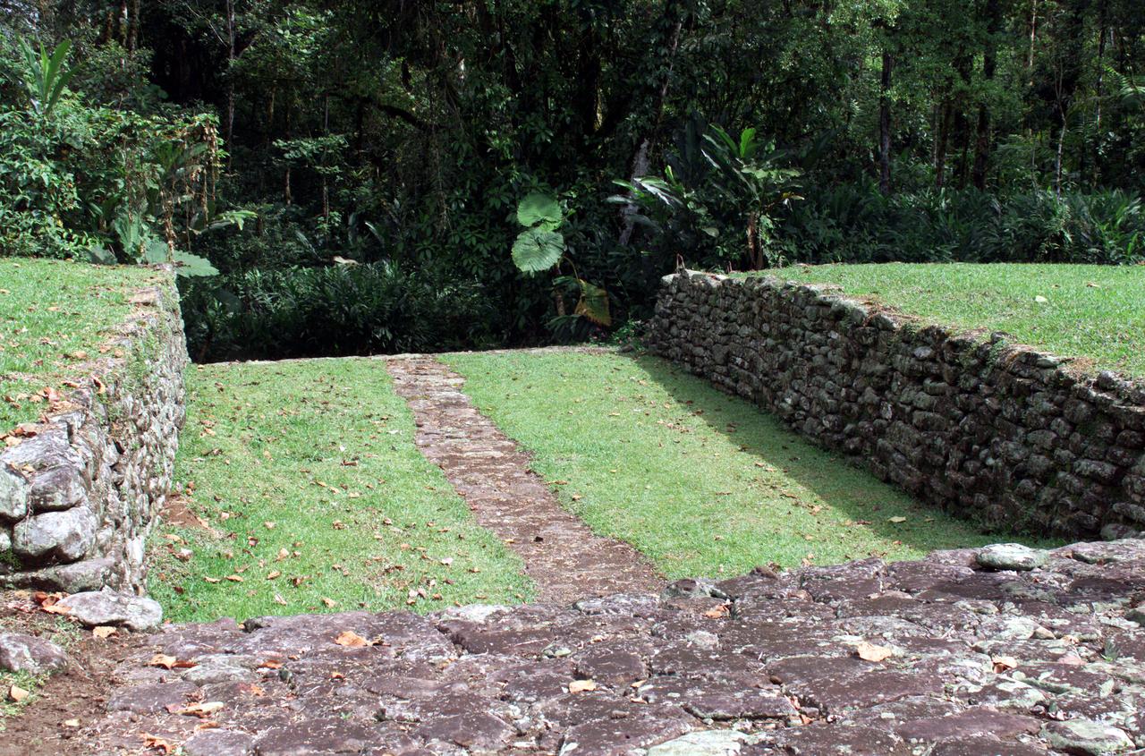
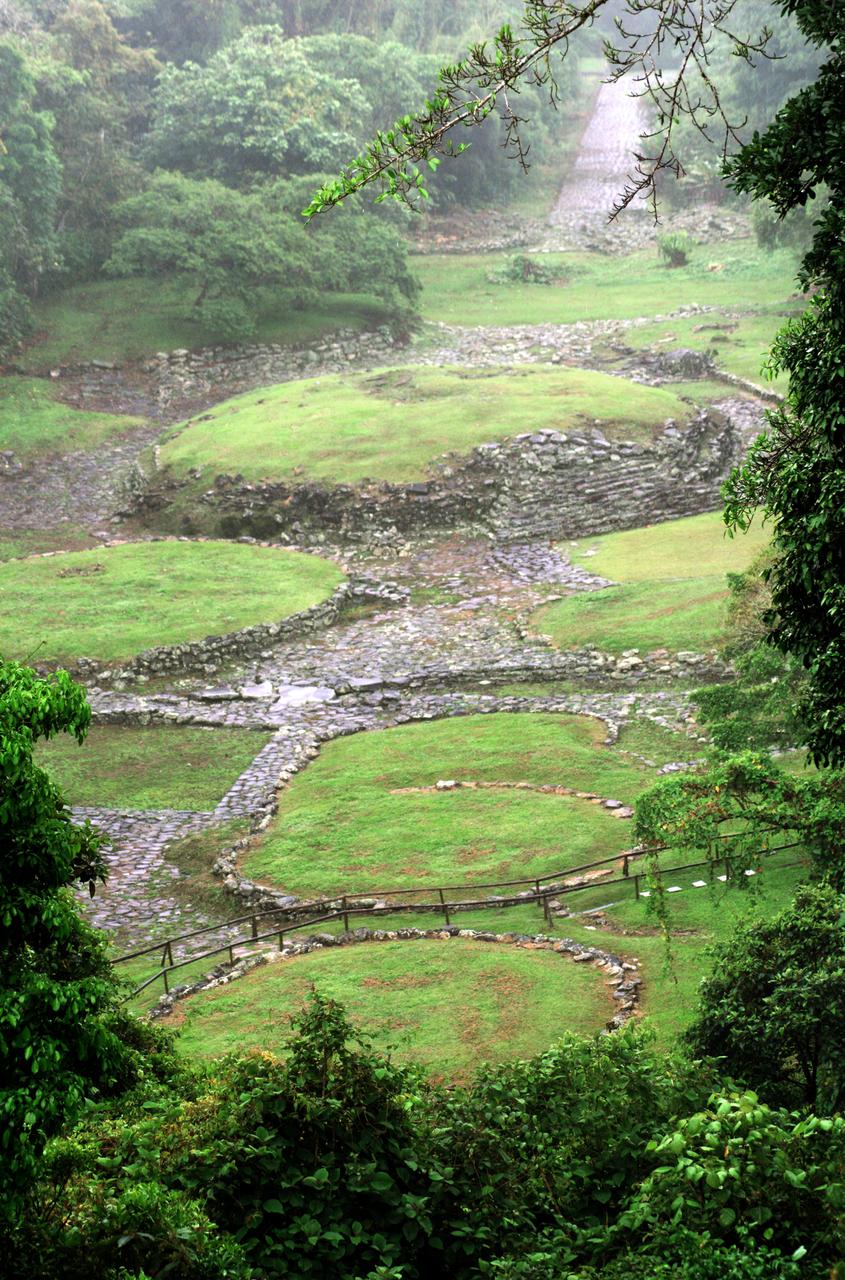
Pre-Columbian archaeological ruins are revealed through Costa Rican rain forest in this photo taken during NASA's AirSAR 2004 Mesoamerica campaign. AirSAR 2004 Mesoamerica is a three-week expedition by an international team of scientists that uses an all-weather imaging tool, called the Airborne Synthetic Aperture Radar (AirSAR) which is located onboard NASA's DC-8 airborne laboratory. The radar, developed by NASA's Jet Propulsion Laboratory, can penetrate clouds and also collect data at night. Its high-resolution sensors operate at multiple wavelengths and modes, allowing AirSAR to see beneath treetops, through thin sand, and dry snow pack. Much of the archaeological evidence needed to understand Pre-Columbian societies in Central America comes from features on the landscape. Difficult terrain and logistics have limited ground data collection. AirSAR helped to detect signs of ancient civilizations hidden beneath the forest. Its images will shed insights into the way modern humans interact with their landscape, and how ancient peoples lived and what became of their civilizations.
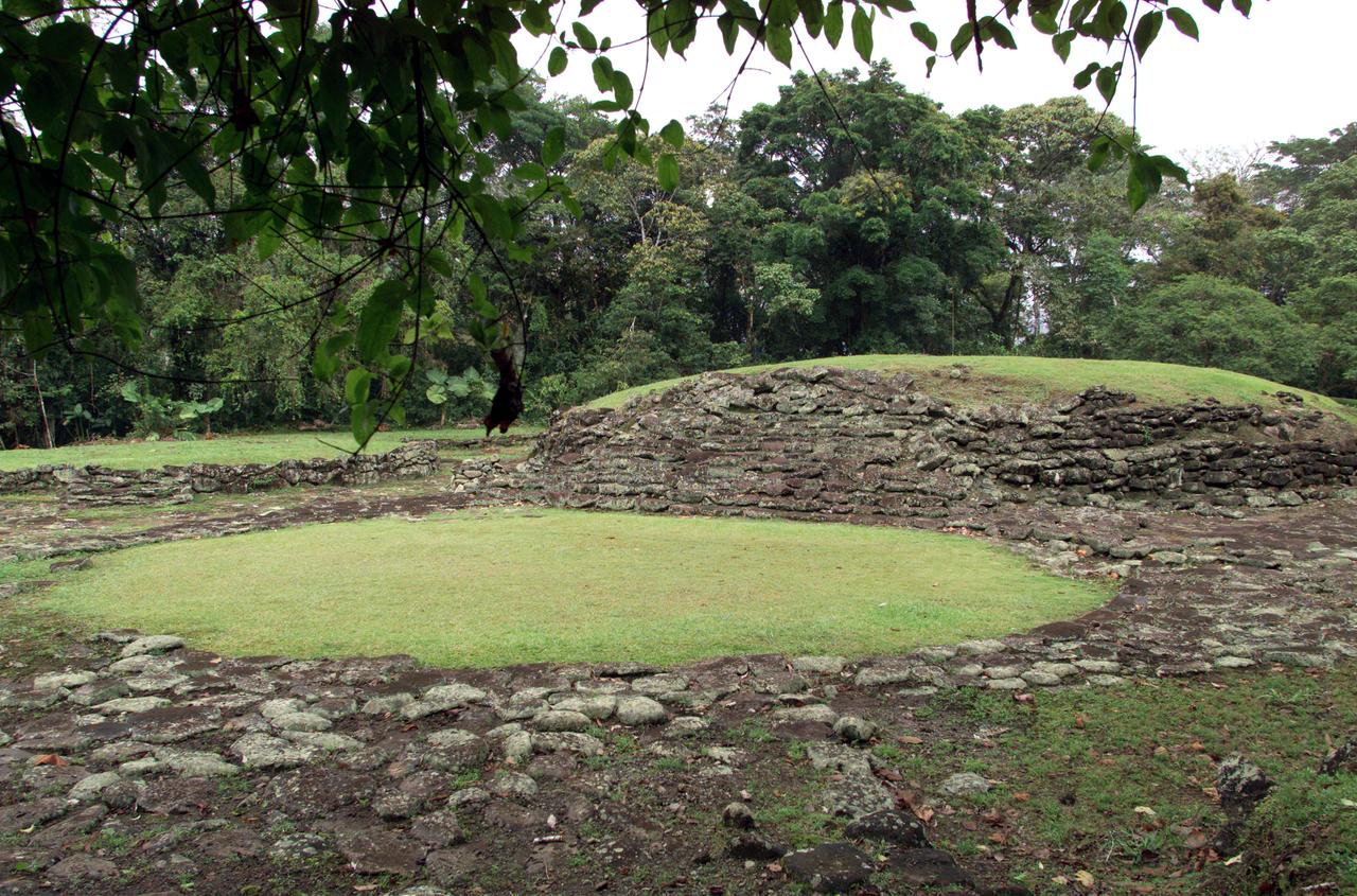
Pre-Columbian archaeological ruins are revealed through Costa Rican rain forest in this photo taken during NASA's AirSAR 2004 Mesoamerica campaign. AirSAR 2004 Mesoamerica is a three-week expedition by an international team of scientists that uses an all-weather imaging tool, called the Airborne Synthetic Aperture Radar (AirSAR) which is located onboard NASA's DC-8 airborne laboratory. The radar, developed by NASA's Jet Propulsion Laboratory, can penetrate clouds and also collect data at night. Its high-resolution sensors operate at multiple wavelengths and modes, allowing AirSAR to see beneath treetops, through thin sand, and dry snow pack. Much of the archaeological evidence needed to understand Pre-Columbian societies in Central America comes from features on the landscape. Difficult terrain and logistics have limited ground data collection. AirSAR helped to detect signs of ancient civilizations hidden beneath the forest. Its images will shed insights into the way modern humans interact with their landscape, and how ancient peoples lived and what became of their civilizations.
This photograph shows a stream in the La Selva region of the Costa Rican rain forest, taken during NASA's AirSAR 2004 Mesoamerica campaign. AirSAR 2004 Mesoamerica is a three-week expedition by an international team of scientists that will use an all-weather imaging tool, called the Airborne Synthetic Aperture Radar (AirSAR) which is located onboard NASA's DC-8 airborne laboratory. Scientists from many parts of the world including NASA's Jet Propulsion Laboratory are combining ground research done in several areas in Central America with NASA's AirSAR technology to improve and expand on the quality of research they are able to do. NASA's AIRSAR technolgy provides two essential elements to the ground-based scientists. First, it tests and provides accurate measurements of the forest structure. Secondly, AirSAR can study a larger area of the forest versus the smaller area that can be tested and plotted by the ground scientists. It also provides a unique one-of-a-kind system of measurement that obtains important information for the scientists, such as where forests are located and what exactly is in them.
Pre-Columbian archaeological ruins are revealed through Costa Rican rain forest in this photo taken during NASA's AirSAR 2004 Mesoamerica campaign. AirSAR 2004 Mesoamerica is a three-week expedition by an international team of scientists that uses an all-weather imaging tool, called the Airborne Synthetic Aperture Radar (AirSAR) which is located onboard NASA's DC-8 airborne laboratory. The radar, developed by NASA's Jet Propulsion Laboratory, can penetrate clouds and also collect data at night. Its high-resolution sensors operate at multiple wavelengths and modes, allowing AirSAR to see beneath treetops, through thin sand, and dry snow pack. Much of the archaeological evidence needed to understand Pre-Columbian societies in Central America comes from features on the landscape. Difficult terrain and logistics have limited ground data collection. AirSAR helped to detect signs of ancient civilizations hidden beneath the forest. Its images will shed insights into the way modern humans interact with their landscape, and how ancient peoples lived and what became of their civilizations.
Pre-Columbian archaeological ruins are revealed through Costa Rican rain forest in this photo taken during NASA's AirSAR 2004 Mesoamerica campaign. AirSAR 2004 Mesoamerica is a three-week expedition by an international team of scientists that uses an all-weather imaging tool, called the Airborne Synthetic Aperture Radar (AirSAR) which is located onboard NASA's DC-8 airborne laboratory. The radar, developed by NASA's Jet Propulsion Laboratory, can penetrate clouds and also collect data at night. Its high-resolution sensors operate at multiple wavelengths and modes, allowing AirSAR to see beneath treetops, through thin sand, and dry snow pack. Much of the archaeological evidence needed to understand Pre-Columbian societies in Central America comes from features on the landscape. Difficult terrain and logistics have limited ground data collection. AirSAR helped to detect signs of ancient civilizations hidden beneath the forest. Its images will shed insights into the way modern humans interact with their landscape, and how ancient peoples lived and what became of their civilizations.
A unique tree trunk photographed in La Selva region of the Costa Rican rain forest as part of NASA's AirSAR 2004 Mesoamerica campaign. AirSAR 2004 Mesoamerica is a three-week expedition by an international team of scientists that will use an all-weather imaging tool, called the Airborne Synthetic Aperture Radar (AirSAR) which is located onboard NASA's DC-8 airborne laboratory. Scientists from many parts of the world including NASA's Jet Propulsion Laboratory are combining ground research done in several areas in Central America with NASA's AirSAR technology to improve and expand on the quality of research they are able to do. NASA's AIRSAR technolgy provides two essential elements to the ground-based scientists. First, it tests and provides accurate measurements of the forest structure. Secondly, AirSAR can study a larger area of the forest versus the smaller area that can be tested and plotted by the ground scientists. It also provides a unique one-of-a-kind system of measurement that obtains important information for the scientists, such as where forests are located and what exactly is in them.
Pre-Columbian archaeological ruins are revealed through Costa Rican rain forest in this photo taken during NASA's AirSAR 2004 Mesoamerica campaign. AirSAR 2004 Mesoamerica is a three-week expedition by an international team of scientists that uses an all-weather imaging tool, called the Airborne Synthetic Aperture Radar (AirSAR) which is located onboard NASA's DC-8 airborne laboratory. The radar, developed by NASA's Jet Propulsion Laboratory, can penetrate clouds and also collect data at night. Its high-resolution sensors operate at multiple wavelengths and modes, allowing AirSAR to see beneath treetops, through thin sand, and dry snow pack. Much of the archaeological evidence needed to understand Pre-Columbian societies in Central America comes from features on the landscape. Difficult terrain and logistics have limited ground data collection. AirSAR helped to detect signs of ancient civilizations hidden beneath the forest. Its images will shed insights into the way modern humans interact with their landscape, and how ancient peoples lived and what became of their civilizations.
Pre-Columbian archaeological ruins are revealed through Costa Rican rain forest in this photo taken during NASA's AirSAR 2004 Mesoamerica campaign. AirSAR 2004 Mesoamerica is a three-week expedition by an international team of scientists that uses an all-weather imaging tool, called the Airborne Synthetic Aperture Radar (AirSAR) which is located onboard NASA's DC-8 airborne laboratory. The radar, developed by NASA's Jet Propulsion Laboratory, can penetrate clouds and also collect data at night. Its high-resolution sensors operate at multiple wavelengths and modes, allowing AirSAR to see beneath treetops, through thin sand, and dry snow pack. Much of the archaeological evidence needed to understand Pre-Columbian societies in Central America comes from features on the landscape. Difficult terrain and logistics have limited ground data collection. AirSAR helped to detect signs of ancient civilizations hidden beneath the forest. Its images will shed insights into the way modern humans interact with their landscape, and how ancient peoples lived and what became of their civilizations.
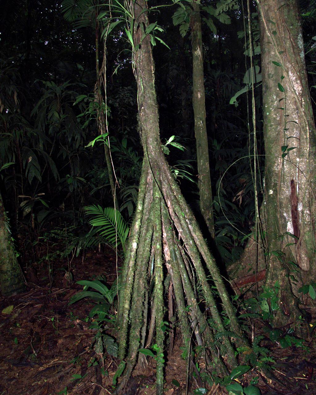
A tree trunk structure photographed in the La Selva region of the Costa Rican rain forest as part of NASA's AirSAR 2004 Mesoamerica campaign. AirSAR 2004 Mesoamerica is a three-week expedition by an international team of scientists that will use an all-weather imaging tool, called the Airborne Synthetic Aperture Radar (AirSAR) which is located onboard NASA's DC-8 airborne laboratory. Scientists from many parts of the world including NASA's Jet Propulsion Laboratory are combining ground research done in several areas in Central America with NASA's AirSAR technology to improve and expand on the quality of research they are able to do. NASA's AIRSAR technolgy provides two essential elements to the ground-based scientists. First, it tests and provides accurate measurements of the forest structure. Secondly, AirSAR can study a larger area of the forest versus the smaller area that can be tested and plotted by the ground scientists. It also provides a unique one-of-a-kind system of measurement that obtains important information for the scientists, such as where forests are located and what exactly is in them.

NASA Deputy Administrator Pam Melroy, left, speaks with Mel Raines, president and chief operating officer of Pacers Sports & Entertainment, before the start of a basketball game between the Indiana Pacers and the Miami Heat, Sunday, April 7, 2024, at Gainbridge Fieldhouse in Indianapolis, Ind. On Monday, April 8, a total solar eclipse will sweep across a narrow portion of the North American continent from Mexico’s Pacific coast to the Atlantic coast of Newfoundland, Canada, while a partial solar eclipse will be visible across the entire North American continent along with parts of Central America and Europe. Photo Credit: (NASA/Joel Kowsky)
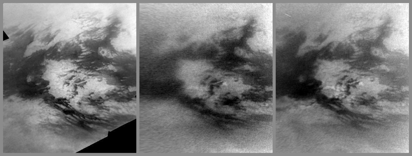
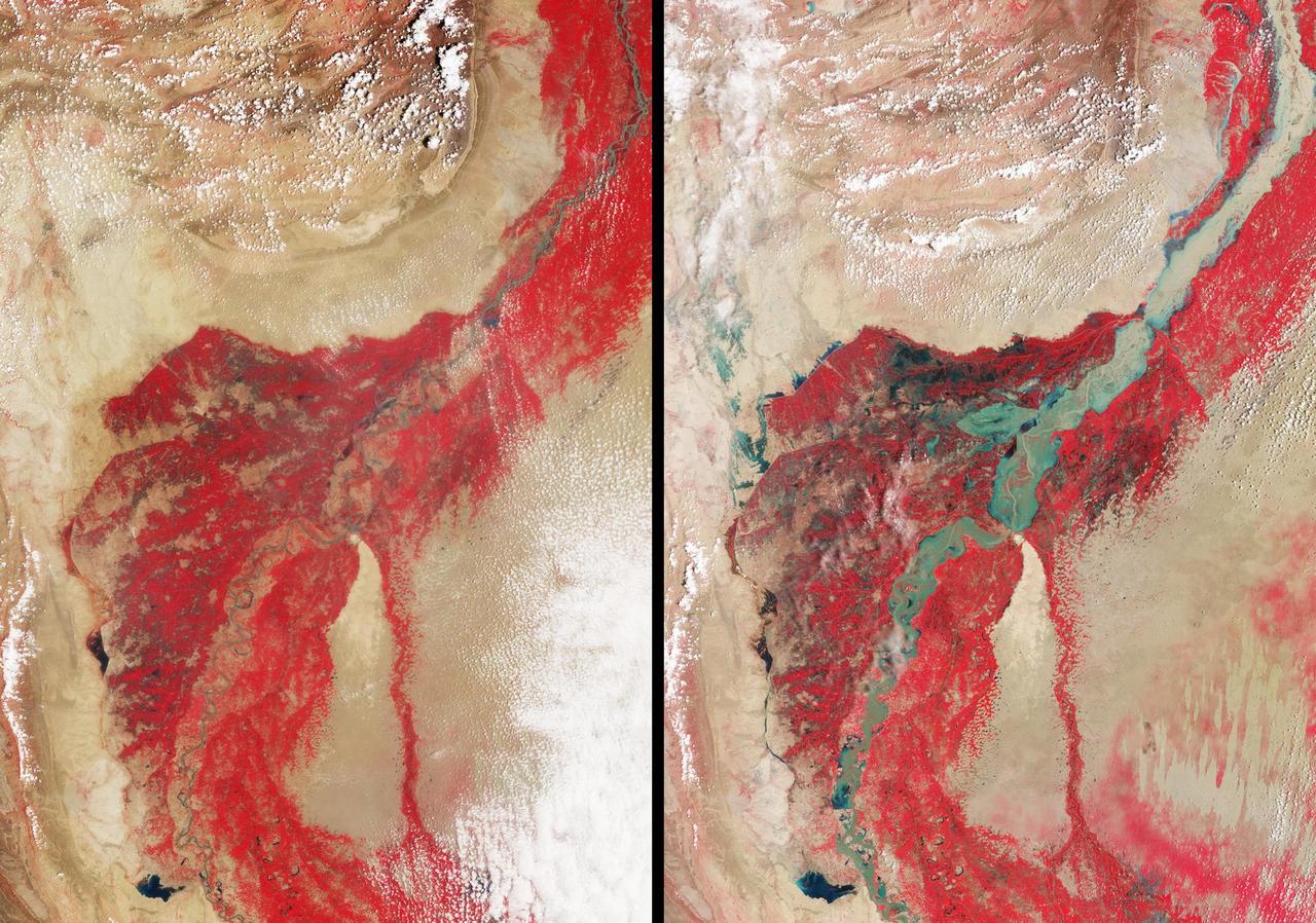
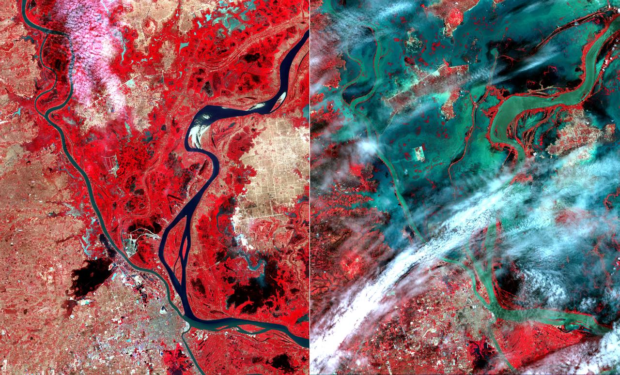
Images from NASA Cassini spacecraft show changes caused by methane rain in the bright Adiri region near the equator of Saturn largest moon, Titan.
NASA Terra spacecraft flew over South Africa and Zimbabwe where week-long torrential rains swelled the Limpopo River in Jan. 2013.
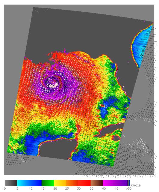
Nearly the whole of the Gulf of Mexico was churning with the powerful winds and rains of Hurricane Katrina on August 28, 2005, when NASA QuikScat satellite captured this image.
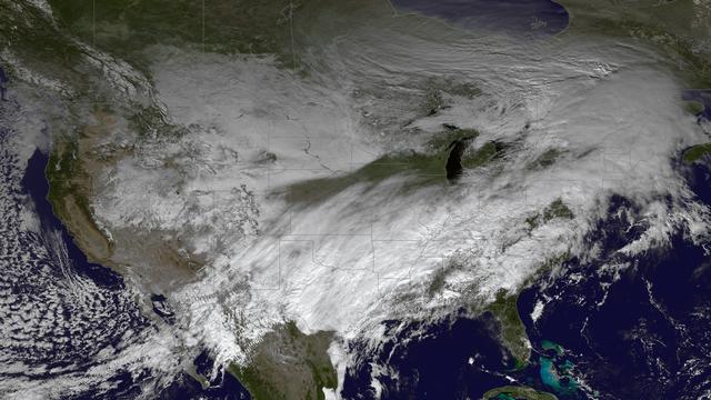
The powerful winter storm that has been affecting much of the central and western U.S. continues to intensify as it moves into Canada. Snow is tapering off across the Upper Midwest, but heavy snow is possible on Thursday from the Ohio Valley to the mid-Mississippi Valley, with heavy rain possible from the central Appalachians to the lower Mississippi Valley. Freezing rain is possible from Texas to the Ohio Valley. This image was taken by GOES East at 1745Z on December 5, 2013. <b><a href="http://goes.gsfc.nasa.gov/" rel="nofollow">Credit: NOAA/NASA GOES Project</a></b> Caption: NOAA <b><a href="http://www.nasa.gov/audience/formedia/features/MP_Photo_Guidelines.html" rel="nofollow">NASA image use policy.</a></b> <b><a href="http://www.nasa.gov/centers/goddard/home/index.html" rel="nofollow">NASA Goddard Space Flight Center</a></b> enables NASA’s mission through four scientific endeavors: Earth Science, Heliophysics, Solar System Exploration, and Astrophysics. Goddard plays a leading role in NASA’s accomplishments by contributing compelling scientific knowledge to advance the Agency’s mission. <b>Follow us on <a href="http://twitter.com/NASA_GoddardPix" rel="nofollow">Twitter</a></b> <b>Like us on <a href="http://www.facebook.com/pages/Greenbelt-MD/NASA-Goddard/395013845897?ref=tsd" rel="nofollow">Facebook</a></b> <b>Find us on <a href="http://instagram.com/nasagoddard?vm=grid" rel="nofollow">Instagram</a></b>
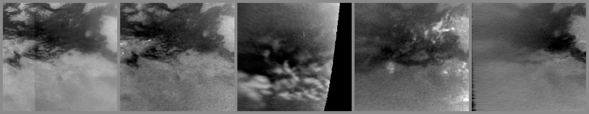
This series of images from NASA Cassini spacecraft shows changes on the surface of Saturn moon Titan, as the transition to northern spring brings methane rains to the moon equatorial latitudes.
This image, acquired by NASA Terra spacecraft, shows Fiji, hard hit by heavy rains in early 2012, causing flooding and landslides. Hardest hit was the western part of the main Island of Viti Levu, Fiji, and the principal city of Nadi.
In late July 2010, flooding caused by heavy monsoon rains began in several regions of Pakistan, including the Khyber Pakhtunkhwa, Sindh, Punjab and parts of Baluchistan. This image was acquired by NASA Terra spacecraft on August 11, 2010.
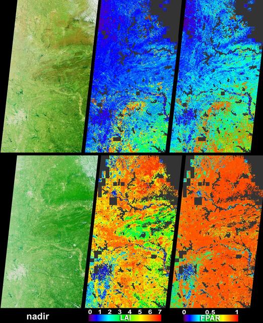
Vigorous vegetation growth in the Southern United States after heavy rains fell during April and early May, 2004, is quantified in these images and data products from NASA Terra spacecraft.
On Jan. 7, 2011, NASA Terra spacecraft captured this image of the inundated city of Rockhampton, Queensland, Australia. Torrential rains in NE Australia caused the Fitzroy River to overflow its banks and flood much of the city.
In late July 2010, flooding caused by heavy monsoon rains began in several regions of Pakistan. These images taken by NASA Aqua spacecraft show were taken before and after the flooding.
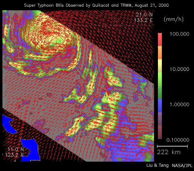
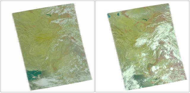
As super Typhoon Bilis, equal in strength to a category 5 hurricane, bore down on Taiwan, these images from August 21, 2000, show the massive storm most devastating components: rain and wind.
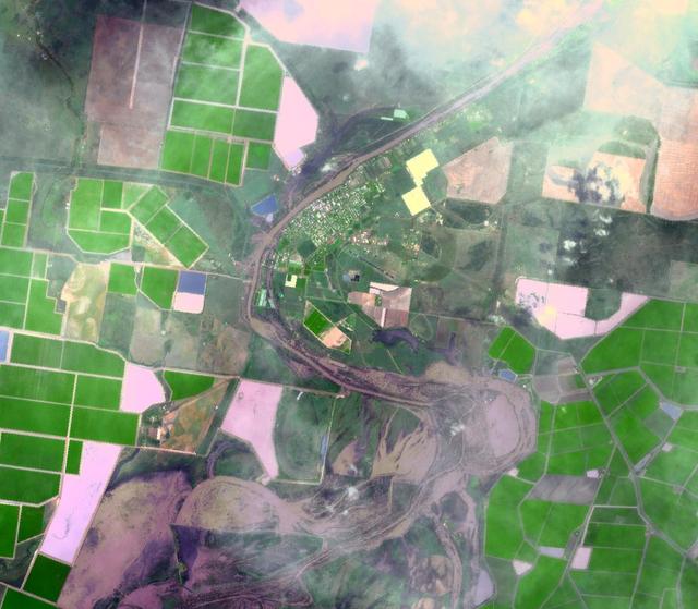
NASA Terra spacecraft captured this image of the city of Jhudo, Pakistan, and surrounding countryside on Sept. 24, 2011. Torrential monsoon rains in south Asia have displaced hundreds of thousands of residents in India, Pakistan and Thailand.
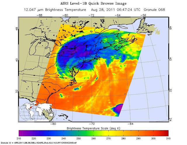
This infrared image of Hurricane Irene from the AIRS instrument on NASA Aqua spacecraft, was taken at 2:47 a.m. EDT on Aug. 28. The storm coldest cloud top temperatures and intense rains are shown in purples and blues.
On Jan. 18, 2011, NASA Terra spacecraft captured this 3-D perspective image of the city of Nova Friburgo, Brazil. A week of torrential rains triggered a series of deadly mudslides and floods. More details about this image at the Photojournal.
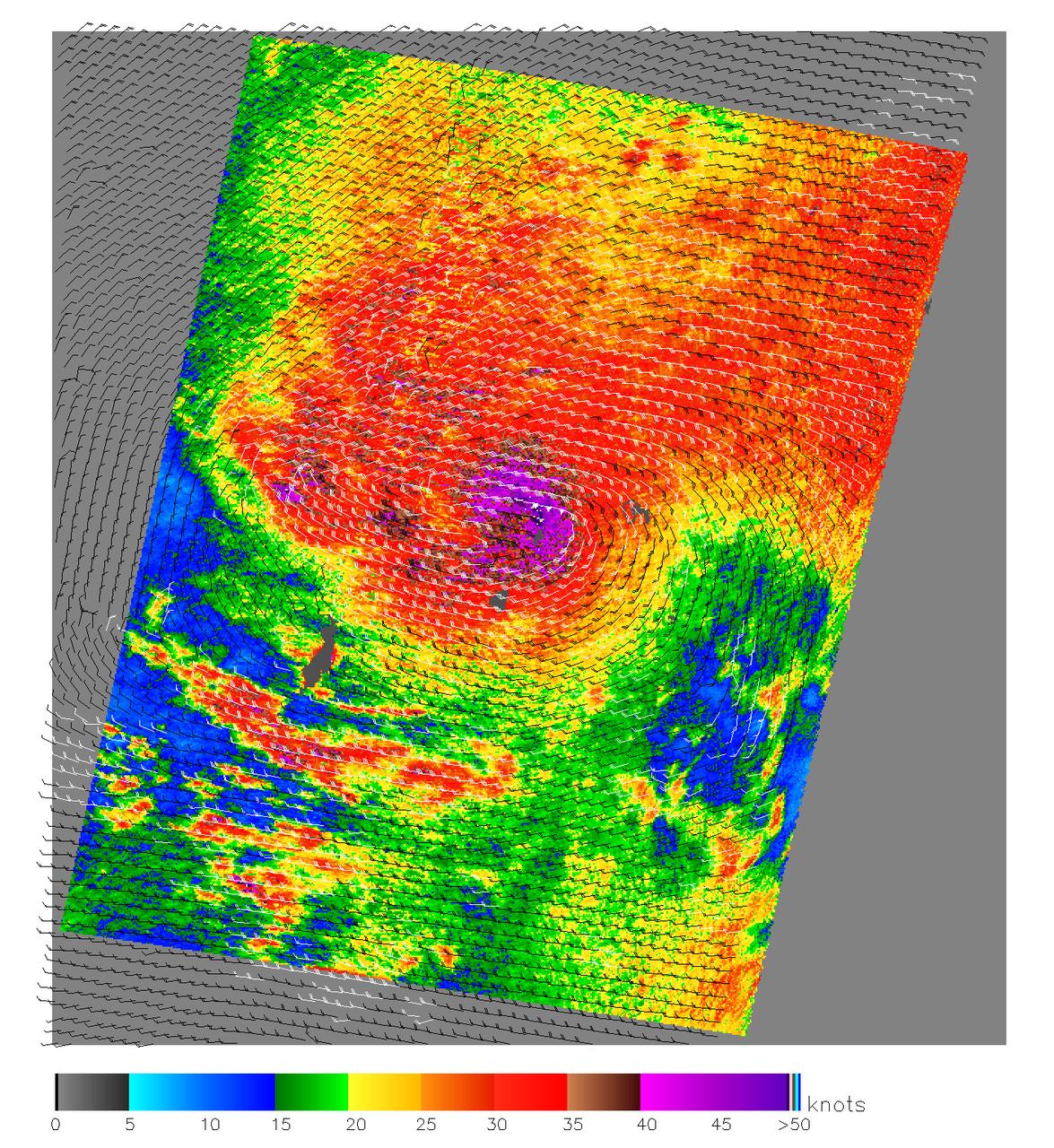
This image, produced from data collected by the SeaWinds scatterometer instrument onboard NASA QuikScat mission reveals the details of the surface winds and rain in Typhoon Nanmadol as it moves westward.
NASA Terra spacecraft shows that extremely heavy seasonal rains have fallen on northern Bolivia since October 2013. The worst affected province is Beni in the northeastern part of the country.

This image from NASA Terra spacecraft is of the Republic of Singapore, a city-state off the southern tip of the Malay Peninsula. An island country made up of 63 islands, the country is largely urbanized with very little rain forest left.
On Jan. 14, 2011, NASA Terra spacecraft captured this image of the inundated city of St. George, Queensland, Australia. Torrential rains in northeastern Australia caused the Balonne River to overflow its banks and flood much of the city.
This image acquired by NASA Terra spacecraft shows unusually heavy rains over the upper Mekong River in Laos and Thailand that led to severe flooding in Cambodia in mid-August 2011. The city of Phnom Penh is at the bottom center of the image.
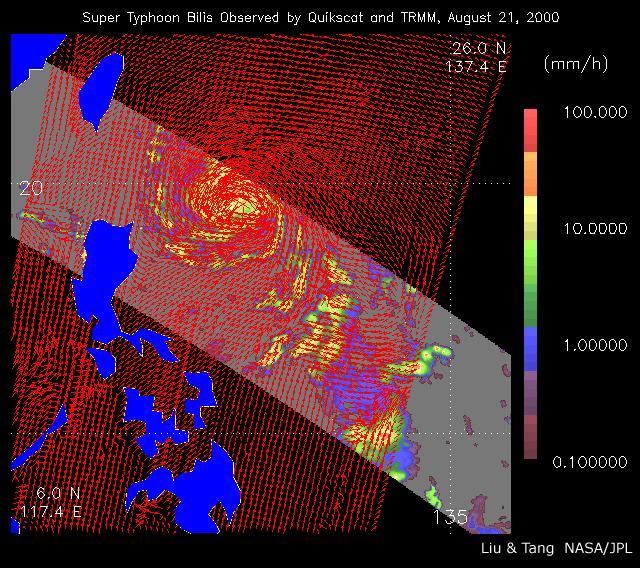
As super Typhoon Bilis, equal in strength to a category 5 hurricane, bore down on Taiwan, these images from August 21, 2000, show the massive storm most devastating components: rain and wind.
Extremely heavy rains fell at the end of February 2012 in the northern Algerian province of El Tarf, near the Tunisian border. The rainfall total was the greatest recorded in the last 30 years. This image is from NASA Terra spacecraft.
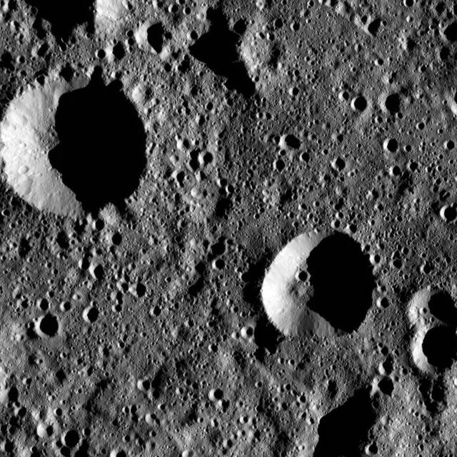
This image from NASA Dawn spacecraft shows terrain within Chaminuka Crater on Ceres. Chaminuka was named for the spirit who provides rains during times of drought, according to the legends of the Shona people of Zimbabwe.
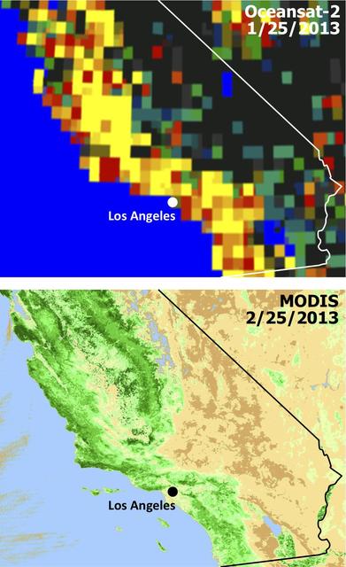
Extensive and persistent rains between Jan. 24 and Jan. 27, 2013, significantly increased soil moisture and enhanced vegetation growth in Southern California based on data from NASA Aqua spacecraft and ISRO Oceansat-2 satellite.
In late July 2010, flooding caused by heavy monsoon rains began in several regions of Pakistan. This image from NASA Aqua spacecraft reveals the bright white cloud tops from the cluster of thunderstorms.
This image acquired by NASA Terra spacecraft depicts the high water levels and flooding along the Thames River west of London as record-breaking rains covered the United Kingdom in January and February.
This image, acquired by NASA Terra satellite on July 6, 2013, shows heavy rains, which began in mid-June, resulting in major flooding along the Parana River in Argentina.
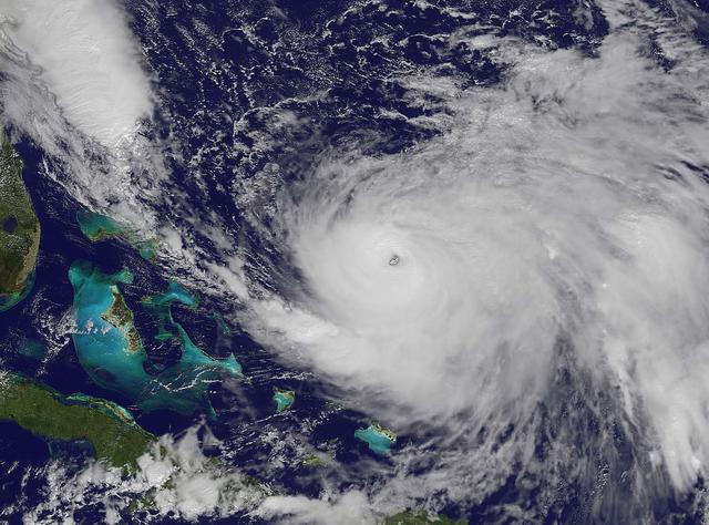
NOAA's GOES-East satellite captured this visible image of Hurricane Joaquin east of the Bahamas on Oct. 3 at 1615 UTC (12:15 p.m. EDT). The national weather forecast for October 3, 2015: Joaquin is no threat for now, but the nor'easter on the East Coast is causing massive flooding. Heavy rain hit Charleston, South Carolina., and much of the Southeast on Saturday, giving the region little relief from the threat of Hurricane Joaquin as it moved to the northeast away from the East Coast. Credit: NASA/NOAA GOES Project <b><a href="http://www.nasa.gov/audience/formedia/features/MP_Photo_Guidelines.html" rel="nofollow">NASA image use policy.</a></b> <b><a href="http://www.nasa.gov/centers/goddard/home/index.html" rel="nofollow">NASA Goddard Space Flight Center</a></b> enables NASA’s mission through four scientific endeavors: Earth Science, Heliophysics, Solar System Exploration, and Astrophysics. Goddard plays a leading role in NASA’s accomplishments by contributing compelling scientific knowledge to advance the Agency’s mission. <b>Follow us on <a href="http://twitter.com/NASAGoddardPix" rel="nofollow">Twitter</a></b> <b>Like us on <a href="http://www.facebook.com/pages/Greenbelt-MD/NASA-Goddard/395013845897?ref=tsd" rel="nofollow">Facebook</a></b> <b>Find us on <a href="http://instagrid.me/nasagoddard/?vm=grid" rel="nofollow">Instagram</a></b>
NOAA's GOES-East satellite captured this visible image of Hurricane Joaquin east of the Bahamas on Oct. 3 at 1615 UTC (12:15 p.m. EDT). The national weather forecast for October 3, 2015: Joaquin is no threat for now, but the nor'easter on the East Coast is causing massive flooding. Heavy rain hit Charleston, South Carolina., and much of the Southeast on Saturday, giving the region little relief from the threat of Hurricane Joaquin as it moved to the northeast away from the East Coast. Credit: NASA/NOAA GOES Project <b><a href="http://www.nasa.gov/audience/formedia/features/MP_Photo_Guidelines.html" rel="nofollow">NASA image use policy.</a></b> <b><a href="http://www.nasa.gov/centers/goddard/home/index.html" rel="nofollow">NASA Goddard Space Flight Center</a></b> enables NASA’s mission through four scientific endeavors: Earth Science, Heliophysics, Solar System Exploration, and Astrophysics. Goddard plays a leading role in NASA’s accomplishments by contributing compelling scientific knowledge to advance the Agency’s mission. <b>Follow us on <a href="http://twitter.com/NASAGoddardPix" rel="nofollow">Twitter</a></b> <b>Like us on <a href="http://www.facebook.com/pages/Greenbelt-MD/NASA-Goddard/395013845897?ref=tsd" rel="nofollow">Facebook</a></b> <b>Find us on <a href="http://instagrid.me/nasagoddard/?vm=grid" rel="nofollow">Instagram</a></b>
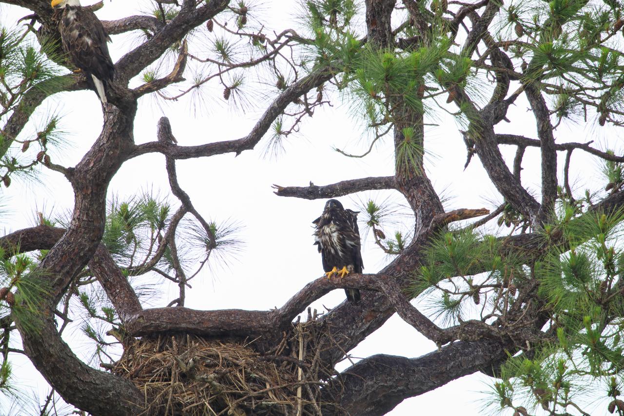
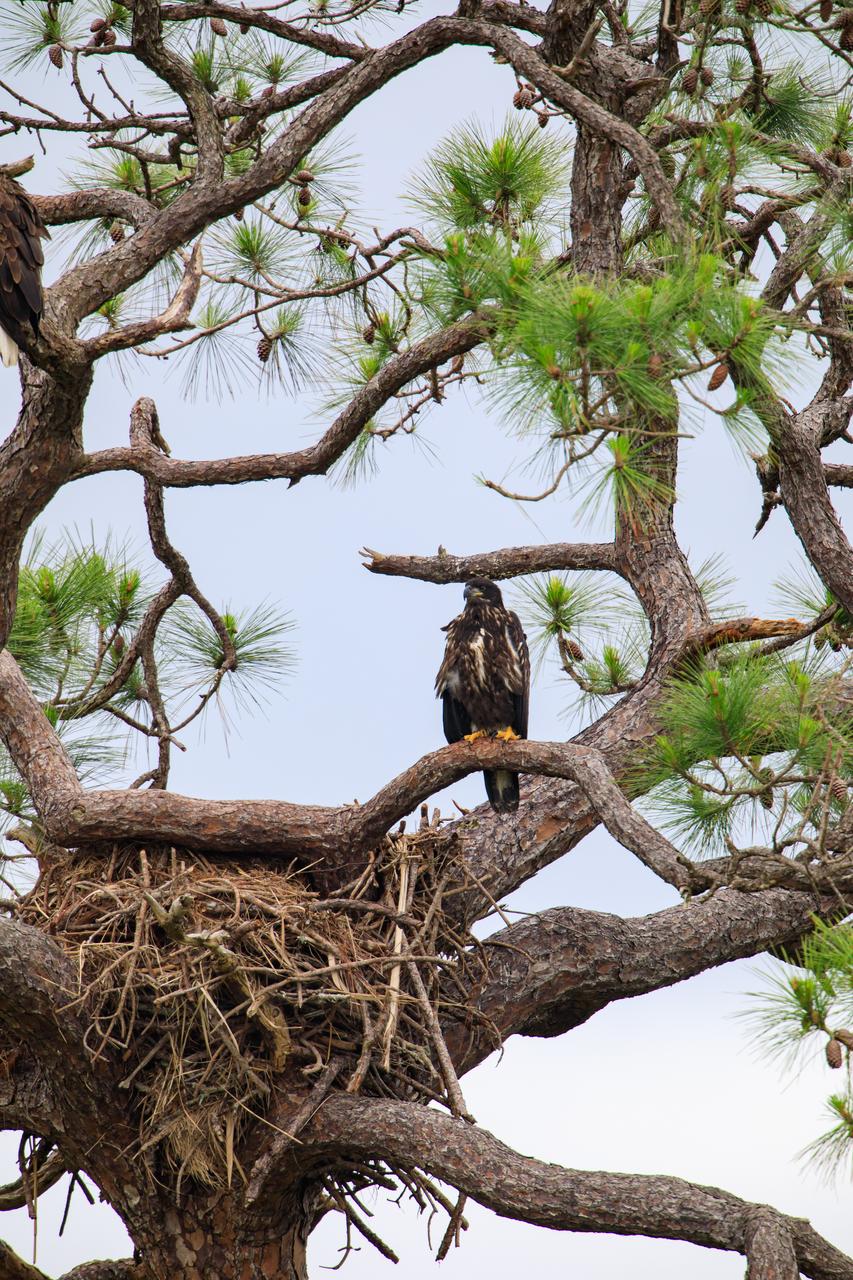
An American bald eagle, upper left, and its baby are perched in a tree near their nest at NASA’s Kennedy Space Center in Florida on April 25, 2023. The eaglet is the lone offspring of a mated pair of eagles that recently built the new home after storms badly damaged their original nest located about 50 yards away. That nest was built in 1973 and had been used by eagles almost every year since 1975.
An American bald eagle, upper left, and its baby are perched in a tree near their nest at NASA’s Kennedy Space Center in Florida as a rainstorm approaches on April 25, 2023. The eaglet is the lone offspring of a mated pair of eagles that recently built the new home after storms badly damaged their original nest located about 50 yards away. That nest was built in 1973 and had been used by eagles almost every year since 1975.

An American bald eagle, upper left, and its baby are perched in a tree near their nest at NASA’s Kennedy Space Center in Florida as a rainstorm approaches on April 25, 2023. The eaglet is the lone offspring of a mated pair of eagles that recently built the new home after storms badly damaged their original nest located about 50 yards away. That nest was built in 1973 and had been used by eagles almost every year since 1975.
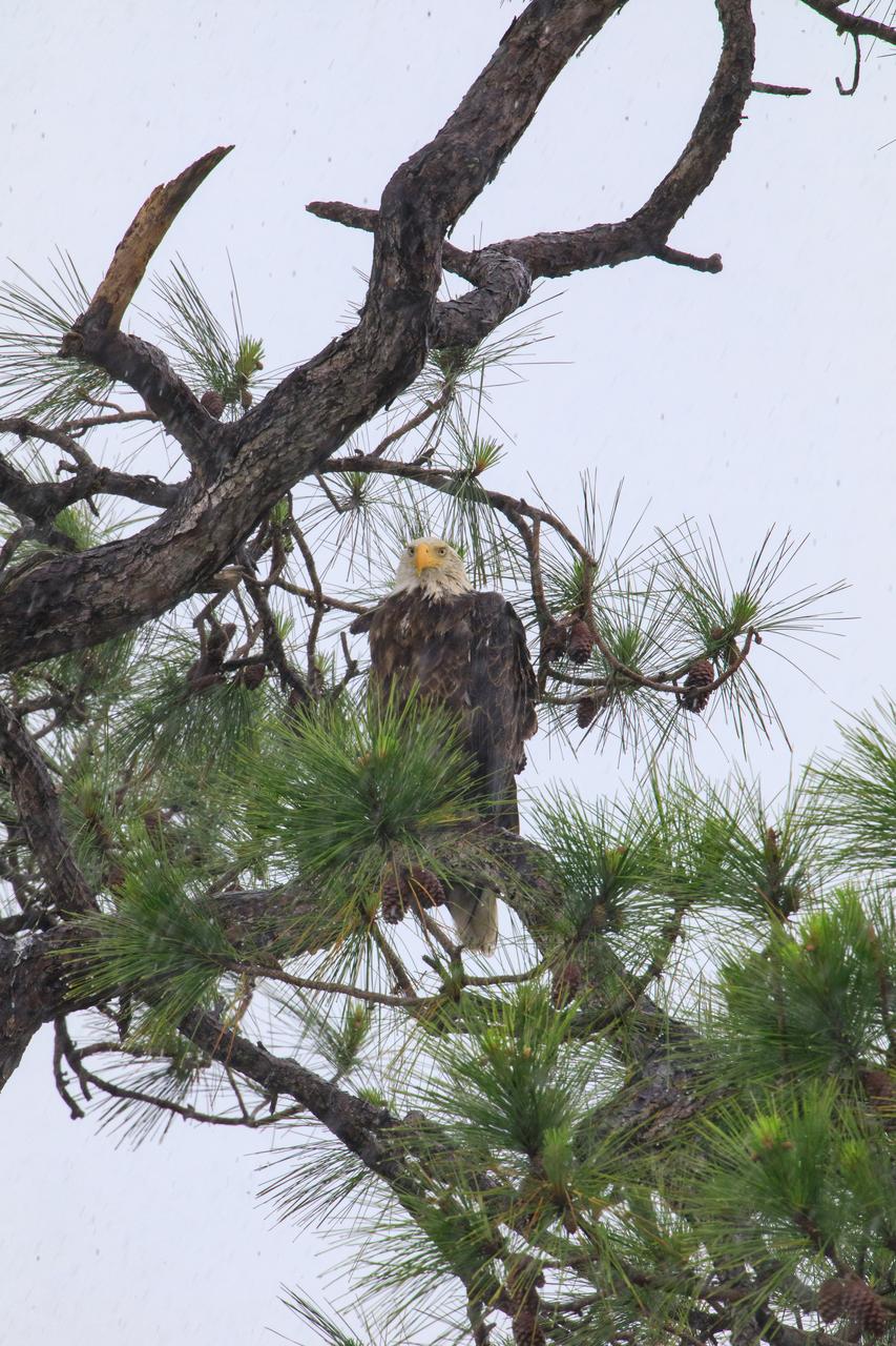
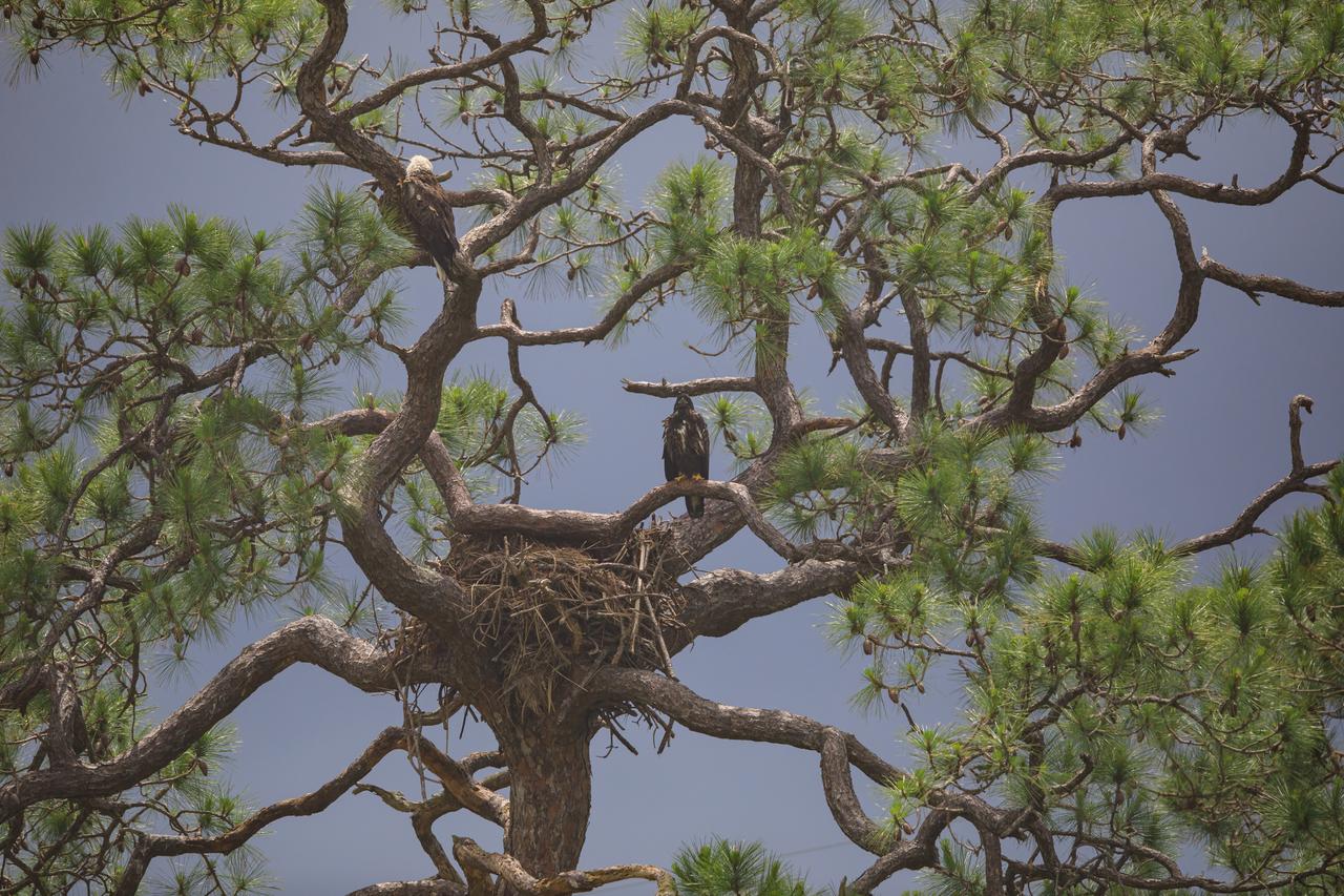
An American bald eagle is perched high in a tree above its nest at NASA’s Kennedy Space Center in Florida on April 25, 2023. The adult eagle is part of a mated pair that recently built a new home in this tree after storms badly damaged their original nest located about 50 yards away. That nest was built in 1973 and had been used by eagles almost every year since 1975. This season, the pair produced one eaglet.
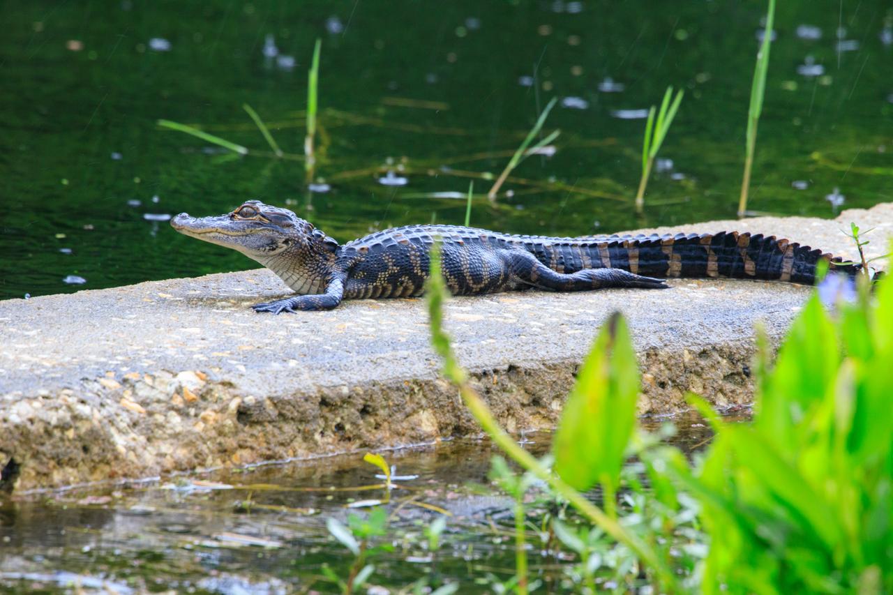
A young alligator rests on a concrete structure at NASA’s Kennedy Space Center in Florida on April 25, 2023. Alligator breeding season starts in May when males begin courting females. By June, pairs have mated and females build vegetation nests in the marsh. Eggs hatch in about 65 days. The mother carries her young to the water and protects them from predators, including male alligators.
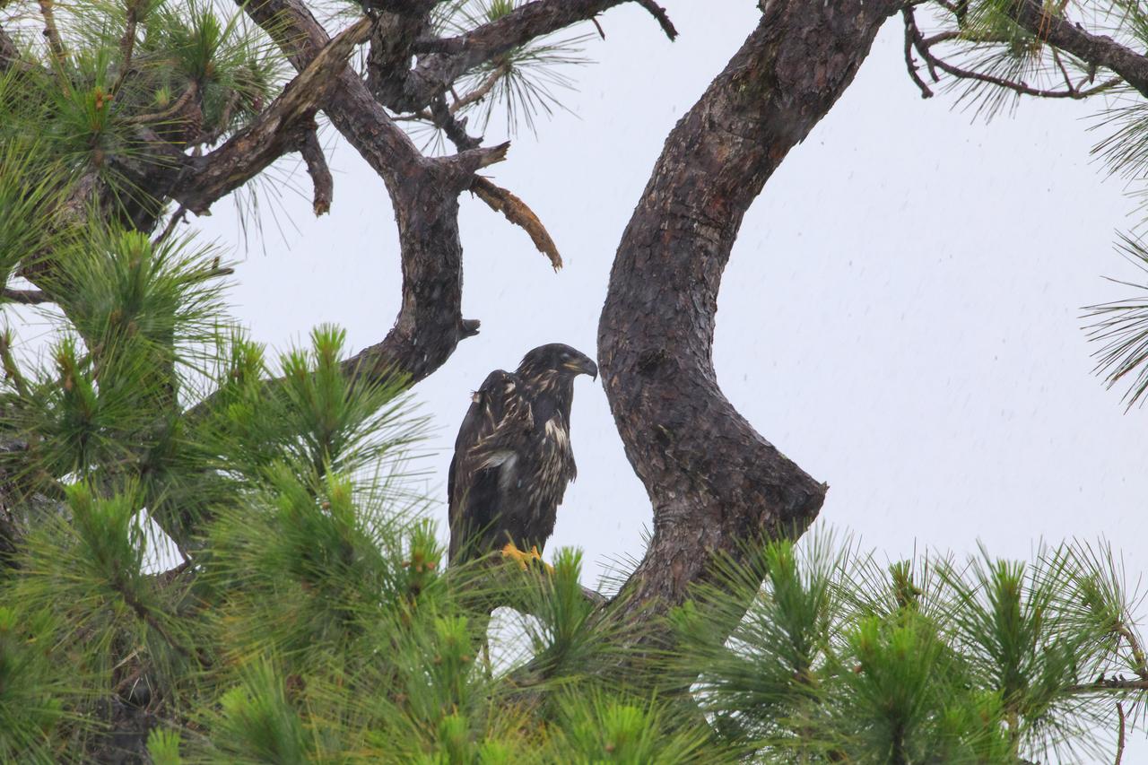
A baby American bald eagle looks out from just above its nest, located in a tree at NASA’s Kennedy Space Center in Florida on April 25, 2023. The eaglet is the lone offspring of a mated pair of eagles that recently built the new home after storms badly damaged their original nest located about 50 yards away. That nest was built in 1973 and had been used by eagles almost every year since 1975.
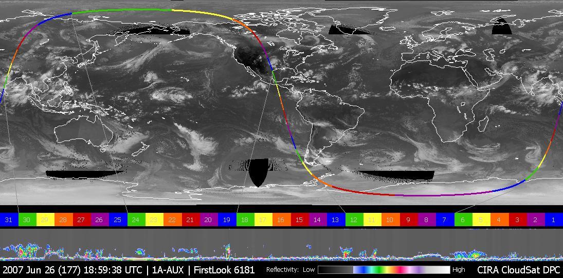
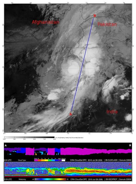
This image was taken on June 26, 2007, UTC 20:00. In this image an obvious storm hangs over the middle of the United States. Figure 1 shows NASA CloudSat data looking, in profile, at the cloud in this storm.
A baby American bald eagle looks out from just above its nest, located in a tree at NASA’s Kennedy Space Center in Florida on April 25, 2023. A mated pair of eagles recently built a new home in this tree after storms badly damaged their original nest located about 50 yards away, and produced one eaglet. The previous nest was built in 1973 and had been used by eagles almost every year since 1975.
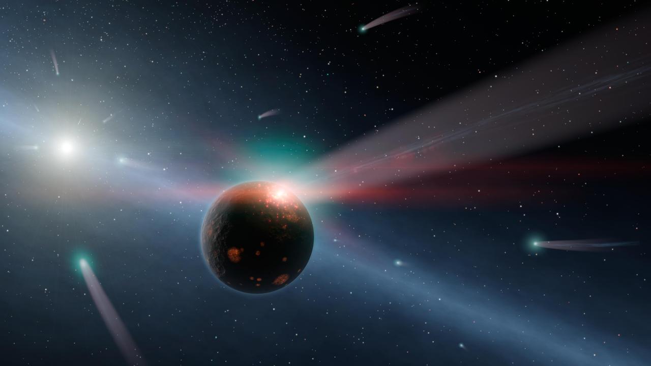
This artist conception illustrates a storm of comets around a star near our own, called Eta Corvi. Evidence for this barrage comes from NASA Spitzer Space Telescope infrared detectors.

Using NASA Spitzer Space Telescope, astronomers have, for the first time, found signatures of silicate crystals around a newly forming protostar in the constellation of Orion.
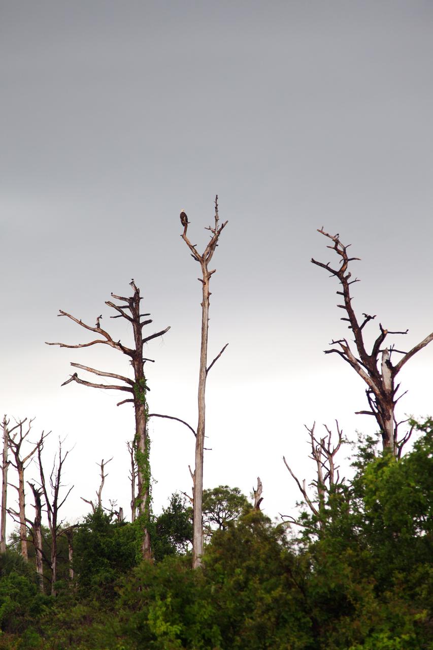
CAPE CANAVERAL, Fla. – A Bald Eagle takes advantage of a break in rain and perches on a tree at NASA's Kennedy Space Center in Florida. Severe storms associated with a frontal system are moving through Central Florida, producing strong winds, heavy rain, frequent lightning and even funnel clouds. Photo credit: NASA/Ben Smegelsky

Space Shuttle tile rain erosion test: Frank Hui sets MDA samples in Panel Test Facility for PTF-65
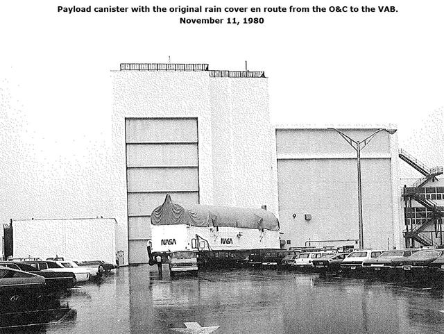
Payload canister with the original rain cover en route from the O&C to the VAB, November 11, 1980
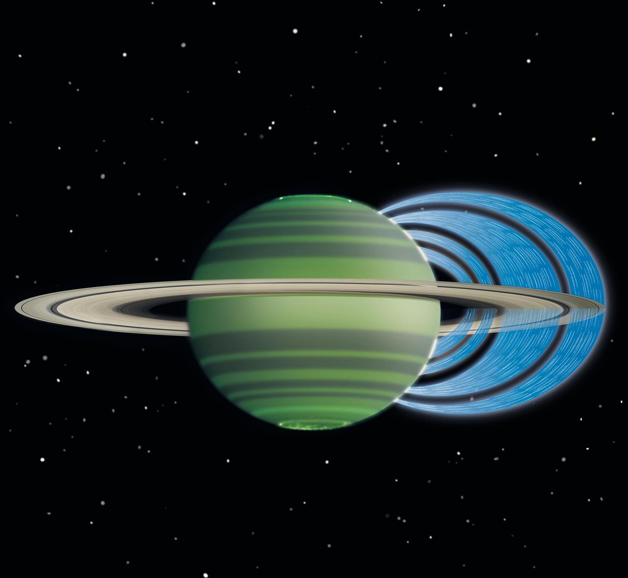
This artist concept illustrates how charged water particles flow into the Saturnian atmosphere from the planet rings, causing a reduction in atmospheric brightness.
Chennai, India's sixth largest city, has seen no rain for over six months. Its four major reservoirs have virtually run dry, and the city's population of four million is mostly relying on government tankers to provide water, or paying private companies to supply water. The two images were acquired by ASTER on October 6, 2015, and Landsat OLI on June 3, 2019. They cover an area of 29.9 by 45.7 kilometers, and are centered at 13.1 degrees north, 80.3 degrees east. https://photojournal.jpl.nasa.gov/catalog/PIA23300
Badwater Basin in Death Valley, California, is one of the driest places on Earth. In August, Hurricane Hilary dropped a year's worth of rain in a single day. Floodwaters have filled the ephemeral lake to a depth of about 60 cm. But the lake may evaporate in the next weeks. The scenes were acquired October 25, 2023 and November 10, 2012; cover an area of 24 by 28.5 km, and are located at 36.3 degrees north, 116.8 degrees west. https://photojournal.jpl.nasa.gov/catalog/PIA26197
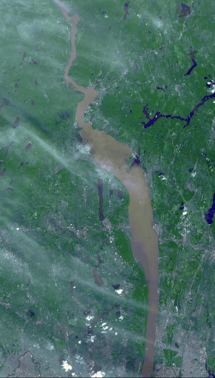
Brown and tan muddy water flows down the Hudson River are seen in this image acquired by NASA Terra spacecraft on Sept. 1, 2011. After the torrential rains from Hurricane Irene, many rivers in the eastern United States were filled with sediment.
NASA Terra spacecraft captured this view of severe flooding in La Plata, Argentina, on April 4, 2013. Torrential rains and record flash flooding has killed more than 50 and left thousands homeless, according to news reports.
iss069e004762 (April 20, 2023) --- Wadis, the Arabic term for drainage courses that contain water only when intermittent, heavy rain occurs, in the hot desert climate of Yemen were pictured by NASA astronaut and Expedition 69 Flight Engineer Woody Hoburg as the International Space Station orbited 258 miles above.
Mount Mabu in northern Mozambique is famous for its old-growth rain forest. The 75 square kilometers forest and its extremely diverse wildlife were unknown to scientists until 2005. One scientist believes he has discovered 15 new species of dung beetles. At least 25 additional new species of animals have also been found. The image was acquired October 4, 2023, covers an area of 26.7 by 28.8 km, and is located at 16.3 degrees south, 36.4 degrees east. https://photojournal.jpl.nasa.gov/catalog/PIA26392
Earth observation taken during a day pass by the Expedition 40 crew aboard the International Space Station (ISS). Folder lists this as: Amazonian rain forest.
As rain showers dissipate, a rainbow appeared over the Kennedy Space Center's Press Site and turn basin. In the background is the historic countdown clock.
Earth observation taken during a day pass by the Expedition 40 crew aboard the International Space Station (ISS). Folder lists this as: Amazonian rain forest.
KENNEDY SPACE CENTER, FLA. -- On Launch Pad 39A, workers are removing the rain gutters from space shuttle Discovery's payload bay. The gutters prevent leaks into the bay from rain while the shuttle is on the pad. Beneath is the orbital docking system. Mission STS-120 will bring the Harmony module that will provide attachment points for European and Japanese laboratory modules to the International Space Station. Launch of Discovery is targeted for Oct. 23. Photo credit: NASA/George Shelton
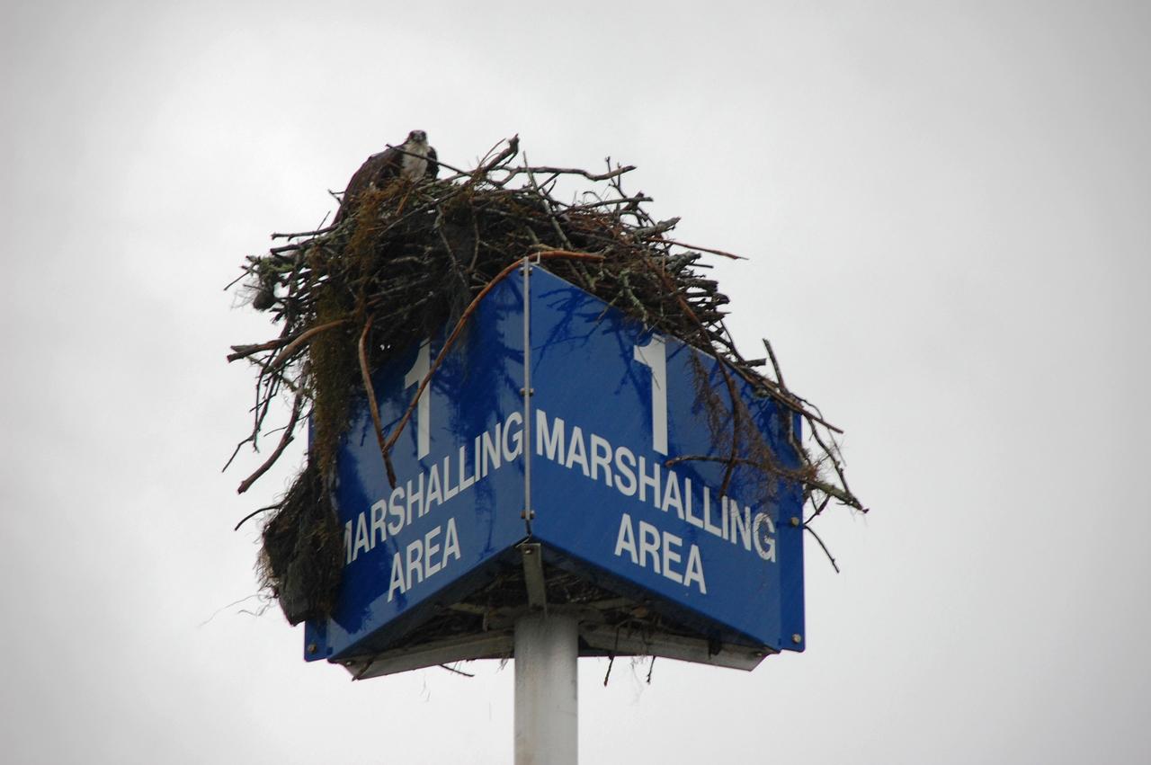
CAPE CANAVERAL, Fla. – An osprey takes advantage of a break in rain and peers out of its nest near the Press Site at NASA's Kennedy Space Center in Florida. Severe storms associated with a frontal system are moving through Central Florida, producing strong winds, heavy rain, frequent lightning and even funnel clouds. Photo credit: NASA/Ben Smegelsky
KENNEDY SPACE CENTER, FLA. -- On Launch Pad 39A, workers remove the rain gutters from space shuttle Discovery's payload bay. The gutters prevent leaks into the bay from rain while the shuttle is on the pad. Beneath is the orbital docking system. Mission STS-120 will bring the Harmony module that will provide attachment points for European and Japanese laboratory modules to the International Space Station. Launch of Discovery is targeted for Oct. 23. Photo credit: NASA/George Shelton

CAPE CANAVERAL, Fla. – An osprey takes advantage of a break in rain and ventures out of its nest near the Press Site at NASA's Kennedy Space Center in Florida. Severe storms associated with a frontal system are moving through Central Florida, producing strong winds, heavy rain, frequent lightning and even funnel clouds. Photo credit: NASA/Ben Smegelsky
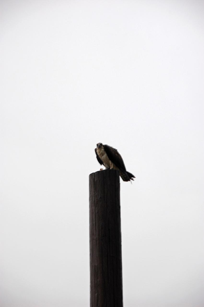
CAPE CANAVERAL, Fla. – An osprey takes advantage of a break in rain and perches on a pole near the Press Site at NASA's Kennedy Space Center in Florida. Severe storms associated with a frontal system are moving through Central Florida, producing strong winds, heavy rain, frequent lightning and even funnel clouds. Photo credit: NASA/Ben Smegelsky

KENNEDY SPACE CENTER, FLA. - Dark, rain-filled clouds blanket the sky over the Vehicle Assembly Building and Launch Control Center, bringing thunder and heavy rain to the area. This type of weather convinced flight control managers to wave off the two scheduled landing attempts at KSC for Endeavour, returning from mission STS-111

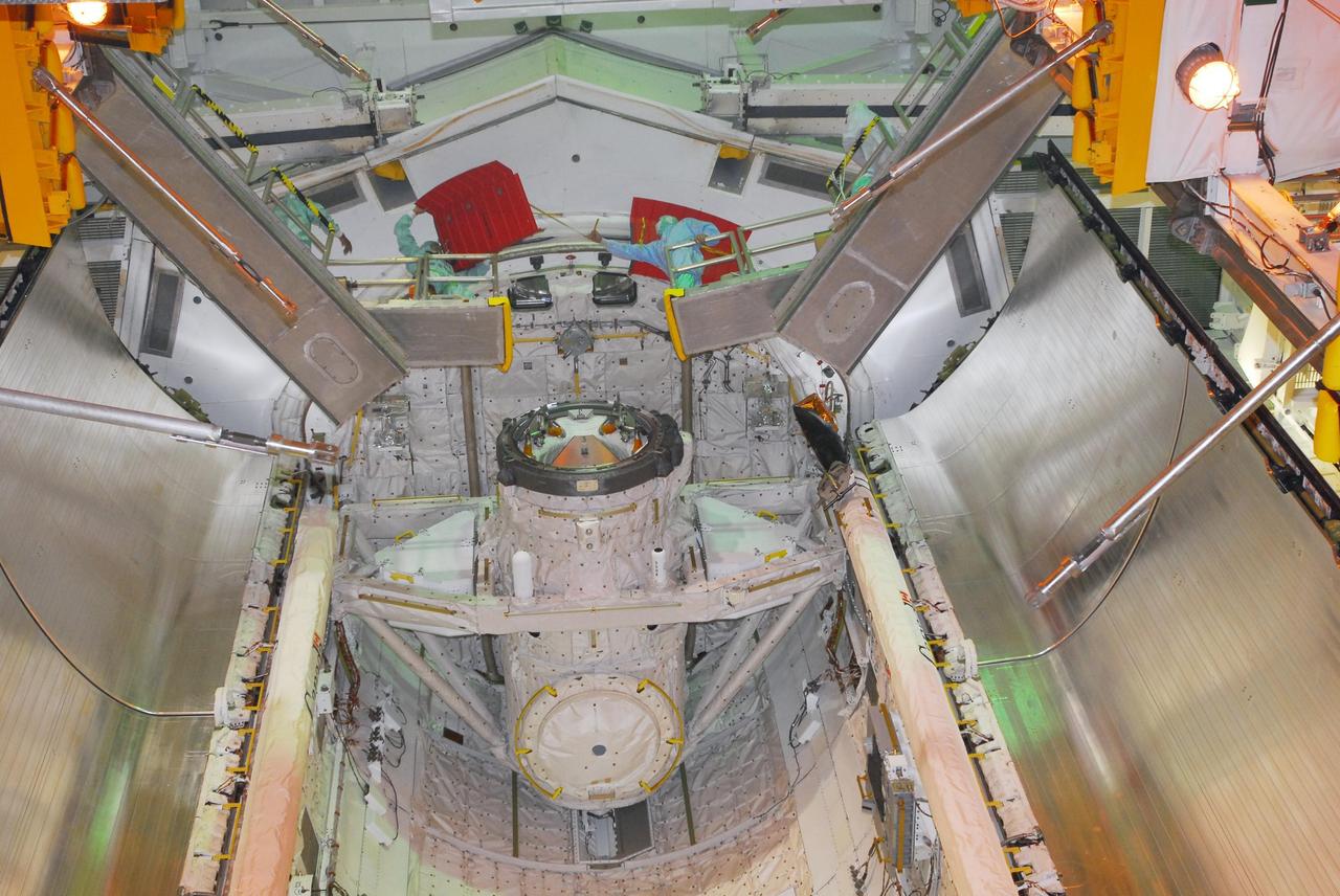
CAPE CANAVERAL, Fla. -- Inside space shuttle Discovery's payload bay can be seen the red rain gutters, which prevent leaks into the bay from rain while the shuttle is on the pad. The STS-124 mission payload, the Japanese Experiment Module - Pressurized Module and the Japanese Remote Manipulator System (below the gutters), is being transferred from the Payload Changeout Room into the payload bay. Launch of Discovery is targeted for May 31. Photo credit: NASA/Jim Grossmann
CAPE CANAVERAL, Fla. – Rain soaked Launch Pad 39A at NASA's Kennedy Space Center in Florida, where space shuttle Endeavour is poised to launch on its final mission, STS-134, to the International Space Station. Severe storms associated with a frontal system are moving through Central Florida, producing strong winds, heavy rain, frequent lightning and even funnel clouds. Photo credit: NASA/Ben Smegelsky

CAPE CANAVERAL, Fla. – Rain pounds Launch Pad 39A at NASA's Kennedy Space Center in Florida, where space shuttle Endeavour is poised to launch on its final mission, STS-134, to the International Space Station. Severe storms associated with a frontal system are moving through Central Florida, producing strong winds, heavy rain, frequent lightning and even funnel clouds. Photo credit: NASA/Ben Smegelsky
CAPE CANAVERAL, Fla. – Between rain showers over NASA's Kennedy Space Center in Florida, a rainbow breaks through the clouds behind the Vehicle Assembly Building. Rain and thunderstorms caused the waveoff of two landing opportunities Sept. 10 for space shuttle Discovery's return to Earth from the STS-128 mission. Photo credit: NASA/Jim Grossmann
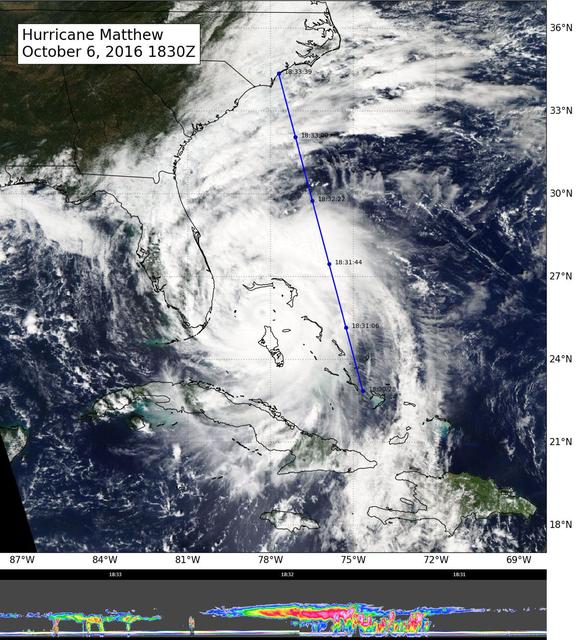
NASA's CloudSat flew east of Hurricane Matthew's center on Oct. 6 at 11:30 a.m. PDT (2:30 p.m. EDT), intersecting parts of Matthew's outer rain bands and revealing Matthew's anvil clouds (thick cirrus cloud cover), with cumulus and cumulonimbus clouds beneath (lower image). Reds/pinks are larger water/ice droplets. http://photojournal.jpl.nasa.gov/catalog/PIA21095
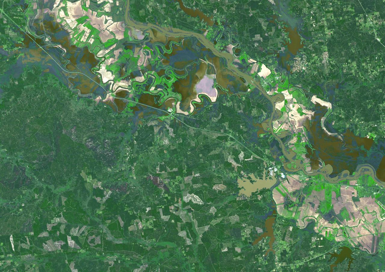
Torrential rains in the mid-South of the United States in mid-March 2016 produced flooding throughout Texas, Louisiana and Mississippi. On March 21, 2016, the Advanced Spaceborne Thermal Emission and Reflection Radiometer (ASTER) instrument on NASA's Terra spacecraft acquired this image showing persistent flooding along the Mississippi River between the Louisiana cities of Alexandria and Natchitoches. The image covers an area of 25 to 36 miles (41 by 58 kilometers), and is located at 31.5 degrees north, 92.8 degrees west. http://photojournal.jpl.nasa.gov/catalog/PIA20533

Dr Chris McKay, Ames presents Director's Colloquium entitled 'Titan: rain, storms, lakes and organic goo.' (Saturn moon) Intro by Dr Stephanie Langhoff, Ames Research Center
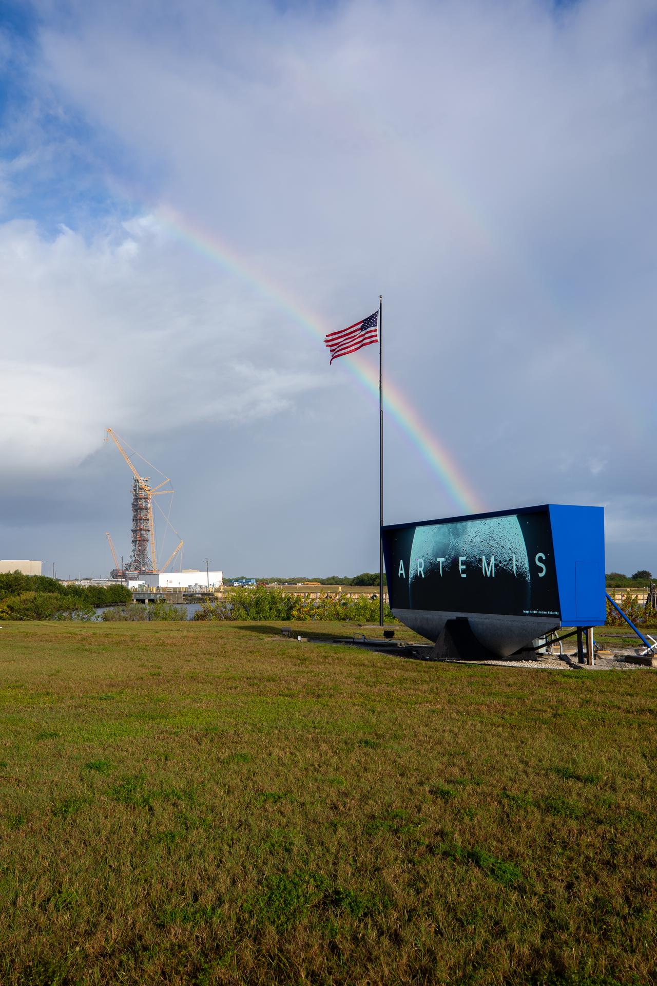
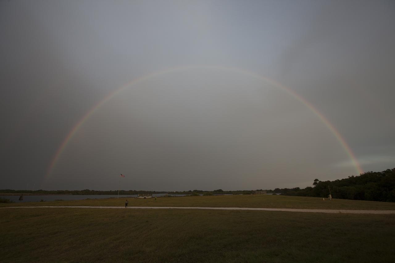
Rain showers create a rainbow near countdown clock featuring the Artemis Moon logo at the NASA News Center at the agency’s Kennedy Space Center in Florida on Thursday, Dec. 19, 2025.
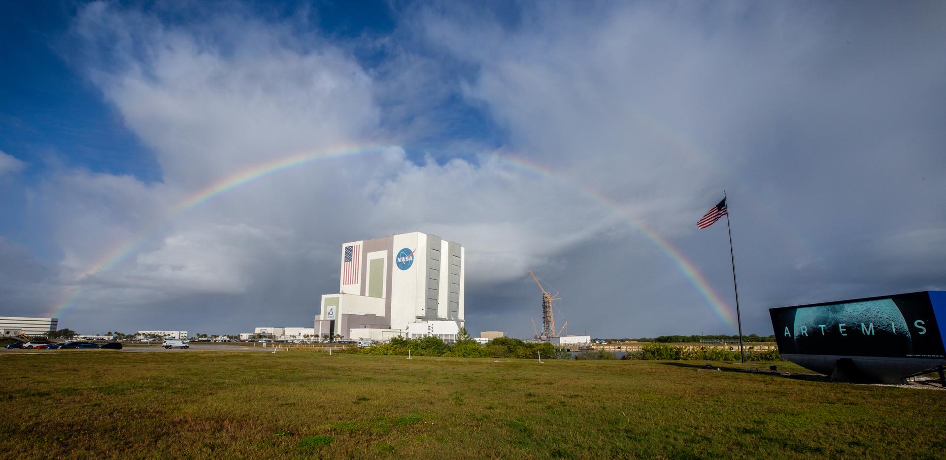
Rain showers create a rainbow over the Vehicle Assembly Building near countdown clock featuring the Artemis Moon logo at the NASA News Center at the agency’s Kennedy Space Center in Florida on Thursday, Dec. 19, 2025.

CAPE CANAVERAL, Fla. – The large windows of a building at NASA's Kennedy Space Center are covered by plywood and sandbags to protect against the wind and rain driven by Tropical Storm Fay. The storm passed over the center Aug. 20 and then stalled offshore, bringing with it heavy rain and tropical storm force wind. Kennedy closed Aug. 19 because of Fay and reopened for normal operations Aug. 22. Based on initial assessments, there was no damage to space flight hardware, such as the space shuttles and Hubble Space Telescope equipment. Some facilities did sustain minor damage. Photo credit: NASA/Jack Pfaller
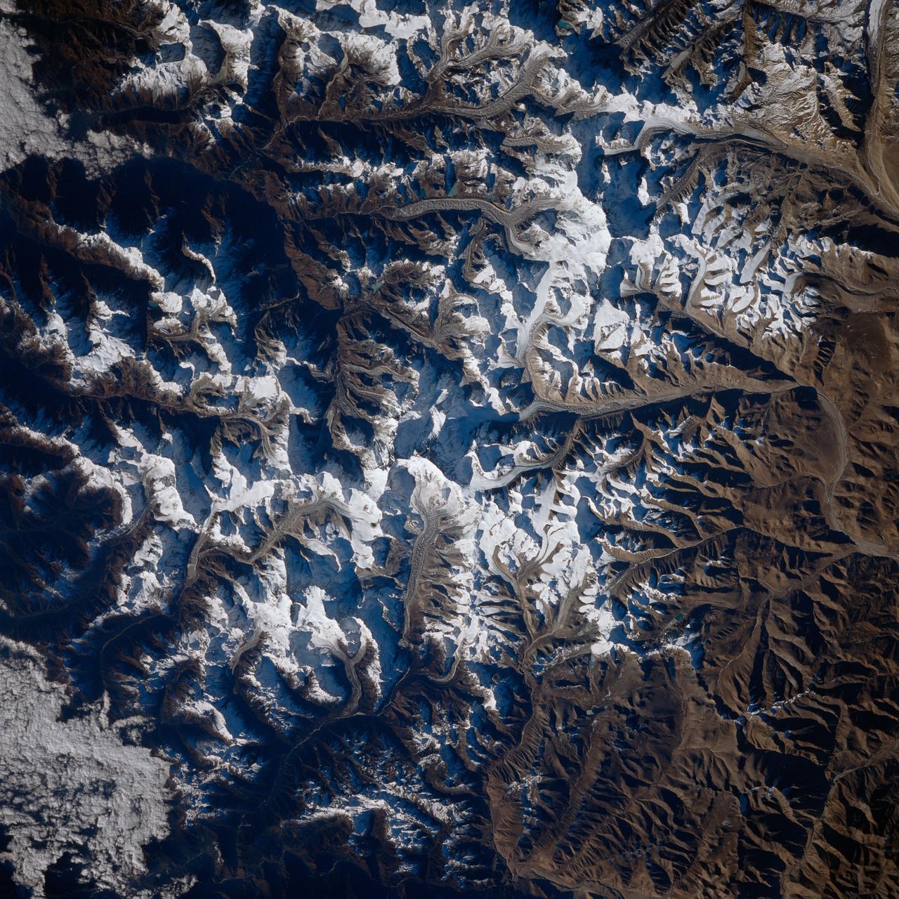
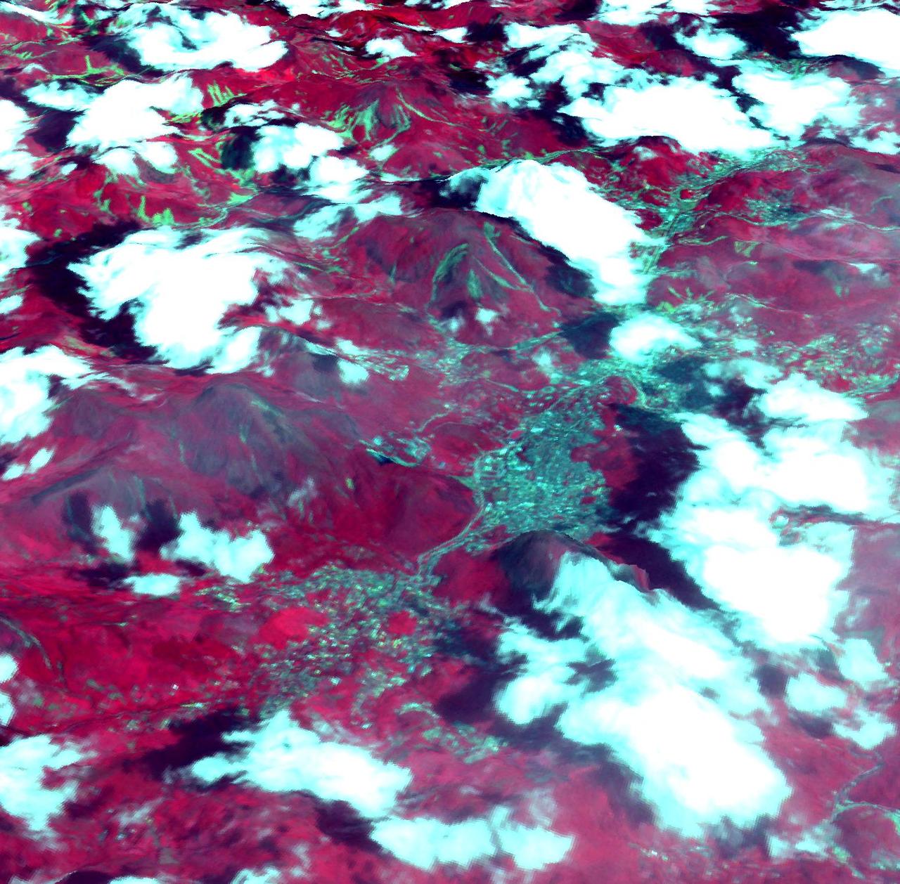
STS080-733-001 (19 Nov.-7 Dec. 1996) --- This view shows Mount Everest, near the border of Nepal and China, which reaches 29,028 feet in elevation (8,848 meters). Mount Everest is to the left of the V-shaped valley (holding picture with numbers on the right). Tibet is to the right, and Nepal is below. Rongbuk Glacier flows to the north while Khumbu Glacier flows to the south from Mount Everest. Many other glaciers are visible. The snow level is about 4,000 meters south of the divide or rain shadow, and about 6,000 meters north of the divide, in the rain shadow.