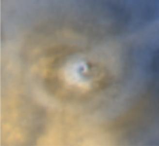
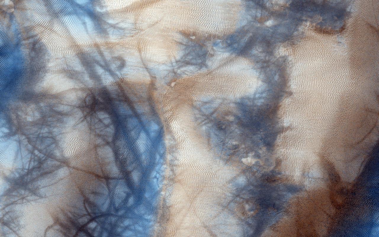
Repeated Clouds over Arsia Mons
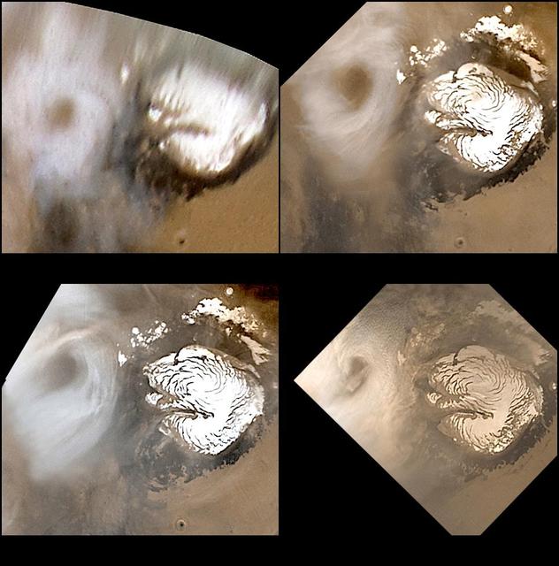
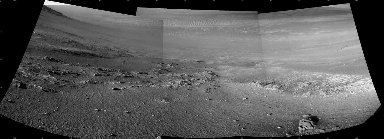
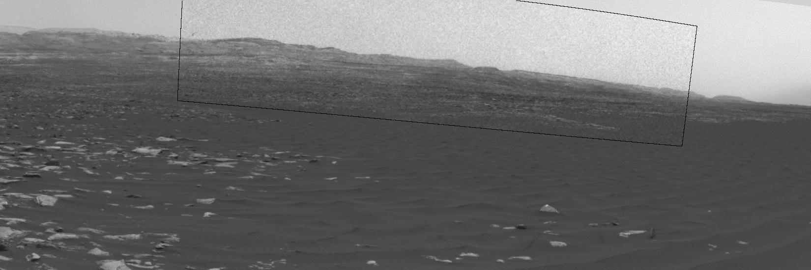
Celebrating 8 Years at Mars: Repeated Weather Events
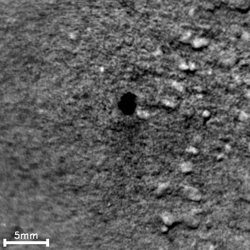
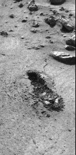
This image from an animation shows how repeated laser shots from the ChemCam instrument on NASA Mars rover Curiosity cause a pit to form at the target point in Martian soil.
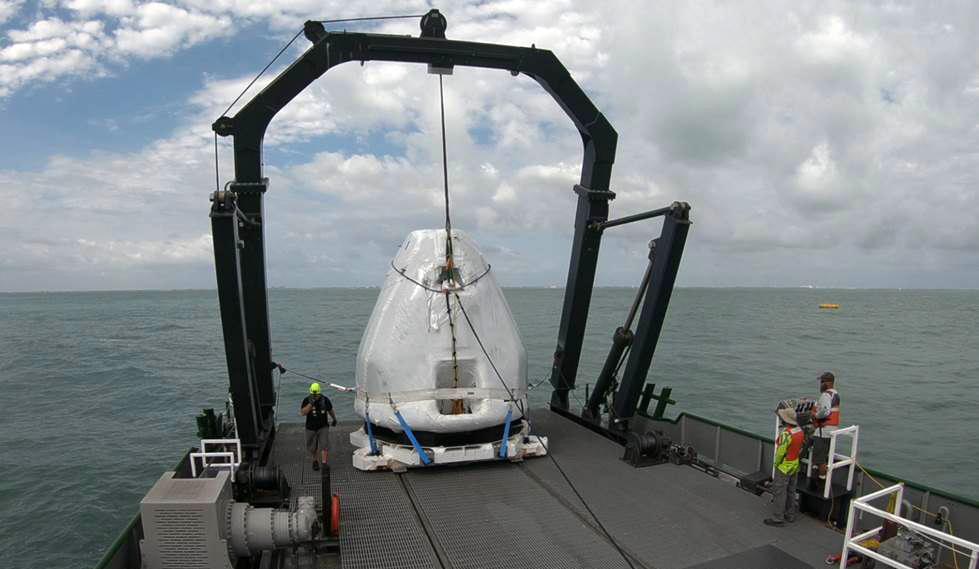
On February 28, SpaceX completed a demonstration of their ability to recover the crew and capsule after a nominal water splashdown. This marks an important recovery milestone and joint test. The timeline requirement from splashdown to crew egress onboard the ship is one hour, and the recovery team demonstrated that they can accomplish this operation under worst-case conditions in under 45 minutes. Further improvements are planned to shorten the recovery time even more as the team works to build a process that is safe, repeatable, and efficient.
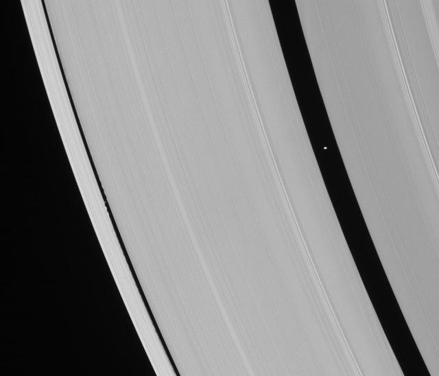
Saturn ring-embedded moons, Pan and Daphnis, are captured in an alignment they repeat with the regularity of a precise cosmic clock

Repeated flybys of Io by NASA Galileo spacecraft have allowed scientists to develop an understanding of Io Tohil-Culann region of interconnected volcanoes and mountains.
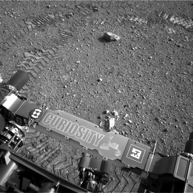
This image shows a close-up of track marks from the first test drive of NASA Curiosity rover. The rover arm is visible in the foreground. A close inspection of the tracks reveals a unique, repeating pattern: Morse code for JPL.
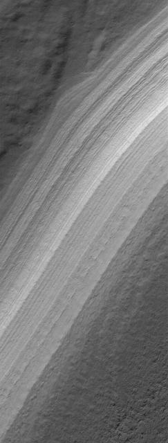
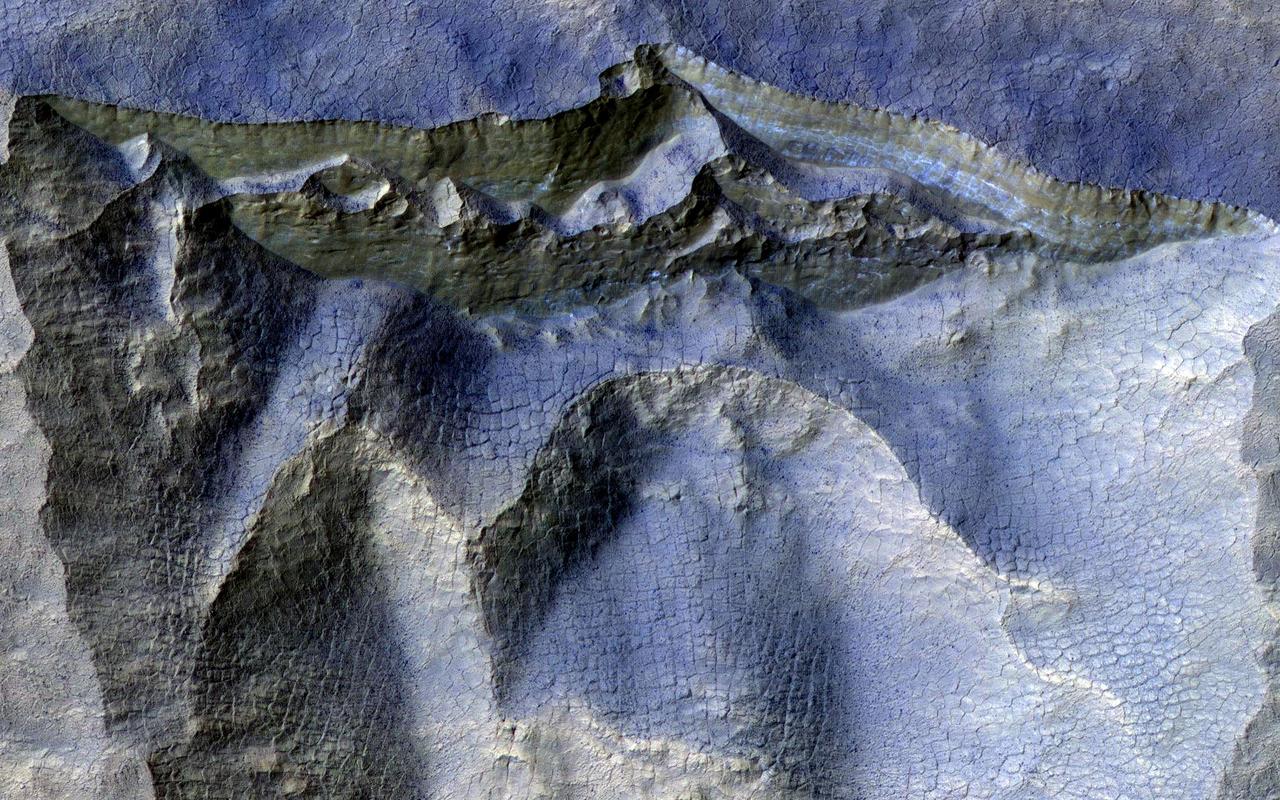
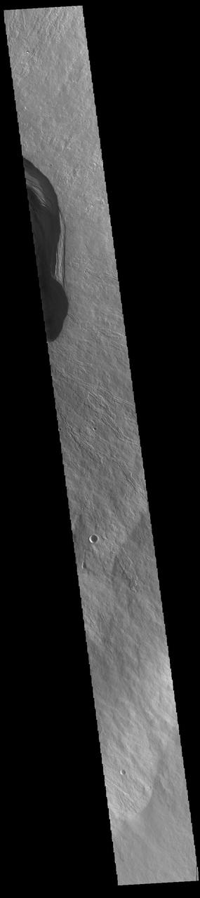
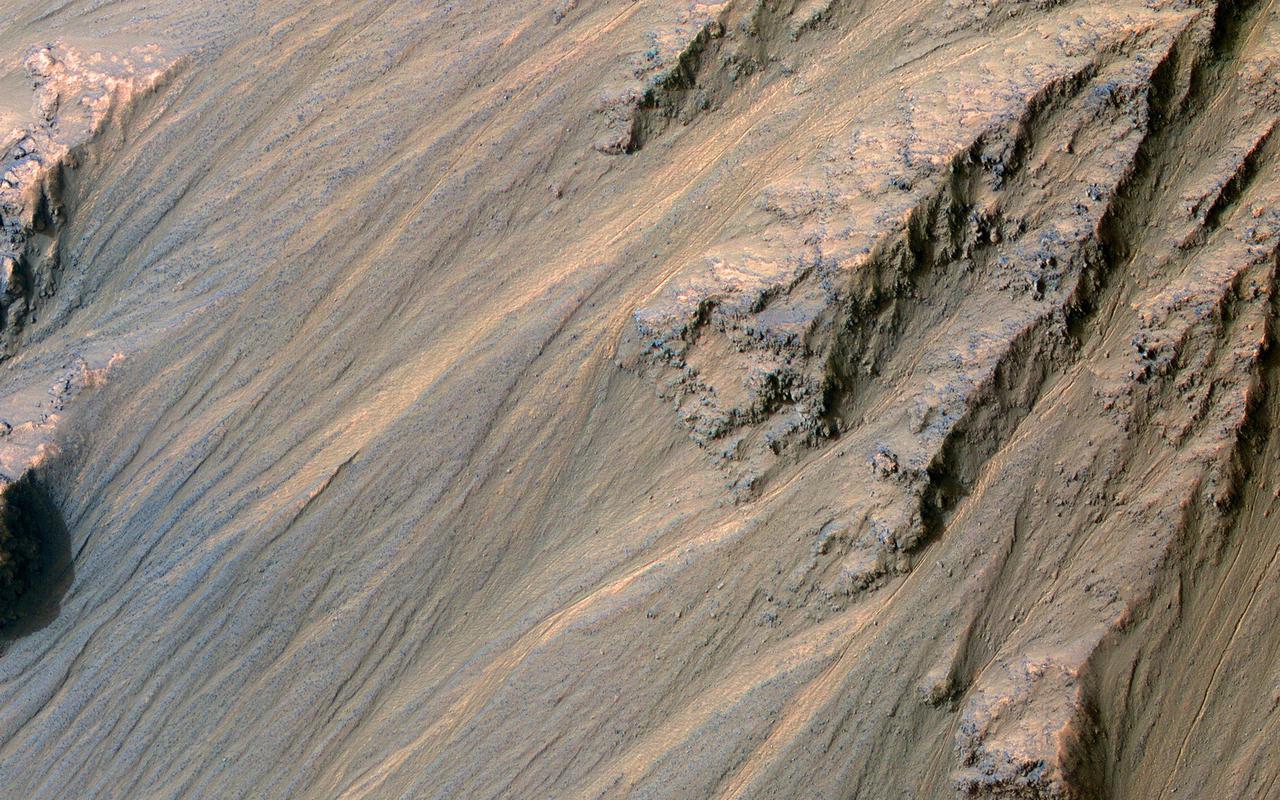
This MOC image shows repeated layers of material, possibly a combination of dust and ice, or perhaps ancient sedimentary rock, exposed by erosion on a slope in the south polar region of Mars

A repeat of last year mild La Niña conditions -- with a stormy winter in the Pacific Northwest and a dry winter in the southwestern United States -- will be the likely outcome of sea-surface heights observed by NASA TOPEX/Poseidon satellite.
This observation, taken in June 2014, covers a small 1-kilometer sized simple crater located in the Southern hemisphere in late Martian winter as Mars is heading into spring.
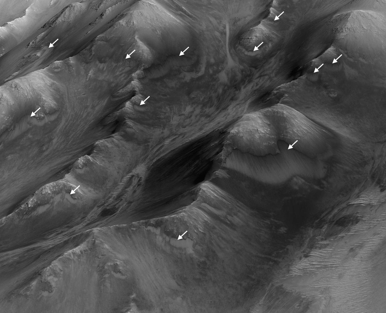
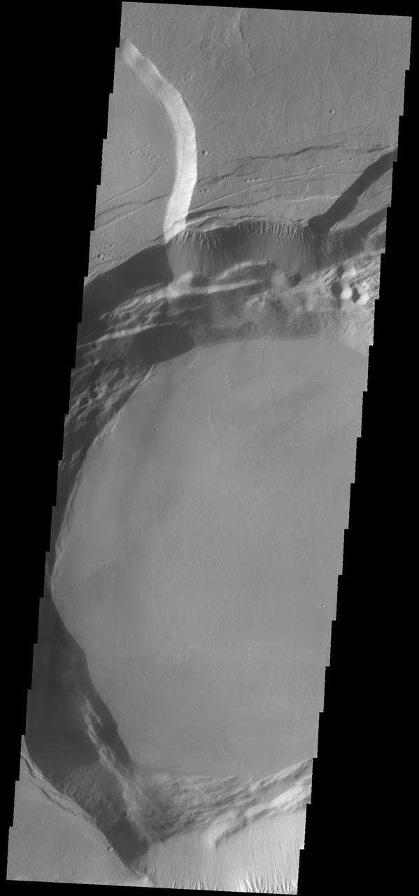
The white arrows indicate locations in this scene where numerous seasonal dark streaks have been identified in the Coprates Montes area of Mars' Valles Marineris by repeated observations from orbit. The streaks, called recurring slope lineae or RSL, extend downslope during a warm season, fade in the colder part of the year, and repeat the process the next Martian year. They are regarded as the strongest evidence for the possibility of liquid water on the surface of modern Mars. This oblique perspective for this view uses a three-dimensional terrain model derived from a stereo pair of observations by the High Resolution Imaging Science Experiment (HiRISE) camera on NASA's Mars Reconnaissance Orbiter. The scene covers an area approximately 1.6 miles (2.5 kilometers) wide. http://photojournal.jpl.nasa.gov/catalog/PIA20757
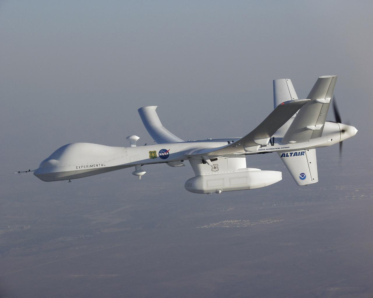
A high-tech infrared imaging sensor in its underbelly pod, the Altair UAS flew repeated passes over the Esperanza fire to aid firefighting efforts.
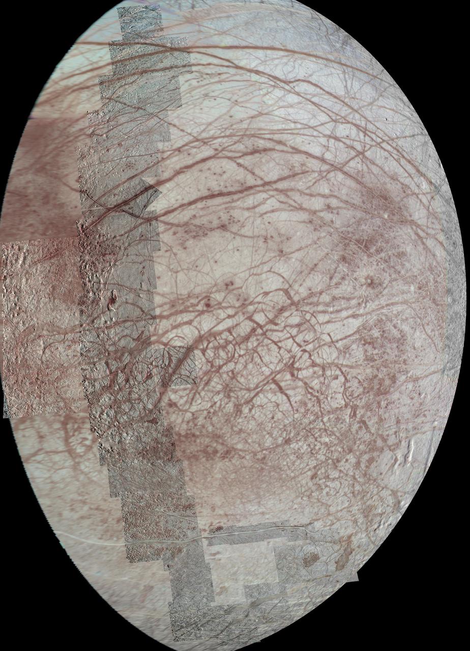
This view of Jupiter moon Europa features several regional-resolution mosaics overlaid on a lower resolution global view for context. The regional views were obtained during several different flybys of the moon by NASA Galileo mission.

jsc2023e054808 (7/2/2023) --- The Astro Bit payload is a BBC micro:bit microcontroller v2.21 enclosed in an aerospace grade aluminum case for use on board the International Space Station. Astro Bit students in Denmark and the other Scandinavian countries design an experiment that can also be repeated aboard the International Space Station with an interesting scientific outcome.

jsc2023e054806 (7/2/2023) --- The Astro Bit payload is a BBC micro:bit microcontroller v2.21 enclosed in an aerospace grade aluminum case for use on board the International Space Station. Astro Bit students in Denmark and the other Scandinavian countries design an experiment that can also be repeated aboard the International Space Station with an interesting scientific outcome.
The small crater observed at the middle-right edge of this NASA Mars Odyssey image is very different from other similar looking impact craters located southeast of the Pavonis Mons volcano. This crater appears to be a volcanic crater at the summit of a small composite cone that shows evidence of repeated volcanic flows. http://photojournal.jpl.nasa.gov/catalog/PIA04004
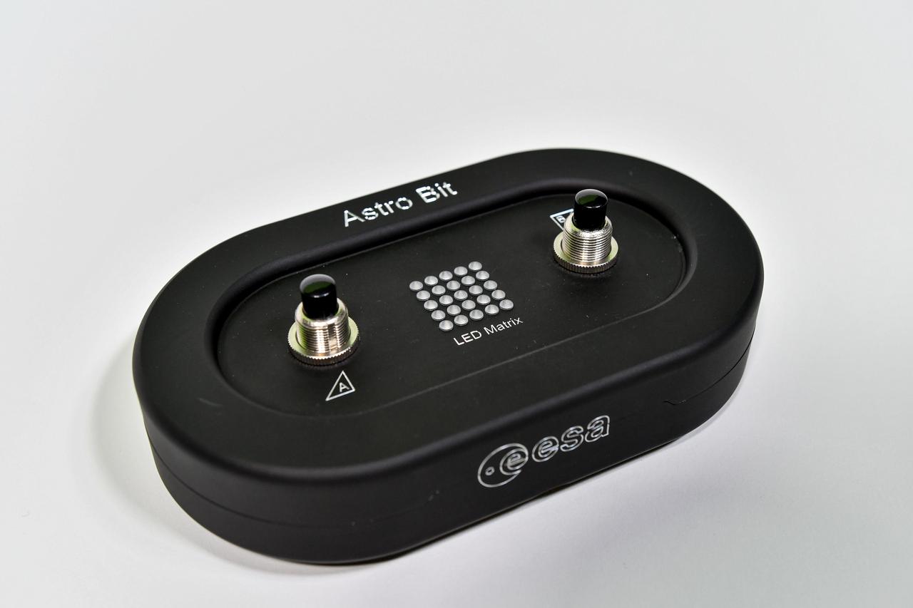
jsc2023e054795 (7/2/2023) --- The Astro Bit payload is a BBC micro:bit microcontroller v2.21 enclosed in an aerospace grade aluminum case for use on board the International Space Station. Astro Bit students in Denmark and the other Scandinavian countries design an experiment that can also be repeated aboard the International Space Station with an interesting scientific outcome.
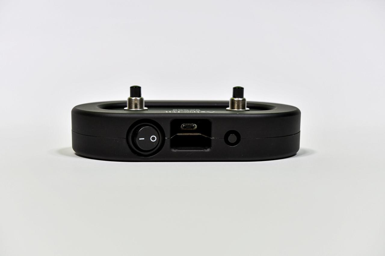
jsc2023e054780 (7/2/2023) --- The Astro Bit payload is a BBC micro:bit microcontroller v2.21 enclosed in an aerospace grade aluminum case for use on board the International Space Station. Astro Bit students in Denmark and the other Scandinavian countries design an experiment that can also be repeated aboard the International Space Station with an interesting scientific outcome.
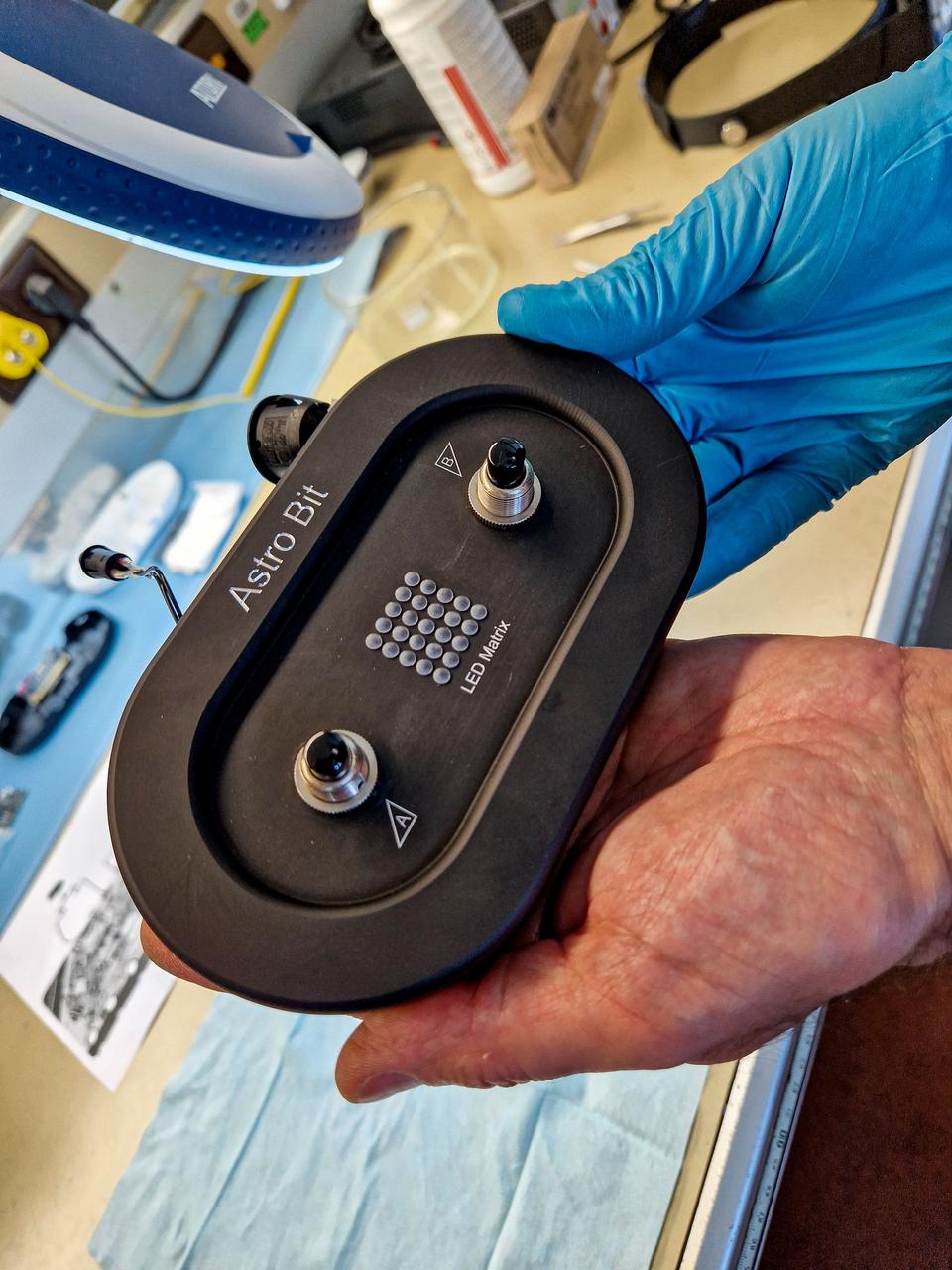
jsc2023e054757 (7/2/2023) --- The Astro Bit payload is a BBC micro:bit microcontroller v2.21 enclosed in an aerospace grade aluminum case for use on board the International Space Station. Astro Bit students in Denmark and the other Scandinavian countries design an experiment that can also be repeated aboard the International Space Station with an interesting scientific outcome.
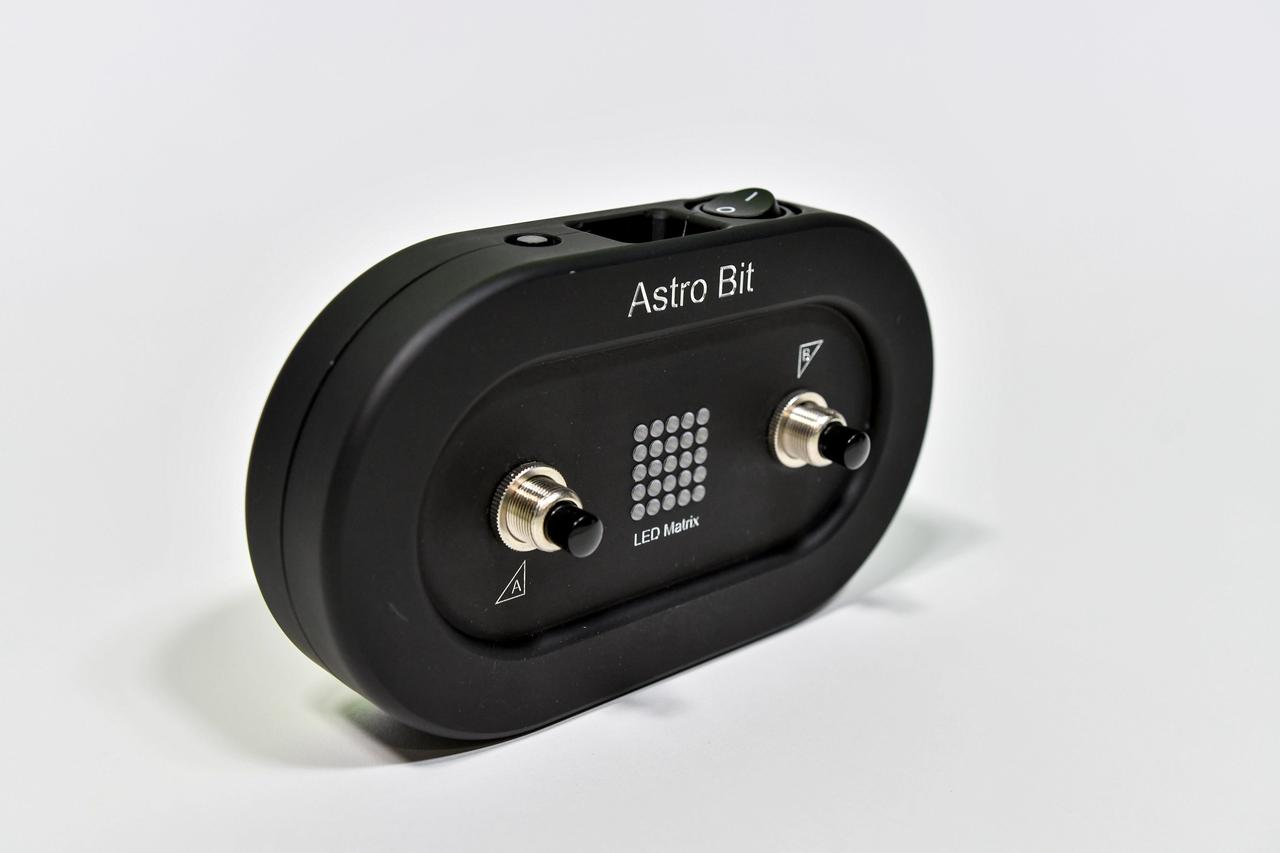
jsc2023e054792 (7/2/2023) --- The Astro Bit payload is a BBC micro:bit microcontroller v2.21 enclosed in an aerospace grade aluminum case for use on board the International Space Station. Astro Bit students in Denmark and the other Scandinavian countries design an experiment that can also be repeated aboard the International Space Station with an interesting scientific outcome.
![Recurring Slope Lineae (called "RSL") are seasonally-repeating dark flows that are active at the warmest times of the year. Some of these grow from the top of the steep slope downwards as expected for liquid or granular flows. Others show different darkening patterns, which suggests different processes. Although HiRISE has acquired many images to monitor RSL sites, it still is not certain how these features form. The map is projected here at a scale of 25 centimeters (9.8 inches) per pixel. [The original image scale is 25.8 centimeters (10.2 inches) per pixel (with 2 x 2 binning); objects on the order of 51.7 centimeters (20.4 inches) across are resolved.] North is up. http://photojournal.jpl.nasa.gov/catalog/PIA21558](https://images-assets.nasa.gov/image/PIA21558/PIA21558~medium.jpg)
Recurring Slope Lineae (called "RSL") are seasonally-repeating dark flows that are active at the warmest times of the year. Some of these grow from the top of the steep slope downwards as expected for liquid or granular flows. Others show different darkening patterns, which suggests different processes. Although HiRISE has acquired many images to monitor RSL sites, it still is not certain how these features form. The map is projected here at a scale of 25 centimeters (9.8 inches) per pixel. [The original image scale is 25.8 centimeters (10.2 inches) per pixel (with 2 x 2 binning); objects on the order of 51.7 centimeters (20.4 inches) across are resolved.] North is up. http://photojournal.jpl.nasa.gov/catalog/PIA21558
Gully and defrosting activity have been visible here along the edge of a dune field, along with blocks of frost. Observations from NASA Mars Reconnaissance Orbiter of the same area help check for repeat activity, as well as measuring those meter-scale blocks that we've seen prior. In this case, we want to compare any possible changes with a previous observation, which we acquired in 2011. We've also seen images where carbon dioxide frost was the driving process in creating new gullies, so we know their formation is occurring to this day. Tracking for changes, especially when we look at the 1-kilometer enhanced color swath, can help us find more. http://photojournal.jpl.nasa.gov/catalog/PIA19843
KENNEDY SPACE CENTER, FLA. - Apollo 7 Command Module Pilot Donn F. Eisele enters the spacecraft at Pad 34 while fellow crew members, Commander Walter M. Schirra Jr., left, and Lunar Module Pilot Walter Cunningham hold a brief discussion before they repeat that portion of the Plugs-Out test at the pad. The tests are being conducted in preparation for the scheduled launch of Apollo 7, the first manned lunar orbital mission.

STS98-E-5075 (10 February 2001) --- Pictured on the mid deck the Space Shuttle Atlantis, astronaut Robert L. Curbeam, STS-98 mission specialist, will be repeating this scene of suit donning (and doffing) a number of times as he will be participating in three separate space walks during the ISS 5a flight. The scene was recorded with a digital still camera during Flight Day 4 activity.
S116-E-05789 (13 Dec. 2006) --- This digital still image was taken by a crew member aboard the Space Shuttle Discovery of a kink that occurred in the port-side P6 solar array during the first attempt to retract that array on Dec. 13. The crew later extended the array and cleared this kink. The slow retraction of the array was then begun again with similar retraction and extension cycles repeated as the day progressed.
iss069e030677 (July 10, 2023) --- NASA astronaut and Expedition 69 Flight Engineer Stephen Bowen works on the Plant Habitat-03B Science Carrier, a space botany research device, in the International Space Station's Harmony module. The Plant Habitat-03 investigation explores how space-caused DNA changes are transferred from one generation of plants to the next and then continue to accumulate or stabilize. This could provide insight into how to grow repeated generations of crops to provide food and other services on future space missions.

KENNEDY SPACE CENTER, FLA. -- ASTP crewman Thomas Stafford is suited up for the Countdown Demonstration Test. The test, a step-by-step dress rehearsal for the July 15 luanch, will culminate in a simulated T-zero and launch. Yesterday the 'wet' portion of the test was conducted with the vehicle fueled as it will be on launch day. The fuels were offloaded and the terminal portion of the count repeated with the prime crew aboard the spacecraft.
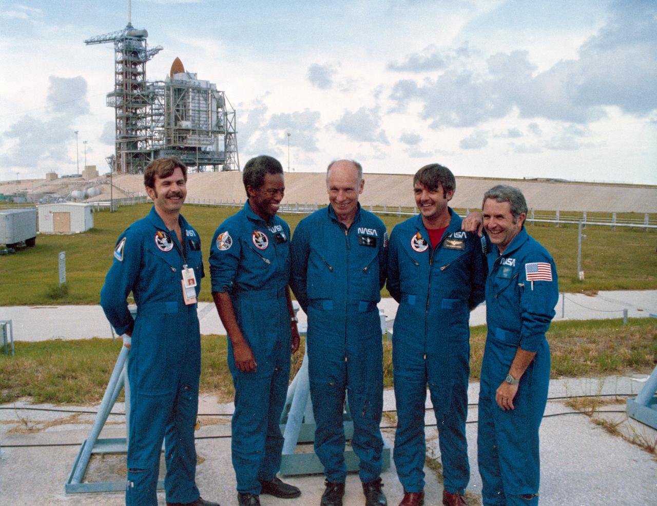
S83-38389 (6 Aug. 1983) --- The STS-8 crew members pause for a crew photo at Pad 39A after a question and answer session with the press. They were about to participate in the STS-8 countdown demonstration test. They will repeat many of their measures on Aug. 30 when they are scheduled to lift off aboard the space shuttle Challenger. From left to right are astronauts Dale A. Gardner, Guion S. Bluford, Dr. William E. Thornton, all mission specialists; Daniel C. Brandenstein, pilot; and Richard F. Truly, commander. The Challenger is in the background at complex 39.
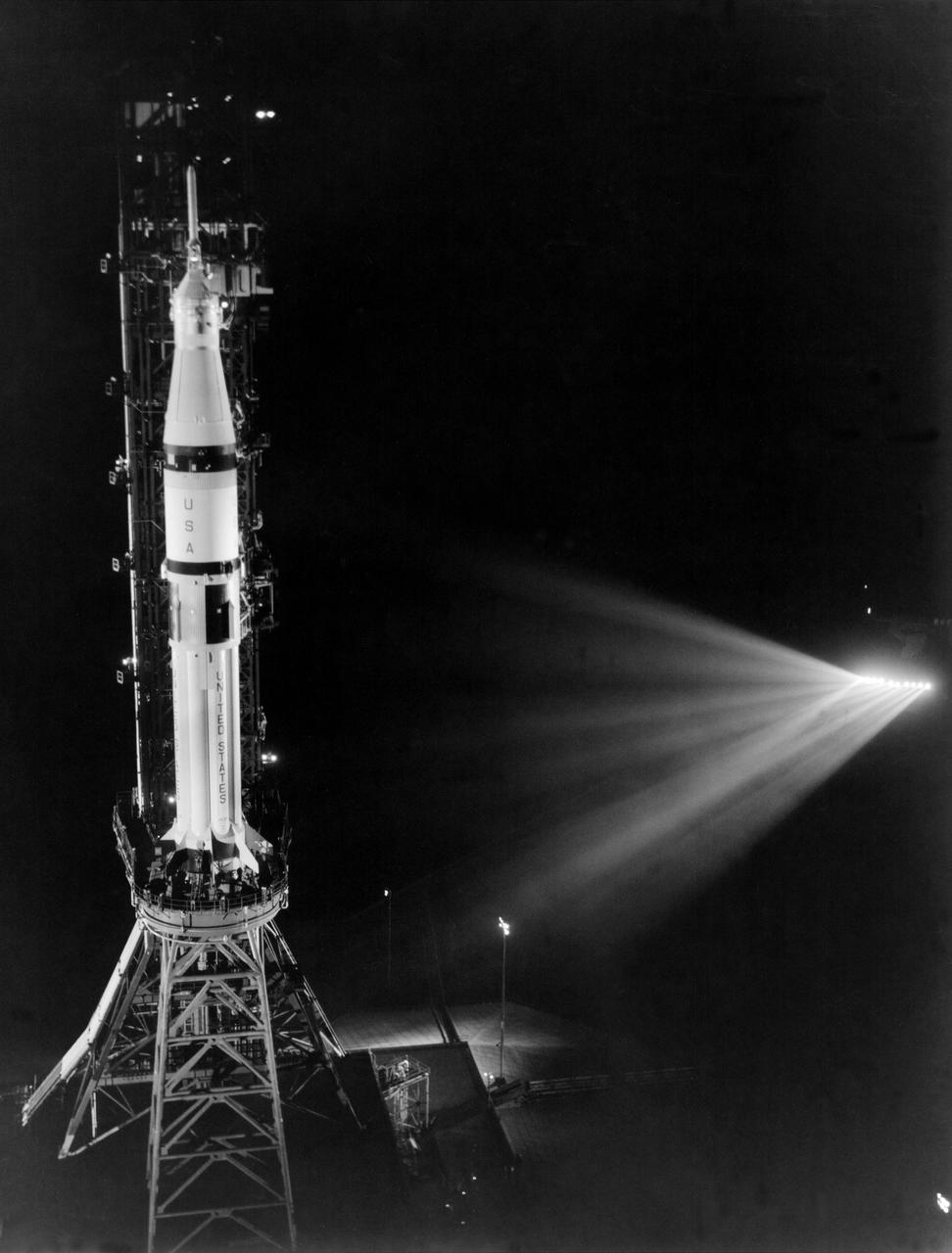
KENNEDY SPACE CENTER, FLA. -- As seen from the Mobile Service Structure as it is being rolled back to its park site, the ASTP Saturn IB launch vehicle sits on its pedestal during the Countdown Demonstration Test. The test is a step-by-step dress rehearsal for the July 15 mission, which culminates with a simulated T-zero and launch with the stages of the rocket fueled as they will be on launch day. Following the simulated launch, the propellants will be offloaded. The terminal portion of the test will be repeated tomorrow with the ASTP astronauts Thomas Stafford, Vance Brand and Donald Slayton aboard the spacecraft.
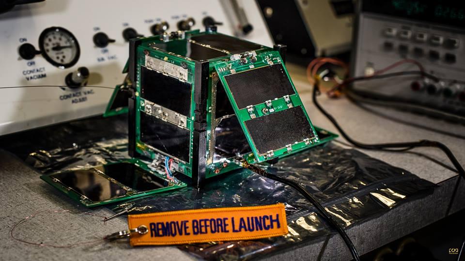
CAPE-2: Cajun Advanced Picosatellite Experiment – ELaNa IV CAPE-2 was developed by students from the University of Louisiana Lafayette to engage, inspire and educate K-12 students to encourage them to pursue STEM careers. The secondary focus is the technology demonstration of deployed solar panels to support the following payloads: text to speech, voice repeater, tweeting, email, file transfer and data collection from buoys. Launched by NASA’s CubeSat Launch Initiative on the ELaNa IV mission as an auxiliary payload aboard the U.S. Air Force-led Operationally Responsive Space (ORS-3) Mission on November 19, 2013.
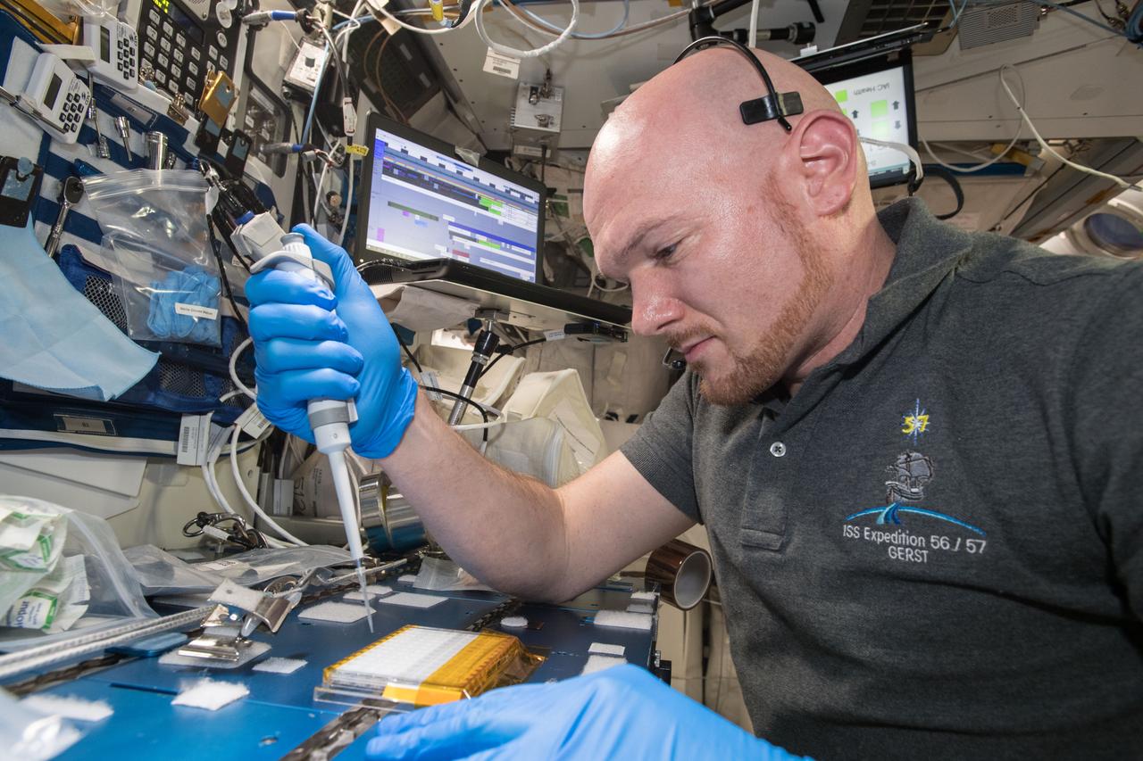
iss057e106231 (Nov. 26, 2018) --- European Space Agency (ESA) asrtonaut Alexander Gerst uses a uses a pipette to transfer a protein solution into the Protein Crystal Growth Card for an experiment observing protein crystals associated with Parkinson’s disease to potentially improve treatments on Earth. Crystallization of LRRK2 Under Microgravity Conditions-2 (CASIS PCG 16) evaluates growth of Leucine-rich repeat kinase 2 (LRRK2) protein crystals in microgravity. LRRK2 is implicated in Parkinson’s disease, but crystals of the protein grown on Earth are too small and compact to study. Detailed analysis of larger, space-grown crystals can define the protein’s exact shape and morphology and help scientists better understand the disease’s pathology.
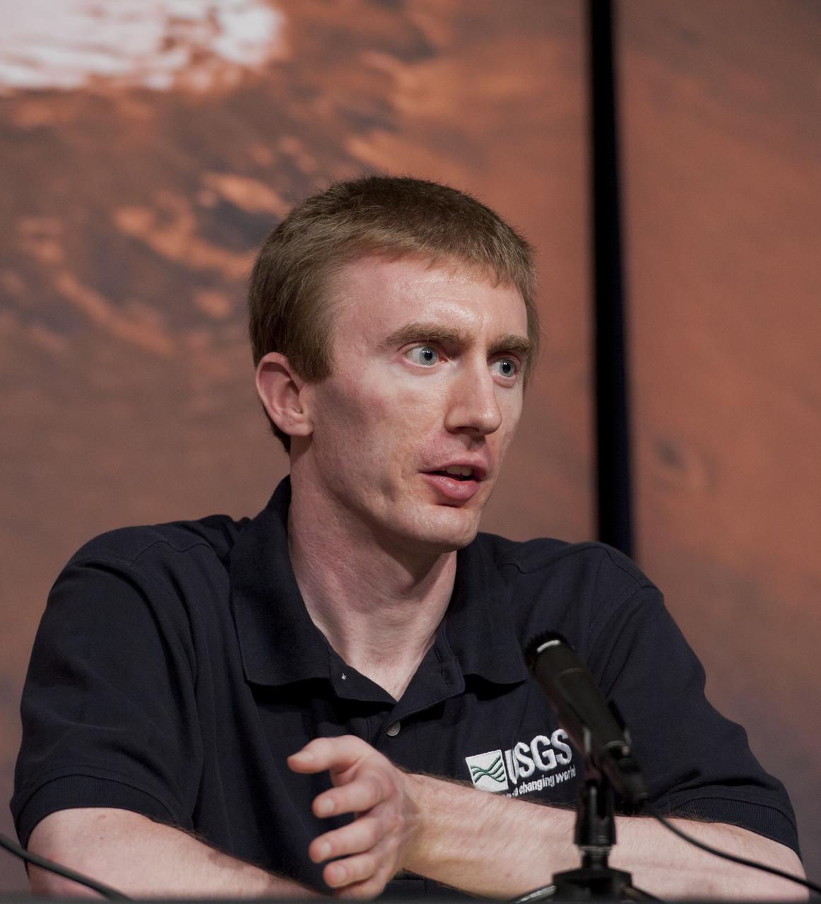
Colin Dundas, a research geologist with the U.S. Geological Survey, speaks during a briefing, Thursday, Aug. 4, 2011, at NASA Headquarters in Washington. Observations from NASA's Mars Reconnaissance Orbiter (MRO) have revealed possible flowing water during the warmest months on Mars. Dark, finger-like features appear and extend down some Martian slopes during late spring through summer, fade in winter, and return during the next spring. Repeated observations have tracked the seasonal changes in these recurring features on several steep slopes in the middle latitudes of Mars' southern hemisphere. Photo Credit: (NASA/Paul E. Alers)
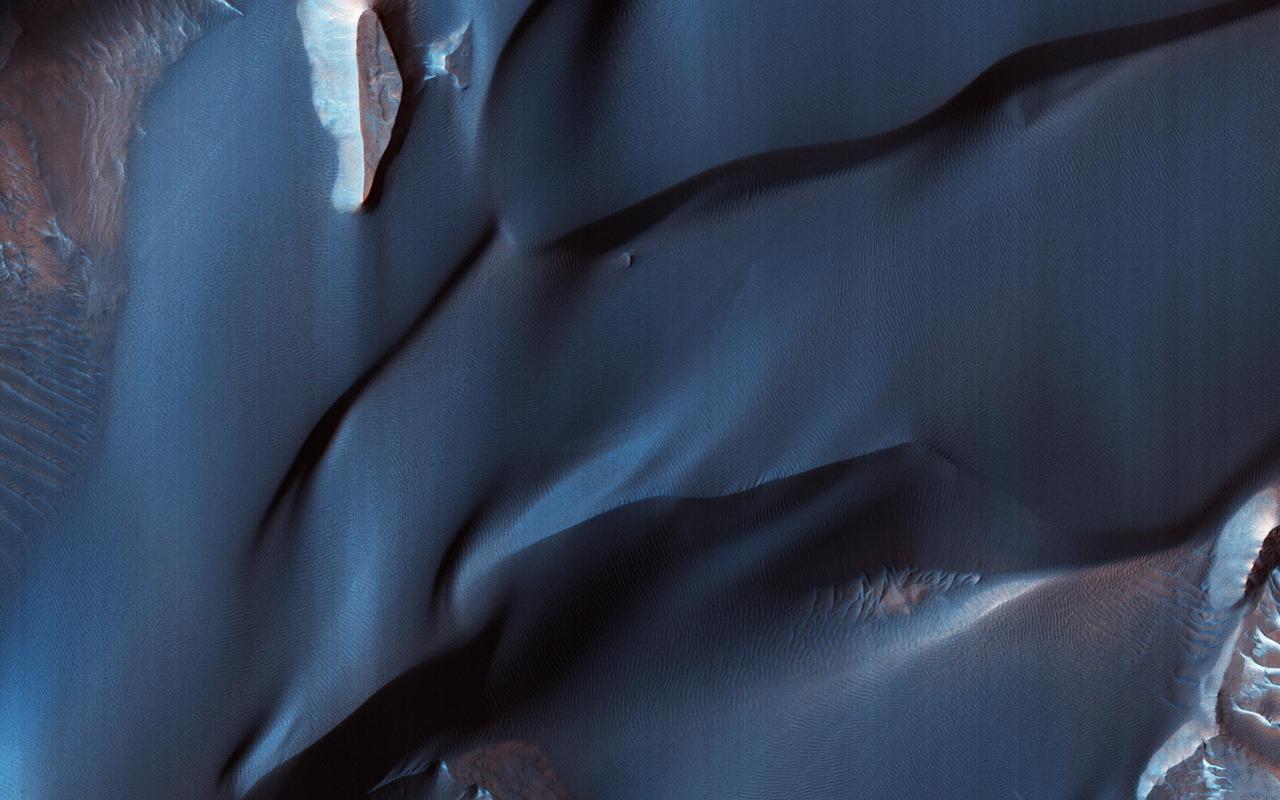
This color-infrared image shows sand dunes in Melas Chasma, located within the Valles Marineris canyon system. The dark-blue and purple colors indicate coarse-grained sands that are comprised of basalt, an iron and magnesium-rich volcanic rock that formed from cooled lava millions of years ago when volcanism was an active process on Mars. Migrating sand dunes often lead to the erosion and excavation of underlying material; regions where there are active dune fields are ideal places to search for exposed bedrock. Repeated imaging of dunes may also show changes that provide evidence for active surface processes related to wind patterns and climate. More information is available at https://photojournal.jpl.nasa.gov/catalog/PIA22783

HiRISE has been operating since 2006, and lately many of our observations of gullies are repeat images designed to study changes. However, we are also collecting data over gullies never before seen at this resolution, to study their morphology and allow us to look for changes in the future. This is the first HiRISE look at a cluster of gullies that appear modified or degraded—the gully fans have ripples and ridges that have formed since the last major gully activity, suggesting that they don't change very often, but we won't know for sure unless we look! https://photojournal.jpl.nasa.gov/catalog/PIA23666

iss058e002064 (1/6/2019) --- CASIS PCG 16 floating in front of Window 7 in the Cupola module. Earth is in the background. Crystallization of LRRK2 Under Microgravity Conditions-2 (CASIS PCG 16) evaluates growth of Leucine-rich repeat kinase 2 (LRRK2) protein crystals in microgravity. LRRK2 is implicated in Parkinson’s disease, but crystals of the protein grown on Earth are too small and compact to study. Detailed analysis of larger, space-grown crystals can define the protein’s exact shape and morphology and help scientists better understand the disease’s pathology.

Philip Christensen, a geophysicist at Arizona State University, speaks during a briefing, Thursday, Aug. 4, 2011, at NASA Headquarters in Washington. Observations from NASA's Mars Reconnaissance Orbiter (MRO) have revealed possible flowing water during the warmest months on Mars. Dark, finger-like features appear and extend down some Martian slopes during late spring through summer, fade in winter, and return during the next spring. Repeated observations have tracked the seasonal changes in these recurring features on several steep slopes in the middle latitudes of Mars' southern hemisphere. Photo Credit: (NASA/Paul E. Alers)
iss057e106417 (Nov. 30, 2018) --- Samples from the Protein Crystal Growth Card are examined using a microscope for an experiment observing protein crystals associated with Parkinson’s disease to potentially improve treatments on Earth. Crystallization of LRRK2 Under Microgravity Conditions-2 (CASIS PCG 16) evaluates growth of Leucine-rich repeat kinase 2 (LRRK2) protein crystals in microgravity. LRRK2 is implicated in Parkinson’s disease, but crystals of the protein grown on Earth are too small and compact to study. Detailed analysis of larger, space-grown crystals can define the protein’s exact shape and morphology and help scientists better understand the disease’s pathology.
iss057e106419 (Nov. 30, 2018) --- Samples from the Protein Crystal Growth Card are examined using a microscope for an experiment observing protein crystals associated with Parkinson’s disease to potentially improve treatments on Earth. Crystallization of LRRK2 Under Microgravity Conditions-2 (CASIS PCG 16) evaluates growth of Leucine-rich repeat kinase 2 (LRRK2) protein crystals in microgravity. LRRK2 is implicated in Parkinson’s disease, but crystals of the protein grown on Earth are too small and compact to study. Detailed analysis of larger, space-grown crystals can define the protein’s exact shape and morphology and help scientists better understand the disease’s pathology.
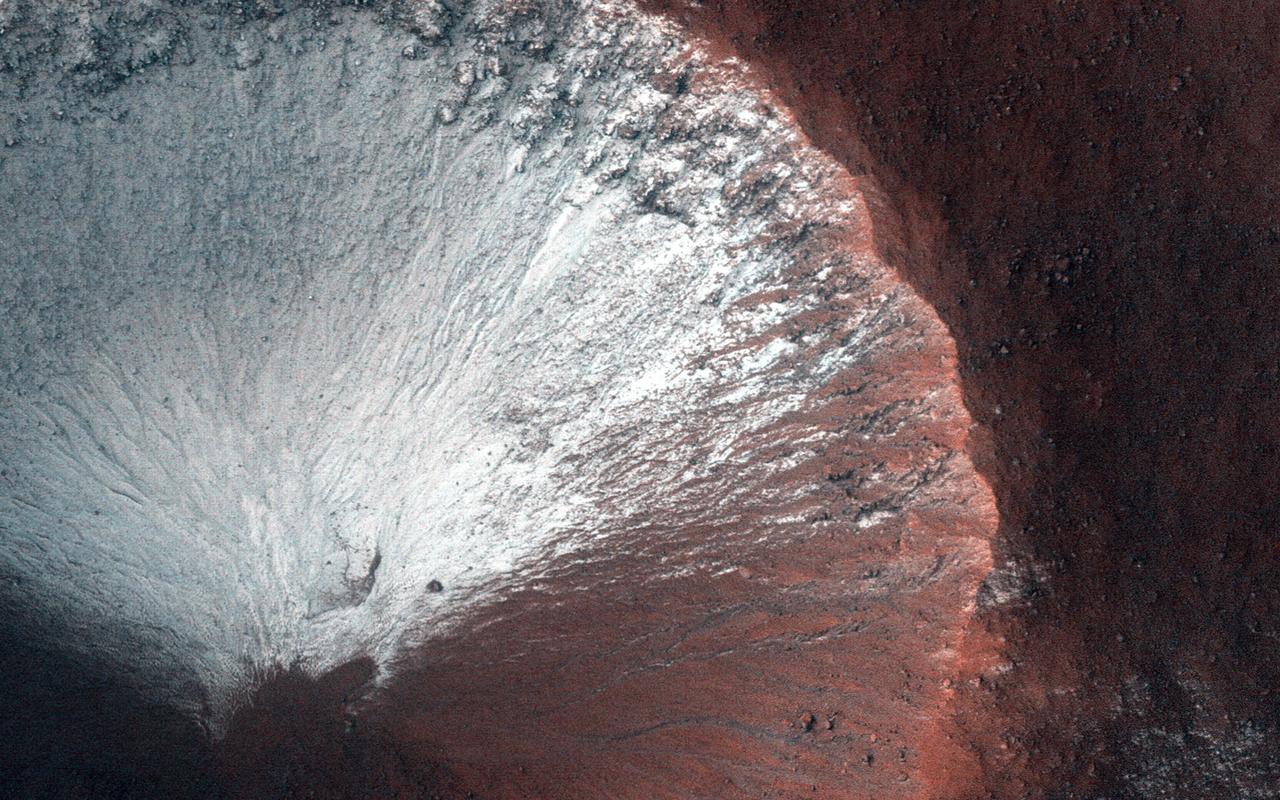
Scientists have come to realize that, just below the surface, about one third of Mars is covered in ice. We study this ice to learn about Mars' ancient climate and astronauts' future water supplies. Sometimes we see the buried ice because cliffs form like the one in this image. On the brownish, dusty cliff wall, the faint light-blue-colored ice shows through. Some of these cliffs change before our eyes and boulders of ice can tumble downhill. We take repeat images of these scenes to check for changes like this. https://photojournal.jpl.nasa.gov/catalog/PIA24147

Engineers and technicians at NASA’s Michoud Assembly Facility in New Orleans have structurally mated the first of four RS-25 engines to the core stage for NASA’s Space Launch System rocket that will help power the first Artemis mission to the Moon. Integration of the RS-25 engine to the recently completed core stage structure is a collaborative, multistep process for NASA and its partners Boeing, the core stage lead contractor, and Aerojet Rocketdyne, the RS-25 engine lead contractor. To complete the installation, the technicians will now integrate the propulsion and electrical systems. The installation process will be repeated for each of the four RS-25 engines. Offering more payload mass, volume capability and energy to speed missions through space, the SLS rocket, along with NASA’s Gateway in lunar orbit and Orion, is part of NASA’s backbone for deep space exploration and the Artemis lunar program. No other rocket is capable of carrying astronauts in Orion around the Moon in a single mission.

Engineers and technicians at NASA’s Michoud Assembly Facility in New Orleans have structurally mated the first of four RS-25 engines to the core stage for NASA’s Space Launch System rocket that will help power the first Artemis mission to the Moon. Integration of the RS-25 engine to the recently completed core stage structure is a collaborative, multistep process for NASA and its partners Boeing, the core stage lead contractor, and Aerojet Rocketdyne, the RS-25 engine lead contractor. To complete the installation, the technicians will now integrate the propulsion and electrical systems. The installation process will be repeated for each of the four RS-25 engines. Offering more payload mass, volume capability and energy to speed missions through space, the SLS rocket, along with NASA’s Gateway in lunar orbit and Orion, is part of NASA’s backbone for deep space exploration and the Artemis lunar program. No other rocket is capable of carrying astronauts in Orion around the Moon in a single mission.

Engineers and technicians at NASA’s Michoud Assembly Facility in New Orleans have structurally mated the first of four RS-25 engines to the core stage for NASA’s Space Launch System rocket that will help power the first Artemis mission to the Moon. Integration of the RS-25 engine to the recently completed core stage structure is a collaborative, multistep process for NASA and its partners Boeing, the core stage lead contractor, and Aerojet Rocketdyne, the RS-25 engine lead contractor. To complete the installation, the technicians will now integrate the propulsion and electrical systems. The installation process will be repeated for each of the four RS-25 engines. Offering more payload mass, volume capability and energy to speed missions through space, the SLS rocket, along with NASA’s Gateway in lunar orbit and Orion, is part of NASA’s backbone for deep space exploration and the Artemis lunar program. No other rocket is capable of carrying astronauts in Orion around the Moon in a single mission.
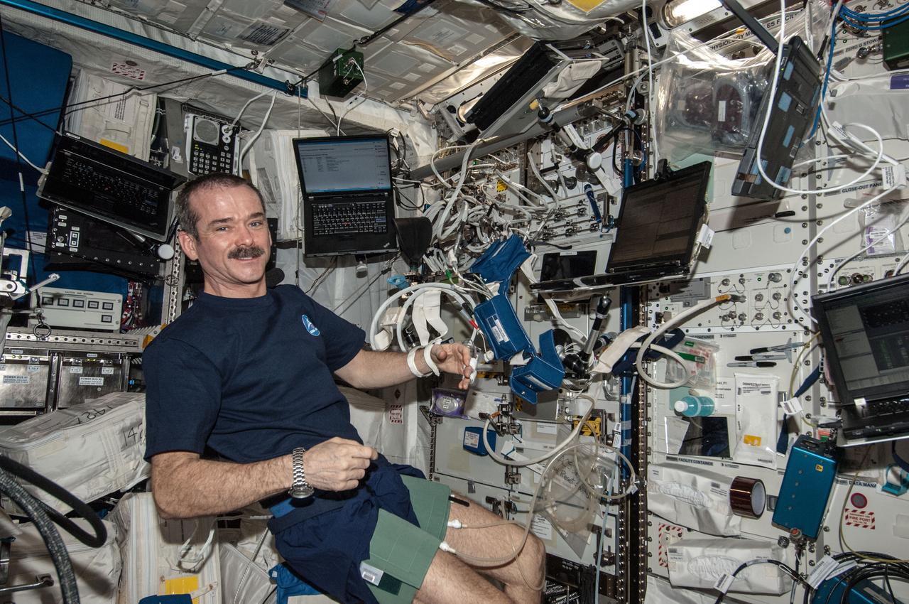
ISS035-E-022360 (17 April 2013) --- In support of the Blood Pressure Regulation Experiment (BP Reg), Expedition 35 Commander Chris Hadfield of the Canadian Space Agency is pictured after having set up the Human Research Facility (HRF) PFS (Pulmonary Function System) and the European Physiology Module (EPM) Cardiolab (CDL) Leg/Arm Cuff System (LACS) and conducting the first ever session of this experiment. The test, which will be repeated using other crew members as well, will help to identify the astronauts who could benefit from countermeasures before returning to Earth. Thus, this method has great potential for astronaut health monitoring during future long-term space flights and it also has important implications for testing of individuals on Earth, especially the elderly, who are at risk for fainting. The research will also allow demonstrating the feasibility of obtaining a set of indicators of overall cardiovascular regulation from the non-invasive measurement of continuous blood pressure.
This VIS image shows part of the complex caldera at the summit of Ascraeus Mons. Ascraeus Mons is the northernmost and tallest of the three large aligned Tharsis volcanoes. Calderas are found at the tops of volcanoes and are the source region for magma that rises from an underground lava source to erupt at the surface. Volcanoes are formed by repeated flows from the central caldera. The final eruptions can pool within the summit caldera, leaving a flat surface as they cool. Calderas are also a location of collapse, creating rings of tectonic faults that form the caldera rim. Ascraeus Mons has several caldera features at its summit. Ascraeus Mons is 18 km (11 miles) tall, for comparison Mauna Kea – the tallest volcano on Earth – is 10 km tall (6.2 miles, measured from the base below sea level). Orbit Number: 89125 Latitude: 11.0029 Longitude: 256.08 Instrument: VIS Captured: 2022-01-16 20:38 https://photojournal.jpl.nasa.gov/catalog/PIA25349
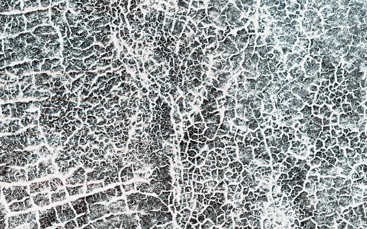
The arc of hills in this image from NASA Mars Reconnaissance Orbiter spacecraft is the rim of an old and infilled impact crater. The sediments that were deposited within the crater have since formed polygonal cracks due to repeated cycles of freezing and thawing. The process of polygon formation is common at these polar latitudes, but polygons are not always as striking as they are here. In this image, the polygons have been highlighted by persistent frost in the cracks. The crater rim constrains the polygon formation within the crater close to the rim, creating a spoke and ring pattern of cracks. This leads to more rectangular polygons than those near the center of the crater. The polygons close to the center of the crater display a more typical pattern. A closer look shows some of these central polygons, which have smaller polygons within them, and smaller polygons within those smaller polygons, which makes for a natural fractal. http://photojournal.jpl.nasa.gov/catalog/PIA20289
This VIS image shows part of the summit of Ascraeus Mons. Ascraeus Mons is the northernmost and tallest of the three large aligned Tharsis volcanoes. Calderas are found at the tops of volcanoes and are the source region for magma that rises from an underground lava source to erupt at the surface. Volcanoes are formed by repeated flows from the central caldera. The final eruptions can pool within the summit caldera, leaving a flat surface as they cool. Calderas are also a location of collapse, creating rings of tectonic faults that form the caldera rim. Ascraeus Mons has several caldera features at its summit. Ascraeus Mons is 18 km (11 miles) tall, for comparison Mauna Kea – the tallest volcano on Earth – is 10 km tall (6.2 miles, measured from the base below sea level). Orbit Number: 94653 Latitude: 10.5186 Longitude: 256.223 Instrument: VIS Captured: 2023-04-17 00:48 https://photojournal.jpl.nasa.gov/catalog/PIA26053
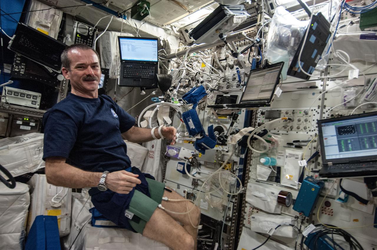
ISS035-E-022357 (17 April 2013) --- In support of the Blood Pressure Regulation Experiment (BP Reg), Expedition 35 Commander Chris Hadfield of the Canadian Space Agency is pictured after having set up the Human Research Facility (HRF) PFS (Pulmonary Function System) and the European Physiology Module (EPM) Cardiolab (CDL) Leg/Arm Cuff System (LACS) and conducting the first ever session of this experiment. The test, which will be repeated using other crew members as well, will help to identify the astronauts who could benefit from countermeasures before returning to Earth. Thus, this method has great potential for astronaut health monitoring during future long-term space flights and it also has important implications for testing of individuals on Earth, especially the elderly, who are at risk for fainting. The research will also allow demonstrating the feasibility of obtaining a set of indicators of overall cardiovascular regulation from the non-invasive measurement of continuous blood pressure.

This four-panel graphic illustrates how the binary-star system V Hydrae is launching balls of plasma into space. Panel 1 shows the two stars orbiting each other. One of the stars is nearing the end of its life and has swelled in size, becoming a red giant. In panel 2, the smaller star's orbit carries the star into the red giant's expanded atmosphere. As the star moves through the atmosphere, it gobbles up material from the red giant that settles into a disk around the star. The buildup of material reaches a tipping point and is eventually ejected as blobs of hot plasma along the star's spin axis, as shown in panel 3. This ejection process is repeated every eight years, which is the time it takes for the orbiting star to make another pass through the bloated red giant's envelope, as shown in panel 4. http://photojournal.jpl.nasa.gov/catalog/PIA21071
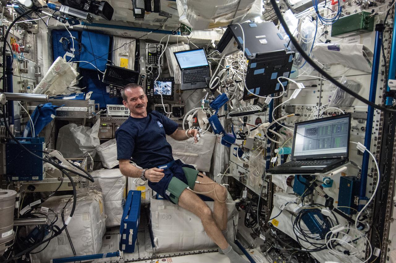
ISS035-E-022356 (17 April 2013) --- In support of the Blood Pressure Regulation Experiment (BP Reg), Expedition 35 Commander Chris Hadfield of the Canadian Space Agency is pictured after having set up the Human Research Facility (HRF) PFS (Pulmonary Function System) and the European Physiology Module (EPM) Cardiolab (CDL) Leg/Arm Cuff System (LACS) and conducting the first ever session of this experiment. The test, which will be repeated using other crew members as well, will help to identify the astronauts who could benefit from countermeasures before returning to Earth. Thus, this method has great potential for astronaut health monitoring during future long-term space flights and it also has important implications for testing of individuals on Earth, especially the elderly, who are at risk for fainting. The research will also allow demonstrating the feasibility of obtaining a set of indicators of overall cardiovascular regulation from the non-invasive measurement of continuous blood pressure.
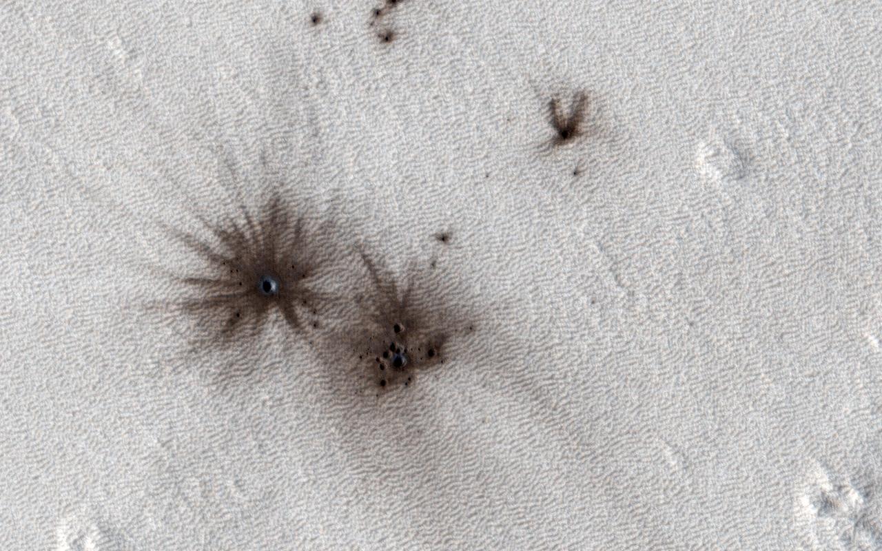
HiRISE and the Context Camera (CTX, also on board the Mars Reconnaissance Orbiter) are always on the lookout for new impact craters. New impacts can be identified by comparing images of the same region taken at different times (typically years apart) and looking for visual clues of recent impacts. CTX is more adept at identifying new impacts because of its larger and repeated surface coverage, but HiRISE allows us to study those impacts in higher resolution. In this image, we can see multiple dark spots corresponding to numerous new craters. We can also identify a slightly larger crater, and a number of smaller ones, particularly in a cluster next to it. That clustering gives us the first indication that these craters were formed in a single event. As the impactor was falling towards Mars, the friction with the atmosphere led to the body fragmenting into smaller pieces shortly before striking the surface creating this notable pattern. https://photojournal.jpl.nasa.gov/catalog/PIA26322
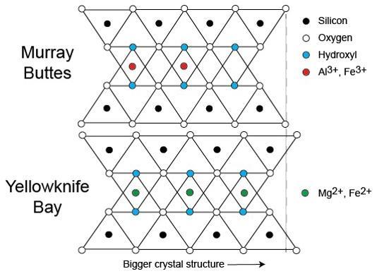
This diagram illustrates how the dimensions of clay minerals' crystal structure are affected by which ions are present in the composition of the mineral. Different clay minerals were identified this way at two sites in Mars' Gale Crater: "Murray Buttes" and "Yellowknife Bay." In otherwise identical clay minerals, a composition that includes aluminum and ferric iron ions (red dots) results in slightly smaller crystalline unit cells than one that instead includes magnesium and ferrous iron ions (green dots). Ferric iron is more highly oxidized than ferrous iron. Crystalline cell units are the basic repeating building blocks that define minerals. X-ray diffraction analysis, a capability of the Chemistry and Mineralogy (CheMin) instrument on NASA's Curiosity Mars rover, identifies minerals from their crystalline structure. http://photojournal.jpl.nasa.gov/catalog/PIA21148
This VIS image shows part of the complex caldera at the summit of Ascraeus Mons. Ascraeus Mons is the northernmost and tallest of the three large aligned Tharsis volcanoes. Calderas are found at the tops of volcanoes and are the source region for magma that rises from an underground lava source to erupt at the surface. Volcanoes are formed by repeated flows from the central caldera. The final eruptions can pool within the summit caldera, leaving a flat surface as they cool. Calderas are also a location of collapse, creating rings of tectonic faults that form the caldera rim. Ascraeus Mons has several caldera features at its summit. Ascraeus Mons is 18 km (11 miles) tall, for comparison Mauna Kea – the tallest volcano on Earth – is 10 km tall (6.2 miles, measured from the base below sea level). Orbit Number: 86205 Latitude: 11.3492 Longitude: 255.876 Instrument: VIS Captured: 2021-05-21 10:18 https://photojournal.jpl.nasa.gov/catalog/PIA24227
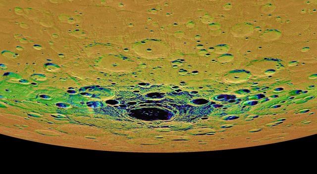
This view from NASA MESSENGER spacecraft is an orthographic projection of Mercury south polar region, colored by an illumination map. The illumination map, created from repeated MDIS imaging, is colored on the basis of the percentage of time that a given area is sunlit. Areas appearing black in the map are regions of permanent shadow. The largest permanently shadowed region near the center of the image is within the interior of the crater Chao Meng-Fu, a location with evidence for hosting considerable amounts of water ice. Instrument: Mercury Dual Imaging System (MDIS) Chao Meng-Fu Center Latitude: -88.4° Chao Meng-Fu Center Longitude: 203.6° E Scale: Chao Meng-Fu has a diameter of roughly 180 kilometers (112 miles) http://photojournal.jpl.nasa.gov/catalog/PIA19416
This VIS image shows part of the complex caldera at the summit of Ascraeus Mons. Ascraeus Mons is the northernmost and tallest of the three large aligned Tharsis volcanoes. Calderas are found at the tops of volcanoes and are the source region for magma that rises from an underground lava source to erupt at the surface. Volcanoes are formed by repeated flows from the central caldera. The final eruptions can pool within the summit caldera, leaving a flat surface as they cool. Calderas are also a location of collapse, creating rings of tectonic faults that form the caldera rim. Ascraeus Mons has several caldera features at its summit. Ascraeus Mons is 18 km (11 miles) tall, for comparison Mauna Kea — the tallest volcano on Earth — is 10 km tall (6.2 miles, measured from the base below sea level). Orbit Number: 79142 Latitude: 11.5042 Longitude: 256.023 Instrument: VIS Captured: 2019-10-17 20:56 https://photojournal.jpl.nasa.gov/catalog/PIA23575
This VIS image shows part of the summit of Ascraeus Mons. Ascraeus Mons is the northernmost and tallest of the three large aligned Tharsis volcanoes. Calderas are found at the tops of volcanoes and are the source region for magma that rises from an underground lava source to erupt at the surface. Volcanoes are formed by repeated flows from the central caldera. The final eruptions can pool within the summit caldera, leaving a flat surface as they cool. Calderas are also a location of collapse, creating rings of tectonic faults that form the caldera rim. Ascraeus Mons has several caldera features at its summit. Ascraeus Mons is 18 km (11 miles) tall, for comparison Mauna Kea – the tallest volcano on Earth – is 10 km tall (6.2 miles, measured from the base below sea level). Orbit Number: 93767 Latitude: 11.2722 Longitude: 11.2722 Instrument: VIS Captured: 2023-02-03 01:58 https://photojournal.jpl.nasa.gov/catalog/PIA25875
This VIS image shows part of the summit of Ascraeus Mons. Ascraeus Mons is the northernmost and tallest of the three large aligned Tharsis volcanoes. Calderas are found at the tops of volcanoes and are the source region for magma that rises from an underground lava source to erupt at the surface. Volcanoes are formed by repeated flows from the central caldera. The final eruptions can pool within the summit caldera, leaving a flat surface as they cool. Calderas are also a location of collapse, creating rings of tectonic faults that form the caldera rim. Ascraeus Mons has several caldera features at its summit. Ascraeus Mons is 18 km (11 miles) tall, for comparison Mauna Kea – the tallest volcano on Earth – is 10 km tall (6.2 miles, measured from the base below sea level). Orbit Number: 94366 Latitude: 11.3736 Longitude: 255.73 Instrument: VIS Captured: 2023-03-24 09:40 https://photojournal.jpl.nasa.gov/catalog/PIA26021
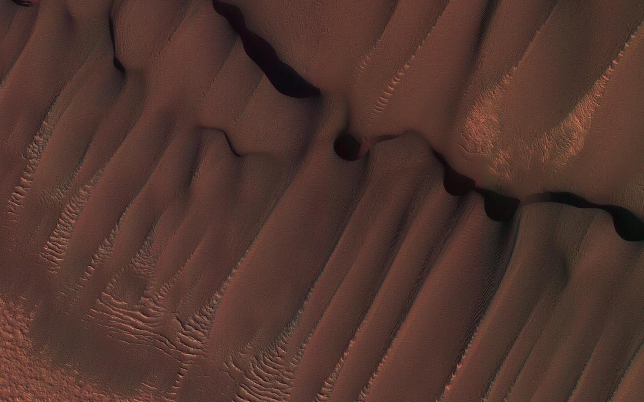
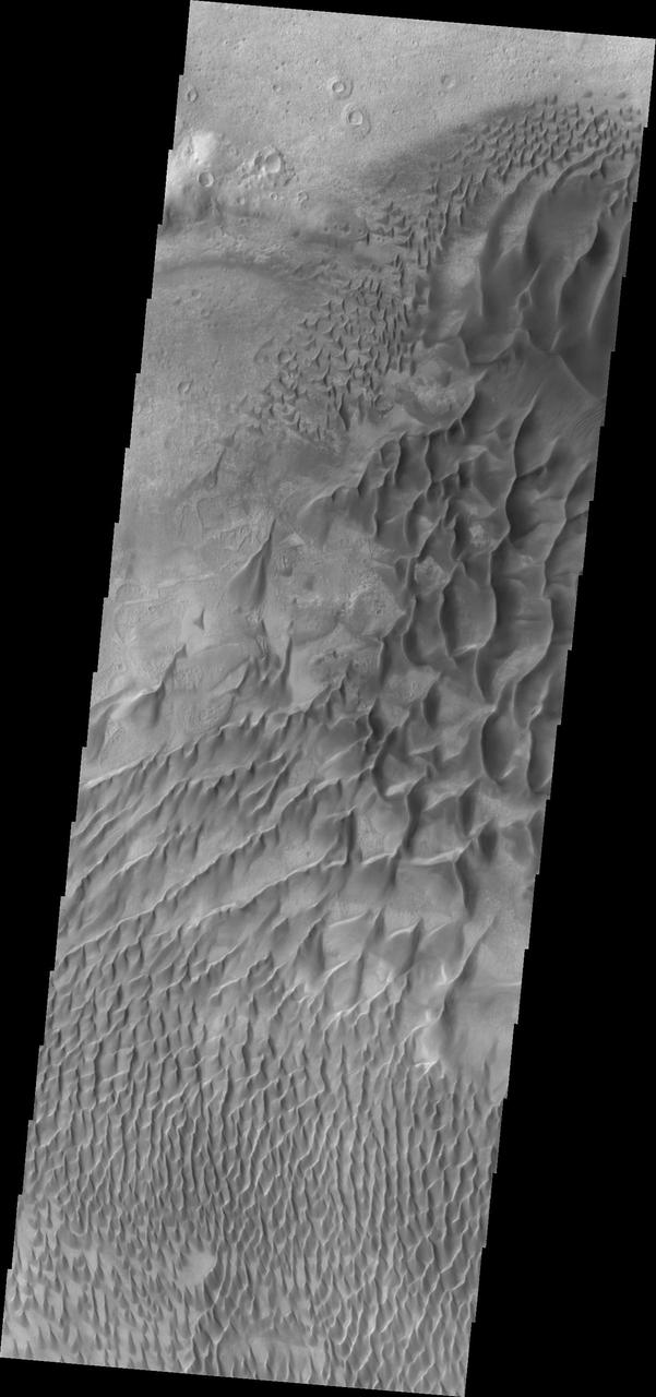
This dune field formed near the base of the North Polar cap. Dunes require a source of loose particulate material to form. The source of the northern dune fields around the polar cap may be from the layers of dusty ice that are eroded by strong polar winds. This image was taken during the Martian northern summer, so there is no frost present on the dunes. The dunes closest to the base of the polar cap are long and parallel, indicating strong winds from the direction of the cap. As they get farther away from the polar cap, they start to form more crescent shaped dunes, called barchan dunes. Repeated observations by HiRISE of dunes like these show measurable changes in some locations. This discovery adds to the growing evidence that there are active processes happening all over the surface of Mars today. http://photojournal.jpl.nasa.gov/catalog/PIA11181
This image from NASA's Mars Reconnaisance Orbiter (MRO) shows one possible place where sand grains are being produced on Mars today. Discovered in images from the Context Camera, this region exhibits dark material that is being eroded from dark layers in the bedrock of a semicircular depression near the boundary of the Southern highlands and the Northern lowlands. Downslope lineations support the notion that these dark sediments are derived locally, and did not accumulate here by coincidence because of the winds. The grains of sand that make up sand dunes on Earth and Mars have a hazardous existence because of the way that they travel. Wind-blown sand is lifted above the surface of each planet before crashing onto the ground and bouncing in a sequence of repeated hops, a process called saltation. Sand grains can also roll along the ground as they are blown by the wind, and they are also jostled by other sand gains that are similarly flying across the surface. All of these repeated impacts tend to wear down the sand grains, smoothing them into a more spherical shape and breaking off small fragments that supply the vast dust deposits of Mars. This process (known as comminution) ultimately destroys sand grains and limits the length of time that the particles exist. The fact that we see active sand dunes on Mars today requires that sand particles must be resupplied to replace the grains that are lost over time. Where are the modern day sources of sand on Mars? https://photojournal.jpl.nasa.gov/catalog/PIA22043

Engineers at NASA's Jet Propulsion Laboratory in Southern California examine one of Psyche's solar arrays during a deployment test in the Lab's High Bay 2 clean room in late February 2022. The twin arrays are together about 800 square feet (75 square meters) – the largest ever deployed at JPL. Part of a solar electric propulsion system provided by Maxar Technologies, they will power the spacecraft on its 1.5 billion-mile (2.4 billion-kilometer) journey to the large, metal-rich asteroid Psyche. Only the three center panels on each five-panel, cross-shaped array can be deployed at JPL due to the limitations of the gravity-offload fixture and the opposing direction of rotation of the cross panels. Deployment of the two cross panels was previously performed at Maxar with different equipment. After further spacecraft testing is completed at JPL, the arrays will be removed and returned to Maxar in order to repeat the cross-panel deployments, make any final repairs to the solar cells, and test overall performance. The arrays then get shipped from Maxar to NASA's Kennedy Space Center in Florida, where they will be reintegrated onto the spacecraft in preparation for launch in August 2022. About an hour after launch, Psyche will deploy the arrays sequentially, first unfolding the three lengthwise center panels, then the two cross panels on one wing before repeating the process with the other wing. Each array takes about 7 ½ minutes to unfurl and latch into place. Each array is 37.1 feet (11.3 meters) long and 24 feet (7.3 meters) wide when fully deployed. With arrays deployed on either side of the chassis, the spacecraft is about the size of a singles tennis court: 81 feet long (24.7 meters) and 24 feet (7.3 meters) wide. https://photojournal.jpl.nasa.gov/catalog/PIA25134
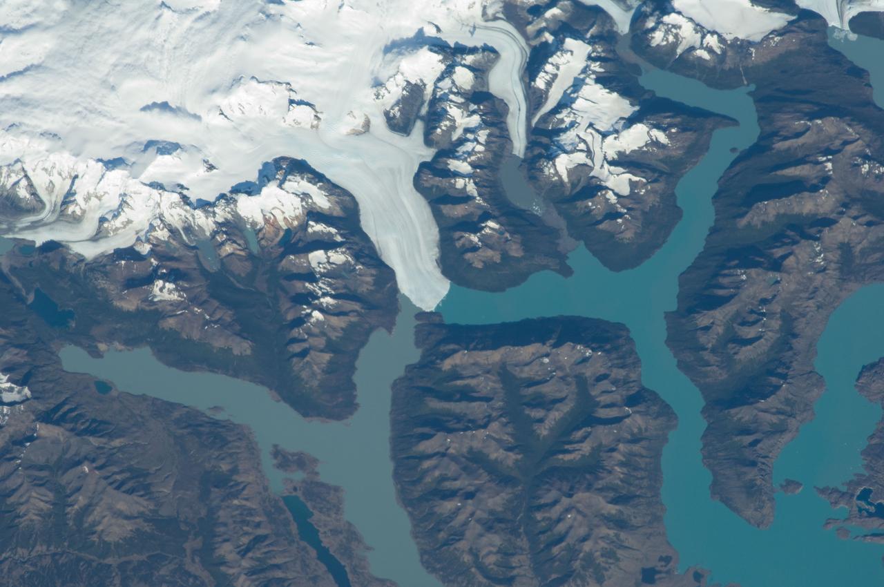
ISS030-E-091253 (21 Feb. 2012) --- Perito Moreno Glacier near Lake Argentino, Argentina is featured in this image photographed by an Expedition 30 crew member on the International Space Station. The largest glacier tongue in this image is known as the Perito Moreno Glacier (center). It descends from the Southern Patagonian Icefield (top) at great altitudes (greater than 2,100 meters, 6,825 feet) in the southern Andes Mountains, down into the water and warmer altitudes of Lake Argentino at approximately 180 meters above sea level. The glacier is 30 kilometers long (image width represents approximately 60 kilometers on the ground). Perito Moreno is one of the largest glaciers in Patagonia, and is perhaps the most famous for the fact that it periodically cuts off the major southern arm (known as Brazo Rico) of Lake Argentino completely from the rest of the lake. This is because the glacier advances right across the lake until it meets the opposite shoreline. The ice tongue is “grounded” (meaning that it is not floating, as occurs at the termini of glaciers and ice shelves where they enter the sea), thus forming a natural dam which prevents the lake water on either side from circulating, which in turn causes muddier, “milkier” water to concentrate in Brazo Rico. Sub-ice water, flows under the ice, not only carrying the mud into the lake but also helping lubricate the glacier’s downhill movement. Because of its effect as a dam, meltwater from the south raises water levels in Brazo Rico by as much as 30 meters above the level of the water in Lago Argentino. The great pressure of this higher water ultimately causes the ice tongue to rupture catastrophically, in a great natural spectacle. The last rupture took place in March 2012. The process then repeats, on average every four to five years, as the glacier starts to grow back towards the opposite shoreline. The repeatability of the rupture has contributed to the event becoming a major tourist attraction in the region.
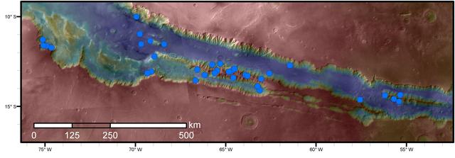
Blue dots on this map indicate sites of recurring slope lineae (RSL) in part of the Valles Marineris canyon network on Mars. RSL are seasonal dark streaks regarded as the strongest evidence for the possibility of liquid water on the surface of modern Mars. The area mapped here has the highest density of known RSL on the Red Planet. The RSL were identified by repeated observations of the sites using the High Resolution Imaging Science Experiment (HiRISE) camera on NASA's Mars Reconnaissance Orbiter. Map colors represent elevation, where red is high and blue is low. Valles Marineris is the largest canyon system in the solar system. The region shown here includes Melas Chasma and Coprates Chasma, in the central and eastern portions of Valles Marineris. The mapped area extends about 1,500 miles (2,400 kilometers) east to west and about 280 miles (450 kilometers) north to south, at latitudes from 9 to 17 degrees south of Mars' equator. The base map uses data from the Mars Orbiter Camera and Mars Orbiter Laser Altimeter of NASA's Mars Global Surveyor mission. RSL extend downslope during a warm season, fade in the colder part of the year, and repeat the process in a subsequent Martian year. A study of 41 RSL sites in this canyon area, published July 7, 2016, provides support for the notion that significant amounts of near-surface water can be found on modern Mars, though the work also indicates that puzzles remain unsolved in understanding how these seasonal features form. Each site includes anywhere from a few to more than 1,000 individual "lineae." http://photojournal.jpl.nasa.gov/catalog/PIA20756
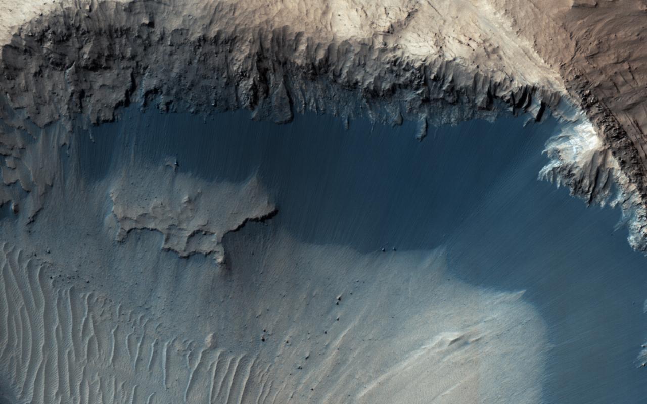
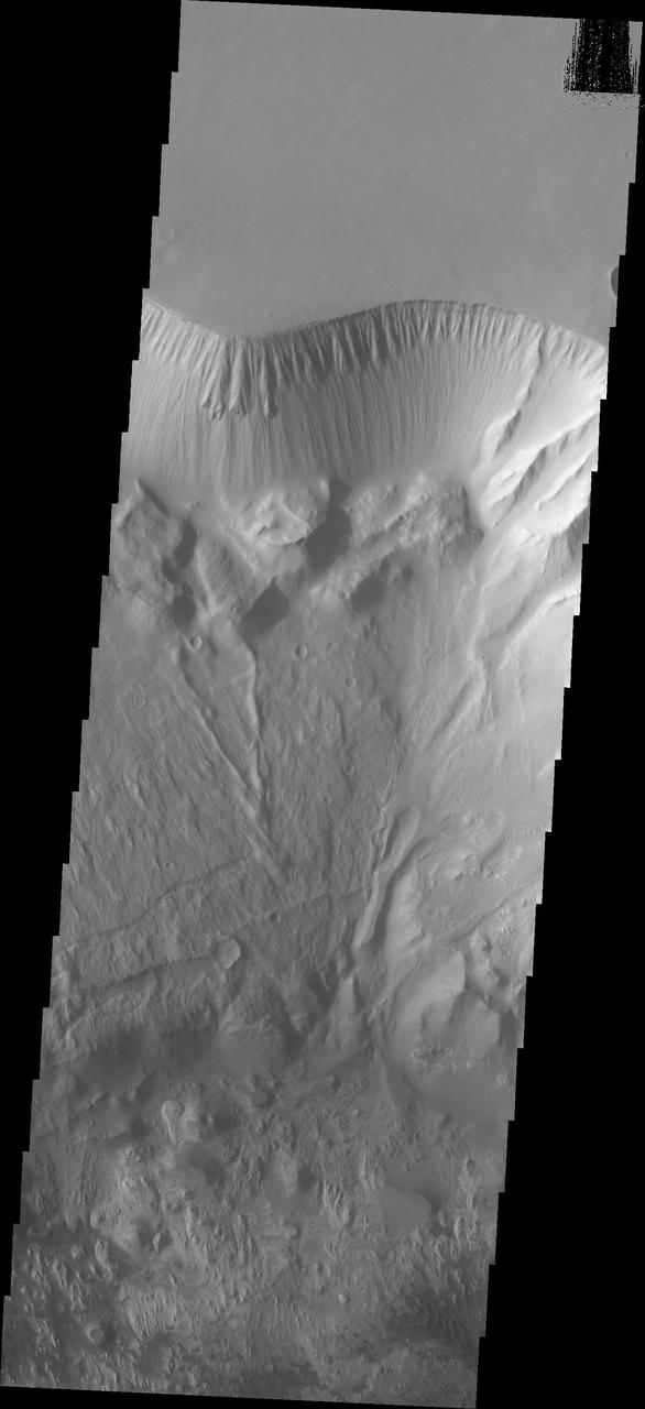
The extended-mission status of the Mars Reconnaissance Orbiter and the HiRISE camera has greatly increased our understanding of numerous active processes occurring on Mars. By taking carefully planned repeat images of surface, we now have an important record of how the surface evolves for a maximum of 5 Mars years. This image shows the central peak in Porter Crater. Although there are no repeat images here we can infer several active geologic processes, based on morphologic evidence and lessons learned from past well-monitored sites. Shallow gullies are located on the south and east facing slopes of the central peak. These features might have been carved by volatiles, such as carbon dioxide frost, sometime in the recent geologic past. Meanwhile on the northern slopes are several smaller slope features that have a morphology hinting at recurring slope lineae (RSL). Alternatively, these features could be the remnants of past active gullies. Several more HiRISE images would be needed to characterize their behavior and confirm their status as RSL (see "Recurring Slope Lineae in Equatorial Regions of Mars"). Southward on the slopes below the peak is a large dune field. Dunes show sharp crests with prominent ripples, both signs of actively migrating dunes. Also, we can see dust devil tracks crossing the nearby dusty surfaces and clear evidence for ongoing modification by swirling winds that persistently remove surface dust. Ongoing operations by HiRISE are dedicated to studying all of the active surface and atmospheric processes operating on Mars. http://photojournal.jpl.nasa.gov/catalog/PIA19853
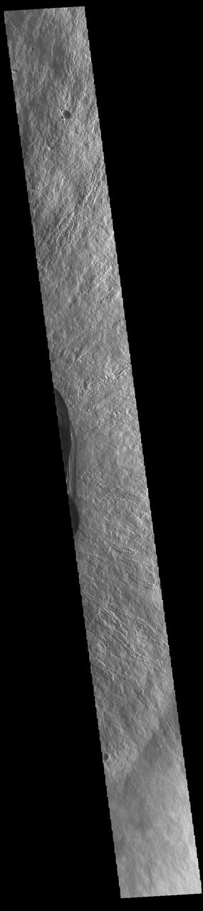
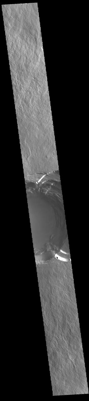
This image shows part of the complex caldera at the summit of the volcano. Calderas are found at the tops of volcanoes and are the source region for magma that rises from an underground lava source to erupt at the surface. Volcanoes are formed by repeated flows from the central caldera. The final eruptions can pool within the summit caldera, leaving a flat surface as they cool. This image shows part of two of the summit calderas, each with a floor at different elevations. Calderas are also a location of collapse, creating rings of tectonic faults that form the caldera rim. Ascraeus Mons has several caldera features at its summit. The Odyssey spacecraft has spent over 15 years in orbit around Mars, circling the planet more than 69000 times. It holds the record for longest working spacecraft at Mars. THEMIS, the IR/VIS camera system, has collected data for the entire mission and provides images covering all seasons and lighting conditions. Over the years many features of interest have received repeated imaging, building up a suite of images covering the entire feature. From the deepest chasma to the tallest volcano, individual dunes inside craters and dune fields that encircle the north pole, channels carved by water and lava, and a variety of other feature, THEMIS has imaged them all. For the next several months the image of the day will focus on the Tharsis volcanoes, the various chasmata of Valles Marineris, and the major dunes fields. We hope you enjoy these images! Orbit Number: 63076 Latitude: 11.3749 Longitude: 255.364 Instrument: VIS Captured: 2016-03-03 11:14 https://photojournal.jpl.nasa.gov/catalog/PIA21830
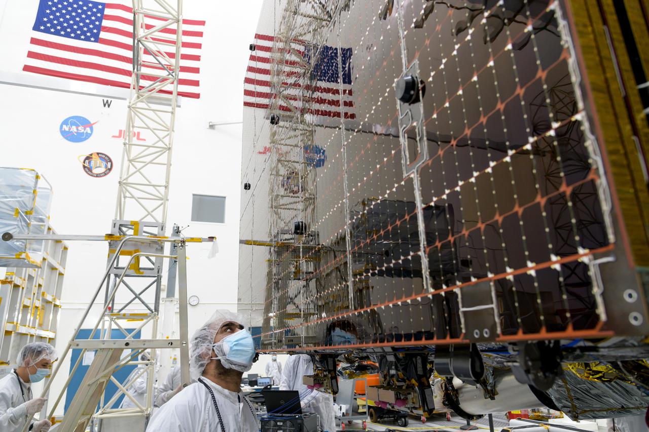
An engineer at NASA's Jet Propulsion Laboratory in Southern California examines a panel on Psyche's stowed solar arrays prior to a deployment test in the Lab's High Bay 2 clean room in February 2022. The twin arrays are together about 800 square feet (75 square meters) – the largest ever deployed at JPL. Part of a solar electric propulsion system provided by Maxar Technologies, they will power the spacecraft on its 1.5 billion-mile (2.4 billion-kilometer) journey to the large, metal-rich asteroid Psyche. Only the three center panels on each five-panel, cross-shaped array can be deployed at JPL due to the limitations of the gravity-offload fixture and the opposing direction of rotation of the cross panels. Deployment of the two cross panels was previously performed at Maxar with different equipment. After further spacecraft testing is completed at JPL, the arrays will be removed and returned to Maxar in order to repeat the cross-panel deployments, make any final repairs to the solar cells, and test overall performance. The arrays then get shipped from Maxar to NASA's Kennedy Space Center in Florida, where they will be reintegrated onto the spacecraft in preparation for launch in August 2022. About an hour after launch, Psyche will deploy the arrays sequentially, first unfolding the three lengthwise center panels, then the two cross panels on one wing before repeating the process with the other wing. Each array takes about 7 ½ minutes to unfurl and latch into place. Each array is 37.1 feet (11.3 meters) long and 24 feet (7.3 meters) wide when fully deployed. With arrays deployed on either side of the chassis, the spacecraft is about the size of a singles tennis court: 81 feet long (24.7 meters) and 24 feet (7.3 meters) wide. https://photojournal.jpl.nasa.gov/catalog/PIA25133
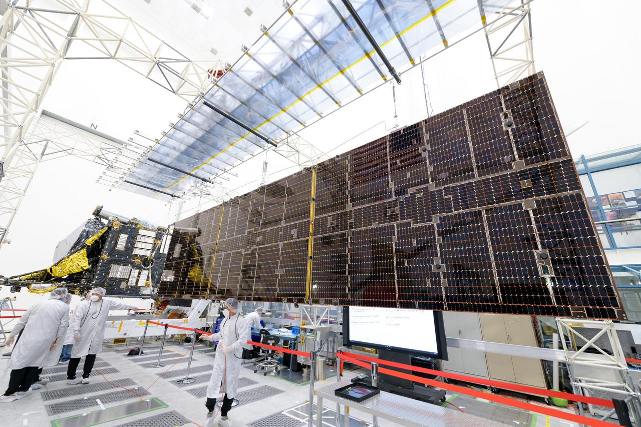
Engineers at NASA's Jet Propulsion Laboratory in Southern California successfully deployed a solar array installed on the agency's Psyche spacecraft. It was one of two deployed during testing in the Lab's High Bay 2 clean room in late February 2022. The twin arrays are together about 800 square feet (75 square meters) – the largest ever deployed at JPL. Part of a solar electric propulsion system provided by Maxar Technologies, they will power the spacecraft on its 1.5 billion-mile (2.4 billion-kilometer) journey to the large, metal-rich asteroid Psyche. Only the three center panels on each five-panel, cross-shaped array can be deployed at JPL due to the limitations of the gravity-offload fixture and the opposing direction of rotation of the cross panels. Deployment of the two cross panels was previously performed at Maxar with different equipment. After further spacecraft testing is completed at JPL, the arrays will be removed and returned to Maxar in order to repeat the cross-panel deployments, make any final repairs to the solar cells, and test overall performance. The arrays then get shipped from Maxar to NASA's Kennedy Space Center in Florida, where they will be reintegrated onto the spacecraft in preparation for launch in August 2022. About an hour after launch, Psyche will deploy the arrays sequentially, first unfolding the three lengthwise center panels, then the two cross panels on one wing before repeating the process with the other wing. Each array takes about 7 ½ minutes to unfurl and latch into place. Each array is 37.1 feet (11.3 meters) long and 24 feet (7.3 meters) wide when fully deployed. With arrays deployed on either side of the chassis, the spacecraft is about the size of a singles tennis court: 81 feet long (24.7 meters) and 24 feet (7.3 meters) wide. https://photojournal.jpl.nasa.gov/catalog/PIA25135
This image shows part of the complex caldera at the summit of the volcano. Calderas are found at the tops of volcanoes and are the source region for magma that rises from an underground lava source to erupt at the surface. Volcanoes are formed by repeated flows from the central caldera. The final eruptions can pool within the summit caldera, leaving a flat surface as they cool. Calderas are also a location of collapse, creating rings of tectonic faults that form the caldera rim. Ascraeus Mons has several caldera features at its summit. The Odyssey spacecraft has spent over 15 years in orbit around Mars, circling the planet more than 69000 times. It holds the record for longest working spacecraft at Mars. THEMIS, the IR/VIS camera system, has collected data for the entire mission and provides images covering all seasons and lighting conditions. Over the years many features of interest have received repeated imaging, building up a suite of images covering the entire feature. From the deepest chasma to the tallest volcano, individual dunes inside craters and dune fields that encircle the north pole, channels carved by water and lava, and a variety of other feature, THEMIS has imaged them all. For the next several months the image of the day will focus on the Tharsis volcanoes, the various chasmata of Valles Marineris, and the major dunes fields. We hope you enjoy these images! Orbit Number: 17440 Latitude: 11.128 Longitude: 255.731 Instrument: VIS Captured: 2005-11-19 08:59 https://photojournal.jpl.nasa.gov/catalog/PIA21822
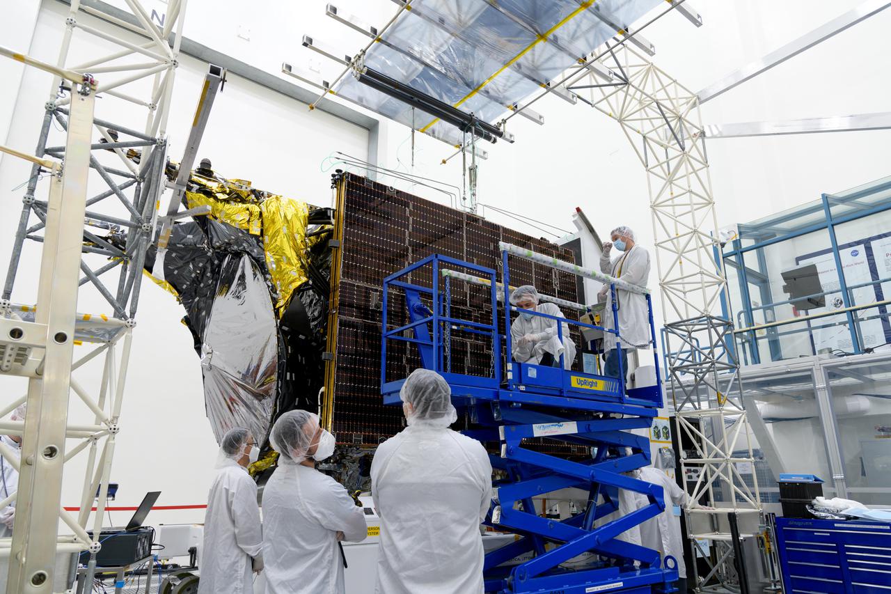
Engineers at NASA's Jet Propulsion Laboratory in Southern California examine one of Psyche's stowed solar arrays prior to a deployment test in the Lab's High Bay 2 clean room in late February 2022. The twin arrays are together about 800 square feet (75 square meters) – the largest ever deployed at JPL. Part of a solar electric propulsion system provided by Maxar Technologies, they will power the spacecraft on its 1.5 billion-mile (2.4 billion-kilometer) journey to the large, metal-rich asteroid Psyche. Only the three center panels on each five-panel, cross-shaped array can be deployed at JPL due to the limitations of the gravity-offload fixture and the opposing direction of rotation of the cross panels. Deployment of the two cross panels was previously performed at Maxar with different equipment. After further spacecraft testing is completed at JPL, the arrays will be removed and returned to Maxar in order to repeat the cross-panel deployments, make any final repairs to the solar cells, and test overall performance. The arrays then get shipped from Maxar to NASA's Kennedy Space Center in Florida, where they will be reintegrated onto the spacecraft in preparation for launch in August 2022. About an hour after launch, Psyche will deploy the arrays sequentially, first unfolding the three lengthwise center panels, then the two cross panels on one wing before repeating the process with the other wing. Each array takes about 7 ½ minutes to unfurl and latch into place. Each array is 37.1 feet (11.3 meters) long and 24 feet (7.3 meters) wide when fully deployed. With arrays deployed on either side of the chassis, the spacecraft is about the size of a singles tennis court: 81 feet long (24.7 meters) and 24 feet (7.3 meters) wide. https://photojournal.jpl.nasa.gov/catalog/PIA25132
This image shows part of the complex caldera at the summit of the volcano. Calderas are found at the tops of volcanoes and are the source region for magma that rises from an underground lava source to erupt at the surface. Volcanoes are formed by repeated flows from the central caldera. The final eruptions can pool within the summit caldera, leaving a flat surface as they cool. Calderas are also a location of collapse, creating rings of tectonic faults that form the caldera rim. Ascraeus Mons has several caldera features at its summit. The Odyssey spacecraft has spent over 15 years in orbit around Mars, circling the planet more than 69000 times. It holds the record for longest working spacecraft at Mars. THEMIS, the IR/VIS camera system, has collected data for the entire mission and provides images covering all seasons and lighting conditions. Over the years many features of interest have received repeated imaging, building up a suite of images covering the entire feature. From the deepest chasma to the tallest volcano, individual dunes inside craters and dune fields that encircle the north pole, channels carved by water and lava, and a variety of other feature, THEMIS has imaged them all. For the next several months the image of the day will focus on the Tharsis volcanoes, the various chasmata of Valles Marineris, and the major dunes fields. We hope you enjoy these images! Orbit Number: 52847 Latitude: 11.2724 Longitude: 255.564 Instrument: VIS Captured: 2013-11-12 08:41 https://photojournal.jpl.nasa.gov/catalog/PIA21828

The diagram – based on data used in a July 2024 NASA-funded study – shows polar motion, a phenomenon that results from the combined action of several physical processes that broadly shift the distribution of mass around the globe or create forces in its mantle and core that cause the planet to wobble as it rotates. These changes cause the spin axis to meander over time. The blue line starts at the position of the spin axis near the North Pole in 1900, the first year polar motion data was collected, and tracks it until 2023. The spin axis now sits about 30 feet (10 meters) from where it was in 1900, in the direction of Canada's Baffin Bay. Around 2000, the axis took a sudden eastward turn, which researchers at NASA's Jet Propulsion Laboratory in Southern California in a 2016 study attributed to faster melting of the Greenland and Antarctic ice sheets and groundwater depletion in Eurasia. Surendra Adhikari, a JPL geophysicist who co-authored that study, used measurements from the International Earth Rotation and Reference Systems Service to create the animation. Adhikari and collaborators from Switzerland, Canada, and Germany found in a July 2024 paper in Nature Geoscience that about 90% of repeated oscillations in polar motion between 1900 and 2018 could be explained by large-scale mass redistribution at Earth's surface due to the melting of ice sheets and glaciers and the depletion of aquifers. It also found that nearly all of the long-term, non-repeating drift of the axis was due to dynamics in the mantle. Animation available at https://photojournal.jpl.nasa.gov/catalog/PIA26120
This image shows the eastern part of the complex caldera at the summit of the volcano. Calderas are found at the tops of volcanoes and are the source region for magma that rises from an underground lava source to erupt at the surface. Volcanoes are formed by repeated flows from the central caldera. The final eruptions can pool within the summit caldera, leaving a flat surface as they cool. Calderas are also a location of collapse, creating rings of tectonic faults that form the caldera rim. This image is dominated by the ring of faults that defines the outer margin of the caldera. Ascraeus Mons has several caldera features at its summit. The Odyssey spacecraft has spent over 15 years in orbit around Mars, circling the planet more than 69000 times. It holds the record for longest working spacecraft at Mars. THEMIS, the IR/VIS camera system, has collected data for the entire mission and provides images covering all seasons and lighting conditions. Over the years many features of interest have received repeated imaging, building up a suite of images covering the entire feature. From the deepest chasma to the tallest volcano, individual dunes inside craters and dune fields that encircle the north pole, channels carved by water and lava, and a variety of other feature, THEMIS has imaged them all. For the next several months the image of the day will focus on the Tharsis volcanoes, the various chasmata of Valles Marineris, and the major dunes fields. We hope you enjoy these images! Orbit Number: 53334 Latitude: 11.2134 Longitude: 255.911 Instrument: VIS Captured: 2013-12-22 10:29 https://photojournal.jpl.nasa.gov/catalog/PIA21829
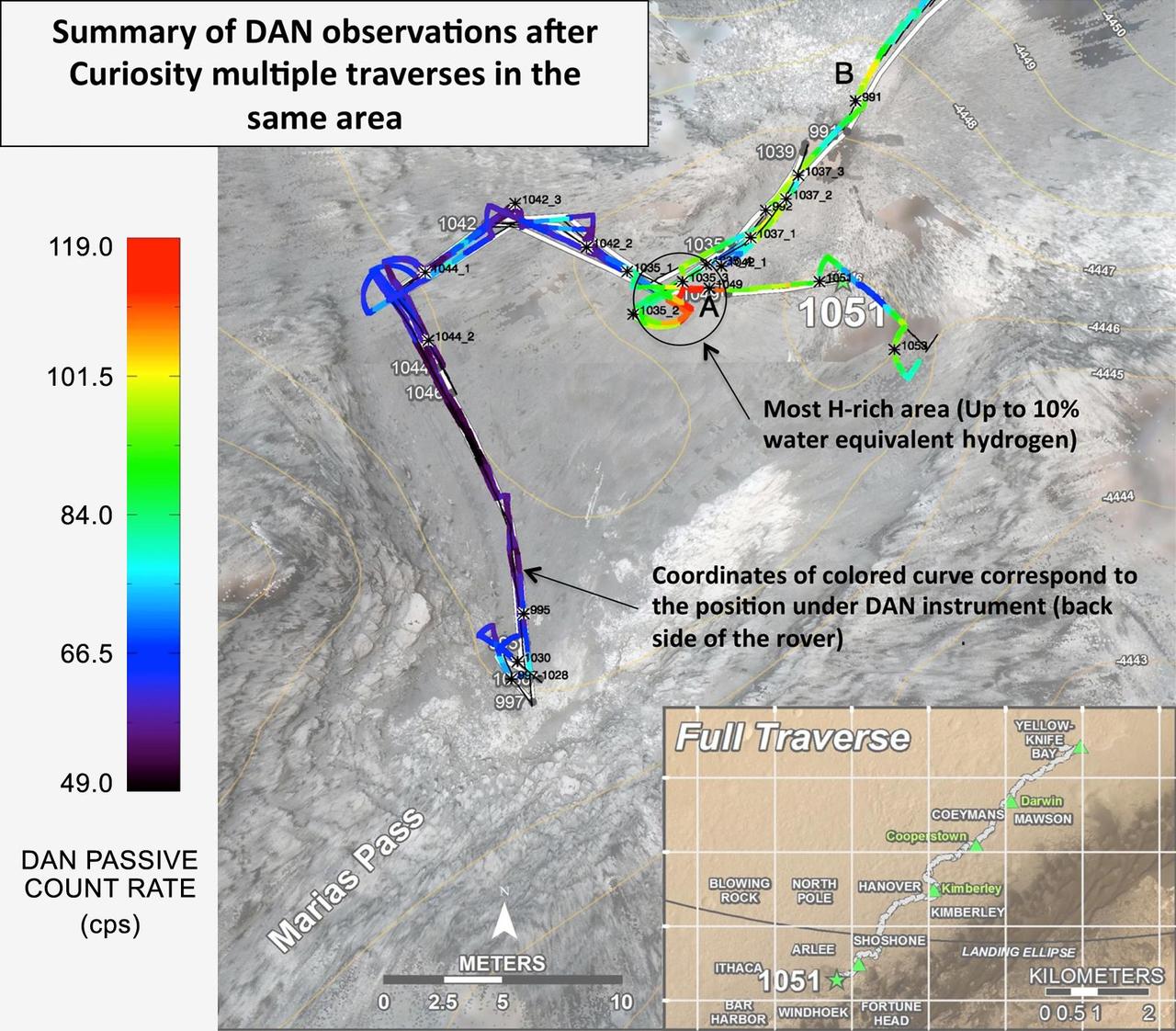
Curiosity's Russian-made instrument for checking hydration levels in the ground beneath the rover detected an unusually high amount at a site near "Marias Pass," prompting repeated passes over the area to map the hydrogen amounts. The instrument is named Dynamic Albedo of Neutrons, or DAN. It detects hydrogen by the effect of hydrogen atoms on neutrons entering the ground either from cosmic rays and Curiosity's power source (DAN's passive mode) or from the instrument's neutron pulse generator (DAN's active mode). DAN recognizes which neutrons have bounced off hydrogen from their rerduced energy level. This map, covering an area about 130 feet (40 meters) across, shows results from DAN's multiple traverses over the area, with color coding for levels of hydrogen detected. The red coding indicates amounts of hydrogen three to four times as high as the amounts detected anywhere previously along Curiosity's traverse of about 6.9 miles (11.1 kilometers) since landing in August 2012. The inset map at lower right shows the full traverse through Sol 1051 (July 21, 2015), with names assigned to rectangles within Gale Crater for geological mapping purposes. The vertical bar at left indicates the color coding according to counts per second in DAN's passive mode. The hydrogen detected by DAN is interpreted as water molecules or hydroxyl ions bound within minerals or water absorbed onto minerals in the rocks and soil, to a depth of about 3 feet (1 meter) beneath the rover. The amount of hydrogen is often expressed as "water equivalent hydrogen" based on two hydrogen atoms per molecule of water. In the same area where DAN detected an unusually high amount of hydration, Curiosity's Chemistry and Camera (ChemCam) instrument detected an unusually high amount of silica in several rock targets. The DAN and ChemCam findings led to the rover's science team choosing a rock target called "Buckskin" for collection of a drilled sample to be analyzed by the rover's internal laboratory instruments. Russia's Space Research Institute developed DAN in close cooperation with the N.L. Dukhov All-Russia Research Institute of Automatics, Moscow, and the Joint Institute for Nuclear Research, Dubna. The neutron generator development was supervised by the late technical designer German A. Smirnov of the All-Russia Institute of Automatics. Moscow. http://photojournal.jpl.nasa.gov/catalog/PIA19809
This image of the flank of Ascraeus Mons shows several individual flows where the sides are higher than the center. These are called leveed flows, as the outer margin acts as a levee containing the flow as it continues downslope. Levees grow as the flow margins start to cool. The hotter liquid lava continues as long as the source flows. The Odyssey spacecraft has spent over 15 years in orbit around Mars, circling the planet more than 69000 times. It holds the record for longest working spacecraft at Mars. THEMIS, the IR/VIS camera system, has collected data for the entire mission and provides images covering all seasons and lighting conditions. Over the years many features of interest have received repeated imaging, building up a suite of images covering the entire feature. From the deepest chasma to the tallest volcano, individual dunes inside craters and dune fields that encircle the north pole, channels carved by water and lava, and a variety of other feature, THEMIS has imaged them all. For the next several months the image of the day will focus on the Tharsis volcanoes, the various chasmata of Valles Marineris, and the major dunes fields. We hope you enjoy these images! Orbit Number: 18039 Latitude: 10.3245 Longitude: 256.26 Instrument: VIS Captured: 2006-01-07 16:37 https://photojournal.jpl.nasa.gov/catalog/PIA21823
Textured rows on the ground in this portion of "Perseverance Valley" are under investigation by NASA's Mars Exploration Rover Opportunity, which used its Navigation Camera (Navcam) to take the component images of this downhill-looking scene. The rover took this image on Jan. 4, 2018, during the 4,958th Martian day, or sol, of its work on Mars, looking downhill from a position about one-third of the way down the valley. Perseverance Valley descends the inboard slope of the western rim of Endeavour Crater. A view on the same sol with the rover's front Hazard Avoidance Camera includes ground even closer to the rover at this site. Opportunity was still working close by as it reached the mission's Sol 5,000 (Feb. 16, 2018). In the portion of the valley seen here, soil and gravel have been shaped into a striped pattern in the foreground and partially bury outcrops visible in the midfield. The long dimensions of the stripes are approximately aligned with the downhill direction. The striped pattern resembles a type of feature on Earth (such as on Hawaii's Mauna Kea) that is caused by repeated cycles of freezing and thawing, though other possible origins are also under consideration for the pattern in Perseverance Valley. The view is spans from north on the left to east-southeast on the right. For scale, the foreground rock clump in the lower right is about 11 inches (28 centimeters) in width. https://photojournal.jpl.nasa.gov/catalog/PIA22217
This image, received today, shows the trench excavated by NASA's Viking 1 surface sampler. The trench was dug by extending the surface sampler collection head in a direction from lower right toward the upper left and then withdrawing the surface sampler collector head. Lumpy piles of material at end of trench at lower right was pulled by plowing from trench by the backhoe which will be used to dig trenches later in the mission. Area around trench has ripple marks produced by Martian wind. The trench which was dug early on Sol 8, is about 3 inches wide, 2 inches deep and 6 inches long. Steep dark crater walls show the grains of the Martian surface material stick together (have adhesion). The doming of the surface at far end of the trench show the granular material is dense. The Martian surface material behaves somewhat like moist sand on Earth. Evidence from the trench indicate a sample was collected and delivered to the experiments after repeated tries. The biology experiment level full indicator indicates a sample was received for analysis. The X-Ray fluorescence experiment has no indication to show it received a sample. The GCMS experiment level full indicator suggests no sample was received but this matter is being investigated. http://photojournal.jpl.nasa.gov/catalog/PIA00389

This image shows the side of the large mesa at the top of the image and the southern canyon cliff face at the bottom. Materials on the floor of the chasma originated from both features. Although the cliff faces are eroding differently, both contribute to the rough floor seen in the center of the image. Hebes Chasma is an enclosed basin not connected to Valles Marineris. The Odyssey spacecraft has spent over 15 years in orbit around Mars, circling the planet more than 69000 times. It holds the record for longest working spacecraft at Mars. THEMIS, the IR/VIS camera system, has collected data for the entire mission and provides images covering all seasons and lighting conditions. Over the years many features of interest have received repeated imaging, building up a suite of images covering the entire feature. From the deepest chasma to the tallest volcano, individual dunes inside craters and dune fields that encircle the north pole, channels carved by water and lava, and a variety of other feature, THEMIS has imaged them all. For the next several months the image of the day will focus on the Tharsis volcanoes, the various chasmata of Valles Marineris, and the major dunes fields. We hope you enjoy these images! Orbit Number: 39664 Latitude: -1.49358 Longitude: 283.431 Instrument: VIS Captured: 2010-11-23 04:54 https://photojournal.jpl.nasa.gov/catalog/PIA21817
Although actively-forming gullies are common in the middle latitudes of Mars, there are also pristine-looking gullies in equatorial regions. In this scene, the gullies have very sharp channels and different colors where the gullies have eroded and deposited material. Over time, the topography becomes smoothed over and the color variations disappear, unless there is recent activity. Changes have not been visible here from before-and-after images, and maybe such differences are apparent compared to older images, but nobody has done a careful comparison. What may be needed to see subtle changes is a new image that matches the lighting conditions of an older one. Equatorial gully activity is probably much less common — perhaps there is major downslope avalanching every few centuries — so we need to be lucky to see changes. MRO has now been imaging Mars for over 16 years, and the chance of seeing rare activity increases as the time interval widens between repeat images. https://photojournal.jpl.nasa.gov/catalog/PIA25309
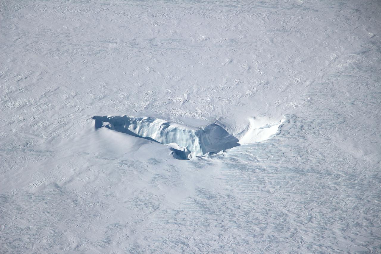
Scientists and crew with NASA’s Operation IceBridge, which makes annual aerial surveys of polar ice, are wrapping up their seventh campaign over the Arctic. In spring 2015, the team began using a different research aircraft—an adapted C-130 Hercules. They also added four new high-priority targets in the rapidly changing region of northeast Greenland. Many of the flights, however, were routine. And that’s exactly the point; making measurements over the same path each year provides continuity between NASA’s Ice, Cloud, and Land Elevation Satellite (ICESat) missions—the first of which ended in 2009 and the second of which is scheduled for launch in 2017. Repeat measurements show how a landscape changes over time. One area that has been surveyed repeatedly is northern Greenland’s Ryder Glacier. This photograph, taken during the IceBridge flight on May 6, 2015, shows a large moulin—dozens of meters across—atop this glacier. Moulins are holes in the ice sheet that drain melt water from the ice sheet’s surface to the bottom or out to the sea. Scientists are working to figure out what happens to melt water once it enters a moulin.
This frame from a sequence of images shows a dust-carrying whirlwind, called a dust devil, on lower Mount Sharp inside Gale Crater, as viewed by NASA's Curiosity Mars Rover during the summer afternoon of the rover's 1,613rd Martian day, or sol (Feb. 18, 2017). Set within a broader southward view from the rover's Navigation Camera, the rectangular area outlined in black was imaged multiple times over a span of several minutes to check for dust devils. Images from the period with most activity are shown in the inset area. The images are in pairs that were taken about 12 seconds apart, with an interval of about 90 seconds between pairs. Timing is accelerated and not fully proportional in this animation. Contrast has been modified to make frame-to-frame changes easier to see. A black frame provides a marker between repeats of the sequence. On Mars as on Earth, dust devils result from sunshine warming the ground, prompting convective rising of air that has gained heat from the ground. Observations of dust devils provide information about wind directions and interaction between the surface and the atmosphere. An animation is available at http://photojournal.jpl.nasa.gov/catalog/PIA21483
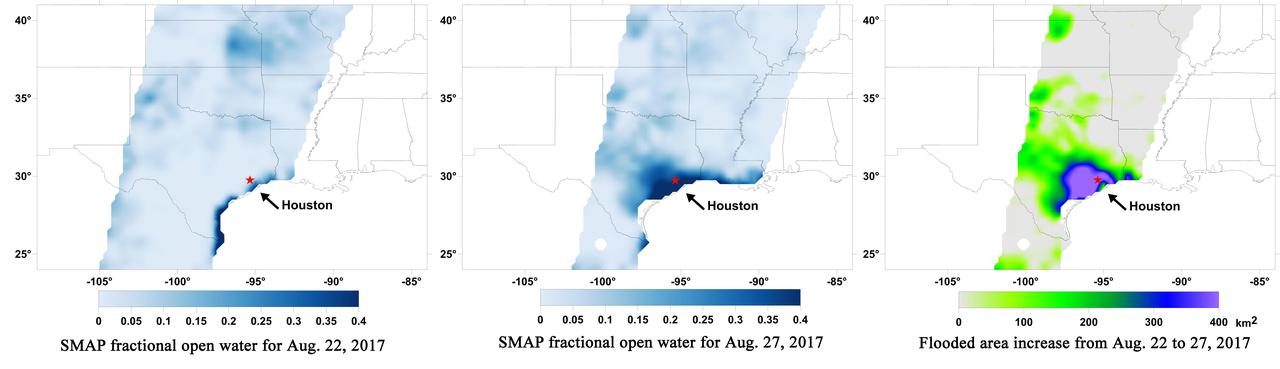
A new series of images generated with data from NASA's Soil Moisture Active Passive (SMAP) satellite illustrate the surface flooding caused by Hurricane Harvey from before its initial landfall through August 27, 2017. The SMAP observations detect the proportion of the ground covered by surface water within the satellite's field of view. The sequence of images depicts successive satellite orbital swath observations showing the surface water conditions on August 22, before Harvey's landfall (left), and then on Aug. 27, two days after landfall (middle). The resulting increase in surface flooding from record rainfall over the three-day period, shown at right, depicts regionally heavy flooding around the Houston metropolitan area. The hardest hit areas (blue and purple shades) cover more than 23,000 square miles (about 59,600 square kilometers) and indicate a more than 1,000-fold increase in surface water cover from rainfall-driven flooding. SMAP's low-frequency (L-band) microwave radiometer features enhanced capabilities for detecting surface water changes in nearly all weather conditions and under low-to-moderate vegetation cover. The satellite provides global coverage with one to three-day repeat sampling, which is well suited for monitoring dynamic inland waters around the world. https://photojournal.jpl.nasa.gov/catalog/PIA21930

Siton Undae is a large dune field located in the northern plains near Escorial Crater. Siton Undae is west of the crater and is one of three dune fields near the crater. The nearby north polar cap is dissected by Chasma Boreale, which exposes an ice free surface. This image crosses the center of the dune field and was collected in early spring. The Odyssey spacecraft has spent over 15 years in orbit around Mars, circling the planet more than 69000 times. It holds the record for longest working spacecraft at Mars. THEMIS, the IR/VIS camera system, has collected data for the entire mission and provides images covering all seasons and lighting conditions. Over the years many features of interest have received repeated imaging, building up a suite of images covering the entire feature. From the deepest chasma to the tallest volcano, individual dunes inside craters and dune fields that encircle the north pole, channels carved by water and lava, and a variety of other feature, THEMIS has imaged them all. For the next several months the image of the day will focus on the Tharsis volcanoes, the various chasmata of Valles Marineris, and the major dunes fields. We hope you enjoy these images! Orbit Number: 27273 Latitude: 75.8111 Longitude: 297.072 Instrument: VIS Captured: 2008-02-06 23:05 https://photojournal.jpl.nasa.gov/catalog/PIA21989
This image shows the north central cliff face of Hebes Chasma. The cliff face and downslope movement of material is very different in appearance than the same features of the large mesa in the center of the chasma. Hebes Chasma is an enclosed basin not connected to Valles Marineris. The Odyssey spacecraft has spent over 15 years in orbit around Mars, circling the planet more than 69000 times. It holds the record for longest working spacecraft at Mars. THEMIS, the IR/VIS camera system, has collected data for the entire mission and provides images covering all seasons and lighting conditions. Over the years many features of interest have received repeated imaging, building up a suite of images covering the entire feature. From the deepest chasma to the tallest volcano, individual dunes inside craters and dune fields that encircle the north pole, channels carved by water and lava, and a variety of other feature, THEMIS has imaged them all. For the next several months the image of the day will focus on the Tharsis volcanoes, the various chasmata of Valles Marineris, and the major dunes fields. We hope you enjoy these images! Orbit Number: 26886 Latitude: -0.142089 Longitude: 283.512 Instrument: VIS Captured: 2008-01-06 02:43 https://photojournal.jpl.nasa.gov/catalog/PIA21814
Siton Undae is a large dune field located in the northern plains near Escorial Crater. Siton Undae is west of the crater and is one of three dune fields near the crater. The nearby north polar cap is dissected by Chasma Boreale, which exposes an ice free surface. This image shows part of the southern extent of the dune field. The Odyssey spacecraft has spent over 15 years in orbit around Mars, circling the planet more than 69000 times. It holds the record for longest working spacecraft at Mars. THEMIS, the IR/VIS camera system, has collected data for the entire mission and provides images covering all seasons and lighting conditions. Over the years many features of interest have received repeated imaging, building up a suite of images covering the entire feature. From the deepest chasma to the tallest volcano, individual dunes inside craters and dune fields that encircle the north pole, channels carved by water and lava, and a variety of other feature, THEMIS has imaged them all. For the next several months the image of the day will focus on the Tharsis volcanoes, the various chasmata of Valles Marineris, and the major dunes fields. We hope you enjoy these images! Orbit Number: 27560 Latitude: 74.5974 Longitude: 296.119 Instrument: VIS Captured: 2008-03-01 14:16 https://photojournal.jpl.nasa.gov/catalog/PIA21831
This image shows individual dunes on the floor of Russell Crater, as well as larger dunes created by individual dunes coalescing . These dunes are in the western part of the dune field. Russell Crater is located in Noachis Terra. A spectacular dune ridge and other dune forms on the crater floor have caused extensive imaging. The Odyssey spacecraft has spent over 15 years in orbit around Mars, circling the planet more than 69000 times. It holds the record for longest working spacecraft at Mars. THEMIS, the IR/VIS camera system, has collected data for the entire mission and provides images covering all seasons and lighting conditions. Over the years many features of interest have received repeated imaging, building up a suite of images covering the entire feature. From the deepest chasma to the tallest volcano, individual dunes inside craters and dune fields that encircle the north pole, channels carved by water and lava, and a variety of other feature, THEMIS has imaged them all. For the next several months the image of the day will focus on the Tharsis volcanoes, the various chasmata of Valles Marineris, and the major dunes fields. We hope you enjoy these images! Orbit Number: 26372 Latitude: -54.372 Longitude: 12.5481 Instrument: VIS Captured: 2007-11-24 17:16 https://photojournal.jpl.nasa.gov/catalog/PIA21800

This image shows the northern side of Hebes Chasma. The large central layered mesa is just off the bottom of the image. Meeting in approximately the center of the image are materials eroded from the cliff face and mesa. The appearance of the material differs. Both the floor and central mesa are very complex features in this canyon. Hebes Chasma is an enclosed basin not connected to Valles Marineris. The Odyssey spacecraft has spent over 15 years in orbit around Mars, circling the planet more than 69000 times. It holds the record for longest working spacecraft at Mars. THEMIS, the IR/VIS camera system, has collected data for the entire mission and provides images covering all seasons and lighting conditions. Over the years many features of interest have received repeated imaging, building up a suite of images covering the entire feature. From the deepest chasma to the tallest volcano, individual dunes inside craters and dune fields that encircle the north pole, channels carved by water and lava, and a variety of other feature, THEMIS has imaged them all. For the next several months the image of the day will focus on the Tharsis volcanoes, the various chasmata of Valles Marineris, and the major dunes fields. We hope you enjoy these images! Orbit Number: 51210 Latitude: -0.415426 Longitude: 284.165 Instrument: VIS Captured: 2013-06-30 15:57 https://photojournal.jpl.nasa.gov/catalog/PIA21819

STS043-04-038 (2-11 Aug 1991) --- Astronaut James C. Adamson, STS-43 mission specialist, checks on an experiment on Atlantis? flight deck. Part of the experiment, Optical Communications Through the Shuttle Window (OCTW), can be seen mounted in upper right. The OCTW system consists of two modules, one inside the orbiter crew cabin (as pictured here) and one in the payload bay. The crew compartment version houses an optoelectronic transmitter/receiver pair for video and digital subsystems, test circuitry and interface circuitry. The payload bay module serves as a repeater station. During operation a signal is transmitted through the shuttle window to a bundle of optical fiber cables mounted in the payload bay near an aft window. The cables carry optical signals from the crew compartment equipment to the OCTW payload bay module. The signals are returned via optical fiber cable to the aft flight deck window, retransmitted through the window, and received by the crew compartment equipment.
![CAPE CANAVERAL, Fla. – ASTP prime crewmen Donald Slayton, Thomas Stafford and Vance Brand pose with their Saturn IB launch vehicle following the Countdown Demonstration Test [CDDT], a step-by-step dress rehearsal for their July 15 launch. During the “wet” portion of the test, conducted yesterday, the stages of the launch vehicle were fueled as they will be on launch day. The fuels were off loaded and the terminal portion of the count repeated today with the astronauts aboard the vehicle. The first international crewed spaceflight was a joint U.S.-U.S.S.R. rendezvous and docking mission. The Apollo-Soyuz Test Project, or ASTP, took its name from the spacecraft employed: the American Apollo and the Soviet Soyuz. The three-man Apollo crew lifted off from Kennedy Space Center aboard a Saturn IB rocket on July 15, 1975, to link up with the Soyuz that had launched a few hours earlier. A cylindrical docking module served as an airlock between the two spacecraft for transfer of the crew members. Photo credit: NASA](https://images-assets.nasa.gov/image/KSC-75PC-0330/KSC-75PC-0330~medium.jpg)
CAPE CANAVERAL, Fla. – ASTP prime crewmen Donald Slayton, Thomas Stafford and Vance Brand pose with their Saturn IB launch vehicle following the Countdown Demonstration Test [CDDT], a step-by-step dress rehearsal for their July 15 launch. During the “wet” portion of the test, conducted yesterday, the stages of the launch vehicle were fueled as they will be on launch day. The fuels were off loaded and the terminal portion of the count repeated today with the astronauts aboard the vehicle. The first international crewed spaceflight was a joint U.S.-U.S.S.R. rendezvous and docking mission. The Apollo-Soyuz Test Project, or ASTP, took its name from the spacecraft employed: the American Apollo and the Soviet Soyuz. The three-man Apollo crew lifted off from Kennedy Space Center aboard a Saturn IB rocket on July 15, 1975, to link up with the Soyuz that had launched a few hours earlier. A cylindrical docking module served as an airlock between the two spacecraft for transfer of the crew members. Photo credit: NASA
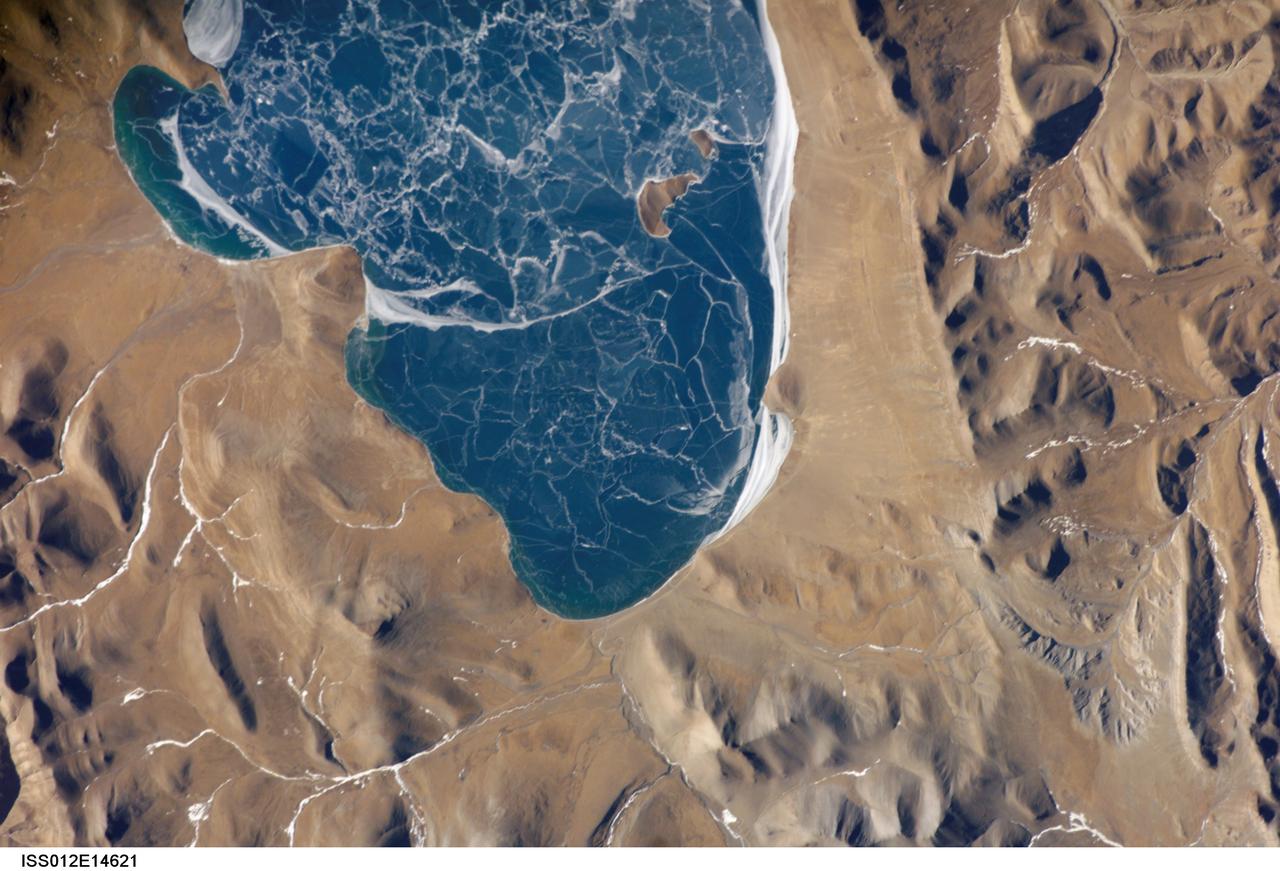
ISS012-E-14621 (6 Jan. 2006) --- A portion of Lake Puma Yumco and parts of Tibet and China are featured in this image photographed by an Expedition 12 crew member on the International Space Station. The alpine lakes of the Tibetan Plateau are some of the most remote in the world. This image depicts Lake Puma Yumco during the winter season. The lake is located at an elevation of 5,030 meters above sea level, and is considered ultraoligotrophic in that nutrient concentrations in both the water column and lake sediments are extremely low. Water in such lakes tends to be blue to blue-green and have high clarity due to the lack of abundant photosynthesizing organisms such as phytoplankton. Water color change in these lakes is usually due to shallowing of the water – blue indicating deeper water. The maximum dimensions of the lake are 31 kilometers by 14 kilometers, indicating that the ice blocks range from less than ten to hundreds of meters in diameter. According to scientists, the ice pattern is caused by repeated cycles of freezing, fracturing, and refreezing of the ice due to variations in temperature and wind-induced ice motion. A prominent white linear feature across the center of the lake (not visible in this image) is suggestive of an ice ridge formed by east-west winds subsequently highlighted by snow.

This image shows the part of the southern cliff face of Hebes Chasma a the bottom of the image. At the top of the image is part of the large mesa located in the center of the chasma. Hebes Chasma is an enclosed basin not connected to Valles Marineris. The cliff faces of the chasma itself and the interior mesa appear quite different, which may provided information on how the chasma and the mesa formed. The Odyssey spacecraft has spent over 15 years in orbit around Mars, circling the planet more than 69000 times. It holds the record for longest working spacecraft at Mars. THEMIS, the IR/VIS camera system, has collected data for the entire mission and provides images covering all seasons and lighting conditions. Over the years many features of interest have received repeated imaging, building up a suite of images covering the entire feature. From the deepest chasma to the tallest volcano, individual dunes inside craters and dune fields that encircle the north pole, channels carved by water and lava, and a variety of other feature, THEMIS has imaged them all. For the next several months the image of the day will focus on the Tharsis volcanoes, the various chasmata of Valles Marineris, and the major dunes fields. We hope you enjoy these images! Orbit Number: 10052 Latitude: -1.5441 Longitude: 283.71 Instrument: VIS Captured: 2004-03-21 00:22 https://photojournal.jpl.nasa.gov/catalog/PIA21809
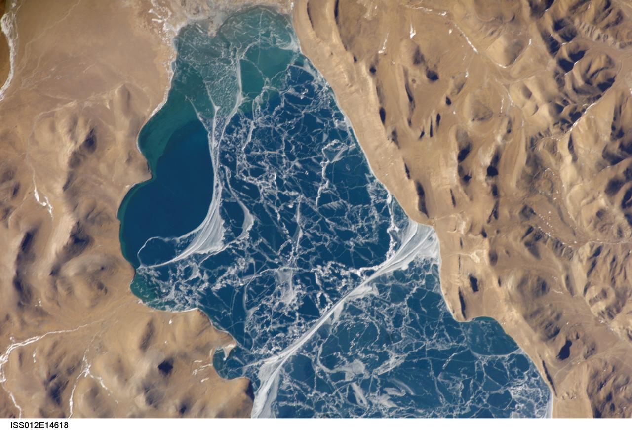
ISS012-E-14618 (6 Jan. 2006) --- A portion of Lake Puma Yumco and parts of Tibet and China are featured in this image photographed by an Expedition 12 crew member on the International Space Station. The alpine lakes of the Tibetan Plateau are some of the most remote in the world. This image depicts Lake Puma Yumco during the winter season. The lake is located at an elevation of 5,030 meters above sea level, and is considered ultraoligotrophic in that nutrient concentrations in both the water column and lake sediments are extremely low. Water in such lakes tends to be blue to blue-green and have high clarity due to the lack of abundant photosynthesizing organisms such as phytoplankton. Water color change in these lakes is usually due to shallowing of the water – blue indicating deeper water - as is visible in the depth transition along the west/southwestern shoreline (left). The maximum dimensions of the lake are 31 kilometers by 14 kilometers, indicating that the ice blocks range from less than ten to hundreds of meters in diameter. According to scientists, the ice pattern is caused by repeated cycles of freezing, fracturing, and refreezing of the ice due to variations in temperature and wind-induced ice motion. A prominent white linear feature extending north-south across the center of the lake (lower center) is suggestive of an ice ridge formed by east-west winds subsequently highlighted by snow.

This image shows the western part of the dune field on the floor of Russell Crater. Russell Crater is located in Noachis Terra. A spectacular dune ridge and other dune forms on the crater floor have caused extensive imaging. The Odyssey spacecraft has spent over 15 years in orbit around Mars, circling the planet more than 69000 times. It holds the record for longest working spacecraft at Mars. THEMIS, the IR/VIS camera system, has collected data for the entire mission and provides images covering all seasons and lighting conditions. Over the years many features of interest have received repeated imaging, building up a suite of images covering the entire feature. From the deepest chasma to the tallest volcano, individual dunes inside craters and dune fields that encircle the north pole, channels carved by water and lava, and a variety of other feature, THEMIS has imaged them all. For the next several months the image of the day will focus on the Tharsis volcanoes, the various chasmata of Valles Marineris, and the major dunes fields. We hope you enjoy these images! Orbit Number: 33970 Latitude: -54.3831 Longitude: 12.3712 Instrument: VIS Captured: 2009-08-11 09:20 https://photojournal.jpl.nasa.gov/catalog/PIA21802

The interior layered mesa in Hebes Chasma is visible at the top of this image. The southern cliff face is at the bottom. A landslide deposit is visible originating from the southern cliff face. Hebes Chasma is an enclosed basin not connected to Valles Marineris. The Odyssey spacecraft has spent over 15 years in orbit around Mars, circling the planet more than 69000 times. It holds the record for longest working spacecraft at Mars. THEMIS, the IR/VIS camera system, has collected data for the entire mission and provides images covering all seasons and lighting conditions. Over the years many features of interest have received repeated imaging, building up a suite of images covering the entire feature. From the deepest chasma to the tallest volcano, individual dunes inside craters and dune fields that encircle the north pole, channels carved by water and lava, and a variety of other feature, THEMIS has imaged them all. For the next several months the image of the day will focus on the Tharsis volcanoes, the various chasmata of Valles Marineris, and the major dunes fields. We hope you enjoy these images! Orbit Number: 46042 Latitude: -1.47735 Longitude: 282.848 Instrument: VIS Captured: 2012-05-01 06:12 https://photojournal.jpl.nasa.gov/catalog/PIA21818
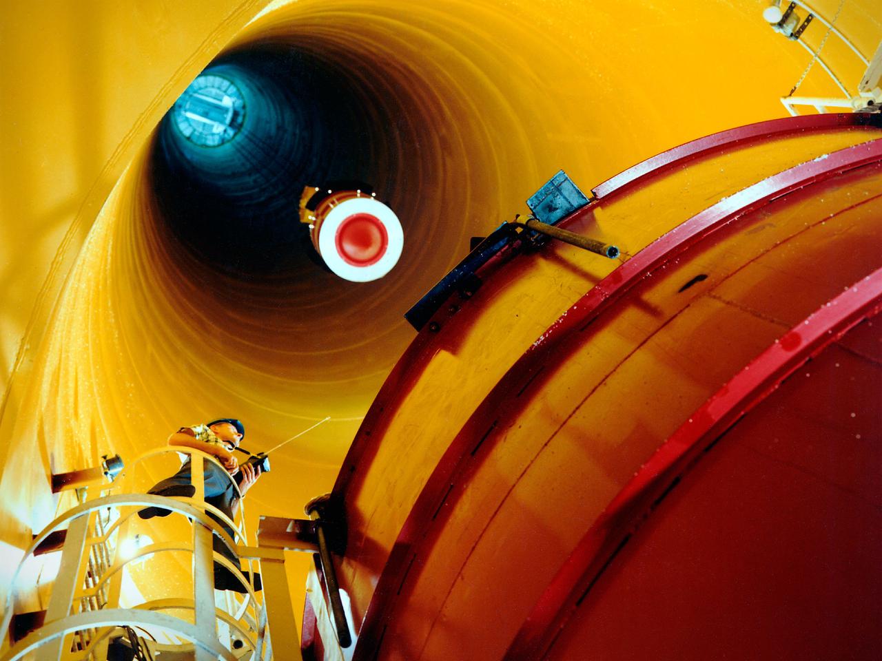
National Aeronautics and Space Administration (NASA) Lewis Research Center. Lewis researchers had been studying the behavior of liquid in microgravity for several years using ballistic rocket flights, aircraft flying series of parabolas, and in the 2.2-Second Drop Tower. It was easier to control experiments and repeat tests based on almost instantaneous test results in the Zero Gravity Research Facility than missiles or aircraft. It also more than doubled the microgravity time of the original drop tower. The experiments were enclosed in a large experiment package that was suspended inside the chamber. A vacuum was introduced to the chamber before the package was released. The test equipment allowed researchers to film and take measurements of the experiment as it was falling. The 2500‐pound package was slowed by special Styrofoam‐like pellets in a decelerator cart. An experiment, traveling 176 feet per second, was stopped in about 15 feet of deceleration material. The facility’s designers struggled to determine the correct type of deceleration pellets to use. For several years Lewis engineers tested various samples from manufacturers. The final selection was not made until the facility’s completion in May 1966, just before the facility made its public debut at the 1966 Inspection of the Center.
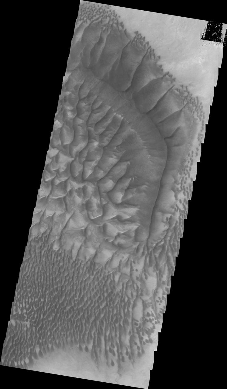
This image shows the central part of the dune field on the floor of Russell Crater. The large ridge "bends" about 60 degrees from parallel to the right side of the image to angle towards the upper left corner. Russell Crater is located in Noachis Terra. A spectacular dune ridge and other dune forms on the crater floor have caused extensive imaging. The Odyssey spacecraft has spent over 15 years in orbit around Mars, circling the planet more than 69000 times. It holds the record for longest working spacecraft at Mars. THEMIS, the IR/VIS camera system, has collected data for the entire mission and provides images covering all seasons and lighting conditions. Over the years many features of interest have received repeated imaging, building up a suite of images covering the entire feature. From the deepest chasma to the tallest volcano, individual dunes inside craters and dune fields that encircle the north pole, channels carved by water and lava, and a variety of other feature, THEMIS has imaged them all. For the next several months the image of the day will focus on the Tharsis volcanoes, the various chasmata of Valles Marineris, and the major dunes fields. We hope you enjoy these images! Orbit Number: 34232 Latitude: -54.4921 Longitude: 12.9013 Instrument: VIS Captured: 2009-09-01 23:04 https://photojournal.jpl.nasa.gov/catalog/PIA21804
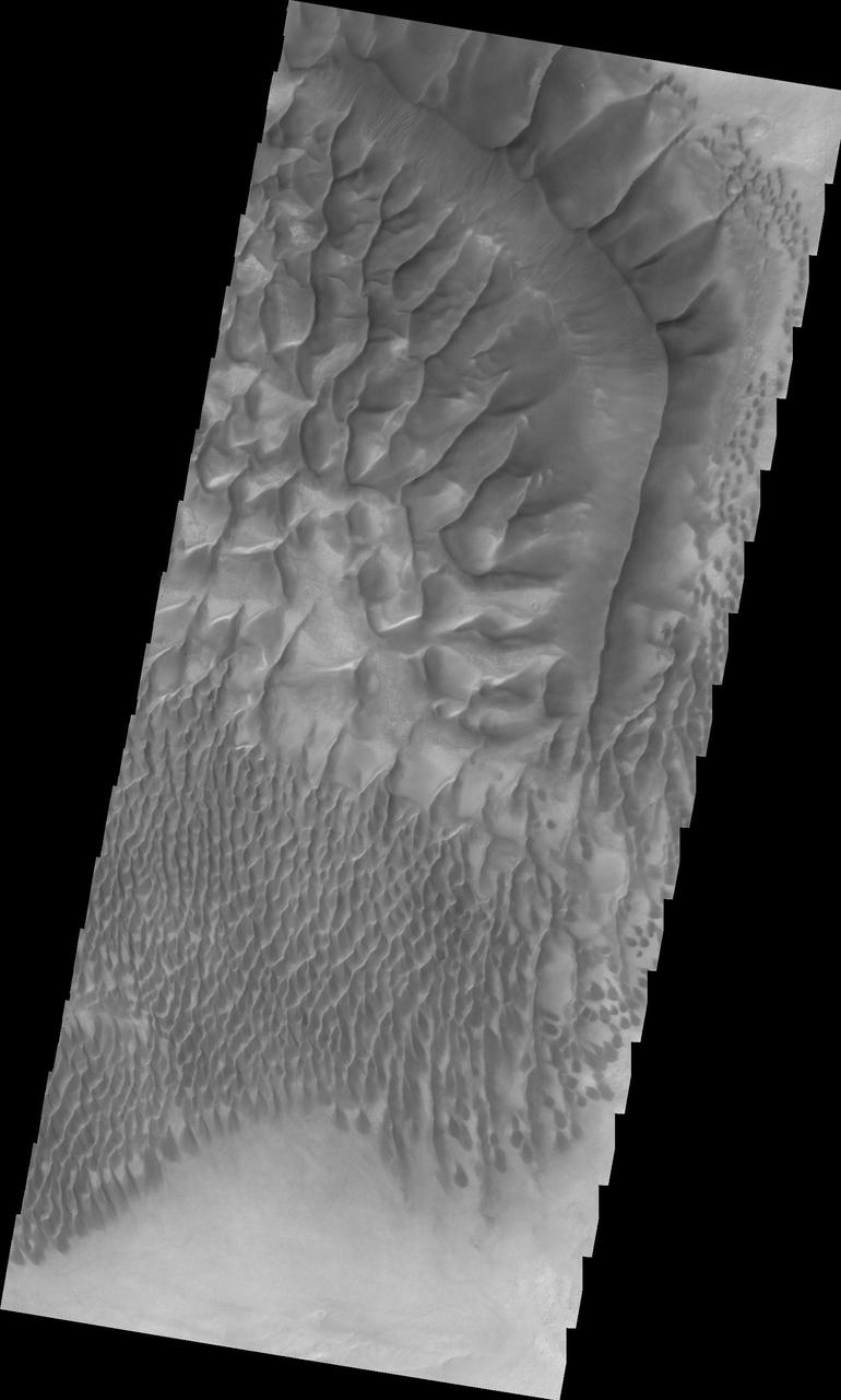
This image shows the central part of the dune field on the floor of Russell Crater. Russell Crater is located in Noachis Terra. A spectacular dune ridge and other dune forms on the crater floor have caused extensive imaging. The Odyssey spacecraft has spent over 15 years in orbit around Mars, circling the planet more than 69000 times. It holds the record for longest working spacecraft at Mars. THEMIS, the IR/VIS camera system, has collected data for the entire mission and provides images covering all seasons and lighting conditions. Over the years many features of interest have received repeated imaging, building up a suite of images covering the entire feature. From the deepest chasma to the tallest volcano, individual dunes inside craters and dune fields that encircle the north pole, channels carved by water and lava, and a variety of other feature, THEMIS has imaged them all. For the next several months the image of the day will focus on the Tharsis volcanoes, the various chasmata of Valles Marineris, and the major dunes fields. We hope you enjoy these images! Orbit Number: 34856 Latitude: -54.5757 Longitude: 12.8629 Instrument: VIS Captured: 2009-10-23 08:04 https://photojournal.jpl.nasa.gov/catalog/PIA21806
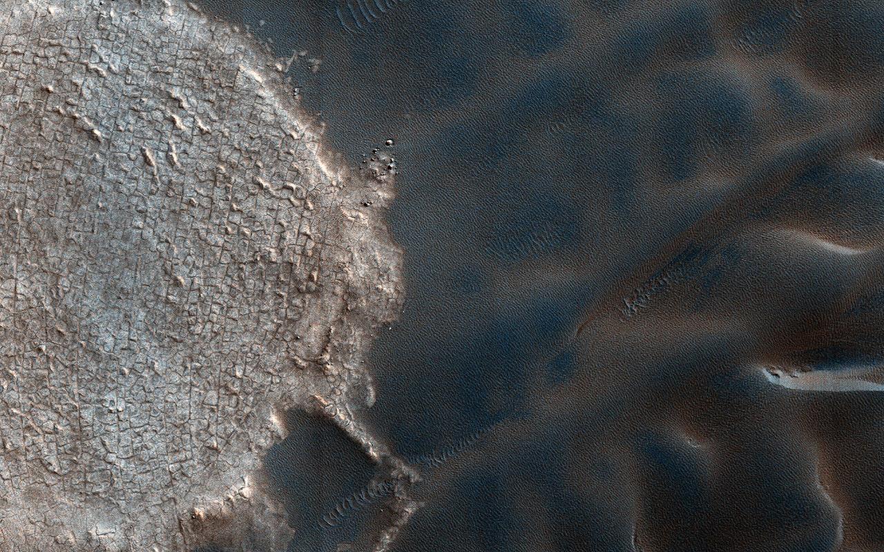
Mega-ripples are distinct wind-driven formations that occur on the surface of Earth and Mars, often with sizes between that of smaller ripples and larger dunes. Based on their shapes and examples of fractured crests in some areas, mega-ripples are thought to be largely inactive relics of past climates. Thanks to repeat coverage by HiRISE, we can tell that some mega-ripple fields are active and migrating alongside dunes and ripples. In a down-wind perspective view we can see mega-ripples collecting along the flanks of the dark sand dunes near the North Polar deposits. A closer look illustrates the fine scale details of some active mega-ripples during the summer. Landforms across these North Polar latitudes become ice-cemented when wintertime carbon dioxide ice buries dunes. Then the ice sublimates through the northern spring until dunes and mega-ripples become "frost free" and mobile by summer. It is these summertime seasonal winds that drive the enhanced activity of migrating mega-ripples of the North Polar region. https://photojournal.jpl.nasa.gov/catalog/PIA25449

This image shows part of the western side of Hebes Chasma. The large central mesa is on the right side of the image. The smooth region in the lower left side of the image is a region of sand and sand dunes. These features indicate that winds played a part in eroding materials inside the chasma. Hebes Chasma is an enclosed basin not connected to Valles Marineris. The Odyssey spacecraft has spent over 15 years in orbit around Mars, circling the planet more than 69000 times. It holds the record for longest working spacecraft at Mars. THEMIS, the IR/VIS camera system, has collected data for the entire mission and provides images covering all seasons and lighting conditions. Over the years many features of interest have received repeated imaging, building up a suite of images covering the entire feature. From the deepest chasma to the tallest volcano, individual dunes inside craters and dune fields that encircle the north pole, channels carved by water and lava, and a variety of other feature, THEMIS has imaged them all. For the next several months the image of the day will focus on the Tharsis volcanoes, the various chasmata of Valles Marineris, and the major dunes fields. We hope you enjoy these images! Orbit Number: 16841 Latitude: -0.660183 Longitude: 282.319 Instrument: VIS Captured: 2005-09-30 23:26 https://photojournal.jpl.nasa.gov/catalog/PIA21813
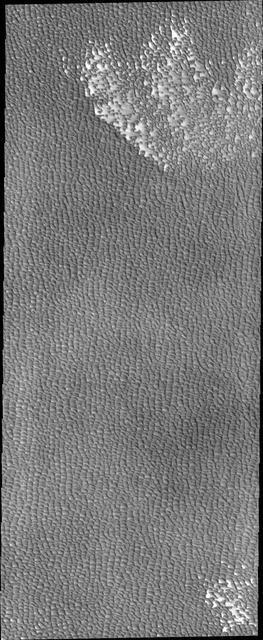
Siton Undae is a large dune field located in the northern plains near Escorial Crater. Siton Undae is west of the crater and is one of three dune fields near the crater. The nearby north polar cap is dissected by Chasma Boreale, which exposes an ice free surface. This image shows part of the southern extent of the dune field. The Odyssey spacecraft has spent over 15 years in orbit around Mars, circling the planet more than 69000 times. It holds the record for longest working spacecraft at Mars. THEMIS, the IR/VIS camera system, has collected data for the entire mission and provides images covering all seasons and lighting conditions. Over the years many features of interest have received repeated imaging, building up a suite of images covering the entire feature. From the deepest chasma to the tallest volcano, individual dunes inside craters and dune fields that encircle the north pole, channels carved by water and lava, and a variety of other feature, THEMIS has imaged them all. For the next several months the image of the day will focus on the Tharsis volcanoes, the various chasmata of Valles Marineris, and the major dunes fields. We hope you enjoy these images! Orbit Number: 46166 Latitude: 74.717 Longitude: 295.529 Instrument: VIS Captured: 2012-05-11 12:43 https://photojournal.jpl.nasa.gov/catalog/PIA21833
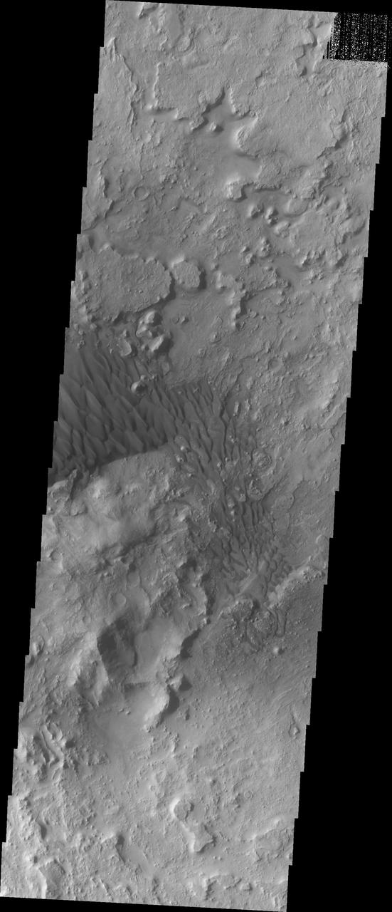
Located in eastern Arabia is an unnamed crater, 120 kilometers (75 miles) across. The floor of this crater contains a large exposure of rocky material, a field of dark sand dunes, and numerous patches of what is probably fine-grain sand. The shape of the dunes indicate that prevailing winds have come from different directions over the years. The Odyssey spacecraft has spent over 15 years in orbit around Mars, circling the planet more than 71,000 times. It holds the record for longest working spacecraft at Mars. THEMIS, the IR/VIS camera system, has collected data for the entire mission and provides images covering all seasons and lighting conditions. Over the years many features of interest have received repeated imaging, building up a suite of images covering the entire feature. From the deepest chasma to the tallest volcano, individual dunes inside craters and dune fields that encircle the north pole, channels carved by water and lava, and a variety of other feature, THEMIS has imaged them all. For the next several months the image of the day will focus on the Tharsis volcanoes, the various chasmata of Valles Marineris, and the major dunes fields. We hope you enjoy these images! Orbit Number: 11469 Latitude: 26.6454 Longitude: 63.0499 Instrument: VIS Captured: 2004-07-15 18:09 https://photojournal.jpl.nasa.gov/catalog/PIA22298
This graphic overlays Martian atmospheric temperature data as curtains over an image of Mars taken during a regional dust storm. The temperature profiles extend from the surface to about 50 miles (80 kilometers) up. Temperatures are color coded, ranging from minus 243 degrees Fahrenheit (minus 153 degrees Celsius) where coded purple to minus 9 F (minus 23 C) where coded red. The temperature data and global image were both recorded on Oct. 18, 2014, by instruments on NASA's Mars Reconnaissance Orbiter: Mars Climate Sounder and Mars Color Imager. On that day a regional dust storm was active in the Acidalia Planitia region of northern Mars, at the upper center of this image. A storm from this area in typically travels south and grows into a large regional storm in the southern hemisphere during southern spring. That type of southern-spring storm and two other large regional dust storms repeat as a three-storm series most Martian years. The pattern has been identified from their effects on atmospheric temperature in a layer about 16 miles (25 kilometers) above the surface. http://photojournal.jpl.nasa.gov/catalog/PIA20747
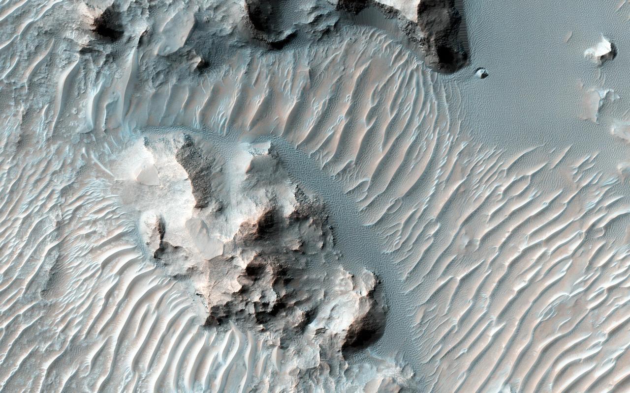
Schaeberle Crater is a large, heavily-infilled crater with many interesting features. This image NASA Mars Reconnaissance Orbiter spacecraft shows a window into the crater fill deposit, showcasing eroding bedrock and aeolian landforms. This pit is located near the geometric center of our image, making it a central pit crater. Central pit craters are thought to form from impact melt draining through subsurface cracks in the deepest part of the crater shortly following impact. A closeup image shows light-toned bedrock and a small cliff that appears to be weathering away. Below the cliff there are several different types of aeolian features, including ripples and transverse aeolian ridges (TAR). The sand that forms the small, bluish ripples may be weathering out of the cliff face, in contrast to the larger, light-toned TAR which are thought to be currently inactive. More of the TAR are visible in another closeup image. In this case, they are clearly covered by a dark, ripple-covered sand sheet. We have only imaged this location once, so it is impossible to determine whether or not the sand sheet is blowing in the wind. But due to repeated HiRISE imaging in other areas, active dunes are now known to be common across Mars and we can reasonably speculate that these dunes are moving, too. http://photojournal.jpl.nasa.gov/catalog/PIA20339