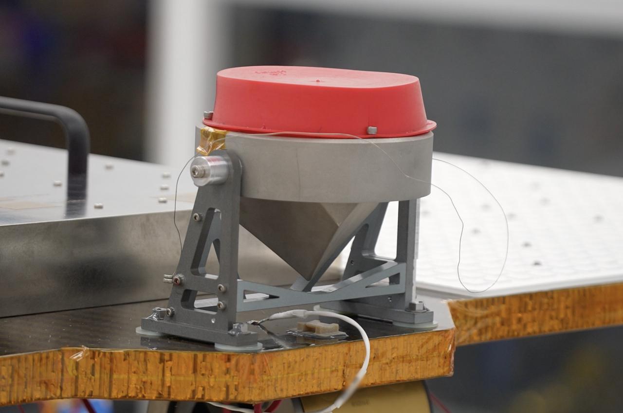
A science instrument flying aboard the next delivery for NASA’s CLPS (Commercial Lunar Payload Services) initiative is expected to significantly expand our knowledge of the Moon. Next Generation Lunar Retroreflector, or NGLR-1, is one of 10 payloads set to be carried to the Moon by the Blue Ghost 1 lunar lander in 2025. Developed by the University of Maryland in College Park, NGLR-1 is designed to reflect very short laser pulses from Earth-based lunar laser ranging observatories using a retroreflector, or a mirror designed to reflect the incoming light back in the same incoming direction. Investigations and demonstrations, such as NGLR-1, launched on CLPS flights will help NASA study Earth’s nearest neighbor under Artemis and pave the way for future crewed missions on the Moon. NASA’s Marshall Space Flight Center in Huntsville, Alabama, manages the development for seven of the 10 CLPS payloads that will be carried on Firefly’s Blue Ghost lunar lander.
The Apollo 15 Lunar Laser Ranging Retroreflector - A Fundamental Point on the Moon
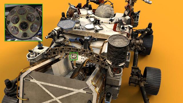
Visible near the center of NASA's Perseverance Mars rover in this illustration is the palm-size dome called the Laser Retroreflector Array (LaRA). In the distant future, laser-equipped Mars orbiters could use such a reflector for scientific studies. https://photojournal.jpl.nasa.gov/catalog/PIA24097
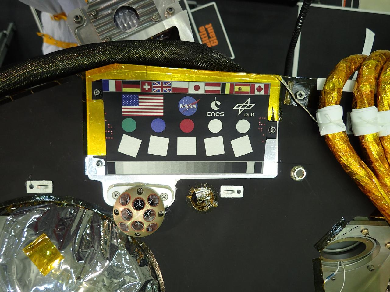
A camera calibration target sits on the deck of the NASA's InSight lander, adorned with the flags of the countries participating in the mission. The target, which will be viewed by InSight's cameras, provides a variety of colors and shapes to help calibrate the lander's cameras. It also shows off international flags representing the agencies, institutions and participating scientists of the mission as of late 2014 (since that time, Italy has contributed an experiment). In the second row are the United States flag and the logos of NASA, the French space agency CNES, which provided InSight's seismometer; and the German Aerospace Center DLR, which provided InSight's heat flow probe. Below the target in the photo is an Italian experiment called the Laser Retroreflector for InSight (LaRRI). LaRRI is the small, copper-colored dome covered with circles just below the calibration target; it won't actually play a role in InSight's mission. The national space agency of Italy (ASI, for Agenzia Spaziale Italiana) provided LaRRI to be used by a possible future Mars orbiter mission with a laser altimeter making extremely precise measurements of the lander's location for fundamental physics studies and precision cartography. A microchip bearing the names of nearly a million members of the public is visible in this image to the right of the calibration target. A second microchip with more than a million additional names was added after this photo was taken. https://photojournal.jpl.nasa.gov/catalog/PIA22540
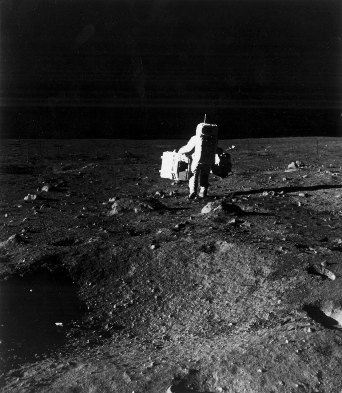
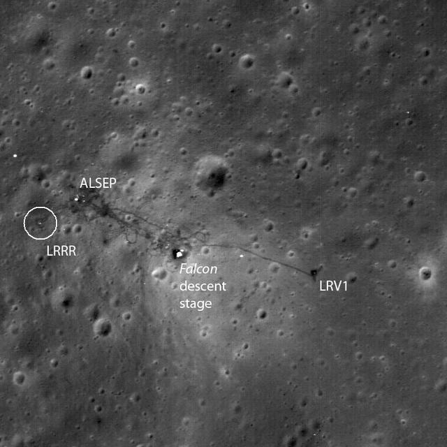
The first manned lunar landing mission, Apollo 11, launched from the Kennedy Space Center (KSC) in Florida via the Marshall Space Flight Center (MSFC) developed Saturn V launch vehicle on July 16, 1969 and safely returned to Earth on July 24, 1969. Aboard the space craft were astronauts Neil A. Armstrong, commander; Michael Collins, Command Module (CM) pilot; and Edwin E. (Buzz) Aldrin Jr., Lunar Module (LM) pilot. The CM, piloted by Michael Collins, remained in a parking orbit around the Moon, while the LM, named “Eagle’’, carrying astronauts Armstrong and Aldrin, landed on the Moon in the Sea of Tranquility. During 2½ hours of surface exploration, the crew set up experiments, collected 47 pounds of lunar surface material for analysis back on Earth, planted the U.S. Flag, and left a message for all mankind. In this photograph, Aldrin walks past some rocks, easily carrying scientific equipment experiements, which would have been to heavy too carry on Earth. The two packages made up the Early Apollo Scientific Experiment Package (EASEP) on Apollo 11. On the left is the Passive Seismic Experiment Package (PSEP) and on the right is the Laser Ranging Retroreflector (LRRR).
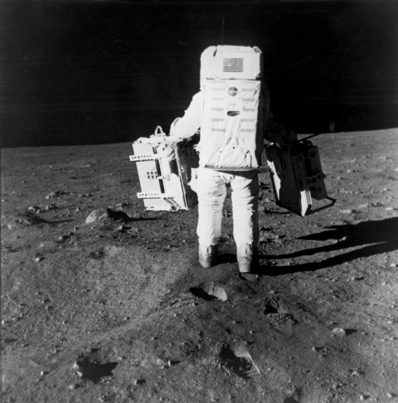
The first manned lunar landing mission, Apollo 11, launched from the Kennedy Space Center (KSC) in Florida via the Marshall Space Flight Center (MSFC) developed Saturn V launch vehicle on July 16, 1969 and safely returned to Earth on July 24, 1969. Aboard the space craft were astronauts Neil A. Armstrong, commander; Michael Collins, Command Module (CM) pilot; and Edwin E. (Buzz) Aldrin Jr., Lunar Module (LM) pilot. The CM, piloted by Michael Collins, remained in a parking orbit around the Moon, while the LM, named “Eagle’’, carrying astronauts Armstrong and Aldrin, landed on the Moon in the Sea of Tranquility. During 2½ hours of surface exploration, the crew set up experiments, collected 47 pounds of lunar surface material for analysis back on Earth, planted the U.S Flag, and left a message for all mankind. In this photograph, Aldrin walks past some rocks, easily carrying scientific equipment which would have been too heavy to carry on Earth. The two packages made up the Early Apollo Scientific Experiment Package (EASEP) on Apollo 11. On the left is the Passive Seismic Experiment Package (PSEP) and on the right is the Laser Ranging Retroreflector (LRR).

A shipping container containing the Sentinel-6 Michael Freilich satellite is transported on a truck to the SpaceX payload processing facility at Vandenberg Air Force Base after arriving in California on Sept. 24, 2020. An Antonov aircraft carrying the spacecraft arrived at around 10:40 a.m. PDT (1:40 p.m. EDT) after a two-day journey from an IABG engineering facility near Munich, Germany. The ocean-monitoring satellite will undergo prelaunch tests before its scheduled launch on Nov. 10, 2020. Sentinel-6 Michael Freilich will begin a five-and-a-half-year mission to collect sea surface height measurements down to the centimeter for 90% of the world's oceans. The satellite is named after Dr. Michael Freilich, the former director of NASA's Earth Science Division and an instrumental figure in advancing ocean observations from space. Sentinel-6 Michael Freilich is one of two identical spacecraft that compose the Sentinel-6/Jason-CS (Continuity of Service) mission developed in partnership with ESA (the European Space Agency). ESA is developing the new Sentinel family of missions to support the operational needs of the European Union's Copernicus program, the EU's Earth observation program managed by the European Commission. The spacecraft's twin, Sentinel-6B, will launch in 2025. Sentinel-6/Jason-CS is being jointly developed by ESA, the European Organisation for the Exploitation of Meteorological Satellites (EUMETSAT), NASA, and the National Oceanic and Atmospheric Administration, with funding support from the European Commission and technical support from France's National Centre for Space Studies (CNES). JPL, a division of Caltech in Pasadena, is contributing three science instruments for each Sentinel-6 satellite: the Advanced Microwave Radiometer, the Global Navigation Satellite System - Radio Occultation, and the Laser Retroreflector Array. NASA is also contributing launch services, ground systems supporting operation of the NASA science instruments, the science data processors for two of these instruments, and support for the international Ocean Surface Topography Science Team. https://photojournal.jpl.nasa.gov/catalog/PIA24104
Workers in a clean room in Cannes, France, load the Surface Water and Ocean Topography (SWOT) satellite into a container in preparation for shipping the spacecraft to the U.S. SWOT is an international mission led by NASA and the French space agency Centre National d'Études Spatiales (CNES) that will survey water on more than 90% of Earth's surface. The spacecraft will view water in Earth's lakes, rivers, reservoirs, and the ocean in higher definition than ever before. The information that SWOT gathers will help inform water management decisions and prepare communities for rising seas and changing coastlines. It will also help researchers better understand the exchange of heat and carbon between the ocean and atmosphere, an important component of the role that Earth's ocean plays in the planet's climate. SWOT will launch out of the Vandenberg Space Force Base in central California no earlier than Dec. 5, 2022. SWOT is being jointly developed by NASA and CNES, with contributions from the Canadian Space Agency and the United Kingdom Space Agency. JPL, which is managed for NASA by Caltech in Pasadena, California, leads the U.S. component of the project. For the flight system payload, NASA is providing the KaRIn instrument, a GPS science receiver, a laser retroreflector, a two-beam microwave radiometer, and NASA instrument operations. CNES is providing the Doppler Orbitography and Radioposition Integrated by Satellite (DORIS) system, the dual frequency Poseidon altimeter (developed by Thales Alenia Space), the KaRIn radio-frequency subsystem (together with Thales Alenia Space and with support from the UK Space Agency), the platform, and ground control segment. CSA is providing the KaRIn high-power transmitter assembly. NASA is providing the launch vehicle and associated launch services. https://photojournal.jpl.nasa.gov/catalog/PIA24910
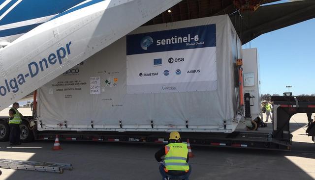
A shipping container containing the Sentinel-6 Michael Freilich satellite is removed from an Antonov 124 aircraft at Vandenberg Air Force Base in California on Sept. 24, 2020. The flight arrived at around 10:40 a.m. PDT (1:40 p.m. EDT) after a two-day journey from an IABG engineering facility near Munich, Germany. The ocean-monitoring satellite will undergo prelaunch tests before its scheduled launch on Nov. 10, 2020. Sentinel-6 Michael Freilich will begin a five-and-a-half-year mission to collect sea surface height measurements down to the centimeter for 90% of the world's oceans. The satellite is named after Dr. Michael Freilich, the former director of NASA's Earth Science Division and an instrumental figure in advancing ocean observations from space. Sentinel-6 Michael Freilich is one of two identical spacecraft that compose the Sentinel-6/Jason-CS (Continuity of Service) mission developed in partnership with ESA (the European Space Agency). ESA is developing the new Sentinel family of missions specifically to support the operational needs of the European Union's Copernicus program, the EU's Earth observation program managed by the European Commission. The spacecraft's twin, Sentinel-6B, will launch in 2025. Sentinel-6/Jason-CS is being jointly developed by ESA, the European Organisation for the Exploitation of Meteorological Satellites (EUMETSAT), NASA, and the National Oceanic and Atmospheric Administration, with funding support from the European Commission and technical support from France's National Centre for Space Studies (CNES). NASA JPL is contributing three science instruments for each Sentinel-6 satellite: the Advanced Microwave Radiometer, the Global Navigation Satellite System - Radio Occultation, and the Laser Retroreflector Array. NASA is also contributing launch services, ground systems supporting operation of the NASA science instruments, the science data processors for two of these instruments, and support for the international Ocean Surface Topography Science Team. https://photojournal.jpl.nasa.gov/catalog/PIA24103
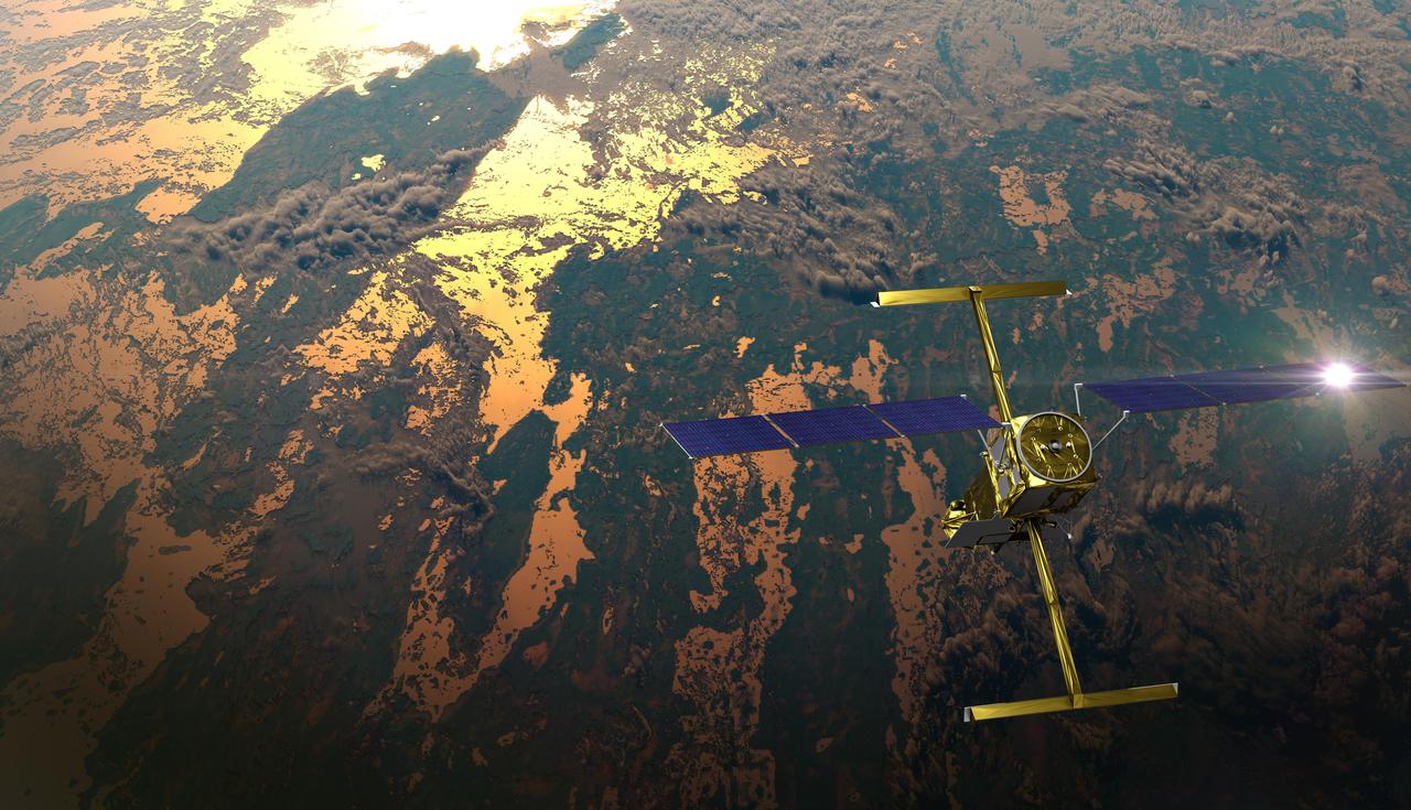
The international Surface Water and Ocean Topography (SWOT) satellite is shown in orbit over Earth in this illustration, with sunlight glinting off one of its solar arrays and both antennas of its Ka-band Radar Interferometer (KaRIn) instrument extended. The mission is a collaborative effort between NASA and the French space agency Centre National d'Études Spatiales (CNES) – with contributions from the Canadian Space Agency (CSA) and the UK Space Agency. KaRIn is the scientific heart of the SWOT satellite, which will survey the water on more than 90% of Earth's surface, measuring the height of water in lakes, rivers, reservoirs, and the ocean. To do that, KaRIn will transmit radar pulses to Earth's surface and use its two antennas to triangulate the return signals that bounce back. Mounted at the ends of a boom 33 feet (10 meters) long, the antennas will collect data along a swath 30 miles (50 kilometers) wide on either side of the satellite. KaRIn will operate in two modes: A lower-resolution mode over the ocean will involve significant onboard processing of the data to reduce the volume of information sent during downlinks to Earth; a higher-resolution mode will be used mainly over land. Scheduled to launch from Vandenberg Space Force Base in Central California on Dec. 15, 2022, SWOT is being jointly developed by NASA and CNES, with contributions from the CSA and the UK Space Agency. NASA's Jet Propulsion Laboratory, which is managed for the agency by Caltech in Pasadena, California, leads the U.S. component of the project. For the flight system payload, NASA is providing the Ka-band Radar Interferometer (KaRIn) instrument, a GPS science receiver, a laser retroreflector, a two-beam microwave radiometer, and NASA instrument operations. CNES is providing the Doppler Orbitography and Radioposition Integrated by Satellite (DORIS) system, the dual frequency Poseidon altimeter (developed by Thales Alenia Space), the KaRIn radio-frequency subsystem (together with Thales Alenia Space and with support from the UK Space Agency), the satellite platform, and ground control segment. CSA is providing the KaRIn high-power transmitter assembly. NASA is providing the launch vehicle and associated launch services. https://photojournal.jpl.nasa.gov/catalog/PIA25595

The new international satellite mission called Surface Water and Ocean Topography (SWOT) — slated for launch in late 2022 — will measure the height of Earth's surface water. The data the spacecraft will collect will help researchers understand and track the volume and location of water around the world. The satellite will assist with monitoring changes in floodplains and wetlands, measuring how much fresh water flows into and out of lakes and rivers and back to the ocean, and tracking regional shifts in sea level at scales never seen before. The satellite will also provide information on small-scale ocean currents that will support real-time marine operations affected by tides, currents, storm surge, sediment transport, and water quality issues. The payload is taking shape in a clean room at NASA's Jet Propulsion Laboratory in Southern California before being shipped to France. There, technicians and engineers from the French space agency Centre National d'Etudes Spatial (CNES), their prime contractor Thales Alenia Space, and JPL will complete the build and prepare the satellite for shipment to its California launch site at Vandenberg Air Force Base. JPL project manager Parag Vaze (pronounced vah-zay) is central to ensuring the handoff to his CNES counterpart Thierry Lafon goes smoothly. SWOT is being jointly developed by NASA and CNES, with contributions from the Canadian Space Agency (CSA) and United Kingdom Space Agency (UKSA). JPL, which is managed for NASA by Caltech in Pasadena, California, leads the U.S. component of the project. For the flight system, NASA is providing the Ka-band Radar Interferometer (KaRIn) instrument, a GPS science receiver, a laser retroreflector, and a two-beam microwave radiometer. CNES is providing the Doppler Orbitography and Radioposition Integrated by Satellite (DORIS) system, nadir altimeter, and the KaRIn RF subsystem (with support from the UKSA). CSA is providing the KaRIn high-power transmitter assembly. NASA is providing associated launch services. https://photojournal.jpl.nasa.gov/catalog/PIA24531
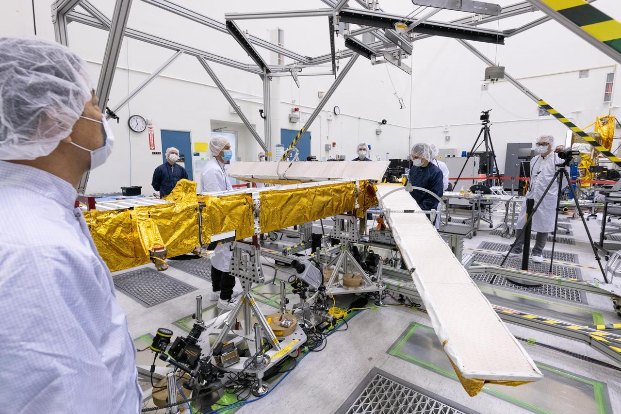
Members of the international Surface Water and Ocean Topography (SWOT) mission test one of the antennas for the Ka-band Radar Interferometer (KaRIn) instrument in a clean room at NASA's Jet Propulsion Laboratory in Southern California. The mission is a collaborative effort between NASA and the French space agency Centre National d'Études Spatiales (CNES) – with contributions from the Canadian Space Agency (CSA) and the UK Space Agency. KaRIn is the scientific heart of the SWOT satellite, which will survey the water on more than 90% of Earth's surface, measuring the height of water in lakes, rivers, reservoirs, and the ocean. To do that, KaRIn will transmit radar pulses to Earth's surface and use its two antennas to triangulate the return signals that bounce back. Mounted at the ends of a boom 33 feet (10 meters) long, the antennas will collect data along a swath 30 miles (50 kilometers) wide on either side of the satellite. KaRIn will operate in two modes: A lower-resolution mode over the ocean will involve significant onboard processing of the data to reduce the volume of information sent during downlinks to Earth; a higher-resolution mode will be used mainly over land. Scheduled to launch from Vandenberg Space Force Base in Central California on Dec. 15, 2022, SWOT is being jointly developed by NASA and CNES, with contributions from the CSA and the UK Space Agency. NASA's Jet Propulsion Laboratory, which is managed for the agency by Caltech in Pasadena, California, leads the U.S. component of the project. For the flight system payload, NASA is providing the Ka-band Radar Interferometer (KaRIn) instrument, a GPS science receiver, a laser retroreflector, a two-beam microwave radiometer, and NASA instrument operations. CNES is providing the Doppler Orbitography and Radioposition Integrated by Satellite (DORIS) system, the dual frequency Poseidon altimeter (developed by Thales Alenia Space), the KaRIn radio-frequency subsystem (together with Thales Alenia Space and with support from the UK Space Agency), the satellite platform, and ground control segment. CSA is providing the KaRIn high-power transmitter assembly. NASA is providing the launch vehicle and associated launch services. https://photojournal.jpl.nasa.gov/catalog/PIA25594