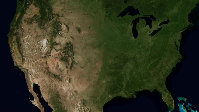
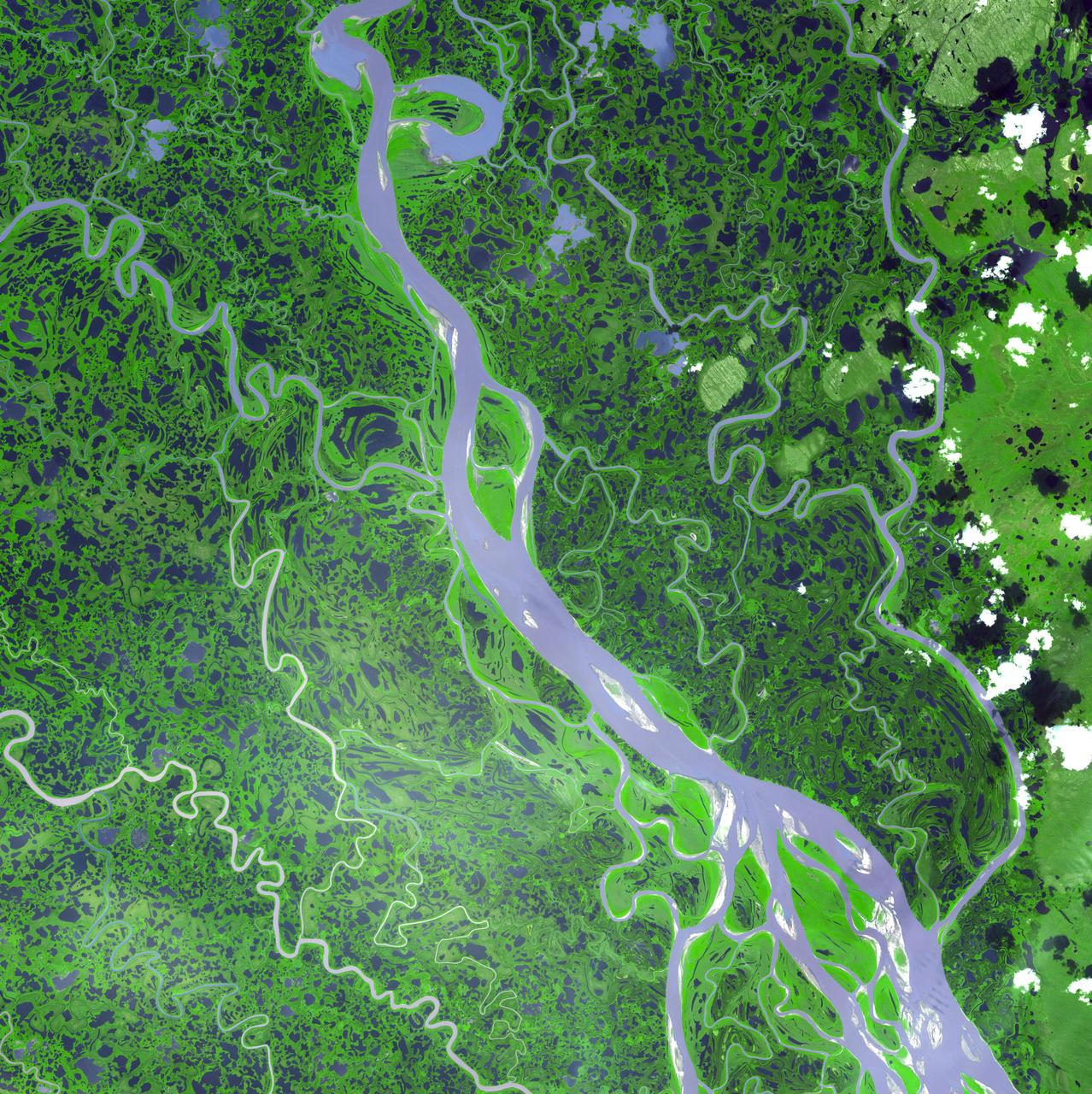
The Mississippi Watershed is the largest drainage basin in North America at 3.2 million square kilometers in area. The USGS has created a database of this area which indicates the direction of waterflow at each point. By assembling these directions into streamflows, it is possible to trace the path of water from every point of the area to the mouth of the Mississippi in the Gulf of Mexico. This animation starts with the points furthest from the Gulf and reveals the streams and rivers as a steady progression towards the mouth of the Mississippi until all the major rivers are revealed. The speed of the reveal of the rivers is not dependent on the actual speed of the water flow. The reveal proceeds at a constant velocity along each river path, timed so that all reveals reach the mouth of the Mississippi at the same time. This animation does not show actual flow rates of the rivers. All rivers are shown with identical rates. The river colors and widths correspond to the relative lengths of river segments. Credit: NASA's Scientific Visualization Studio/Horace Mitchell Go here to download this video: <a href="http://svs.gsfc.nasa.gov/4493" rel="nofollow">svs.gsfc.nasa.gov/4493</a>
Rivers of Craters
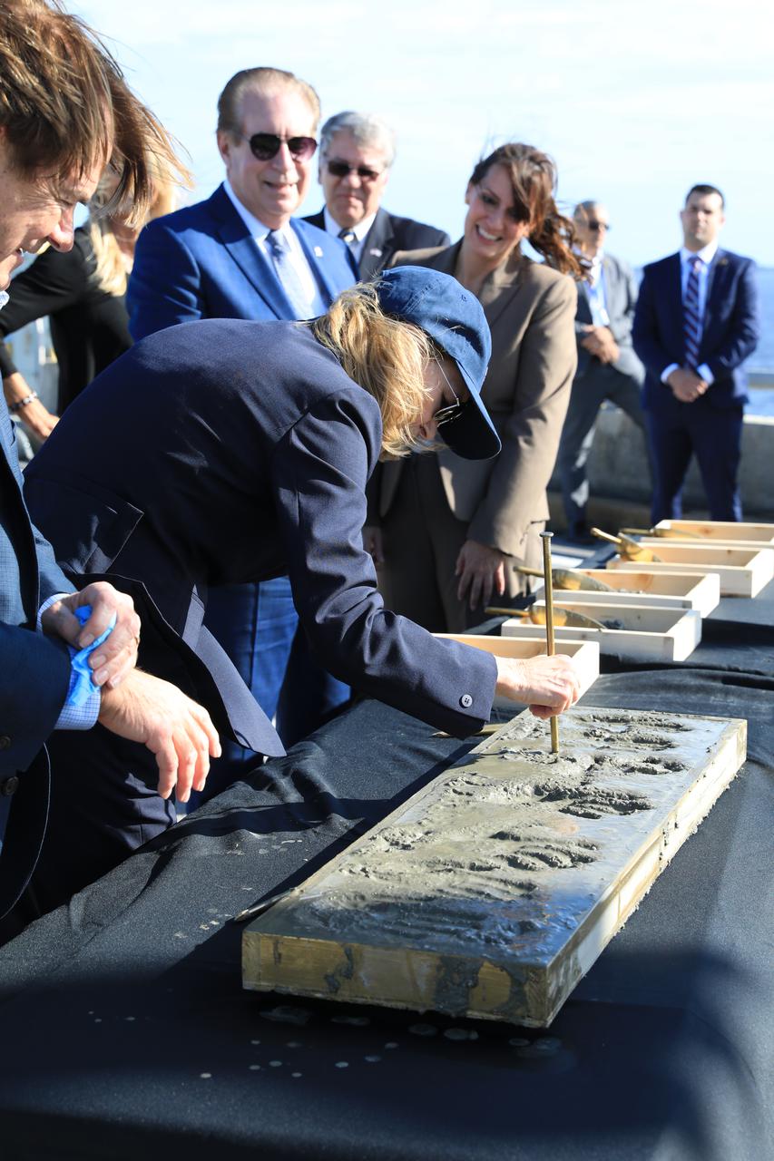
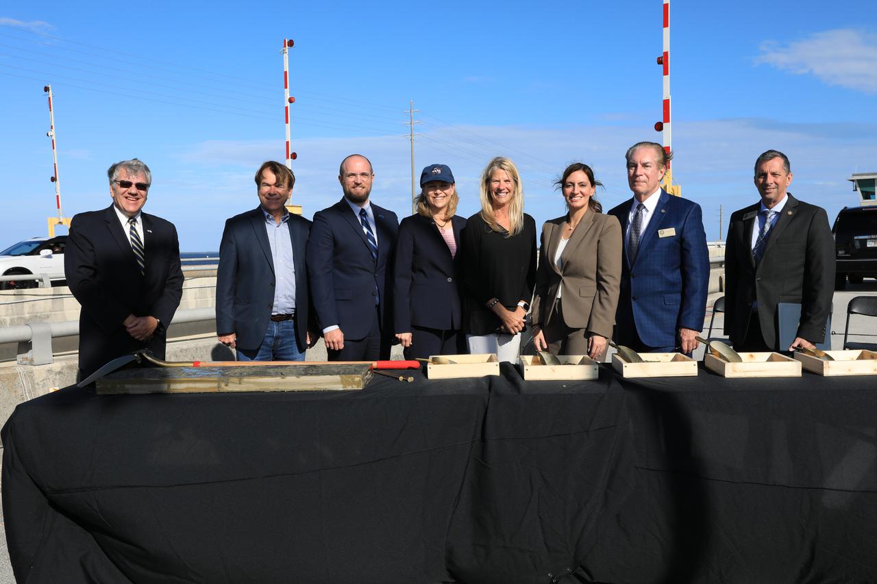
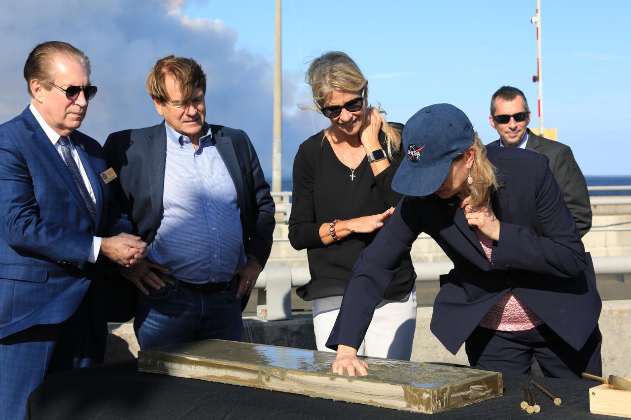
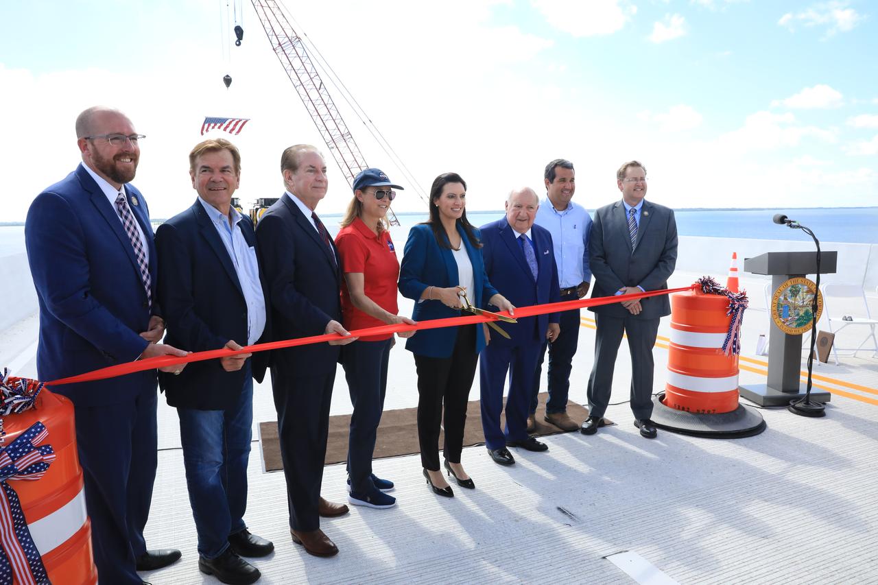
Center Director Janet Petro joins partners and elected officials for a groundbreaking ceremony on a new NASA Causeway bridge over the Indian River leading to NASA’s Kennedy Space Center on Merritt Island in Florida. The construction is made possible through a $90M Infrastructure for Rebuilding America (INFRA) grant, which was awarded thanks to an extensive effort by NASA, the State of Florida – through Florida Department of Transportation and Space Florida – as well as support from industry partners, other local, state, and federal government agencies. The new bridge enables Kennedy’s growth as a multi-user spaceport and will allow NASA to better support the space industry. Construction is scheduled to take several years. To commemorate the day, speakers left a handprint and signed their name in cement.
Center Director Janet Petro joins partners and elected officials for a groundbreaking ceremony on a new NASA Causeway bridge over the Indian River leading to NASA’s Kennedy Space Center on Merritt Island in Florida. The construction is made possible through a $90M Infrastructure for Rebuilding America (INFRA) grant, which was awarded thanks to an extensive effort by NASA, the State of Florida – through Florida Department of Transportation and Space Florida – as well as support from industry partners, other local, state, and federal government agencies. The new bridge enables Kennedy’s growth as a multi-user spaceport and will allow NASA to better support the space industry. Construction is scheduled to take several years. To commemorate the day, speakers left a handprint and signed their name in cement.
Center Director Janet Petro joins partners and elected officials for a groundbreaking ceremony on a new NASA Causeway bridge over the Indian River leading to NASA’s Kennedy Space Center on Merritt Island in Florida. The construction is made possible through a $90M Infrastructure for Rebuilding America (INFRA) grant, which was awarded thanks to an extensive effort by NASA, the State of Florida – through Florida Department of Transportation and Space Florida – as well as support from industry partners, other local, state, and federal government agencies. The new bridge enables Kennedy’s growth as a multi-user spaceport and will allow NASA to better support the space industry. Construction is scheduled to take several years. To commemorate the day, speakers left a handprint and signed their name in cement.
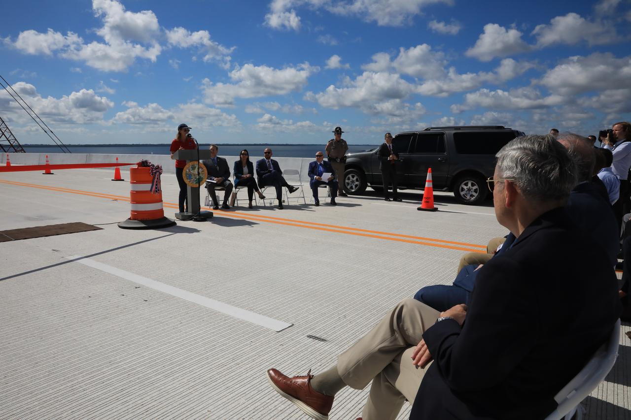
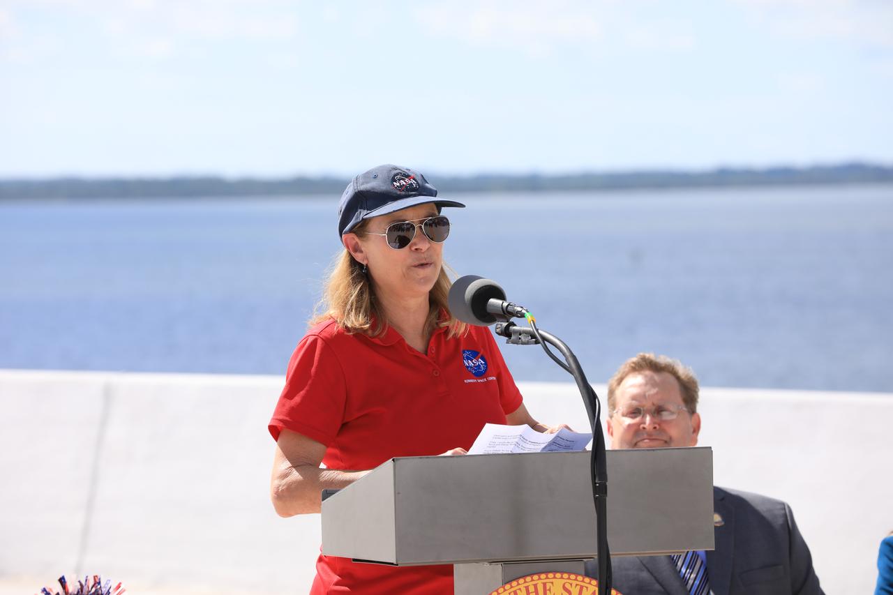
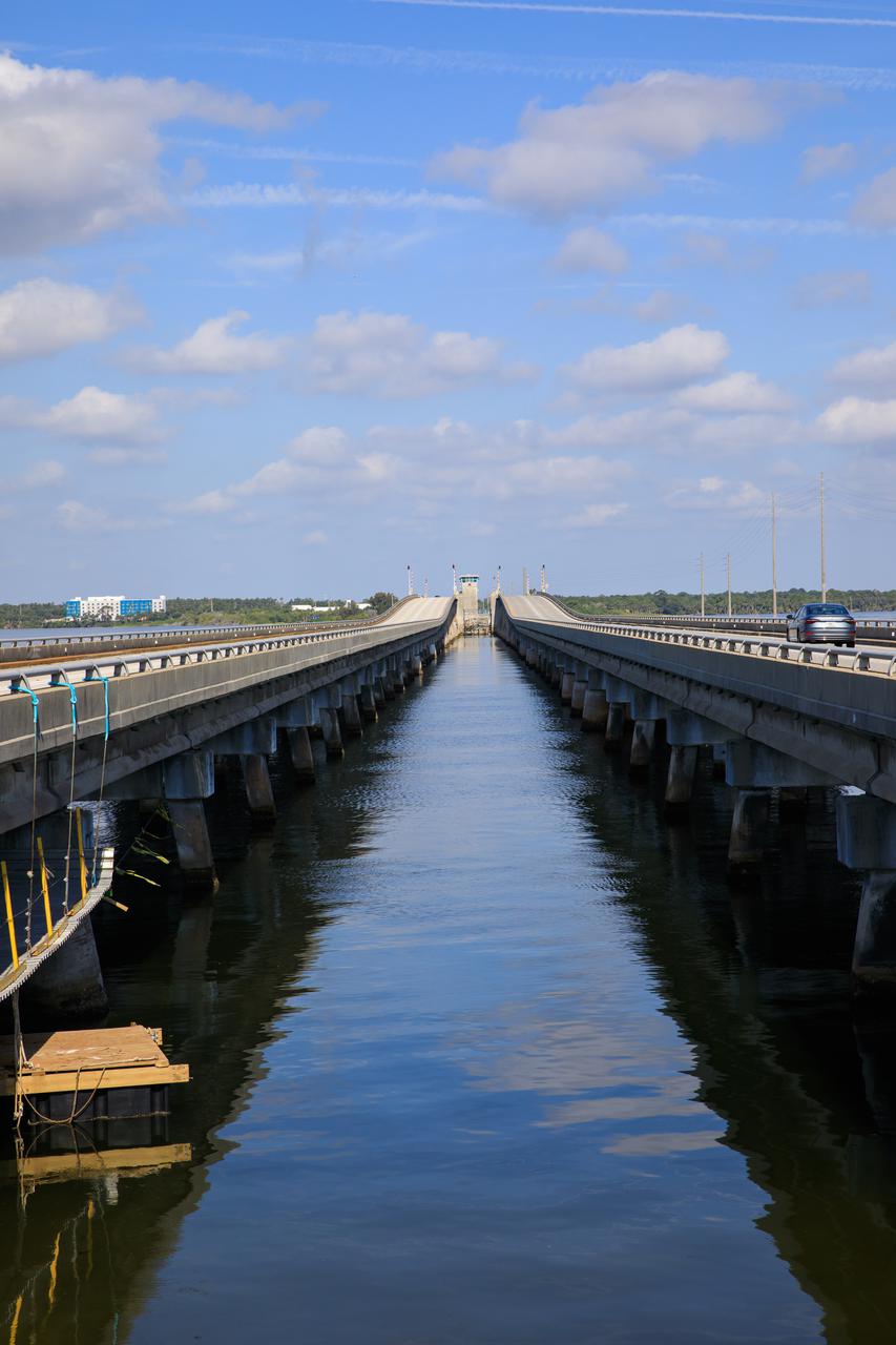
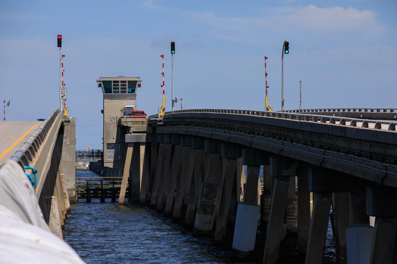
NASA Kennedy Space Center Director Janet Petro speaks during the grand opening ceremony for the upgraded eastbound span of the Indian River Bridge near Kennedy Space Center on June 9, 2023. The new high-rise bridge serves as the primary entrance and exit to the space center for employees and visitors. The bridge spans the Indian River Lagoon and connects Kennedy and the Cape Canaveral Space Force Station to the mainland via State Road 405/NASA Causeway in Titusville. This first section of the bridge replaces the two-lane drawbridge which was built in the mid-1960s to support the Apollo program.
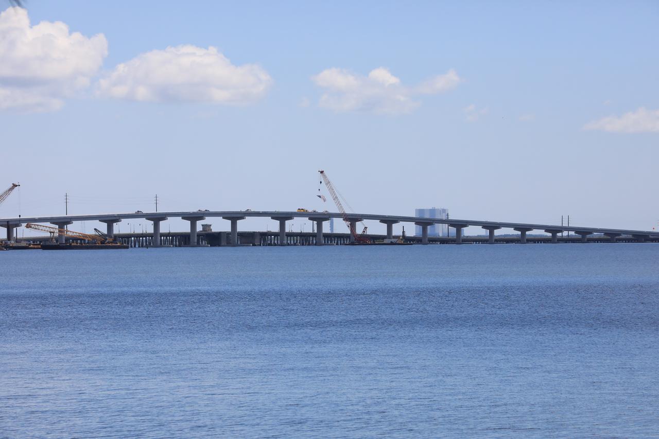
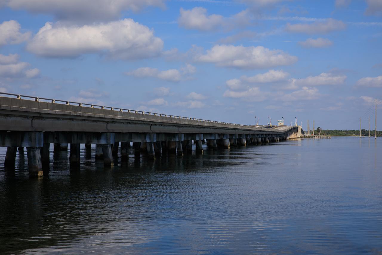
In view is the upgraded eastbound span of the Indian River Bridge leading to NASA’s Kennedy Space Center in Florida. A ribbon cutting ceremony was held June 9, 2023 to officially open the East part of the bridge. The new high-rise bridge serves as the primary entrance and exit to the space center for employees and visitors. The bridge spans the Indian River Lagoon and connects Kennedy and the Cape Canaveral Space Force Station to the mainland via State Road 405/NASA Causeway in Titusville. This first section of the bridge replaces the two-lane drawbridge which was built in the mid-1960s to support the Apollo program.
NASA Kennedy Space Center Director Janet Petro speaks during the grand opening ceremony for the upgraded eastbound span of the Indian River Bridge near the center on June 9, 2023. The new high-rise bridge serves as the primary entrance and exit to the space center for employees and visitors. The bridge spans the Indian River Lagoon and connects Kennedy and the Cape Canaveral Space Force Station to the mainland via State Road 405/NASA Causeway in Titusville. This first section of the bridge replaces the two-lane drawbridge which was built in the mid-1960s to support the Apollo program.
A ribbon cutting ceremony on the upgraded eastbound span of the Indian River Bridge is held on June 9, 2023 near NASA’s Kennedy Space Center in Florida. From left are Florida Department of Transportation State Secretary Jared Perdue; Florida State House Representative Thad Altman; Florida State Senator Tom Wright; Kennedy Space Center Director Janet Petro; Florida Lieutenant Governor Jeanette Nuñez (cutting the ribbon); Frank DiBello, Space Florida President/Chief Executive Officer; Florida State House Representative Tyler Sirois; and FDOT District Five Secretary John Tyler. The new high-rise bridge serves as the primary entrance and exit to the space center for employees and visitors. The bridge spans the Indian River Lagoon and connects Kennedy and the Cape Canaveral Space Force Station to the mainland via State Road 405/NASA Causeway in Titusville. This first section of the bridge replaces the two-lane drawbridge which was built in the mid-1960s to support the Apollo program.
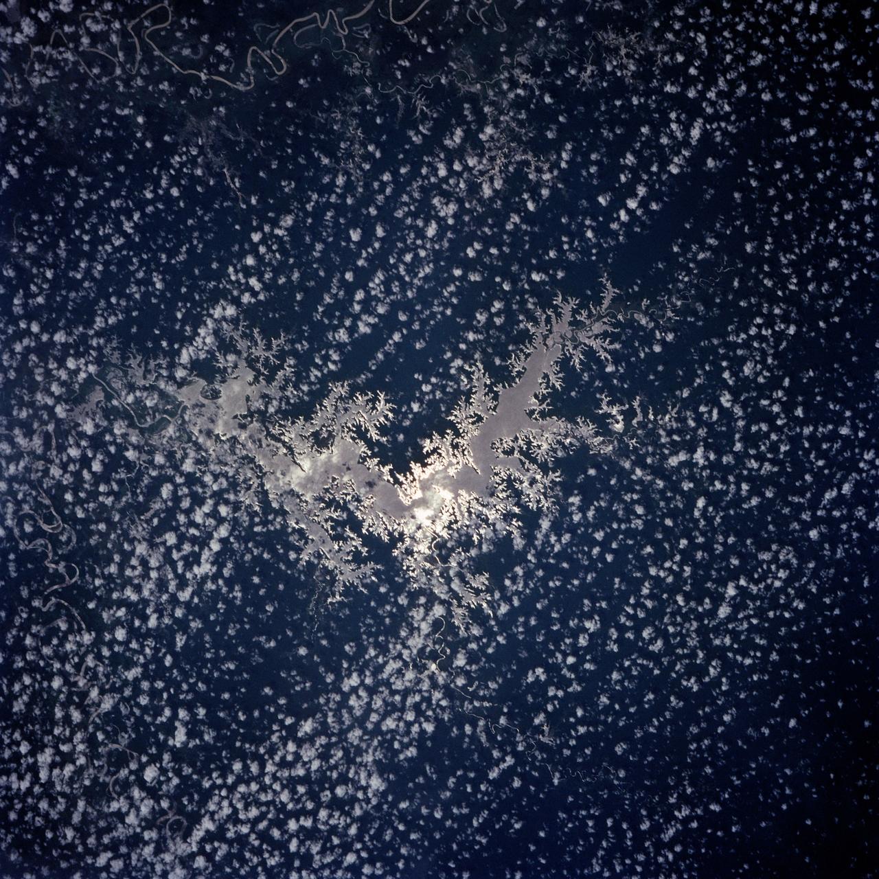
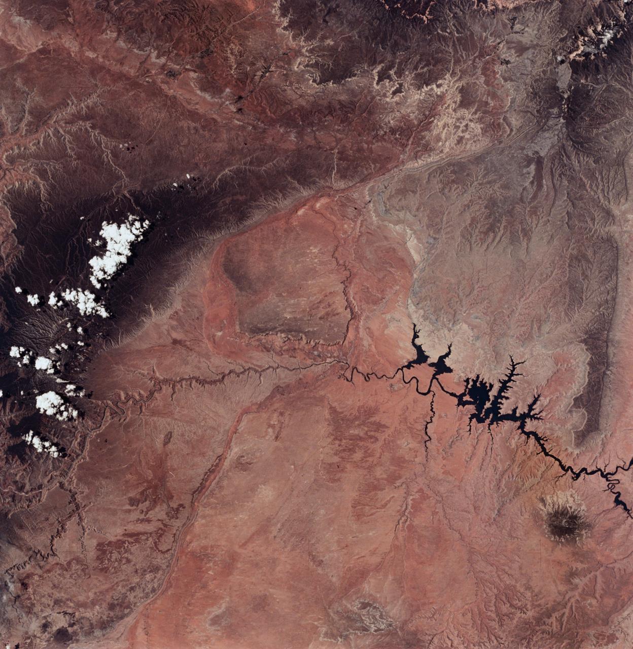
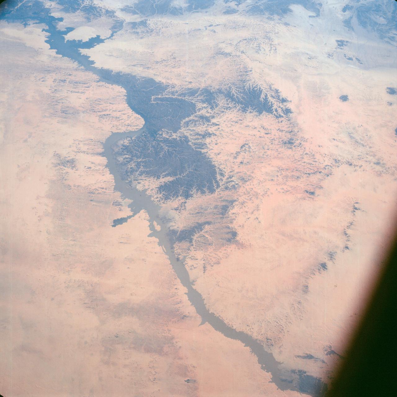
The Nile River Delta of Egypt (30.0N, 31.0E) irrigated by the Nile River and its many distributaries, is some of the richest farm land in the world and home to some 45 million people, over half of Egypt's population. The capital city of Cairo is at the apex of the delta. Just across the river from Cairo can be seen the ancient three big pyramids and sphinx at Giza and the Suez Canal is just to the right of the delta.
Mangoro River on Madagascar's east coast leads to the Indian Ocean in this photograph from the Indian Ocean as it orbited 263 miles above
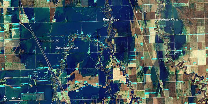
NASA Satellite image acquired March 21, 2010. To see a high res of this image go here: <a href="http://www.flickr.com/photos/gsfc/4455124807/in/photostream/">www.flickr.com/photos/gsfc/4455124807/in/photostream/</a> On March 21, 2010, the Red River crested at 36.99 feet (11.27 meters), according to the National Weather Service. The New York Times reported that the river’s crest was 1 foot (0.3 meters) below predictions and 4 feet (1 meter) below 2009’s record crest. A cold front passing through the area on March 19, 2010, slowed the rate of snowmelt feeding local rivers. That, combined with sandbags and dykes, spared the metropolitan area of Fargo, North Dakota, from serious flooding. North of town, however, agricultural fields and roads flooded. The Advanced Land Imager (ALI) on NASA’s Earth Observing-1 (EO-1) satellite captured these images of fields north of Fargo on March 21, 2010. The top image uses shortwave infrared light, and the bottom image uses visible light. Muddy waters and fallow fields blend together in the true-color image (bottom), but the false-color image (top) distinguishes better between water and land. Blue indicates water and green indicates vegetation. Fallow fields, bare ground, and paved surfaces appear in shades of brown. Cyan suggests pale water and/or sediment. Wide swaths of blue show large areas of standing water. The Sheyenne, Red, and Buffalo Rivers all flow through the area pictured here. According to The New York Times, flooding in rural areas around Fargo resulted primarily from the Red River’s failure to absorb water from the tributaries feeding it. Much of the standing water apparent in this image occurs around the Sheyenne and Buffalo Rivers. Overflowing tributaries left several inches of standing water in agricultural fields and on highways. About 10 miles (16 kilometers) north of Fargo, flooding forced the closure of Interstate 29. NASA image created by Jesse Allen, using EO-1 ALI data provided courtesy of the NASA EO-1 team and the United States Geological Survey. Caption by Michon Scott.. Instrument: EO-1 - ALI. To learn more about this image go here: <a href="http://earthobservatory.nasa.gov/NaturalHazards/view.php?id=43211" rel="nofollow">earthobservatory.nasa.gov/NaturalHazards/view.php?id=43211</a> To learn more about NASA's Goddard Space Flight Center go here: <a href="http://www.nasa.gov/centers/goddard/home/index.html" rel="nofollow">www.nasa.gov/centers/goddard/home/index.html</a>
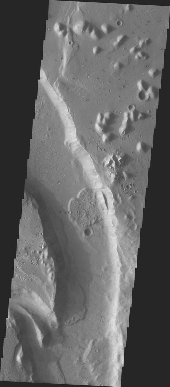
MSIP: A Bend In The River in Tiu Vallis

Members of the 2007 class of Partners in Leadership toured NASA Stennis Space Center in Hancock County, Miss., on Jan. 11. They visited the center's B Test Stand, part of the center's rocket engine test complex. The Partners in Leadership training program is designed to teach Pearl River County leaders about their county's government, economic development, health and human services, history and arts, environment and education during a 10-month period. The program, sponsored by the Partners for Pearl River County, helps fulfill the mission of the economic and community development agency.
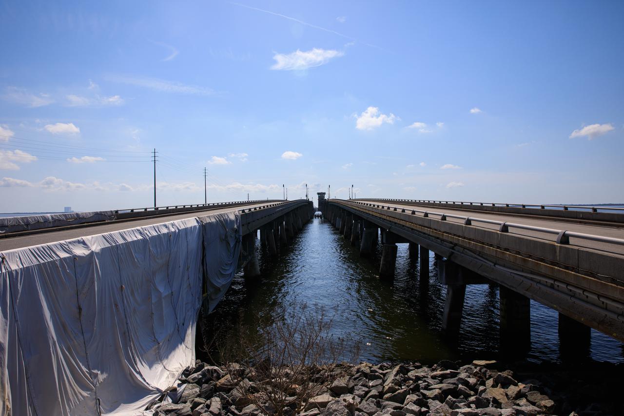
NASA’s bridge engineering team at Kennedy Space Center is managing multiple critical projects on the Indian River Bridge. This includes running new utility lines and safeguarding the existing wires and piping prior to the beginning of construction of the new Brevard County bridge. The much-traveled structure is a key access and evacuation route for the Florida spaceport and Cape Canaveral Space Force Station. Also known as the NASA Causeway Bridge, the Indian River Bridge was built in 1964.
NASA’s bridge engineering team at Kennedy Space Center is managing multiple critical projects on the Indian River Bridge. This includes running new utility lines and safeguarding the existing wires and piping prior to the beginning of construction of the new Brevard County bridge. The much-traveled structure is a key access and evacuation route for the Florida spaceport and Cape Canaveral Space Force Station. Also known as the NASA Causeway Bridge, the Indian River Bridge was built in 1964.
NASA’s bridge engineering team at Kennedy Space Center is managing multiple critical projects on the Indian River Bridge. This includes running new utility lines and safeguarding the existing wires and piping prior to the beginning of construction of the new Brevard County bridge. The much-traveled structure is a key access and evacuation route for the Florida spaceport and Cape Canaveral Space Force Station. Also known as the NASA Causeway Bridge, the Indian River Bridge was built in 1964.
NASA’s bridge engineering team at Kennedy Space Center is managing multiple critical projects on the Indian River Bridge. This includes running new utility lines and safeguarding the existing wires and piping prior to the beginning of construction of the new Brevard County bridge. The much-traveled structure is a key access and evacuation route for the Florida spaceport and Cape Canaveral Space Force Station. Also known as the NASA Causeway Bridge, the Indian River Bridge was built in 1964.
STS054-80-024 (13-19 Jan 1993) --- As the Shuttle was passing southeast over the coast of India, approaching the Bay of Bengal, Endeavour's crew took this picture of the Godavari River Delta. The sun glint pattern was centered directly over the delta and highlighted well the intricate drainage pattern. Offshore, water features associated with current boundaries and river plumes are readily visible. The line of clouds along the coast south of the delta suggest that surface winds are blowing onshore from the Bay of Bengal. As the air passes over the warmer coastal water and land, it is warmed and begins to rise. The moisture in the air condenses, forming a line of low-level clouds.
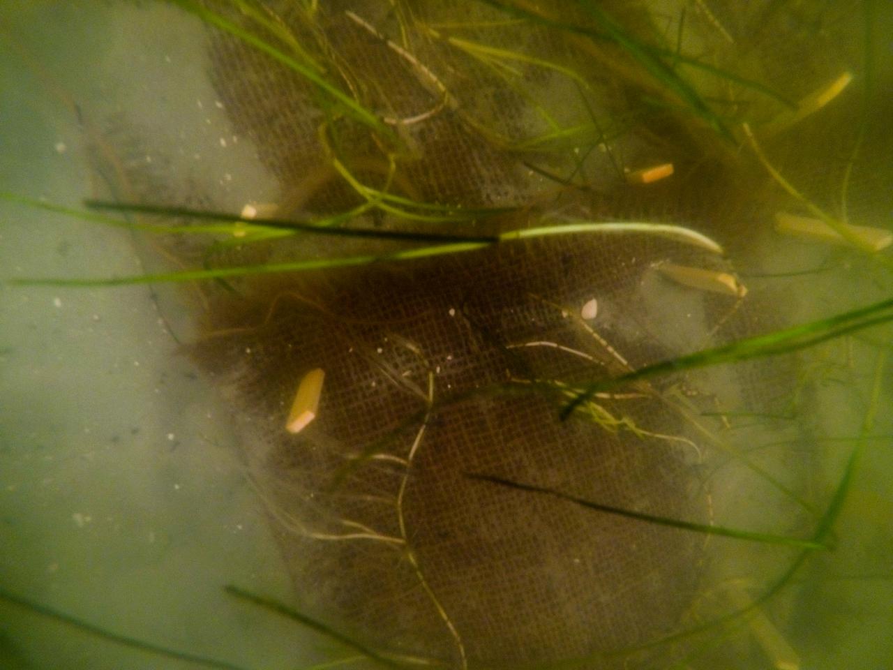
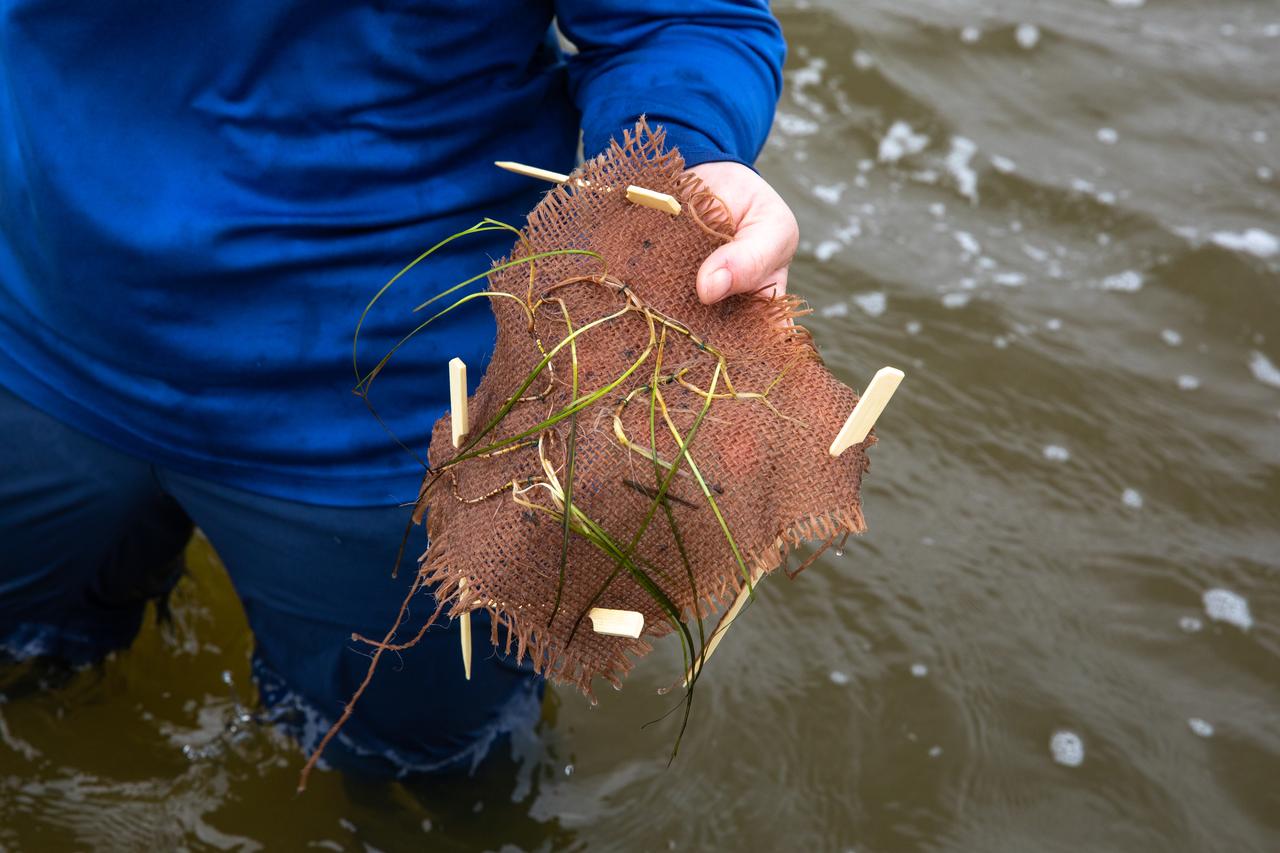
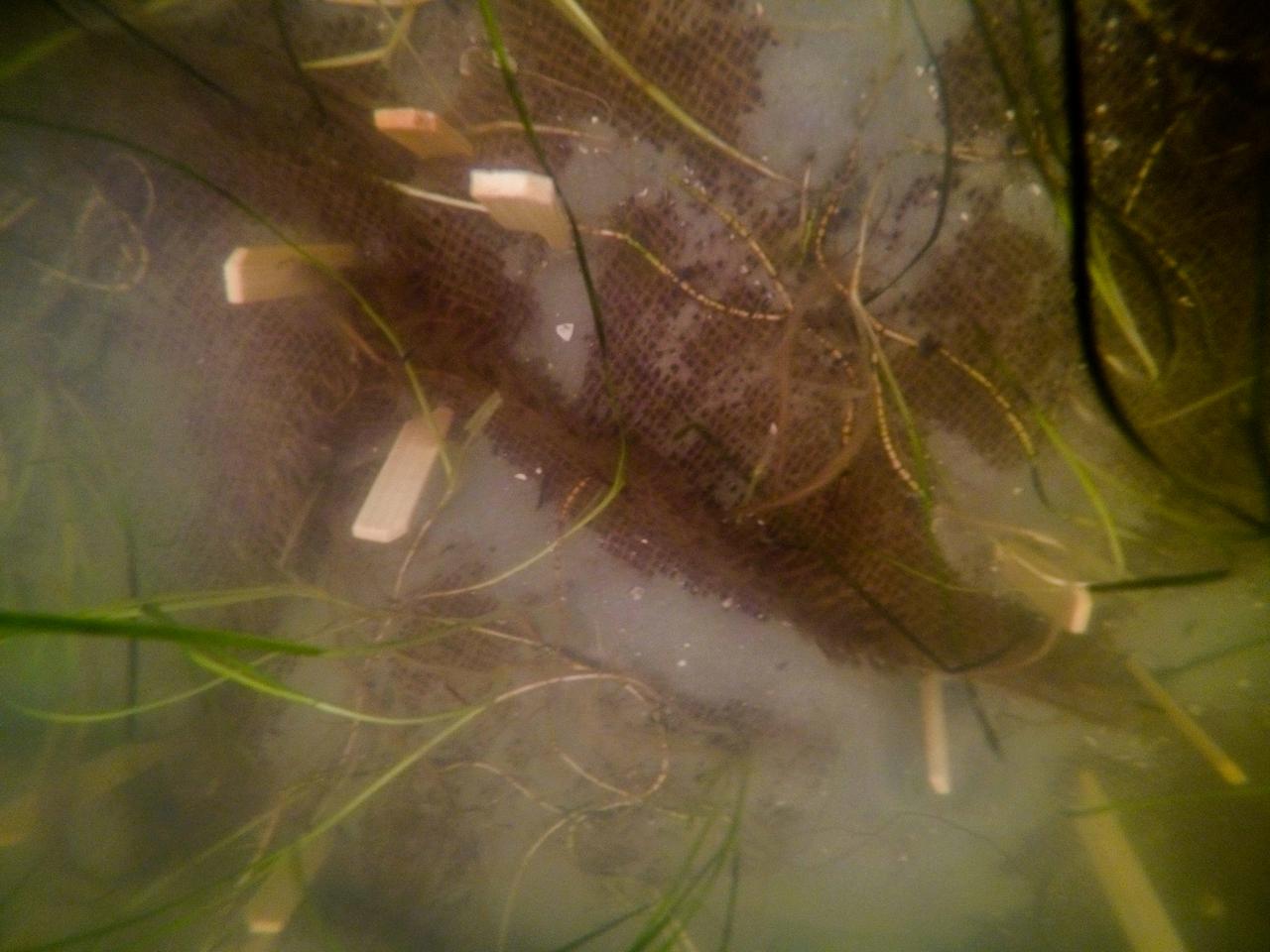
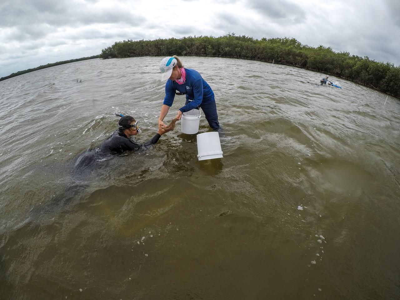
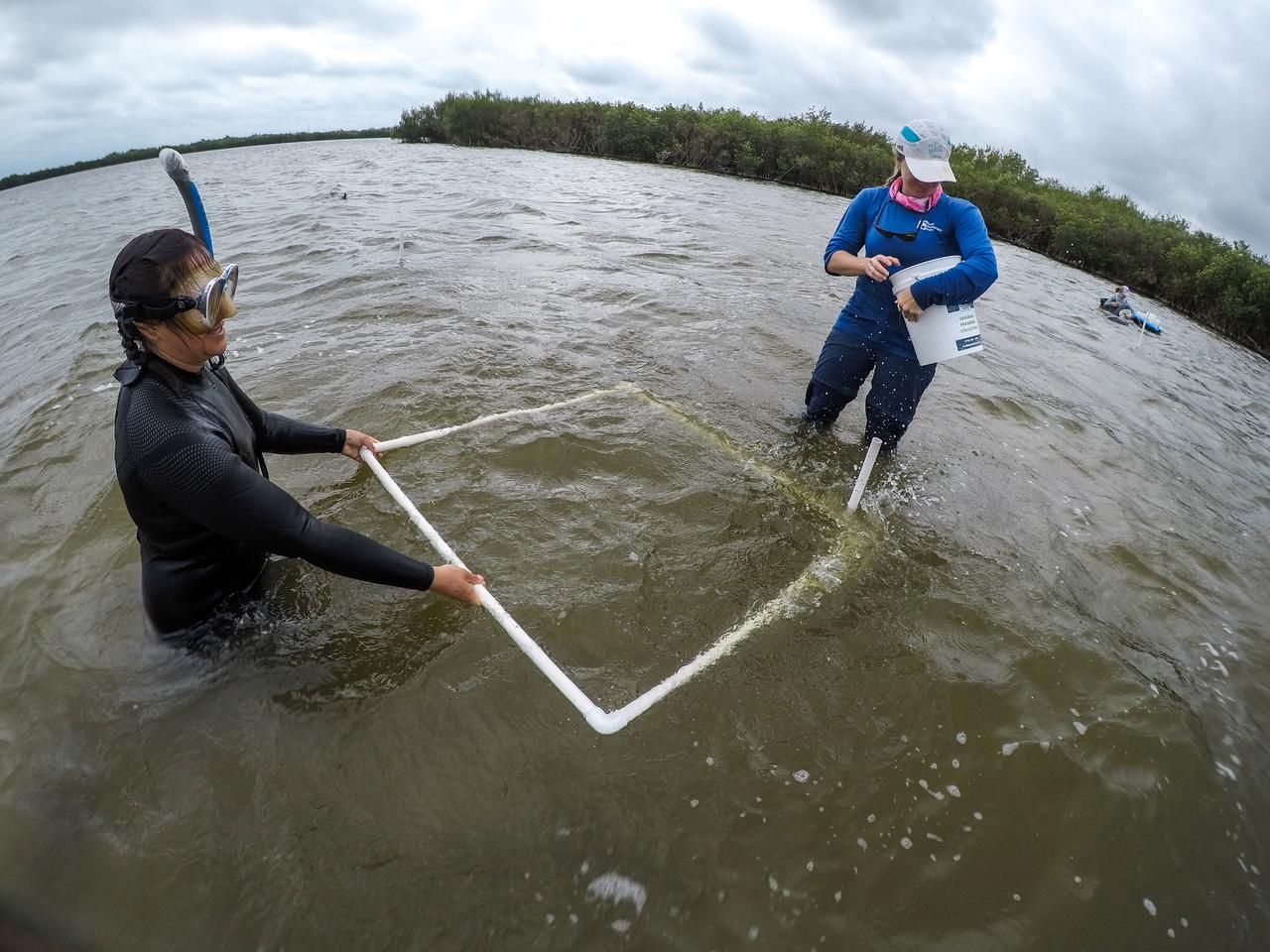
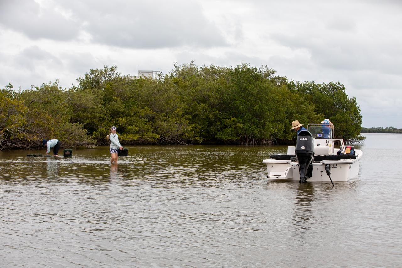
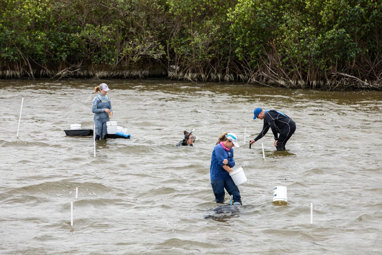
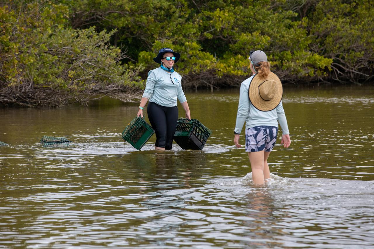
Seen here is a close-up view of newly planted seagrass in the Banana River – one of three bodies of water that make up the Indian River Lagoon (IRL) – at NASA’s Kennedy Space Center in Florida on March 29, 2023. Kennedy’s Environmental Management Branch is working to plant a minimum of 28,000 shoots of seagrass divided into 18 sites across three areas at the Florida spaceport as part of a pilot project for seagrass restoration efforts. Each “plot” of seagrass contains 16 shoots tied to a burlap mesh square with floral ties and has bamboo skewers at each corner that are staked into the sediment. The project, which involves using all biodegradable materials, will look at the feasibility of replanting seagrass in Kennedy waters and, if successful, could lead to the spaceport becoming a donor site where shoots of grass can be broken off and relocated to other areas within Kennedy or along the Indian River Lagoon to promote growth.
Seen here is a close-up view of one “plot” of seagrass being planted in the Banana River – one of three bodies of water that make up the Indian River Lagoon (IRL) – at NASA’s Kennedy Space Center in Florida on March 29, 2023. Kennedy’s Environmental Management Branch is working to plant a minimum of 28,000 shoots of seagrass divided into 18 sites across three areas at the Florida spaceport as part of a pilot project for seagrass restoration efforts. Each “plot” of seagrass contains 16 shoots tied to a burlap mesh square with floral ties and has bamboo skewers at each corner that are staked into the sediment. The project, which involves using all biodegradable materials, will look at the feasibility of replanting seagrass in Kennedy waters and, if successful, could lead to the spaceport becoming a donor site where shoots of grass can be broken off and relocated to other areas within Kennedy or along the Indian River Lagoon to promote growth.

Seen here is a close-up view of one “plot” of seagrass being planted in the Banana River – one of three bodies of water that make up the Indian River Lagoon (IRL) – at NASA’s Kennedy Space Center in Florida on March 29, 2023. Kennedy’s Environmental Management Branch is working to plant a minimum of 28,000 shoots of seagrass divided into 18 sites across three areas at the Florida spaceport as part of a pilot project for seagrass restoration efforts. Each “plot” of seagrass contains 16 shoots tied to a burlap mesh square with floral ties and has bamboo skewers at each corner that are staked into the sediment. The project, which involves using all biodegradable materials, will look at the feasibility of replanting seagrass in Kennedy waters and, if successful, could lead to the spaceport becoming a donor site where shoots of grass can be broken off and relocated to other areas within Kennedy or along the Indian River Lagoon to promote growth.

Lorae Simpson, director of research and conservation with the Florida Oceanographic Society, prepares to plant seagrass in the Banana River – one of three bodies of water that make up the Indian River Lagoon (IRL) – at NASA’s Kennedy Space Center in Florida on March 29, 2023. Kennedy’s Environmental Management Branch is working to plant a minimum of 28,000 shoots of seagrass divided into 18 sites across three areas at the Florida spaceport as part of a pilot project for seagrass restoration efforts. Each “plot” of seagrass contains 16 shoots tied to a burlap mesh square with floral ties and has bamboo skewers at each corner that are staked into the sediment. The project, which involves using all biodegradable materials, will look at the feasibility of replanting seagrass in Kennedy waters and, if successful, could lead to the spaceport becoming a donor site where shoots of grass can be broken off and relocated to other areas within Kennedy or along the Indian River Lagoon to promote growth.
Seen here is a close-up view of newly planted seagrass in the Banana River – one of three bodies of water that make up the Indian River Lagoon (IRL) – at NASA’s Kennedy Space Center in Florida on March 29, 2023. Kennedy’s Environmental Management Branch is working to plant a minimum of 28,000 shoots of seagrass divided into 18 sites across three areas at the Florida spaceport as part of a pilot project for seagrass restoration efforts. Each “plot” of seagrass contains 16 shoots tied to a burlap mesh square with floral ties and has bamboo skewers at each corner that are staked into the sediment. The project, which involves using all biodegradable materials, will look at the feasibility of replanting seagrass in Kennedy waters and, if successful, could lead to the spaceport becoming a donor site where shoots of grass can be broken off and relocated to other areas within Kennedy or along the Indian River Lagoon to promote growth.
NASA Satellite image acquired March 21, 2010. To see a high res more detail of this image go here: <a href="http://www.flickr.com/photos/gsfc/4455125023/in/photostream/">www.flickr.com/photos/gsfc/4455125023/in/photostream/</a> On March 21, 2010, the Red River crested at 36.99 feet (11.27 meters), according to the National Weather Service. The New York Times reported that the river’s crest was 1 foot (0.3 meters) below predictions and 4 feet (1 meter) below 2009’s record crest. A cold front passing through the area on March 19, 2010, slowed the rate of snowmelt feeding local rivers. That, combined with sandbags and dykes, spared the metropolitan area of Fargo, North Dakota, from serious flooding. North of town, however, agricultural fields and roads flooded. The Advanced Land Imager (ALI) on NASA’s Earth Observing-1 (EO-1) satellite captured these images of fields north of Fargo on March 21, 2010. The top image uses shortwave infrared light, and the bottom image uses visible light. Muddy waters and fallow fields blend together in the true-color image (bottom), but the false-color image (top) distinguishes better between water and land. Blue indicates water and green indicates vegetation. Fallow fields, bare ground, and paved surfaces appear in shades of brown. Cyan suggests pale water and/or sediment. Wide swaths of blue show large areas of standing water. The Sheyenne, Red, and Buffalo Rivers all flow through the area pictured here. According to The New York Times, flooding in rural areas around Fargo resulted primarily from the Red River’s failure to absorb water from the tributaries feeding it. Much of the standing water apparent in this image occurs around the Sheyenne and Buffalo Rivers. Overflowing tributaries left several inches of standing water in agricultural fields and on highways. About 10 miles (16 kilometers) north of Fargo, flooding forced the closure of Interstate 29. NASA image created by Jesse Allen, using EO-1 ALI data provided courtesy of the NASA EO-1 team and the United States Geological Survey. Caption by Michon Scott. Instrument: EO-1 - ALI. To learn more about this image go here: <a href="http://earthobservatory.nasa.gov/NaturalHazards/view.php?id=43211" rel="nofollow">earthobservatory.nasa.gov/NaturalHazards/view.php?id=43211</a> To learn more about NASA's Goddard Space Flight Center go here: <a href="http://www.nasa.gov/centers/goddard/home/index.html" rel="nofollow">www.nasa.gov/centers/goddard/home/index.html</a>
Members of the Florida Oceanographic Society plant seagrass in the Banana River – one of three bodies of water that make up the Indian River Lagoon (IRL) – at NASA’s Kennedy Space Center in Florida on March 29, 2023. Kennedy’s Environmental Management Branch is working to plant a minimum of 28,000 shoots of seagrass divided into 18 sites across three areas at the Florida spaceport as part of a pilot project for seagrass restoration efforts. The project will look at the feasibility of replanting seagrass in Kennedy waters and, if successful, could lead to the spaceport becoming a donor site where shoots of grass can be broken off and relocated to other areas within Kennedy or along the IRL to promote growth.
Members of the Florida Oceanographic Society prepare to plant seagrass in the Banana River – one of three bodies of water that make up the Indian River Lagoon (IRL) – at NASA’s Kennedy Space Center in Florida on March 29, 2023. Kennedy’s Environmental Management Branch is working to plant a minimum of 28,000 shoots of seagrass divided into 18 sites across three areas at the Florida spaceport as part of a pilot project for seagrass restoration efforts. The project will look at the feasibility of replanting seagrass in Kennedy waters and, if successful, could lead to the spaceport becoming a donor site where shoots of grass can be broken off and relocated to other areas within Kennedy or along the IRL to promote growth.
iss071e439833 (Aug. 8, 2024) --- Xiang River runs through the city of Changsha (center) in China's province of Hunan. At far left, the city of Yueyang lies on the bank of Dongdongting Lake in Hunan's humid, subtropical region. The International Space Station was orbiting 262 miles above the Asian nation at the time of this photograph.
SL2-05-422 (22 June 1973) --- This section of the lower Mississippi River (34.0N, 90.0W) known as the Yazoo Basin, is characterized by a wide expanse of rich river bottomland with many oxbow lakes, the remains of the many changes in the riverbed over the course of many thousands of years. This soil is very fertile and productive but the region is prone to flooding. In this view, some of the back areas around the Delta National Forest show the effects of heavy spring rains. Photo credit: NASA
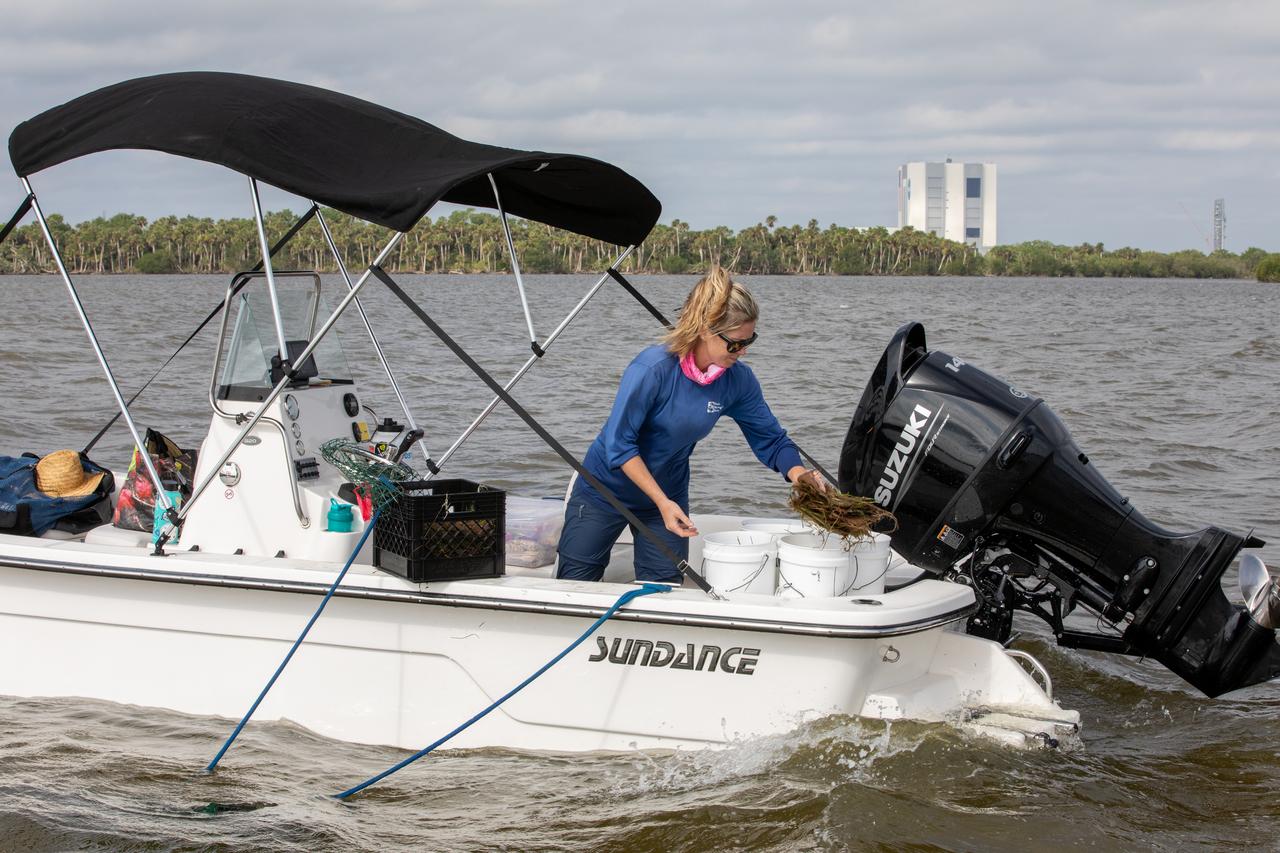
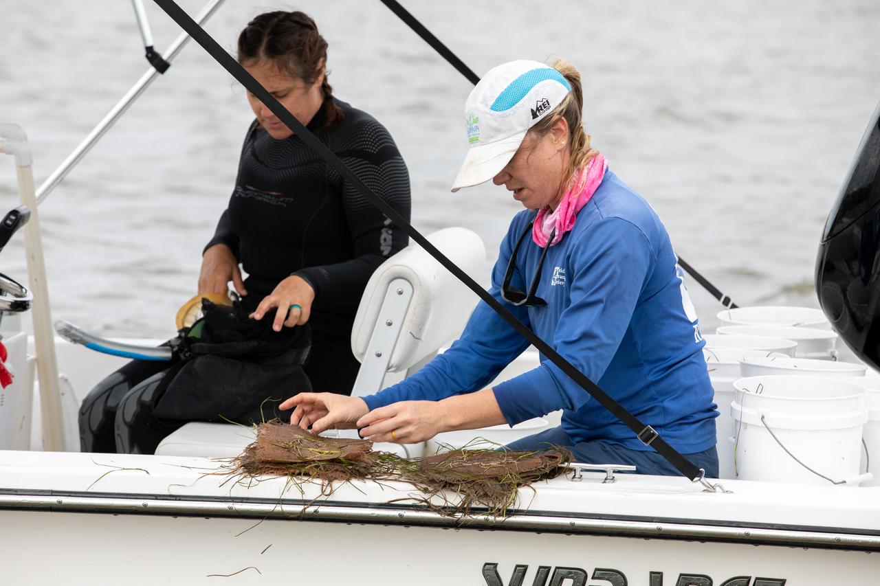
Members of the Florida Oceanographic Society collect mats of seagrass from their storage site at NASA’s Kennedy Space Center in Florida as they prepare to plant them in the Banana River – one of three bodies of water that make up the Indian River Lagoon (IRL) – on March 29, 2023. Kennedy’s Environmental Management Branch is working to plant a minimum of 28,000 shoots of seagrass divided into 18 sites across three areas at the Florida spaceport as part of a pilot project for seagrass restoration efforts. The project will look at the feasibility of replanting seagrass in Kennedy waters and, if successful, could lead to the spaceport becoming a donor site where shoots of grass can be broken off and relocated to other areas within Kennedy or along the IRL to promote growth.
Members of the Florida Oceanographic Society collect mats of seagrass from their storage site at NASA’s Kennedy Space Center in Florida as they prepare to plant them in the Banana River – one of three bodies of water that make up the Indian River Lagoon (IRL) – on March 29, 2023. Kennedy’s Environmental Management Branch is working to plant a minimum of 28,000 shoots of seagrass divided into 18 sites across three areas at the Florida spaceport as part of a pilot project for seagrass restoration efforts. The project will look at the feasibility of replanting seagrass in Kennedy waters and, if successful, could lead to the spaceport becoming a donor site where shoots of grass can be broken off and relocated to other areas within Kennedy or along the IRL to promote growth.
Members of the Florida Oceanographic Society begin planting seagrass in the Banana River – one of three bodies of water that make up the Indian River Lagoon (IRL) – at NASA’s Kennedy Space Center in Florida on March 29, 2023. At the top right is Doug Scheidt, an ecologist working on NASA’s Environmental and Medical Contract at Kennedy. Kennedy’s Environmental Management Branch is working to plant a minimum of 28,000 shoots of seagrass divided into 18 sites across three areas at the Florida spaceport as part of a pilot project for seagrass restoration efforts. The project will look at the feasibility of replanting seagrass in Kennedy waters and, if successful, could lead to the spaceport becoming a donor site where shoots of grass can be broken off and relocated to other areas within Kennedy or along the IRL to promote growth.
Lorae Simpson, director of research and conservation with the Florida Oceanographic Society, gathers “plots” of seagrass as her team prepares to plant them in the Banana River – one of three bodies of water that make up the Indian River Lagoon (IRL) – at NASA’s Kennedy Space Center in Florida on March 29, 2023. Kennedy’s Environmental Management Branch is working to plant a minimum of 28,000 shoots of seagrass divided into 18 sites across three areas at the Florida spaceport as part of a pilot project for seagrass restoration efforts. The project will look at the feasibility of replanting seagrass in Kennedy waters and, if successful, could lead to the spaceport becoming a donor site where shoots of grass can be broken off and relocated to other areas within Kennedy or along the IRL to promote growth.
Lorae Simpson, director of research and conservation with the Florida Oceanographic Society, gathers “plots” of seagrass as her team prepares to plant them in the Banana River – one of three bodies of water that make up the Indian River Lagoon (IRL) – at NASA’s Kennedy Space Center in Florida on March 29, 2023. Kennedy’s Environmental Management Branch is working to plant a minimum of 28,000 shoots of seagrass divided into 18 sites across three areas at the Florida spaceport as part of a pilot project for seagrass restoration efforts. The project will look at the feasibility of replanting seagrass in Kennedy waters and, if successful, could lead to the spaceport becoming a donor site where shoots of grass can be broken off and relocated to other areas within Kennedy or along the IRL to promote growth.

Lorae Simpson, director of research and conservation with the Florida Oceanographic Society, gathers “plots” of seagrass as her team prepares to plant them in the Banana River – one of three bodies of water that make up the Indian River Lagoon (IRL) – at NASA’s Kennedy Space Center in Florida on March 29, 2023. Kennedy’s Environmental Management Branch is working to plant a minimum of 28,000 shoots of seagrass divided into 18 sites across three areas at the Florida spaceport as part of a pilot project for seagrass restoration efforts. The project will look at the feasibility of replanting seagrass in Kennedy waters and, if successful, could lead to the spaceport becoming a donor site where shoots of grass can be broken off and relocated to other areas within Kennedy or along the IRL to promote growth.
Members of the Florida Oceanographic Society collect mats of seagrass from their storage site at NASA’s Kennedy Space Center in Florida as they prepare to plant them in the Banana River – one of three bodies of water that make up the Indian River Lagoon (IRL) – on March 29, 2023. Kennedy’s Environmental Management Branch is working to plant a minimum of 28,000 shoots of seagrass divided into 18 sites across three areas at the Florida spaceport as part of a pilot project for seagrass restoration efforts. The project will look at the feasibility of replanting seagrass in Kennedy waters and, if successful, could lead to the spaceport becoming a donor site where shoots of grass can be broken off and relocated to other areas within Kennedy or along the IRL to promote growth.
The Mackenzie River in the Northwest Territories, Canada, with its headstreams the Peace and Finley, is the longest river in North America. This image was acquired by NASA Terra satellite on August 4, 2005.
The Yellow River is the second-longest river in China, and the sixth longest in the world and makes many dramatic shifts over time. This image was taken with the ASTER instrument aboard NASA Terra spacecraft in 2009.
Huge sediment loads from the interior of the country flow through the Mouths of the Amazon River, Brazil (0.5S, 50.0W). The river current carries hundreds of tons of sediment through the multiple outlets of the great river over 100 miles from shore before it is carried northward by oceanic currents. The characteristic "fair weather cumulus" pattern of low clouds over the land but not over water may be observed in this scene.
SL2-05-397 (22 June 1973) --- New Orleans, Louisiana, Mississippi River, and Lake Pontchartrain (31.0N, 91.0W) can all be seen in this single detailed view. The marshlands of the Atchafalaya Basin, previously the main drainage way for the Mississippi River, can be seen to be partially silted as a result of sediments. The long narrow field patterns fronting on the river is called the "Long Lot" system of equal land distribution based on the French Napoleonic Civil Code. Photo credit: NASA
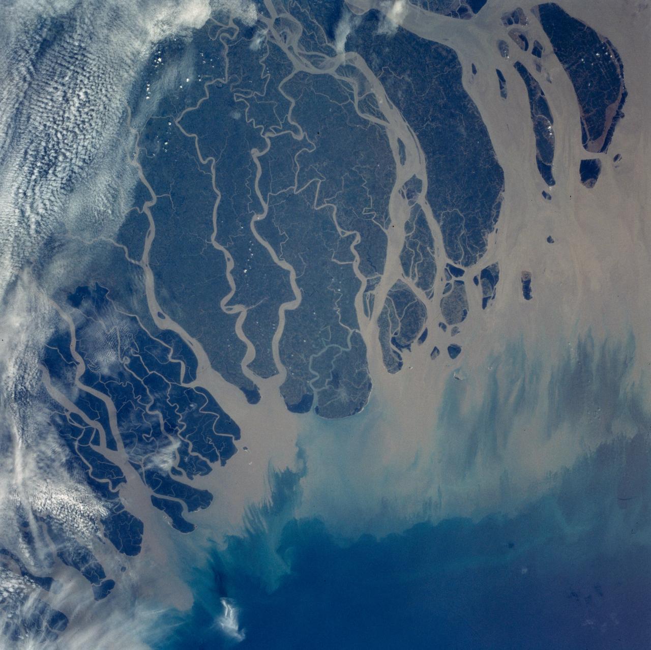
The Ganges River Delta is the largest inter-tidal delta in the world. With its extensive mangrove mud flats, swamp vegetation and sand dunes, it is characteristic of many tropical and subtropical coasts. As seen in this photograph, the tributaries and distributaries of the Ganges and Brahmaputra Rivers deposit huge amounts of silt and clay that create a shifting maze of waterways and islands in the Bay of Bengal.
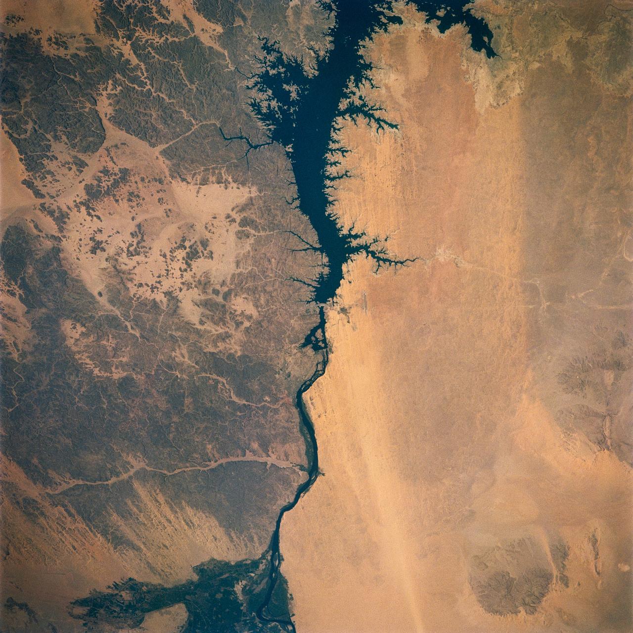
Egypt's High Aswan Dam on the Nile River at the first cataracts, Nile River, (24.0N, 33.0E) was completed in 1971 to provide cheap hydroelectric power and to regulate the historically uneven flow of the Nile River. The contrast between the largely base rock desert east of the Nile versus the sand covered desert west of the river and the ancient irrigated floodplain downstream from the damsite is clearly shown.
This view shows the confluence of the Amazon and the Topajos Rivers at Santarem, Brazil (2.0S, 55.0W). The Am,azon flows from lower left to upper right of the photo. Below the river juncture of the Amazon and Tapajos, there is considerable deforestation activity along the Trans-Amazon Highway.
STS007-03-058 (18-24 June 1983) --- The Island of Madagascar in the Indian Ocean off the coast of Africa. The colorful area is the mouth of the Betsiboka River near the city of Majunga. The photograph was taken with a 70mm handheld camera aimed through the aft flight deck?s overhead windows on the Earth-orbiting Space Shuttle Challenger.

iss071e439834 (Aug. 8, 2024) --- The Yangtze River beams in the Sun's glint as wildfires burn in the surrounding forestland near the city of Wuhan in China's province of Hubei. The International Space Station was orbiting 262 miles above the Asian nation at the time of this photograph.
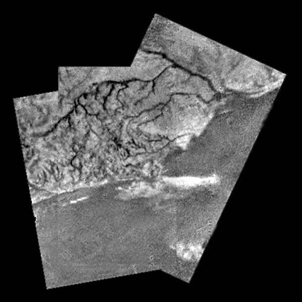
Mosaic of River Channel and Ridge Area on Titan
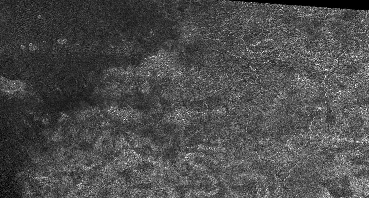
Xanadu: Rivers Flowed onto a Sunless Sea
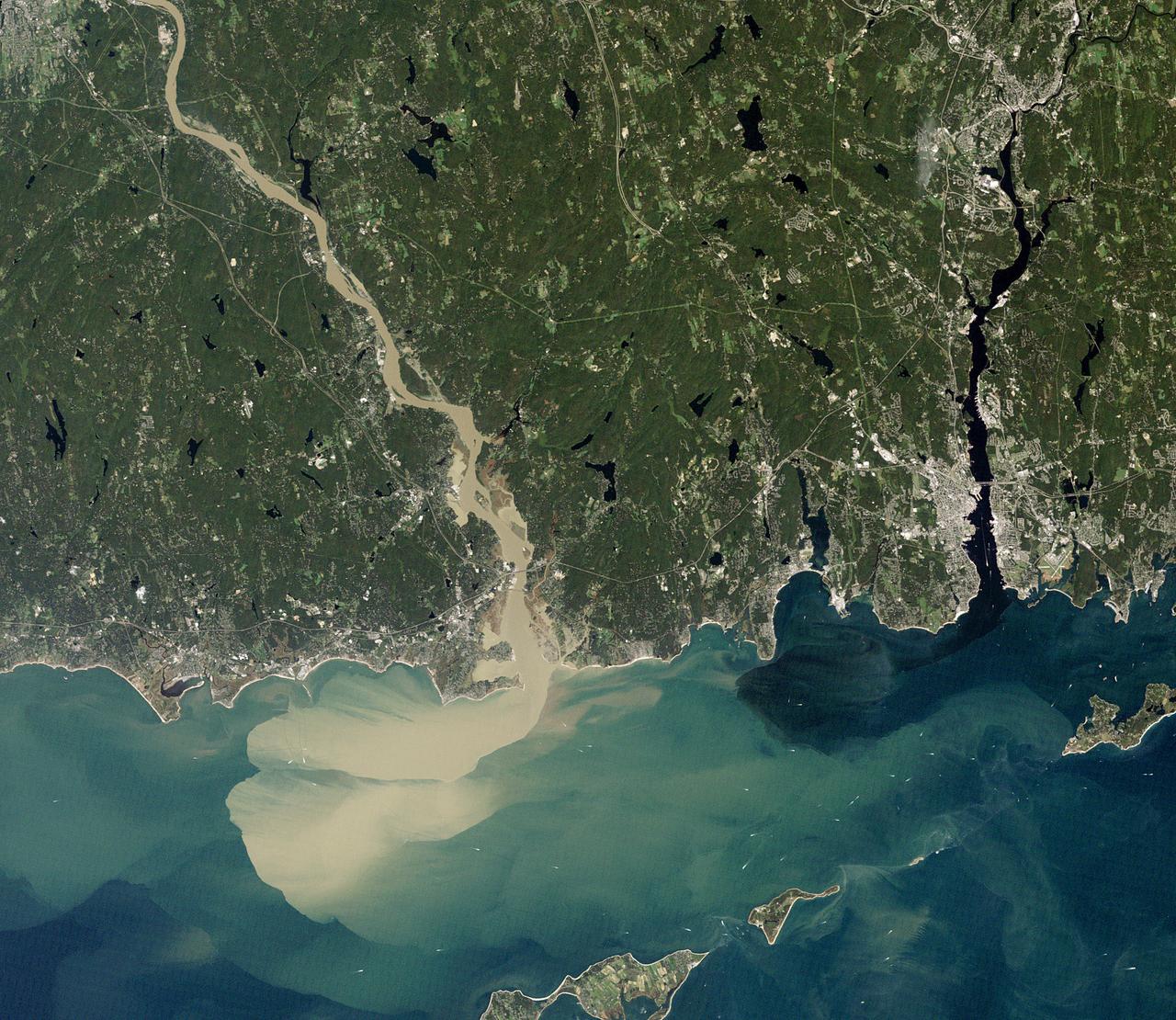
NASA image acquired September 2, 2011 To download the full high res go to: <a href="http://earthobservatory.nasa.gov/IOTD/view.php?id=52059" rel="nofollow">earthobservatory.nasa.gov/IOTD/view.php?id=52059</a> Nearly a week after Hurricane Irene drenched New England with rainfall in late August 2011, the Connecticut River was spewing muddy sediment into Long Island Sound and wrecking the region's farmland just before harvest. The Thematic Mapper on the Landsat 5 satellite acquired this true-color satellite image on September 2, 2011. With its headwaters near the Canadian border, the Connecticut River drains nearly 11,000 square miles (28,500 square kilometers) and receives water from at least 33 tributaries in Vermont, New Hampshire, Massachusetts, and Connecticut. The 410-mile river—New England's longest—enters Long Island Sound near Old Lyme, Connecticut, and is estimated to provide 70 percent of the fresh water entering the Sound. When Irene blew through the region on August 27-28, substantial portions of the Connecticut River watershed received more than 6 to 8 inches (15-20 centimeters) of rainfall, and several locations received more than 10 inches (25 centimeters). Whole towns were cut off from overland transportation—particularly upstream in Vermont, which suffered its worst flooding in 80 years. Thousands of people saw their homes flooded, if not washed off their foundations, at a time of year when rivers are usually at their lowest. Preliminary estimates of river flow at Thompsonville, Connecticut, (not shown in this image) reached 128,000 cubic feet per second (cfs) on August 30, nearly 64 times the usual flow (2,000 cfs) for early fall and the highest flow rate since May 1984. At the mouth of the river—where flow is tidal, and therefore not gauged—the peak water height reached 6.9 feet (2.1 meters) above sea level, almost a foot higher than at any time in the past 10 years. According to Suzanne O'Connell, an environmental scientist working along the Connecticut River at Wesleyan University, the torrent of water coursing through New England picked up silt and clay from the river valleys, giving it the tan color shown in the image above. At Essex, Connecticut, the turbidity (muddiness) of the water was 50 times higher than pre-Irene values. To the east, the Thames River appears to be carrying very little sediment at all on September 2. According to O'Connell, the Thames "drains glaciated terrain, so fine sediment was removed long ago." Most of the land surface in the Thames basin is "just bedrock, till, and glacial erratics." Unlike the Connecticut, areas within the Thames watershed only received 2 to 4 inches of rain in most locations. The flooding that occurred in the aftermath of Hurricane Irene inundated farmland in Massachusetts and Connecticut just before harvest time, the Associated Press noted. Crops were drowned under inches to feet of water. The substantial amounts of soil, sediment, and water deposited on land during the flood could also pose trouble for farmers in coming seasons. "It's notable that whole segments of river bank are just gone," said Andrew Fisk of the Connecticut River Watershed Council. "That's not just loss of sediment. That's land disappearing down river." <b>NASA Earth Observatory image by Robert Simmon, using Landsat 5 data from the U.S. Geological Survey Global Visualization Viewer. Caption by Michael Carlowicz, with interpretation help from Suzanne O'Connell, Wesleyan University, and Andrew Fisk, Connecticut River Watershed Council.</b> Instrument: Landsat 5 - TM Credit: <b><a href="http://www.earthobservatory.nasa.gov/" rel="nofollow"> NASA Earth Observatory</a></b> <b><a href="http://www.nasa.gov/centers/goddard/home/index.html" rel="nofollow">NASA Goddard Space Flight Center</a></b> enables NASA’s mission through four scientific endeavors: Earth Science, Heliophysics, Solar System Exploration, and Astrophysics. Goddard plays a leading role in NASA’s accomplishments by contributing compelling scientific knowledge to advance the Agency’s mission. <b>Follow us on <a href="http://twitter.com/NASA_GoddardPix" rel="nofollow">Twitter</a></b> <b>Like us on <a href="http://www.facebook.com/pages/Greenbelt-MD/NASA-Goddard/395013845897?ref=tsd" rel="nofollow">Facebook</a></b> <b>Find us on <a href="http://web.stagram.com/n/nasagoddard/?vm=grid" rel="nofollow">Instagram</a></b>
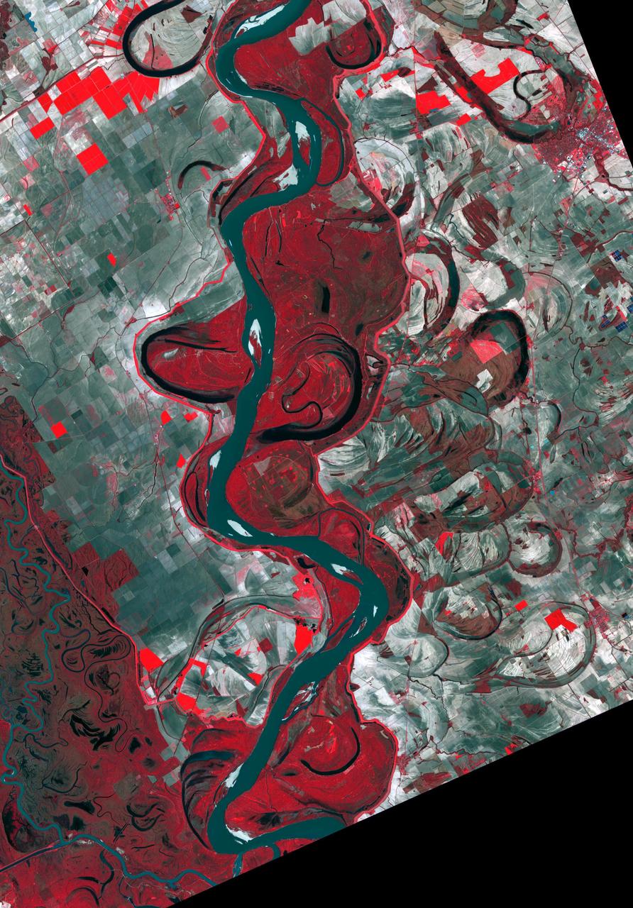
The Mississippi River continually evolves and changes course, as these two images testify. Harold Fisk's 1944 map (Figure 1) covers a stretch of the river between Friars Point and Gunnison, Mississippi. The March 31, 2017 image clearly shows the changing course of the main channel that has taken place in the intervening 73 years. The image covers an area of 39.2 by 56.3 km, and is located at 34.1 degrees north, 90.4 degrees west. https://photojournal.jpl.nasa.gov/catalog/PIA23534
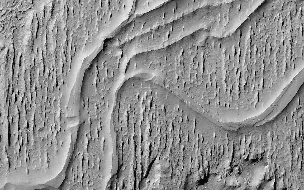
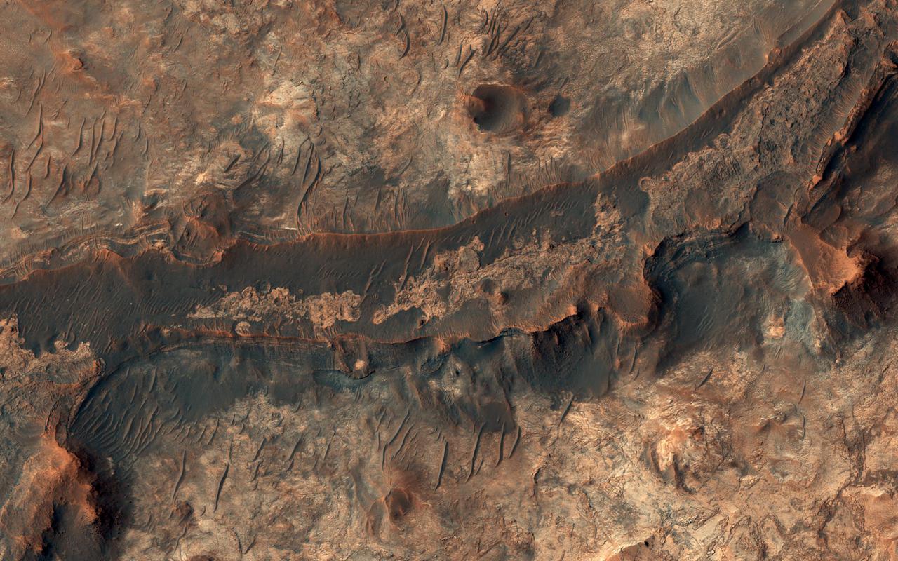
This image of ridges in Aeolis Planum tells a story of ancient rivers and a Mars very different to that of today. River beds often get filled with gravel and the surrounding terrain is often built up of fine-grained mud from river overflows. The gravely river bottom and the fine-grained surroundings can lead to a strange phenomenon that geologists call inverted channels. After the river disappears, the fine-grained surroundings can be easily eroded away leaving the gravely river bed as a high-standing ridge. These ridges show the location of the old river beds in Mars' distant past. The angle at which the ridges join together indicate that these rivers flowed from top-right to bottom-left (i.e. southwest). https://photojournal.jpl.nasa.gov/catalog/PIA22822
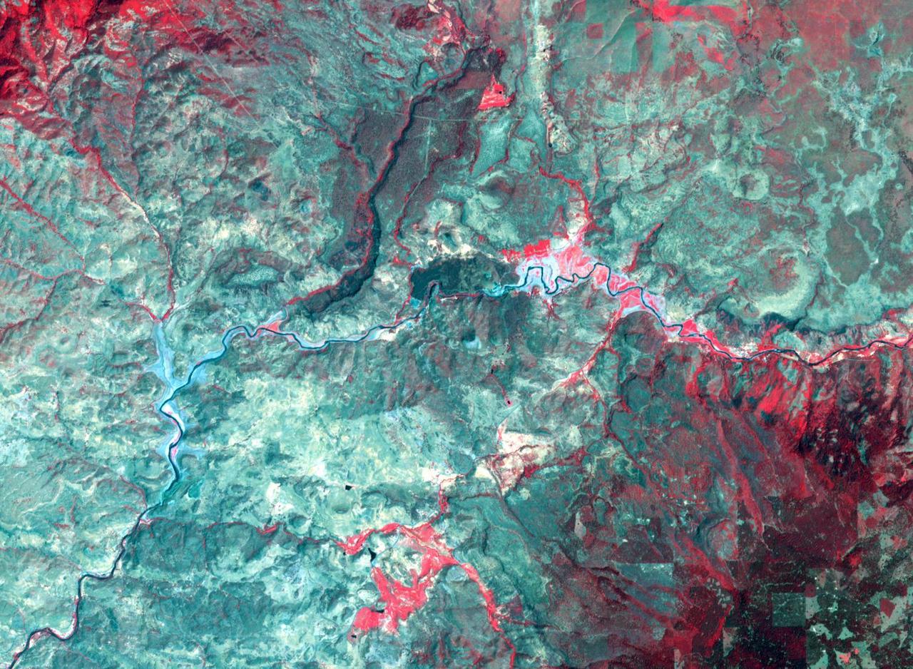
The Dneiper River in the Ukraine is the fourth longest river in Europe, flowing 2200 km into the Black Sea. This wintery scene near the city of Oster shows the many meanders and abandoned paleochannels of this major river. The image was acquired March 6, 2001, covers an area of 18.6 by 32.1 km, and is located at 50.9 degrees north, 30.9 degrees east. https://photojournal.jpl.nasa.gov/catalog/PIA23912
This close-up view of the intensively cultivated Nile River flood plain near Cairo presents a sharp color contrast to the virtually non-vegetated, sandy desert, located to the west of the vegetated area. Some rectangular cultivated field patterns, as well as circular center pivot irrigation patterns, can be observed northwest of the Nile River flood plain. The world famous Giza Pyramids are located near the center of this photography (see highly reflective sand surfaces).
This space radar image illustrates the recent rapid urban development occurring along the lower Colorado River at the Nevada/Arizona state line. Lake Mojave is the dark feature that occupies the river valley in the upper half of the image.
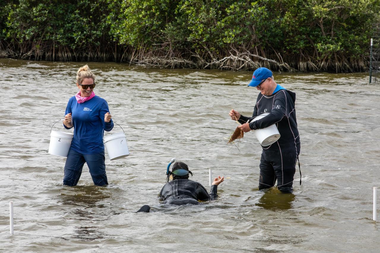
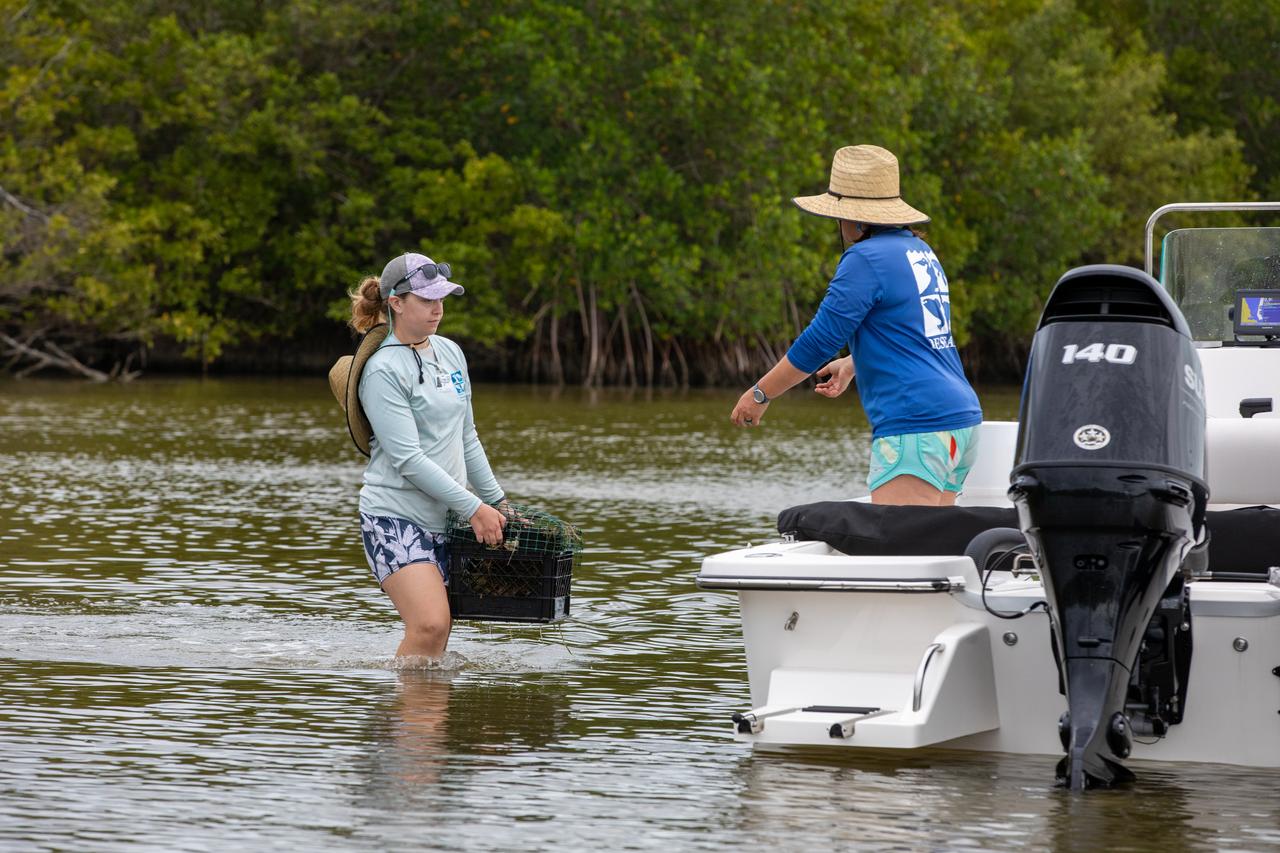
Lorae Simpson (left), director of research and conservation with the Florida Oceanographic Society, and Doug Scheidt (right), an ecologist working on NASA’s Environmental and Medical Contract (NEMCON), begin planting seagrass in the Banana River – one of three bodies of water that make up the Indian River Lagoon (IRL) – at NASA’s Kennedy Space Center in Florida on March 29, 2023. Scheidt is handing each “plot” of seagrass to another Florida Oceanographic Society member in the water, who then uses bamboo skewers to stake each one into the sediment. Kennedy’s Environmental Management Branch is working to plant a minimum of 28,000 shoots of seagrass divided into 18 sites across three areas at the Florida spaceport as part of a pilot project for seagrass restoration efforts. The project will look at the feasibility of replanting seagrass in Kennedy waters and, if successful, could lead to the spaceport becoming a donor site where shoots of grass can be broken off and relocated to other areas within Kennedy or along the IRL to promote growth.
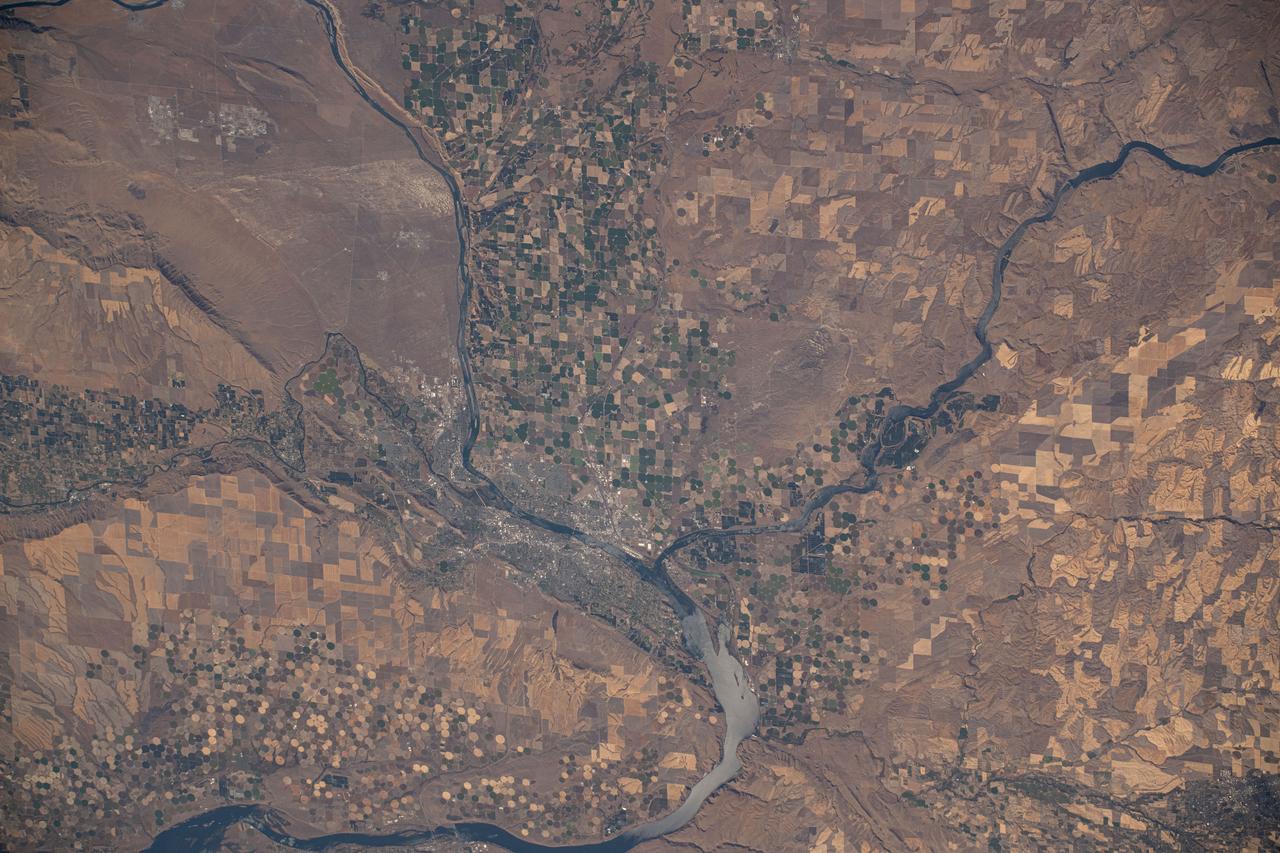
iss072e009926 (Oct. 1, 2024) --- The Columbia River splits into the Snake River where the Washington state counties of Walla Walla, Benton, and Franklin meet in this photograph from the International Space Station as it orbited 259 miles above.
SL2-05-393 (22 June 1973) --- The nation's capital lies astride the Potomac River (38.5N, 77.5W) at the head of the Potomac Estuary. Baltimore, MD, also in the scene, is connected to Washington by the Baltimore-Washington Parkway. The suburbs of both cities tend to cluster around the Washington and Baltimore Beltways. Most of the countryside in the eastern two-thirds of this scene is either heavily forested or is in farming, dairy operations or poultry production. Photo credit: NASA
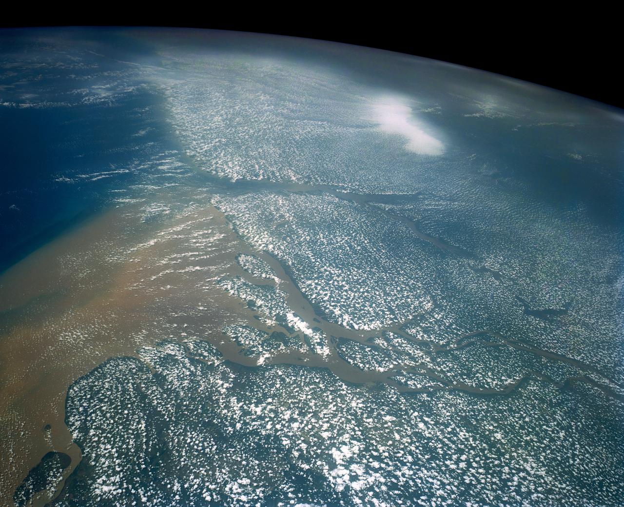
STS058-107-083 (18 Oct.-1 Nov. 1993) --- A near-nadir view of the mouth of the Amazon River, that shows all signs of being a relatively healthy system, breathing and exhaling. The well-developed cumulus field over the forested areas on both the north and south sides of the river (the view is slightly to the west) shows that good evapotranspiration is underway. The change in the cloud field from the moisture influx from the Atlantic (the cloud fields over the ocean are parallel to the wind direction) to perpendicular cloud fields over the land surface are normal. This change in direction is caused by the increased surface roughness over the land area. The plume of the river, although turbid, is no more or less turbid than it has been reported since the Portuguese first rounded Brasil's coast at the end of the 15th Century.
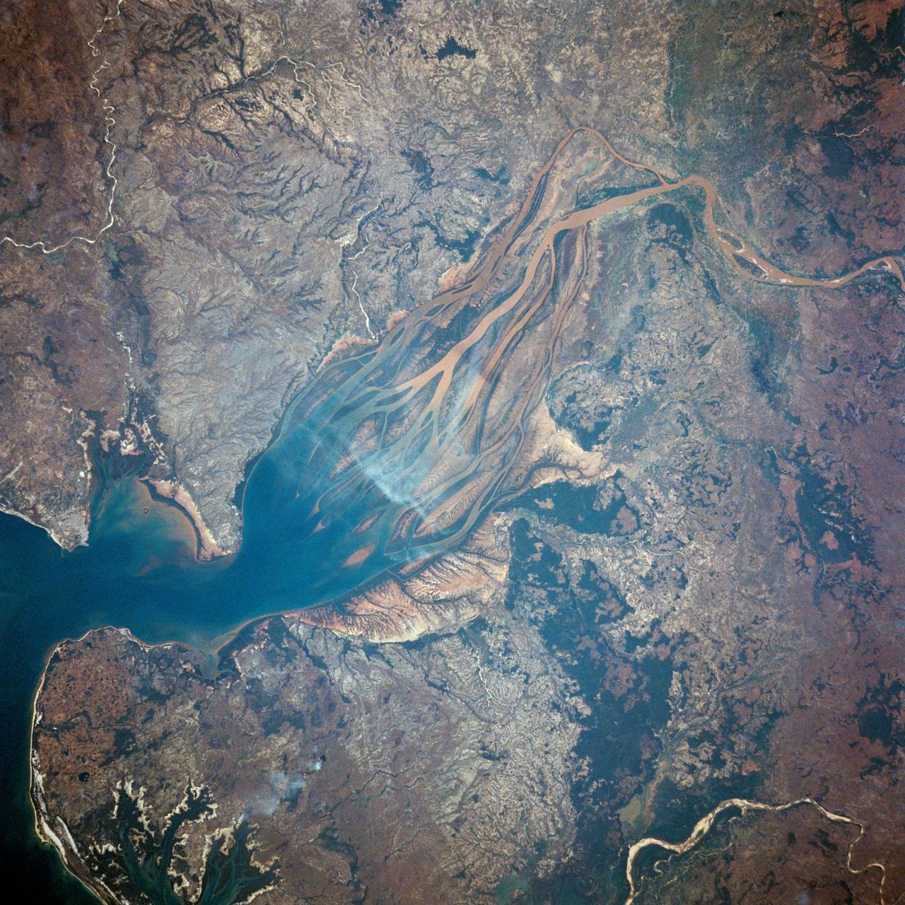
Lake Murray, a manmade reservoir, lies between the Fly and Strickland River Basins, Papua, New Guinea (7.0S, 141.5E). The region, photographed in sunglint, shows the water level in the reservoir and the full extent of the drainage basins of both river systems as the rivers meander through wide alluvial floodplains. Some forest clearing can be seen in places throughout the region, but most of the area remains in closed canopy forest.
Billions of years ago, a river flowed across this scene in Mawrth Vallis. Like on Earth, these river beds can get filled up with rocks that are cemented together. After Mars became a colder, drier place and the river disappeared, the rocky river bed remained. In this HiRISE image, we see a dark ridge snaking across the surface. The dark ridge is the old river bed. It is raised above its surroundings now because these softer surroundings have been eroded away, whereas the rocky river bed resists that. Scientists call these ridges inverted channels and many of them are visible in this area of Mars. https://photojournal.jpl.nasa.gov/catalog/PIA25081
Kennedy Space Center’s Doug Scheidt (left), an ecologist working on NASA’s Environmental and Medical Contract (NEMCON), and Jane Provancha, manager of the ecological group for NEMCON, oversee seagrass restoration efforts at the Florida spaceport on March 29, 2023. Kennedy’s Environmental Management Branch is working to plant a minimum of 28,000 shoots of seagrass divided into 18 sites across three areas at the Florida spaceport as part of a pilot project for seagrass restoration efforts. The project will look at the feasibility of replanting seagrass in Kennedy waters and, if successful, could lead to the spaceport becoming a donor site where shoots of grass can be broken off and relocated to other areas within Kennedy or along the Indian River Lagoon to promote growth.
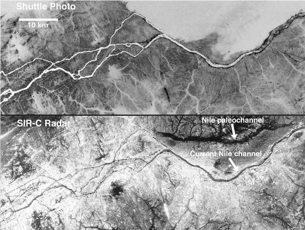
These two gray-scale images from NASA Space Shuttle show part of the Nile River, near the Fourth Cataract in Sudan.

A paper led by researchers at NASA's Jet Propulsion Laboratory estimates the total volume of water in Earth's rivers – called river storage – on average between 1980 and 2009, and maps out the results for the planet's major hydrological regions. This graphic, adapted from data gathered for the paper, indicates the amount of storage by hydrologic regions that contain one or more river basins, with shades of blue deepening as the amount of storage increases. The paper, published in Nature Geoscience in April 2024, calculated Earth's river storage at about 539 cubic miles (2,246 cubic kilometers), and found that the Amazon River basin, shown in dark blue in South America, was the region with the most storage, with 204 cubic miles (850 cubic kilometers), or about 38% of the global total. The study also estimated the flow of water through more than 3 million segments of river around the world and identified several locations marked by intense human water use, including parts of the Colorado River basin in the United States, portions of the Amazon basin in South America, the Orange River basin in southern Africa, and the Murray-Darling basin in southeastern Australia. https://photojournal.jpl.nasa.gov/catalog/PIA26119
SL2-04-018 (June 1973) --- A vertical view of the Arizona-Utah border area showing the Colorado River and Grand Canyon photographed from the Skylab 1/2 space station in Earth orbit. This picture was taken by one of the six lenses of the Itek-furnished S190-A Multispectral Photographic Facility Experiment in the Multiple Docking Adapter of the space station. Type S0-356 film was used. The row of white clouds extend north-south over the dark colored Kaibab Plateau. The junction of the Colorado and Little Colorado rivers is in the southwest corner of the picture. The body of water is Lake Powell on the Colorado River upstream from the Grand Canyon. The lone peak at the eastern edge of the photograph south of Colorado River is the 10,416-foot Navajo Mountain. The S190-A experiment is part of the Skylab Earth Resources Experiments Package(EREP). Photo credit: NASA
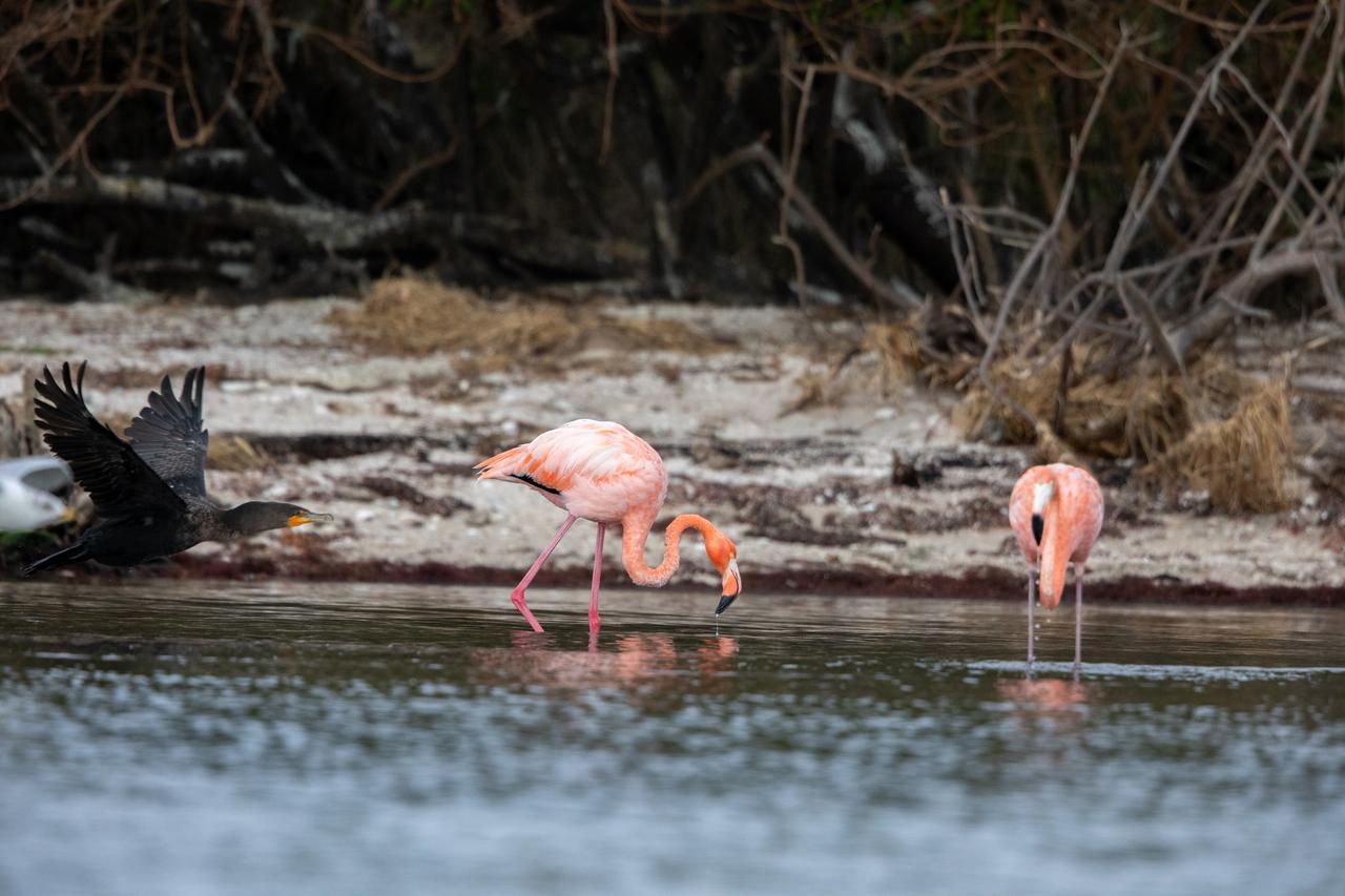
American Flamingos cool off in the Indian River at Haulover Canal on Merritt Island on Thursday, Jan. 11, 2024. The American Flamingos are more common in Mexico and Cuba but the winds from Hurricane Idalia relocated them to Florida in September 2023. Kennedy Space Center in Florida shares a border with the Merritt Island National Wildlife Refuge where more than 310 species of birds inhabit the refuge.
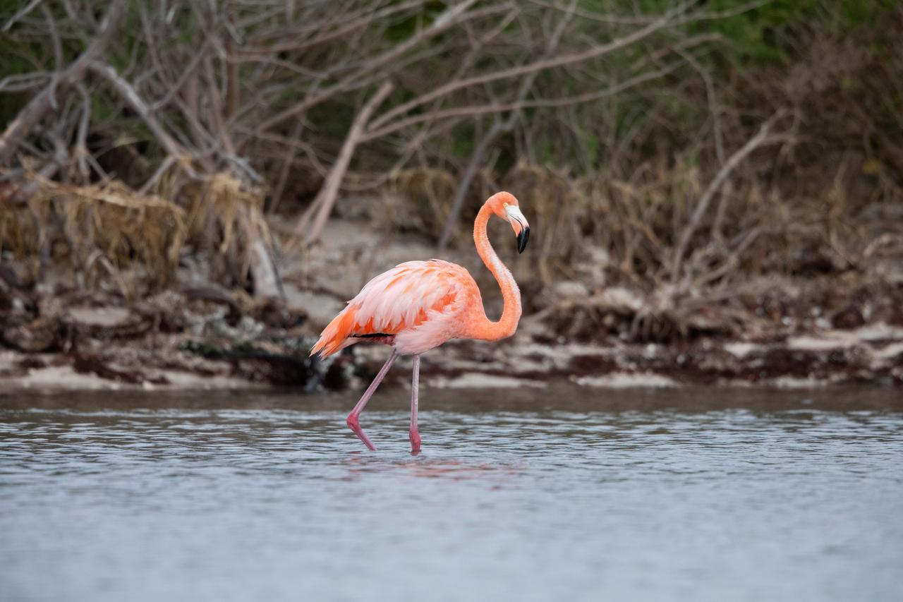
An American Flamingo cools off in the Indian River at Haulover Canal on Merritt Island on Thursday, Jan. 11, 2024. The American Flamingos are more common in Mexico and Cuba but the winds from Hurricane Idalia relocated them to Florida in September 2023. Kennedy Space Center in Florida shares a border with the Merritt Island National Wildlife Refuge where more than 310 species of birds inhabit the refuge.
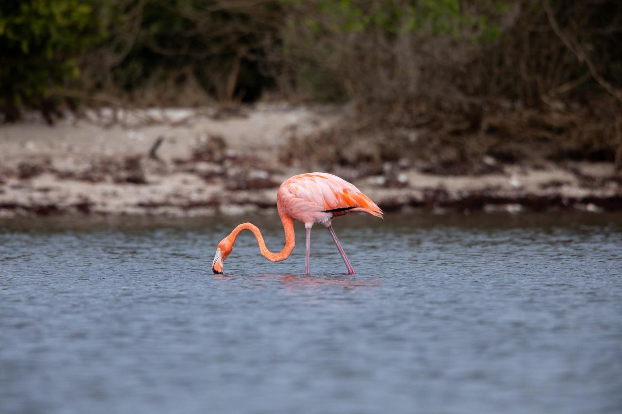
An American Flamingo takes a sip of water in the Indian River at Haulover Canal on Merritt Island on Thursday, Jan. 11, 2024. The American Flamingos are more common in Mexico and Cuba but the winds from Hurricane Idalia relocated them to Florida in September 2023. Kennedy Space Center in Florida shares a border with the Merritt Island National Wildlife Refuge where more than 310 species of birds inhabit the refuge.
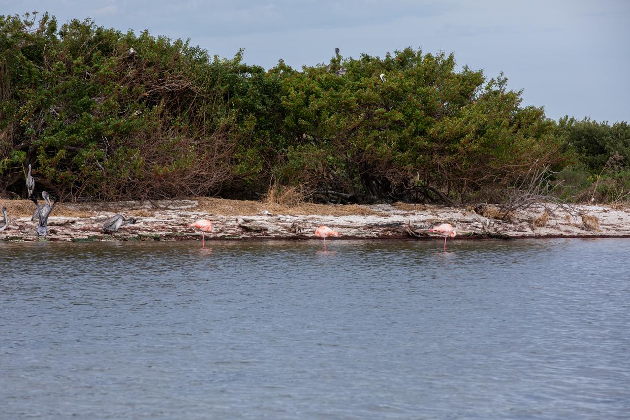
Three American Flamingos cool off in the Indian River at Haulover Canal on Merritt Island on Thursday, Jan. 11, 2024. The American Flamingos are more common in Mexico and Cuba but the winds from Hurricane Idalia relocated them to Florida in September 2023. Kennedy Space Center in Florida shares a border with the Merritt Island National Wildlife Refuge where more than 310 species of birds inhabit the refuge.
The western-most part of the Ganges Delta is seen in this 54.5 by 60 km ASTER sub-scene acquired on January 6, 2005. The Hugli River branches off from the Ganges River 300 km to the north, and flows by the city of Calcutta before emptying into the Bay of Bengal. High sediment load is evident by the light tan colors in the water, particularly downstream from off-shore islands. The deep green colors of some of these islands are mangrove swamps. The image is centered at 21.9 degrees north latitude, 88 degrees east longitude. http://photojournal.jpl.nasa.gov/catalog/PIA11158
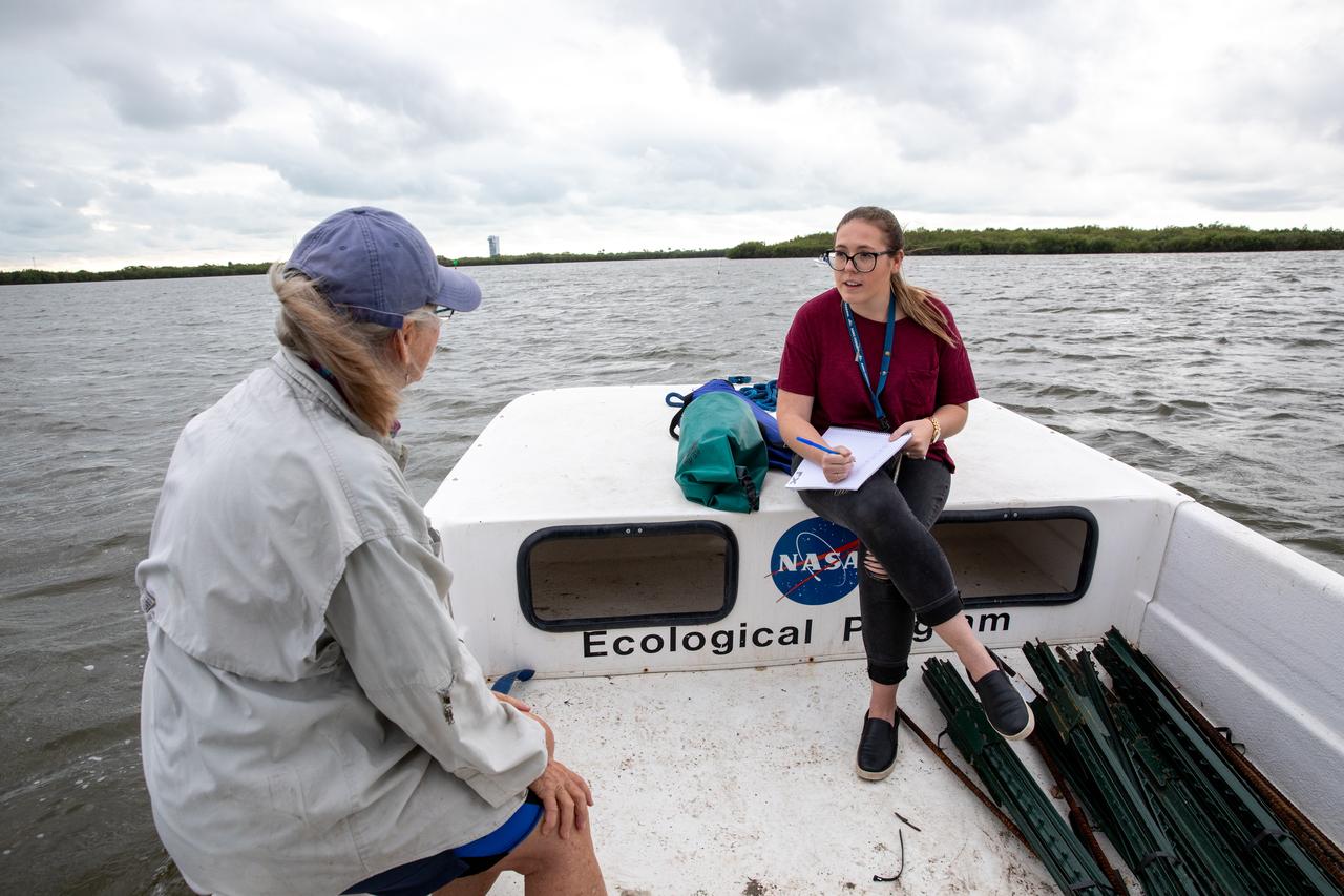
Kennedy Space Center Public Affairs Writer Danielle Sempsrott (right) interviews Jane Provancha, manager of the ecological group for NASA’s Environmental and Medical Contract (NEMCON) at Kennedy, for a web feature highlighting seagrass restoration efforts taking place at the Florida spaceport on March 29, 2023. Kennedy’s Environmental Management Branch is working to plant a minimum of 28,000 shoots of seagrass divided into 18 sites across three areas at the Florida spaceport as part of a pilot project for seagrass restoration efforts. The project will look at the feasibility of replanting seagrass in Kennedy waters and, if successful, could lead to the spaceport becoming a donor site where shoots of grass can be broken off and relocated to other areas within Kennedy or along the Indian River Lagoon to promote growth.
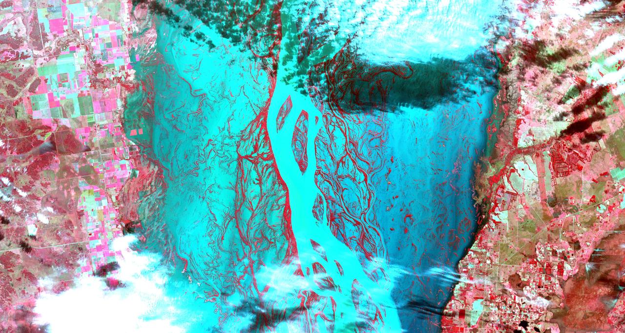
STS062-85-021 (4-18 March 1994) --- The Mississippi River is the largest river system in North America. Its delta is a typical example of the bird's foot class of river deltas. It drains nearly 3 1/2 million square kilometers of real estate and is estimated to carry 2.4 billion kilograms (more than 500 million tons) of sand, silt, and clay to the Gulf of Mexico annually. Most of this sediment is deposited as a delta at the mouth of the river where the velocity of the river water is slowed and its ability to transport sediment is accordingly diminished. Continued deposition at such a site progrades the delta or extends it seaward into the Gulf as much as 150 meters each year until such time as a flooding episode finds a shorter more efficient channel to deliver sediment-laden river waters to the Gulf. At that time the old delta is abandoned and the river begins to build a new delta. In time, compaction of the sediment in the old delta causes it to subside forming first marshes, then bays. This and the modifying effects of coastal waves eventually allow the sea to reclaim much of the temporary land area of the delta. This sequence has repeated itself over and over again at the Mississippi Delta. In this photograph, the present day active Balize delta is shown. According to NASA scientists it is the youngest of the recent delta lobes having begun its seaward pro-gradation only some 600 - 800 years ago. The main channel of the river is 2 kilometers wide and 30 - 40 meters deep. Natural levees here are almost 1 kilometer wide and 3 to 4 meters above sea level. Along the active distributaries of the lower delta, natural levees are less than 100 meters wide and generally less than 0.5 meters above sea level. The bird's foot appearance of deltas such as this is characteristic of low coastal energy conditions - that is, low levels of tidal fluctuation and generally low wave energy. The interdistributary bays are extremely shallow, usually less than a few meters, and contain brackish to normal marine waters except during times of flooding, when fresh water fills the bays. Sedimentation within the bays is very slow, occurring only during flood periods. Along the west side of the river, a highway has been built southeastward to Venice.
iss072e097231 (Oct. 22, 2024) --- The Bani River, a tributary of the Niger River, in Mali is pictured from the International Space Station as it orbited 257 miles above the African nation.
iss072e095268 (Oct. 20, 2024) --- The Niger River splits into its tributary, the Benue River, at the Nigerian city of Lokoja with a population of over 692,00 in this photograph from the International Space Station as it orbited 258 miles above the African nation.
iss072e862232 (March 28, 2025) --- This portion of the Orange River, South Africa's longest river, east of Namibia's southern border and beaming under the sun's glint is pictured from the International Space Station as it orbited 264 miles above.
STS049-91-079 (7 - 16 May 1992) --- This 70mm frame, photographed from the Earth-orbiting Space Shuttle Endeavour, features a dendritic drainage pattern in Zaire. Cleared pasture land shows light green in this color photograph, in contrast to the dark, closed-canopy forest of Zaire. Remnant woodland along minor streams indicates the intricate drainage network of this hilly region. Scattered vegetation-free spots show the deep red, tropical soil of the region. The sediment-laden stream is the Vele River just west of the village of Niangara. A crew member used a 70mm handheld Hasselblad camera with a 250mm lens to record the image.
This image of the Mississippi River in Mississippi, Arkansas, and Louisiana shows regions of the southern United States that are prone to flooding.
This image from NASA Cassini spacecraft shows a vast river system on Saturn moon Titan. It is the first time images from space have revealed a river system so vast and in such high resolution anywhere other than Earth.
The Colorado River ends its 2330 km journey in the Gulf of Mexico in Baja California. NASA Terra spacecraft acquired this image on May 29, 2006.
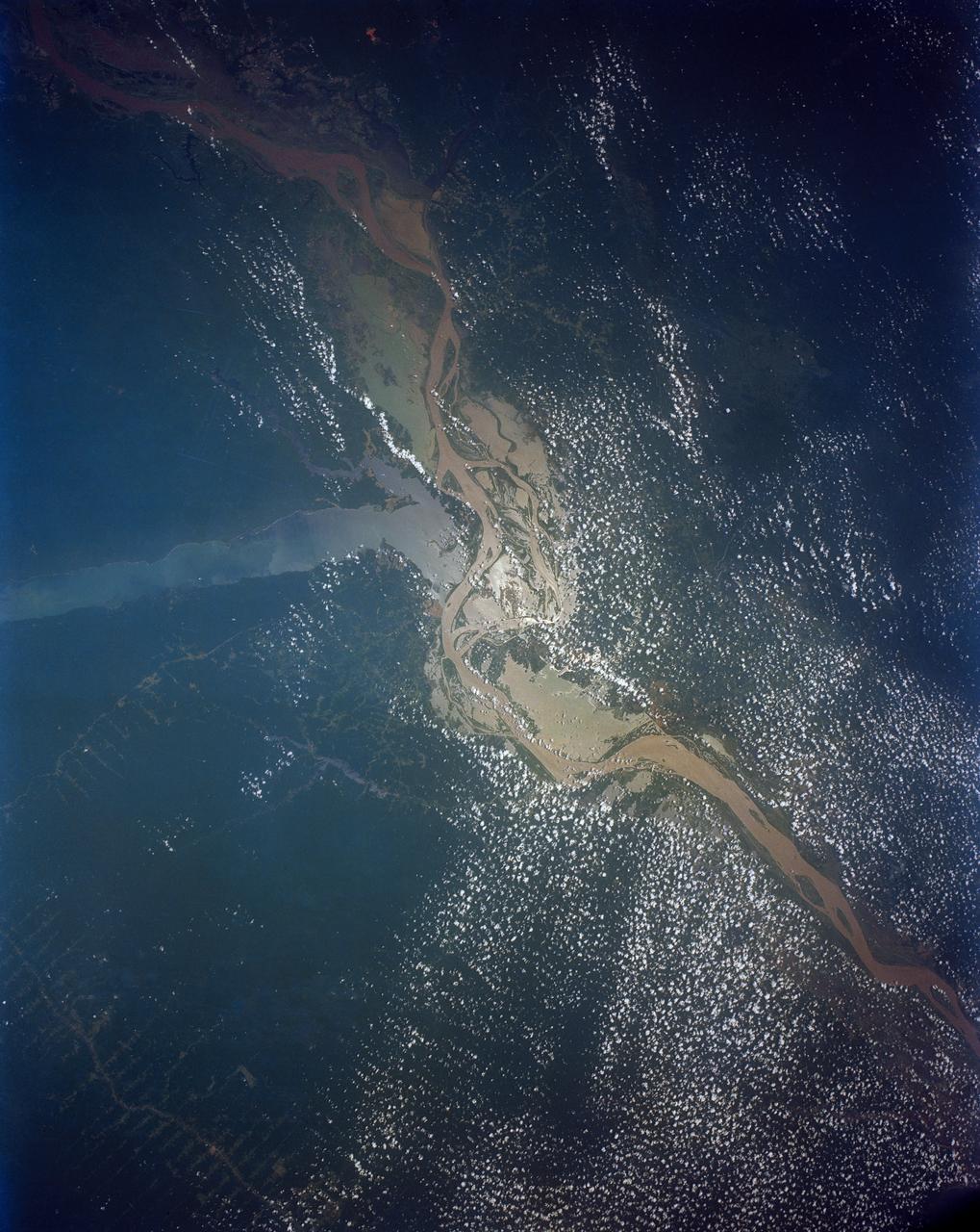
STS046-80-009 (31 July-8 Aug. 1992) --- A view of the mouth of the Amazon River and the Amazon Delta shows a large sediment plume expanding outward into the Atlantic Ocean. The sediment plume can be seen hugging the coast north of the Delta. This is caused by the west-northwest flowing Guyana Current. The large island of Marajo is partially visible through the clouds.
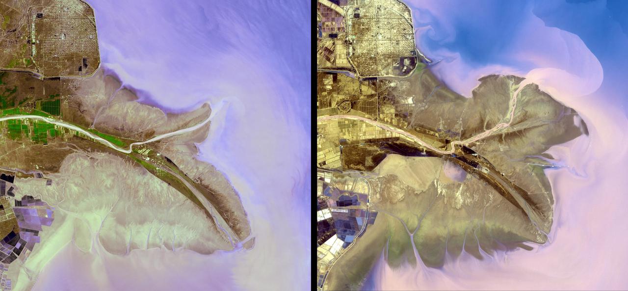
By August, 2024, the four dams blocking the flow of the Klamath River in California and Oregon were removed. After more than 100 years, nearly 640 km of salmon habitat were restored. Two of the dams and their reservoirs, Copco 1 and Copco 2 in northern California, are shown before and after removal. The images were acquired July 18, 2024 and August 15, 2020, cover an area of 16.5 by 22.5 km, and are located at 42.1 degrees north, 122.2 degrees west. https://photojournal.jpl.nasa.gov/catalog/PIA26448
The town of Shadegan, Iran is northeast of where the Tigris and Euphrates Rivers enter the Persian Gulf. It sits near a wetland and upon land that was once part of an inland river delta. The long, linear orchards follow the topography created by the delta. The image was acquired September 3, 2012, covers an area of 40.6 by 55.3 km, and is located at 30.6 degrees north, 48.6 degrees east. http://photojournal.jpl.nasa.gov/catalog/PIA21170
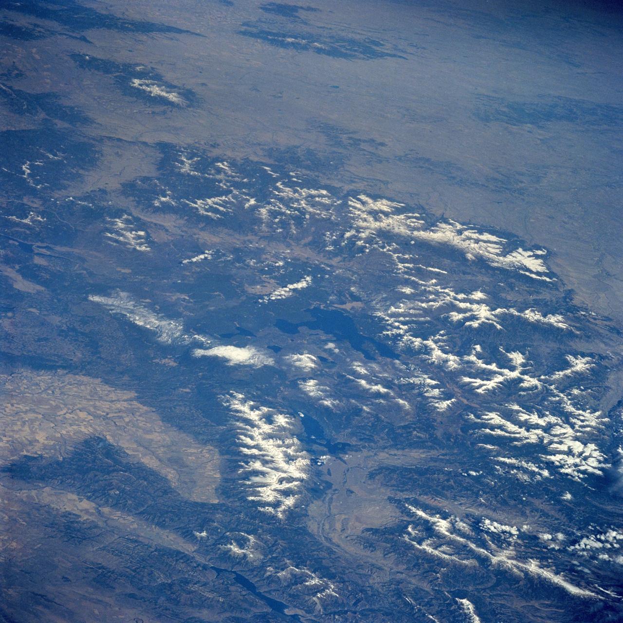
STS058-085-091 (18 Oct-1 Nov 1993) --- Yellowstone Lake and the surrounding Plateau are centered in this scene of northwestern Wyoming, and adjacent Idaho and Montana. The view extends across the Absaroka Range to Billings, on the Yellowstone River at the upper right edge of the photograph. Jackson Lake, Jackson Hole (valley) and the Grand Tetons extend from the Yellowstone Plateau toward the camera.
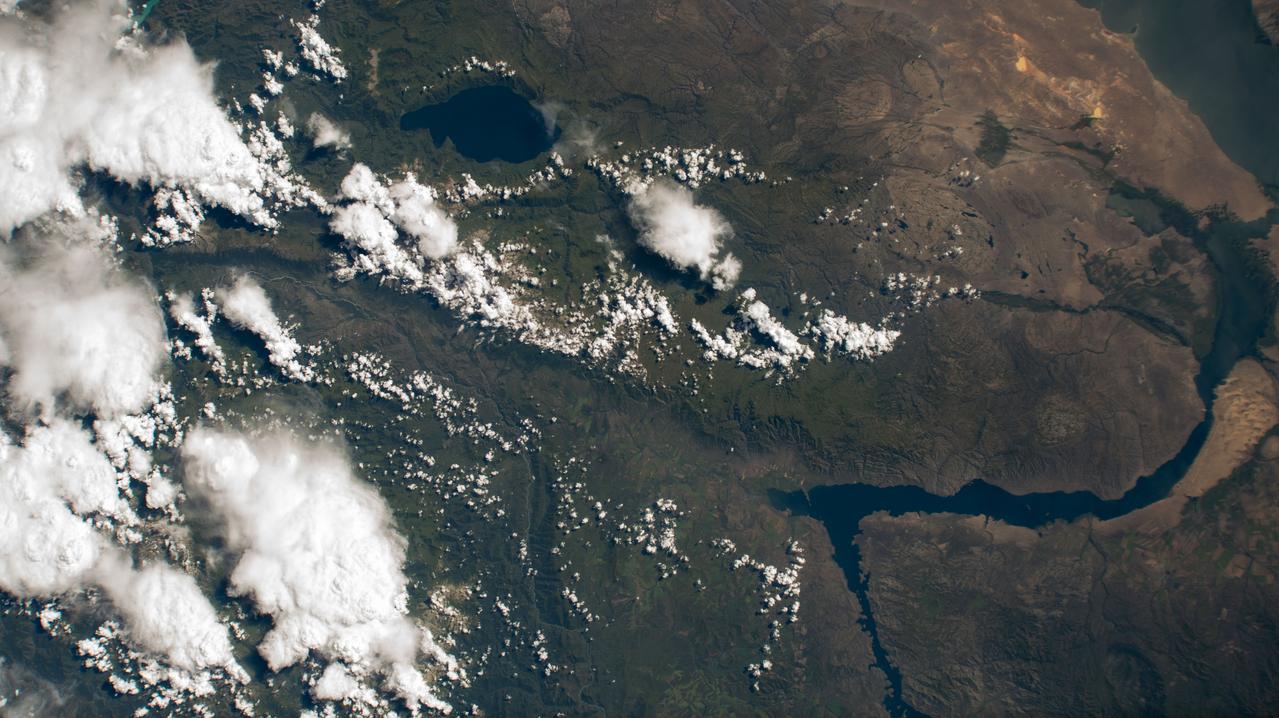
iss071e413340 (Aug. 1, 2024) --- At top left, is Lake Markakol, and at lower right, is the Irtysh River flowing into Lake Zayson in this photograph from the International Space Station as it orbited 259 miles above Kazakhstan.

A network of river channels is located atop Xanadu, the continent-sized region on Saturn moon Titan. This radar image was captured by the Cassini Radar Mapper on April 30, 2006
This image, acquired by NASA Terra satellite on July 6, 2013, shows heavy rains, which began in mid-June, resulting in major flooding along the Parana River in Argentina.
This is a combined radar and topography image of an area along the Missouri River that experienced severe flooding and levee failure in the summer of 1993.
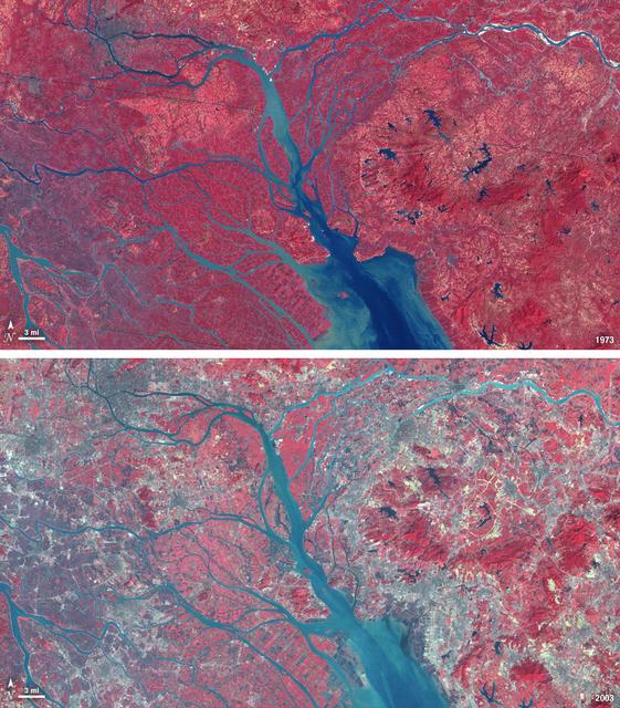
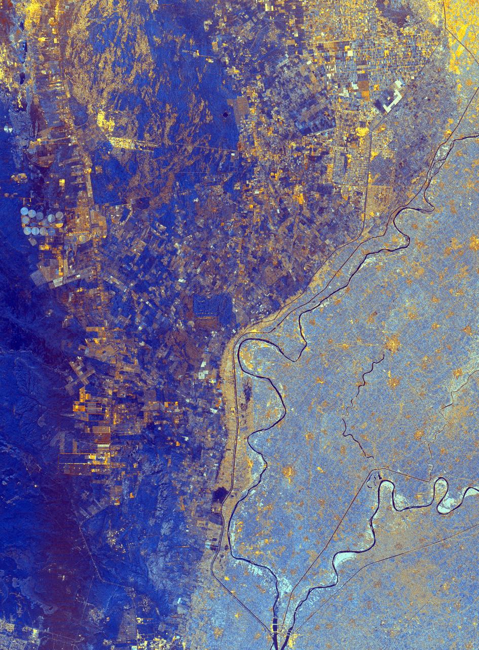
In 1979, China established two special economic zones around the Pearl River Delta, north of Hong Kong. This image, taken by Landsat 3 on October 19, 1973, shows that the region was rural when the zone was established. Plant-covered land, which is red in this false-color image, dominates the scene. Square grids are agriculture. By January 10, 2003, when Landsat 7 took this image, the Pearl River Delta was a densely populated urban corridor with several large cities. The urban areas are gray in this image. The region is a major manufacturing center with an economy the size of Taiwan’s. As of 2010, the Pearl River Economic Zone had a population of 36 million people. ---- NASA and the U.S. Department of the Interior through the U.S. Geological Survey (USGS) jointly manage Landsat, and the USGS preserves a 40-year archive of Landsat images that is freely available over the Internet. The next Landsat satellite, now known as the Landsat Data Continuity Mission (LDCM) and later to be called Landsat 8, is scheduled for launch in 2013. In honor of Landsat’s 40th anniversary in July 2012, the USGS released the LandsatLook viewer – a quick, simple way to go forward and backward in time, pulling images of anywhere in the world out of the Landsat archive. <b><a href="http://www.nasa.gov/audience/formedia/features/MP_Photo_Guidelines.html" rel="nofollow">NASA image use policy.</a></b> <b><a href="http://www.nasa.gov/centers/goddard/home/index.html" rel="nofollow">NASA Goddard Space Flight Center</a></b> enables NASA’s mission through four scientific endeavors: Earth Science, Heliophysics, Solar System Exploration, and Astrophysics. Goddard plays a leading role in NASA’s accomplishments by contributing compelling scientific knowledge to advance the Agency’s mission. <b>Follow us on <a href="http://twitter.com/NASA_GoddardPix" rel="nofollow">Twitter</a></b> <b>Like us on <a href="http://www.facebook.com/pages/Greenbelt-MD/NASA-Goddard/395013845897?ref=tsd" rel="nofollow">Facebook</a></b> <b>Find us on <a href="http://instagrid.me/nasagoddard/?vm=grid" rel="nofollow">Instagram</a></b>
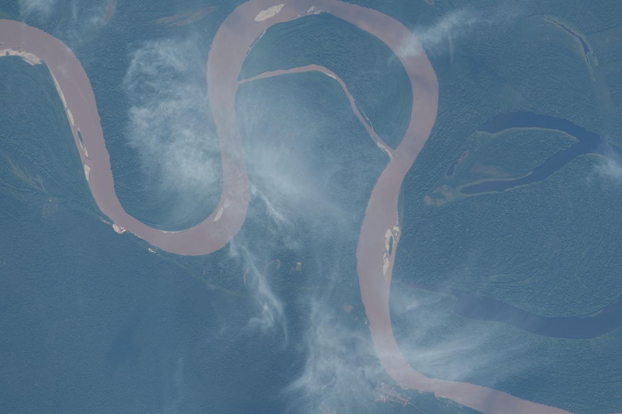
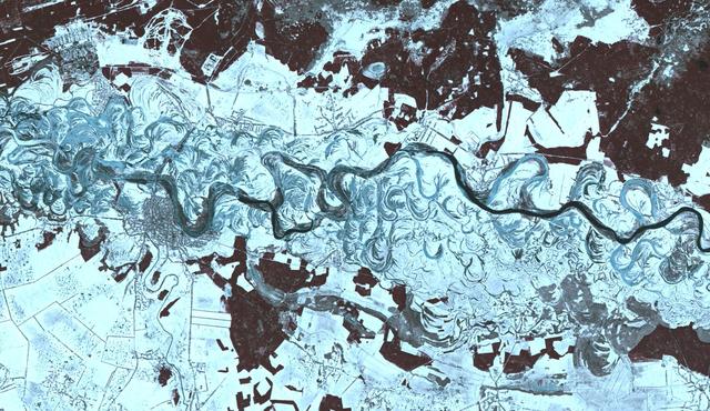
iss069e033689 (July 19, 2023) -- Curves of the Amazon River are pictured from the International Space Station as it orbited 260 miles above Bolivia.
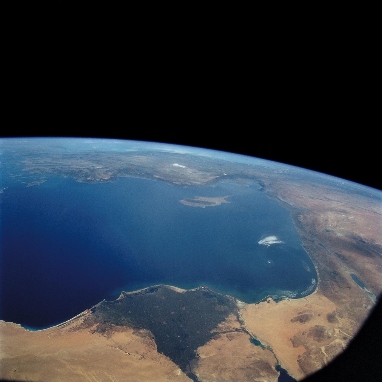
Lake Nasser on the Nile River in southeastern United Arab Republic (Egypt) as seen from the Apollo 7 spacecraft during its 10th revolution of the earth. Photographed from an altitude of 130 nautical miles, at ground elapsed time of 14 hours and 56 minutes. Lake Nasser was created by the contruction of the Aswan Dam on the Nile.
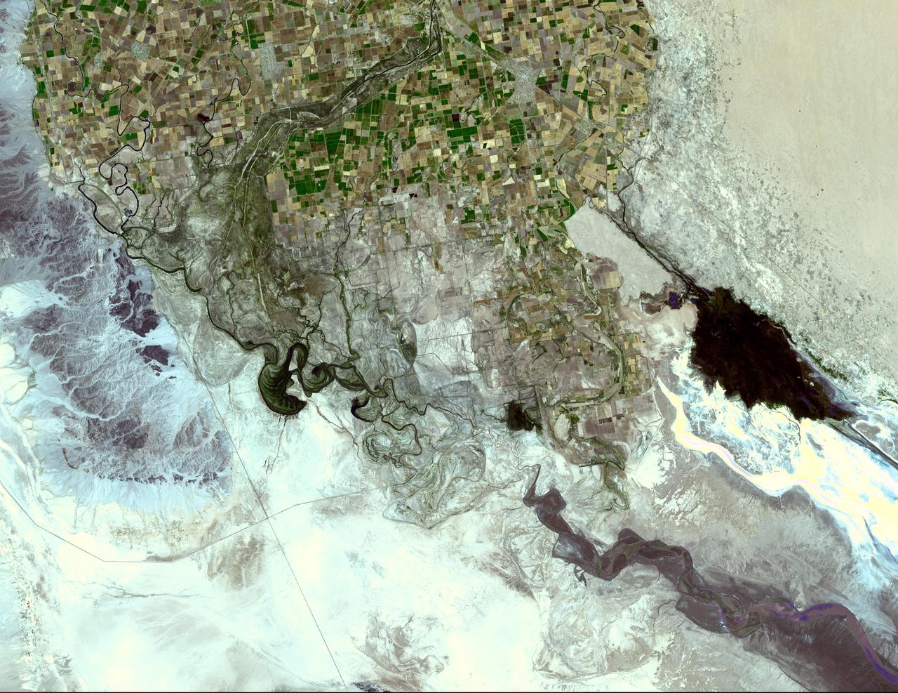
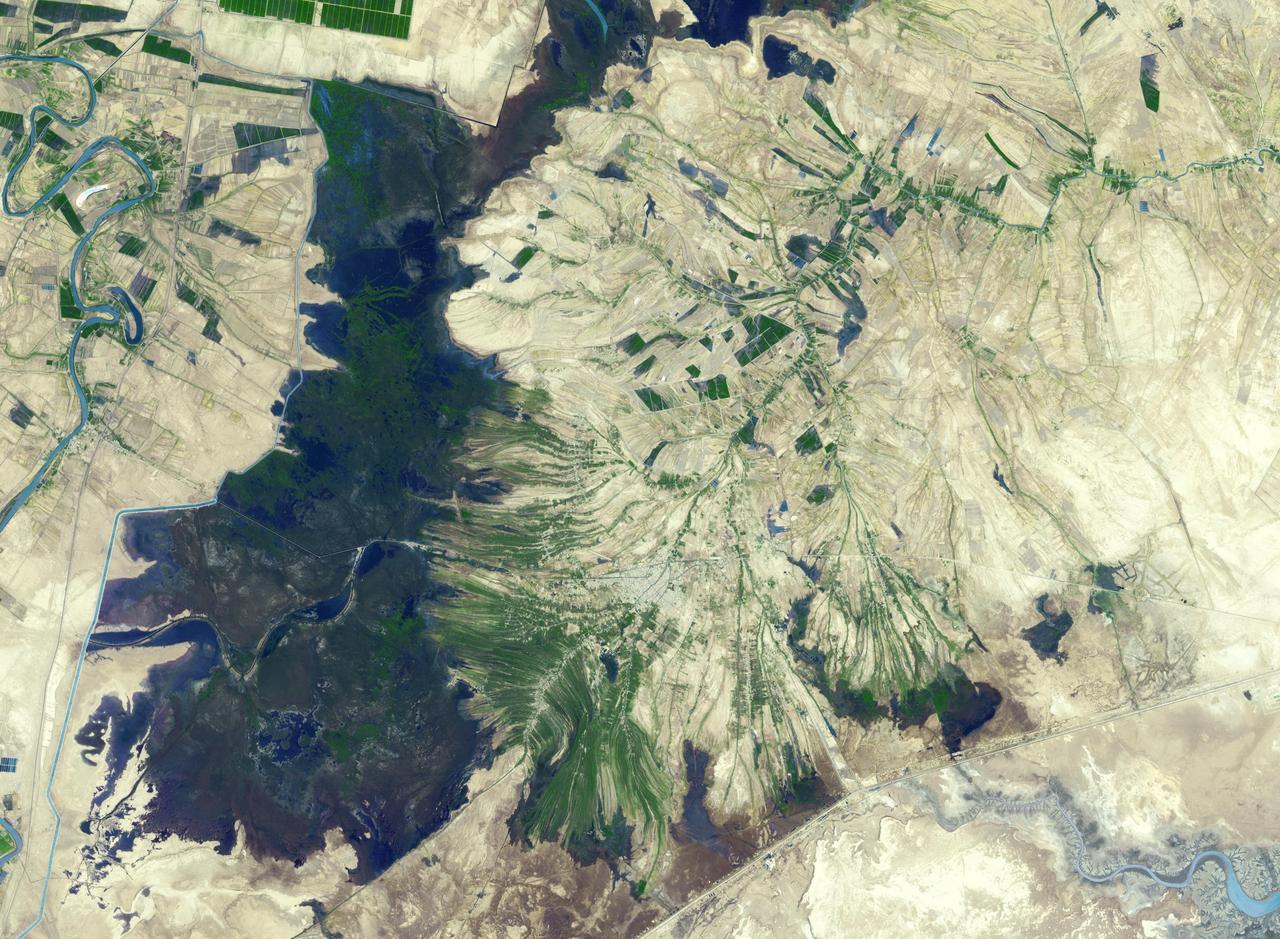
It drains a watershed that spans eight countries and nearly 1.6 million square kilometers 600,000 square miles. The Zambezi also Zambeze is the fourth largest river in Africa, and the largest east-flowing waterway. The Operational Land Imager on the Landsat 8 satellite acquired this natural-color image of the Zambezi Delta on August 29, 2013. Sandbars and barrier spits stretch across the mouths of the delta, and suspended sediment extends tens of kilometers out into the sea. The sandy outflow turns the coastal waters to a milky blue-green compared to the deep blue of open water in the Indian Ocean. The Zambezi Delta includes 230 kilometers of coastline fronting 18,000 square kilometers (7,00 square miles) of swamps, floodplains, and even savannahs (inland). The area has long been prized by subsistence fishermen and farmers, who find fertile ground for crops like sugar and fertile waters for prawns and fish. Two species of endangered cranes and one of the largest concentration of buffalo in Africa -- among many other species of wildlife -- have found a haven in this internationally recognized wetland. However, the past six decades have brought great changes to the Zambezi Delta, which used to pour more water and sediment off of the continent. Hydropower dams upstream-most prominently, the Kariba and the Cahora Bassa-greatly reduce river flows during the wet season; they also trap sediments that would otherwise flow downstream. The result has been less water reaching the delta and the floodplains, which rely on pulses of nutrients and sediments from annual (and mostly benign) natural flooding. The change in the flow of the river affects freshwater availability and quality in the delta. Strong flows push fresh water further out into the sea and naturally keep most of a delta full of fresh (or mostly fresh) water. When that fresh flow eases, the wetlands become drier and more prone to fire. Salt water from the Indian Ocean also can penetrate further into the marsh, upsetting the ecological balance for aquatic plant and animal species. Researchers have found that the freshwater table in the delta has dropped as much as five meters in the 50 years since dams were placed on the river. Less river flow also affects the shape and extent of the delta. Today there is less sediment replenishing the marshes and beaches as they are scoured by ocean waves and tides. "What strikes me in this image is the suspended sediment offshore," said Liviu Giosan, a delta geologist at the Woods Hole Oceanographic Institution. "Sediment appears to be transferred from the delta offshore in plumes that not only originate in active river mouths but also from deactivated former mouths, now tidal channels. This shows the power of tidal scouring contributing to the slow but relentless erosion of the delta." http://photojournal.jpl.nasa.gov/catalog/PIA18155
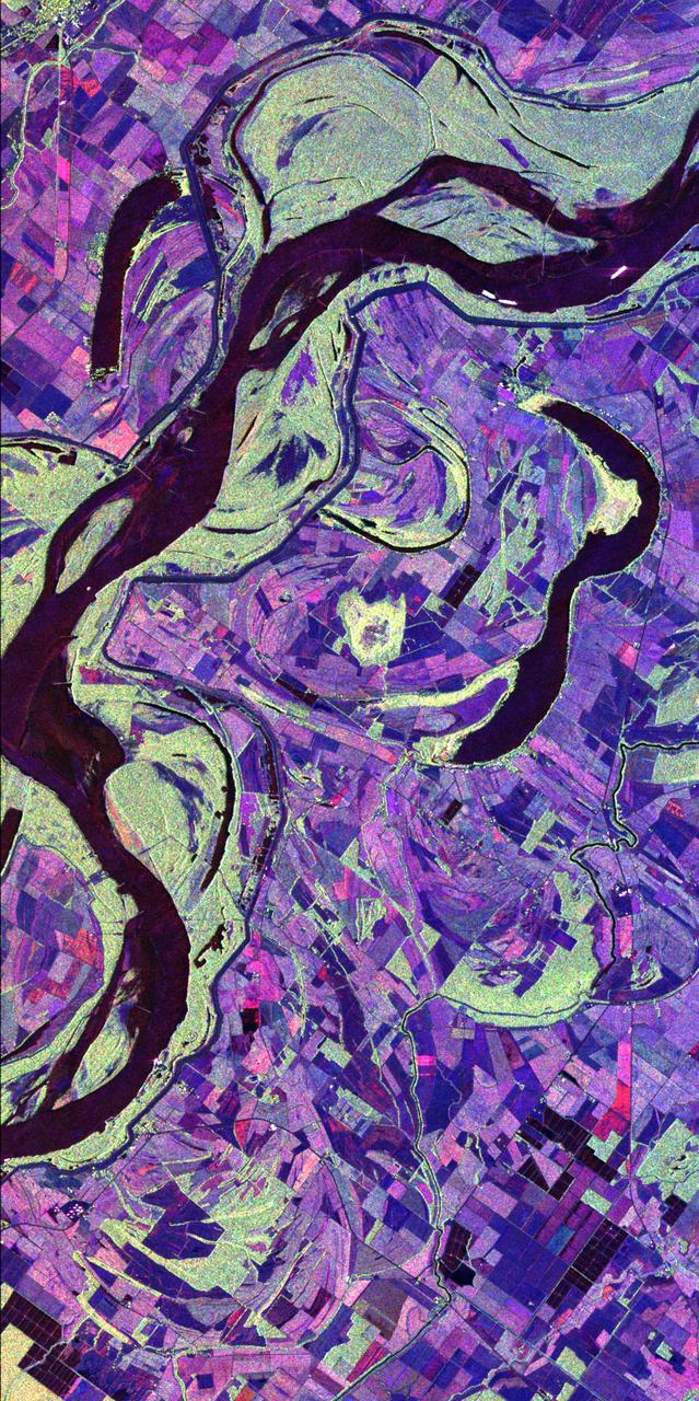
SL2-81-189 (22 June 1973) --- The well defined meanderings of the Mississippi River, just to the south of St. Louis, MO (38.5N, 90.5W) can easily be seen as curved lines and loops roughly paralleling the present river in this view showing the former water channels. The vegetated bluffs on either side of the river define the limits of the meanders where the rich river flood plain offers some of the most fertile land for agriculture although flooding remains a constant threat. Photo credit: NASA
AS09-23-3586 (11 March 1969) --- Dallas, Ft. Worth, Sherman, Denison, Red River, and Lake Texoma, as photographed from the Apollo 9 spacecraft during its 122nd revolution of Earth.
Numerous fires occurred near the headwaters of the Xingu River and the Xingu Indigenous Peoples Reserve in Mato Grosso, Brazil, during late June and early July, 2004, as seen by NASA Terra spacecraft.
STS072-738-019 (11-20 Jan. 1996) --- The Delta of the Paraiba do Sul River, northeast of Rio de Janeiro, Brazil, stands out in this 70mm frame exposed from the Earth-orbiting Space Shuttle Endeavour. The brown color of the river water and offshore sediment plume show that the river is in flood stage. This delta attracts much attention from orbit because of its prominent beach ridges either side of the river mouth. River sediment from inland supplies the material which is redistributed by coastal currents to form the parallel beach ridges. The lower 20 miles of the river appear in this scene. The river flows into the Atlantic in an easterly direction.
This radar image acquired by NASA Airborne Synthetic Aperture Radar AIRSAR in 2001, shows the Altamaha River Delta in the Georgia Sea Islands.
This spaceborne radar image shows the area just north of the city of Cairo, Egypt, where the Nile River splits into two main branches.
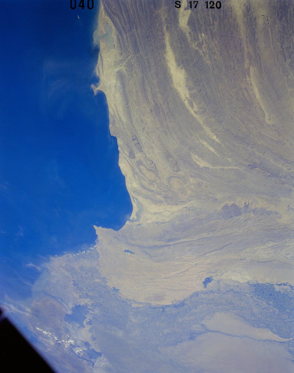
41G-120-040 (5-13 Oct. 1984) --- Pakistan, featuring the city of Karachi, the Makran mountain range, the mouth of the Indus River and the North Arabian Sea were photographed with a medium format camera aboard the space shuttle Challenger during the 41-G mission. Photo credit: NASA

The mighty Yukon River and nearby lakes appear in red in this image produced using data recorded on June 18, 2023, by the international Surface Water and Ocean Topography (SWOT) satellite as it passed over Alaska. The satellite measures the height of nearly all the water on Earth's surface, providing one of the most detailed, comprehensive views yet of the planet's ocean and fresh water. The mission is a collaboration between NASA and the French space agency, CNES (Centre National d'Études Spatiales). SWOT will address some of the most pressing climate change questions of our time, offering insights into areas including how a warming world is accelerating Earth's water cycle, leading to more volatile precipitation patterns. SWOT will also help researchers better understand how climate change affects water storage in lakes, rivers, and reservoirs, and how communities can better manage water resources and prepare for floods and other disasters. SWOT passed over the Yukon River and recorded this data during a period called calibration and validation, when the mission confirms the accuracy of its data. Calibration involved ensuring SWOT's software and hardware – including its main scientific instrument, the Ka-band Radar Interferometer (KaRIn) and its antenna – operate as designed. During validation activities, dozens of research teams headed into the field to measure water levels and the slope of rivers, including the Yukon. Mission scientists then compared field measurements to the data taken by the satellite to ensure SWOT's accuracy. In mid-June, the team of freshwater researchers tasked with gathering data on the Yukon drifted down the waterway around midnight – the same time as SWOT passed overhead, collecting its own data on the river. Launched on Dec. 16, 2022, from Vandenberg Space Force Base in central California, SWOT is now in its operations phase, collecting data that will be used for research and other purposes. https://photojournal.jpl.nasa.gov/catalog/PIA25780
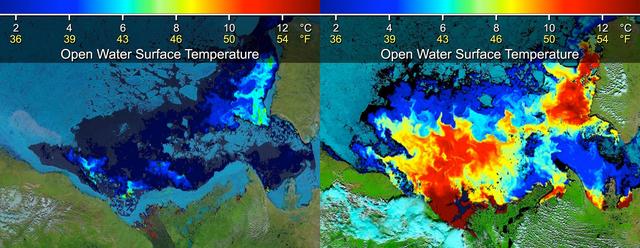
Beaufort Sea surface temperatures where Canada Mackenzie River discharges into the Arctic Ocean, measured by NASA MODIS instrument; warm river waters had broken through a shoreline sea ice barrier to enhance sea ice melt.
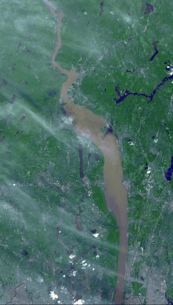
Brown and tan muddy water flows down the Hudson River are seen in this image acquired by NASA Terra spacecraft on Sept. 1, 2011. After the torrential rains from Hurricane Irene, many rivers in the eastern United States were filled with sediment.
STS057-73-075 (21 June-1 July 1993) --- Eastern Mediterranean from an unusually high vantage point over the Nile River, this north-looking view shows not only the eastern Mediterranean but also the entire landmass of Asia Minor, with the Black Sea dimly visible at the horizon. Many of the Greek islands can be seen in the Aegean Sea (top left), off the coast of Asia Minor. Cyprus is visible under atmospheric dust in the northeast corner of the Mediterranean. The dust cloud covers the east end of the Mediterranean, its western edge demarcated by a line that cuts the center of the Nile Delta. This dust cloud originated far to the west, in Algeria, and moved northeast over Sicily, southern Italy, and Greece. Part of the cloud then moved on over the Black Sea, but another part swerved southward back towards Egypt. A gyre of clouds in the southeast corner of the Mediterranean indicates a complementary counterclockwise (cyclonic) circulation of air. The Euphrates River appears as a thin green line (upper right) in the yellow Syrian Desert just south of the blue-green mountains of Turkey. The Dead Sea (lower right) lies in a rift valley which extends north into Turkey and south thousands of miles down the Gulf of Aqaba, the Red Sea, and on through East Africa. The straight international boundary between Israel and Egypt (where the coastline angles) is particularly clear in this view, marked by the thicker vegetation on the Israeli side of the border. The green delta of the Nile River appears in the foreground, with the great conurbation of Cairo seen as a gray area at the apex of the triangle. Most of Egypt's 52 million inhabitants live in the delta. On the east side of the delta, the Suez Canal is visible. On the western corner of the delta lies the ancient city of Alexandria, beside the orange and white salt pans. The World War II battlesite El Alamein lies on the coast.