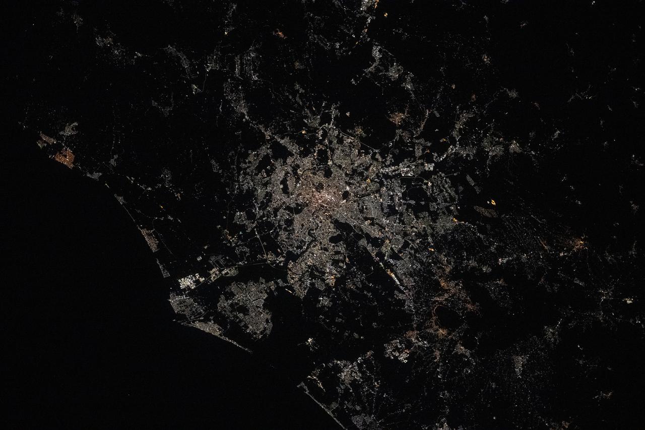
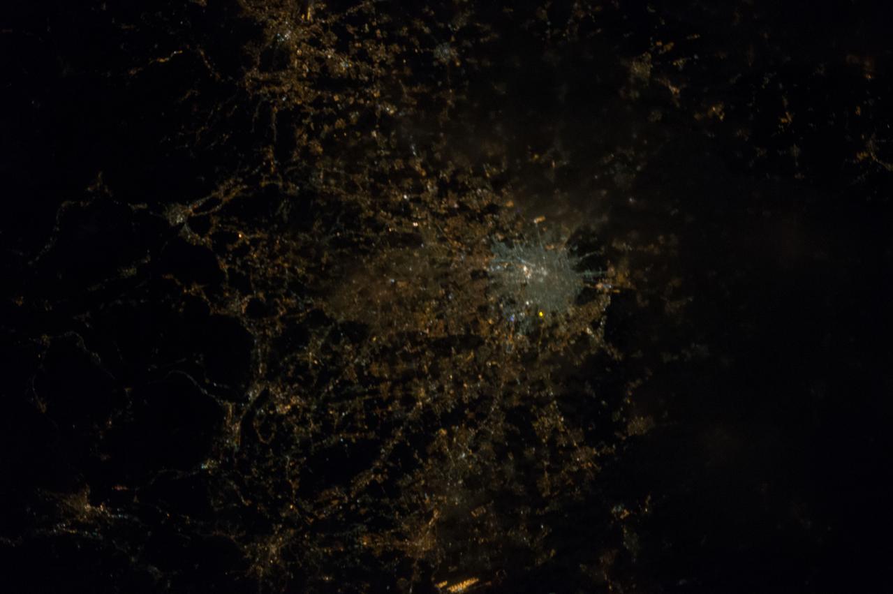
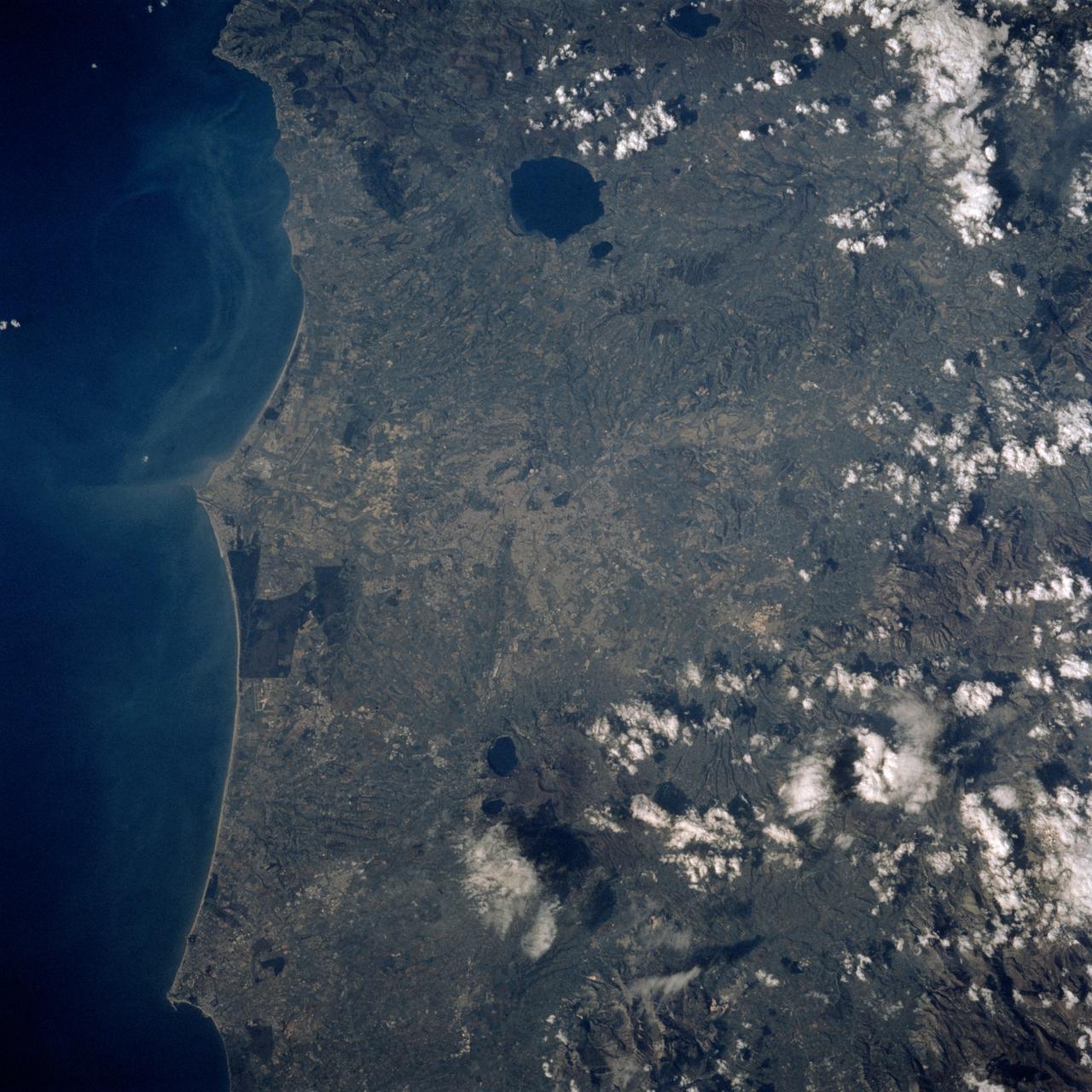
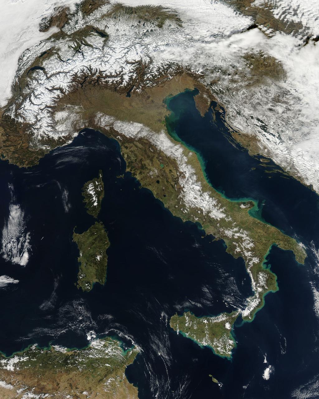
iss073e0343840 (July 15, 2025) --- Rome, Italy, the nation's capital and largest city nearly 3,000 years old with a metropolitan population of about 4.22 million, is pictured at approximately 1:16 a.m. local time from the International Space Station as it orbited 260 miles above.
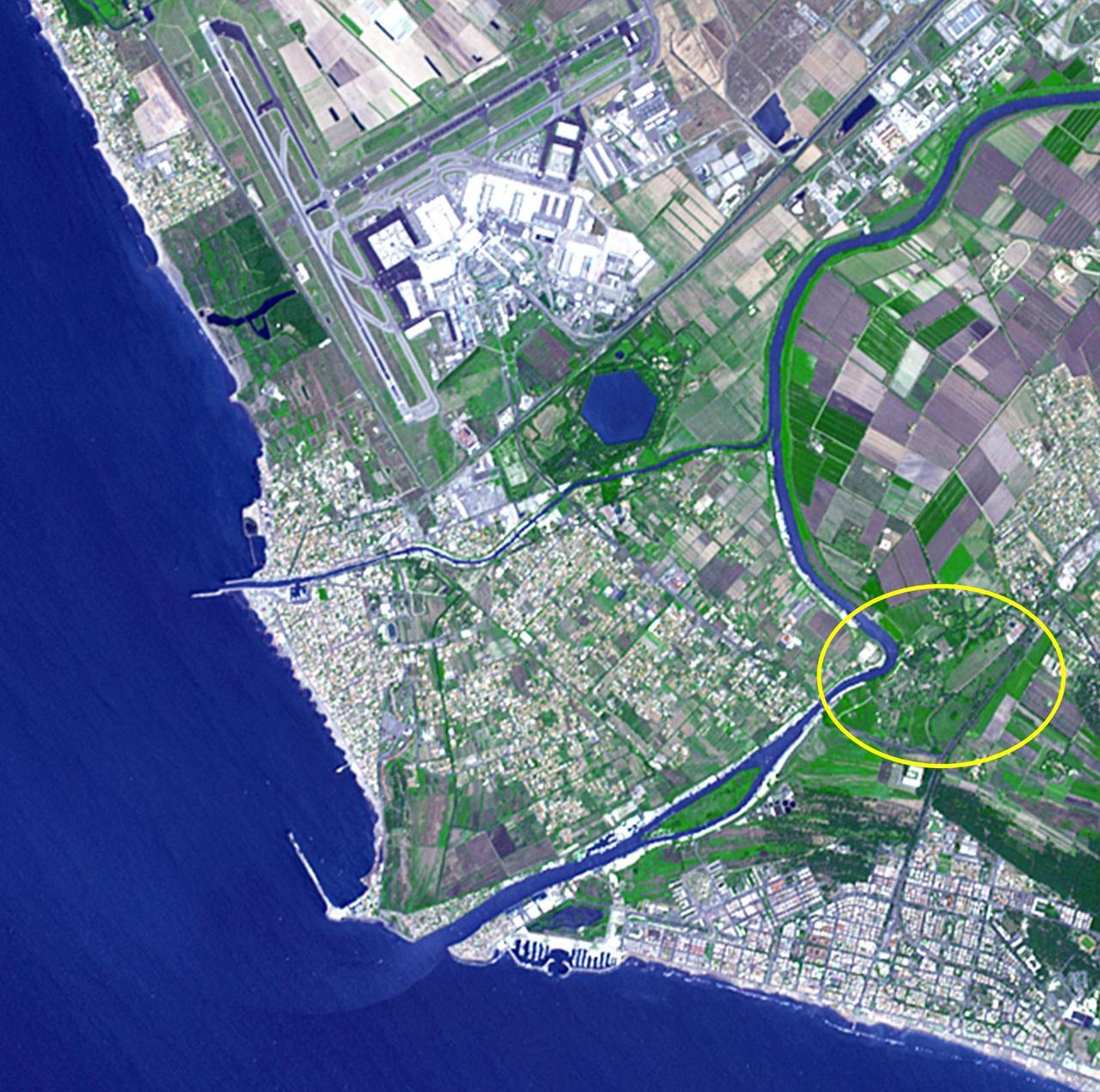
Thirty kilometers southwest of Rome lies what may be ancient Rome's greatest engineering achievement: Portus. Built in the first century A.D., Portus was Rome's principal maritime harbor, replacing the port city of Ostia on the Tiber River (circled area) that had become inadequate to handle the hundreds of ships loaded with food stuffs to feed Rome's 1 million+ inhabitants. The hexagonal Trajanic Basin and the outer Claudian Basin (now silted up) formed a port complex without equal. In 2000 years, the coastline has moved seaward, and the Trajanic Basin is now a private lake. The image was acquired June 29, 2014, covers an area of 10 by 10 km, and is located at 41.7 degrees north, 12.3 degrees east. http://photojournal.jpl.nasa.gov/catalog/PIA19209
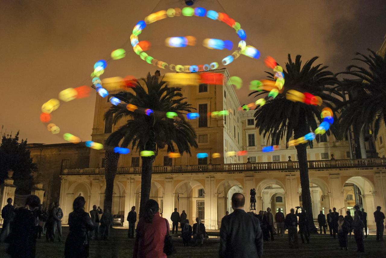
Last week researchers from around the world gathered at the Accademia dei Lincei in Rome for the Science with the Hubble Space Telescope IV conference. The event celebrated the history of Hubble’s extraordinary achievements, and looked to the future at what might yet be achieved and how the James Webb Space Telescope will build on our knowledge of the Universe. As part of this celebration artist Tim Otto Roth revealed a new artwork, Heaven’s Carousel, inspired by Hubble’s work on the accelerating expansion of the Universe. This image shows audiences taking in the new astronomy-inspired art installation premiered in Rome at the Science with the Hubble Space Telescope IV conference. The installation, named Heaven’s Carousel, links together the fields of art, music and astronomy. Conceptualised and designed by German artist and composer Tim Otto Roth, the work is inspired by novel work on the accelerating expansion of the Universe by Nobel laureate Adam Riess (STScl), Greek cosmology and Renaissance astronomers. Read more here: <a href="http://www.spacetelescope.org/news/heic1407/" rel="nofollow">www.spacetelescope.org/news/heic1407/</a> Credit: NASA, ESA, and Pam Jeffries (STScI) <b><a href="http://www.nasa.gov/audience/formedia/features/MP_Photo_Guidelines.html" rel="nofollow">NASA image use policy.</a></b> <b><a href="http://www.nasa.gov/centers/goddard/home/index.html" rel="nofollow">NASA Goddard Space Flight Center</a></b> enables NASA’s mission through four scientific endeavors: Earth Science, Heliophysics, Solar System Exploration, and Astrophysics. Goddard plays a leading role in NASA’s accomplishments by contributing compelling scientific knowledge to advance the Agency’s mission. <b>Follow us on <a href="http://twitter.com/NASAGoddardPix" rel="nofollow">Twitter</a></b> <b>Like us on <a href="http://www.facebook.com/pages/Greenbelt-MD/NASA-Goddard/395013845897?ref=tsd" rel="nofollow">Facebook</a></b> <b>Find us on <a href="http://instagram.com/nasagoddard?vm=grid" rel="nofollow">Instagram</a></b>
This image from NASA Terra spacecraft shows the Vatican City State, a sovereign city-state, whose area is a 44 hectare walled enclave west of the Tiber River, within the city of Rome.
GMT344_23_39_Terry Virts_sunrise set cities at night rome cairo jerusalem more_127
GMT344_23_39_Terry Virts_sunrise set cities at night rome cairo jerusalem more_127
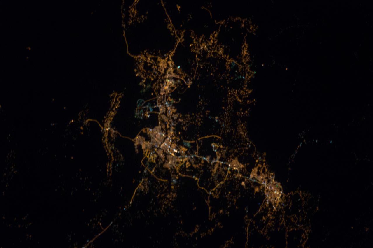
GMT344_23_39_Terry Virts_sunrise set cities at night rome cairo jerusalem more_127
GMT344_23_39_Terry Virts_sunrise set cities at night rome cairo jerusalem more_127
GMT344_23_39_Terry Virts_sunrise set cities at night rome cairo jerusalem more_127
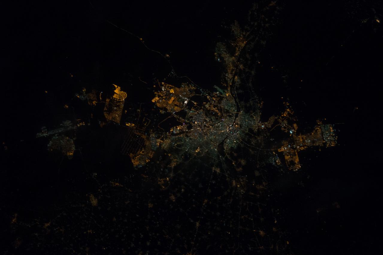
GMT344_23_39_Terry Virts_sunrise set cities at night rome cairo jerusalem more_127
iss064e051271 (April 2, 2021) --- Sabaudia, an Italian province south of Rome, is pictured on the coast of the Tyrrhenian Sea as the International Space Station orbited 264 miles above.
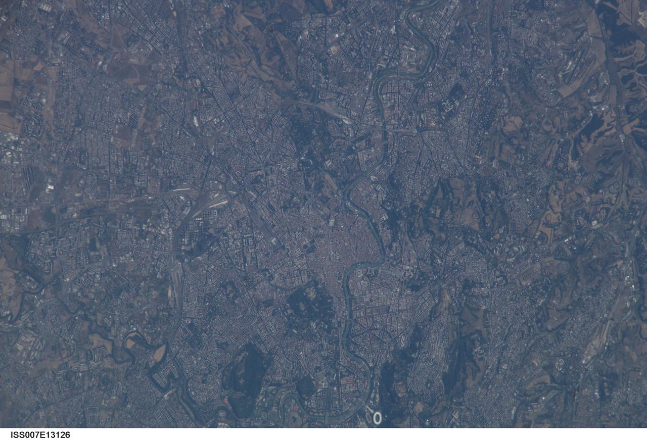
ISS007-E-13126 (21 August 2003) --- This view of Rome, Italy was taken by one of the Expedition 7 crewmembers onboard the International Space Station (ISS).
jsc2022e072967 (4/12/2021) --- Image of bovine ovary Granulosa cells. Coordinated by the Italian Space Agency (ASI), OVOSPACE investigates how microgravity influences the maturation and development ovarian cells in mammals, including Granulosa cells. This experiment could help scientists understand how long-term settlement on the Moon or Mars might affect the fertility of astronauts living in reduced gravity for long durations. Image courtesy of Professor Mariano Bizzarri, Department of Experimental Medicine, Sapienza University of Rome.
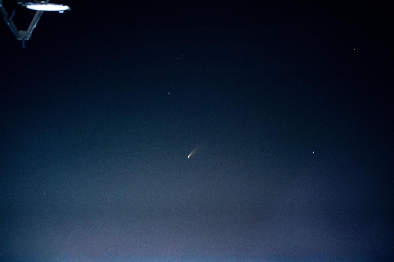
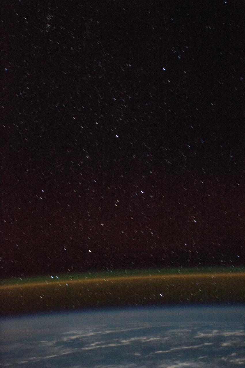
iss063e040094 (July 5, 2020) --- Comet Neowise was photographed by an Expedition 63 crew member as the International Space Station orbited above Rome, Italy, just after 1:36 a.m. local time on July 5.
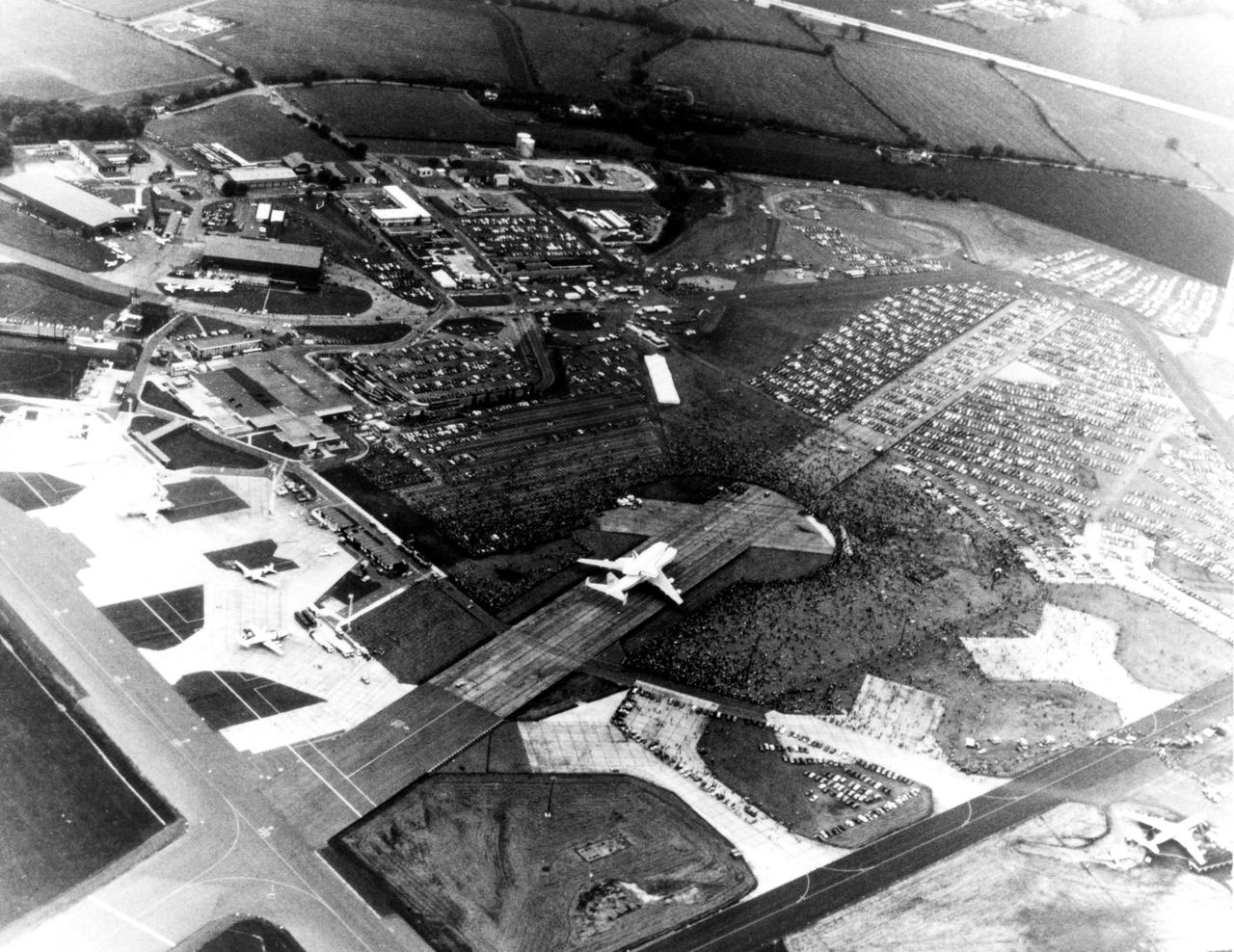
KENNEDY SPACE CENTER, FLA. -- Thousands of Britons surround the Space Shuttle Orbiter Enterprise at Stansted Airport, near London. The Enterprise atop its 747 carrier aircraft was viewed in London, Bonn-Cologne, West Germany, Rome and Ottawa, Canada, in addition to being shown at the Paris Air Show in June 1983.

ISS036-E-025994 (29 July 2013) --- One of the Expedition 36 crew members aboard the International Space Station photographed this oblique, north-looking nighttime image of parts of Italy on July 29, 2013. Rome is well lighted and clearly visible on the Mediterranean coast in the lower left quadrant. Much of the Adriatic Sea coast is visible on the right side of the frame

ISS036-E-026000 (29 July 2013) --- One of the Expedition 36 crew members aboard the International Space Station photographed this oblique, north-looking nighttime image of parts of Italy on July 29, 2013. Rome is well lighted and cleary visible on the Mediteranean coast in the lower left quadrant. Much of the Adriatic Sea coast is visible on the right side of the frame.

ISS037-E-018864 (23 Oct. 2013) --- This night image of most of Italy and all of Sicily was photographed by one of the Expedition 37 crew members aboard the International Space Station flying approximately 240 miles above Earth on Oct. 23, 2013. The night lights of Rome and Naples are visible near the center of the frame. Many other major cities are also visible by their lights. The Adriatic Sea is on the east (right) side of Italy.

iss073e0705168 (Sept. 18, 2025) --- A faint blue-green airglow blankets Earth’s horizon as city lights define northern Italy's luminous urban corridor (center) from Turin, to Milan, and Venice. At upper right, Rome is visible along the Tyrrhenian coastline. The International Space Station was orbiting 262 miles above Southern Europe when this image was captured at approximately 11:14 p.m. local time.
STS060-90-028 (3-11 Feb 1994) --- This view is centered over Rome and covers approximately 3,600 square miles. Anzio, the site of the January 22, 1944, Allied landing in Central Italy, is on the coast at the lower left. The coastal protuberance near the center is Ostia. This Roman Empire port on the Tiber River silted in and was covered over. It is now an archeological site and a tourist attraction. Southeast of the mouth of the Tiber is the Pontine Marsh. These marshlands were drained in the 1930's and have been converted to farmland. Volcanism formed the land in the region. It is evidenced in the circular caldera lakes visible. Castel Gandolfo, part of the Papal State, is on Lake Albano toward the bottom of the frame. Rome was founded during the Bronze Age on a river crossing. The road from the coast along the river was the main route for the early salt trade. The city became the capital of modern Italy in 1861. It has undergone explosive growth since World War II and now has a population of over three million people. Leonardo da Vinci (Fiumicino) Airport, the main international airport, is visible near the coast north of the Tiber River.

ISS030-E-074777 (25 Jan. 2012 ) --- This nighttime panorama of much of Europe was photographed by one of the Expedition 30 crew members aboard the International Space Station flying approximately 240 miles above the Tyrrhenian Sea on Jan. 25, 2012. Most of the country of Italy is visible running horizontally across the center of the frame, with the night lights of Rome and Naples being visible to the left and right of center, respectively. Sardinia, and Corsica are in the lower left quadrant of the photo. The Adriatic Sea is on the other side of Italy, and beyond it to the east and north can be seen parts of several other European nations.

ISS030-E-074752 (25 Jan. 2012 ) --- This nighttime panorama of much of Europe was photographed by one of the Expedition 30 crew members aboard the International Space Station flying approximately 240 miles above the Tyrrhenian Sea on Jan. 25, 2012. Most of the country of Italy is visible running horizontally across the center of the frame, with the night lights of Rome and Naples being visible to the center and right center, respectively. Sardinia, and Corsica are in the lower left quadrant of the photo, and Sicily is at lower right corner. The Adriatic Sea is on the other side of Italy, and beyond it to the east and north can be seen parts of several other European nations.
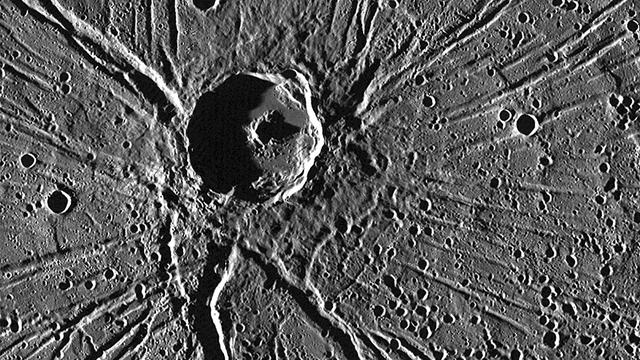
One of the most captivating views acquired during NASA MESSENGER first Mercury flyby was of the crater Apollodorus surrounded by the radiating troughs of Pantheon Fossae. The team nicknamed the combined feature as "the spider." Since then, MESSENGER has acquired many other striking views of this unique feature located near the center of Caloris basin. Although Apollodorus of Damascus (the namesake of the crater) is thought to be the architect of the Pantheon in Rome (the namesake of the fossae), the crater Apollodorus is thought to be unrelated to the creation of Pantheon Fossae. Instrument: Mercury Dual Imaging System (MDIS) Center Latitude: 39.1° Center Longitude: 164.3° E Scale: Apollodorus has a diameter of 42 kilometers (26 miles) http://photojournal.jpl.nasa.gov/catalog/PIA19410

ISS030-E-074783 (25 Jan. 2012 ) --- This nighttime panorama of much of Europe was photographed by one of the Expedition 30 crew members aboard the International Space Station flying approximately 240 miles above the Tyrrhenian Sea on Jan. 25, 2012. Most of the country of Italy is visible running horizontally across the center of the frame, with the night lights of Rome and Naples being visible to the left and right of center, respectively. Sardinia, and Corsica are in the lower left quadrant of the photo. The Adriatic Sea is on the other side of Italy, and beyond it to the east and north can be seen parts of several other European nations.

ISS032-E-020159 (18 Aug. 2012 ) --- This oblique, nighttime panorama of much of Europe was photographed by one of the Expedition 32 crew members aboard the International Space Station flying approximately 240 miles above the Mediterranean Sea on Aug. 18, 2012. The country of Italy is visible running diagonally southward from the horizon across the center of the frame, with the night lights of Rome and Naples being visible on the coast near the center. Sardinia and Corsica are just above left center of the photo, and Sicily is at lower left. The Adriatic Sea is on the other side of Italy, and beyond it to the east and north can be seen parts of several other European nations.
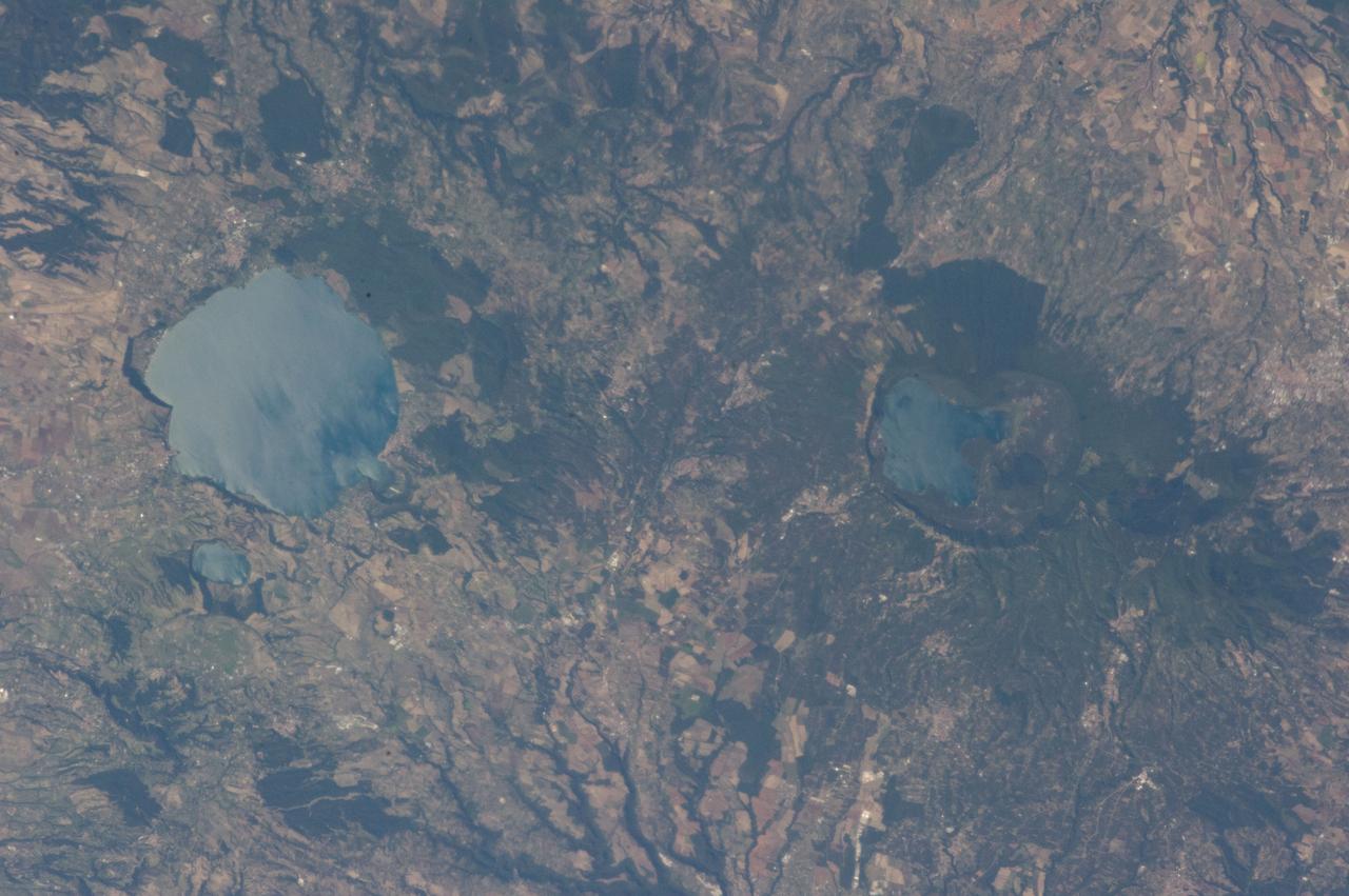
ISS036-E-039778 (3 Sept. 2013) --- Caldera lakes to the northwest of Rome, Italy are featured in this image photographed by an Expedition 36 crew member on the International Space Station. The Lazio region of central Italy has many landforms of volcanic origin, including several large lakes that mark the locations of ancient volcanoes. This photograph highlights two such lakes, Lago di Vico and Lago Bracciano, located to the northwest of the capital city of Rome. Both lakes are located within calderas, large depressions that form after violent explosive eruptions empty a volcano’s underlying magma chamber. Any remnants of the volcanic edifice can then collapse into the newly-formed void space, leading to the creation of large depressions. These depressions can then fill partially or completely with water, forming permanent lakes. Lago Bracciano (left) is the larger of the two lakes highlighted in the image; it is approximately eight kilometers wide at its widest point, and is located 32 kilometers northwest of Rome. According to scientists, the volcanic activity that led to the formation of Lago Bracciano began approximately 600,000 years ago and continued to approximately 40,000 years ago as part of the formation of the Sabatini volcanic complex. While part of the lake formation was due to caldera collapse of part of a large magma chamber, the current depression was also formed by movement along numerous faults in the area – a process known as volcano-tectonic collapse. Located approximately 24 kilometers to the north-northwest of Lago Bracciano, Lago di Vico (right) occupies part of a caldera associated with eruptive activity that began approximately 800,000 years ago and continued until approximately 90,000 years ago. The caldera formed largely by the catastrophic eruption of the ancestral Vico volcano approximately 200,000-150,000 years ago. The final phase of volcanic activity in the caldera led to the formation of a small lava cone in the northeast quadrant known as Mount Venus. The extent of the lakes of Bracciano and Vico are readily apparent in this image due to sunglint – light reflecting back towards the observer from the water surfaces. This reflection gives a mirror-like sheen to the water surfaces in the image. Dark green forested areas associated with parks are visible near both lakes, while light gray to white regions indicate built areas - such as the city of Viterbo at right - and tilled fields (bottom center).
NASA image acquired February 24, 2012 By late February, 2012, the great European cold wave had begun to loosen its frigid grip, but significant snow still remained in the region. The Moderate Resolution Imaging Spectroradiometer (MODIS) aboard the Aqua satellite captured this true-color image of snow in Italy on February 24 at 12:35 UTC (1:30 p.m. local time). In the north of the image, bright white clouds blanket the region in a broad arc. Snow, which tends to be generally less bright that clouds, covers the Alps in the north of Italy. The Apennine Mountains, which form the backbone of the Italian peninsula, also carry a blanket of snow. Although clouds and snow can, at times, be distinguished visually in a true-color image, sometimes they can appear very similar. When it is important to clearly define snow from cloud, false color images are often helpful. Rome, which can be seen as a gray smudge on the southwestern coast of the peninsula, recorded highs of a spring-like 50°F the day this image was captured, but earlier in the month the temperatures dove as low as 26°F on February 5. During that cold snap a rare intense snowfall blanketed Rome, causing the closure of the Colosseum, the Roman Forum and the Palatine Hill due to concerns of the risk of icy footing for tourists, and roads became impassible. Further north, temperatures plummeted to −21 °C (−6 °F) on 7 February. On February 11, news media reported over 2 meters (6.5 feet) of snow had fallen in Urbino, a walled town situated on a high sloping hillside on the eastern side of the Apennine Mountains. That same snowfall cut access to many remote towns in the Apennines, blocking roads and trapping some people in the homes. Credit: NASA/GSFC/Jeff Schmaltz/MODIS Land Rapid Response Team <b><a href="http://www.nasa.gov/centers/goddard/home/index.html" rel="nofollow">NASA Goddard Space Flight Center</a></b> enables NASA’s mission through four scientific endeavors: Earth Science, Heliophysics, Solar System Exploration, and Astrophysics. Goddard plays a leading role in NASA’s accomplishments by contributing compelling scientific knowledge to advance the Agency’s mission. <b>Follow us on <a href="http://twitter.com/NASA_GoddardPix" rel="nofollow">Twitter</a></b> <b>Like us on <a href="http://www.facebook.com/pages/Greenbelt-MD/NASA-Goddard/395013845897?ref=tsd" rel="nofollow">Facebook</a></b> <b>Find us on <a href="http://instagrid.me/nasagoddard/?vm=grid" rel="nofollow">Instagram</a></b>
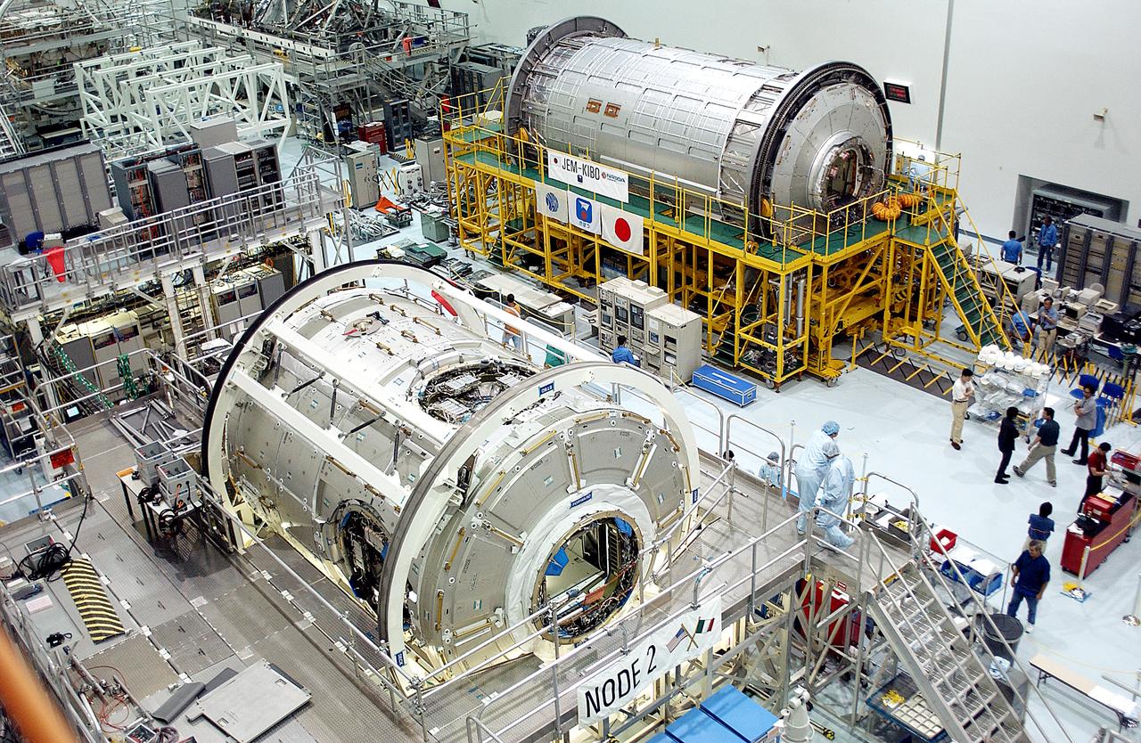
Lining the walls of the Space Station Processing Facility at the Kennedy Space Center (KSC) are the launch awaiting U.S. Node 2 (lower left). and the first pressurized module of the Japanese Experimental Module (JEM) (upper right), named "Kibo" (Hope). Node 2, the "utility hub" and second of three connectors between International Space Station (ISS) modules, was built in the Torino, Italy facility of Alenia Spazio, an International contractor based in Rome. Japan's major contribution to the station, the JEM, was built by the Space Development Agency of Japan (NASDA) at the Tsukuba Space Center near Tokyo and will expand research capabilities aboard the station. Both were part of an agreement between NASA and the European Space Agency (ESA). The Node 2 will be the next pressurized module installed on the Station. Once the Japanese and European laboratories are attached to it, the resulting roomier Station will expand from the equivalent space of a 3-bedroom house to a 5-bedroom house. The Marshall Space Center in Huntsville, Alabama manages the Node program for NASA.
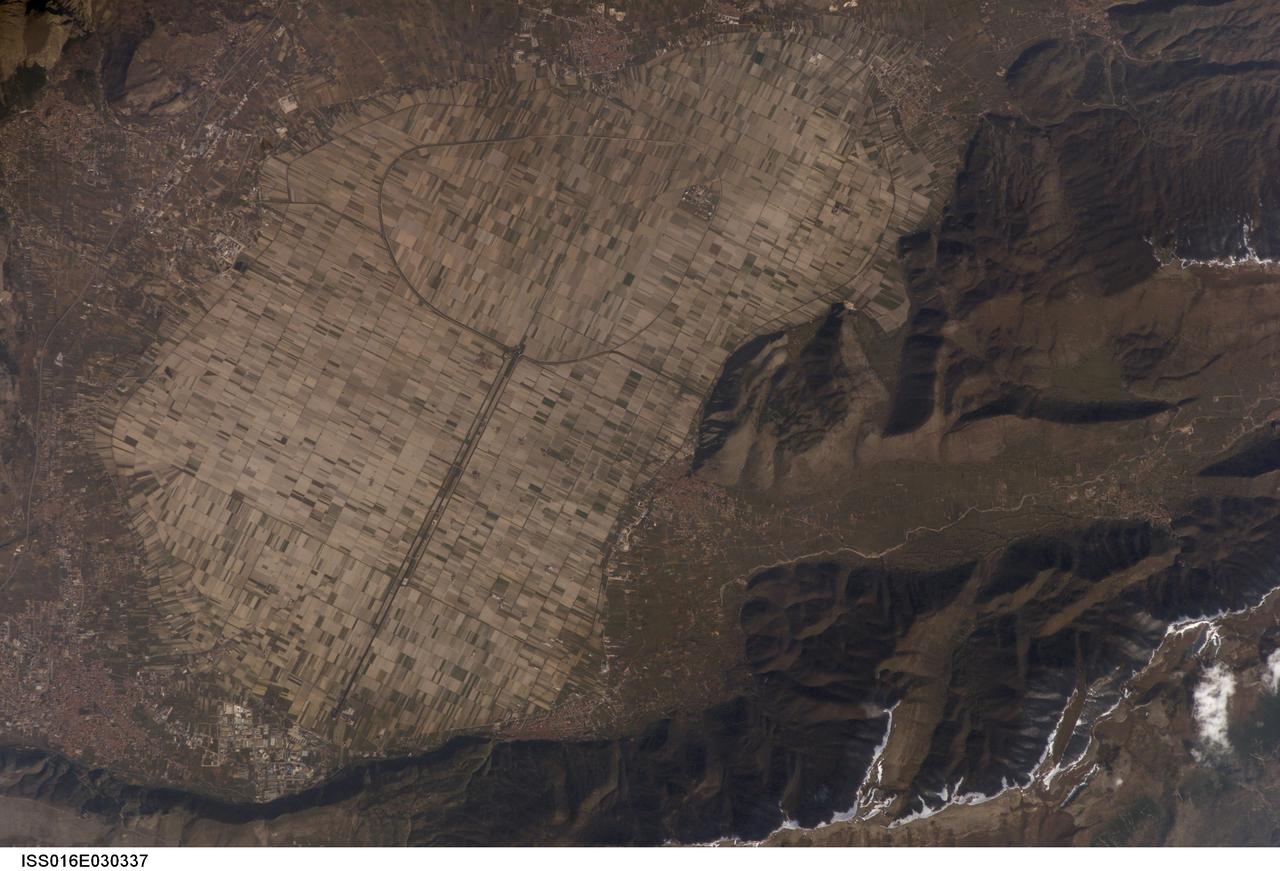
ISS016-E-030337 (26 Feb. 2008) --- Fucine Lake, central Italy is featured in this image photographed by an Expedition 16 crewmember on the International Space Station. The light tan oval in this image is the floor of a lake in central Italy that has been drained by a tunnel dug through the surrounding hills. Numerous rectangular fields can be seen on this former lake bottom--now one of the most fertile regions of Italy. The existence of a former lake explains the name of the area. The town of Avezzano (bottom left), near the drainage outlet of the basin, lies 80 kilometers east of Rome. The "circumference road" can be detected tracking around the edge of the lake; it roughly follows the boundary between green, vegetated fields around the basin and tan fallow fields within. This recent photograph shows a dusting of snow along mountain ridges to the south (image upper and lower right). The basin of Fucine Lake has no natural outlet. Consequently the level of the original lake fluctuated widely with any higher-than-average rainfall.
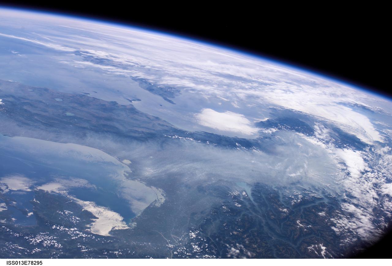
ISS013-E-78295 (6 Sept. 2006) --- Haze in the Po River Valley of Italy is featured in this image photographed by an Expedition 13 crewmember onboard the International Space Station. The valley is visible across the horizontal center of the frame, with the floor obscured by what NASA scientists refer to as frequent atmospheric haze, a mixture of industrial pollutants, dust and smoke. The visual texture of such haze is perceptibly different from that of bright white clouds which stretch across the top of the scene and cover part of the Alps. The Po River Valley is Italy's industrial heartland and one of the most industrialized regions on Earth, according to scientists. Northern Italy is in the foreground of this southwesterly view. The partially cloud-covered Alps are at lower right; the Adriatic Sea at lower left. Corsica is under partial cloud cover at center; and Sardinia, almost totally obscured, is to its south. The island of Elba is visible just to the west of Italy. By contrast with haze accumulation along the axis of the valley, the Alps and the Apennines are clearly visible, and Lake Garda can be seen in the foothills of the Alps. Other visible geographic features are the lagoon at Venice north of the Po River delta, and three small lakes north of Rome. The winds on the day this image was taken are mainly from the north, as shown by the flow lines in the haze near Venice. The haze typically flows south down the Adriatic Sea. Visibility in the Mediterranean basin is often reduced by hazes such as these, deriving from different sources in industrialized Europe.
This composite image is of an area thought to contain the ruins of the ancient settlement of Niya. It is located in the southwest corner of the Taklamakan Desert in China Sinjiang Province. This region was part of some of China's earliest dynasties and from the third century BC on was traversed by the famous Silk Road. The Silk Road, passing east-west through this image, was an ancient trade route that led across Central Asia's desert to Persia, Byzantium and Rome. The multi-frequency, multi-polarized radar imagery was acquired on orbit 106 of the space shuttle Endeavour on April 16, 1994 by the Spaceborne Imaging Radar-C/X-band Synthetic Aperture Radar. The image is centered at 37.78 degrees north latitude and 82.41 degrees east longitude. The area shown is approximately 35 kilometers by 83 kilometers (22 miles by 51 miles). The image is a composite of an image from an Earth-orbiting satellite called Systeme Probatoire d'Observation de la Terre (SPOT) and a SIR-C multi-frequency, multi-polarized radar image. The false-color radar image was created by displaying the C-band (horizontally transmitted and received) return in red, the L-band (horizontally transmitted and received) return in green, and the L-band (horizontally transmitted and vertically received) return in blue. The prominent east/west pink formation at the bottom of the image is most likely a ridge of loosely consolidated sedimentary rock. The Niya River -- the black feature in the lower right of the French satellite image -- meanders north-northeast until it clears the sedimentary ridge, at which point it abruptly turns northwest. Sediment and evaporite deposits left by the river over millennia dominate the center and upper right of the radar image (in light pink). High ground, ridges and dunes are seen among the riverbed meanderings as mottled blue. Through image enhancement and analysis, a new feature probably representing a man-made canal has been discovered and mapped. http://photojournal.jpl.nasa.gov/catalog/PIA01726

Last week researchers from around the world gathered at the Accademia dei Lincei in Rome for the Science with the Hubble Space Telescope IV conference. The event celebrated the history of Hubble’s extraordinary achievements, and looked to the future at what might yet be achieved and how the James Webb Space Telescope will build on our knowledge of the Universe. As part of this celebration artist Tim Otto Roth revealed a new artwork, Heaven’s Carousel, inspired by Hubble’s work on the accelerating expansion of the Universe. This installation, named Heaven’s Carousel, links together the fields of art, music and astronomy. Conceptualised and designed by German artist and composer Tim Otto Roth, the work is inspired by novel work on the accelerating expansion of the Universe by Nobel laureate Adam Riess (STScl), Greek cosmology and Renaissance astronomers. Read more here: <a href="http://www.spacetelescope.org/news/heic1407/" rel="nofollow">www.spacetelescope.org/news/heic1407/</a> Credit: NASA, ESA, and Pam Jeffries (STScI) <b><a href="http://www.nasa.gov/audience/formedia/features/MP_Photo_Guidelines.html" rel="nofollow">NASA image use policy.</a></b> <b><a href="http://www.nasa.gov/centers/goddard/home/index.html" rel="nofollow">NASA Goddard Space Flight Center</a></b> enables NASA’s mission through four scientific endeavors: Earth Science, Heliophysics, Solar System Exploration, and Astrophysics. Goddard plays a leading role in NASA’s accomplishments by contributing compelling scientific knowledge to advance the Agency’s mission. <b>Follow us on <a href="http://twitter.com/NASAGoddardPix" rel="nofollow">Twitter</a></b> <b>Like us on <a href="http://www.facebook.com/pages/Greenbelt-MD/NASA-Goddard/395013845897?ref=tsd" rel="nofollow">Facebook</a></b> <b>Find us on <a href="http://instagram.com/nasagoddard?vm=grid" rel="nofollow">Instagram</a></b>

S72-49079 (8 Sept. 1972) --- This is the official emblem of the Apollo 17 lunar landing mission which will be flown by astronauts Eugene A. Cernan, Ronald E. Evans and Harrison H. Schmitt. The insignia is dominated by the image of Apollo, the Greek sun god. Suspended in space behind the head of Apollo is an American eagle of contemporary design, the red bars of the eagle's wing represent the bars in the United States flag; the three white stars symbolize the three astronaut crewmen. The background is deep blue space and within it are the moon, the planet Saturn and a spiral galaxy or nebula. The moon is partially overlaid by the eagle's wing suggesting that this is a celestial body that man has visited and in that sense conquered. The thrust of the eagle and the gaze of Apollo to the right and toward Saturn and the galaxy is meant to imply that man's goals in space will someday include the planets and perhaps the stars. The colors of the emblem are red, white and blue, the colors of our flag; with the addition of gold, to symbolize the golden age of space flight that will begin with this Apollo 17 lunar landing. The Apollo image used in this emblem was the famous Apollo of Belvedere sculpture now in the Vatican Gallery in Rome. This emblem was designed by artist Robert T. McCall in collaboration with the astronauts. This is the official Apollo 17 emblem, a property of the government of the United States. It has been authorized only for use by the astronauts. Its reproduction in any form other than in news, information and education media is not authorized without approval. Unauthorized use is subject to the provisions of Title 18, U.S. Code, Section 701.

SL3-87-355 (July-September 1973) --- A vertical view of the eastern coast of Sicily area is seen in this Skylab 3 Earth Resources Experiments Package S190-B (five-inch earth terrain camera) infrared photograph taken from the Skylab space station in Earth orbit. Mount Etna, the highest volcano in Europe (10,958 feet), is still active as evidenced by the thin plume of smoke emanating from its crest. (The altitude is approximate because the height of the volcano changes with each eruption). On the flanks of Etna recent lava flows appear black in contrast to the older flows and volcanic debris that are red. Numerous small, circular cinder cones on the flanks represent sites of previous eruptions. Catania, on the Mediterranean coast south of Etna, is the largest of several cities and villages which appear as light-gray patches on the lower slopes of the volcano. Plano de Catania, south of the city of Catania, is outlined by polygonal light and dark agricultural tracts. Several lakes, the largest of which is Lake Pozzillo, show up as dark blue in the photograph. The unusual colors in the picture are due to the use of color infrared film in which vegetation appears red. This is very evident on the slopes of Etna, in the Monti Nebrodi area at upper let, and in the local areas in the lower part of the picture. Studies of Mount Etna and related volcanic features will be undertaken by Professor Roberto Cassinis of Servizio Geologio d?Italia, Rome. Federal agencies participating with NASA on the EREP project are the Departments of Agriculture, Commerce, Interior, the Environmental Protection Agency and the Corps of Engineers. All EREP photography is available to the public through the Department of Interior?s Earth Resources Observation Systems Data Center, Sioux Falls, South Dakota, 57198. Photo credit: NASA
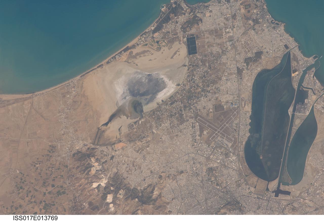
ISS017-E-013769 (19 Aug. 2008) --- Tunis, Tunisia is featured in this image photographed by an Expedition 17 crewmember on the International Space Station. The city of Tunis, capital of Tunisia, is a rapidly modernizing city located along the Mediterranean coast of northern Africa. Sharing much of its history with famous Carthage to the north, Tunis was also destroyed by Rome in approximately 146 BC. Tunis, however, was rebuilt by the Romans and became an important agricultural center. Modern Tunis serves as the administrative center for the whole of Tunisia, and as a commercial hub for trade in the northern part of the country. The urban area of Tunis is located on a flat coastal plain, and is distinguished in this view from the surrounding desert by the pattern of grey to tan buildings and darker street grid. The city is bordered by an evaporating saline lake to the northeast known as Sebkhet Arina (upper left) -- evaporite minerals such as halite (table salt) and gypsum produce the white deposits surrounding the darker lake center where there is more moisture. To the southeast of the city is Lake Tunis, a lagoon that has been significantly altered by human activities -- such as closing off water exchange with the Mediterranean Sea - dating back to Roman times. The general lack of water circulation and input of nutrients from sewage has lead to the establishment of marine worm reefs, and occasional fish kills. The western urban-rural fringe is defined by a range of low hills (lower left); dark green agricultural fields are visible on the western side of these hills.

William Kerslake, a combustion researcher at the National Advisory Committee for Aeronautics (NACA) Lewis Flight Propulsion Laboratory, examines the setup of a transparent rocket in a Rocket Laboratory test cell. Kerslake joined NACA Lewis the previous summer after graduating from the Case Institute of Technology with a chemistry degree. His earliest professional research concentrated on combustion instability in small rocket engines. While at Case the quiet, 250-pound Kerslake also demonstrated his athletic prowess on the wrestling team. He continued wrestling for roughly a decade afterwards while conducting his research with the NACA. Kerslake participated in Olympic competitions in Helsinki (1952), Melbourne (1956), and Rome (1960). He won 30 national championships in three different weight classes and captured the gold at the 1955 Pan American Games in Mexico City. Kerslake accomplished all this while maintaining his research career, raising a family, and paying his own expenses. As his wrestling career was winding down in the early 1960s, Kerslake’s professional career changed, as well. He was transferred to Harold Kaufman’s Electrostatic Propulsion Systems Section in the new Electromagnetic Propulsion Division. Kaufman was developing the first successful ion engine at the time, and Kerslake spent the remainder of his career working in the electric propulsion field. He was heavily involved in the two Space Electric Rocket Test (SERT) missions which demonstrated that the ion thrusters could successfully operate in space. Kerslake retired in 1985 with over 30 years of service.
A comparison of two radargrams from the SHARAD instrument on NASA Mars Reconnaissance Orbiter shows effects on the Martian ionosphere from the close passage of a comet.

This collage shows some of the most interesting geological sites that NASA's Dawn spacecraft has revealed at dwarf planet Ceres. Images were acquired with the spacecraft's framing camera during various phases of the mission: Survey orbit at a distance of about 2,700 miles (4,400 kilometers); high-altitude mapping orbit (HAMO) at a distance of 915 miles (1,470 kilometers) from Ceres; and low-altitude mapping orbit (LAMO) at an altitude of 240 miles (385 kilometers). In the first row, from left to right: Ceres in shown in false color, roughly centered on Occator Crater, home of the brightest area on Ceres. This picture combines color images obtained by Dawn in its survey orbit. Red corresponds to a wavelength range around 980 nanometers (near infrared), green to a wavelength range around 750 nanometers (red, visible light) and blue to a wavelength range of around 430 nanometers (blue, visible light). This picture illustrates the diversity of terrains on Ceres where the bluish material points to recently emplaced material and the brownish background material is associated with older terrains. Juling Crater (12 miles, 20 kilometers in diameter) as seen in LAMO. Central coordinates are 36 degrees south latitude, 168 degrees east longitude. It is named after the Sakai/Orang Asli (Malaysia) spirit of the crops. This crater displays evidence for the presence of ice -- for example, in the form of a large flow feature seen at the top of the image. Oxo Crater (6 miles, 10 kilometers in diameter) as seen in LAMO. Center coordinates are 42 degrees north latitude, 0 degrees east longitude. It is named after the god of agriculture in Afro-Brazilian beliefs of Yoruba derivation. Oxo hosts the first site at which Dawn detected ice on Ceres, exposed by a landslide. Ahuna Mons is not only a volcano, but also the tallest mountain on Ceres. It is about 2.5 miles (4 kilometers) high and 11 miles (17 kilometers) wide. Center coordinates are 10 degrees south latitude, 316 degrees east longitude. This view combines images obtained in LAMO in blue (430 nanometers), green (750 nanometers) and infrared (980 nanometers) color filters. Ahuna is named after the Sumi tribe (Nagaland, northeastern India) traditional post-harvest thanksgiving festival. Second Row Occator Crater (57 miles, 92 kilometers across) is seen in LAMO images. Center coordinates are 20 degrees north latitude, 239 degrees east longitude. Named after the Roman agricultural deity of the harrowing. This image shows a "Type I" flow feature with a thick "toe" typical of rock glaciers and icy landslides on Earth as viewed in LAMO. The flow feature, found in Ghanan Crater (77 degrees north latitude, 31 degrees east longitude), is one of the most voluminous on Ceres. Enhanced color view of Haulani Crater (21 miles, 34 kilometers in diameter) in color observed in HAMO. Central coordinates: 6 degrees north latitude, 11 degrees east longitude. Named after the Hawaiian plant goddess. Kokopelli Crater (21 miles, 34 kilometers in diameter) seen in LAMO. Central coordinates: 18 degrees north latitude, 125 degrees east longitude. Named after the Pueblo (SW USA) fertility deity, who presides over agriculture. This crater displays a nice arrangement of scarps that likely formed when the crater partly collapsed during its formation. Third Row Central region of Occator Crater, called Cerealia Facula, seen in color. The facula -- or "bright spot" -- is about 9 miles (14 kilometers) in diameter. Center coordinates: 20 N, 240 E. Cerealia refers to the major festival in Ancient Rome that celebrates the grain goddess Ceres (8 days in mid- to late April). The view was produced by combining the highest resolution images of Occator obtained in LAMO (at image scales of 35 meters, or 115 feet, per pixel) with color images obtained in HAMO (at image scales of 135 meters, or about 440 feet, per pixel). The three images used to produce the color were taken using filters centered at 430, 750 and 980 nanometers (the last being slightly beyond the range of human vision, in the near-infrared). North part of Nar Sulcus seen in LAMO. The full feature is about 39 miles (63 km) in length and is located around 42 degrees south latitude, 280 degrees east longitude. Nar is a Azerbaijani festival of pomegranate harvest held in October-November in Goychay city, center of pomegranate cultivation in Azerbaijan. A sulcus is a set of parallel furrows or ridges. Ikapati Crater (31 miles, 50 kilometers in diameter) seen in LAMO. Central coordinates: 34 degrees north latitude, 46 degrees east longitude. Ikapati is named after the Philippine goddess of the cultivated lands. The crater has a smooth floor, probably because heat from the impact that formed Ikapati caused ice in the ground to melt, and then refreeze. This view of Ceres, taken in LAMO, shows an area located at approximately 86 degrees south longitude, 177 degrees east longitude. This part of Ceres, near the south pole, has such long shadows because, from the perspective of this location, the sun is near the horizon. At the time this image was taken, the sun was 4 degrees north of the equator. If you were standing this close to Ceres' south pole, the sun would never get high in the sky during the course of a nine-hour Cerean day. https://photojournal.jpl.nasa.gov/catalog/PIA22090
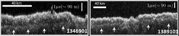
These two images show data acquired by the Shallow Radar (SHARAD) instrument while passing over two ground tracks in a part of Mars' Utopia Planitia region where the orbiting, ground-penetrating radar detected subsurface deposits rich in water ice. The instrument on NASA's Mars Reconnaissance Orbiter emits radio waves and times their echo off of radio-reflective surfaces and interfaces on Mars. The white arrows indicate a subsurface reflector interpreted as the bottom of the ice-rich deposit. The deposit is about as large in area as the state of New Mexico and contains about as much water as Lake Superior. The horizontal scale bar indicates 40 kilometers (25 miles) along the ground track of the radar, as flown by the orbiter overhead. The vertical scale bar indicates a return time of one microsecond for the reflected radio signal, equivalent to a distance of about 90 meters (295 feet). http://photojournal.jpl.nasa.gov/catalog/PIA21137
What Lies Below a Martian Ice Cap
This artist animation illustrates how NASA Mars Reconnaissance Orbiter used radar to map the insides of the north polar ice cap on Mars.
How Thick is the North Polar Ice Cap on Mars?
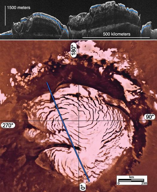
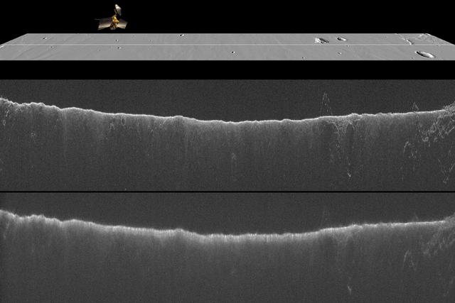
This image montage features a two-dimensional radar cross section of Mars north polar cap collected by SHARAD instrument on NASA Mars Reconnaissance Orbiter spacecraft top, and a color image mosaic of the polar cap from NASA Viking project bottom
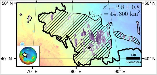
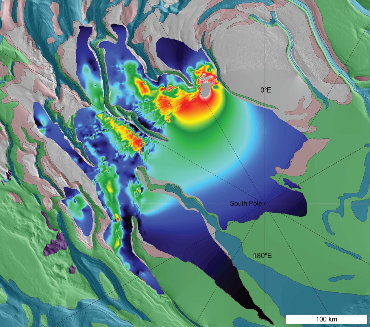
Diagonal striping on this map of a portion of the Utopia Planitia region on Mars indicates the area where a large subsurface deposit rich in water ice was assessed using the Shallow Radar (SHARAD) instrument on NASA's Mars Reconnaissance Orbiter. The area is about halfway between the planet's equator and north pole, and the deposit is estimated to hold about as much water as what is in Lake Superior, largest of the Great Lakes. The scale bar at lower right indicates 140 kilometers (76 miles). The violet vertical bars show depth to the bottom of the ice-rich deposit, as estimated from SHARAD passes overhead. Darkest violet indicates a depth of about 550 feet (about 170 meters). Palest violet indicates a depth of about 33 feet (10 meters). The value of 2.8 plus-or-minus 0.8 in the upper right corner denotes the dielectric constant, a property related to radar reflectivity. The value of 14,300 cubic kilometers is an estimate of the volume of water in the deposit. http://photojournal.jpl.nasa.gov/catalog/PIA21138
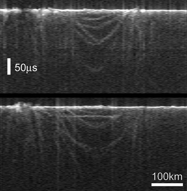
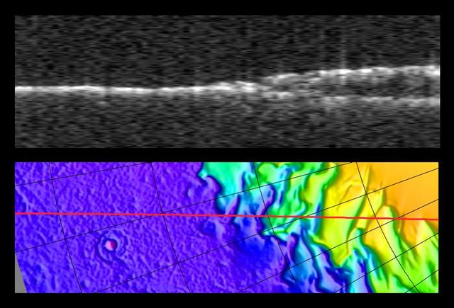
Radargrams of Buried Basin from Two Adjacent Orbits
NASA Mars Reconnaissance Orbiter has detected widespread deposits of glacial ice in the mid-latitudes of Mars. This map of a region known as Deuteronilus Mensae, in the northern hemisphere, shows locations of the detected ice deposits in blue.
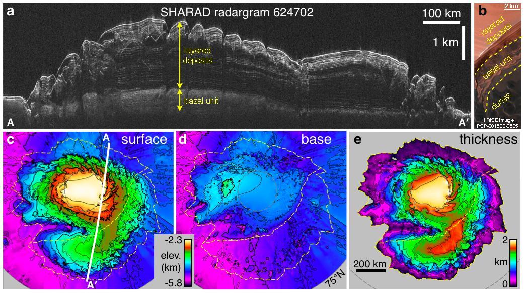
Radargram of Mars North Polar Layered Deposits with Topographic Map

These spectrograms from the MARSIS instrument on the European Space Agency Mars Express orbiter show the intensity of radar echo in Mars far-northern ionosphere at three times on Oct. 19 and 20, 2014.
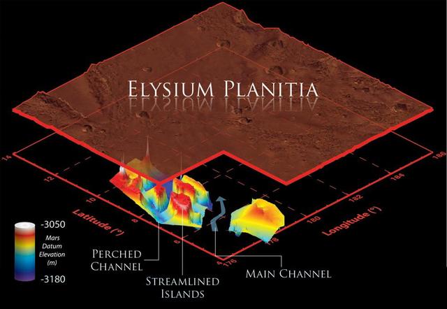
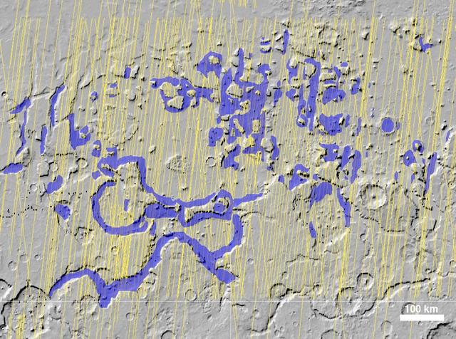
This illustration schematically shows where the Shallow Radar instrument on NASA Mars Reconnaissance Orbiter detected flood channels that had been buried by lava flows in the Elysium Planitia region of Mars.
This composite graphic illustrates the use of the Shallow Radar instrument on NASA Mars Reconnaissance Orbiter for mapping underground ice-rich layers of the north polar layered terrain on Mars.

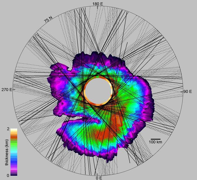
This map shows the thickness of the south polar layered deposits of Mars, an ice-rich geologic unit that was probed by the Mars Advanced Radar for Subsurface and Ionospheric Sounding MARSIS
Bright Lower Echo in Radargram of South Polar Layered Deposits
Interpreting Radar View near Mars South Pole, Orbit 1334
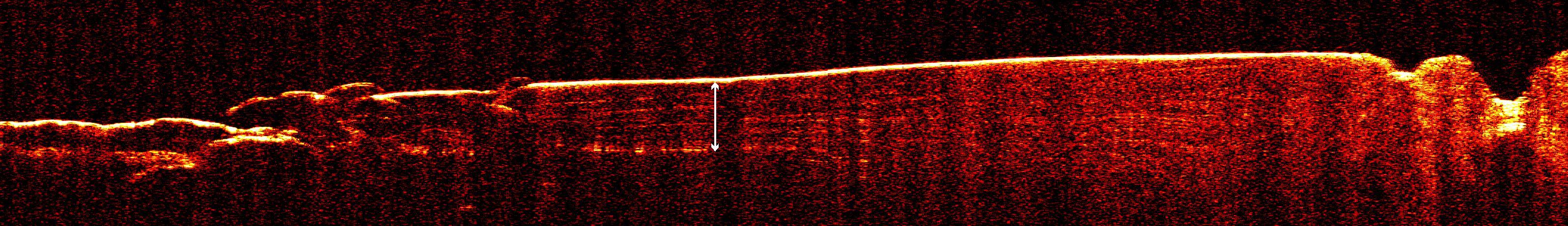
This radargram shows data collected by the Shallow Radar, or SHARAD, on NASA's Mars Reconnaissance Orbiter (MRO) on May 2, 2023, as it performed a 120-degree roll maneuver called a "very large roll" over a formation named Medusae Fossae. Scientists used SHARAD to look for ice beneath the surface of this region. Designed to peer from about a half-mile to a little over a mile (1 to 2 kilometers) below ground, SHARAD emits radio waves that are reflected off materials in the subsurface, measuring how long it takes for those waves to bounce back to the instrument. The longer it takes, the deeper the subsurface layer is. Because different materials reflect radio waves differently, SHARAD allows scientists to distinguish between rock, sand, and ice. While MRO often performs a standard 28-degree roll to give SHARAD's antenna a more direct view of Martian terrain, the 120-degree very large roll rotates the antenna even farther, providing its radio waves an unobstructed path to the surface. This boosts the radar's signals by 10 times or more, giving SHARAD a clearer, deeper view of the Martian underground than ever before. Scientists hope the very large rolls will help them look for frozen and liquid water, among other things. https://photojournal.jpl.nasa.gov/catalog/PIA26555
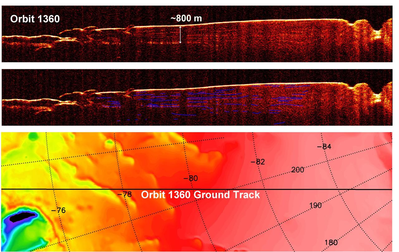
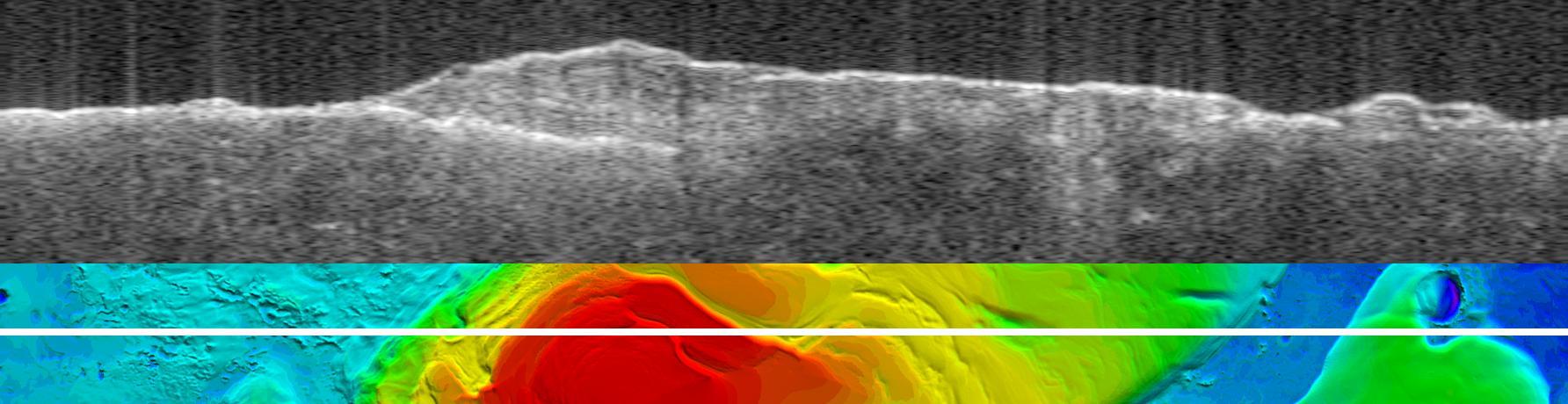
Interpreting Radar View near Mars South Pole, Orbit 1360
This radargram profile from ESA Mars Express and NASA Mars Global Surveyor orbiter shows data from the subsurface of Mars in the ice-rich north polar plateau of Mars.
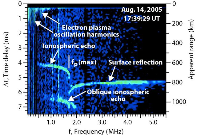
Radar Ionogram with Oblique Ionospheric Echo
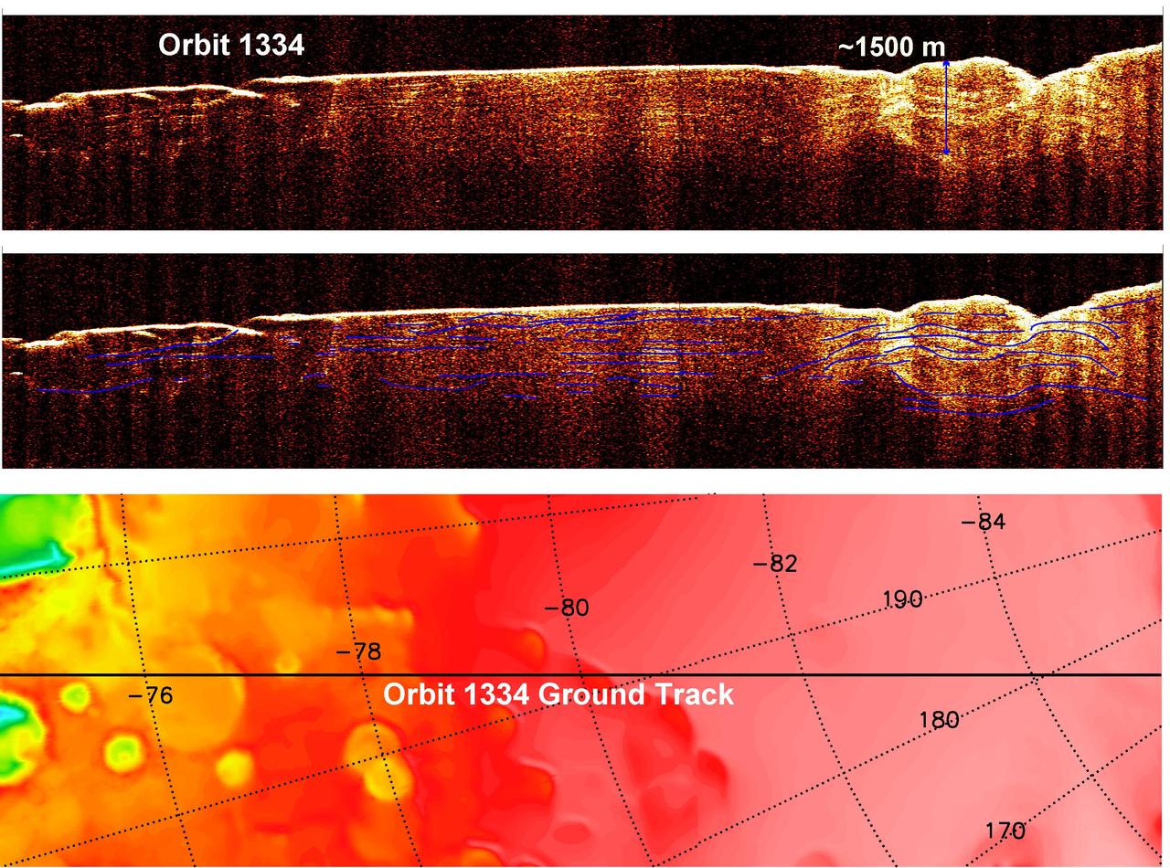
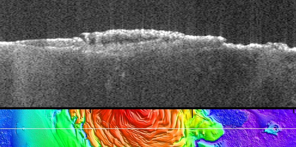
Interpreting Radar View near Mars South Pole, Orbit 1334
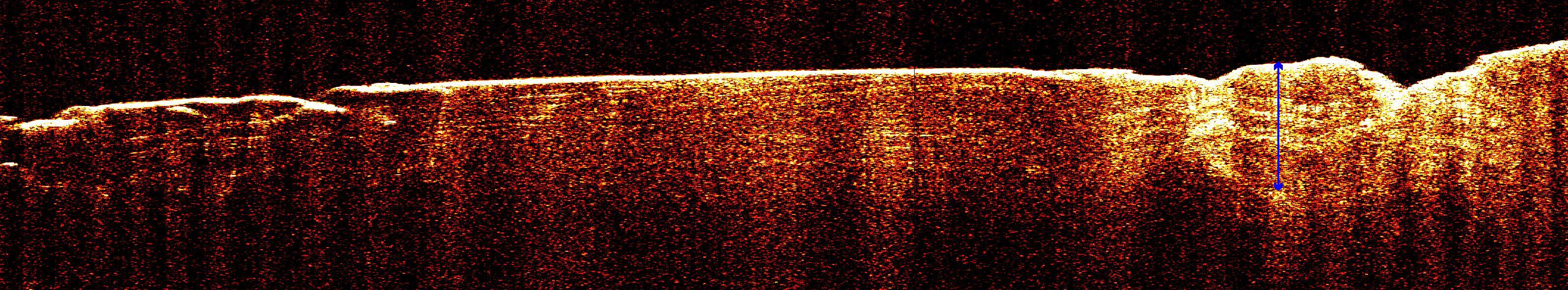
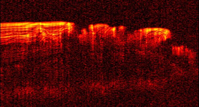
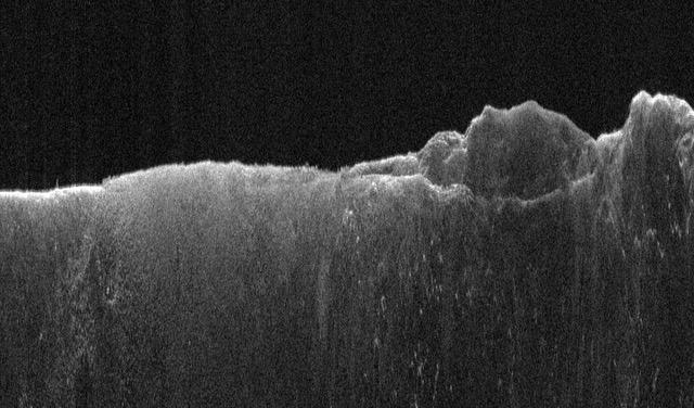
Radar View of Layering near Mars South Pole, Orbit 1360

These plots portray data from radar sounding of Mars mid-latitude ionosphere at three times on Oct. 19 and 20, 2014. The data are from the MARSIS instrument on the European Space Agency Mars Express orbiter.

This map shows the topography of the south polar region of Mars. The elevation of the terrain is shown by colors, with purple and blue representing the lowest areas, and orange and red the highest
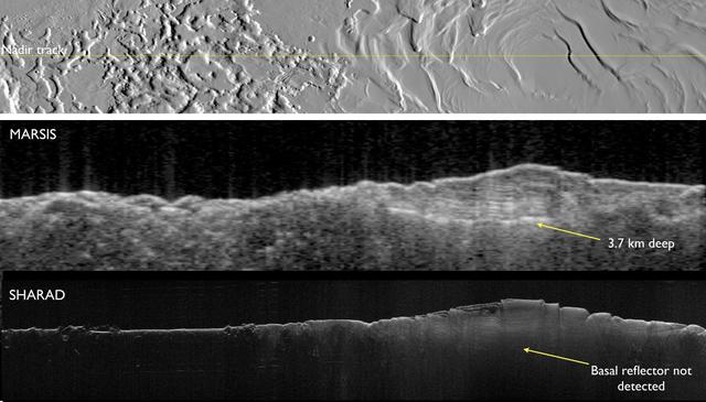
Two Radar Sounders Examine South Polar Layered Deposits on Mars

The upper image is a radargram showing data from the subsurface of Mars in the ice-rich layered deposits that surround the south pole. The lower image shows the position of the ground track white line on a topographic map
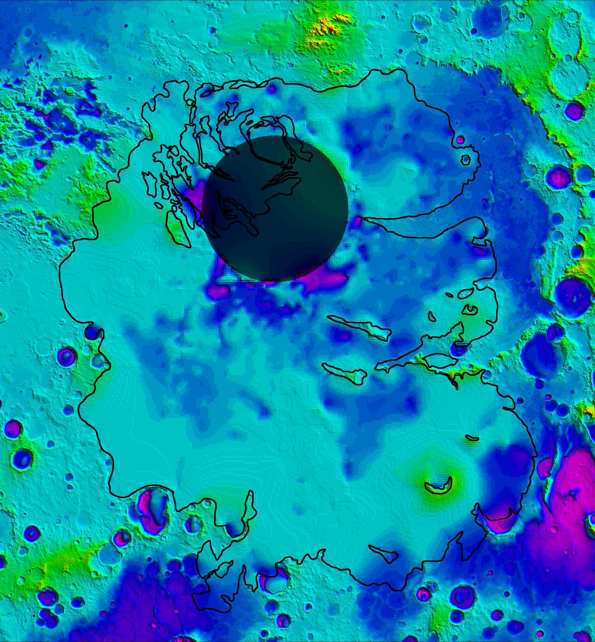
This map shows the topography of the south polar region of Mars, including topography buried by thick deposits of icy material
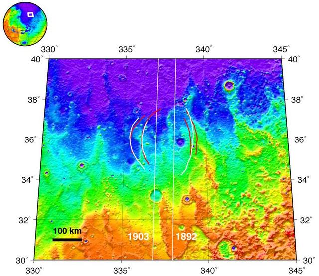
Topographic Map of Chryse Planitia with Location of Possible Buried Basin
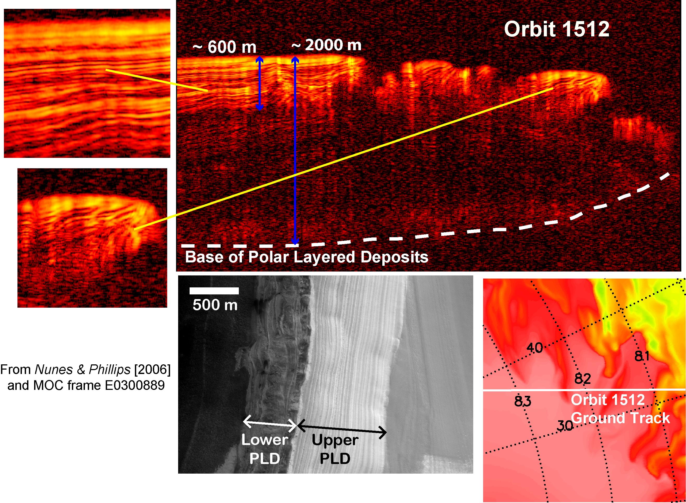
Interpreting Radar View near Mars North Pole, Orbit 1512
Radar View of Layering near Mars South Pole, Orbit 1360
NASA Mars Reconnaissance Orbiter color-codes thickness estimates in a newly found, buried deposit of frozen carbon dioxide, dry ice, near the south pole of Mars contains ~30 times more carbon dioxide than previously estimated to be frozen near the pole.

Mars Radar Opens a Planet Third Dimension