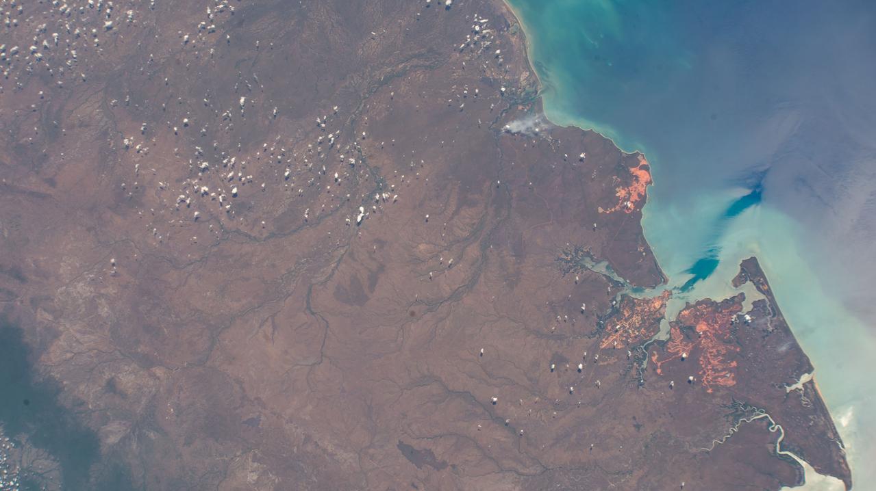
iss072e098244 (Oct. 24, 2024) --- Mission River, a coastal rural locality on the Gulf of Carpenteria in the northern tip and tropical climate of Australia's state of Queensland, is pictured from the International Space Station as it orbited 261 miles above the island continent.

Several projects supporting NASA's Advanced Air Mobility, or AAM mission, are working on different elements to help make AAM a reality. In order for these new AAM aircraft to safely operate, new infrastructure and changes to current infrastructure will need to be developed in cities, suburbs, and rural areas.
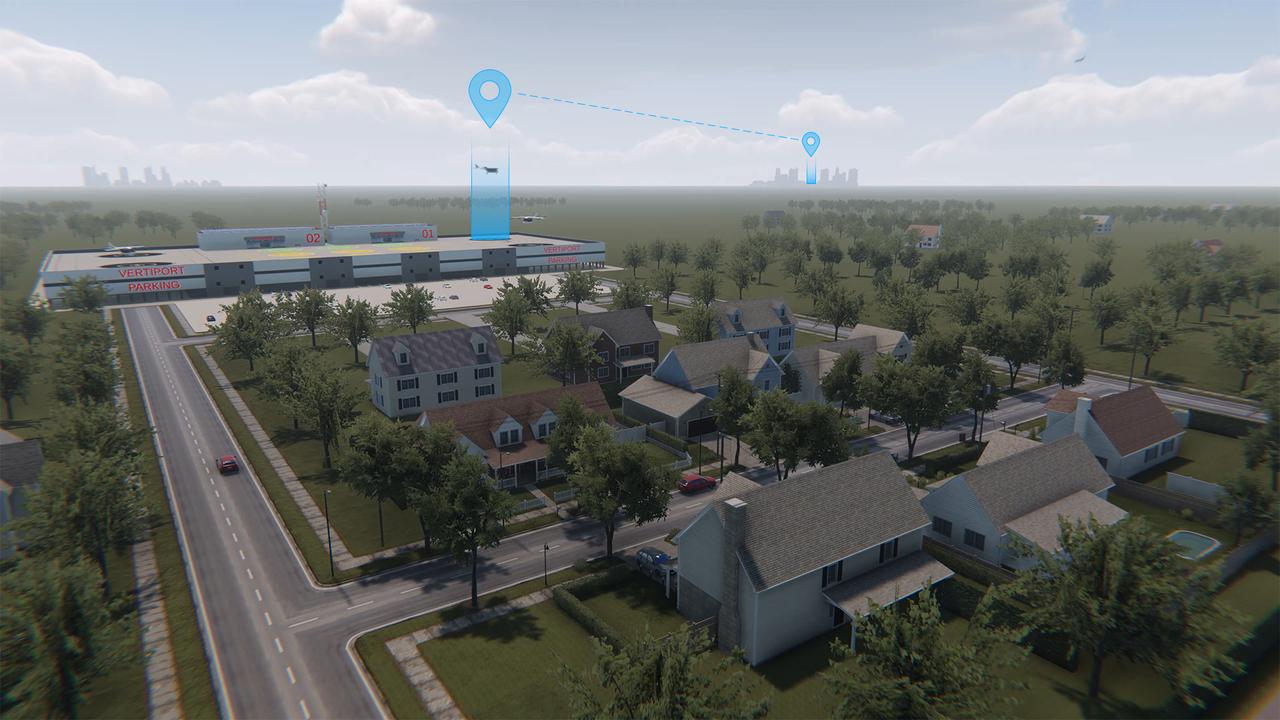
Advanced Air Mobility will connect both urban dwellers and rural residents by adding a new way to travel by air. As shown in this concept art, passengers could travel from rural areas into the city quicker than by car to board a commercial airliner, access medical care or to purchase goods.

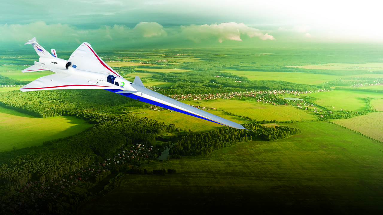
Artist illustration of the X-59 in flight over land (with cities and rural areas below). Satellite image from USGS/NASA Landsat.

Advanced Air Mobility, with its many vehicle concepts and potential uses in both local and intraregional applications, is shown in this illustration.
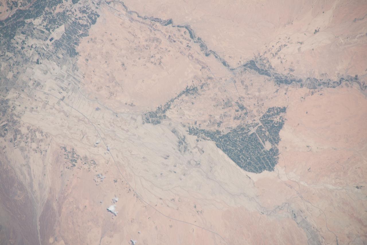
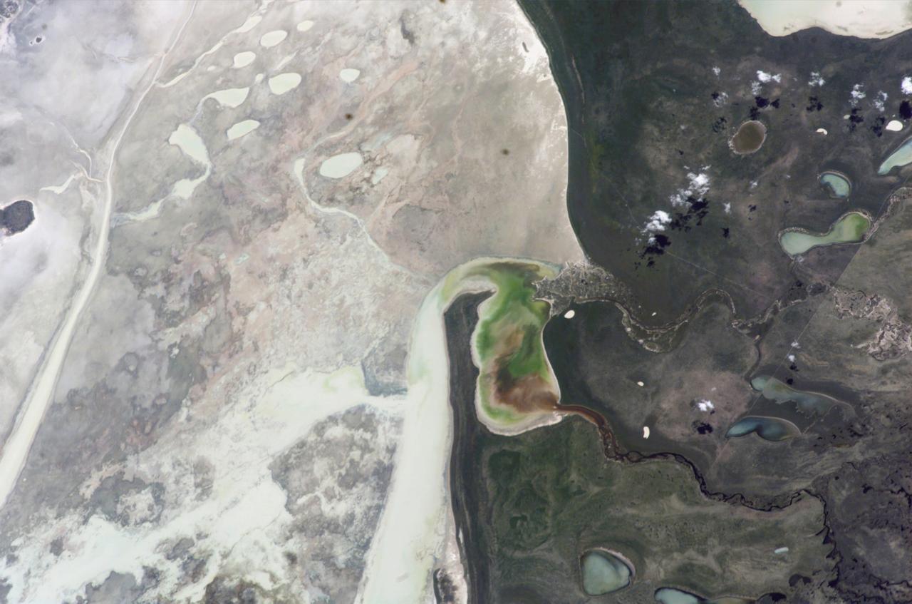
iss063e002345 (April 22, 2020) --- Oued Melloulou is a stream that runs through the Moroccan Province of Guercif which also hosts its capital town of Guercif (upper left) and the rural commune of Taddart (center right).
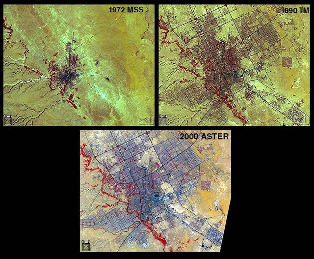
Riyadh, the national capital of Saudi Arabia, is shown in 1972, 1990 and 2000. Its population grew in these years from about a half million to more than two million. Saudi Arabia experienced urbanization later than many other countries; in the early 1970s its urban-rural ratio was still about 1:3. By 1990 that had reversed to about 3:1. The city grew through in-migration from rural areas, and from decreases in the death rate while birthrates remained high. The 1972 image is a Landsat MSS scene; the 1990 image is a Landsat Thematic Mapper scene; and the 2000 image is an ASTER scene. All three images cover an area of about 27 x 34 km. The image is centered at 24.6 degrees north latitude, 46.6 degrees east longitude. http://photojournal.jpl.nasa.gov/catalog/PIA11087
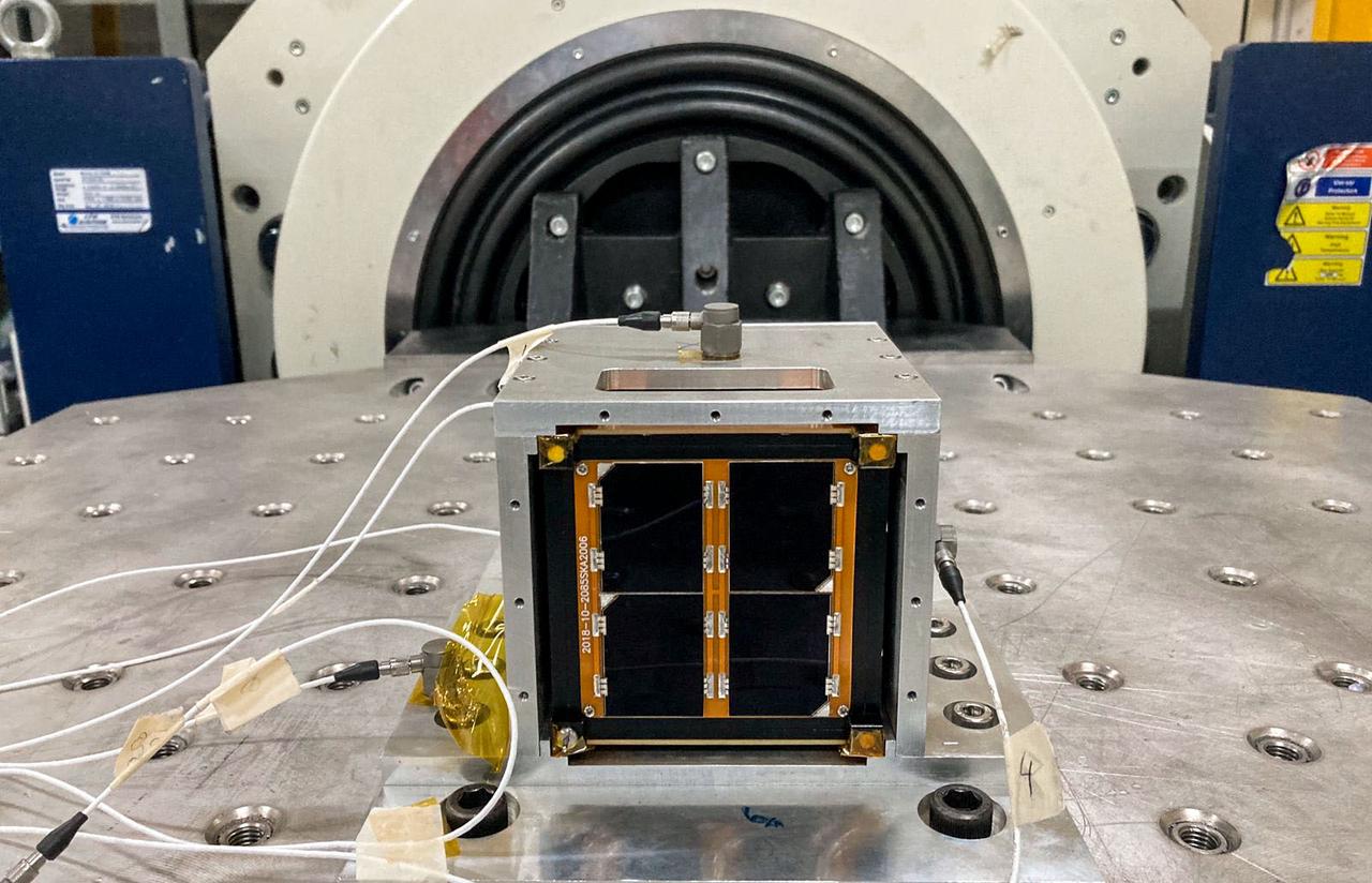
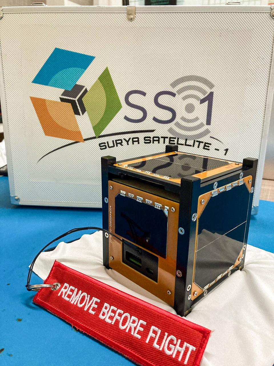
jsc2022e068265 (3/1/2022) --- A preflight view of the Surya Satellite-1 (SS-1) during Vibration Testing. The Surya Satellite-1 (SS-1) is the first Indonesian nanosatellite developed by university students at Surya University. SS-1 tests a satellite telecommunication system to serve amateur radio stations, and serves as a proof of concept of sensoric information transfer in rural areas for disaster mitigation application. Image Courtesy of The SS-1 Team.

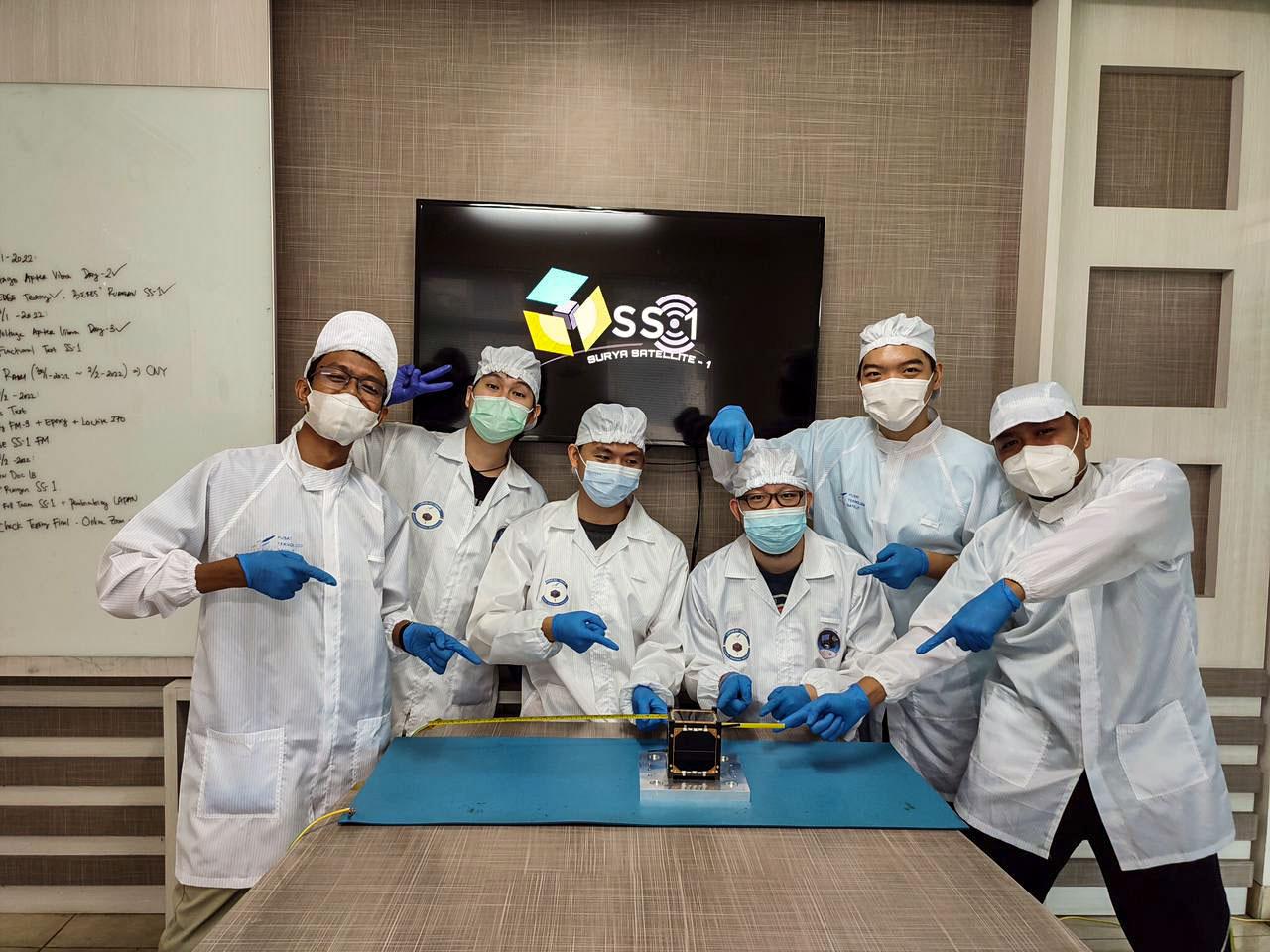
jsc2022e068261 (11/1/2021) --- The Surya Satellite-1 and its developer team after Vibration Testing, shown left to right: Afiq, Roberto, Setra, Suhan, Hery, Zulfa. The Surya Satellite-1 (SS-1) is the first Indonesian nanosatellite developed by university students at Surya University. SS-1 tests a satellite telecommunication system to serve amateur radio stations, and serves as a proof of concept of sensoric information transfer in rural areas for disaster mitigation application. Image Courtesy of The SS-1 Team.
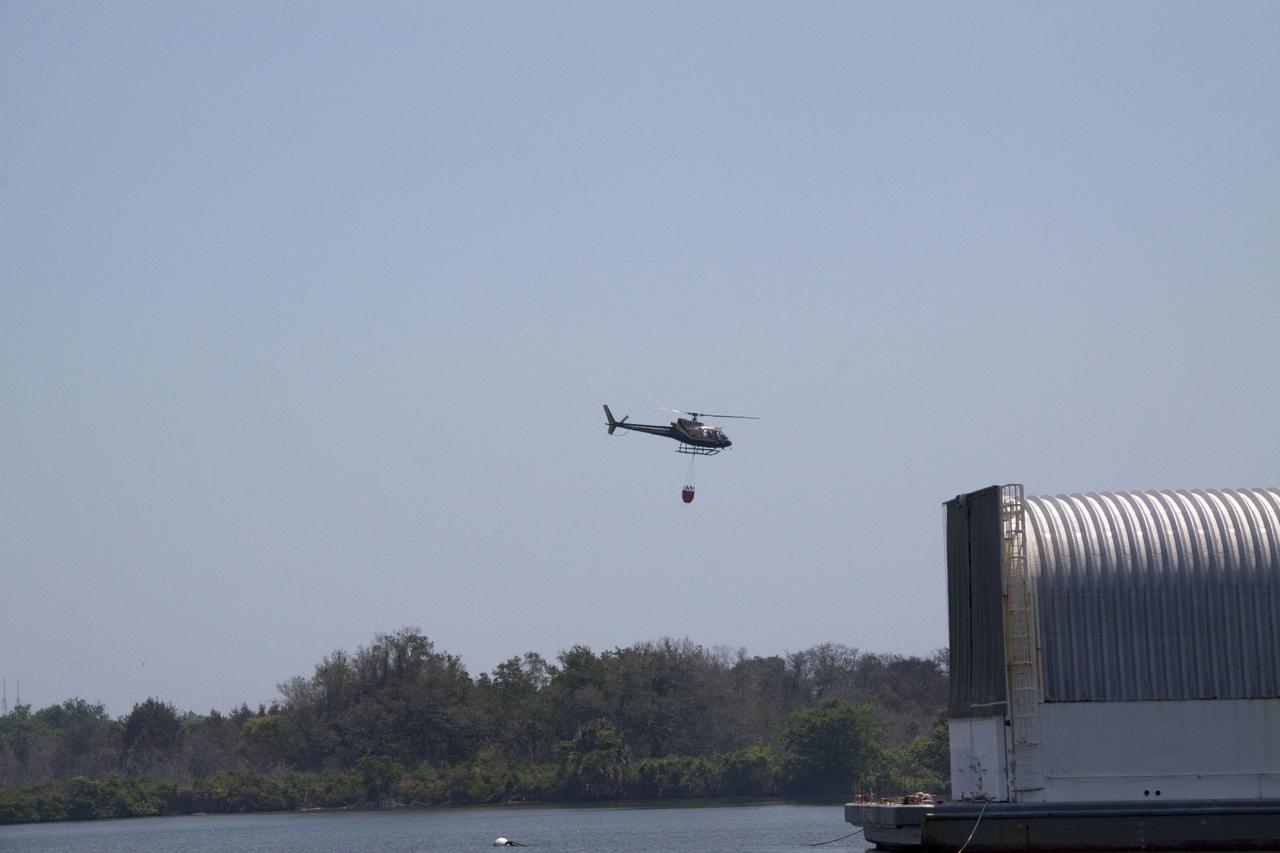
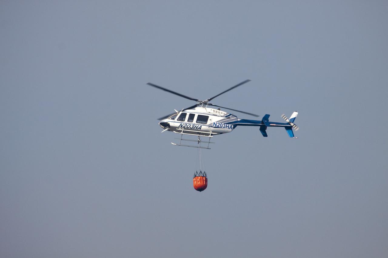
CAPE CANAVERAL, Fla. -- At NASA's Kennedy Space Center in Florida, a helicopter collects water from the Turn Basin to douse a nearby brush fire. The fire was spotted in a rural area southeast of Kennedy’s Press Site approximately three miles away from Launch Pad 39A, where space shuttle Endeavour awaits liftoff on the STS-134 mission to the International Space Station. The fire is being contained by crews from Kennedy and the U.S. Fish and Wildlife Service and smoke is not expected to impact launch. Photo credit: NASA_Jack Pfaller
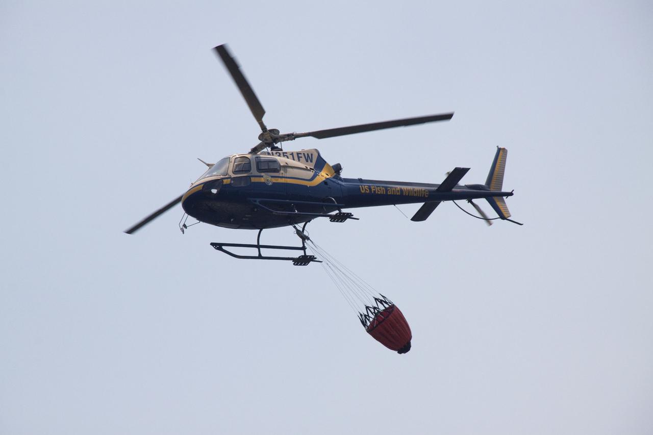
CAPE CANAVERAL, Fla. -- At NASA's Kennedy Space Center in Florida, a helicopter collects water from the Turn Basin to douse a nearby brush fire. The fire was spotted in a rural area southeast of Kennedy’s Press Site approximately three miles away from Launch Pad 39A, where space shuttle Endeavour awaits liftoff on the STS-134 mission to the International Space Station. The fire is being contained by crews from Kennedy and the U.S. Fish and Wildlife Service and smoke is not expected to impact launch. Photo credit: NASA_Jack Pfaller
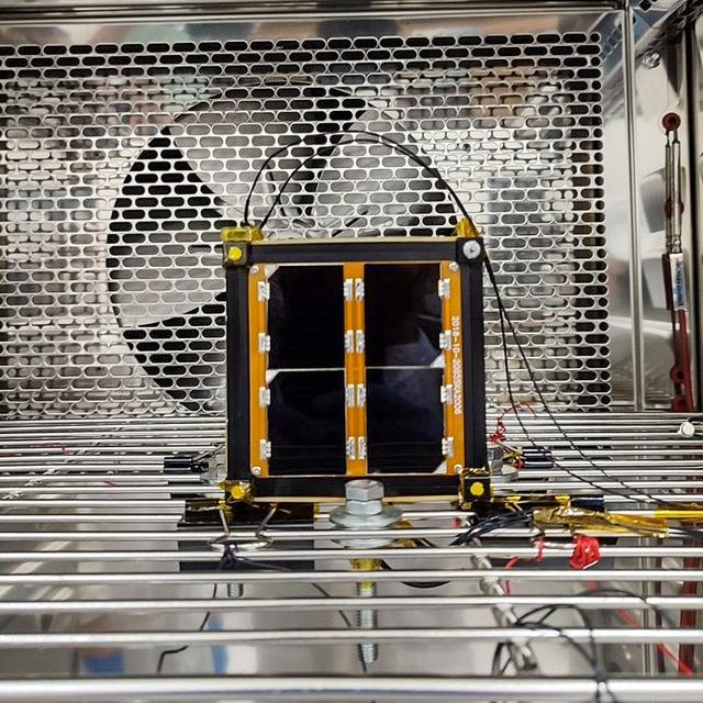
jsc2022e068264 (12/1/2021) --- A preflight view of the Surya Satellite-1 (SS-1) during Thermal Testing. The Surya Satellite-1 (SS-1) is the first Indonesian nanosatellite developed by university students at Surya University. SS-1 tests a satellite telecommunication system to serve amateur radio stations, and serves as a proof of concept of sensoric information transfer in rural areas for disaster mitigation application. Image Courtesy of The SS-1 Team.
jsc2022e068260 (11/1/2021) --- The Surya Satellite-1 and its Developer Team After Deployment Testing, shown left to right: Zulfa, Hery, Setra, Roberto, Suhan, Afiq. The Surya Satellite-1 (SS-1) is the first Indonesian nanosatellite developed by university students at Surya University. SS-1 tests a satellite telecommunication system to serve amateur radio stations, and serves as a proof of concept of sensoric information transfer in rural areas for disaster mitigation application. Image Courtesy of The SS-1 Team.
iss057e055559 (Oct. 22, 2018) --- The rural community of Grand View, Idaho is just south of the Ted Trueblood Wildlife Area which can host a variety of thousands of birds during migration periods. Snake River flows through the area and also forms portions of the Idaho, Oregon and Washington borders. The International Space Station was orbiting 256 miles above North America when this photograph was taken.
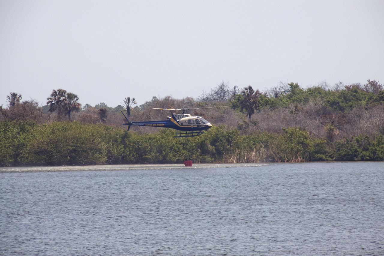
CAPE CANAVERAL, Fla. -- At NASA's Kennedy Space Center in Florida, a helicopter collects water from the Turn Basin to douse a nearby brush fire. The fire was spotted in a rural area southeast of Kennedy’s Press Site approximately three miles away from Launch Pad 39A, where space shuttle Endeavour awaits liftoff on the STS-134 mission to the International Space Station. The fire is being contained by crews from Kennedy and the U.S. Fish and Wildlife Service and smoke is not expected to impact launch. Photo credit: NASA_Jack Pfaller
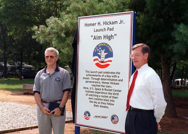
Noted author and previous Marshall Space Flight Center employee Mr. Homer Hickam Jr. poses in front of a placque commemorating his achievement in realizing his dreams of becoming a rocket scientist. The dedication site is located at the U. S. Space and Rocket Center in Huntsville, AL, and is used by amature rocket builders attending the Space Camp to launch their self-made rockets like Mr. Hickam did as a youth growing up in rural West Virginia. Posing with Mr. Hickam is the Madison County Commissioner Mr. Mike Gillispie.

jsc2022e068262 (5/1/2022) --- A view of the SS-1 Team during the JAXA Safety Review. The Surya Satellite-1 (SS-1) is the first Indonesian nanosatellite developed by university students at Surya University. SS-1 tests a satellite telecommunication system to serve amateur radio stations, and serves as a proof of concept of sensoric information transfer in rural areas for disaster mitigation application. Image Courtesy of The SS-1 Team.
jsc2022e068263 (5/1/2022) --- A preflight view of the Surya Satellite-1 (SS-1) Flight Model. The Surya Satellite-1 (SS-1) is the first Indonesian nanosatellite developed by university students at Surya University. SS-1 tests a satellite telecommunication system to serve amateur radio stations, and serves as a proof of concept of sensoric information transfer in rural areas for disaster mitigation application. Image Courtesy of The SS-1 Team.

Children at Coquina Elementary School, Titusville, Fla., look with curiosity at the wrapped computer equipment donated by Kennedy Space Center. Coquina is one of 13 Brevard County schools receiving 81 excess contractor computers thanks to an innovative educational outreach project spearheaded by the Nasa k-12 Education Services Office at ksc. The Astronaut Memorial Foundation, a strategic partner in the effort, and several schools in rural Florida and Georgia also received refurbished computers as part of the year-long project. KSC employees put in about 3,300 volunteer hours to transform old, excess computers into upgraded, usable units. A total of $90,000 in upgraded computer equipment is being donated

Children at Coquina Elementary School, Titusville, Fla., "practice" using a computer keyboard, part of equipment donated by Kennedy Space Center. Coquina is one of 13 Brevard County schools receiving 81 excess contractor computers thanks to an innovative educational outreach project spearheaded by the Nasa k-12 Education Services Office at ksc. The Astronaut Memorial Foundation, a strategic partner in the effort, and several schools in rural Florida and Georgia also received refurbished computers as part of the year-long project. KSC employees put in about 3,300 volunteer hours to transform old, excess computers into upgraded, usable units. A total of $90,000 in upgraded computer equipment is being donated

Children at Coquina Elementary School, Titusville, Fla., eagerly tear into the wrapped computer equipment donated by Kennedy Space Center. Coquina is one of 13 Brevard County schools receiving 81 excess contractor computers thanks to an innovative educational outreach project spearheaded by the Nasa k-12 Education Services Office at ksc. The Astronaut Memorial Foundation, a strategic partner in the effort, and several schools in rural Florida and Georgia also received refurbished computers as part of the year-long project. KSC employees put in about 3,300 volunteer hours to transform old, excess computers into upgraded, usable units. A total of $90,000 in upgraded computer equipment is being donated
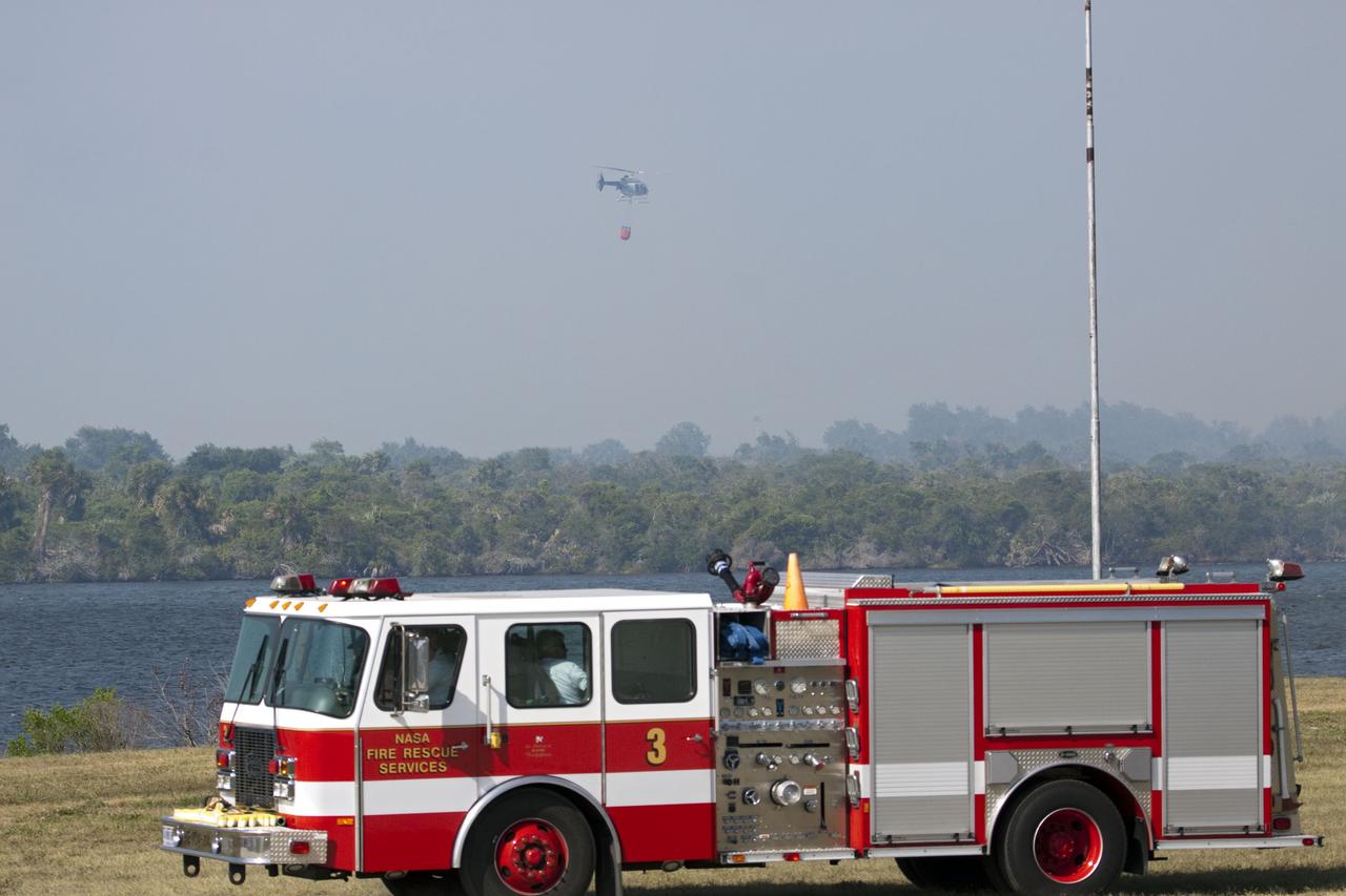
CAPE CANAVERAL, Fla. -- At NASA's Kennedy Space Center in Florida, a helicopter collects water from the Turn Basin to douse a nearby brush fire. The fire was spotted in a rural area southeast of Kennedy’s Press Site approximately three miles away from Launch Pad 39A, where space shuttle Endeavour awaits liftoff on the STS-134 mission to the International Space Station. The fire is being contained by crews from Kennedy and the U.S. Fish and Wildlife Service and smoke is not expected to impact launch. Photo credit: NASA/Jack Pfaller
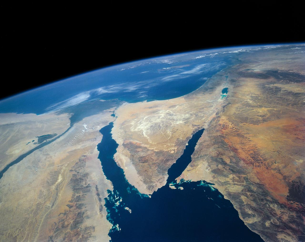
STS040-152-180 (5-24 June 1991) --- The Sinai Peninsula dominates this north-looking, oblique view. According to NASA photo experts studying the STS 40 imagery, the Red Sea in the foreground is clear of river sediment because of the prevailing dry climate of the Middle East. The great rift of the Gulf of Aqaba extends northward to Turkey (top right) through the Dead Sea. The international boundary between Israel and Egypt, reflecting different rural landscapes, stands out clearly. The Nile River runs through the frame. NASA photo experts believe the haze over the Mediterranean to be wind-borne dust. The photo was taken with an Aero-Linhof large format camera.
CAPE CANAVERAL, Fla. -- At NASA's Kennedy Space Center in Florida, a helicopter collects water from the Turn Basin to douse a nearby brush fire. The fire was spotted in a rural area southeast of Kennedy’s Press Site approximately three miles away from Launch Pad 39A, where space shuttle Endeavour awaits liftoff on the STS-134 mission to the International Space Station. The fire is being contained by crews from Kennedy and the U.S. Fish and Wildlife Service and smoke is not expected to impact launch. Photo credit: NASA/Jack Pfaller
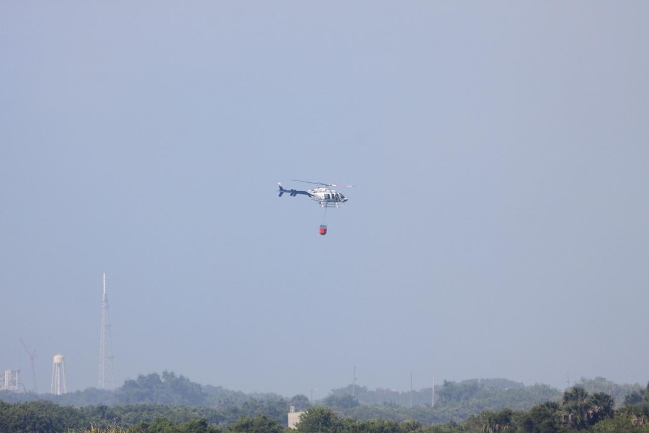
CAPE CANAVERAL, Fla. -- At NASA's Kennedy Space Center in Florida, a helicopter collects water from the Turn Basin to douse a nearby brush fire. The fire was spotted in a rural area southeast of Kennedy’s Press Site approximately three miles away from Launch Pad 39A, where space shuttle Endeavour awaits liftoff on the STS-134 mission to the International Space Station. The fire is being contained by crews from Kennedy and the U.S. Fish and Wildlife Service and smoke is not expected to impact launch. Photo credit: NASA/Jack Pfaller

Children at Coquina Elementary School, Titusville, Fla., excitedly tear into the wrapped computer equipment donated by Kennedy Space Center. Coquina is one of 13 Brevard County schools receiving 81 excess contractor computers thanks to an innovative educational outreach project spearheaded by the Nasa k-12 Education Services Office at ksc. The Astronaut Memorial Foundation, a strategic partner in the effort, and several schools in rural Florida and Georgia also received refurbished computers as part of the year-long project. KSC employees put in about 3,300 volunteer hours to transform old, excess computers into upgraded, usable units. A total of $90,000 in upgraded computer equipment is being donated

Children at Audubon Elementary School, Merritt Island, Fla., eagerly unwrap computer equipment donated by Kennedy Space Center. Audubon is one of 13 Brevard County schools receiving 81 excess contractor computers thanks to an innovative educational outreach project spearheaded by the Nasa k-12 Education Services Office at ksc. The Astronaut Memorial Foundation, a strategic partner in the effort, and several schools in rural Florida and Georgia also received refurbished computers as part of the year-long project. KSC employees put in about 3,300 volunteer hours to transform old, excess computers into upgraded, usable units. A total of $90,000 in upgraded computer equipment is being donated
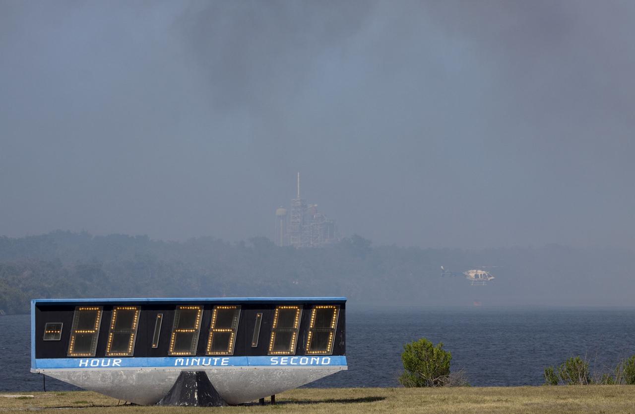
CAPE CANAVERAL, Fla. -- At NASA's Kennedy Space Center in Florida, a helicopter collects water from the Turn Basin to douse a nearby brush fire. The fire was spotted in a rural area southeast of Kennedy’s Press Site approximately three miles away from Launch Pad 39A, where space shuttle Endeavour awaits liftoff on the STS-134 mission to the International Space Station. The fire is being contained by crews from Kennedy and the U.S. Fish and Wildlife Service and smoke is not expected to impact launch. Photo credit: NASA/Jack Pfaller
ISS008-E-09603 (20 December 2003) --- The village of Argudan near the north slopes of the Greater Caucasus Mountains in Russia is featured in this photo taken by an Expedition 8 crewmember onboard the International Space Station (ISS). The striking land use pattern, seen through a high magnification lens and highlighted by winter snow and low sun angles, produces this unique view. This rural, agricultural community sits astride the main highway about 15 kilometers east-southeast of the city of Nalchik. Shadows from a line of trees planted as a windbreak near the highway give the road a ragged appearance. A small stream flowing northeastward exits heavily forested foothills through the village and fields of intensely cultivated croplands on the plains. Snow falls through the vegetation, making the woodlands appear extremely dark compared to the snow-covered fields.

Children at Cambridge Elementary School, Cocoa, Fla., eagerly unwrap computer equipment donated by Kennedy Space Center. Cambridge is one of 13 Brevard County schools receiving 81 excess contractor computers thanks to an innovative educational outreach project spearheaded by the Nasa k-12 Education Services Office at ksc. Behind the children is Jim Thurston, a school volunteer and retired employee of USBI, who shared in the project. The Astronaut Memorial Foundation, a strategic partner in the effort, and several schools in rural Florida and Georgia also received refurbished computers as part of the year-long project. KSC employees put in about 3,300 volunteer hours to transform old, excess computers into upgraded, usable units. A total of $90,000 in upgraded computer equipment is being donated

Nancy Nichols, principal of South Lake Elementary School, Titusville, Fla., joins students in teacher Michelle Butler's sixth grade class who are unwrapping computer equipment donated by Kennedy Space Center. South Lake is one of 13 Brevard County schools receiving 81 excess contractor computers thanks to an innovative educational outreach project spearheaded by the Nasa k-12 Education Services Office at ksc. The Astronaut Memorial Foundation, a strategic partner in the effort, and several schools in rural Florida and Georgia also received refurbished computers as part of the year-long project. KSC employees put in about 3,300 volunteer hours to transform old, excess computers into upgraded, usable units. A total of $90,000 in upgraded computer equipment is being donated
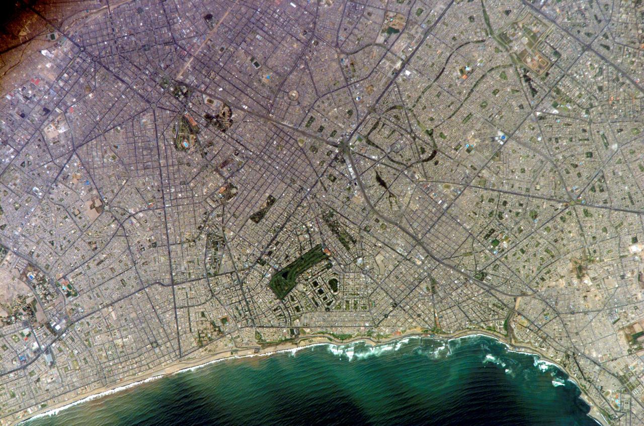
ISS010-E-20111 (15 March 2005) --- Lima, Peru is featured in this image photographed by an Expedition 10 crewmember on the International Space Station (ISS). Located on the broad alluvial fan of the Rimac River, Lima is the capital of Peru and the only mega city (7.7 million inhabitants in 2002) located on the western coastline of South America. The city was established by Francisco Pizarro in 1535 and became an important colonial port linking silver mines of the Altiplano of the high Andes to the east with the burgeoning Spanish empire. During the mid-20th century a significant relocation of people from rural mountain communities into the Lima metropolitan area led to its growth into a mega city. Problems now facing the metropolitan region include development of adequate water resources, control of pollution, and the potential effects of natural hazards such as earthquakes and landslides. This photograph depicts the wealthier San Isidro and Mira Flores quarters of Lima. This part of the metropolitan area is characterized by numerous vegetated parks, golf courses (such as the Lima Golf Course—approximately 1 kilometer long), and greenbelts interspersed with residential and commercial areas. The higher proportion of dark asphalt in the street grid of the residential and commercial areas lends a purple coloration to the left portion of the image (downtown Lima is to the north). Regions with fewer built materials and vegetation are light tan. Wave patterns are visible approaching beaches, popular tourist destinations, in the lower half of the image.
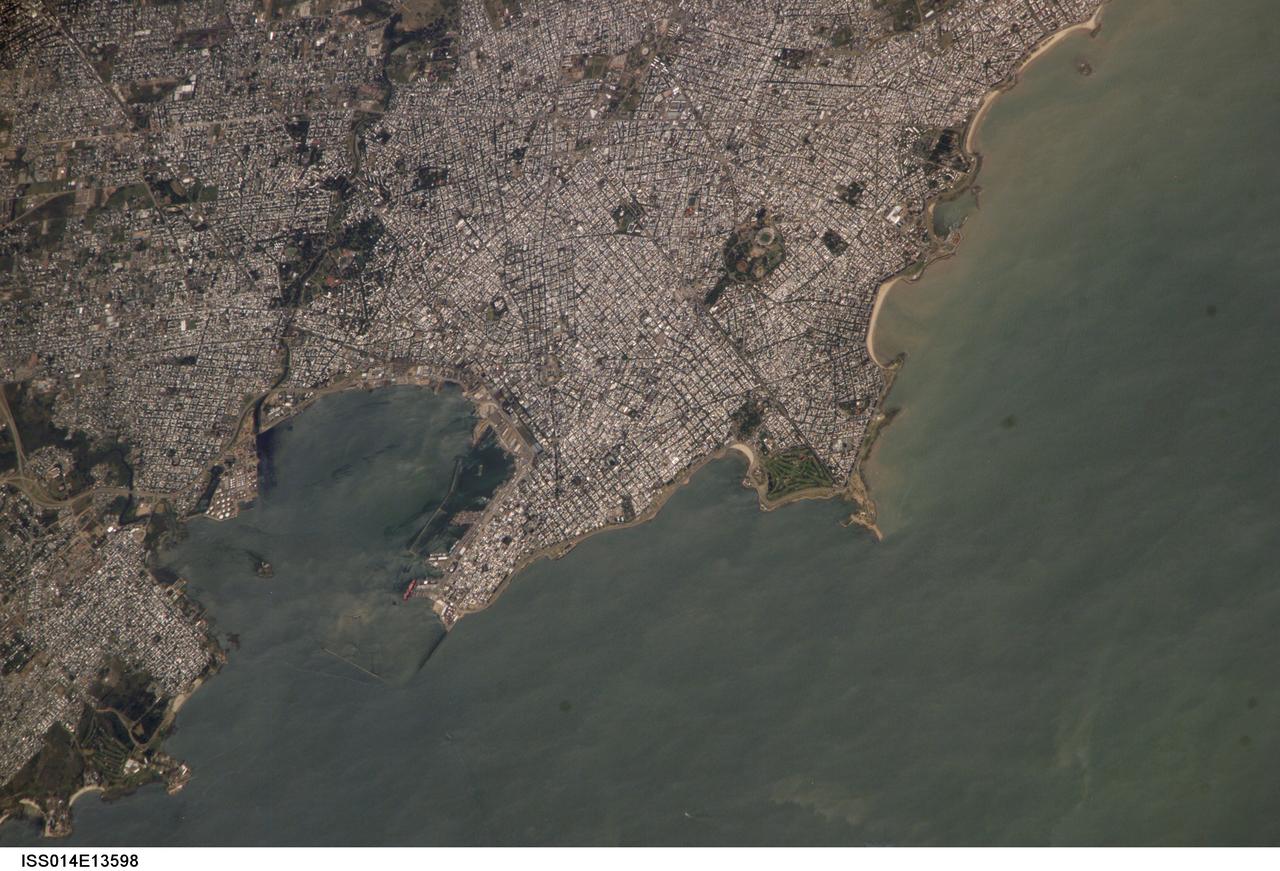
ISS014-E-13598 (29 Jan. 2007) --- Montevideo, Uruguay is featured in this image photographed by an Expedition 14 crewmember on the International Space Station. Reflective roofing materials and dark asphalt streets outline the urban grid pattern of Uruguay's capital city of Montevideo in this image. The city may be viewed as a precursor of the predicted global population shift from dominantly rural to urban environments (by 2030, according to recent United Nations estimates) -- nearly half of Uruguay's total population now lives in the Montevideo metropolitan area. Located on the southern coastline of Uruguay along the Rio de la Plata, Montevideo Bay provides an important harbor and port facilities for transport of South American agricultural products. This view is of sufficient resolution (approximately 7 meters/pixel) to discriminate between dark green canopied tree cover and light green grass - important information for study of urban ecology and climate, as well as city water use planning - in a large golf course located at the southern edge of the city (near center right). Sediment plumes along the coastline to the southeast of the city are also visible; rough patterns in the water surface of Montevideo Bay and the Rio de la Plata are a combination of wind disturbance and sediments.

ISS034-E-005935 (8 Dec. 2012) --- A nighttime view of Liege, Belgium is featured in this image photographed by an Expedition 34 crew member on the International Space Station. To paraphrase the old expression, “all roads lead to Liege” – or at least one could get that impression from this nighttime photograph. The brightly lit core of the Liege urban area appears to lie at the center of a network of roadways—traceable by continuous orange lighting—extending outwards into the rural, and relatively dark, Belgium countryside. For a sense of scale the distance from left to right is approximately 70 kilometers. The region at upper left to the southeast of Verviers includes agricultural fields and forest; hence it appears almost uniformly dark at night. The image was taken using the European Space Agency’s Nodding mechanism, also known as the NightPod. NightPod is an electro-mechanical mount system designed to compensate digital cameras for the motion of the space station relative to Earth. The primary mission goal was to take high-resolution, long exposure digital imagery of Earth from the station’s Cupola, particularly cities at night. While the official NightPod mission has been completed, the mechanism remains onboard for crew members to use. Liege is the third most populous metropolitan region in Belgium (after Brussels and Antwerp); it includes 52 municipalities, including the nearby city of Seraing.

STS098-716-057 (7-20 February 2001) --- Baltimore, Maryland can be identified in this northwest-looking view, photographed with a 70mm handheld camera from the Space Shuttle Atlantis, which shows the western shore of Chesapeake Bay. Numerous drowned river valleys provide excellent natural harbors along the periphery of the bay. Baltimore’s harbor has been developed along one of these drowned valleys, the Patapsco River. With a population of over 2.5 million people, the greater Baltimore urban area is part of the northeastern U.S. Megalopolis that extends from the Boston (MA) area to Richmond (VA). Specific features that can be seen in the image include a short segment of Interstate Highway 95 that connects southwest Baltimore with northeast Washington, D.C.; the intersecting runways of Baltimore-Washington International Airport south of downtown Baltimore; Francis Scott Key Bridge that skirts around the southeast side of Baltimore; the Chesapeake Bay Bridge that spans the bay and connects the Baltimore area with the eastern shore of Maryland; and the central business district of Baltimore where the two arms of the inner harbor terminate. The darker-looking vegetation cover is mixed hardwood forests (notice that many wooded areas are located along streambeds and floodplains of small river valleys), while lighter-looking land parcels in the rural countryside is used for crops or pasturelands.
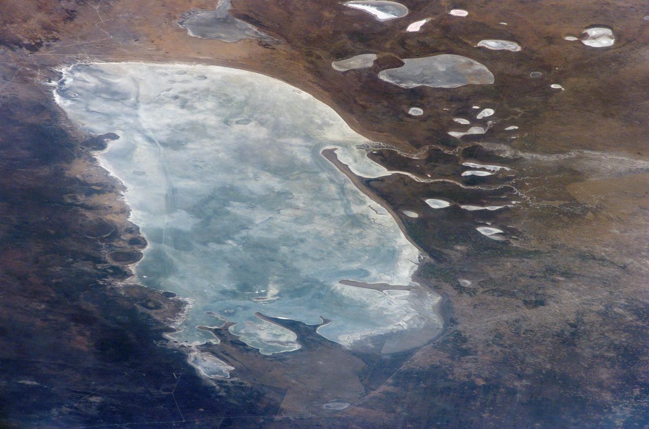
ISS011-E-09504 (24 June 2005) --- Ekuma River and Etosha Pan, Namibia are featured in this image photographed by an Expedition 11 crewmember on the International Space Station. Etosha Pan, northern Namibia, is a large (120 kilometers or 75 mile long) dry lakebed in the Kalahari Desert. The lake and surrounds are protected today as one of Namibia’s largest wildlife parks. Herds of elephants occupy the dense mopane woodland on the south side of the lake. Mopane trees are common throughout south-central Africa, and host the mopane worm (the larval form of the Mopane Emperor Moth)–an important source of protein for rural communities. According to scientists, about 16,000 years ago, when ice sheets were melting across Northern Hemisphere land masses, a wet climate phase in southern Africa filled Etosha Lake. Today, Etosha Pan is seldom seen with even a thin sheet of water covering the salt pan. Typically, little river water or sediment reaches the dry lake because water seeps into the riverbed along its 250 kilometers (155 miles) course, reducing discharge along the way.
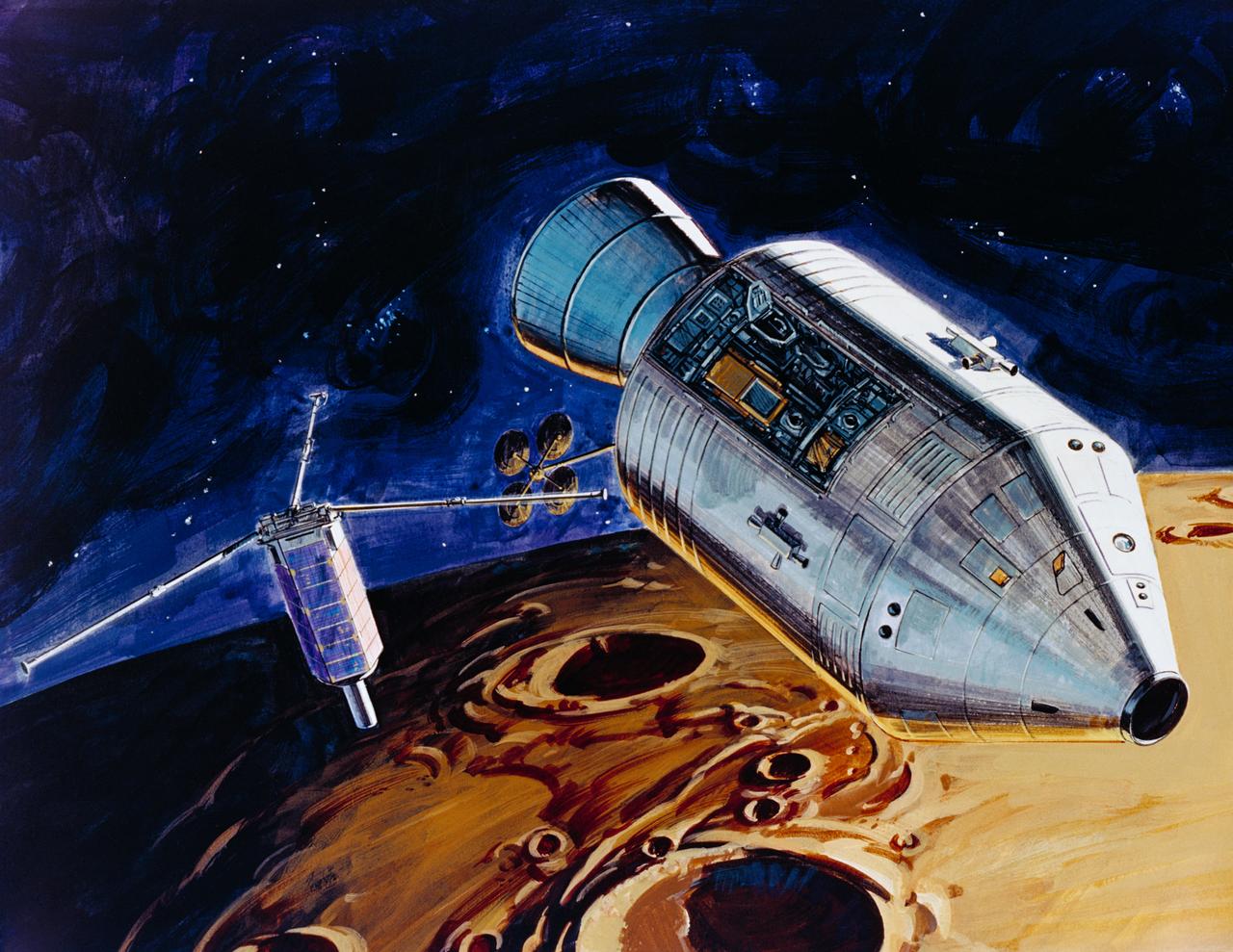
S71-39481 (July 1971) --- An artist's concept showing TRW's small lunar subsatellite being ejected into lunar orbit from the SIM bay of the Apollo 15 Service Module. The 80-pound satellite will remain in orbit a year or more, carrying scientific experiments to study space in the vicinity of the moon. The satellite carries three experiments: S-Band Transponder; Particle Shadows/Boundary Layer Experiment; and Subsatellite Magnetometer Experiment. The subsatellite is housed in a container resembling a rural mailbox, and when deployed is spring-ejected out-of-plane at 4 fps with a spin rate of 140 rpm. After the satellite booms are deployed, the spin rate is stabilized at about 12 rpm. The subsatellite is 31 inches long and has a 14 inch hexagonal diameter. The exact weight is 78.5 pounds. The folded booms deploy to a length of five feet. Subsatellite electrical power is supplied by a solar cell array outputting 25 watts for dayside operation and a rechargeable silver-cadmium battery for nightside passes.
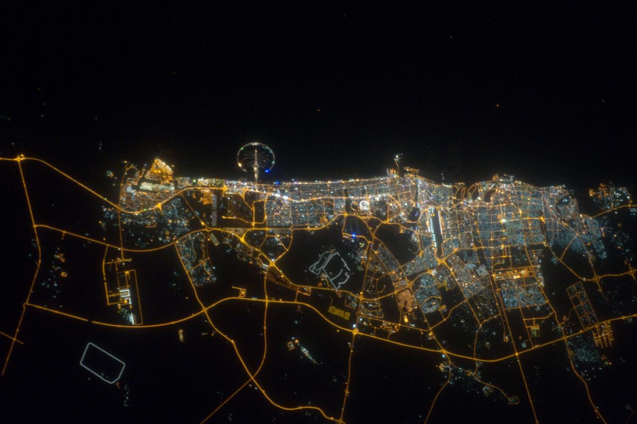
ISS032-E-023718 (11 Aug. 2012) --- The city of Dubai, United Arab Emirates, is featured in this night view photographed by an Expedition 32 crew member on the International Space Station. The city of Dubai is the largest metropolitan area in the emirate of Dubai, one of the member states of the United Arab Emirates. Dubai is located along the southern Persian Gulf on the Arabian Peninsula, and its signature city is known for high profile architectural and development projects. Among the most notable is the Palm Island Resort, a manmade peninsula and surrounding islands built from over 50 million cubic meters of sand. Two other island projects (out of frame), one similar to the Palm Island Resort and another crafted to look like a map of the world, are also visible in other space station imagery along the Dubai coastline. Orange sodium vapor lights trace out the major highways and surface street grid in and around the metropolitan area, while grey-white mercury vapor lamps fill in the commercial and residential areas. The lighted islands and peninsula of the Palm Island Resort are clearly visible along the coastline. An interesting spiral pattern of lights on the southeastern fringe of the urban area is a camel racetrack. Night time images like this are useful to climate modelers, urban planners, and geographers as they allow for simple definition of urban (densely lit) and rural (sparsely lit) areas.
ISS012-E-23057 (2 March 2006) --- Ekuma River and Etosha Pan, Namibia are featured in this close-up image photographed by an Expedition 12 crewmember on the International Space Station. Etosha Pan, northern Namibia, is a large (120 kilometers or 75 mile long) dry lakebed in the Kalahari Desert. The lake and surrounds are protected today as one of Namibia’s largest wildlife parks. Herds of elephant occupy the dense mopane woodland on the south side of the lake. Mopane trees are common throughout south-central Africa, and host the mopane worm (the larval form of the Mopane Emperor Moth)–an important source of protein for rural communities. According to scientists, about 16,000 years ago, when ice sheets were melting across Northern Hemisphere land masses, a wet climate phase in southern Africa filled Etosha Lake. Today, Etosha Pan is seldom seen with even a thin sheet of water covering the salt pan. This view shows the point where the Ekuma River flows into the salt lake. The Ekuma River is almost never seen with water, but in early 2006 rainfall twice the average amount in the river’s catchment generated flow. Greens and browns show vegetation and algae growing in different depths of water where the river enters the dry lake. Typically, little river water or sediment reaches the dry lake because water seeps into the riverbed along its 250 kilometers (155 miles) course, reducing discharge along the way. In this image, there was enough surface flow to reach the Pan, but too little water reached the mouth of the river to flow beyond the inlet bay. The unusual levels of precipitation also filled several small, usually dry lakes to the north of Etosha Pan.
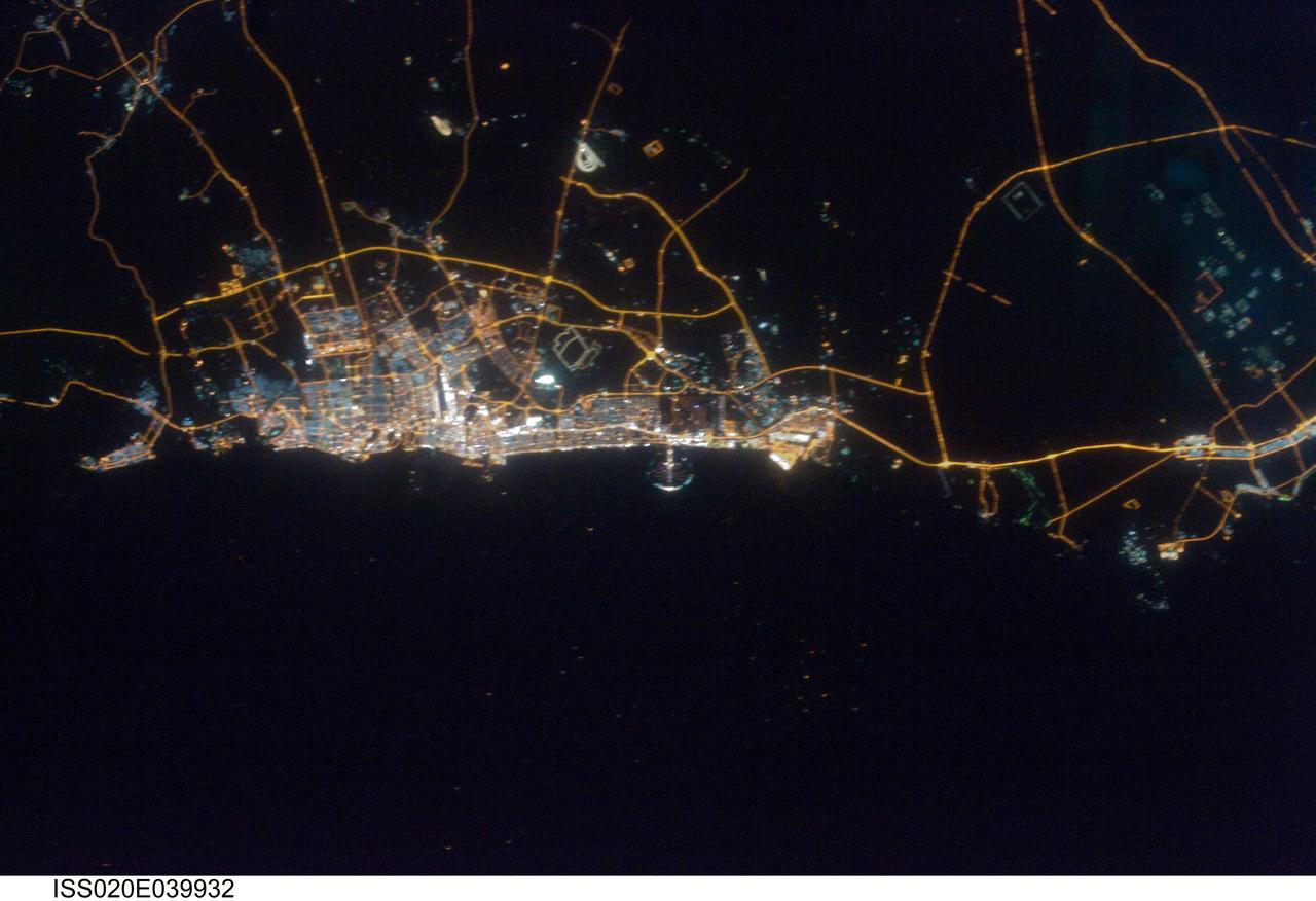
ISS020-E-039932 (11 Sept. 2009) --- City of Dubai, United Arab Emirates is featured in this night view photographed by an Expedition 20 crew member on the International Space Station. The city of Dubai is the largest metropolitan area in the emirate of Dubai, one of the member states of the United Arab Emirates. Dubai is located along the southern Persian Gulf on the Arabian Peninsula, and its signature city is known for high profile architectural and development projects. Among the most notable is the Palm Island Resort, a manmade peninsula and surrounding islands built from over 50 million cubic meters of sand. Two other island projects, one similar to the Palm Island Resort and another crafted to look like a map of the world, are also underway along the Dubai coastline. This night time photograph of the city of Dubai was taken at approximately 2:00 a.m. local time. Orange sodium vapor lights trace out the major highways and surface street grid in and around the metropolitan area, while grey-white mercury vapor lamps fill in the commercial and residential areas. The lighted islands and peninsula of the Palm Island Resort are clearly visible along the coastline. An interesting spiral pattern of lights on the southeastern fringe of the urban area is a camel racetrack. Night time images like these are useful to climate modelers, urban planners, and geographers as they allow for simple definition of urban (densely lit) and rural (sparely lit) areas.
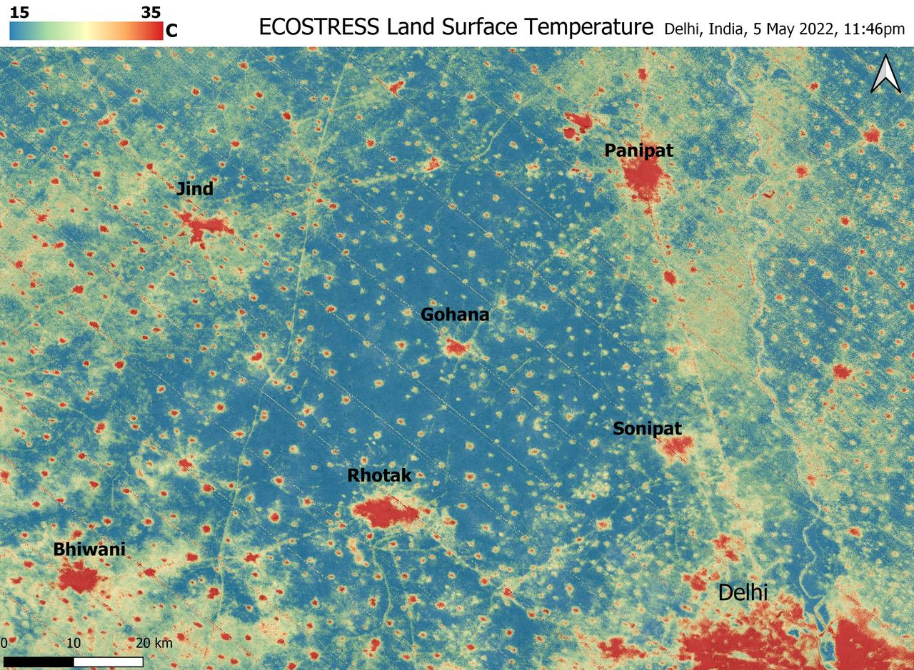
A relentless heat wave has blanketed India and Pakistan since mid-March 2022, causing dozens of deaths, fires, increased air pollution, and reduced crop yields. NASA's Ecosystem Spaceborne Thermal Radiometer Experiment on Space Station instrument (ECOSTRESS) has been measuring these temperatures from space, at the highest spatial resolution of any satellite instrument. This image, taken shortly before local midnight on May 5, shows urban areas and agricultural lands northwest of Delhi that are home to about 28 million people. The image covers about 4,800 square miles (12,350 square kilometers). Cities are usually markedly warmer than the surrounding countryside due to human activities and the materials used in the built environment. The image clearly delineates these urban "heat islands." Nighttime temperatures in Delhi and several smaller villages were above 95 degrees Fahrenheit (35 degrees Celsius), peaking at about 102 degrees F (39 degrees C), while the rural fields nearby had cooled to around 60 degrees F (15 degrees C). This data suggests that city dwellers are experiencing considerably higher temperatures than the average temperatures reported for their regions. ECOSTRESS measures the temperature of the ground itself, which is very similar to air temperature at night (though the ground may be warmer than the air in daylight hours). The instrument launched to the space station in 2018. Its primary mission is to identify plants' thresholds for water use and water stress, giving insight into their ability to adapt to a warming climate. However, ECOSTRESS also records other heat-related phenomena like this heat wave. Its high-resolution images, with a pixel size of about 225 feet (70 meters) by 125 feet (38 meters), are a powerful tool for understanding aspects of the weather event that might be overlooked by traditional observation networks. https://photojournal.jpl.nasa.gov/catalog/PIA24987
ISS010-E-13807 (18 January 2005) --- Shenyang, China is featured in this image photographed by an Expedition 10 crewmember on the International Space Station (ISS). The city of Shenyang is China’s sixth largest city with a population of over 4 million residents in the urban core. The city is the major industrial, commercial, and cultural center of northeast China (the region historically known as Manchuria). Its geographic location on the floodplains of the Hun and Liao Rivers ensured an early agrarian economy that was later replaced by industrialization and natural resource extraction. Shenyang was first settled as a Mongol trading center in the 10th century, and served as the capitol of the Manchu government from the 17th through 20th centuries. Currently the city serves as the capital of Liaoning Province. Snow cover provides a clear contrast between urbanized (dark grey, center of image) and rural regions (white to light grey). The major portion of the local economy is devoted to industries such as metal smelting, coal mining, and petrochemical processing. Several southeast-trending plumes from industrial facilities are visible in the image. According to NASA scientists studying the Expedition 10 imagery, the high density of industrial land use in the Shenyang metropolitan area has lead to significant air, water, and soil pollution in the region. Recently, several initiatives to reduce pollution levels and establish environmentally-sound development guidelines have begun with support from local government and the United Nations.

ISS026-E-012474 (24 Dec. 2010) --- A night view of the Montreal metropolitan area is featured in this image photographed by an Expedition 26 crew member on the International Space Station. This photograph of the Montreal, Quebec, Canada metropolitan area (center) illustrates the extent of urbanization made clearly visible by city lights at night. Major roadways and industrial areas are traced by bright white lighting, while the adjacent residential and commercial land uses are characterized by more diffuse yellow-gold lighting. Rivers and other water bodies appear black, while the surrounding rural countryside is faintly illuminated by moonlight. Blurry areas at top and bottom left are caused by cloud cover. Montreal is the largest city in the dominantly French-speaking Province of Quebec. The metropolitan area is the country?s second-largest, having been surpassed by Toronto in 1976. While the city of Montreal proper is located on?and almost completely covers?the Island of Montreal at the confluence of the St. Lawrence (center) and Ottawa Rivers (not visible), the city takes its name from Mont Royal located at the city?s center . Several smaller urban areas form a loose ring around the Montreal metro region: Sorel-Tracy, Saint-Hyacinthe, Saint-Jean-sur-Richelieu, Salaberry-de-Valleyfield, Saint-Jerome, and Joliette are among those that can be readily identified. The International Space Station was located over the Pennsylvania-New York border (near Warren, PA) at the time this image was taken?a ground distance of approximately 600 kilometers southwest of Montreal. This distance from the camera target, coupled with the oblique (inclined) viewing angle from the ISS, results in the foreshortened appearance of urban areas in the image.
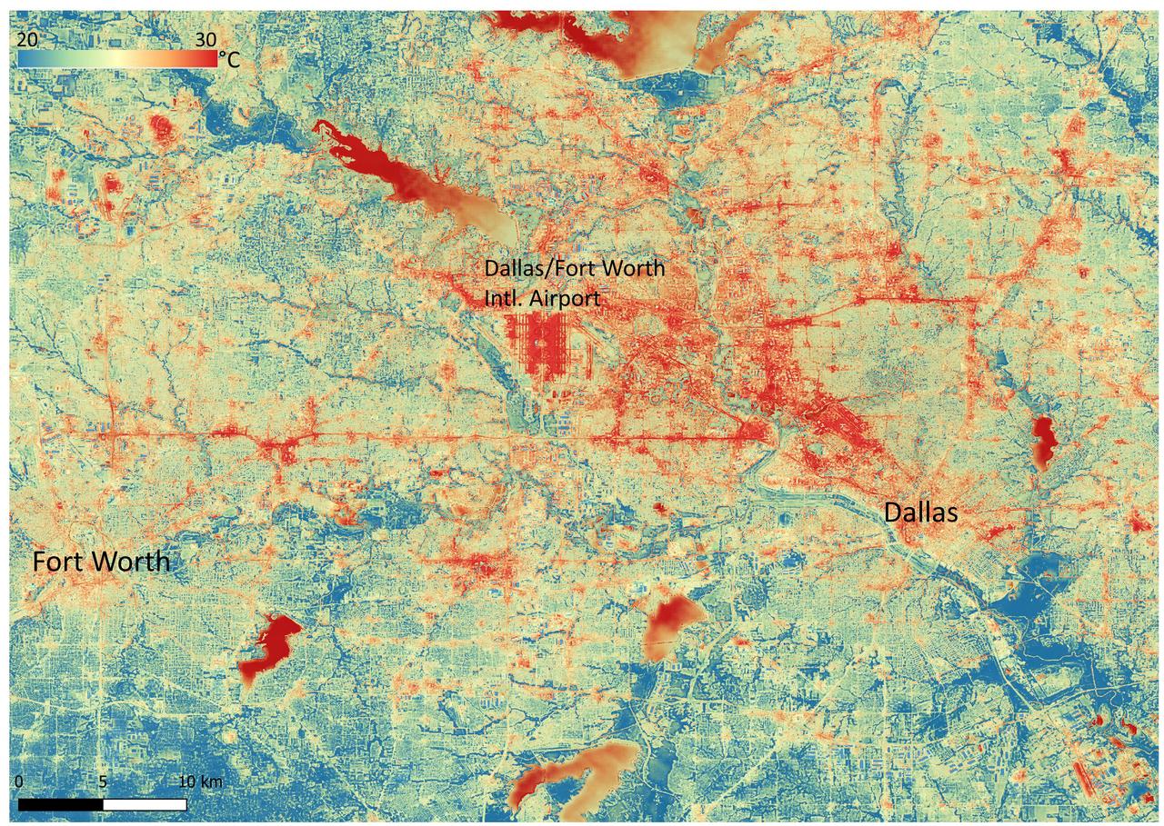
NASA's Ecosystem Spaceborne Thermal Radiometer Experiment on Space Station (ECOSTRESS) instrument recorded this image of ground surface temperatures in Dallas and Fort Worth, Texas, on June 20, 2022, at 7:17 a.m. Central Daylight Time. Even early in the day, manmade urban surfaces near city centers and transportation networks – streets, roads, and highways shown in red and orange – are warmer than the outskirts by up to 18 degrees Fahrenheit (10 degrees Celsius). The paved surfaces at Dallas/Fort Worth International Airport, shown in red near the top-center of the image, had the warmest temperatures, exceeding 86 F (30 C). Natural land surfaces such as vegetation and streams in rural areas, shown in green and blue, are cooler than nearby large bodies of water, shown in red and yellow, that tend to retain more heat overnight due to their higher heat capacity. Cities are usually warmer than open land because of human activities and the materials used in building and construction. Streets are often the hottest part of the built environment due to asphalt paving. Dark-colored surfaces absorb more heat from the Sun than lighter-colored ones; asphalt absorbs up to 95% of solar radiation and retains the heat for hours into the nighttime. ECOSTRESS measures the temperature of the ground, which is hotter than the air temperature during the daytime. The instrument launched to the space station in 2018. Its primary mission is to identify plants' thresholds for water use and water stress, giving insight into their ability to adapt to a warming climate. However, ECOSTRESS is also useful for documenting other heat-related phenomena, like patterns of heat absorption and retention. Its high-resolution images, with a pixel size of about 225 feet (70 meters) by 125 feet (38 meters), are a powerful tool for understanding our environment. https://photojournal.jpl.nasa.gov/catalog/PIA25422

ISS033-E-014186 (16 Oct. 2012) --- A nighttime view of Baltimore, Maryland is featured in this image photographed by an Expedition 33 crew member in the International Space Station. Baltimore is located on the U.S. mid-Atlantic coastline along the terminus of the Patapsco River into Chesapeake Bay, and is the largest seaport along this part of the coast. Like many large U.S. metropolitan areas, the most brightly lit area corresponds to the highest density of buildings and typically indicates the urban core -- in this case, downtown Baltimore at center. Highways and large arterial streets appear as bright yellow-orange lines extending outwards from the downtown area into the surrounding suburban regions (light violet and reddish brown regions of diffuse lighting). Dark areas beyond the suburban zone are rural - or to the southeast, indicate the waters of Chesapeake Bay. Small dark patches within the metropolitan area are open space including parks, cemeteries, and the Baltimore Zoo (top left). Two large, brightly-lit areas along Chesapeake Bay are commercial/industrial regions, and include the major port facilities for Baltimore. The City of Baltimore was incorporated in 1796, after serving as the de facto capital of the nascent United States of America during the Second Continental Congress (from Dec. 20, 1776 to March 4, 1777). Today, the Baltimore metropolitan area (as defined by the Baltimore Metropolitan Council) includes over 2.5 million people and includes six Maryland counties (Anne Arundel, Baltimore, Carroll, Harford, and Howard) in addition to the City of Baltimore. The region is also a focus of urban ecological research through the Baltimore Ecosystem Study.
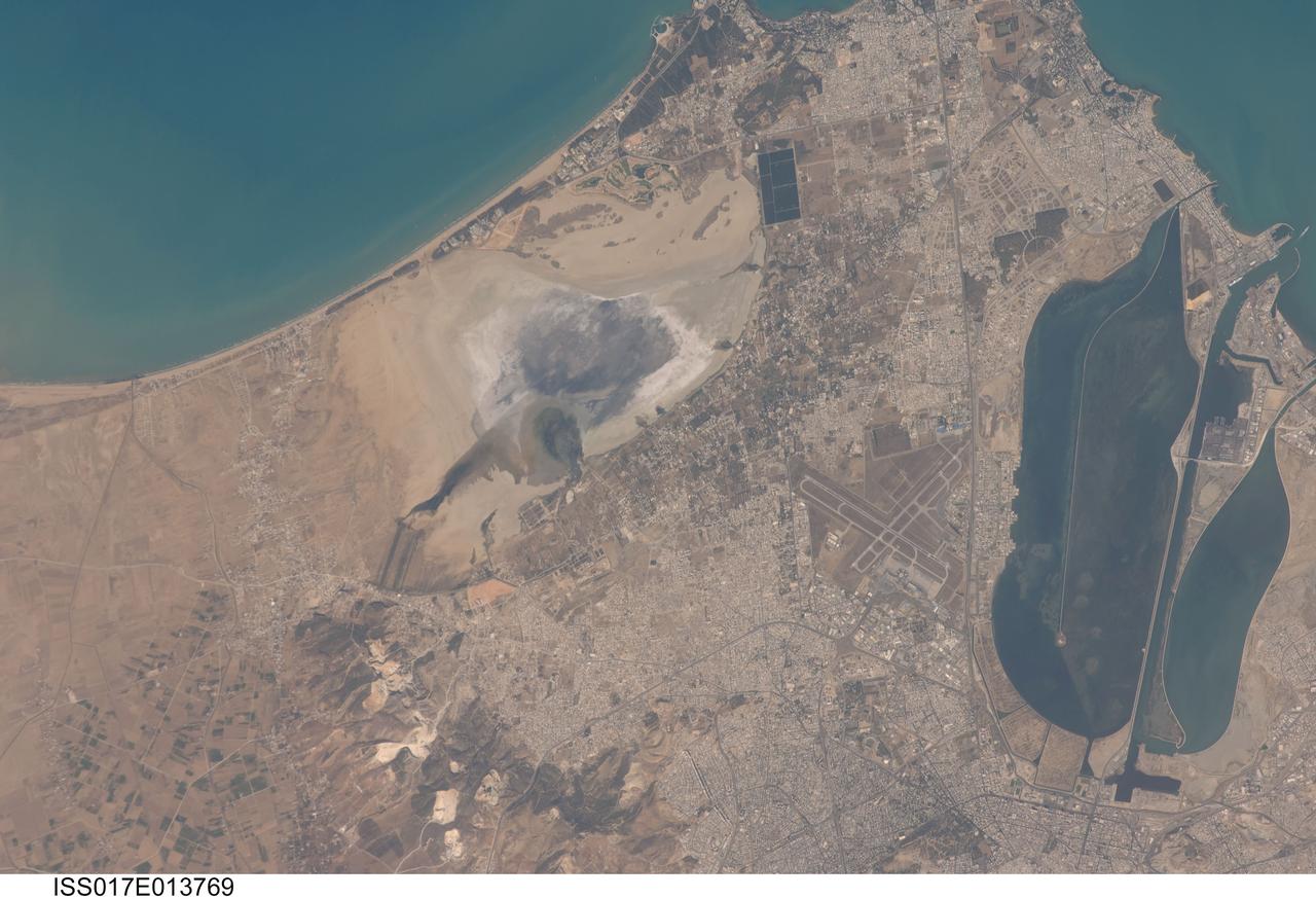
ISS017-E-013769 (19 Aug. 2008) --- Tunis, Tunisia is featured in this image photographed by an Expedition 17 crewmember on the International Space Station. The city of Tunis, capital of Tunisia, is a rapidly modernizing city located along the Mediterranean coast of northern Africa. Sharing much of its history with famous Carthage to the north, Tunis was also destroyed by Rome in approximately 146 BC. Tunis, however, was rebuilt by the Romans and became an important agricultural center. Modern Tunis serves as the administrative center for the whole of Tunisia, and as a commercial hub for trade in the northern part of the country. The urban area of Tunis is located on a flat coastal plain, and is distinguished in this view from the surrounding desert by the pattern of grey to tan buildings and darker street grid. The city is bordered by an evaporating saline lake to the northeast known as Sebkhet Arina (upper left) -- evaporite minerals such as halite (table salt) and gypsum produce the white deposits surrounding the darker lake center where there is more moisture. To the southeast of the city is Lake Tunis, a lagoon that has been significantly altered by human activities -- such as closing off water exchange with the Mediterranean Sea - dating back to Roman times. The general lack of water circulation and input of nutrients from sewage has lead to the establishment of marine worm reefs, and occasional fish kills. The western urban-rural fringe is defined by a range of low hills (lower left); dark green agricultural fields are visible on the western side of these hills.
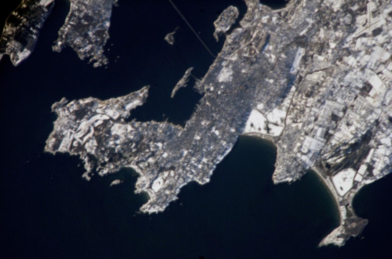
ISS012-E-19051 (4 March 2006) --- Newport, R.I., is featured in this image photographed by an Expedition 12 crew member on the International Space Station. Newport is well-known as a summer destination, but winter snow blankets the city in this image. One of the first settlements by Europeans in the Americas, the region was initially settled by colonists seeking religious freedom denied them in Europe, but over time some of them perceived a need to escape the strictures of the dominant Puritan faith. Newport, founded in 1639, became a bastion of the Baptist faith and exemplified one of the basic precepts of the United States Constitution – separation of church and state. Throughout the 17th and 18th centuries, Newport consolidated its position as one of the premier ports of the United States. The 19th and early 20th centuries saw a decline in commercial shipping at Newport and its rebirth as a recreational destination. Many of the leading industrialist families of the time, such as the Vanderbilts, built grand summer mansions in Newport that are now open to visitors. The United States Navy has also had a strong presence in the Newport area since 1869, exemplified by the establishment of the Naval War College in 1884 (image top center). The College still serves as an educational institution for naval officers. The gray-brown metropolitan area of Newport is thrown into sharp contrast by the surrounding snow-covered open fields and rural areas to the east and southwest. The Clairborne Pell (also known as Newport) Bridge connects Jamestown, R.I. on Conanicut Island to Newport at image top. The main span of this suspension bridge is 1600 feet (485 meters) long and crosses the East Passage of Narragansett Bay. The Sachuest Point National Wildlife Refuge (image lower right) supports over 200 bird species, including the largest winter harlequin duck population on the East Coast.
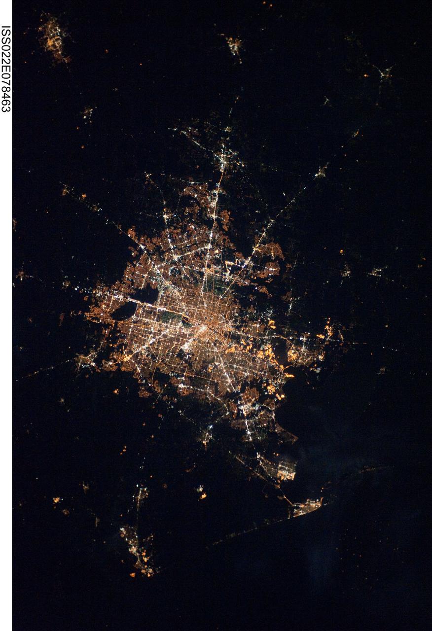
ISS022-E-078463 (28 Feb. 2010) ---The Houston metropolitan area at night is featured in this image photographed by an Expedition 22 crew member on the International Space Station. Houston, Texas has been called the ?energy capital of the world? due to its role as a major hub of the petroleum and other energy resource industries. The image is oriented with north toward the top. The Houston metropolitan area covers almost 2,331,000 hectares (approximately 9,000 square miles) along the southeast Texas coastline, with an average elevation of 13 meters (approximately 43 feet) above sea level and a population of over 5 million (2006 US Census estimate). The Houston metropolitan area is also noteworthy as being the largest in the US without formal zoning restrictions. This has lead to a highly diverse pattern of land use at the neighborhood scale; nevertheless, more general spatial patterns of land use can be recognized in remotely sensed data. This is particularly evident in night time photography of the urban area taken by crew members onboard the space station. The image depicts the roughly 100 kilometers (approximately 62 miles) east-west extent of the Houston metropolitan area. Houston proper is at center, indicated by a ?bull?s-eye? of elliptical white to orange-lighted beltways and brightly lit white freeways radiating outwards from the central downtown area. Suburban and primarily residential urban land use is indicated by both reddish-brown and gray-green lighted regions that reflect a higher proportion of tree cover and lower light density. Petroleum refineries along the Houston Ship Channel are recognized by densely lit areas of golden yellow light. Rural and undeveloped land circles the metropolitan area, and Galveston Bay to the southeast (lower right) provides access to the Gulf of Mexico. Both types of non-urban surface appear dark in the image.
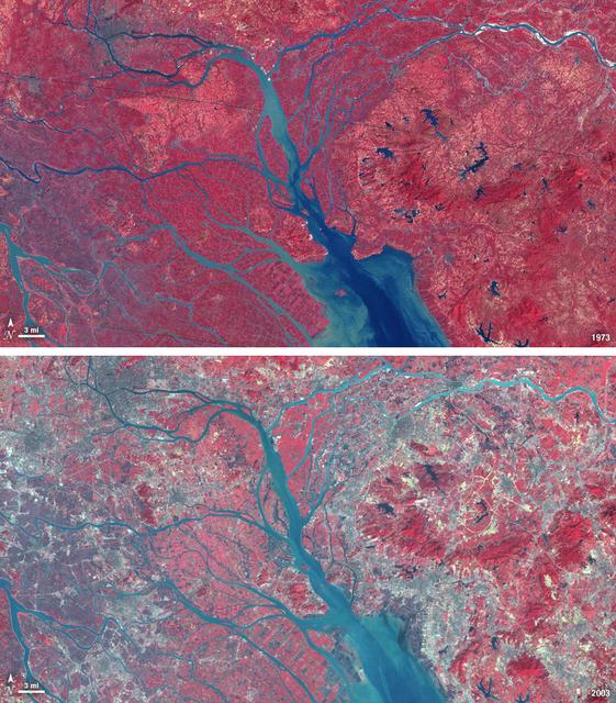
In 1979, China established two special economic zones around the Pearl River Delta, north of Hong Kong. This image, taken by Landsat 3 on October 19, 1973, shows that the region was rural when the zone was established. Plant-covered land, which is red in this false-color image, dominates the scene. Square grids are agriculture. By January 10, 2003, when Landsat 7 took this image, the Pearl River Delta was a densely populated urban corridor with several large cities. The urban areas are gray in this image. The region is a major manufacturing center with an economy the size of Taiwan’s. As of 2010, the Pearl River Economic Zone had a population of 36 million people. ---- NASA and the U.S. Department of the Interior through the U.S. Geological Survey (USGS) jointly manage Landsat, and the USGS preserves a 40-year archive of Landsat images that is freely available over the Internet. The next Landsat satellite, now known as the Landsat Data Continuity Mission (LDCM) and later to be called Landsat 8, is scheduled for launch in 2013. In honor of Landsat’s 40th anniversary in July 2012, the USGS released the LandsatLook viewer – a quick, simple way to go forward and backward in time, pulling images of anywhere in the world out of the Landsat archive. <b><a href="http://www.nasa.gov/audience/formedia/features/MP_Photo_Guidelines.html" rel="nofollow">NASA image use policy.</a></b> <b><a href="http://www.nasa.gov/centers/goddard/home/index.html" rel="nofollow">NASA Goddard Space Flight Center</a></b> enables NASA’s mission through four scientific endeavors: Earth Science, Heliophysics, Solar System Exploration, and Astrophysics. Goddard plays a leading role in NASA’s accomplishments by contributing compelling scientific knowledge to advance the Agency’s mission. <b>Follow us on <a href="http://twitter.com/NASA_GoddardPix" rel="nofollow">Twitter</a></b> <b>Like us on <a href="http://www.facebook.com/pages/Greenbelt-MD/NASA-Goddard/395013845897?ref=tsd" rel="nofollow">Facebook</a></b> <b>Find us on <a href="http://instagrid.me/nasagoddard/?vm=grid" rel="nofollow">Instagram</a></b>
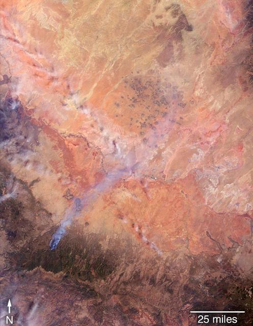
On April 27, 2018, the Tinder Fire ignited in eastern Arizona near the Blue Ridge Reservoir, about 50 miles (80 kilometers) southeast of Flagstaff and 20 miles (32 kilometers) northeast of Payson. During the first 24 hours it remained relatively small at 500 acres (202 hectares), but on April 29, during red flag wind conditions, it exploded to 8,600 acres (3,480 hectares). Residents of rural communities in the area were forced to evacuate and an unknown number of structures were burned. As of April 30, the Tinder Fire had burned a total of 11,400 acres (4,613 hectares). On April 30 at 11:15 a.m. local time, the Multi-angle Imaging SpectroRadiometer (MISR) captured imagery of the Tinder Fire as it passed overhead on NASA's Terra satellite. The MISR instrument has nine cameras that view Earth at different angles. This image shows the view from MISR's nadir (downward-pointing) camera. The angular information from MISR's images is used to calculate the height of the smoke plume, results of which are superimposed on the right-hand image. This shows that the plume top near the active fire was at approximately 13,000 feet altitude (4,000 meters). In general, higher-altitude plumes transport smoke greater distances from the source, impacting communities downwind. A stereo anaglyph providing a three-dimensional view of the plume is also shown. Red-blue glasses with the red lens placed over your left eye are required to observe the 3D effect. These data were acquired during Terra orbit 97691. An annotated figure and anaglyph are available at https://photojournal.jpl.nasa.gov/catalog/PIA00698
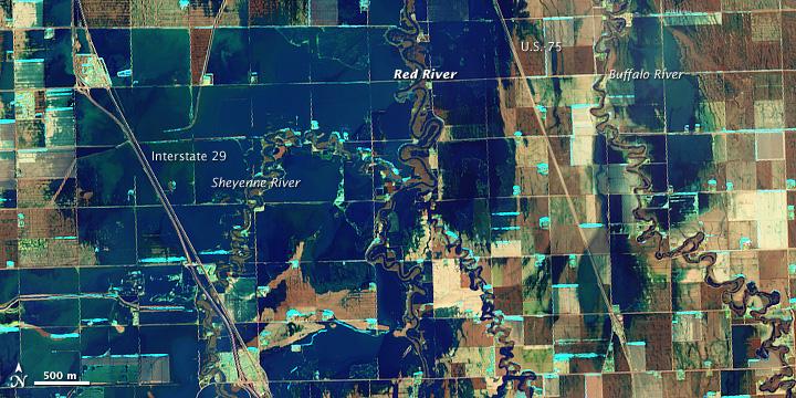
NASA Satellite image acquired March 21, 2010. To see a high res of this image go here: <a href="http://www.flickr.com/photos/gsfc/4455124807/in/photostream/">www.flickr.com/photos/gsfc/4455124807/in/photostream/</a> On March 21, 2010, the Red River crested at 36.99 feet (11.27 meters), according to the National Weather Service. The New York Times reported that the river’s crest was 1 foot (0.3 meters) below predictions and 4 feet (1 meter) below 2009’s record crest. A cold front passing through the area on March 19, 2010, slowed the rate of snowmelt feeding local rivers. That, combined with sandbags and dykes, spared the metropolitan area of Fargo, North Dakota, from serious flooding. North of town, however, agricultural fields and roads flooded. The Advanced Land Imager (ALI) on NASA’s Earth Observing-1 (EO-1) satellite captured these images of fields north of Fargo on March 21, 2010. The top image uses shortwave infrared light, and the bottom image uses visible light. Muddy waters and fallow fields blend together in the true-color image (bottom), but the false-color image (top) distinguishes better between water and land. Blue indicates water and green indicates vegetation. Fallow fields, bare ground, and paved surfaces appear in shades of brown. Cyan suggests pale water and/or sediment. Wide swaths of blue show large areas of standing water. The Sheyenne, Red, and Buffalo Rivers all flow through the area pictured here. According to The New York Times, flooding in rural areas around Fargo resulted primarily from the Red River’s failure to absorb water from the tributaries feeding it. Much of the standing water apparent in this image occurs around the Sheyenne and Buffalo Rivers. Overflowing tributaries left several inches of standing water in agricultural fields and on highways. About 10 miles (16 kilometers) north of Fargo, flooding forced the closure of Interstate 29. NASA image created by Jesse Allen, using EO-1 ALI data provided courtesy of the NASA EO-1 team and the United States Geological Survey. Caption by Michon Scott.. Instrument: EO-1 - ALI. To learn more about this image go here: <a href="http://earthobservatory.nasa.gov/NaturalHazards/view.php?id=43211" rel="nofollow">earthobservatory.nasa.gov/NaturalHazards/view.php?id=43211</a> To learn more about NASA's Goddard Space Flight Center go here: <a href="http://www.nasa.gov/centers/goddard/home/index.html" rel="nofollow">www.nasa.gov/centers/goddard/home/index.html</a>
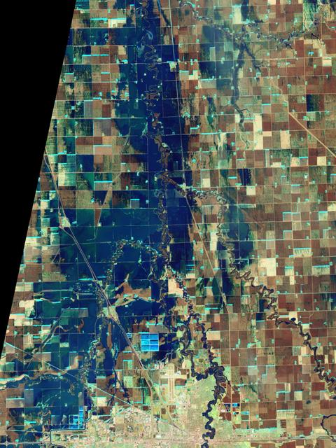
NASA Satellite image acquired March 21, 2010. To see a high res more detail of this image go here: <a href="http://www.flickr.com/photos/gsfc/4455125023/in/photostream/">www.flickr.com/photos/gsfc/4455125023/in/photostream/</a> On March 21, 2010, the Red River crested at 36.99 feet (11.27 meters), according to the National Weather Service. The New York Times reported that the river’s crest was 1 foot (0.3 meters) below predictions and 4 feet (1 meter) below 2009’s record crest. A cold front passing through the area on March 19, 2010, slowed the rate of snowmelt feeding local rivers. That, combined with sandbags and dykes, spared the metropolitan area of Fargo, North Dakota, from serious flooding. North of town, however, agricultural fields and roads flooded. The Advanced Land Imager (ALI) on NASA’s Earth Observing-1 (EO-1) satellite captured these images of fields north of Fargo on March 21, 2010. The top image uses shortwave infrared light, and the bottom image uses visible light. Muddy waters and fallow fields blend together in the true-color image (bottom), but the false-color image (top) distinguishes better between water and land. Blue indicates water and green indicates vegetation. Fallow fields, bare ground, and paved surfaces appear in shades of brown. Cyan suggests pale water and/or sediment. Wide swaths of blue show large areas of standing water. The Sheyenne, Red, and Buffalo Rivers all flow through the area pictured here. According to The New York Times, flooding in rural areas around Fargo resulted primarily from the Red River’s failure to absorb water from the tributaries feeding it. Much of the standing water apparent in this image occurs around the Sheyenne and Buffalo Rivers. Overflowing tributaries left several inches of standing water in agricultural fields and on highways. About 10 miles (16 kilometers) north of Fargo, flooding forced the closure of Interstate 29. NASA image created by Jesse Allen, using EO-1 ALI data provided courtesy of the NASA EO-1 team and the United States Geological Survey. Caption by Michon Scott. Instrument: EO-1 - ALI. To learn more about this image go here: <a href="http://earthobservatory.nasa.gov/NaturalHazards/view.php?id=43211" rel="nofollow">earthobservatory.nasa.gov/NaturalHazards/view.php?id=43211</a> To learn more about NASA's Goddard Space Flight Center go here: <a href="http://www.nasa.gov/centers/goddard/home/index.html" rel="nofollow">www.nasa.gov/centers/goddard/home/index.html</a>
NASA satellite image acquired February 2, 2008. Outside the ground is frozen, quite possibly covered in snow and ice, and yet, stroll through a supermarket in North America or Europe in February, and you’ll be confronted with large displays of roses. We expect flowers in winter, and equatorial countries meet those expectations. A quarter of the cut flowers sold in Europe are grown in Kenya. Straddling the equator, Kenya gets steady sunlight dealt out in days that vary little in length. It’s the perfect climate for flowers year-round. The center of Kenya’s flower industry is Lake Naivasha, shown here. The Advanced Spaceborne Thermal Emission and Reflection Radiometer (ASTER) flying on NASA’s Terra satellite captured this image of Lake Naivasha on February 2, 2008. Bright white squares mix with fields of green, tan, and purple along the shores of the lake. Sunlight glints off the long rows of glass greenhouses, turning them silvery blue and white in this view from space. Fallow fields are tan and pink, while growing plants turn the ground bright green. Roses, lilies, and carnations are the most common flowers grown in the greenhouses and fields scattered around the lake. The large-scale industry shown here extends into small-scale rural farms elsewhere in Kenya, where smaller filler flowers are grown. The flowers provide an important source of income to Kenya, but the industry comes with a price. Flowers are not held to the same standards for chemical residues as food products, which are tightly regulated. Strong chemical pesticides can be used on the flowers to produce the perfect, pest-free bloom, and this could pose a health risk to workers and local wildlife, including hippos, environmental groups told the Food and Agriculture Organization of the United Nations in 2002. The chemicals may also have threatened the water quality of Lake Naivasha, one of Kenya’s few freshwater lakes. The Kenya Flower Council instituted a code of conduct establishing guidelines for pesticide that phases out the use of one of the most toxic pesticides. NASA image created by Jesse Allen, using data provided courtesy of NASA/GSFC/METI/ERSDAC/JAROS, and U.S./Japan ASTER Science Team. Caption by Holli Riebeek. Instrument: Terra - ASTER <b><a href="http://www.nasa.gov/centers/goddard/home/index.html" rel="nofollow">NASA Goddard Space Flight Center</a></b> is home to the nation's largest organization of combined scientists, engineers and technologists that build spacecraft, instruments and new technology to study the Earth, the sun, our solar system, and the universe.
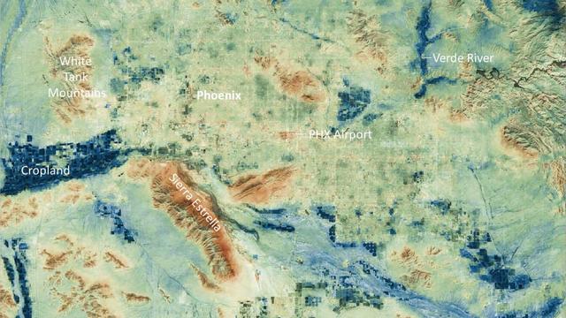
Researchers at NASA's Jet Propulsion Laboratory have created a series of maps showing land-surface temperatures in the Phoenix area in July 2023, when the city experienced a record-breaking run of hot weather. The images reveal the cumulative effect – overnight and across the month – of relentless daytime heating. The data was captured during overnight hours (around 2 a.m.) on several days in July by an instrument called the Visible Infrared Imaging Radiometer Suite (VIIRS) aboard the NOAA-NASA Suomi National Polar-orbiting Partnership (Suomi NPP) satellite managed by the National Oceanic and Atmospheric Administration and NASA. The images show how built surfaces – roads, buildings, airport runways, and the like – retain heat, sometimes hovering around 100 degrees Fahrenheit (38 degrees Celsius) for hours after sunset. From July 1 to July 19, the built surfaces in the maps grew progressively hotter, likely the combined effect of the heat wave intensifying and the cumulative heating of those human-made structures. Due to their high heat capacity, these surfaces didn't fully cool overnight before the onset of the next day's heat. At the center of the images is Phoenix's Sky Harbor International Airport, where VIIRS measured the hottest land-surface temperature within the city. The airport is also where Phoenix takes its official air temperature. By those measurements, the city experienced the hottest month on record in July, including a record 31 consecutive days in which the temperature exceeded 110 degrees Fahrenheit (43.3 degrees Celsius). The previous record was 18 days. Land-surface temperatures in cities are usually warmer than in rural and undeveloped areas because of human activities and the materials used for building. Streets – seen in these maps as a grid pattern – are often the hottest part of the built environment due to dark asphalt paving that absorbs more sunlight than lighter-colored surfaces; asphalt absorbs up to 95% of solar radiation. In the images, the mountains near Phoenix are also notably hot due to their angle to the Sun and greater soil exposure from lack of vegetation. The hot surfaces in and around the city stand in contrast to nearby irrigated surfaces such as agricultural fields, golf courses, and parks, which fell as low as 68 degrees Fahrenheit (18.9 degrees Celsius) during the night. The Verde River and other nearby waterways also were significantly cooler. VIIRS is one of five instruments aboard the NOAA-NASA Suomi NPP satellite. Short for Suomi National Polar-orbiting Partnership, the spacecraft is one of several in the Joint Polar Satellite System. The images were produced from the VNP21IMG Land Surface Temperature product, which is available at NASA's Land, Atmosphere Near-real-time Capability for EOS (LANCE). Animation available at https://photojournal.jpl.nasa.gov/catalog/PIA25868
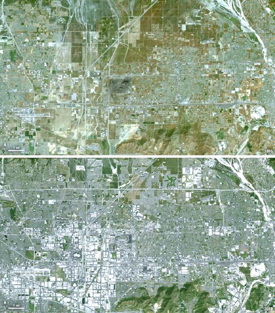
Thirty-five miles due east of downtown Los Angeles lies the city of Ontario, California. In 1881 two Canadian brothers established the town, naming it after their native city. By 1891 Ontario, Calif., was incorporated as a city. The farming-based economy (olives, citrus, dairy) of the city helped it grow to 20,000 by the 1960s. Subsequently, warehousing and freight trafficking took over as the major industry and the city’s population was over 160,000 by 2010. The L.A./Ontario International Airport is now America’s 15th busiest cargo airport. In these natural color Landsat 5 images, the massive growth of the city between 1985 and 2010 can be seen. The airport, found in the southwest portion of the images, added a number of runways and large warehousing structures now dominate the once rural areas surrounding the airport. In these images vegetation is green and brown and urban structures are bright white and gray. (Note there is a large dry riverbed in the northeast corner that is also bright white, but its nonlinear appearance sets it apart visually). ---- NASA and the U.S. Department of the Interior through the U.S. Geological Survey (USGS) jointly manage Landsat, and the USGS preserves a 40-year archive of Landsat images that is freely available over the Internet. The next Landsat satellite, now known as the Landsat Data Continuity Mission (LDCM) and later to be called Landsat 8, is scheduled for launch in 2013. In honor of Landsat’s 40th anniversary in July 2012, the USGS released the LandsatLook viewer – a quick, simple way to go forward and backward in time, pulling images of anywhere in the world out of the Landsat archive. <b><a href="http://www.nasa.gov/audience/formedia/features/MP_Photo_Guidelines.html" rel="nofollow">NASA image use policy.</a></b> <b><a href="http://www.nasa.gov/centers/goddard/home/index.html" rel="nofollow">NASA Goddard Space Flight Center</a></b> enables NASA’s mission through four scientific endeavors: Earth Science, Heliophysics, Solar System Exploration, and Astrophysics. Goddard plays a leading role in NASA’s accomplishments by contributing compelling scientific knowledge to advance the Agency’s mission. <b>Follow us on <a href="http://twitter.com/NASA_GoddardPix" rel="nofollow">Twitter</a></b> <b>Like us on <a href="http://www.facebook.com/pages/Greenbelt-MD/NASA-Goddard/395013845897?ref=tsd" rel="nofollow">Facebook</a></b> <b>Find us on <a href="http://instagrid.me/nasagoddard/?vm=grid" rel="nofollow">Instagram</a></b>

ISS029-E-012564 (29 Sept. 2011) --- The Midwestern United States at night with Aurora Borealis is featured in this image photographed by an Expedition 29 crew member on the International Space Station. The night skies viewed from the space station are illuminated with light from many sources. For example, the Midwestern United States presents a night-time appearance not unlike a patchwork quilt when viewed from orbit. The artificial light from human settlements appears everywhere with a characteristic yellow tinge in this photograph. But green light of the Aurora Borealis also appears strongly in this view (top left)—even seeming to be reflected off Earth’s surface—in Canada—beneath the aurora. A small white patch of light is almost certainly lightning from a storm on the East coast (top right). Part of the International Space Station appears across the top of the image. This photograph highlights the Chicago, IL, metropolitan area as the largest cluster of lights at center, next to the dark patch of Lake Michigan. The other largest metropolitan areas include St. Louis, MO (lower right), Minneapolis–St. Paul, MN (left) and the Omaha–Council Bluffs region on the Nebraska–Iowa border (lower left). City light clusters give an immediate sense of relative city size; demographers have used night time satellite imagery to make estimates of city populations, especially in the developing world where city growth can be very rapid. The U.S. northeast seaboard lies in the most oblique (meaning viewed at an angle) part of the image at top right, just beyond the Appalachian Mts., a dark winding zone without major cities. Scales change significantly in oblique views: Omaha is only 200 kilometers from Des Moines, but appears roughly the same distance from Minneapolis—which is actually 375 kilometers to the north of Des Moines. In addition to the major metropolitan areas, the rectangular NS/EW-oriented pattern of townships is clearly visible in the rural, lower left part of the image. This pattern instantly gives the sense of north orientation (toward the top left corner) and is a distinctive characteristic of the United States, so that ISS crew members can quickly know which continent they are flying over even at night. In contrast to the regular township pattern, interstate highways converge on St. Louis (e.g. Hwy 44), Chicago and other large cities, much like wheel spokes around a central hub. Rivers—major visual features in daylight—become almost invisible at night. The course of the Mississippi River appears as a slightly meandering zone from Minneapolis through St. Louis (dashed line)—the river course continues out of the lower right corner of the image.

NASA image acquired April 18 - October 23, 2012 This new image of Europe, Africa, and the Middle East at night is a composite assembled from data acquired by the Suomi NPP satellite in April and October 2012. The new data was mapped over existing Blue Marble imagery of Earth to provide a realistic view of the planet. The nighttime view was made possible by the new satellite’s “day-night band” of the Visible Infrared Imaging Radiometer Suite. VIIRS detects light in a range of wavelengths from green to near-infrared and uses filtering techniques to observe dim signals such as gas flares, auroras, wildfires, city lights, and reflected moonlight. In this case, auroras, fires, and other stray light have been removed to emphasize the city lights. “Night time imagery provides an intuitively graspable view of our planet,” says William Stefanov, senior remote sensing scientist for the International Space Station program office. “They provide a fairly straightforward means to map urban versus rural areas, and to show where the major population centers are and where they are not.” Named for satellite meteorology pioneer Verner Suomi, NPP flies over any given point on Earth's surface twice each day at roughly 1:30 a.m. and p.m. The polar-orbiting satellite flies 824 kilometers (512 miles) above the surface, sending its data once per orbit to a ground station in Svalbard, Norway, and continuously to local direct broadcast users distributed around the world. The mission is managed by NASA with operational support from NOAA and its Joint Polar Satellite System, which manages the satellite's ground system. NASA Earth Observatory image by Robert Simmon, using Suomi NPP VIIRS data provided courtesy of Chris Elvidge (NOAA National Geophysical Data Center). Suomi NPP is the result of a partnership between NASA, NOAA, and the Department of Defense. Caption by Mike Carlowicz. Instrument: Suomi NPP - VIIRS Credit: <b><a href="http://www.earthobservatory.nasa.gov/" rel="nofollow"> NASA Earth Observatory</a></b> <b>Click here to view all of the <a href="http://earthobservatory.nasa.gov/Features/NightLights/" rel="nofollow"> Earth at Night 2012 images </a></b> <b>Click here to <a href="http://earthobservatory.nasa.gov/NaturalHazards/view.php?id=79793" rel="nofollow"> read more </a> about this image </b> <b><a href="http://www.nasa.gov/audience/formedia/features/MP_Photo_Guidelines.html" rel="nofollow">NASA image use policy.</a></b> <b><a href="http://www.nasa.gov/centers/goddard/home/index.html" rel="nofollow">NASA Goddard Space Flight Center</a></b> enables NASA’s mission through four scientific endeavors: Earth Science, Heliophysics, Solar System Exploration, and Astrophysics. Goddard plays a leading role in NASA’s accomplishments by contributing compelling scientific knowledge to advance the Agency’s mission. <b>Follow us on <a href="http://twitter.com/NASA_GoddardPix" rel="nofollow">Twitter</a></b> <b>Like us on <a href="http://www.facebook.com/pages/Greenbelt-MD/NASA-Goddard/395013845897?ref=tsd" rel="nofollow">Facebook</a></b> <b>Find us on <a href="http://instagram.com/nasagoddard?vm=grid" rel="nofollow">Instagram</a></b>
According to the NBCnews.com, Southern California firefighters were battling a growing, brush-fueled wildfire early Friday that had reached the beach in Ventura County and was pushing toward the upscale city of Malibu, officials said. Dubbed the Springs Fire, this "monster" of a wildfire has been made worse by howling Santa Ana winds and unusually dry vegetation. As of 2 am local time in California on Friday the 3rd, it was within "seven or eight miles" of Malibu, Ventura County Fire Department spokesman Bill Nash said. Weather conditions are not cooperating in the containment of this fire. The Weather Channel has predicted dry winds from offshore that will bring gusts of 40 to 50 miles per hour to the Southern California region on Friday the 3rd which could easily spread the fire. A complication to the winds is the extremely dry plant life left from a season in which only about five inches of rain fell in the area. The Springs Fire grew to 10,000 acres and was ten percent contained as of early Friday morning, according to the California Department of Forestry and Fire Prevention. Evacuations took place Thursday, and as of Friday morning 15 homes had been damaged. More than 2,000 homes and 100 commercial properties were under threat from the fire and those numbers could grow with weather conditions today (May 3). Currently the fire is burning in a rural area outside of Malibu, but it doesn't have to go very far to get to some expensive homes and more populated areas. It's current direction has it burning down the mountainside toward Malibu. Firefighters expect to receive help from tankers and helicopters in the air Friday morning, according to a release from the Ventura County Fire Department. The cause of the fire remained under investigation Friday. There had been no lightning or other natural fire-starting phenomenon in the area when the blaze began, Nash said. This natural-color satellite image was collected by the Moderate Resolution Imaging Spectroradiometer (MODIS) aboard the Aqua satellite on May 02, 2013. Actively burning areas, detected by MODIS’s thermal bands, are outlined in red. NASA image courtesy Jeff Schmaltz LANCE/EOSDIS MODIS Rapid Response Team, GSFC. Caption by Lynn Jenner with information from NBCnews.com <b><a href="http://www.nasa.gov/audience/formedia/features/MP_Photo_Guidelines.html" rel="nofollow">NASA image use policy.</a></b> <b><a href="http://www.nasa.gov/centers/goddard/home/index.html" rel="nofollow">NASA Goddard Space Flight Center</a></b> enables NASA’s mission through four scientific endeavors: Earth Science, Heliophysics, Solar System Exploration, and Astrophysics. Goddard plays a leading role in NASA’s accomplishments by contributing compelling scientific knowledge to advance the Agency’s mission. <b>Follow us on <a href="http://twitter.com/NASA_GoddardPix" rel="nofollow">Twitter</a></b> <b>Like us on <a href="http://www.facebook.com/pages/Greenbelt-MD/NASA-Goddard/395013845897?ref=tsd" rel="nofollow">Facebook</a></b> <b>Find us on <a href="http://instagram.com/nasagoddard?vm=grid" rel="nofollow">Instagram</a></b>
Aerial view cityscape from airplane at summer