NASA CloudSat spacecraft overpassed Hurricane Sandy on Oct. 29, 2012 just as Sandy was approaching the Atlantic coastline. Sandy contained estimated maximum sustained winds of 90 miles per hour 78 knots.

NASA image acquired acquired October 28, 2012 <b>For the latest info from NASA on Hurricane Sandy go to: <a href="http://1.usa.gov/Ti5SgS" rel="nofollow">1.usa.gov/Ti5SgS</a></b> At noon Eastern Daylight Time (16:00 Universal Time) on October 28, 2012, the Moderate Resolution Imaging Spectroradiometer (MODIS) on NASA’s Terra satellite acquired this image of Hurricane Sandy off the southeastern United States. At 11 a.m. local time (one hour before the image was captured), the U.S. National Hurricane Center reported that the storm was located at 32.5° North and 72.6° West, about 250 miles (400 kilometers) southeast of Cape Hatteras, North Carolina, and 575 miles (930 kilometers) south of New York City. Maximum sustained winds were 75 miles (120 kilometers) per hour, and the central pressure was 951 millibars (28.08 inches). Forecasters predicted that the storm would continue heading north-northeast until the morning of October and then take a hard turn to the northwest into the coastaline of Delaware, New Jersey, or New York. The wind field from the storm was said to stretch 500 to 700 miles and was likely to affect an area from South Carolina to Maine, and as far inland as the Great Lakes. The storm has already caused significant damage in the Bahamas, Cuba, Jamaica, Puerto Rico, the Dominican Republic, and Haiti; at least 65 lives have been lost to the storm. NASA image courtesy LANCE MODIS Rapid Response Team at NASA GSFC. Caption by Michael Carlowicz. Instrument: Terra - MODIS Credit: <b><a href="http://www.earthobservatory.nasa.gov/" rel="nofollow"> NASA Earth Observatory</a></b> <b><a href="http://www.nasa.gov/audience/formedia/features/MP_Photo_Guidelines.html" rel="nofollow">NASA image use policy.</a></b> <b><a href="http://www.nasa.gov/centers/goddard/home/index.html" rel="nofollow">NASA Goddard Space Flight Center</a></b> enables NASA’s mission through four scientific endeavors: Earth Science, Heliophysics, Solar System Exploration, and Astrophysics. Goddard plays a leading role in NASA’s accomplishments by contributing compelling scientific knowledge to advance the Agency’s mission. <b>Follow us on <a href="http://twitter.com/NASA_GoddardPix" rel="nofollow">Twitter</a></b> <b>Like us on <a href="http://www.facebook.com/pages/Greenbelt-MD/NASA-Goddard/395013845897?ref=tsd" rel="nofollow">Facebook</a></b> <b>Find us on <a href="http://instagrid.me/nasagoddard/?vm=grid" rel="nofollow">Instagram</a></b>
NASA image acquired October 28, 2012 <b>For the latest info from NASA on Hurricane Sandy go to: <a href="http://1.usa.gov/Ti5SgS" rel="nofollow">1.usa.gov/Ti5SgS</a></b> This image of Hurricane Sandy was acquired by the Visible Infrared Imaging Radiometer Suite (VIIRS) on the Suomi NPP satellite around 2:42 a.m. Eastern Daylight Time (06:42 Universal Time) on October 28, 2012. The storm was captured by a special “day-night band,” which detects light in a range of wavelengths from green to near-infrared and uses filtering techniques to observe dim signals such as auroras, airglow, gas flares, city lights, and reflected moonlight. In this case, the cloud tops were lit by the nearly full Moon (full occurs on October 29). Some city lights in Florida and Georgia are also visible amidst the clouds. The Suomi NPP satellite was launched one year ago today (on October 28, 2011) to extend and enhance long-term records of key environmental data monitored by NASA, the National Oceanic and Atmospheric Administration (NOAA), and the U.S. Department of Defense. NASA Earth Observatory image by Jesse Allen and Robert Simmon, using VIIRS Day-Night Band data from the Suomi National Polar-orbiting Partnership (Suomi NPP). Suomi NPP is the result of a partnership between NASA, the National Oceanic and Atmospheric Administration, and the Department of Defense. Caption by Michael Carlowicz. Instrument: Suomi NPP - VIIRS <b><a href="http://www.nasa.gov/audience/formedia/features/MP_Photo_Guidelines.html" rel="nofollow">NASA image use policy.</a></b> <b><a href="http://www.nasa.gov/centers/goddard/home/index.html" rel="nofollow">NASA Goddard Space Flight Center</a></b> enables NASA’s mission through four scientific endeavors: Earth Science, Heliophysics, Solar System Exploration, and Astrophysics. Goddard plays a leading role in NASA’s accomplishments by contributing compelling scientific knowledge to advance the Agency’s mission. <b>Follow us on <a href="http://twitter.com/NASA_GoddardPix" rel="nofollow">Twitter</a></b> <b>Like us on <a href="http://www.facebook.com/pages/Greenbelt-MD/NASA-Goddard/395013845897?ref=tsd" rel="nofollow">Facebook</a></b> <b>Find us on <a href="http://instagrid.me/nasagoddard/?vm=grid" rel="nofollow">Instagram</a></b>
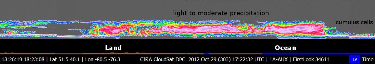
NASA CloudSat passed over Sandy at 10:32 a.m. EDT on Oct. 27, 2012. Light to moderate precipitation associated with parts of the outer bands of Hurricane Sandy were moving on shore into parts of North Carolina.
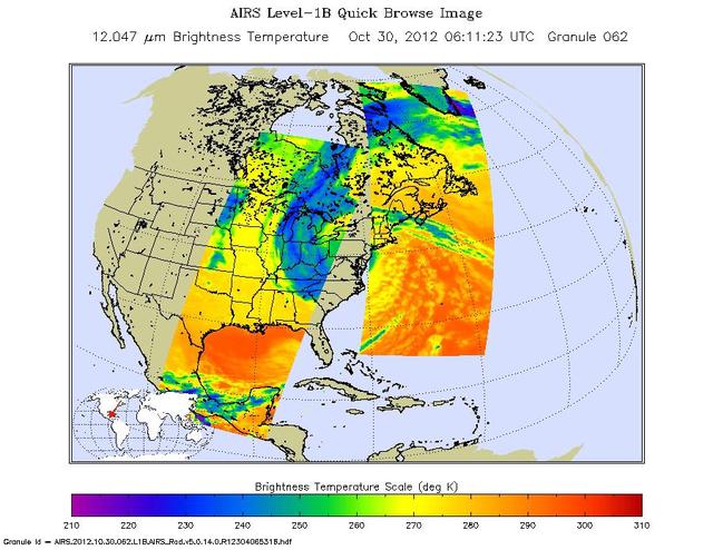
Early Tuesday, Oct. 30, 2012, Hurricane Sandy continued inland, moving to the northwest over Pennsylvania. Swaths of infrared measurements taken over two orbits of NASA Aqua satellite by the Atmospheric Infrared Sounder are displayed here.
This view from NASA's Mars Reconnaissance Orbiter shows the downwind stretches of a sand sheet in central part of the much larger Herschel Crater. This sandy province began kilometers upwind in a string of barchan sand dunes. As the north-to-south blowing wind weakened downwind, it could no longer fashion the sand into dunes but rather into amorphously-shaped sand sheets. While perhaps not awe-inspiringly beautiful, sand sheets can tell us about Mars' current and past environmental conditions as a piece of the puzzle for understanding habitability. Having dunes upwind of sheets is the opposite situation Earth has, where upwind sand sheets evolve downwind into sand dunes. This mystery is receiving ongoing research to to understand these sandy differences between Earth and Mars. https://photojournal.jpl.nasa.gov/catalog/PIA21933

Sandy Krasner from NASA's Jet Propulsion Laboratory discusses the Mars InSight lander with attendees of a Mars celebration Friday, May 31, 2019, in Mars, Pennsylvania. NASA is in the small town to celebrate Mars exploration and share the agency’s excitement about landing astronauts on the Moon in five years. The celebration includes a weekend of Science, Technology, Engineering, Arts and Mathematics (STEAM) activities. Photo Credit: (NASA/Bill Ingalls)
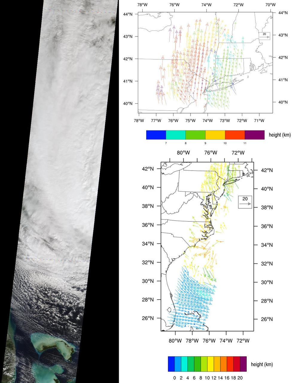
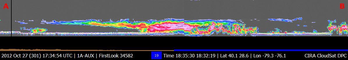
NASA Terra spacecraft captured this imagery and data over Hurricane Sandy as the storm approached the U.S. east coast on Oct. 28, 2012. The image at left covers an area 250 miles 400 kilometers wide and extends from Massachusetts to Florida.

Former NASA astronaut and co-chair of the local organizing committee for the International Astronautical Congress Sandy Magnus is seen during an interactive STEM discussion with students attending the 70th International Astronautical Congress, Wednesday, Oct. 23, 2019, at NASA Headquarters in Washington. Photo Credit: (NASA/Joel Kowsky)

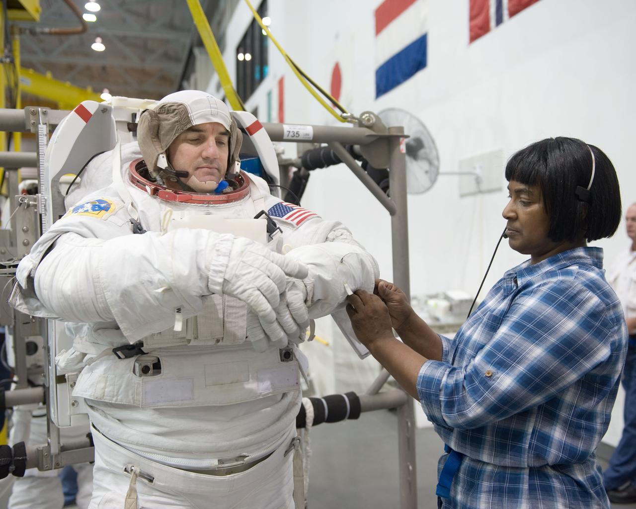
JSC2010-E-181442 (27 Oct. 2010) --- NASA astronaut Sandy Magnus, STS-135 mission specialist, gets help donning a training version of her Extravehicular Mobility Unit (EMU) spacesuit in preparation for a spacewalk training session in the waters of the Neutral Buoyancy Laboratory (NBL) near NASA's Johnson Space Center. NASA astronaut Chris Ferguson, commander, is at center. STS-135 is planned to be the final mission of the space shuttle program. Photo credit: NASA or National Aeronautics and Space Administration

JSC2010-E-181455 (27 Oct. 2010) --- NASA astronaut Sandy Magnus, STS-135 mission specialist, gets help donning a training version of her Extravehicular Mobility Unit (EMU) spacesuit in preparation for a spacewalk training session in the waters of the Neutral Buoyancy Laboratory (NBL) near NASA's Johnson Space Center. NASA astronaut Chris Ferguson, commander, assisted Magnus. STS-135 is planned to be the final mission of the space shuttle program. Photo credit: NASA or National Aeronautics and Space Administration
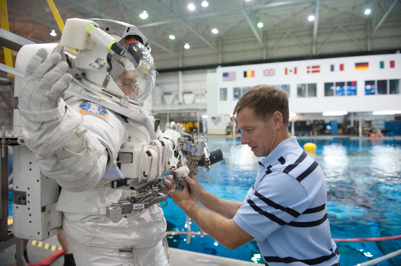
JSC2010-E-181466 (27 Oct. 2010) --- NASA astronaut Chris Ferguson, STS-135 commander, helps NASA astronaut Sandy Magnus, mission specialist, don a training version of her Extravehicular Mobility Unit (EMU) spacesuit in preparation for a spacewalk training session in the waters of the Neutral Buoyancy Laboratory (NBL) near NASA's Johnson Space Center. STS-135 is planned to be the final mission of the space shuttle program. Photo credit: NASA or National Aeronautics and Space Administration

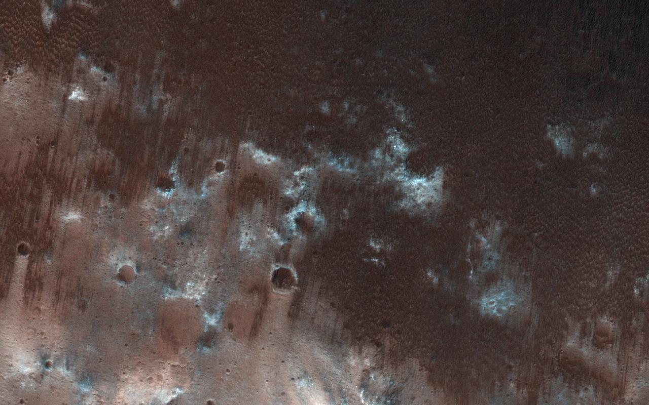
This MOC image shows dark sand dunes, with a thin coating of autumn frost, in the Ogygis Regio west of Argyre basin
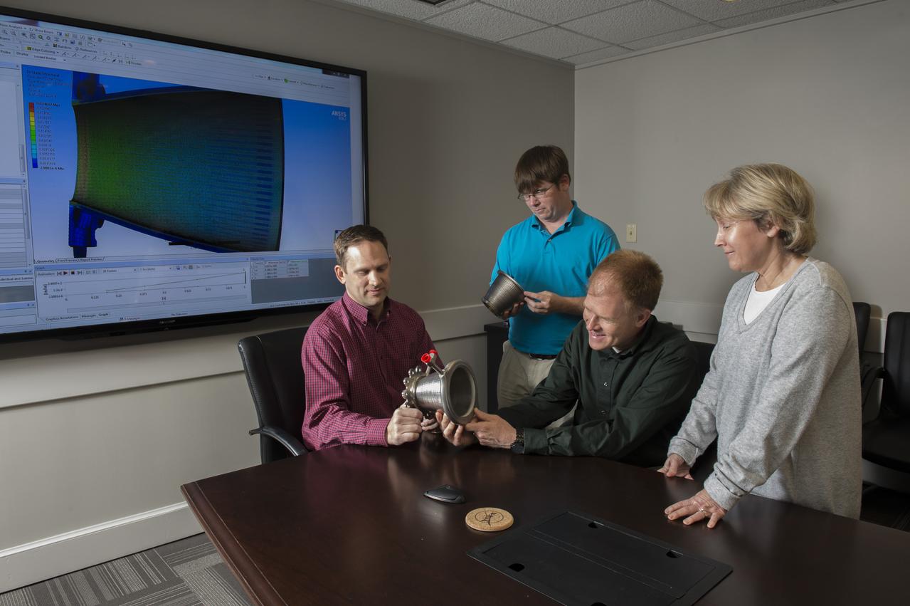
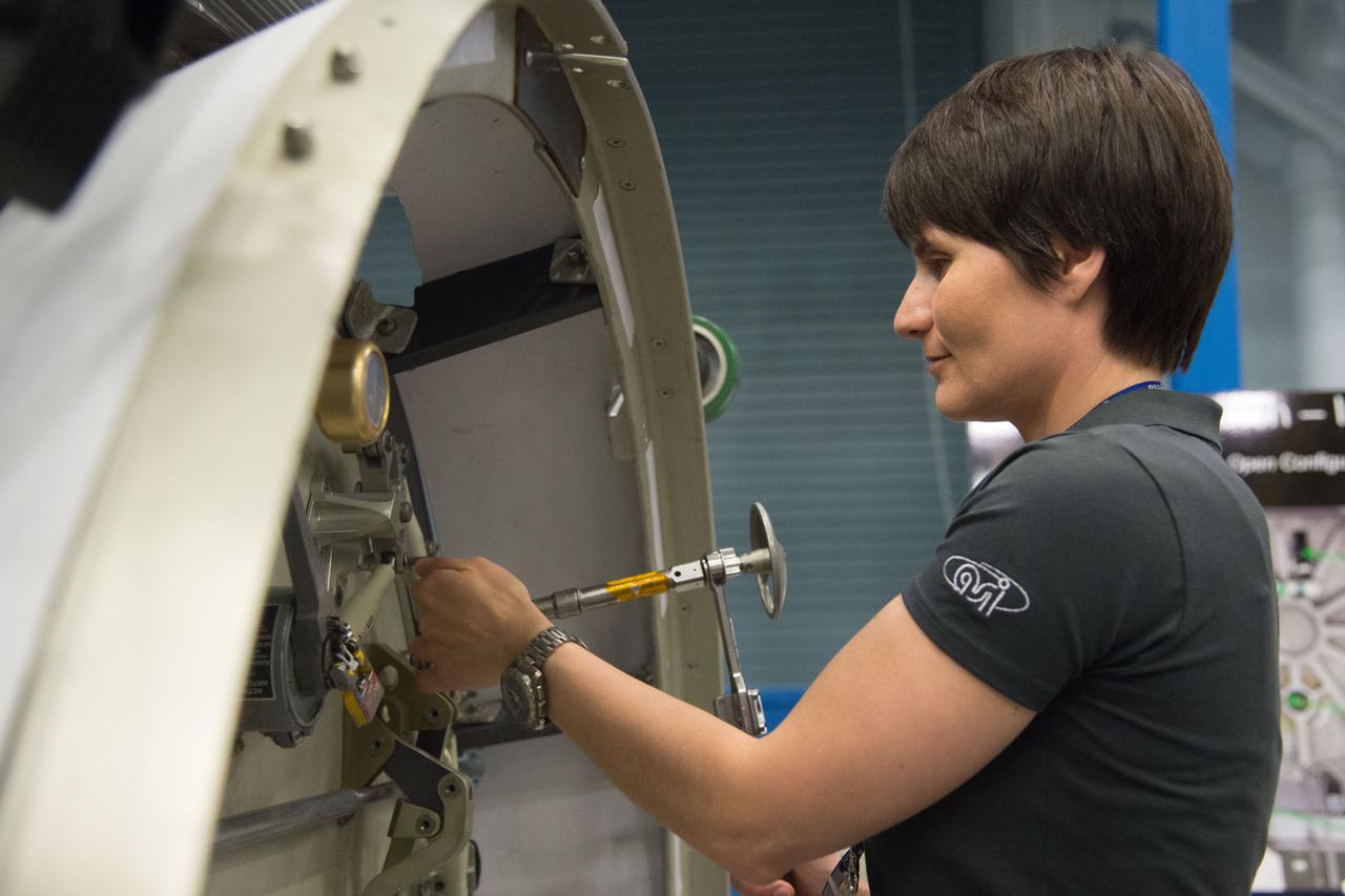
Engineers from NASA Marshall Space Flight Center's Propulsion Department examine nozzles fabricated using a freeform-directed energy wire deposition process. From left are Paul Gradl, Will Brandsmeier, Ian Johnston and Sandy Greene, with the nozzles, which were built using a NASA-patented technology that has the potential to reduce build time from several months to several weeks.

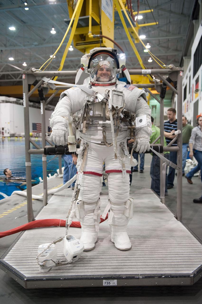
JSC2010-E-181484 (27 Oct. 2010) --- Attired in a training version of her Extravehicular Mobility Unit (EMU) spacesuit, NASA astronaut Sandy Magnus, STS-135 mission specialist, participates in a spacewalk training session in the waters of the Neutral Buoyancy Laboratory (NBL) near NASA's Johnson Space Center. Divers are in the water to assist Magnus in her rehearsal, which is intended to help prepare her for work on the exterior of the International Space Station. STS-135 is planned to be the final mission of the space shuttle program. Photo credit: NASA or National Aeronautics and Space Administration

JSC2010-E-181478 (27 Oct. 2010) --- Attired in a training version of her Extravehicular Mobility Unit (EMU) spacesuit, NASA astronaut Sandy Magnus, STS-135 mission specialist, is about to be submerged in the waters of the Neutral Buoyancy Laboratory (NBL) near NASA's Johnson Space Center. Divers (out of frame) are in the water to assist Magnus in her rehearsal, which is intended to help prepare her for work on the exterior of the International Space Station. STS-135 is planned to be the final mission of the space shuttle program. Photo credit: NASA or National Aeronautics and Space Administration

JSC2010-E-181461 (27 Oct. 2010) --- Attired in a training version of her Extravehicular Mobility Unit (EMU) spacesuit, NASA astronaut Sandy Magnus, STS-135 mission specialist, is about to be submerged in the waters of the Neutral Buoyancy Laboratory (NBL) near NASA's Johnson Space Center. Divers (out of frame) are in the water to assist Magnus in her rehearsal, which is intended to help prepare her for work on the exterior of the International Space Station. STS-135 is planned to be the final mission of the space shuttle program. Photo credit: NASA or National Aeronautics and Space Administration

This Mars Odyssey image of Pityusa Patera shows sandy material trapped in depressions and blown into dune forms.

201108160008hq (16 Aug. 2011) --- Stephen Colbert, host of The Colbert Report, salutes the crew of STS-135, seated from lower left, NASA astronauts Chris Ferguson, commander; Doug Hurley, pilot; Sandy Magnus and Rex Walheim, both mission specialists, during their appearance for a taping of his television show, Aug. 16, 2011, in New York. The astronauts from STS-135 are in New York for a three-day visit. Photo credit: NASA/Paul E. Alers
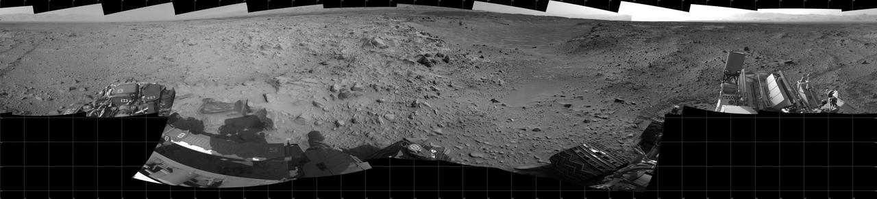
This full-circle panorama of the landscape surrounding NASA Curiosity Mars rover on July 31, 2014, offers a view into sandy lower terrain called Hidden Valley

Mars InSight team members Kris Bruvold, left, and Sandy Krasner react after receiving confirmation that the Mars InSight lander successfully touched down on the surface of Mars, Monday, Nov. 26, 2018 inside the Mission Support Area at NASA's Jet Propulsion Laboratory in Pasadena, California. InSight, short for Interior Exploration using Seismic Investigations, Geodesy and Heat Transport, is a Mars lander designed to study the "inner space" of Mars: its crust, mantle, and core. Photo Credit: (NASA/Bill Ingalls)
Jody Singer, Director of NASA’s Marshall Space Flight Center, left, moderates a discussion with NASA Administrator Jim Bridenstine, NASA astronauts Jeanette Epps and Doug Wheelock, and former NASA astronaut and co-chair of the local organizing committee for the International Astronautical Congress Sandy Magnus, during an interactive STEM discussion with students attending the 70th International Astronautical Congress, Wednesday, Oct. 23, 2019, at NASA Headquarters in Washington. Photo Credit: (NASA/Joel Kowsky)
Lockheed Martin Program Manager Sandy Freund, second from left, answers questions from reporters during an OSIRIS-REx sample return press conference, Wednesday, Aug. 30, 2023, at the Department of Defense's Utah Test and Training Range. The sample was collected from the asteroid Bennu in October 2020 by NASA’s OSIRIS-REx spacecraft and will return to Earth on September 24th, landing under parachute at the Utah Test and Training Range. Photo Credit: (NASA/Keegan Barber)
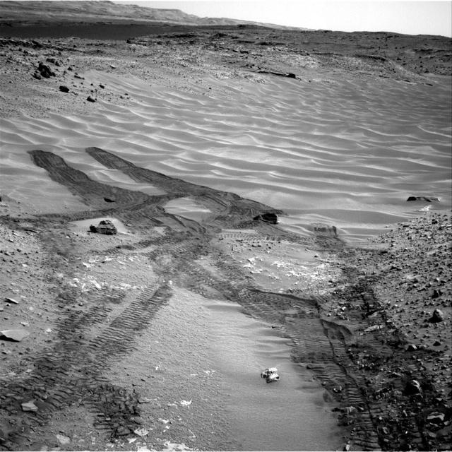
Rover engineers prepare a mixture of sandy and powdery materials to simulate some difficult Mars driving conditions inside a facility at NASA Jet Propulsion Laboratory, Pasadena, Calif.
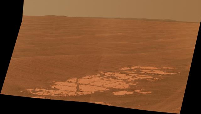
NASA Mars Exploration Rover Opportunity used its panoramic camera Pancam to capture this view approximately true-color view of the rim of Endeavour crater, the rover destination in a multi-year traverse along the sandy Martian landscape.

With the extensive amount of dust and sandy materials on Mars, dunes are a pervasive feature. Many dunes are small, like the ones in this image from NASA 2001 Mars Odyssey spacecraft. The bright quiggles in this image are small dunes.
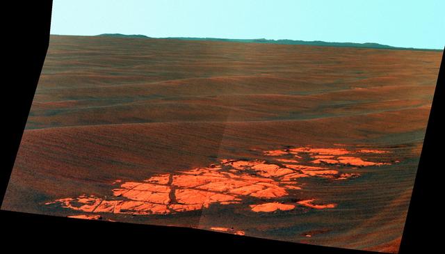
NASA Mars Exploration Rover Opportunity used its panoramic camera Pancam to capture this false-color view of the rim of Endeavour crater, the rover destination in a multi-year traverse along the sandy Martian landscape.

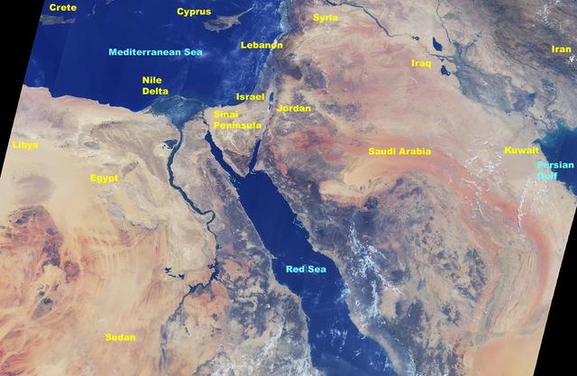
This image from NASA Terra satellite in August, 2000, shows the northern tip of the Red Sea, the Gulf of Suez and the Gulf of Aqaba frame the sandy deserts and spectacular mountains of the Sinai Peninsula.
This image from NASA Curiosity Mars rover looks down the ramp at the northeastern end of Hidden Valley and across the sandy-floored valley to lower slopes of Mount Sharp on the horizon.
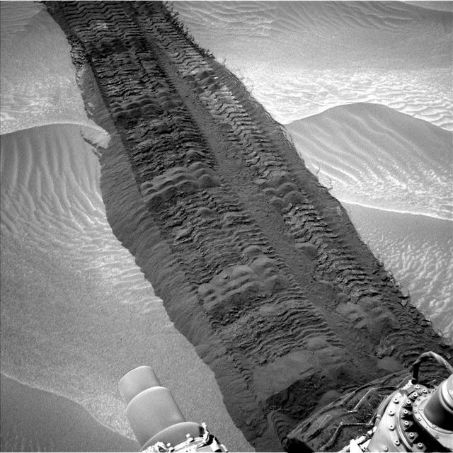
This image, taken on Aug. 4, 2014, from the Navigation Camera on NASA Curiosity Mars rover shows wheel tracks printed by the rover as it drove on the sandy floor of a lowland called Hidden Valley on the route toward Mount Sharp.
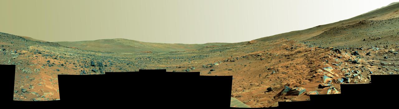
This panorama shows two rock-strewn slopes on the left and right sides of a broad, U-shaped dip in the middle. The sandy surface in front of the rover is reddish brown; individual rocks and more distant features are blue-gray

From left, astronauts Pam Melroy; Kay Hire; Cady Coleman; Kathy Sullivan; Tam O'Shaughnessy, Sally Ride's life partner and chair, board of directors of Sally Ride Science; astronauts Bonnie Dunbar; Sandy Magnus; Julie Payette; and Ellen Ochoa, pose for a photograph before a National Tribute to Sally Ride at the John F. Kennedy Center for the Performing Arts, Monday, May 20, 2013 in Washington. Photo Credit: (NASA/Bill Ingalls)

NASA Office of Communications Deputy Chief Patrick Lynch, left, introduces, from left to right, NASA Program Executive Melissa Morris, NASA Project Manager Rich Burns, Lockheed Martin Program Manager Sandy Freund, OSIRIS-REx Deputy Curation Lead Kevin Righter, and University of Arizona OSIRIS-REx Principal Investigator Dante Lauretta, during an OSIRIS-REx sample return press conference, Wednesday, Aug. 30, 2023, at the Department of Defense's Utah Test and Training Range. The sample was collected from the asteroid Bennu in October 2020 by NASA’s OSIRIS-REx spacecraft and will return to Earth on September 24th, landing under parachute at the Utah Test and Training Range. Photo Credit: (NASA/Keegan Barber)
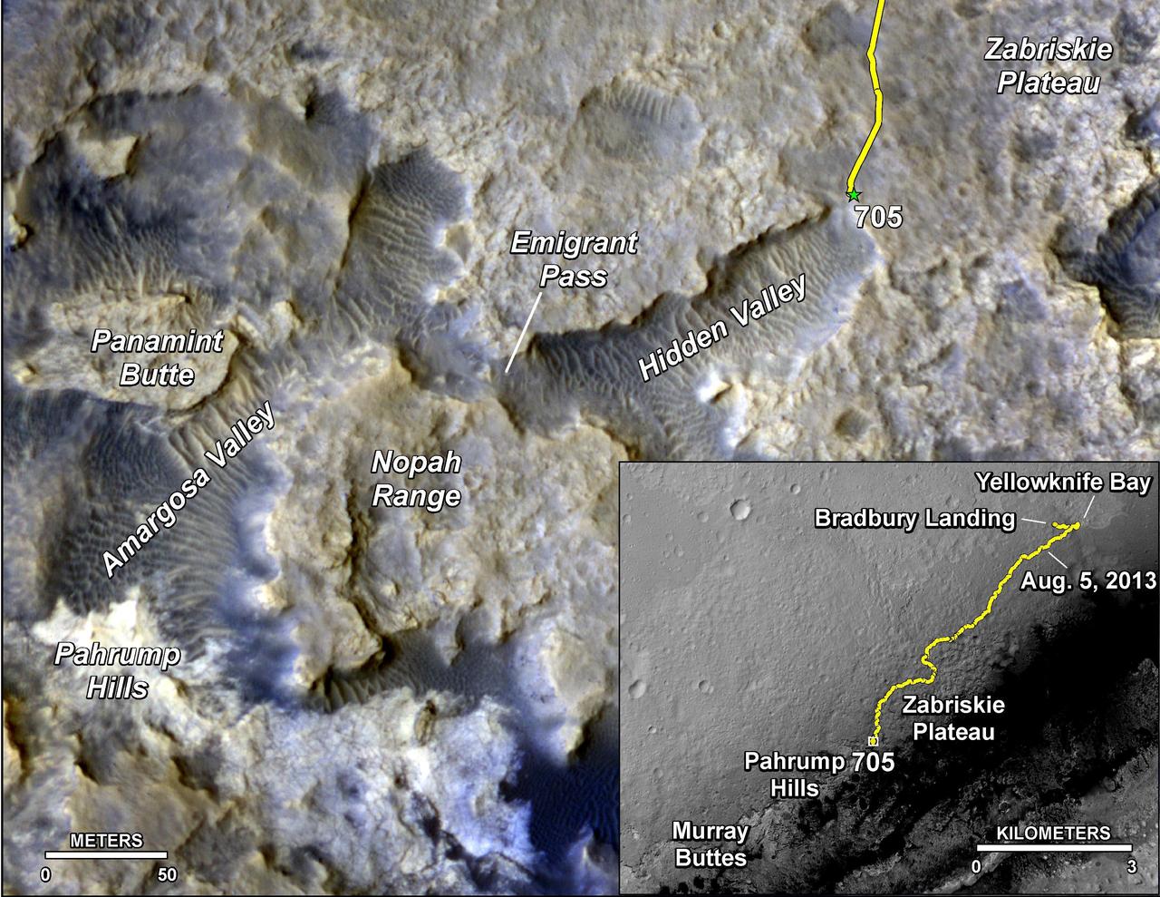
The main map shows landforms near NASA Curiosity Mars rover as the rover second anniversary of landing on Mars nears. The gold traverse line ends at Curiosity position as of July 31, 2014 Sol 705.

JSC2011-E-039719 (11 Feb. 2011) --- NASA astronaut Sandy Magnus, mission specialist. Photo credit: NASA

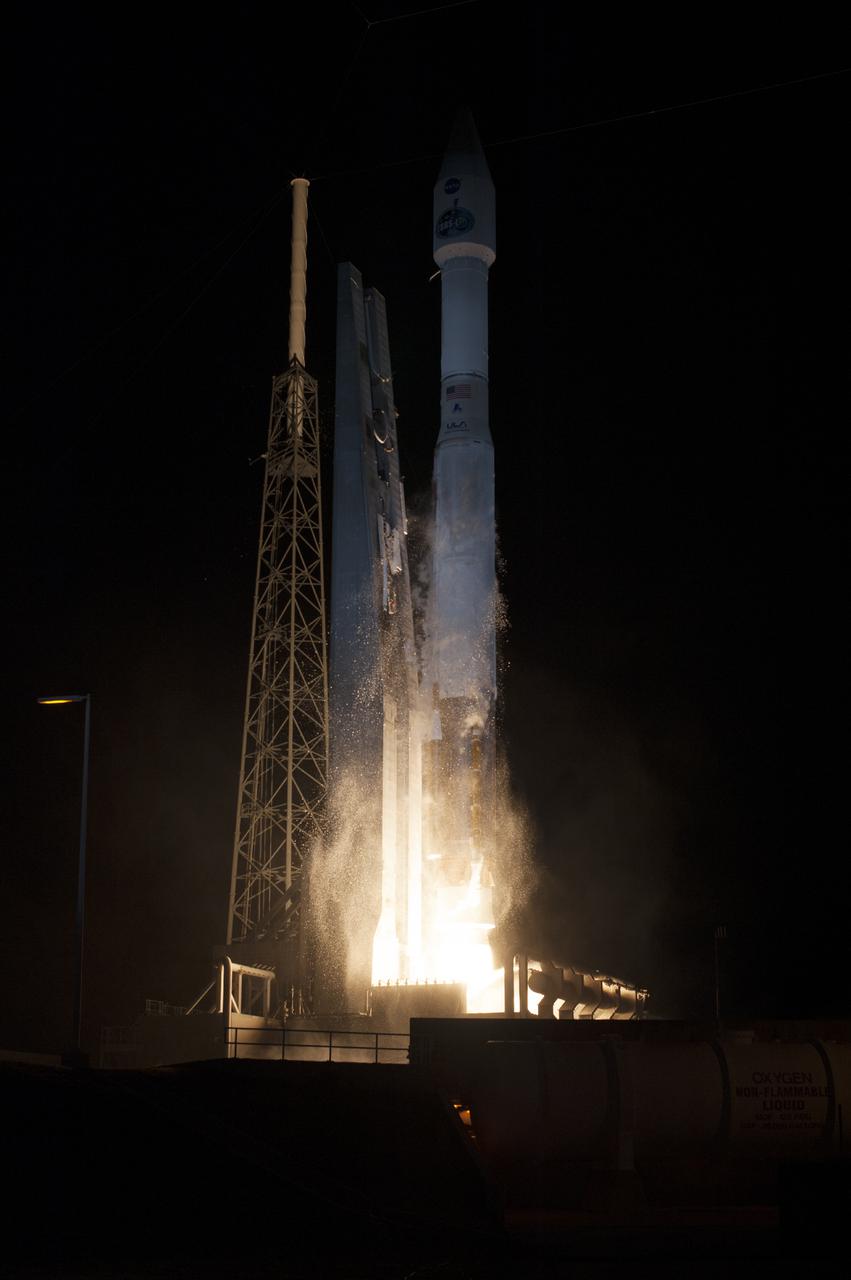
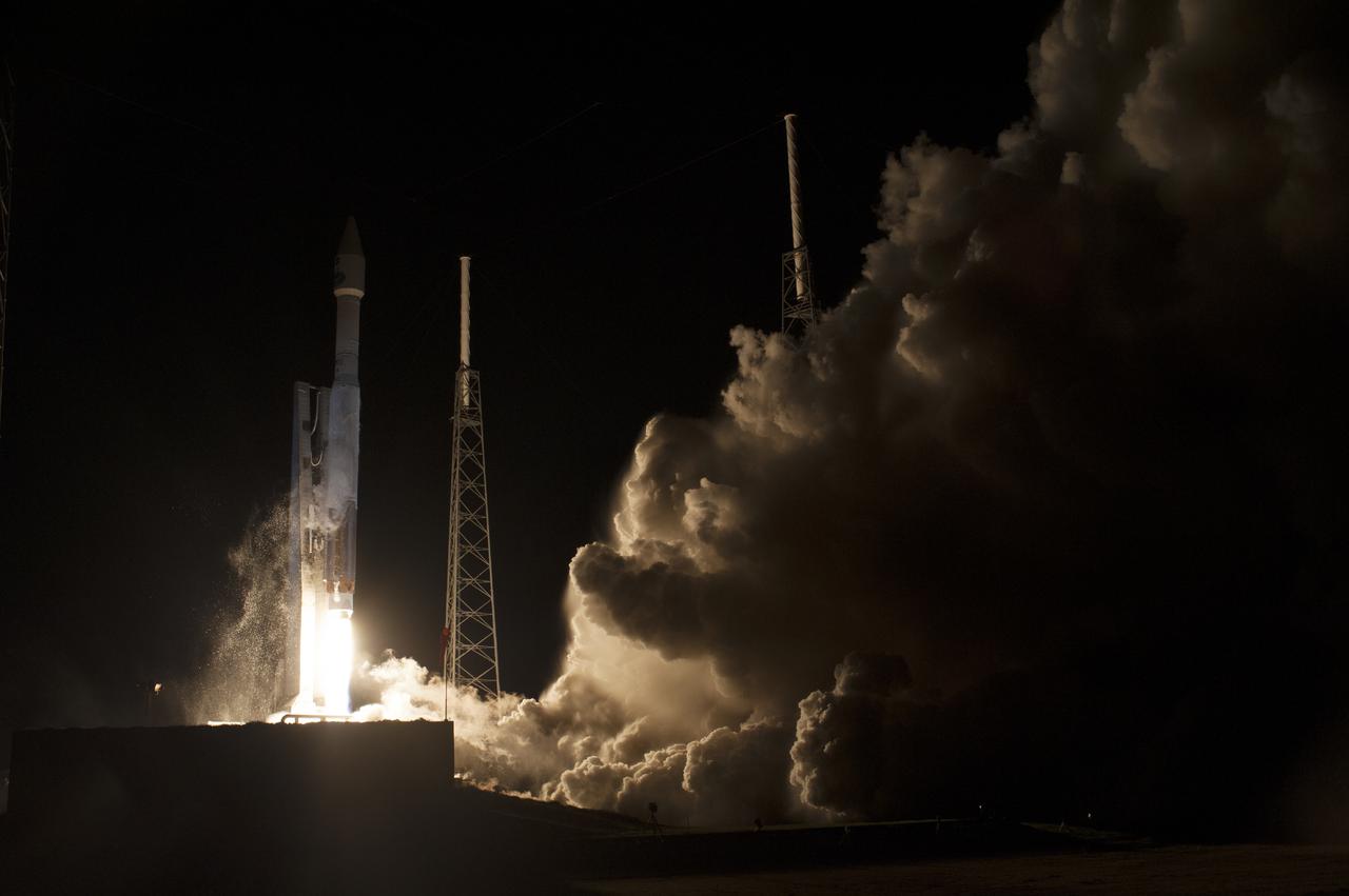
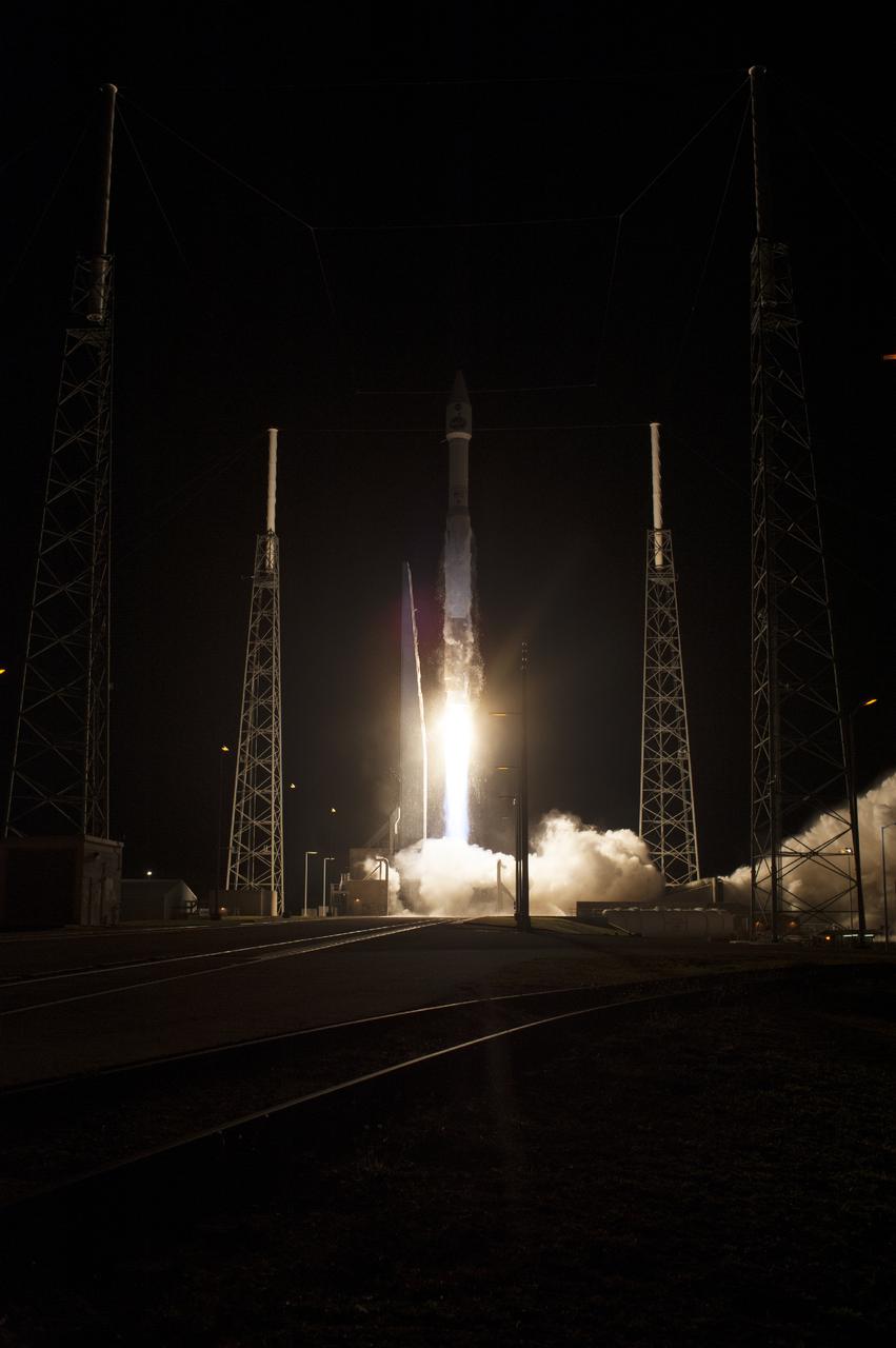
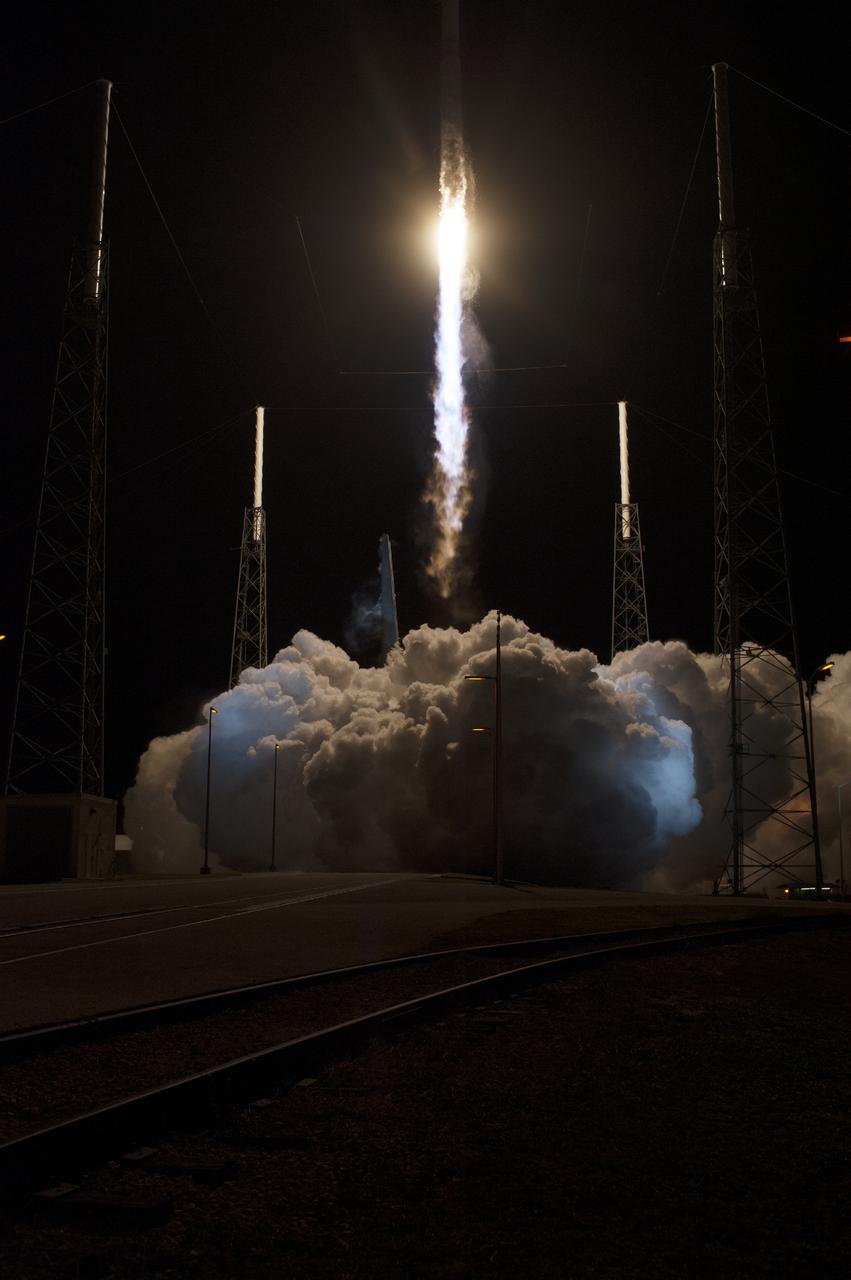
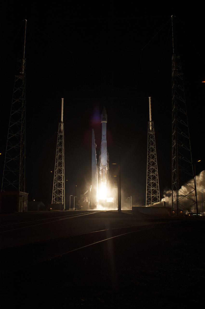
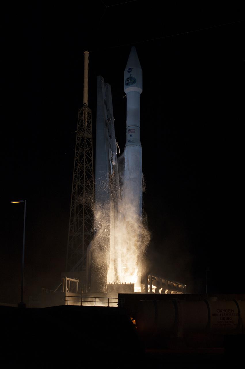
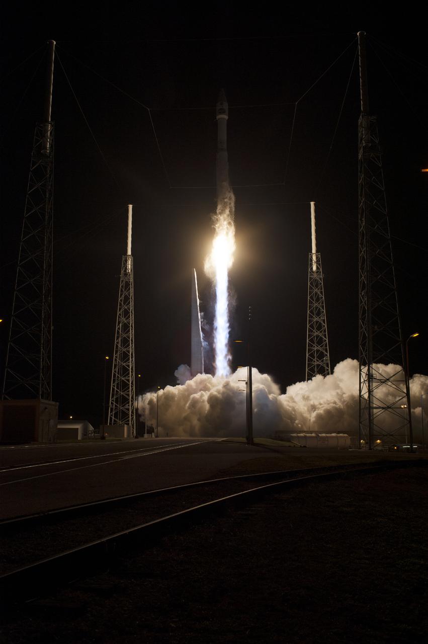
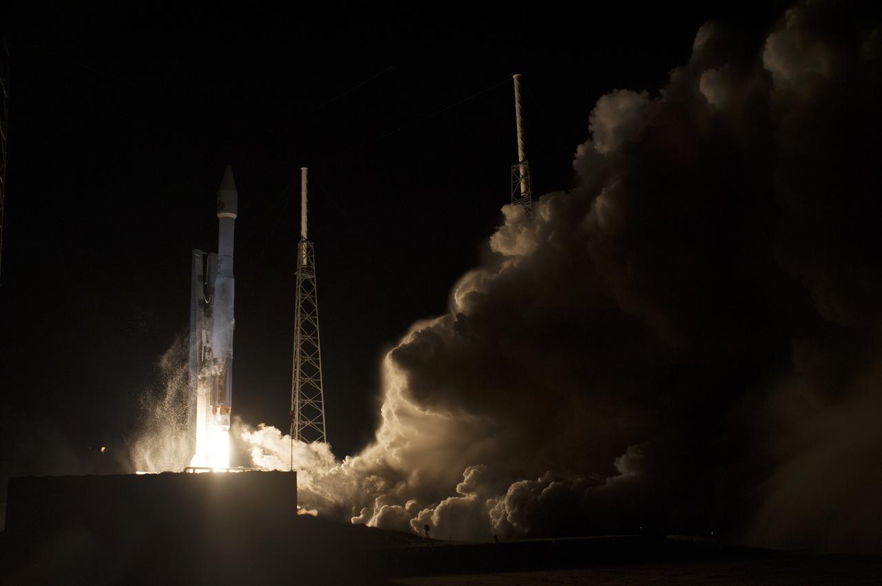
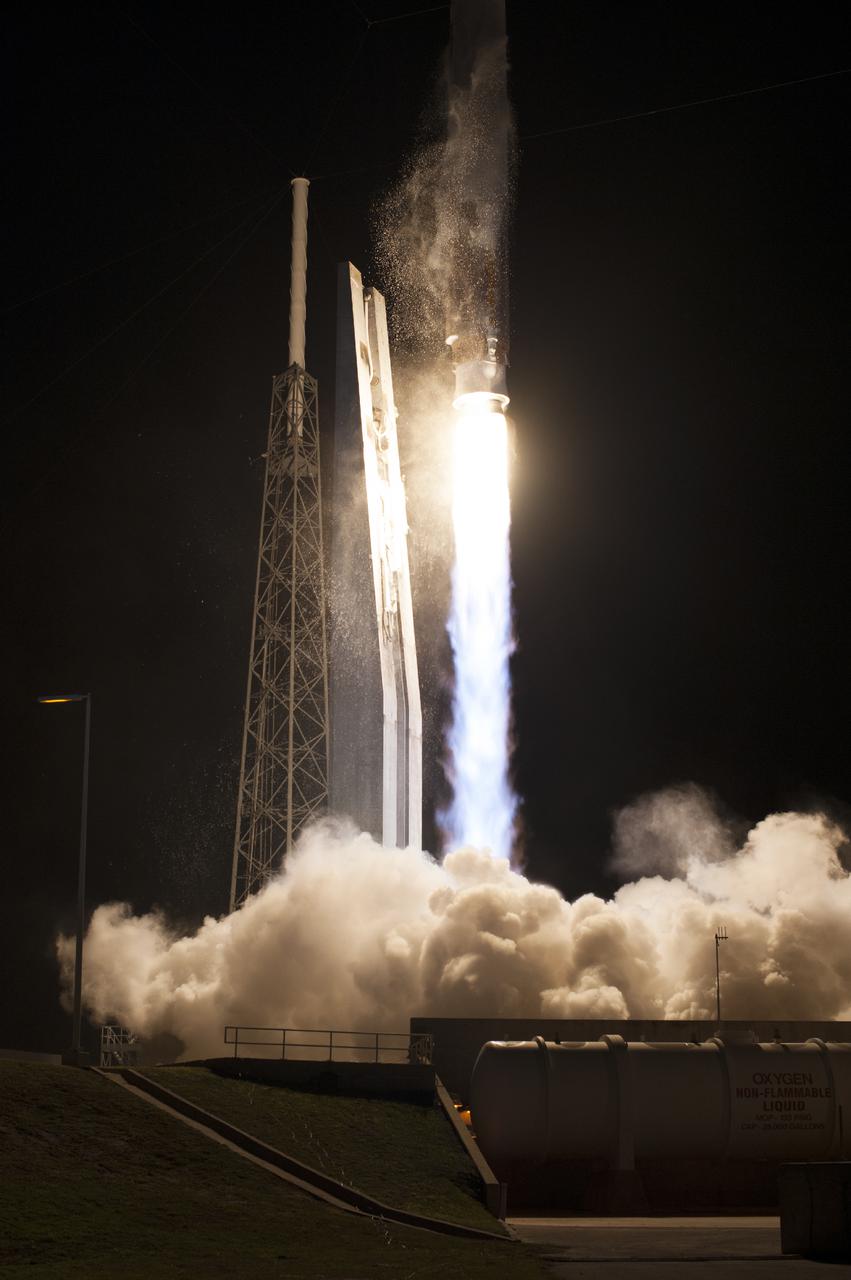
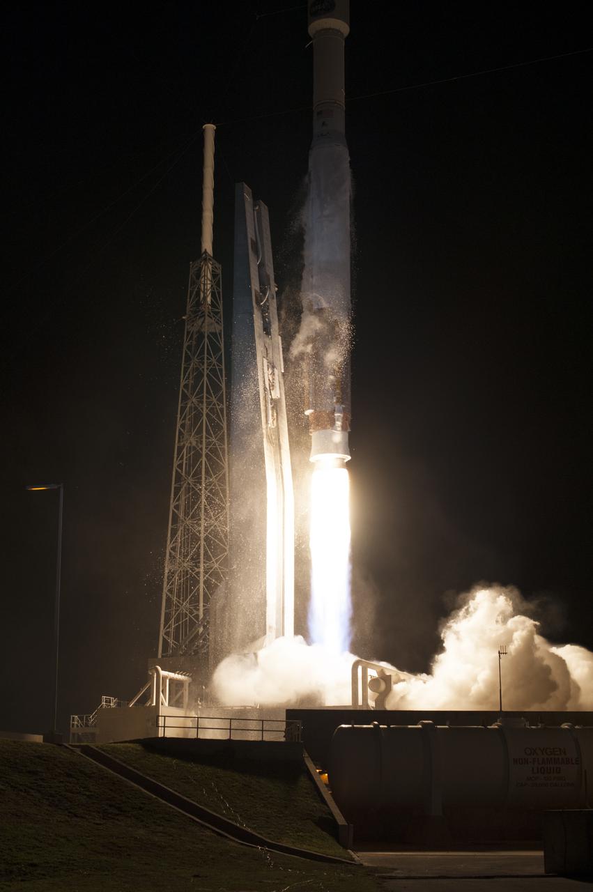
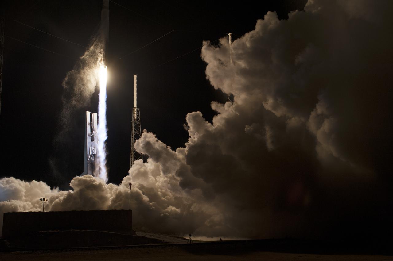
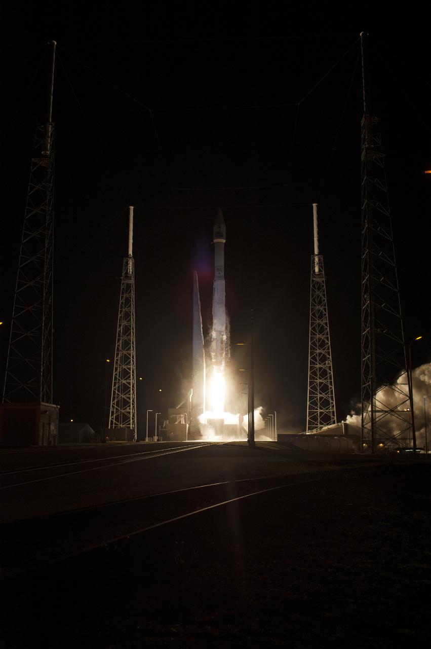
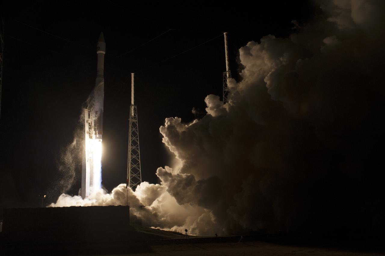
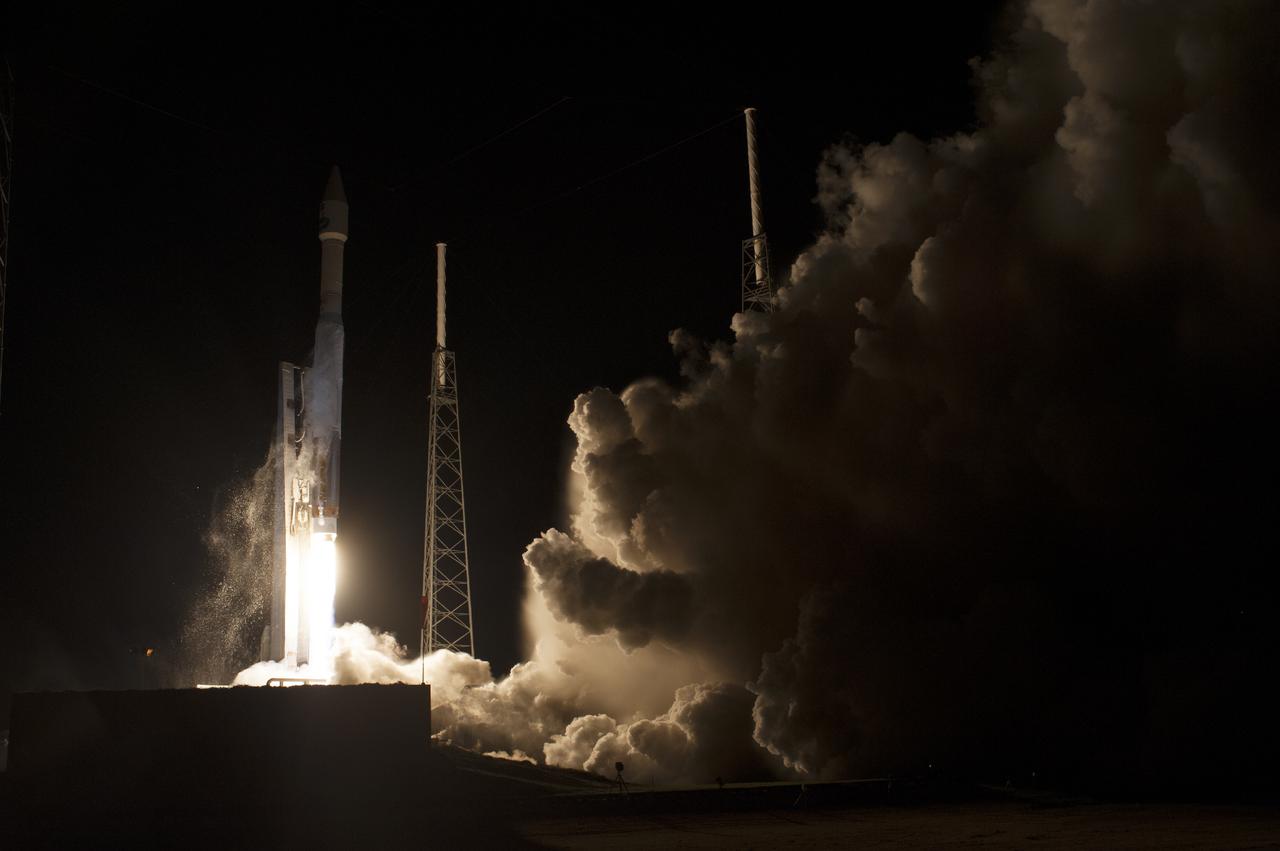
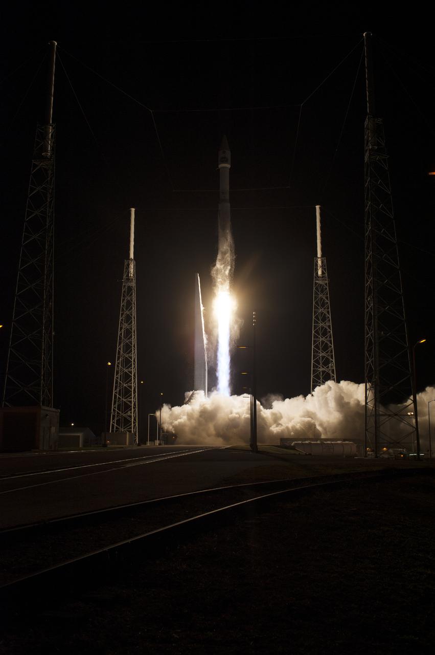
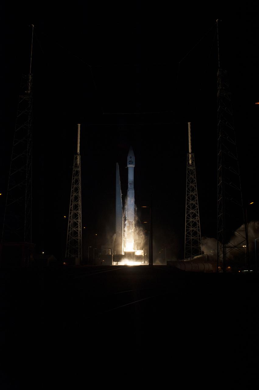
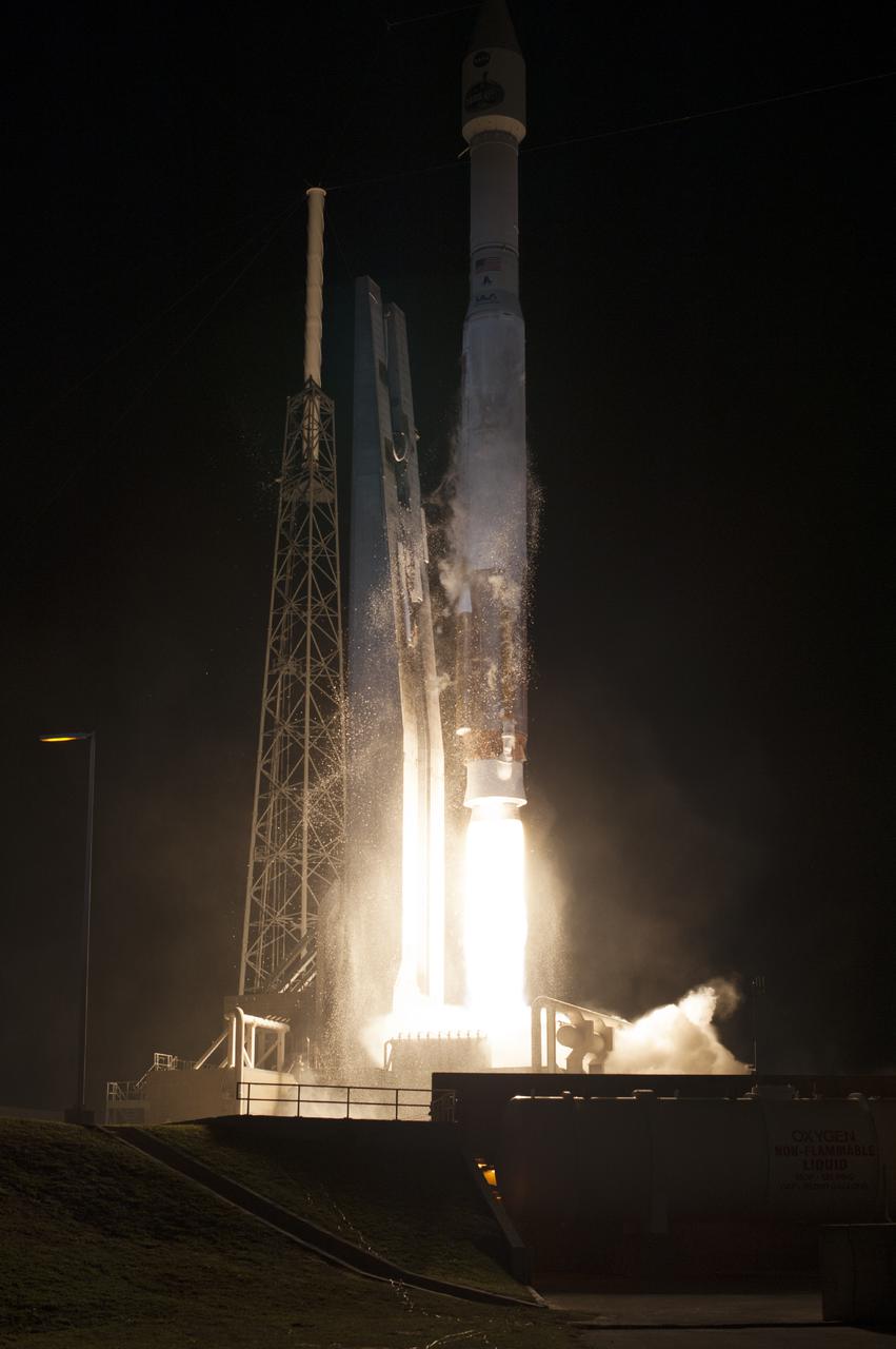
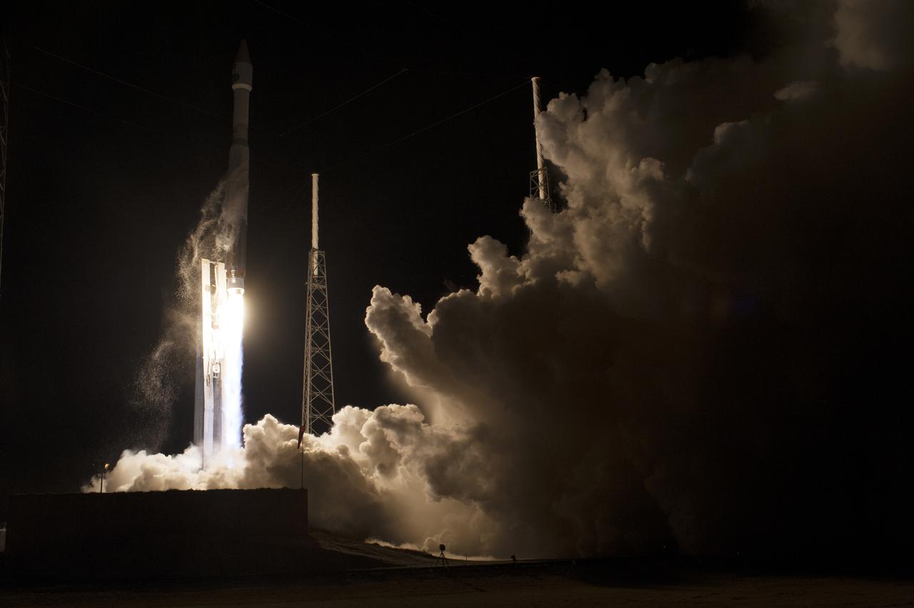
CAPE CANAVERAL, Fla. – The United Launch Alliance Atlas V rocket lifts off from Space Launch Complex 41 at Cape Canaveral Air Force Station carrying NASA's Tracking and Data Relay Satellite, or TDRS-L, spacecraft to Earth orbit. Liftoff was at 9:33 p.m. EST. The TDRS-L spacecraft is the second of three new satellites designed to ensure vital operational continuity for NASA by expanding the lifespan of the Tracking and Data Relay Satellite System TDRSS fleet, which consists of eight satellites in geosynchronous orbit. The spacecraft provide tracking, telemetry, command and high bandwidth data return services for numerous science and human exploration missions orbiting Earth. These include NASA's Hubble Space Telescope and the International Space Station. TDRS-L has a high-performance solar panel designed for more spacecraft power to meet the growing S-band communications requirements. TDRSS is one of NASA Space Communication and Navigation’s SCaN three networks providing space communications to NASA’s missions. For more information more about TDRS-L, visit: http:__www.nasa.gov_tdrs To learn more about SCaN, visit: www.nasa.gov_scan Photo credit: NASA_Tony Gray and Sandy Joseph
CAPE CANAVERAL, Fla. – The United Launch Alliance Atlas V rocket lifts off from Space Launch Complex 41 at Cape Canaveral Air Force Station carrying NASA's Tracking and Data Relay Satellite, or TDRS-L, spacecraft to Earth orbit. Liftoff was at 9:33 p.m. EST. The TDRS-L spacecraft is the second of three new satellites designed to ensure vital operational continuity for NASA by expanding the lifespan of the Tracking and Data Relay Satellite System TDRSS fleet, which consists of eight satellites in geosynchronous orbit. The spacecraft provide tracking, telemetry, command and high bandwidth data return services for numerous science and human exploration missions orbiting Earth. These include NASA's Hubble Space Telescope and the International Space Station. TDRS-L has a high-performance solar panel designed for more spacecraft power to meet the growing S-band communications requirements. TDRSS is one of NASA Space Communication and Navigation’s SCaN three networks providing space communications to NASA’s missions. For more information more about TDRS-L, visit: http:__www.nasa.gov_tdrs To learn more about SCaN, visit: www.nasa.gov_scan Photo credit: NASA_Tony Gray and Sandy Joseph
CAPE CANAVERAL, Fla. – The United Launch Alliance Atlas V rocket lifts off from Space Launch Complex 41 at Cape Canaveral Air Force Station carrying NASA's Tracking and Data Relay Satellite, or TDRS-L, spacecraft to Earth orbit. Liftoff was at 9:33 p.m. EST. The TDRS-L spacecraft is the second of three new satellites designed to ensure vital operational continuity for NASA by expanding the lifespan of the Tracking and Data Relay Satellite System TDRSS fleet, which consists of eight satellites in geosynchronous orbit. The spacecraft provide tracking, telemetry, command and high bandwidth data return services for numerous science and human exploration missions orbiting Earth. These include NASA's Hubble Space Telescope and the International Space Station. TDRS-L has a high-performance solar panel designed for more spacecraft power to meet the growing S-band communications requirements. TDRSS is one of NASA Space Communication and Navigation’s SCaN three networks providing space communications to NASA’s missions. For more information more about TDRS-L, visit: http:__www.nasa.gov_tdrs To learn more about SCaN, visit: www.nasa.gov_scan Photo credit: NASA_Tony Gray and Sandy Joseph
CAPE CANAVERAL, Fla. – The United Launch Alliance Atlas V rocket lifts off from Space Launch Complex 41 at Cape Canaveral Air Force Station carrying NASA's Tracking and Data Relay Satellite, or TDRS-L, spacecraft to Earth orbit. Liftoff was at 9:33 p.m. EST. The TDRS-L spacecraft is the second of three new satellites designed to ensure vital operational continuity for NASA by expanding the lifespan of the Tracking and Data Relay Satellite System TDRSS fleet, which consists of eight satellites in geosynchronous orbit. The spacecraft provide tracking, telemetry, command and high bandwidth data return services for numerous science and human exploration missions orbiting Earth. These include NASA's Hubble Space Telescope and the International Space Station. TDRS-L has a high-performance solar panel designed for more spacecraft power to meet the growing S-band communications requirements. TDRSS is one of NASA Space Communication and Navigation’s SCaN three networks providing space communications to NASA’s missions. For more information more about TDRS-L, visit: http:__www.nasa.gov_tdrs To learn more about SCaN, visit: www.nasa.gov_scan Photo credit: NASA_Tony Gray and Sandy Joseph
CAPE CANAVERAL, Fla. – The United Launch Alliance Atlas V rocket lifts off from Space Launch Complex 41 at Cape Canaveral Air Force Station carrying NASA's Tracking and Data Relay Satellite, or TDRS-L, spacecraft to Earth orbit. Liftoff was at 9:33 p.m. EST. The TDRS-L spacecraft is the second of three new satellites designed to ensure vital operational continuity for NASA by expanding the lifespan of the Tracking and Data Relay Satellite System TDRSS fleet, which consists of eight satellites in geosynchronous orbit. The spacecraft provide tracking, telemetry, command and high bandwidth data return services for numerous science and human exploration missions orbiting Earth. These include NASA's Hubble Space Telescope and the International Space Station. TDRS-L has a high-performance solar panel designed for more spacecraft power to meet the growing S-band communications requirements. TDRSS is one of NASA Space Communication and Navigation’s SCaN three networks providing space communications to NASA’s missions. For more information more about TDRS-L, visit: http:__www.nasa.gov_tdrs To learn more about SCaN, visit: www.nasa.gov_scan Photo credit: NASA_Tony Gray and Sandy Joseph
CAPE CANAVERAL, Fla. – The United Launch Alliance Atlas V rocket lifts off from Space Launch Complex 41 at Cape Canaveral Air Force Station carrying NASA's Tracking and Data Relay Satellite, or TDRS-L, spacecraft to Earth orbit. Liftoff was at 9:33 p.m. EST. The TDRS-L spacecraft is the second of three new satellites designed to ensure vital operational continuity for NASA by expanding the lifespan of the Tracking and Data Relay Satellite System TDRSS fleet, which consists of eight satellites in geosynchronous orbit. The spacecraft provide tracking, telemetry, command and high bandwidth data return services for numerous science and human exploration missions orbiting Earth. These include NASA's Hubble Space Telescope and the International Space Station. TDRS-L has a high-performance solar panel designed for more spacecraft power to meet the growing S-band communications requirements. TDRSS is one of NASA Space Communication and Navigation’s SCaN three networks providing space communications to NASA’s missions. For more information more about TDRS-L, visit: http:__www.nasa.gov_tdrs To learn more about SCaN, visit: www.nasa.gov_scan Photo credit: NASA_Tony Gray and Sandy Joseph
CAPE CANAVERAL, Fla. – The United Launch Alliance Atlas V rocket lifts off from Space Launch Complex 41 at Cape Canaveral Air Force Station carrying NASA's Tracking and Data Relay Satellite, or TDRS-L, spacecraft to Earth orbit. Liftoff was at 9:33 p.m. EST. The TDRS-L spacecraft is the second of three new satellites designed to ensure vital operational continuity for NASA by expanding the lifespan of the Tracking and Data Relay Satellite System TDRSS fleet, which consists of eight satellites in geosynchronous orbit. The spacecraft provide tracking, telemetry, command and high bandwidth data return services for numerous science and human exploration missions orbiting Earth. These include NASA's Hubble Space Telescope and the International Space Station. TDRS-L has a high-performance solar panel designed for more spacecraft power to meet the growing S-band communications requirements. TDRSS is one of NASA Space Communication and Navigation’s SCaN three networks providing space communications to NASA’s missions. For more information more about TDRS-L, visit: http:__www.nasa.gov_tdrs To learn more about SCaN, visit: www.nasa.gov_scan Photo credit: NASA_Tony Gray and Sandy Joseph
CAPE CANAVERAL, Fla. – The United Launch Alliance Atlas V rocket lifts off from Space Launch Complex 41 at Cape Canaveral Air Force Station carrying NASA's Tracking and Data Relay Satellite, or TDRS-L, spacecraft to Earth orbit. Liftoff was at 9:33 p.m. EST. The TDRS-L spacecraft is the second of three new satellites designed to ensure vital operational continuity for NASA by expanding the lifespan of the Tracking and Data Relay Satellite System TDRSS fleet, which consists of eight satellites in geosynchronous orbit. The spacecraft provide tracking, telemetry, command and high bandwidth data return services for numerous science and human exploration missions orbiting Earth. These include NASA's Hubble Space Telescope and the International Space Station. TDRS-L has a high-performance solar panel designed for more spacecraft power to meet the growing S-band communications requirements. TDRSS is one of NASA Space Communication and Navigation’s SCaN three networks providing space communications to NASA’s missions. For more information more about TDRS-L, visit: http:__www.nasa.gov_tdrs To learn more about SCaN, visit: www.nasa.gov_scan Photo credit: NASA_Tony Gray and Sandy Joseph
CAPE CANAVERAL, Fla. – The United Launch Alliance Atlas V rocket lifts off from Space Launch Complex 41 at Cape Canaveral Air Force Station carrying NASA's Tracking and Data Relay Satellite, or TDRS-L, spacecraft to Earth orbit. Liftoff was at 9:33 p.m. EST. The TDRS-L spacecraft is the second of three new satellites designed to ensure vital operational continuity for NASA by expanding the lifespan of the Tracking and Data Relay Satellite System TDRSS fleet, which consists of eight satellites in geosynchronous orbit. The spacecraft provide tracking, telemetry, command and high bandwidth data return services for numerous science and human exploration missions orbiting Earth. These include NASA's Hubble Space Telescope and the International Space Station. TDRS-L has a high-performance solar panel designed for more spacecraft power to meet the growing S-band communications requirements. TDRSS is one of NASA Space Communication and Navigation’s SCaN three networks providing space communications to NASA’s missions. For more information more about TDRS-L, visit: http:__www.nasa.gov_tdrs To learn more about SCaN, visit: www.nasa.gov_scan Photo credit: NASA_Tony Gray and Sandy Joseph
CAPE CANAVERAL, Fla. – The United Launch Alliance Atlas V rocket lifts off from Space Launch Complex 41 at Cape Canaveral Air Force Station carrying NASA's Tracking and Data Relay Satellite, or TDRS-L, spacecraft to Earth orbit. Liftoff was at 9:33 p.m. EST. The TDRS-L spacecraft is the second of three new satellites designed to ensure vital operational continuity for NASA by expanding the lifespan of the Tracking and Data Relay Satellite System TDRSS fleet, which consists of eight satellites in geosynchronous orbit. The spacecraft provide tracking, telemetry, command and high bandwidth data return services for numerous science and human exploration missions orbiting Earth. These include NASA's Hubble Space Telescope and the International Space Station. TDRS-L has a high-performance solar panel designed for more spacecraft power to meet the growing S-band communications requirements. TDRSS is one of NASA Space Communication and Navigation’s SCaN three networks providing space communications to NASA’s missions. For more information more about TDRS-L, visit: http:__www.nasa.gov_tdrs To learn more about SCaN, visit: www.nasa.gov_scan Photo credit: NASA_Tony Gray and Sandy Joseph
CAPE CANAVERAL, Fla. – The United Launch Alliance Atlas V rocket lifts off from Space Launch Complex 41 at Cape Canaveral Air Force Station carrying NASA's Tracking and Data Relay Satellite, or TDRS-L, spacecraft to Earth orbit. Liftoff was at 9:33 p.m. EST. The TDRS-L spacecraft is the second of three new satellites designed to ensure vital operational continuity for NASA by expanding the lifespan of the Tracking and Data Relay Satellite System TDRSS fleet, which consists of eight satellites in geosynchronous orbit. The spacecraft provide tracking, telemetry, command and high bandwidth data return services for numerous science and human exploration missions orbiting Earth. These include NASA's Hubble Space Telescope and the International Space Station. TDRS-L has a high-performance solar panel designed for more spacecraft power to meet the growing S-band communications requirements. TDRSS is one of NASA Space Communication and Navigation’s SCaN three networks providing space communications to NASA’s missions. For more information more about TDRS-L, visit: http:__www.nasa.gov_tdrs To learn more about SCaN, visit: www.nasa.gov_scan Photo credit: NASA_Tony Gray and Sandy Joseph
CAPE CANAVERAL, Fla. – The United Launch Alliance Atlas V rocket lifts off from Space Launch Complex 41 at Cape Canaveral Air Force Station carrying NASA's Tracking and Data Relay Satellite, or TDRS-L, spacecraft to Earth orbit. Liftoff was at 9:33 p.m. EST. The TDRS-L spacecraft is the second of three new satellites designed to ensure vital operational continuity for NASA by expanding the lifespan of the Tracking and Data Relay Satellite System TDRSS fleet, which consists of eight satellites in geosynchronous orbit. The spacecraft provide tracking, telemetry, command and high bandwidth data return services for numerous science and human exploration missions orbiting Earth. These include NASA's Hubble Space Telescope and the International Space Station. TDRS-L has a high-performance solar panel designed for more spacecraft power to meet the growing S-band communications requirements. TDRSS is one of NASA Space Communication and Navigation’s SCaN three networks providing space communications to NASA’s missions. For more information more about TDRS-L, visit: http:__www.nasa.gov_tdrs To learn more about SCaN, visit: www.nasa.gov_scan Photo credit: NASA_Tony Gray and Sandy Joseph
CAPE CANAVERAL, Fla. – The United Launch Alliance Atlas V rocket lifts off from Space Launch Complex 41 at Cape Canaveral Air Force Station carrying NASA's Tracking and Data Relay Satellite, or TDRS-L, spacecraft to Earth orbit. Liftoff was at 9:33 p.m. EST. The TDRS-L spacecraft is the second of three new satellites designed to ensure vital operational continuity for NASA by expanding the lifespan of the Tracking and Data Relay Satellite System TDRSS fleet, which consists of eight satellites in geosynchronous orbit. The spacecraft provide tracking, telemetry, command and high bandwidth data return services for numerous science and human exploration missions orbiting Earth. These include NASA's Hubble Space Telescope and the International Space Station. TDRS-L has a high-performance solar panel designed for more spacecraft power to meet the growing S-band communications requirements. TDRSS is one of NASA Space Communication and Navigation’s SCaN three networks providing space communications to NASA’s missions. For more information more about TDRS-L, visit: http:__www.nasa.gov_tdrs To learn more about SCaN, visit: www.nasa.gov_scan Photo credit: NASA_Tony Gray and Sandy Joseph
CAPE CANAVERAL, Fla. – The United Launch Alliance Atlas V rocket lifts off from Space Launch Complex 41 at Cape Canaveral Air Force Station carrying NASA's Tracking and Data Relay Satellite, or TDRS-L, spacecraft to Earth orbit. Liftoff was at 9:33 p.m. EST. The TDRS-L spacecraft is the second of three new satellites designed to ensure vital operational continuity for NASA by expanding the lifespan of the Tracking and Data Relay Satellite System TDRSS fleet, which consists of eight satellites in geosynchronous orbit. The spacecraft provide tracking, telemetry, command and high bandwidth data return services for numerous science and human exploration missions orbiting Earth. These include NASA's Hubble Space Telescope and the International Space Station. TDRS-L has a high-performance solar panel designed for more spacecraft power to meet the growing S-band communications requirements. TDRSS is one of NASA Space Communication and Navigation’s SCaN three networks providing space communications to NASA’s missions. For more information more about TDRS-L, visit: http:__www.nasa.gov_tdrs To learn more about SCaN, visit: www.nasa.gov_scan Photo credit: NASA_Tony Gray and Sandy Joseph
CAPE CANAVERAL, Fla. – The United Launch Alliance Atlas V rocket lifts off from Space Launch Complex 41 at Cape Canaveral Air Force Station carrying NASA's Tracking and Data Relay Satellite, or TDRS-L, spacecraft to Earth orbit. Liftoff was at 9:33 p.m. EST. The TDRS-L spacecraft is the second of three new satellites designed to ensure vital operational continuity for NASA by expanding the lifespan of the Tracking and Data Relay Satellite System TDRSS fleet, which consists of eight satellites in geosynchronous orbit. The spacecraft provide tracking, telemetry, command and high bandwidth data return services for numerous science and human exploration missions orbiting Earth. These include NASA's Hubble Space Telescope and the International Space Station. TDRS-L has a high-performance solar panel designed for more spacecraft power to meet the growing S-band communications requirements. TDRSS is one of NASA Space Communication and Navigation’s SCaN three networks providing space communications to NASA’s missions. For more information more about TDRS-L, visit: http:__www.nasa.gov_tdrs To learn more about SCaN, visit: www.nasa.gov_scan Photo credit: NASA_Tony Gray and Sandy Joseph
CAPE CANAVERAL, Fla. – The United Launch Alliance Atlas V rocket lifts off from Space Launch Complex 41 at Cape Canaveral Air Force Station carrying NASA's Tracking and Data Relay Satellite, or TDRS-L, spacecraft to Earth orbit. Liftoff was at 9:33 p.m. EST. The TDRS-L spacecraft is the second of three new satellites designed to ensure vital operational continuity for NASA by expanding the lifespan of the Tracking and Data Relay Satellite System TDRSS fleet, which consists of eight satellites in geosynchronous orbit. The spacecraft provide tracking, telemetry, command and high bandwidth data return services for numerous science and human exploration missions orbiting Earth. These include NASA's Hubble Space Telescope and the International Space Station. TDRS-L has a high-performance solar panel designed for more spacecraft power to meet the growing S-band communications requirements. TDRSS is one of NASA Space Communication and Navigation’s SCaN three networks providing space communications to NASA’s missions. For more information more about TDRS-L, visit: http:__www.nasa.gov_tdrs To learn more about SCaN, visit: www.nasa.gov_scan Photo credit: NASA_Tony Gray and Sandy Joseph
CAPE CANAVERAL, Fla. – The United Launch Alliance Atlas V rocket lifts off from Space Launch Complex 41 at Cape Canaveral Air Force Station carrying NASA's Tracking and Data Relay Satellite, or TDRS-L, spacecraft to Earth orbit. Liftoff was at 9:33 p.m. EST. The TDRS-L spacecraft is the second of three new satellites designed to ensure vital operational continuity for NASA by expanding the lifespan of the Tracking and Data Relay Satellite System TDRSS fleet, which consists of eight satellites in geosynchronous orbit. The spacecraft provide tracking, telemetry, command and high bandwidth data return services for numerous science and human exploration missions orbiting Earth. These include NASA's Hubble Space Telescope and the International Space Station. TDRS-L has a high-performance solar panel designed for more spacecraft power to meet the growing S-band communications requirements. TDRSS is one of NASA Space Communication and Navigation’s SCaN three networks providing space communications to NASA’s missions. For more information more about TDRS-L, visit: http:__www.nasa.gov_tdrs To learn more about SCaN, visit: www.nasa.gov_scan Photo credit: NASA_Tony Gray and Sandy Joseph
CAPE CANAVERAL, Fla. – The United Launch Alliance Atlas V rocket lifts off from Space Launch Complex 41 at Cape Canaveral Air Force Station carrying NASA's Tracking and Data Relay Satellite, or TDRS-L, spacecraft to Earth orbit. Liftoff was at 9:33 p.m. EST. The TDRS-L spacecraft is the second of three new satellites designed to ensure vital operational continuity for NASA by expanding the lifespan of the Tracking and Data Relay Satellite System TDRSS fleet, which consists of eight satellites in geosynchronous orbit. The spacecraft provide tracking, telemetry, command and high bandwidth data return services for numerous science and human exploration missions orbiting Earth. These include NASA's Hubble Space Telescope and the International Space Station. TDRS-L has a high-performance solar panel designed for more spacecraft power to meet the growing S-band communications requirements. TDRSS is one of NASA Space Communication and Navigation’s SCaN three networks providing space communications to NASA’s missions. For more information more about TDRS-L, visit: http:__www.nasa.gov_tdrs To learn more about SCaN, visit: www.nasa.gov_scan Photo credit: NASA_Tony Gray and Sandy Joseph
CAPE CANAVERAL, Fla. – The United Launch Alliance Atlas V rocket lifts off from Space Launch Complex 41 at Cape Canaveral Air Force Station carrying NASA's Tracking and Data Relay Satellite, or TDRS-L, spacecraft to Earth orbit. Liftoff was at 9:33 p.m. EST. The TDRS-L spacecraft is the second of three new satellites designed to ensure vital operational continuity for NASA by expanding the lifespan of the Tracking and Data Relay Satellite System TDRSS fleet, which consists of eight satellites in geosynchronous orbit. The spacecraft provide tracking, telemetry, command and high bandwidth data return services for numerous science and human exploration missions orbiting Earth. These include NASA's Hubble Space Telescope and the International Space Station. TDRS-L has a high-performance solar panel designed for more spacecraft power to meet the growing S-band communications requirements. TDRSS is one of NASA Space Communication and Navigation’s SCaN three networks providing space communications to NASA’s missions. For more information more about TDRS-L, visit: http:__www.nasa.gov_tdrs To learn more about SCaN, visit: www.nasa.gov_scan Photo credit: NASA_Tony Gray and Sandy Joseph

German Deligation visits Ames SOFIA Science Office for briefing and enjoy a Ames tour of CVSRF Simulator and 'fly' in the 774 cab with Jochen Homann & Sandy Wrede.
Photograph final space shuttle crew training session in the NBL with STS-135 Mission Specialists Sandy Magnus & Rex Walheim. STS-135 Commander Chris Ferguson serves as Intravehicular suit-up lead, Pilot Doug Hurley serves as robotic arm operator. Mission Specialists Sandy Magnus & Rex Walheim in the water. Photo Date: June 13, 2011. Location: NBL - Pool Topside. Photographer: Robert Markowitz

Photograph final space shuttle crew training session in the NBL with STS-135 Mission Specialists Sandy Magnus & Rex Walheim. STS-135 Commander Chris Ferguson serves as Intravehicular suit-up lead, Pilot Doug Hurley serves as robotic arm operator. Mission Specialists Sandy Magnus & Rex Walheim in the water. Photo Date: June 13, 2011. Location: NBL - Pool Topside. Photographer: Robert Markowitz

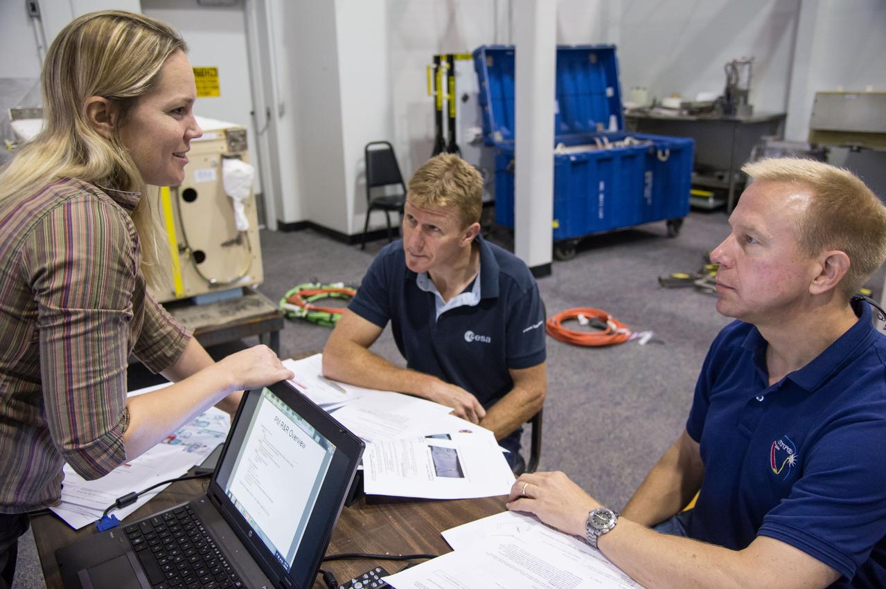
JSC2011-E-058624 (24 June 2011) --- STS-135 crew members participate in a flight data file review in the Flight Operations Facility at NASA?s Johnson Space Center. Pictured seated from the left are NASA astronauts Chris Ferguson, commander; Doug Hurley, pilot; along with Sandy Magnus and Rex Walheim, both mission specialists. Instructor Sandy Wayne assisted the crew members. Photo credit: NASA
iss071e522575 (Aug. 20, 2024) --- A portion of the Kalahari Desert, a semi-arid and sandy savanna, in South Africa's Northern Cape province is pictured from the International Space Station as it orbited 262 miles above.
DATE: 6-25-14 LOCATION: Bldg 9NW - POGO SUBJECT: Expedition 42/43 ESA astronaut Samantha Cristoforetti during ISS EVA POGO 2 training with instructor Sandy Fletcher. PHOTOGRAPHER: Lauren Harnett
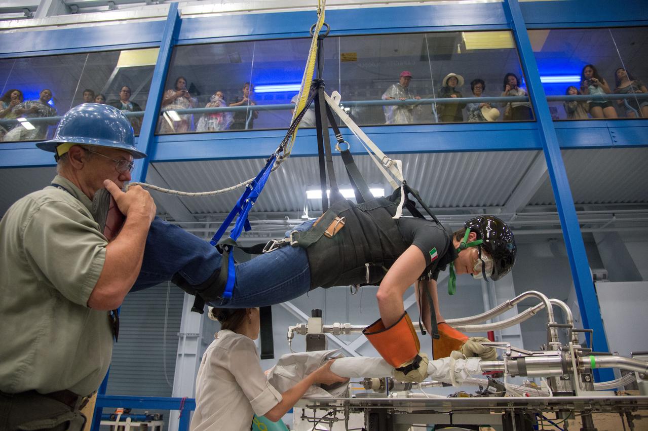
DATE: 6-25-14 LOCATION: Bldg 9NW - POGO SUBJECT: Expedition 42/43 ESA astronaut Samantha Cristoforetti during ISS EVA POGO 2 training with instructor Sandy Fletcher. PHOTOGRAPHER: Lauren Harnett
iss069e031173 (July 11, 2023) -- The Sunshine Coast, located in Southern Queensland, Australia, displays its bright sandy beaches and coastal blue waters of the Coral Sea as the International Space Station orbited 264 miles above.

DATE: 6-25-14 LOCATION: Bldg 9NW - POGO SUBJECT: Expedition 42/43 ESA astronaut Samantha Cristoforetti during ISS EVA POGO 2 training with instructor Sandy Fletcher. PHOTOGRAPHER: Lauren Harnett

JOHNSON SPACE CENTER, Houston, Texas --- JSC2011-E-039719 --- NASA astronaut Sandy Magnus, mission specialist. Photo credit: NASA or National Aeronautics and Space Administration

German Deligation visits Ames SOFIA Science Office for briefing and enjoy a Ames tour of CVSRF Simulator and 'fly' in the 774 cab with Ederhard Brockmann in front and Jochen Homann & Sandy Wrede in pilot/co-pilot seats.
DATE: 6-25-14 LOCATION: Bldg 9NW - POGO SUBJECT: Expedition 42/43 ESA astronaut Samantha Cristoforetti during ISS EVA POGO 2 training with instructor Sandy Fletcher. PHOTOGRAPHER: Lauren Harnett
Soyuz 33 crew (33s) (Hadfield, Romanenko and Marshburn) during EVA Prep & Post training with Sandy Fletcher. Photo Date: March 6, 2012. Location: Building 9NW - ISS Mockups. Photographer: Robert Markowitz

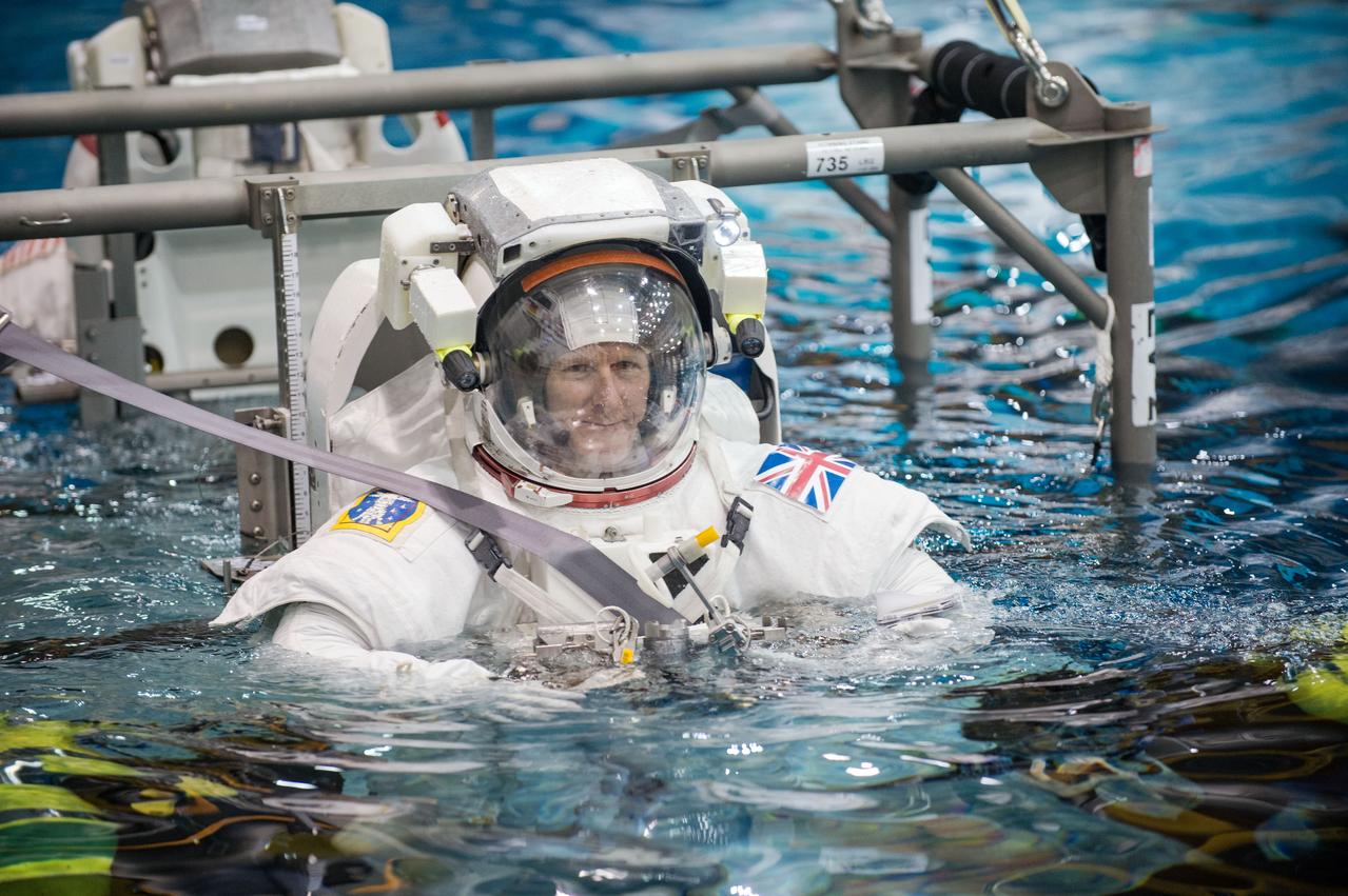
NASA astronaut Sandy Magnus waves as she is lowered into the water to train for spacewalk in the Neutral Buoyancy Laboratory (NBL) on Tuesday, March 22, 2011, in Houston. ( NASA Photo / Houston Chronicle, Smiley N. Pool )

DATE: 6-25-14 LOCATION: Bldg 9NW - POGO SUBJECT: Expedition 42/43 ESA astronaut Samantha Cristoforetti during ISS EVA POGO 2 training with instructor Sandy Fletcher. PHOTOGRAPHER: Lauren Harnett
Soyuz 33 crew (33s) (Hadfield, Romanenko and Marshburn) during EVA Prep & Post training with Sandy Fletcher. Photo Date: March 6, 2012. Location: Building 9NW - ISS Mockups. Photographer: Robert Markowitz
Soyuz 33 crew (33s) (Hadfield, Romanenko and Marshburn) during EVA Prep & Post training with Sandy Fletcher. Photo Date: March 6, 2012. Location: Building 9NW - ISS Mockups. Photographer: Robert Markowitz

DATE: 6-25-14 LOCATION: Bldg 9NW - POGO SUBJECT: Expedition 42/43 ESA astronaut Samantha Cristoforetti during ISS EVA POGO 2 training with instructor Sandy Fletcher. PHOTOGRAPHER: Lauren Harnett

German Deligation visits Ames SOFIA Science Office for briefing and enjoy a Ames tour of CVSRF Simulator and 'fly' in the 774 cab with l-r Terrence Rager, Sandy Wrede, Eberhard Brockmann, and jochen Homann..
Soyuz 33 crew (33s) (Hadfield, Romanenko and Marshburn) during EVA Prep & Post training with Sandy Fletcher. Photo Date: March 6, 2012. Location: Building 9NW - ISS Mockups. Photographer: Robert Markowitz
DATE: 6-25-14 LOCATION: Bldg 9NW - POGO SUBJECT: Expedition 42/43 ESA astronaut Samantha Cristoforetti during ISS EVA POGO 2 training with instructor Sandy Fletcher. PHOTOGRAPHER: Joe DeMartino

DATE: 6-25-14 LOCATION: Bldg 9NW - POGO SUBJECT: Expedition 42/43 ESA astronaut Samantha Cristoforetti during ISS EVA POGO 2 training with instructor Sandy Fletcher. PHOTOGRAPHER: Lauren Harnett

DATE: 6-25-14 LOCATION: Bldg 9NW - POGO SUBJECT: Expedition 42/43 ESA astronaut Samantha Cristoforetti during ISS EVA POGO 2 training with instructor Sandy Fletcher. PHOTOGRAPHER: Lauren Harnett

DATE: 6-25-14 LOCATION: Bldg 9NW - POGO SUBJECT: Expedition 42/43 ESA astronaut Samantha Cristoforetti during ISS EVA POGO 2 training with instructor Sandy Fletcher. PHOTOGRAPHER: Joe DeMartino
DATE: 6-25-14 LOCATION: Bldg 9NW - POGO SUBJECT: Expedition 42/43 ESA astronaut Samantha Cristoforetti during ISS EVA POGO 2 training with instructor Sandy Fletcher. PHOTOGRAPHER: Lauren Harnett
NASA's Curiosity Mars rover used its Mast Camera, or Mastcam, to capture geologic details within "Paraitepuy Pass," a sandy, hill-lined area the rover traversed to reach the "sulfate-bearing unit" in August 2022. In the this scene is a hill nicknamed "Orinoco" within the sulfate region, and upper Mount Sharp in the distance. This image was taken on Aug. 15, 2022, the 3,564rd Martian day, or sol, of the mission. This scene is made up of three individual images that were stitched together once they were sent back to Earth. The color has been adjusted to match the lighting conditions as the human eye would perceive them on Earth. https://photojournal.jpl.nasa.gov/catalog/PIA25415

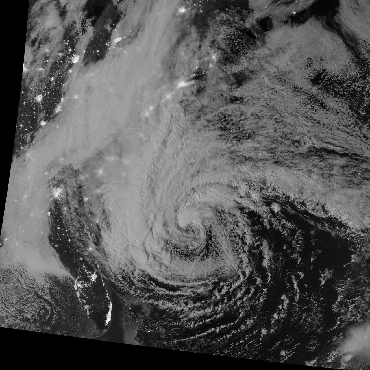
ISS033-E-016695 (29 Oct. 2012) --- One of the Expedition 33 crew members aboard the International Space Station took this photo of Hurricane Sandy at 16:55:32 GMT on Oct. 29, 2012. East is generally at the top of the photo, south to the right. At the camera time of the photo Sandy was located by the National Hurricane Center at approximately 37.5 degrees north latitude and 71.5 degrees west longitude or 25 miles southeast of Atlantic City, New Jersey moving north-northwest at 18 miles per hour and packing winds of 90 miles per hour.

JSC2010-E-181439 (27 Oct. 2010) --- NASA astronaut Rex Walheim, STS-135 mission specialist, dons a training version of his Extravehicular Mobility Unit (EMU) spacesuit in preparation for a spacewalk training session in the waters of the Neutral Buoyancy Laboratory (NBL) near NASA's Johnson Space Center. STS-135 is planned to be the final mission of the space shuttle program. Photo credit: NASA or National Aeronautics and Space Administration
JSC2010-E-181447 (27 Oct. 2010) --- NASA astronaut Rex Walheim, STS-135 mission specialist, gets help donning a training version of his Extravehicular Mobility Unit (EMU) spacesuit in preparation for a spacewalk training session in the waters of the Neutral Buoyancy Laboratory (NBL) near NASA's Johnson Space Center. STS-135 is planned to be the final mission of the space shuttle program. Photo credit: NASA or National Aeronautics and Space Administration
JSC2010-E-181470 (27 Oct. 2010) --- Attired in a training version of his Extravehicular Mobility Unit (EMU) spacesuit, NASA astronaut Rex Walheim, STS-135 mission specialist, is about to be submerged in the waters of the Neutral Buoyancy Laboratory (NBL) near NASA's Johnson Space Center. Divers (out of frame) are in the water to assist Walheim in his rehearsal, which is intended to help prepare him for work on the exterior of the International Space Station. STS-135 is planned to be the final mission of the space shuttle program. Photo credit: NASA or National Aeronautics and Space Administration

JSC2010-E-181483 (27 Oct. 2010) --- Attired in a training version of his Extravehicular Mobility Unit (EMU) spacesuit, NASA astronaut Rex Walheim, STS-135 mission specialist, participates in a spacewalk training session in the waters of the Neutral Buoyancy Laboratory (NBL) near NASA's Johnson Space Center. Divers are in the water to assist Walheim in his rehearsal, which is intended to help prepare him for work on the exterior of the International Space Station. STS-135 is planned to be the final mission of the space shuttle program. Photo credit: NASA or National Aeronautics and Space Administration
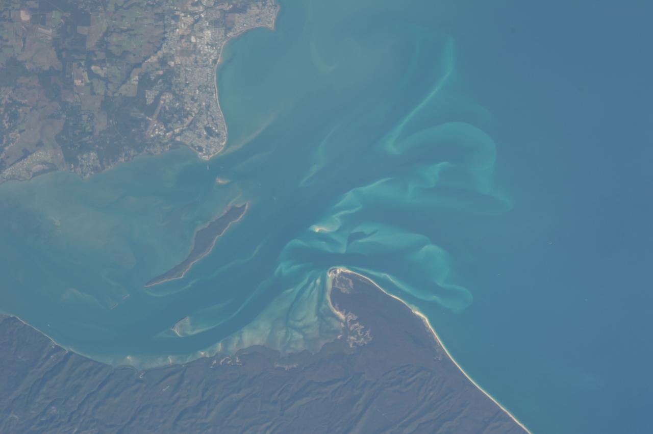
ISS036-E-028444 (3 Aug. 2013) --- Hervey Bay, Queensland, Australia is featured in this image photographed by an Expedition 36 crew member on the International Space Station. The northern end of the Great Sandy Strait and Hervey Bay are highlighted in this photograph. The Strait is an estuary that separates the mainland coastline of the state of Queensland, Australia from neighboring Fraser Island. The mainland side of the Strait includes the city of Hervey Bay, visible at top center. Other communities that have become part of the larger metropolitan area include Scarness, Booral, and Urangan. A small vegetated island and shallow sand bars of the Great Sandy Strait are visible at center left, while submerged sands appear as bright blue flowing ribbons at center. A small, bright white exposure of sand is visible above the water level near the center point of the image. While once a major freighting center for the sugar cane industry, the local economy is now largely based on tourism, with whale watching tours a popular attraction. The Great Sandy Strait estuary provides habitat for breeding fish, crustaceans, turtles, and other sea life, as well as a wide variety of birds. Nearby Fraser Island is the world?s largest sand island and a World Heritage site.
European Astronaut Tim Peake of ESA during ISS EVA MAINT 3 NBL Training with Astronaut Tim Kopra and instructor Sandy Moore. Photo Date: September 10, 2014. Location: NBL - Pool Topside. Photographer: Robert Markowitz
Date: 06-30-14 Location: NBL, MU-176 Subject: Photograph Expedition 43 crew members Scott Kelly from 42S and Terry Virts from 41S during ISS EVA Maintenance 7 - 1G training with instructor Sandy Moore. Photographer: James Blair

European Astronaut Tim Peake of ESA during ISS EVA MAINT 3 NBL Training with Astronaut Tim Kopra and instructor Sandy Moore. Photo Date: September 10, 2014. Location: NBL - Pool Topside. Photographer: Robert Markowitz

S135-E-007435 (11 July 2011) --- NASA astronaut Sandy Magnus, STS-135 mission specialist, is pictured in the U.S. lab or Destiny on the International Space Station during the fourth day in space for the Atlantis crew and the second day while the two spacecraft are docked in Earth orbit. Photo credit: NASA
S135-E-007696 (13 July 2011) --- On Atlantis' middeck, NASA astronauts Rex Walheim and Sandy Magnus, STS-135 mission specialists, discuss the large tasks of moving supplies on the joint shuttle/International Space Station complex during the sixth day in space for the four shuttle crewmembers. Photo credit: NASA
JSC2011-E-028153 (23 March 2011) --- NASA astronauts Doug Hurley, STS-135 pilot; and Sandy Magnus (foreground), mission specialist, participate in an exercise in the systems engineering simulator in the Avionics Systems Laboratory at NASA's Johnson Space Center. Photo credit: NASA or National Aeronautics and Space Administration

European Astronaut Tim Peake of ESA during ISS EVA MAINT 3 NBL Training with Astronaut Tim Kopra and instructor Sandy Moore. Photo Date: September 10, 2014. Location: NBL - Pool Topside. Photographer: Robert Markowitz

S135-E-006328 (9 July 2011) --- NASA astronaut Sandy Magnus, STS-135 mission specialist, is pictured on the middeck of the space shuttle Atlantis during a brief break in the flight's second day of activities in Earth orbit. Photo credit: NASA
DATE: 9-3-14 LOCATION: NBL - MU-176 SUBJECT: ESA Astronaut Tim Peaks and US Astronaut Tim Kopra during ISS EVA MAINT 3 1G training with instructor Sandy Moore. PHOTOGRAPHER: Lauren Harnett

JSC2011-E-060424 (30 June 2011) --- NASA astronauts Sandy Magnus and Rex Walheim, both STS-135 mission specialists, are pictured during a preflight press conference at NASA's Johnson Space Center. Photo credit: NASA

DATE: 9-3-14 LOCATION: NBL - MU-176 SUBJECT: ESA Astronaut Tim Peaks and US Astronaut Tim Kopra during ISS EVA MAINT 3 1G training with instructor Sandy Moore. PHOTOGRAPHER: Lauren Harnett

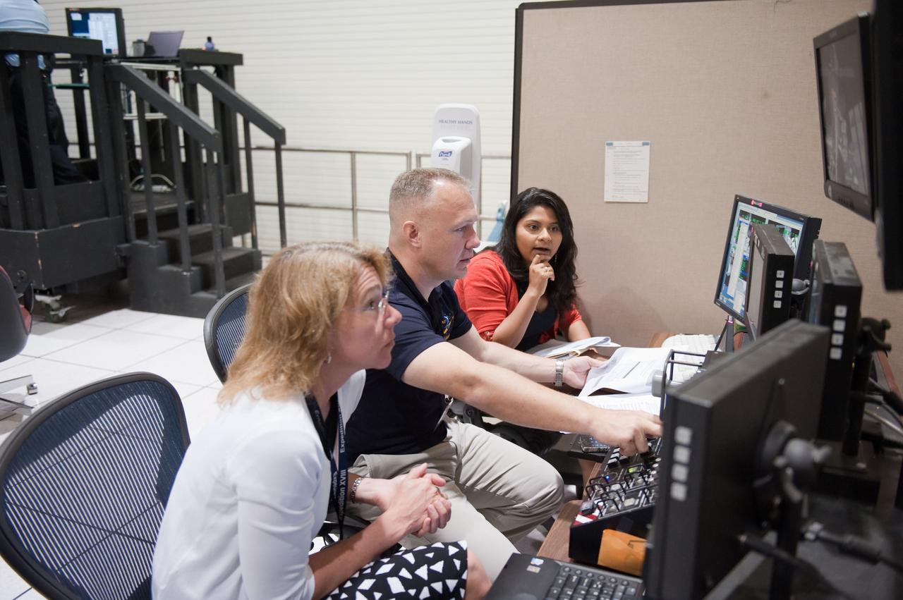
JSC2011-E-058647 (24 June 2011) --- NASA astronaut Sandy Magnus, STS-135 mission specialist, participates in a flight data file review in the Flight Operations Facility at NASA?s Johnson Space Center. Photo credit: NASA

S135-E-006388 (9 July 2011) --- NASA astronauts Chris Ferguson, STS-135 commander, and Sandy Magnus, mission specialist, are pictured on the aft flight deck of the space shuttle Atlantis during the mission's second day of activities in Earth orbit. Photo credit: NASA