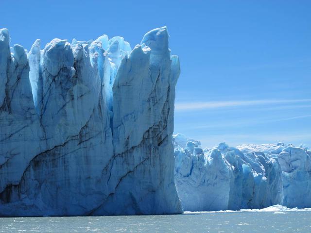
Calving front of the Perito Moreno Glacier (Argentina). Contrary to the majority of the glaciers from the southern Patagonian ice field, the Perito Moreno Glacier is currently stable. It is also one of the most visited glaciers in the world. To learn about the contributions of glaciers to sea level rise, visit: <a href="http://www.nasa.gov/topics/earth/features/glacier-sea-rise.html" rel="nofollow">www.nasa.gov/topics/earth/features/glacier-sea-rise.html</a> Credit: Etienne Berthier, Université de Toulouse <b><a href="http://www.nasa.gov/audience/formedia/features/MP_Photo_Guidelines.html" rel="nofollow">NASA image use policy.</a></b> <b><a href="http://www.nasa.gov/centers/goddard/home/index.html" rel="nofollow">NASA Goddard Space Flight Center</a></b> enables NASA’s mission through four scientific endeavors: Earth Science, Heliophysics, Solar System Exploration, and Astrophysics. Goddard plays a leading role in NASA’s accomplishments by contributing compelling scientific knowledge to advance the Agency’s mission. <b>Follow us on <a href="http://twitter.com/NASA_GoddardPix" rel="nofollow">Twitter</a></b> <b>Like us on <a href="http://www.facebook.com/pages/Greenbelt-MD/NASA-Goddard/395013845897?ref=tsd" rel="nofollow">Facebook</a></b> <b>Find us on <a href="http://instagram.com/nasagoddard?vm=grid" rel="nofollow">Instagram</a></b>
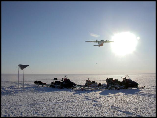
An airplane drops essential support on the Austfonna Ice Cap in Svalbard (Norwegian Arctic). The triangular structure is a corner reflector used as ground reference for airborne radar surveys. To learn about the contributions of glaciers to sea level rise, visit: <a href="http://www.nasa.gov/topics/earth/features/glacier-sea-rise.html" rel="nofollow">www.nasa.gov/topics/earth/features/glacier-sea-rise.html</a> Credit: Andrea Taurisano, Norwegian Polar Institute <b><a href="http://www.nasa.gov/audience/formedia/features/MP_Photo_Guidelines.html" rel="nofollow">NASA image use policy.</a></b> <b><a href="http://www.nasa.gov/centers/goddard/home/index.html" rel="nofollow">NASA Goddard Space Flight Center</a></b> enables NASA’s mission through four scientific endeavors: Earth Science, Heliophysics, Solar System Exploration, and Astrophysics. Goddard plays a leading role in NASA’s accomplishments by contributing compelling scientific knowledge to advance the Agency’s mission. <b>Follow us on <a href="http://twitter.com/NASA_GoddardPix" rel="nofollow">Twitter</a></b> <b>Like us on <a href="http://www.facebook.com/pages/Greenbelt-MD/NASA-Goddard/395013845897?ref=tsd" rel="nofollow">Facebook</a></b> <b>Find us on <a href="http://instagram.com/nasagoddard?vm=grid" rel="nofollow">Instagram</a></b>
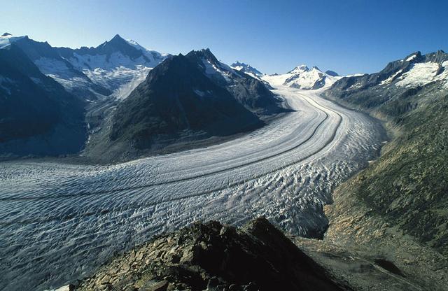
The Aletsch Glacier in Switzerland is the largest valley glacier in the Alps. Its volume loss since the middle of the 19th century is well-visible from the trimlines to the right of the image. To learn about the contributions of glaciers to sea level rise, visit: <a href="http://www.nasa.gov/topics/earth/features/glacier-sea-rise.html" rel="nofollow">www.nasa.gov/topics/earth/features/glacier-sea-rise.html</a> Credit: Frank Paul, University of Zurich <b><a href="http://www.nasa.gov/audience/formedia/features/MP_Photo_Guidelines.html" rel="nofollow">NASA image use policy.</a></b> <b><a href="http://www.nasa.gov/centers/goddard/home/index.html" rel="nofollow">NASA Goddard Space Flight Center</a></b> enables NASA’s mission through four scientific endeavors: Earth Science, Heliophysics, Solar System Exploration, and Astrophysics. Goddard plays a leading role in NASA’s accomplishments by contributing compelling scientific knowledge to advance the Agency’s mission. <b>Follow us on <a href="http://twitter.com/NASA_GoddardPix" rel="nofollow">Twitter</a></b> <b>Like us on <a href="http://www.facebook.com/pages/Greenbelt-MD/NASA-Goddard/395013845897?ref=tsd" rel="nofollow">Facebook</a></b> <b>Find us on <a href="http://instagram.com/nasagoddard?vm=grid" rel="nofollow">Instagram</a></b>
Small valley glacier exiting the Devon Island Ice Cap in Canada. To learn about the contributions of glaciers to sea level rise, visit: <a href="http://www.nasa.gov/topics/earth/features/glacier-sea-rise.html" rel="nofollow">www.nasa.gov/topics/earth/features/glacier-sea-rise.html</a> Credit: Alex Gardner, Clark University <b><a href="http://www.nasa.gov/audience/formedia/features/MP_Photo_Guidelines.html" rel="nofollow">NASA image use policy.</a></b> <b><a href="http://www.nasa.gov/centers/goddard/home/index.html" rel="nofollow">NASA Goddard Space Flight Center</a></b> enables NASA’s mission through four scientific endeavors: Earth Science, Heliophysics, Solar System Exploration, and Astrophysics. Goddard plays a leading role in NASA’s accomplishments by contributing compelling scientific knowledge to advance the Agency’s mission. <b>Follow us on <a href="http://twitter.com/NASA_GoddardPix" rel="nofollow">Twitter</a></b> <b>Like us on <a href="http://www.facebook.com/pages/Greenbelt-MD/NASA-Goddard/395013845897?ref=tsd" rel="nofollow">Facebook</a></b> <b>Find us on <a href="http://instagram.com/nasagoddard?vm=grid" rel="nofollow">Instagram</a></b>

Aerial view of the Sverdrup Glacier, a river of ice that flows from the interior of the Devon Island Ice Cap (Canada) into the ocean. To learn about the contributions of glaciers to sea level rise, visit: <a href="http://www.nasa.gov/topics/earth/features/glacier-sea-rise.html" rel="nofollow">www.nasa.gov/topics/earth/features/glacier-sea-rise.html</a> Credit: Alex Gardner, Clark University <b><a href="http://www.nasa.gov/audience/formedia/features/MP_Photo_Guidelines.html" rel="nofollow">NASA image use policy.</a></b> <b><a href="http://www.nasa.gov/centers/goddard/home/index.html" rel="nofollow">NASA Goddard Space Flight Center</a></b> enables NASA’s mission through four scientific endeavors: Earth Science, Heliophysics, Solar System Exploration, and Astrophysics. Goddard plays a leading role in NASA’s accomplishments by contributing compelling scientific knowledge to advance the Agency’s mission. <b>Follow us on <a href="http://twitter.com/NASA_GoddardPix" rel="nofollow">Twitter</a></b> <b>Like us on <a href="http://www.facebook.com/pages/Greenbelt-MD/NASA-Goddard/395013845897?ref=tsd" rel="nofollow">Facebook</a></b> <b>Find us on <a href="http://instagram.com/nasagoddard?vm=grid" rel="nofollow">Instagram</a></b>
Summit camp on top of the Austfonna Ice Cap in Svalbard (Norwegian Arctic). To learn about the contributions of glaciers to sea level rise, visit: <a href="http://www.nasa.gov/topics/earth/features/glacier-sea-rise.html" rel="nofollow">www.nasa.gov/topics/earth/features/glacier-sea-rise.html</a> Credit: Thorben Dunse, University of Oslo <b><a href="http://www.nasa.gov/audience/formedia/features/MP_Photo_Guidelines.html" rel="nofollow">NASA image use policy.</a></b> <b><a href="http://www.nasa.gov/centers/goddard/home/index.html" rel="nofollow">NASA Goddard Space Flight Center</a></b> enables NASA’s mission through four scientific endeavors: Earth Science, Heliophysics, Solar System Exploration, and Astrophysics. Goddard plays a leading role in NASA’s accomplishments by contributing compelling scientific knowledge to advance the Agency’s mission. <b>Follow us on <a href="http://twitter.com/NASA_GoddardPix" rel="nofollow">Twitter</a></b> <b>Like us on <a href="http://www.facebook.com/pages/Greenbelt-MD/NASA-Goddard/395013845897?ref=tsd" rel="nofollow">Facebook</a></b> <b>Find us on <a href="http://instagram.com/nasagoddard?vm=grid" rel="nofollow">Instagram</a></b>
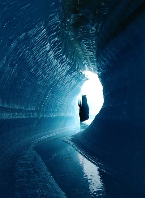
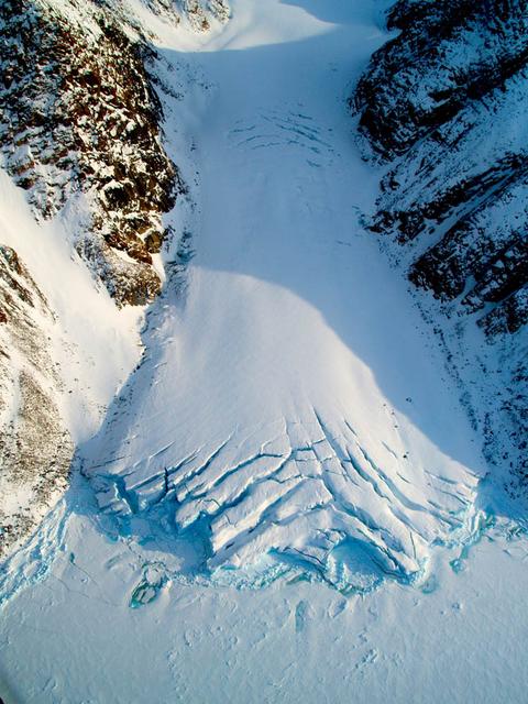
This ice cave in Belcher Glacier (Devon Island, Canada) was formed by melt water flowing within the glacier ice. To learn about the contributions of glaciers to sea level rise, visit: <a href="http://www.nasa.gov/topics/earth/features/glacier-sea-rise.html" rel="nofollow">www.nasa.gov/topics/earth/features/glacier-sea-rise.html</a> Credit: Angus Duncan, University of Saskatchewan <b><a href="http://www.nasa.gov/audience/formedia/features/MP_Photo_Guidelines.html" rel="nofollow">NASA image use policy.</a></b> <b><a href="http://www.nasa.gov/centers/goddard/home/index.html" rel="nofollow">NASA Goddard Space Flight Center</a></b> enables NASA’s mission through four scientific endeavors: Earth Science, Heliophysics, Solar System Exploration, and Astrophysics. Goddard plays a leading role in NASA’s accomplishments by contributing compelling scientific knowledge to advance the Agency’s mission. <b>Follow us on <a href="http://twitter.com/NASA_GoddardPix" rel="nofollow">Twitter</a></b> <b>Like us on <a href="http://www.facebook.com/pages/Greenbelt-MD/NASA-Goddard/395013845897?ref=tsd" rel="nofollow">Facebook</a></b> <b>Find us on <a href="http://instagram.com/nasagoddard?vm=grid" rel="nofollow">Instagram</a></b>
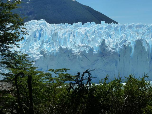
Calving front of the Perito Moreno Glacier (Argentina). Contrary to the majority of the glaciers from the southern Patagonian ice field, the Perito Moreno Glacier is currently stable. It is also one of the most visited glaciers in the world. To learn about the contributions of glaciers to sea level rise, visit: <a href="http://www.nasa.gov/topics/earth/features/glacier-sea-rise.html" rel="nofollow">www.nasa.gov/topics/earth/features/glacier-sea-rise.html</a> Credit: Etienne Berthier, Université de Toulouse <b><a href="http://www.nasa.gov/audience/formedia/features/MP_Photo_Guidelines.html" rel="nofollow">NASA image use policy.</a></b> <b><a href="http://www.nasa.gov/centers/goddard/home/index.html" rel="nofollow">NASA Goddard Space Flight Center</a></b> enables NASA’s mission through four scientific endeavors: Earth Science, Heliophysics, Solar System Exploration, and Astrophysics. Goddard plays a leading role in NASA’s accomplishments by contributing compelling scientific knowledge to advance the Agency’s mission. <b>Follow us on <a href="http://twitter.com/NASA_GoddardPix" rel="nofollow">Twitter</a></b> <b>Like us on <a href="http://www.facebook.com/pages/Greenbelt-MD/NASA-Goddard/395013845897?ref=tsd" rel="nofollow">Facebook</a></b> <b>Find us on <a href="http://instagram.com/nasagoddard?vm=grid" rel="nofollow">Instagram</a></b>

Peripheral glaciers and ice caps (isolated from the main ice sheet, which is seen in the upper right section of the image) in eastern Greenland. To learn about the contributions of glaciers to sea level rise, visit: <a href="http://www.nasa.gov/topics/earth/features/glacier-sea-rise.html" rel="nofollow">www.nasa.gov/topics/earth/features/glacier-sea-rise.html</a> Credit: Frank Paul, University of Zurich <b><a href="http://www.nasa.gov/audience/formedia/features/MP_Photo_Guidelines.html" rel="nofollow">NASA image use policy.</a></b> <b><a href="http://www.nasa.gov/centers/goddard/home/index.html" rel="nofollow">NASA Goddard Space Flight Center</a></b> enables NASA’s mission through four scientific endeavors: Earth Science, Heliophysics, Solar System Exploration, and Astrophysics. Goddard plays a leading role in NASA’s accomplishments by contributing compelling scientific knowledge to advance the Agency’s mission. <b>Follow us on <a href="http://twitter.com/NASA_GoddardPix" rel="nofollow">Twitter</a></b> <b>Like us on <a href="http://www.facebook.com/pages/Greenbelt-MD/NASA-Goddard/395013845897?ref=tsd" rel="nofollow">Facebook</a></b> <b>Find us on <a href="http://instagram.com/nasagoddard?vm=grid" rel="nofollow">Instagram</a></b>
Melt water ponded at surface in the accumulation zone of Columbia Glacier, Alaska, in July 2008. To learn about the contributions of glaciers to sea level rise, visit: <a href="http://www.nasa.gov/topics/earth/features/glacier-sea-rise.html" rel="nofollow">www.nasa.gov/topics/earth/features/glacier-sea-rise.html</a> Credit: W. Tad Pfeffer, University of Colorado at Boulder <b><a href="http://www.nasa.gov/audience/formedia/features/MP_Photo_Guidelines.html" rel="nofollow">NASA image use policy.</a></b> <b><a href="http://www.nasa.gov/centers/goddard/home/index.html" rel="nofollow">NASA Goddard Space Flight Center</a></b> enables NASA’s mission through four scientific endeavors: Earth Science, Heliophysics, Solar System Exploration, and Astrophysics. Goddard plays a leading role in NASA’s accomplishments by contributing compelling scientific knowledge to advance the Agency’s mission. <b>Follow us on <a href="http://twitter.com/NASA_GoddardPix" rel="nofollow">Twitter</a></b> <b>Like us on <a href="http://www.facebook.com/pages/Greenbelt-MD/NASA-Goddard/395013845897?ref=tsd" rel="nofollow">Facebook</a></b> <b>Find us on <a href="http://instagram.com/nasagoddard?vm=grid" rel="nofollow">Instagram</a></b>
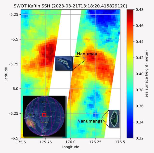
The recently launched Surface Water and Ocean Topography (SWOT) mission collected data on sea levels around two of the inhabited islands of Tuvalu, a nation in the South Pacific Ocean that has been threatened with sea level rise that substantially exceeds the global average. The image shows two areas of red that indicate higher than normal sea levels around two of Tuvalu's inhabited islands, Nanumanga and Nanumea. The higher sea levels were likely caused by internal tides or circular currents called eddies. The SWOT data illuminates for the first time these small ocean features that, when they occur on top of rising sea levels, can lead to episodic flooding along coastlines. The Tuvalu data was collected March 21, 2023. Rising seas are a direct consequence of climate change. On a global scale, the combination of warming ocean waters and ice melt from glaciers and ice sheets is leading to sea level rise that is occurring at an ever-increasing rate. The current rate of rise is more than 0.15 inches (4 millimeters) per year, an increase from 0.08 inches (2 millimeters) per year in 1993. This seemingly small increase holds great significance for coastal communities that have seen more than a century of persistent sea level rise. The gap between the average high tide and flooding conditions has narrowed, and coastal impacts driven by sea level rise have increased in frequency and severity in recent years. This is particularly true for low-lying island nations like Tuvalu, located about 620 miles (1,000 kilometers) north of Fiji. Sea level rise does not occur at the same rate everywhere across the globe, and can be exacerbated by natural ocean fluctuations that occur over time periods from years to decades. For Tuvalu, the amount of sea level rise has been substantially higher than the global average over the past three decades. The amount of rise, when coupled with Tuvalu's low land elevations, places the country increasingly under threat. In the near term, sea level rise will combine with naturally occurring ocean variability and storms to exacerbate events like coastal flooding. Monitoring and understanding sea level change is critical for Tuvalu and other low-lying island nations. Launched on Dec. 16, 2022, from Vandenberg Space Force Base in central California, SWOT collected the Tuvalu sea level data during a period of commissioning, calibration, and validation. Engineers are checking out the performance of the satellite's systems and science instruments before the planned start of science operations in summer 2023. https://photojournal.jpl.nasa.gov/catalog/PIA25777

Calving front of the Upsala Glacier (Argentina). This glacier has been thinning and retreating at a rapid rate during the last decades – from 2006 to 2010, it receded 43.7 yards (40 meters) per year. During summer 2012, large calving events prevented boat access to the glacier. To learn about the contributions of glaciers to sea level rise, visit: <a href="http://www.nasa.gov/topics/earth/features/glacier-sea-rise.html" rel="nofollow">www.nasa.gov/topics/earth/features/glacier-sea-rise.html</a> Credit: Etienne Berthier, Université de Toulouse <b><a href="http://www.nasa.gov/audience/formedia/features/MP_Photo_Guidelines.html" rel="nofollow">NASA image use policy.</a></b> <b><a href="http://www.nasa.gov/centers/goddard/home/index.html" rel="nofollow">NASA Goddard Space Flight Center</a></b> enables NASA’s mission through four scientific endeavors: Earth Science, Heliophysics, Solar System Exploration, and Astrophysics. Goddard plays a leading role in NASA’s accomplishments by contributing compelling scientific knowledge to advance the Agency’s mission. <b>Follow us on <a href="http://twitter.com/NASA_GoddardPix" rel="nofollow">Twitter</a></b> <b>Like us on <a href="http://www.facebook.com/pages/Greenbelt-MD/NASA-Goddard/395013845897?ref=tsd" rel="nofollow">Facebook</a></b> <b>Find us on <a href="http://instagram.com/nasagoddard?vm=grid" rel="nofollow">Instagram</a></b>

Over the past 30 years, global average sea level has risen a total of 3.6 inches (9.1 centimeters), as indicated in this graphic, which is based on sea level measurements (in blue) from five successive satellites starting with the U.S.-French TOPEX/Poseidon mission in 1993. The solid red line shows the trajectory of sea level rise from 1993 to 2022, while the dotted red line shows the increase sea level into the future. Researchers can take the solid red line and calculate the rate of sea level rise, which was 0.08 inches (0.20 centimeters) per year in 1993 and doubled to 0.17 inches (0.44 centimeters) per year by 2022. The dotted red line shows that by 2040, sea levels may rise by an additional 3.66 inches (9.3 cm) above 2022 levels. The trajectory shown in the solid and dotted red line is based on work by the NASA Sea Level Change Team and the Ocean Surface Topography Science Team. https://photojournal.jpl.nasa.gov/catalog/PIA25775

This poster highlights NASA JPL missions that provide important inputs to research in sea level rise and variability -- key measures of ocean circulation and global climate change.

This graph shows the rise in global mean sea level from 1993 to 2023 based on data from a series of five international satellites. The solid red line indicates the trajectory of this increase, which has more than doubled over the three decades. The dotted red line projects future sea level rise. The relatively large jump in sea level from 2022 to 2023, a rise of about 0.3 inches (0.76 centimeters), is due mostly to a warming climate and the development of a strong El Niño. The 2022-2023 rise is equivalent to draining a quarter of Lake Superior into the ocean over the course of a year. This NASA-led analysis is based on a sea level data set featuring more than 30 years of satellite observations, starting with the U.S.-French TOPEX/Poseidon mission, which launched in 1992. The Sentinel-6 Michael Freilich mission, which launched in November 2020, is the latest in the series of satellites that have contributed to this sea level record. https://photojournal.jpl.nasa.gov/catalog/PIA26183
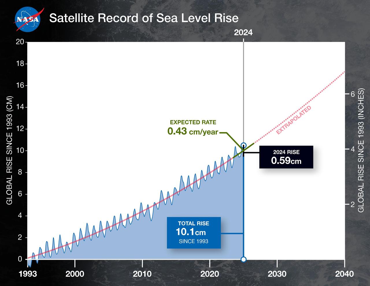
This graph shows the rise in global mean sea level from 1993 to 2024 based on data from a series of five international satellites. The solid red line indicates the trajectory of this increase, which has more than doubled over the three decades. The dotted red line projects future sea level rise. Global sea level rose faster than expected in 2024 due mostly to ocean water expanding as it warms, or thermal expansion. According to a NASA-led analysis, last year's rate of rise was 0.23 inches (0.59 centimeters) per year, compared to the expected rate of 0.17 inches (0.43 centimeters) per year. In recent years, about two-thirds of sea level rise was due to the addition of water from land into the ocean by melting ice sheets and glaciers. About a third came from thermal expansion of seawater. But in 2024, those contributions flipped, with two-thirds of sea level rise coming from thermal expansion. This NASA-led analysis is based on a sea level dataset featuring more than 30 years of satellite observations, starting with the U.S.-French TOPEX/Poseidon mission, which launched in 1992. The Sentinel-6 Michael Freilich mission, which launched in November 2020, is the latest in the series of satellites that have contributed to this sea level record. https://photojournal.jpl.nasa.gov/catalog/PIA26189
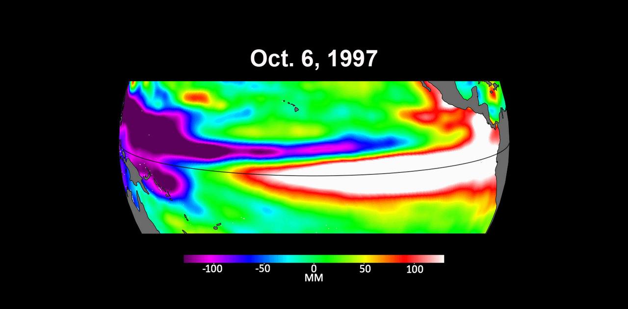
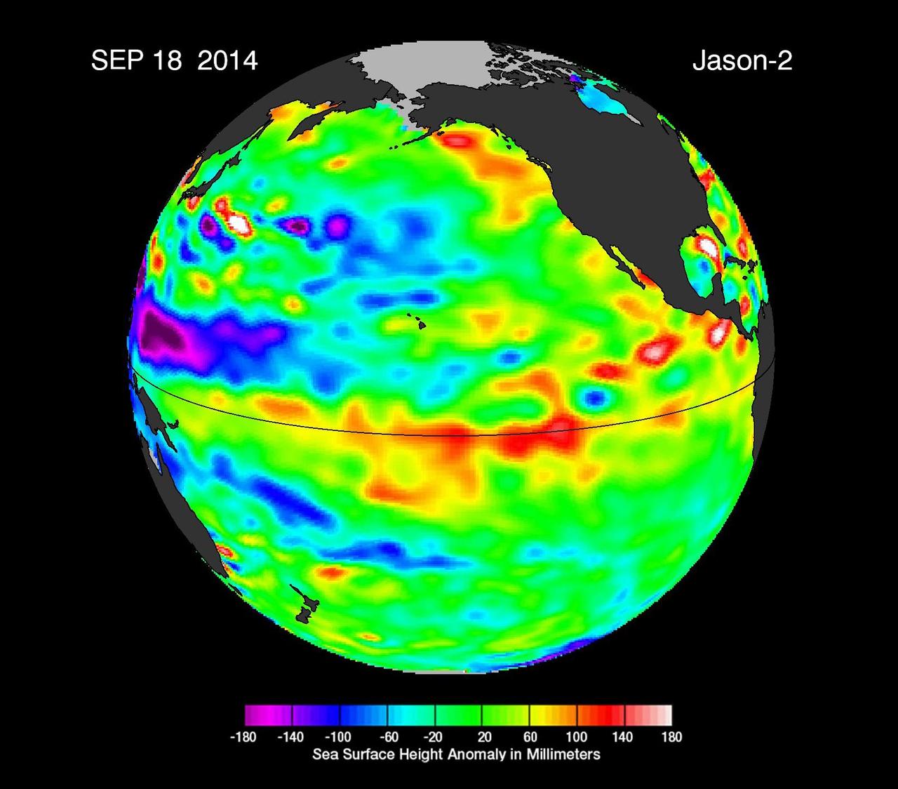
These three maps based on satellite data show sea levels in the Pacific Ocean during developing El Niño events in early October of 1997, 2015, and 2023. Higher-than-average ocean heights are shown in red and white, while lower-than-average heights are blue and purple. The two earlier maps represent the two extreme El Niño events from the past 30 years – the first from 1997 to 1998 and the second from 2015 to 2016. Both caused shifts in global air and ocean temperatures, atmospheric wind and rainfall patterns, and sea level. El Niños are characterized by higher-than-normal sea levels and warmer-than-average ocean temperatures along the equatorial Pacific. Water expands as it warms, so sea levels tend to be higher in places with warmer water. These temperature and sea level conditions can then propagate poleward along the western coasts of the Americas. El Niños can bring wetter conditions to the U.S. Southwest and drought to regions in the western Pacific, including Indonesia. Not all El Niño events are created equal, however, and their impacts vary widely. Satellites like the U.S.-European Sentinel-6 Michael Freilich, which captured the 2023 data, help anticipate those impacts on a global scale by tracking changes in sea surface height in the Pacific Ocean. The TOPEX/Poseidon satellite collected the 1997 data while Jason-2 collected data for the 2015 event. This year's El Niño is still developing, but researchers are looking to the recent past for clues as to how it is shaping up. By October 1997 and 2015, large areas of the central and eastern Pacific had sea levels more than 7 inches (18 centimeters) higher than normal. This year, sea levels are about 2 or 3 inches (5 to 8 centimeters) higher than normal and are elevated over a smaller area compared to the 1997 and 2015 events. Both of the past El Niños reached peak strength in late November or early December, so this year's event may still intensify. Launched in November 2020, Sentinel-6 Michael Freilich is named after former NASA Earth Science Division Director Michael Freilich. The satellite is one of two that compose the Copernicus Sentinel-6/Jason-CS (Continuity of Service) mission. Animation available at https://photojournal.jpl.nasa.gov/catalog/PIA26099
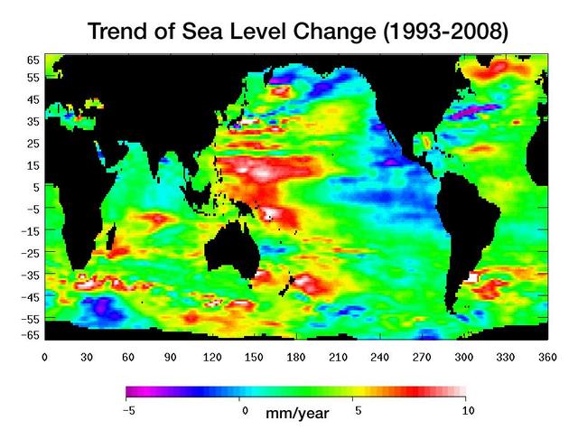
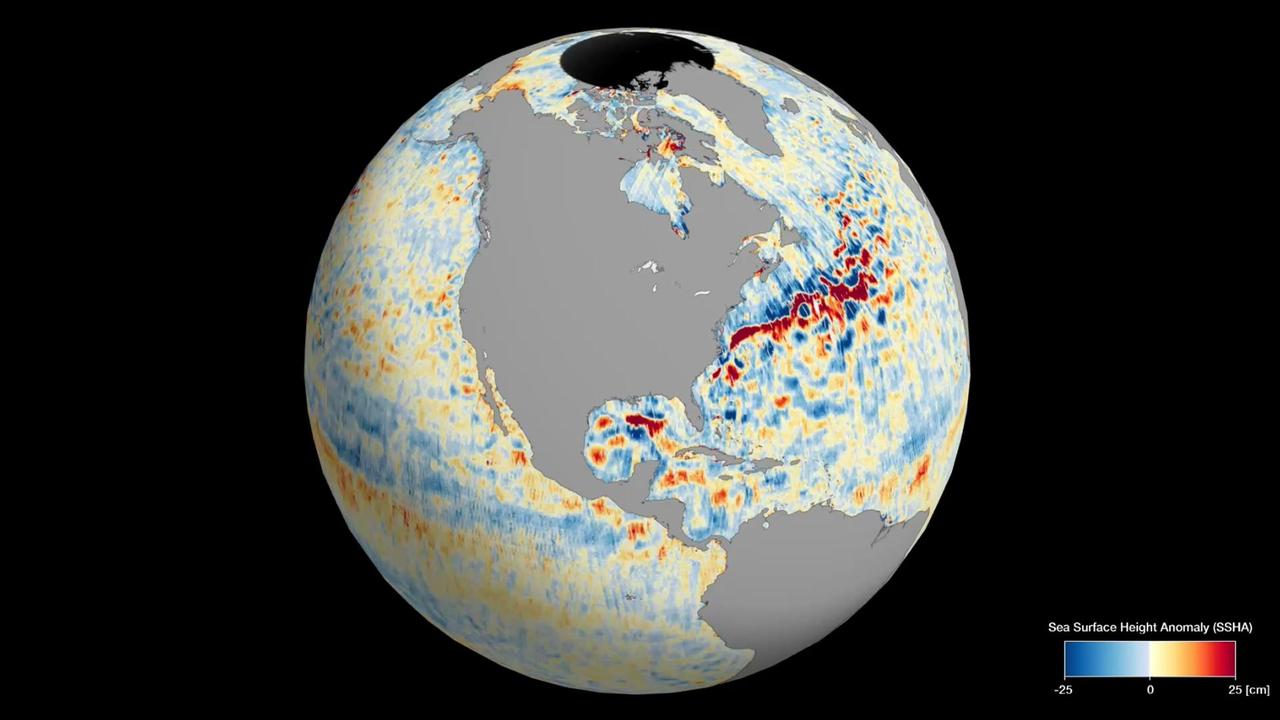
Warming water and melting land ice have raised global mean sea level 4.5 centimeters 1.7 inches from 1993 to 2008. But the rise is by no means uniform.
This animation shows global sea level data collected by the Surface Water and Ocean Topography (SWOT) satellite during its first 21-day science orbit, which it completed from July 26 to Aug. 16, 2023. Red and orange indicate ocean heights that were higher than the global mean sea surface height, while blue represents lower-than-the mean. Sea level differences can highlight ocean currents, like the Gulf Stream coming off the U.S. East Coast or the Kuroshio current off the east coast of Japan. Increased sea surface heights can also indicate regions of relatively warmer water – like the eastern part of the equatorial Pacific Ocean during an El Niño – because water expands as it warms. The SWOT science team made the measurements using the spacecraft's Ka-band Radar Interferometer (KaRIn) instrument. With two antennas spread 33 feet (10 meters) apart on a boom, KaRIn produces a pair of data swaths (tracks visible in the animation) as it circles the globe, bouncing radar pulses off the water's surface to collect surface-height measurements. Launched on Dec. 16, 2022, from Vandenberg Space Force Base in central California, SWOT is now in its operations phase, measuring the height of nearly all water on Earth's surface. The satellite will provide one of the most detailed, comprehensive views yet of the planet's oceans and fresh water lakes and rivers, collecting data that will be used for research and other purposes. Animation available at https://photojournal.jpl.nasa.gov/catalog/PIA26100
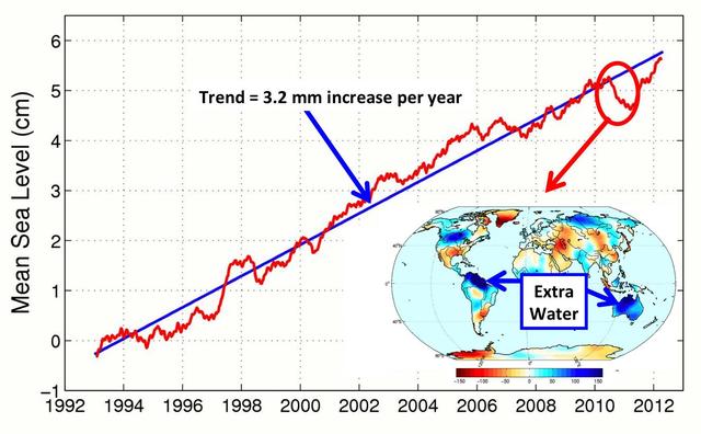
This figure shows changes in global mean sea level as measured by satellite altimetry NASA/CNES Topex/Poseidon and Jason-1; and NASA/CNES/NOAA/EUMETSAT Jason-2 between 1992 to 2012.
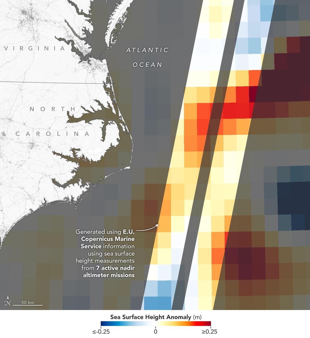
This visualization shows sea surface height measurements of the Gulf Stream off the coast of North Carolina and Virginia. The data was collected on Jan. 21, 2023, by seven satellites currently in operation. The information, provided by the Copernicus Marine Service of ESA (European Space Agency), comes from radar instruments called Earth-facing altimeters. In the visualization, red and orange areas represent sea levels that are higher than the global average, while shades of blue represent sea levels that are lower than average. An altimeter – widely used to measure sea level from space – works by bouncing radar signals off the ocean's surface directly beneath the instrument. It records both the time the signal takes to travel from a satellite to Earth and back, as well as the strength of the return signal. The spatial resolution offered by these instruments – shown in the composite image that's been modified so that different sea levels appear as different colors – is in contrast to the spatial resolution offered by a new instrument called the Ka-band Radar Interferometer (KaRIn), which is 10 times greater. KaRIn launched on board the Surface Water and Ocean Topography (SWOT) satellite on Dec. 16, 2022. SWOT is now in a six-month period called commissioning, calibration and validation. This is when engineers on the mission check out the performance of the satellite's systems and science instruments before the planned start of science operations in July 2023. Led by NASA and the French space agency Centre National d'Études Spatiales (CNES), SWOT will measure the height of water on over 90% of Earth's surface, providing a high-definition survey of our planet's water for the first time. The satellite's measurements of freshwater bodies and the ocean will provide insights into how the ocean influences climate change; how a warming world affects lakes, rivers, and reservoirs; and how communities can better prepare for floods and other disasters. https://photojournal.jpl.nasa.gov/catalog/PIA25773
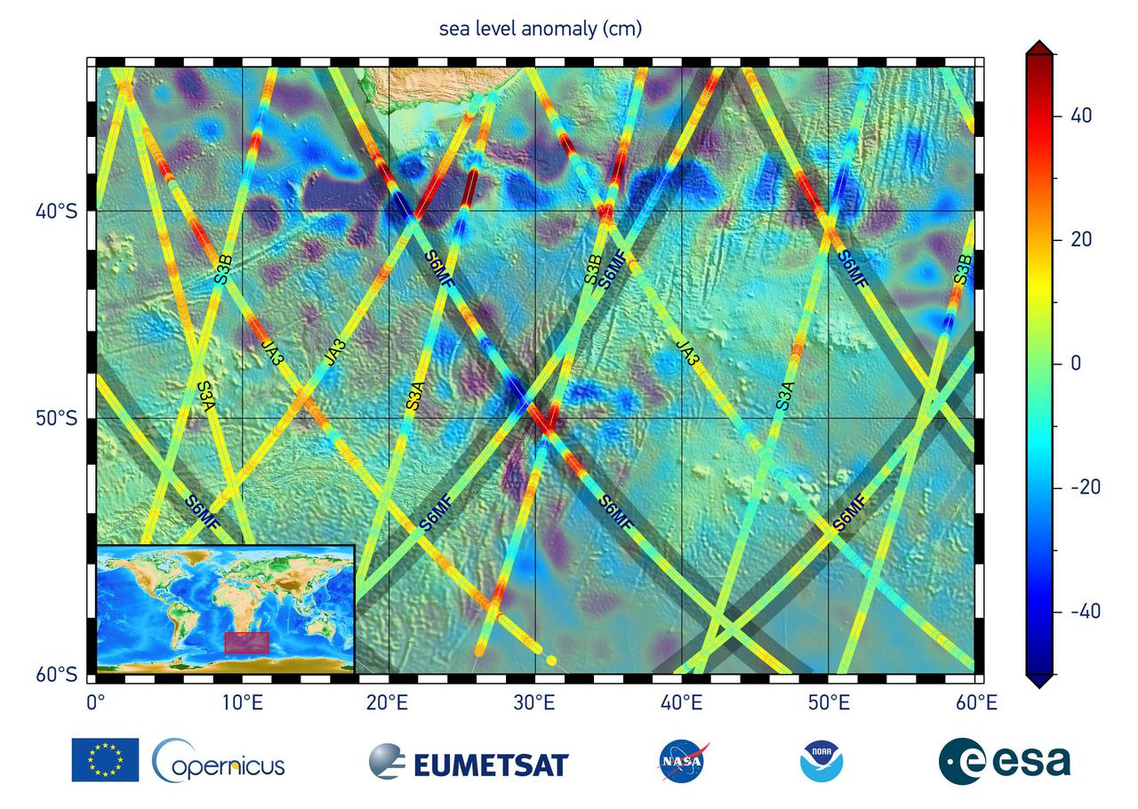
This graphic, released on Dec. 10, 2020, shows the first sea level measurements taken by Sentinel-6 Michael Freilich (S6MF), which launched Nov. 21, 2020. It focuses on the ocean off the southern tip of Africa, where red colors indicate higher sea level relative to blue areas, which are lower. Also included are sea surface height measurements from three other satellites for comparison: Jason-3 (JA3), Sentinel-3A (S3A), and Sentinel-3B (S3B). https://photojournal.jpl.nasa.gov/catalog/PIA24135
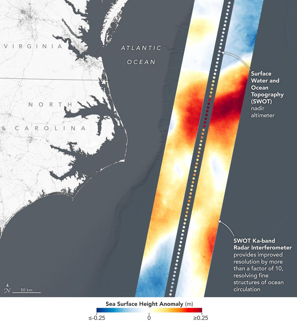
This visualization shows sea surface height measurements in the Gulf Stream off the coast of North Carolina and Virginia. The data was collected on Jan. 21, 2023, by an instrument on the Surface Water and Ocean Topography (SWOT) satellite called the Ka-band Radar Interferometer (KaRIn). KaRIn's two antennas acquired data that was mapped as two wide, colored strips spanning a total of 75 miles (120 kilometers) across. In the visualization, red and orange areas represent sea levels that are higher than the global average, while shades of blue represent sea levels that are lower than average. The spatial resolution of SWOT ocean measurements is 10 times greater than the composite of sea surface height data gathered over the same area by seven other satellites that same day. KaRIn is the scientific heart of the SWOT mission. It's a radar instrument with one antenna at each end of a boom that's 33 feet (10 meters) long. This enables KaRIn to look off to either side of a center line directly below the satellite as the instrument bounces microwave signals off of Earth's surface. The returning radar signals arrive at each antenna slightly out of step, or phase, from one another. When these signals are combined with other information about the antennas and the satellite's altitude, scientists will be able to map the height of water on Earth's surface with never-before-seen clarity. Led by NASA and the French space agency Centre National d'Études Spatiales (CNES), SWOT will measure the height of water on over 90% of Earth's surface, providing a high-definition survey of our planet's water for the first time. The satellite's measurements of freshwater bodies and the ocean will provide insights into how the ocean influences climate change; how a warming world affects lakes, rivers, and reservoirs; and how communities can better prepare for disasters like floods. Launched on Dec. 16, 2022, from Vandenberg Space Force Base in central California, SWOT is now in a six-month period called commissioning, calibration and validation. This is when engineers on the mission check out the satellite's systems and science instruments to ensure data accuracy before the start of science operations in July. https://photojournal.jpl.nasa.gov/catalog/PIA25772
The North Pacific Ocean continues to run hot and cold, with abnormally low sea levels and cool waters in the northeastern Pacific contrasting with unusually high sea levels and warm waters in the northwestern Pacific.
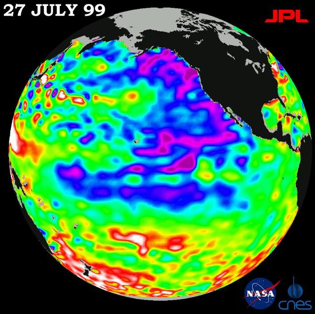
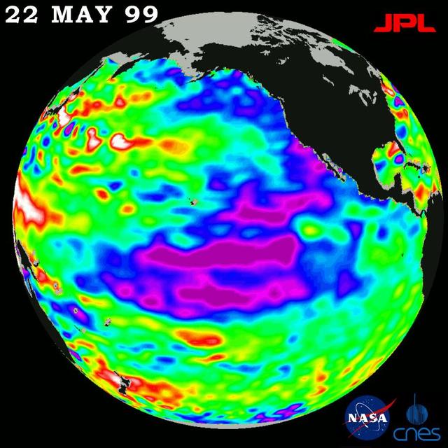
The latest remote sensing data from NASA's Jason satellite show that the equatorial Pacific sea surface levels are higher, indicating warmer sea surface temperatures in the central and west Pacific Ocean. This pattern has the appearance of La Niña rather than El Niño. This contrasts with the Bering Sea, Gulf of Alaska and U.S. West Coast where lower-than-normal sea surface levels and cool ocean temperatures continue (indicated by blue and purple areas). The image above is a global map of sea surface height, accurate to within 30 millimeters. The image represents data collected and composited over a 10-day period, ending on Jan 23, 2004. The height of the water relates to the temperature of the water. As the ocean warms, its level rises; and as it cools, its level falls. Yellow and red areas indicate where the waters are relatively warmer and have expanded above sea level, green indicates near normal sea level, and blue and purple areas show where the waters are relatively colder and the surface is lower than sea level. The blue areas are between 5 and 13 centimeters (2 and 5 inches) below normal, whereas the purple areas range from 14 to 18 centimeters (6 to 7 inches) below normal. http://photojournal.jpl.nasa.gov/catalog/PIA05071
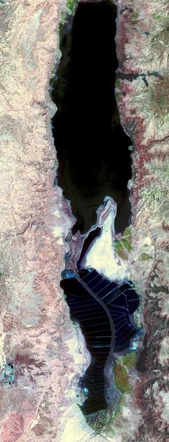
The Dead Sea is the lowest point on Earth at 418 meters below sea level, and also one of the saltiest bodies of water on Earth. This image was acquired by NASA Terra spacecraft.
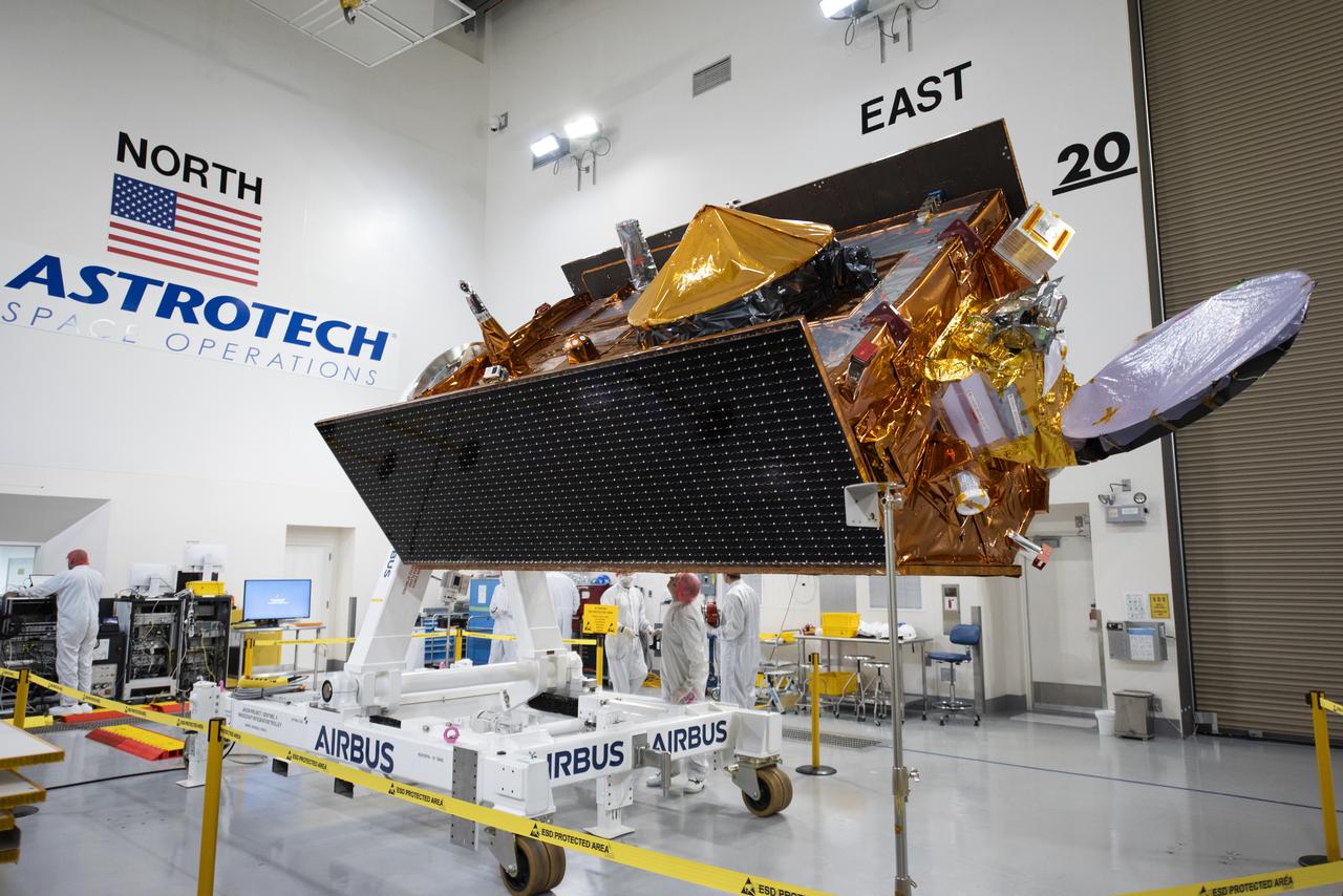
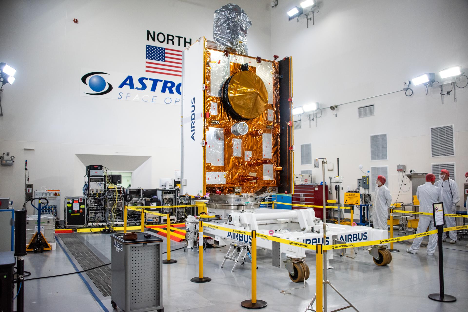
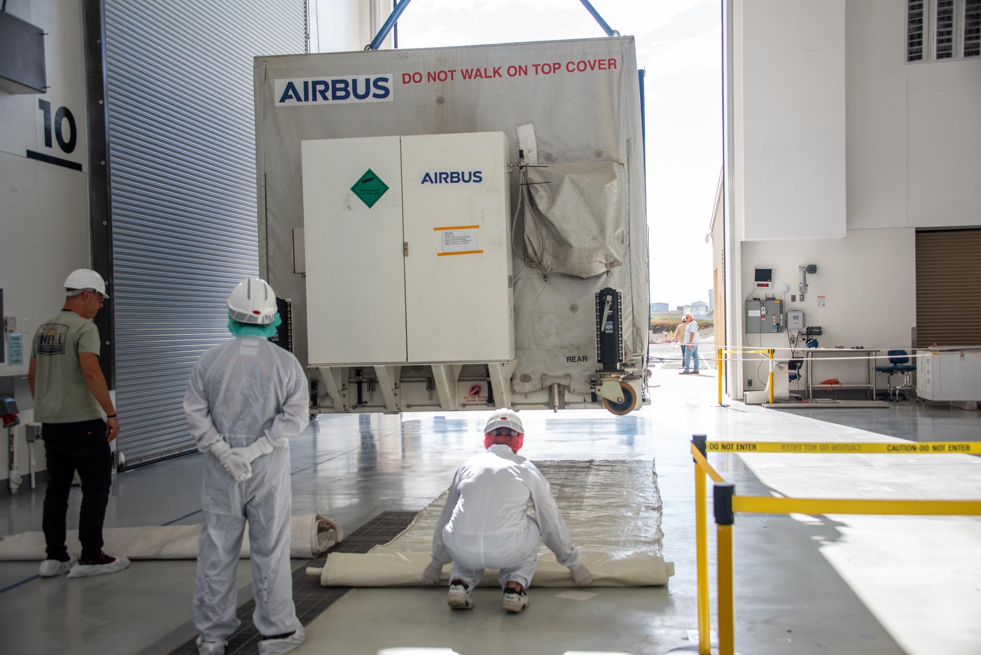
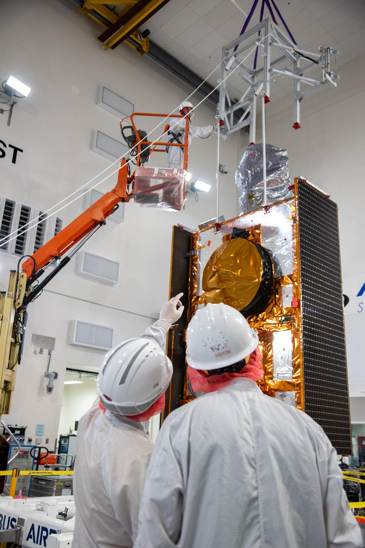
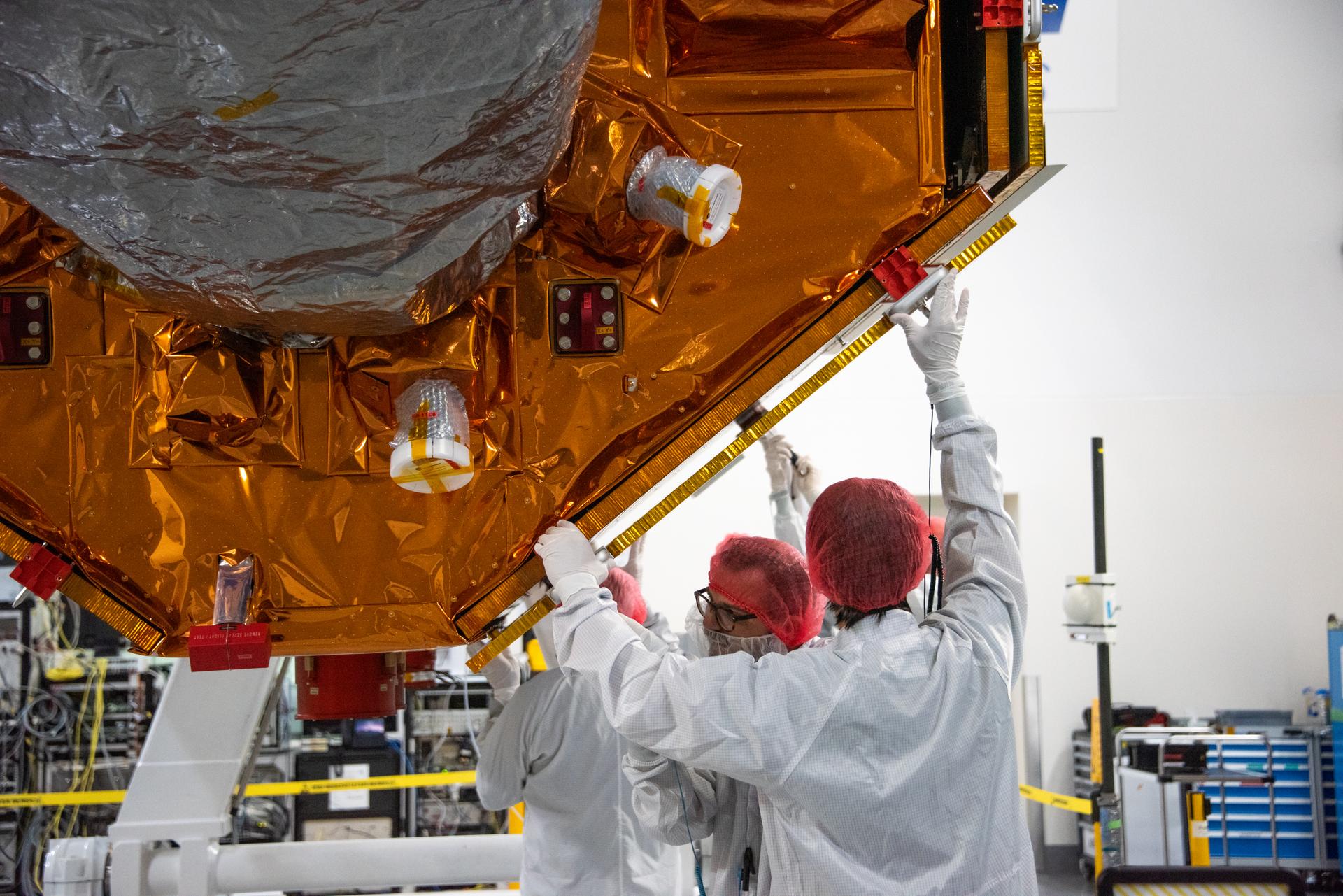
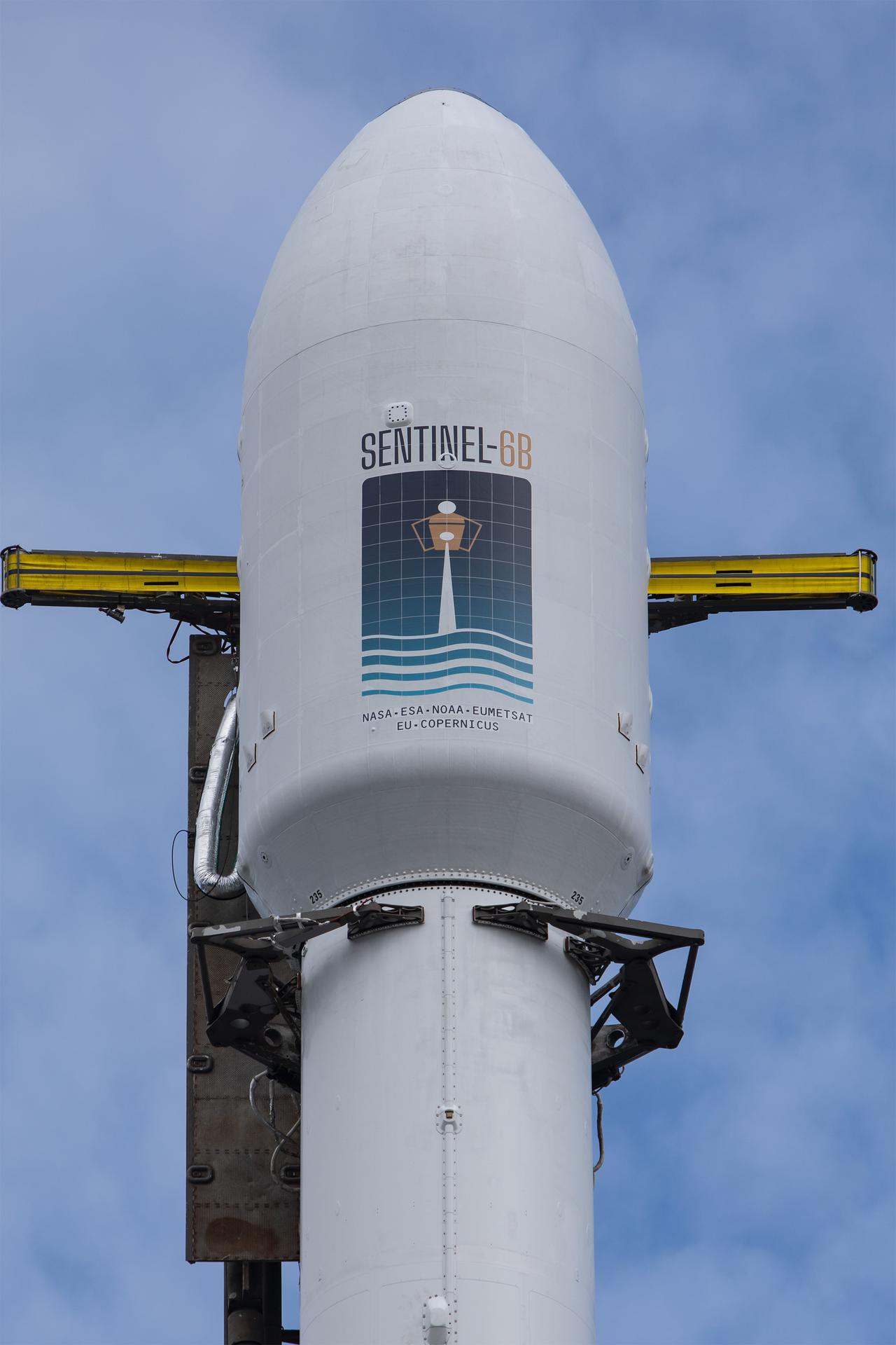
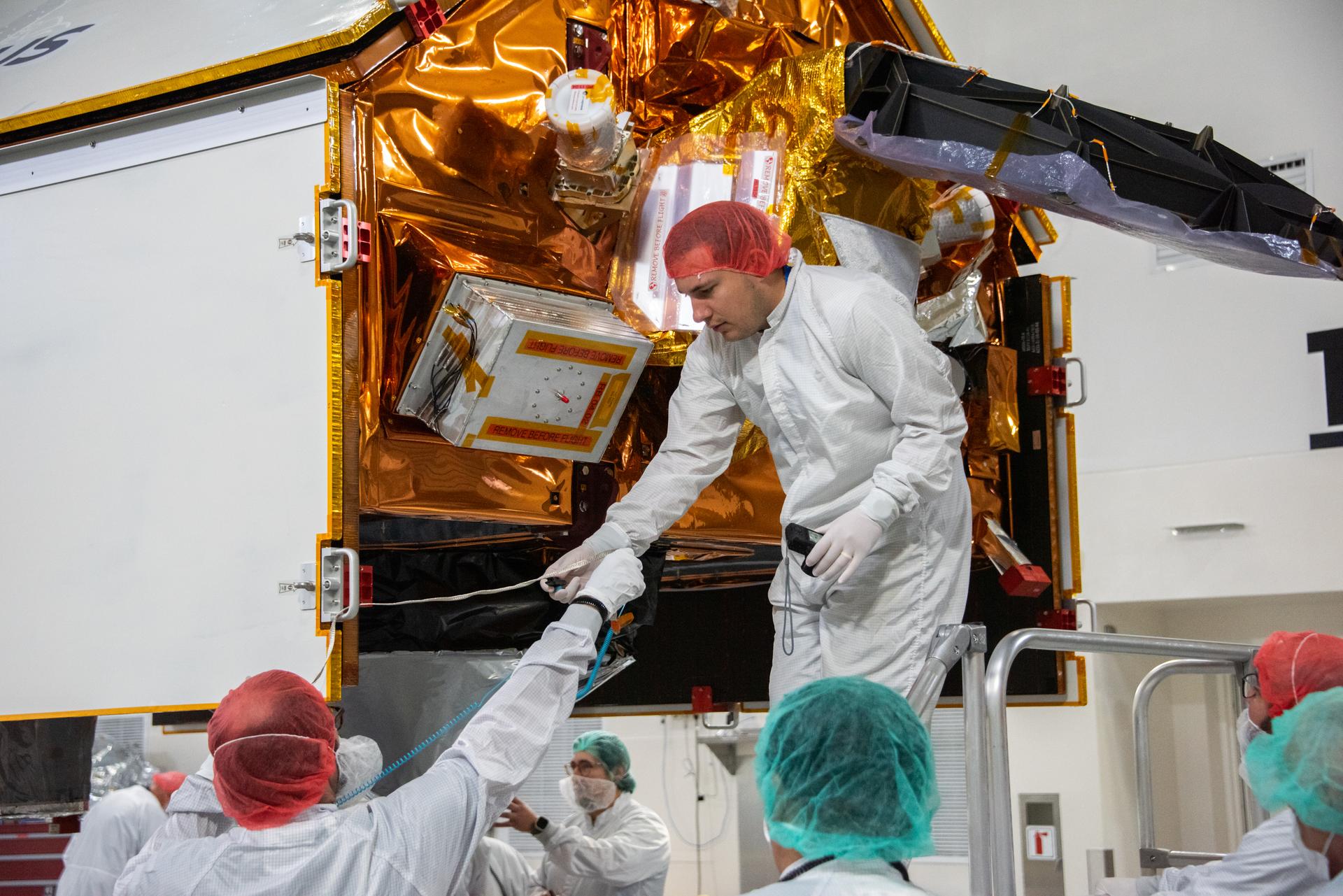
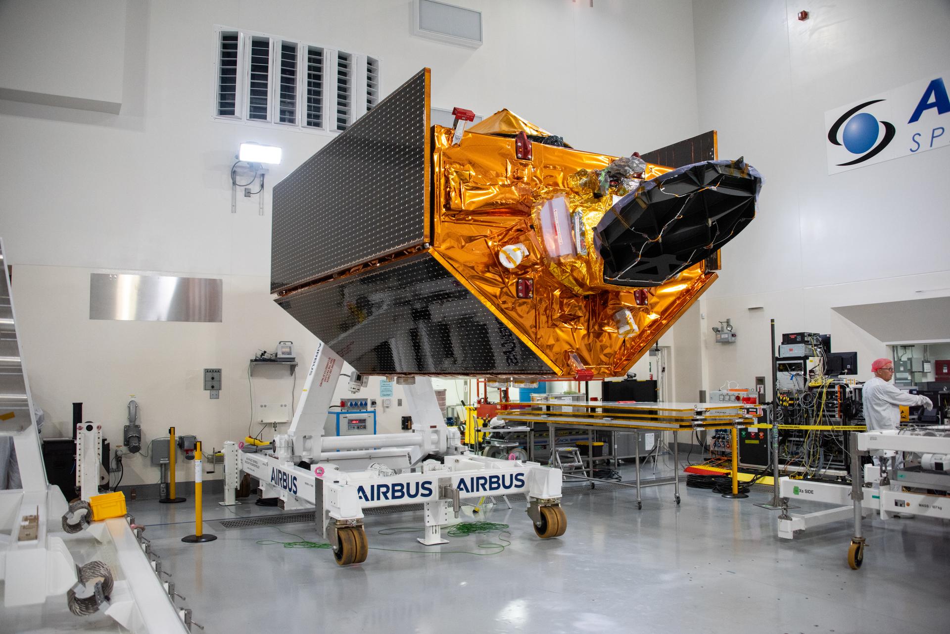
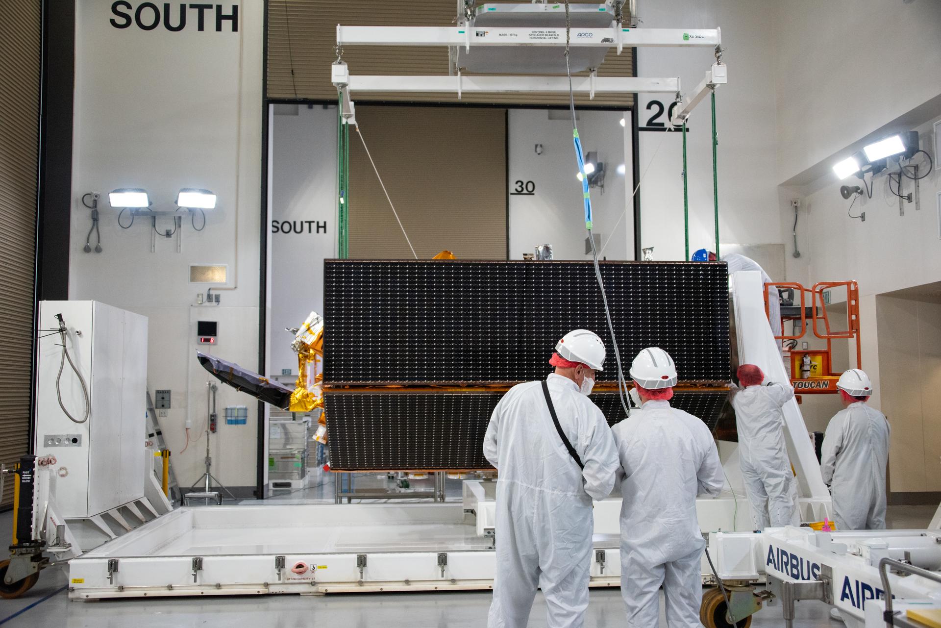
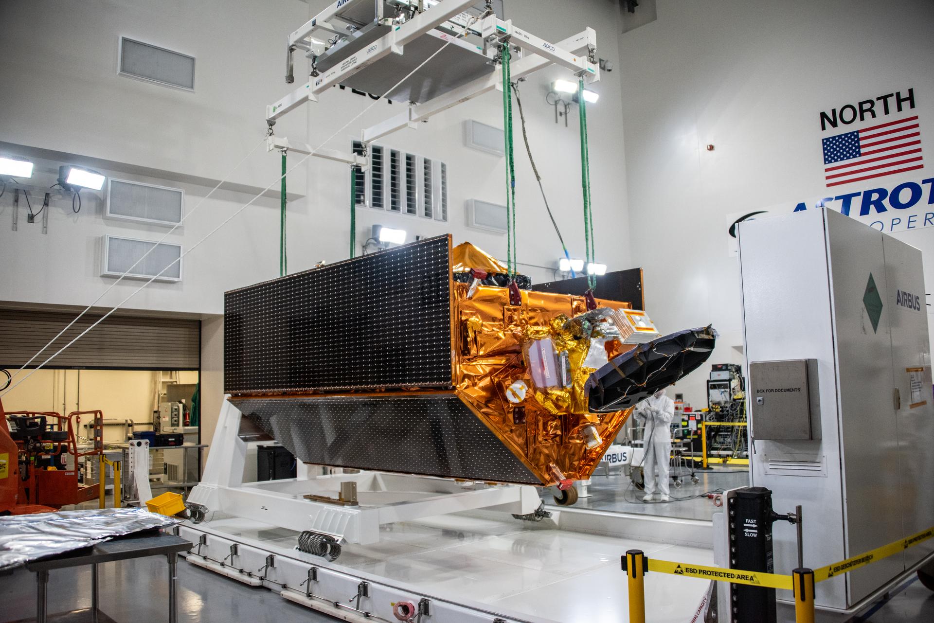
Technicians transfer the Sentinel-6B spacecraft from the NASA hangar to the Astrotech Space Operations payload processing facility at Vandenberg Space Force Base in California on Thursday, Sept. 25, 2025. Sentinel-6B will undergo detailed inspections, tests, and fueling in a cleanroom as it prepares for a November launch on a SpaceX Falcon 9 rocket. The spacecraft is designed to measure sea levels down to roughly an inch for about 90% of the world’s oceans. Sentinel-6B also will extend the record of atmospheric temperatures, begun by Sentinel-6 Michael Freilich, out to a decade.
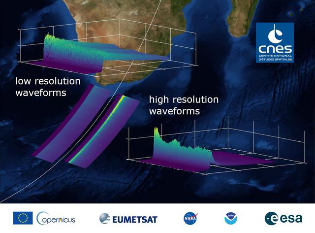
This graphic, released on Dec. 10, 2020, shows the basic radar measurements, called waveforms, collected by the instrument that monitors sea level on the Sentinel-6 Michael Freilich satellite, which launched Nov. 21, 2020. The instrument, called an altimeter, works by bouncing a radar signal off the ocean surface and measuring how long it takes to go out and return. The higher-resolution waveforms focus on a smaller area of the ocean than the lower-resolution waveforms, allowing researchers to resolve smaller ocean features such as currents closer to the coast. The waveform provides information not only on sea level, but also on wave height and wind speed. https://photojournal.jpl.nasa.gov/catalog/PIA24136
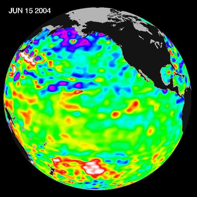
Recent sea level height data from NASA U.S./France Jason altimetric satellite during a 10-day cycle ending June 15, 2004.
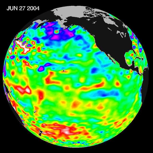
Recent sea level height data from NASA U.S./France Jason altimetric satellite during a 10-day cycle ending June 27, 2004.
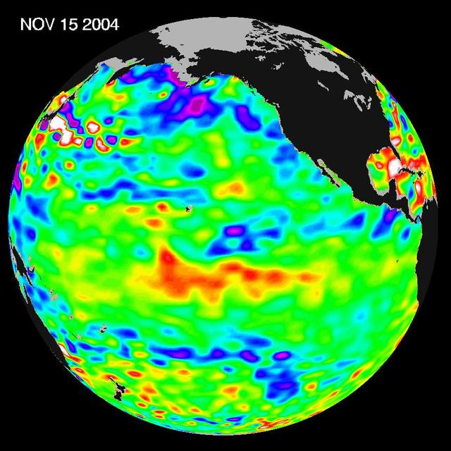
Recent sea-level height data from NASA U.S./France Jason altimetric satellite during a 10-day cycle ending November 15, 2004.
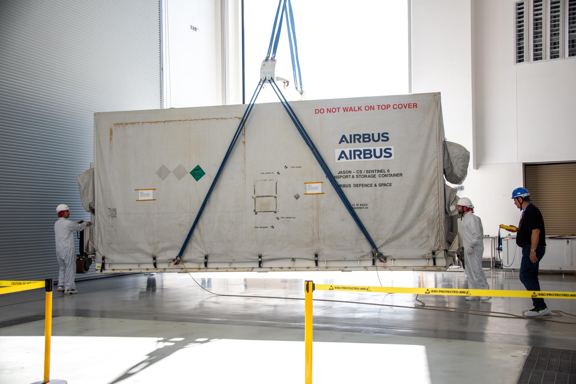
Technicians transfer the Sentinel-6B spacecraft from the NASA hangar to the Astrotech Space Operations payload processing facility at Vandenberg Space Force Base in California on Wednesday, Sept. 24, 2025. Sentinel-6B will undergo detailed inspections, tests, and fueling in a cleanroom as it prepares for a November launch on a SpaceX Falcon 9 rocket. A collaboration between NASA, ESA (European Space Agency), EUMETSAT (European Organisation for the Exploitation of Meteorological Satellites), and the National Oceanic and Atmospheric Administration (NOAA), Sentinel-6B is designed to measure sea levels down to roughly an inch for about 90% of the world’s oceans and will extend out to a decade the record of atmospheric temperatures begun by Sentinel-6 Michael Freilich.
Technicians install protective solar array covers for the Sentinel-6B spacecraft inside the Astrotech Space Operations payload processing facility at Vandenberg Space Force Base in California on Friday, Sept. 26, 2025. Sentinel-6B will undergo detailed inspections, tests, and fueling in a cleanroom as it prepares for a November launch on a SpaceX Falcon 9 rocket. A collaboration between NASA, ESA (European Space Agency), EUMETSAT (European Organisation for the Exploitation of Meteorological Satellites), and the National Oceanic and Atmospheric Administration (NOAA), Sentinel-6B is designed to measure sea levels down to roughly an inch for about 90% of the world’s oceans and will extend out to a decade the record of atmospheric temperatures begun by Sentinel-6 Michael Freilich.
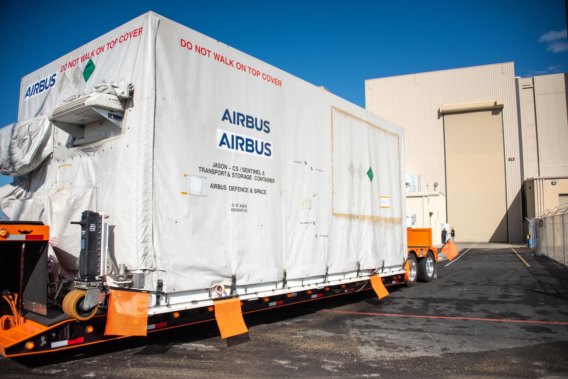
Technicians transfer the Sentinel-6B spacecraft from the NASA hangar to the Astrotech Space Operations payload processing facility at Vandenberg Space Force Base in California on Wednesday, Sept. 24, 2025. Sentinel-6B will undergo detailed inspections, tests, and fueling in a cleanroom as it prepares for a November launch on a SpaceX Falcon 9 rocket. A collaboration between NASA, ESA (European Space Agency), EUMETSAT (European Organisation for the Exploitation of Meteorological Satellites), and the National Oceanic and Atmospheric Administration (NOAA), Sentinel-6B is designed to measure sea levels down to roughly an inch for about 90% of the world’s oceans and will extend out to a decade the record of atmospheric temperatures begun by Sentinel-6 Michael Freilich.
Technicians transfer the Sentinel-6B spacecraft from the NASA hangar to the Astrotech Space Operations payload processing facility at Vandenberg Space Force Base in California on Wednesday, Sept. 24, 2025. Sentinel-6B will undergo detailed inspections, tests, and fueling in a cleanroom as it prepares for a November launch on a SpaceX Falcon 9 rocket. A collaboration between NASA, ESA (European Space Agency), EUMETSAT (European Organisation for the Exploitation of Meteorological Satellites), and the National Oceanic and Atmospheric Administration (NOAA), Sentinel-6B is designed to measure sea levels down to roughly an inch for about 90% of the world’s oceans and will extend out to a decade the record of atmospheric temperatures begun by Sentinel-6 Michael Freilich.
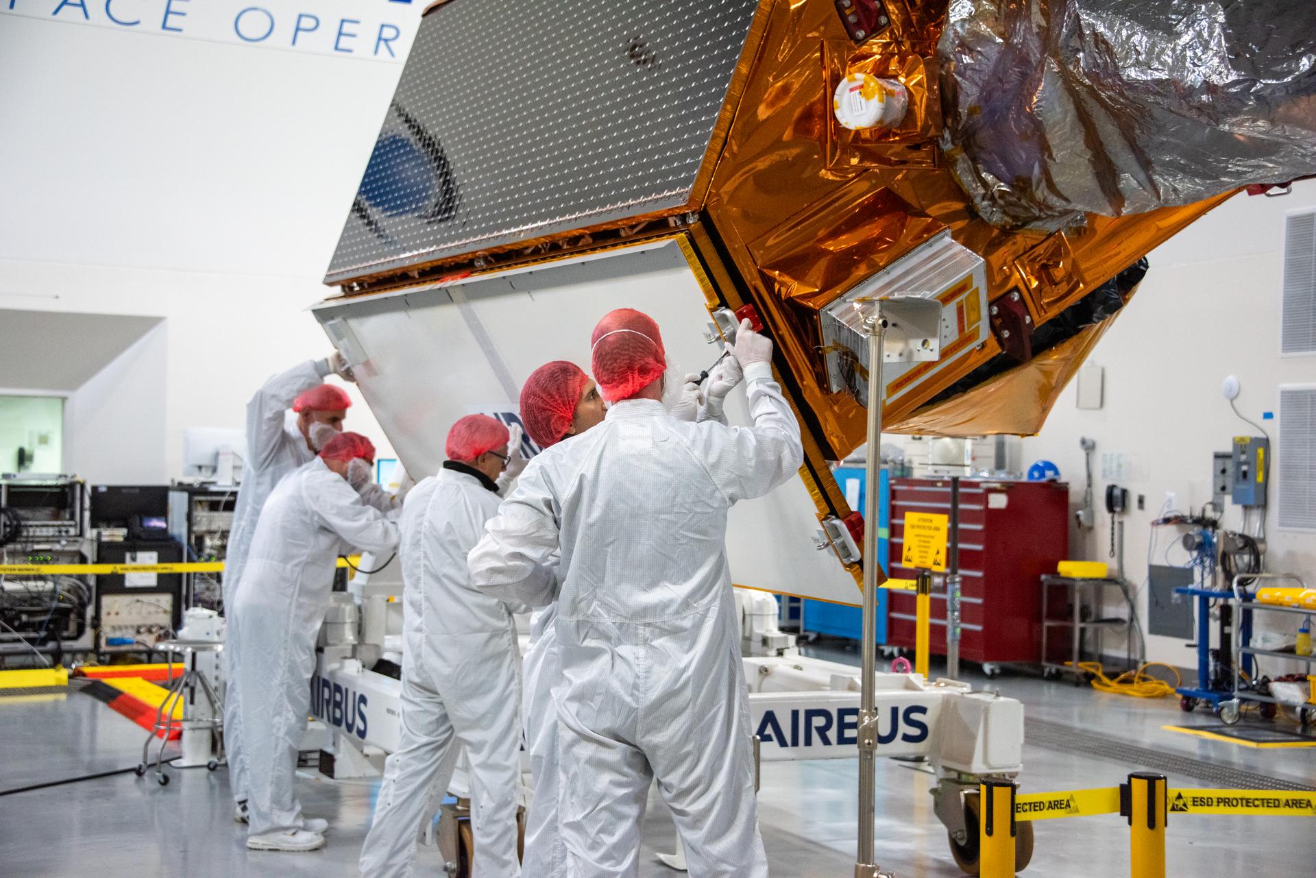
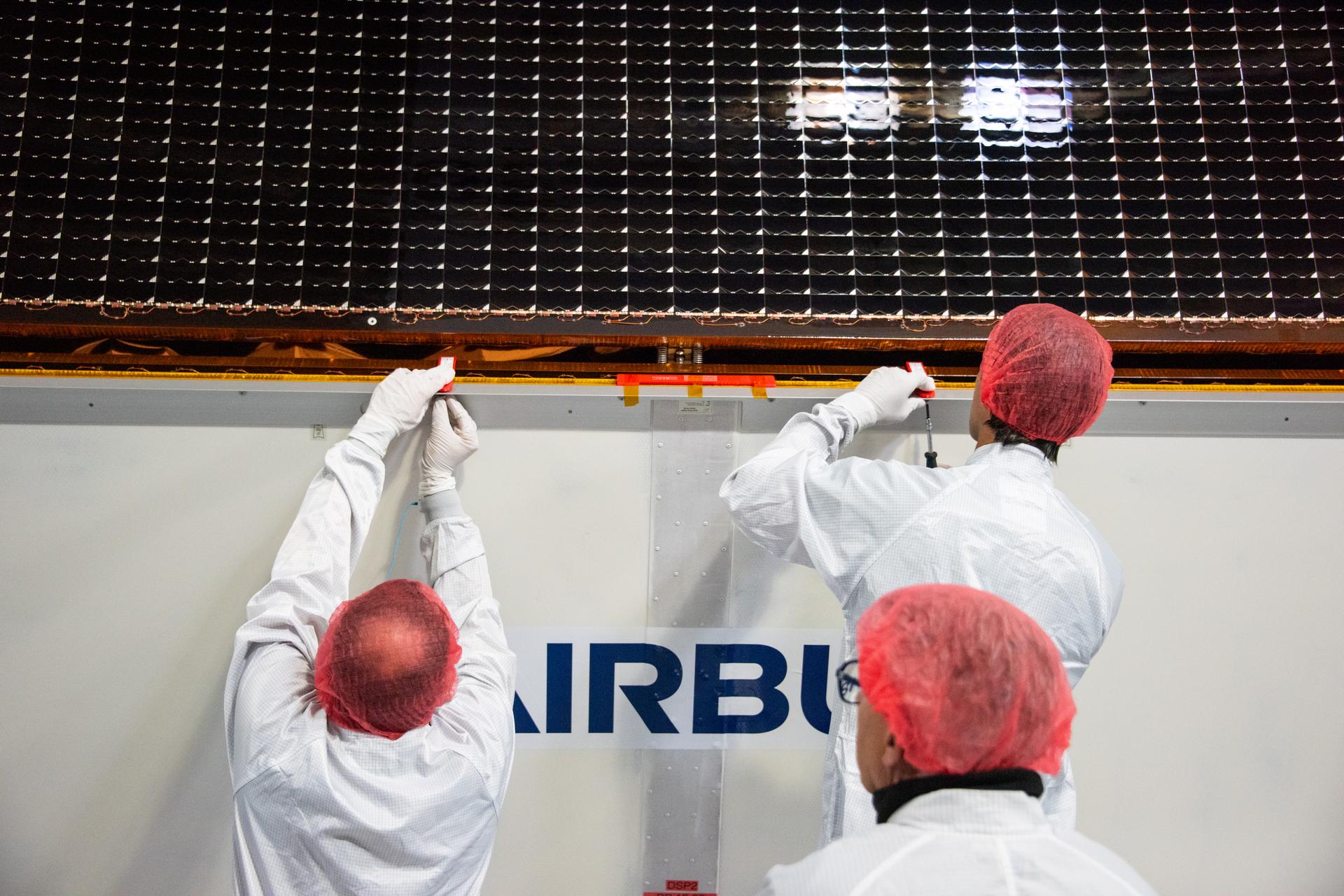
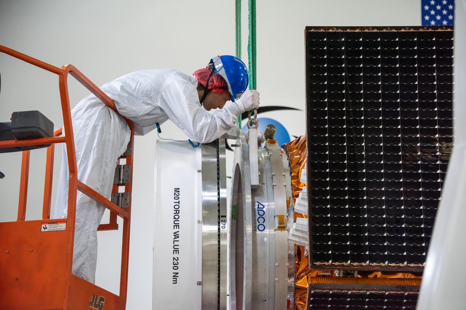
Technicians test the solar arrays during processing of the Sentinel-6B spacecraft during prelaunch operations at the Astrotech Space Operations payload processing facility at Vandenberg Space Force Base in California on Thursday, Oct. 16, 2025. Sentinel-6B will undergo detailed inspections, tests, and fueling in a cleanroom as it prepares for a November launch on a SpaceX Falcon 9 rocket. A collaboration between NASA, ESA (European Space Agency), EUMETSAT (European Organisation for the Exploitation of Meteorological Satellites), and the National Oceanic and Atmospheric Administration (NOAA), Sentinel-6B is designed to measure sea levels down to roughly an inch for about 90% of the world’s oceans.
Technicians test the solar arrays during processing of the Sentinel-6B spacecraft during prelaunch operations at the Astrotech Space Operations payload processing facility at Vandenberg Space Force Base in California on Thursday, Oct. 16, 2025. Sentinel-6B will undergo detailed inspections, tests, and fueling in a cleanroom as it prepares for a November launch on a SpaceX Falcon 9 rocket. A collaboration between NASA, ESA (European Space Agency), EUMETSAT (European Organisation for the Exploitation of Meteorological Satellites), and the National Oceanic and Atmospheric Administration (NOAA), Sentinel-6B is designed to measure sea levels down to roughly an inch for about 90% of the world’s oceans.
Technicians install protective solar array covers for the Sentinel-6B spacecraft inside the Astrotech Space Operations payload processing facility at Vandenberg Space Force Base in California on Friday, Sept. 26, 2025. Sentinel-6B will undergo detailed inspections, tests, and fueling in a cleanroom as it prepares for a November launch on a SpaceX Falcon 9 rocket. A collaboration between NASA, ESA (European Space Agency), EUMETSAT (European Organisation for the Exploitation of Meteorological Satellites), and the National Oceanic and Atmospheric Administration (NOAA), Sentinel-6B is designed to measure sea levels down to roughly an inch for about 90% of the world’s oceans and will extend out to a decade the record of atmospheric temperatures begun by Sentinel-6 Michael Freilich.
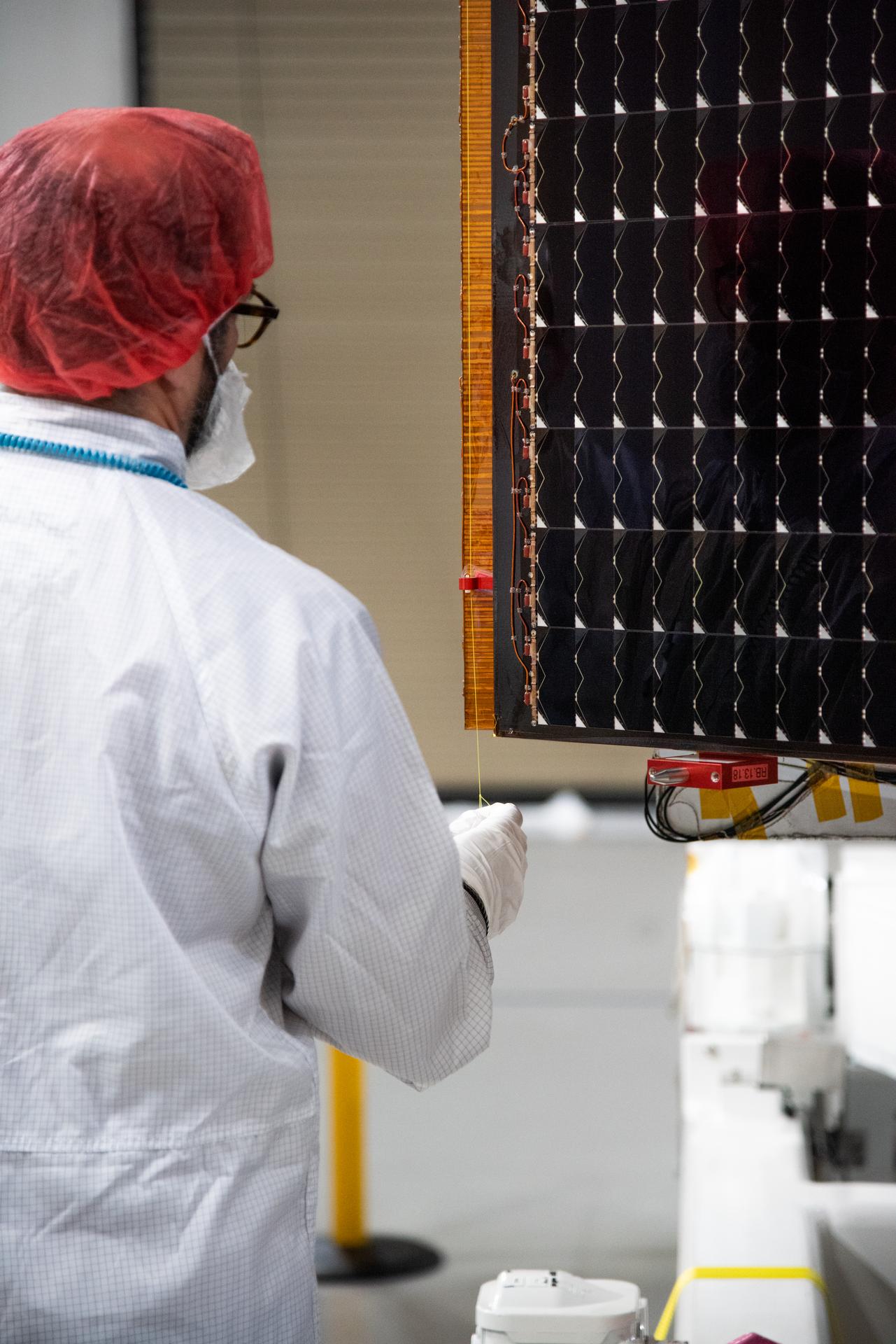
Technicians test the solar arrays during processing of the Sentinel-6B spacecraft during prelaunch operations at the Astrotech Space Operations payload processing facility at Vandenberg Space Force Base in California on Thursday, Oct. 16, 2025. Sentinel-6B will undergo detailed inspections, tests, and fueling in a cleanroom as it prepares for a November launch on a SpaceX Falcon 9 rocket. A collaboration between NASA, ESA (European Space Agency), EUMETSAT (European Organisation for the Exploitation of Meteorological Satellites), and the National Oceanic and Atmospheric Administration (NOAA), Sentinel-6B is designed to measure sea levels down to roughly an inch for about 90% of the world’s oceans.
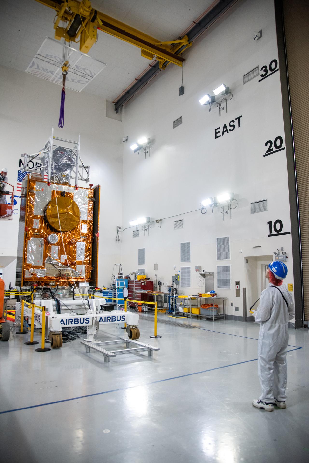
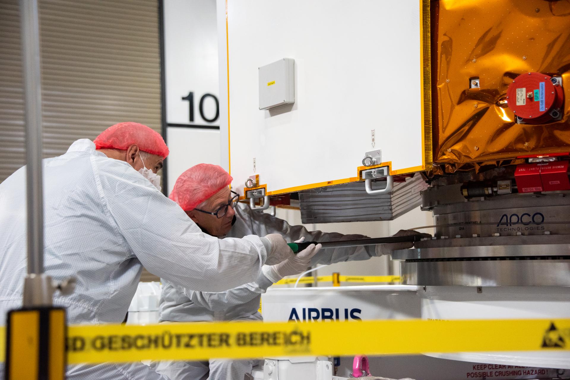
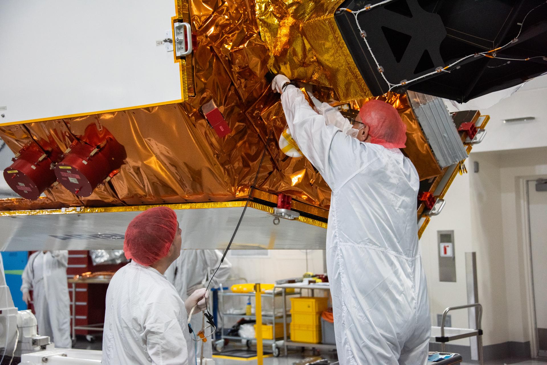
Technicians use a crane during processing of the Sentinel-6B spacecraft on its work stand during prelaunch operations at the Astrotech Space Operations payload processing facility at Vandenberg Space Force Base in California on Thursday, Oct. 16, 2025. Sentinel-6B will undergo detailed inspections, tests, and fueling in a cleanroom as it prepares for a November launch on a SpaceX Falcon 9 rocket. A collaboration between NASA, ESA (European Space Agency), EUMETSAT (European Organisation for the Exploitation of Meteorological Satellites), and the National Oceanic and Atmospheric Administration (NOAA), Sentinel-6B is designed to measure sea levels down to roughly an inch for about 90% of the world’s oceans.
Technicians test the solar arrays during processing of the Sentinel-6B spacecraft during prelaunch operations at the Astrotech Space Operations payload processing facility at Vandenberg Space Force Base in California on Thursday, Oct. 16, 2025. Sentinel-6B will undergo detailed inspections, tests, and fueling in a cleanroom as it prepares for a November launch on a SpaceX Falcon 9 rocket. A collaboration between NASA, ESA (European Space Agency), EUMETSAT (European Organisation for the Exploitation of Meteorological Satellites), and the National Oceanic and Atmospheric Administration (NOAA), Sentinel-6B is designed to measure sea levels down to roughly an inch for about 90% of the world’s oceans.
Technicians use a crane during processing of the Sentinel-6B spacecraft on its work stand during prelaunch operations at the Astrotech Space Operations payload processing facility at Vandenberg Space Force Base in California on Thursday, Oct. 16, 2025. Sentinel-6B will undergo detailed inspections, tests, and fueling in a cleanroom as it prepares for a November launch on a SpaceX Falcon 9 rocket. A collaboration between NASA, ESA (European Space Agency), EUMETSAT (European Organisation for the Exploitation of Meteorological Satellites), and the National Oceanic and Atmospheric Administration (NOAA), Sentinel-6B is designed to measure sea levels down to roughly an inch for about 90% of the world’s oceans.
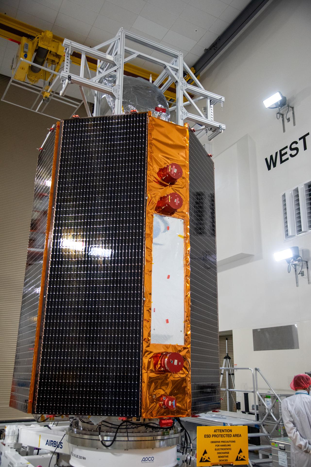
Technicians test the solar arrays during processing of the Sentinel-6B spacecraft during prelaunch operations at the Astrotech Space Operations payload processing facility at Vandenberg Space Force Base in California on Thursday, Oct. 16, 2025. Sentinel-6B will undergo detailed inspections, tests, and fueling in a cleanroom as it prepares for a November launch on a SpaceX Falcon 9 rocket. A collaboration between NASA, ESA (European Space Agency), EUMETSAT (European Organisation for the Exploitation of Meteorological Satellites), and the National Oceanic and Atmospheric Administration (NOAA), Sentinel-6B is designed to measure sea levels down to roughly an inch for about 90% of the world’s oceans.
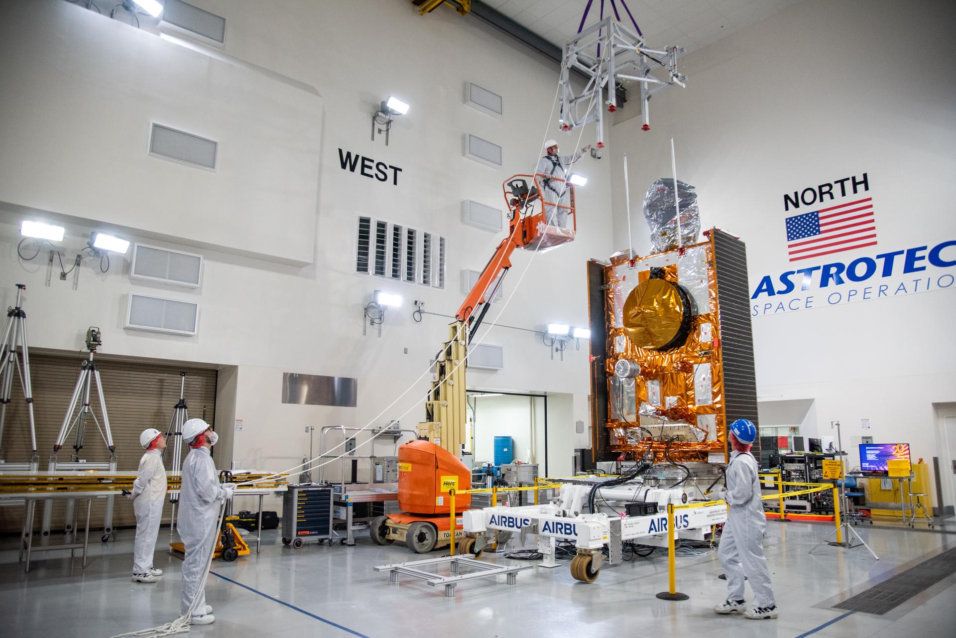
Technicians use a crane during processing of the Sentinel-6B spacecraft on its work stand during prelaunch operations at the Astrotech Space Operations payload processing facility at Vandenberg Space Force Base in California on Thursday, Oct. 16, 2025. Sentinel-6B will undergo detailed inspections, tests, and fueling in a cleanroom as it prepares for a November launch on a SpaceX Falcon 9 rocket. A collaboration between NASA, ESA (European Space Agency), EUMETSAT (European Organisation for the Exploitation of Meteorological Satellites), and the National Oceanic and Atmospheric Administration (NOAA), Sentinel-6B is designed to measure sea levels down to roughly an inch for about 90% of the world’s oceans.

Technicians install protective solar array covers for the Sentinel-6B spacecraft inside the Astrotech Space Operations payload processing facility at Vandenberg Space Force Base in California on Friday, Sept. 26, 2025. Sentinel-6B will undergo detailed inspections, tests, and fueling in a cleanroom as it prepares for a November launch on a SpaceX Falcon 9 rocket. A collaboration between NASA, ESA (European Space Agency), EUMETSAT (European Organisation for the Exploitation of Meteorological Satellites), and the National Oceanic and Atmospheric Administration (NOAA), Sentinel-6B is designed to measure sea levels down to roughly an inch for about 90% of the world’s oceans and will extend out to a decade the record of atmospheric temperatures begun by Sentinel-6 Michael Freilich.
Technicians install protective solar array covers for the Sentinel-6B spacecraft inside the Astrotech Space Operations payload processing facility at Vandenberg Space Force Base in California on Friday, Sept. 26, 2025. Sentinel-6B will undergo detailed inspections, tests, and fueling in a cleanroom as it prepares for a November launch on a SpaceX Falcon 9 rocket. A collaboration between NASA, ESA (European Space Agency), EUMETSAT (European Organisation for the Exploitation of Meteorological Satellites), and the National Oceanic and Atmospheric Administration (NOAA), Sentinel-6B is designed to measure sea levels down to roughly an inch for about 90% of the world’s oceans and will extend out to a decade the record of atmospheric temperatures begun by Sentinel-6 Michael Freilich.
Technicians use a crane during processing of the Sentinel-6B spacecraft on its work stand during prelaunch operations at the Astrotech Space Operations payload processing facility at Vandenberg Space Force Base in California on Thursday, Oct. 16, 2025. Sentinel-6B will undergo detailed inspections, tests, and fueling in a cleanroom as it prepares for a November launch on a SpaceX Falcon 9 rocket. A collaboration between NASA, ESA (European Space Agency), EUMETSAT (European Organisation for the Exploitation of Meteorological Satellites), and the National Oceanic and Atmospheric Administration (NOAA), Sentinel-6B is designed to measure sea levels down to roughly an inch for about 90% of the world’s oceans.
Technicians install protective solar array covers for the Sentinel-6B spacecraft inside the Astrotech Space Operations payload processing facility at Vandenberg Space Force Base in California on Friday, Sept. 26, 2025. Sentinel-6B will undergo detailed inspections, tests, and fueling in a cleanroom as it prepares for a November launch on a SpaceX Falcon 9 rocket. A collaboration between NASA, ESA (European Space Agency), EUMETSAT (European Organisation for the Exploitation of Meteorological Satellites), and the National Oceanic and Atmospheric Administration (NOAA), Sentinel-6B is designed to measure sea levels down to roughly an inch for about 90% of the world’s oceans and will extend out to a decade the record of atmospheric temperatures begun by Sentinel-6 Michael Freilich.
Technicians install protective solar array covers for the Sentinel-6B spacecraft inside the Astrotech Space Operations payload processing facility at Vandenberg Space Force Base in California on Friday, Sept. 26, 2025. Sentinel-6B will undergo detailed inspections, tests, and fueling in a cleanroom as it prepares for a November launch on a SpaceX Falcon 9 rocket. A collaboration between NASA, ESA (European Space Agency), EUMETSAT (European Organisation for the Exploitation of Meteorological Satellites), and the National Oceanic and Atmospheric Administration (NOAA), Sentinel-6B is designed to measure sea levels down to roughly an inch for about 90% of the world’s oceans and will extend out to a decade the record of atmospheric temperatures begun by Sentinel-6 Michael Freilich.
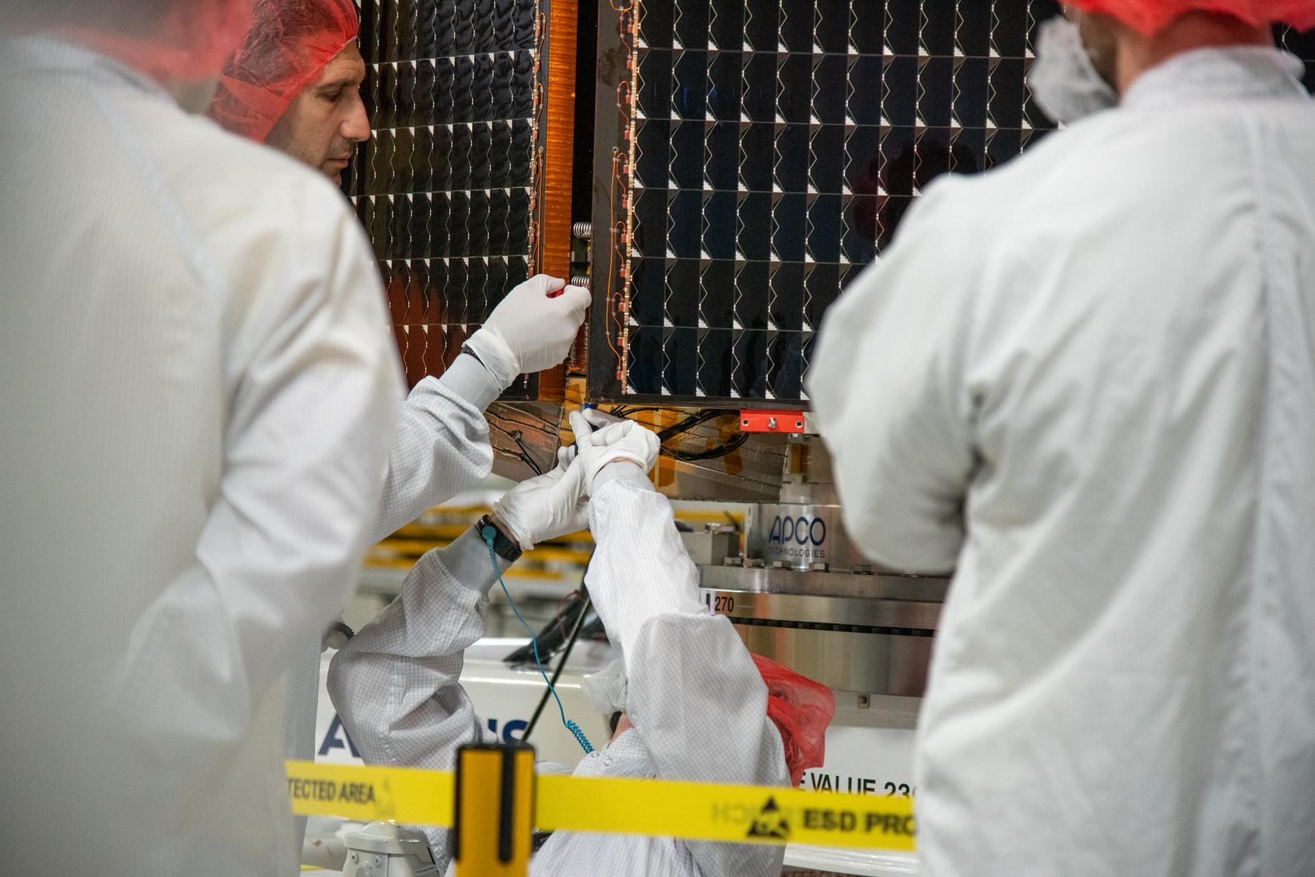
Technicians test the solar arrays during processing of the Sentinel-6B spacecraft during prelaunch operations at the Astrotech Space Operations payload processing facility at Vandenberg Space Force Base in California on Thursday, Oct. 16, 2025. Sentinel-6B will undergo detailed inspections, tests, and fueling in a cleanroom as it prepares for a November launch on a SpaceX Falcon 9 rocket. A collaboration between NASA, ESA (European Space Agency), EUMETSAT (European Organisation for the Exploitation of Meteorological Satellites), and the National Oceanic and Atmospheric Administration (NOAA), Sentinel-6B is designed to measure sea levels down to roughly an inch for about 90% of the world’s oceans.
Technicians install protective solar array covers for the Sentinel-6B spacecraft inside the Astrotech Space Operations payload processing facility at Vandenberg Space Force Base in California on Friday, Sept. 26, 2025. Sentinel-6B will undergo detailed inspections, tests, and fueling in a cleanroom as it prepares for a November launch on a SpaceX Falcon 9 rocket. A collaboration between NASA, ESA (European Space Agency), EUMETSAT (European Organisation for the Exploitation of Meteorological Satellites), and the National Oceanic and Atmospheric Administration (NOAA), Sentinel-6B is designed to measure sea levels down to roughly an inch for about 90% of the world’s oceans and will extend out to a decade the record of atmospheric temperatures begun by Sentinel-6 Michael Freilich.
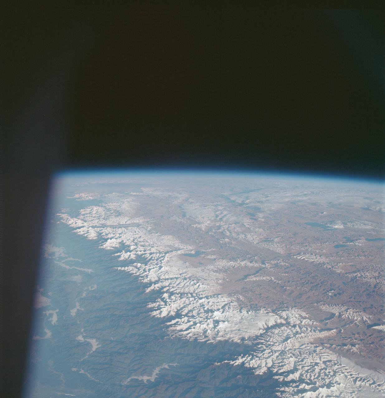
AS7-07-1748 (15 Oct. 1968) --- The world's dozen peaks which reach a height of greater than five miles above sea level are seen in this photograph from the Apollo 7 spacecraft at an altitude of approximately 130 nautical miles. The 29,028 ft. high Mount Everest is at lower center. On the central horizon can be seen the 28,250 ft. high Mount Godwin-Austen (K-2) some 800 miles northwest of Mount Everest. In the lower right, Mount Kanchenjunga rises 28,208 ft. to separate Nepal from Sikkim. The snow line on the peaks was at 17,500 ft. In the upper right the lake-studded highlands of Tibet are visible.
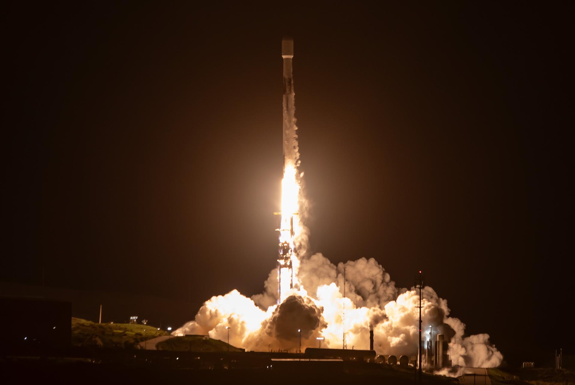
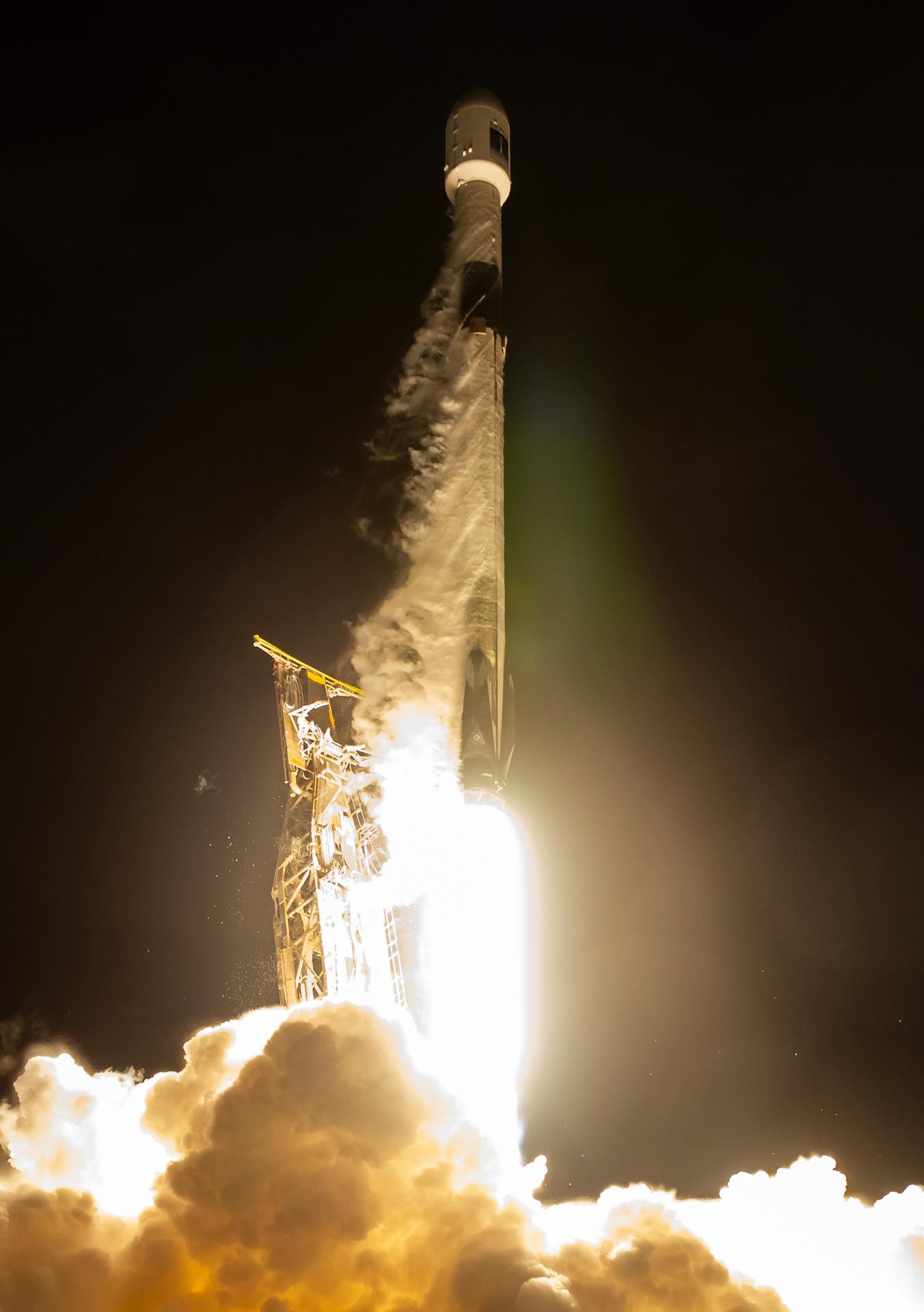
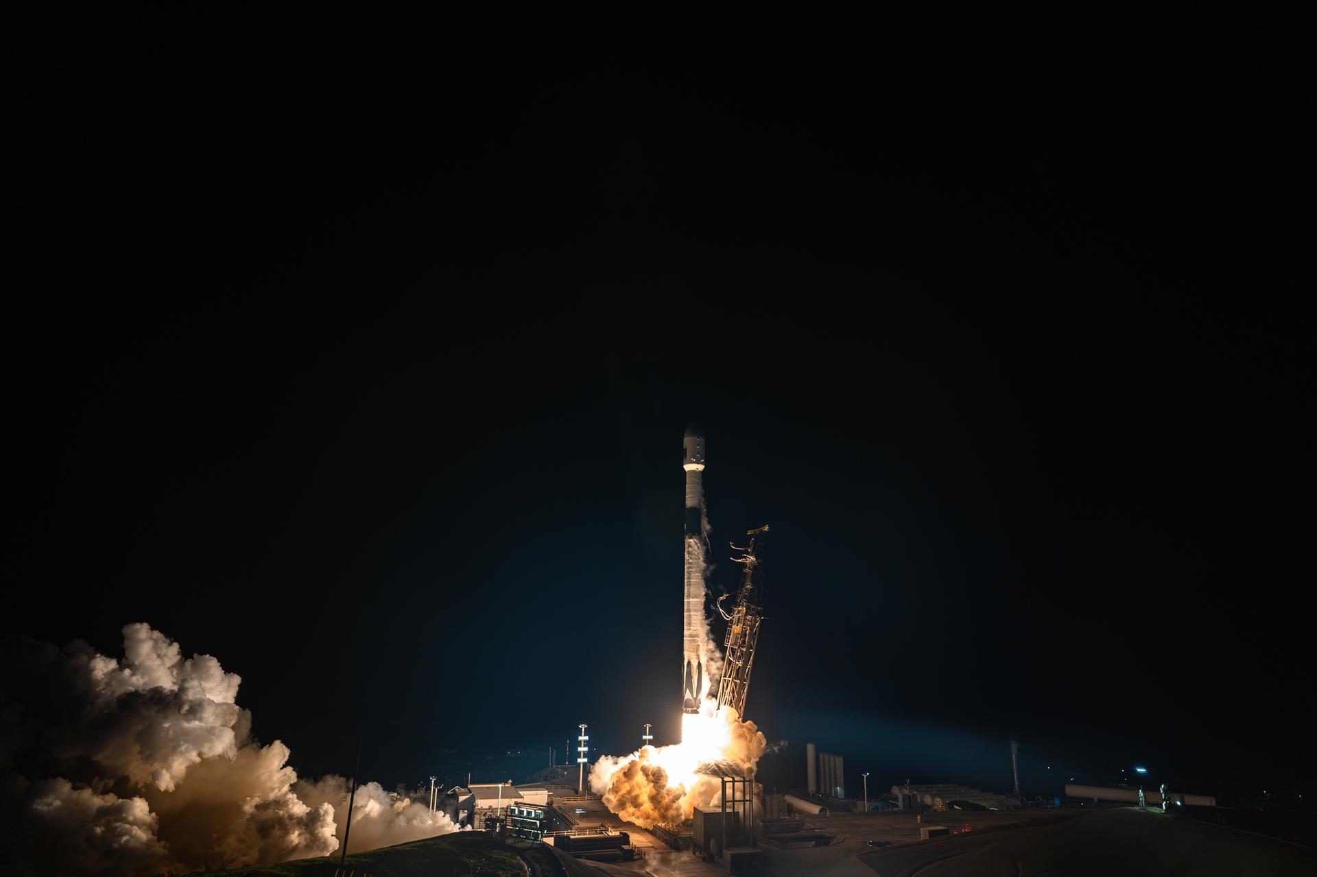
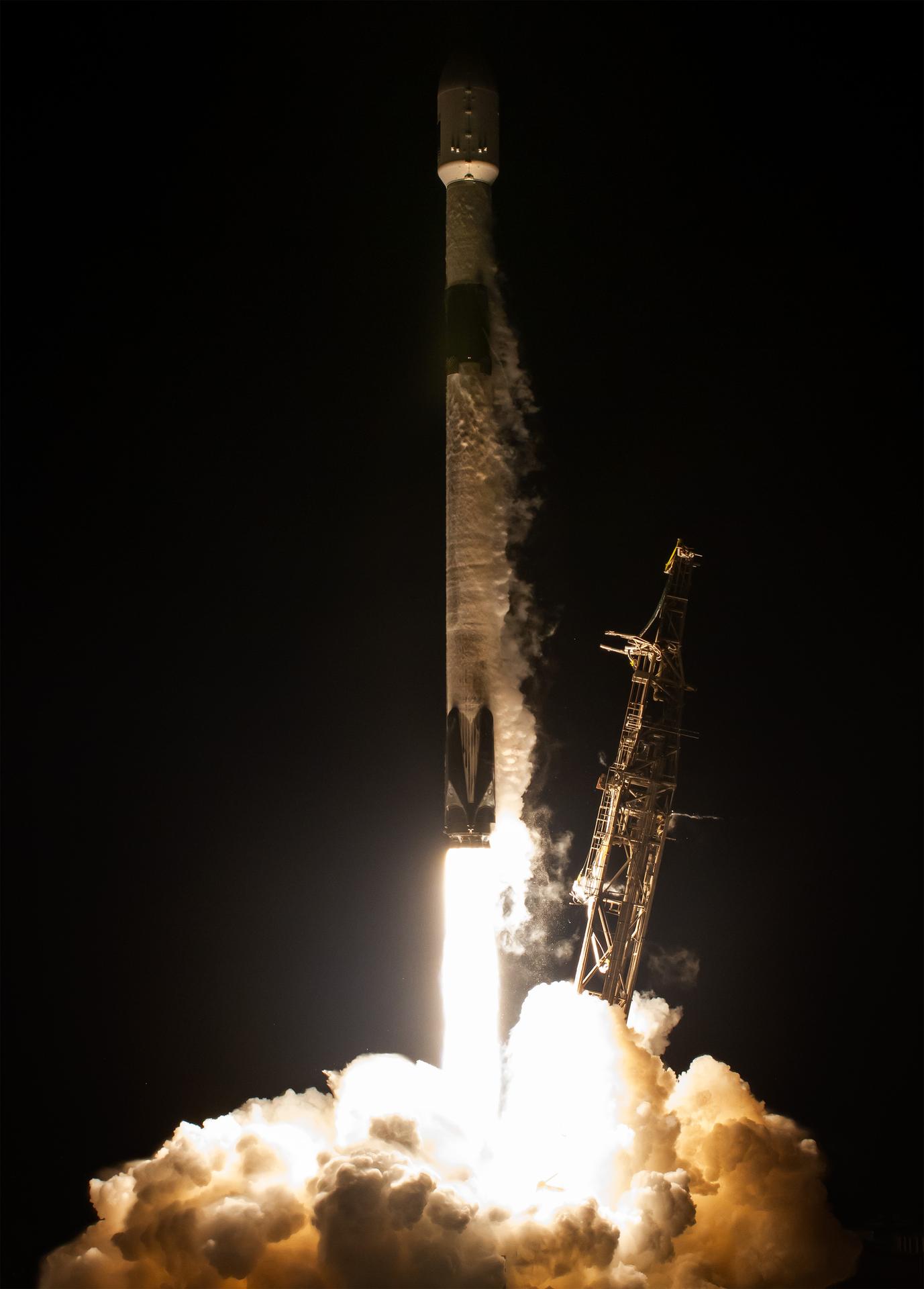
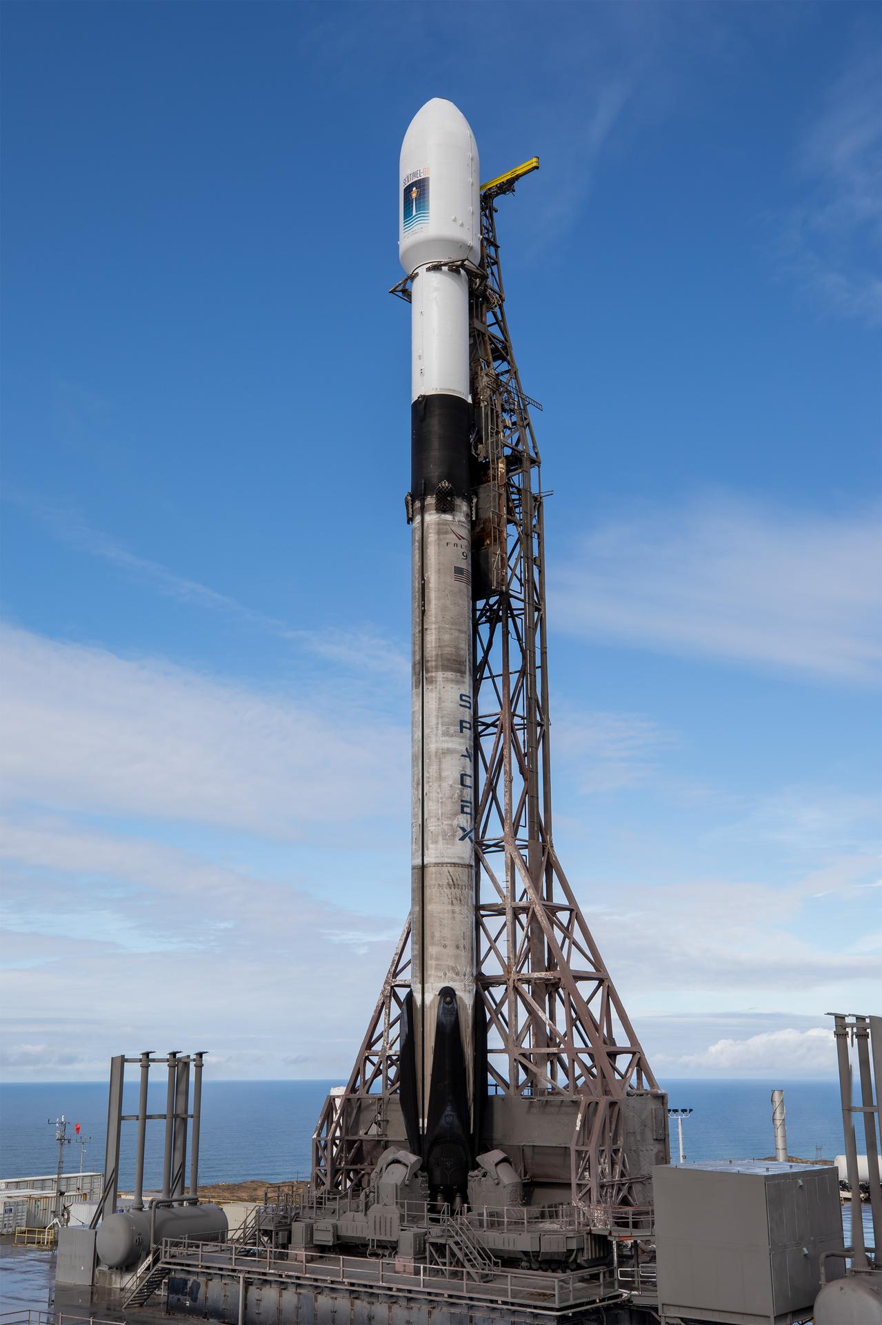
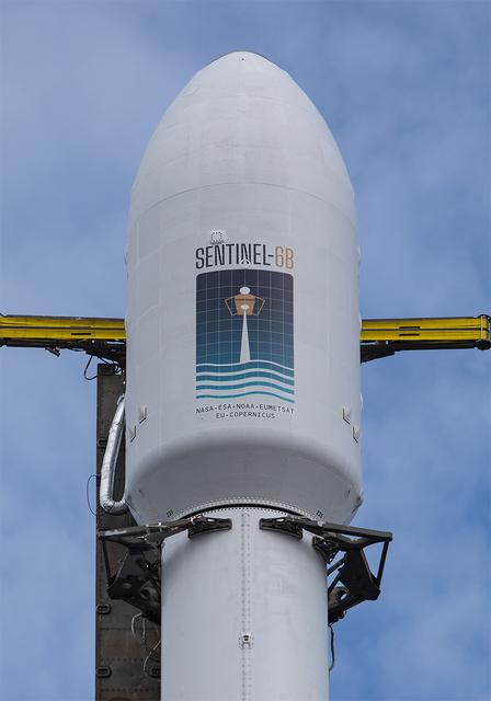
A SpaceX Falcon 9 rocket carrying the international Sentinel-6B spacecraft lifts off from Space Launch Complex 4 East at Vandenberg Space Force Base in California at 9:21 p.m. PST Sunday, Nov. 16, 2025. A collaboration between NASA, ESA (European Space Agency), EUMETSAT (European Organisation for the Exploitation of Meteorological Satellites), and the National Oceanic and Atmospheric Administration (NOAA), Sentinel-6B is designed to measure sea levels down to roughly an inch for about 90% of the world’s oceans.
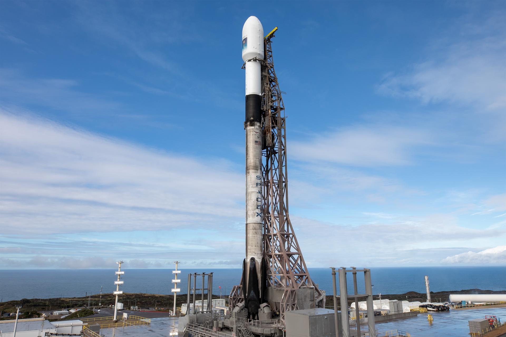
A SpaceX rocket carrying the Sentinel-6B satellite stands vertical on the launch pad at Space Launch Complex 4 East at Vandenberg Space Force Base in California on Sunday, Nov. 16, 2025, ahead of launch targeted for no earlier than 9:21 p.m. PST. A collaboration between NASA, ESA (European Space Agency), EUMETSAT (European Organisation for the Exploitation of Meteorological Satellites), and the National Oceanic and Atmospheric Administration (NOAA), Sentinel-6B is designed to measure sea levels down to roughly an inch for about 90% of the world’s oceans.
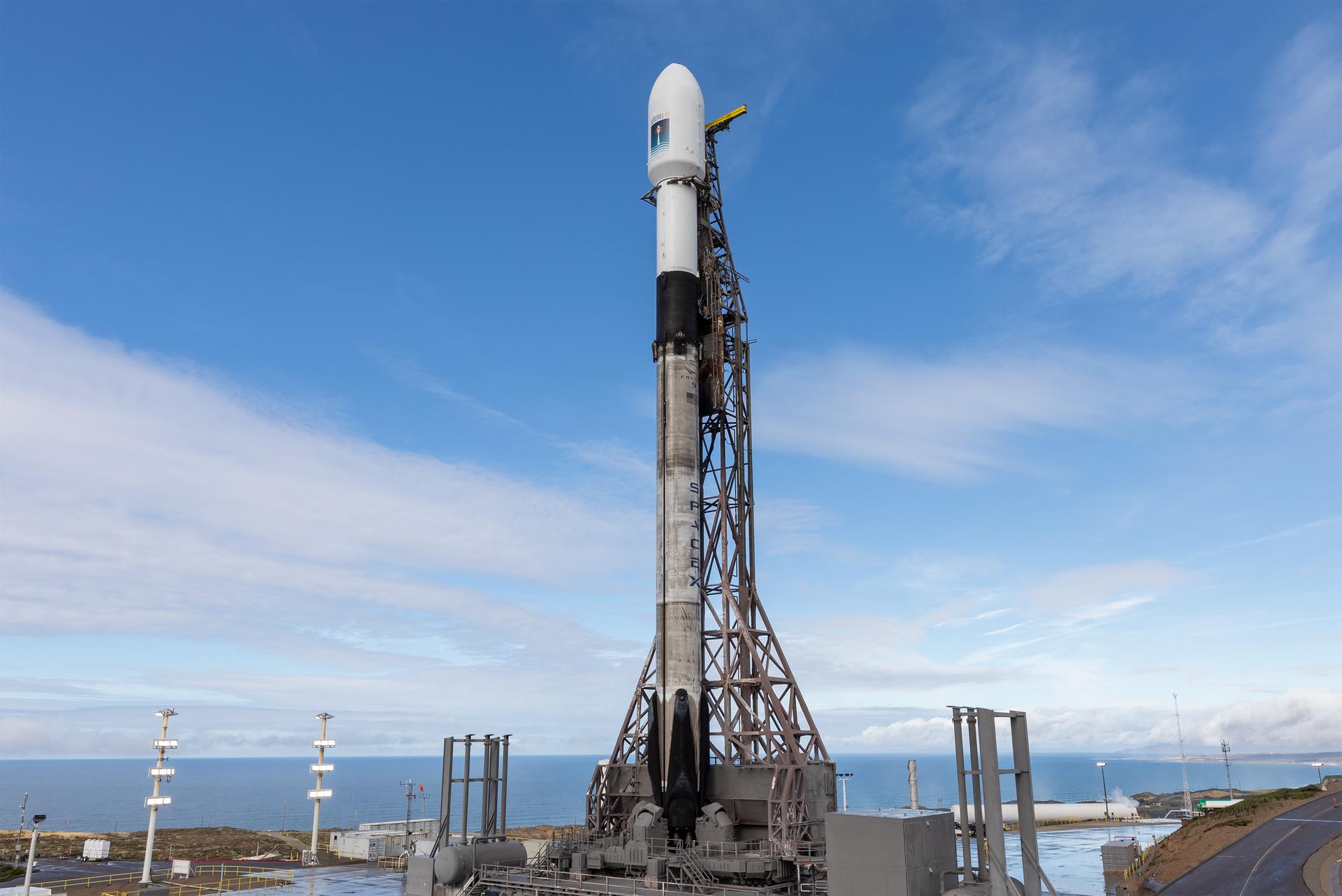
A SpaceX rocket carrying the Sentinel-6B satellite stands vertical on the launch pad at Space Launch Complex 4 East at Vandenberg Space Force Base in California on Sunday, Nov. 16, 2025, ahead of launch targeted for no earlier than 9:21 p.m. PST. A collaboration between NASA, ESA (European Space Agency), EUMETSAT (European Organisation for the Exploitation of Meteorological Satellites), and the National Oceanic and Atmospheric Administration (NOAA), Sentinel-6B is designed to measure sea levels down to roughly an inch for about 90% of the world’s oceans.
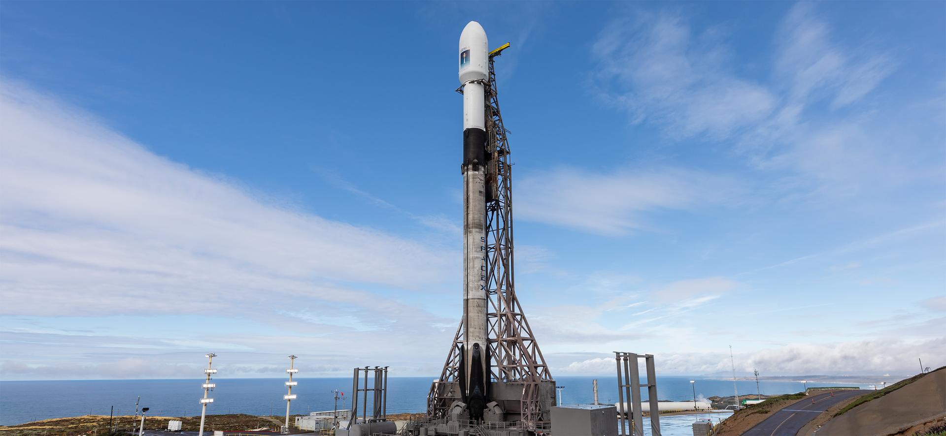
A SpaceX rocket carrying the Sentinel-6B satellite stands vertical on the launch pad at Space Launch Complex 4 East at Vandenberg Space Force Base in California on Sunday, Nov. 16, 2025, ahead of launch targeted for no earlier than 9:21 p.m. PST. A collaboration between NASA, ESA (European Space Agency), EUMETSAT (European Organisation for the Exploitation of Meteorological Satellites), and the National Oceanic and Atmospheric Administration (NOAA), Sentinel-6B is designed to measure sea levels down to roughly an inch for about 90% of the world’s oceans.
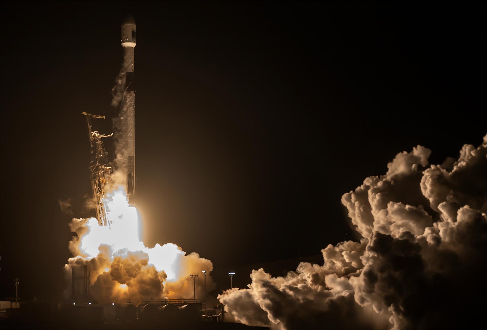
A SpaceX Falcon 9 rocket carrying the international Sentinel-6B spacecraft lifts off from Space Launch Complex 4 East at Vandenberg Space Force Base in California at 9:21 p.m. PST Sunday, Nov. 16, 2025. A collaboration between NASA, ESA (European Space Agency), EUMETSAT (European Organisation for the Exploitation of Meteorological Satellites), and the National Oceanic and Atmospheric Administration (NOAA), Sentinel-6B is designed to measure sea levels down to roughly an inch for about 90% of the world’s oceans.
A SpaceX rocket carrying the Sentinel-6B satellite stands vertical on the launch pad at Space Launch Complex 4 East at Vandenberg Space Force Base in California on Sunday, Nov. 16, 2025, ahead of launch targeted for no earlier than 9:21 p.m. PST. A collaboration between NASA, ESA (European Space Agency), EUMETSAT (European Organisation for the Exploitation of Meteorological Satellites), and the National Oceanic and Atmospheric Administration (NOAA), Sentinel-6B is designed to measure sea levels down to roughly an inch for about 90% of the world’s oceans.
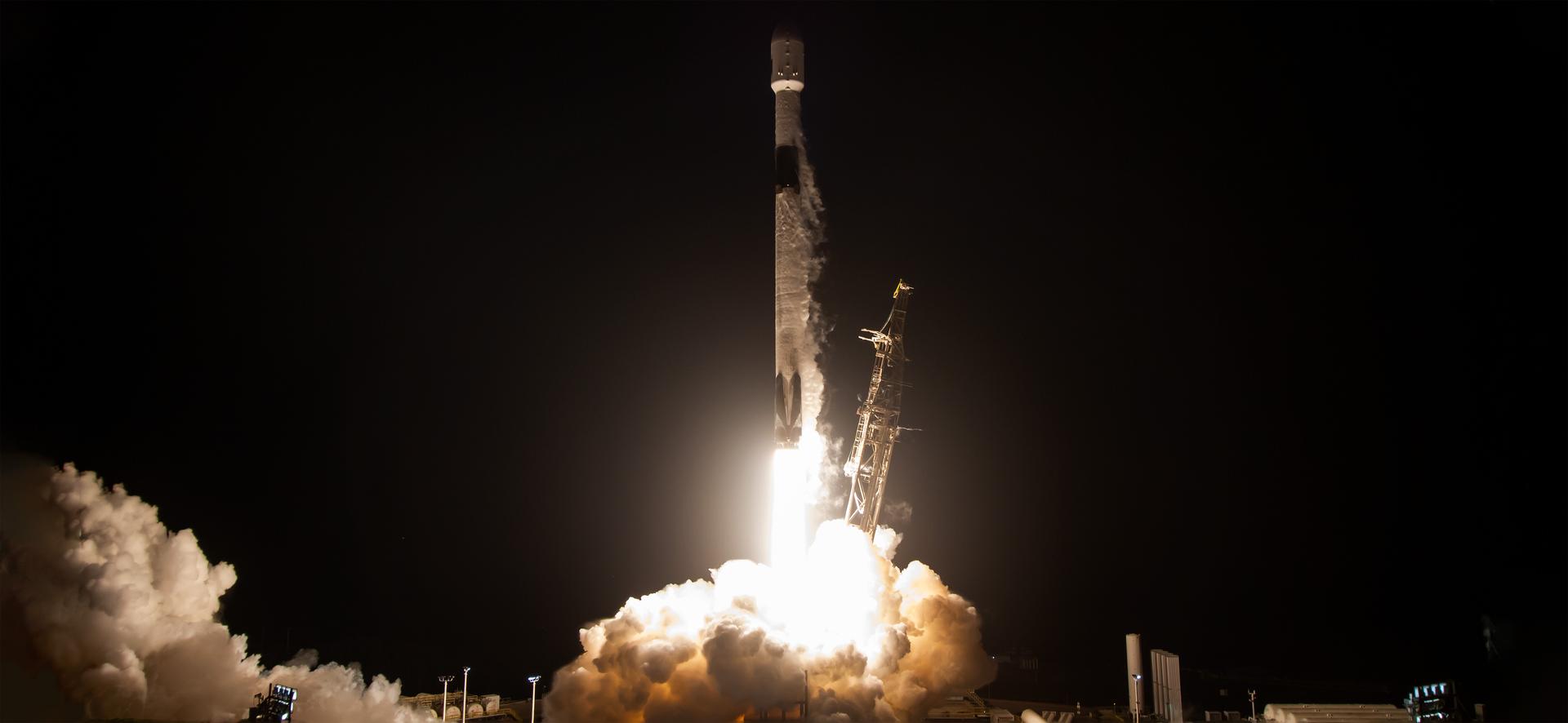
A SpaceX Falcon 9 rocket carrying the international Sentinel-6B spacecraft lifts off from Space Launch Complex 4 East at Vandenberg Space Force Base in California at 9:21 p.m. PST Sunday, Nov. 16, 2025. A collaboration between NASA, ESA (European Space Agency), EUMETSAT (European Organisation for the Exploitation of Meteorological Satellites), and the National Oceanic and Atmospheric Administration (NOAA), Sentinel-6B is designed to measure sea levels down to roughly an inch for about 90% of the world’s oceans.
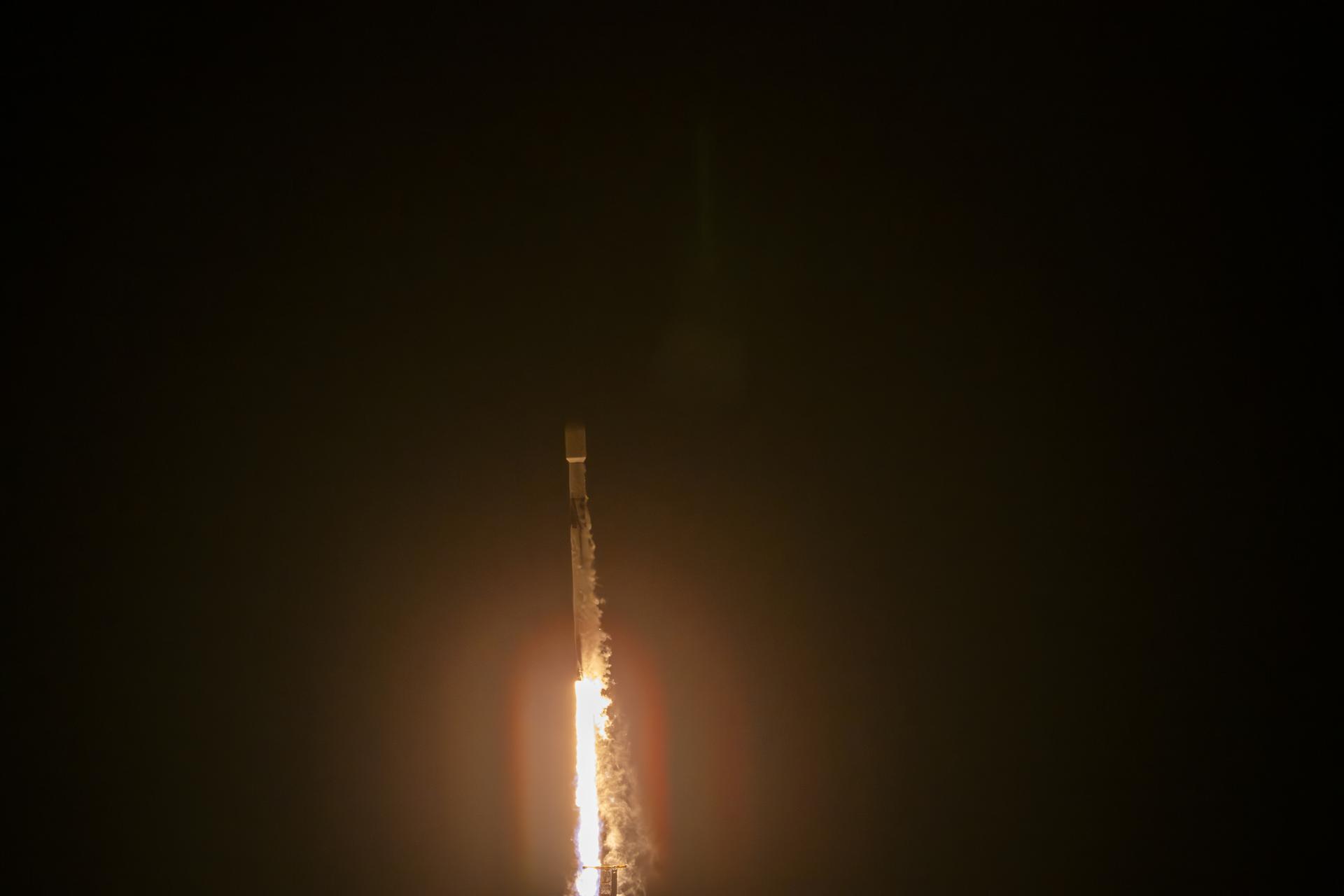
A SpaceX Falcon 9 rocket carrying the international Sentinel-6B spacecraft lifts off from Space Launch Complex 4 East at Vandenberg Space Force Base in California on Sunday, Nov. 16, 2025. A collaboration between NASA, ESA (European Space Agency), EUMETSAT (European Organisation for the Exploitation of Meteorological Satellites), and the National Oceanic and Atmospheric Administration (NOAA), Sentinel-6B is designed to measure sea levels down to roughly an inch for about 90% of the world’s oceans.
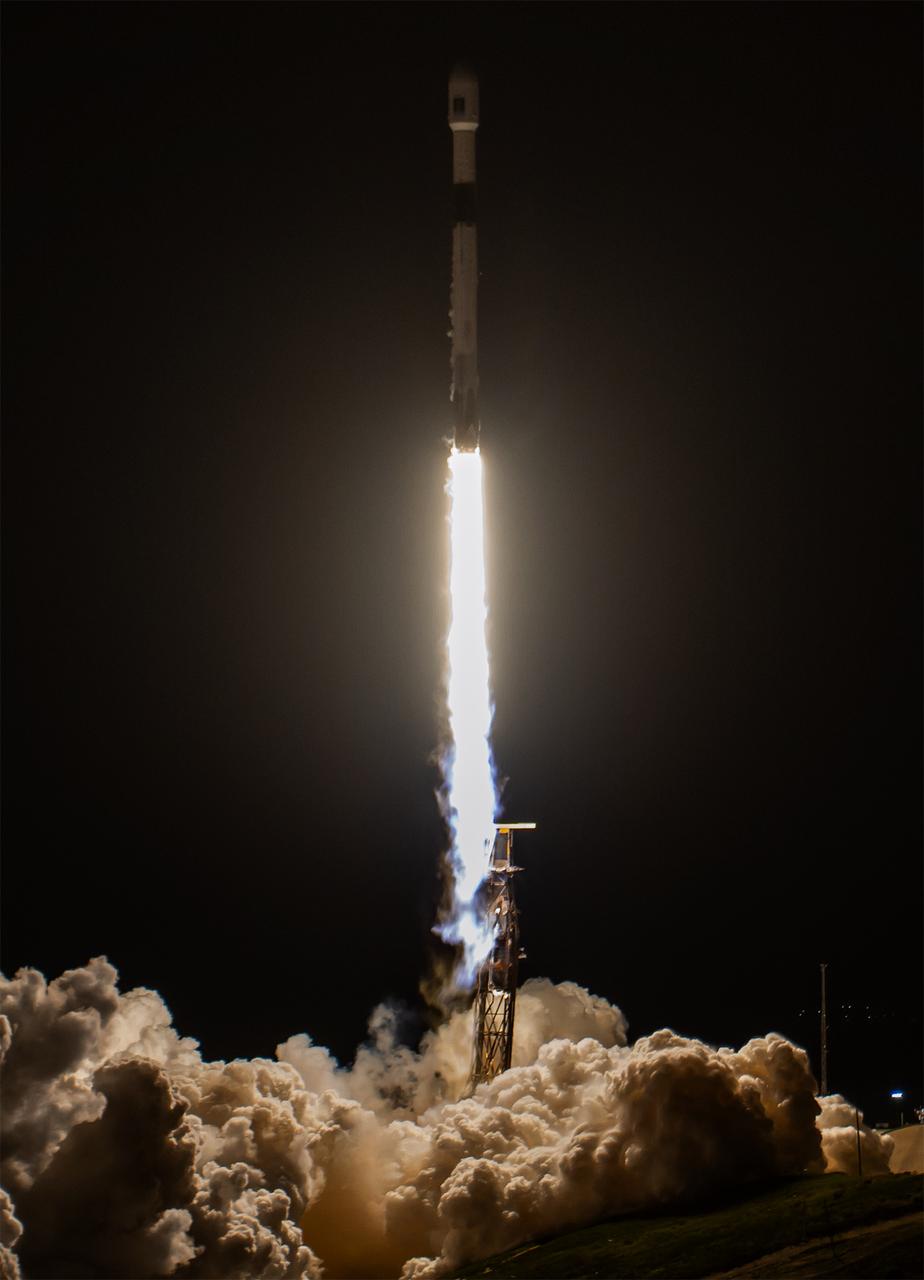
A SpaceX Falcon 9 rocket carrying the international Sentinel-6B spacecraft lifts off from Space Launch Complex 4 East at Vandenberg Space Force Base in California at 9:21 p.m. PST Sunday, Nov. 16, 2025. A collaboration between NASA, ESA (European Space Agency), EUMETSAT (European Organisation for the Exploitation of Meteorological Satellites), and the National Oceanic and Atmospheric Administration (NOAA), Sentinel-6B is designed to measure sea levels down to roughly an inch for about 90% of the world’s oceans.
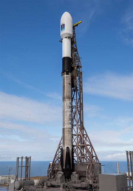
A SpaceX rocket carrying the Sentinel-6B satellite stands vertical on the launch pad at Space Launch Complex 4 East at Vandenberg Space Force Base in California on Sunday, Nov. 16, 2025, ahead of launch targeted for no earlier than 9:21 p.m. PST. A collaboration between NASA, ESA (European Space Agency), EUMETSAT (European Organisation for the Exploitation of Meteorological Satellites), and the National Oceanic and Atmospheric Administration (NOAA), Sentinel-6B is designed to measure sea levels down to roughly an inch for about 90% of the world’s oceans.

A SpaceX Falcon 9 rocket carrying the international Sentinel-6B spacecraft lifts off from Space Launch Complex 4 East at Vandenberg Space Force Base in California on Sunday, Nov. 16, 2025. A collaboration between NASA, ESA (European Space Agency), EUMETSAT (European Organisation for the Exploitation of Meteorological Satellites), and the National Oceanic and Atmospheric Administration (NOAA), Sentinel-6B is designed to measure sea levels down to roughly an inch for about 90% of the world’s oceans.
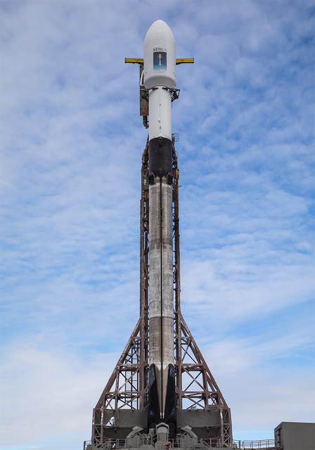
A SpaceX rocket carrying the Sentinel-6B satellite stands vertical on the launch pad at Space Launch Complex 4 East at Vandenberg Space Force Base in California on Sunday, Nov. 16, 2025, ahead of launch targeted for no earlier than 9:21 p.m. PST. A collaboration between NASA, ESA (European Space Agency), EUMETSAT (European Organisation for the Exploitation of Meteorological Satellites), and the National Oceanic and Atmospheric Administration (NOAA), Sentinel-6B is designed to measure sea levels down to roughly an inch for about 90% of the world’s oceans.
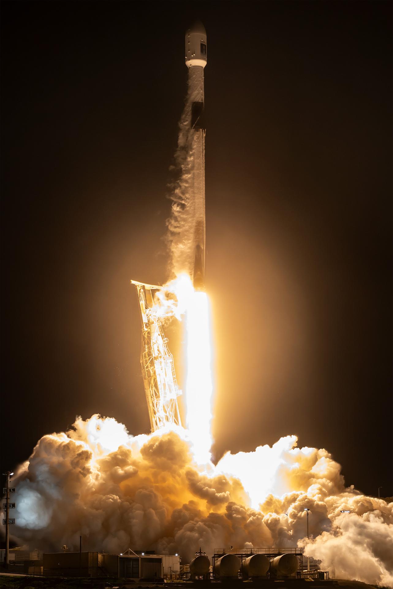
A SpaceX Falcon 9 rocket carrying the international Sentinel-6B spacecraft lifts off from Space Launch Complex 4 East at Vandenberg Space Force Base in California at 9:21 p.m. PST Sunday, Nov. 16, 2025. A collaboration between NASA, ESA (European Space Agency), EUMETSAT (European Organisation for the Exploitation of Meteorological Satellites), and the National Oceanic and Atmospheric Administration (NOAA), Sentinel-6B is designed to measure sea levels down to roughly an inch for about 90% of the world’s oceans.
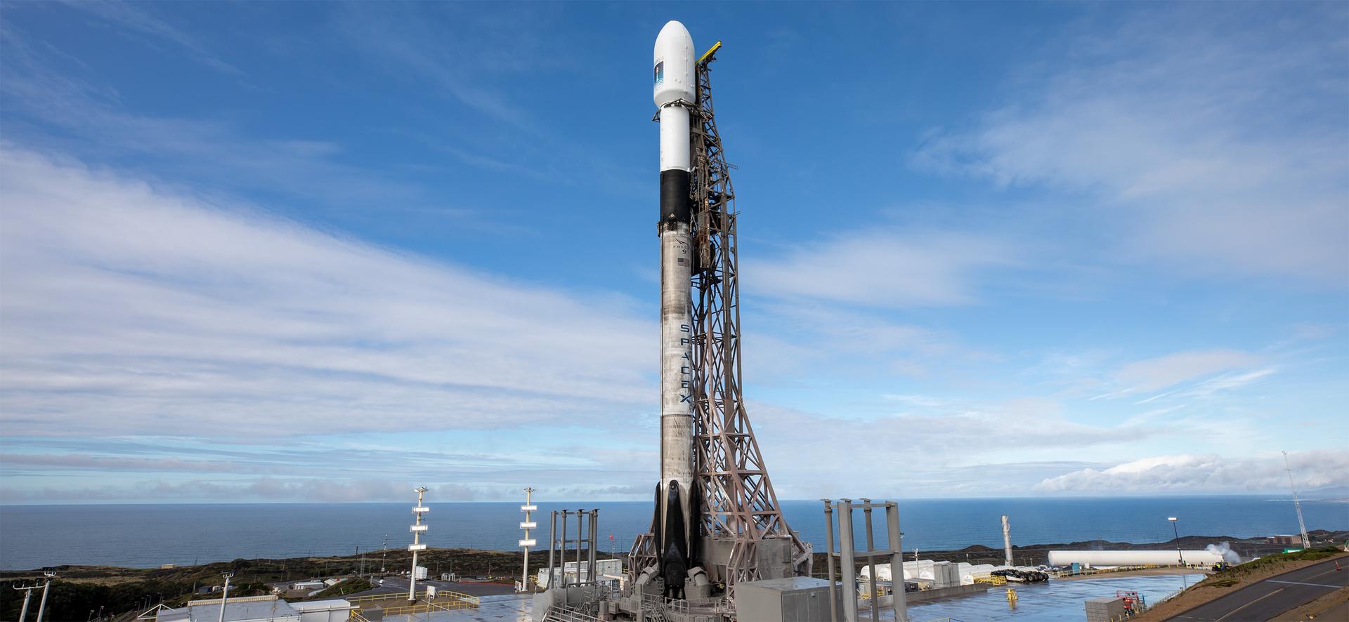
A SpaceX rocket carrying the Sentinel-6B satellite stands vertical on the launch pad at Space Launch Complex 4 East at Vandenberg Space Force Base in California on Sunday, Nov. 16, 2025, ahead of launch targeted for no earlier than 9:21 p.m. PST. A collaboration between NASA, ESA (European Space Agency), EUMETSAT (European Organisation for the Exploitation of Meteorological Satellites), and the National Oceanic and Atmospheric Administration (NOAA), Sentinel-6B is designed to measure sea levels down to roughly an inch for about 90% of the world’s oceans.
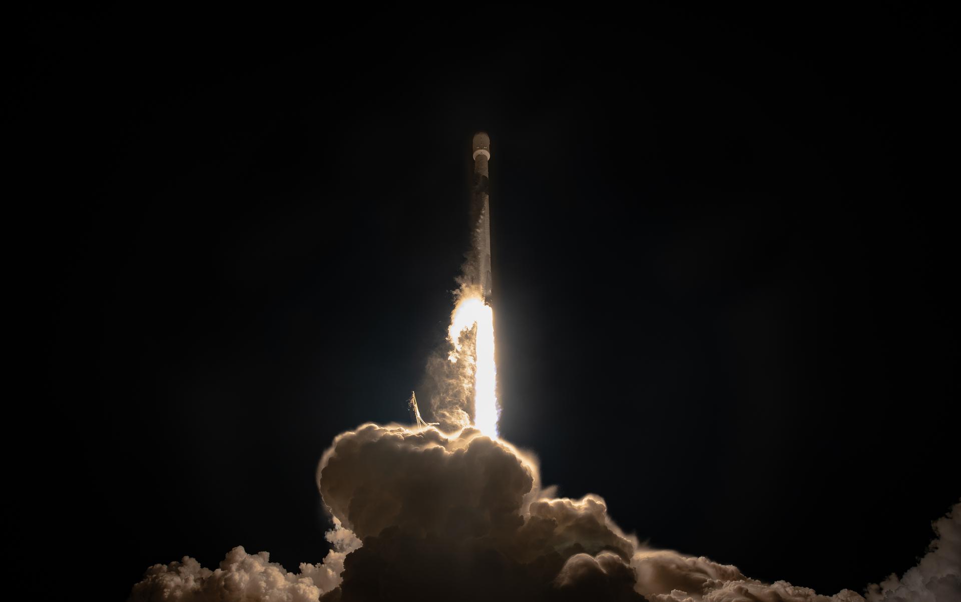
A SpaceX Falcon 9 rocket carrying the international Sentinel-6B spacecraft lifts off from Space Launch Complex 4 East at Vandenberg Space Force Base in California at 9:21 p.m. PST Sunday, Nov. 16, 2025. A collaboration between NASA, ESA (European Space Agency), EUMETSAT (European Organisation for the Exploitation of Meteorological Satellites), and the National Oceanic and Atmospheric Administration (NOAA), Sentinel-6B is designed to measure sea levels down to roughly an inch for about 90% of the world’s oceans.
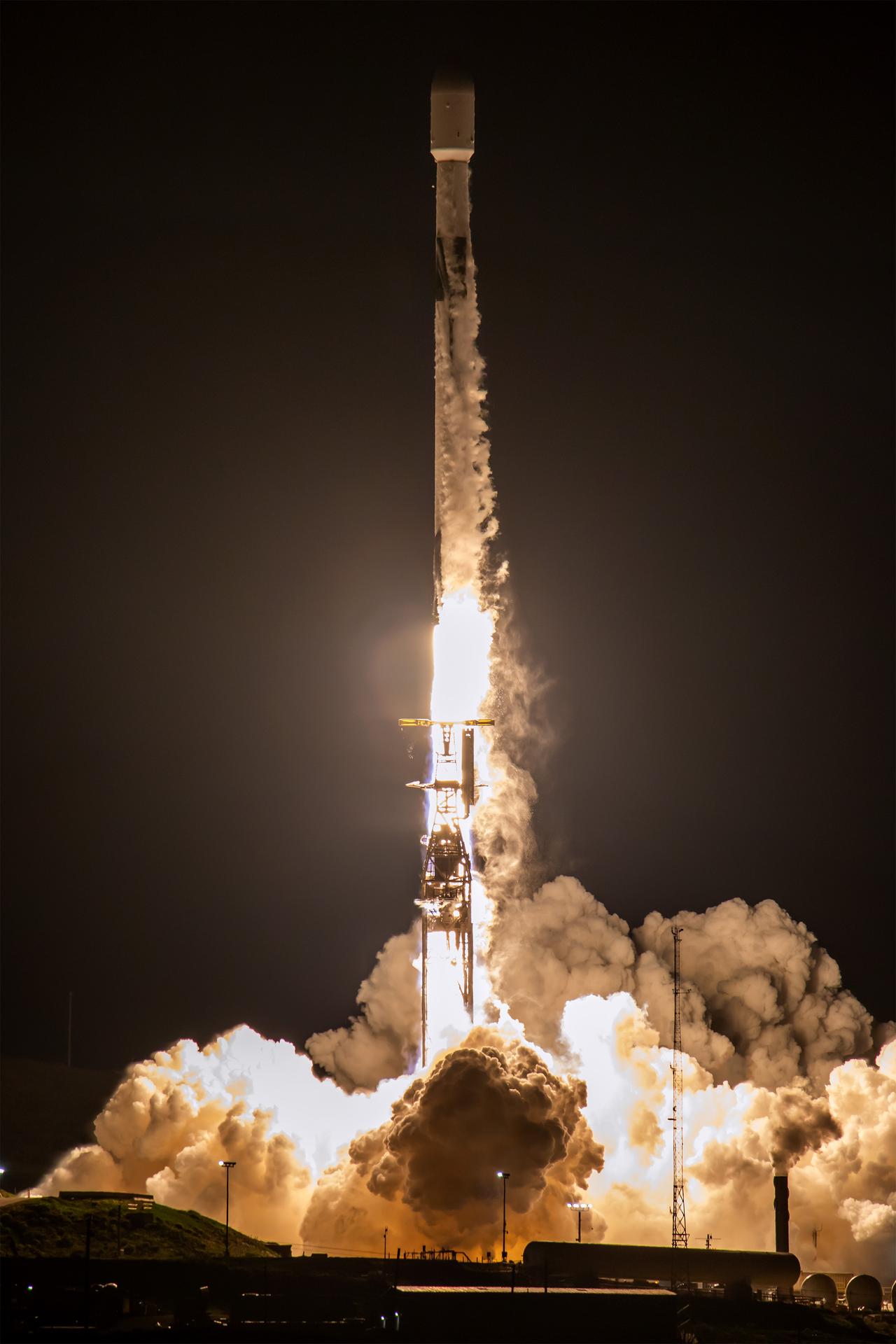
A SpaceX Falcon 9 rocket carrying the international Sentinel-6B spacecraft lifts off from Space Launch Complex 4 East at Vandenberg Space Force Base in California at 9:21 p.m. PST Sunday, Nov. 16, 2025. A collaboration between NASA, ESA (European Space Agency), EUMETSAT (European Organisation for the Exploitation of Meteorological Satellites), and the National Oceanic and Atmospheric Administration (NOAA), Sentinel-6B is designed to measure sea levels down to roughly an inch for about 90% of the world’s oceans.
A SpaceX Falcon 9 rocket carrying the international Sentinel-6B spacecraft lifts off from Space Launch Complex 4 East at Vandenberg Space Force Base in California at 9:21 p.m. PST Sunday, Nov. 16, 2025. A collaboration between NASA, ESA (European Space Agency), EUMETSAT (European Organisation for the Exploitation of Meteorological Satellites), and the National Oceanic and Atmospheric Administration (NOAA), Sentinel-6B is designed to measure sea levels down to roughly an inch for about 90% of the world’s oceans.
A SpaceX Falcon 9 rocket carrying the international Sentinel-6B spacecraft lifts off from Space Launch Complex 4 East at Vandenberg Space Force Base in California at 9:21 p.m. PST Sunday, Nov. 16, 2025. A collaboration between NASA, ESA (European Space Agency), EUMETSAT (European Organisation for the Exploitation of Meteorological Satellites), and the National Oceanic and Atmospheric Administration (NOAA), Sentinel-6B is designed to measure sea levels down to roughly an inch for about 90% of the world’s oceans.

A SpaceX Falcon 9 rocket carrying the international Sentinel-6B spacecraft lifts off from Space Launch Complex 4 East at Vandenberg Space Force Base in California at 9:21 p.m. PST Sunday, Nov. 16, 2025. A collaboration between NASA, ESA (European Space Agency), EUMETSAT (European Organisation for the Exploitation of Meteorological Satellites), and the National Oceanic and Atmospheric Administration (NOAA), Sentinel-6B is designed to measure sea levels down to roughly an inch for about 90% of the world’s oceans.
A SpaceX Falcon 9 rocket carrying the international Sentinel-6B spacecraft lifts off from Space Launch Complex 4 East at Vandenberg Space Force Base in California at 9:21 p.m. PST Sunday, Nov. 16, 2025. A collaboration between NASA, ESA (European Space Agency), EUMETSAT (European Organisation for the Exploitation of Meteorological Satellites), and the National Oceanic and Atmospheric Administration (NOAA), Sentinel-6B is designed to measure sea levels down to roughly an inch for about 90% of the world’s oceans.
A SpaceX Falcon 9 rocket carrying the international Sentinel-6B spacecraft lifts off from Space Launch Complex 4 East at Vandenberg Space Force Base in California on Sunday, Nov. 16, 2025. A collaboration between NASA, ESA (European Space Agency), EUMETSAT (European Organisation for the Exploitation of Meteorological Satellites), and the National Oceanic and Atmospheric Administration (NOAA), Sentinel-6B is designed to measure sea levels down to roughly an inch for about 90% of the world’s oceans.
A SpaceX rocket carrying the Sentinel-6B satellite stands vertical on the launch pad at Space Launch Complex 4 East at Vandenberg Space Force Base in California on Sunday, Nov. 16, 2025, ahead of launch targeted for no earlier than 9:21 p.m. PST. A collaboration between NASA, ESA (European Space Agency), EUMETSAT (European Organisation for the Exploitation of Meteorological Satellites), and the National Oceanic and Atmospheric Administration (NOAA), Sentinel-6B is designed to measure sea levels down to roughly an inch for about 90% of the world’s oceans.
A SpaceX rocket carrying the Sentinel-6B satellite stands vertical on the launch pad at Space Launch Complex 4 East at Vandenberg Space Force Base in California on Sunday, Nov. 16, 2025, ahead of launch targeted for no earlier than 9:21 p.m. PST. A collaboration between NASA, ESA (European Space Agency), EUMETSAT (European Organisation for the Exploitation of Meteorological Satellites), and the National Oceanic and Atmospheric Administration (NOAA), Sentinel-6B is designed to measure sea levels down to roughly an inch for about 90% of the world’s oceans.
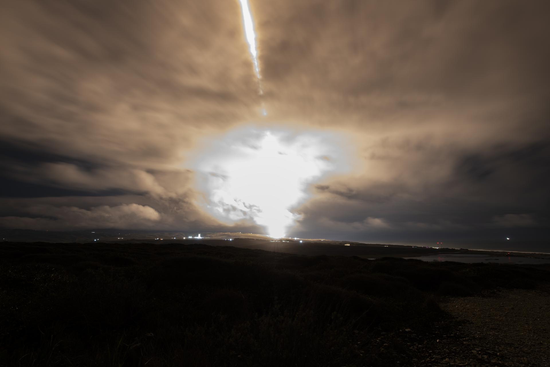
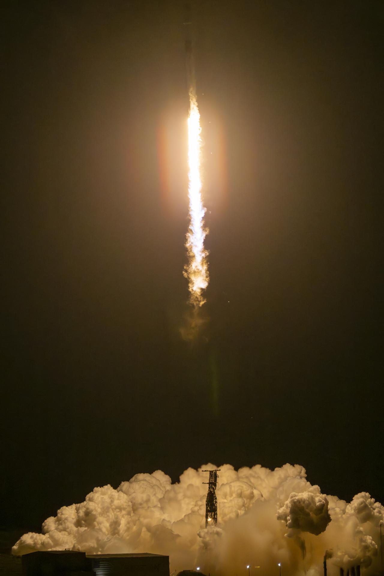
A long exposure photo shows the SpaceX Falcon 9 rocket carrying the internation Sentinel-6B spacecraft lifting off from Space Launch Complex 4 East at Vandenberg Space Force Base in California on Sunday, Nov. 16, 2025. A collaboration between NASA, ESA (European Space Agency), EUMETSAT (European Organisation for the Exploitation of Meteorological Satellites), and the National Oceanic and Atmospheric Administration (NOAA), Sentinel-6B is designed to measure sea levels down to roughly an inch for about 90% of the world’s oceans.
New sea surface height measurements from NASA TOPEX/Poseidon satellite show that the sea level and temperature of the entire Pacific is out of balance, including a large area of abnormally cool water along the west coast of North America.
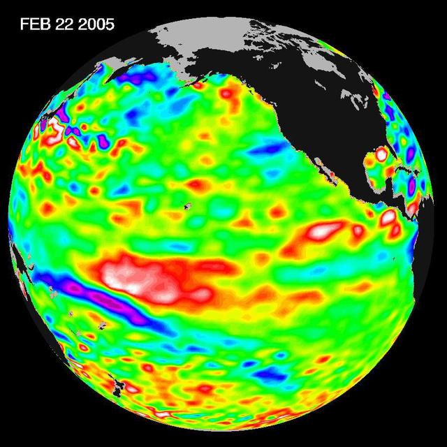
Recent sea-level height data from NASA U.S./France Jason altimetric satellite during a 10-day cycle ending February 22, 2005, show that the central equatorial Pacific continues to exhibit an area of higher-than-normal sea surface heights.

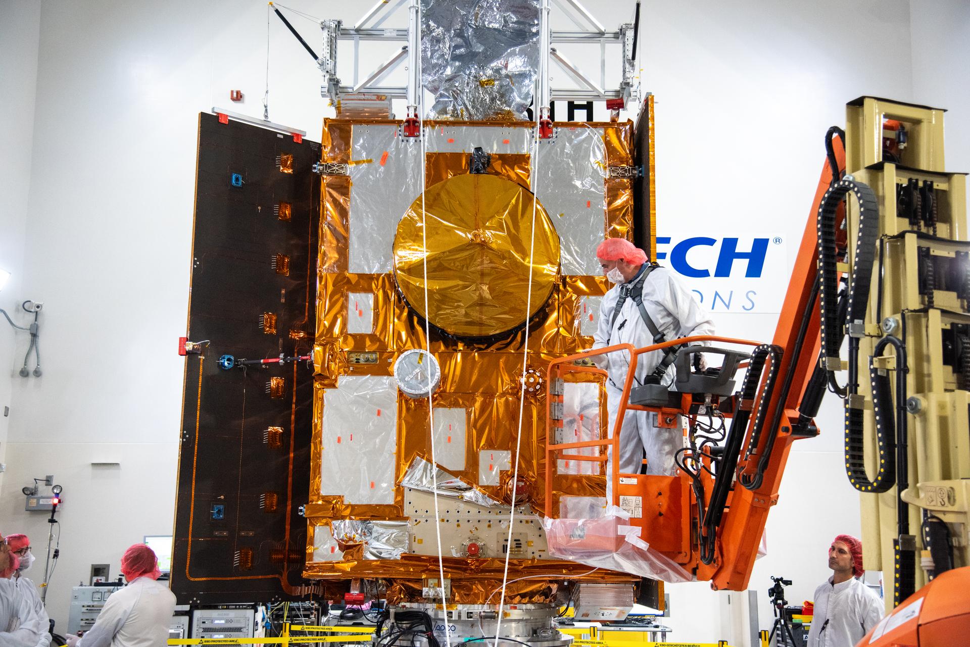
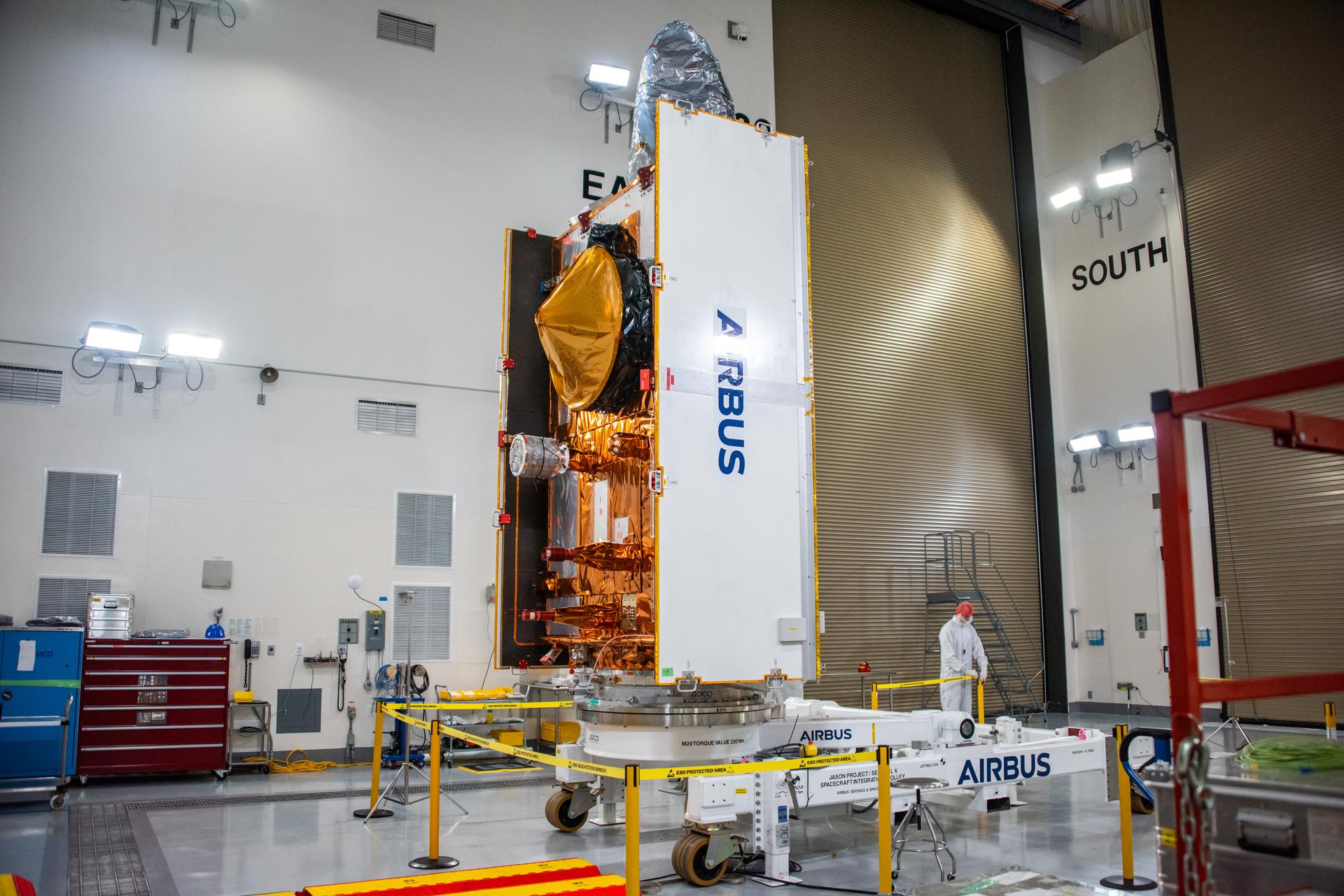
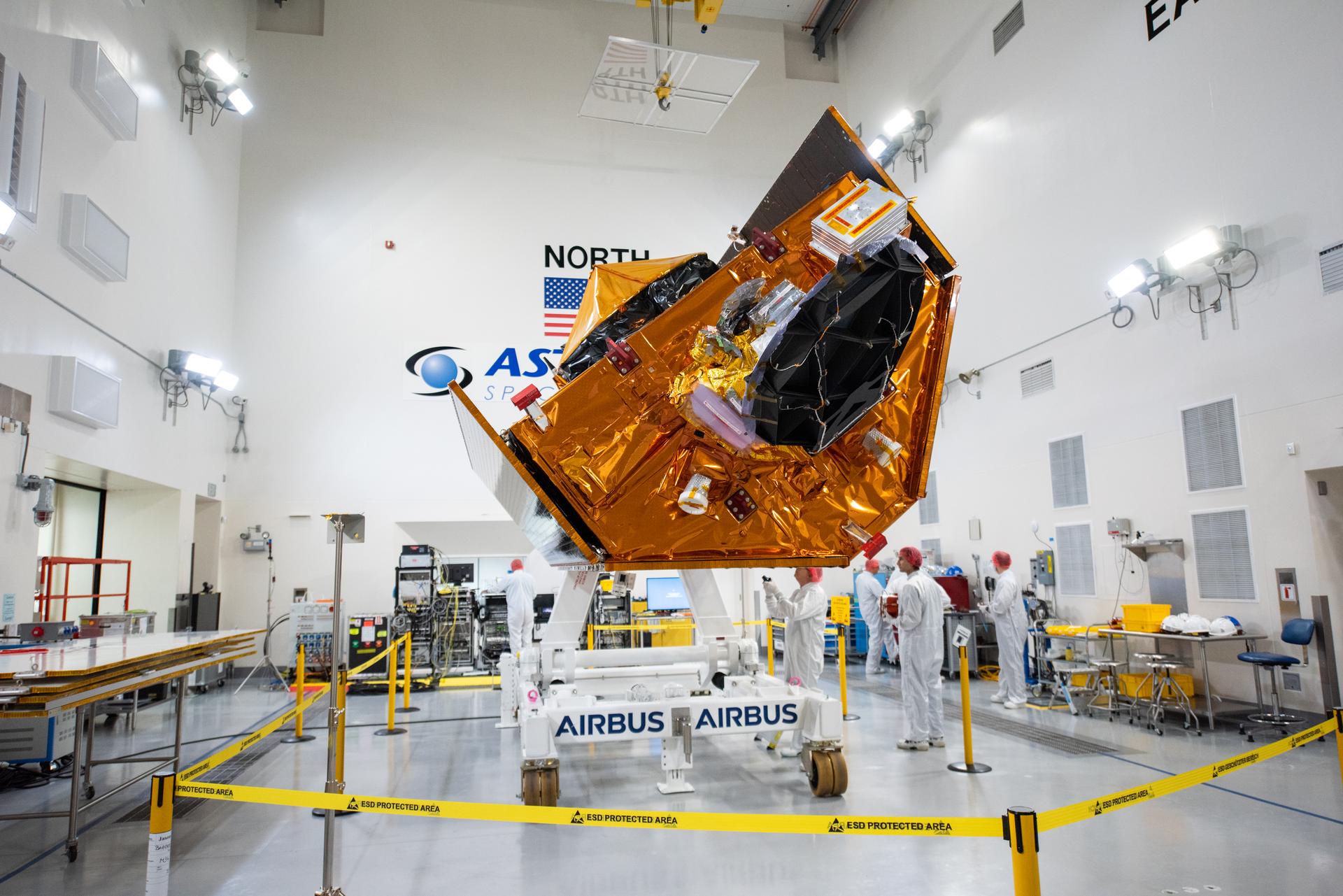
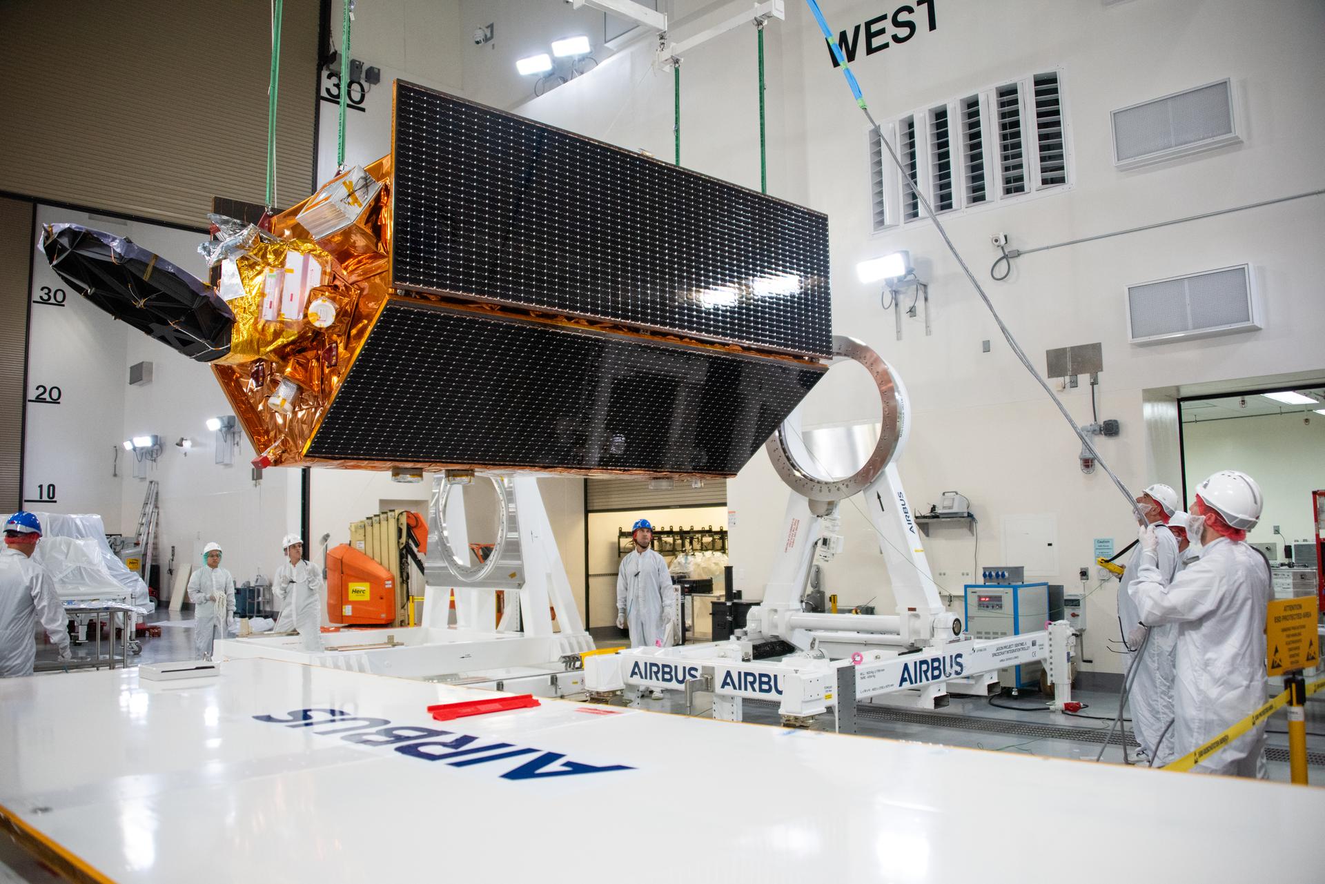
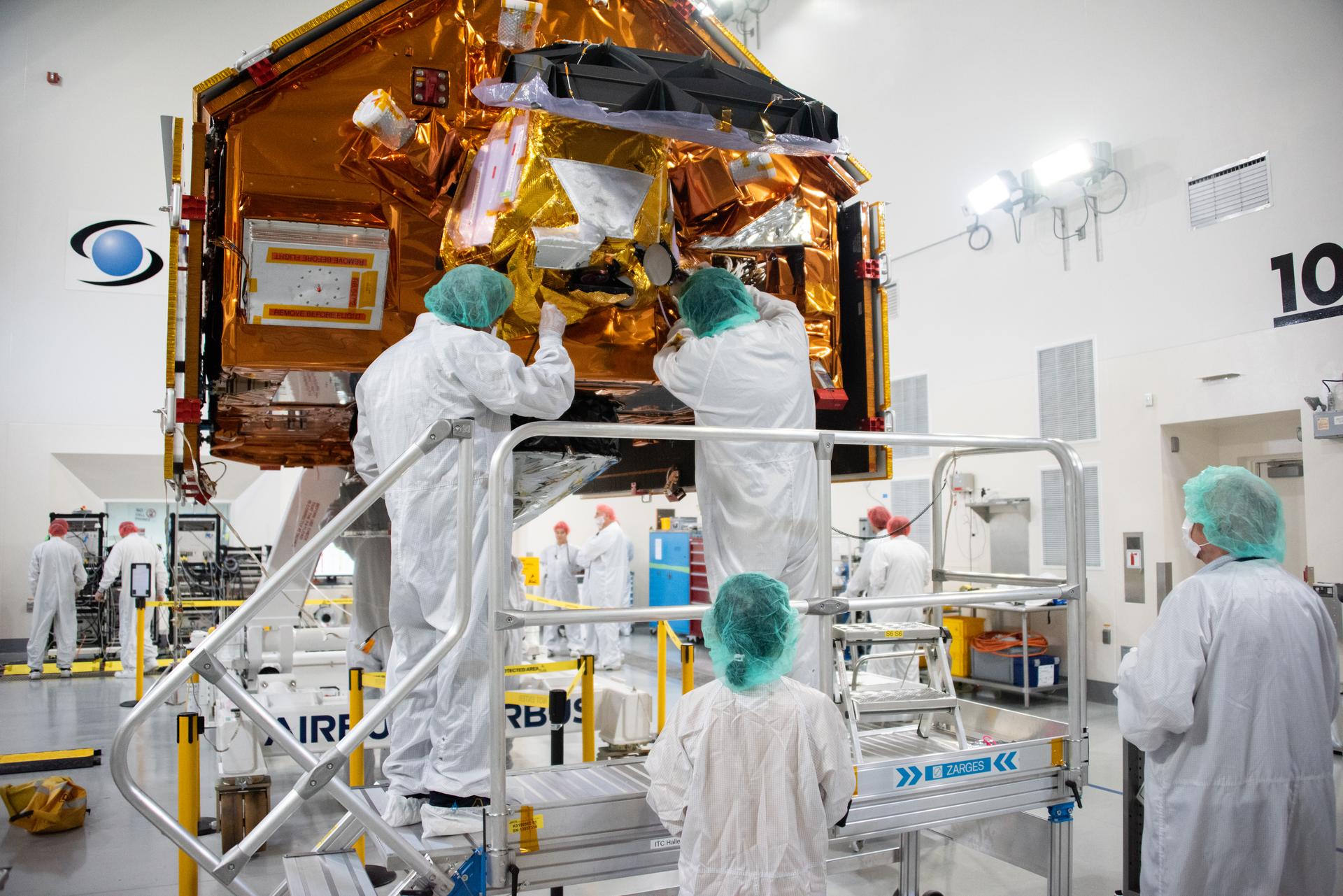
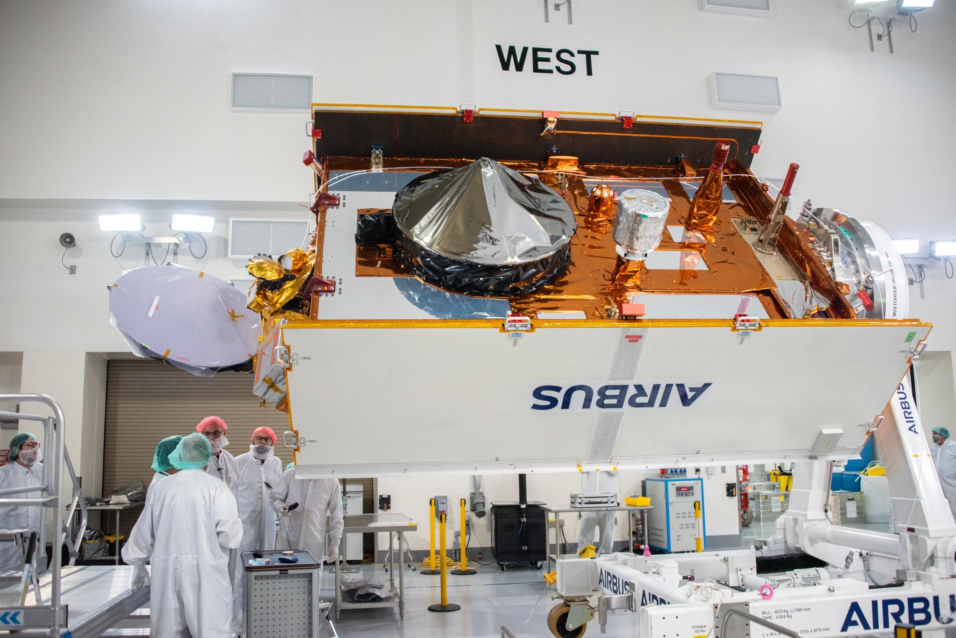
Technicians use a crane to place the Sentinel-6B spacecraft onto a work stand ahead of prelaunch operations at the Astrotech Space Operations payload processing facility at Vandenberg Space Force Base in California on Thursday, Sept. 25, 2025. Sentinel-6B will undergo detailed inspections, tests, and fueling in a cleanroom as it prepares for a November launch on a SpaceX Falcon 9 rocket. A collaboration between NASA, ESA (European Space Agency), EUMETSAT (European Organisation for the Exploitation of Meteorological Satellites), and the National Oceanic and Atmospheric Administration (NOAA), Sentinel-6B is designed to measure sea levels down to roughly an inch for about 90% of the world’s oceans and will extend out to a decade the record of atmospheric temperatures begun by Sentinel-6 Michael Freilich.
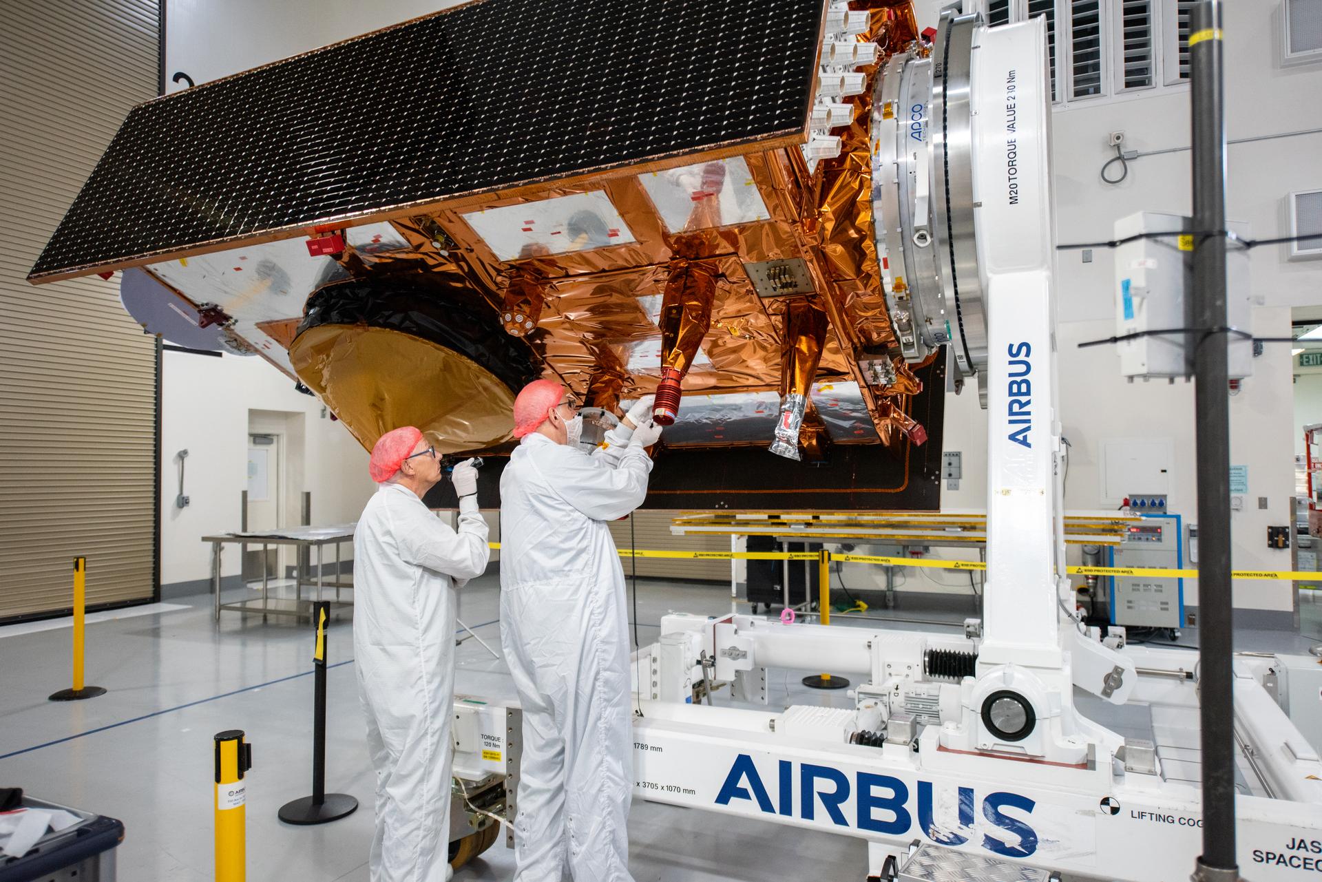
Technicians use a crane to place the Sentinel-6B spacecraft onto a work stand ahead of prelaunch operations at the Astrotech Space Operations payload processing facility at Vandenberg Space Force Base in California on Thursday, Sept. 25, 2025. Sentinel-6B will undergo detailed inspections, tests, and fueling in a cleanroom as it prepares for a November launch on a SpaceX Falcon 9 rocket. A collaboration between NASA, ESA (European Space Agency), EUMETSAT (European Organisation for the Exploitation of Meteorological Satellites), and the National Oceanic and Atmospheric Administration (NOAA), Sentinel-6B is designed to measure sea levels down to roughly an inch for about 90% of the world’s oceans and will extend out to a decade the record of atmospheric temperatures begun by Sentinel-6 Michael Freilich.
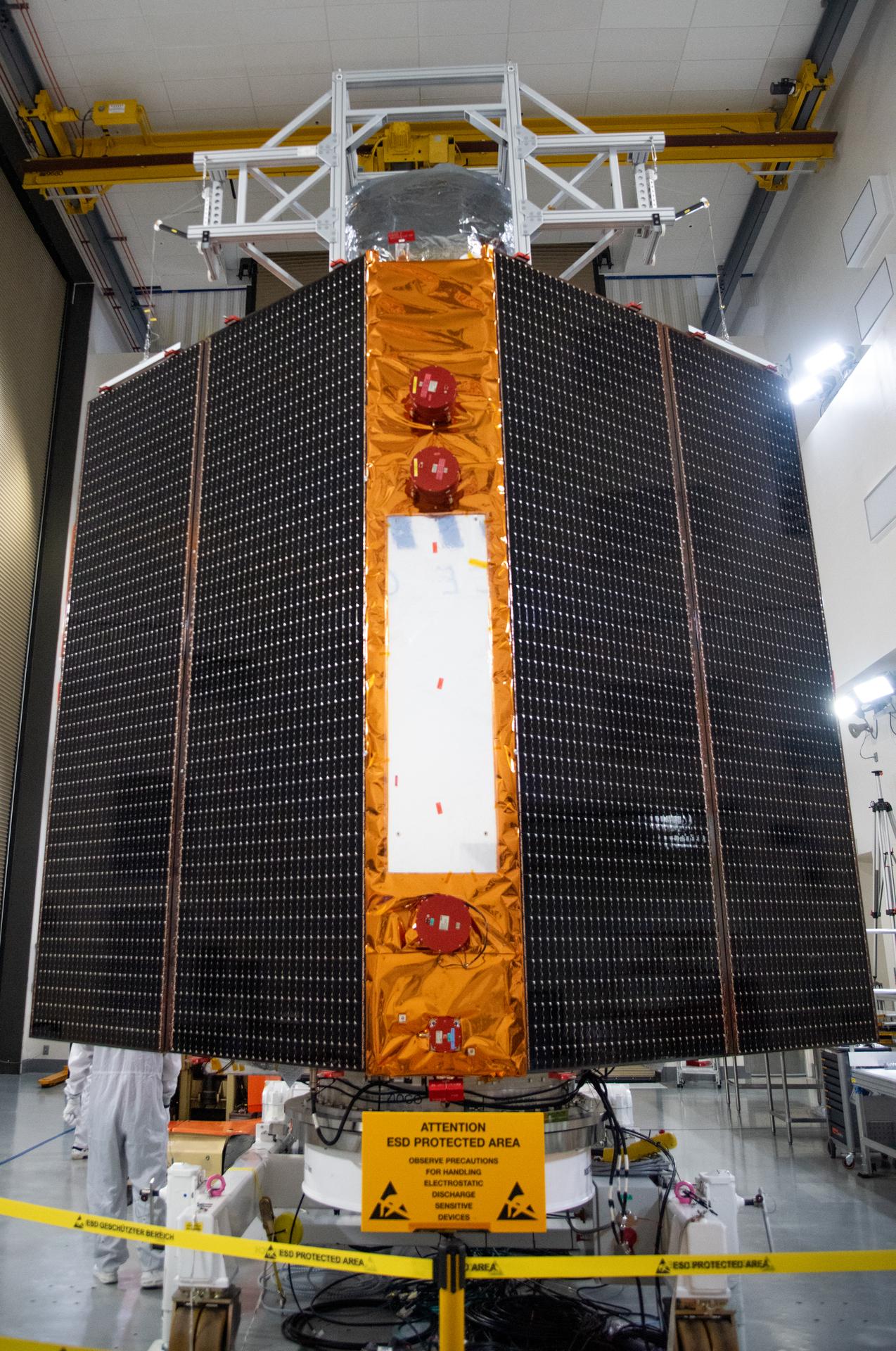
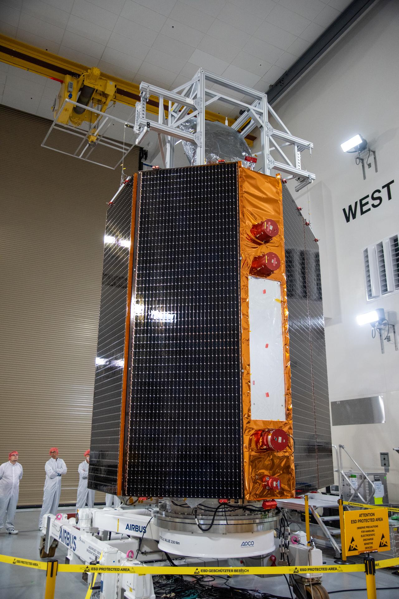
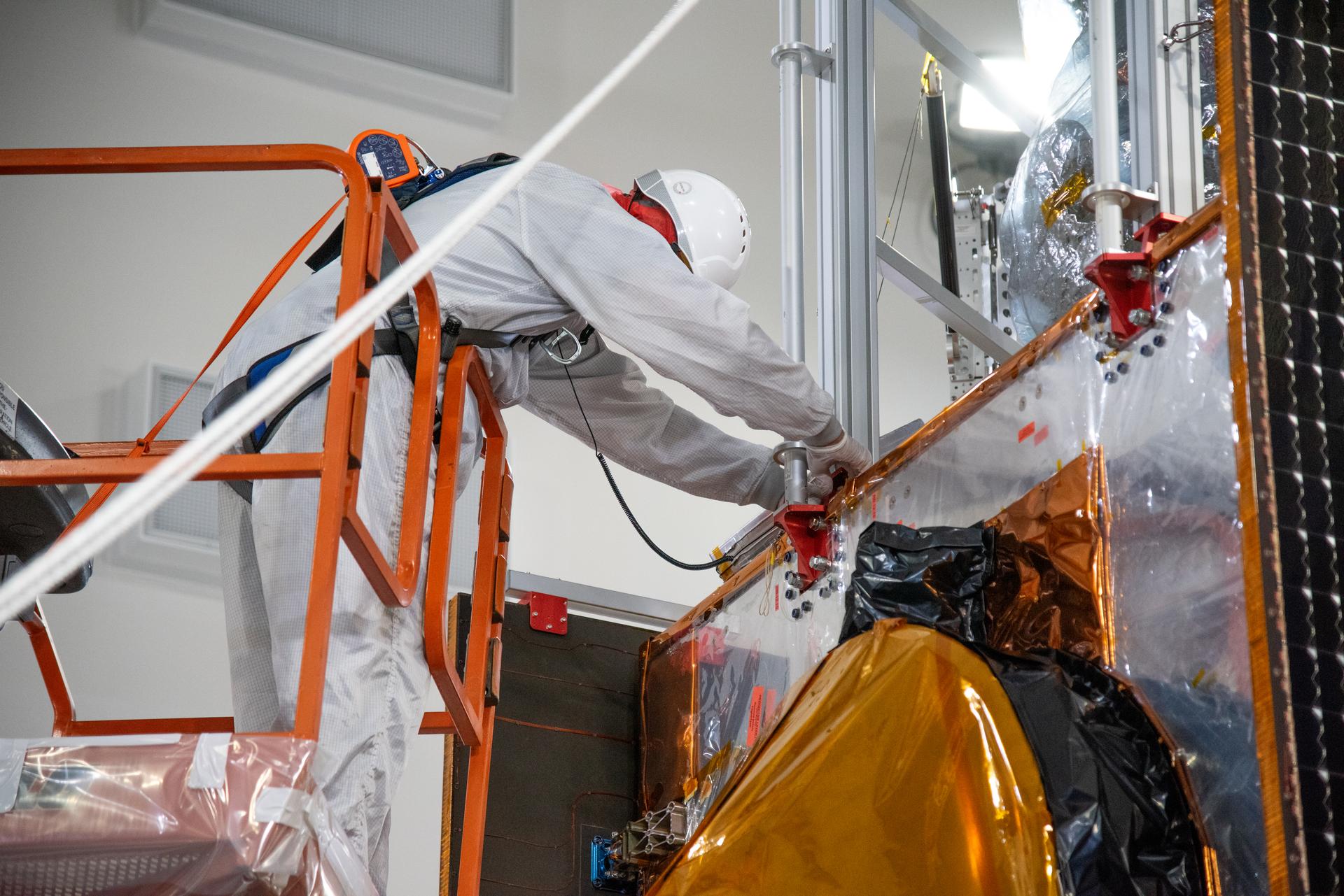
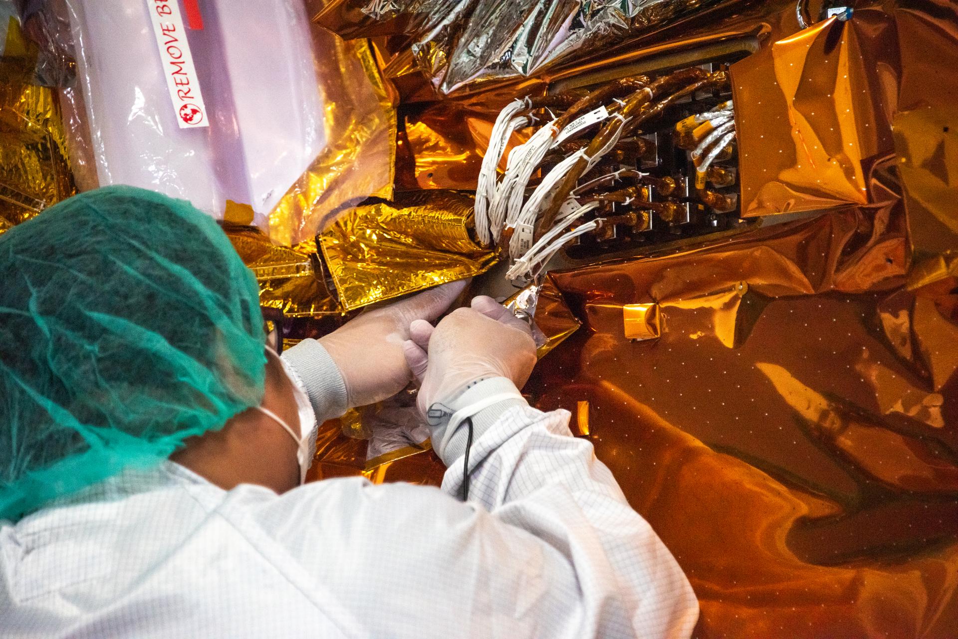
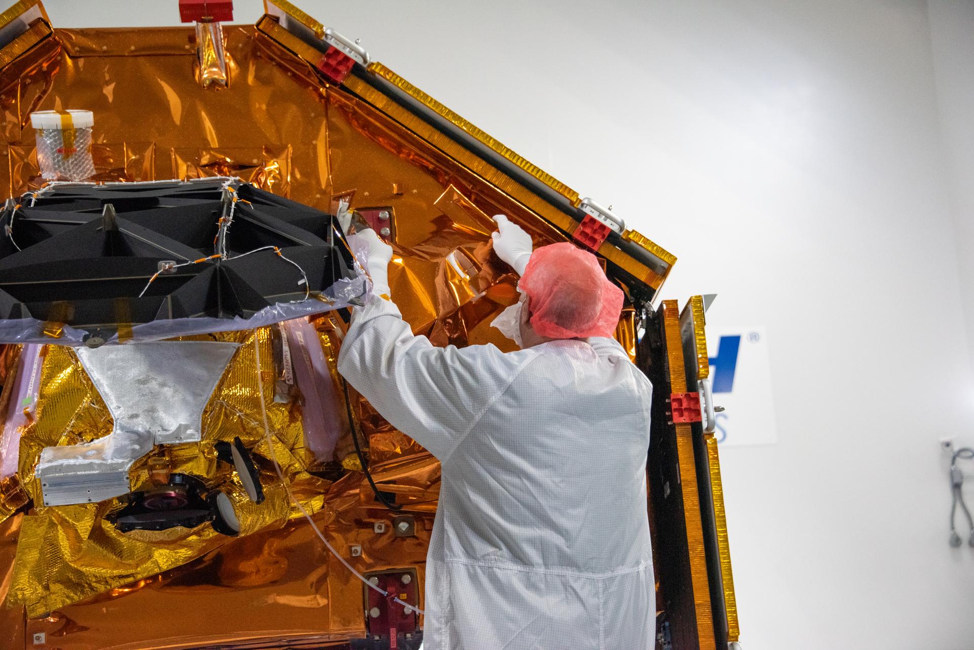
Technicians install multi-layer insulation on the Sentinel-6B spacecraft on a work stand inside the Astrotech Space Operations payload processing facility at Vandenberg Space Force Base in California on Thursday, Oct. 23, 2025. Critical for protecting spacecraft from extreme temperatures and environmental conditions in space, the thin, reflective multi-layer insulation will create a barrier to help reduce heat transfer through radiation while Sentinel-6B is in orbit. A collaboration between NASA, ESA (European Space Agency), EUMETSAT (European Organisation for the Exploitation of Meteorological Satellites), and the National Oceanic and Atmospheric Administration (NOAA), Sentinel-6B is designed to measure sea levels down to roughly an inch for about 90% of the world’s oceans. NASA is targeting launch no earlier than Sunday, Nov. 16, 2025, on a SpaceX Falcon 9 rocket from Space Launch Complex 4 East at Vandenberg.

Technicians use a crane to place the Sentinel-6B spacecraft onto a work stand ahead of prelaunch operations at the Astrotech Space Operations payload processing facility at Vandenberg Space Force Base in California on Thursday, Sept. 25, 2025. Sentinel-6B will undergo detailed inspections, tests, and fueling in a cleanroom as it prepares for a November launch on a SpaceX Falcon 9 rocket. A collaboration between NASA, ESA (European Space Agency), EUMETSAT (European Organisation for the Exploitation of Meteorological Satellites), and the National Oceanic and Atmospheric Administration (NOAA), Sentinel-6B is designed to measure sea levels down to roughly an inch for about 90% of the world’s oceans and will extend out to a decade the record of atmospheric temperatures begun by Sentinel-6 Michael Freilich.
Technicians use a crane to place the Sentinel-6B spacecraft onto a work stand ahead of prelaunch operations at the Astrotech Space Operations payload processing facility at Vandenberg Space Force Base in California on Thursday, Sept. 25, 2025. Sentinel-6B will undergo detailed inspections, tests, and fueling in a cleanroom as it prepares for a November launch on a SpaceX Falcon 9 rocket. A collaboration between NASA, ESA (European Space Agency), EUMETSAT (European Organisation for the Exploitation of Meteorological Satellites), and the National Oceanic and Atmospheric Administration (NOAA), Sentinel-6B is designed to measure sea levels down to roughly an inch for about 90% of the world’s oceans and will extend out to a decade the record of atmospheric temperatures begun by Sentinel-6 Michael Freilich.
Technicians use a crane to place the Sentinel-6B spacecraft onto a work stand ahead of prelaunch operations at the Astrotech Space Operations payload processing facility at Vandenberg Space Force Base in California on Thursday, Sept. 25, 2025. Sentinel-6B will undergo detailed inspections, tests, and fueling in a cleanroom as it prepares for a November launch on a SpaceX Falcon 9 rocket. A collaboration between NASA, ESA (European Space Agency), EUMETSAT (European Organisation for the Exploitation of Meteorological Satellites), and the National Oceanic and Atmospheric Administration (NOAA), Sentinel-6B is designed to measure sea levels down to roughly an inch for about 90% of the world’s oceans and will extend out to a decade the record of atmospheric temperatures begun by Sentinel-6 Michael Freilich.
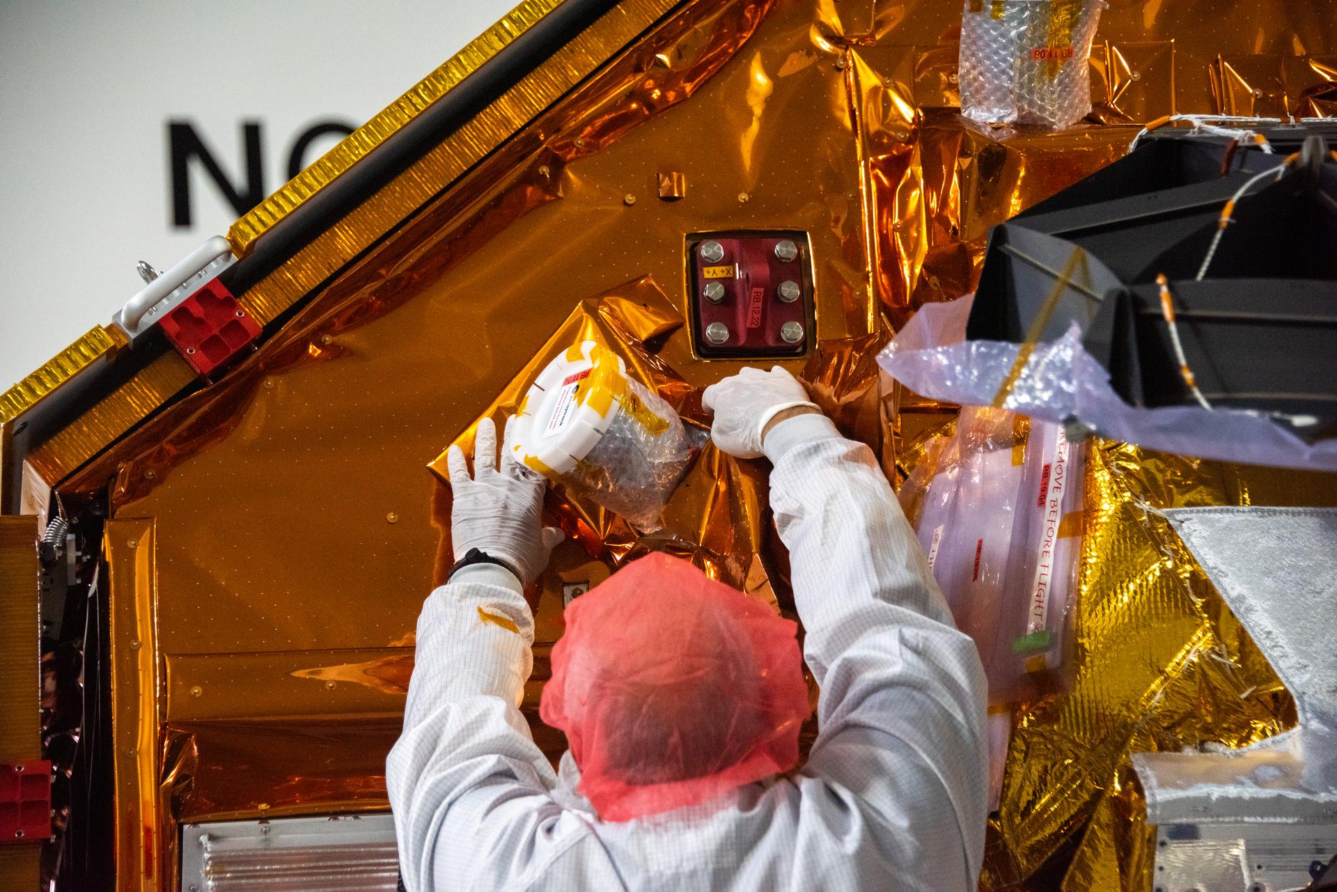
Technicians install multi-layer insulation on the Sentinel-6B spacecraft on a work stand inside the Astrotech Space Operations payload processing facility at Vandenberg Space Force Base in California on Thursday, Oct. 23, 2025. Critical for protecting spacecraft from extreme temperatures and environmental conditions in space, the thin, reflective multi-layer insulation will create a barrier to help reduce heat transfer through radiation while Sentinel-6B is in orbit. A collaboration between NASA, ESA (European Space Agency), EUMETSAT (European Organisation for the Exploitation of Meteorological Satellites), and the National Oceanic and Atmospheric Administration (NOAA), Sentinel-6B is designed to measure sea levels down to roughly an inch for about 90% of the world’s oceans. NASA is targeting launch no earlier than Sunday, Nov. 16, 2025, on a SpaceX Falcon 9 rocket from Space Launch Complex 4 East at Vandenberg.
Technicians use a crane to place the Sentinel-6B spacecraft onto a work stand ahead of prelaunch operations at the Astrotech Space Operations payload processing facility at Vandenberg Space Force Base in California on Thursday, Sept. 25, 2025. Sentinel-6B will undergo detailed inspections, tests, and fueling in a cleanroom as it prepares for a November launch on a SpaceX Falcon 9 rocket. A collaboration between NASA, ESA (European Space Agency), EUMETSAT (European Organisation for the Exploitation of Meteorological Satellites), and the National Oceanic and Atmospheric Administration (NOAA), Sentinel-6B is designed to measure sea levels down to roughly an inch for about 90% of the world’s oceans and will extend out to a decade the record of atmospheric temperatures begun by Sentinel-6 Michael Freilich.
Technicians install multi-layer insulation on the Sentinel-6B spacecraft on a work stand inside the Astrotech Space Operations payload processing facility at Vandenberg Space Force Base in California on Thursday, Oct. 23, 2025. Critical for protecting spacecraft from extreme temperatures and environmental conditions in space, the thin, reflective multi-layer insulation will create a barrier to help reduce heat transfer through radiation while Sentinel-6B is in orbit. A collaboration between NASA, ESA (European Space Agency), EUMETSAT (European Organisation for the Exploitation of Meteorological Satellites), and the National Oceanic and Atmospheric Administration (NOAA), Sentinel-6B is designed to measure sea levels down to roughly an inch for about 90% of the world’s oceans. NASA is targeting launch no earlier than Sunday, Nov. 16, 2025, on a SpaceX Falcon 9 rocket from Space Launch Complex 4 East at Vandenberg.
Technicians install multi-layer insulation on the Sentinel-6B spacecraft on a work stand inside the Astrotech Space Operations payload processing facility at Vandenberg Space Force Base in California on Thursday, Oct. 23, 2025. Critical for protecting spacecraft from extreme temperatures and environmental conditions in space, the thin, reflective multi-layer insulation will create a barrier to help reduce heat transfer through radiation while Sentinel-6B is in orbit. A collaboration between NASA, ESA (European Space Agency), EUMETSAT (European Organisation for the Exploitation of Meteorological Satellites), and the National Oceanic and Atmospheric Administration (NOAA), Sentinel-6B is designed to measure sea levels down to roughly an inch for about 90% of the world’s oceans. NASA is targeting launch no earlier than Sunday, Nov. 16, 2025, on a SpaceX Falcon 9 rocket from Space Launch Complex 4 East at Vandenberg.
Technicians install multi-layer insulation on the Sentinel-6B spacecraft on a work stand inside the Astrotech Space Operations payload processing facility at Vandenberg Space Force Base in California on Thursday, Oct. 23, 2025. Critical for protecting spacecraft from extreme temperatures and environmental conditions in space, the thin, reflective multi-layer insulation will create a barrier to help reduce heat transfer through radiation while Sentinel-6B is in orbit. A collaboration between NASA, ESA (European Space Agency), EUMETSAT (European Organisation for the Exploitation of Meteorological Satellites), and the National Oceanic and Atmospheric Administration (NOAA), Sentinel-6B is designed to measure sea levels down to roughly an inch for about 90% of the world’s oceans. NASA is targeting launch no earlier than Sunday, Nov. 16, 2025, on a SpaceX Falcon 9 rocket from Space Launch Complex 4 East at Vandenberg.
Technicians install multi-layer insulation on the Sentinel-6B spacecraft on a work stand inside the Astrotech Space Operations payload processing facility at Vandenberg Space Force Base in California on Thursday, Oct. 23, 2025. Critical for protecting spacecraft from extreme temperatures and environmental conditions in space, the thin, reflective multi-layer insulation will create a barrier to help reduce heat transfer through radiation while Sentinel-6B is in orbit. A collaboration between NASA, ESA (European Space Agency), EUMETSAT (European Organisation for the Exploitation of Meteorological Satellites), and the National Oceanic and Atmospheric Administration (NOAA), Sentinel-6B is designed to measure sea levels down to roughly an inch for about 90% of the world’s oceans. NASA is targeting launch no earlier than Sunday, Nov. 16, 2025, on a SpaceX Falcon 9 rocket from Space Launch Complex 4 East at Vandenberg.
Technicians install multi-layer insulation on the Sentinel-6B spacecraft on a work stand inside the Astrotech Space Operations payload processing facility at Vandenberg Space Force Base in California on Thursday, Oct. 23, 2025. Critical for protecting spacecraft from extreme temperatures and environmental conditions in space, the thin, reflective multi-layer insulation will create a barrier to help reduce heat transfer through radiation while Sentinel-6B is in orbit. A collaboration between NASA, ESA (European Space Agency), EUMETSAT (European Organisation for the Exploitation of Meteorological Satellites), and the National Oceanic and Atmospheric Administration (NOAA), Sentinel-6B is designed to measure sea levels down to roughly an inch for about 90% of the world’s oceans. NASA is targeting launch no earlier than Sunday, Nov. 16, 2025, on a SpaceX Falcon 9 rocket from Space Launch Complex 4 East at Vandenberg.
Technicians use a crane to place the Sentinel-6B spacecraft onto a work stand ahead of prelaunch operations at the Astrotech Space Operations payload processing facility at Vandenberg Space Force Base in California on Thursday, Sept. 25, 2025. Sentinel-6B will undergo detailed inspections, tests, and fueling in a cleanroom as it prepares for a November launch on a SpaceX Falcon 9 rocket. A collaboration between NASA, ESA (European Space Agency), EUMETSAT (European Organisation for the Exploitation of Meteorological Satellites), and the National Oceanic and Atmospheric Administration (NOAA), Sentinel-6B is designed to measure sea levels down to roughly an inch for about 90% of the world’s oceans and will extend out to a decade the record of atmospheric temperatures begun by Sentinel-6 Michael Freilich.

Technicians install multi-layer insulation on the Sentinel-6B spacecraft on a work stand inside the Astrotech Space Operations payload processing facility at Vandenberg Space Force Base in California on Thursday, Oct. 23, 2025. Critical for protecting spacecraft from extreme temperatures and environmental conditions in space, the thin, reflective multi-layer insulation will create a barrier to help reduce heat transfer through radiation while Sentinel-6B is in orbit. A collaboration between NASA, ESA (European Space Agency), EUMETSAT (European Organisation for the Exploitation of Meteorological Satellites), and the National Oceanic and Atmospheric Administration (NOAA), Sentinel-6B is designed to measure sea levels down to roughly an inch for about 90% of the world’s oceans. NASA is targeting launch no earlier than Sunday, Nov. 16, 2025, on a SpaceX Falcon 9 rocket from Space Launch Complex 4 East at Vandenberg.
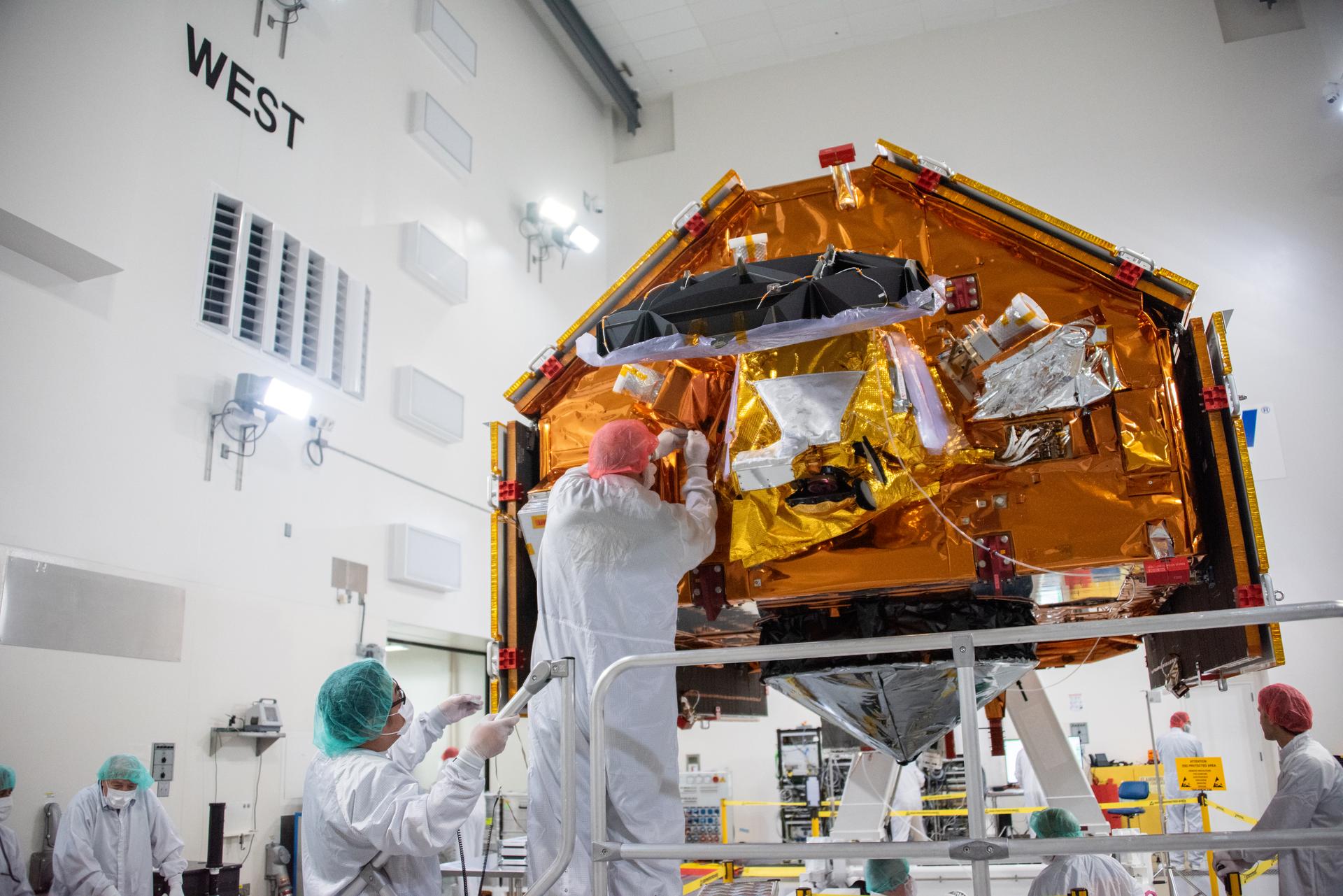
Technicians install multi-layer insulation on the Sentinel-6B spacecraft on a work stand inside the Astrotech Space Operations payload processing facility at Vandenberg Space Force Base in California on Thursday, Oct. 23, 2025. Critical for protecting spacecraft from extreme temperatures and environmental conditions in space, the thin, reflective multi-layer insulation will create a barrier to help reduce heat transfer through radiation while Sentinel-6B is in orbit. A collaboration between NASA, ESA (European Space Agency), EUMETSAT (European Organisation for the Exploitation of Meteorological Satellites), and the National Oceanic and Atmospheric Administration (NOAA), Sentinel-6B is designed to measure sea levels down to roughly an inch for about 90% of the world’s oceans. NASA is targeting launch no earlier than Sunday, Nov. 16, 2025, on a SpaceX Falcon 9 rocket from Space Launch Complex 4 East at Vandenberg.
Technicians use a crane to place the Sentinel-6B spacecraft onto a work stand ahead of prelaunch operations at the Astrotech Space Operations payload processing facility at Vandenberg Space Force Base in California on Thursday, Sept. 25, 2025. Sentinel-6B will undergo detailed inspections, tests, and fueling in a cleanroom as it prepares for a November launch on a SpaceX Falcon 9 rocket. A collaboration between NASA, ESA (European Space Agency), EUMETSAT (European Organisation for the Exploitation of Meteorological Satellites), and the National Oceanic and Atmospheric Administration (NOAA), Sentinel-6B is designed to measure sea levels down to roughly an inch for about 90% of the world’s oceans and will extend out to a decade the record of atmospheric temperatures begun by Sentinel-6 Michael Freilich.
Technicians use a crane to place the Sentinel-6B spacecraft onto a work stand ahead of prelaunch operations at the Astrotech Space Operations payload processing facility at Vandenberg Space Force Base in California on Thursday, Sept. 25, 2025. Sentinel-6B will undergo detailed inspections, tests, and fueling in a cleanroom as it prepares for a November launch on a SpaceX Falcon 9 rocket. A collaboration between NASA, ESA (European Space Agency), EUMETSAT (European Organisation for the Exploitation of Meteorological Satellites), and the National Oceanic and Atmospheric Administration (NOAA), Sentinel-6B is designed to measure sea levels down to roughly an inch for about 90% of the world’s oceans and will extend out to a decade the record of atmospheric temperatures begun by Sentinel-6 Michael Freilich.

Death Valley, Calif., has the lowest point in North America, Badwater at 85.5 meters 282 feet below sea level. It is also the driest and hottest location in North America. This image is from NASA Terra spacecraft.
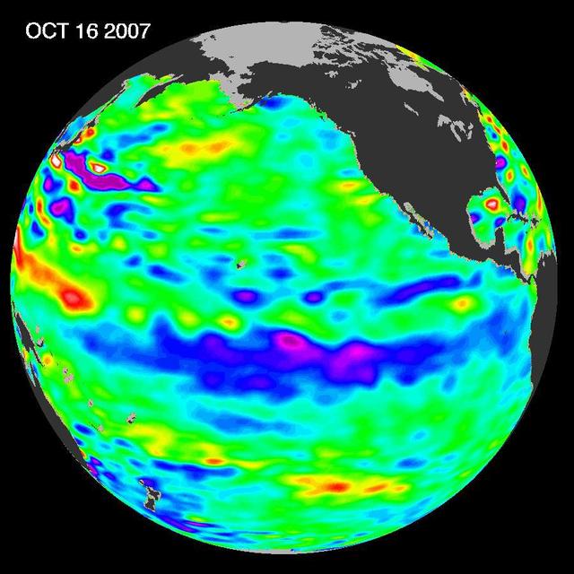
The tropical Pacific Ocean remains in the grips of a cool La Niña, as shown by new data of sea-level heights from mid-October of 2007, collected by NASA U.S-French Jason altimetric satellite.
This image from NASA European Jason-2 satellite shows Kelvin waves of high sea level red/yellow crossing the Pacific Ocean at the equator. The waves can be related to El Niño events.
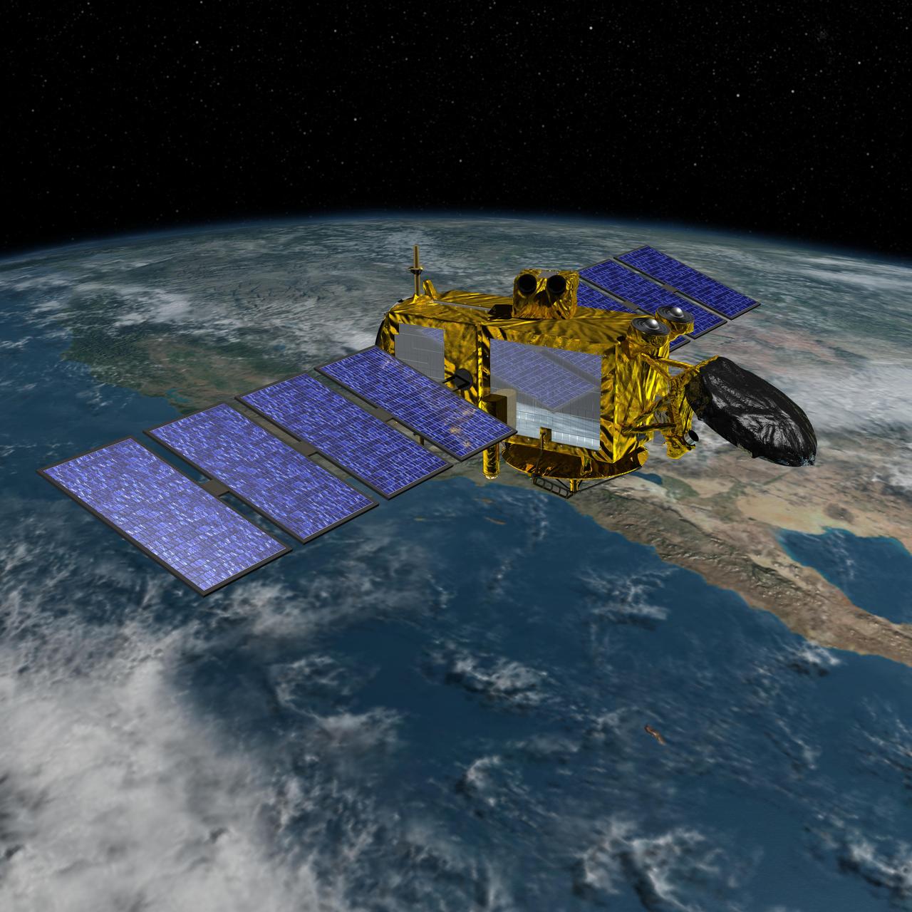
Artist concept of the U.S.-European Jason-3 spacecraft over the California coast. Jason-3 will precisely measure the height of the ocean surface, allowing scientists to monitor ocean circulation and sea level.