
A Skyline View

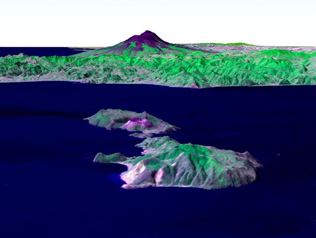
The Tsugaru Iwaki Skyline is a toll road in northern Japan, which partially ascends Mount Iwaki stratovolcano, and is notable for its steep gradient and 69 hairpin turns. The road ascends 806 meters over an average gradient of 8.66%, with some sections going up to 10%. The Tsugaru Iwaki Skyline has been considered one of the most dangerous mountain roads in the world. (Wikipedia) The image was acquired May 26, 2015, and is located at 40.6 degrees north, 140.3 degrees east. https://photojournal.jpl.nasa.gov/catalog/PIA22385

Houston's skyline as seen from the Gulf Freeway Looking Northwest. HOUSTON, TX

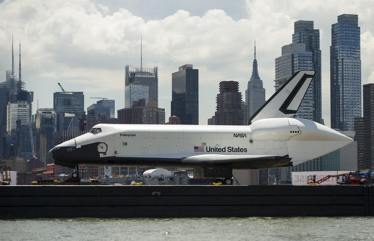
Space shuttle Enterprise, mounted atop a NASA 747 Shuttle Carrier Aircraft (SCA), is seen as it flies over the Manhattan Skyline with Freedom Tower in the background, Friday, April 27, 2012, in New York. Enterprise was the first shuttle orbiter built for NASA performing test flights in the atmosphere and was incapable of spaceflight. Originally housed at the Smithsonian's Steven F. Udvar-Hazy Center, Enterprise will be demated from the SCA and placed on a barge that will eventually be moved by tugboat up the Hudson River to the Intrepid Sea, Air & Space Museum in June. Photo Credit: (NASA/Robert Markowitz)

Space shuttle Enterprise, mounted atop a NASA 747 Shuttle Carrier Aircraft (SCA), is seen as it flies near the Statue of Liberty and the Manhattan skyline, Friday, April 27, 2012, in New York. Enterprise was the first shuttle orbiter built for NASA performing test flights in the atmosphere and was incapable of spaceflight. Originally housed at the Smithsonian's Steven F. Udvar-Hazy Center, Enterprise will be demated from the SCA and placed on a barge that will eventually be moved by tugboat up the Hudson River to the Intrepid Sea, Air & Space Museum in June. Photo Credit: (NASA/Robert Markowitz)

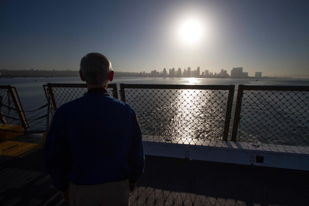
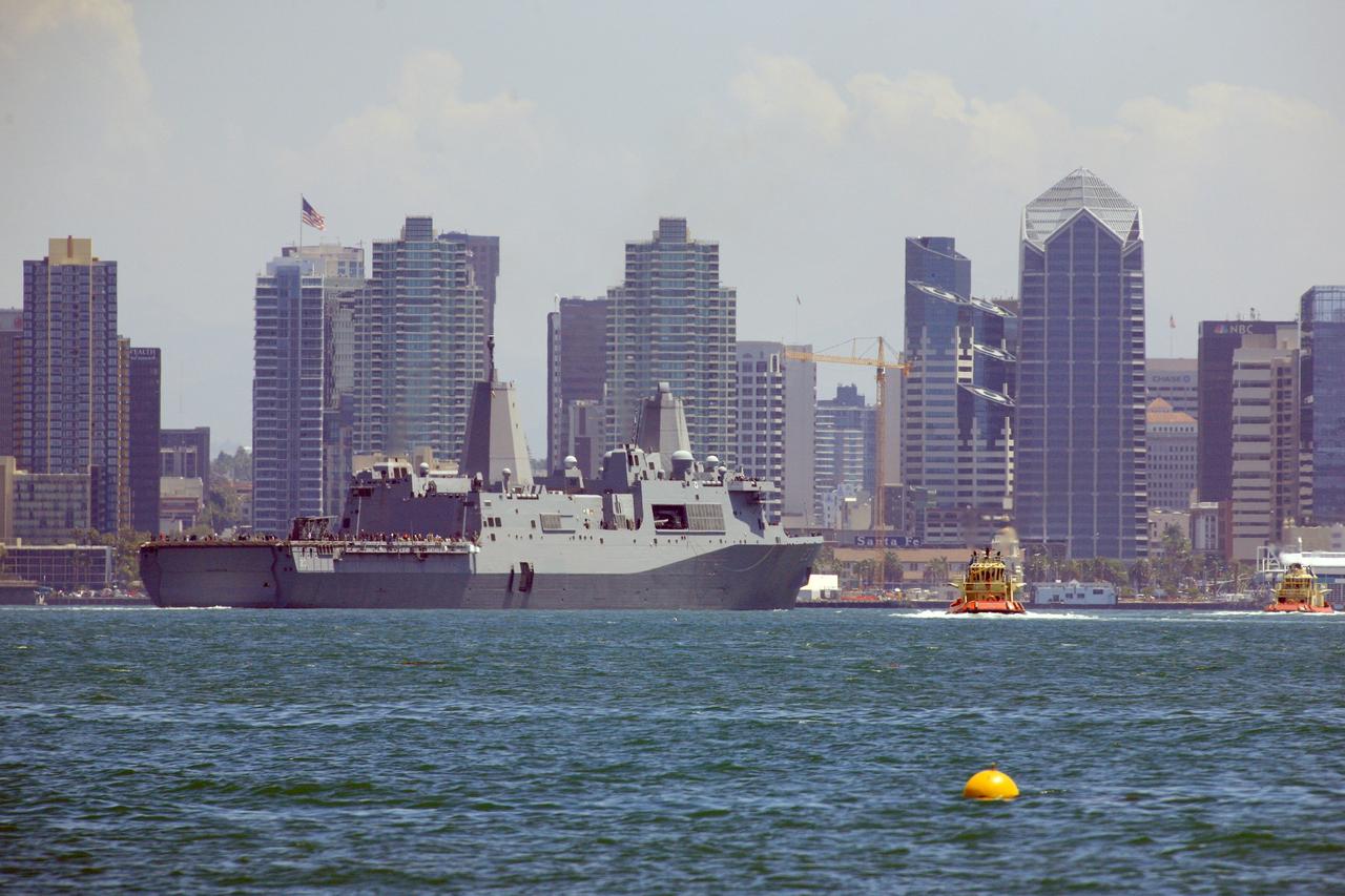
SAN DIEGO, Calif. – The skyline of San Diego, California is visible as the USS San Diego departs from the U.S. Naval Base San Diego with the Orion boilerplate test vehicle and other hardware in its well deck for an underway recovery test. About 100 miles offshore, NASA and the U.S. Navy conducted tests conducted tests to prepare for recovery of the Orion crew module, forward bay cover and parachutes on its return from a deep space mission. The underway recovery test will allow the teams to demonstrate and evaluate the recovery processes, procedures, hardware and personnel in open waters. During the testing, the tether lines were unable to support the tension caused by crew module motion that was driven by wave turbulence in the well deck of the ship. NASA and the U.S. Navy are reviewing the testing data collected to evaluate the next steps. The Ground Systems Development and Operations Program conducted the underway recovery tests. Orion is the exploration spacecraft designed to carry astronauts to destinations not yet explored by humans, including an asteroid and Mars. It will have emergency abort capability, sustain the crew during space travel and provide safe re-entry from deep space return velocities. The first unpiloted test flight of the Orion is scheduled to launch in 2014 atop a Delta IV rocket and in 2017 on NASA’s Space Launch System rocket. For more information, visit http://www.nasa.gov/orion. Photo credit: NASA/Cory Huston
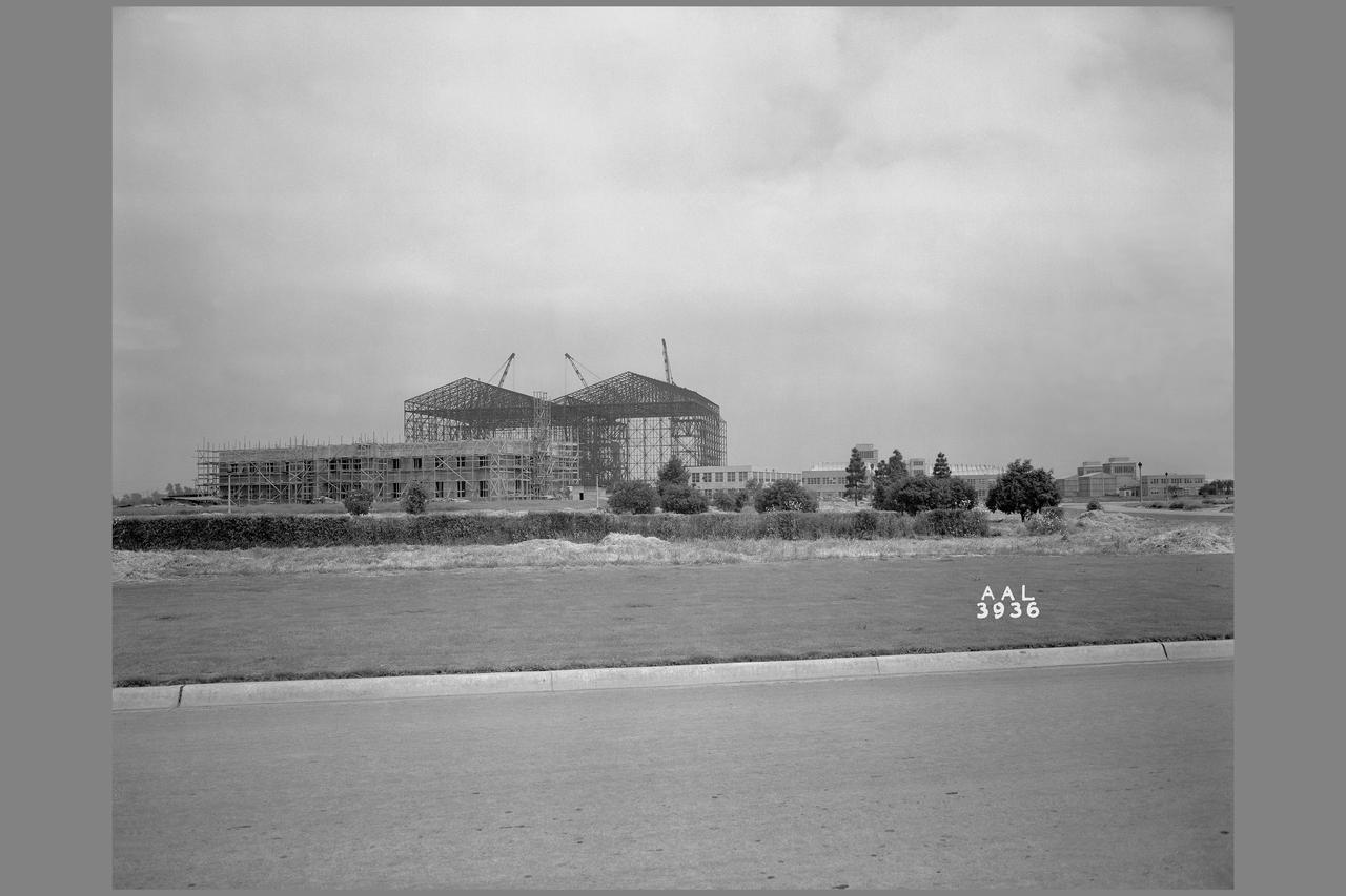
Ames Aeronautical Laboratory skyline from Akron Road
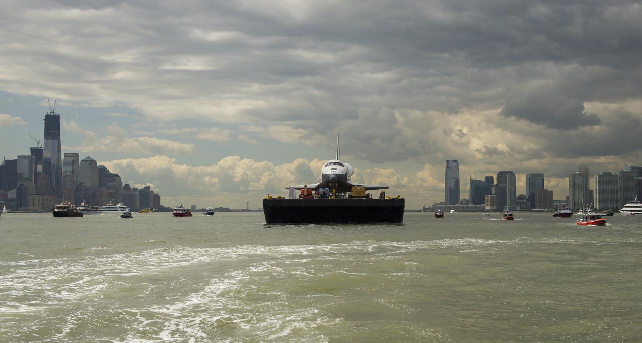
The space shuttle Enterprise is towed by barge up the Hudson River with the New York skyline seen on the left and the Jersey City skyline on the right while on it's way to the Intrepid Sea, Air and Space Museum where it will be permanently displayed, Wednesday, June 6, 2012. Photo Credit: (NASA/Bill Ingalls)

On Friday, April 26, 2014, an avalanche on Mount Everest killed at least 13 Sherpa guides. NASA Terra spacecraft looked toward the northeast, with Mount Everest center, and Lhotse, the fourth-highest mountain on Earth, on the skyline to right center.

STS119-S-025 (15 March 2009) --- The setting sun paints the clouds over NASA's Kennedy Space Center in Florida before the launch of Space Shuttle Discovery on the STS-119 mission. Liftoff is scheduled for 7:43 p.m. (EDT) on March 15, 2009.
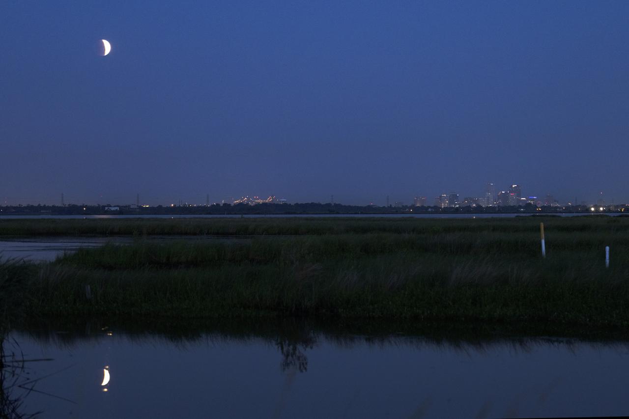
The eclipse of the Super Flower Blood Moon over Bayou Bienvenue with the skyline of the city of New Orleans in the distance early Wednesday morning, May 26, 2021. Image credit: NASA/Michael DeMocker

The San Diego skyline grows distant in the background as the USS Anchorage leaves port on Sept. 15, 2014 to begin testing Orion recovery tools and techniques prior to Exploration Flight Test-1 (EFT-1). Part of Batch image transfer from Flickr.
The space shuttle Enterprise is towed by barge up the Hudson River in New York with the New York City Skyline, including the Empire State Building, in the background while on it's way to the Intrepid Sea, Air and Space Museum where it will be permanently displayed, Wednesday, June 6, 2012. Photo Credit: (NASA/Bill Ingalls)

iss073e0420094 (July 3, 2025) --- Shanghai, China—the nation's largest city with a metropolitan population of approximately 24.9 million—is seen from the International Space Station at around 9:55 p.m. local time. Located where the Yangtze River meets the Yellow Sea, the city glows with urban energy. Notable landmarks include Shanghai Hongqiao International Airport near the top center and Shanghai Pudong International Airport at the bottom. The Huangpu River winds through the heart of downtown, dividing the historic Bund from the futuristic skyline of Lujiazui.
Former astronaut and Special Assistant for Orion Program Integration John Casper watches the San Diego skyline grow smaller in the distance as the Navy's USS Anchorage heads out to sea on Sept. 15, 2014. The ship is being used to test Orion recovery tools and techniques prior to Exploration Flight Test-1 (EFT-1). Part of Batch image transfer from Flickr.

This photo shows NASA Glenn’s S-3 Viking Aircraft flying over downtown Cleveland, Ohio. The S-3 continues to conduct important research including regular flights over Lake Erie and other waterways to image algal blooms that have plagued the area’s waters.

February 17, 2021, The Terminal Tower is illuminated in red to commemorate the Landing of NASA’s Perseverance Rover on the surface of Mars, February 18, 2021. Terminal Tower is a 52-story, (771 ft), landmark skyscraper located on Public Square in downtown Cleveland, Ohio. Cleveland is also the home of the NASA Glenn Research Center.
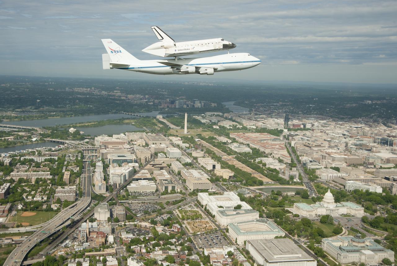
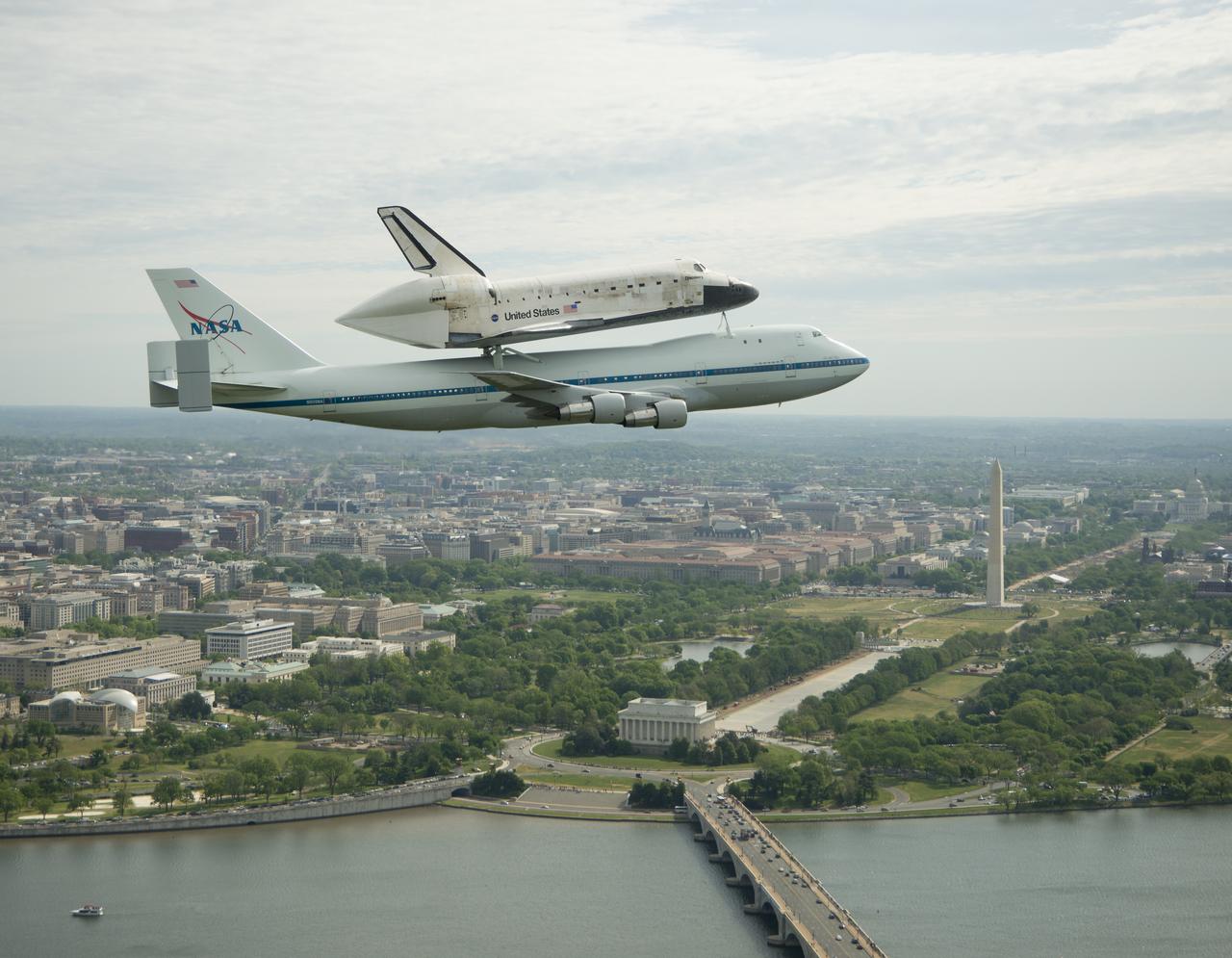
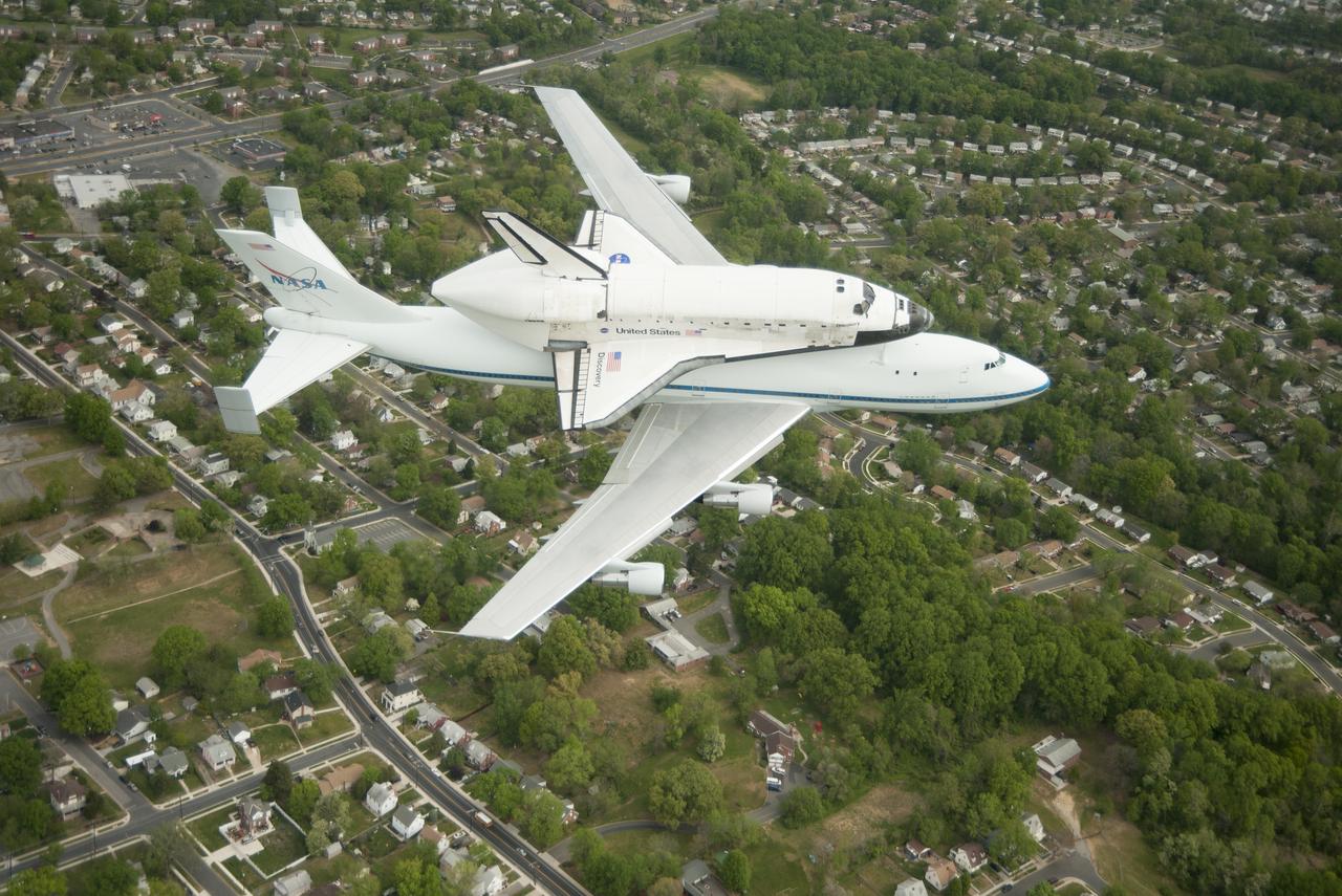
Space shuttle Discovery, mounted atop a NASA 747 Shuttle Carrier Aircraft (SCA), flies over the Washington skyline as seen from a NASA T-38 aircraft, Tuesday, April 17, 2012. Discovery, the first orbiter retired from NASA’s shuttle fleet, completed 39 missions, spent 365 days in space, orbited the Earth 5,830 times, and traveled 148,221,675 miles. NASA will transfer Discovery to the National Air and Space Museum to begin its new mission to commemorate past achievements in space and to educate and inspire future generations of explorers. Photo Credit: (NASA/Robert Markowitz)
Space shuttle Discovery, mounted atop a NASA 747 Shuttle Carrier Aircraft (SCA), flies over the Washington skyline as seen from a NASA T-38 aircraft, Tuesday, April 17, 2012. Discovery, the first orbiter retired from NASA’s shuttle fleet, completed 39 missions, spent 365 days in space, orbited the Earth 5,830 times, and traveled 148,221,675 miles. NASA will transfer Discovery to the National Air and Space Museum to begin its new mission to commemorate past achievements in space and to educate and inspire future generations of explorers. Photo Credit: (NASA/Robert Markowitz)

Space shuttle Discovery, mounted atop a NASA 747 Shuttle Carrier Aircraft (SCA), flies over the Washington skyline as seen from a NASA T-38 aircraft, Tuesday, April 17, 2012. Discovery, the first orbiter retired from NASA’s shuttle fleet, completed 39 missions, spent 365 days in space, orbited the Earth 5,830 times, and traveled 148,221,675 miles. NASA will transfer Discovery to the National Air and Space Museum to begin its new mission to commemorate past achievements in space and to educate and inspire future generations of explorers. Photo Credit: (NASA/Robert Markowitz)

Space shuttle Discovery, mounted atop a NASA 747 Shuttle Carrier Aircraft (SCA), flies over the Washington skyline as seen from a NASA T-38 aircraft, Tuesday, April 17, 2012. Discovery, the first orbiter retired from NASA’s shuttle fleet, completed 39 missions, spent 365 days in space, orbited the Earth 5,830 times, and traveled 148,221,675 miles. NASA will transfer Discovery to the National Air and Space Museum to begin its new mission to commemorate past achievements in space and to educate and inspire future generations of explorers. Photo Credit: (NASA/Robert Markowitz)
Space shuttle Discovery, mounted atop a NASA 747 Shuttle Carrier Aircraft (SCA), flies over the Washington skyline as seen from a NASA T-38 aircraft, Tuesday, April 17, 2012. Discovery, the first orbiter retired from NASA’s shuttle fleet, completed 39 missions, spent 365 days in space, orbited the Earth 5,830 times, and traveled 148,221,675 miles. NASA will transfer Discovery to the National Air and Space Museum to begin its new mission to commemorate past achievements in space and to educate and inspire future generations of explorers. Photo Credit: (NASA/Robert Markowitz)

Space shuttle Discovery, mounted atop a NASA 747 Shuttle Carrier Aircraft (SCA), flies over the Washington skyline as seen from a NASA T-38 aircraft, Tuesday, April 17, 2012. Discovery, the first orbiter retired from NASA’s shuttle fleet, completed 39 missions, spent 365 days in space, orbited the Earth 5,830 times, and traveled 148,221,675 miles. NASA will transfer Discovery to the National Air and Space Museum to begin its new mission to commemorate past achievements in space and to educate and inspire future generations of explorers. Photo Credit: (NASA/Robert Markowitz)
Italy's Mount Etna and the Aeolian Islands are the focus of this perspective view made from an Advanced Spaceborne Thermal and Emission Radiometer (ASTER) image from NASA's Terra spacecraft overlaid on Shuttle Radar Topography Mission (SRTM) topography. The image is looking south with the islands of Lipari and Vulcano in the foreground and Etna with its dark lava flows on the skyline. Vulcano also hosts an active volcano, the cone of which is prominent. In late October 2002, Etna erupted again, sending lava flows down the north and south sides of the volcano. The north flows are near the center of this view, but the ASTER image is from before the eruption. In addition to the terrestrial applications of these data for understanding active volcanoes and hazards associated with them such as lava flows and explosive eruptions, geologists studying Mars find these data useful as an analog to martian landforms and geologic processes. In late September 2002, a field conference with the theme of Terrestrial Analogs to Mars focused on Mount Etna allowing Mars geologists to see in person the types of features they can only sample remotely. http://photojournal.jpl.nasa.gov/catalog/PIA03370

Cleveland’s Terminal Tower as seen from Public Square was lit up “Mars Red” leading up the Perseverance Rover’s arrival on Mars Wednesday night February 18th and Thursday morning.

Cleveland’s Terminal Tower as seen from Voinovich Bicentennial Park was lit up “Mars Red” leading up the Perseverance Rover’s arrival on Mars Wednesday night February 18th and Thursday morning.

February 17, 2021, The Terminal Tower is illuminated in red to commemorate the Landing of NASA’s Perseverance Rover on the surface of Mars, February 18, 2021. Terminal Tower is a 52-story, (771 ft), landmark skyscraper located on Public Square in downtown Cleveland, Ohio. Cleveland is also the home of the NASA Glenn Research Center.

February 17, 2021, The Terminal Tower is illuminated in red to commemorate the Landing of NASA’s Perseverance Rover on the surface of Mars, February 18, 2021. Terminal Tower is a 52-story, (771 ft), landmark skyscraper located on Public Square in downtown Cleveland, Ohio. Cleveland is also the home of the NASA Glenn Research Center.

February 17, 2021, The Terminal Tower is illuminated in red to commemorate the Landing of NASA’s Perseverance Rover on the surface of Mars, February 18, 2021. Terminal Tower is a 52-story, (771 ft), landmark skyscraper located on Public Square in downtown Cleveland, Ohio. Cleveland is also the home of the NASA Glenn Research Center.

February 17, 2021, The Terminal Tower is illuminated in red to commemorate the Landing of NASA’s Perseverance Rover on the surface of Mars, February 18, 2021. Terminal Tower is a 52-story, (771 ft), landmark skyscraper located on Public Square in downtown Cleveland, Ohio. Cleveland is also the home of the NASA Glenn Research Center.
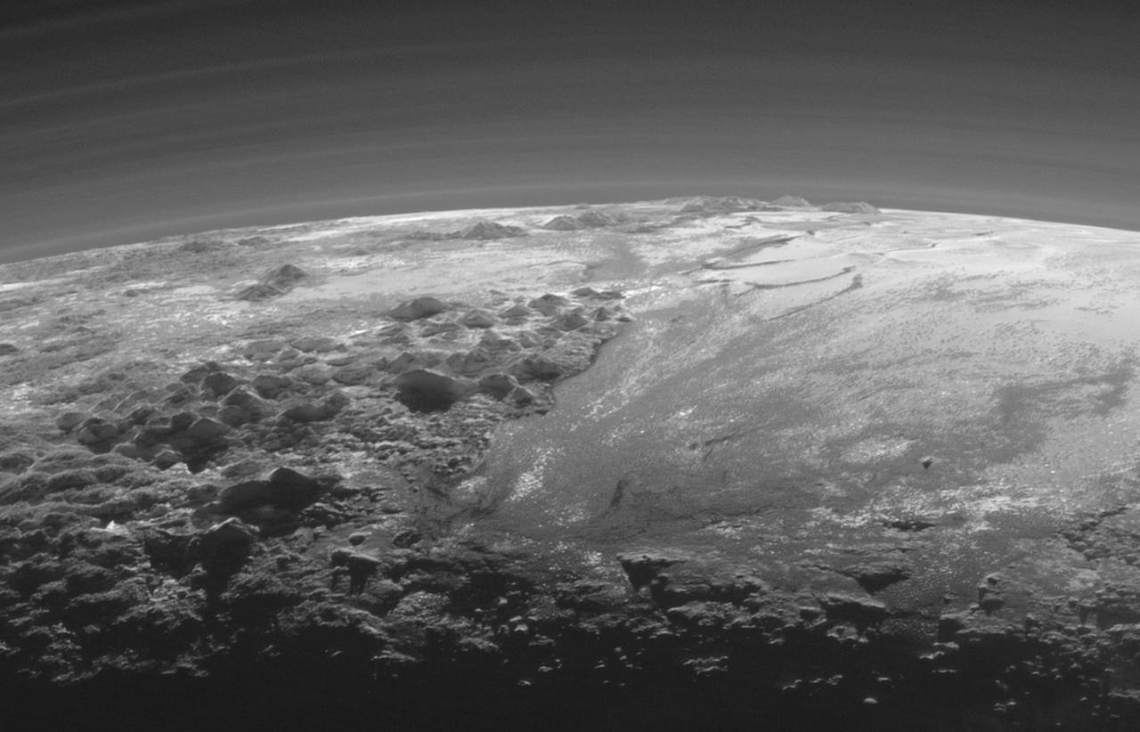
Just 15 minutes after its closest approach to Pluto on July 14, 2015, NASA's New Horizons spacecraft looked back toward the sun and captured a near-sunset view of the rugged, icy mountains and flat ice plains extending to Pluto's horizon. The smooth expanse of the informally named Sputnik Planum (right) is flanked to the west (left) by rugged mountains up to 11,000 feet (3,500 meters) high, including the informally named Norgay Montes in the foreground and Hillary Montes on the skyline. The backlighting highlights more than a dozen layers of haze in Pluto's tenuous but distended atmosphere. The image was taken from a distance of 11,000 miles (18,000 kilometers) to Pluto; the scene is 230 miles (380 kilometers) across. http://photojournal.jpl.nasa.gov/catalog/PIA19947
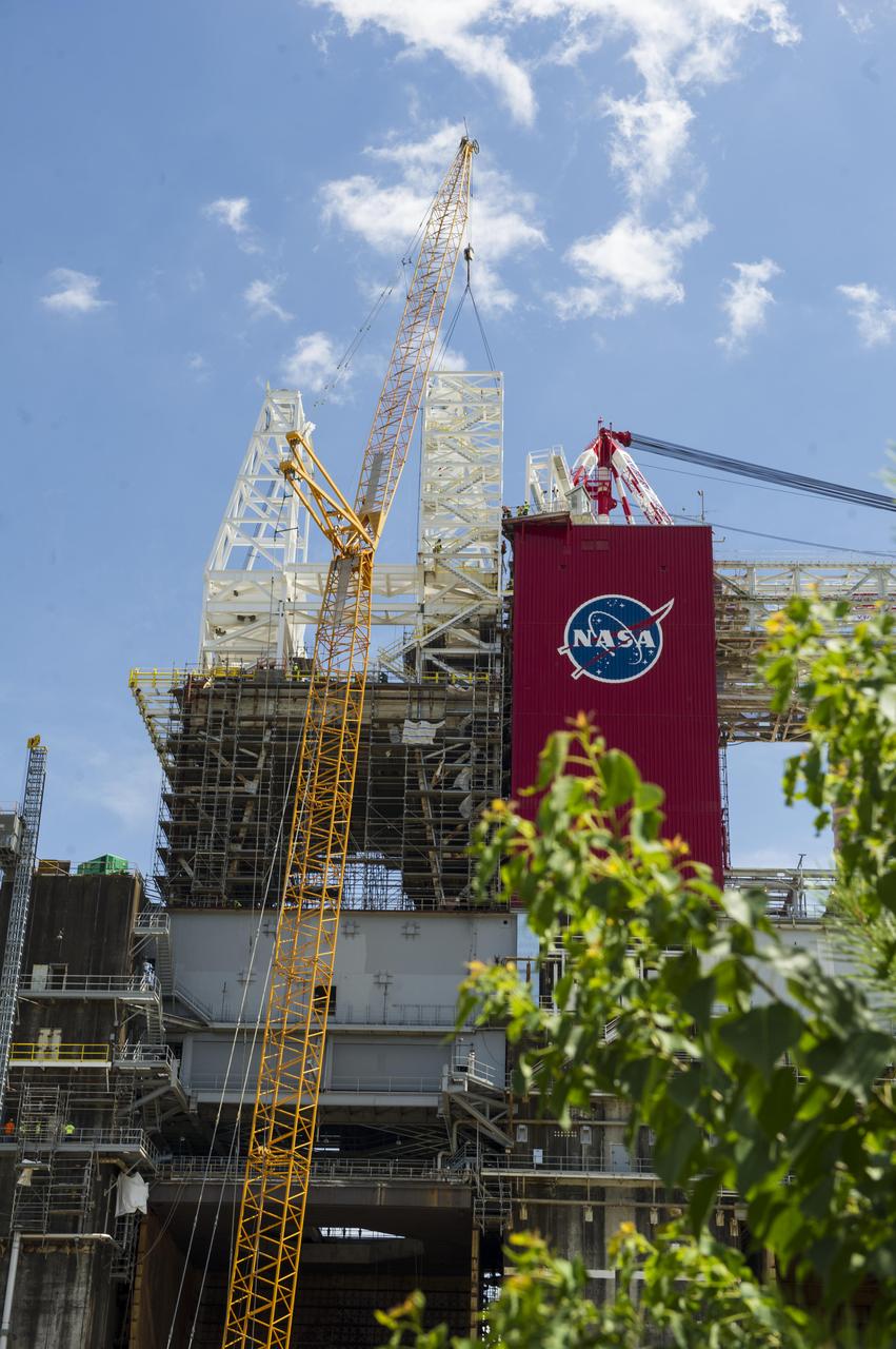
A structural steel section is lifted into place atop the B-2 Test Stand at NASA’s Stennis Space Center as part of modification work to prepare for testing the core stage of NASA’s new Space Launch System. The section is part of the Main Propulsion Test Article (MPTA) framework, which will support the SLS core stage for testing. The existing framework was installed on the stand in the late 1970s to test the shuttle MPTA. However, that framework had to be repositioned and modified to accommodate the larger SLS stage. About 1 million pounds of structural steel has been added, extending the framework about 100 feet higher and providing a new look to the Stennis skyline. Stennis will test the actual flight core stage for the first uncrewed SLS mission, Exploration Mission-1.
Just 15 minutes after its closest approach to Pluto on July 14, 2015, NASA's New Horizons spacecraft looked back toward the sun and captured this near-sunset view of the rugged, icy mountains and flat ice plains extending to Pluto's horizon. The smooth expanse of the informally named icy plain Sputnik Planum (right) is flanked to the west (left) by rugged mountains up to 11,000 feet (3,500 meters) high, including the informally named Norgay Montes in the foreground and Hillary Montes on the skyline. To the right, east of Sputnik, rougher terrain is cut by apparent glaciers. The backlighting highlights more than a dozen layers of haze in Pluto's tenuous but distended atmosphere. The image was taken from a distance of 11,000 miles (18,000 kilometers) to Pluto; the scene is 780 miles (1,250 kilometers) wide. http://photojournal.jpl.nasa.gov/catalog/PIA19948
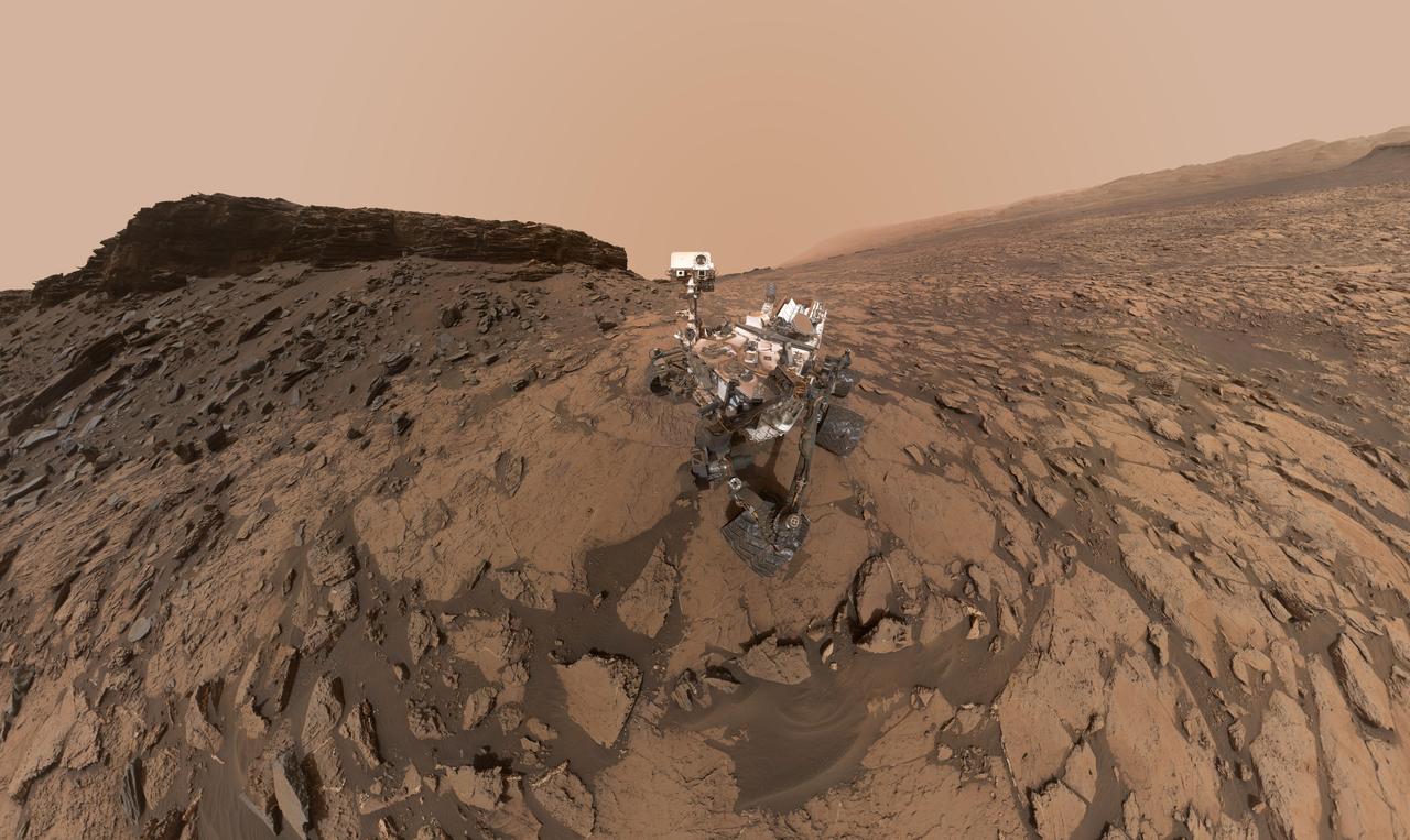
This self-portrait of NASA's Curiosity Mars rover shows the vehicle at the "Quela" drilling location in the "Murray Buttes" area on lower Mount Sharp. Key features on the skyline of this panorama are the dark mesa called "M12" to the left of the rover's mast and pale, upper Mount Sharp to the right of the mast. The top of M12 stands about 23 feet (7 meters) above the base of the sloping piles of rocks just behind Curiosity. The scene combines approximately 60 images taken by the Mars Hand Lens Imager (MAHLI) camera at the end of the rover's robotic arm. Most of the component images were taken on Sept. 17, 2016, during the 1,463rd Martian day, or sol, of Curiosity's work on Mars. Two component images of the drill-hole area in front of the rover were taken on Sol 1466 (Sept. 20) to show the hole created by collecting a drilled sample at Quela on Sol 1464 (Sept. 18). The skyline sweeps from west on the left to south-southwest on the right, with the rover's mast at northeast. The rover's location when it recorded this scene was where it ended a drive on Sol 1455, mapped at http://mars.nasa.gov/msl/multimedia/images/?ImageID=8029. The view does not include the rover's arm nor the MAHLI camera itself, except in the miniature scene reflected upside down in the parabolic mirror at the top of the mast. That mirror is part of Curiosity's Chemistry and Camera (ChemCam) instrument. MAHLI appears in the center of the mirror. Wrist motions and turret rotations on the arm allowed MAHLI to acquire the mosaic's component images. The arm was positioned out of the shot in the images, or portions of images, that were used in this mosaic. This process was used previously in acquiring and assembling Curiosity self-portraits taken at other sample-collection sites, including "Rocknest" (PIA16468), "Windjana" (PIA18390"), "Buckskin" (PIA19808) and "Gobabeb" (PIA20316). For scale, the rover's wheels are 20 inches (50 centimeters) in diameter and about 16 inches (40 centimeters) wide. http://photojournal.jpl.nasa.gov/catalog/PIA20844

CAPTION: ---------------------------- Space shuttle Enterprise, mounted atop a NASA 747 Shuttle Carrier Aircraft (SCA), is seen as it flies near the Intrepid Sea, Air and Space Museum, Friday, April 27, 2012, in New York. Enterprise was the first shuttle orbiter built for NASA performing test flights in the atmosphere and was incapable of spaceflight. Originally housed at the Smithsonian's Steven F. Udvar-Hazy Center, Enterprise will be demated from the SCA and placed on a barge that will eventually be moved by tugboat up the Hudson River to the Intrepid Sea, Air & Space Museum in June. Photo Credit: (NASA/Robert Markowitz)

Space shuttle Enterprise, mounted atop a NASA 747 Shuttle Carrier Aircraft (SCA), is seen as it flies near the Empire State Building, Friday, April 27, 2012, in New York. Enterprise was the first shuttle orbiter built for NASA performing test flights in the atmosphere and was incapable of spaceflight. Originally housed at the Smithsonian's Steven F. Udvar-Hazy Center, Enterprise will be demated from the SCA and placed on a barge that will eventually be moved by tugboat up the Hudson River to the Intrepid Sea, Air & Space Museum in June. Photo Credit: (NASA/Robert Markowitz)

SAN DIEGO, Calif. – A member of the U.S. Navy watches the San Diego skyline from the deck of the USS Anchorage as the ship departs Naval Base San Diego on the first day of Orion Underway Recovery Test 3. The ship is heading out to sea, off the coast of San Diego, in search of conditions to support test needs for a full dress rehearsal of recovery operations. NASA, Lockheed Martin and U.S. Navy personnel will conduct tests in the Pacific Ocean to prepare for recovery of the Orion crew module on its return from a deep space mission. The test will allow the teams to demonstrate and evaluate the recovery processes, procedures, hardware and personnel in open waters. The Ground Systems Development and Operations Program is conducting the underway recovery tests. Orion is the exploration spacecraft designed to carry astronauts to destinations not yet explored by humans, including an asteroid and Mars. It will have emergency abort capability, sustain the crew during space travel and provide safe re-entry from deep space return velocities. The first unpiloted test flight of Orion is scheduled to launch in 2014 atop a United Launch Alliance Delta IV Heavy rocket and in 2018 on NASA’s Space Launch System rocket. For more information, visit http://www.nasa.gov/orion. Photo credit: NASA/Cory Huston
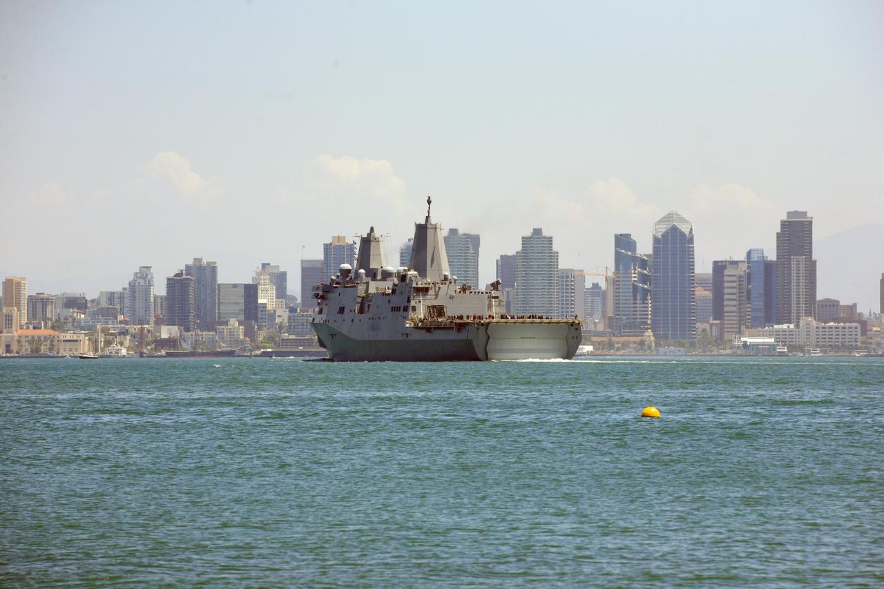
SAN DIEGO, Calif. – The USS Anchorage returns to Naval Base San Diego after completion of the Orion Underway Recovery Test 2 in the Pacific Ocean. The ship is framed by the skyline of the city of San Diego. NASA, Lockheed Martin and the U.S. Navy conducted the test on the Orion boilerplate test vehicle to prepare for recovery of the Orion crew module on its return from a deep space mission. The underway recovery test allowed the team to demonstrate and evaluate the recovery processes, procedures, new hardware and personnel in open waters. The Ground Systems Development and Operations Program conducted the underway recovery test. Orion is the exploration spacecraft designed to carry astronauts to destinations not yet explored by humans, including an asteroid and Mars. It will have emergency abort capability, sustain the crew during space travel and provide safe re-entry from deep space return velocities. The first unpiloted test flight of the Orion is scheduled to launch in 2014 atop a Delta IV rocket and in 2017 on NASA’s Space Launch System rocket. For more information, visit http://www.nasa.gov/orion. Photo credit: NASA/Kim Shiflett
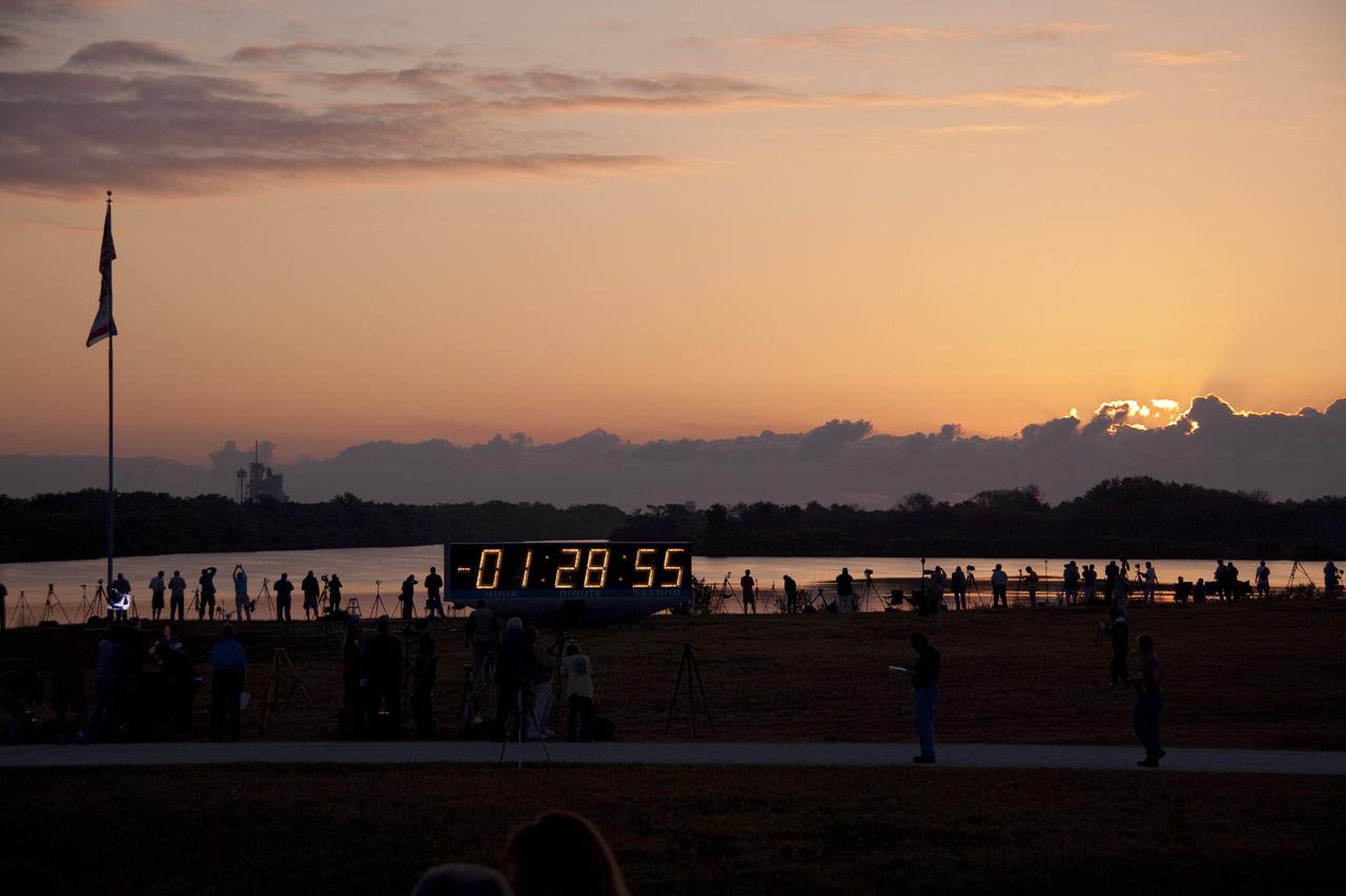
CAPE CANAVERAL, Fla. -- As the sun rises and paints a colorful skyline across NASA's Kennedy Space Center in Florida, media set up their cameras at the countdown clock in the Launch Complex 39 area. At 8:56 a.m. EDT on May 16, space shuttle Endeavour and its six-member STS-134 crew are scheduled to lift off Launch Pad 39A on a mission to the International Space Station. STS-134 will deliver the Alpha Magnetic Spectrometer-2 (AMS), Express Logistics Carrier-3, a high-pressure gas tank and additional spare parts for the Dextre robotic helper to the International Space Station. This will be the second launch attempt for Endeavour. The first attempt on April 29 was scrubbed because of an issue associated with a faulty power distribution box called the aft load control assembly-2 (ALCA-2). STS-134 will be the final spaceflight for Endeavour. For more information visit, www.nasa.gov/mission_pages/shuttle/shuttlemissions/sts134/index.html. Photo credit: NASA/Troy Cryder

CAPE CANAVERAL, Fla. -- As the sun rises and paints a colorful skyline across NASA's Kennedy Space Center in Florida, media set up their cameras at the countdown clock in the Launch Complex 39 area. At 8:56 a.m. EDT on May 16, space shuttle Endeavour and its six-member STS-134 crew are scheduled to lift off Launch Pad 39A on a mission to the International Space Station. STS-134 will deliver the Alpha Magnetic Spectrometer-2 (AMS), Express Logistics Carrier-3, a high-pressure gas tank and additional spare parts for the Dextre robotic helper to the International Space Station. This will be the second launch attempt for Endeavour. The first attempt on April 29 was scrubbed because of an issue associated with a faulty power distribution box called the aft load control assembly-2 (ALCA-2). STS-134 will be the final spaceflight for Endeavour. For more information visit, www.nasa.gov/mission_pages/shuttle/shuttlemissions/sts134/index.html. Photo credit: NASA/Troy Cryder
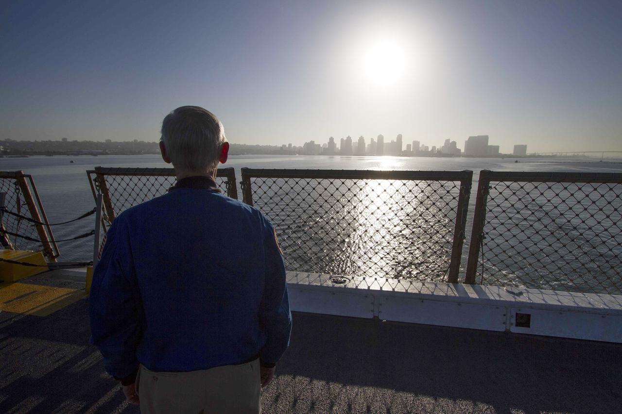
SAN DIEGO, Calif. – John Casper, retired NASA astronaut and Special Assistant for Program Integration for the Orion Program, looks at the San Diego skyline from the deck of the USS Anchorage as the ship departs Naval Base San Diego on the first day of Orion Underway Recovery Test 3. The ship will head out to sea, off the coast of San Diego, in search of conditions to support test needs for a full dress rehearsal of recovery operations. NASA, Lockheed Martin and U.S. Navy personnel will conduct tests in the Pacific Ocean to prepare for recovery of the Orion crew module on its return from a deep space mission. The test will allow the teams to demonstrate and evaluate the recovery processes, procedures, hardware and personnel in open waters. The Ground Systems Development and Operations Program is conducting the underway recovery tests. Orion is the exploration spacecraft designed to carry astronauts to destinations not yet explored by humans, including an asteroid and Mars. It will have emergency abort capability, sustain the crew during space travel and provide safe re-entry from deep space return velocities. The first unpiloted test flight of Orion is scheduled to launch in 2014 atop a United Launch Alliance Delta IV Heavy rocket and in 2018 on NASA’s Space Launch System rocket. For more information, visit http://www.nasa.gov/orion. Photo credit: NASA/Cory Huston

ISS030-E-188071 (27 March 2012) --- A nighttime view of Shanghai is featured in this image photographed by an Expedition 30 crew member on the International Space Station. The city of Shanghai sits along the delta banks of the Yangtze River along the eastern coast of China. The city proper is the world’s most populous city (the 2010 census counts 23 million people, including “unregistered” residents). With that many humans, the city is a tremendous sight at night. Shanghai is a key financial capital for China and the Asian Pacific region. The bright lights of the city center and the distinctive new skyscrapers that form the skyline along the Pudong district (the eastern shore of the Huangpu River, a tributary of the Yangtze that cuts through the center of Shanghai) make for spectacular night viewing both on the ground and from space. The official census count in 2000 was 16.4 million; the city population has increased more than 35 per cent since that time. Much of the growth has occurred in new satellite developments like areas to the west of the city (for example, Suzhou). The city’s rapid growth and development during the 20th and 21st centuries have come at a cost. Water availability is a key concern, and groundwater withdrawal has resulted in substantial subsidence in and around the city. Because it is built only a few meters above sea level – on the banks of the deltaic estuary of the Yangtze River – curbing subsidence rates is a critical concern.
SAN DIEGO, Calif. – The USS Anchorage returns to Naval Base San Diego after completion of the Orion Underway Recovery Test 2 in the Pacific Ocean. The ship is framed by the skyline of the city of San Diego. NASA, Lockheed Martin and the U.S. Navy conducted the test on the Orion boilerplate test vehicle to prepare for recovery of the Orion crew module on its return from a deep space mission. The underway recovery test allowed the team to demonstrate and evaluate the recovery processes, procedures, new hardware and personnel in open waters. The Ground Systems Development and Operations Program conducted the underway recovery test. Orion is the exploration spacecraft designed to carry astronauts to destinations not yet explored by humans, including an asteroid and Mars. It will have emergency abort capability, sustain the crew during space travel and provide safe re-entry from deep space return velocities. The first unpiloted test flight of the Orion is scheduled to launch in 2014 atop a Delta IV rocket and in 2017 on NASA’s Space Launch System rocket. For more information, visit http://www.nasa.gov/orion. Photo credit: NASA/Kim Shiflett
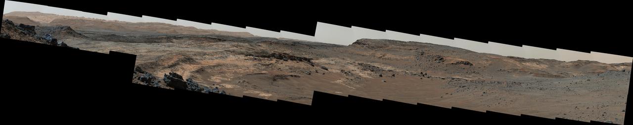
A sweeping panorama combining 33 telephoto images into one Martian vista presents details of several types of terrain visible on Mount Sharp from a location along the route of NASA's Curiosity Mars rover. The rover's Mast Camera (Mastcam) recorded the component images with its right-eye camera on April 10, 2015, during the 952nd Martian day, or sol, of Curiosity's work on Mars, before that sol's drive. The panorama spans from south-southeast, at left, to west-southwest. The color has been approximately white-balanced to resemble how the scene would appear under daytime lighting conditions on Earth. Higher elevations on Mount Sharp are visible at left, including the jagged skyline to the right of a 100-meter scale bar overlaid on the image. (One hundred meters is about 328 feet.) The 2-meter (7-foot) scale bar near the center of the scene is on an exposure of pale mudstone within Mount Sharp's basal geological unit, the Murray formation, and nearby darker rocks. The 3-meter (10-foot) scale bar farther to the right is at the base of a rise called "Gray Wolf Peak." "Logan Pass," a science destination for the rover, is at a dip on the horizon near the right edge of the panorama. Malin Space Science Systems, San Diego, built and operates the rover's Mastcam. NASA's Jet Propulsion Laboratory, a division of the California Institute of Technology, Pasadena, manages the Mars Science Laboratory Project for NASA's Science Mission Directorate, Washington. JPL designed and built the project's Curiosity rover. http://photojournal.jpl.nasa.gov/catalog/PIA19397

On July 3, 1936, President Franklin Delano Roosevelt stood amidst the crowd in Big Meadows and officially dedicated Shenandoah National Park in Virginia. The Thematic Mapper on the Landsat satellite captured this view of the heart of Shenandoah National Park on October 10, 2010, at the height of the fall “leaf-peeping” season. The orange and brown swath across the image highlights the hilly backbone of the park, where leaves had turned to their fall colors. The 169-kilometer (105-mile) Skyline Drive that meanders across the crest of the ridge is often jammed with tourists in autumn. The park includes more than 518 miles of hiking trails, including more than 100 miles of the Appalachian Trail. The highest peak is Hawksbill Mountain at 4,051 feet (1,235 m), but the most popular with hikers is Old Rag Mountain. A circuitous eight-mile (13 kilometer) trail leads to an exposed, rocky summit 3,291 feet (1,003 meters) above sea level. The 2,200 foot elevation change from base to summit, combined with several rock scrambles, make Old Rag not only the most popular but also the most dangerous hike. Read more: <a href="http://go.nasa.gov/2bRnFxH" rel="nofollow">go.nasa.gov/2bRnFxH</a> Credit: NASA/Landsat5 <b><a href="http://www.nasa.gov/audience/formedia/features/MP_Photo_Guidelines.html" rel="nofollow">NASA image use policy.</a></b> <b><a href="http://www.nasa.gov/centers/goddard/home/index.html" rel="nofollow">NASA Goddard Space Flight Center</a></b> enables NASA’s mission through four scientific endeavors: Earth Science, Heliophysics, Solar System Exploration, and Astrophysics. Goddard plays a leading role in NASA’s accomplishments by contributing compelling scientific knowledge to advance the Agency’s mission. <b>Follow us on <a href="http://twitter.com/NASAGoddardPix" rel="nofollow">Twitter</a></b> <b>Like us on <a href="http://www.facebook.com/pages/Greenbelt-MD/NASA-Goddard/395013845897?ref=tsd" rel="nofollow">Facebook</a></b> <b>Find us on <a href="http://instagrid.me/nasagoddard/?vm=grid" rel="nofollow">Instagram</a></b>
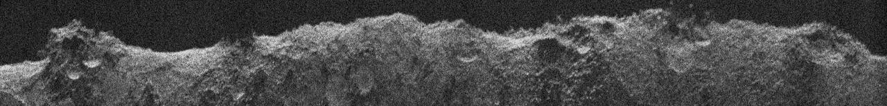
NASA's Europa Clipper, en route to the Jupiter system to investigate the icy moon Europa, conducted a critical test of its radar instrument during a flyby of Mars on March 1, 2025. During the testing, the instrument received echoes of its very-high-frequency radar signals that engineers processed to develop this image, called a radargram. The image was made using radar signals that bounced off Mars. What looks like a skyline is the outline of the topography. Features seen in the radargram include contributions from the topographic features both along and near the ground track (the path below the spacecraft as it passed overhead), such as impact craters, hills, and steep slopes. The 560-mile-long (900-kilometer-long) section of terrain profiled in this radargram is near Mars' equator. The Europa Clipper radar instrument, REASON (Radar for Europa Assessment and Sounding: Ocean to Near-surface), is designed to see into the icy crust of Europa. Though the rocky Martian surface does not allow much penetration by the radar signals, the clarity of the radargram image indicates REASON was performing as expected during the Mars flyby, boding well for future observations at Europa. As Europa Clipper zipped by the Red Planet – starting at 3,100 miles (5,000 kilometers) down to 550 miles (884 kilometers) above the surface – REASON sent and received radio waves for about 40 minutes. In comparison, at Europa the instrument will operate as close as 16 miles (25 kilometers) from the moon's surface. Europa Clipper launched from NASA's Kennedy Space Center in Florida on Oct. 14, 2024, and will arrive at the Jupiter system in 2030 to conduct about 50 flybys of Europa. The mission's main science goal is to determine whether there are places below Europa's surface that could support life. The mission's three main science objectives are to determine the thickness of the moon's icy shell and its surface interactions with the ocean below, to investigate its composition, and to characterize its geology. The mission's detailed exploration of Europa will help scientists better understand the astrobiological potential for habitable worlds beyond our planet. https://photojournal.jpl.nasa.gov/catalog/PIA26568
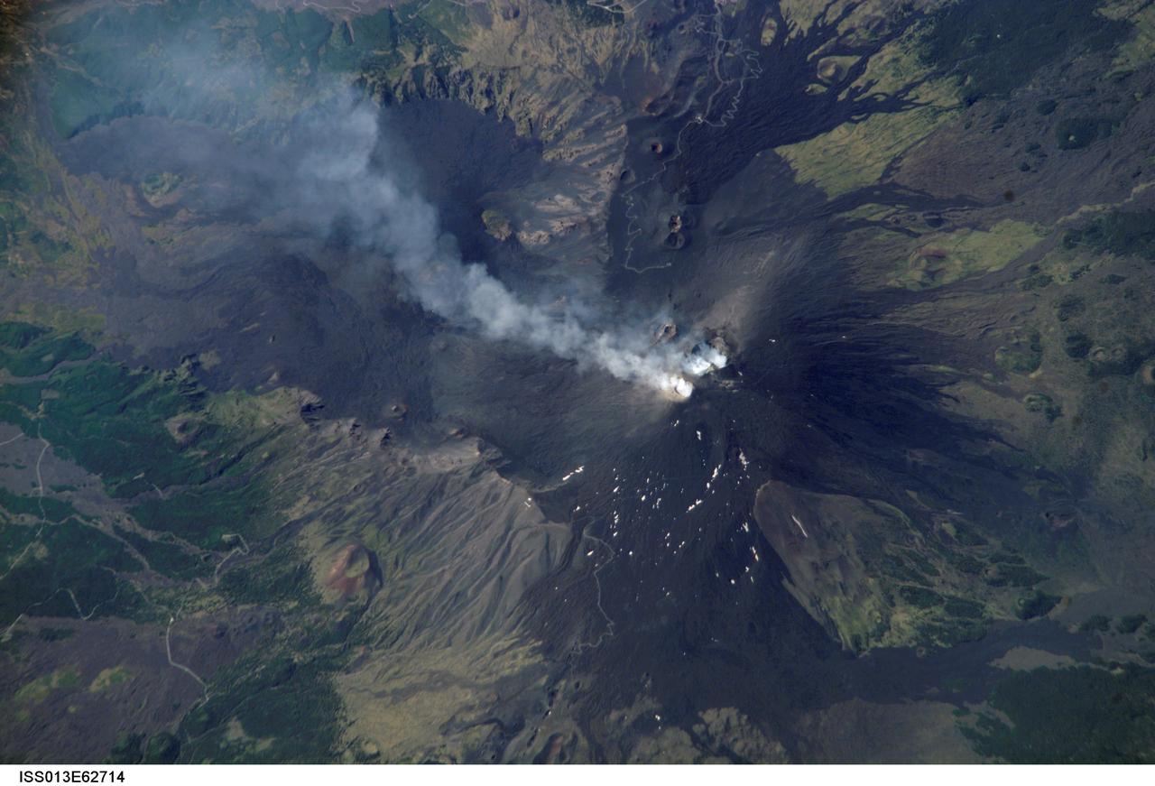
ISS013-E-62714 (2 Aug. 2006) --- Mt. Etna Summit Plumes, Sicily is featured in this image photographed by an Expedition 13 crewmember on the International Space Station. One of the most consistently active volcanoes in the world is Sicily's Mt. Etna, which has a historical record of eruptions dating back to 1500 B.C. This image captures plumes of steam and possible minor ash originating from summit craters on the mountain -- the Northeast Crater and Central Crater, which includes two secondary craters (Voragine and Bocca Nuova). Explosions were heard from the rim of the Northeast Crater on July 26, and scientists suspect that these plumes are a continuation of that activity. The massive 3350 meter high volcano is located approximately 24 kilometers to the north of Catania, the second largest city in Sicily, and dominates the northern skyline. Much of Etna's surface is comprised of numerous generations of dark basaltic lava flows, as can be seen extended outwards from the summit craters. Fertile soils developed on older flows are marked by green vegetation. While the current explosive eruptions of Etna tend to occur at the summit, lava flows generally erupt through fissures lower down on the flanks of the volcano. Many of the lava flow vents are marked by cinder cones on the flanks of Mt. Etna. Scientists have noted evidence of larger eruptive events as well. The Valle Del Bove to the south-southeast of the summit is a caldera formed by the emptying of a subsurface magma chamber during a large eruptive event -- once the magma chamber was emptied, the overlaying roof material collapsed downwards.

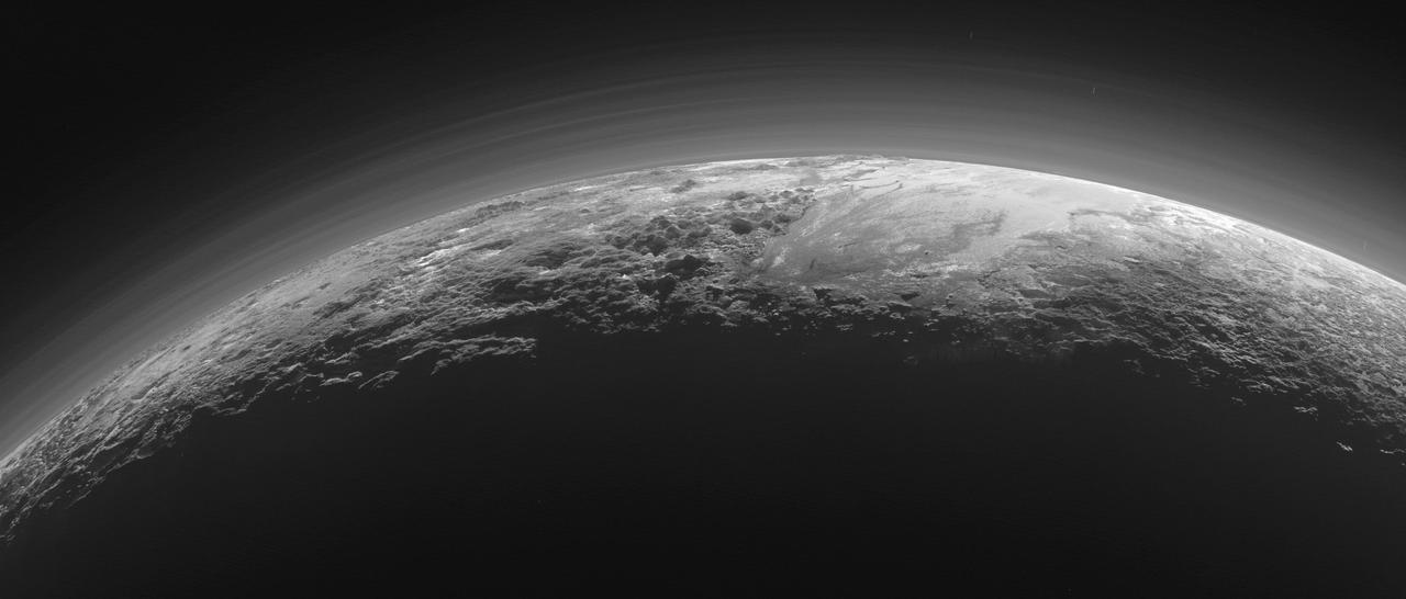
In September, NASA's New Horizons team released a stunning but incomplete image of Pluto's crescent. Thanks to new processing work by the science team, New Horizons is releasing the entire, breathtaking image of Pluto. This image was made just 15 minutes after New Horizons' closest approach to Pluto on July 14, 2015, as the spacecraft looked back at Pluto toward the sun. The wide-angle perspective of this view shows the deep haze layers of Pluto's atmosphere extending all the way around Pluto, revealing the silhouetted profiles of rugged plateaus on the night (left) side. The shadow of Pluto cast on its atmospheric hazes can also be seen at the uppermost part of the disk. On the sunlit side of Pluto (right), the smooth expanse of the informally named icy plain Sputnik Planum is flanked to the west (above, in this orientation) by rugged mountains up to 11,000 feet (3,500 meters) high, including the informally named Norgay Montes in the foreground and Hillary Montes on the skyline. Below (east) of Sputnik, rougher terrain is cut by apparent glaciers. The backlighting highlights more than a dozen high-altitude layers of haze in Pluto's tenuous atmosphere. The horizontal streaks in the sky beyond Pluto are stars, smeared out by the motion of the camera as it tracked Pluto. The image was taken with New Horizons' Multi-spectral Visible Imaging Camera (MVIC) from a distance of 11,000 miles (18,000 kilometers) to Pluto. The resolution is 700 meters (0.4 miles).

ISS032-E-010487 (29 July 2012) --- Walker Lake, Nevada is featured in this image photographed by an Expedition 32 crew member on the International Space Station. According to scientists, the Pleistocene landscape of western Nevada approximately 15,000 years ago was one of narrow mountain ranges and numerous interconnected lakes that together formed the extensive glacial Lake Lahontan. Scientists believe drying and warming of the regional climate since the last Ice Age led to the disappearance of the glaciers feeding meltwater to Lake Lahontan, and eventual disappearance of the lake itself. Today, few remnants of Lahontan remain; most of its arms have become dry enclosed basins known as playas. This photograph highlights Walker Lake, one of only two remnant lakes that contain water throughout the year (Pyramid Lake in Nevada is the other). The lake is located in an enclosed basin bounded by the Wassuk Range to the west and the Gillis Range to the east. It is fed by the Walker River flowing from the north. The current dimensions of the lake are approximately 21 kilometers north-south by 9 kilometers east-west. Shoreline deposits at higher elevations than the current lake level form concentric bands that are just visible in the image (bottom center) ? these record varying lake levels in the geologic past. The nearest town is Hawthorne, Nevada to the southeast. To the southwest the highest peak of the Wassuk Range, Mount Grant (elevation 3,496 meters above sea level), dominates the skyline. Green agricultural fields, primarily alfalfa, located to the west of the Wassuk Range (lower right) provide a striking contrast to the surrounding Great Basin desert. These fields are irrigated using water from the nearby East Fork of the Walker River (right, just visible alongside the fields).

jsc2022e060871_Alt ( 6/22/2022) Friendswood High School art students designed the space themed mural named “Dream Explore Discover”. The mural represents the amazing beauty and excitement of space exploration. Taking on a bit of a colorful look is the NASA Meatball logo designed to have a neon light affect glowing within the background of space. Starting with an American astronaut conducting spacewalk in the colorful cosmic universe that is filled with stars, planets, and nebulas. The International Space Station is seen among the colorful flowers that not only represent the iconic blooms of zinnias grown on the Space Station but hold within their pistils are the planets of our solar System culminating with Mars at the top. Grounded by the moon at the base of the mural is the second astronaut who’s face shield beautifully marks the Houston skyline and home to Johnson Space Center. Giving a thumbs up or go for launch to pursue the next steps in human exploration. From Earth to the moon and onward to Mars. The launch of the Space Launch System (SLS) with the Orion capsule riding on top heading for the next giant step. Next to the Orion capsule you can make out the Orion Constellation. In the bottom right corner is “Teddy”, flown aboard the space shuttle on one of astronaut Brian Duffy’s flights for his daughter. It represents the dreams of children who look up to the stars from our beautiful planet earth the dream of what can be. Brian’s daughter went on to write a children’s story about the friendship between Shannon, the daughter of an astronaut, and her beloved teddy bear named Teddy. Friendswood art student Autumn Potter illustrated the book and painted Teddy on the mural.

At its founding, the Marshall Space Flight Center (MSFC) inherited the Army’s Jupiter and Redstone test stands, but much larger facilities were needed for the giant stages of the Saturn V. From 1960 to 1964, the existing stands were remodeled and a sizable new test area was developed. The new comprehensive test complex for propulsion and structural dynamics was unique within the nation and the free world, and they remain so today because they were constructed with foresight to meet the future as well as on going needs. Construction of the S-IC Static test stand complex began in 1961 in the west test area of MSFC, and was completed in 1964. The S-IC static test stand was designed to develop and test the 138-ft long and 33-ft diameter Saturn V S-IC first stage, or booster stage, weighing in at 280,000 pounds. Required to hold down the brute force of a 7,500,000-pound thrust produced by 5 F-1 engines, the S-IC static test stand was designed and constructed with the strength of hundreds of tons of steel and 12,000,000 pounds of cement, planted down to bedrock 40 feet below ground level. The foundation walls, constructed with concrete and steel, are 4 feet thick. The base structure consists of four towers with 40-foot-thick walls extending upward 144 feet above ground level. The structure was topped by a crane with a 135-foot boom. With the boom in the upright position, the stand was given an overall height of 405 feet, placing it among the highest structures in Alabama at the time. In addition to the stand itself, related facilities were constructed during this time. North of the massive S-IC test stand, the F-1 Engine test stand was built. Designed to assist in the development of the F-1 Engine, the F-1 test stand is a vertical engine firing test stand, 239 feet in elevation and 4,600 square feet in area at the base. Capability was provided for static firing of 1.5 million pounds of thrust using liquid oxygen and kerosene. Like the S-IC stand, the foundation of the F-1 stand is keyed into the bedrock approximately 40 feet below grade. This photo depicts the construction of the F-1 test stand as of August 13, 1963. All four of its tower legs are well underway into the skyline.
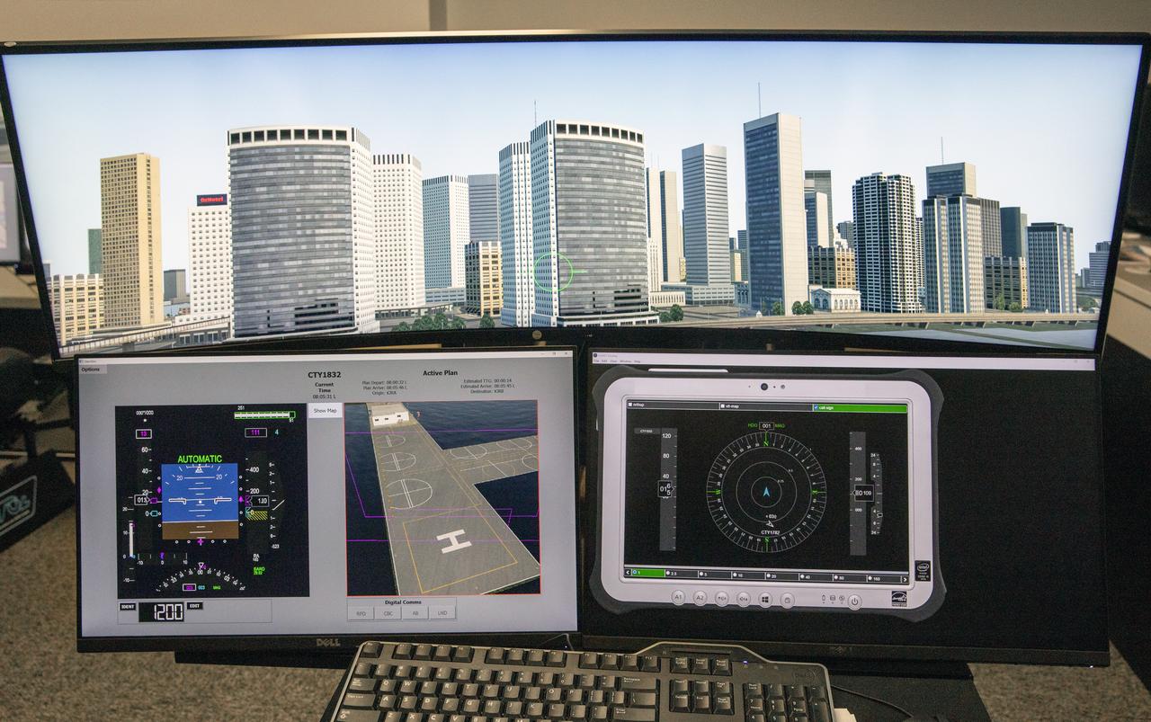
Focus on active photos –Class B Simulation Evaluation in the ATOL Lab at Langley (Also at FAA Tech Center) where team is working with one another in the lab, reviewing data on the monitors. Working the software, adjusting the software systems. Going over the shoulder to show the displays and screens as the software is running. A pilot’s point of view from the controls of the air taxi simulator. An out-the-window simulation appears on the top screen, the primary flight display on the lower left, the virtual moving map in the middle, and the detect and avoid display on the lower right at NASA’s Langley Research Center in Hampton, Virginia on Sept. 25, 2024.