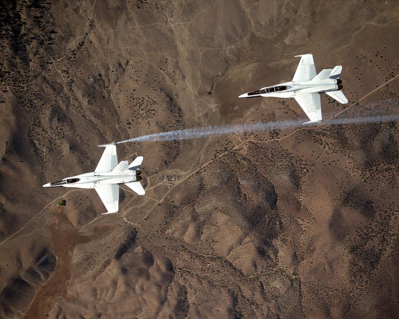
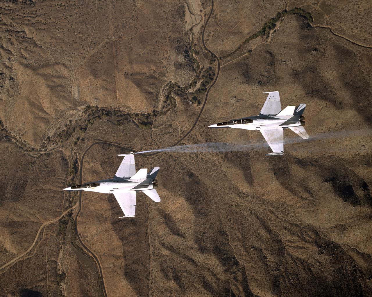
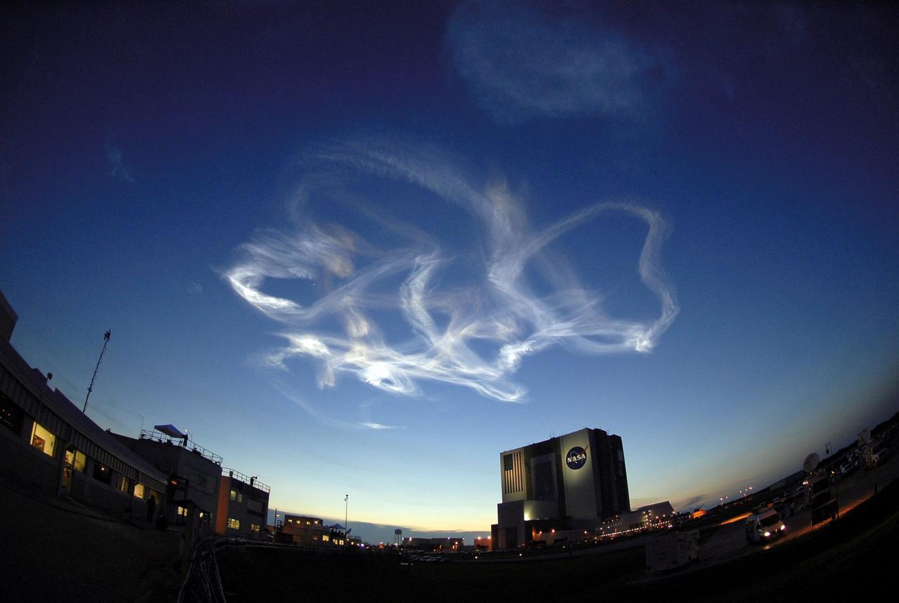
Smoke generators show the twisting paths of wingtip vortices behind two NASA Dryden F/A-18 jets used in the Autonomous Formation Flight (AFF) program
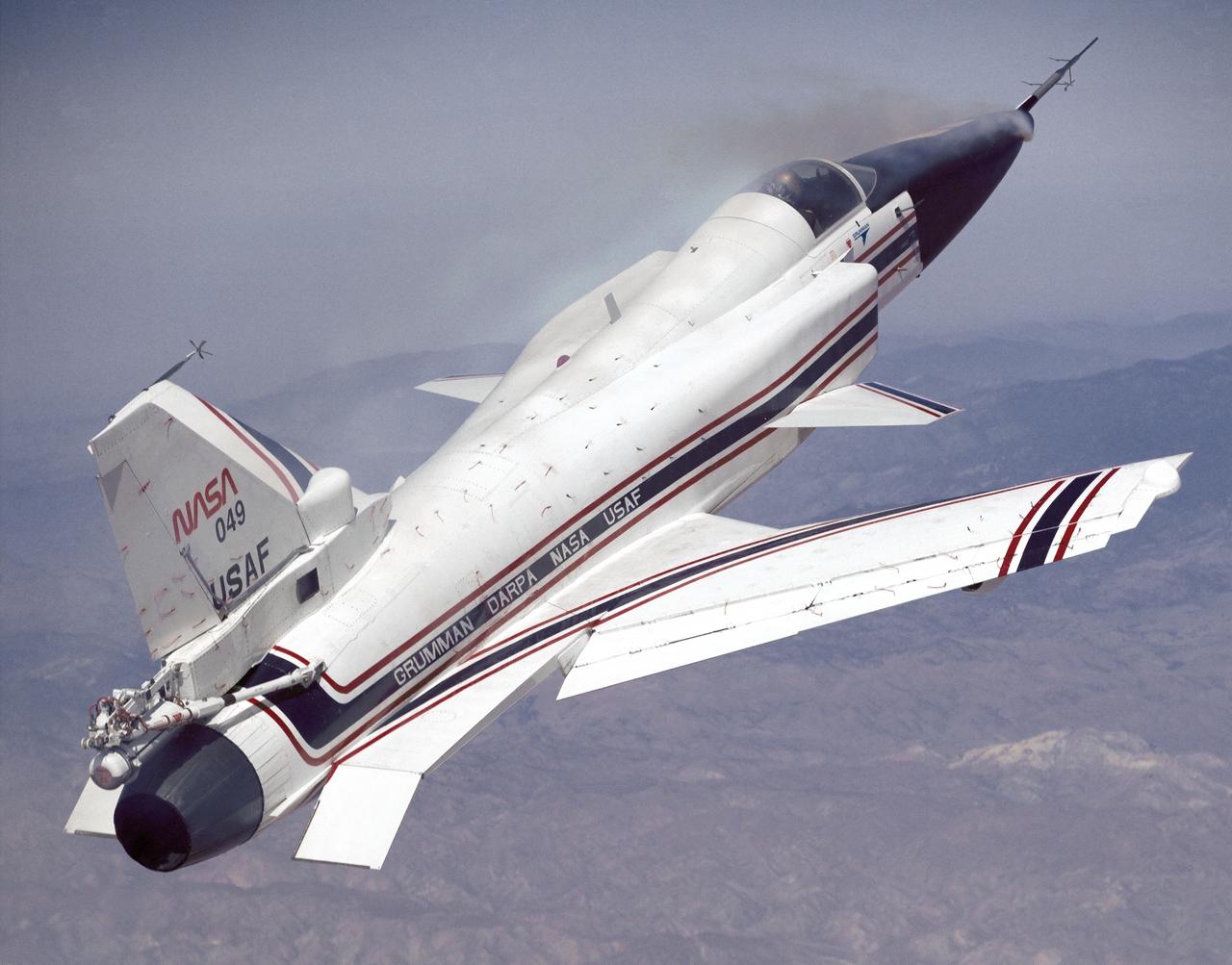
This photo shows the X-29 during a 1991 research flight. Smoke generators in the nose of the aircraft were used to help researchers see the behavior of the air flowing over the aircraft. The smoke here is demonstrating forebody vortex flow. This mission was flown September 10, 1991, by NASA research pilot Rogers Smith.
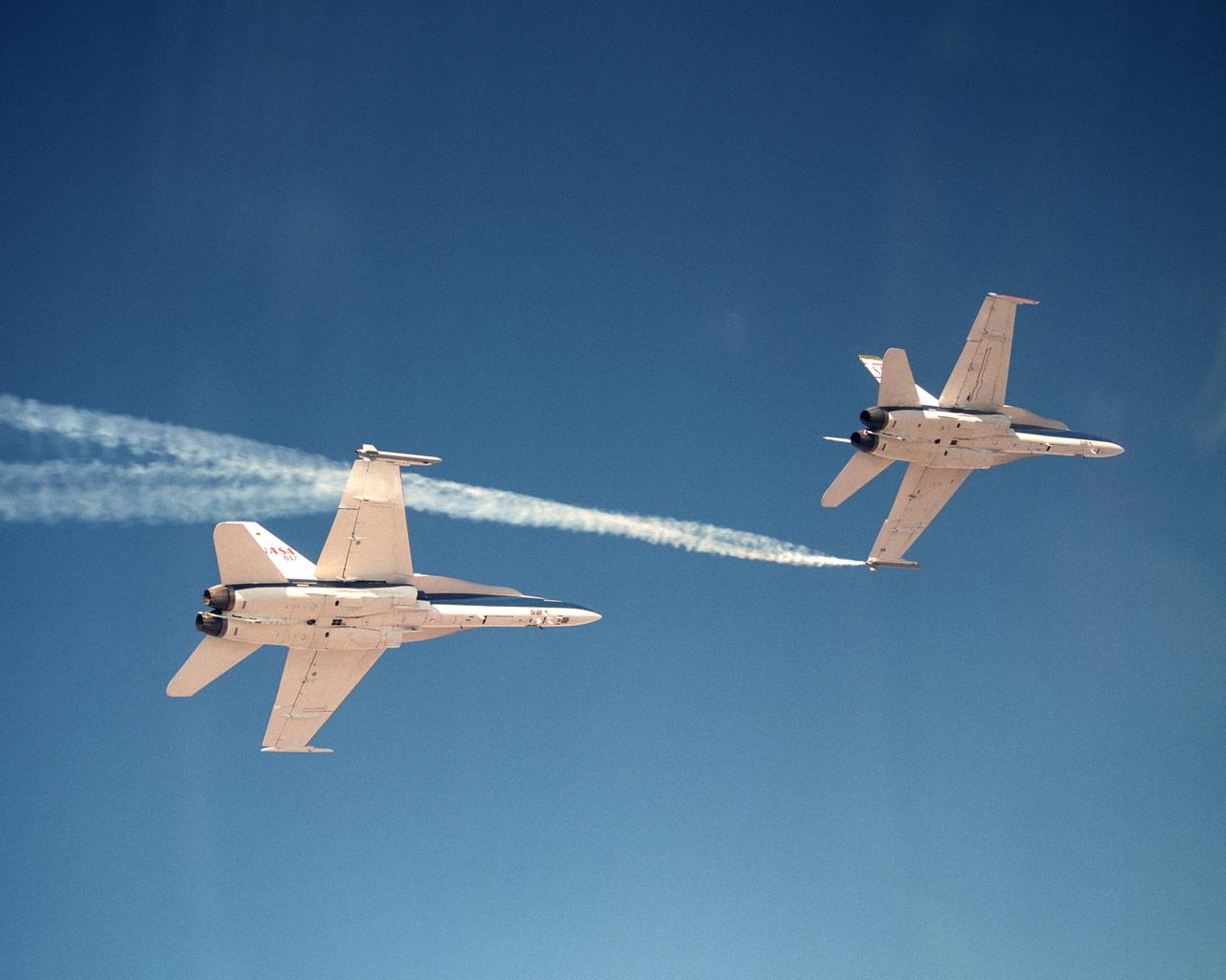
Smoke generators show the twisting paths of wingtip vortices behind two NASA Dryden F/A-18's used in the Autonomous Formation Flight (AFF) program during flight #743.
Smoke generators show the twisting paths of wingtip vortices behind two NASA Dryden F/A-18's used in the Autonomous Formation Flight (AFF) program during flight #743.
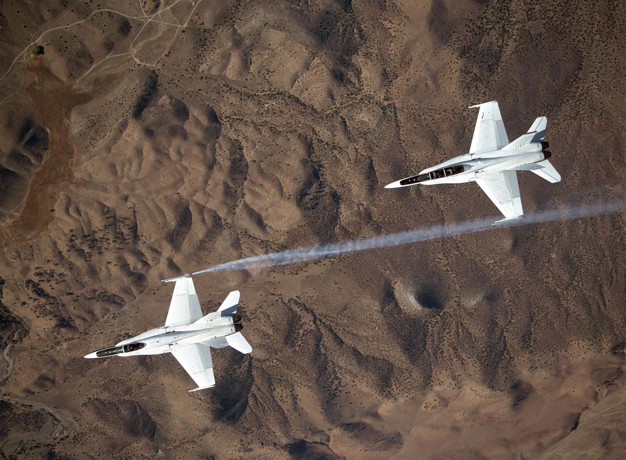
Smoke generators show the twisting paths of wingtip vortices behind two NASA Dryden F/A-18's used in the Autonomous Formation Flight (AFF) program during flight #743.
Smoke generators show the twisting paths of wingtip vortices behind two NASA Dryden F/A-18's used in the Autonomous Formation Flight (AFF) program during flight #743.
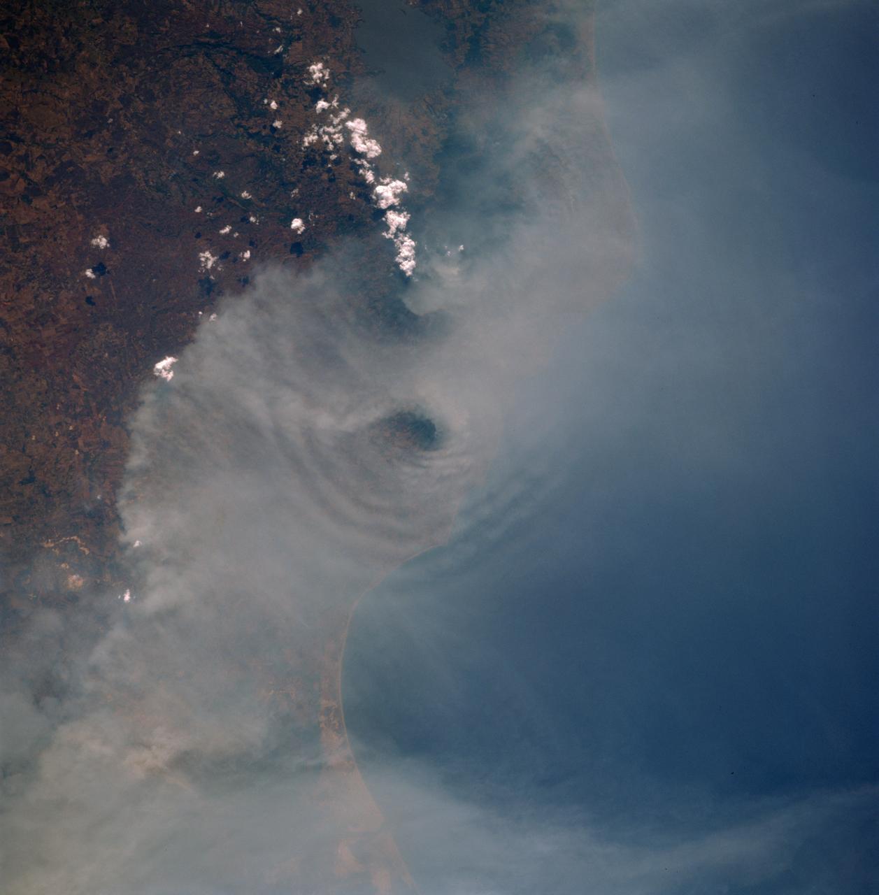
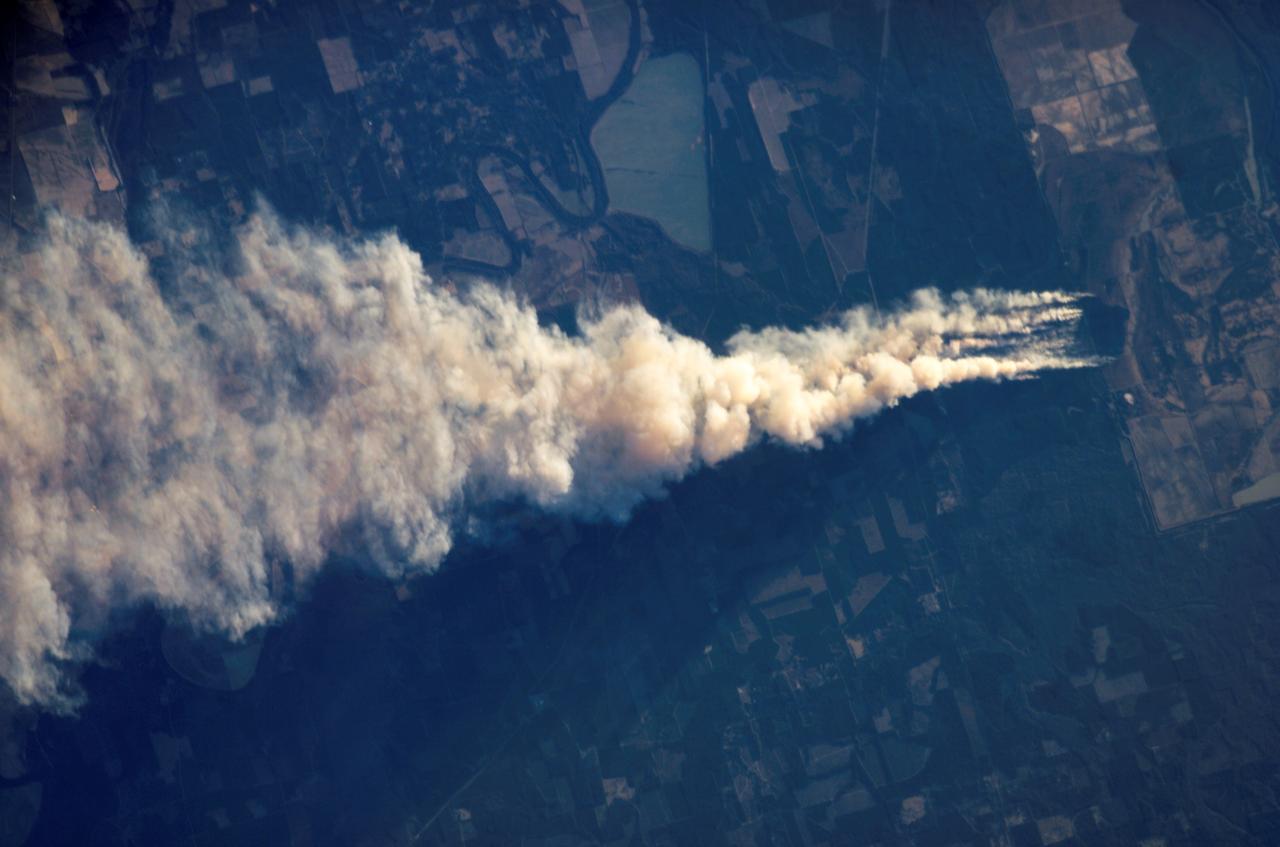
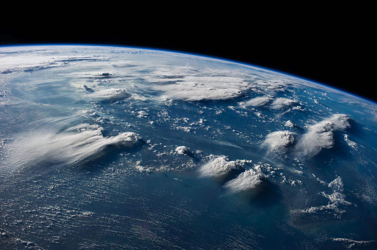
STS091-725-088 (2-12 June 1998)--- In this 70mm picture photographed during one of Discovery's passes over Mexico, waves generated by the volcanic peaks are seen as the wind carrying the smoke moves by the peaks. Along the coast of the Bay of Campeche, the fires burn around the peak of the Cerro San Martin (5,577 feet), which is west and higher than the peak with the waves around it. Lago Catemaco is on the west, center edge of the photo. Fires across Mexico and Central America created heavy smoke plumes for a few weeks in May and June, 1998. The smoke circulated around a high pressure system over the Gulf of Mexico and brought thick smoke and soot to the south central United States. Scientists are looking at burning regions like this around the world to study the smokes affect on the albedo or the reflectance of the suns rays and how it may influence our world's climate.
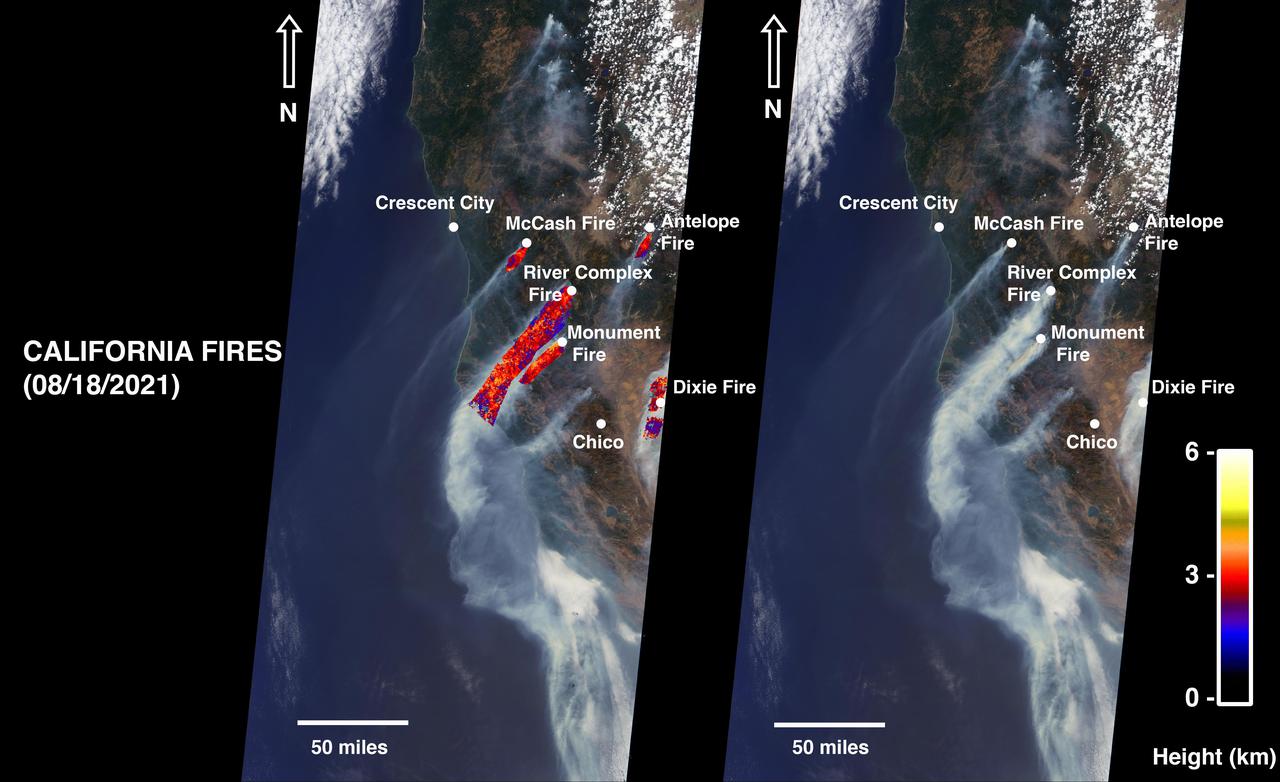
On August 18, 2021, at 12:10 p.m. local time, the Multi-angle Imaging Spectroradiometer (MISR) instrument captured imagery of the McCash, Antelope, River Complex, Monument, and Dixie fires as it passed overhead aboard NASA's Terra satellite. Combined, the fires had burned over 1 million acres as of August 24, 2021. MISR has nine cameras that view Earth at different angles. The right side of the image shows smoke from the five fires as observed by MISR's nadir (downward-pointing) camera. The multi-angular information from MISR's images is used to calculate the height of the smoke plumes. The results of those calculations are shown on the left side of the image. Smoke from areas in red reached an altitude of at least 9,842 feet (3,000 meters). The highest plume top near the active fires reached approximately 19,685 feet (6,000 meters). In general, higher-altitude plumes like this one transport smoke greater distances from the source, impacting communities downwind. In recent weeks, smoke from fires in the Western U.S. and Canada has impacted much of the East Coast. This data was acquired during Terra orbit 115254. The smoke plume height calculation was performed using the publicly available MISR INteractive eXplorer (MINX)software tool. The MISR Plume Height Project maintains a database of global smoke plume heights. https://photojournal.jpl.nasa.gov/catalog/PIA23698
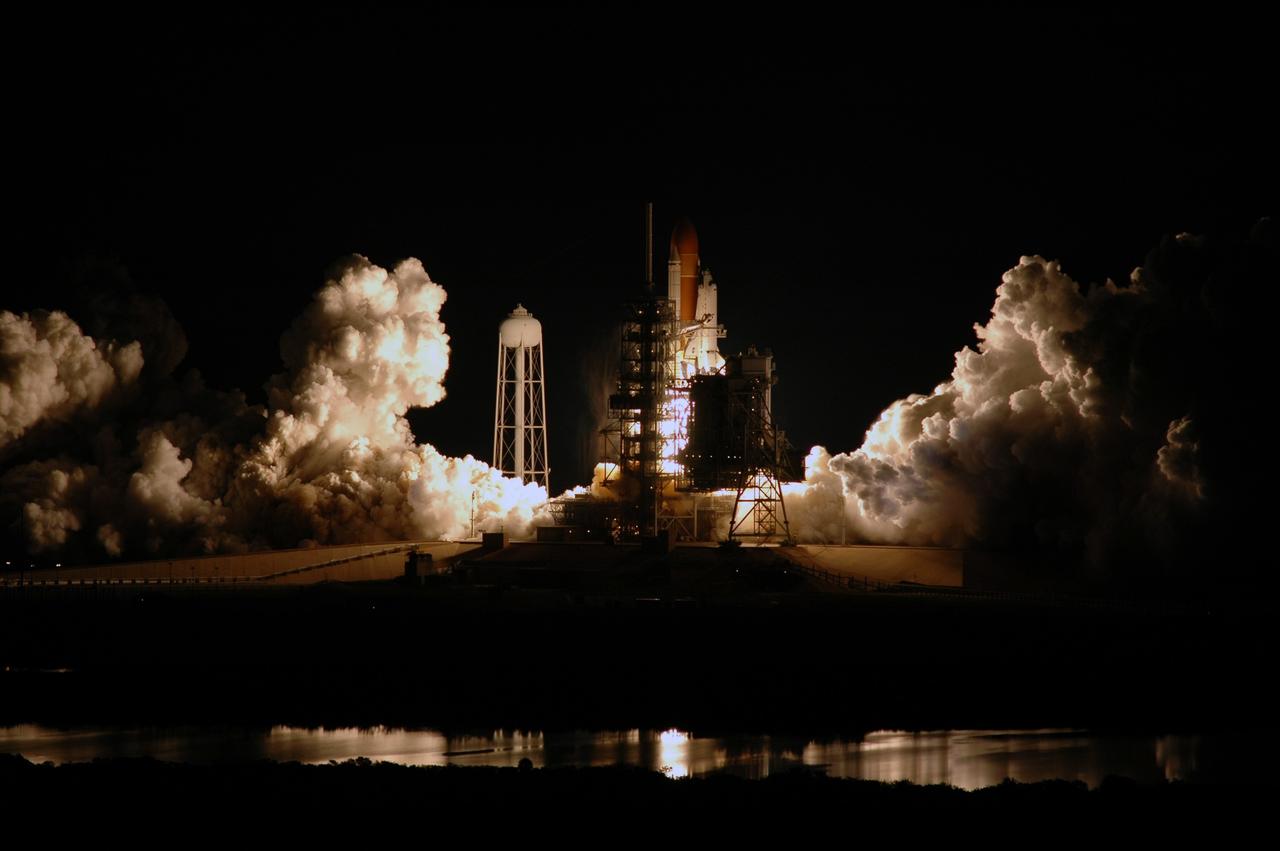
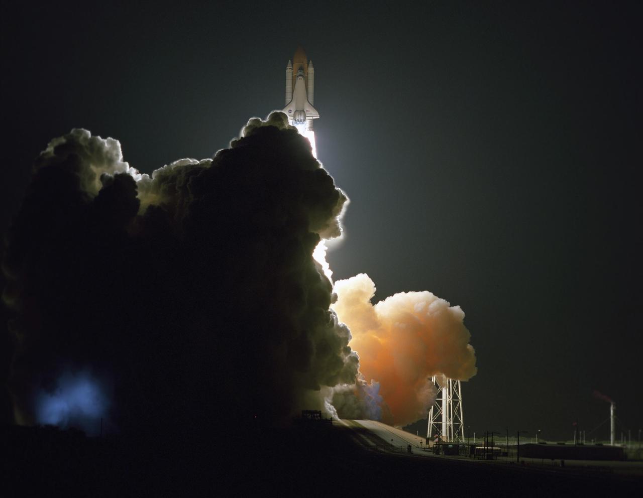
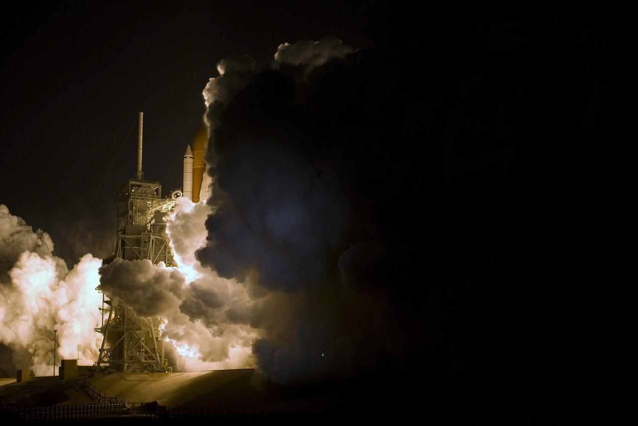
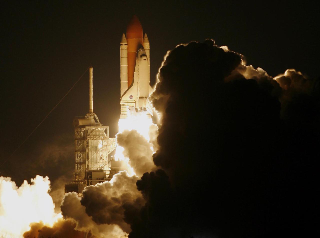
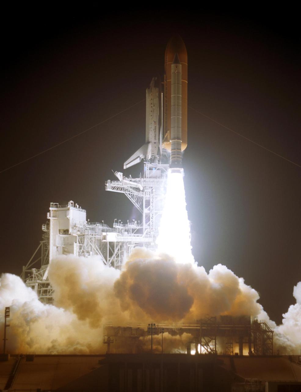
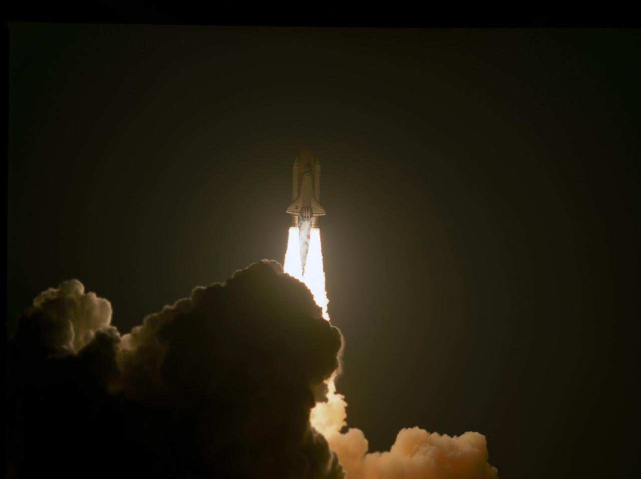
KENNEDY SPACE CENTER, FLA. -- The clouds of smoke and steam generated during liftoff of space shuttle Endeavour on the STS-123 mission capture the light from the flames flowing from the engines and solid rocket boosters. Liftoff was on time at 2:28 a.m. EDT. The crew will make a record-breaking 16-day mission to the International Space Station and deliver the first section of the Japan Aerospace Exploration Agency's Kibo laboratory and the Canadian Space Agency's two-armed robotic system, Dextre. Photo credit: NASA/Jim Grossmann
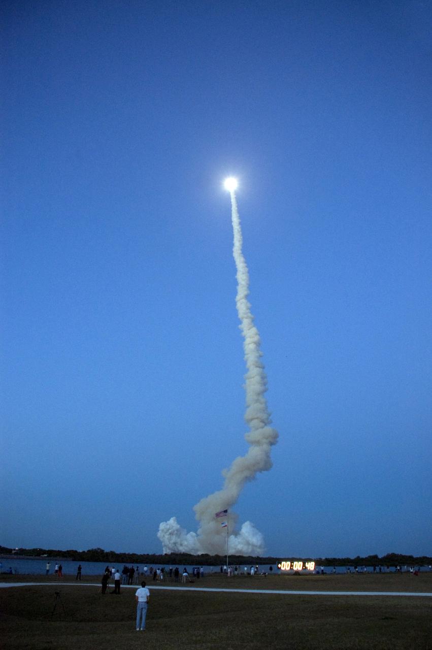
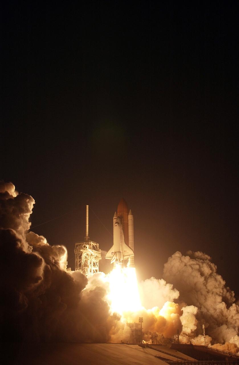
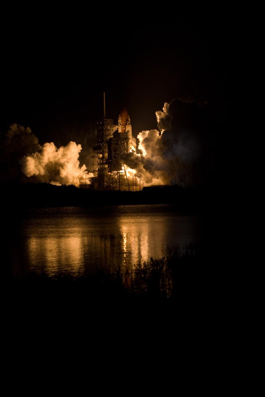
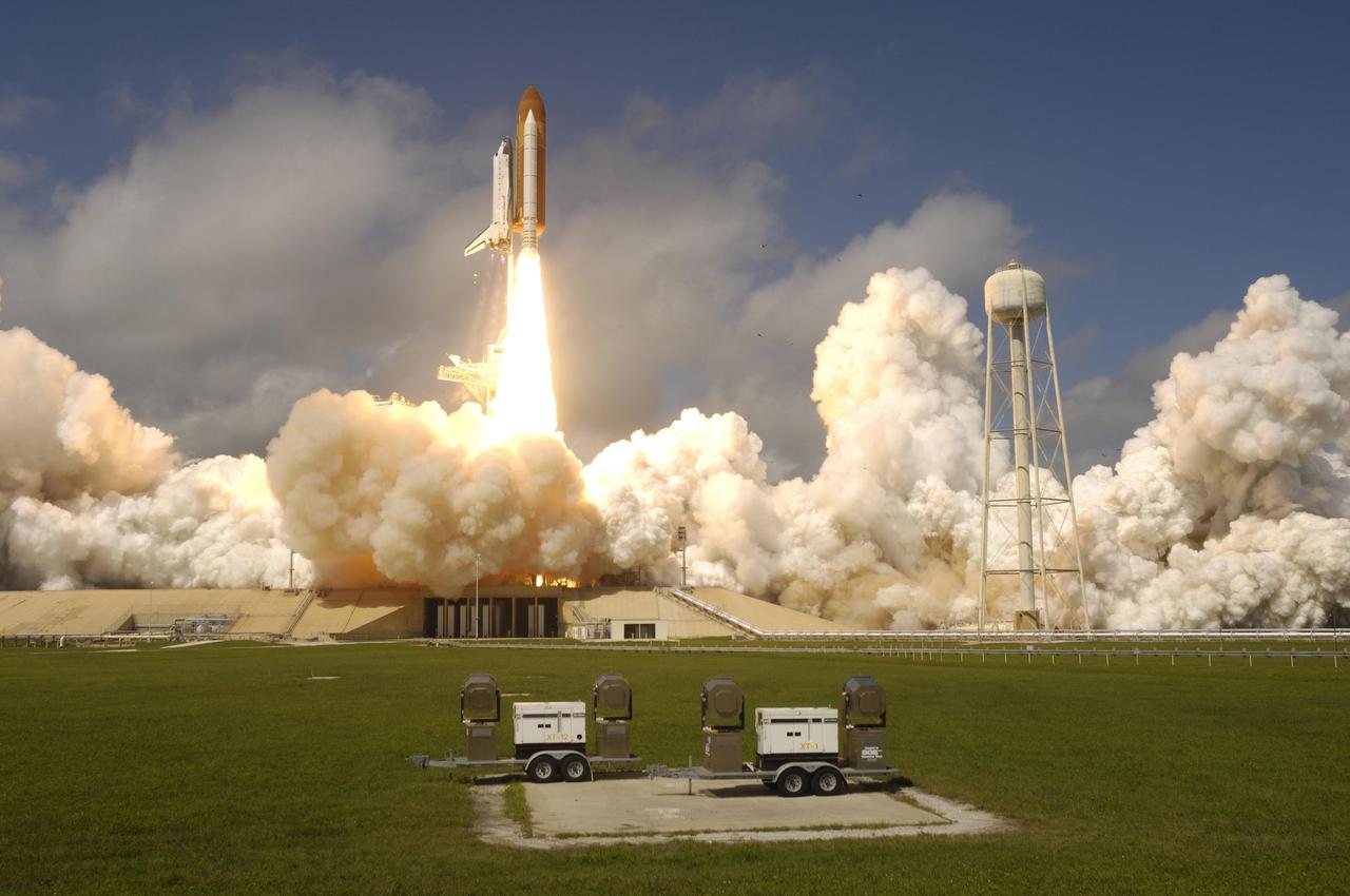
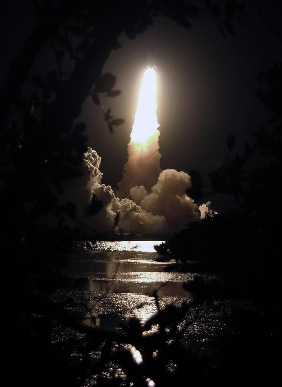
CAPE CANAVERAL, Fla. – Looking like a sun riding a column of smoke, space shuttle Discovery hurtles into the evening sky on the STS-119 mission. Liftoff was on time at 7:43 p.m. EDT. The STS-119 mission is the 28th to the International Space Station and the 125th space shuttle flight. Discovery will deliver the final pair of power-generating solar array wings and the S6 truss segment. Installation of S6 will signal the station's readiness to house a six-member crew for conducting increased science. Photo credit: NASA/Fletch Hildreth
NASA flew an aircraft equipped with Uninhabited Aerial Vehicle Synthetic Aperture Radar (UAVSAR) flew above California fires on Sept. 3 and 10. The smoke-penetrating UAVSAR enables scientists to get a close-up view of how these fires have altered the landscape. Attached to the bottom of the aircraft, the radar is flown repeatedly over an area to measure tiny changes in surface height with extreme accuracy. The flight is part of the ongoing effort by NASA's Applied Sciences Disaster Program in the Earth Sciences Division, which generates maps and other data products that can be used by partner agencies on the ground to track fire hotspots, map the extent of the burn areas, and even measure the height of the smoke plumes that have drifted over California and neighboring states. Movie available at https://photojournal.jpl.nasa.gov/catalog/PIA24102
Generally the old saying “where there is smoke, there is fire” rings true, but when thick, hot smoke rises high aloft into the atmosphere it may travel hundreds, sometimes thousands of kilometers away from the source. This was the case on July 6, 2013 when the Moderate Resolution Imaging Spectroradiometer (MODIS) instrument flying on NASA’s Terra satellite captured this true-color image of a thick river of smoke curling across the Atlantic Ocean. In the west of the image, the green land of Canada can be seen, most of which is covered by a thin gray haze. A thick veil of smoke obscures much of southern Canada, and this tan-gray veil blows to the east, then to the northeast. The color of the smoke appears both tan and gray, and is stretched into brush-stroke like curves across the ocean, which disappears from view under the smoke. The smoke filled plume is so high that it even hides the bright white clouds from view as it travels over them. Fires have been burning across Canada since early June, especially in Manitoba and Quebec. Rain in Quebec on July 5 helped diminish the fires in that location, although a severe fire was ignited when a freight train carrying oil derailed in the small, picturesque town of Lac-Megantic. This accident, which occurred on July 6, the same day this image was captured, killed at least 35 people and poured thick smoke into the skies. Credit: NASA/GSFC/Jeff Schmaltz/MODIS Land Rapid Response Team <b><a href="http://www.nasa.gov/audience/formedia/features/MP_Photo_Guidelines.html" rel="nofollow">NASA image use policy.</a></b> <b><a href="http://www.nasa.gov/centers/goddard/home/index.html" rel="nofollow">NASA Goddard Space Flight Center</a></b> enables NASA’s mission through four scientific endeavors: Earth Science, Heliophysics, Solar System Exploration, and Astrophysics. Goddard plays a leading role in NASA’s accomplishments by contributing compelling scientific knowledge to advance the Agency’s mission. <b>Follow us on <a href="http://twitter.com/NASA_GoddardPix" rel="nofollow">Twitter</a></b> <b>Like us on <a href="http://www.facebook.com/pages/Greenbelt-MD/NASA-Goddard/395013845897?ref=tsd" rel="nofollow">Facebook</a></b> <b>Find us on <a href="http://instagram.com/nasagoddard?vm=grid" rel="nofollow">Instagram</a></b>

ISS032-E-024687 (3 Sept. 2012) --- Idaho fires are featured in this image photographed by an Expedition 32 crew member on the International Space Station. Taken with a short lens (45 mm), this west-looking photograph has a field of view covering much of the forested region of central Idaho. The dark areas are all wooded mountains—the Salmon River Mountains (left), Bitterroot Mountains (lower right) and Clearwater Mountains (right). All three areas experienced wildfires in September 2012—this image illustrates the situation early in the month. Smaller fire ‘complexes” appear as tendrils of smoke near the sources (e.g. Halstead complex at left), and as major white smoke plumes from the Mustang fire complex in the densest forests (darkest green, center) of the Clearwater Mountains. This was the largest plume noted in the region with thick smoke blowing eastward over the Beaverhead Mountains at bottom. The linear shape of the smoke plumes gives a sense of the generally eastward smoke transport on this day in early September. The smoke distribution shows another kind of transport: at night, when winds are weak, cooling of the atmosphere near the ground causes drainage of cooled (denser) air down into the major valleys. Here the smoke can be seen flowing west down into the narrow Salmon and Lochsa River valleys (at a local time of 12:18:50 p.m.) – in the opposite direction to the higher winds and the thick smoke masses. The bright yellow-tan areas at top left and top right contrasting with the mountains are grasslands of the Snake River in southern Idaho around Boise, and the Palouse region in western Idaho–SE Washington state. This latter area is known to ecologists as the Palouse Grasslands Ecoregion. Light green areas visible in the center of many of the valleys are agricultural crops including barley, alfalfa, and wheat. The image also shows several firsts of which Idaho can boast. The Snake River between Boise and the Palouse region has cut Hells Canyon (top), the deepest gorge in the U.S. at almost 2,436 meters (8,000 feet). The largest single wilderness area in the contiguous U.S., the Frank Church-River of No Return Wilderness occupies the wooded zones of the Salmon River Mountains and the Clearwater Mountains, i.e. most of the area shown in the middle of the image. Idaho’s highest peak is Borah Peak (lower left) at 3,860 meters above sea level (12,662 feet ASL). The Continental Divide cuts through the bottom of the image—rivers on the eastern slopes of the Beaverhead Mountains drain to the Atlantic Ocean, whereas rivers in the rest of the area drain to the Pacific Ocean.
ISS012-E-13692 (2 Jan. 2006) --- A Forest Fire in Ouachita National Wildlife Refuge, Louisiana is featured in this image photographed by an Expedition 12 crew member on the International Space Station. Dry conditions and high winds have led to numerous recent fire outbreaks throughout much of the southwestern and south-central USA. This image captures the smoke plume from a fire in the Upper Ouachita National Wildlife Refuge in northeastern Louisiana. Drought conditions have persisted for much of the past year, leading to an increased fuel load comprised of dried grasses, shrubs, and trees. The combination of high amounts of dry fuel and frequent high winds has stoked small point fires into widespread brush fires. The fires generating this minimum 25-kilometer smoke plume started at approximately 13:00 hours local time. This image was acquired approximately 3.5 hours later as the station passed over the Texas/Louisiana border to the southwest. The extent of the plume reflects the strong westerly winds that drove the fire eastwards and damaged an estimated 200-300 acres of the wildlife refuge. The striking illumination of the plume is caused by a very low sun angle (angle between the horizon and the Sun directly below the space station), but this also results in generally low illumination of other scene features such as agricultural fields.
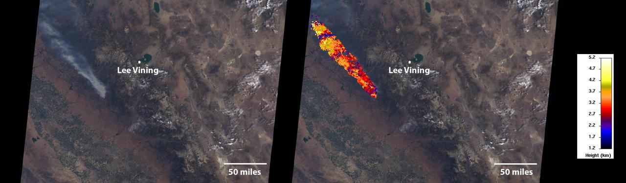
On July 24, 2022, the Multi-angle Imaging SpectroRadiometer (MISR) instrument aboard NASA's Terra satellite captured data on a smoke plume from the Oak Fire burning near Yosemite National Park in California. As of July 26, the Oak Fire had scorched more than 18,000 acres (7,284 hectares) and was 26% contained, with thousands of residents under evacuation orders. Hot, dry air, along with vegetation parched from years of drought, fueled the fire's rapid spread. The MISR instrument contains nine cameras that view Earth at different angles. The left panel in the image above shows an image captured by MISR's nadir (downward-pointing) camera of a smoke plume from the fire. Although the fire was burning near Yosemite at the time, it wasn't a threat to the national park. The panel on the right indicates the height of various parts of the plume as measured by several of MISR's cameras. Yellow areas are higher than the red and blue regions in the smoke plume. The height of the plume top near the active fire was about 17,060 feet (5,200 meters), or roughly 3 miles (nearly 5 kilometers). In general, higher-altitude plumes transport smoke greater distances from the source, impacting communities downwind. On the day the images were captured, unhealthy-to-hazardous air quality was reported in the area around Lake Tahoe and Truckee, about 125 miles (200 kilometers) north of the fire. MISR researchers calculate smoke plume height using the publicly available MISR INteractive eXplorer (MINX) software tool. https://photojournal.jpl.nasa.gov/catalog/PIA24907
KENNEDY SPACE CENTER, FLA. -- Emerging from behind the clouds of smoke and steam generated by its liftoff, Space Shuttle Discovery leaps toward the sky past the lightning mast on Launch Pad 39B on mission STS-116. Liftoff occurred on time at 8:47 p.m. EST. This was the second launch attempt of Discovery on mission STS-116. The first launch attempt on Dec. 7 was postponed due a low cloud ceiling over Kennedy Space Center. This is Discovery's 33rd mission and the first night launch since 2002. The 20th shuttle mission to the International Space Station, STS-116 carries another truss segment, P5. It will serve as a spacer, mated to the P4 truss that was attached in September. After installing the P5, the crew will reconfigure and redistribute the power generated by two pairs of U.S. solar arrays. Landing is expected Dec. 21 at KSC. Photo credit: NASA/Sandra Joseph, Robert Murray, Chris Lynch
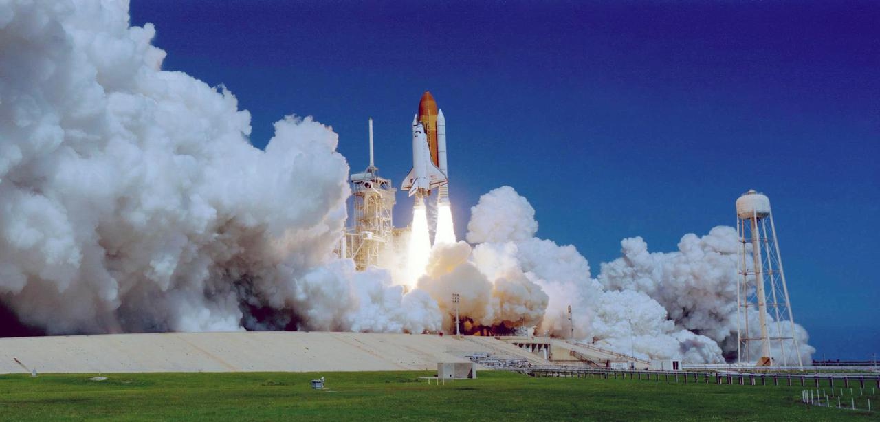
CAPE CANAVERAL, Fla. – Clouds of smoke and steam roll across Launch Pad 39A at NASA's Kennedy Space Center in Florida as space shuttle Discovery races toward space on mission STS-119. Launch was on time at 7:43 p.m. EDT. The STS-119 mission is the 28th to the International Space Station and the 125th space shuttle flight. Discovery will deliver the final pair of power-generating solar array wings and the S6 truss segment. Installation of S6 will signal the station's readiness to house a six-member crew for conducting increased science. Photo credit: NASA/Sandra Joseph, Kevin O'Connell
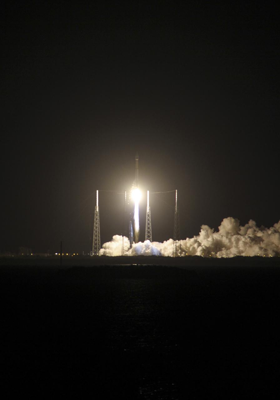
CAPE CANAVERAL, Fla. -- Plumes of exhaust and smoke billow around the lightning masts on Space Launch Complex 41 on Cape Canaveral Air Force Station in Florida as a United Launch Alliance Atlas V 401 rocket lifts off at 8:48 p.m. EST, carrying NASA's Tracking and Data Relay Satellite-K, TDRS-K, to orbit. The TDRS-K spacecraft is part of the next-generation series in the Tracking and Data Relay Satellite System, a constellation of space-based communication satellites providing tracking, telemetry, command and high-bandwidth data return services. For more information, visit http:__www.nasa.gov_mission_pages_tdrs_index.html. Photo credit: NASA_Scott Neener and Cory Huston
CAPE CANAVERAL, Fla. -- A cloud of exhaust and smoke billows past a lightning mast on Space Launch Complex 41 on Cape Canaveral Air Force Station in Florida as a United Launch Alliance Atlas V 401 rocket lifts off at 8:48 p.m. EST, carrying NASA's Tracking and Data Relay Satellite-K, TDRS-K, to orbit. The TDRS-K spacecraft is part of the next-generation series in the Tracking and Data Relay Satellite System, a constellation of space-based communication satellites providing tracking, telemetry, command and high-bandwidth data return services. For more information, visit http:__www.nasa.gov_mission_pages_tdrs_index.html. Photo credit: NASA_Tony Gray and Robert Murray
CAPE CANAVERAL, Fla. – Clouds of smoke and steam roll across Launch Pad 39A at NASA's Kennedy Space Center in Florida as space shuttle Discovery races toward space on mission STS-119. Launch was on time at 7:43 p.m. EDT. The STS-119 mission is the 28th to the International Space Station and the 125th space shuttle flight. Discovery will deliver the final pair of power-generating solar array wings and the S6 truss segment. Installation of S6 will signal the station's readiness to house a six-member crew for conducting increased science. Photo courtesy of Scott Andrews
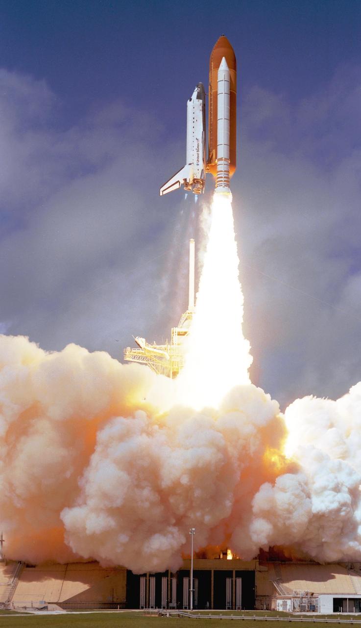
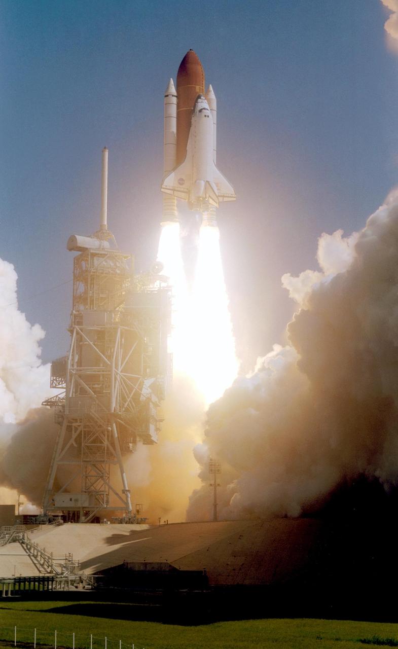
CAPE CANAVERAL, Fla. – Propelled by a column of fire, space shuttle Discovery races toward space on the STS-119 mission after liftoff from Launch Pad 39A at NASA's Kennedy Space Center in Florida. Clouds of smoke and steam roll across the pad. Launch was on time at 7:43 p.m. EDT. The STS-119 mission is the 28th to the International Space Station and the 125th space shuttle flight. Discovery will deliver the final pair of power-generating solar array wings and the S6 truss segment. Installation of S6 will signal the station's readiness to house a six-member crew for conducting increased science. Photo courtesy of Scott Andrews
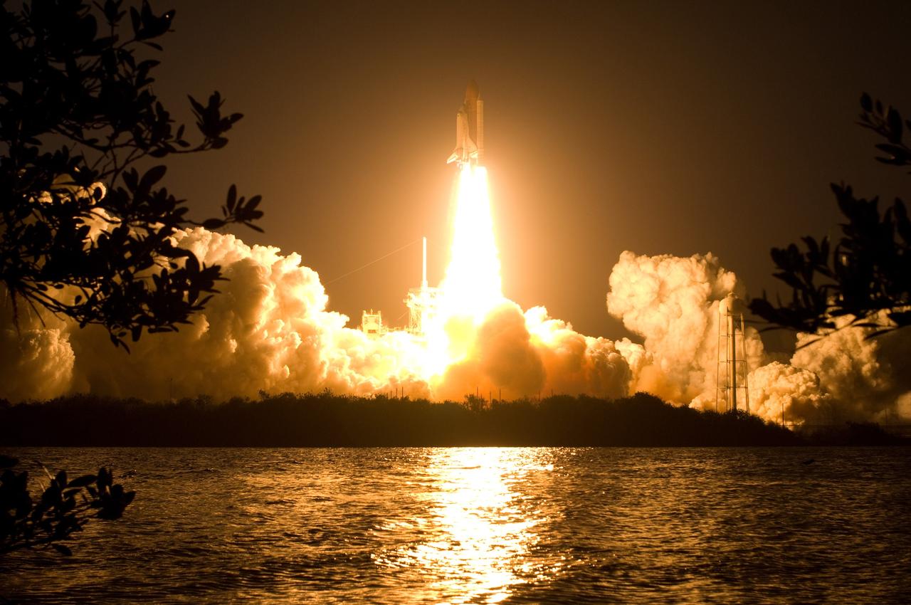
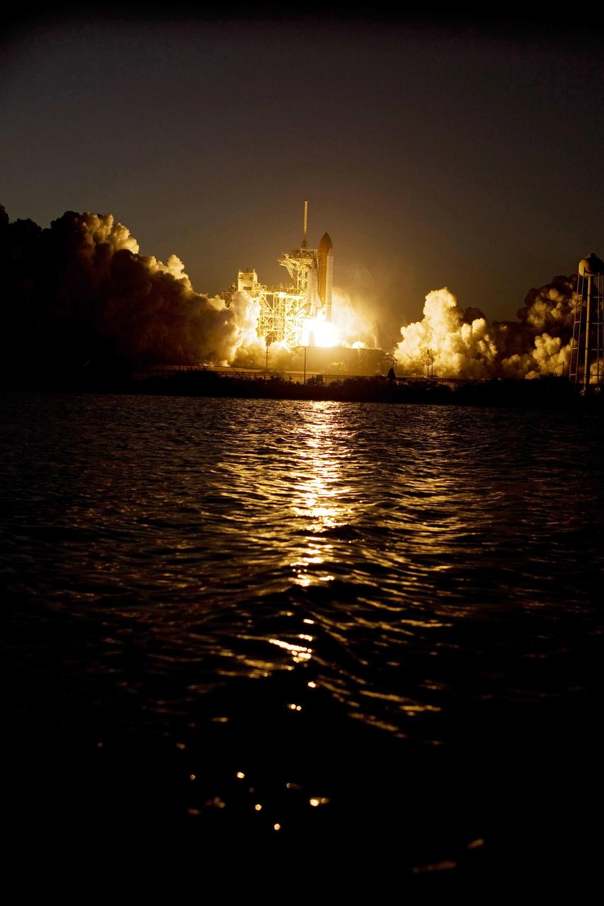
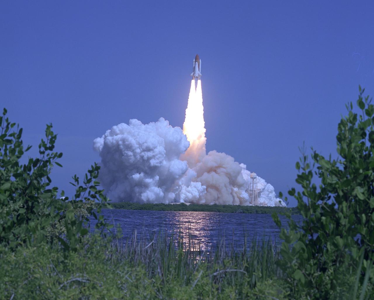
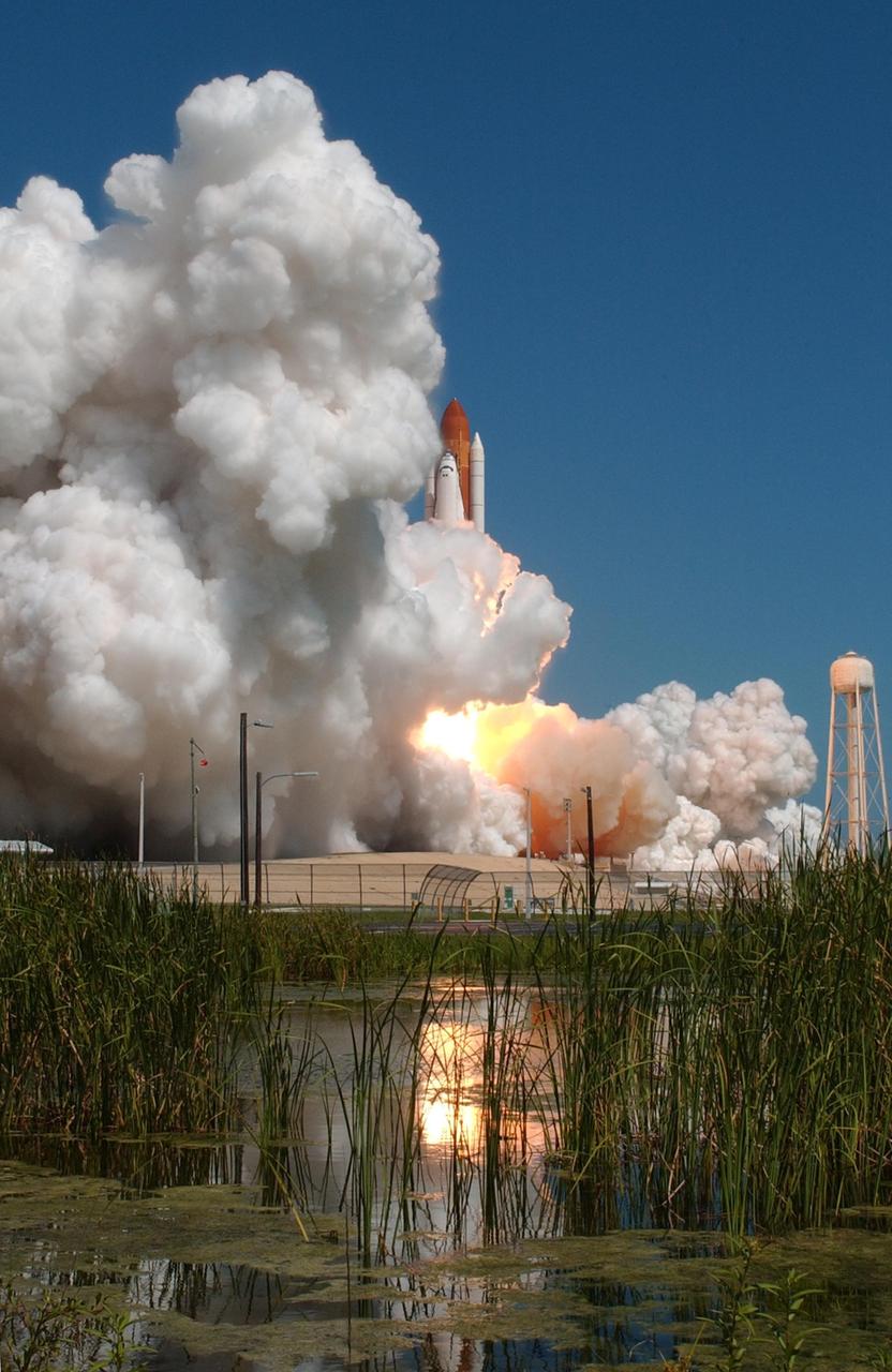
CAPE CANAVERAL, Fla. – Billows of smoke and the water near Launch Pad 39A at NASA's Kennedy Space Center in Florida capture the brilliant light of space shuttle Discovery's lift-off on the STS-119 mission. The launch was on time at 7:43 p.m. EDT. The STS-119 mission is the 28th to the International Space Station and the 125th space shuttle flight. Discovery will deliver the final pair of power-generating solar array wings and the S6 truss segment. Installation of S6 will signal the station's readiness to house a six-member crew for conducting increased science. Photo credit: NASA/Sandra Joseph, Kevin O'Connell
CAPE CANAVERAL, Fla. – Light and dark clouds of smoke and steam, spawned by the fire of liftoff, roll across Launch Pad 39A at NASA's Kennedy Space Center in Florida as space shuttle Discovery heads to space on the STS-119 mission. Liftoff was on time at 7:43 p.m. EDT. The STS-119 mission is the 28th to the International Space Station and the 125th space shuttle flight. Discovery will deliver the final pair of power-generating solar array wings and the S6 truss segment. Installation of S6 will signal the station's readiness to house a six-member crew for conducting increased science. Photo credit: NASA/Tony Gray, Tom Farrar
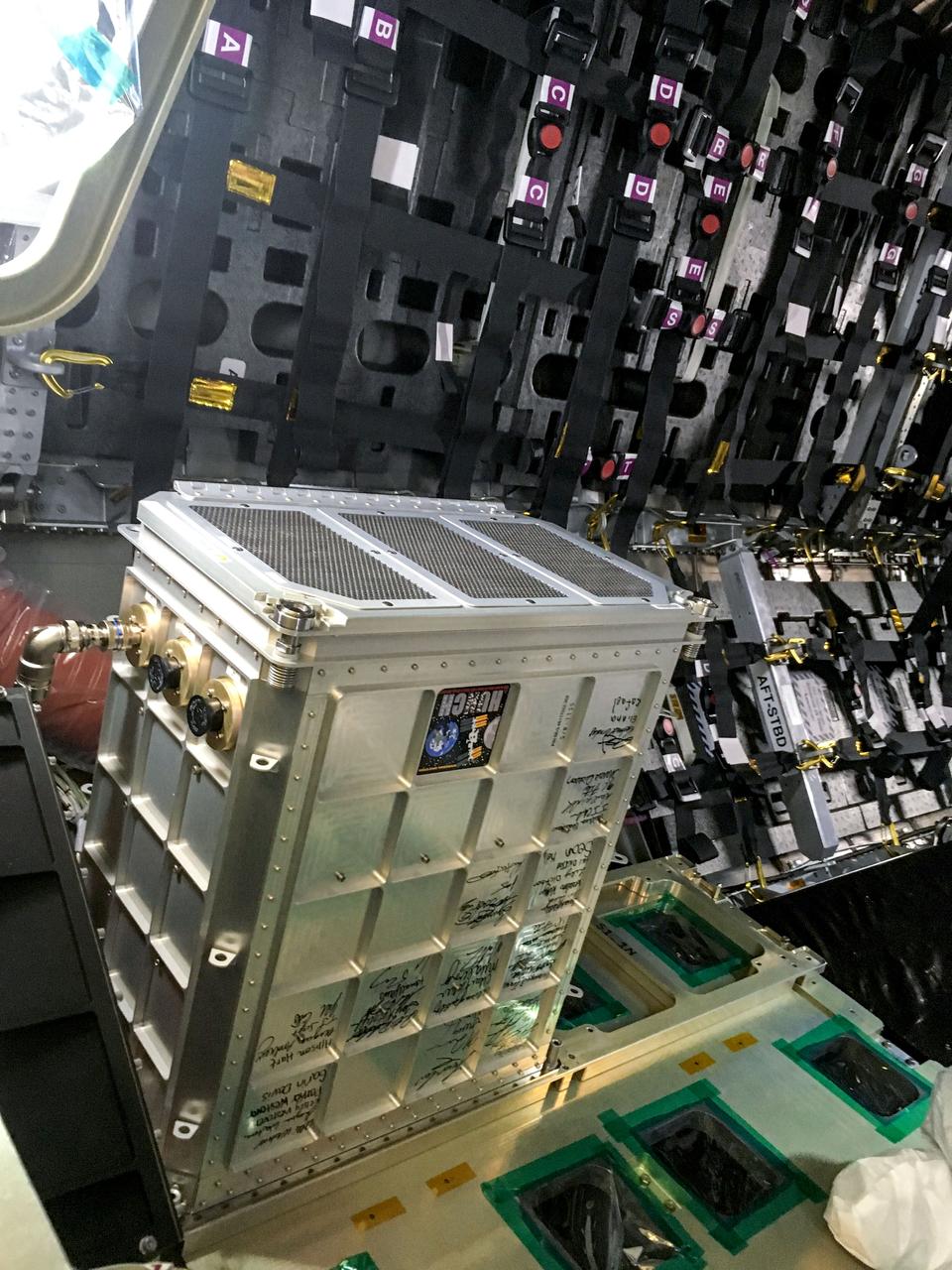
jsc2023e046376 (12/12/2019) --- The Far-Field Diagnostic (FFD) hardware for Spacecraft Fire Experiment-VI (Saffire-VI) is pictured aboard Cygnus before launch. This package contains the Smoke Eater and CO scrubbers, a prototype Combustion Product Monitor to be used on Orion, particulate sensors, and sensors for CO, CO2, and oxygen gases. The containers for the FFD were fabricated by HUNCH (High school students United with NASA to Create Hardware). Their signatures are shown on the side of the FFD. The Saffire series helps researchers to understand realistic fire spread scenarios on spacecraft and generate advanced protective equipment.
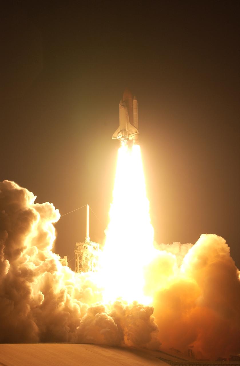
CAPE CANAVERAL, Fla. – Propelled by columns of fire, space shuttle Discovery races toward space on the STS-119 mission after liftoff from Launch Pad 39A at NASA's Kennedy Space Center in Florida. Clouds of smoke and steam roll across the pad. Launch was on time at 7:43 p.m. EDT. The STS-119 mission is the 28th to the International Space Station and the 125th space shuttle flight. Discovery will deliver the final pair of power-generating solar array wings and the S6 truss segment. Installation of S6 will signal the station's readiness to house a six-member crew for conducting increased science. Photo credit: NASA/Sandra Joseph, Kevin O'Connell
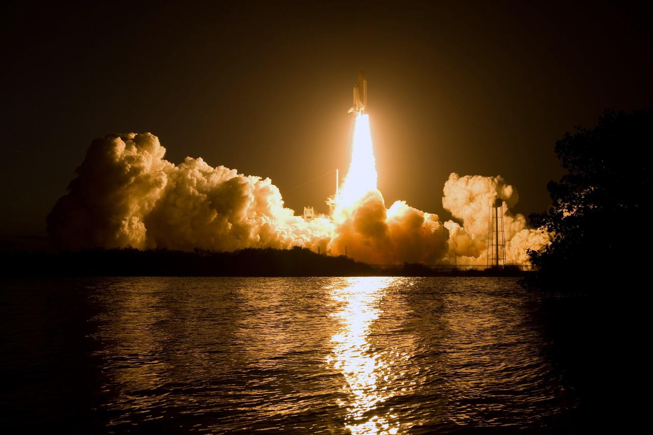
CAPE CANAVERAL, Fla. – Billows of smoke and the water near Launch Pad 39A at NASA's Kennedy Space Center in Florida capture the brilliant light of space shuttle Discovery's lift-off on the STS-119 mission. The launch was on time at 7:43 p.m. EDT. The STS-119 mission is the 28th to the International Space Station and the 125th space shuttle flight. Discovery will deliver the final pair of power-generating solar array wings and the S6 truss segment. Installation of S6 will signal the station's readiness to house a six-member crew for conducting increased science. Photo credit: NASA/Sandra Joseph, Kevin O'Connell
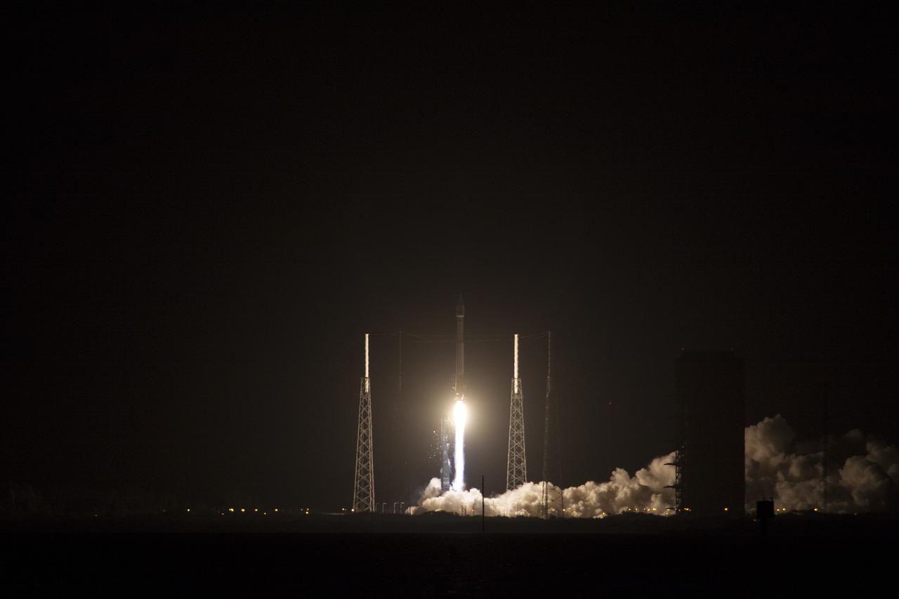
CAPE CANAVERAL, Fla. -- Plumes of exhaust and smoke build around the base of a lightning mast on Space Launch Complex 41 on Cape Canaveral Air Force Station in Florida as a United Launch Alliance Atlas V 401 rocket lifts off at 8:48 p.m. EST, carrying NASA's Tracking and Data Relay Satellite-K, TDRS-K, to orbit. The TDRS-K spacecraft is part of the next-generation series in the Tracking and Data Relay Satellite System, a constellation of space-based communication satellites providing tracking, telemetry, command and high-bandwidth data return services. For more information, visit http:__www.nasa.gov_mission_pages_tdrs_index.html. Photo credit: NASA_Jim Grossmann
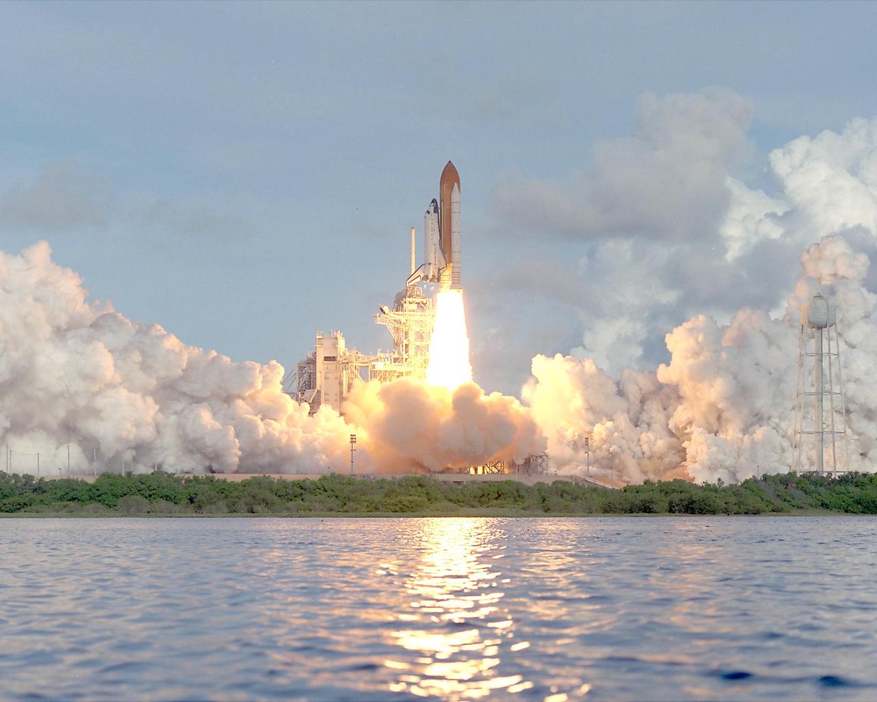
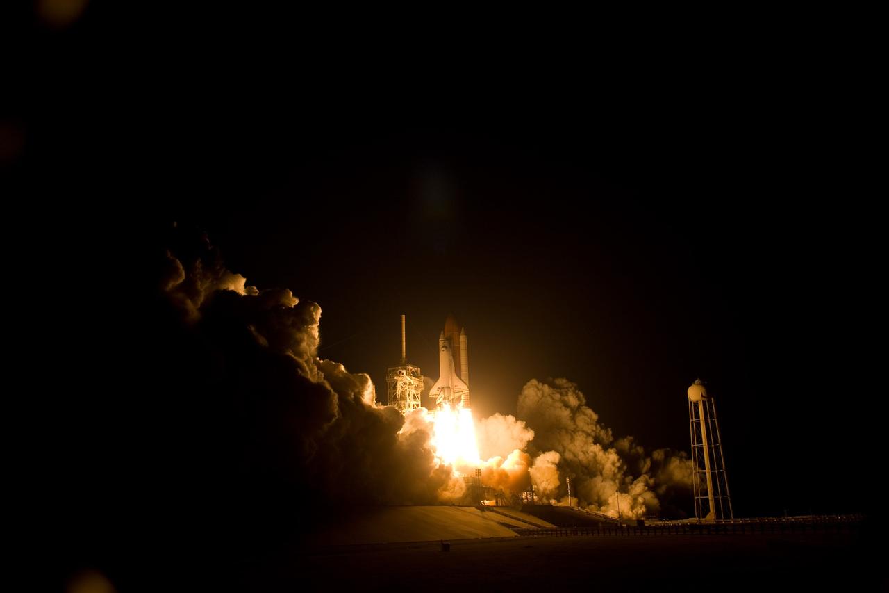
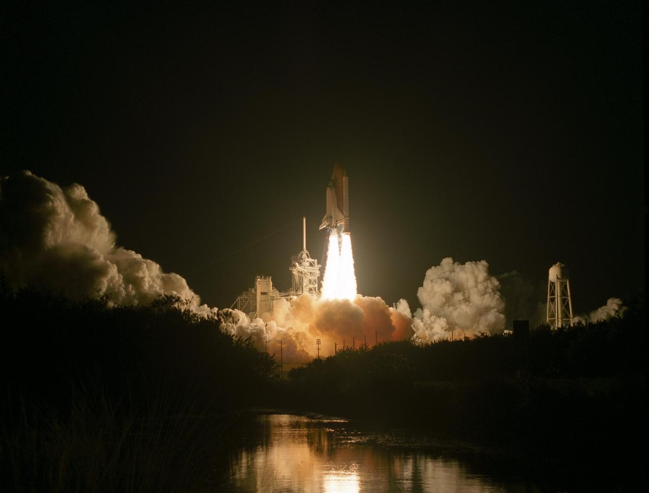
KENNEDY SPACE CENTER, Fla. -- The clouds of steam and smoke generated from the launch of Space Shuttle Atlantis seem to blend with the sky. The launch is reflected in waters near Launch Pad 39B. The perfect on-time liftoff of Atlantis on mission STS-106 occurred at 8:45:47 a.m. EDT. On the 11-day mission to the International Space Station, the seven-member crew will perform support tasks on orbit, transfer supplies and prepare the living quarters in the newly arrived Zvezda Service Module. The first long-duration crew, dubbed “Expedition One,” is due to arrive at the Station in late fall. Landing of Atlantis is targeted for 4:45 a.m. EDT on Sept. 19
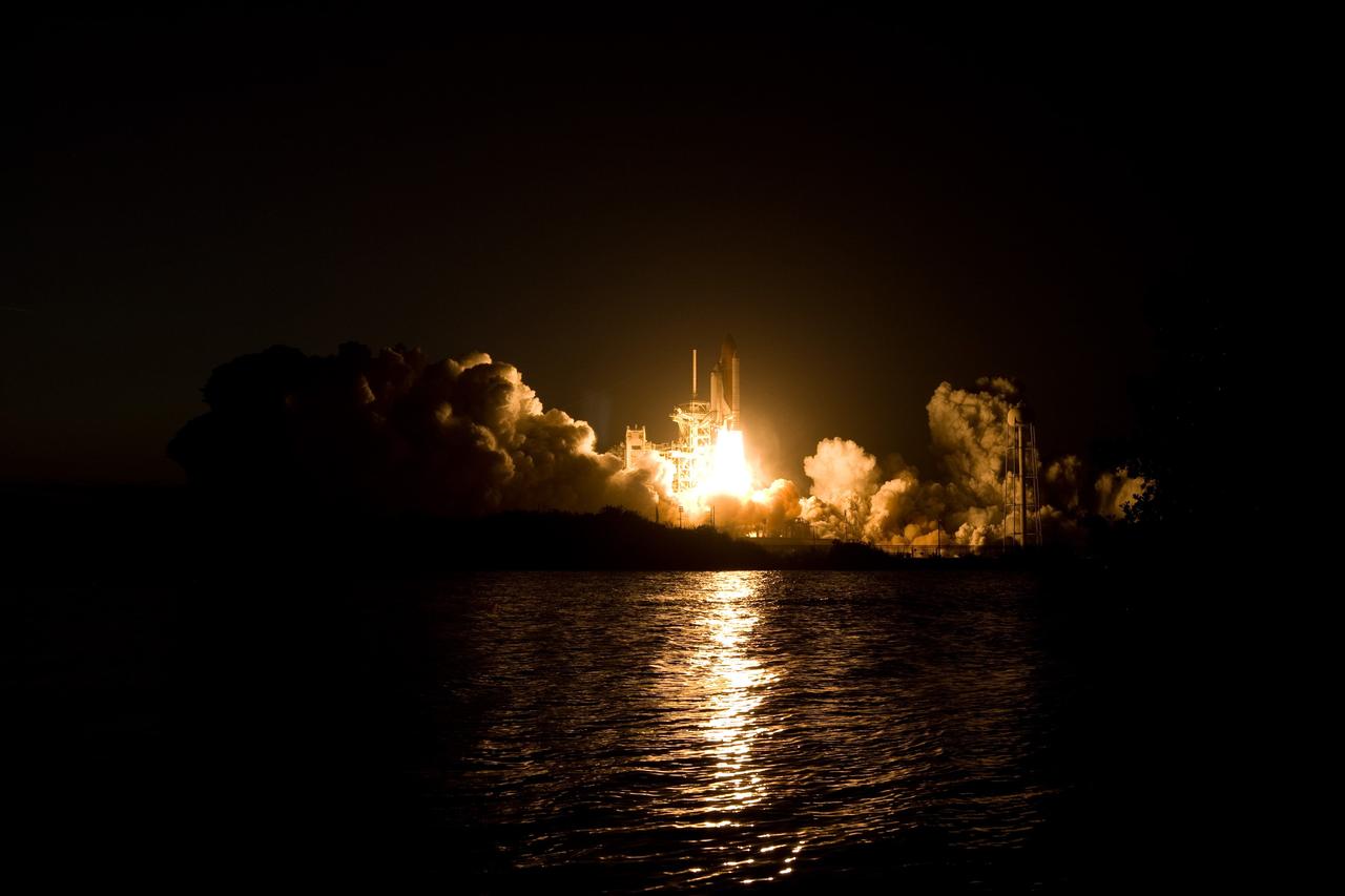
CAPE CANAVERAL, Fla. – Billows of smoke and the water near Launch Pad 39A at NASA's Kennedy Space Center in Florida capture the brilliant light of space shuttle Discovery's lift-off on the STS-119 mission. The launch was on time at 7:43 p.m. EDT. The STS-119 mission is the 28th to the International Space Station and the 125th space shuttle flight. Discovery will deliver the final pair of power-generating solar array wings and the S6 truss segment. Installation of S6 will signal the station's readiness to house a six-member crew for conducting increased science. Photo credit: NASA/Sandra Joseph, Kevin O'Connell
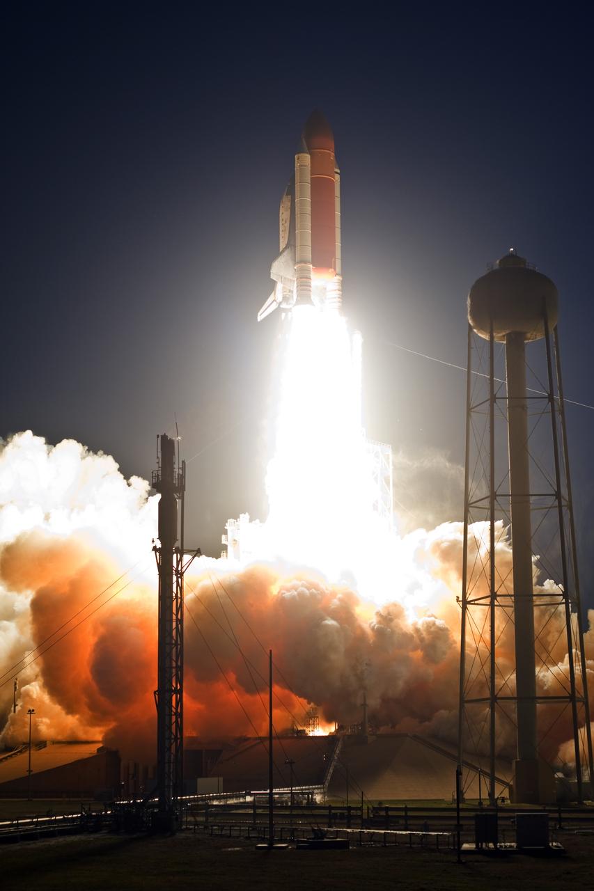
CAPE CANAVERAL, Fla. – From Launch Pad 39A at NASA's Kennedy Space Center in Florida, space shuttle Discovery races toward space atop towers of flame. Clouds of smoke and steam engulf the pad below. Launch on mission STS-119 was on time at 7:43 p.m. EDT. The STS-119 mission is the 28th to the space station and Discovery's 36th flight. Discovery will deliver the final pair of power-generating solar array wings and the S6 truss segment. Installation of S6 will signal the station's readiness to house a six-member crew for conducting increased science. Photo credit: NASA/Tony Gray, Tom Farrar
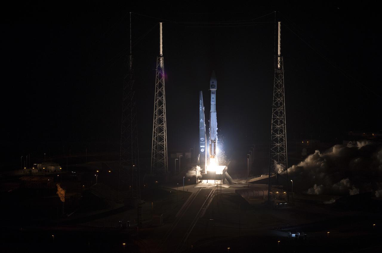
CAPE CANAVERAL, Fla. -- Plumes of exhaust and smoke form around the base of a lightning mast on Space Launch Complex 41 on Cape Canaveral Air Force Station in Florida as a United Launch Alliance Atlas V 401 rocket lifts off at 8:48 p.m. EST, carrying NASA's Tracking and Data Relay Satellite-K, TDRS-K, to orbit. The TDRS-K spacecraft is part of the next-generation series in the Tracking and Data Relay Satellite System, a constellation of space-based communication satellites providing tracking, telemetry, command and high-bandwidth data return services. For more information, visit http:__www.nasa.gov_mission_pages_tdrs_index.html. Photo credit: NASA_Tony Gray and Don Kight
CAPE CANAVERAL, Fla. – Clouds of smoke and steam roll across Launch Pad 39A at NASA's Kennedy Space Center in Florida as space shuttle Discovery roars into the night sky on the STS-119 mission. The launch was on time at 7:43 p.m. EDT. The STS-119 mission is the 28th to the International Space Station and the 125th space shuttle flight. Discovery will deliver the final pair of power-generating solar array wings and the S6 truss segment. Installation of S6 will signal the station's readiness to house a six-member crew for conducting increased science. Photo credit: NASA/Sandra Joseph, Kevin O'Connell

KENNEDY SPACE CENTER, Fla. -- The clouds of steam and smoke generated from the launch of Space Shuttle Atlantis seem to blend with the sky. The launch is reflected in waters near Launch Pad 39B. The perfect on-time liftoff of Atlantis on mission STS-106 occurred at 8:45:47 a.m. EDT. On the 11-day mission to the International Space Station, the seven-member crew will perform support tasks on orbit, transfer supplies and prepare the living quarters in the newly arrived Zvezda Service Module. The first long-duration crew, dubbed “Expedition One,” is due to arrive at the Station in late fall. Landing of Atlantis is targeted for 4:45 a.m. EDT on Sept. 19
CAPE CANAVERAL, Fla. – Clouds of smoke and steam billow across Launch Pad 39A at NASA's Kennedy Space Center in Florida as space shuttle Discovery roars into the evening sky. Liftoff was on time at 7:43 p.m. EDT. The STS-119 mission is the 28th to the International Space Station and the 125th space shuttle flight. Discovery will deliver the final pair of power-generating solar array wings and the S6 truss segment. Installation of S6 will signal the station's readiness to house a six-member crew for conducting increased science. Photo credit: NASA/Tony Gray, Tom Farrar
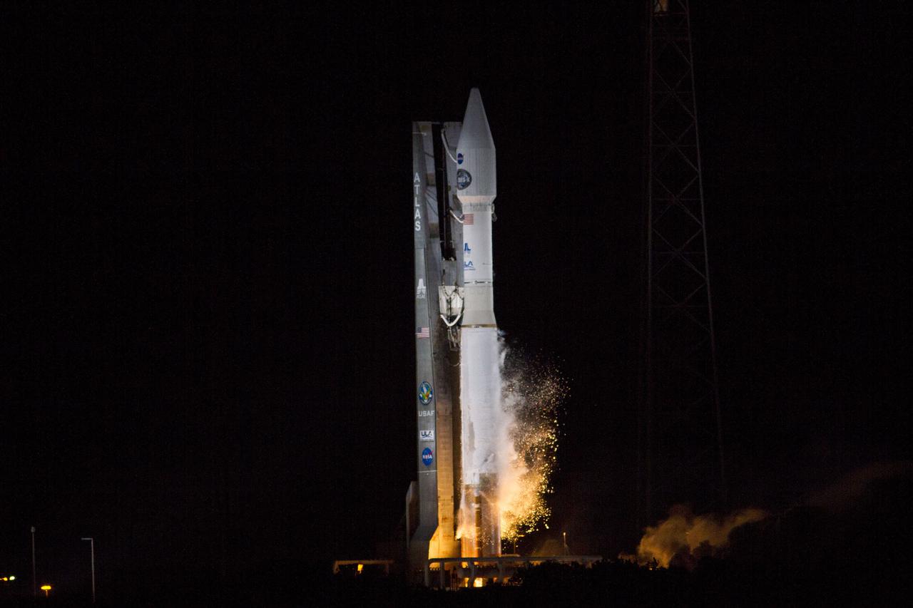
CAPE CANAVERAL, Fla. -- Plumes of exhaust and smoke form around a United Launch Alliance Atlas V 401 rocket at 8:48 p.m. EST as it lifts off Space Launch Complex 41 on Cape Canaveral Air Force Station in Florida, carrying NASA's Tracking and Data Relay Satellite-K, TDRS-K, to orbit. The TDRS-K spacecraft is part of the next-generation series in the Tracking and Data Relay Satellite System, a constellation of space-based communication satellites providing tracking, telemetry, command and high-bandwidth data return services. For more information, visit http:__www.nasa.gov_mission_pages_tdrs_index.html. Photo credit: NASA_George Roberts
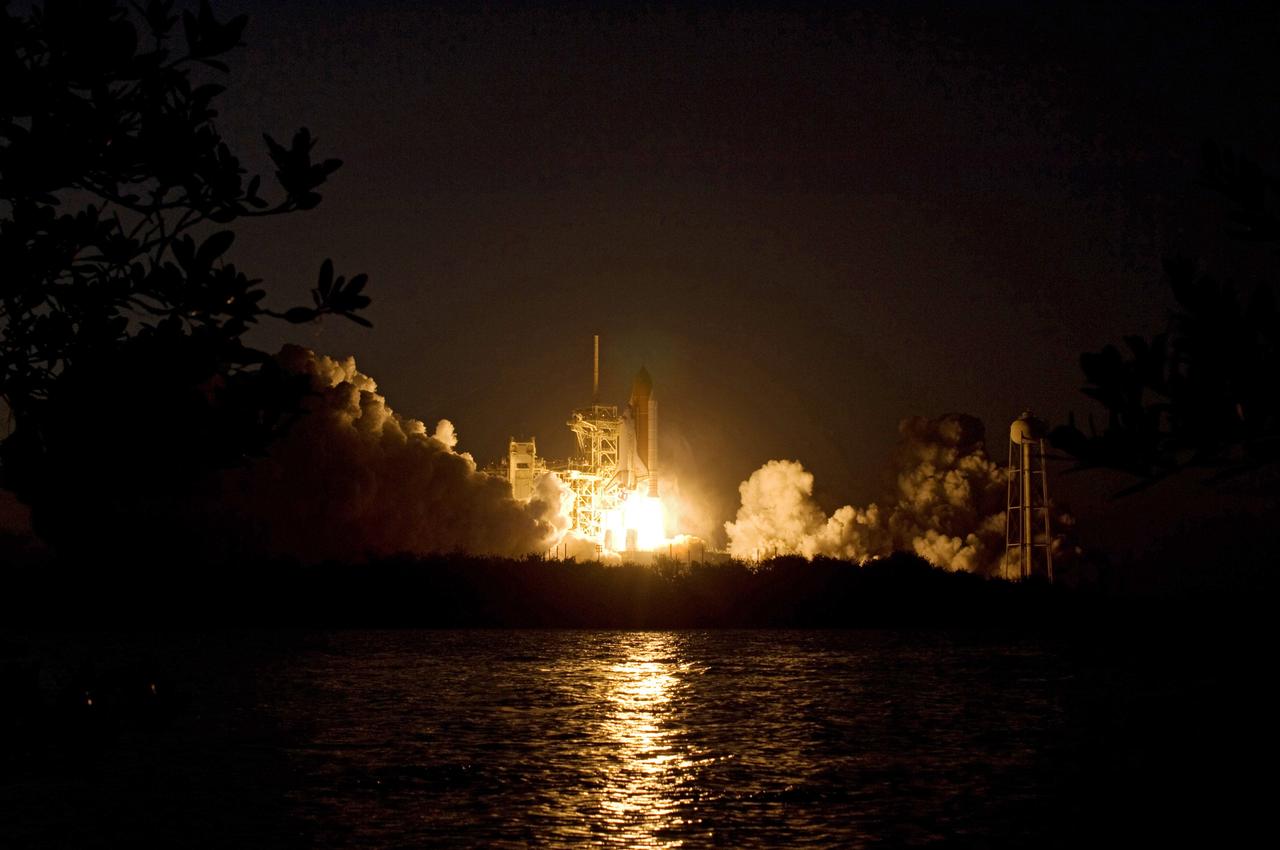
CAPE CANAVERAL, Fla. – The brilliant light of space shuttle Discovery's lift-off on the STS-119 mission lights up the clouds of smoke and the water near Launch Pad 39A at NASA's Kennedy Space Center in Florida. The launch was on time at 7:43 p.m. EDT. The STS-119 mission is the 28th to the International Space Station and the 125th space shuttle flight. Discovery will deliver the final pair of power-generating solar array wings and the S6 truss segment. Installation of S6 will signal the station's readiness to house a six-member crew for conducting increased science. Photo credit: NASA/Sandra Joseph, Kevin O'Connell
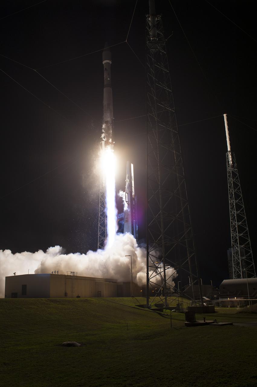
CAPE CANAVERAL, Fla. -- A cloud of exhaust and smoke forms under a United Launch Alliance Atlas V 401 rocket on Space Launch Complex 41 on Cape Canaveral Air Force Station in Florida as it lifts off at 8:48 p.m. EST, carrying NASA's Tracking and Data Relay Satellite-K, TDRS-K, to orbit. The TDRS-K spacecraft is part of the next-generation series in the Tracking and Data Relay Satellite System, a constellation of space-based communication satellites providing tracking, telemetry, command and high-bandwidth data return services. For more information, visit http:__www.nasa.gov_mission_pages_tdrs_index.html. Photo credit: NASA_Tony Gray and Robert Murray
CAPE CANAVERAL, Fla. – The brilliant light of space shuttle Discovery's lift-off on the STS-119 mission lights up the clouds of smoke and the water near Launch Pad 39A at NASA's Kennedy Space Center in Florida. The launch was on time at 7:43 p.m. EDT. The STS-119 mission is the 28th to the International Space Station and the 125th space shuttle flight. Discovery will deliver the final pair of power-generating solar array wings and the S6 truss segment. Installation of S6 will signal the station's readiness to house a six-member crew for conducting increased science. Photo credit: NASA/Tony Gray, Tom Farrar
CAPE CANAVERAL, Fla. – Billows of smoke and the water near Launch Pad 39A at NASA's Kennedy Space Center in Florida capture the brilliant light of space shuttle Discovery's lift-off on the STS-119 mission. The launch was on time at 7:43 p.m. EDT.The STS-119 mission is the 28th to the International Space Station and the 125th space shuttle flight. Discovery will deliver the final pair of power-generating solar array wings and the S6 truss segment. Installation of S6 will signal the station's readiness to house a six-member crew for conducting increased science. Photo credit: NASA/Tony Gray, Tom Farrar
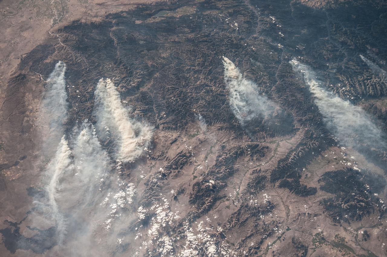
ISS036-E-032853 (18 Aug. 2013) --- Central Idaho wildfires are featured in this image photographed by an Expedition 36 crew member on the International Space Station. Taken with a short lens (50 mm), this west-looking image covers much of forested central Idaho?the dark areas are all wooded mountains. The image highlights part of the largest single wilderness area in the contiguous United States (the Frank Church-River of No Return Wilderness). Within this mountainous region, several fires can be seen producing extensive smoke plumes. Some fires had been named by Aug. 20, 2013, two days after the image was taken. The densest smoke on that day appears to be generated by a combination of the Little Queens and Leggit fires (left, within the Salmon River Mountains). The named fires were mostly set by lightning, and on Aug. 20 totaled 53,000 acres of burned forest south of the Salmon River, and many more if the unnamed fires are included. The Gold Pan fire north of the Salmon River had burned 27,000 acres. For a sense of scale in this oblique view, the Gold Pan fire lies about 125 miles north of the Little Queens fire. This image shows the common pattern of westerly winds transporting smoke in an easterly direction, as seen during the wildfire season of one year ago. Ten days before this image was taken, fires in central Idaho near Boise were aggravated by southerly winds. Some of the fires began to burn in July but were quelled and remain under observation for new flare-ups. Smoke from fires in the south partly obscures the black lava flows of the Craters of the Moon National Monument (lower left). The Beaverhead Mountains mark the eastern boundary of Idaho with Montana.
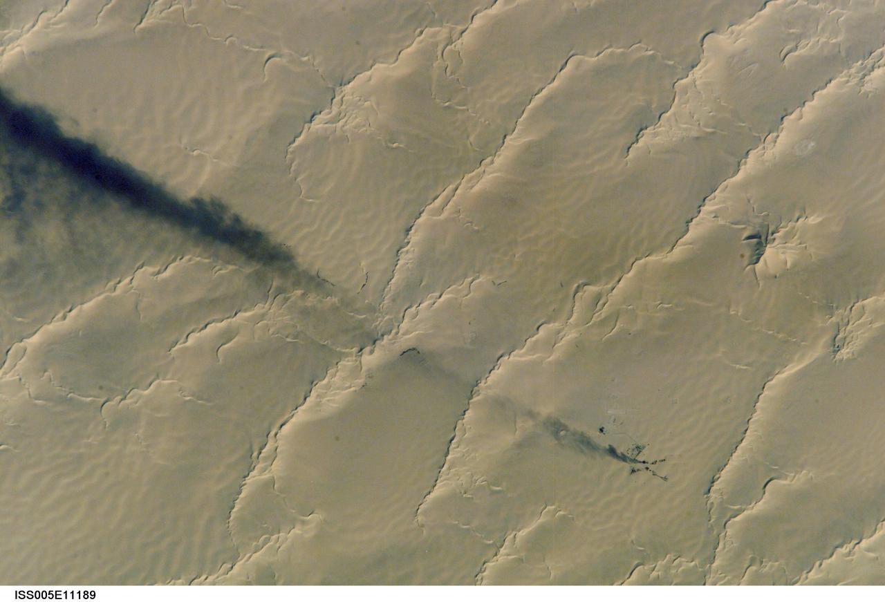
ISS005-E-11189 (25 August 2002) --- Calanscio Sand Sea, Libya is featured in this digital image photographed by an Expedition 5 crewmember on the International Space Station (ISS). A plume of black smoke blowing westward is silhouetted against yellow linear dunes in the great sand sea of northeast Libya. Smoke from flares at remote well heads is commonly seen by astronauts flying over the Sahara Desert. NASA scientists studying the Station imagery had the following observations about the image. The plume dispersal pattern visible at the left edge of the image may be due to upper-level winds or gravitational settling of heavier particulates. The regular pattern of linear dunes is generated by two major winds: the dominant north wind (north is towards the top right) determines the orientation of the sand dunes. Gentler easterly winds, as were blowing when this view was taken, make the dunes asymmetric, with a gentle windward (west) slope and an over steeped downwind slope. Some over steepened slopes even cast shadows in the early morning light. One mound of sand (top right), due north of the well head, does not fit the pattern of linear dunes. This type is known as a star dune.
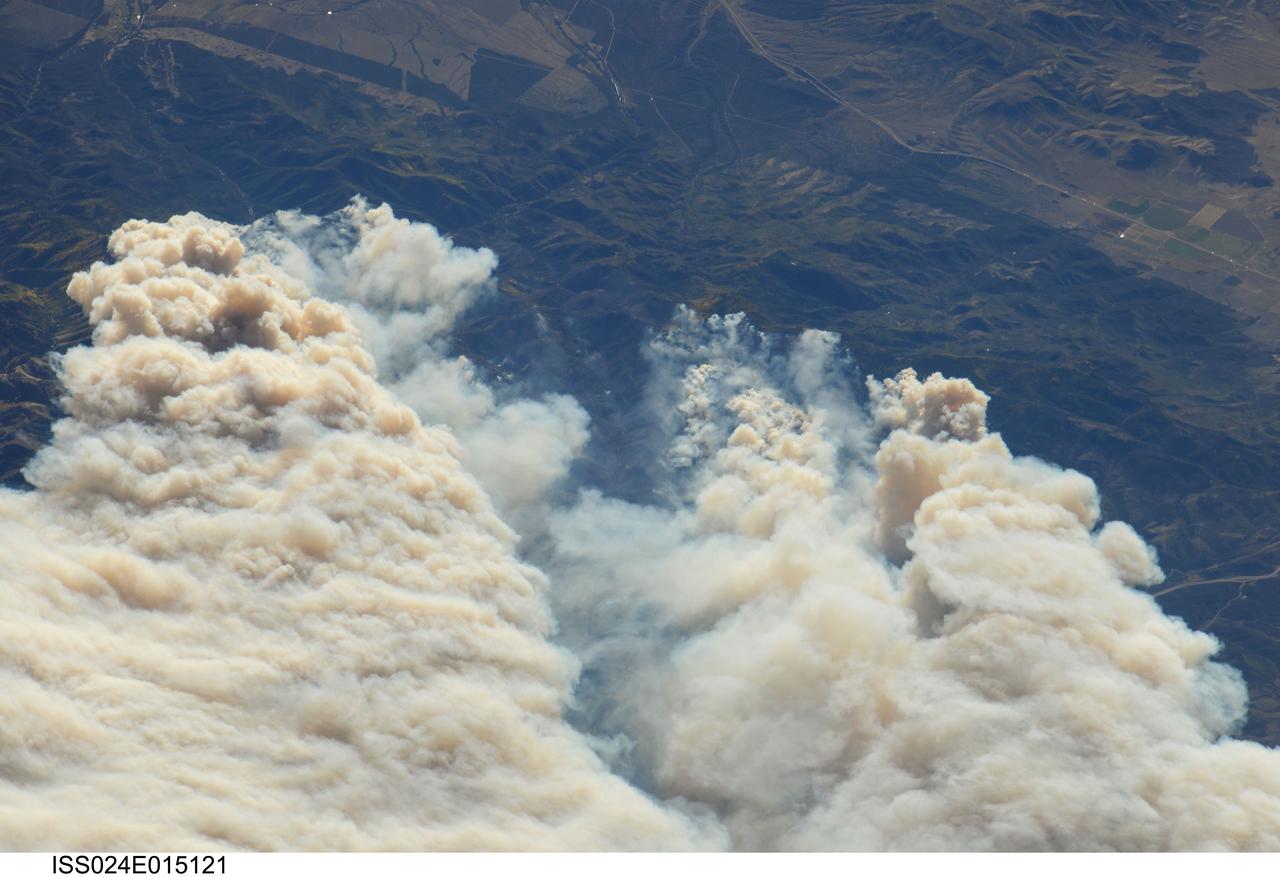
ISS024-E-015121 (20 Sept. 2010) --- Twitchell Canyon Fire in central Utah is featured in this image photographed by an Expedition 24 crew member on the International Space Station (ISS). The Twitchell Canyon Fire near central Utah?s Fishlake National Forest is reported to have an area of approximately 13,383 hectares (approximately 134 square kilometers, or 33,071 acres). This detailed image shows smoke plumes generated by several fire spots close to the southwestern edge of the burned area. The fire was started by a lightning strike on July 20, 2010. Whereas many of the space station images of Earth are looking straight down (nadir), this photograph was exposed at an angle. The space station was located over a point approximately 509 kilometers (316 miles) to the northeast, near the Colorado/Wyoming border, at the time the image was taken on Sept. 20. Southwesterly winds were continuing to extend smoke plumes from the fire to the northeast. While the Twitchell Canyon region is sparsely populated, Interstate Highway 15 is visible at upper left.

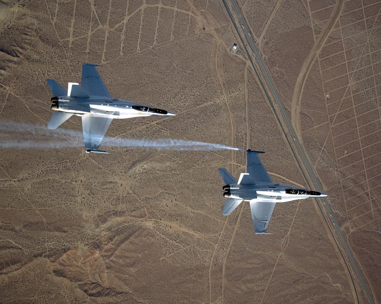
This unique view, looking directly up at two NASA Dryden F/A-18's used in the Autonomous Formation Flight (AFF) program, was captured by Carla Thomas from another F-18 flying safety/chase.
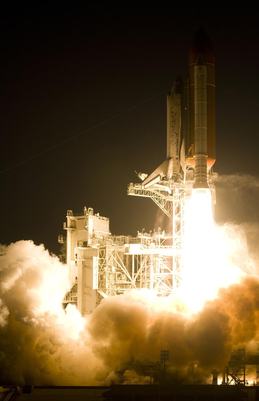
KENNEDY SPACE CENTER, FLA. -- From amid the smoke and steam, Space Shuttle Discovery leaps toward the sky past the lightning mast on Launch Pad 39B on mission STS-116. The launch occurred at 8:47:35 p.m. EST. This was the second launch attempt for mission STS-116. The first launch attempt on Dec. 7 was postponed due a low cloud ceiling over Kennedy Space Center. This is Discovery's 33rd mission and the first night launch since 2002. The 20th shuttle mission to the International Space Station, STS-116 carries another truss segment, P5. It will serve as a spacer, mated to the P4 truss that was attached in September. After installing the P5, the crew will reconfigure and redistribute the power generated by two pairs of U.S. solar arrays. Landing is expected Dec. 21 at KSC. Photo courtesy of Reuters/Larry Rubenstein and Peter Jones
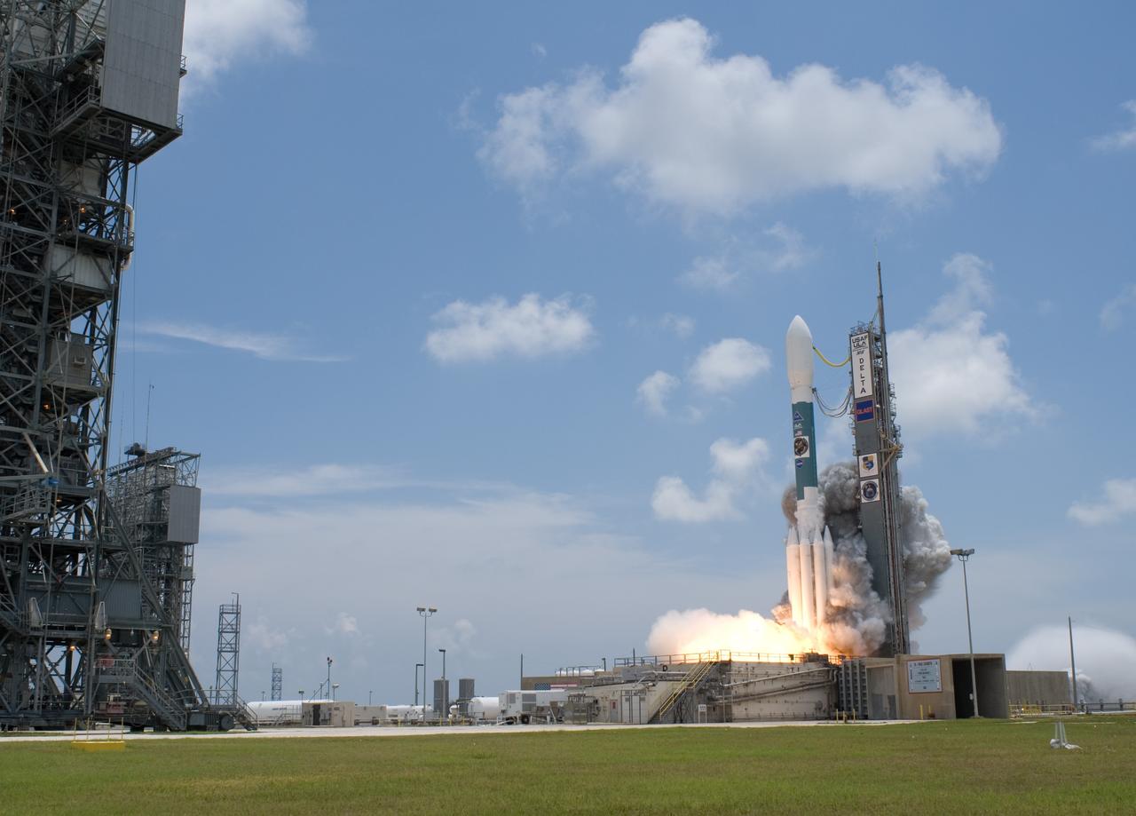
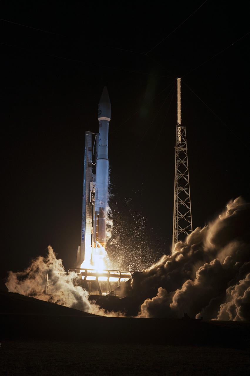
CAPE CANAVERAL, Fla. -- Smoke is generated at liftoff of NASA's Gamma-Ray Large Area Space Telescope , or GLAST, aboard a Delta II rocket from Cape Canaveral Air Force Station's Launch Pad 17-B. Liftoff was at 12:05 p.m. EDT. GLAST is a powerful space observatory that will explore the universe's ultimate frontier, where nature harnesses forces and energies far beyond anything possible on Earth; probe some of science's deepest questions, such as what our universe is made of, and search for new laws of physics; explain how black holes accelerate jets of material to nearly light speed; and help crack the mystery of stupendously powerful explosions known as gamma-ray bursts. Launch is scheduled for 11:45 a.m. June 11. Photo credit: NASA/Tony Gray, Regina Mitchell-Ryall
CAPE CANAVERAL, Fla. -- Smoke is generated at liftoff of the Delta II rocket with NASA's Gamma-Ray Large Area Space Telescope , or GLAST, aboard from Cape Canaveral Air Force Station's Launch Pad 17-B. In the background can be seen the blue Atlantic Ocean between the beach and the cloud-filled sky. Liftoff was at 12:05 p.m. EDT. GLAST is a powerful space observatory that will explore the universe's ultimate frontier, where nature harnesses forces and energies far beyond anything possible on Earth; probe some of science's deepest questions, such as what our universe is made of, and search for new laws of physics; explain how black holes accelerate jets of material to nearly light speed; and help crack the mystery of stupendously powerful explosions known as gamma-ray bursts. Launch is scheduled for 11:45 a.m. June 11. Photo credit: NASA/Jerry Cannon, Robert Murray
KENNEDY SPACE CENTER, FLA. -- Rising on columns of fire from amid the smoke and steam below, Space Shuttle Discovery leaps toward the sky past the lightning mast on Launch Pad 39B on mission STS-116. Liftoff occurred on time at 8:47 p.m. EST. This was the second launch attempt of Discovery on mission STS-116. The first launch attempt on Dec. 7 was postponed due a low cloud ceiling over Kennedy Space Center. This is Discovery's 33rd mission and the first night launch since 2002. The 20th shuttle mission to the International Space Station, STS-116 carries another truss segment, P5. It will serve as a spacer, mated to the P4 truss that was attached in September. After installing the P5, the crew will reconfigure and redistribute the power generated by two pairs of U.S. solar arrays. Landing is expected Dec. 21 at KSC. Photo credit: NASA/Sandra Joseph, Robert Murray, Chris Lynch
KENNEDY SPACE CENTER, FLA. -- Rising on columns of fire above the smoke and steam below, Space Shuttle Discovery leaps toward the sky past the lightning mast on Launch Pad 39B on mission STS-116. Liftoff occurred on time at 8:47 p.m. EST. This was the second launch attempt for mission STS-116. The first launch attempt on Dec. 7 was postponed due a low cloud ceiling over Kennedy Space Center. This is Discovery's 33rd mission and the first night launch since 2002. The 20th shuttle mission to the International Space Station, STS-116 carries another truss segment, P5. It will serve as a spacer, mated to the P4 truss that was attached in September. After installing the P5, the crew will reconfigure and redistribute the power generated by two pairs of U.S. solar arrays. Landing is expected Dec. 21 at KSC. Photo courtesy of Nikon/Scott Andrews
KENNEDY SPACE CENTER, FLA. -- From amid the smoke and steam, Space Shuttle Discovery leaps toward the sky past the lightning mast on Launch Pad 39B on mission STS-116. The launch occurred at 8:47:35 p.m. EST. This was the second launch attempt for mission STS-116. The first launch attempt on Dec. 7 was postponed due a low cloud ceiling over Kennedy Space Center. This is Discovery's 33rd mission and the first night launch since 2002. The 20th shuttle mission to the International Space Station, STS-116 carries another truss segment, P5. It will serve as a spacer, mated to the P4 truss that was attached in September. After installing the P5, the crew will reconfigure and redistribute the power generated by two pairs of U.S. solar arrays. Landing is expected Dec. 21 at KSC. Photo courtesy of Reuters/Larry Rubenstein and Peter Jones
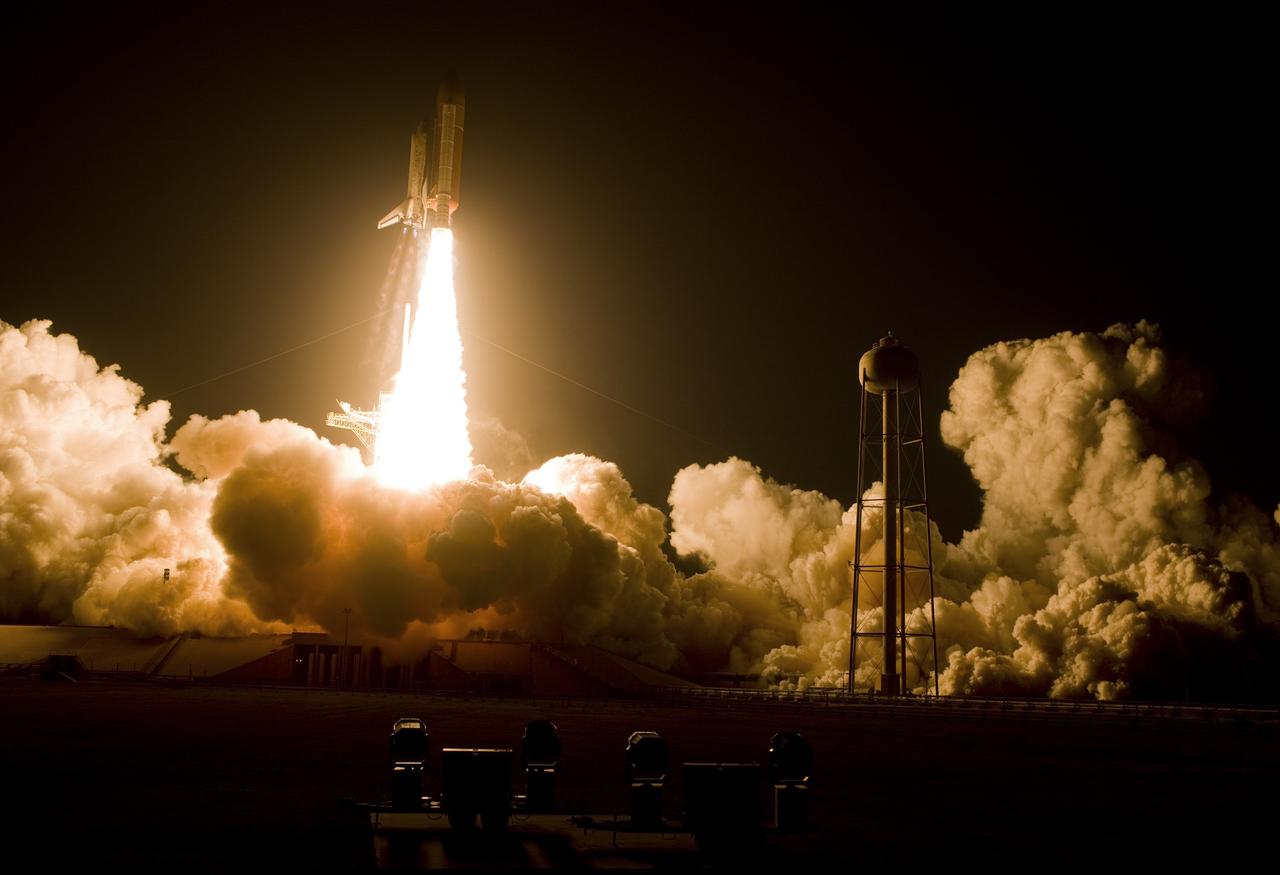
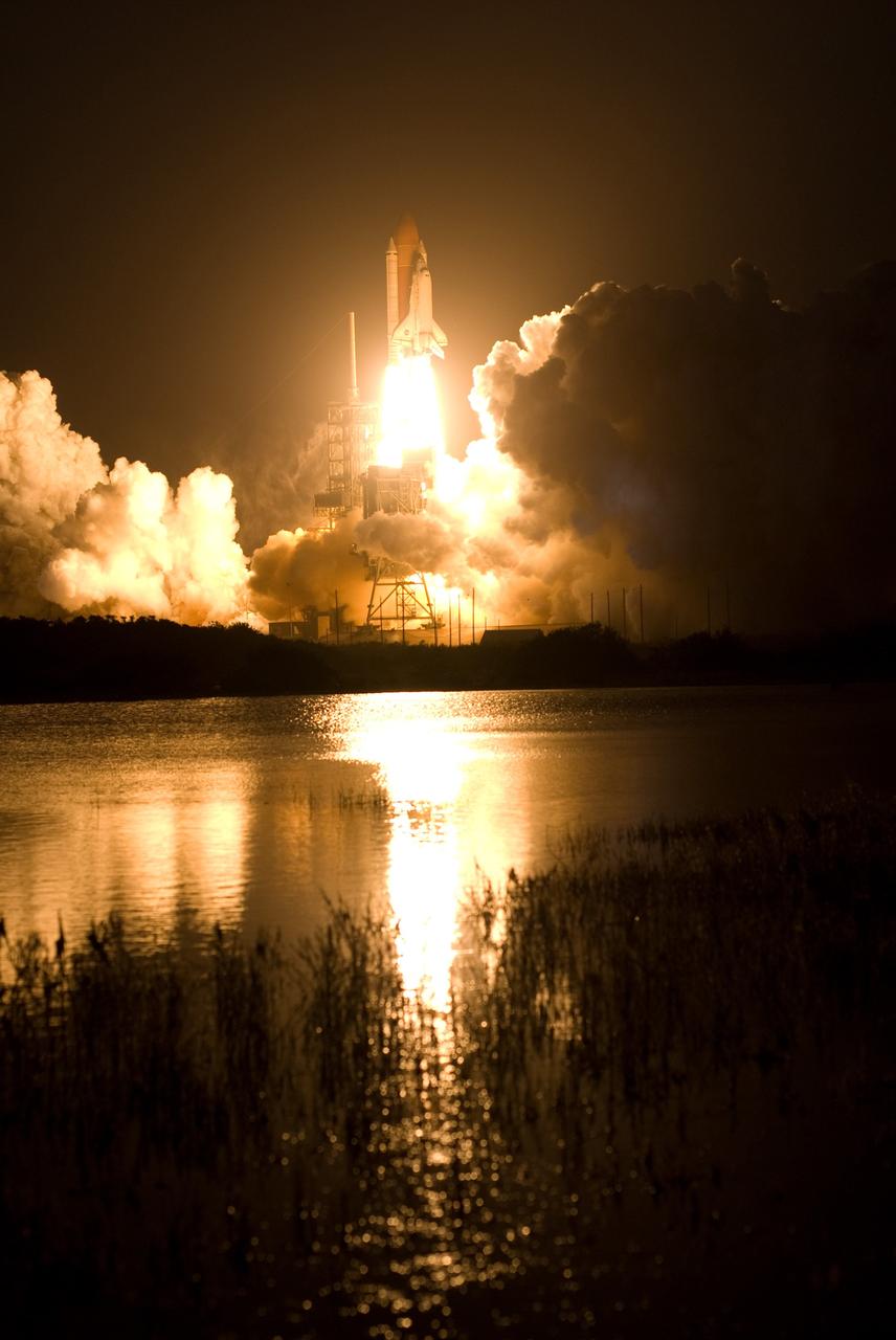
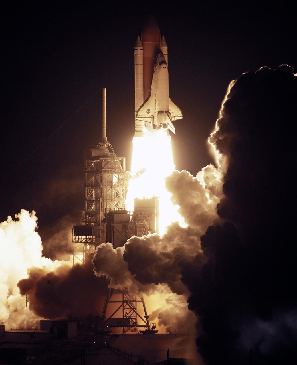
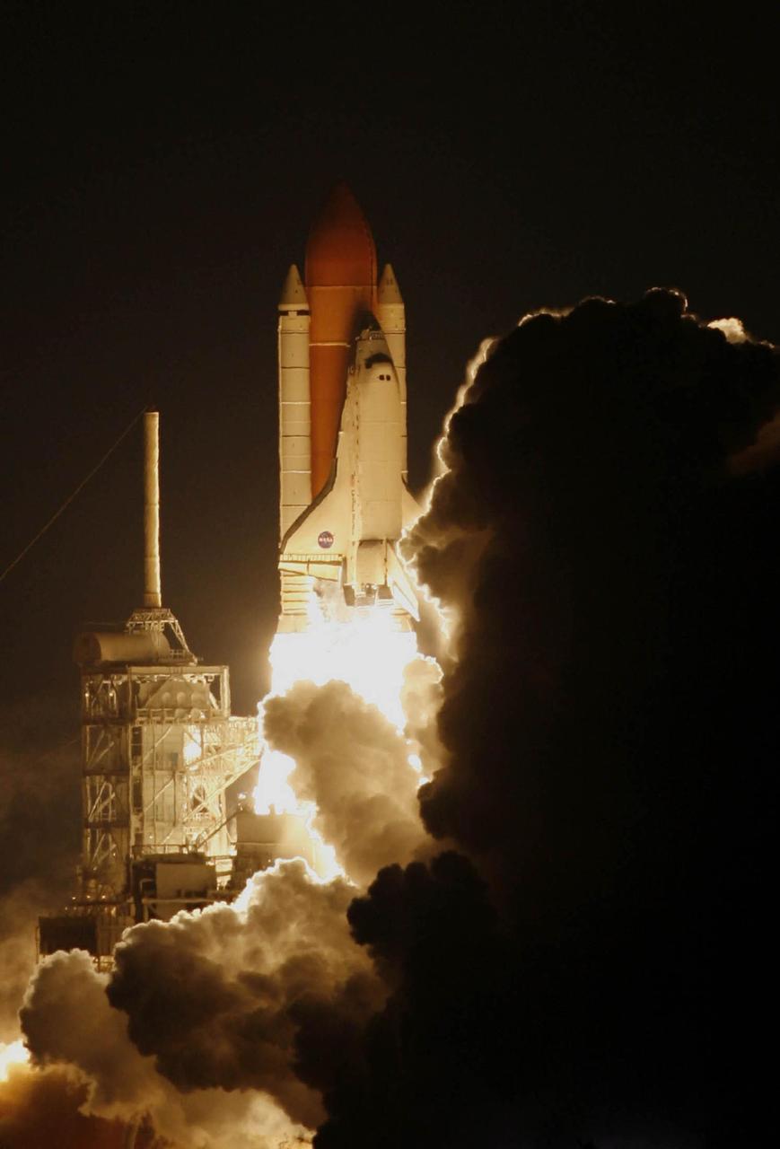
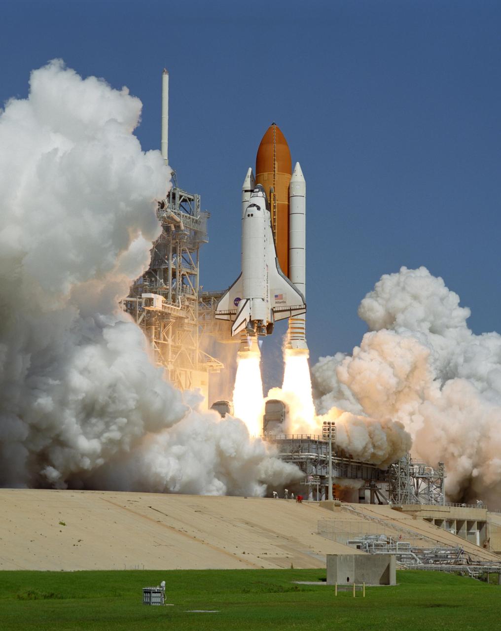
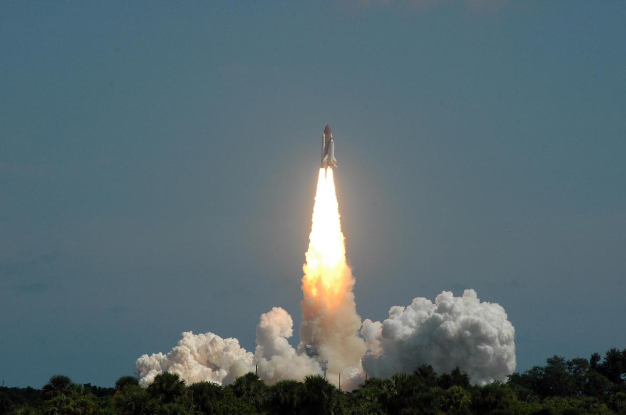
KENNEDY SPACE CENTER, FLA. - Trailing fire and a plume of smoke, Space Shuttle Atlantis leaves a dance of lights on nearby water as it hurtles toward space for a rendezvous with the International Space Station on mission STS-115. Liftoff was on-time at 11:14:55 a.m. EDT. After several launch attempts were scrubbed due to weather and technical concerns, this launch was executed perfectly. Mission STS-115 is the 116th space shuttle flight, the 27th flight for orbiter Atlantis, and the 19th U.S. flight to the International Space Station. During the mission, Atlantis' astronauts will deliver and install the 17.5-ton, bus-sized P3/P4 integrated truss segment on the station. The girder-like truss includes a set of giant solar arrays, batteries and associated electronics and will provide one-fourth of the total power-generation capability for the completed station. STS-115 is scheduled to last 11 days with a planned landing at KSC
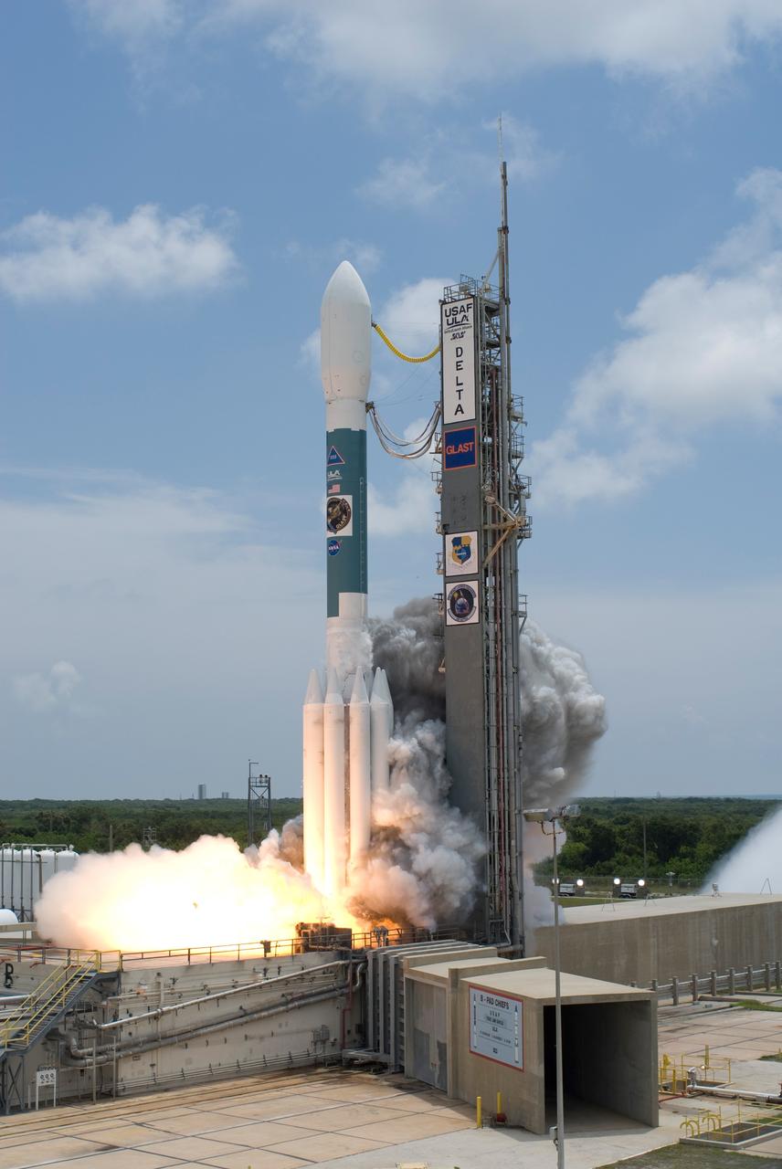
CAPE CANAVERAL, Fla. -- Smoke is generated at liftoff of NASA's Gamma-Ray Large Area Space Telescope , or GLAST, aboard a Delta II rocket from Cape Canaveral Air Force Station's Launch Pad 17-B. Liftoff was at 12:05 p.m. EDT. GLAST is a powerful space observatory that will explore the universe's ultimate frontier, where nature harnesses forces and energies far beyond anything possible on Earth; probe some of science's deepest questions, such as what our universe is made of, and search for new laws of physics; explain how black holes accelerate jets of material to nearly light speed; and help crack the mystery of stupendously powerful explosions known as gamma-ray bursts. Launch is scheduled for 11:45 a.m. June 11. Photo credit: NASA/Tony Gray, Regina Mitchell-Ryall
KENNEDY SPACE CENTER, FLA. -- Rising on columns of fire above the smoke and steam below, Space Shuttle Discovery leaps toward the sky past the lightning mast on Launch Pad 39B on mission STS-116. Liftoff occurred at 8:47 p.m. EST. This was the second launch attempt for mission STS-116. The first launch attempt on Dec. 7 was postponed due a low cloud ceiling over Kennedy Space Center. This is Discovery's 33rd mission and the first night launch since 2002. The 20th shuttle mission to the International Space Station, STS-116 carries another truss segment, P5. It will serve as a spacer, mated to the P4 truss that was attached in September. After installing the P5, the crew will reconfigure and redistribute the power generated by two pairs of U.S. solar arrays. Landing is expected Dec. 21 at KSC. Photo credit: NASA/Regina Mitchell-Ryall & Tim Powers
KENNEDY SPACE CENTER, FLA. - Smoke and steam billow across Launch Pad 39B as Space Shuttle Atlantis hurtles into the sky for its rendezvous with the International Space Station on mission STS-115. Liftoff was on-time at 11:14:55 a.m. EDT. After several earlier launch attempts were scrubbed due to weather and technical concerns, this launch was executed perfectly. Mission STS-115 is the 116th space shuttle flight, the 27th flight for orbiter Atlantis, and the 19th U.S. flight to the International Space Station. During the mission, Atlantis' astronauts will deliver and install the 17.5-ton, bus-sized P3/P4 integrated truss segment on the station. The girder-like truss includes a set of giant solar arrays, batteries and associated electronics and will provide one-fourth of the total power-generation capability for the completed station. STS-115 is scheduled to last 11 days with a planned landing at KSC. Photo courtesy of Nikon/Scott Andrews
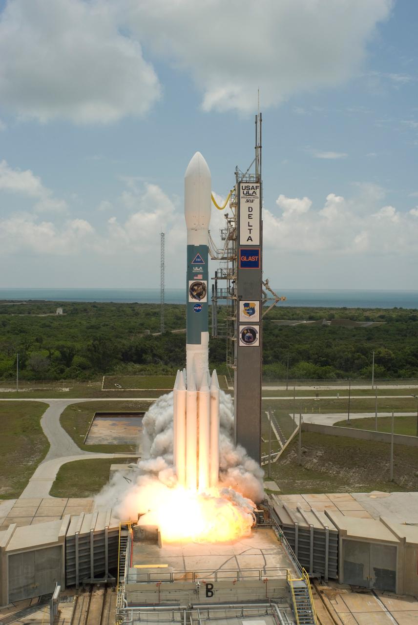
CAPE CANAVERAL, Fla. -- The Delta II rocket with NASA's Gamma-Ray Large Area Space Telescope , or GLAST, on top emerges from the smoke generated at liftoff from Cape Canaveral Air Force Station's Launch Pad 17-B. Liftoff was at 12:05 p.m. EDT. GLAST is a powerful space observatory that will explore the universe's ultimate frontier, where nature harnesses forces and energies far beyond anything possible on Earth; probe some of science's deepest questions, such as what our universe is made of, and search for new laws of physics; explain how black holes accelerate jets of material to nearly light speed; and help crack the mystery of stupendously powerful explosions known as gamma-ray bursts. Launch is scheduled for 11:45 a.m. June 11. Photo credit: NASA/Sandra Joseph, Kevin O'Connel

KENNEDY SPACE CENTER, FLA. -- The smoke and steam obscure Launch Pad 39B as Space Shuttle Discovery rockets through the black skies into space on mission STS-116. Liftoff occurred at 8:47 p.m. EST. This was the second launch attempt for mission STS-116. The first launch attempt on Dec. 7 was postponed due a low cloud ceiling over Kennedy Space Center. This is Discovery's 33rd mission and the first night launch since 2003. The 20th shuttle mission to the International Space Station, STS-116 carries another truss segment, P5. It will serve as a spacer, mated to the P4 truss that was attached in September. After installing the P5, the crew will reconfigure and redistribute the power generated by two pairs of U.S. solar arrays. Landing is expected Dec. 21 at KSC. Photo credit: NASA/Sandy Joseph, Robert Murray & Chris Lynch
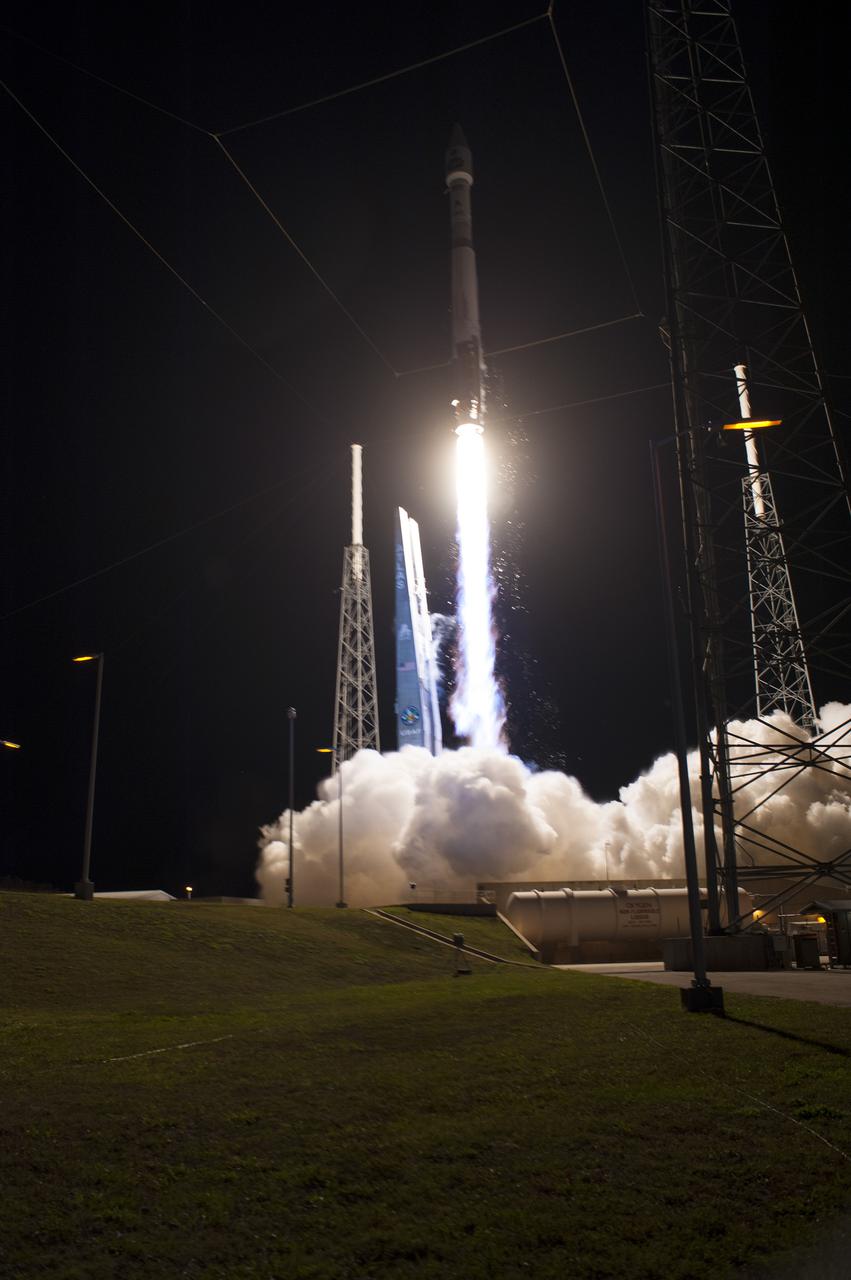
CAPE CANAVERAL, Fla. -- A United Launch Alliance Atlas V 401 rocket rushes past the lightning masts on Space Launch Complex 41 on Cape Canaveral Air Force Station in Florida, leaving plumes of exhaust and smoke in its wake. Its payload, NASA's Tracking and Data Relay Satellite-K or TDRS-K, began its climb to orbit at 8:48 p.m. EST. The TDRS-K spacecraft is part of the next-generation series in the Tracking and Data Relay Satellite System, a constellation of space-based communication satellites providing tracking, telemetry, command and high-bandwidth data return services. For more information, visit http:__www.nasa.gov_mission_pages_tdrs_index.html. Photo credit: NASA_Tony Gray and Rick Wetherington
KENNEDY SPACE CENTER, FLA. -- Looking like a shooting star, Space Shuttle Discovery roars into the night sky on mission STS-116. The trailing blaze lighted the sky and nearby water, while clouds of smoke and steam billowed across the launch pad. Liftoff occurred on time at 8:47 p.m. EST. This was the second launch attempt for mission STS-116. The first launch attempt on Dec. 7 was postponed due a low cloud ceiling over Kennedy Space Center. This is Discovery's 33rd mission and the first night launch since 2002. The 20th shuttle mission to the International Space Station, STS-116 carries another truss segment, P5. It will serve as a spacer, mated to the P4 truss that was attached in September. After installing the P5, the crew will reconfigure and redistribute the power generated by two pairs of U.S. solar arrays. Landing is expected Dec. 21 at KSC. Photo courtesy of Nikon/Scott Andrews
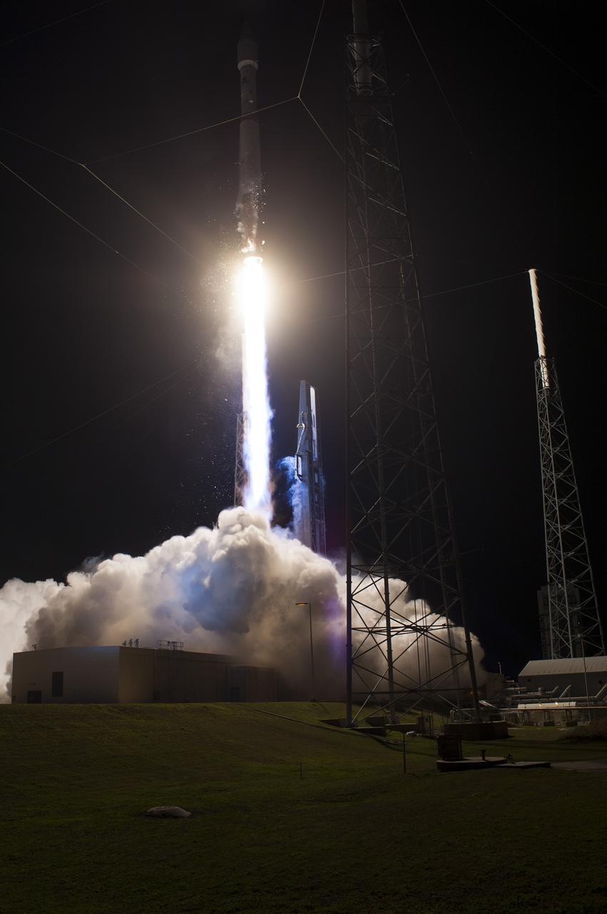
CAPE CANAVERAL, Fla. -- A United Launch Alliance Atlas V 401 rocket races above the lightning masts on Space Launch Complex 41 on Cape Canaveral Air Force Station in Florida, leaving plumes of exhaust and smoke in its wake. Its payload, NASA's Tracking and Data Relay Satellite-K or TDRS-K, began its climb to orbit at 8:48 p.m. EST. The TDRS-K spacecraft is part of the next-generation series in the Tracking and Data Relay Satellite System, a constellation of space-based communication satellites providing tracking, telemetry, command and high-bandwidth data return services. For more information, visit http:__www.nasa.gov_mission_pages_tdrs_index.html. Photo credit: NASA_Tony Gray and Robert Murray
KENNEDY SPACE CENTER, FLA. -- Rising on columns of fire as it emerges from behind the clouds of smoke and steam generated by its liftoff, Space Shuttle Discovery leaps toward the sky past the lightning mast on Launch Pad 39B on mission STS-116. Liftoff occurred on time at 8:47 p.m. EST. This was the second launch attempt of Discovery on mission STS-116. The first launch attempt on Dec. 7 was postponed due a low cloud ceiling over Kennedy Space Center. This is Discovery's 33rd mission and the first night launch since 2002. The 20th shuttle mission to the International Space Station, STS-116 carries another truss segment, P5. It will serve as a spacer, mated to the P4 truss that was attached in September. After installing the P5, the crew will reconfigure and redistribute the power generated by two pairs of U.S. solar arrays. Landing is expected Dec. 21 at KSC. Photo credit: NASA/Sandra Joseph, Robert Murray, Chris Lynch
On April 27, 2018, the Tinder Fire ignited in eastern Arizona near the Blue Ridge Reservoir, about 50 miles (80 kilometers) southeast of Flagstaff and 20 miles (32 kilometers) northeast of Payson. During the first 24 hours it remained relatively small at 500 acres (202 hectares), but on April 29, during red flag wind conditions, it exploded to 8,600 acres (3,480 hectares). Residents of rural communities in the area were forced to evacuate and an unknown number of structures were burned. As of April 30, the Tinder Fire had burned a total of 11,400 acres (4,613 hectares). On April 30 at 11:15 a.m. local time, the Multi-angle Imaging SpectroRadiometer (MISR) captured imagery of the Tinder Fire as it passed overhead on NASA's Terra satellite. The MISR instrument has nine cameras that view Earth at different angles. This image shows the view from MISR's nadir (downward-pointing) camera. The angular information from MISR's images is used to calculate the height of the smoke plume, results of which are superimposed on the right-hand image. This shows that the plume top near the active fire was at approximately 13,000 feet altitude (4,000 meters). In general, higher-altitude plumes transport smoke greater distances from the source, impacting communities downwind. A stereo anaglyph providing a three-dimensional view of the plume is also shown. Red-blue glasses with the red lens placed over your left eye are required to observe the 3D effect. These data were acquired during Terra orbit 97691. An annotated figure and anaglyph are available at https://photojournal.jpl.nasa.gov/catalog/PIA00698

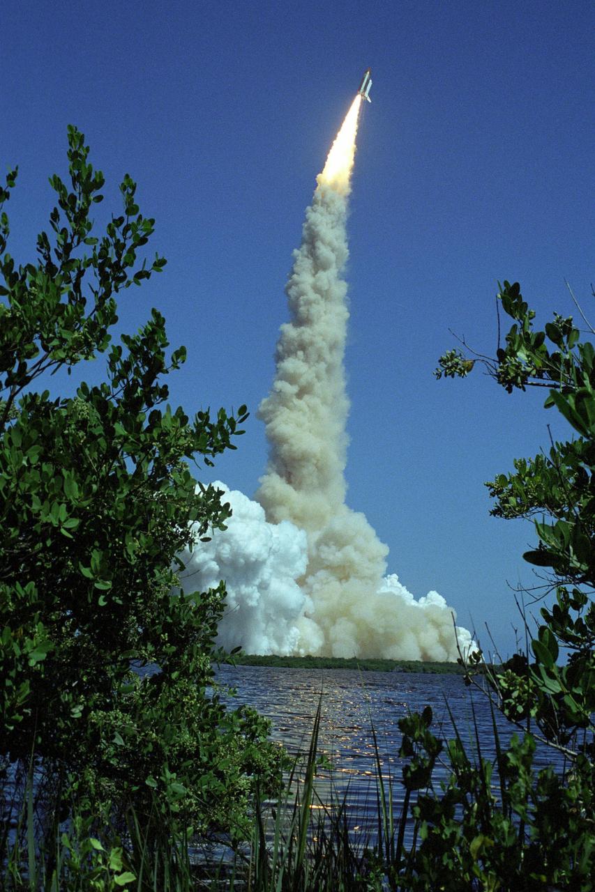
KENNEDY SPACE CENTER, FLA. - Launch of Space Shuttle Atlantis into the deep blue sky is reflected in the nearby water framed by the green underbrush. Clouds of smoke and steam spread side to side across Launch Pad 39B. Atlantis is heading for a rendezvous with the International Space Station on mission STS-115. Liftoff was on-time at 11:14:55 a.m. EDT. After several launch attempts were scrubbed due to weather and technical concerns, this launch was executed perfectly. Mission STS-115 is the 116th space shuttle flight, the 27th flight for orbiter Atlantis, and the 19th U.S. flight to the International Space Station. During the mission, Atlantis' astronauts will deliver and install the 17.5-ton, bus-sized P3/P4 integrated truss segment on the station. The girder-like truss includes a set of giant solar arrays, batteries and associated electronics and will provide one-fourth of the total power-generation capability for the completed station. STS-115 is scheduled to last 11 days with a planned landing at KSC
KENNEDY SPACE CENTER, FLA. - Space Shuttle Atlantis hurtles toward space, propelled by twin columns of fire from the solid rocket boosters, which are captured in the reflection on the water. The resulting clouds of smoke and steam billow across Launch Pad 39B and upward, obscuring the service structures on the pad. Atlantis is heading for a rendezvous with the International Space Station on mission STS-115. Liftoff was on-time at 11:14:55 a.m. EDT. After several launch attempts were scrubbed due to weather and technical concerns, this launch was executed perfectly. Mission STS-115 is the 116th space shuttle flight, the 27th flight for orbiter Atlantis, and the 19th U.S. flight to the International Space Station. During the mission, Atlantis' astronauts will deliver and install the 17.5-ton, bus-sized P3/P4 integrated truss segment on the station. The girder-like truss includes a set of giant solar arrays, batteries and associated electronics and will provide one-fourth of the total power-generation capability for the completed station. STS-115 is scheduled to last 11 days with a planned landing at KSC
KENNEDY SPACE CENTER, FLA. - Hurtling toward space, Space Shuttle Atlantis clears the lightning mast atop the fixed service structure on Launch Pad 39B. Clouds of smoke and steam nearly obscure the pad. Atlantis is heading for a rendezvous with the International Space Station on mission STS-115. Liftoff was on-time at 11:14:55 a.m. EDT. After several launch attempts were scrubbed due to weather and technical concerns, this launch was executed perfectly. Mission STS-115 is the 116th space shuttle flight, the 27th flight for orbiter Atlantis, and the 19th U.S. flight to the International Space Station. During the mission, Atlantis' astronauts will deliver and install the 17.5-ton, bus-sized P3/P4 integrated truss segment on the station. The girder-like truss includes a set of giant solar arrays, batteries and associated electronics and will provide one-fourth of the total power-generation capability for the completed station. STS-115 is scheduled to last 11 days with a planned landing at KSC.
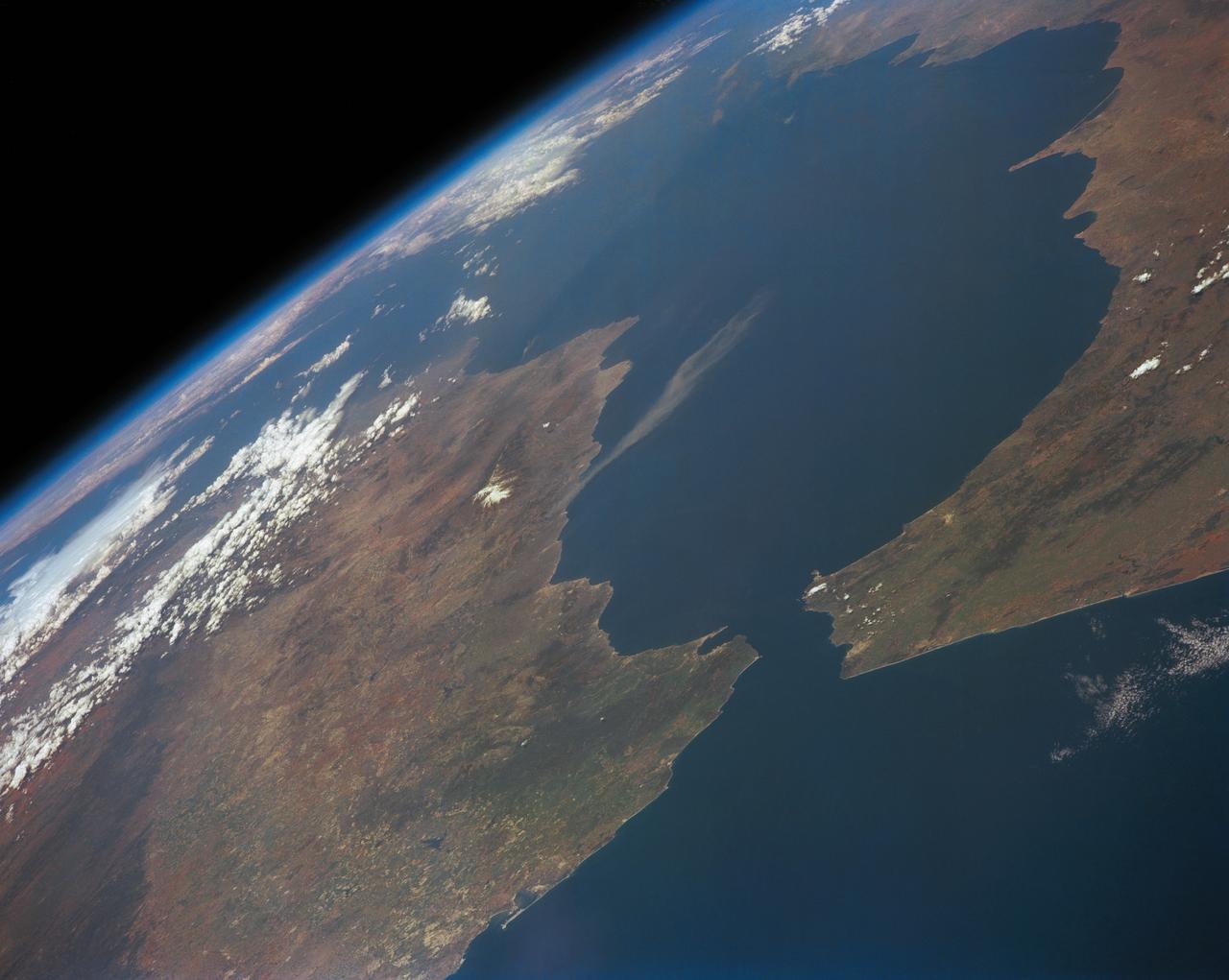
STS039-151-193 (28 April-6 May 1991) --- The Strait of Gibraltar, the only outlet for the Mediterranean Sea, was photographed with a large format handheld camera by the STS-39 crew members. Scientists site evidence in Shuttle photography that the Mediterranean Sea dried up a number of times between 5 million and 20 million years ago. Sea levels, they say, dropped slightly, cutting off the Mediterranean (top right) from the Atlantic Ocean (bottom). In southern Spain, the dark area near the coast is the delta of the Guadalquivir River with the city of Seville. The Sierra Nevada range still has some snow. A small field fire near the Spanish coast has generated a conspicuous smoke plume. The small spike of land on the north side of the Strait is the Rock of Gibraltar, an outpost of the British empire. The larger spike of land on the north coast of Africa marks the border between Morocco (center foreground) and Algeria (right). The sharp line cutting across them Mediterranean (top right) marks the edge of a dust cloud blowing from Africa into Europe. Photo credit: NASA
KENNEDY SPACE CENTER, FLA. - Space Shuttle Atlantis appears enveloped in the smoke and steam created at liftoff from Launch Pad 39B. Liftoff was on-time at 11:14:55 a.m. EDT. Atlantis is heading for space and its rendezvous with the International Space Station on mission STS-115. After launch attempts were scrubbed Aug. 27 and 29 and Sept. 3 and 8 due to weather and technical concerns, this launch was executed perfectly. Mission STS-115 is the 116th space shuttle flight, the 27th flight for orbiter Atlantis, and the 19th U.S. flight to the International Space Station. During the mission, Atlantis' astronauts will deliver and install the 17.5-ton, bus-sized P3/P4 integrated truss segment on the station. The girder-like truss includes a set of giant solar arrays, batteries and associated electronics and will provide one-fourth of the total power-generation capability for the completed station. STS-115 is scheduled to last 11 days with a planned landing at KSC. Photo credit: NASA/Sandra Joseph & Robert Murray
KENNEDY SPACE CENTER, FLA. - Twin columns of fire from the solid rocket boosters hurl Space Shuttle Atlantis off Launch Pad 39B into the sky for a rendezvous with the International Space Station on mission STS-115. Clouds of smoke and steam spread across the pad and the fixed service structure at left, topped by the lightning mast. Atlantis is heading for a rendezvous with the International Space Station on mission STS-115. Liftoff was on-time at 11:14:55 a.m. EDT. After several launch attempts were scrubbed due to weather and technical concerns, this launch was executed perfectly. Mission STS-115 is the 116th space shuttle flight, the 27th flight for orbiter Atlantis, and the 19th U.S. flight to the International Space Station. During the mission, Atlantis' astronauts will deliver and install the 17.5-ton, bus-sized P3/P4 integrated truss segment on the station. The girder-like truss includes a set of giant solar arrays, batteries and associated electronics and will provide one-fourth of the total power-generation capability for the completed station. STS-115 is scheduled to last 11 days with a planned landing at KSC
KENNEDY SPACE CENTER, FLA. - Tree limbs frame the brilliant launch of Space Shuttle Atlantis as it flees the smoke and steam below, heading for a rendezvous with the International Space Station on mission STS-115. Liftoff was on-time at 11:14:55 a.m. EDT. After launch attempts were scrubbed Aug. 27 and 29 and Sept. 3 and 8 due to weather and technical concerns, this launch was executed perfectly. Mission STS-115 is the 116th space shuttle flight, the 27th flight for orbiter Atlantis, and the 19th U.S. flight to the International Space Station. During the mission, Atlantis' astronauts will deliver and install the 17.5-ton, bus-sized P3/P4 integrated truss segment on the station. The girder-like truss includes a set of giant solar arrays, batteries and associated electronics and will provide one-fourth of the total power-generation capability for the completed station. STS-115 is scheduled to last 11 days with a planned landing at KSC. Photo courtesy of Nikon/Scott Andrews

KENNEDY SPACE CENTER, FLA. - Flaming rockets propel Space Shuttle Atlantis away from the smoke and steam below and into the sky for a rendezvous with the International Space Station on mission STS-115. Liftoff was on-time at 11:14:55 a.m. EDT. After launch attempts were scrubbed Aug. 27 and 29 and Sept. 3 and 8 due to weather and technical concerns, this launch was executed perfectly. Mission STS-115 is the 116th space shuttle flight, the 27th flight for orbiter Atlantis, and the 19th U.S. flight to the International Space Station. During the mission, Atlantis' astronauts will deliver and install the 17.5-ton, bus-sized P3/P4 integrated truss segment on the station. The girder-like truss includes a set of giant solar arrays, batteries and associated electronics and will provide one-fourth of the total power-generation capability for the completed station. STS-115 is scheduled to last 11 days with a planned landing at KSC. Photo credit: NASA/Sandra Joseph & Robert Murray
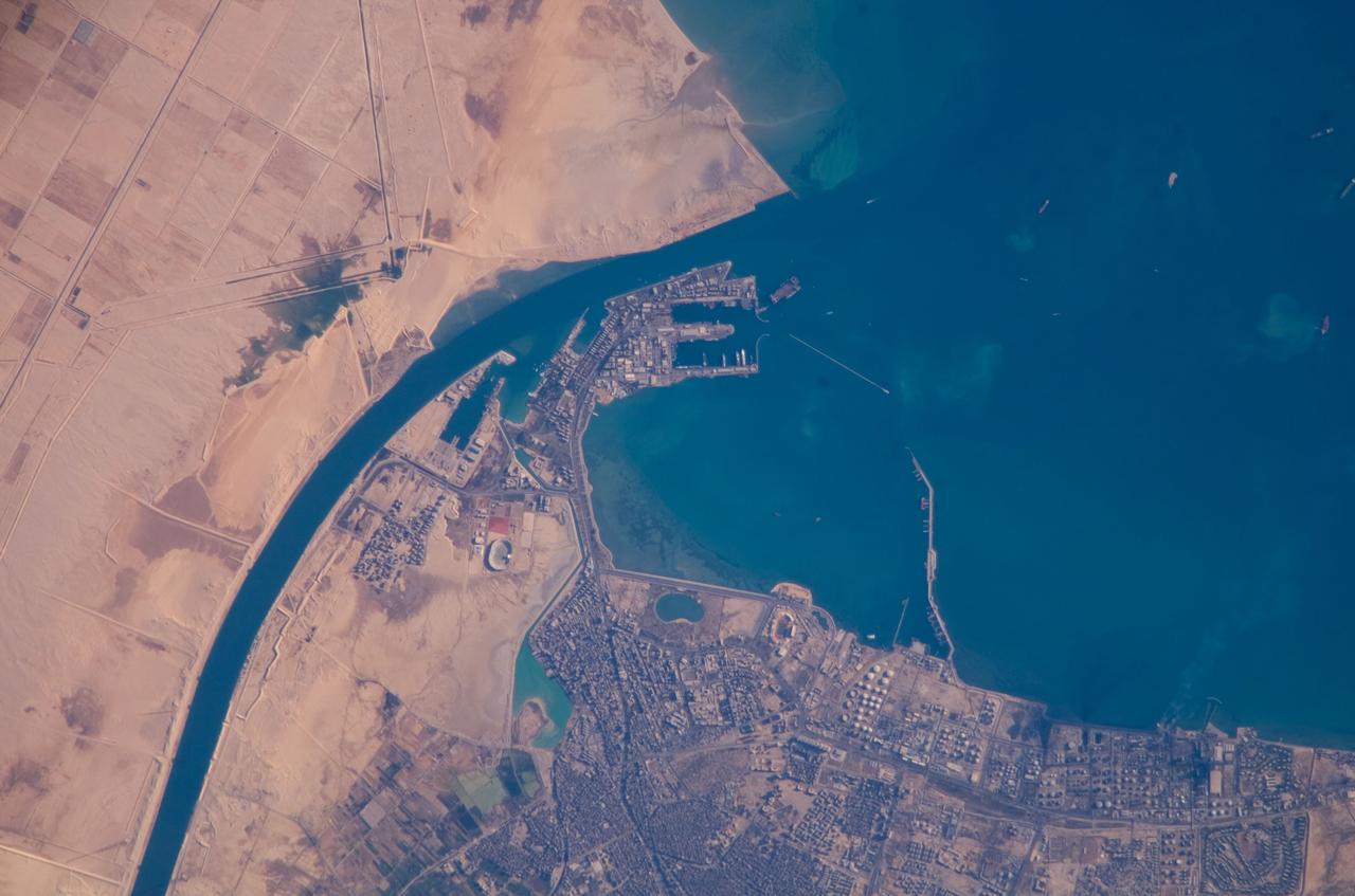
ISS016-E-019375 (30 Dec. 2007) --- Port of Suez, Egypt is featured in this image photographed by an Expedition 16 crewmember on the International Space Station. The Port of Suez is located in Egypt along the northern coastline of the Gulf of Suez. The port and city are the southern terminus of the Suez Canal that transits through Egypt and debouches into the Mediterranean Sea near Port Said. The port serves vessels transporting general cargo, oil tankers, and both commercial and private passenger vessels. The port is also an important waypoint for Muslim pilgrims traveling to and from Mecca in Saudi Arabia. Several large vessels are visible in the Gulf of Suez and berthed at various docks around the port. An extensive petroleum refinery complex forms the southern coastal boundary of the Port of Suez. At the time this image was acquired, gaseous byproducts of petroleum processing were being burned off -- as indicated by a smoke plume extending southwards into the Gulf of Suez (lower right). This view also captures several regions of greenish blue coloration in the Gulf. These are most probably sediments stirred up by passage of ships traveling to and from the Port. Similarly-colored regions along the coastline are bottom sediments visible through the shallow water column.
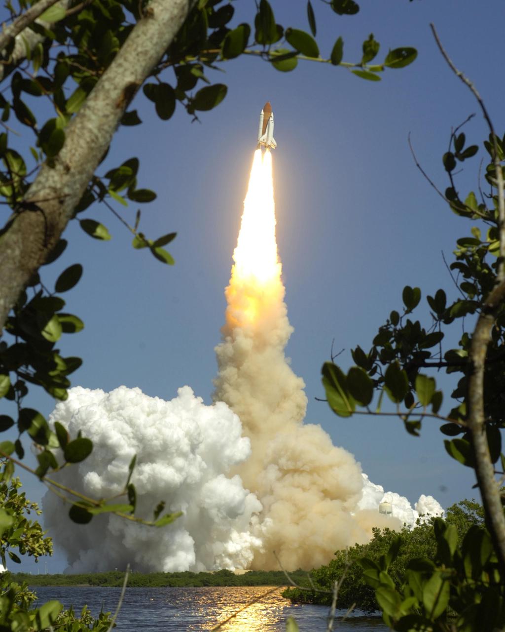
STS117-S-013 (8 June 2007) --- The drifting smoke plumes from the launch of Space Shuttle Atlantis (out of frame) swirl above the Vehicle Assembly Building near sunset. Atlantis and its seven-member STS-117 crew head toward Earth-orbit and a scheduled link-up with the International Space Station. Liftoff from Kennedy Space Center's launch pad 39A occurred at 7:38 p.m. (EDT) on June 8, 2007. Onboard are astronauts Rick Sturckow, commander; Lee Archambault, pilot; Jim Reilly, Patrick Forrester, John "Danny" Olivas, Steven Swanson and Clayton Anderson, all mission specialists. Anderson will join Expedition 15 in progress to serve as a flight engineer aboard the station. Atlantis will dock with the orbital outpost on Sunday, June 10, to begin a joint mission that will increase the complex's power generation capability. Using the shuttle and station robotic arms and conducting three scheduled spacewalks, the astronauts will install another set of giant solar array wings on the station and retract another array, preparing it for a future move.
ISS040-E-088891 (5 Aug. 2014) --- Thunderheads near Borneo, Indonesia are featured in this image photographed by an Expedition 40 crew member on the International Space Station. Late afternoon sun casts long shadows from high thunderhead anvils over southern Borneo. Crews aboard the space station have recently concentrated on panoramic views of clouds?taken with lenses similar to the focal length of the human eye. These images reveal the kinds of views crews see -- huge areas of the planet, with a strong three-dimensional sense of what it is like to fly 350 kilometers above Earth. Winds usually blow in different directions at different altitudes. High-altitude winds are clearly sweeping the tops off the many tallest thunderclouds, generating long anvils of diffuse cirrus plumes that trail south. At low levels, ?streets? of white dots -- fair-weather cumulus clouds -- are aligned with west-moving winds (lower left). Small smoke plumes from forest fires onshore are also aligned west. Storm formation near the horizon -- more than 1,000 kilometers away (center) -- is assisted by air currents rising over the central mountains of Borneo.
KENNEDY SPACE CENTER, FLA. - Space Shuttle Atlantis leaps off the launch pad as smoke and steam billow behind it. Atlantis is heading for space and its rendezvous with the International Space Station on mission STS-115. Liftoff was on-time at 11:14:55 a.m. EDT. After several earlier launch attempts were scrubbed due to weather and technical concerns, this launch was executed perfectly. Mission STS-115 is the 116th space shuttle flight, the 27th flight for orbiter Atlantis, and the 19th U.S. flight to the International Space Station. During the mission, Atlantis' astronauts will deliver and install the 17.5-ton, bus-sized P3/P4 integrated truss segment on the station. The girder-like truss includes a set of giant solar arrays, batteries and associated electronics and will provide one-fourth of the total power-generation capability for the completed station. STS-115 is scheduled to last 11 days with a planned landing at KSC. Photo courtesy of Nikon/Scott Andrews
STS117-S-029 (8 June 2007) --- The drifting smoke plumes from the launch of Space Shuttle Atlantis (out of frame) swirl above the Vehicle Assembly Building near sunset. Atlantis and its seven-member STS-117 crew head toward Earth-orbit and a scheduled link-up with the International Space Station. Liftoff from Kennedy Space Center's launch pad 39A occurred at 7:38 p.m. (EDT) on June 8, 2007. Onboard are astronauts Rick Sturckow, commander; Lee Archambault, pilot; Jim Reilly, Patrick Forrester, John "Danny" Olivas, Steven Swanson and Clayton Anderson, all mission specialists. Anderson will join Expedition 15 in progress to serve as a flight engineer aboard the station. Atlantis will dock with the orbital outpost on Sunday, June 10, to begin a joint mission that will increase the complex's power generation capability. Using the shuttle and station robotic arms and conducting three scheduled spacewalks, the astronauts will install another set of giant solar array wings on the station and retract another array, preparing it for a future move.
KENNEDY SPACE CENTER, FLA. - From the top of the Vehicle Assembly Building, the fiery launch of Space Shuttle Atlantis is seen against the background of the Atlantic Ocean to the east while billows of smoke and steam roll across the launch pad. Atlantis is heading for a rendezvous with the International Space Station on mission STS-115. After launch attempts were scrubbed Aug. 27 and 29 and Sept. 3 and 8 due to weather and technical concerns, this launch was executed perfectly. During the STS-115 mission, Atlantis' astronauts will deliver and install the 17.5-ton, bus-sized P3/P4 integrated truss segment on the station. The girder-like truss includes a set of giant solar arrays, batteries and associated electronics and will provide one-fourth of the total power-generation capability for the completed station. This mission is the 116th space shuttle flight, the 27th flight for orbiter Atlantis, and the 19th U.S. flight to the ISS. STS-115 is scheduled to last 11 days with a planned landing at KSC. Photo credit: NASA/George Shelton
KENNEDY SPACE CENTER, FLA. - Twin columns of fire propel Space Shuttle Atlantis into a clear blue sky after liftoff from Launch Pad 39B. At left is the fixed service structure, topped by the lightning mast. Clouds of smoke and steam nearly obscure the pad. Atlantis is heading for a rendezvous with the International Space Station on mission STS-115. Liftoff was on-time at 11:14:55 a.m. EDT. After several launch attempts were scrubbed due to weather and technical concerns, this launch was executed perfectly. Mission STS-115 is the 116th space shuttle flight, the 27th flight for orbiter Atlantis, and the 19th U.S. flight to the International Space Station. During the mission, Atlantis' astronauts will deliver and install the 17.5-ton, bus-sized P3/P4 integrated truss segment on the station. The girder-like truss includes a set of giant solar arrays, batteries and associated electronics and will provide one-fourth of the total power-generation capability for the completed station. STS-115 is scheduled to last 11 days with a planned landing at KSC

KENNEDY SPACE CENTER, FLA. - A fish-eye view curves the fixed service structure toward Space Shuttle Atlantis as it hurtles past, propelled by columns of fire from the solid rocket boosters. Below, the smoke and steam billows across Launch Pad 39B. At the lower left is the White Room that, when extended against Atlantis, gave the mission crew access to the orbiter. Atlantis is heading for a rendezvous with the International Space Station on mission STS-115. Liftoff was on-time at 11:14:55 a.m. EDT. After several launch attempts were scrubbed due to weather and technical concerns, this launch was executed perfectly. Mission STS-115 is the 116th space shuttle flight, the 27th flight for orbiter Atlantis, and the 19th U.S. flight to the International Space Station. During the mission, Atlantis' astronauts will deliver and install the 17.5-ton, bus-sized P3/P4 integrated truss segment on the station. The girder-like truss includes a set of giant solar arrays, batteries and associated electronics and will provide one-fourth of the total power-generation capability for the completed station. STS-115 is scheduled to last 11 days with a planned landing at KSC
KENNEDY SPACE CENTER, FLA. - Space Shuttle Atlantis hurtles toward space, propelled by twin columns of fire from the solid rocket boosters. Clouds of smoke and steam spread side to side across Launch Pad 39B. Atlantis is heading for a rendezvous with the International Space Station on mission STS-115. Liftoff was on-time at 11:14:55 a.m. EDT. After several launch attempts were scrubbed due to weather and technical concerns, this launch was executed perfectly. Mission STS-115 is the 116th space shuttle flight, the 27th flight for orbiter Atlantis, and the 19th U.S. flight to the International Space Station. During the mission, Atlantis' astronauts will deliver and install the 17.5-ton, bus-sized P3/P4 integrated truss segment on the station. The girder-like truss includes a set of giant solar arrays, batteries and associated electronics and will provide one-fourth of the total power-generation capability for the completed station. STS-115 is scheduled to last 11 days with a planned landing at KSC
KENNEDY SPACE CENTER, FLA. - Flaming rockets propel Space Shuttle Atlantis away from the smoke and steam below and into the sky for a rendezvous with the International Space Station on mission STS-115. Liftoff was on-time at 11:14:55 a.m. EDT. After launch attempts were scrubbed Aug. 27 and 29 and Sept. 3 and 8 due to weather and technical concerns, this launch was executed perfectly. Mission STS-115 is the 116th space shuttle flight, the 27th flight for orbiter Atlantis, and the 19th U.S. flight to the International Space Station. During the mission, Atlantis' astronauts will deliver and install the 17.5-ton, bus-sized P3/P4 integrated truss segment on the station. The girder-like truss includes a set of giant solar arrays, batteries and associated electronics and will provide one-fourth of the total power-generation capability for the completed station. STS-115 is scheduled to last 11 days with a planned landing at KSC. Photo credit: NASA/Ken Thornsley
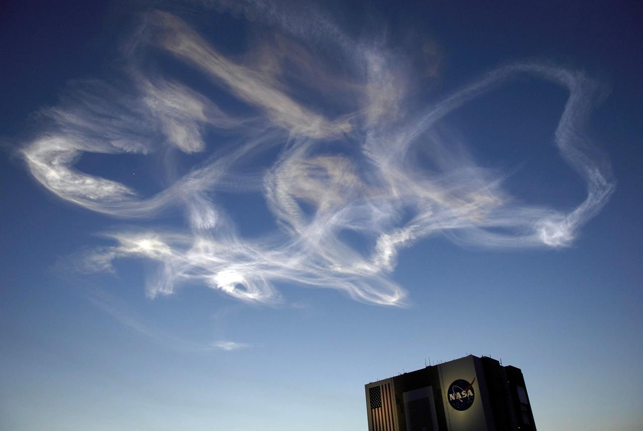
STS117-S-012 (8 June 2007) --- The drifting smoke plumes from the launch of Space Shuttle Atlantis (out of frame) swirl above the Vehicle Assembly Building near sunset. Atlantis and its seven-member STS-117 crew head toward Earth-orbit and a scheduled link-up with the International Space Station. Liftoff from Kennedy Space Center's launch pad 39A occurred at 7:38 p.m. (EDT) on June 8, 2007. Onboard are astronauts Rick Sturckow, commander; Lee Archambault, pilot; Jim Reilly, Patrick Forrester, John "Danny" Olivas, Steven Swanson and Clayton Anderson, all mission specialists. Anderson will join Expedition 15 in progress to serve as a flight engineer aboard the station. Atlantis will dock with the orbital outpost on Sunday, June 10, to begin a joint mission that will increase the complex's power generation capability. Using the shuttle and station robotic arms and conducting three scheduled spacewalks, the astronauts will install another set of giant solar array wings on the station and retract another array, preparing it for a future move.
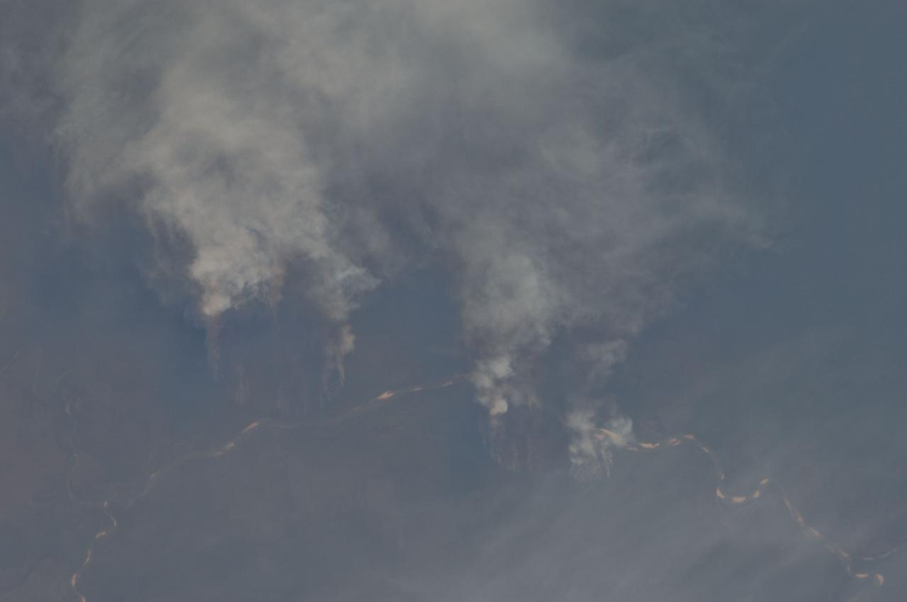
ISS029-E-008032 (17 Sept. 2011) --- Fires along the Rio Xingu, Brazil are featured in this image photographed by an Expedition 29 crew member on the International Space Station. The rain forest of South America, also known as ?Amazonia??the largest such forest on Earth?has been undergoing a continual and accelerated land use conversion process into farmlands (including pasture for livestock) since the early 1960s. This process has typically been achieved by clearing of the forest using fire ? ?slash and burn? ? followed by planting of crops. The generally infertile soils of the region make sustainable farming difficult; this drives more forest conversion into new farmland. The area of clearing can be considerable, and as the deforested regions are easily identifiable and measurable from space the rate of deforestation is likewise easy to track. This detailed photograph illustrates slash-and-burn forest clearing along the Xingu River (Rio) in the northeast of the state of Matto Grasso, Brazil. The perspective of this image allows for a striking visualization of both the horizontal position and extent of the fire lines next to the river, as well as providing a sense of the vertical structure of the smoke plumes due to the viewing angle and shadowing. Light colored areas within the river channel are sand bars, which show that the river is in its annual low-flow/ low water stage. For a sense of scale, the Xingu River channel within the view is approximately 63 kilometers long. Rivers in Amazonia are its natural highways, which may explain why the burning is occurring right next to the Xingu River, one of Amazonia?s largest. In recent years, preservation has gained traction in the region as a result of such considerations as new valuation of the ecosystem services provided by the forest, concerns about the impact of widespread burning on global climate change, and greater sensitivity to the ethnic and biological heritage of Amazonia.
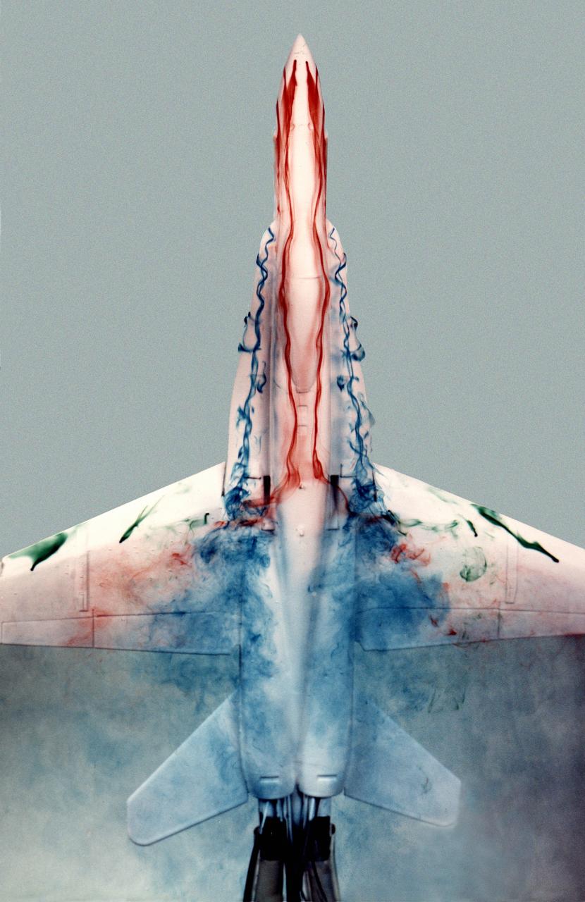
This image shows a plastic 1/48-scale model of an F-18 aircraft inside the "Water Tunnel" more formally known as the NASA Dryden Flow Visualization Facility. Water is pumped through the tunnel in the direction of normal airflow over the aircraft; then, colored dyes are pumped through tubes with needle valves. The dyes flow back along the airframe and over the airfoils highlighting their aerodynamic characteristics. The aircraft can also be moved through its pitch axis to observe airflow disruptions while simulating actual flight at high angles of attack. The Water Tunnel at NASA's Dryden Flight Research Center, Edwards, CA, became operational in 1983 when Dryden was a Flight Research Facility under the management of the Ames Research Center in Mountain View, CA. As a medium for visualizing fluid flow, water has played a significant role. Its use dates back to Leonardo da Vinci (1452-1519), the Renaissance Italian engineer, architect, painter, and sculptor. In more recent times, water tunnels have assisted the study of complex flows and flow-field interactions on aircraft shapes that generate strong vortex flows. Flow visualization in water tunnels assists in determining the strength of vortices, their location, and possible methods of controlling them. The design of the Dryden Water Tunnel imitated that of the Northrop Corporation's tunnel in Hawthorne, CA. Called the Flow Visualization Facility, the Dryden tunnel was built to assist researchers in understanding the aerodynamics of aircraft configured in such a way that they create strong vortex flows, particularly at high angles of attack. The tunnel provides results that compare well with data from aircraft in actual flight in another fluid-air. Other uses of the tunnel have included study of how such flight hardware as antennas, probes, pylons, parachutes, and experimental fixtures affect airflow. The facility has also been helpful in finding the best locations for emitting smoke from flight vehicles for flow vi

NASA image release July 3, 2012 Caption: Resembling a Fourth of July skyrocket, Herbig-Haro 110 is a geyser of hot gas from a newborn star that splashes up against and ricochets off the dense core of a cloud of molecular hydrogen. Although the plumes of gas look like whiffs of smoke, they are actually billions of times less dense than the smoke from a July 4 firework. This Hubble Space Telescope photo shows the integrated light from plumes, which are light-years across. -- Herbig-Haro (HH) objects come in a wide array of shapes, but the basic configuration stays the same. Twin jets of heated gas, ejected in opposite directions away from a forming star, stream through interstellar space. Astronomers suspect that these outflows are fueled by gas accreting onto a young star surrounded by a disk of dust and gas. The disk is the "fuel tank," the star is the gravitational engine, and the jets are the exhaust. When these energetic jets slam into colder gas, the collision plays out like a traffic jam on the interstate. Gas within the shock front slows to a crawl, but more gas continues to pile up as the jet keeps slamming into the shock from behind. Temperatures climb sharply, and this curving, flared region starts to glow. These "bow shocks" are so named because they resemble the waves that form at the front of a boat. In the case of the single HH 110 jet, astronomers observe a spectacular and unusual permutation on this basic model. Careful study has repeatedly failed to find the source star driving HH 110, and there may be good reason for this: perhaps the HH 110 outflow is itself generated by another jet. Astronomers now believe that the nearby HH 270 jet grazes an immovable obstacle - a much denser, colder cloud core - and gets diverted off at about a 60-degree angle. The jet goes dark and then reemerges, having reinvented itself as HH 110. The jet shows that these energetic flows are like the erratic outbursts from a Roman candle. As fast-moving blobs of gas catch up and collide with slower blobs, new shocks arise along the jet's interior. The light emitted from excited gas in these hot blue ridges marks the boundaries of these interior collisions. By measuring the current velocity and positions of different blobs and hot ridges along the chain within the jet, astronomers can effectively "rewind" the outflow, extrapolating the blobs back to the moment when they were emitted. This technique can be used to gain insight into the source star's history of mass accretion. This image is a composite of data taken with Hubble's Advanced Camera for Surveys in 2004 and 2005 and the Wide Field Camera 3 in April 2011. Credit: NASA, ESA, and the Hubble Heritage Team (STScI/AURA) <b><a href="http://www.nasa.gov/audience/formedia/features/MP_Photo_Guidelines.html" rel="nofollow">NASA image use policy.</a></b> <b><a href="http://www.nasa.gov/centers/goddard/home/index.html" rel="nofollow">NASA Goddard Space Flight Center</a></b> enables NASA’s mission through four scientific endeavors: Earth Science, Heliophysics, Solar System Exploration, and Astrophysics. Goddard plays a leading role in NASA’s accomplishments by contributing compelling scientific knowledge to advance the Agency’s mission. <b>Follow us on <a href="http://twitter.com/NASA_GoddardPix" rel="nofollow">Twitter</a></b> <b>Like us on <a href="http://www.facebook.com/pages/Greenbelt-MD/NASA-Goddard/395013845897?ref=tsd" rel="nofollow">Facebook</a></b> <b>Find us on <a href="http://instagrid.me/nasagoddard/?vm=grid" rel="nofollow">Instagram</a></b>
On August 29, 2012, the Visible Infrared Imaging Radiometer Suite (VIIRS) on the Suomi NPP satellite captured this nighttime view of wildfires burning in Idaho and Montana. The image was captured by the VIIRS “day-night band,” which detects light in a range of wavelengths from green to near-infrared and uses filtering techniques to observe signals such as gas flares, auroras, wildfires, city lights, and reflected moonlight. When the image was acquired, the moon was in its waxing gibbous phase, meaning it was more than half-lit, but less than full. Numerous hot spots from the Mustang Complex Fire are visible in northern Idaho. A plume of thick, billowing smoke streams west from the brightest fires near the Idaho-Montana border. The Halstead and Trinity Ridge fires are visible to the south. In addition to the fires, city lights from Boise and other smaller cities appear throughout the image. A bank of clouds is located west of the Mustang Complex, over southeastern Washington and northeastern Oregon. The Operational Line System (OLS)—an earlier generation of night-viewing sensors on the U.S. Defense Meteorological Satellite Program (DMSP) satellites—was also capable of detecting fires at night. But the VIIRS “day-night band” is far better than OLS at resolving them. Each pixel of an VIIRS image shows roughly 740 meters (0.46 miles), compared to the 3-kilometer footprint (1.86 miles) on the OLS system. NASA Earth Observatory image by Jesse Allen and Robert Simmon, using VIIRS Day-Night Band data from the Suomi National Polar-orbiting Partnership. Suomi NPP is the result of a partnership between NASA, the National Oceanic and Atmospheric Administration, and the Department of Defense. Caption by Adam Voiland. Instrument: Suomi NPP - VIIRS Credit: <b><a href="http://www.earthobservatory.nasa.gov/" rel="nofollow"> NASA Earth Observatory</a></b> <b>Click here to view all of the <a href="http://earthobservatory.nasa.gov/Features/NightLights/" rel="nofollow"> Earth at Night 2012 images </a></b> <b>Click here to <a href="http://earthobservatory.nasa.gov/NaturalHazards/view.php?id=79754" rel="nofollow"> read more </a> about this image </b> <b><a href="http://www.nasa.gov/audience/formedia/features/MP_Photo_Guidelines.html" rel="nofollow">NASA image use policy.</a></b> <b><a href="http://www.nasa.gov/centers/goddard/home/index.html" rel="nofollow">NASA Goddard Space Flight Center</a></b> enables NASA’s mission through four scientific endeavors: Earth Science, Heliophysics, Solar System Exploration, and Astrophysics. Goddard plays a leading role in NASA’s accomplishments by contributing compelling scientific knowledge to advance the Agency’s mission. <b>Follow us on <a href="http://twitter.com/NASA_GoddardPix" rel="nofollow">Twitter</a></b> <b>Like us on <a href="http://www.facebook.com/pages/Greenbelt-MD/NASA-Goddard/395013845897?ref=tsd" rel="nofollow">Facebook</a></b> <b>Find us on <a href="http://instagram.com/nasagoddard?vm=grid" rel="nofollow">Instagram</a></b>
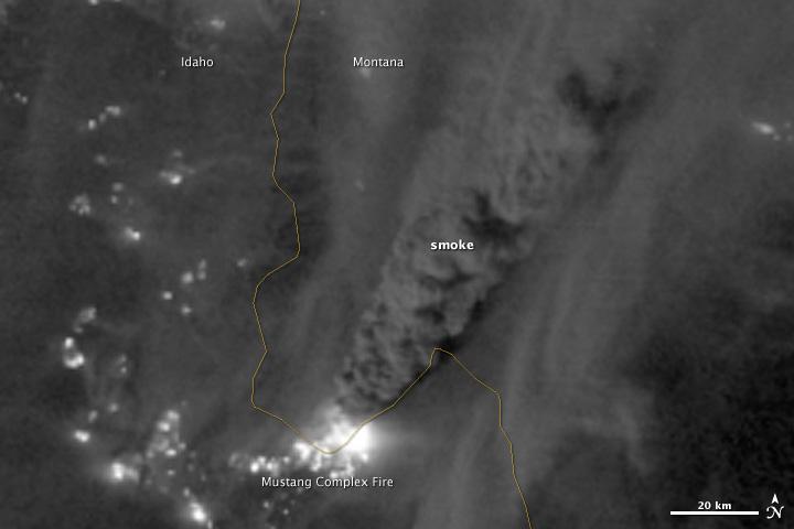
On August 29, 2012, the Visible Infrared Imaging Radiometer Suite (VIIRS) on the Suomi NPP satellite captured this nighttime view of wildfires burning in Idaho and Montana. The image was captured by the VIIRS “day-night band,” which detects light in a range of wavelengths from green to near-infrared and uses filtering techniques to observe signals such as gas flares, auroras, wildfires, city lights, and reflected moonlight. When the image was acquired, the moon was in its waxing gibbous phase, meaning it was more than half-lit, but less than full. Numerous hot spots from the Mustang Complex Fire are visible in northern Idaho. A plume of thick, billowing smoke streams west from the brightest fires near the Idaho-Montana border. The Halstead and Trinity Ridge fires are visible to the south. In addition to the fires, city lights from Boise and other smaller cities appear throughout the image. A bank of clouds is located west of the Mustang Complex, over southeastern Washington and northeastern Oregon. The Operational Line System (OLS)—an earlier generation of night-viewing sensors on the U.S. Defense Meteorological Satellite Program (DMSP) satellites—was also capable of detecting fires at night. But the VIIRS “day-night band” is far better than OLS at resolving them. Each pixel of an VIIRS image shows roughly 740 meters (0.46 miles), compared to the 3-kilometer footprint (1.86 miles) on the OLS system. NASA Earth Observatory image by Jesse Allen and Robert Simmon, using VIIRS Day-Night Band data from the Suomi National Polar-orbiting Partnership. Suomi NPP is the result of a partnership between NASA, the National Oceanic and Atmospheric Administration, and the Department of Defense. Caption by Adam Voiland. Instrument: Suomi NPP - VIIRS Credit: <b><a href="http://www.earthobservatory.nasa.gov/" rel="nofollow"> NASA Earth Observatory</a></b> <b>Click here to view all of the <a href="http://earthobservatory.nasa.gov/Features/NightLights/" rel="nofollow"> Earth at Night 2012 images </a></b> <b>Click here to <a href="http://earthobservatory.nasa.gov/NaturalHazards/view.php?id=79754" rel="nofollow"> read more </a> about this image </b> <b><a href="http://www.nasa.gov/audience/formedia/features/MP_Photo_Guidelines.html" rel="nofollow">NASA image use policy.</a></b> <b><a href="http://www.nasa.gov/centers/goddard/home/index.html" rel="nofollow">NASA Goddard Space Flight Center</a></b> enables NASA’s mission through four scientific endeavors: Earth Science, Heliophysics, Solar System Exploration, and Astrophysics. Goddard plays a leading role in NASA’s accomplishments by contributing compelling scientific knowledge to advance the Agency’s mission. <b>Follow us on <a href="http://twitter.com/NASA_GoddardPix" rel="nofollow">Twitter</a></b> <b>Like us on <a href="http://www.facebook.com/pages/Greenbelt-MD/NASA-Goddard/395013845897?ref=tsd" rel="nofollow">Facebook</a></b> <b>Find us on <a href="http://instagram.com/nasagoddard?vm=grid" rel="nofollow">Instagram</a></b>
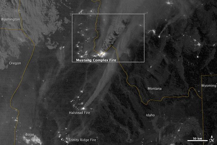
On August 29, 2012, the Visible Infrared Imaging Radiometer Suite (VIIRS) on the Suomi NPP satellite captured this nighttime view of wildfires burning in Idaho and Montana. The image was captured by the VIIRS “day-night band,” which detects light in a range of wavelengths from green to near-infrared and uses filtering techniques to observe signals such as gas flares, auroras, wildfires, city lights, and reflected moonlight. When the image was acquired, the moon was in its waxing gibbous phase, meaning it was more than half-lit, but less than full. Numerous hot spots from the Mustang Complex Fire are visible in northern Idaho. A plume of thick, billowing smoke streams west from the brightest fires near the Idaho-Montana border. The Halstead and Trinity Ridge fires are visible to the south. In addition to the fires, city lights from Boise and other smaller cities appear throughout the image. A bank of clouds is located west of the Mustang Complex, over southeastern Washington and northeastern Oregon. The Operational Line System (OLS)—an earlier generation of night-viewing sensors on the U.S. Defense Meteorological Satellite Program (DMSP) satellites—was also capable of detecting fires at night. But the VIIRS “day-night band” is far better than OLS at resolving them. Each pixel of an VIIRS image shows roughly 740 meters (0.46 miles), compared to the 3-kilometer footprint (1.86 miles) on the OLS system. NASA Earth Observatory image by Jesse Allen and Robert Simmon, using VIIRS Day-Night Band data from the Suomi National Polar-orbiting Partnership. Suomi NPP is the result of a partnership between NASA, the National Oceanic and Atmospheric Administration, and the Department of Defense. Caption by Adam Voiland. Instrument: Suomi NPP - VIIRS Credit: <b><a href="http://www.earthobservatory.nasa.gov/" rel="nofollow"> NASA Earth Observatory</a></b> <b>Click here to view all of the <a href="http://earthobservatory.nasa.gov/Features/NightLights/" rel="nofollow"> Earth at Night 2012 images </a></b> <b>Click here to <a href="http://earthobservatory.nasa.gov/NaturalHazards/view.php?id=79754" rel="nofollow"> read more </a> about this image </b> <b><a href="http://www.nasa.gov/audience/formedia/features/MP_Photo_Guidelines.html" rel="nofollow">NASA image use policy.</a></b> <b><a href="http://www.nasa.gov/centers/goddard/home/index.html" rel="nofollow">NASA Goddard Space Flight Center</a></b> enables NASA’s mission through four scientific endeavors: Earth Science, Heliophysics, Solar System Exploration, and Astrophysics. Goddard plays a leading role in NASA’s accomplishments by contributing compelling scientific knowledge to advance the Agency’s mission. <b>Follow us on <a href="http://twitter.com/NASA_GoddardPix" rel="nofollow">Twitter</a></b> <b>Like us on <a href="http://www.facebook.com/pages/Greenbelt-MD/NASA-Goddard/395013845897?ref=tsd" rel="nofollow">Facebook</a></b> <b>Find us on <a href="http://instagram.com/nasagoddard?vm=grid" rel="nofollow">Instagram</a></b>