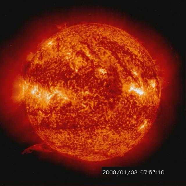
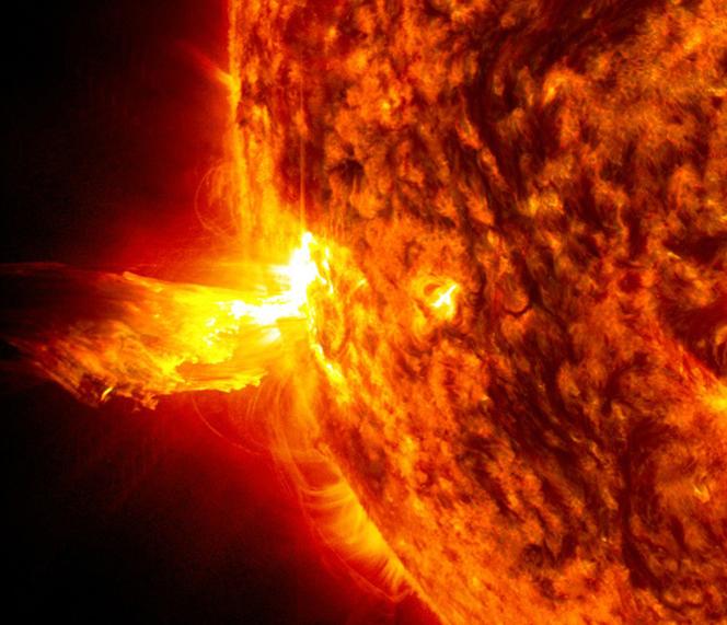
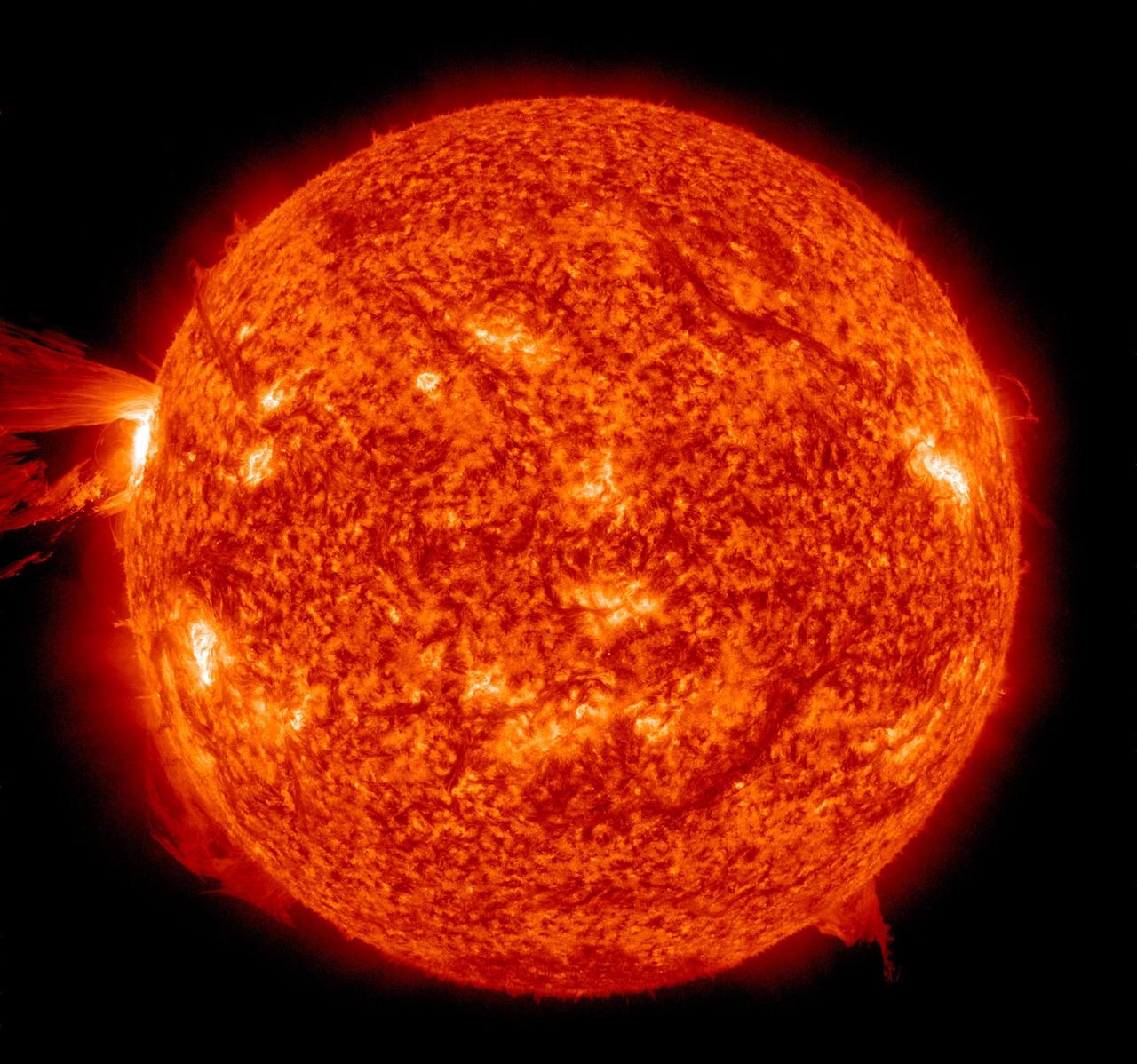
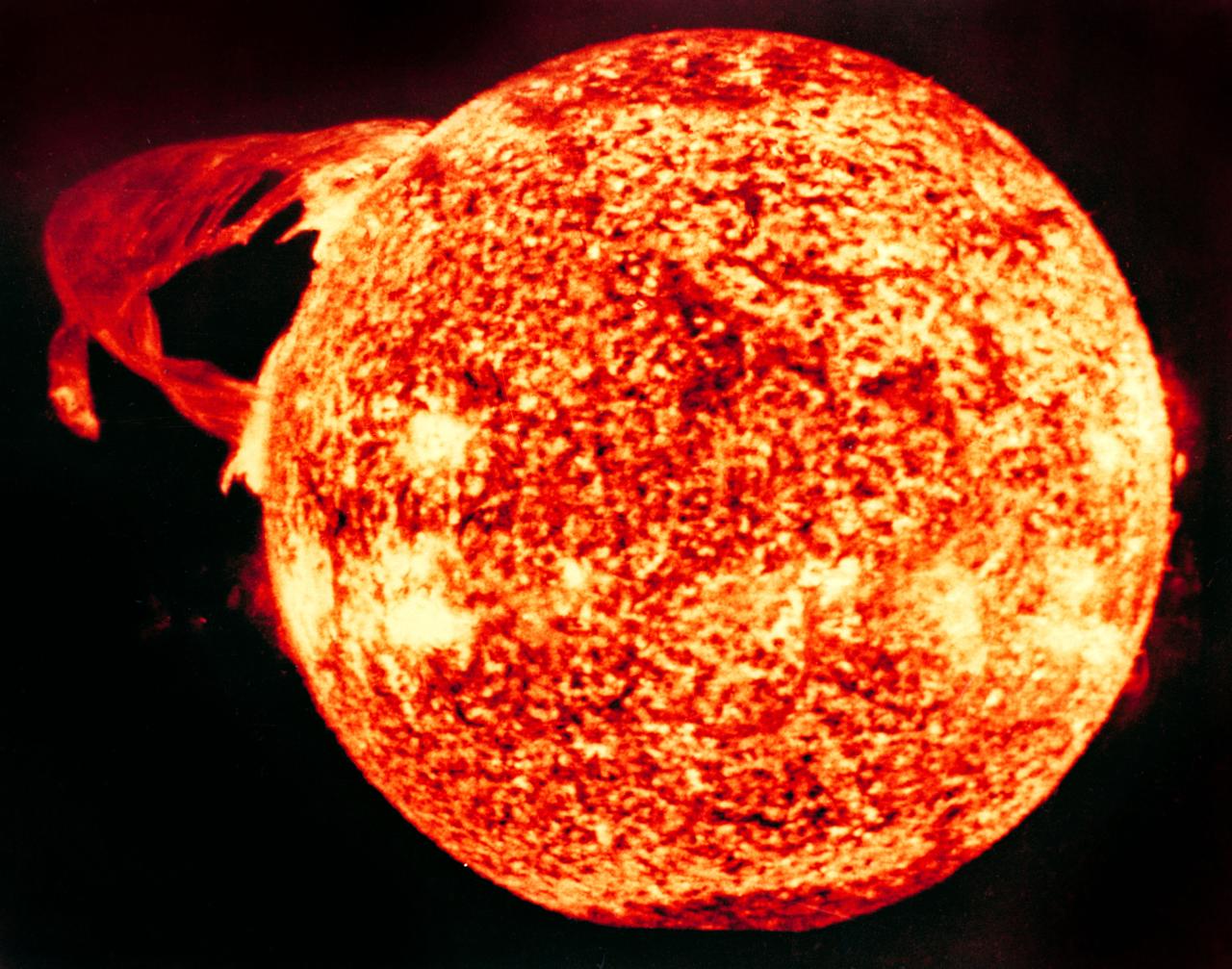
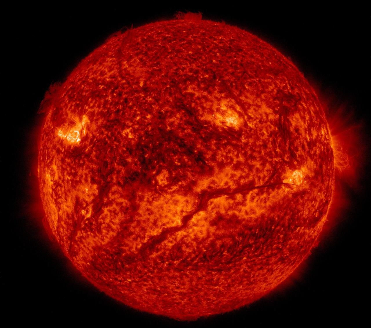
Solar activity and erupting prominences. EIT 304A (Jan. 8-10, 2000) Credit: NASA/GSFC/SOHO/ESA To learn more go to the SOHO website: <a href="http://sohowww.nascom.nasa.gov/home.html" rel="nofollow">sohowww.nascom.nasa.gov/home.html</a> To learn more about NASA's Sun Earth Day go here: <a href="http://sunearthday.nasa.gov/2010/index.php" rel="nofollow">sunearthday.nasa.gov/2010/index.php</a>
A minor solar eruption triggered a crackling, white flash that sent an expanding wave of plasma below it over about six hours (Nov. 4, 2016). Some of the plasma also appeared to surge along a narrow path above the active region as well. Such occurrences are fairly common, but still interesting to watch up close. The images were taken in a wavelength of extreme ultraviolet light. Movies are available at http://photojournal.jpl.nasa.gov/catalog/PIA21202
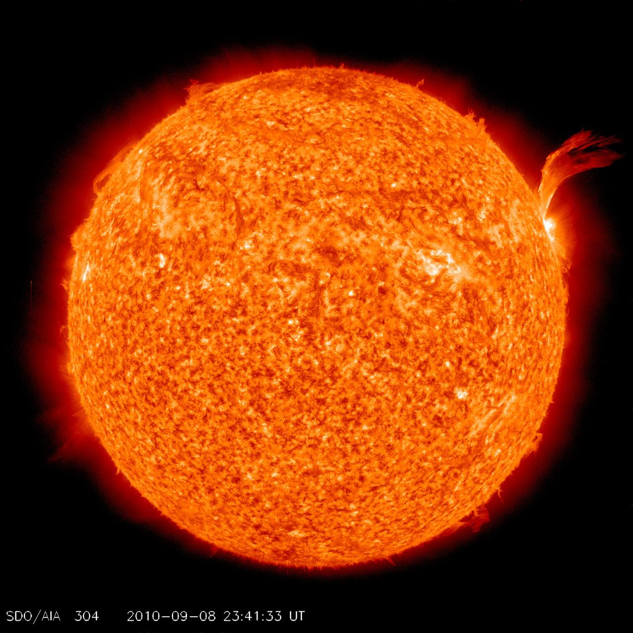
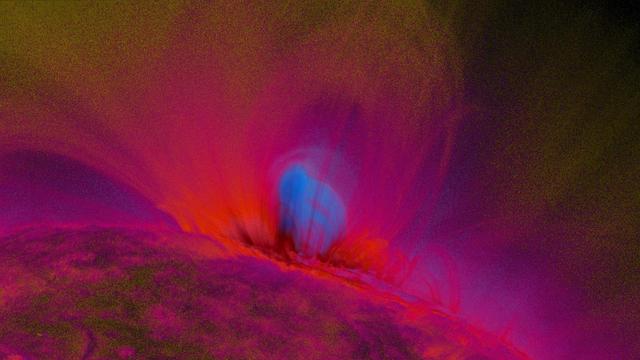
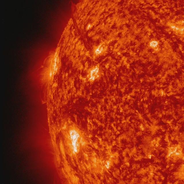
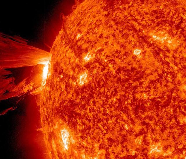
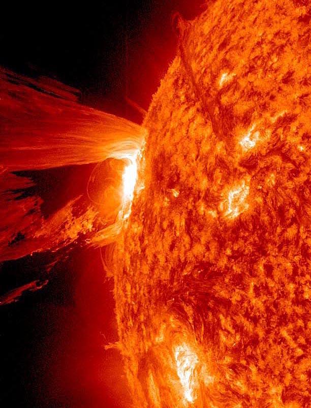
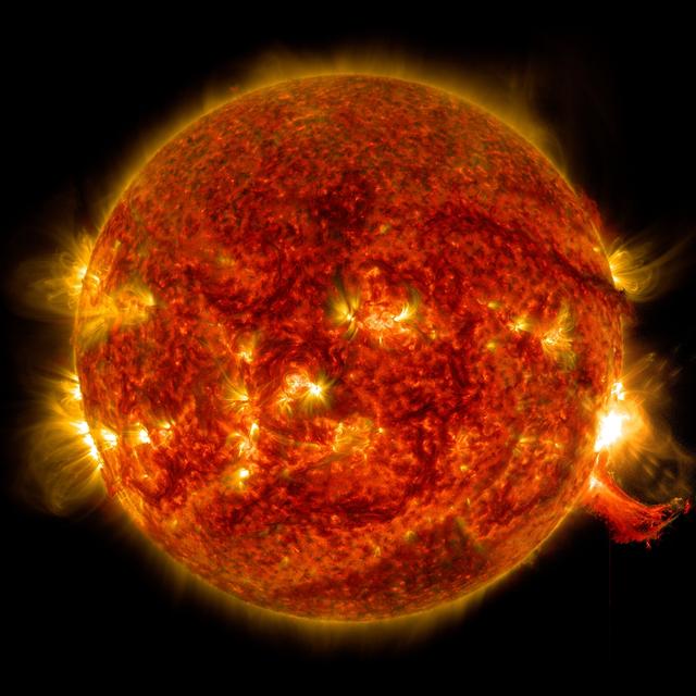
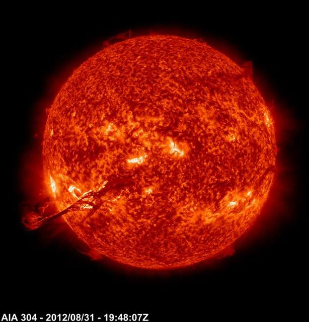
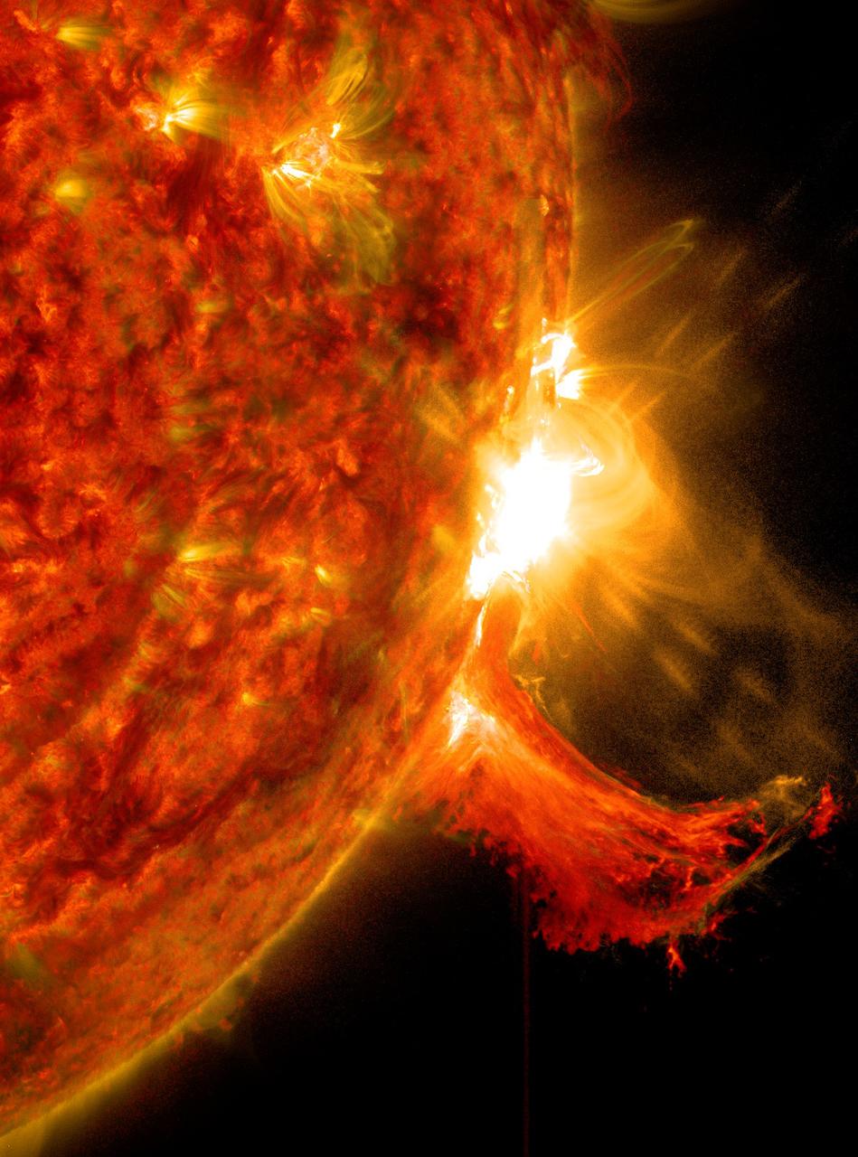
NASA image release Sept 9, 2010 Just as sunspot 1105 was turning away from Earth on Sept. 8, the active region erupted, producing a solar flare and a fantastic prominence. The eruption also hurled a bright coronal mass ejection into space. The eruption was not directed toward any planets. To see a detail go here: <a href="http://www.flickr.com/photos/gsfc/4974263471/">www.flickr.com/photos/gsfc/4974263471/</a> View the video here: <a href="http://www.flickr.com/photos/gsfc/4974878090">www.flickr.com/photos/gsfc/4974878090</a> This is a snapshot of the prominence. Credit: NASA/SDO <b><a href="http://www.nasa.gov/centers/goddard/home/index.html" rel="nofollow">NASA Goddard Space Flight Center</a></b> is home to the nation's largest organization of combined scientists, engineers and technologists that build spacecraft, instruments and new technology to study the Earth, the sun, our solar system, and the universe. <b>Follow us on <a href="http://twitter.com/NASA_GoddardPix" rel="nofollow">Twitter</a></b> <b>Join us on <a href="http://www.facebook.com/pages/Greenbelt-MD/NASA-Goddard/395013845897?ref=tsd" rel="nofollow">Facebook</a></b>
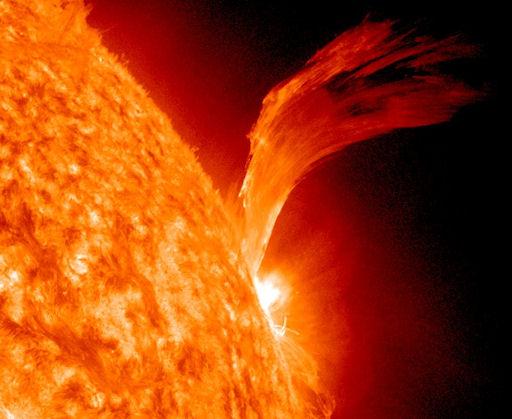
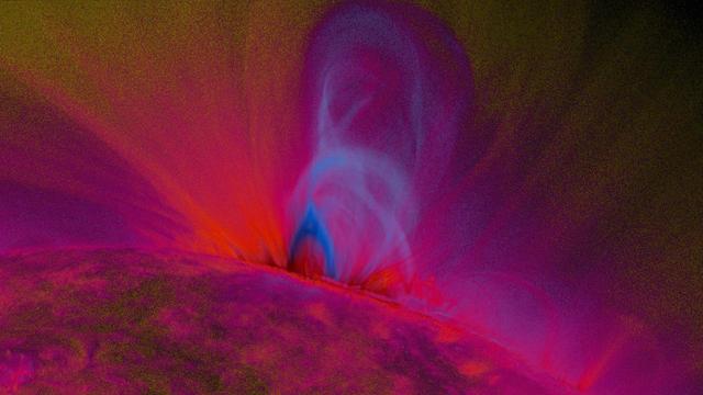
NASA image release Sept 9, 2010 Just as sunspot 1105 was turning away from Earth on Sept. 8, the active region erupted, producing a solar flare and a fantastic prominence. The eruption also hurled a bright coronal mass ejection into space. The eruption was not directed toward any planets. View the video here: <a href="http://www.flickr.com/photos/gsfc/4974878090">www.flickr.com/photos/gsfc/4974878090</a> To see a full disk view go here: <a href="http://www.flickr.com/photos/gsfc/4975115754/">www.flickr.com/photos/gsfc/4975115754/</a> This is a snapshot of the prominence. Credit: NASA/SDO <b><a href="http://www.nasa.gov/centers/goddard/home/index.html" rel="nofollow">NASA Goddard Space Flight Center</a></b> is home to the nation's largest organization of combined scientists, engineers and technologists that build spacecraft, instruments and new technology to study the Earth, the sun, our solar system, and the universe. <b>Follow us on <a href="http://twitter.com/NASA_GoddardPix" rel="nofollow">Twitter</a></b> <b>Join us on <a href="http://www.facebook.com/pages/Greenbelt-MD/NASA-Goddard/395013845897?ref=tsd" rel="nofollow">Facebook</a></b>
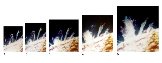
Breaking the grip of the closed magnetic loops that constrain other gases around it, a spray of chromospheric material surges upward, free of the Sun. Views 1 through 5 were recorded about 5 minutes apart by Skylab and comprise a composite of separate images made in chromospheric (red), transition region (green), and coronal (blue) temperatures of an ultraviolet sequence that depicts a solar eruption. Eruption begins (view 2) as material in or near a small, compact loop develops enough energy to overcome the Sun's magnetic bonds.
Watch a video from this event here: <a href="https://www.flickr.com/photos/gsfc/14118958800/">www.flickr.com/photos/gsfc/14118958800/</a> A coronal mass ejection, or CME, surged off the side of the sun on May 9, 2014, and NASA's newest solar observatory caught it in extraordinary detail. This was the first CME observed by the Interface Region Imaging Spectrograph, or IRIS, which launched in June 2013 to peer into the lowest levels of the sun's atmosphere with better resolution than ever before. Watch the movie to see how a curtain of solar material erupts outward at speeds of 1.5 million miles per hour. Read more: <a href="http://1.usa.gov/1kp7O4F" rel="nofollow">1.usa.gov/1kp7O4F</a> <b><a href="http://www.nasa.gov/audience/formedia/features/MP_Photo_Guidelines.html" rel="nofollow">NASA image use policy.</a></b> <b><a href="http://www.nasa.gov/centers/goddard/home/index.html" rel="nofollow">NASA Goddard Space Flight Center</a></b> enables NASA’s mission through four scientific endeavors: Earth Science, Heliophysics, Solar System Exploration, and Astrophysics. Goddard plays a leading role in NASA’s accomplishments by contributing compelling scientific knowledge to advance the Agency’s mission. <b>Follow us on <a href="http://twitter.com/NASAGoddardPix" rel="nofollow">Twitter</a></b> <b>Like us on <a href="http://www.facebook.com/pages/Greenbelt-MD/NASA-Goddard/395013845897?ref=tsd" rel="nofollow">Facebook</a></b> <b>Find us on <a href="http://instagram.com/nasagoddard?vm=grid" rel="nofollow">Instagram</a></b>

Watch a video from this event here: <a href="https://www.flickr.com/photos/gsfc/14118958800/">www.flickr.com/photos/gsfc/14118958800/</a> A coronal mass ejection, or CME, surged off the side of the sun on May 9, 2014, and NASA's newest solar observatory caught it in extraordinary detail. This was the first CME observed by the Interface Region Imaging Spectrograph, or IRIS, which launched in June 2013 to peer into the lowest levels of the sun's atmosphere with better resolution than ever before. Watch the movie to see how a curtain of solar material erupts outward at speeds of 1.5 million miles per hour. Read more: <a href="http://1.usa.gov/1kp7O4F" rel="nofollow">1.usa.gov/1kp7O4F</a> <b><a href="http://www.nasa.gov/audience/formedia/features/MP_Photo_Guidelines.html" rel="nofollow">NASA image use policy.</a></b> <b><a href="http://www.nasa.gov/centers/goddard/home/index.html" rel="nofollow">NASA Goddard Space Flight Center</a></b> enables NASA’s mission through four scientific endeavors: Earth Science, Heliophysics, Solar System Exploration, and Astrophysics. Goddard plays a leading role in NASA’s accomplishments by contributing compelling scientific knowledge to advance the Agency’s mission. <b>Follow us on <a href="http://twitter.com/NASAGoddardPix" rel="nofollow">Twitter</a></b> <b>Like us on <a href="http://www.facebook.com/pages/Greenbelt-MD/NASA-Goddard/395013845897?ref=tsd" rel="nofollow">Facebook</a></b> <b>Find us on <a href="http://instagram.com/nasagoddard?vm=grid" rel="nofollow">Instagram</a></b>

Watch a video from this event here: <a href="https://www.flickr.com/photos/gsfc/14118958800/">www.flickr.com/photos/gsfc/14118958800/</a> A coronal mass ejection, or CME, surged off the side of the sun on May 9, 2014, and NASA's newest solar observatory caught it in extraordinary detail. This was the first CME observed by the Interface Region Imaging Spectrograph, or IRIS, which launched in June 2013 to peer into the lowest levels of the sun's atmosphere with better resolution than ever before. Watch the movie to see how a curtain of solar material erupts outward at speeds of 1.5 million miles per hour. Read more: <a href="http://1.usa.gov/1kp7O4F" rel="nofollow">1.usa.gov/1kp7O4F</a> <b><a href="http://www.nasa.gov/audience/formedia/features/MP_Photo_Guidelines.html" rel="nofollow">NASA image use policy.</a></b> <b><a href="http://www.nasa.gov/centers/goddard/home/index.html" rel="nofollow">NASA Goddard Space Flight Center</a></b> enables NASA’s mission through four scientific endeavors: Earth Science, Heliophysics, Solar System Exploration, and Astrophysics. Goddard plays a leading role in NASA’s accomplishments by contributing compelling scientific knowledge to advance the Agency’s mission. <b>Follow us on <a href="http://twitter.com/NASAGoddardPix" rel="nofollow">Twitter</a></b> <b>Like us on <a href="http://www.facebook.com/pages/Greenbelt-MD/NASA-Goddard/395013845897?ref=tsd" rel="nofollow">Facebook</a></b> <b>Find us on <a href="http://instagram.com/nasagoddard?vm=grid" rel="nofollow">Instagram</a></b>

Watch a video from this event here: <a href="https://www.flickr.com/photos/gsfc/14118958800/">www.flickr.com/photos/gsfc/14118958800/</a> A coronal mass ejection, or CME, surged off the side of the sun on May 9, 2014, and NASA's newest solar observatory caught it in extraordinary detail. This was the first CME observed by the Interface Region Imaging Spectrograph, or IRIS, which launched in June 2013 to peer into the lowest levels of the sun's atmosphere with better resolution than ever before. Watch the movie to see how a curtain of solar material erupts outward at speeds of 1.5 million miles per hour. Read more: <a href="http://1.usa.gov/1kp7O4F" rel="nofollow">1.usa.gov/1kp7O4F</a> <b><a href="http://www.nasa.gov/audience/formedia/features/MP_Photo_Guidelines.html" rel="nofollow">NASA image use policy.</a></b> <b><a href="http://www.nasa.gov/centers/goddard/home/index.html" rel="nofollow">NASA Goddard Space Flight Center</a></b> enables NASA’s mission through four scientific endeavors: Earth Science, Heliophysics, Solar System Exploration, and Astrophysics. Goddard plays a leading role in NASA’s accomplishments by contributing compelling scientific knowledge to advance the Agency’s mission. <b>Follow us on <a href="http://twitter.com/NASAGoddardPix" rel="nofollow">Twitter</a></b> <b>Like us on <a href="http://www.facebook.com/pages/Greenbelt-MD/NASA-Goddard/395013845897?ref=tsd" rel="nofollow">Facebook</a></b> <b>Find us on <a href="http://instagram.com/nasagoddard?vm=grid" rel="nofollow">Instagram</a></b>

The Sun erupted with an X8 solar flare, one of the largest of the current solar cycle (Sept. 10, 2017). Its source was the same sunspot region that produced an X9 flare last week. This is shown in two wavelengths of extreme ultraviolet light at the same time and each reveals different features. Both are colorized to identify in which wavelength they were observed. The coils of loops after the flare are the magnetic field lines reorganizing themselves after the eruption. The video clip covers about six hours. Movies are available at https://photojournal.jpl.nasa.gov/catalog/PIA21958
NASA's Solar Dynamics Observatory (SDO) zoomed in to watch close-up the dynamics of this single active region on the sun over a two-day period (July 14-16, 2018). The loops SDO observed in extreme ultraviolet light are illuminated by charged particles spinning along the magnetic field lines above an active region. Active regions are magnetically intense areas that are pushed up to the surface of the sun from below. These regions are often the sources of large eruptions that cause solar storms, though no large eruptions seem to have occurred during this period. To give a sense of scale, these loops are rising up many times the diameter of Earth. Movies are available at https://photojournal.jpl.nasa.gov/catalog/PIA22645
Photograph by Skylab 2 Solar eruption (flare)
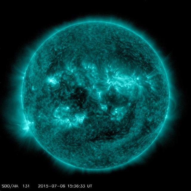
An eruption from the surface of the sun is conspicuous in the lower left portion of this July 6, 2015, image from NASA's Earth-orbiting Solar Dynamics Observatory (SDO). It originates from a location on the surface where NASA's Curiosity Mars rover had been tracking a sunspot in late June and early July. This image was taken by the Atmosphere Imaging Assembly on SDO using the instrument's 131-Angstrom wavelength channel, which is sensitive to hot solar flares. The sun completes a rotation about once a month -- faster near its equator than near its poles. This summer, Mars has a view of the opposite side of the sun from what's facing Earth. Images from Curiosity tracking a southern-hemisphere sunspot until it rotated out of view during the July 4 weekend are in an animation at PIA19801. This location on the sun rotated into position to be seen from Earth a few days later. The eruption visible in this image was linked to a coronal mass ejection observed by SDO and NASA's Solar and Heliospheric Observatory. The coronal mass ejection affected interplanetary space weather, as shown at http://go.nasa.gov/1JSXLF3. http://photojournal.jpl.nasa.gov/catalog/PIA19680

The sun emitted a significant solar flare, peaking at 5:40 p.m. EDT on Oct. 24, 2014. The flare erupted from a particularly large active region -- labeled AR 12192 -- on the sun that is the largest in 24 years. This is the fourth substantial flare from this active region since Oct. 19. Read more: <a href="http://www.nasa.gov/content/goddard/giant-sunspot-erupts-with-4th-substantial-flare" rel="nofollow">www.nasa.gov/content/goddard/giant-sunspot-erupts-with-4t...</a>
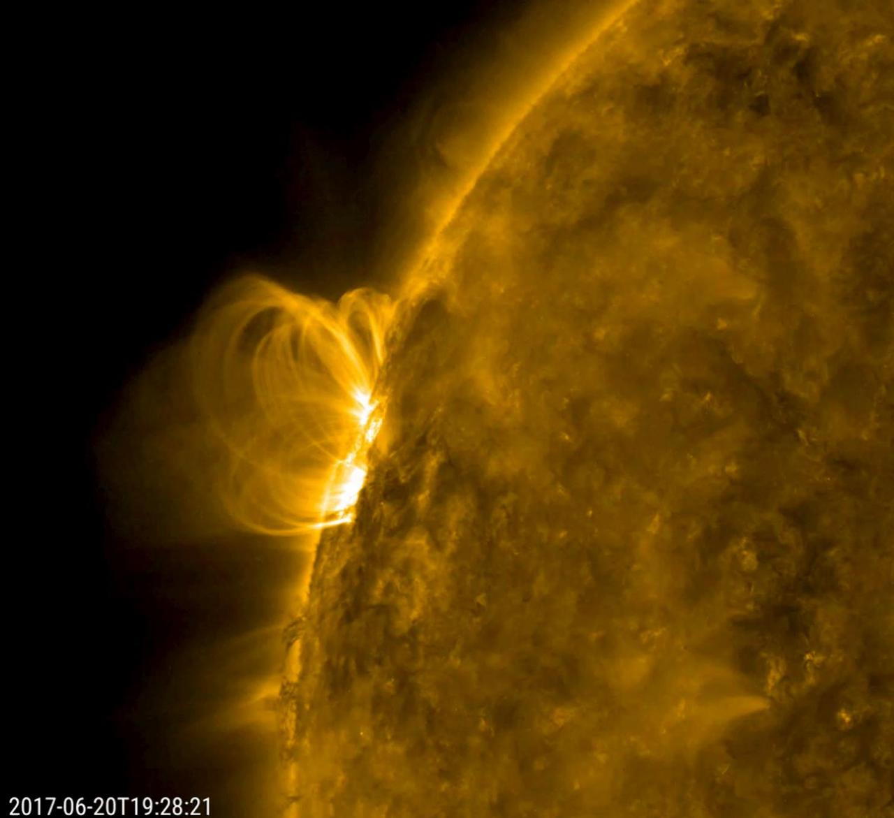
A smallish solar filament looks like it collapsed into the sun and set off a minor eruption that hurled plasma into space (June 20, 2017). Then, the disrupted magnetic field immediately began to reorganize itself, hence the bright series of spirals coiling up over that area. The magnetic field lines are made visible in extreme ultraviolet light as charged particles spin along them. Also of interest are the darker, cooler strands of plasma being pulled and twisted at the edge of the sun just below the active region. The activity here is in a 21-hour period. Movies are available at https://photojournal.jpl.nasa.gov/catalog/PIA21764
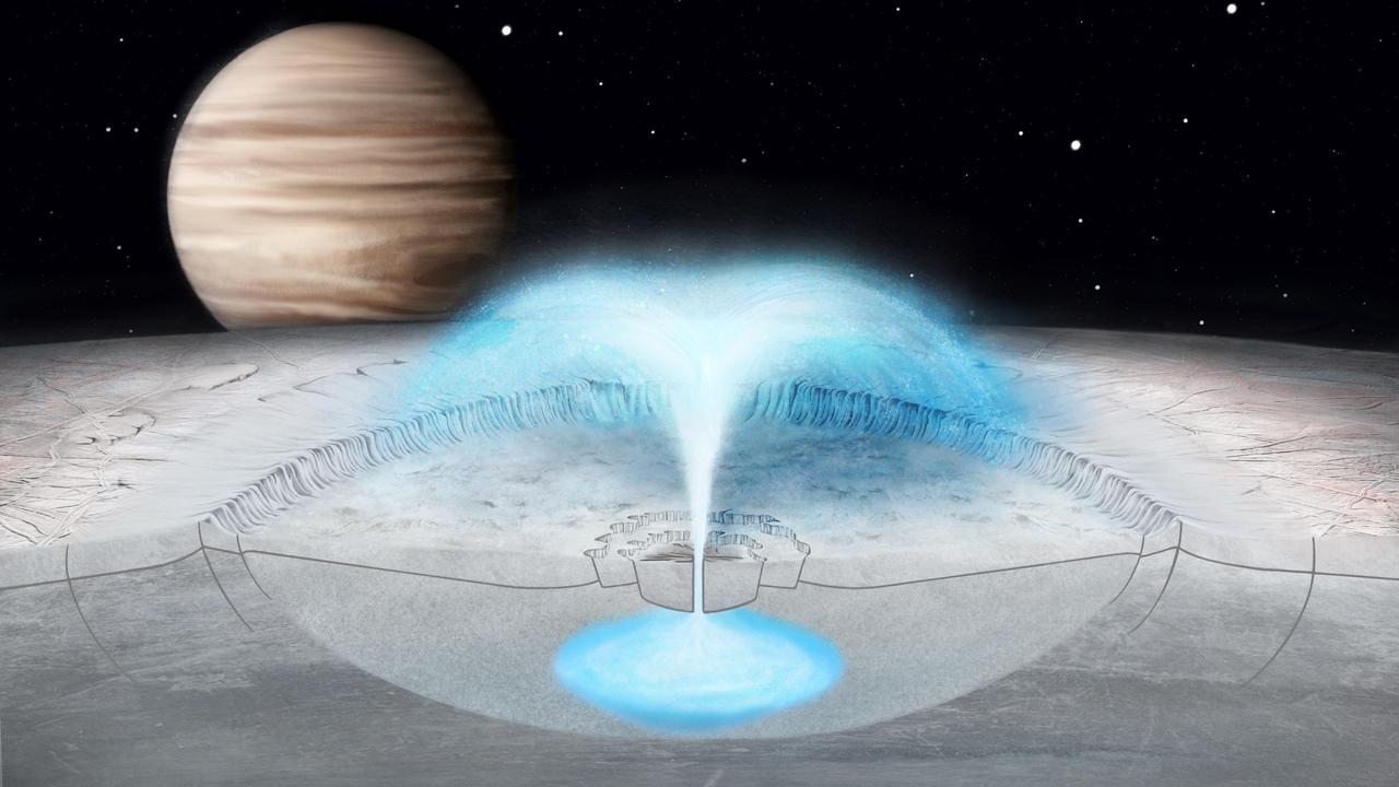
Scientists have theorized on the origin of water plumes that are possibly erupting from Jupiter's moon Europa. This illustration depicts a scenario modeled in new research that proposes some plumes could come from an eruption of brine, or salt-enriched water, from a pocket of water within the moon's crust. If Europa is venting plumes of liquid, they could possibly be observed by NASA's upcoming Europa Clipper mission, set to launch in the mid-2020's. The research on eruptions of briny water from Europa's crust used images collected by NASA's Galileo spacecraft. The model shows how a combination of freezing and pressurization could lead to a cryovolcanic eruption, or a burst of frigid water, like the one illustrated here. The model could also shed light on cryovolcanic eruptions on other icy bodies in the solar system. https://photojournal.jpl.nasa.gov/catalog/PIA24029
S73-33788 (10 June 1973) --- The solar eruption of June 10, 1973, is seen in this spectroheliogram obtained during the first manned Skylab mission (Skylab 2), with the SO82A experiment, an Apollo Telescope Mount (ATM) component covering the wavelength region from 150 to 650 angstroms (EUV). The solid disk in the center was produced from 304 angstrom ultraviolet light from He + ions. At the top of this image a great eruption is visible extending more than one-third of a solar radius from the sun's surface. This eruption preceded the formation of an enormous coronal bubble which extended a distance of several radii from the sun's surface, and which was observed with the coronagraph aboard Skylab. In contrast, the Fe XV image at 285 angstrom just to the right of the 304 angstrom image does not show this event. Instead, it shows the bright emission from a magnetic region in the lower corona. In this picture, solar north is to the right, and east is up. The wavelength scale increases to the left. The U.S. Naval Research Laboratory is principal investigator in charge of the SO82 experiment. Photo credit: NASA

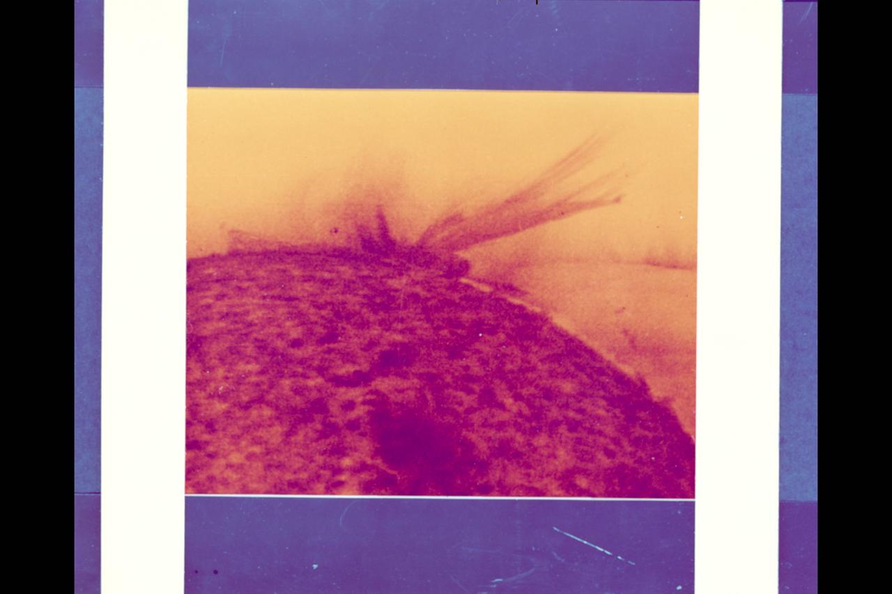
Some of the prominences that float like lazy clouds above the solar surface suddenly erupt and break away from the Sun in cataclysmic action. The trigger of this coronal transient, like many others seen by Skylab's coronagraph, was an eruptive prominence that surged outward from the limb of the Sun, ejecting matter that disturbed the outer corona. This image is of the surge in action in ultraviolet light of ionized helium. Simultaneous observations like this made possible an almost immediate understanding of the new-found cosmic phenomenon. The elbow prominence was accidentally photographed by Astronaut Garriott (Skylab-3) while observing a small flare near the limb of the Sun beneath the mighty arch on August 9, 1973.
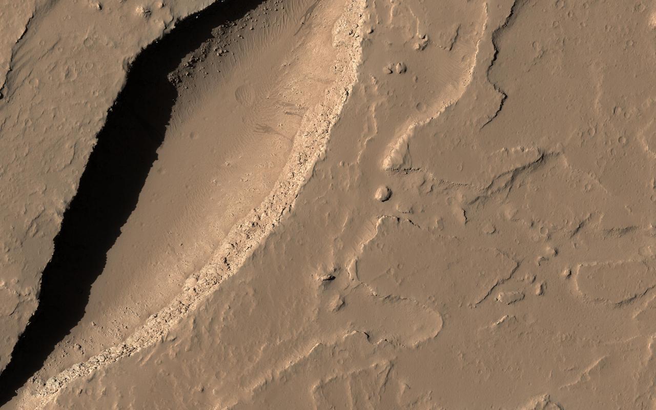
Although Mars is known for having the largest volcano in our solar system, Olympus Mons, we also find small-scale volcanic features on its surface, as shown in this image from HiRISE onboard NASA's Mars Reconnaissance Orbiter (MRO). This fissure, less than 500 meters across at its widest point, lies in the Tharsis region and is believed to be a vent from which lava flowed in ancient eruptions. The total volume of lava released from this fissure is much less than what would erupt from nearby volcanoes, but the mark left on the landscape is dramatic nonetheless. https://photojournal.jpl.nasa.gov/catalog/PIA21601
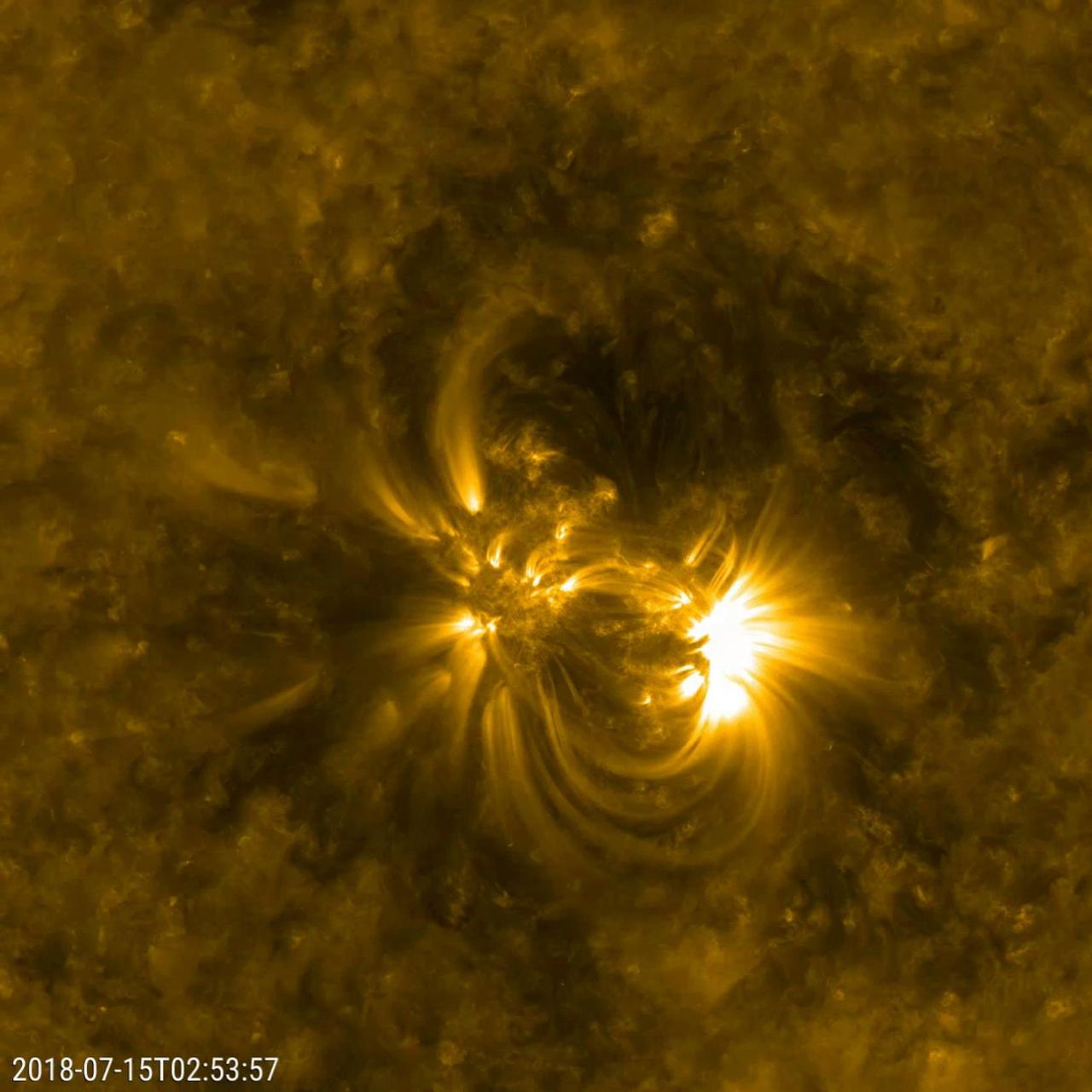
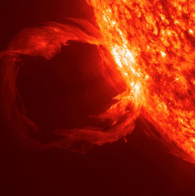
Caption: This is an image of magnetic loops on the sun, captured by NASA's Solar Dynamics Observatory (SDO). It has been processed to highlight the edges of each loop to make the structure more clear. A series of loops such as this is known as a flux rope, and these lie at the heart of eruptions on the sun known as coronal mass ejections (CMEs.) This is the first time scientists were able to discern the timing of a flux rope's formation. (SDO AIA 131 and 171 difference blended image of flux ropes during CME.) Credit: NASA/Goddard Space Flight Center/SDO ---- On July 18, 2012, a fairly small explosion of light burst off the lower right limb of the sun. Such flares often come with an associated eruption of solar material, known as a coronal mass ejection or CME – but this one did not. Something interesting did happen, however. Magnetic field lines in this area of the sun's atmosphere, the corona, began to twist and kink, generating the hottest solar material – a charged gas called plasma – to trace out the newly-formed slinky shape. The plasma glowed brightly in extreme ultraviolet images from the Atmospheric Imaging Assembly (AIA) aboard NASA’s Solar Dynamics Observatory (SDO) and scientists were able to watch for the first time the very formation of something they had long theorized was at the heart of many eruptive events on the sun: a flux rope. Eight hours later, on July 19, the same region flared again. This time the flux rope's connection to the sun was severed, and the magnetic fields escaped into space, dragging billions of tons of solar material along for the ride -- a classic CME. "Seeing this structure was amazing," says Angelos Vourlidas, a solar scientist at the Naval Research Laboratory in Washington, D.C. "It looks exactly like the cartoon sketches theorists have been drawing of flux ropes since the 1970s. It was a series of figure eights lined up to look like a giant slinky on the sun." <b>To read more about this new discovery go to: <a href="http://1.usa.gov/14UHsTt" rel="nofollow">1.usa.gov/14UHsTt</a> </b>
Caption: This is an image of magnetic loops on the sun, captured by NASA's Solar Dynamics Observatory (SDO). It has been processed to highlight the edges of each loop to make the structure more clear. A series of loops such as this is known as a flux rope, and these lie at the heart of eruptions on the sun known as coronal mass ejections (CMEs.) This is the first time scientists were able to discern the timing of a flux rope's formation. (SDO AIA 131 and 171 difference blended image of flux ropes during CME.) Credit: NASA/Goddard Space Flight Center/SDO ---- On July 18, 2012, a fairly small explosion of light burst off the lower right limb of the sun. Such flares often come with an associated eruption of solar material, known as a coronal mass ejection or CME – but this one did not. Something interesting did happen, however. Magnetic field lines in this area of the sun's atmosphere, the corona, began to twist and kink, generating the hottest solar material – a charged gas called plasma – to trace out the newly-formed slinky shape. The plasma glowed brightly in extreme ultraviolet images from the Atmospheric Imaging Assembly (AIA) aboard NASA’s Solar Dynamics Observatory (SDO) and scientists were able to watch for the first time the very formation of something they had long theorized was at the heart of many eruptive events on the sun: a flux rope. Eight hours later, on July 19, the same region flared again. This time the flux rope's connection to the sun was severed, and the magnetic fields escaped into space, dragging billions of tons of solar material along for the ride -- a classic CME. "Seeing this structure was amazing," says Angelos Vourlidas, a solar scientist at the Naval Research Laboratory in Washington, D.C. "It looks exactly like the cartoon sketches theorists have been drawing of flux ropes since the 1970s. It was a series of figure eights lined up to look like a giant slinky on the sun." <b>To read more about this new discovery go to: <a href="http://1.usa.gov/14UHsTt" rel="nofollow">1.usa.gov/14UHsTt</a> </b>

NASA Image acquired March 24, 2010 To learn more and to download a high res version of this image go here: <a href="http://earthobservatory.nasa.gov/IOTD/view.php?id=43252" rel="nofollow">earthobservatory.nasa.gov/IOTD/view.php?id=43252</a> Iceland’s Eyjafjallajökull Volcano burst into life for the first time in 190 years on March 20, 2010. A 500-meter- (2,000-foot) long fissure opened in the Fimmvörduháls pass to the west of the ice-covered summit of Eyjafjallajökull. Lava fountains erupted fluid magma, which quickly built several hills of bubble-filled lava rocks (scoria) along the vent. A lava flow spread northeast, spilling into Hrunagil Gully. This natural-color satellite image shows lava fountains, lava flows, a volcanic plume, and steam from vaporized snow. The image was acquired on March 24, 2010, by the Advanced Land Imager (ALI) aboard NASA’s Earth Observing-1 (EO-1) satellite. The lava fountains are orange-red, barely visible at the 10-meter (33-foot) resolution of the satellite. The scoria cones surrounding the fissure are black, as is the lava flow extending to the northeast. White volcanic gases escape from the vent and erupting lava, while a steam plume rises where the hot lava meets snow. (The bright green color along the edge of the lava flow is an artifact of the sensor.) The eruption of Eyjafjallajökull was presaged by a series of earthquakes starting in early March. Over time, the earthquakes rose towards the surface, and land near the volcano rose at least 40 millimeters (2 inches)—both indications that magma was moving underneath the volcano. The eruption continued through at least March 26th, and may continue for several more months. Previous eruptions in the area have caused flooding due to the melting of glacial ice (a Jökulhlaup), but the current eruption is in an area covered by winter snow, not permanent ice. Although some past eruptions of Eyjafjallajökull were followed by larger, explosive eruptions at nearby Katla Volcano, there is currently no sign of activity at Katla. NASA image by Robert Simmon, using ALI data from the EO-1 team. Caption by Robert Simmon. Instrument: EO-1 - ALI <b><a href="http://www.nasa.gov/centers/goddard/home/index.html" rel="nofollow">NASA Goddard Space Flight Center</a></b> is home to the nation's largest organization of combined scientists, engineers and technologists that build spacecraft, instruments and new technology to study the Earth, the sun, our solar system, and the universe.
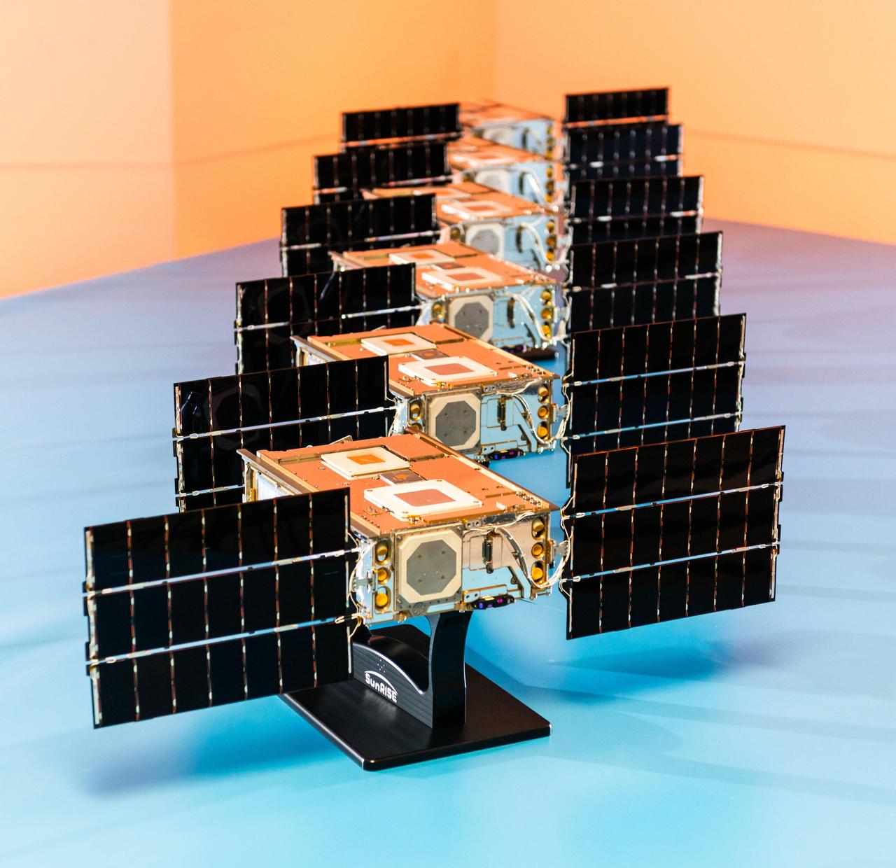
Shown here at Utah State University's Space Dynamics Laboratory in Logan, Utah, in November, 2023, the six satellites that make up NASA's Sun Radio Interferometer Space Experiment (SunRISE) mission are each only about the size of a cereal box, flanked by small solar panels. Once in space, the six SmallSats fly about 6 miles (10 kilometers) apart and each deploy four radio antennas that extend 10 feet (2.5 meters). Using a technique called interferometry, the six satellites will effectively act like one big radio receiver and detect solar radio bursts, or eruptions of radio waves in the outer atmosphere of the Sun. In the places where these radio bursts arise, scientists also see eruptions of accelerated particles, which can damage spacecraft electronics, including on communications satellites in Earth orbit, and pose a health threat to astronauts. Keeping track of solar radio bursts and pinpointing their location could help warn humans of approaching accelerated particles. https://photojournal.jpl.nasa.gov/catalog/PIA25789
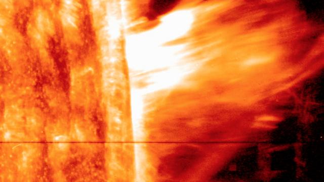
NASA image release August 6, 2010 On August 1, 2010, almost the entire Earth-facing side of the sun erupted in a tumult of activity. This image from the Solar Dynamics Observatory of the news-making solar event on August 1 shows the C3-class solar flare (white area on upper left), a solar tsunami (wave-like structure, upper right), multiple filaments of magnetism lifting off the stellar surface, large-scale shaking of the solar corona, radio bursts, a coronal mass ejection and more. This multi-wavelength extreme ultraviolet snapshot from the Solar Dynamics Observatory shows the sun's northern hemisphere in mid-eruption. Different colors in the image represent different gas temperatures. Earth's magnetic field is still reverberating from the solar flare impact on August 3, 2010, which sparked aurorae as far south as Wisconsin and Iowa in the United States. Analysts believe a second solar flare is following behind the first flare and could re-energize the fading geomagnetic storm and spark a new round of Northern Lights. Credit: NASA/SDO/AIA <b><a href="http://www.nasa.gov/centers/goddard/home/index.html" rel="nofollow">NASA Goddard Space Flight Center</a></b> is home to the nation's largest organization of combined scientists, engineers and technologists that build spacecraft, instruments and new technology to study the Earth, the sun, our solar system, and the universe. <b>Follow us on <a href="http://twitter.com/NASA_GoddardPix" rel="nofollow">Twitter</a></b> <b>Join us on <a href="http://www.facebook.com/pages/Greenbelt-MD/NASA-Goddard/395013845897?ref=tsd" rel="nofollow">Facebook</a><b> </b></b>

The lone active region visible on the sun put on a fine display with its tangled magnetic field lines swaying and twisting above it (Apr. 24-26, 2018) when viewed in a wavelength of extreme ultraviolet light. The charged particles spinning along these field lines illuminate them. The region did not erupt with any significant solar storms, although it still might. Videos are available at https://photojournal.jpl.nasa.gov/catalog/PIA22449
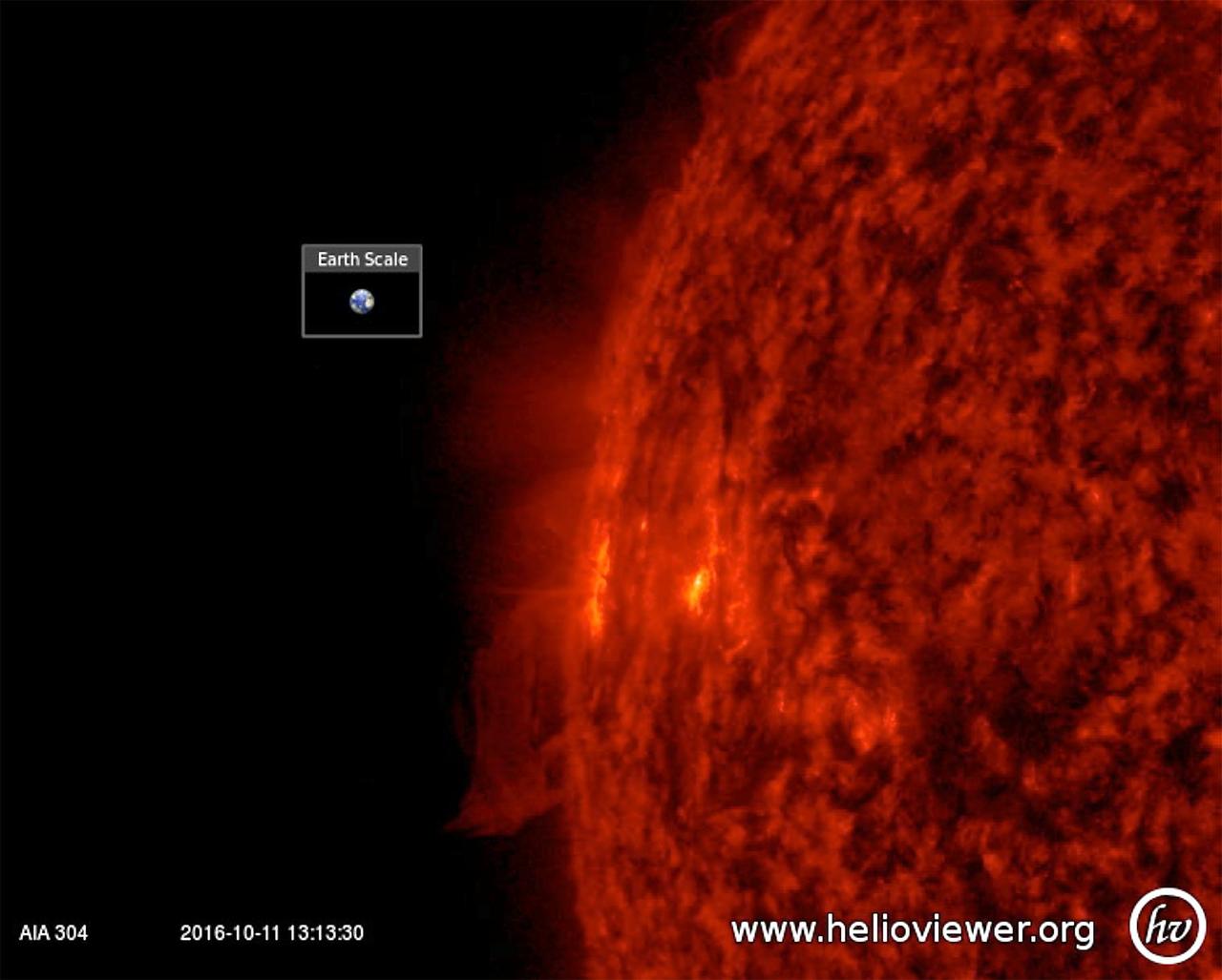
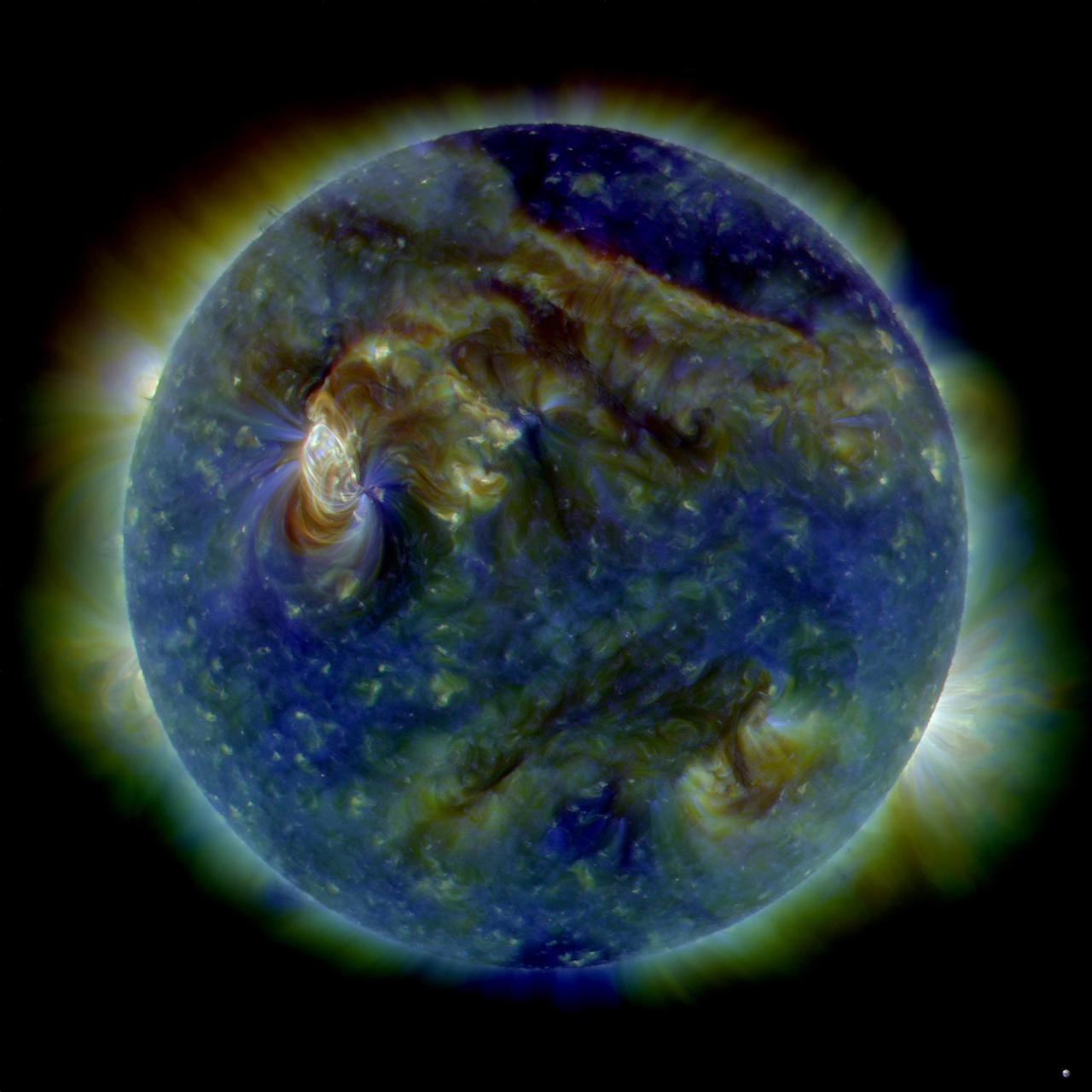
An active region just rotating into view gave us a perfect view of the tussle of magnetic field lines above it (Oct. 10-11, 2016). The particles spiraling along the magnetic field lines become visible in extreme ultraviolet light, helping us to see the struggle going on. There were no eruptions during this period, although active regions are usually the source for solar storms. The video clip covers just one day's worth of activity. Movies are available at http://photojournal.jpl.nasa.gov/catalog/PIA21109

VANDENBERG AIR FORCE BASE, CALIF. -- An overhead crane lifts the probe carrier assembly on the THEMIS spacecraft to a dolly. Visible are some of the solar array covers. THEMIS, which stands for Time History of Events and Macroscale Interactions during Substorms, comprises five identical probes that will study the dynamic and colorful eruptions of auroras. THEMIS is scheduled to launch Oct. 19 from Cape Canaveral Air Force Station in Florida.
This VIS image shows a small portion of the vast lava flow field of Daedalia Planum. The flows originate at Arsia Mons, the southernmost and youngest of the three large aligned volcanoes in the Tharsis region. Arsia Mons' last eruption was tens of million years ago. The youngest volcano in the region is Olympus Mons, the largest volcano in our solar system. Orbit Number: 78993 Latitude: -22.11 Longitude: 239.279 Instrument: VIS Captured: 2019-10-05 14:17 https://photojournal.jpl.nasa.gov/catalog/PIA23540
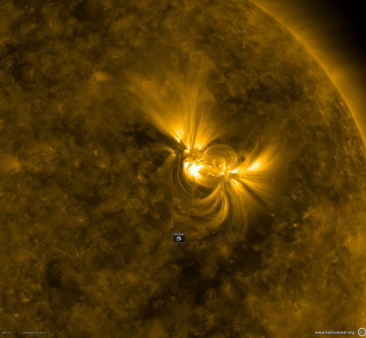
This close-up from a video clip taken May 30-June 1, 2018 shows a large active region in extreme ultraviolet light as the bright magnetic field lines above it shift and twist. Note the Earth scale below the active region: the longest loops extend about 10 times the diameter of Earth. When the magnetic field lines get themselves tangled up enough, they can erupt with a solar storm. Videos are available at https://photojournal.jpl.nasa.gov/catalog/PIA22475
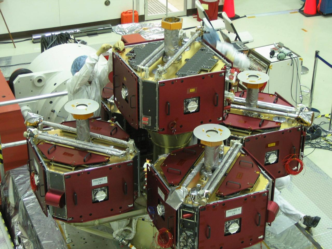
VANDENBERG AIR FORCE BASE, CALIF. -- The probe carrier assembly on the THEMIS spacecraft is prepared for a vibration test. The assembly has solar array covers attached. THEMIS, which stands for Time History of Events and Macroscale Interactions during Substorms, comprises five identical probes that will study the dynamic and colorful eruptions of auroras. THEMIS is scheduled to launch Oct. 19 from Cape Canaveral Air Force Station in Florida.
Today's VIS image shows a small portion of the immense lava flows that originated from Arsia Mons. Arsia Mons is the southernmost of the three large aligned volcanoes in the Tharsis region. Arsia Mons last eruption was 10s of million years ago. The youngest volcano in the region is Olympus Mons, the largest volcano in our solar system. Orbit Number: 74945 Latitude: -18.9808 Longitude: 225.731 Instrument: VIS Captured: 2018-11-06 05:00 https://photojournal.jpl.nasa.gov/catalog/PIA22973

Caption: This image from June 20, 2013, at 11:15 p.m. EDT shows the bright light of a solar flare on the left side of the sun and an eruption of solar material shooting through the sun’s atmosphere, called a prominence eruption. Shortly thereafter, this same region of the sun sent a coronal mass ejection out into space. --- On June 20, 2013, at 11:24 p.m., the sun erupted with an Earth-directed coronal mass ejection or CME, a solar phenomenon that can send billions of tons of particles into space that can reach Earth one to three days later. These particles cannot travel through the atmosphere to harm humans on Earth, but they can affect electronic systems in satellites and on the ground. Experimental NASA research models, based on observations from NASA’s Solar Terrestrial Relations Observatory and ESA/NASA’s Solar and Heliospheric Observatory show that the CME left the sun at speeds of around 1350 miles per second, which is a fast speed for CMEs. Earth-directed CMEs can cause a space weather phenomenon called a geomagnetic storm, which occurs when they funnel energy into Earth's magnetic envelope, the magnetosphere, for an extended period of time. The CME’s magnetic fields peel back the outermost layers of Earth's fields changing their very shape. Magnetic storms can degrade communication signals and cause unexpected electrical surges in power grids. They also can cause aurora. Storms are rare during solar minimum, but as the sun’s activity ramps up every 11 years toward solar maximum – currently expected in late 2013 -- large storms occur several times per year. In the past, geomagnetic storms caused by CMEs of this strength and direction have usually been mild. Read more: <a href="http://1.usa.gov/14OxuEe" rel="nofollow">1.usa.gov/14OxuEe</a> Credit: NASA/Goddard/SDO <b><a href="http://www.nasa.gov/audience/formedia/features/MP_Photo_Guidelines.html" rel="nofollow">NASA image use policy.</a></b> <b><a href="http://www.nasa.gov/centers/goddard/home/index.html" rel="nofollow">NASA Goddard Space Flight Center</a></b> enables NASA’s mission through four scientific endeavors: Earth Science, Heliophysics, Solar System Exploration, and Astrophysics. Goddard plays a leading role in NASA’s accomplishments by contributing compelling scientific knowledge to advance the Agency’s mission. <b>Follow us on <a href="http://twitter.com/NASA_GoddardPix" rel="nofollow">Twitter</a></b> <b>Like us on <a href="http://www.facebook.com/pages/Greenbelt-MD/NASA-Goddard/395013845897?ref=tsd" rel="nofollow">Facebook</a></b> <b>Find us on <a href="http://instagram.com/nasagoddard?vm=grid" rel="nofollow">Instagram</a></b>
Caption: This image from June 20, 2013, at 11:15 p.m. EDT shows the bright light of a solar flare on the left side of the sun and an eruption of solar material shooting through the sun’s atmosphere, called a prominence eruption. Shortly thereafter, this same region of the sun sent a coronal mass ejection out into space. --- On June 20, 2013, at 11:24 p.m., the sun erupted with an Earth-directed coronal mass ejection or CME, a solar phenomenon that can send billions of tons of particles into space that can reach Earth one to three days later. These particles cannot travel through the atmosphere to harm humans on Earth, but they can affect electronic systems in satellites and on the ground. Experimental NASA research models, based on observations from NASA’s Solar Terrestrial Relations Observatory and ESA/NASA’s Solar and Heliospheric Observatory show that the CME left the sun at speeds of around 1350 miles per second, which is a fast speed for CMEs. Earth-directed CMEs can cause a space weather phenomenon called a geomagnetic storm, which occurs when they funnel energy into Earth's magnetic envelope, the magnetosphere, for an extended period of time. The CME’s magnetic fields peel back the outermost layers of Earth's fields changing their very shape. Magnetic storms can degrade communication signals and cause unexpected electrical surges in power grids. They also can cause aurora. Storms are rare during solar minimum, but as the sun’s activity ramps up every 11 years toward solar maximum – currently expected in late 2013 -- large storms occur several times per year. In the past, geomagnetic storms caused by CMEs of this strength and direction have usually been mild. Credit: NASA/Goddard/SDO <b><a href="http://www.nasa.gov/audience/formedia/features/MP_Photo_Guidelines.html" rel="nofollow">NASA image use policy.</a></b> <b><a href="http://www.nasa.gov/centers/goddard/home/index.html" rel="nofollow">NASA Goddard Space Flight Center</a></b> enables NASA’s mission through four scientific endeavors: Earth Science, Heliophysics, Solar System Exploration, and Astrophysics. Goddard plays a leading role in NASA’s accomplishments by contributing compelling scientific knowledge to advance the Agency’s mission. <b>Follow us on <a href="http://twitter.com/NASA_GoddardPix" rel="nofollow">Twitter</a></b> <b>Like us on <a href="http://www.facebook.com/pages/Greenbelt-MD/NASA-Goddard/395013845897?ref=tsd" rel="nofollow">Facebook</a></b> <b>Find us on <a href="http://instagram.com/nasagoddard?vm=grid" rel="nofollow">Instagram</a></b>
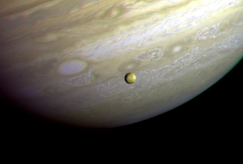
This photograph of the southern hemisphere of Jupiter was obtained by Voyager 2 on June 25, 1979, at a distance of 12 million kilometers (8 million miles). The Voyager spacecraft is rapidly nearing the giant planet, with closest approach to occur at 4:23 pm PDT on July 9. Seen in front of the turbulent clouds of the planet is Io, the innermost of the large Galilean satellites of Jupiter. Io is the size of our moon. Voyager discovered in early March that Io is the most volcanically active planetary body known in the solar system, with continuous eruptions much larger than any that take place on the Earth. The red, orange, and yellow colors of Io are thought to be deposits of sulfur and sulfur compounds produced in these eruptions. The smallest features in either Jupiter or Io that can be distinguished in this picture are about 200 kilometers (125 miles) across; this resolution, it is not yet possible to identify individual volcanic eruptions. Monitoring of the erupture activity of Io by Voyager 2 will begin about July 5 and will extend past the encounter July 9. http://photojournal.jpl.nasa.gov/catalog/PIA00371
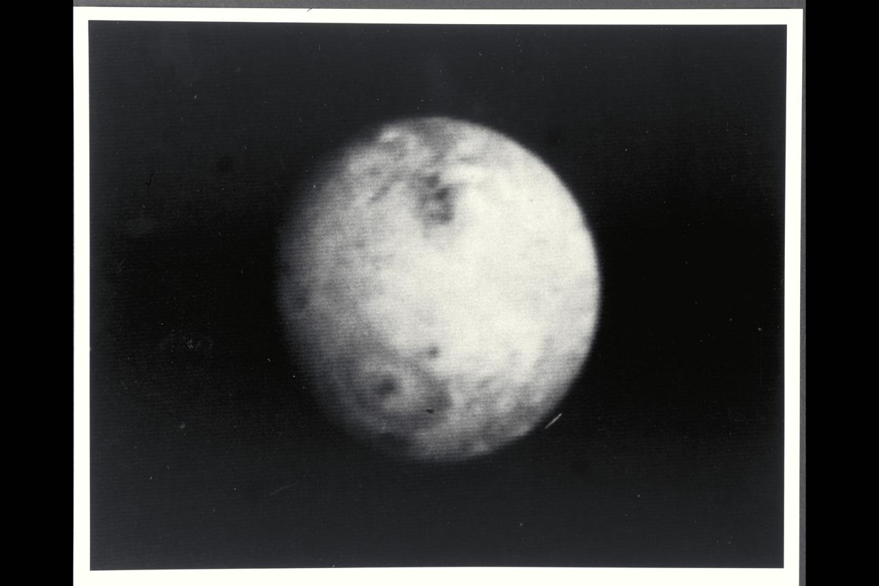
P-21739 BW Range: 4.7 million kilometers (2.9 million miles) This picture of Io was taken as Voyager 2 closes in on the Jovian system. Scientists are studying these distant views of Io for evidences of changes since Voyager 1 observations in March of 79. Voyager 1 discovered that Io, the innermost of the Galilean satellites, is the most volcanically active body yet seen in the solar system, surpassing even earth. In this picture, the first volcano discovered by Voyager 1 is again visible in the lower left portion of the disk as a dark oval with a dark spot in the center. In March, this volcano appeared as a heart-shaped marking, not a symmetrical oval. Scientists believe that the non-symmetric markings earlier resulted from a constriction in the mouth of the volcanic vent causing erupting material to extrude preferentially in certain directions. Apparently, the volcanic eruptive activity, which sends material to altitudes of 280 kilometers (175 miles) or more above this volcano, has changed the vent geometry or dislodged an obstruction. Such changes in the form of eruptive fountains are common in terrestial volcanos, although on a much smaller scale than on Io.
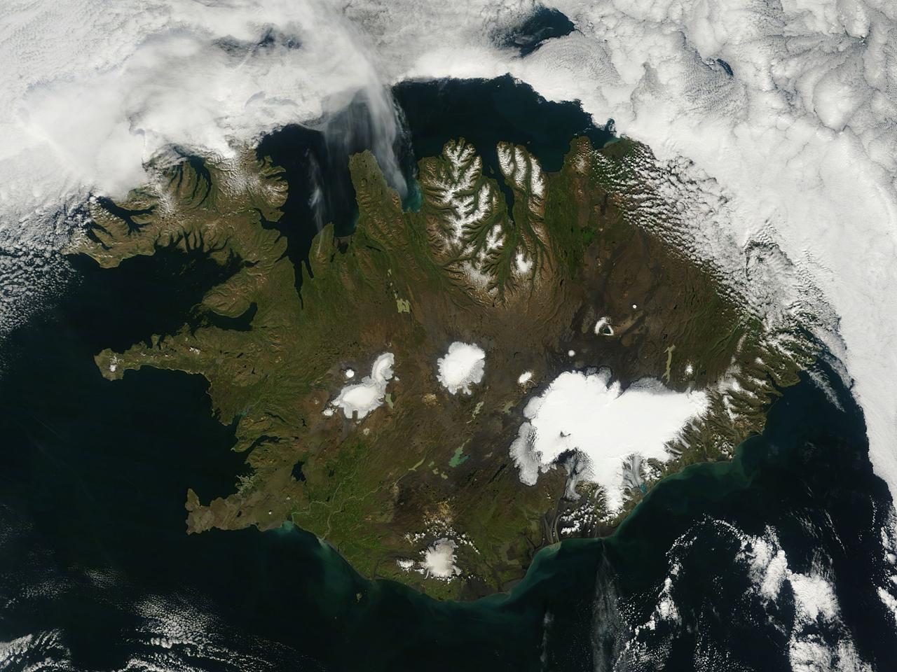
On August 22, 2014 the Moderate Resolution Imaging Spectroradiometer (MODIS) aboard NASA’s Terra satellite captured a true-color image of a sunny summer day in Iceland. While most of the winter snow has melted to reveal green vegetation, the rugged northern peaks retain a snow cap. Further south bright white marks the location of glaciers. Situated in the southeast is Vatnajökull – the largest glacier in Europe and the site of Iceland’s highest mountain, Hvannadalshnjúkur. On August 20, scientists from the Icelandic Met Office closed all roads into the north of Vatnajökull Glacier due to increase seismic activity from the Bardarbunga volcano which lies under the ice cap in this area. On August 23, a small eruption was detected in Bardarbunga and the airspace near the activity was closed as a precautionary measure. Further study of the data suggested that no eruption had in fact occurred and airspace was opened under a code orange alert. Seismic activity remained high. On August 29, an eruption occurred north of Vatnajökull Glacier when a fissure, close to 1 km in length, opened up, and emitted lava at a slow pace. The eruption was short-lived, but on August 31 an eruption was confirmed in the same remote, uninhabited area. The Icelandic Meteorological Office reported that as of September 11 that eruption continued unabated. There has been no significant explosive activity, but lava flow has been the primary feature. High concentrations of sulfuric gases from the volcanic activity accompany the eruption, and are the primary health concern. Credit: NASA/GSFC/Jeff Schmaltz/MODIS Land Rapid Response Team <b><a href="http://www.nasa.gov/audience/formedia/features/MP_Photo_Guidelines.html" rel="nofollow">NASA image use policy.</a></b> <b><a href="http://www.nasa.gov/centers/goddard/home/index.html" rel="nofollow">NASA Goddard Space Flight Center</a></b> enables NASA’s mission through four scientific endeavors: Earth Science, Heliophysics, Solar System Exploration, and Astrophysics. Goddard plays a leading role in NASA’s accomplishments by contributing compelling scientific knowledge to advance the Agency’s mission. <b>Follow us on <a href="http://twitter.com/NASAGoddardPix" rel="nofollow">Twitter</a></b> <b>Like us on <a href="http://www.facebook.com/pages/Greenbelt-MD/NASA-Goddard/395013845897?ref=tsd" rel="nofollow">Facebook</a></b> <b>Find us on <a href="http://instagram.com/nasagoddard?vm=grid" rel="nofollow">Instagram</a></b>

NASA image acquired Sept 7, 2010 Shiveluch (also spelled Sheveluch) is one of the largest and most active volcanoes on Russia’s Kamchatka Peninsula. It has been spewing ash and steam intermittently—with occasional dome collapses, pyroclastic flows, and lava flows, as well—for the past decade. Shiveluch is a stratovolcano, a steep-sloped formation of alternating layers of hardened lava, ash, and rocks thrown out by earlier eruptions. A lava dome has been growing southwest of the 3,283-meter (10,771-foot) summit. The Advanced Land Imager (ALI) on NASA’s Earth Observing-1 (EO-1) satellite acquired this image on September 7, 2010. Brown and tan debris—perhaps ash falls, perhaps mud from lahars—covers the southern landscape of the volcano, while the hills on the northern side remain covered in snow and ice. The Kamchatkan Volcanic Eruption Response Team (KVERT) reported that seismic activity at Shiveluch was "above background levels" from September 3-10. Ash plumes rose to an altitude of 6.5 kilometers (21,300 feet) on September 3-4, and gas-and-ash plumes were reported on September 7, when this image was acquired. According to the Smithsonian Institution's volcano program, at least 60 large eruptions of Shiveluch have occurred during the current Holocene Epoch of geological history. Intermittent explosive eruptions began in the 1990s, and the largest historical eruptions from Shiveluch occurred in 1854 and 1964. NASA Earth Observatory image created by Jesse Allen and Robert Simmon, using EO-1 ALI data provided courtesy of the NASA EO-1 team. Caption by Mike Carlowicz. Instrument: EO-1 - ALI Credit: NASA Earth Observatory NASA Goddard Space Flight Center contributes to NASA’s mission through four scientific endeavors: Earth Science, Heliophysics, Solar System Exploration, and Astrophysics. Goddard plays a leading role in NASA’s endeavors by providing compelling scientific knowledge to advance the Agency’s mission. Follow us on Twitter Join us on Facebook
Caption: This is an image of magnetic loops on the sun, captured by NASA's Solar Dynamics Observatory on July 18, 2012. It has been processed to highlight the edges of each loop to make the structure more clear. A series of loops such as this is known as a flux rope, and these lie at the heart of eruptions on the sun known as coronal mass ejections (CMEs.) This is the first time scientists were able to discern the timing of a flux rope's formation. Credit: NASA/Goddard Space Flight Center/SDO ---- On July 18, 2012, a fairly small explosion of light burst off the lower right limb of the sun. Such flares often come with an associated eruption of solar material, known as a coronal mass ejection or CME – but this one did not. Something interesting did happen, however. Magnetic field lines in this area of the sun's atmosphere, the corona, began to twist and kink, generating the hottest solar material – a charged gas called plasma – to trace out the newly-formed slinky shape. The plasma glowed brightly in extreme ultraviolet images from the Atmospheric Imaging Assembly (AIA) aboard NASA’s Solar Dynamics Observatory (SDO) and scientists were able to watch for the first time the very formation of something they had long theorized was at the heart of many eruptive events on the sun: a flux rope. Eight hours later, on July 19, the same region flared again. This time the flux rope's connection to the sun was severed, and the magnetic fields escaped into space, dragging billions of tons of solar material along for the ride -- a classic CME. "Seeing this structure was amazing," says Angelos Vourlidas, a solar scientist at the Naval Research Laboratory in Washington, D.C. "It looks exactly like the cartoon sketches theorists have been drawing of flux ropes since the 1970s. It was a series of figure eights lined up to look like a giant slinky on the sun." <b>To read more about this new discovery go to: <a href="http://1.usa.gov/14UHsTt" rel="nofollow">1.usa.gov/14UHsTt</a> </b> <b><a href="http://www.nasa.gov/audience/formedia/features/MP_Photo_Guidelines.html" rel="nofollow">NASA image use policy.</a></b> <b><a href="http://www.nasa.gov/centers/goddard/home/index.html" rel="nofollow">NASA Goddard Space Flight Center</a></b> enables NASA’s mission through four scientific endeavors: Earth Science, Heliophysics, Solar System Exploration, and Astrophysics. Goddard plays a leading role in NASA’s accomplishments by contributing compelling scientific knowledge to advance the Agency’s mission. <b>Follow us on <a href="http://twitter.com/NASA_GoddardPix" rel="nofollow">Twitter</a></b> <b>Like us on <a href="http://www.facebook.com/pages/Greenbelt-MD/NASA-Goddard/395013845897?ref=tsd" rel="nofollow">Facebook</a></b> <b>Find us on <a href="http://instagram.com/nasagoddard?vm=grid" rel="nofollow">Instagram</a></b>
A beautiful prominence eruption shot off the east limb (left side) of the sun on Monday, April 16, 2012. Such eruptions are often associated with solar flares, and in this case an M1 class (medium-sized) flare did occur at the same time, though it was not aimed toward Earth. This event, which is still in progress, was seen by NASA’s SDO satellite. Credit: NASA/GSFC/SDO <b><a href="http://www.nasa.gov/audience/formedia/features/MP_Photo_Guidelines.html" rel="nofollow">NASA image use policy.</a></b> <b><a href="http://www.nasa.gov/centers/goddard/home/index.html" rel="nofollow">NASA Goddard Space Flight Center</a></b> enables NASA’s mission through four scientific endeavors: Earth Science, Heliophysics, Solar System Exploration, and Astrophysics. Goddard plays a leading role in NASA’s accomplishments by contributing compelling scientific knowledge to advance the Agency’s mission. <b>Follow us on <a href="http://twitter.com/NASA_GoddardPix" rel="nofollow">Twitter</a></b> <b>Like us on <a href="http://www.facebook.com/pages/Greenbelt-MD/NASA-Goddard/395013845897?ref=tsd" rel="nofollow">Facebook</a></b> <b>Find us on <a href="http://instagrid.me/nasagoddard/?vm=grid" rel="nofollow">Instagram</a></b>
A beautiful prominence eruption shot off the east limb (left side) of the sun on Monday, April 16, 2012. Such eruptions are often associated with solar flares, and in this case an M1 class (medium-sized) flare did occur at the same time, though it was not aimed toward Earth. This event, which is still in progress, was seen by NASA’s SDO satellite. Credit: NASA/GSFC/SDO <b><a href="http://www.nasa.gov/audience/formedia/features/MP_Photo_Guidelines.html" rel="nofollow">NASA image use policy.</a></b> <b><a href="http://www.nasa.gov/centers/goddard/home/index.html" rel="nofollow">NASA Goddard Space Flight Center</a></b> enables NASA’s mission through four scientific endeavors: Earth Science, Heliophysics, Solar System Exploration, and Astrophysics. Goddard plays a leading role in NASA’s accomplishments by contributing compelling scientific knowledge to advance the Agency’s mission. <b>Follow us on <a href="http://twitter.com/NASA_GoddardPix" rel="nofollow">Twitter</a></b> <b>Like us on <a href="http://www.facebook.com/pages/Greenbelt-MD/NASA-Goddard/395013845897?ref=tsd" rel="nofollow">Facebook</a></b> <b>Find us on <a href="http://instagrid.me/nasagoddard/?vm=grid" rel="nofollow">Instagram</a></b>
A beautiful prominence eruption shot off the east limb (left side) of the sun on Monday, April 16, 2012. Such eruptions are often associated with solar flares, and in this case an M1 class (medium-sized) flare did occur at the same time, though it was not aimed toward Earth. This event, which is still in progress, was seen by NASA’s SDO satellite. Credit: NASA/GSFC/SDO <b><a href="http://www.nasa.gov/audience/formedia/features/MP_Photo_Guidelines.html" rel="nofollow">NASA image use policy.</a></b> <b><a href="http://www.nasa.gov/centers/goddard/home/index.html" rel="nofollow">NASA Goddard Space Flight Center</a></b> enables NASA’s mission through four scientific endeavors: Earth Science, Heliophysics, Solar System Exploration, and Astrophysics. Goddard plays a leading role in NASA’s accomplishments by contributing compelling scientific knowledge to advance the Agency’s mission. <b>Follow us on <a href="http://twitter.com/NASA_GoddardPix" rel="nofollow">Twitter</a></b> <b>Like us on <a href="http://www.facebook.com/pages/Greenbelt-MD/NASA-Goddard/395013845897?ref=tsd" rel="nofollow">Facebook</a></b> <b>Find us on <a href="http://instagrid.me/nasagoddard/?vm=grid" rel="nofollow">Instagram</a></b>
A beautiful prominence eruption shot off the east limb (left side) of the sun on Monday, April 16, 2012. Such eruptions are often associated with solar flares, and in this case an M1 class (medium-sized) flare did occur at the same time, though it was not aimed toward Earth. This event, which is still in progress, was seen by NASA’s SDO satellite. <b>View a video of this event here: <a href="http://www.flickr.com/photos/gsfc/7084820027">www.flickr.com/photos/gsfc/7084820027</a></b> Credit: NASA/GSFC/SDO <b><a href="http://www.nasa.gov/audience/formedia/features/MP_Photo_Guidelines.html" rel="nofollow">NASA image use policy.</a></b> <b><a href="http://www.nasa.gov/centers/goddard/home/index.html" rel="nofollow">NASA Goddard Space Flight Center</a></b> enables NASA’s mission through four scientific endeavors: Earth Science, Heliophysics, Solar System Exploration, and Astrophysics. Goddard plays a leading role in NASA’s accomplishments by contributing compelling scientific knowledge to advance the Agency’s mission. <b>Follow us on <a href="http://twitter.com/NASA_GoddardPix" rel="nofollow">Twitter</a></b> <b>Like us on <a href="http://www.facebook.com/pages/Greenbelt-MD/NASA-Goddard/395013845897?ref=tsd" rel="nofollow">Facebook</a></b> <b>Find us on <a href="http://instagrid.me/nasagoddard/?vm=grid" rel="nofollow">Instagram</a></b>
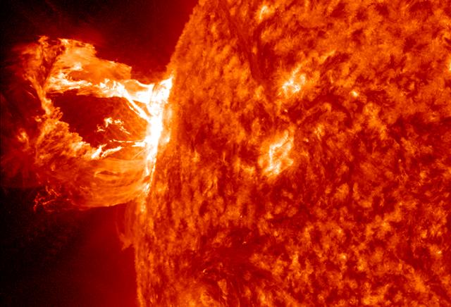
A beautiful prominence eruption shot off the east limb (left side) of the sun on Monday, April 16, 2012. Such eruptions are often associated with solar flares, and in this case an M1 class (medium-sized) flare did occur at the same time, though it was not aimed toward Earth. This event, which is still in progress, was seen by NASA’s SDO satellite. <b>View a video of this event here: <a href="http://www.flickr.com/photos/gsfc/7084820027">www.flickr.com/photos/gsfc/7084820027</a></b> Credit: NASA/GSFC/SDO <b><a href="http://www.nasa.gov/audience/formedia/features/MP_Photo_Guidelines.html" rel="nofollow">NASA image use policy.</a></b> <b><a href="http://www.nasa.gov/centers/goddard/home/index.html" rel="nofollow">NASA Goddard Space Flight Center</a></b> enables NASA’s mission through four scientific endeavors: Earth Science, Heliophysics, Solar System Exploration, and Astrophysics. Goddard plays a leading role in NASA’s accomplishments by contributing compelling scientific knowledge to advance the Agency’s mission. <b>Follow us on <a href="http://twitter.com/NASA_GoddardPix" rel="nofollow">Twitter</a></b> <b>Like us on <a href="http://www.facebook.com/pages/Greenbelt-MD/NASA-Goddard/395013845897?ref=tsd" rel="nofollow">Facebook</a></b> <b>Find us on <a href="http://instagrid.me/nasagoddard/?vm=grid" rel="nofollow">Instagram</a></b>
S74-23458 (19 Dec. 1973) --- This photograph of the sun, taken on Dec. 19, 1973, during the third and final manned Skylab mission (Skylab 4), shows one of the most spectacular solar flares ever recorded, spanning more than 588,000 kilometers (365,000 miles) across the solar surface. The last picture, taken some 17 hours earlier, showed this feature as a large quiescent prominence on the eastern side of the sun. The flare gives the distinct impression of a twisted sheet of gas in the process of unwinding itself. Skylab photographs such quiescent features erupt from the sun. In this photograph the solar poles are distinguished by a relative absence of supergranulation network, and a much darker tone than the central portions of the disk. Several active regions are seen on the eastern side of the disk. The photograph was taken in the light of ionized helium by the extreme ultraviolet spectroheliograph instrument of the United States Naval Research Laboratory. Photo credit: NASA

Active region AR 12192 on the sun erupted with a strong flare on Oct. 24, 2014, as seen in the bright light of this image captured by NASA's Solar Dynamics Observatory. This image shows extreme ultraviolet light that highlights the hot solar material in the sun's atmosphere. Credit: NASA/GSFC/SDO More info: The sun emitted a significant solar flare, peaking at 5:40 p.m. EDT on Oct. 24, 2014. NASA's Solar Dynamics Observatory, which watches the sun constantly, captured images of the event. Solar flares are powerful bursts of radiation. Harmful radiation from a flare cannot pass through Earth's atmosphere to physically affect humans on the ground, however -- when intense enough -- they can disturb the atmosphere in the layer where GPS and communications signals travel. This flare is classified as an X3.1-class flare. X-class denotes the most intense flares, while the number provides more information about its strength. An X2 is twice as intense as an X1, an X3 is three times as intense, etc. The flare erupted from a particularly large active region -- labeled AR 12192 -- on the sun that is the largest in 24 years. This is the fourth substantial flare from this active region since Oct. 19. Credit: NASA's Goddard Space Flight Center <b><a href="http://www.nasa.gov/audience/formedia/features/MP_Photo_Guidelines.html" rel="nofollow">NASA image use policy.</a></b> <b><a href="http://www.nasa.gov/centers/goddard/home/index.html" rel="nofollow">NASA Goddard Space Flight Center</a></b> enables NASA’s mission through four scientific endeavors: Earth Science, Heliophysics, Solar System Exploration, and Astrophysics. Goddard plays a leading role in NASA’s accomplishments by contributing compelling scientific knowledge to advance the Agency’s mission. <b>Follow us on <a href="http://twitter.com/NASAGoddardPix" rel="nofollow">Twitter</a></b> <b>Like us on <a href="http://www.facebook.com/pages/Greenbelt-MD/NASA-Goddard/395013845897?ref=tsd" rel="nofollow">Facebook</a></b> <b>Find us on <a href="http://instagrid.me/nasagoddard/?vm=grid" rel="nofollow">Instagram</a></b>

The largest solar flare ever recorded occurred at 4:51 p.m. EDT, on Monday, April 2, 2001. as Observed by the Solar and Heliospheric Observatory (SOHO) satellite. Solar flares, among the solar systems mightiest eruptions, are tremendous explosions in the atmosphere of the Sun capable of releasing as much energy as a billion megatons of TNT. Caused by the sudden release of magnetic energy, in just a few seconds, solar flares can accelerate solar particles to very high velocities, almost to the speed of light, and heat solar material to tens of millions of degrees. The recent explosion from the active region near the sun's northwest limb hurled a coronal mass ejection into space at a whopping speed of roughly 7.2 million kilometers per hour. Luckily, the flare was not aimed directly towards Earth. Second to the most severe R5 classification of radio blackout, this flare produced an R4 blackout as rated by the NOAA SEC. This classification measures the disruption in radio communications. Launched December 2, 1995 atop an ATLAS-IIAS expendable launch vehicle, the SOHO is a cooperative effort involving NASA and the European Space Agency (ESA). (Image courtesy NASA Goddard SOHO Project office)
SDO View of M7.3 Class Solar Flare on Oct. 2, 2014 NASA's Solar Dynamics Observatory captured this image of an M7.3 class solar flare on Oct. 2, 2014. The solar flare is the bright flash of light on the right limb of the sun. A burst of solar material erupting out into space can be seen just below it. Credit: NASA/Goddard/SDO <b><a href="http://www.nasa.gov/audience/formedia/features/MP_Photo_Guidelines.html" rel="nofollow">NASA image use policy.</a></b> <b><a href="http://www.nasa.gov/centers/goddard/home/index.html" rel="nofollow">NASA Goddard Space Flight Center</a></b> enables NASA’s mission through four scientific endeavors: Earth Science, Heliophysics, Solar System Exploration, and Astrophysics. Goddard plays a leading role in NASA’s accomplishments by contributing compelling scientific knowledge to advance the Agency’s mission. <b>Follow us on <a href="http://twitter.com/NASAGoddardPix" rel="nofollow">Twitter</a></b> <b>Like us on <a href="http://www.facebook.com/pages/Greenbelt-MD/NASA-Goddard/395013845897?ref=tsd" rel="nofollow">Facebook</a></b> <b>Find us on <a href="http://instagram.com/nasagoddard?vm=grid" rel="nofollow">Instagram</a></b>
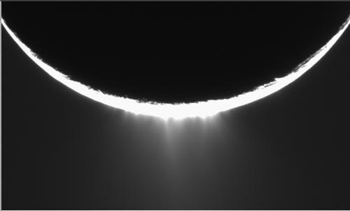
Jets of icy particles burst from Saturn’s moon Enceladus in this brief movie sequence of four images taken on Nov. 27, 2005. The sensational discovery of active eruptions on a third outer solar system body (Io and Triton are the others) is surely one of the great highlights of the Cassini mission. Imaging scientists, as reported in the journal Science on March 10, 2006, believe that the jets are geysers erupting from pressurized subsurface reservoirs of liquid water above 273 degrees Kelvin (0 degrees Celsius). Images taken in January 2005 appeared to show the plume emanating from the fractured south polar region of Enceladus, but the visible plume was only slightly brighter than the background noise in the image, because the lighting geometry was not suitable to reveal the true details of the feature. This potential sighting, in addition to the detection of the icy particles in the plume by other Cassini instruments, prompted imaging scientists to target Enceladus again with exposures designed to confirm the validity of the earlier plume sighting. The new views show individual jets, or plume sources, that contribute to the plume with much greater visibility than the earlier images. The full plume towers over the 505-kilometer-wide (314-mile) moon and is at least as tall as the moon's diameter. The four 10-second exposures were taken over the course of about 36 minutes at approximately 12 minute intervals. Enceladus rotates about 7.5 degrees in longitude over the course of the frames, and most of the observed changes in the appearances of the jets is likely attributable to changes in the viewing geometry. However, some of the changes may be due to actual variation in the flow from the jets on a time scale of tens of minutes. Additionally, the shift of the sources seen here should provide information about their location in front of and behind the visible limb (edge) of Enceladus. These images were obtained using the Cassini spacecraft narrow-angle camera at distances between 144,350 and 149,520 kilometers (89,695 and 92,907 miles) from Enceladus and at a phase angle of about 161 degrees. Image scale is about 900 meters (2,950 feet) per pixel on Enceladus. A movie is available at http://photojournal.jpl.nasa.gov/catalog/PIA07762
When NASA’s Terra satellite passed over Russia’s Kamchatka Peninsula at noon local time (00:00 Universal Time) on October 6, 2012, Shilveluch Volcano was quiet. By the time NASA’s Aqua satellite passed over the area two hours later (bottom image), the volcano had erupted and sent a plume of ash over the Kamchatskiy Zaliv. The plume traveled about 90 kilometers (55 miles) toward the south-southeast, where a change in wind direction began pushing the plume toward the east. On October 6, 2012, the Kamchatka Volcanic Emergency Response Team (KVERT) reported that the ash plume from Shiveluch reached an altitude of 3 kilometers (9,800 feet) above sea level, and had traveled some 220 kilometers (140 miles) from the volcano summit. Shiveluch (also spelled Sheveluch) ranks among the biggest and most active volcanoes on the Kamchatka Peninsula. Rising to 3,283 meters (10,771 feet) above sea level, Shiveluch is a stratovolcano composed of alternating layers of hardened lava, compacted ash, and rocks ejected by previous eruptions. The beige-colored expanse of rock on the volcano’s southern slopes (visible in both images) is due to an explosive eruption that occurred in 1964. Part of Shiveluch’s southern flank collapsed, and the light-colored rock is avalanche debris left by that event. High-resolution imagery of Shiveluch shows very little vegetation within that avalanche zone. On October 6, 2012, KVERT cited observations from the Moderate Resolution Imaging Spectroradiometer (MODIS) instruments on Terra and Aqua in detecting the Shiveluch eruption. This was not the first time that MODIS observed a Shiveluch eruption shortly after it started. In 2007, MODIS captured an image within minutes of the eruption’s start, before winds could blow the ash away from the summit. When NASA’s Terra satellite passed over Russia’s Kamchatka Peninsula at noon local time (00:00 Universal Time) on October 6, 2012, Shilveluch Volcano was quiet (top image). By the time NASA’s Aqua satellite passed over the area two hours later (bottom image), the volcano had erupted and sent a plume of ash over the Kamchatskiy Zaliv. The plume traveled about 90 kilometers (55 miles) toward the south-southeast, where a change in wind direction began pushing the plume toward the east. On October 6, 2012, the Kamchatka Volcanic Emergency Response Team (KVERT) reported that the ash plume from Shiveluch reached an altitude of 3 kilometers (9,800 feet) above sea level, and had traveled some 220 kilometers (140 miles) from the volcano summit. Shiveluch (also spelled Sheveluch) ranks among the biggest and most active volcanoes on the Kamchatka Peninsula. Rising to 3,283 meters (10,771 feet) above sea level, Shiveluch is a stratovolcano composed of alternating layers of hardened lava, compacted ash, and rocks ejected by previous eruptions. The beige-colored expanse of rock on the volcano’s southern slopes (visible in both images) is due to an explosive eruption that occurred in 1964. Part of Shiveluch’s southern flank collapsed, and the light-colored rock is avalanche debris left by that event. High-resolution imagery of Shiveluch shows very little vegetation within that avalanche zone. On October 6, 2012, KVERT cited observations from the Moderate Resolution Imaging Spectroradiometer (MODIS) instruments on Terra and Aqua in detecting the Shiveluch eruption. This was not the first time that MODIS observed a Shiveluch eruption shortly after it started. In 2007, MODIS captured an image within minutes of the eruption’s start, before winds could blow the ash away from the summit. Credit: <b><a href="http://www.earthobservatory.nasa.gov/" rel="nofollow"> NASA Earth Observatory</a></b> <b><a href="http://www.nasa.gov/audience/formedia/features/MP_Photo_Guidelines.html" rel="nofollow">NASA image use policy.</a></b> <b><a href="http://www.nasa.gov/centers/goddard/home/index.html" rel="nofollow">NASA Goddard Space Flight Center</a></b> enables NASA’s mission through four scientific endeavors: Earth Science, Heliophysics, Solar System Exploration, and Astrophysics. Goddard plays a leading role in NASA’s accomplishments by contributing compelling scientific knowledge to advance the Agency’s mission. <b>Follow us on <a href="http://twitter.com/NASA_GoddardPix" rel="nofollow">Twitter</a></b> <b>Like us on <a href="http://www.facebook.com/pages/Greenbelt-MD/NASA-Goddard/395013845897?ref=tsd" rel="nofollow">Facebook</a></b> <b>Find us on <a href="http://instagrid.me/nasagoddard/?vm=grid" rel="nofollow">Instagram</a></b>
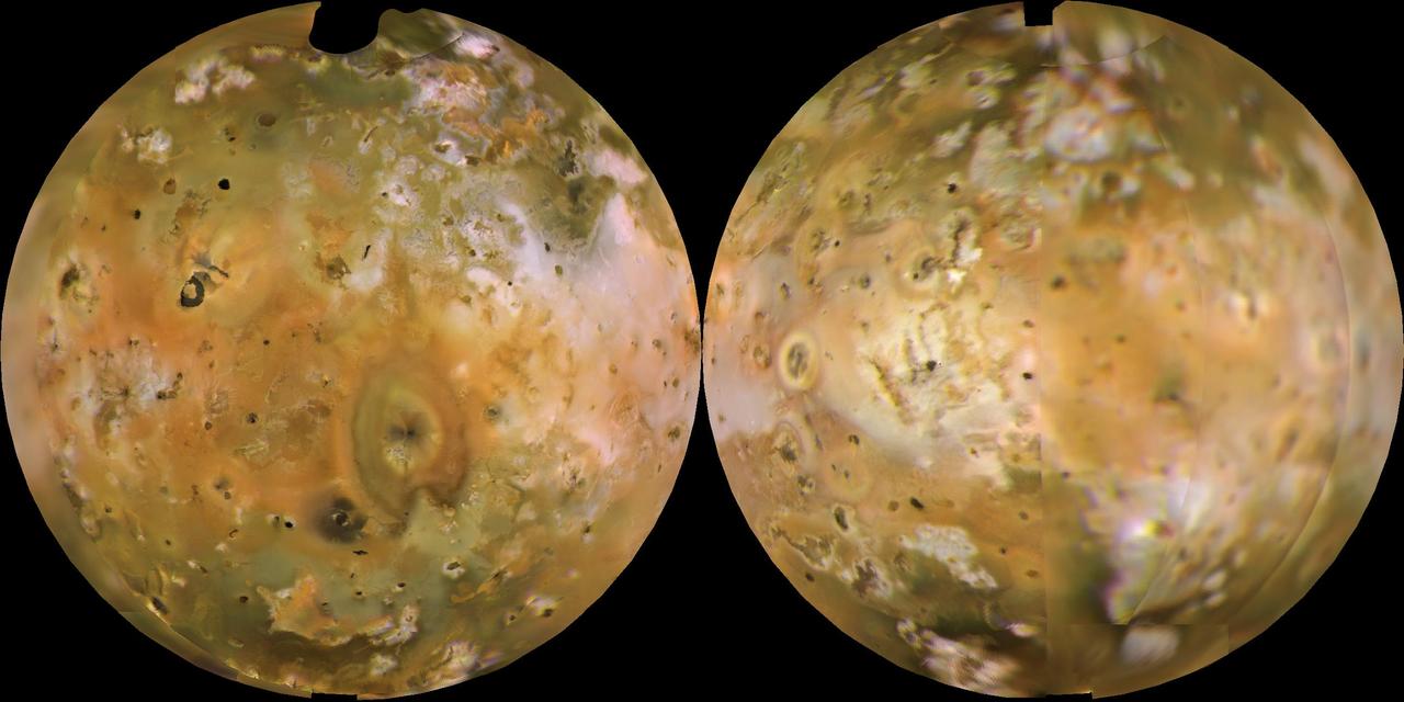
NASA's Voyager 1 computer color mosaics, shown in approximately natural color and in Lambertian equal-area projections, show the Eastern (left) and Western (right) hemispheres of Io. This innermost of Jupiter's 4 major satellites is the most volcanically active object in the solar system. Io is 2263 mi (3640 km) in diameter, making it a little bigger than Earth's moon. Almost all the features visible here have volcanic origins, including several calderas and eruption plumes that were active at the time of the Voyager 1 encounter. http://photojournal.jpl.nasa.gov/catalog/PIA00318
Sparked by a medium-sized (C-class) flare, a long, magnetic filament burst out from the Sun, producing one of the best shows that the Solar Dynamics Observatory (SDO) has seen (Aug. 31, 2012). Viewed in the 304 Angstrom wavelength of extreme ultraviolet light, the filament strand gets stretched outwards until it finally breaks and heads off to the left. Some of the particles from this eruption did hit Earth with a glancing blow on Sept. 3, generating some beautiful aurora. The video clip covers four hours of activity. http://photojournal.jpl.nasa.gov/catalog/PIA18167
An erupting prominence observed by SDO on March 30, 2010. Credit: NASA/GSFC/SDO To read more about this image go to: <a href="http://www.nasa.gov/mission_pages/sdo/news/first-light.html" rel="nofollow">www.nasa.gov/mission_pages/sdo/news/first-light.html</a> <b><a href="http://www.nasa.gov/centers/goddard/home/index.html" rel="nofollow">NASA Goddard Space Flight Center</a></b> is home to the nation's largest organization of combined scientists, engineers and technologists that build spacecraft, instruments and new technology to study the Earth, the sun, our solar system, and the universe.
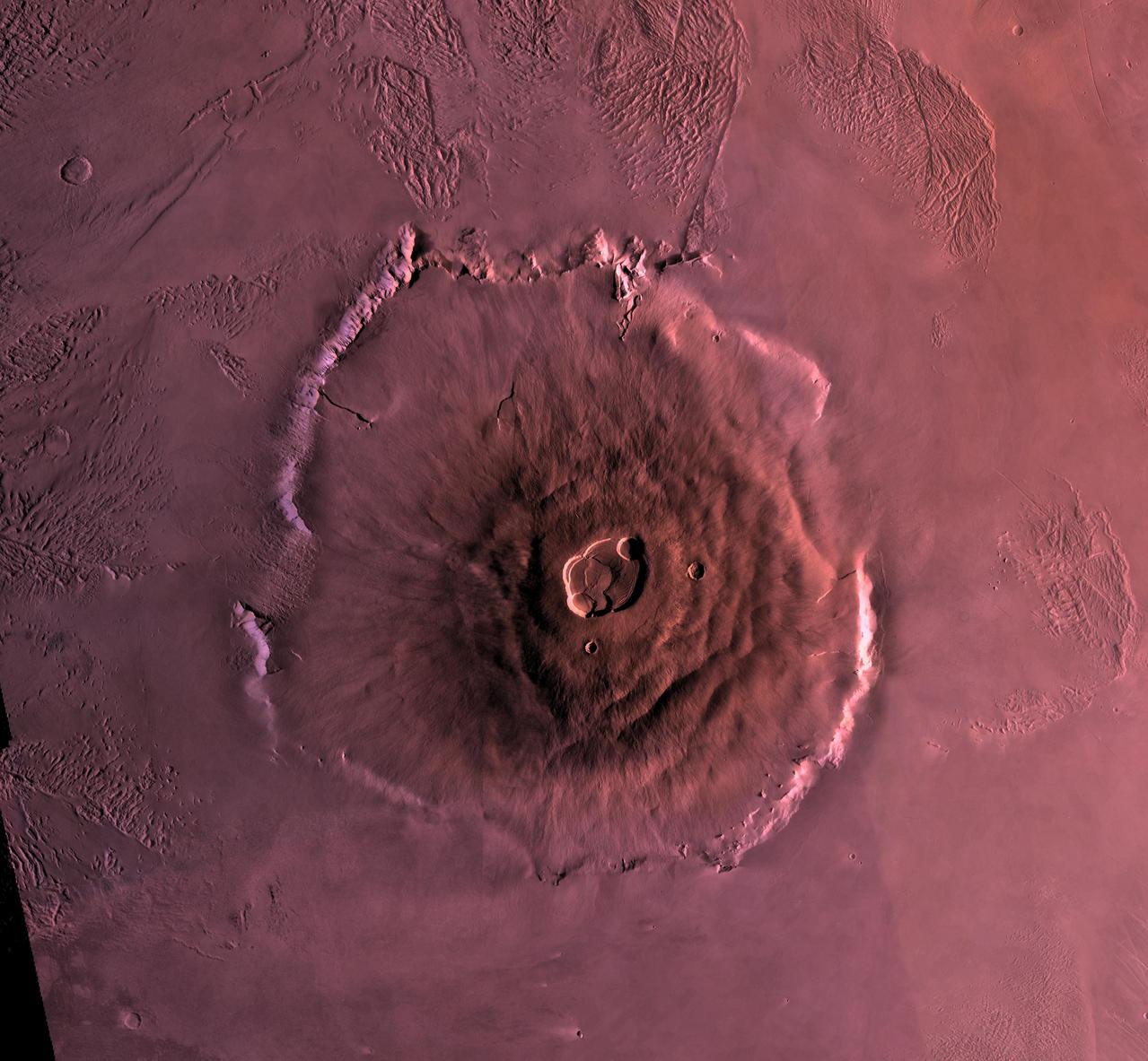
Shown here is a digital mosaic of Olympus Mons, the largest known volcano in the Solar System. It is 27 kilometers high, over 600 kilometers at the base, and is surrounded by a well-defined scarp that is up to 6 km high. Lava flows drape over the scarp in places. Much of the plains surrounding the volcano are covered by the ridged and grooved 'aureole' of Olympus Mons. The origin of the aureole is controversial, but may be related to gravity sliding off of the flanks of an ancestral volcano. The summit caldera (central depression) is almost 3 km deep and 25 km across. It probably formed from recurrent collapse following drainage of magma resulting from flank eruptions. http://photojournal.jpl.nasa.gov/catalog/PIA00300
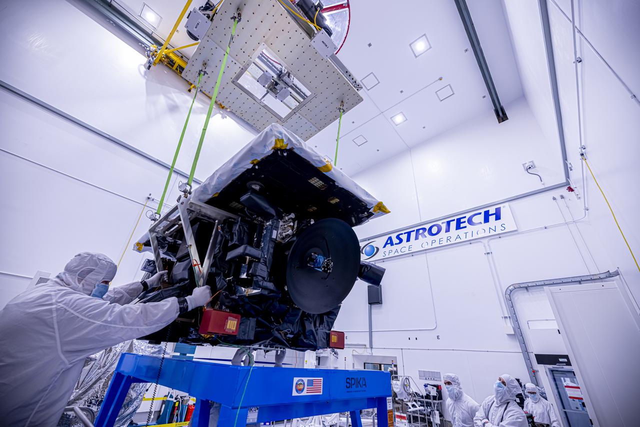
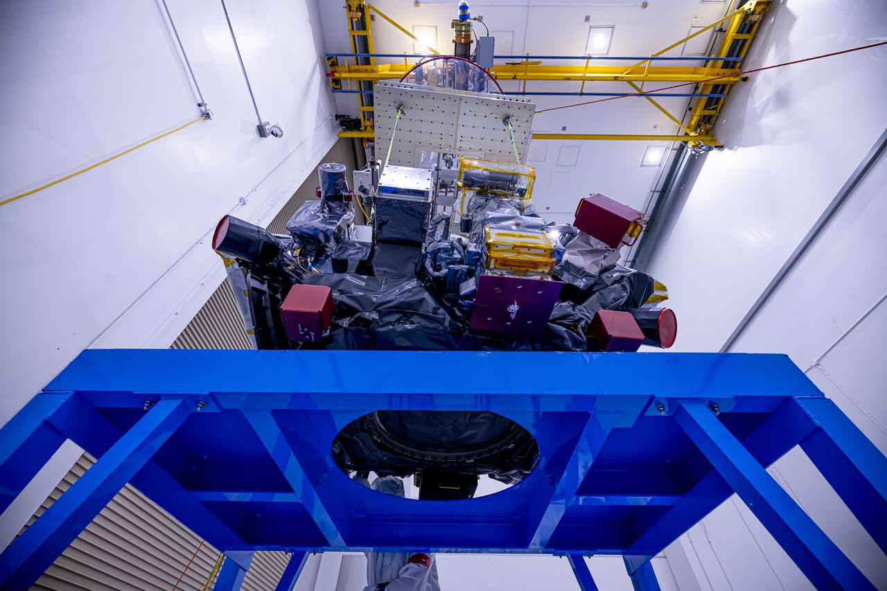
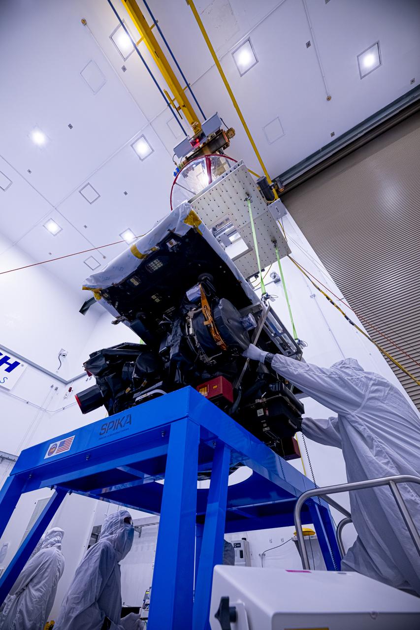
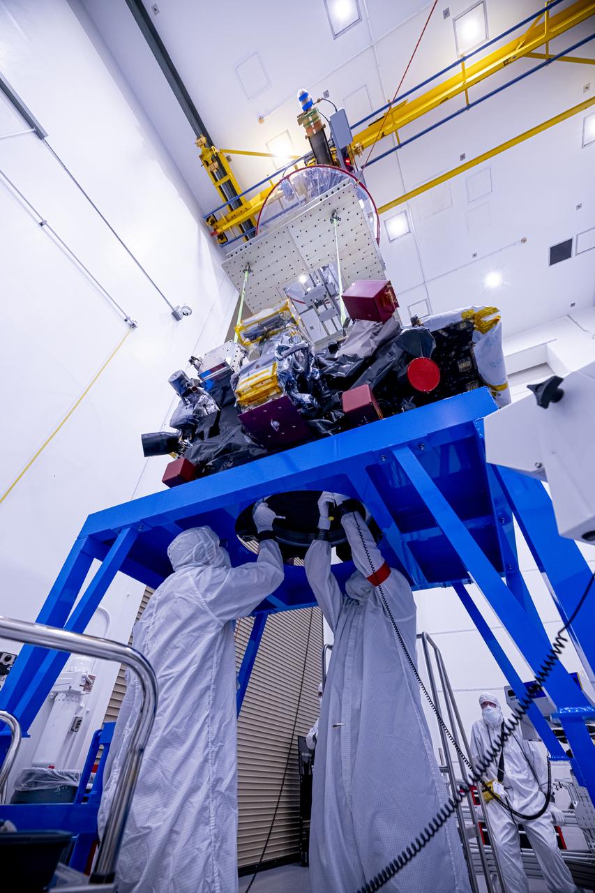
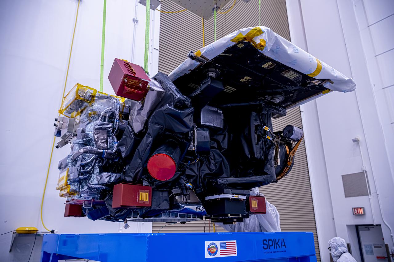
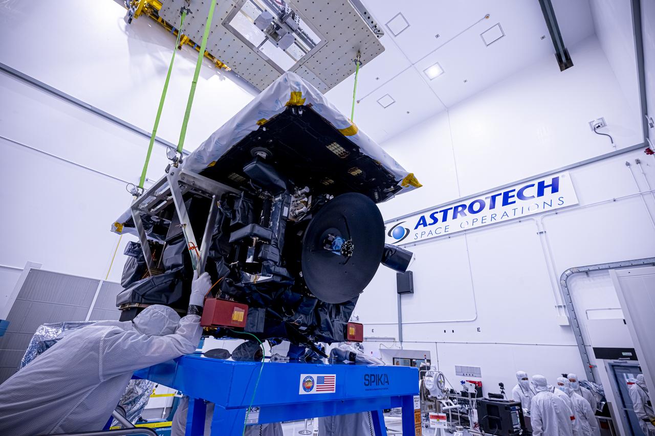
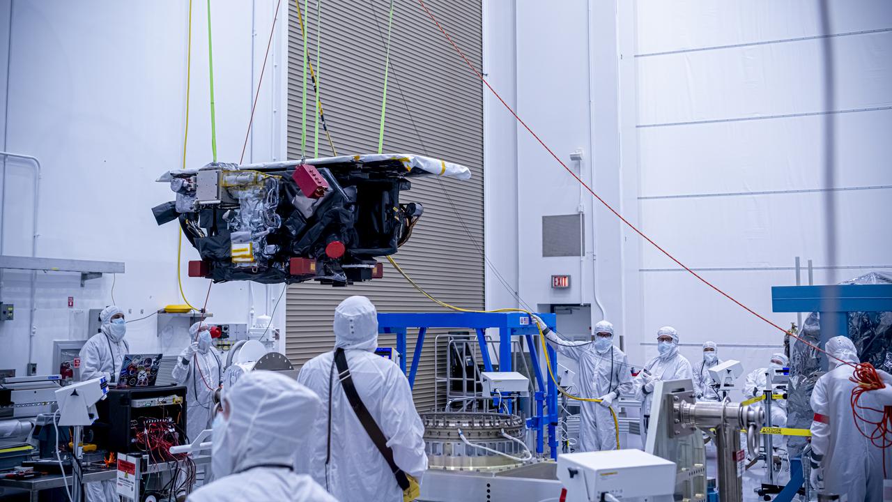
Technicians use a crane to lift the National Oceanic and Atmospheric Administration’s (NOAA) Space Weather Follow On–Lagrange 1 (SWFO-L1) Observatory onto a work stand on Friday, July 25, 2025, during prelaunch processing at the Astrotech Space Operations Facility near NASA’s Kennedy Space Center in Florida. The SWFO-L1 mission will observe solar eruptions, and monitor incoming space weather 24/7, providing early warnings and validating forecasts that protect vital communication and navigation infrastructure, economic interests, and national security, both on Earth and in space. The observatory will launch as a rideshare with NASA’s IMAP (Interstellar Mapping and Acceleration Probe) no earlier than September 2025.
Technicians use a crane to lift the National Oceanic and Atmospheric Administration’s (NOAA) Space Weather Follow On–Lagrange 1 (SWFO-L1) Observatory onto a work stand on Friday, July 25, 2025, during prelaunch processing at the Astrotech Space Operations Facility near NASA’s Kennedy Space Center in Florida. The SWFO-L1 mission will observe solar eruptions, and monitor incoming space weather 24/7, providing early warnings and validating forecasts that protect vital communication and navigation infrastructure, economic interests, and national security, both on Earth and in space. The observatory will launch as a rideshare with NASA’s IMAP (Interstellar Mapping and Acceleration Probe) no earlier than September 2025.
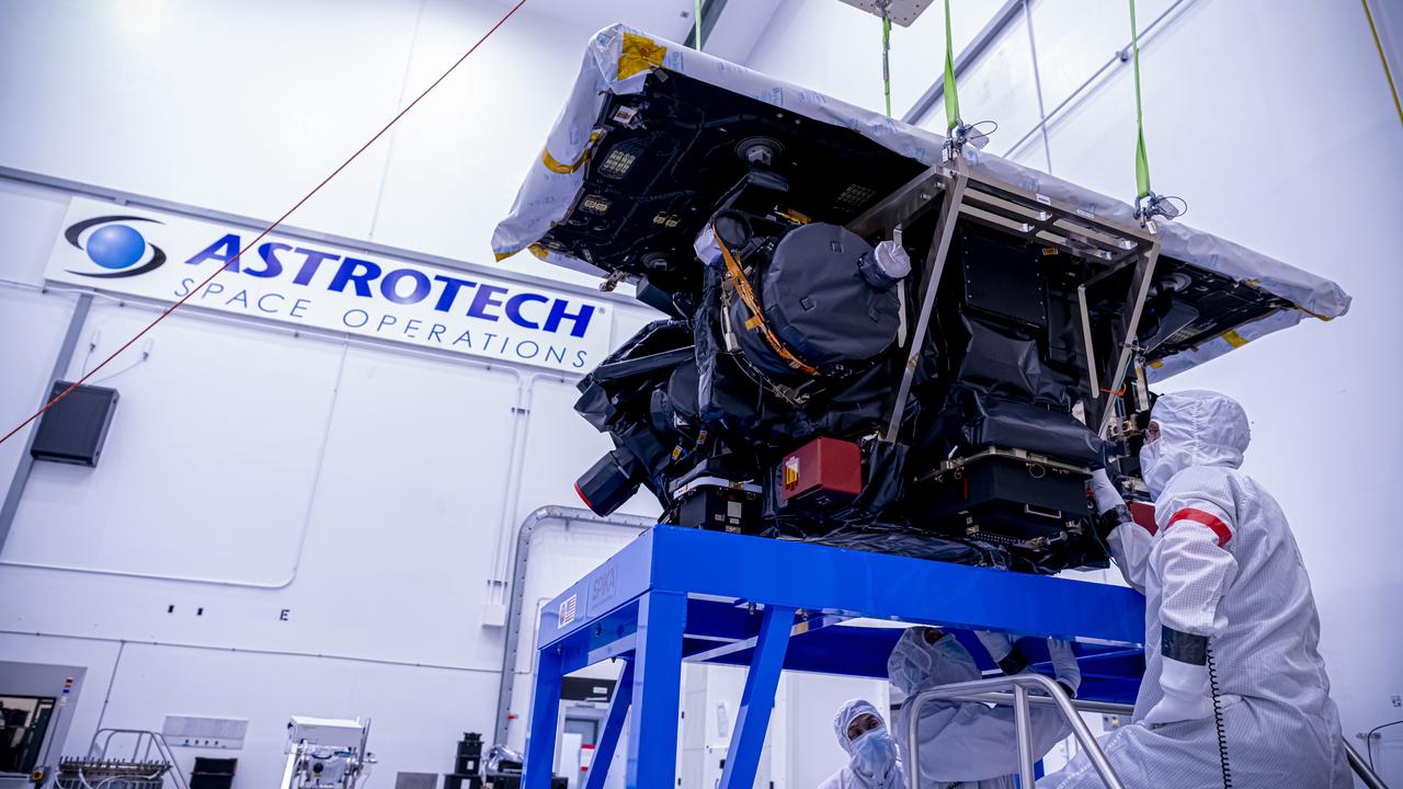
With hardware in the foreground, technicians use a crane to lift the National Oceanic and Atmospheric Administration’s (NOAA) Space Weather Follow On–Lagrange 1 (SWFO-L1) Observatory onto a work stand on Friday, July 25, 2025, during prelaunch processing at the Astrotech Space Operations Facility near NASA’s Kennedy Space Center in Florida. The SWFO-L1 mission will observe solar eruptions, and monitor incoming space weather 24/7, providing early warnings and validating forecasts that protect vital communication and navigation infrastructure, economic interests, and national security, both on Earth and in space. The observatory will launch as a rideshare with NASA’s IMAP (Interstellar Mapping and Acceleration Probe) no earlier than September 2025.
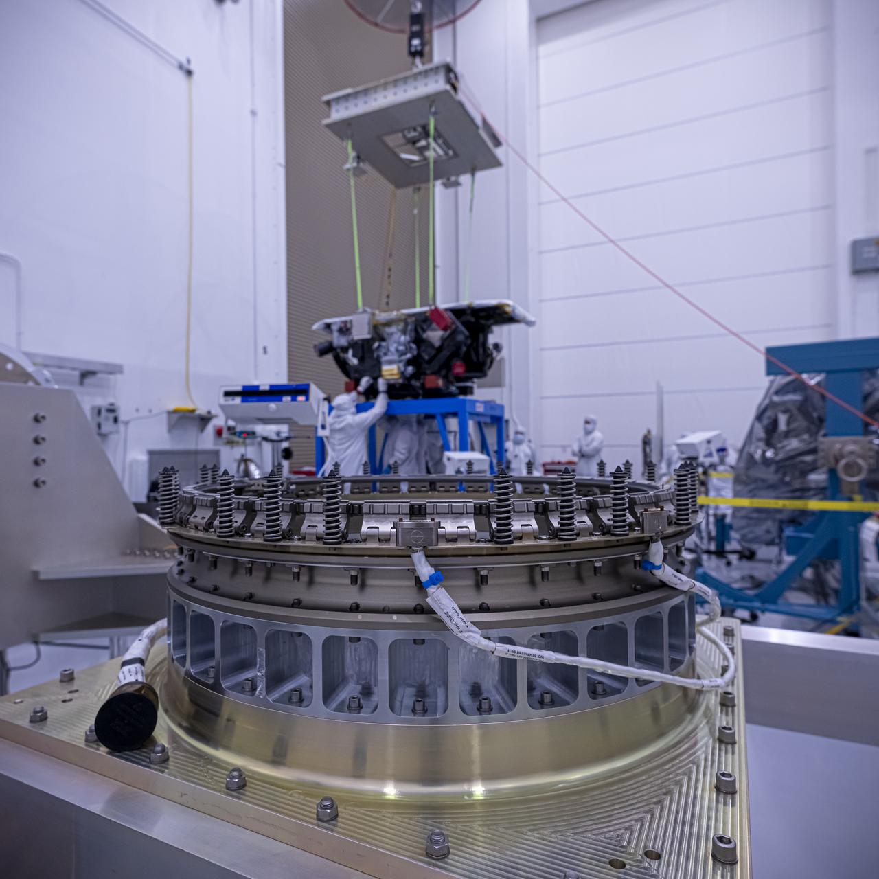
Technicians use a crane to lift the National Oceanic and Atmospheric Administration’s (NOAA) Space Weather Follow On–Lagrange 1 (SWFO-L1) Observatory onto a work stand on Friday, July 25, 2025, during prelaunch processing at the Astrotech Space Operations Facility near NASA’s Kennedy Space Center in Florida. The SWFO-L1 mission will observe solar eruptions, and monitor incoming space weather 24/7, providing early warnings and validating forecasts that protect vital communication and navigation infrastructure, economic interests, and national security, both on Earth and in space. The observatory will launch as a rideshare with NASA’s IMAP (Interstellar Mapping and Acceleration Probe) no earlier than September 2025.
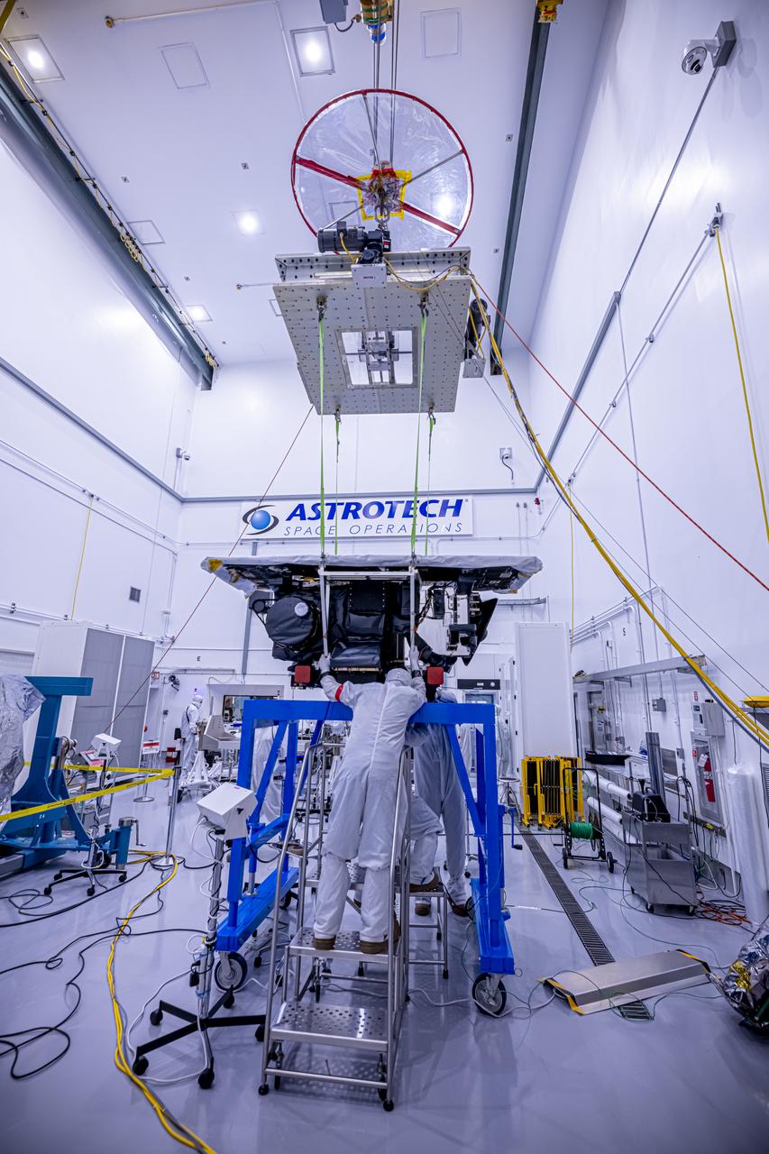
Technicians use a crane to lift the National Oceanic and Atmospheric Administration’s (NOAA) Space Weather Follow On–Lagrange 1 (SWFO-L1) Observatory onto a work stand on Friday, July 25, 2025, during prelaunch processing at the Astrotech Space Operations Facility near NASA’s Kennedy Space Center in Florida. The SWFO-L1 mission will observe solar eruptions, and monitor incoming space weather 24/7, providing early warnings and validating forecasts that protect vital communication and navigation infrastructure, economic interests, and national security, both on Earth and in space. The observatory will launch as a rideshare with NASA’s IMAP (Interstellar Mapping and Acceleration Probe) no earlier than September 2025.
Technicians use a crane to lift the National Oceanic and Atmospheric Administration’s (NOAA) Space Weather Follow On–Lagrange 1 (SWFO-L1) Observatory onto a work stand on Friday, July 25, 2025, during prelaunch processing at the Astrotech Space Operations Facility near NASA’s Kennedy Space Center in Florida. The SWFO-L1 mission will observe solar eruptions, and monitor incoming space weather 24/7, providing early warnings and validating forecasts that protect vital communication and navigation infrastructure, economic interests, and national security, both on Earth and in space. The observatory will launch as a rideshare with NASA’s IMAP (Interstellar Mapping and Acceleration Probe) no earlier than September 2025.
Technicians use a crane to lift the National Oceanic and Atmospheric Administration’s (NOAA) Space Weather Follow On–Lagrange 1 (SWFO-L1) Observatory onto a work stand on Friday, July 25, 2025, during prelaunch processing at the Astrotech Space Operations Facility near NASA’s Kennedy Space Center in Florida. The SWFO-L1 mission will observe solar eruptions, and monitor incoming space weather 24/7, providing early warnings and validating forecasts that protect vital communication and navigation infrastructure, economic interests, and national security, both on Earth and in space. The observatory will launch as a rideshare with NASA’s IMAP (Interstellar Mapping and Acceleration Probe) no earlier than September 2025.
Technicians use a crane to lift the National Oceanic and Atmospheric Administration’s (NOAA) Space Weather Follow On–Lagrange 1 (SWFO-L1) Observatory onto a work stand on Friday, July 25, 2025, during prelaunch processing at the Astrotech Space Operations Facility near NASA’s Kennedy Space Center in Florida. The SWFO-L1 mission will observe solar eruptions, and monitor incoming space weather 24/7, providing early warnings and validating forecasts that protect vital communication and navigation infrastructure, economic interests, and national security, both on Earth and in space. The observatory will launch as a rideshare with NASA’s IMAP (Interstellar Mapping and Acceleration Probe) no earlier than September 2025.
Technicians use a crane to lift the National Oceanic and Atmospheric Administration’s (NOAA) Space Weather Follow On–Lagrange 1 (SWFO-L1) Observatory onto a work stand on Friday, July 25, 2025, during prelaunch processing at the Astrotech Space Operations Facility near NASA’s Kennedy Space Center in Florida. The SWFO-L1 mission will observe solar eruptions, and monitor incoming space weather 24/7, providing early warnings and validating forecasts that protect vital communication and navigation infrastructure, economic interests, and national security, both on Earth and in space. The observatory will launch as a rideshare with NASA’s IMAP (Interstellar Mapping and Acceleration Probe) no earlier than September 2025.
Technicians use a crane to lift the National Oceanic and Atmospheric Administration’s (NOAA) Space Weather Follow On–Lagrange 1 (SWFO-L1) Observatory onto a work stand on Friday, July 25, 2025, during prelaunch processing at the Astrotech Space Operations Facility near NASA’s Kennedy Space Center in Florida. The SWFO-L1 mission will observe solar eruptions, and monitor incoming space weather 24/7, providing early warnings and validating forecasts that protect vital communication and navigation infrastructure, economic interests, and national security, both on Earth and in space. The observatory will launch as a rideshare with NASA’s IMAP (Interstellar Mapping and Acceleration Probe) no earlier than September 2025.

Solar Flare Extremely energetic objects permeate the universe. But close to home, the sun produces its own dazzling lightshow, producing the largest explosions in our solar system and driving powerful solar storms.. When solar activity contorts and realigns the sun’s magnetic fields, vast amounts of energy can be driven into space. This phenomenon can create a sudden flash of light—a solar flare. Flares typically last a few minutes and unleash energies equivalent to millions of hydrogen bombs. The above picture features a filament eruption on the sun, accompanied by solar flares. To learn more about solar flares, go to NASA’s SDO mission: <a href="http://www.nasa.gov/sdo" rel="nofollow">www.nasa.gov/sdo</a> --------------------------------- Original caption: <b>Click here to view an image showing the size of this CME compared to the size of Earth: <a href="http://bit.ly/RkYr7z" rel="nofollow">bit.ly/RkYr7z</a> </b> On August 31, 2012 a long filament of solar material that had been hovering in the sun's atmosphere, the corona, erupted out into space at 4:36 p.m. EDT. The coronal mass ejection, or CME, traveled at over 900 miles per second. The CME did not travel directly toward Earth, but did connect with Earth's magnetic environment, or magnetosphere, causing aurora to appear on the night of Monday, September 3. Pictured here is a lighten blended version of the 304 and 171 angstrom wavelengths. Cropped Credit: NASA/GSFC/SDO <b><a href="http://www.nasa.gov/audience/formedia/features/MP_Photo_Guidelines.html" rel="nofollow">NASA image use policy.</a></b> <b><a href="http://www.nasa.gov/centers/goddard/home/index.html" rel="nofollow">NASA Goddard Space Flight Center</a></b> enables NASA’s mission through four scientific endeavors: Earth Science, Heliophysics, Solar System Exploration, and Astrophysics. Goddard plays a leading role in NASA’s accomplishments by contributing compelling scientific knowledge to advance the Agency’s mission. <b>Follow us on <a href="http://twitter.com/NASA_GoddardPix" rel="nofollow">Twitter</a></b> <b>Like us on <a href="http://www.facebook.com/pages/Greenbelt-MD/NASA-Goddard/395013845897?ref=tsd" rel="nofollow">Facebook</a></b> <b>Find us on <a href="http://instagrid.me/nasagoddard/?vm=grid" rel="nofollow">Instagram</a></b>
NASA's Solar Dynamics Observatory captured these images of a solar flare on Oct. 2, 2014. The solar flare is the bright flash of light on the right limb of the sun. A burst of solar material erupting out into space can be seen just below it. Read more: <a href="http://1.usa.gov/1mW8rel" rel="nofollow">1.usa.gov/1mW8rel</a> Credit: NASA/Goddard/SDO <b><a href="http://www.nasa.gov/audience/formedia/features/MP_Photo_Guidelines.html" rel="nofollow">NASA image use policy.</a></b> <b><a href="http://www.nasa.gov/centers/goddard/home/index.html" rel="nofollow">NASA Goddard Space Flight Center</a></b> enables NASA’s mission through four scientific endeavors: Earth Science, Heliophysics, Solar System Exploration, and Astrophysics. Goddard plays a leading role in NASA’s accomplishments by contributing compelling scientific knowledge to advance the Agency’s mission. <b>Follow us on <a href="http://twitter.com/NASAGoddardPix" rel="nofollow">Twitter</a></b> <b>Like us on <a href="http://www.facebook.com/pages/Greenbelt-MD/NASA-Goddard/395013845897?ref=tsd" rel="nofollow">Facebook</a></b> <b>Find us on <a href="http://instagram.com/nasagoddard?vm=grid" rel="nofollow">Instagram</a></b>
A dark line snaked across the lower half of the sun on Feb.10, 2015, as seen in this image from NASA's Solar Dynamics Observatory, or SDO. SDO shows colder material as dark and hotter material as light, so the line is, in fact, an enormous swatch of colder material hovering in the sun's atmosphere, the corona. Stretched out, that line – or solar filament as scientists call it – would be more than 533,000 miles long. That is longer than 67 Earths lined up in a row. Filaments can float sedately for days before disappearing. Sometimes they also erupt out into space, releasing solar material in a shower that either rains back down or escapes out into space, becoming a moving cloud known as a coronal mass ejection, or CME. SDO captured images of the filament in numerous wavelengths, each of which helps highlight material of different temperatures on the sun. By looking at such features in different wavelengths and temperatures, scientists learn more about what causes these structures, as well as what catalyzes their occasional eruptions. For more on SDO, visit: <a href="http://www.nasa.gov/sdo" rel="nofollow">www.nasa.gov/sdo</a> Karen C. Fox NASA's Goddard Space Flight Center, Greenbelt, Maryland Credit: NASA/Goddard/SDO <b><a href="http://www.nasa.gov/audience/formedia/features/MP_Photo_Guidelines.html" rel="nofollow">NASA image use policy.</a></b> <b><a href="http://www.nasa.gov/centers/goddard/home/index.html" rel="nofollow">NASA Goddard Space Flight Center</a></b> enables NASA’s mission through four scientific endeavors: Earth Science, Heliophysics, Solar System Exploration, and Astrophysics. Goddard plays a leading role in NASA’s accomplishments by contributing compelling scientific knowledge to advance the Agency’s mission. <b>Follow us on <a href="http://twitter.com/NASAGoddardPix" rel="nofollow">Twitter</a></b> <b>Like us on <a href="http://www.facebook.com/pages/Greenbelt-MD/NASA-Goddard/395013845897?ref=tsd" rel="nofollow">Facebook</a></b> <b>Find us on <a href="http://instagram.com/nasagoddard?vm=grid" rel="nofollow">Instagram</a></b>
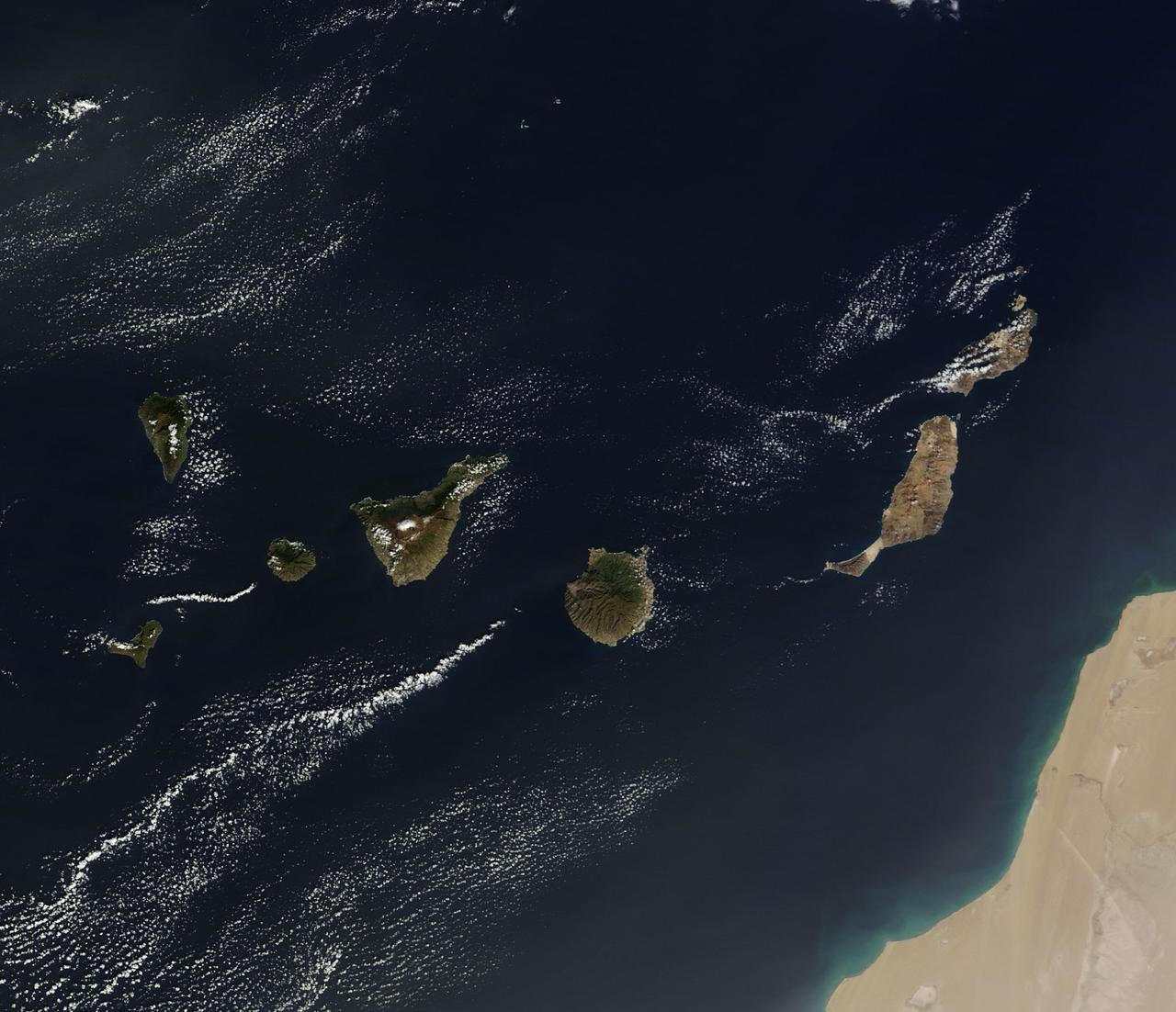
On December 10, 2013 the Moderate Resolution Imaging Spectroradiometer (MODIS) aboard NASA’s Terra satellite flew across the central Atlantic Ocean and captured a true-color image of the Canary Islands. Lying off of the coast of Western Sahara and Morocco, the islands were created by successive submarine volcanic eruptions which raised the ocean floor vertically until some of land rose above sea level. The oldest islands lie in the east and the youngest in the west. From east to west, the major islands seen in this image are: Lanzarote, Fuerteventura, Gran Canaria, Tenerife, La Gomera, La Palmera and El Hierro. While the creation of the islands began in the Late Cretaceous Period (70 – 80 million years ago), active volcanic activity continues. In 2011, a spectacular submarine eruption occurred just off the shore of El Hierro. The volcano became quiet again, but very recently increasing earthquakes and changing height of El Hierro suggested the volcano may again be entering an active eruptive phase. On December 27 the island’s volcano monitoring agency had raised the volcanic eruption risk for El Hierro to “yellow” – a code that means increasing activity but no eruption imminent. That afternoon a magnitude 5.1 earthquake struck offshore at El Hierro. The epicenter was 9 miles (15 km) deep, and it was one of the largest quakes ever recorded at the island. Credit: NASA/GSFC/Jeff Schmaltz/MODIS Land Rapid Response Team <b><a href="http://www.nasa.gov/audience/formedia/features/MP_Photo_Guidelines.html" rel="nofollow">NASA image use policy.</a></b> <b><a href="http://www.nasa.gov/centers/goddard/home/index.html" rel="nofollow">NASA Goddard Space Flight Center</a></b> enables NASA’s mission through four scientific endeavors: Earth Science, Heliophysics, Solar System Exploration, and Astrophysics. Goddard plays a leading role in NASA’s accomplishments by contributing compelling scientific knowledge to advance the Agency’s mission. <b>Follow us on <a href="http://twitter.com/NASA_GoddardPix" rel="nofollow">Twitter</a></b> <b>Like us on <a href="http://www.facebook.com/pages/Greenbelt-MD/NASA-Goddard/395013845897?ref=tsd" rel="nofollow">Facebook</a></b> <b>Find us on <a href="http://instagram.com/nasagoddard?vm=grid" rel="nofollow">Instagram</a></b>
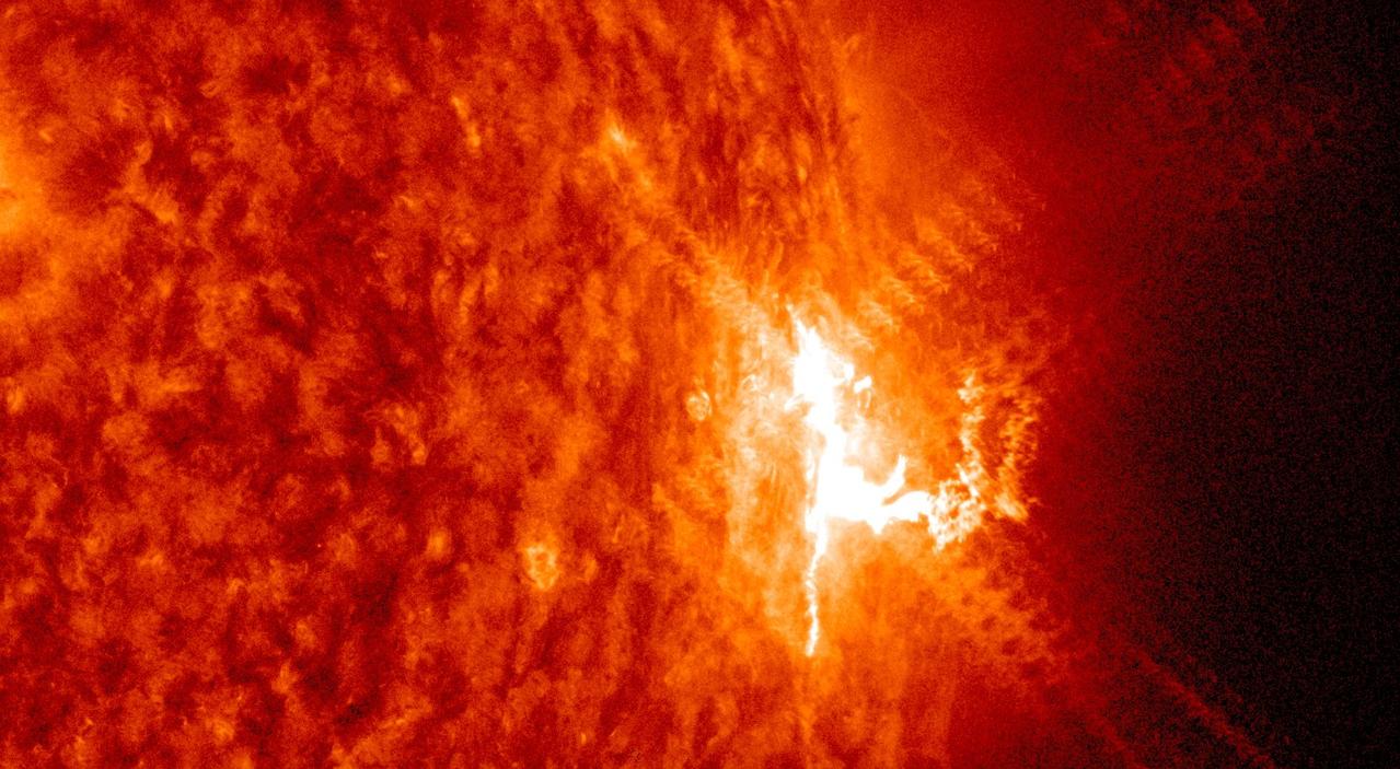
The sun emitted three mid-level solar flares on July 22-23, 2016, the strongest peaking at 1:16 am EDT on July 23. The sun is currently in a period of low activity, moving toward what's called solar minimum when there are few to no solar eruptions – so these flares were the first large ones observed since April. They are categorized as mid-strength flares, substantially less intense than the most powerful solar flares. These flares were classified as M-level flares. M-class flares are the category just below the most intense flares, X-class flares. The number provides more information about its strength. An M2 is twice as intense as an M1, an M3 is three times as intense, etc. Of these three flares: The first was an M5.0, which peaked at 10:11 pm EDT on July 22, 2016. The second -- the strongest -- was an M7.6, which peaked at 1:16 am EDT on July 23. The final was an M5.5, which peaked 15 minutes later at 1:31 am EDT. Credit: NASA/Goddard/SDO
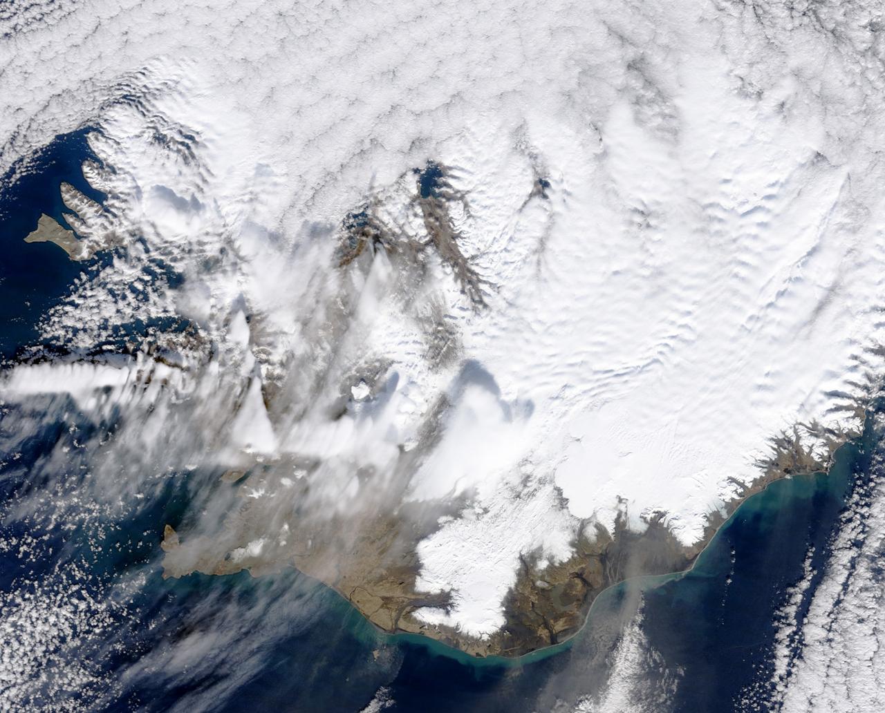
March 31, 2010..The volcanic eruption near Eyjafjallajökull persists into its second week, with continued lava fountaining and lava flows spilling into nearby canyons. The eruption is located at the Fimmvörduháls Pass between the Eyjafjallajökull ice field to the west (left) and the Mýrdalsjökull ice field to the east (right). This natural-color satellite image was acquired on March 26, 2010, by the MODIS aboard NASA’s Terra satellite. Dark ash and scoria cover the northern half of the Fimmvörduháls Pass. White snow covers the rest of the pass, sandwiched between white glaciers. Snow-free land is tan, brown, or dark gray, devoid of vegetation in early spring. To download a high res version of this image go to: <a href="http://modis.gsfc.nasa.gov/gallery/individual.php?db_date=2010-03-31" rel="nofollow">modis.gsfc.nasa.gov/gallery/individual.php?db_date=2010-0...</a> <b><a href="http://www.nasa.gov/centers/goddard/home/index.html" rel="nofollow">NASA Goddard Space Flight Center</a></b> is home to the nation's largest organization of combined scientists, engineers and technologists that build spacecraft, instruments and new technology to study the Earth, the sun, our solar system, and the universe.
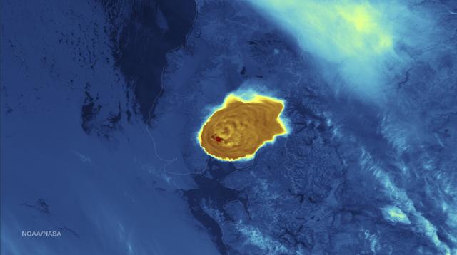
Calbuco Volcano in southern Chile has erupted for the first time since 1972, with the last major eruption occurring in 1961 that sent ash columns 12-15 kilometers high. This image was taken by the Suomi NPP satellite's VIIRS instrument in a high resolution infrared channel around 0515Z on April 23, 2015. Credit: NOAA/NASA/NPP/VIIRS <b><a href="http://goes.gsfc.nasa.gov/" rel="nofollow">Credit: NOAA/NASA GOES Project</a></b> <b><a href="http://www.nasa.gov/audience/formedia/features/MP_Photo_Guidelines.html" rel="nofollow">NASA image use policy.</a></b> <b><a href="http://www.nasa.gov/centers/goddard/home/index.html" rel="nofollow">NASA Goddard Space Flight Center</a></b> enables NASA’s mission through four scientific endeavors: Earth Science, Heliophysics, Solar System Exploration, and Astrophysics. Goddard plays a leading role in NASA’s accomplishments by contributing compelling scientific knowledge to advance the Agency’s mission. <b>Follow us on <a href="http://twitter.com/NASAGoddardPix" rel="nofollow">Twitter</a></b> <b>Like us on <a href="http://www.facebook.com/pages/Greenbelt-MD/NASA-Goddard/395013845897?ref=tsd" rel="nofollow">Facebook</a></b> <b>Find us on <a href="http://instagrid.me/nasagoddard/?vm=grid" rel="nofollow">Instagram</a></b>
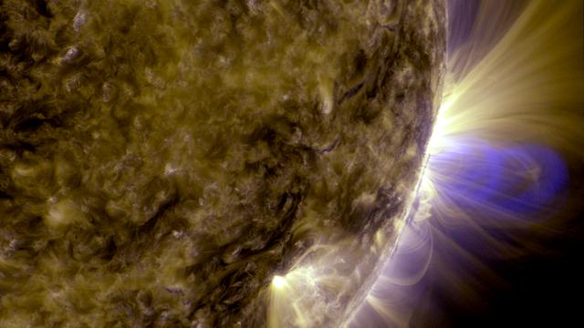
Caption: This is an image of magnetic loops on the sun, captured by NASA's Solar Dynamics Observatory (SDO). It has been processed to highlight the edges of each loop to make the structure more clear. A series of loops such as this is known as a flux rope, and these lie at the heart of eruptions on the sun known as coronal mass ejections (CMEs.) This is the first time scientists were able to discern the timing of a flux rope's formation. (Blended 131 Angstrom and 171 Angstrom images of July 19, 2012 flare and CME.) Credit: NASA/Goddard Space Flight Center/SDO ---- On July 18, 2012, a fairly small explosion of light burst off the lower right limb of the sun. Such flares often come with an associated eruption of solar material, known as a coronal mass ejection or CME – but this one did not. Something interesting did happen, however. Magnetic field lines in this area of the sun's atmosphere, the corona, began to twist and kink, generating the hottest solar material – a charged gas called plasma – to trace out the newly-formed slinky shape. The plasma glowed brightly in extreme ultraviolet images from the Atmospheric Imaging Assembly (AIA) aboard NASA’s Solar Dynamics Observatory (SDO) and scientists were able to watch for the first time the very formation of something they had long theorized was at the heart of many eruptive events on the sun: a flux rope. Eight hours later, on July 19, the same region flared again. This time the flux rope's connection to the sun was severed, and the magnetic fields escaped into space, dragging billions of tons of solar material along for the ride -- a classic CME. "Seeing this structure was amazing," says Angelos Vourlidas, a solar scientist at the Naval Research Laboratory in Washington, D.C. "It looks exactly like the cartoon sketches theorists have been drawing of flux ropes since the 1970s. It was a series of figure eights lined up to look like a giant slinky on the sun." <b>To read more about this new discovery go to: <a href="http://1.usa.gov/14UHsTt" rel="nofollow">1.usa.gov/14UHsTt</a> </b> <b><a href="http://www.nasa.gov/audience/formedia/features/MP_Photo_Guidelines.html" rel="nofollow">NASA image use policy.</a></b> <b><a href="http://www.nasa.gov/centers/goddard/home/index.html" rel="nofollow">NASA Goddard Space Flight Center</a></b> enables NASA’s mission through four scientific endeavors: Earth Science, Heliophysics, Solar System Exploration, and Astrophysics. Goddard plays a leading role in NASA’s accomplishments by contributing compelling scientific knowledge to advance the Agency’s mission. <b>Follow us on <a href="http://twitter.com/NASA_GoddardPix" rel="nofollow">Twitter</a></b> <b>Like us on <a href="http://www.facebook.com/pages/Greenbelt-MD/NASA-Goddard/395013845897?ref=tsd" rel="nofollow">Facebook</a></b> <b>Find us on <a href="http://instagram.com/nasagoddard?vm=grid" rel="nofollow">Instagram</a></b>

NASA’s Solar Dynamics Observatory caught this image of an eruption on the side of the sun on June 18, 2015. The eruption ultimately escaped the sun, growing into a substantial coronal mass ejection, or CME — a giant cloud of solar material traveling through space. This imagery is shown in the 304 Angstrom wavelength of extreme ultraviolet light, a wavelength that highlights material in the low parts of the sun’s atmosphere and that is typically colorized in red. The video clip covers about four hours of the event. Credit: NASA/Goddard/SDO Download: <a href="http://svs.gsfc.nasa.gov/goto?11908" rel="nofollow">svs.gsfc.nasa.gov/goto?11908</a> <b><a href="http://www.nasa.gov/audience/formedia/features/MP_Photo_Guidelines.html" rel="nofollow">NASA image use policy.</a></b> <b><a href="http://www.nasa.gov/centers/goddard/home/index.html" rel="nofollow">NASA Goddard Space Flight Center</a></b> enables NASA’s mission through four scientific endeavors: Earth Science, Heliophysics, Solar System Exploration, and Astrophysics. Goddard plays a leading role in NASA’s accomplishments by contributing compelling scientific knowledge to advance the Agency’s mission. <b>Follow us on <a href="http://twitter.com/NASAGoddardPix" rel="nofollow">Twitter</a></b> <b>Like us on <a href="http://www.facebook.com/pages/Greenbelt-MD/NASA-Goddard/395013845897?ref=tsd" rel="nofollow">Facebook</a></b> <b>Find us on <a href="http://instagrid.me/nasagoddard/?vm=grid" rel="nofollow">Instagram</a></b>

NASA image captured December 6, 2010 To view a video of this event go here: <a href="http://www.flickr.com/photos/gsfc/5258354738">www.flickr.com/photos/gsfc/5258354738</a> A very long solar filament that had been snaking around the Sun erupted (Dec. 6, 2010) with a flourish. STEREO (Behind) caught the action in dramatic detail in extreme ultraviolet light of Helium. It had been almost a million km long (about half a solar radius) and a prominent feature on the Sun visible over two weeks earlier before it rotated out of view. Filaments, elongated clouds of cooler gases suspended above the Sun by magnetic forces, are rather unstable and often break away from the Sun. Credit: NASA/GSFC/SOHO <b><a href="http://www.nasa.gov/centers/goddard/home/index.html" rel="nofollow">NASA Goddard Space Flight Center</a></b> enables NASA’s mission through four scientific endeavors: Earth Science, Heliophysics, Solar System Exploration, and Astrophysics. Goddard plays a leading role in NASA’s accomplishments by contributing compelling scientific knowledge to advance the Agency’s mission. <b>Follow us on <a href="http://twitter.com/NASA_GoddardPix" rel="nofollow">Twitter</a></b> <b>Join us on <a href="http://www.facebook.com/pages/Greenbelt-MD/NASA-Goddard/395013845897?ref=tsd" rel="nofollow">Facebook</a></b>
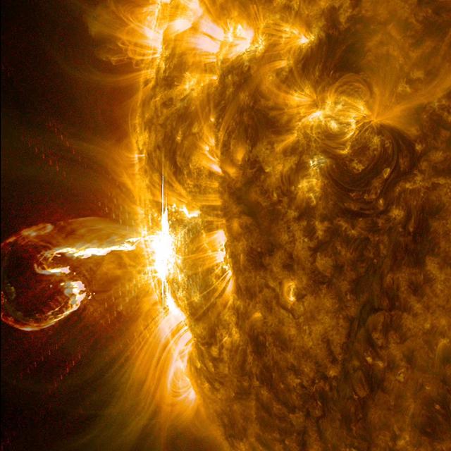
An active region at the edge of the Sun blew out an X4 flare (one of the largest of the solar cycle) and a coronal mass ejection on Feb. 25, 2014. The still image of the ejected plasma (taken at 00:45 UT) shows it curled like a shrimp, but this eruption was no shrimp: it was powerful. The images seen here are a combination of two wavelengths of extreme ultraviolet light (171 and 304 Angstroms). The video clip covers about three hours of activity. Credit: NASA/GSFC/Solar Dynamics Observatory <b><a href="http://www.nasa.gov/audience/formedia/features/MP_Photo_Guidelines.html" rel="nofollow">NASA image use policy.</a></b> <b><a href="http://www.nasa.gov/centers/goddard/home/index.html" rel="nofollow">NASA Goddard Space Flight Center</a></b> enables NASA’s mission through four scientific endeavors: Earth Science, Heliophysics, Solar System Exploration, and Astrophysics. Goddard plays a leading role in NASA’s accomplishments by contributing compelling scientific knowledge to advance the Agency’s mission. <b>Follow us on <a href="http://twitter.com/NASAGoddardPix" rel="nofollow">Twitter</a></b> <b>Like us on <a href="http://www.facebook.com/pages/Greenbelt-MD/NASA-Goddard/395013845897?ref=tsd" rel="nofollow">Facebook</a></b> <b>Find us on <a href="http://instagram.com/nasagoddard?vm=grid" rel="nofollow">Instagram</a></b>
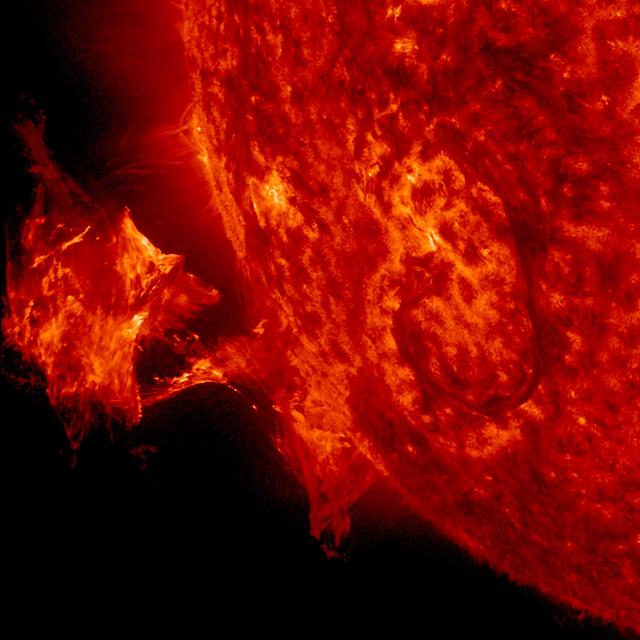
A twisted blob of solar material – a hot, charged gas called plasma – can be seen erupting off the side of the sun on Sept. 26, 2014. The image is from NASA's Solar Dynamics Observatory, focusing in on ionized Helium at 60,000 degrees C. Credit: NASA/SDO <b><a href="http://www.nasa.gov/audience/formedia/features/MP_Photo_Guidelines.html" rel="nofollow">NASA image use policy.</a></b> <b><a href="http://www.nasa.gov/centers/goddard/home/index.html" rel="nofollow">NASA Goddard Space Flight Center</a></b> enables NASA’s mission through four scientific endeavors: Earth Science, Heliophysics, Solar System Exploration, and Astrophysics. Goddard plays a leading role in NASA’s accomplishments by contributing compelling scientific knowledge to advance the Agency’s mission. <b>Follow us on <a href="http://twitter.com/NASAGoddardPix" rel="nofollow">Twitter</a></b> <b>Like us on <a href="http://www.facebook.com/pages/Greenbelt-MD/NASA-Goddard/395013845897?ref=tsd" rel="nofollow">Facebook</a></b> <b>Find us on <a href="http://instagram.com/nasagoddard?vm=grid" rel="nofollow">Instagram</a></b>
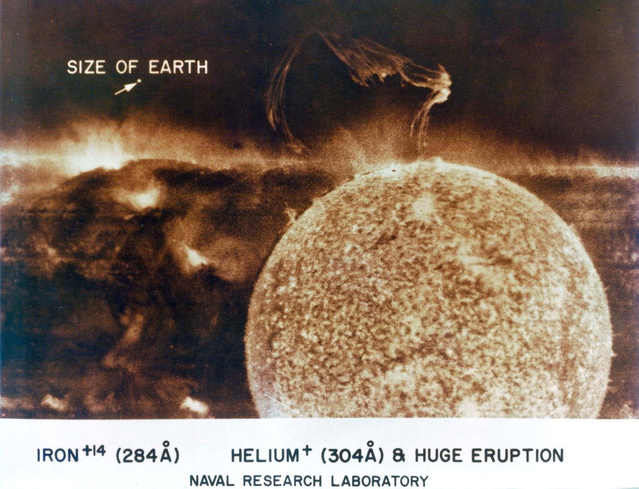
S74-15583 (July 1973) --- A huge solar eruption can be seen in this Spectroheliogram obtained during the Skylab 3 mission by the Extreme Ultraviolet Spectrograph/Spectroheliograph SO82A Experiment aboard the Skylab space station in Earth orbit. SO82 is one of the Apollo Telescope Mount experiments. The SO82 "A" instrument covers the wavelength region from 150-650 angstroms (EUV regions). The magnitude of the eruption can be visualized by comparing it with the small white dot that represents the size of Earth. This photograph reveals for the first time that helium erupting from the sun can stay together to altitudes of up to 500,000 miles. After being ejected from the sun, the gas clouds seem to have come to a standstill, as though blocked by an unseen wall. Some materials appear to have been directed back toward the sun as a rain, distinguished by fine threads. At present it is a challenge to explain this mystery--what forces expelled these huge clouds, then blocked its further progress, yet allowed the cloud to maintain its threads. Both magnetic fields and gravity must play a part, but these curious forms seem to defy explanation based on magnetic and gravitational fields alone. The EUV spectroheliograph was designed and constructed by the U.S. Naval Research Laboratory and the Ball Brothers Research Corporation under the direction of Dr. R. Tousey, the principal investigator for this NASA experiment. On the left may be seen the sun's image in emission from iron atoms which have lost 14 electrons by collision in the sun's million-degree coronal plasma gas. Photo credit: NASA
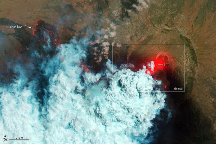
NASA image acquired June 24, 2011 Since it began erupting on June 12, 2011, emissions from Eritrea’s Nabro Volcano have drifted over much of East Africa and the Middle East. Ash has displaced residents living near the volcano and disrupted flights in the region. Despite the volcano’s widespread effects, little is known about the eruption. Nabro is located in an isolated region along the border between Eritrea and Ethiopia, and few English-language reports have been published. Satellite remote sensing is currently the only reliable way to monitor the ongoing eruption. This satellite image is among the first detailed pictures of the erupting vent and lava flows. They were acquired by the Advanced Land Imager (ALI) aboard the Earth Observing-1 (EO-1) satellite on June 24, 2011. The bright red portions of the false-color image (top) indicate hot surfaces. Hot volcanic ash glows above the vent, located in the center of Nabro’s caldera. To the west of the vent, portions of an active lava flow (particularly the front of the flow) are also hot. The speckled pattern on upstream portions of the flow are likely due to the cool, hardened crust splitting and exposing fluid lava as the flow advances. The bulbous blue-white cloud near the vent is likely composed largely of escaping water vapor that condensed as the plume rose and cooled. The whispy, cyan clouds above the lava flow are evidence of degassing from the lava. NASA Earth Observatory image by Robert Simmon, using EO-1 ALI data. Caption by Robert Simmon. Instrument: EO-1 - ALI To download the high res go here: <a href="http://earthobservatory.nasa.gov/IOTD/view.php?id=51216" rel="nofollow">earthobservatory.nasa.gov/IOTD/view.php?id=51216</a> <b><a href="http://www.nasa.gov/centers/goddard/home/index.html" rel="nofollow">NASA Goddard Space Flight Center</a></b> enables NASA’s mission through four scientific endeavors: Earth Science, Heliophysics, Solar System Exploration, and Astrophysics. Goddard plays a leading role in NASA’s accomplishments by contributing compelling scientific knowledge to advance the Agency’s mission. <b>Follow us on <a href="http://twitter.com/NASA_GoddardPix" rel="nofollow">Twitter</a></b> <b>Like us on <a href="http://www.facebook.com/pages/Greenbelt-MD/NASA-Goddard/395013845897?ref=tsd" rel="nofollow">Facebook</a></b> <b>Find us on <a href="http://web.stagram.com/n/nasagoddard/?vm=grid" rel="nofollow">Instagram</a></b>
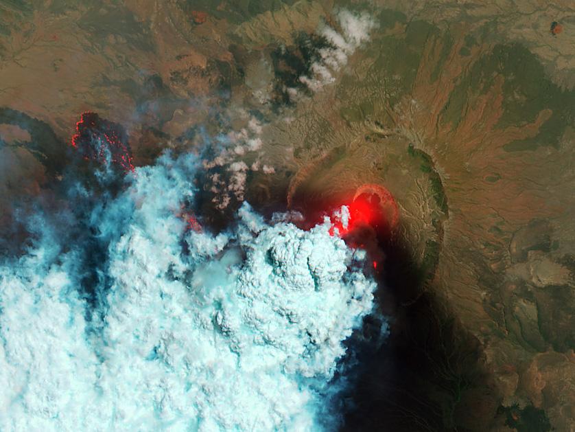
NASA image acquired June 24, 2011 Since it began erupting on June 12, 2011, emissions from Eritrea’s Nabro Volcano have drifted over much of East Africa and the Middle East. Ash has displaced residents living near the volcano and disrupted flights in the region. Despite the volcano’s widespread effects, little is known about the eruption. Nabro is located in an isolated region along the border between Eritrea and Ethiopia, and few English-language reports have been published. Satellite remote sensing is currently the only reliable way to monitor the ongoing eruption. This satellite image is among the first detailed pictures of the erupting vent and lava flows. They were acquired by the Advanced Land Imager (ALI) aboard the Earth Observing-1 (EO-1) satellite on June 24, 2011. The bright red portions of the false-color image (top) indicate hot surfaces. Hot volcanic ash glows above the vent, located in the center of Nabro’s caldera. To the west of the vent, portions of an active lava flow (particularly the front of the flow) are also hot. The speckled pattern on upstream portions of the flow are likely due to the cool, hardened crust splitting and exposing fluid lava as the flow advances. The bulbous blue-white cloud near the vent is likely composed largely of escaping water vapor that condensed as the plume rose and cooled. The whispy, cyan clouds above the lava flow are evidence of degassing from the lava. NASA Earth Observatory image by Robert Simmon, using EO-1 ALI data. Caption by Robert Simmon. Instrument: EO-1 - ALI To download the high res go here: <a href="http://earthobservatory.nasa.gov/IOTD/view.php?id=51216" rel="nofollow">earthobservatory.nasa.gov/IOTD/view.php?id=51216</a> <b><a href="http://www.nasa.gov/centers/goddard/home/index.html" rel="nofollow">NASA Goddard Space Flight Center</a></b> enables NASA’s mission through four scientific endeavors: Earth Science, Heliophysics, Solar System Exploration, and Astrophysics. Goddard plays a leading role in NASA’s accomplishments by contributing compelling scientific knowledge to advance the Agency’s mission. <b>Follow us on <a href="http://twitter.com/NASA_GoddardPix" rel="nofollow">Twitter</a></b> <b>Like us on <a href="http://www.facebook.com/pages/Greenbelt-MD/NASA-Goddard/395013845897?ref=tsd" rel="nofollow">Facebook</a></b> <b>Find us on <a href="http://web.stagram.com/n/nasagoddard/?vm=grid" rel="nofollow">Instagram</a></b>
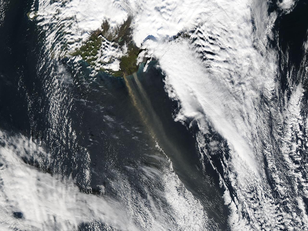
On September 16, 2013 the Moderate Resolution Imaging Spectroradiometer (MODIS) aboard NASA’s Aqua satellite passed over the southern tip of Iceland and captured a remarkable image dust plumes blowing hundreds of kilometers over the Atlantic Ocean. The westernmost plume is dark tan in color and so thick that the blue ocean waters are obscured from view near Iceland's coast. The eastern plume appears broader, thinner and light gray in color. According to the Icelandic Met Office, near the Mýrdalsjökull and Vatnajökull ice-caps there are vast glacial outwash plains which stretch from the glacial margins to the sea. These plains, formed by melt water from glaciers, are known as sandur. Strong northerly winds frequently blow dust from the sandur plains far from the shore. This particular dust plume originates to the east of the Mýrdalsjökull ice cap. The Katla volcano, one of the largest in Iceland, lies under the Mýrdalsjökull glacier and in the general region of the westernmost plume. Katla has a history of large, violent eruptions occurring on an average of every 50-100 years. The volcano has been increasingly restless since 1999, with increased seismicity in recent years. In 2011 a very small eruption was reported, with minimal damage. Because of the increasing restlessness and the dangerous nature of historic eruptions, the volcano is currently carefully monitored. None of the monitoring agencies reported eruption at Katla in mid-September of this year. Credit: NASA/GSFC/Jeff Schmaltz/MODIS Land Rapid Response Team <b><a href="http://www.nasa.gov/audience/formedia/features/MP_Photo_Guidelines.html" rel="nofollow">NASA image use policy.</a></b> <b><a href="http://www.nasa.gov/centers/goddard/home/index.html" rel="nofollow">NASA Goddard Space Flight Center</a></b> enables NASA’s mission through four scientific endeavors: Earth Science, Heliophysics, Solar System Exploration, and Astrophysics. Goddard plays a leading role in NASA’s accomplishments by contributing compelling scientific knowledge to advance the Agency’s mission. <b>Follow us on <a href="http://twitter.com/NASA_GoddardPix" rel="nofollow">Twitter</a></b> <b>Like us on <a href="http://www.facebook.com/pages/Greenbelt-MD/NASA-Goddard/395013845897?ref=tsd" rel="nofollow">Facebook</a></b> <b>Find us on <a href="http://instagram.com/nasagoddard?vm=grid" rel="nofollow">Instagram</a></b>
This false color image of Birt E crater shows the topography of the moon and it is thought to be the source region for lava that carved out Rima Birt, a rille in Mare Nubium. This mare is older than 3.4 billion years, and so is this vent! LROC NAC M1144849711L/R with the a color DTM overlaid; North is up. Download high res: <a href="http://lroc.sese.asu.edu/posts/794" rel="nofollow">lroc.sese.asu.edu/posts/794</a> Credit: NASA/GSFC/Arizona State University More info: Birt E crater was not created like most craters on the Moon; there was no meteorite impact. Lava sputtered out of this pyroclastic vent in Mare Nubium over 3.4 billion years ago, dispersing lava onto the surface and leaving the crater we see today. How can we tell it is a volcanic vent and not an impact crater? Impact craters and volcanic vents can be differentiated because vents often have an irregular or elongated shape (as with Birt E). Impact craters are usually circular in shape, created by the shockwave during an impact event. Also, the vee-shape of this crater is likely a product of the formation mechanism. Vee-shaped vents are thought to be formed from a pyroclastic eruption. Gasses fractionating out of the liquid rock create violent events during eruptions. Explosive eruptions created the shape that we see today, but Birt E could have had a complex history with effusive eruptions forming Rima Birt, a rille flowing from Birt E to the SE. Over long enough time scales Birt E will be filled in with ejecta from newly formed craters around Mare Nubium or by mass wasting of the walls into the crater. Let’s enjoy this ancient crater today while we still can! <b><a href="http://www.nasa.gov/audience/formedia/features/MP_Photo_Guidelines.html" rel="nofollow">NASA image use policy.</a></b> <b><a href="http://www.nasa.gov/centers/goddard/home/index.html" rel="nofollow">NASA Goddard Space Flight Center</a></b> enables NASA’s mission through four scientific endeavors: Earth Science, Heliophysics, Solar System Exploration, and Astrophysics. Goddard plays a leading role in NASA’s accomplishments by contributing compelling scientific knowledge to advance the Agency’s mission. <b>Follow us on <a href="http://twitter.com/NASAGoddardPix" rel="nofollow">Twitter</a></b> <b>Like us on <a href="http://www.facebook.com/pages/Greenbelt-MD/NASA-Goddard/395013845897?ref=tsd" rel="nofollow">Facebook</a></b> <b>Find us on <a href="http://instagram.com/nasagoddard?vm=grid" rel="nofollow">Instagram</a></b>
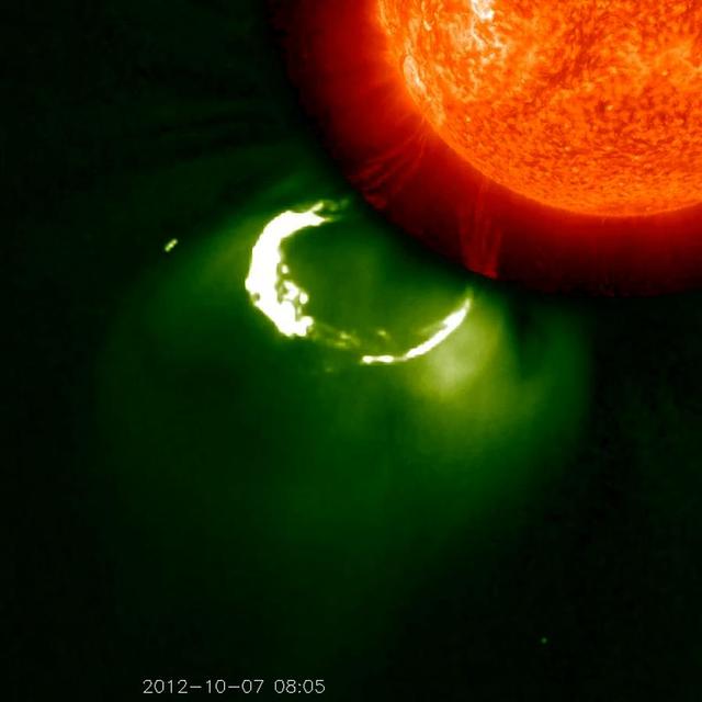
This CME image from Oct. 7, 2012, captured by two instruments on STEREO, shows the eruption from its base out into space. The base of the CME near the sun is seen in extreme ultraviolet light emitted directly from the solar material; the growing loop is seen in visible light. Credit: NASA/STEREO CME WEEK: What To See in CME Images Two main types of explosions occur on the sun: solar flares and coronal mass ejections. Unlike the energy and x-rays produced in a solar flare – which can reach Earth at the speed of light in eight minutes – coronal mass ejections are giant, expanding clouds of solar material that take one to three days to reach Earth. Once at Earth, these ejections, also called CMEs, can impact satellites in space or interfere with radio communications. During CME WEEK from Sept. 22 to 26, 2014, we explore different aspects of these giant eruptions that surge out from the star we live with. When a coronal mass ejection blasts off the sun, scientists rely on instruments called coronagraphs to track their progress. Coronagraphs block out the bright light of the sun, so that the much fainter material in the solar atmosphere -- including CMEs -- can be seen in the surrounding space. CMEs appear in these images as expanding shells of material from the sun's atmosphere -- sometimes a core of colder, solar material (called a filament) from near the sun's surface moves in the center. But mapping out such three-dimensional components from a two-dimensional image isn't easy. Watch the slideshow to find out how scientists interpret what they see in CME pictures. The images in the slideshow are from the three sets of coronagraphs NASA currently has in space. One is on the joint European Space Agency and NASA Solar and Heliospheric Observatory, or SOHO. SOHO launched in 1995, and sits between Earth and the sun about a million miles away from Earth. The other two coronagraphs are on the two spacecraft of the NASA Solar Terrestrial Relations Observatory, or STEREO, mission, which launched in 2006. The two STEREO spacecraft are both currently viewing the far side of the sun. Together these instruments help scientists create a three-dimensional model of any CME as its journey unfolds through interplanetary space. Such information can show why a given characteristic of a CME close to the sun might lead to a given effect near Earth, or any other planet in the solar system...<b><a href="http://www.nasa.gov/audience/formedia/features/MP_Photo_Guidelines.html" rel="nofollow">NASA image use policy.</a></b> <b><a href="http://www.nasa.gov/centers/goddard/home/index.html" rel="nofollow">NASA Goddard Space Flight Center</a></b> enables NASA’s mission through four scientific endeavors: Earth Science, Heliophysics, Solar System Exploration, and Astrophysics. Goddard plays a leading role in NASA’s accomplishments by contributing compelling scientific knowledge to advance the Agency’s mission. <b>Follow us on <a href="http://twitter.com/NASAGoddardPix" rel="nofollow">Twitter</a></b> <b>Like us on <a href="http://www.facebook.com/pages/Greenbelt-MD/NASA-Goddard/395013845897?ref=tsd" rel="nofollow">Facebook</a></b> <b>Find us on <a href="http://instagram.com/nasagoddard?vm=grid" rel="nofollow">Instagram</a></b>
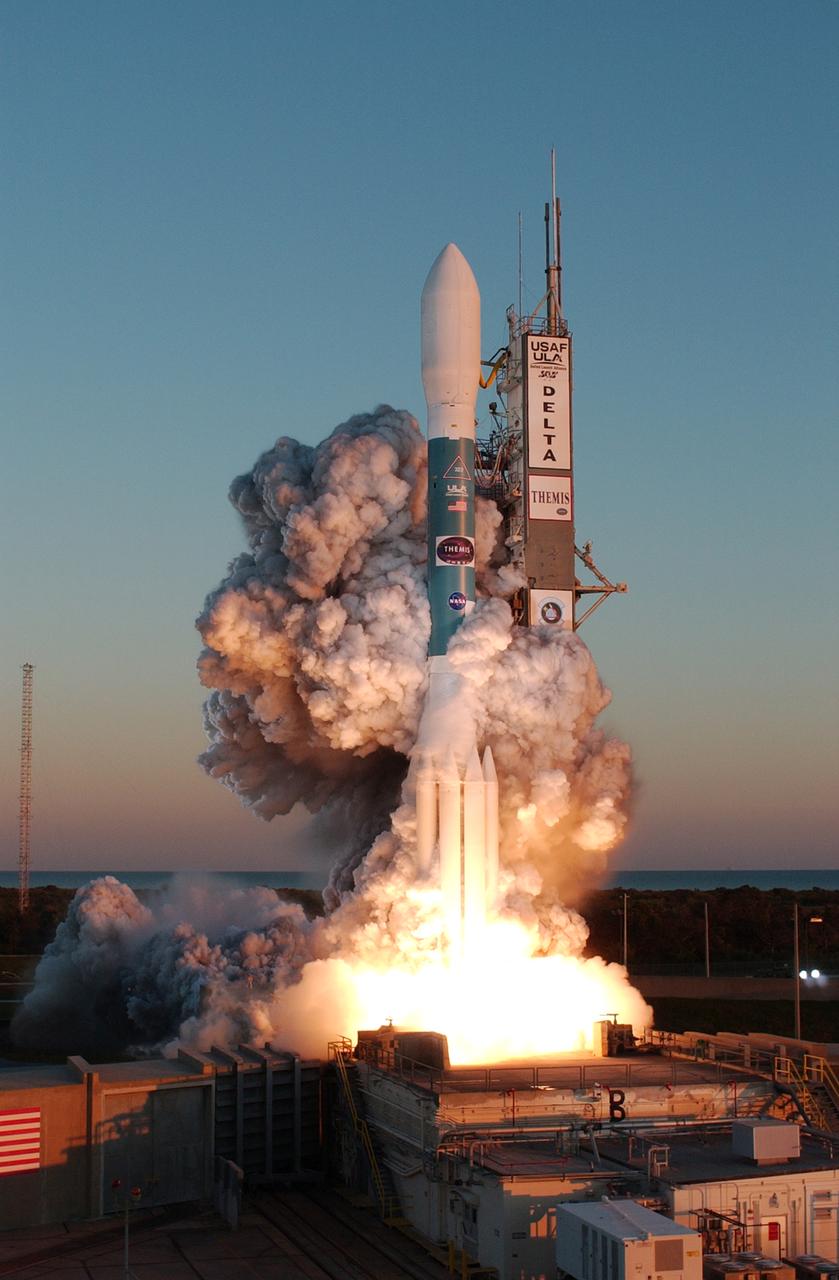
At Cape Canaveral Air Force Station, clouds of smoke form around the Delta II rocket with NASA's THEMIS spacecraft aboard as it blasts off Pad 17-B at 6:01 p.m. EST. THEMIS, an acronym for Time History of Events and Macroscale Interactions during Substorms, consists of five identical probes that will track violent, colorful eruptions near the North Pole. This will be the largest number of scientific satellites NASA has ever launched into orbit aboard a single rocket. The THEMIS mission aims to unravel the mystery behind auroral substorms, an avalanche of magnetic energy powered by the solar wind that intensifies the northern and southern lights. The mission will investigate what causes auroras in the Earth’s atmosphere to dramatically change from slowly shimmering waves of light to wildly shifting streaks of bright color.
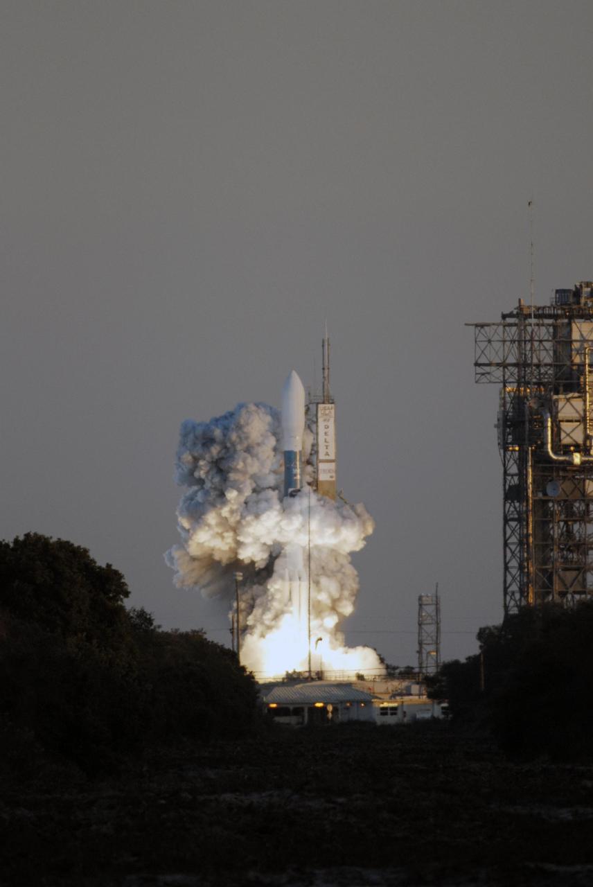
KENNEDY SPACE CENTER, FLA. -- Amid billows of smoke, the Delta II rocket with NASA's THEMIS spacecraft aboard lifts off Pad 17-B at Cape Canaveral Air Force Station at 6:01 p.m. EST. THEMIS, an acronym for Time History of Events and Macroscale Interactions during Substorms, consists of five identical probes that will track violent, colorful eruptions near the North Pole. This will be the largest number of scientific satellites NASA has ever launched into orbit aboard a single rocket. The THEMIS mission aims to unravel the mystery behind auroral substorms, an avalanche of magnetic energy powered by the solar wind that intensifies the northern and southern lights. The mission will investigate what causes auroras in the Earth’s atmosphere to dramatically change from slowly shimmering waves of light to wildly shifting streaks of bright color. Photo credit: NASA/Kim Shiflett
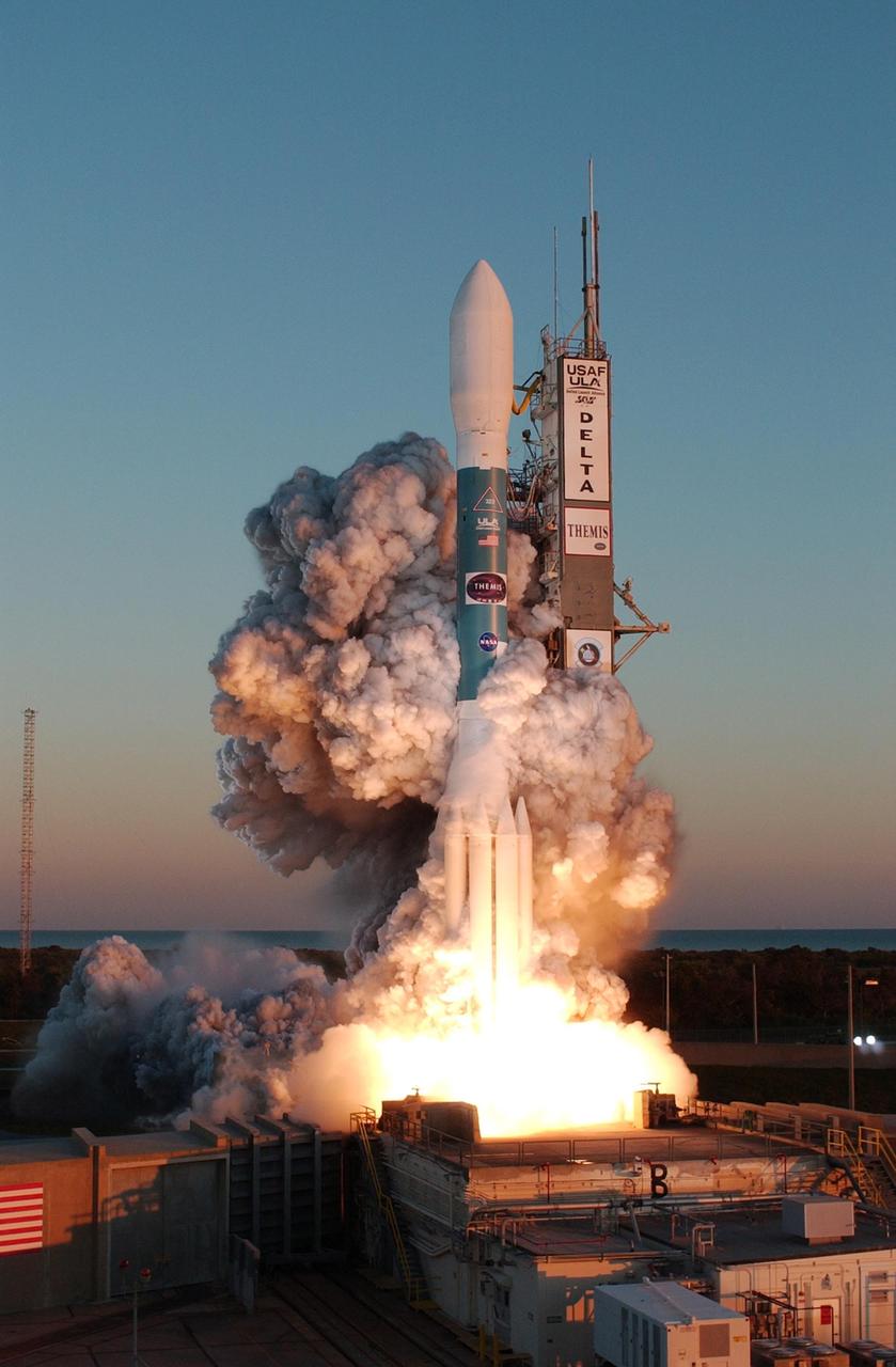
KENNEDY SPACE CENTER, FLA. -- At Cape Canaveral Air Force Station, clouds of smoke form around the Delta II rocket with NASA's THEMIS spacecraft aboard as it blasts off Pad 17-B at 6:01 p.m. EST. THEMIS, an acronym for Time History of Events and Macroscale Interactions during Substorms, consists of five identical probes that will track violent, colorful eruptions near the North Pole. This will be the largest number of scientific satellites NASA has ever launched into orbit aboard a single rocket. The THEMIS mission aims to unravel the mystery behind auroral substorms, an avalanche of magnetic energy powered by the solar wind that intensifies the northern and southern lights. The mission will investigate what causes auroras in the Earth’s atmosphere to dramatically change from slowly shimmering waves of light to wildly shifting streaks of bright color. Photo credit: NASA/Jerry Cannon
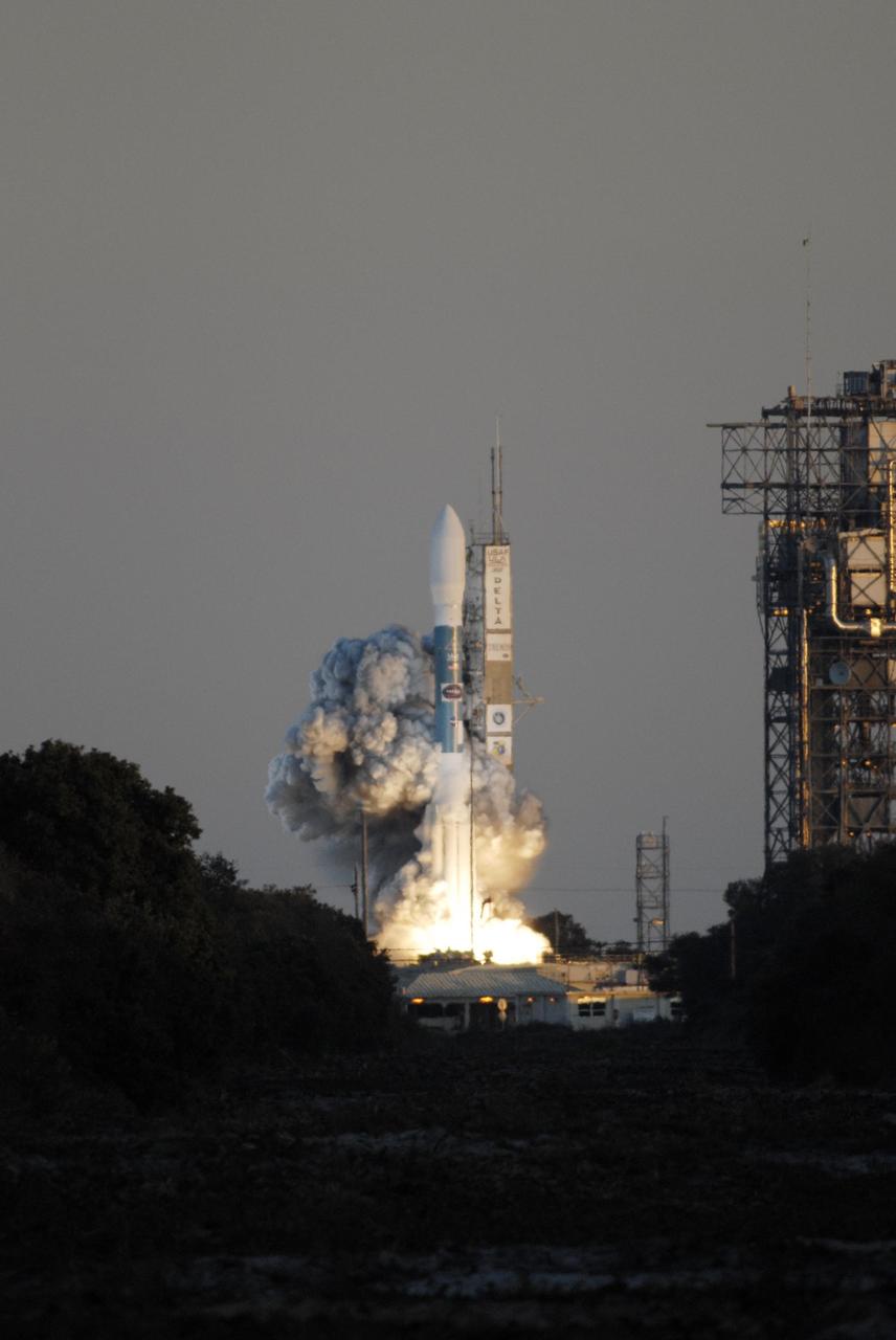
KENNEDY SPACE CENTER, FLA. -- Amid billows of smoke, the Delta II rocket with NASA's THEMIS spacecraft aboard lifts off Pad 17-B at Cape Canaveral Air Force Station at 6:01 p.m. EST. THEMIS, an acronym for Time History of Events and Macroscale Interactions during Substorms, consists of five identical probes that will track violent, colorful eruptions near the North Pole. This will be the largest number of scientific satellites NASA has ever launched into orbit aboard a single rocket. The THEMIS mission aims to unravel the mystery behind auroral substorms, an avalanche of magnetic energy powered by the solar wind that intensifies the northern and southern lights. The mission will investigate what causes auroras in the Earth’s atmosphere to dramatically change from slowly shimmering waves of light to wildly shifting streaks of bright color. Photo credit: NASA/Kim Shiflett
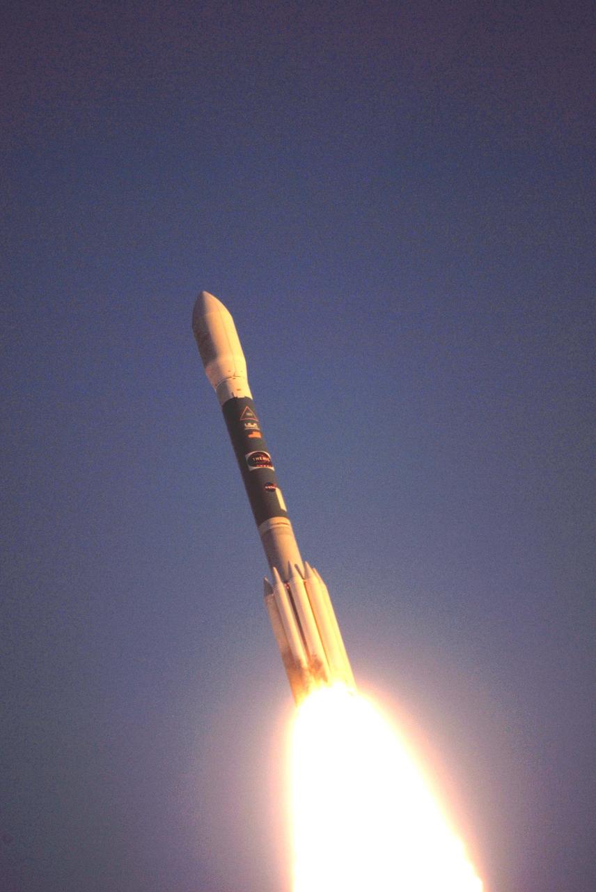
KENNEDY SPACE CENTER, FLA. -- The Delta II rocket with NASA's THEMIS spacecraft aboard begins its journey to orbit at 6:01 p.m. EST from Pad 17-B at Cape Canaveral Air Force Station. THEMIS, an acronym for Time History of Events and Macroscale Interactions during Substorms, consists of five identical probes that will track violent, colorful eruptions near the North Pole. This will be the largest number of scientific satellites NASA has ever launched into orbit aboard a single rocket. The THEMIS mission aims to unravel the mystery behind auroral substorms, an avalanche of magnetic energy powered by the solar wind that intensifies the northern and southern lights. The mission will investigate what causes auroras in the Earth’s atmosphere to dramatically change from slowly shimmering waves of light to wildly shifting streaks of bright color. Photo credit: NASA/Ken Thornsley

KENNEDY SPACE CENTER, FLA. -- The Delta II rocket with the THEMIS spacecraft atop sits ready for launch on Pad 17-B at Cape Canaveral Air Force Station after the mobile service tower moves away from the pad. THEMIS, an acronym for Time History of Events and Macroscale Interactions during Substorms, consists of five identical probes that will track violent, colorful eruptions near the North Pole. This will be the largest number of scientific satellites NASA has ever launched into orbit aboard a single rocket. The THEMIS mission aims to unravel the mystery behind auroral substorms, an avalanche of magnetic energy powered by the solar wind that intensifies the northern and southern lights. The mission will investigate what causes auroras in the Earth’s atmosphere to dramatically change from slowly shimmering waves of light to wildly shifting streaks of bright color. Launch is scheduled for 6:05 p.m. Photo credit: NASA/Kim Shiflett
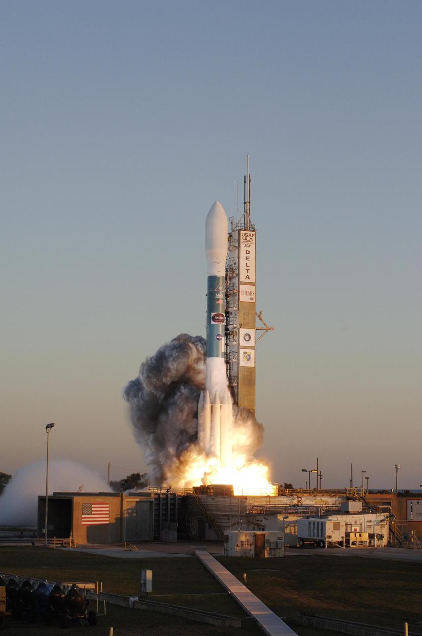
KENNEDY SPACE CENTER, FLA. -- At Cape Canaveral Air Force Station, the Delta II rocket with NASA's THEMIS spacecraft aboard lifts off Pad 17-B on a crisp Florida evening at 6:01 p.m. EST. THEMIS, an acronym for Time History of Events and Macroscale Interactions during Substorms, consists of five identical probes that will track violent, colorful eruptions near the North Pole. This will be the largest number of scientific satellites NASA has ever launched into orbit aboard a single rocket. The THEMIS mission aims to unravel the mystery behind auroral substorms, an avalanche of magnetic energy powered by the solar wind that intensifies the northern and southern lights. The mission will investigate what causes auroras in the Earth’s atmosphere to dramatically change from slowly shimmering waves of light to wildly shifting streaks of bright color. Photo credit: NASA/Jerry Cannon

KENNEDY SPACE CENTER, FLA. -- In this close-up aerial view, the Delta II rocket with the THEMIS spacecraft atop sits ready for launch on Pad 17-B at Cape Canaveral Air Force Station as the mobile service tower moves away from the pad. THEMIS, an acronym for Time History of Events and Macroscale Interactions during Substorms, consists of five identical probes that will track violent, colorful eruptions near the North Pole. This will be the largest number of scientific satellites NASA has ever launched into orbit aboard a single rocket. The THEMIS mission aims to unravel the mystery behind auroral substorms, an avalanche of magnetic energy powered by the solar wind that intensifies the northern and southern lights. The mission will investigate what causes auroras in the Earth’s atmosphere to dramatically change from slowly shimmering waves of light to wildly shifting streaks of bright color. Launch is scheduled for 6:05 p.m. Photo credit: NASA/George Shelton
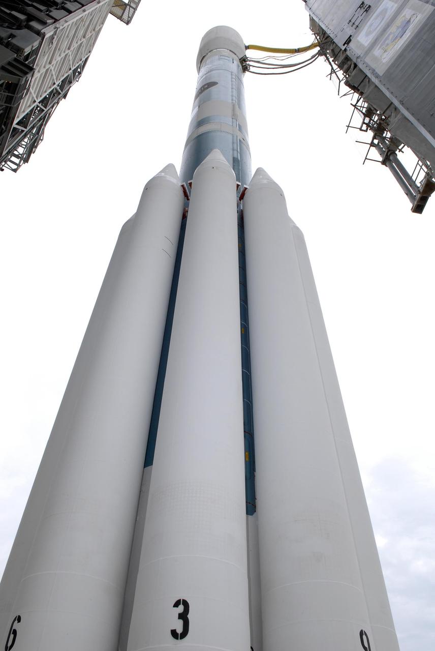
KENNEDY SPACE CENTER, FLA. -- At Launch Pad 17-B at Cape Canaveral Air Force Station, an unusual view of the Delta II rocket with the THEMIS spacecraft atop gives the solid rocket boosters a "larger than life" appearance as the mobile service tower moves away. THEMIS, an acronym for Time History of Events and Macroscale Interactions during Substorms, consists of five identical probes that will track violent, colorful eruptions near the North Pole. This will be the largest number of scientific satellites NASA has ever launched into orbit aboard a single rocket. The THEMIS mission aims to unravel the mystery behind auroral substorms, an avalanche of magnetic energy powered by the solar wind that intensifies the northern and southern lights. The mission will investigate what causes auroras in the Earth’s atmosphere to dramatically change from slowly shimmering waves of light to wildly shifting streaks of bright color. Launch is scheduled for 6:05 p.m. Photo credit: NASA/Kim Shiflett
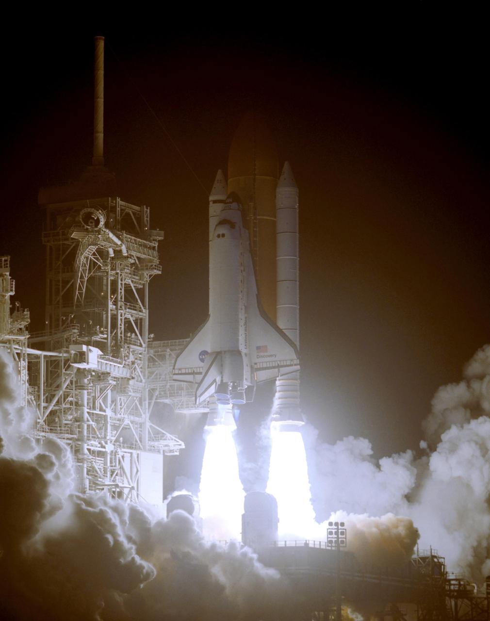
KENNEDY SPACE CENTER, FLA. -- Space Shuttle Discovery seems to be standing on the fiery columns erupting from the solid rocket boosters as it lifts off Launch Pad 39B on mission STS-116. Liftoff occurred at 8:47 p.m. EST. This was the second launch attempt for mission STS-116. The first launch attempt on Dec. 7 was postponed due a low cloud ceiling over Kennedy Space Center. This is Discovery's 33rd mission and the first night launch since 2002. The 20th shuttle mission to the International Space Station, STS-116 carries another truss segment, P5. It will serve as a spacer, mated to the P4 truss that was attached in September. After installing the P5, the crew will reconfigure and redistribute the power generated by two pairs of U.S. solar arrays. Landing is expected Dec. 21 at KSC. Photo credit: NASA/Regina Mitchell-Ryall & Tim Powers
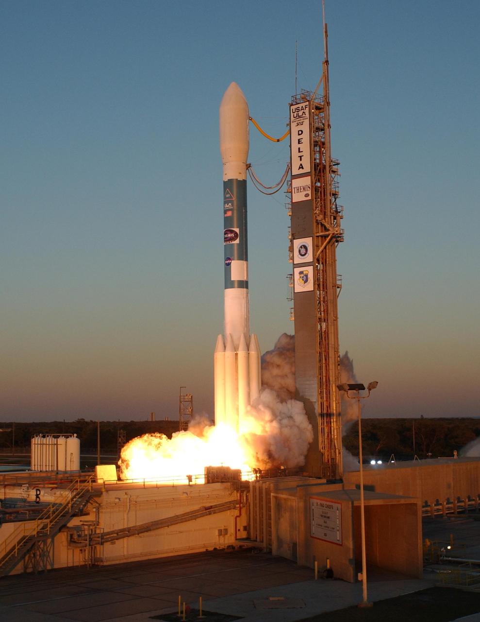
KENNEDY SPACE CENTER, FLA. -- Amid billows of smoke, the Delta II rocket with NASA's THEMIS spacecraft aboard blasts off Pad 17-B at Cape Canaveral Air Force Station at 6:01 p.m. EST. THEMIS, an acronym for Time History of Events and Macroscale Interactions during Substorms, consists of five identical probes that will track violent, colorful eruptions near the North Pole. This will be the largest number of scientific satellites NASA has ever launched into orbit aboard a single rocket. The THEMIS mission aims to unravel the mystery behind auroral substorms, an avalanche of magnetic energy powered by the solar wind that intensifies the northern and southern lights. The mission will investigate what causes auroras in the Earth’s atmosphere to dramatically change from slowly shimmering waves of light to wildly shifting streaks of bright color. Photo credit: NASA/Sandra Joseph, Ralph Hernandez
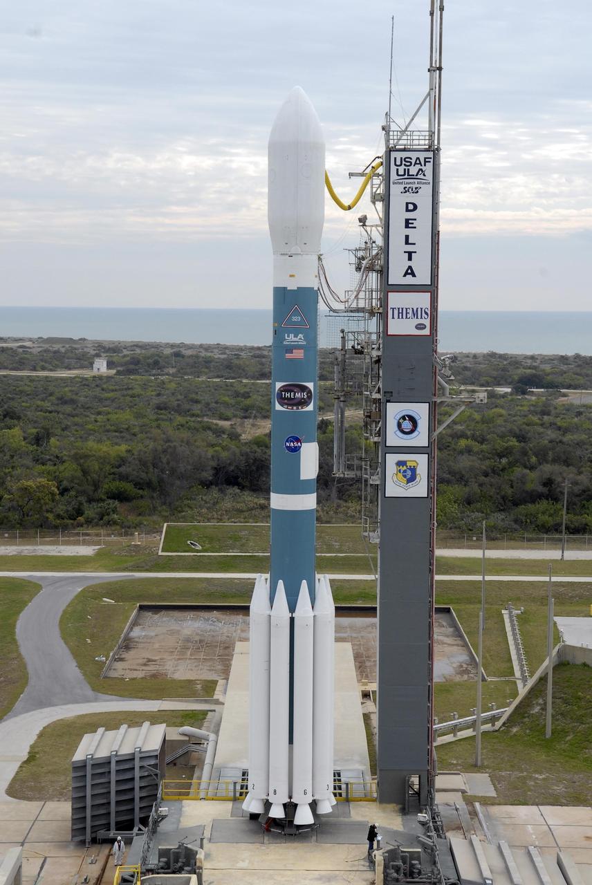
KENNEDY SPACE CENTER, FLA. -- The Delta II rocket with the THEMIS spacecraft atop sits ready for launch on Pad 17-B at Cape Canaveral Air Force Station after the mobile service tower moves away from the pad. THEMIS, an acronym for Time History of Events and Macroscale Interactions during Substorms, consists of five identical probes that will track violent, colorful eruptions near the North Pole. This will be the largest number of scientific satellites NASA has ever launched into orbit aboard a single rocket. The THEMIS mission aims to unravel the mystery behind auroral substorms, an avalanche of magnetic energy powered by the solar wind that intensifies the northern and southern lights. The mission will investigate what causes auroras in the Earth’s atmosphere to dramatically change from slowly shimmering waves of light to wildly shifting streaks of bright color. Launch is scheduled for 6:05 p.m. Photo credit: NASA/Kim Shiflett
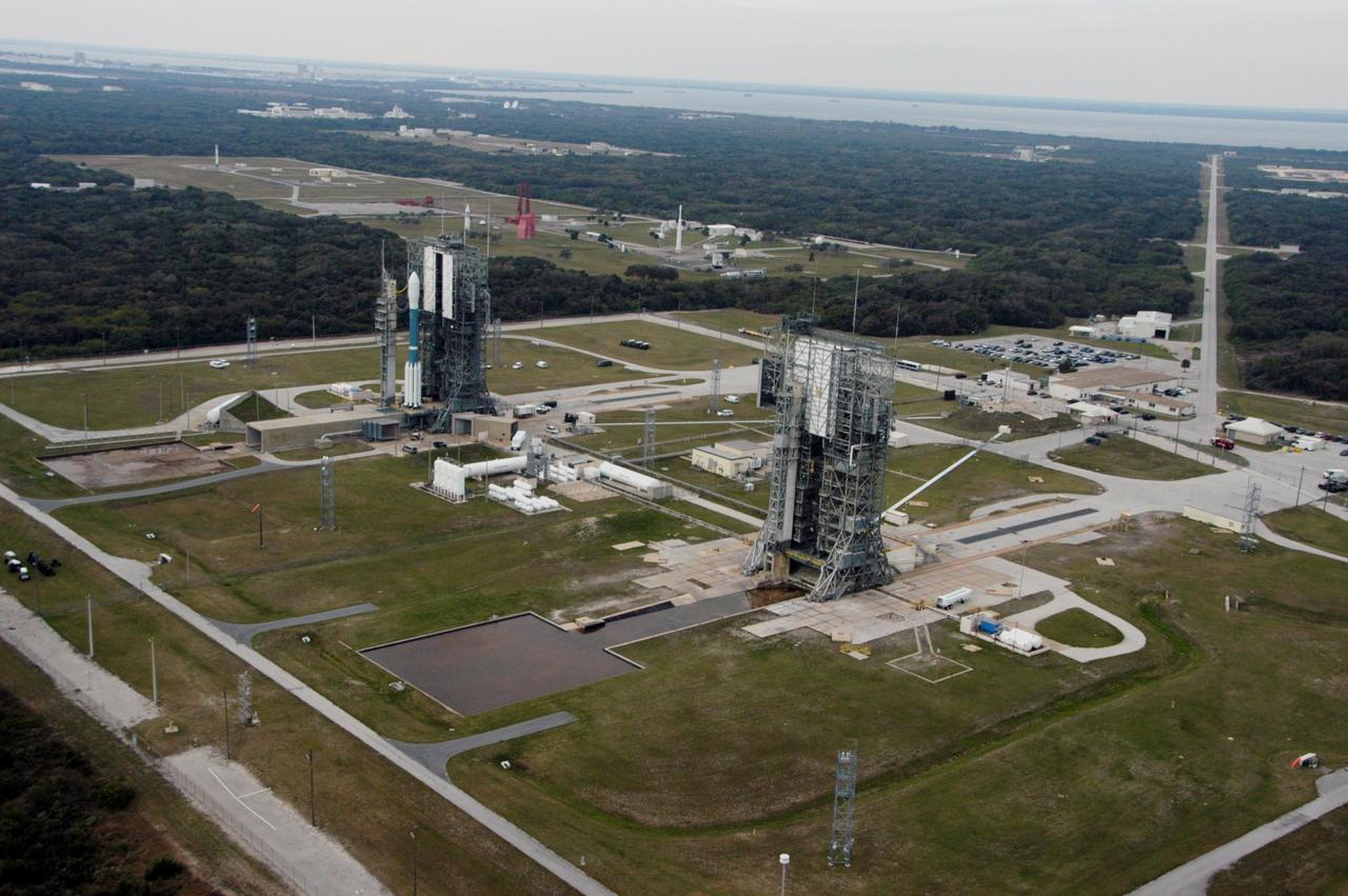
KENNEDY SPACE CENTER, FLA. -- The Delta II rocket with the THEMIS spacecraft atop sits ready for launch on Pad 17-B at Cape Canaveral Air Force Station in this aerial view of the launch complex area as the mobile service tower begins to move away. THEMIS, an acronym for Time History of Events and Macroscale Interactions during Substorms, consists of five identical probes that will track violent, colorful eruptions near the North Pole. This will be the largest number of scientific satellites NASA has ever launched into orbit aboard a single rocket. The THEMIS mission aims to unravel the mystery behind auroral substorms, an avalanche of magnetic energy powered by the solar wind that intensifies the northern and southern lights. The mission will investigate what causes auroras in the Earth’s atmosphere to dramatically change from slowly shimmering waves of light to wildly shifting streaks of bright color. Launch is scheduled for 6:05 p.m. Photo credit: NASA/George Shelton
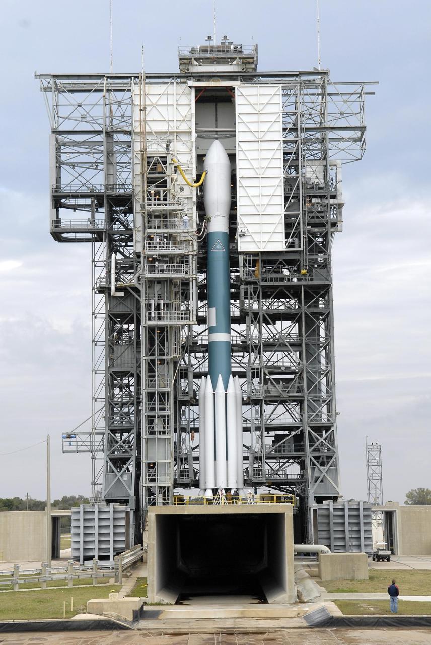
KENNEDY SPACE CENTER, FLA. -- At Launch Pad 17-B at Cape Canaveral Air Force Station, the mobile service tower surrounds the Delta II rocket with the THEMIS spacecraft atop. THEMIS, an acronym for Time History of Events and Macroscale Interactions during Substorms, consists of five identical probes that will track violent, colorful eruptions near the North Pole. This will be the largest number of scientific satellites NASA has ever launched into orbit aboard a single rocket. The THEMIS mission aims to unravel the mystery behind auroral substorms, an avalanche of magnetic energy powered by the solar wind that intensifies the northern and southern lights. The mission will investigate what causes auroras in the Earth’s atmosphere to dramatically change from slowly shimmering waves of light to wildly shifting streaks of bright color. Launch is scheduled for 6:05 p.m. Photo credit: NASA/Kim Shiflett
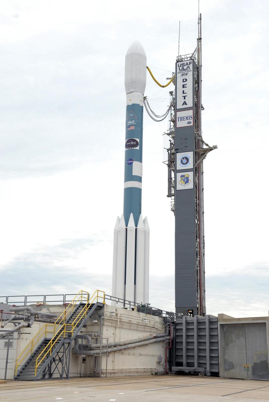
KENNEDY SPACE CENTER, FLA. -- The Delta II rocket with the THEMIS spacecraft atop sits ready for launch on Pad 17-B at Cape Canaveral Air Force Station after the mobile service tower moves away from the pad. THEMIS, an acronym for Time History of Events and Macroscale Interactions during Substorms, consists of five identical probes that will track violent, colorful eruptions near the North Pole. This will be the largest number of scientific satellites NASA has ever launched into orbit aboard a single rocket. The THEMIS mission aims to unravel the mystery behind auroral substorms, an avalanche of magnetic energy powered by the solar wind that intensifies the northern and southern lights. The mission will investigate what causes auroras in the Earth’s atmosphere to dramatically change from slowly shimmering waves of light to wildly shifting streaks of bright color. Launch is scheduled for 6:05 p.m. Photo credit: NASA/Kim Shiflett
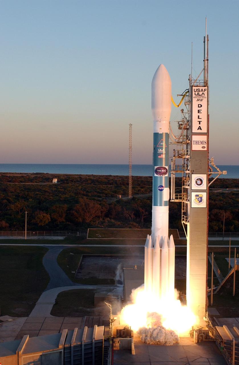
KENNEDY SPACE CENTER, FLA. -- At Cape Canaveral Air Force Station, the Delta II rocket with NASA's THEMIS spacecraft aboard begins its ascent from Pad 17-B, in sight of the Atlantic Ocean, at 6:01 p.m. EST. THEMIS, an acronym for Time History of Events and Macroscale Interactions during Substorms, consists of five identical probes that will track violent, colorful eruptions near the North Pole. This will be the largest number of scientific satellites NASA has ever launched into orbit aboard a single rocket. The THEMIS mission aims to unravel the mystery behind auroral substorms, an avalanche of magnetic energy powered by the solar wind that intensifies the northern and southern lights. The mission will investigate what causes auroras in the Earth’s atmosphere to dramatically change from slowly shimmering waves of light to wildly shifting streaks of bright color. Photo credit: NASA/Regina MItchell-Ryall, Robert Murray, Tony Gray
This single frame from a sequence of six images of an animation shows sunspots as viewed by NASA Curiosity Mars rover from April 4 to April 15, 2015. From Mars, the rover was in position to see the opposite side of the sun. The images were taken by the right-eye camera of Curiosity's Mast Camera (Mastcam), which has a 100-millimeter telephoto lens. The view on the left of each pair in this sequence has little processing other than calibration and putting north toward the top of each frame. The view on the right of each pair has been enhanced to make sunspots more visible. The apparent granularity throughout these enhanced images is an artifact of this processing. These sunspots seen in this sequence eventually produced two solar eruptions, one of which affected Earth. http://photojournal.jpl.nasa.gov/catalog/PIA19802

At Cape Canaveral Air Force Station, the Delta II rocket with NASA's THEMIS spacecraft aboard begins its ascent from Pad 17-B, in sight of the Atlantic Ocean, at 6:01 p.m. EST. THEMIS, an acronym for Time History of Events and Macroscale Interactions during Substorms, consists of five identical probes that will track violent, colorful eruptions near the North Pole. This will be the largest number of scientific satellites NASA has ever launched into orbit aboard a single rocket. The THEMIS mission aims to unravel the mystery behind auroral substorms, an avalanche of magnetic energy powered by the solar wind that intensifies the northern and southern lights. The mission will investigate what causes auroras in the Earth’s atmosphere to dramatically change from slowly shimmering waves of light to wildly shifting streaks of bright color.
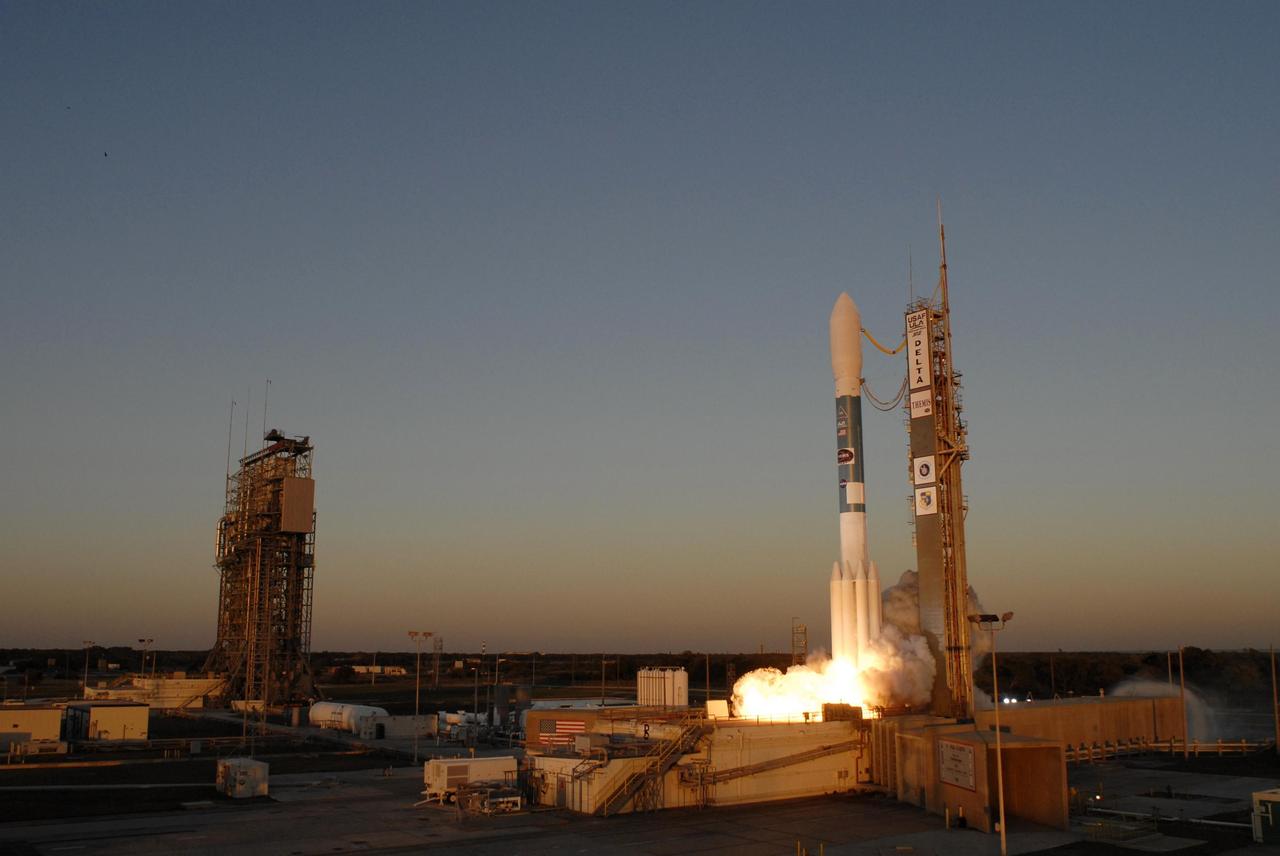
KENNEDY SPACE CENTER, FLA. -- At Cape Canaveral Air Force Station, the Delta II rocket with NASA's THEMIS spacecraft aboard begins its ascent from Pad 17-B on a crisp Florida evening at 6:01 p.m. EST. THEMIS, an acronym for Time History of Events and Macroscale Interactions during Substorms, consists of five identical probes that will track violent, colorful eruptions near the North Pole. This will be the largest number of scientific satellites NASA has ever launched into orbit aboard a single rocket. The THEMIS mission aims to unravel the mystery behind auroral substorms, an avalanche of magnetic energy powered by the solar wind that intensifies the northern and southern lights. The mission will investigate what causes auroras in the Earth’s atmosphere to dramatically change from slowly shimmering waves of light to wildly shifting streaks of bright color. Photo credit: NASA/Sandra Joseph, Ralph Hernandez