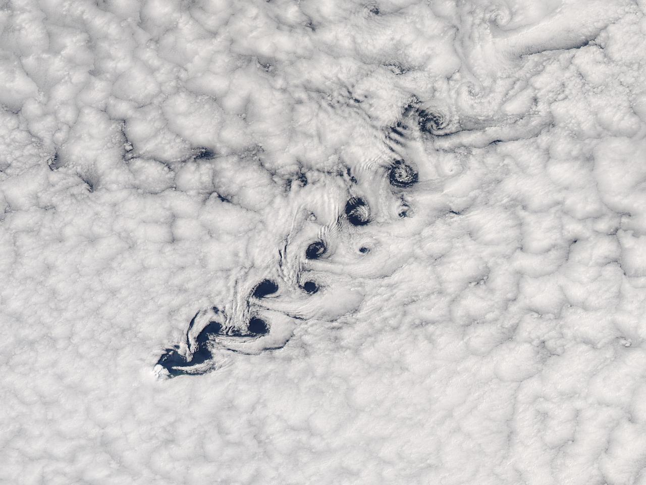
Cloud vortices off Heard Island, south Indian Ocean. The Moderate Resolution Imaging Spectroradiometer (MODIS) aboard NASA’s Aqua satellite captured this true-color image of sea ice off Heard Island on Nov 2, 2015 at 5:02 AM EST (09:20 UTC). Credit: NASA/GSFC/Jeff Schmaltz/MODIS Land Rapid Response Team
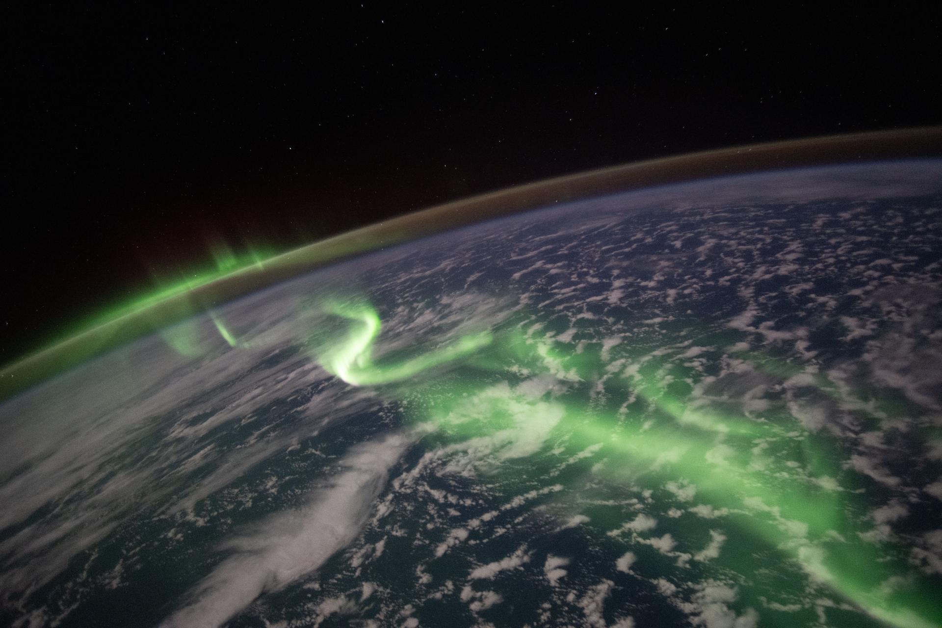
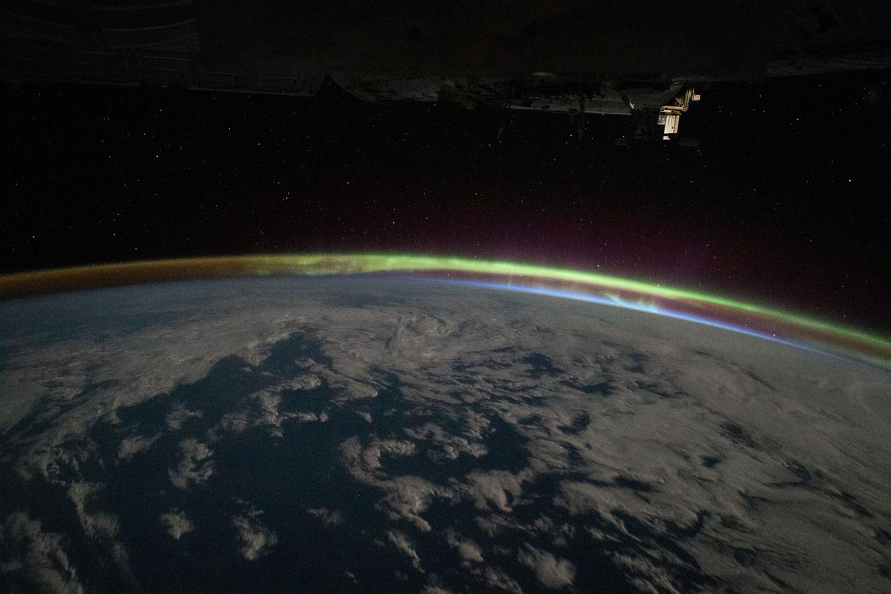
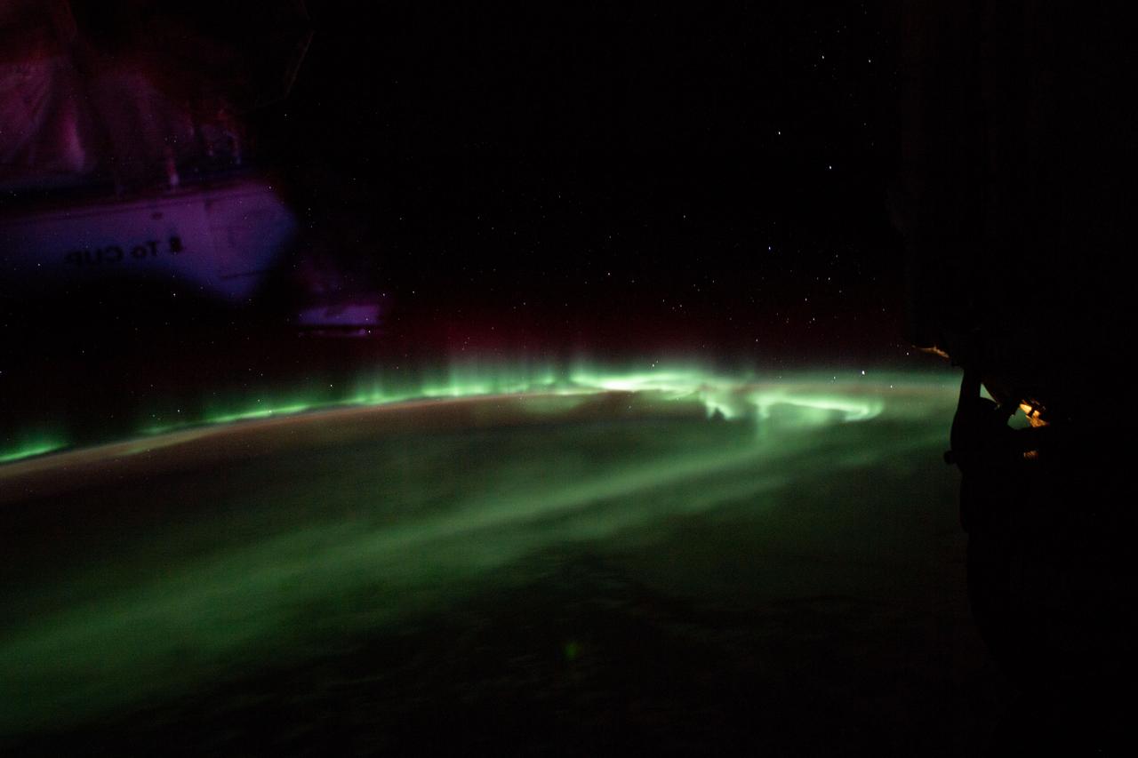
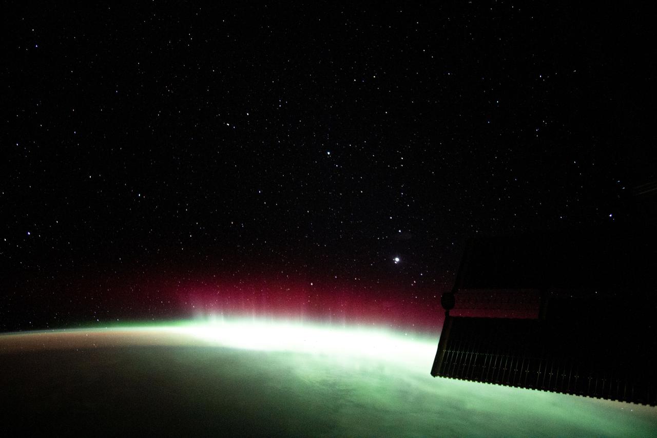
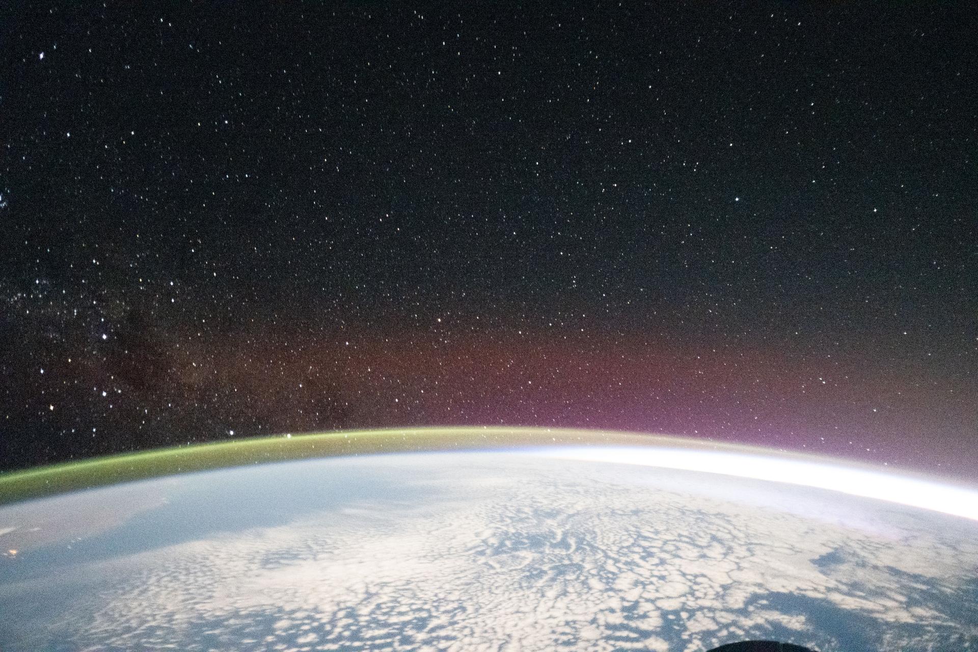
iss074e0462550 (April 4, 2026) --- The aurora australis arcs across the Indian Ocean south of Perth, Australia, in this photograph taken at approximately 2:19 a.m. local time from the International Space Station as it orbited 270 miles above Earth. Credit: NASA/Jessica Meir
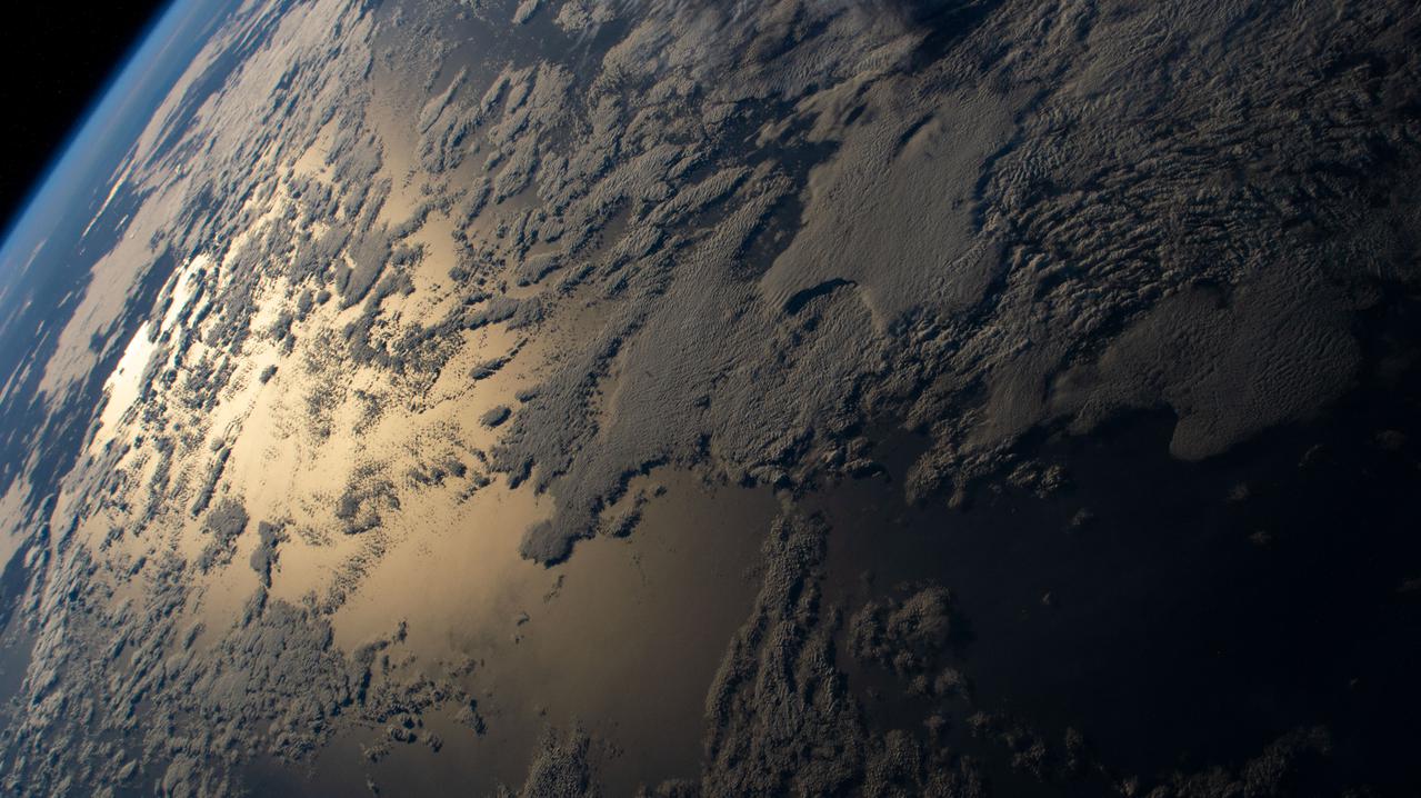
There are special places on Earth that sometimes write their personal signature in the clouds. The Crozet Islands are one such place, thanks to the tall volcanic peaks that grace the islands. When air flows around these tall peaks, it gets pushed around the islands as well as up and over the peak. The net effect of the flowing air flowing around the solid, tall peaks is much like the solid bow of a ship cutting through standing water. In each case v-shaped waves are formed behind the motion. In liquid, this is called a wake; in the atmosphere, when clouds are present or created, they are known as ship-wave-shaped clouds. The Moderate Resolution Imaging Spectroradiometer (MODIS) aboard NASA’s Terra satellite captured this true-color image as it passed over the Crozet Islands on November 26, 2014. Three distinct waves are seen behind the three largest islands. From west to east these are Pig Island, Possession Island and East Island. Credit: NASA/GSFC/Jeff Schmaltz/MODIS Land Rapid Response Team <b><a href="http://www.nasa.gov/audience/formedia/features/MP_Photo_Guidelines.html" rel="nofollow">NASA image use policy.</a></b> <b><a href="http://www.nasa.gov/centers/goddard/home/index.html" rel="nofollow">NASA Goddard Space Flight Center</a></b> enables NASA’s mission through four scientific endeavors: Earth Science, Heliophysics, Solar System Exploration, and Astrophysics. Goddard plays a leading role in NASA’s accomplishments by contributing compelling scientific knowledge to advance the Agency’s mission. <b>Follow us on <a href="http://twitter.com/NASAGoddardPix" rel="nofollow">Twitter</a></b> <b>Like us on <a href="http://www.facebook.com/pages/Greenbelt-MD/NASA-Goddard/395013845897?ref=tsd" rel="nofollow">Facebook</a></b> <b>Find us on <a href="http://instagram.com/nasagoddard?vm=grid" rel="nofollow">Instagram</a></b>

iss058e002592 (Jan. 9, 2019) --- The SpaceX Dragon cargo craft is pictured attached to the International Space Station's Harmony module as the orbital complex flew 258 miles above the Indian Ocean off the eastern coast of South Africa.
iss059e006522 (March 30, 2019) --- The International Space Station flew 265 miles above this cloudy formation in the south Indian Ocean.
iss065e086377 (June 3, 2021) --- The sun's glint beams off the Indian Ocean as the International Space Station orbited 269 miles above south of Western Australia.
iss055e004922 (March 24, 2018) --- Storm clouds blanket an area of South Africa just inland from its eastern coast on the Indian Ocean.
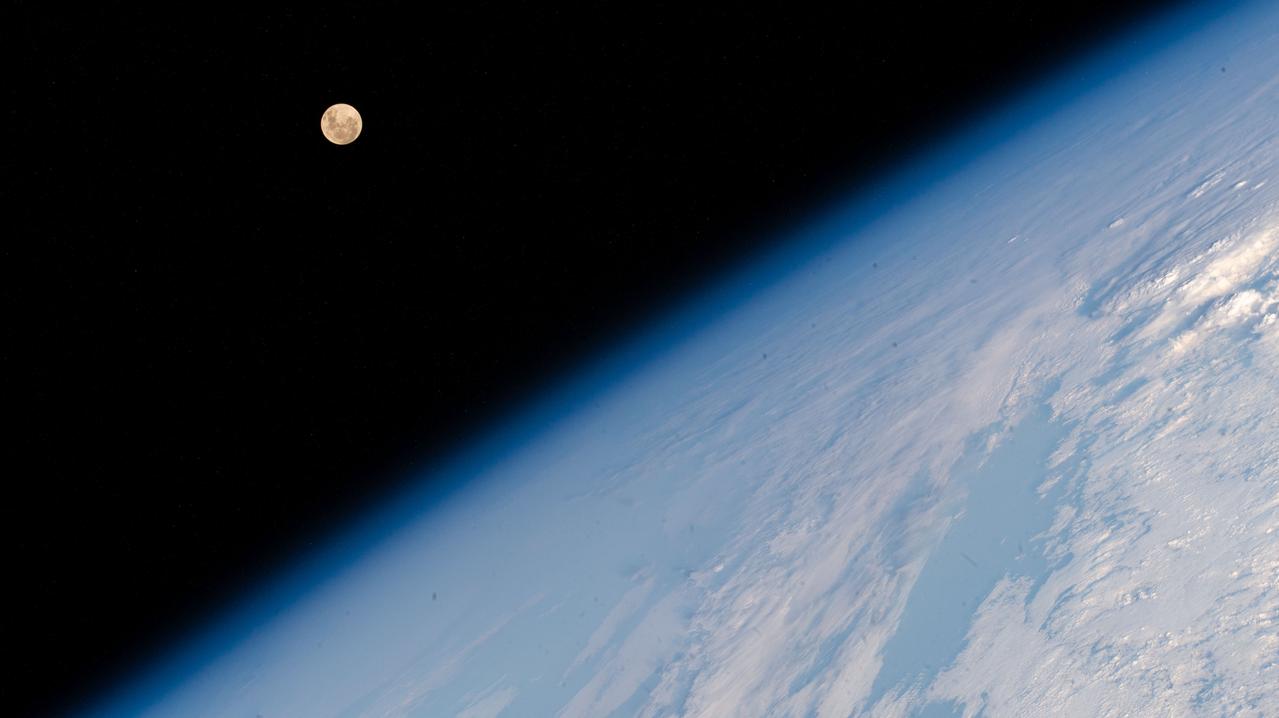
iss065e133389 (June 21, 2021) --- The waxing gibbous Moon is pictured from the International Space Station as it orbited 261 miles above the Indian Ocean south of India.
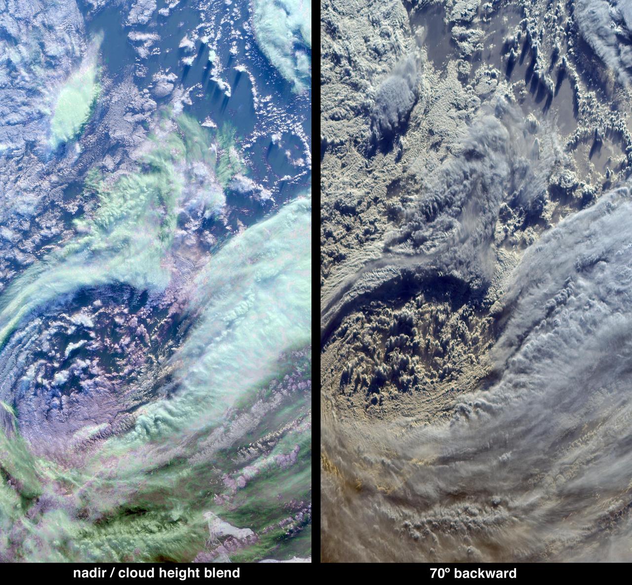
The complex structure and beauty of polar clouds are highlighted by these images acquired by NASA Terra spacecraft on April 23, 2003. These clouds occur at multiple altitudes and exhibit a noticeable cyclonic circulation over the Southern Indian Ocean,
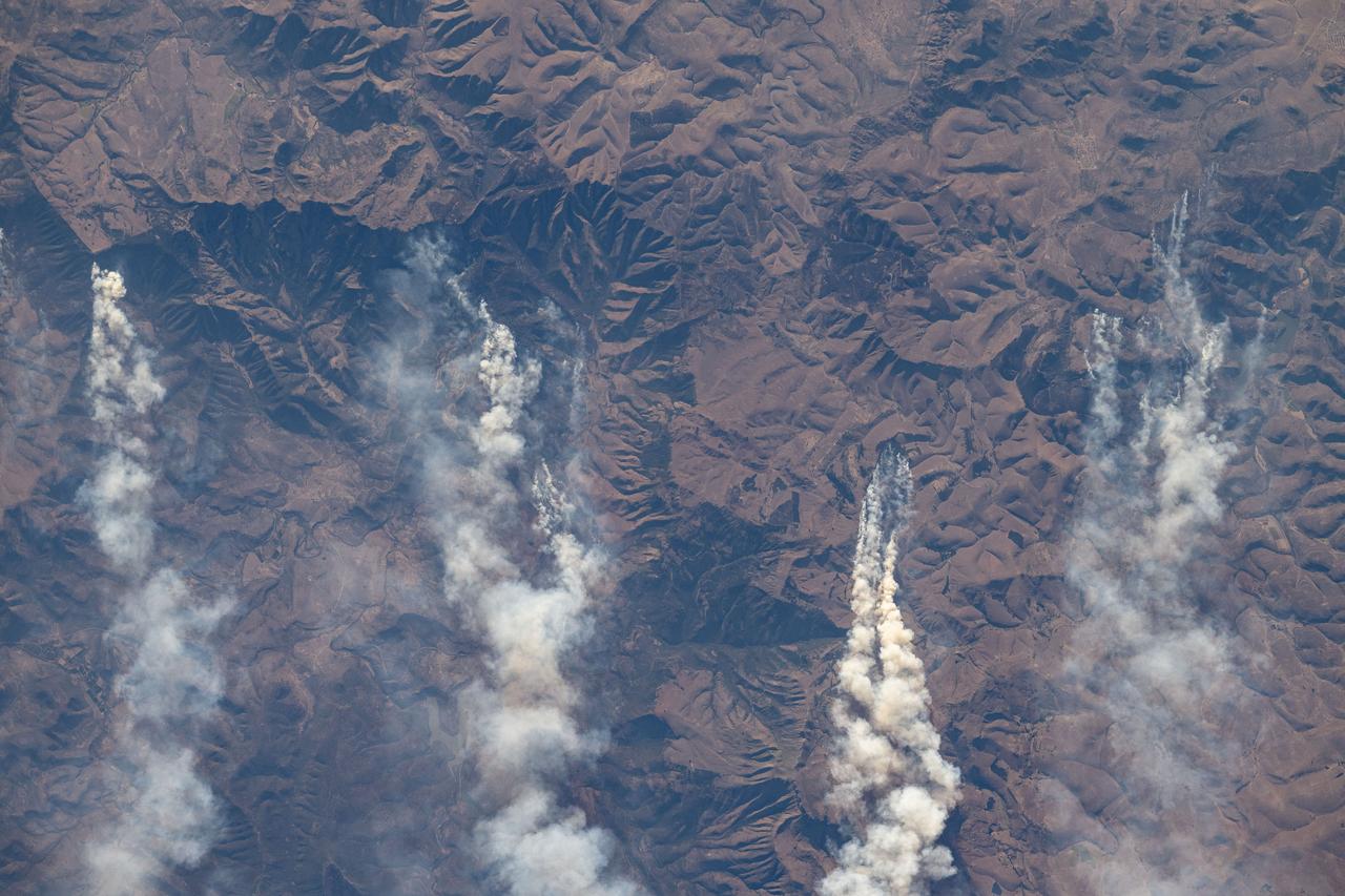
iss071e522679 (Aug. 20, 2024) --- Wildfires in South Africa's Great Escarpment near the coast of the Indian Ocean are pictured from the International Space Station as it orbited 263 miles above.
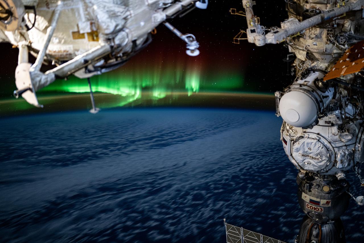
iss068e010113 (Oct. 4, 2022) --- The aurora australis intersects Earth's atmospheric glow in this photograph from the International Space Station as it orbited 268 miles above the Indian Ocean southeast of South Africa.
iss057e106038 (Nov. 22, 2018) --- The Full Moon is pictured by an Expedition 57 crew member as the International Space Station orbited 252 miles above the Indian Ocean about 1,000 kilometers due south of India.
iss068e007201 (Oct. 2, 2022) --- The First Quarter Moon is pictured above the Earth's horizon as the International Space Station orbited 268 miles above the Indian Ocean south of Australia.

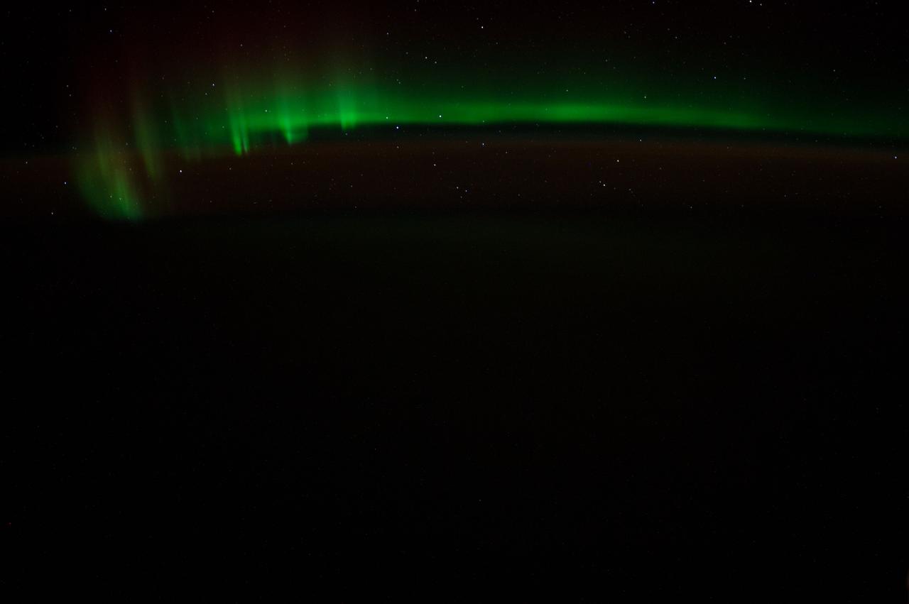
iss063e065220 (July 31, 2020) --- This long-exposure photograph captures a starry sky above the Earth's atmospheric glow as the International Space Station orbited above the Indian Ocean about halfway between South Africa and Australia.
iss073e0107413 (May 17, 2025) --- The Sun's glint beams off a partly cloudy Indian Ocean in this photograph from the International Space Station as it orbited 271 miles above and south of Australia's island state of Tasmania.
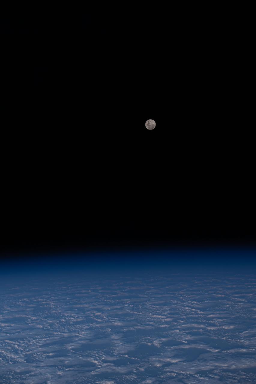
iss070e014820 (Oct. 28, 2023) --- The Full Moon is pictured from the International Space Station as it orbited 271 miles above a cloudy south Indian Ocean half-way between Australia and Antarctica.
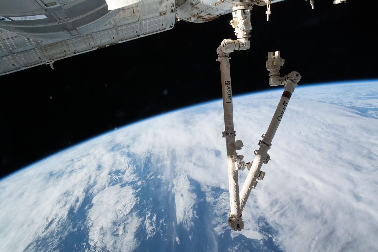
iss067e044014 (May 12, 2022) --- The 57.7-foot-long Canadarm2 is attached to the International Space Station's Harmony module extending into a folded position 271 miles above the Indian Ocean south of Australia's island state of Tasmania.
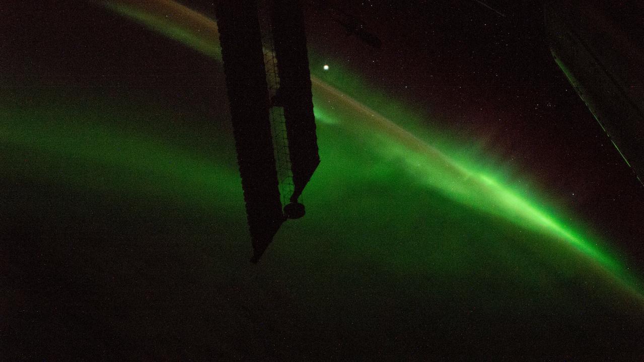
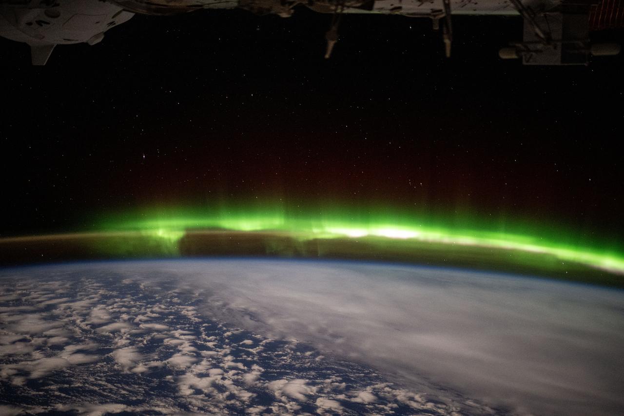
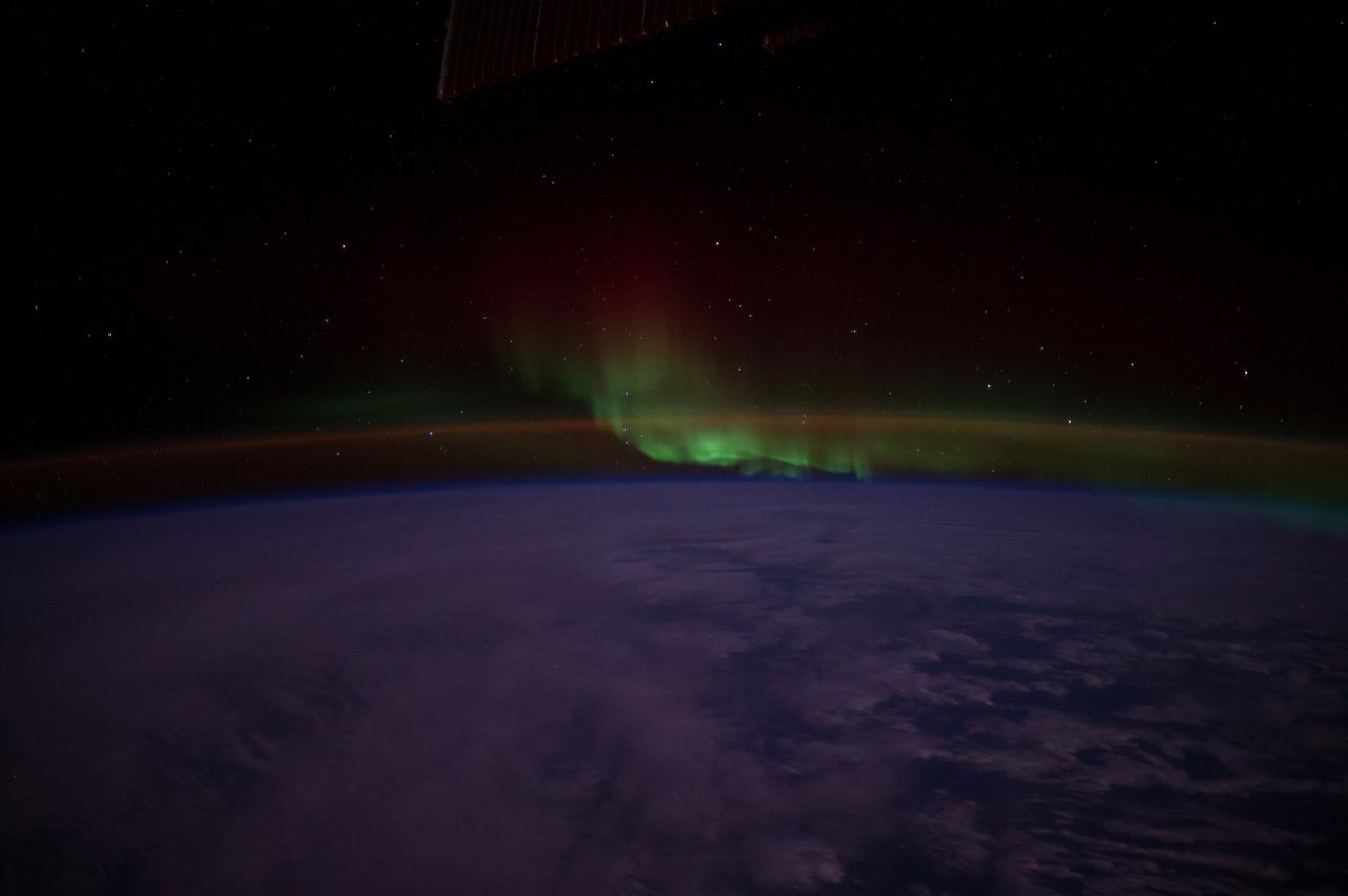
iss071e142810 (May 29, 2024) --- An aurora swirls above the Indian Ocean in this photograph from the International Space Station as it orbited 266 miles above and due south of Australia's island state of Tasmania.
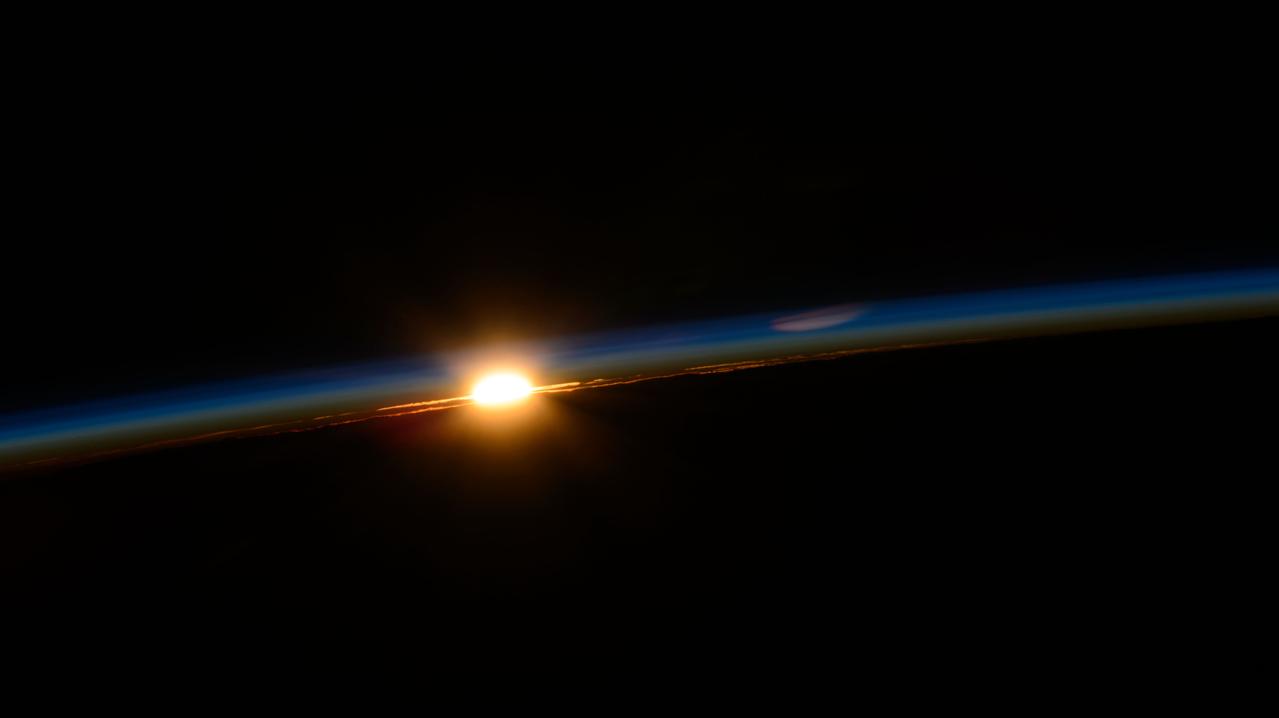
iss071e092499 (May 19, 2024) --- The first rays of an orbital sunrise penetrate Earth's atmosphere revealing the cloud tops as the International Space Station soared 262 miles above the Indian Ocean off the southeast coast of South Africa.
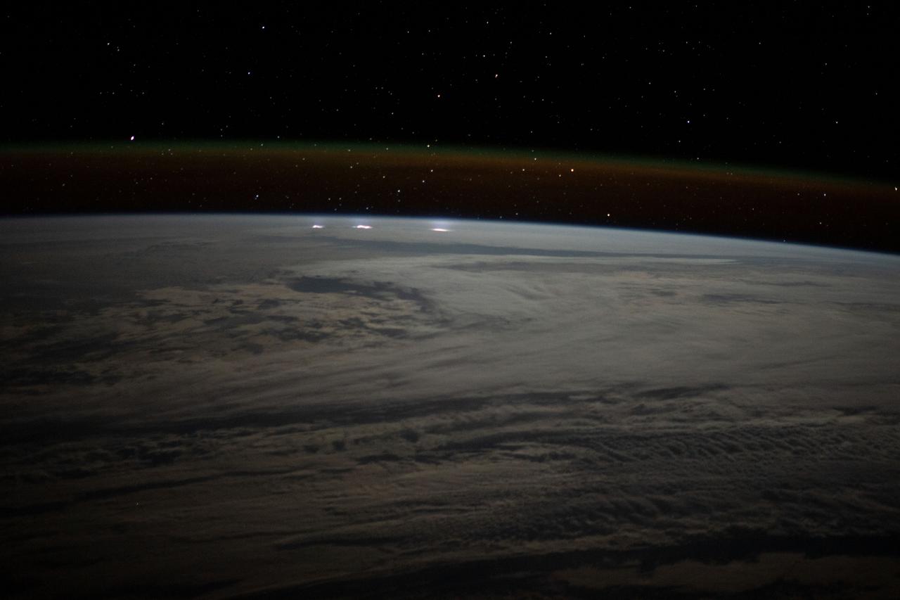
iss067e270871 (Aug. 17, 2022) --- A cloudy, south Indian Ocean between Africa and Antarctica, with lightning storms near the horizon beneath the atmospheric glow, is pictured from the International Space Station as it orbited 271 miles above
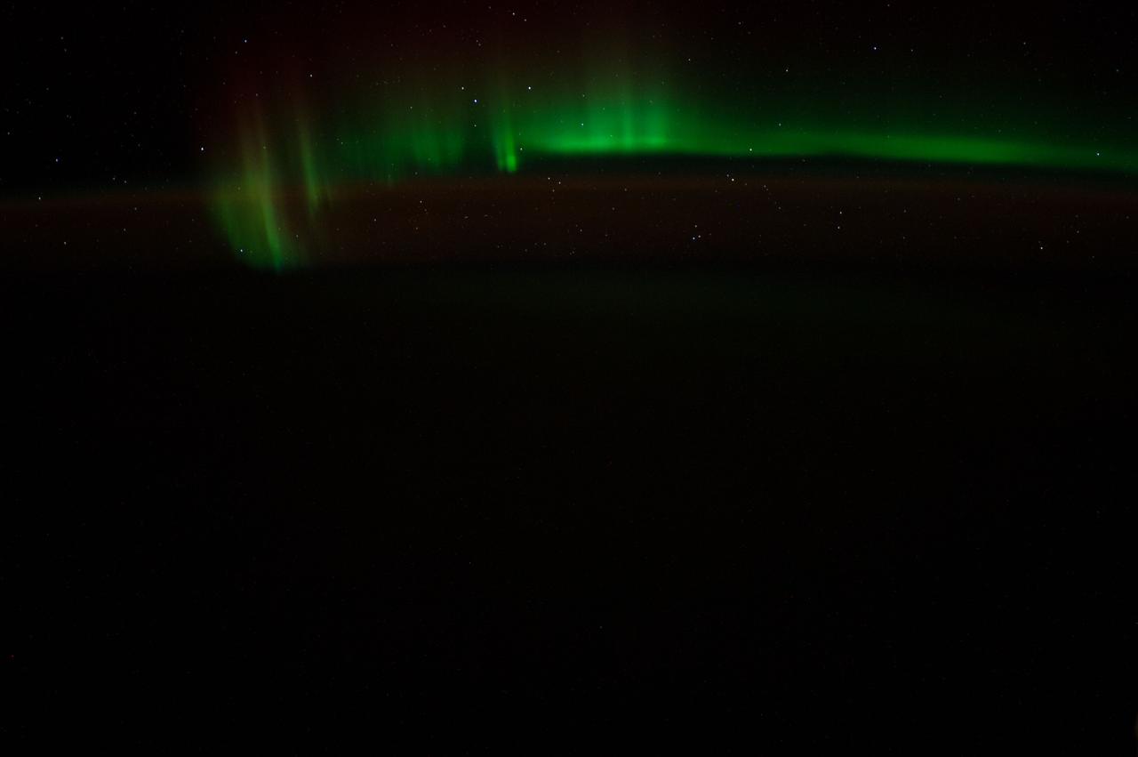
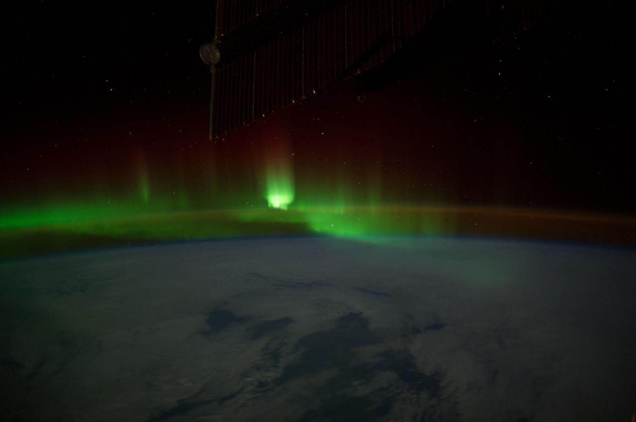
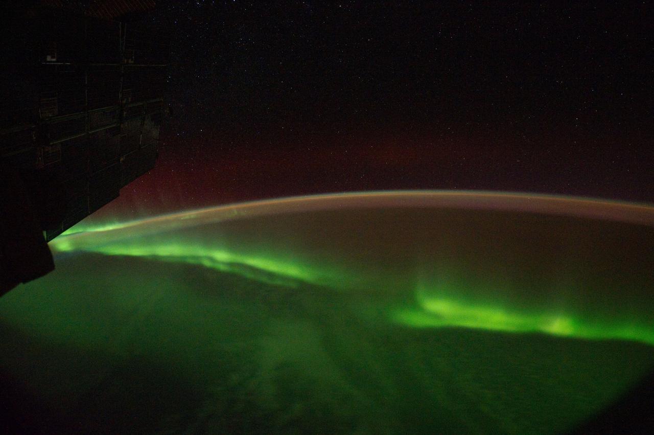
iss059e020015 (April 12, 2019) --- The aurora australis, also known as the "southern lights," is pictured as the International Space Station orbited 264 miles above the Indian Ocean south of the Australian island state of Tasmania.
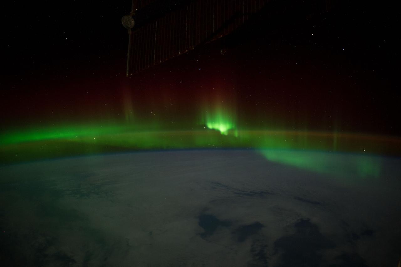
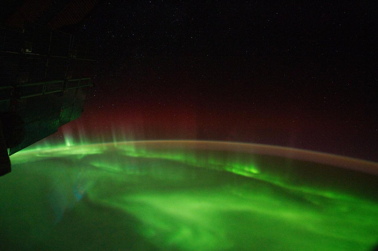
iss059e013117 (April 4, 2019) --- The aurora australis, also known as the "southern lights," is pictured as the International Space Station orbited 264 miles above the Indian Ocean south of the Western Australia city of Perth.
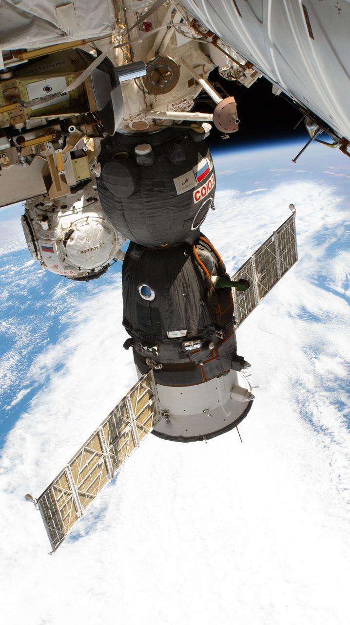
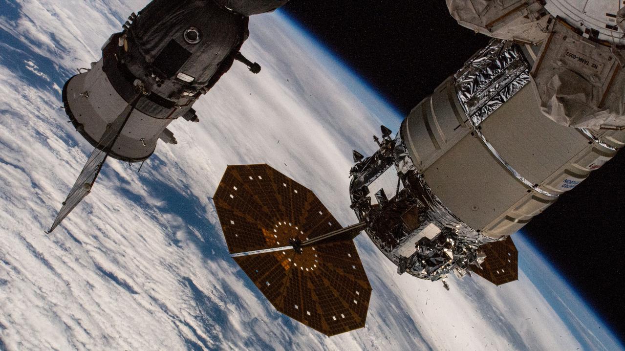
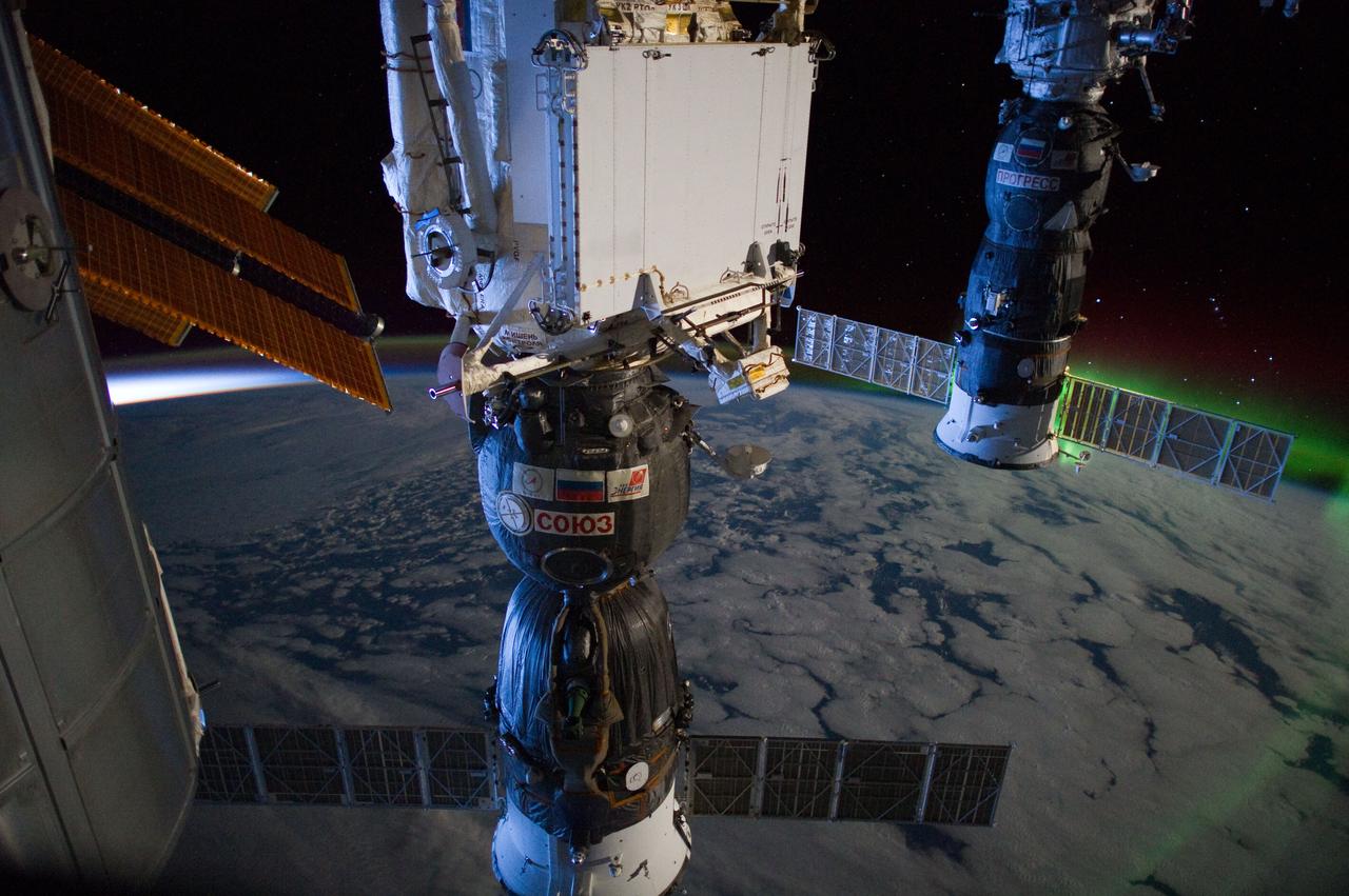
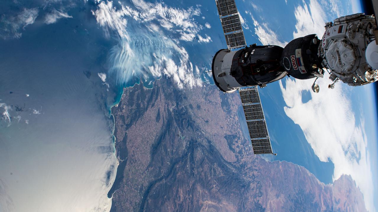
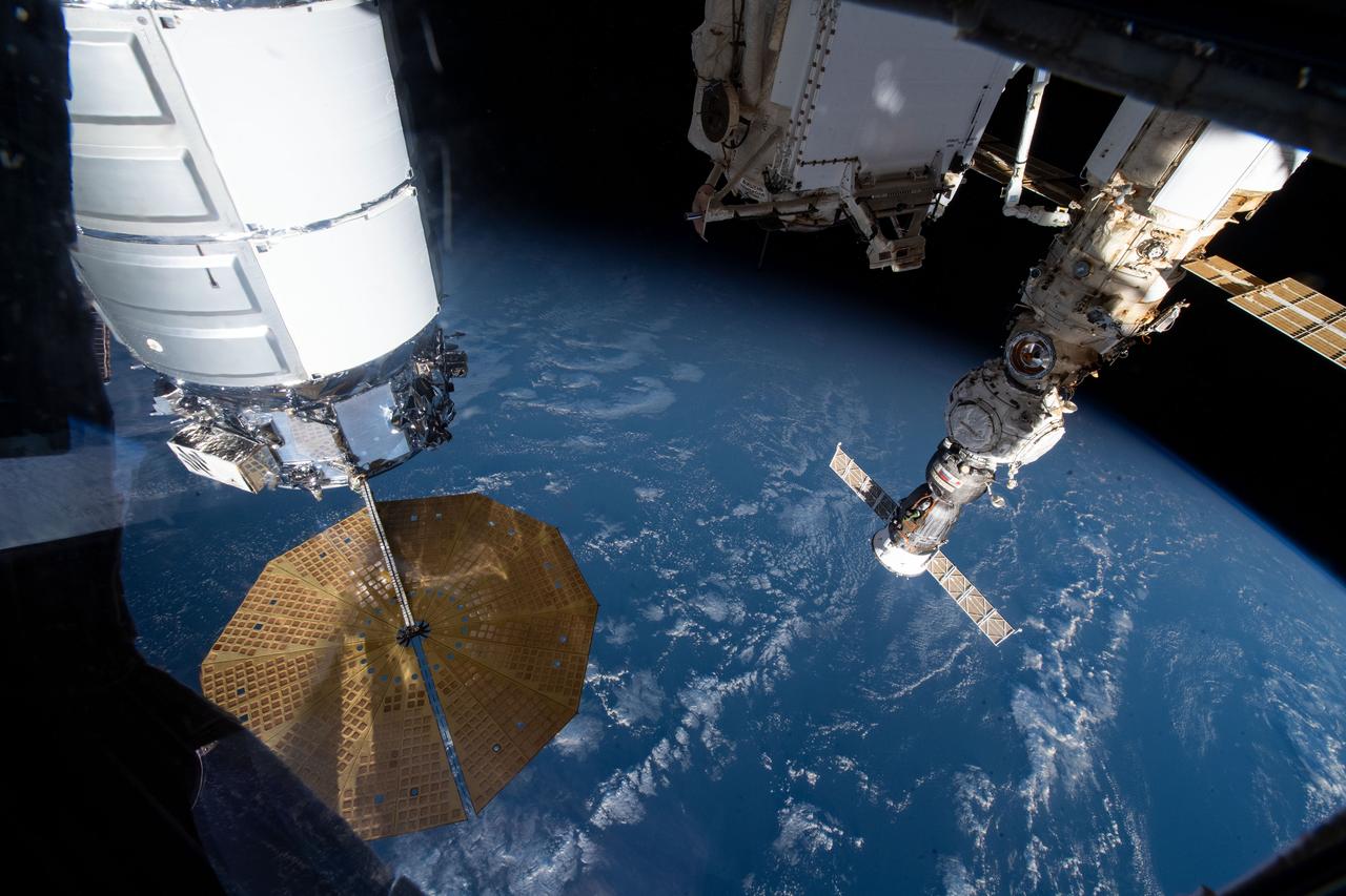
iss066e109863 (Jan. 9, 2022) --- The Soyuz MS-19 crew ship and the Prichal docking module (background) are pictured as the International Space Station orbited 270 miles above the Indian Ocean south of Australia.

iss063e065237 (July 31, 2020) --- This long-exposure photograph captures a starry sky above the Earth's atmospheric glow as the International Space Station orbited above the Indian Ocean about halfway between South Africa and Australia.

iss060e002044 (June 29, 2019) --- An atmospheric glow blankets Earth beneath a starry night sky as the International Space Station orbited 271 miles above the Indian Ocean, south of the Australian island state of Tasmania.
iss065e329698 (Aug. 21, 2021) --- Russia's Nauka multipurpose laboratory module is pictured as the International Space Station orbited into a sunset 271 miles above the southern Indian Ocean in between South Africa and Antarctica.
iss071e515452 (Aug. 19, 2024) --- The Full Moon pictured above Earth's horizon as the International Space Station soared 262 miles above the Indian Ocean south of the African island nation of Madagascar.
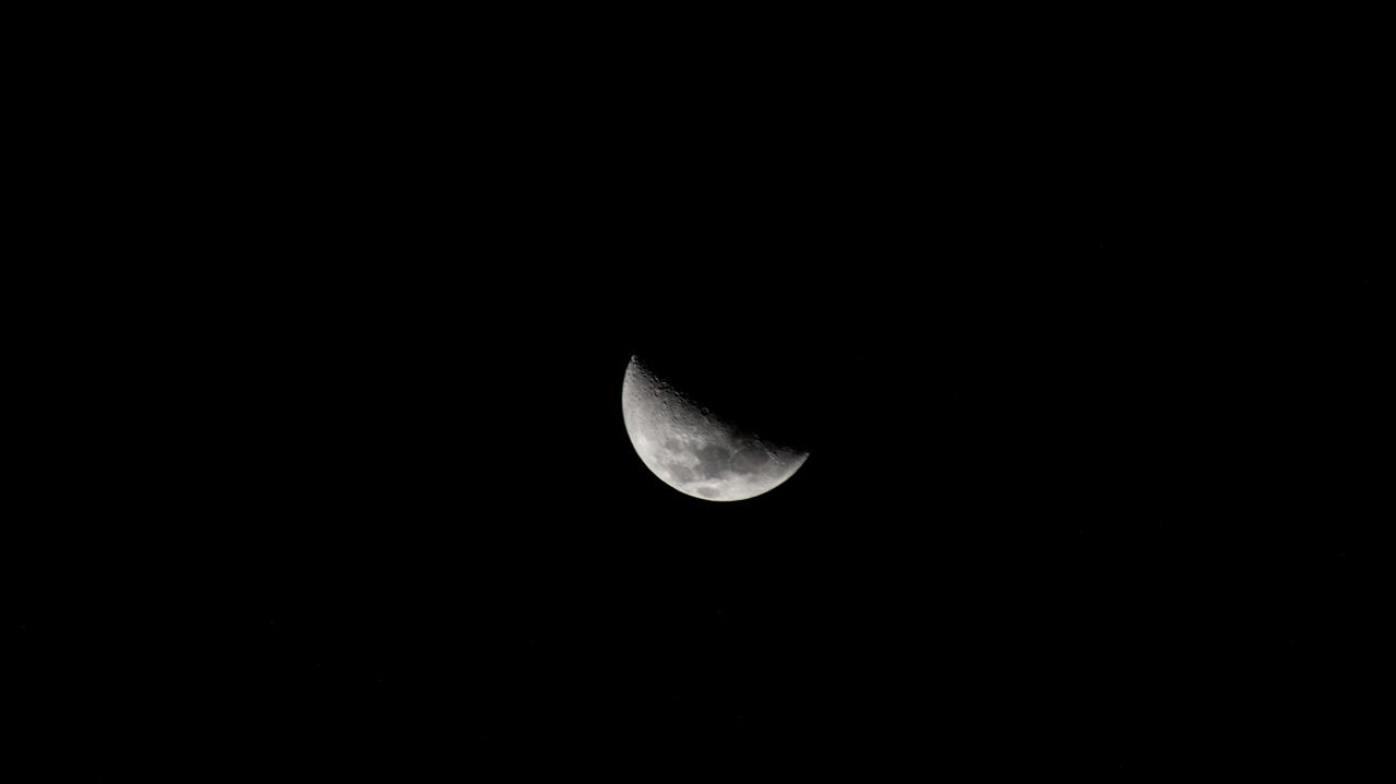
iss067e175497 (July 6, 2022) --- The First Quarter Moon is pictured from the International Space Station as it orbited 266 miles above the Indian Ocean south of Adelaide, Australia.
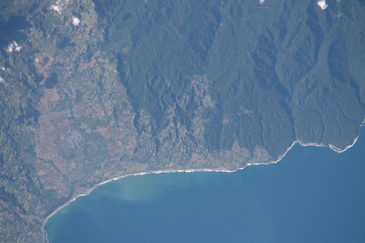
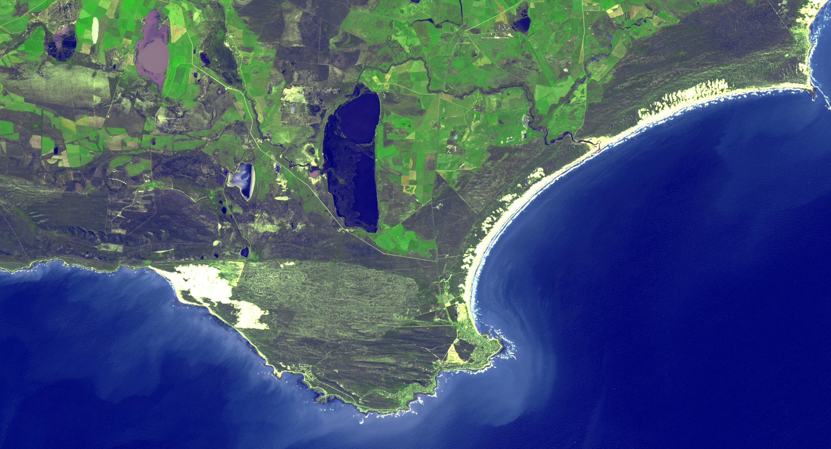
iss065e001304 (April 21, 2021) --- The south coast of West Nusa Tenggara, a province of Indonesia, is pictured from the International Space Station as it orbited 262 miles above the Indian Ocean.
ISS038-E-008471 (26 Nov. 2013) --- One of the Expedition 38 crew members aboard the International Space Station took this photograph showing a part of South Africa's Atlantic Coast. South Africa is the only African nation bordered by both the Indian and Atlantic Oceans.
iss067e035732 (May 6, 2022) --- The Soyuz MS-21 crew ship is picture docked to the Prichal docking module as the International Space Station flew into an orbital sunset 271 miles above the Indian Ocean south of Cape Town, South Africa.
ISS029-E-005904 (17 Sept. 2011) --- This is one of a series of night time images photographed by one of the Expedition 29 crew members from the International Space Station. It features Aurora Australis over the southern Indian ocean. Nadir coordinates are 50.16 south latitude and 48.11 degrees east longitude.
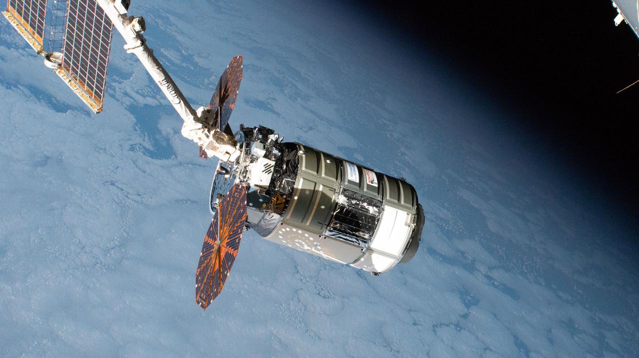
iss064e035911 (Feb. 22, 2021) --- The Cygnus space freighter from Northrop Grumman is pictured moments after its capture with the Canadarm2 robotic arm. Cygnus and the International Space Station were orbiting 271 miles above the Indian Ocean south of Australia at the time this photograph was taken.
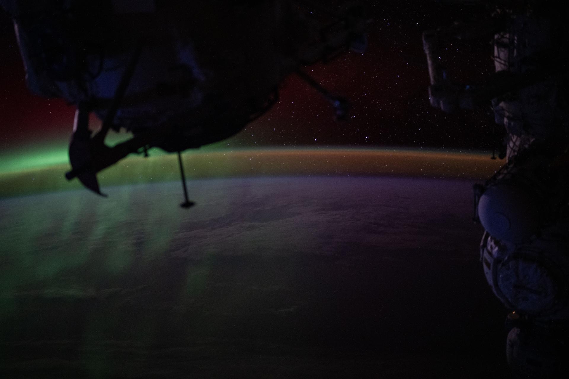
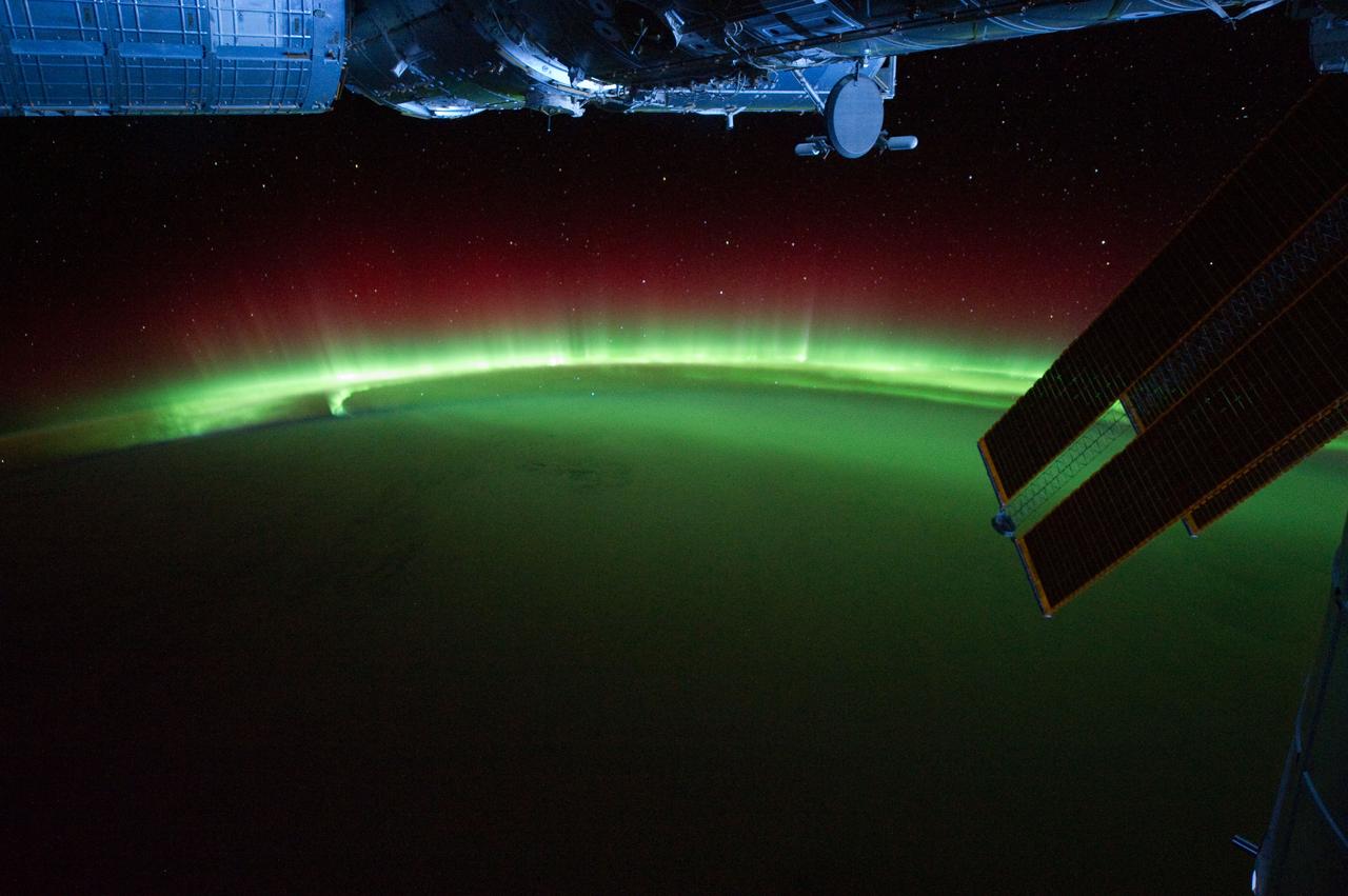
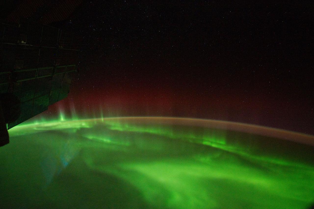
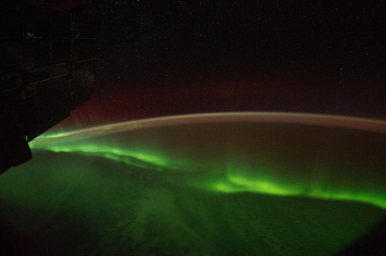
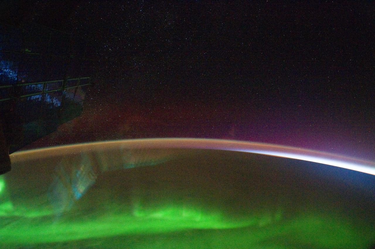
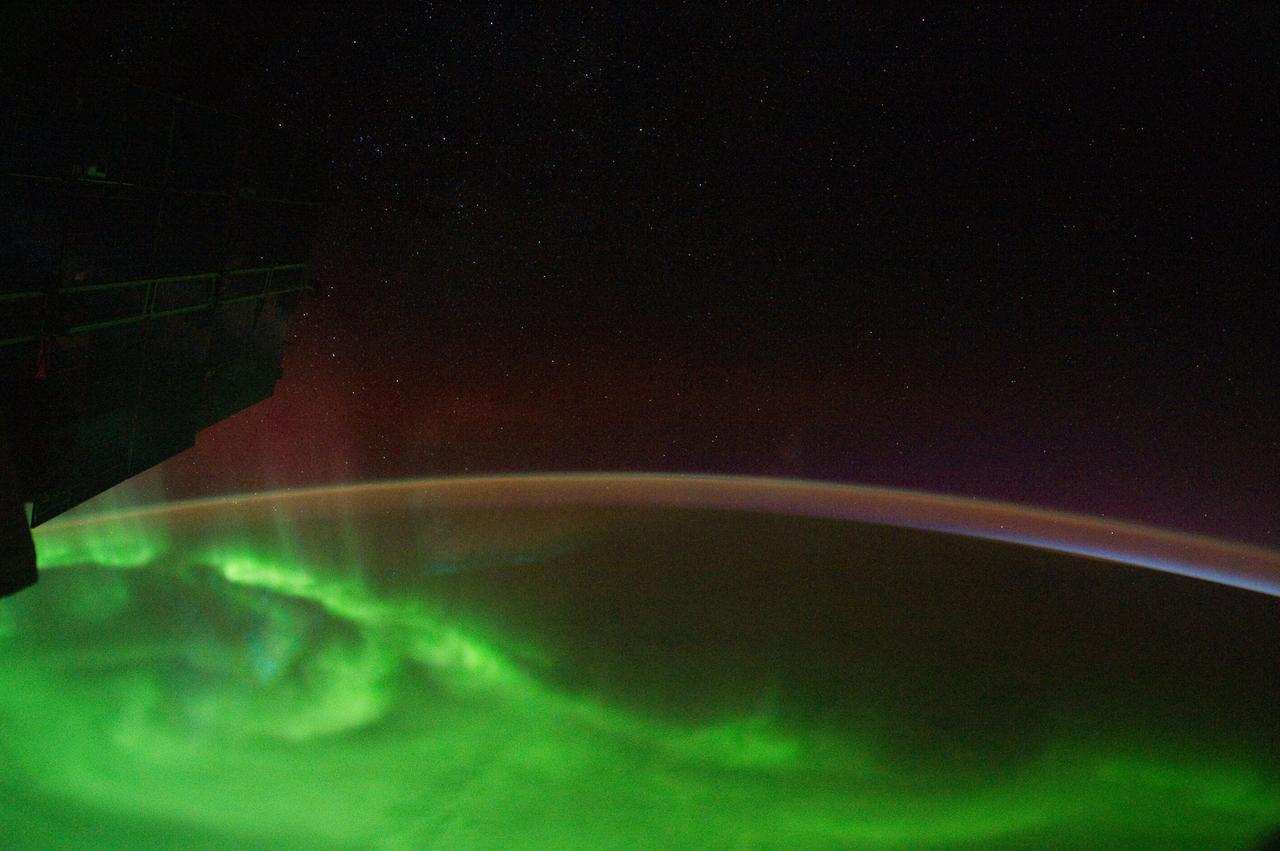
iss073e0865646 (Sept. 28, 2025) --- A wispy green aurora australis fades into a dim orange-yellow airglow above Earth’s horizon in this photograph taken at approximately 2:31 a.m. local time from the International Space Station, as it orbited 270 miles above the Indian Ocean, south of Perth, Australia.
ISS040-E-050825 (7 July 2014) --- One of the Expedition 40 crew members aboard the International Space Station, flying 226 nautical miles above the Indian Ocean, south of Australia, recorded this image of Aurora Australis or the Southern Lights on July 7, 2014.
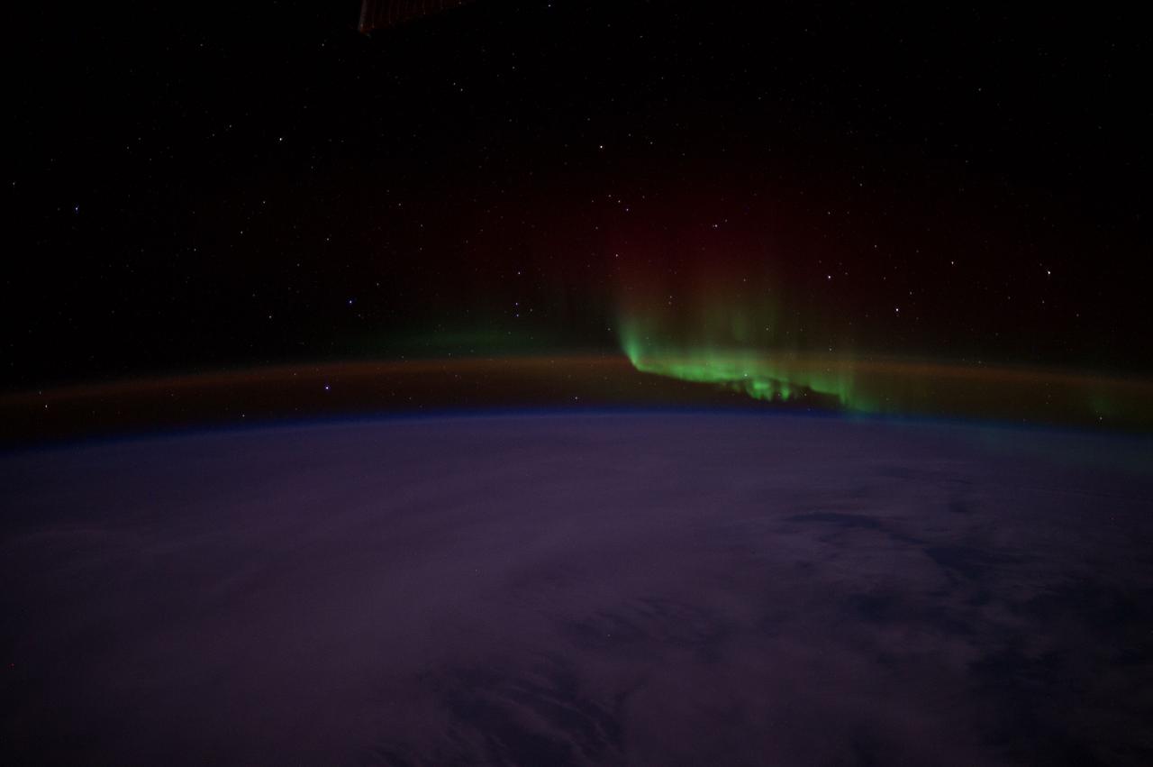
iss073e0246858 (June 9, 2025) --- A bright green aurora australis streams above Earth's horizon blanketing the atmospheric glow in this photograph from the International Space Station as it orbited 269 miles above a cloudy southern Indian Ocean midway between South Africa and Antarctica.
iss065e001061 (April 17, 2021) --- An aurora is pictured streaming above the Earth from a window aboard the SpaceX Crew Dragon Resilience. The International Space Station was orbiting 271 miles above the Indian Ocean in between South Africa and Antarctica.
ISS040-E-040103 (5 July 2014) --- As the International Space Station was flying at an altitude of 226 nautical miles on July 5 above a point in the southern Indian Ocean near South Africa's Prince Edwards Islands, one of the Expedition 40 crew members photographed this image of Aurora Australis.
ISS029-E-007502 (18 Sept. 2011) --- This is one of a series of night time images photographed by one of the Expedition 29 crew members from the International Space Station. It features Aurora Australis, airglow, and parts of the southeast Indian Ocean. Nadir coordinates are 50.58 degrees south latitude and 138.28 degrees east longitude.
ISS040-E-050780 (7 July 2014) --- One of the Expedition 40 crew members aboard the International Space Station, flying 226 nautical miles above the Indian Ocean, south of Australia, recorded this image of Aurora Australis or the Southern Lights on July 7, 2014.

iss069e004683 (April 20, 2023) --- The Northrup Grumman Cygnus space freighter is pictured in the grip of the Canadarm2 robotic arm while attached to the Unity module's Earth-facing port. The International Space Station was soaring into an orbital sunset 266 miles above the Indian Ocean in between South Africa and Antarctica at the time of this photograph.
ISS040-E-048027 (7 July 2014) --- One of the Expedition 40 crew members aboard the International Space Station, flying 226 nautical miles above the Indian Ocean, south of Australia, recorded this image of Aurora Australis or the Southern Lights on July 7, 2014.
ISS040-E-040088 (5 July 2014) --- As the International Space Station was flying at an altitude of 226 nautical miles on July 5 above a point in the southern Indian Ocean near South Africa's Prince Edwards Islands, one of the Expedition 40 crew members photographed this image of Aurora Australis.
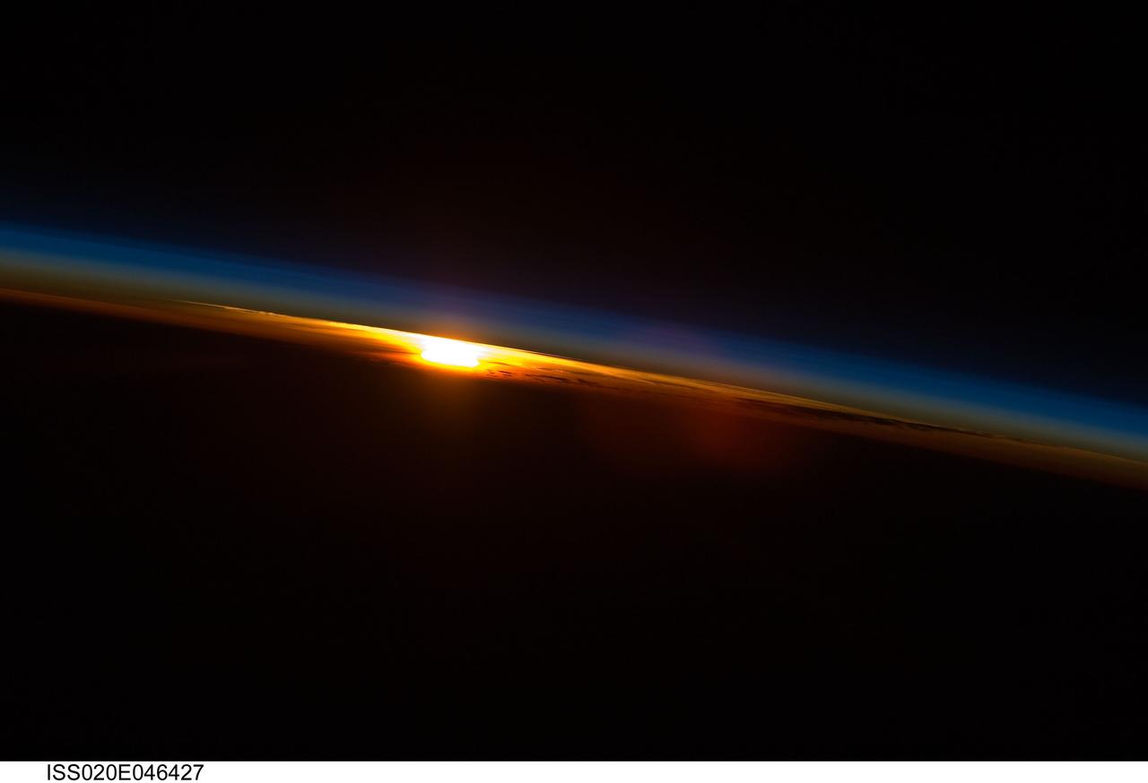
iss020e046427 (Oct. 4, 2009) --- The sun sets below Earth's horizon illuminating the atmosphere with its last rays in this photograph from the International Space Station as it orbited 216 miles above near the Indian Ocean coast of South Africa.
ISS040-E-048011 (7 July 2014) --- One of the Expedition 40 crew members aboard the International Space Station, flying 226 nautical miles above the Indian Ocean, south of Australia, recorded this image of Aurora Australis or the Southern Lights on July 7, 2014.
ISS029-E-007500 (18 Sept. 2011) --- This is one of a series of night time images photographed by one of the Expedition 29 crew members from the International Space Station. It features the Aurora Australis, airglow and parts of the southeastern Indian Ocean. Nadir coordinates are 50.66 degrees south latitude and 137.70 degrees east longitude.
ISS029-E-006406 (18 Sept. 2011) --- This is one of a series of night time images photographed by one of the Expedition 29 crew members from the International Space Station. It features Aurora Australis and parts of the southeastern Indian Ocean. Nadir coordinates are 49.30 degrees south latitude and 121.56 degrees east longitude.

iss071e168287 (June 2, 2024) --- Stars sparkle above Earth's atmospheric glow in this long-duration photograph taken from the International Space Station as it orbited 266 miles above the Indian Ocean and due south of Australia's island state of Tasmania.
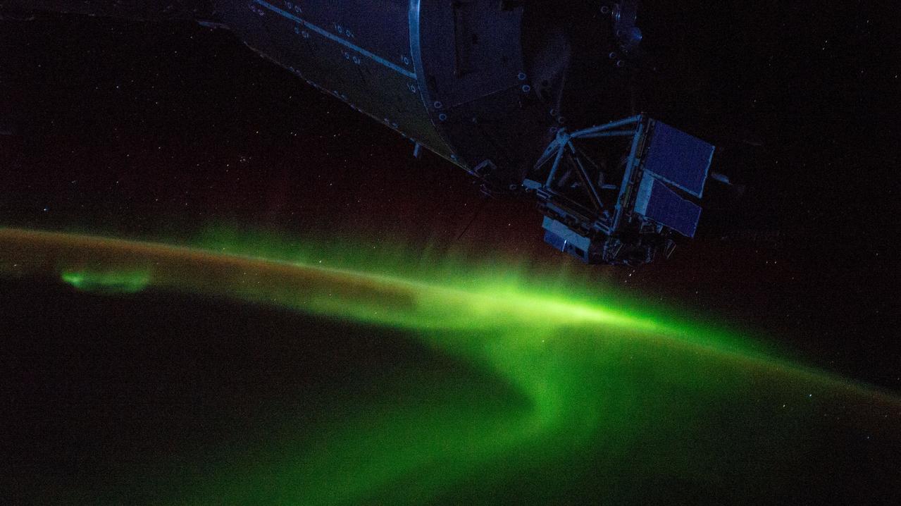
iss059e013118 (April 4, 2019) --- The aurora australis swirls above the Indian Ocean south of Australia as the International Space Station orbited 265 miles over Earth. A portion of the dimly-lit Columbus laboratory module from ESA (European Space Agency) is seen in the top foreground.
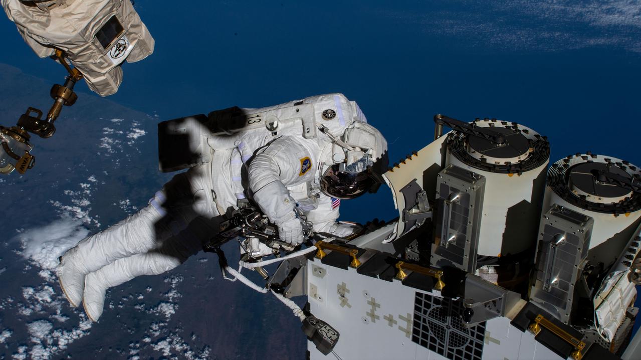
iss068e031767 (Dec. 22, 2022) --- Expedition 68 Flight Engineer and NASA spacewalker Josh Cassada prepares a roll-out solar array for its deployment on the International Space Station's Port-4 truss segment as the orbiting lab flew 264 miles above the Indian Ocean off the coast of South Africa.
ISS029-E-006404 (18 Sept. 2011) --- This is one of a series of night time images photographed by one of the Expedition 29 crew members from the International Space Station. It features Aurora Australis and parts of the southeastern Indian Ocean. Nadir coordinates are 49.42 degrees south latitude and 121.01 degrees east longitude.

iss071e014023 (April 20, 2024) -- Sri Lanka, surrounded by the Indian Ocean, was photographed from the International Space Station as it orbited nearly 260 miles above. Spotted clouds lightly cover the country. Above it is Peninsular India, or South India.
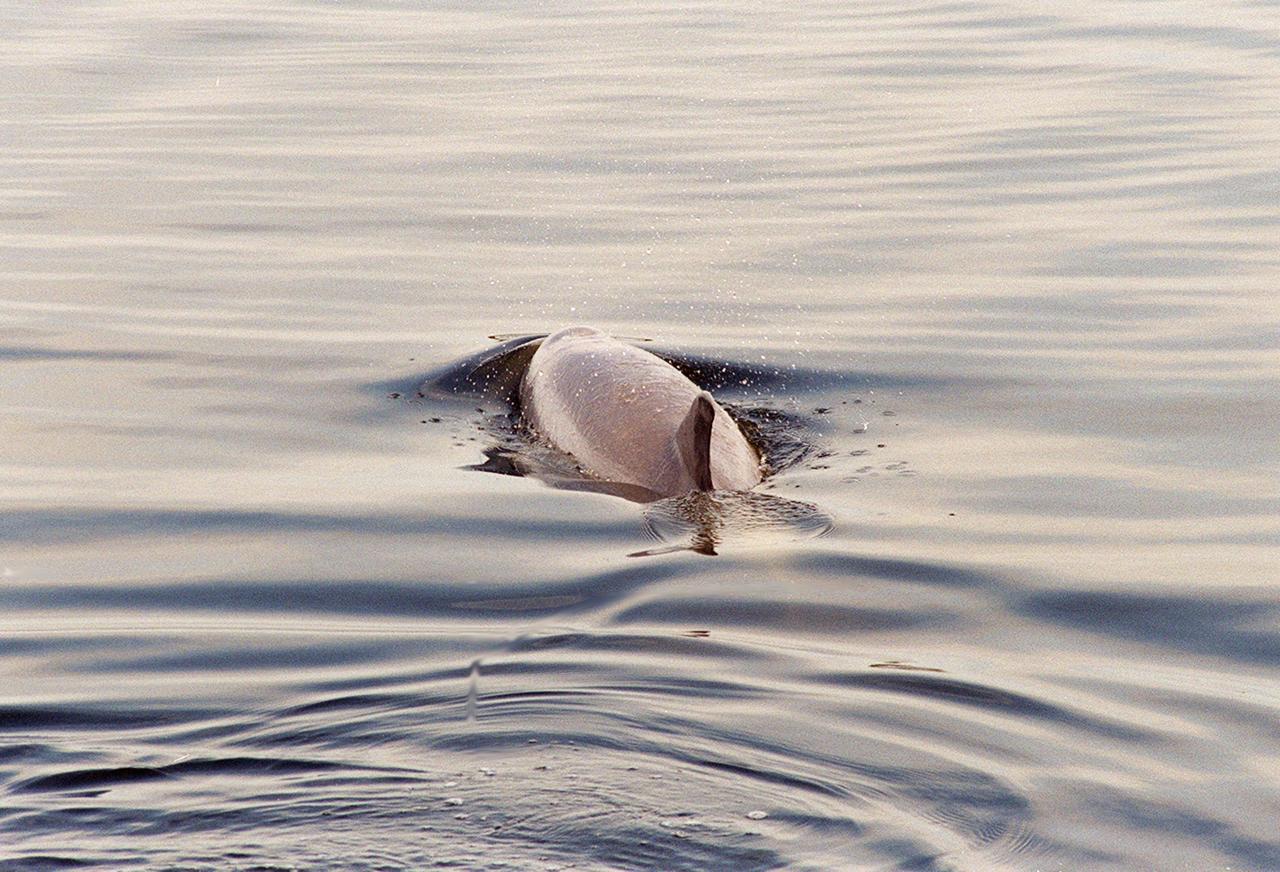
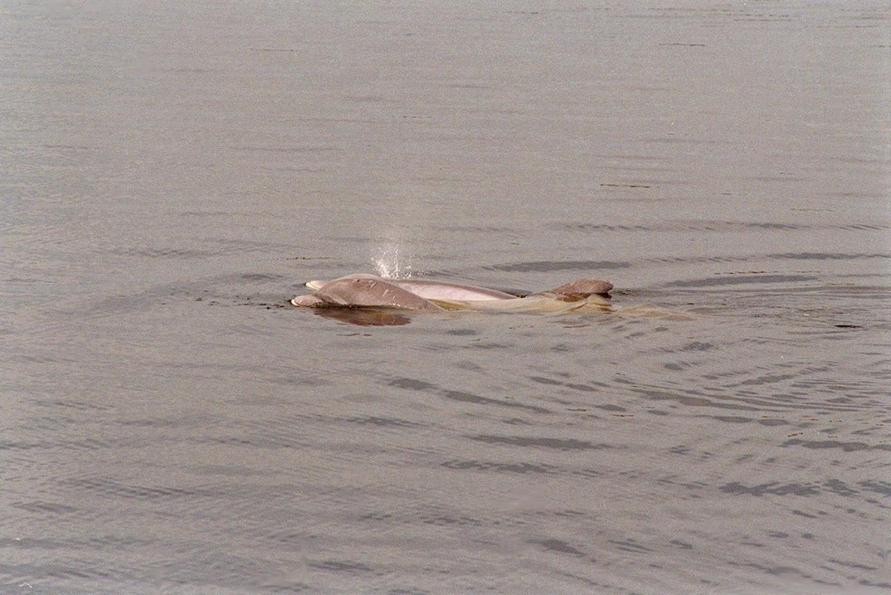
KENNEDY SPACE CENTER, FLA. -- A dolphin glides through the water looking for fish in the turn basin, which is located east of the Vehicle Assembly Building and next to the crawlerway. Dolphins inhabit the waters, known as the Indian River Lagoon, around Kennedy Space Center, along with many different species of oceanic and lagoon fish and shellfish. Mosquito Lagoon to the north, Banana River and Creek to the south and the Indian River to the west make up a special type of estuary called a lagoon, a body of water separated from the ocean by barrier islands, with limited exchange with the ocean through inlets. The Indian River Lagoon has one of the most diverse bird populations anywhere in America. Also, nearly one-third of the nation's manatee population lives here or migrates through the lagoon seasonally. The lagoon varies in width from ½ mile to 5 miles and averages only 3 feet in depth

KENNEDY SPACE CENTER, FLA. -- A dolphin glides through the water looking for fish in the turn basin, which is located east of the Vehicle Assembly Building and next to the crawlerway. Dolphins inhabit the waters, known as the Indian River Lagoon, around Kennedy Space Center, along with many different species of oceanic and lagoon fish and shellfish. Mosquito Lagoon to the north, Banana River and Creek to the south and the Indian River to the west make up a special type of estuary called a lagoon, a body of water separated from the ocean by barrier islands, with limited exchange with the ocean through inlets. The Indian River Lagoon has one of the most diverse bird populations anywhere in America. Also, nearly one-third of the nation's manatee population lives here or migrates through the lagoon seasonally. The lagoon varies in width from ½ mile to 5 miles and averages only 3 feet in depth

iss063e058166 (July 24, 2020) --- The island nation of Sri Lanka and the brightly-lit southern tip of India feature in this photograph from the International Space Station. This portion of the Indian sub-continent is surrounded by three major water bodies including the Laccadive Sea to the west, the Indian Ocean to the south and Bay of Bengal to the east. A starry sky and an atmospheric glow frame the Earth's horizon.
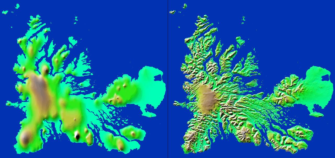
These two images show exactly the same area, Kerguelen Island in the southern Indian Ocean. The image on the left was created using the best global topographic data set previously available, the U.S. Geological Survey GTOPO30.
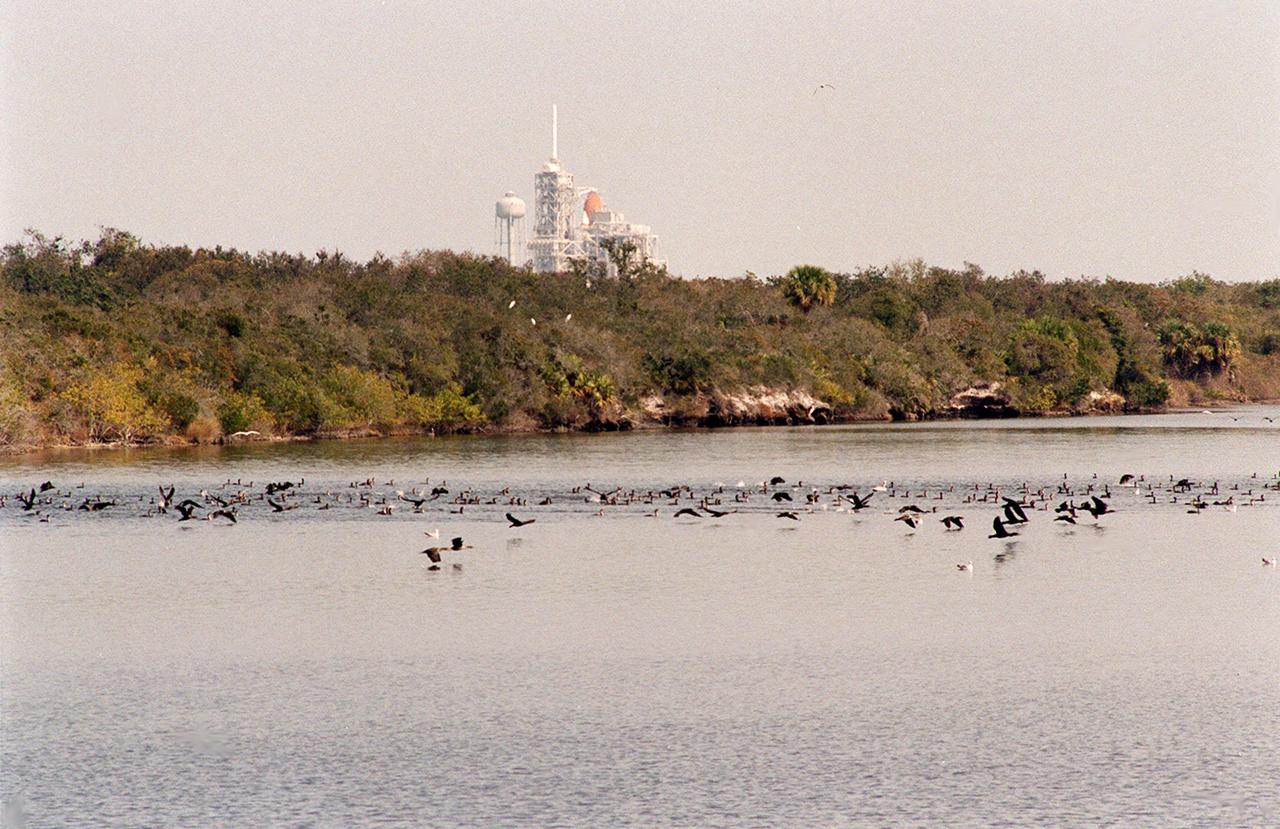
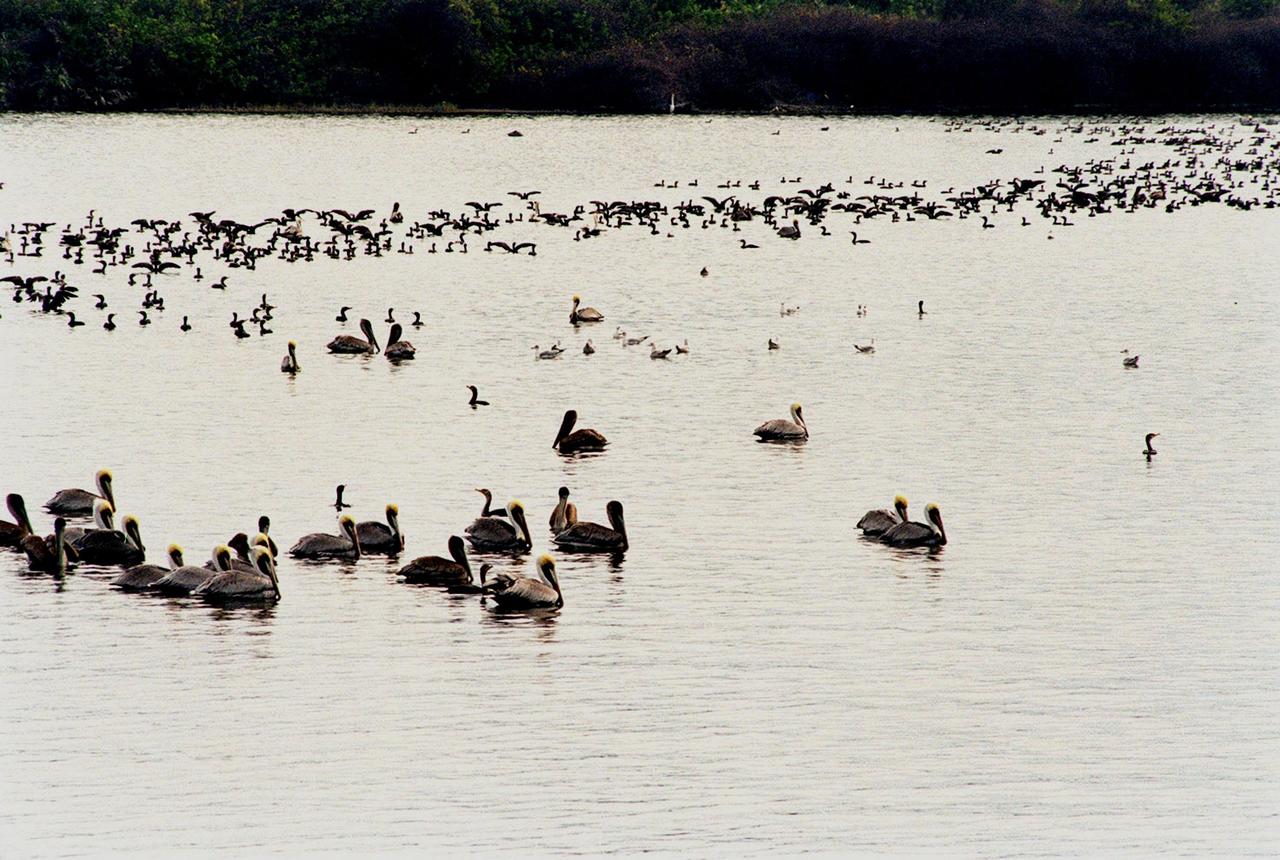
KENNEDY SPACE CENTER, FLA. -- Birds by the score, especially gray and white pelicans, cormorants, sea gulls, herons and ospreys, flock to the turn basin east of the Vehicle Assembly Building in a feeding frenzy as schools of fish fill the waters. In the background is Launch Pad A with Space Shuttle Endeavour waiting for launch on Friday, Feb. 11 for mission STS-99. The basin is part of the Indian River Lagoon, which is made up of Mosquito Lagoon to the north, Banana River and Creek to the south and the Indian River to the west. It is called a lagoon because it is a body of water separated from the ocean by barrier islands, with limited exchange with the ocean through inlets. The Indian River Lagoon has one of the most diverse bird populations anywhere in America. Also, nearly one-third of the nation's manatee population lives here or migrates through the lagoon seasonally. The lagoon varies in width from ½ mile to 5 miles and averages only 3 feet in depth

KENNEDY SPACE CENTER, FLA. -- Birds by the score, especially gray and white pelicans, cormorants, sea gulls, herons and ospreys, flock to the turn basin east of the Vehicle Assembly Building in a feeding frenzy as schools of fish fill the waters. In the background is Launch Pad A with Space Shuttle Endeavour waiting for launch on Friday, Feb. 11 for mission STS-99. The basin is part of the Indian River Lagoon, which is made up of Mosquito Lagoon to the north, Banana River and Creek to the south and the Indian River to the west. It is called a lagoon because it is a body of water separated from the ocean by barrier islands, with limited exchange with the ocean through inlets. The Indian River Lagoon has one of the most diverse bird populations anywhere in America. Also, nearly one-third of the nation's manatee population lives here or migrates through the lagoon seasonally. The lagoon varies in width from ½ mile to 5 miles and averages only 3 feet in depth
iss072e188878 (Nov. 15, 2024) --- Northrop Grumman's Cygnus cargo spacecraft, with its prominent cymbal-shaped solar arrays, is pictured attached to the Earth-facing port on the International Space Station's Unity module. At left, is a portion of the Soyuz MS-26 crew spacecraft docked to the Rassvet module. The orbital outpost was soaring 260 miles above the Indian Ocean south of South Africa at the time of this photograph.
STS032-80-036 (9-20 Jan. 1990) --- This oblique view of Tropical Storm Sam in the eastern Indian Ocean off the western coast of Australia was photographed with a 70mm camera by the astronauts. Tropical Storm Sam (known as Willy-Willy in Australia) was born in the eastern Indian Ocean near the islands of Timor and Sumba in Indonesia. The storm tracked southwestward attaining sustained winds in excess of 60 knots (70 miles per hour). Other than on Christmas Island and the Cocos (Keeling) Islands south of Java, and for strong swells along the western Australia coast, the storm had little impact on land areas. At the time this photograph was taken, the storm was beginning to dissipate in the south Indian Ocean. The eye of the storm is still visible near center, with the swirling bands of the storm propagating in a clockwise direction toward the center. Winds aloft have begun to shear the tops of thunderstorms associated with the storm, forming a high cirrus cloud cover over the center portions of the storm. This picture was used by the crew at their January 30, 1990 Post-Flight Press Conference (PFPC).
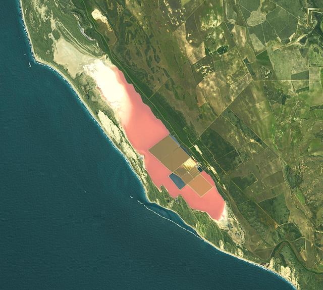
Hutt Lagoon is an elongate lake, located in a dune swale adjacent to the coast of the Indian Ocean, in the mid west region of Western Australia. Port Gregory is located between the ocean and the lake's southern shore. Hutt Lagoon is a pink lake, due to the presence of an algae that produces beta-carotene. A microalgae production plant is the world's largest. The image was acquired September 30, 2012, covers an area of 16.5 by 18.3 km, and is locate at 28.1 degrees south, 114.2 degrees east. https://photojournal.jpl.nasa.gov/catalog/PIA26510
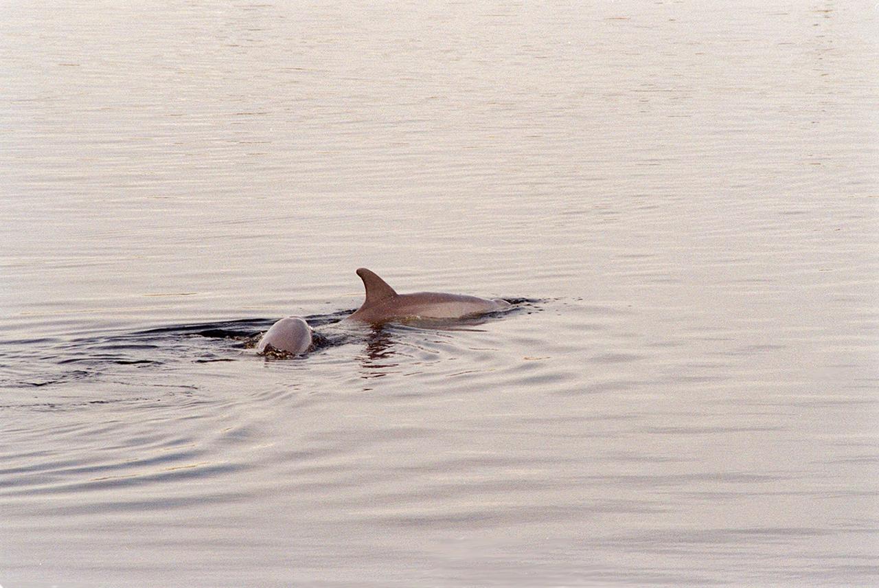
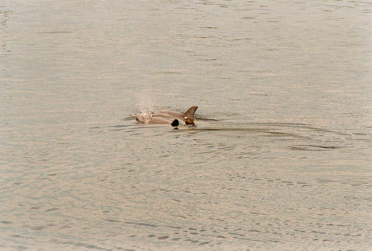
KENNEDY SPACE CENTER, FLA. -- In the turn basin east of the Vehicle Assembly Building and next to the crawlerway, a mother dolphin guides her baby through the water to search for food. Dolphins inhabit the waters around Kennedy Space Center, along with many different species of oceanic and lagoon fish and shellfish. Mosquito Lagoon to the north, Banana River and Creek to the south and the Indian River to the west make up a special type of estuary called a lagoon, a body of water separated from the ocean by barrier islands, with limited exchange with the ocean through inlets. The Indian River Lagoon has one of the most diverse bird populations anywhere in America. Also, nearly one-third of the nation's manatee population lives here or migrates through the lagoon seasonally. The lagoon varies in width from ½ mile to 5 miles and averages only 3 feet in depth

KENNEDY SPACE CENTER, FLA. -- In the turn basin east of the Vehicle Assembly Building and next to the crawlerway, a mother dolphin guides her baby through the water to search for food. Dolphins inhabit the waters around Kennedy Space Center, along with many different species of oceanic and lagoon fish and shellfish. Mosquito Lagoon to the north, Banana River and Creek to the south and the Indian River to the west make up a special type of estuary called a lagoon, a body of water separated from the ocean by barrier islands, with limited exchange with the ocean through inlets. The Indian River Lagoon has one of the most diverse bird populations anywhere in America. Also, nearly one-third of the nation's manatee population lives here or migrates through the lagoon seasonally. The lagoon varies in width from ½ mile to 5 miles and averages only 3 feet in depth
STS061-106-091 (December 1993) --- The entire southern tip of Africa is shown in this high altitude 50mm photograph. The center of the photograph is at approximately 28.0 degrees south and 24.0 degrees east Cape Columbine is at the upper right with Durban at the lower center. The Orange River is at the upper center of the frame. Cape Agulas is the southernmost part of the African continent and is visible toward the upper right corner with the great bays of South Africa trending toward the bottom right. Continuing clockwise along the coast, Durban projects out into the Indian Ocean. The oceanic clouds on the right side of the photograph probably depict a current boundary. The Drakensberg Range on the east, the great Karoo Range to the south and the Karas Mountains on the west surround the drier central plateau. The southern Kalahari Desert is at the upper left of the photograph.
ISS030-E-125322 (6 March 2012) --- Aurora Australis, seen at right on Earth’s horizon, and daybreak (left) highlight this “busy” photograph taken by one of the Expedition 30 crew members aboard the International Space Station. The estimated nadir position of the orbital outpost was over the Indian Ocean (at coordinates of approximately 49.5 degrees south latitude and 122.6 degrees east longitude), or about 1,200 miles south of Australia. The view is toward the east. A Russian Soyuz (center), connected to the Pirs docking compartment, is joined in the foreground (right) by a Russian Progress.
iss064e018944 (Jan. 1, 2021) --- Two spaceships are pictured attached to the International Space Station as the orbiting complex flew into on orbital sunset 269 miles above the Indian Ocean off the southern coast of South Africa. From left, the Northrop Grumman Cygnus space freighter is pictured with its prominent cymbal-shaped UltraFlex solar arrays next to the Soyuz MS-17 crew ship with its rectangular-shaped solar arrays.
S65-63136 (16 Dec. 1965) --- Shark Bay area on the western coast of Western Australia as seen from the Gemini-6 spacecraft during its 16th revolution of Earth. City of Carnarven, where NASA has a tracking station, is located near the bottom of picture in lower left corner, near mouth of stream. Indian Ocean is body of water at upper right. South is toward top of picture. Photo credit: NASA or National Aeronautics and Space Administration
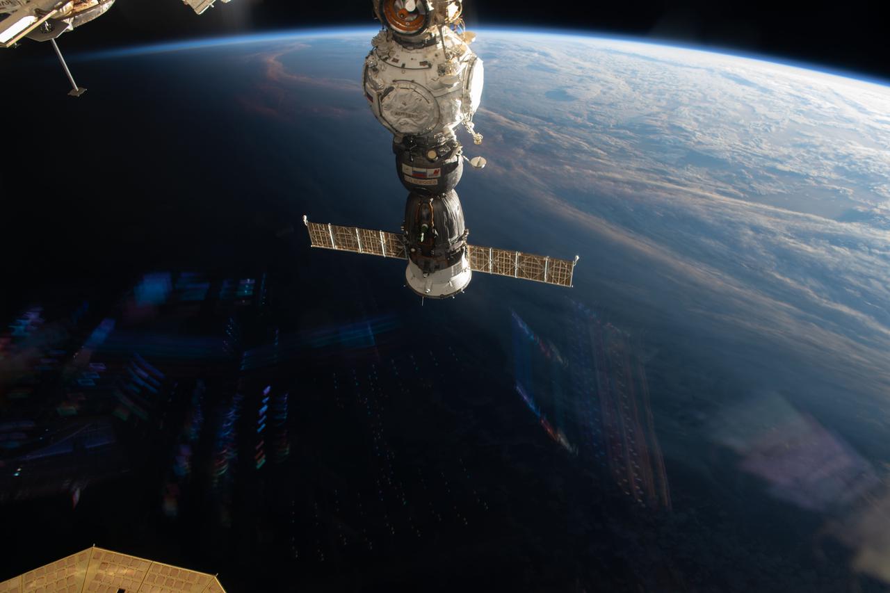
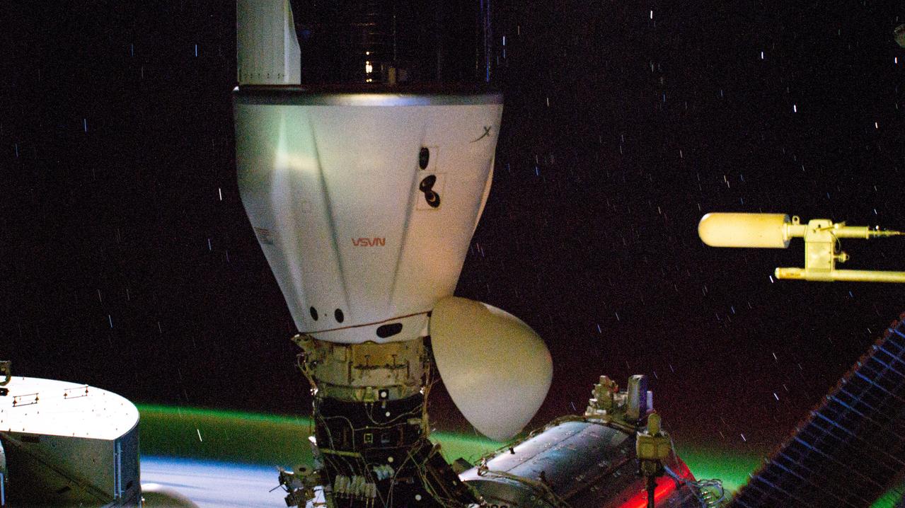
iss073e0002707 (April 27, 2025) --- The Soyuz MS-27 spacecraft is pictured docked to the Prichal module as the International Space Station orbited 269 miles above the Indian Ocean off the coast of South Africa. The Soyuz launched NASA astronaut Jonny Kim and Roscosmos cosmonauts Sergey Ryzhikov and Alexey Zubritsky to the orbital outpost on April 8.
ISS029-E-007455 (18 Sept. 2011) --- This is one of a series of night time images photographed by one of the Expedition 29 crew members from the International Space Station. It features Aurora Australis, airglow, Earth?s Terminator and the southeastern Indian Ocean. Nadir coordinates are 51.78 degrees south latitude and 124.41 degrees east longitude.
iss071e045750 (April 26, 2024) --- The SpaceX Dragon cargo spacecraft is pictured docked to the Harmony module's space-facing port on the International Space Station. In the background, slight star trails and an atmospheric glow above Earth's horizon are pictured in this long-duration photograph as the orbital outpost soared 267 miles above the Indian Ocean south of Africa.
The southernmost tip of Africa is marked by the Cape Agulhas lighthouse. The warm Atlantic Agulhas current meets the cold water Indian Ocean Benguela current, creating treacherous seas that have claimed many ships over the last 450 years. The image covers an area of 22.5 by 41.1 kilometers, was acquired September 27, 2006, and is located at 34.8 degrees south, 20 degrees east. http://photojournal.jpl.nasa.gov/catalog/PIA21014
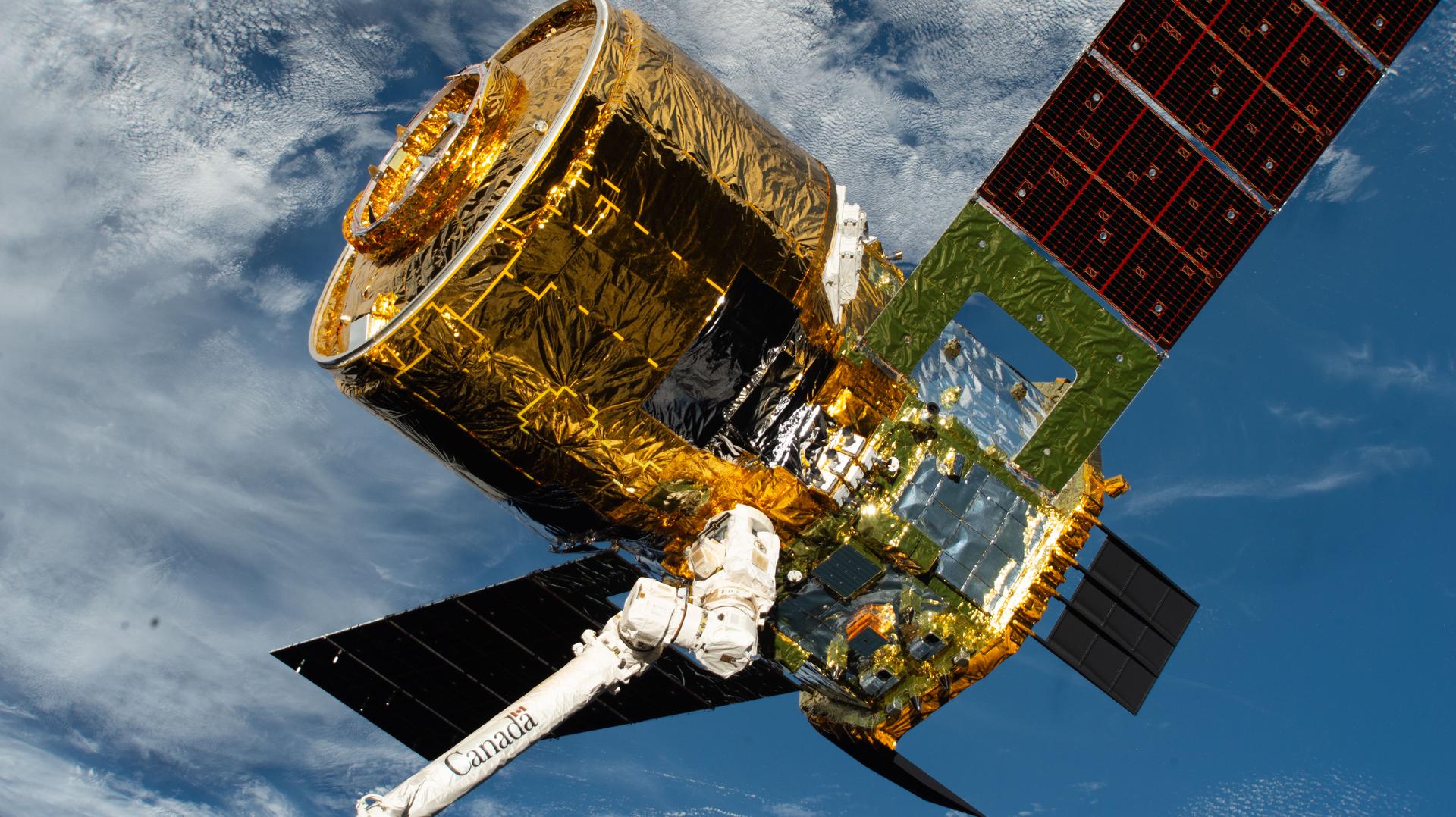
iss074e0365138 (March 6, 2026) --- The HTV‑X1 cargo spacecraft from JAXA (Japan Aerospace Exploration Agency) is grasped by the Canadarm2 robotic arm as the International Space Station orbits 271 miles above the Indian Ocean, off the coast of South Africa. Moments later, Canadarm2 would release HTV‑X1 into Earth orbit, completing the spacecraft’s four‑month stay attached to the orbital outpost’s Harmony module. Credit: NASA

iss070e043722 (Dec. 20, 2023) --- Northrop Grumman's Cygnus space freighter is pictured attached to the International Space Station while orbiting 264 miles above the Indian Ocean south of the island nation of Madagascar. At lower center, is the Canadarm2 robotic arm preparing to grapple Cygnus ahead of its removal from the Unity module and departure from the orbital outpost.
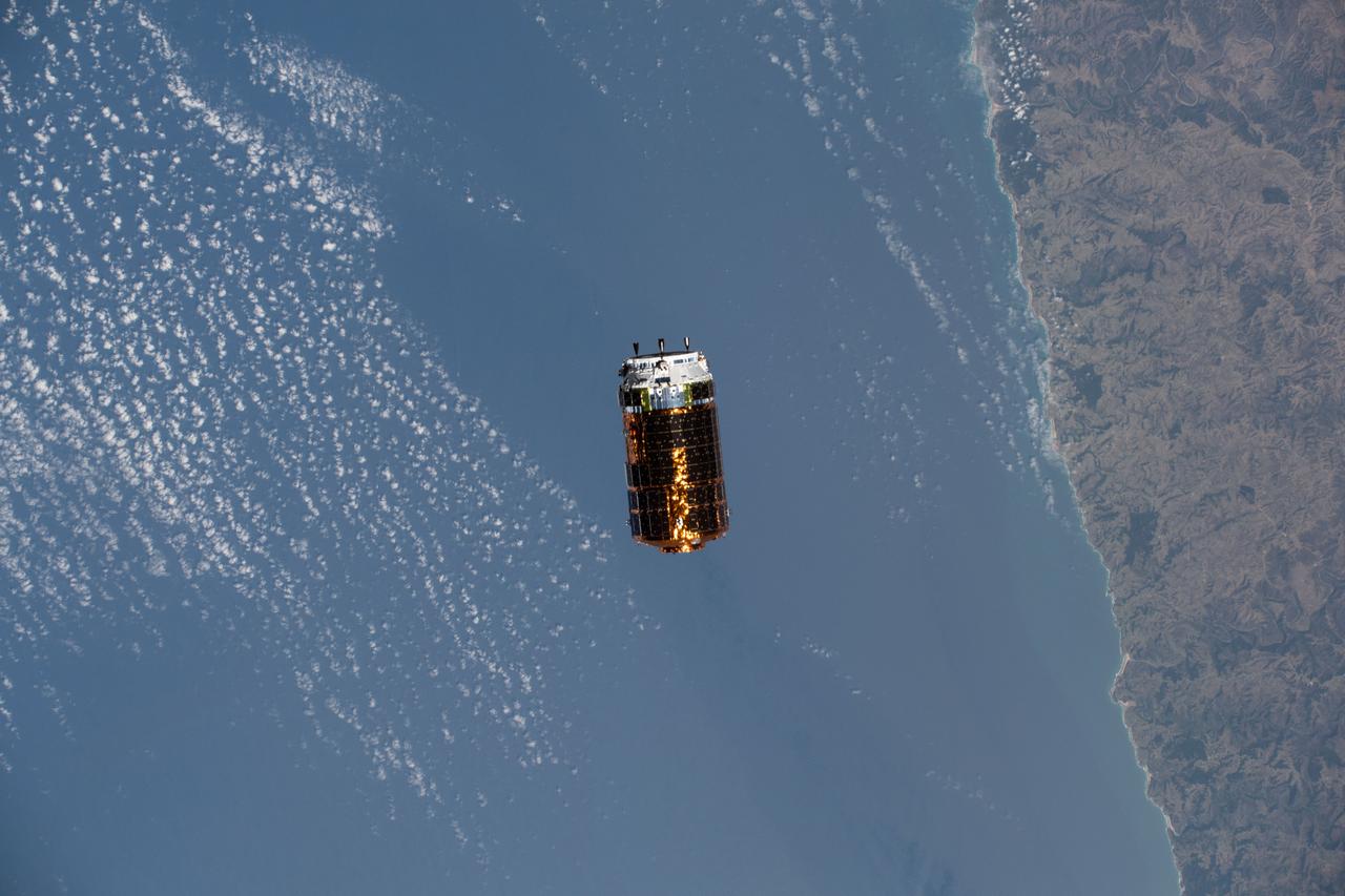
iss060e083260 (Oct. 1, 2019) --- Japan's H-II Transfer Vehicle-8 (HTV-8) slowly approaches the International Space Station as both spacecraft orbited over the Indian Ocean off the coast of South Africa. The HTV-8 would later be grappled by the Canadarm2 robotic arm, operated by astronaut Christina Koch, beginning a month of cargo transfer activities.
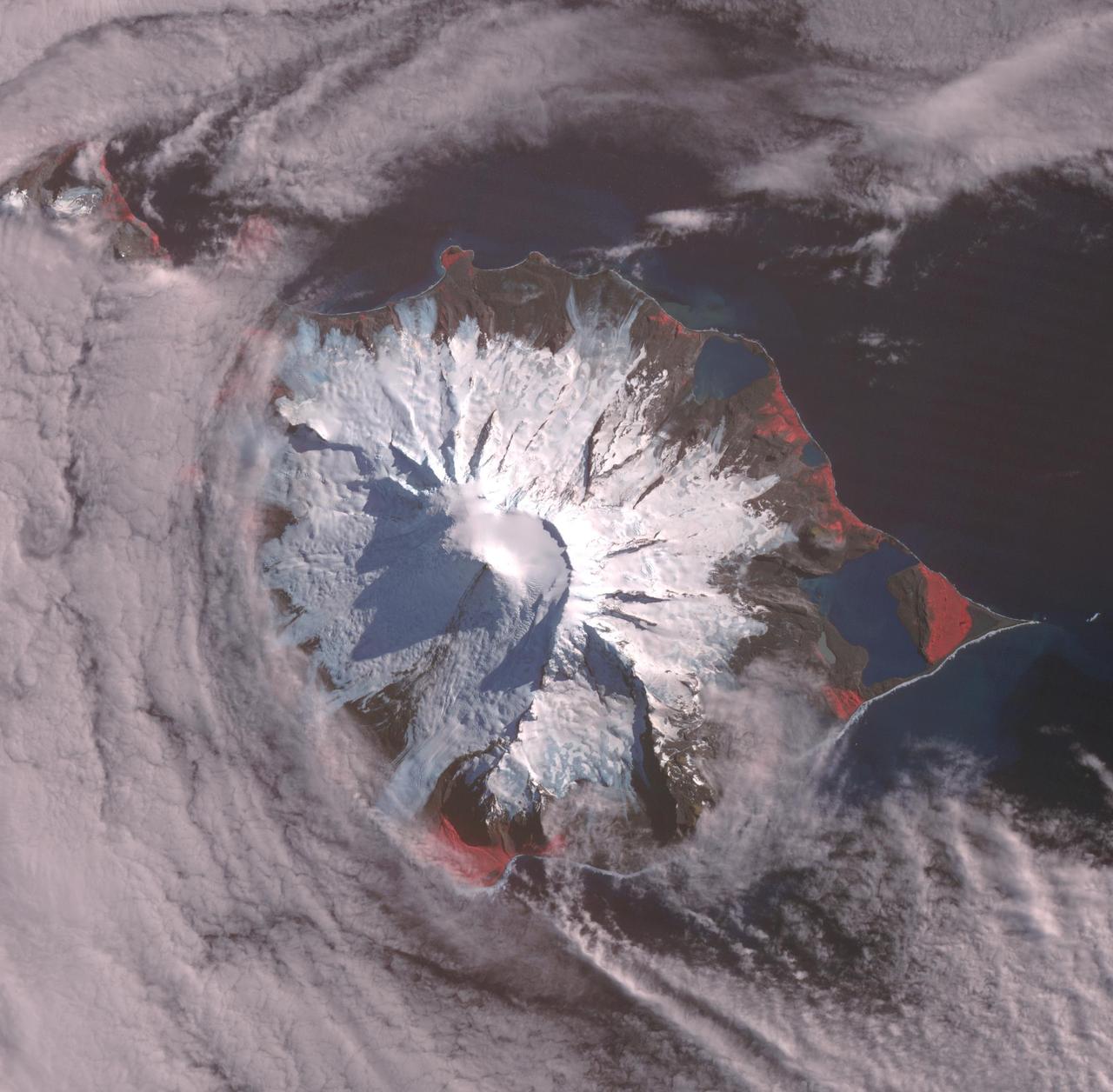
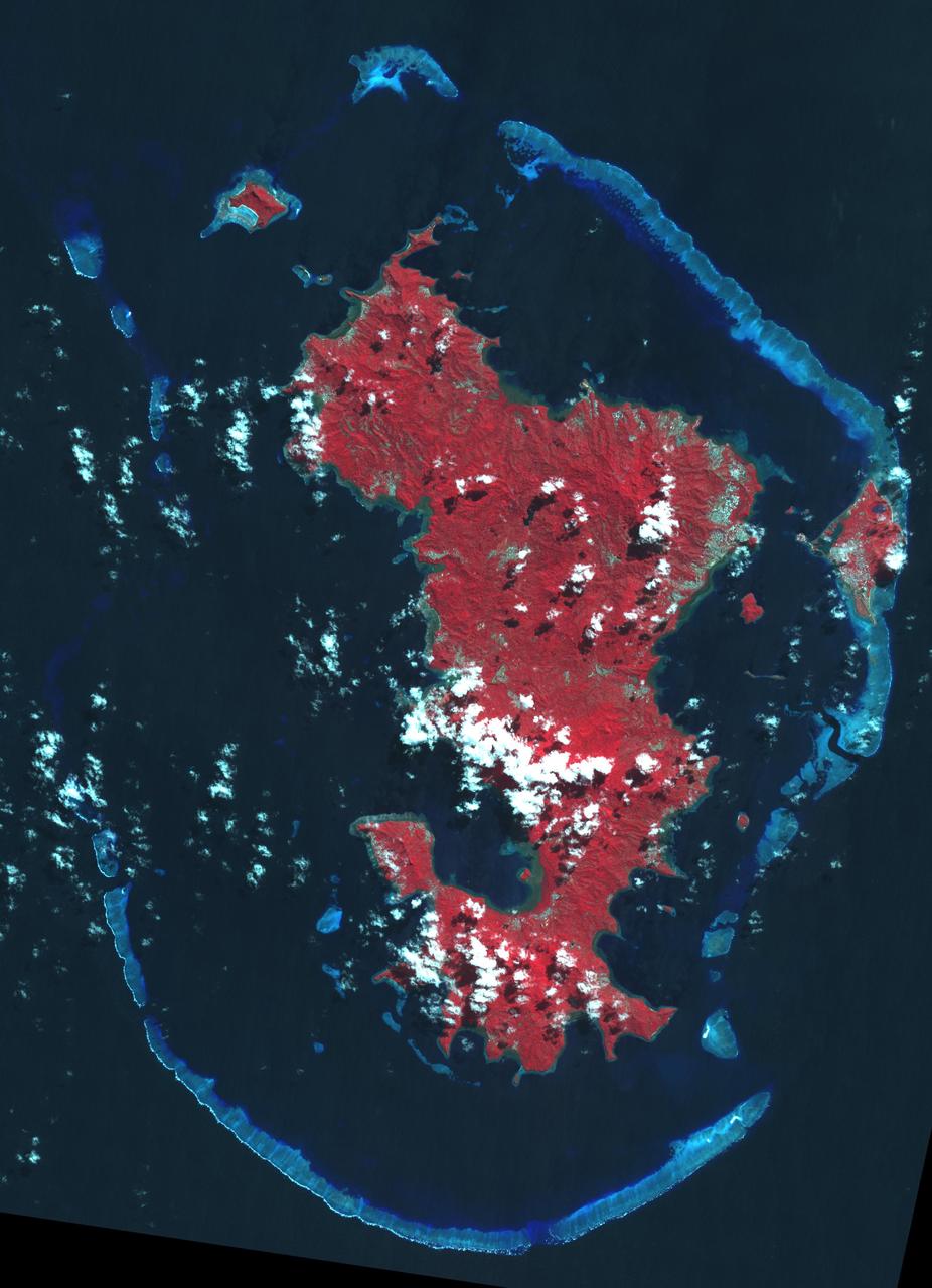
Heard, a remote volcanic island located in the southern Indian Ocean, is an Australian Territory. It consists of two volcanic structures: Big Ben and the smaller Mt. Dixon. The active Mawson Peak is located within a 5-6 km-wide caldera breached to the SW side of Big Ben. Intermittent eruptions have occurred since 1910; the latest in May 2023. The image was acquired March 18, 2025, covers an area of 39.7 by 40.4 km, and is located at 53 degrees south, 73.5 degrees east. https://photojournal.jpl.nasa.gov/catalog/PIA26509
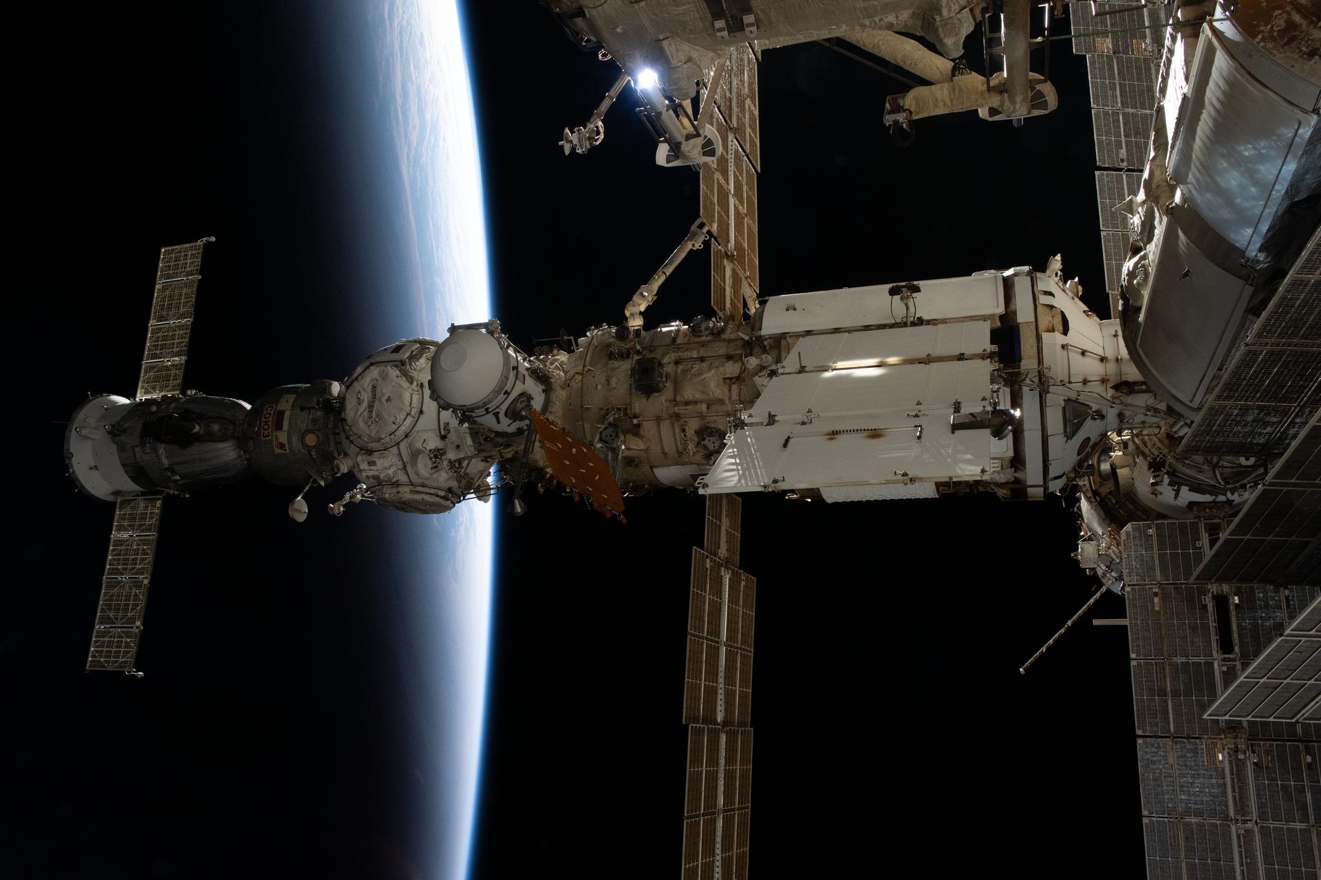
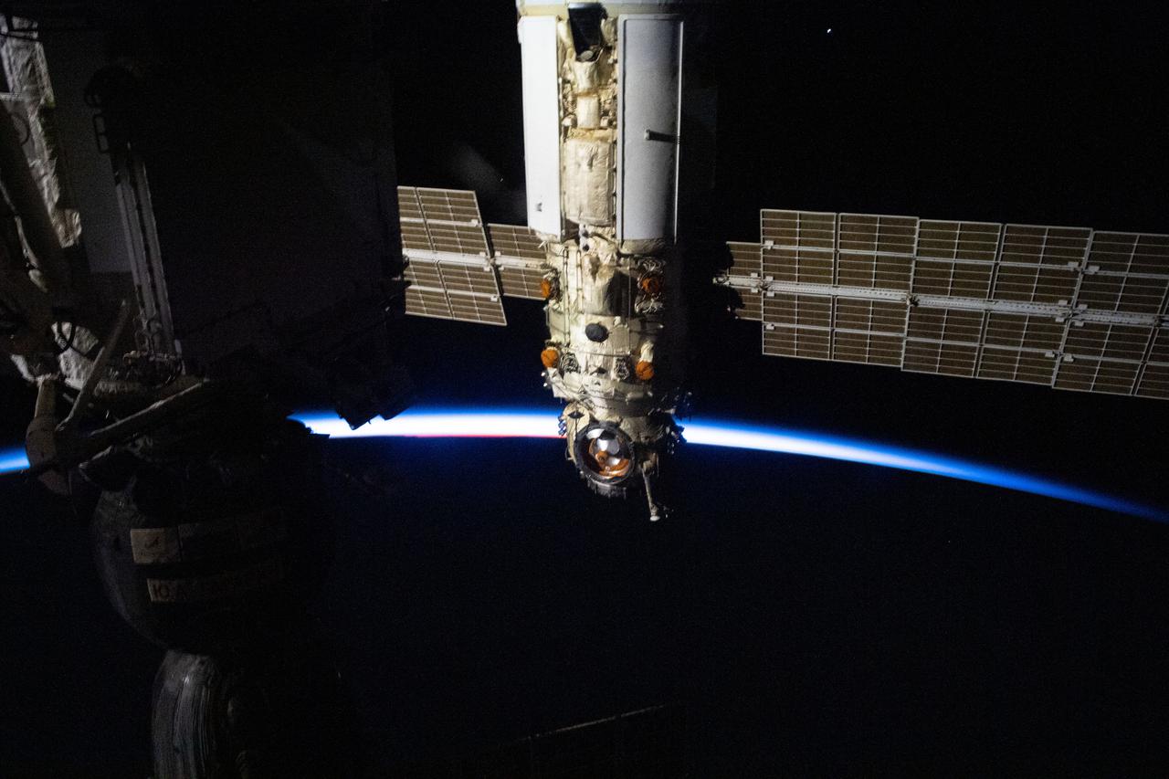
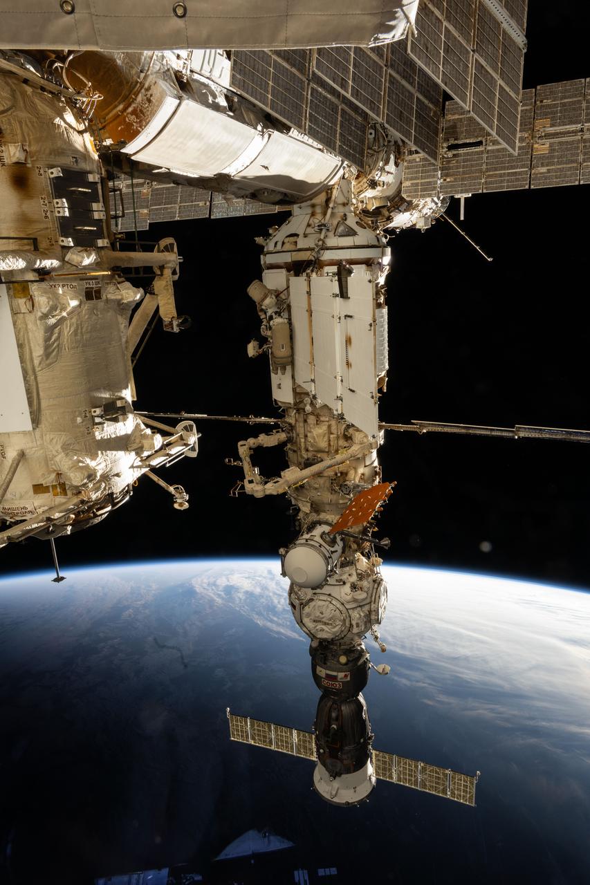
iss073e0885731 (Oct. 16, 2025) --- This view of the International Space Station’s Roscosmos segment shows (from left) the Soyuz MS-27 crew spacecraft docked to the Prichal module. Prichal is connected to the Nauka science module, which in turn is attached to the Earth-facing port of the Zvezda service module. At the time of this photograph, the orbital complex was soaring into a sunset 270 miles above the Indian Ocean, between South Africa and Antarctica, at approximately 8:22 p.m. local time.
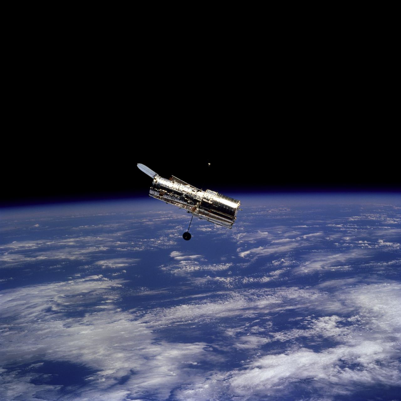
STS082-746-059 (11-21 Feb. 1997) --- The Hubble Space Telescope (HST) is seen during its separation from the Space Shuttle Discovery at a point over the Indian Ocean. Center coordinates of the area pictured are located at 90 degrees west longitude and at the "bottom of the orbit", at 28.5 degrees south latitude, that is, about 1,500 miles west of the Australian coast. The photo was taken in the early afternoon and the sun is high.
The island of Java (8.0S, 112.0E), perhaps better than any other, illustrates the volcanic origin of Pacific Island groups. Seen in this single view are at least a dozen once active volcano craters. Alignment of the craters even defines the linear fault line of Java as well as the other some 1500 islands of the Indonesian Archipelago. Deep blue water of the Indian Ocean to the south contrasts to the sediment laden waters of the Java Sea to the north.
iss071e045543 (April 25, 2024) --- Cosmonauts (near center) Nikolai Chub and Oleg Kononenko are pictured outside of the International Space Station's Nauka science module wearing their Orlan spacesuits during a four-hour and 36-minute spacewalk. The spacewalkers worked on the Russian segment of the complex completing the deployment of one panel on a synthetic radar communications system. The duo also installed equipment and experiments to analyze the level of corrosion on station surfaces and modules. The space station was soaring into an orbital sunset 270 miles above the Indian Ocean south of Africa.
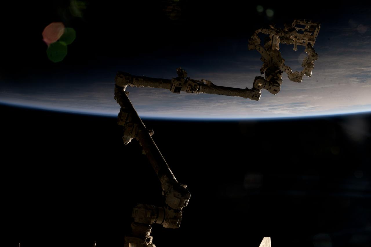
iss073e0490038 (July 22, 2025) --- The International Space Station's 57.7-foot-long robotic arm, also known as the Canadarm2, is partially silhouetted against an orbital sunrise 271 miles above the Indian Ocean south of Australia's island state of Tasmania. Attached to the Canadarm2's latching end effector is Dextre (top right), the fine-tuned robotic hand that performs precise maintenance capabilities on the orbital outpost, including removing and replacing small parts and performing photographic inspections, reducing the need for time-intensive spacewalks.
ISS029-E-007473 (18 Sept. 2011) --- This is one of a series of night time images photographed by one of the Expedition 29 crew members from the International Space Station. It features Aurora Australis, airglow, Earth?s Terminator and parts of the southeast Indian Ocean. Nadir coordinates are 51.53 degrees south latitude and 129.80 degrees east longitude.
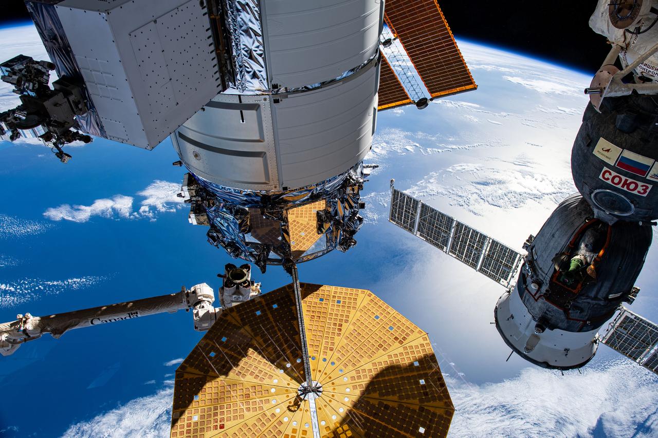
iss067e055885 (May 16, 2022) --- U.S. and Russian spaceships are pictured attached to the International Space Station as it orbited 267 miles above the Indian Ocean south of the island nation of Madagascar. At left, is the U.S. Northrop Grumman Cygnus resupply ship with its prominent cymbal-shaped UltraFlex solar arrays. At right, is the Soyuz MS-21 crew ship docked to the Prichal docking module, which is also attached to the Nauka multipurpose laboratory module. At top center, is the Rassvet module that also hosts Russian visiting vehicles.
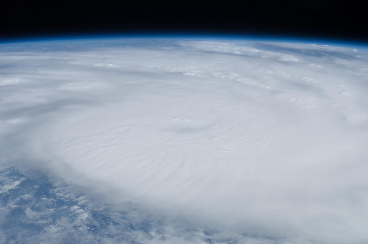
ISS034-E-035983 (28 Jan. 2013) --- This view, photographed by one of the Expedition 34 crew members aboard the International Space Station flying approximately 240 miles above Earth, shows Tropical Cyclone Felleng in the Indian Ocean near Madagascar just prior to being elevated to a Category 4. At the time the photo was taken, the storm was located at 8.5 degrees south latitude and 49.5 degrees east longitude.
iss070e043731 (Dec. 20, 2023) --- Northrop Grumman's Cygnus space freighter and the Roscosmos Soyuz MS-24 crew ship (at right) are pictured attached to the International Space Station while orbiting 266 miles above the Indian Ocean south of the island nation of Madagascar. At lower left, is the Canadarm2 robotic arm preparing to grapple Cygnus ahead of its removal from the Unity module and departure from the orbital outpost.
Mayotte is a volcanic island in the Comoros archipelago between the eastern coast of Africa and the northern tip of Madagascar. It is a French Overseas Territory in the Indian Ocean. On December 14, the island was hit by devastating category-4 hurricane Chido, causing widespread damage and loss of life. The image was acquired June 7, 2016, covers an area of 42 by 58.5 km, and is located at 12.8 degrees south, 45.1 degrees east. https://photojournal.jpl.nasa.gov/catalog/PIA26503
iss074e0043595 (Dec. 29, 2025) --- This long-duration photograph of Earth’s horizon was taken at approximately 8:30 p.m. local time from the International Space Station as it orbited 260 miles above the Indian Ocean, south of Jakarta, Indonesia. A yellow-green airglow crowns the horizon beneath a starry sky and a faint Milky Way. Credit: JAXA/Kimiya Yui
iss072e010127 (Oct. 1, 2024) --- Comet C/2023 A3 Tsuchinshan-ATLAS was about 44 million miles away from Earth in this photograph from the International Space Station as it orbited into a sunrise 272 miles above the Indian Ocean south of Australia's island state of Tasmania. The aurora australis seemingly fades into the atmospheric glow above Earth's horizon.
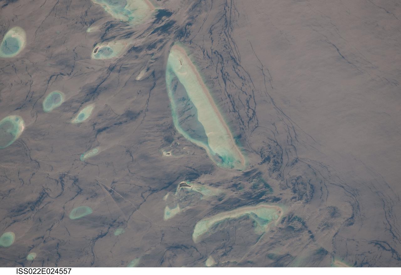
ISS022-E-024557 (12 Jan. 2010) --- Male Atoll and Maldive Islands in the Indian Ocean are featured in this image photographed by an Expedition 22 crew member on the International Space Station. This detailed photograph features one of the numerous atolls in the Maldive Island chain. The Maldives are an island nation, comprised of twenty-six atolls that stretch in a north-to-south chain for almost 900 kilometers southwest of the Indian subcontinent. The silvery, almost pink sheen on the normally blue water of the equatorial Indian Ocean is the result of sunglint. Sunglint occurs when sunlight is reflected off of a water surface directly back towards the observer ? in this case a crew member on the space station. Full sunglint in images typically results in bright silver to white coloration of the water surface. Sunglint images can have different hues depending on the roughness of the water surface and atmospheric conditions. They also can reveal numerous details of water circulation which are otherwise invisible. This image was taken during the Indian Ocean Northeast monsoon season - predominant winds in this area create sinuous surface water patterns on the leeward side, and between, the islets (left). A south-flowing current flows in the deeper water through the Maldives most of the year (right), with fan-shaped surface currents formed by local tides pulsing in and out of the shallow water near the islands (top and bottom). The largest island seen here (center) is 6 kilometers long, and is one of the outer ring of larger islands that make up the 70 kilometers-long, oval-shaped Male Atoll. Shores facing deeper water have well-defined beaches. Numerous small, elliptical coral reef islets are protected within the ring of shallow water to the northeast (left). These islets are mostly awash at high tide, with dry ground appearing in tiny patches only. A small boat was navigating between the islets at the time the image was taken as indicated by its v-shaped wake at bottom left. Images like these illustrate why the Republic of Maldives is one of the most outspoken countries in stressing the dangers of rising sea levels.

KENNEDY SPACE CENTER, FLA. -- Hundreds of birds, especially gray and white pelicans and cormorants, cover the water in the turn basin, located east of the Vehicle Assembly Building and next to the crawlerway. The basin is teeming with fish, attracting the crowd for a meal. The turn basin is part of the Indian River Lagoon, composed of Mosquito Lagoon to the north, Banana River and Creek to the south and the Indian River to the west. The lagoon has one of the most diverse bird populations anywhere in America, plus many different species of oceanic and lagoon fish, shellfish and dolphins. Also, nearly one-third of the nation's manatee population lives here or migrates through the Lagoon seasonally. The Lagoon varies in width from ½ mile to 5 miles and averages only 3 feet in depth
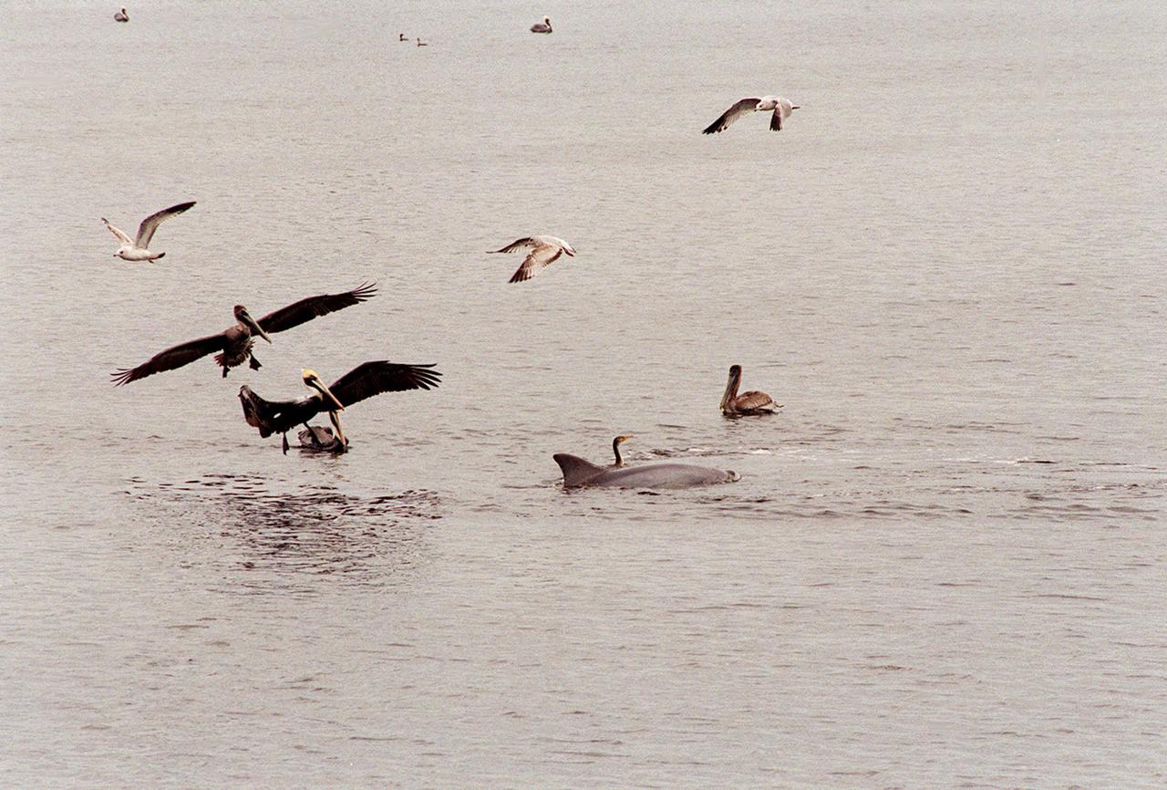
KENNEDY SPACE CENTER, FLA. -- A gray and a white pelican glide down to the water near a dolphin and cormorant in the turn basin to search for a meal in the fish-teeming water. Sea gulls also approach. The turn basin, which is east of the Vehicle Assembly Building and next to the crawlerway, is part of the Indian River Lagoon, composed of Mosquito Lagoon to the north, Banana River and Creek to the south and the Indian River to the west. The lagoon has one of the most diverse bird populations anywhere in America, plus many different species of oceanic and lagoon fish, shellfish and dolphins. Also, nearly one-third of the nation's manatee population lives here or migrates through the Lagoon seasonally. The Lagoon varies in width from ½ mile to 5 miles and averages only 3 feet in depth

KENNEDY SPACE CENTER, FLA. -- A gray and a white pelican glide down to the water near a dolphin and cormorant in the turn basin to search for a meal in the fish-teeming water. Sea gulls also approach. The turn basin, which is east of the Vehicle Assembly Building and next to the crawlerway, is part of the Indian River Lagoon, composed of Mosquito Lagoon to the north, Banana River and Creek to the south and the Indian River to the west. The lagoon has one of the most diverse bird populations anywhere in America, plus many different species of oceanic and lagoon fish, shellfish and dolphins. Also, nearly one-third of the nation's manatee population lives here or migrates through the Lagoon seasonally. The Lagoon varies in width from ½ mile to 5 miles and averages only 3 feet in depth

KENNEDY SPACE CENTER, FLA. -- The water in the turn basin, located east of the Vehicle Assembly Building and next to the crawlerway, teems with fish and draws white pelicans, gray pelicans, cormorants, sea gulls and one of several dolphins looking for a meal. The turn basin is part of the Indian River Lagoon, composed of Mosquito Lagoon to the north, Banana River and Creek to the south and the Indian River to the west. The lagoon has one of the most diverse bird populations anywhere in America, plus many different species of oceanic and lagoon fish, shellfish and dolphins. Also, nearly one-third of the nation's manatee population lives here or migrates through the lagoon seasonally. The lagoon varies in width from ½ mile to 5 miles and averages only 3 feet in depth
KENNEDY SPACE CENTER, FLA. -- Hundreds of birds, especially gray and white pelicans and cormorants, cover the water in the turn basin, located east of the Vehicle Assembly Building and next to the crawlerway. The basin is teeming with fish, attracting the crowd for a meal. The turn basin is part of the Indian River Lagoon, composed of Mosquito Lagoon to the north, Banana River and Creek to the south and the Indian River to the west. The lagoon has one of the most diverse bird populations anywhere in America, plus many different species of oceanic and lagoon fish, shellfish and dolphins. Also, nearly one-third of the nation's manatee population lives here or migrates through the Lagoon seasonally. The Lagoon varies in width from ½ mile to 5 miles and averages only 3 feet in depth
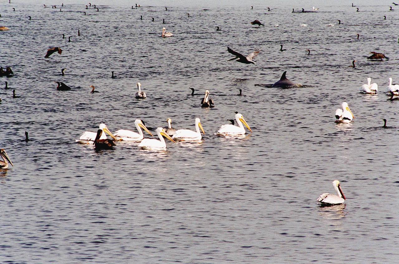
KENNEDY SPACE CENTER, FLA. -- The water in the turn basin, located east of the Vehicle Assembly Building and next to the crawlerway, teems with fish and draws white pelicans, gray pelicans, cormorants, sea gulls and one of several dolphins looking for a meal. The turn basin is part of the Indian River Lagoon, composed of Mosquito Lagoon to the north, Banana River and Creek to the south and the Indian River to the west. The lagoon has one of the most diverse bird populations anywhere in America, plus many different species of oceanic and lagoon fish, shellfish and dolphins. Also, nearly one-third of the nation's manatee population lives here or migrates through the lagoon seasonally. The lagoon varies in width from ½ mile to 5 miles and averages only 3 feet in depth

KENNEDY SPACE CENTER, FLA. -- In the turn basin east of the Vehicle Assembly Building and next to the crawlerway, a mother dolphin guides her baby through the water to search for food. Dolphins inhabit the waters around Kennedy Space Center, along with many different species of oceanic and lagoon fish and shellfish. Mosquito Lagoon to the north, Banana River and Creek to the south and the Indian River to the west make up a special type of estuary called a lagoon, a body of water separated from the ocean by barrier islands, with limited exchange with the ocean through inlets. The Lagoon varies in width from ½ mile to 5 miles and averages only 3 feet in depth. Nearly one-third of the nation's manatee population lives here or migrates through the Lagoon seasonally

KENNEDY SPACE CENTER, FLA. -- In the turn basin east of the Vehicle Assembly Building and next to the crawlerway, a mother dolphin guides her baby through the water to search for food. Next to them on a rock is an osprey eating a fish. Dolphins inhabit the waters around Kennedy Space Center, along with many different species of oceanic and lagoon fish and shellfish. Mosquito Lagoon to the north, Banana River and Creek to the south and the Indian River to the west make up a special type of estuary called a lagoon, a body of water separated from the ocean by barrier islands, with limited exchange with the ocean through inlets. The Lagoon varies in width from ½ mile to 5 miles and averages only 3 feet in depth. Nearly one-third of the nation's manatee population lives here or migrates through the Lagoon seasonally. The lagoon also has one of the most diverse bird populations anywhere in America
KENNEDY SPACE CENTER, FLA. -- In the turn basin east of the Vehicle Assembly Building and next to the crawlerway, a mother dolphin guides her baby through the water to search for food. Dolphins inhabit the waters around Kennedy Space Center, along with many different species of oceanic and lagoon fish and shellfish. Mosquito Lagoon to the north, Banana River and Creek to the south and the Indian River to the west make up a special type of estuary called a lagoon, a body of water separated from the ocean by barrier islands, with limited exchange with the ocean through inlets. The Lagoon varies in width from ½ mile to 5 miles and averages only 3 feet in depth. Nearly one-third of the nation's manatee population lives here or migrates through the Lagoon seasonally
KENNEDY SPACE CENTER, FLA. -- In the turn basin east of the Vehicle Assembly Building and next to the crawlerway, a mother dolphin guides her baby through the water to search for food. Next to them on a rock is an osprey eating a fish. Dolphins inhabit the waters around Kennedy Space Center, along with many different species of oceanic and lagoon fish and shellfish. Mosquito Lagoon to the north, Banana River and Creek to the south and the Indian River to the west make up a special type of estuary called a lagoon, a body of water separated from the ocean by barrier islands, with limited exchange with the ocean through inlets. The Lagoon varies in width from ½ mile to 5 miles and averages only 3 feet in depth. Nearly one-third of the nation's manatee population lives here or migrates through the Lagoon seasonally. The lagoon also has one of the most diverse bird populations anywhere in America
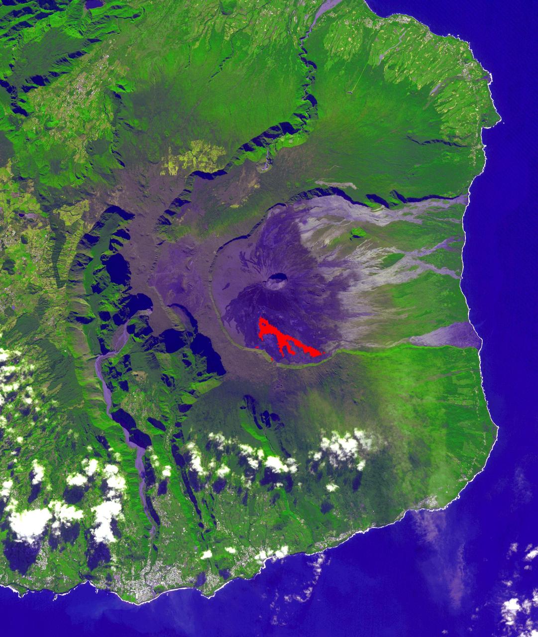
In July, 2018 an eruption began from Piton de la Fournaise volcano on Reunion Island in the western Indian Ocean. Activity continued through November, when these ASTER data were acquired. More than 150 eruptions have occurred since the 17th century. The active flow, derived from the thermal infrared band, is shown in red. The background is a pre-eruption image. The background image was acquired July 16, 2018, and the thermal image on November 1, 2018. The images cover an area of 18 miles by 21 miles (28.9 by 34.2 kilometers), and in the area of 21.3 degrees south, 55.8 degrees east. https://photojournal.jpl.nasa.gov/catalog/PIA22755
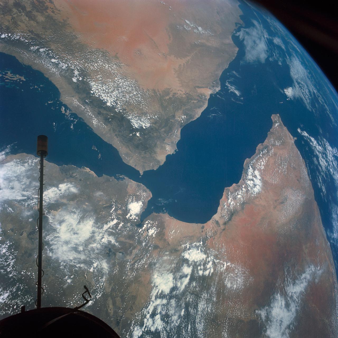
S66-54536 (14 Sept. 1966) --- Arabian Peninsula (on left) and northeast Africa (on right) as seen from the orbiting Gemini-11 spacecraft at an altitude of 340 nautical miles during its 27th revolution of Earth, looking southeast. Saudi Arabia, South Arabia, Yemen, and Aden Protectorate are at left. At bottom right is Ethiopia. French Somaliland is in center on right shore. Somali is at upper right. Body of water at bottom is Red Sea. Gulf of Aden is in center; and at top left is Indian Ocean. Taken with a modified 70mm Hasselblad camera, using Eastman Kodak, Ektachrome, MS (S.O. 368) color film. Photo credit: NASA