
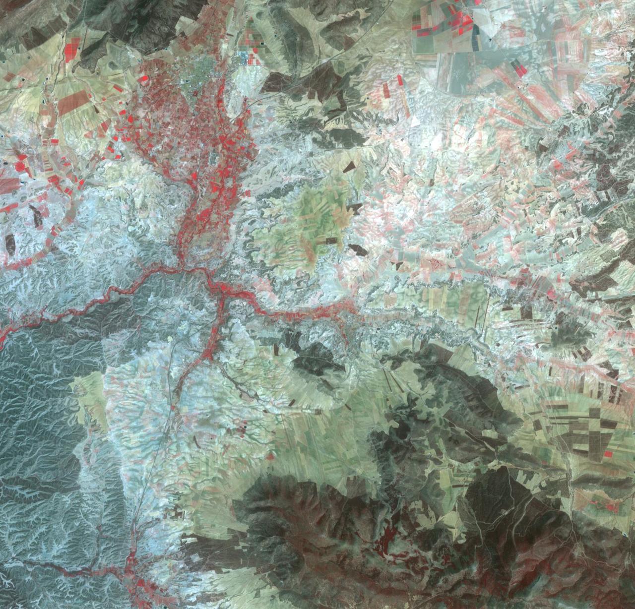
Delegates from the Embassy of Spain visited Goddard on Sept 29, 2016. Center Director Chris Scolese gave a brief overview of the Center and the guests then toured B29 James Webb Space Telescope (JWST) in clean room, and B28 Hyperwall.

Delegates from the Embassy of Spain visited Goddard on Sept 29, 2016. Center Director Chris Scolese gave a brief overview of the Center and the guests then toured B29 James Webb Space Telescope (JWST) in clean room, and B28 Hyperwall.
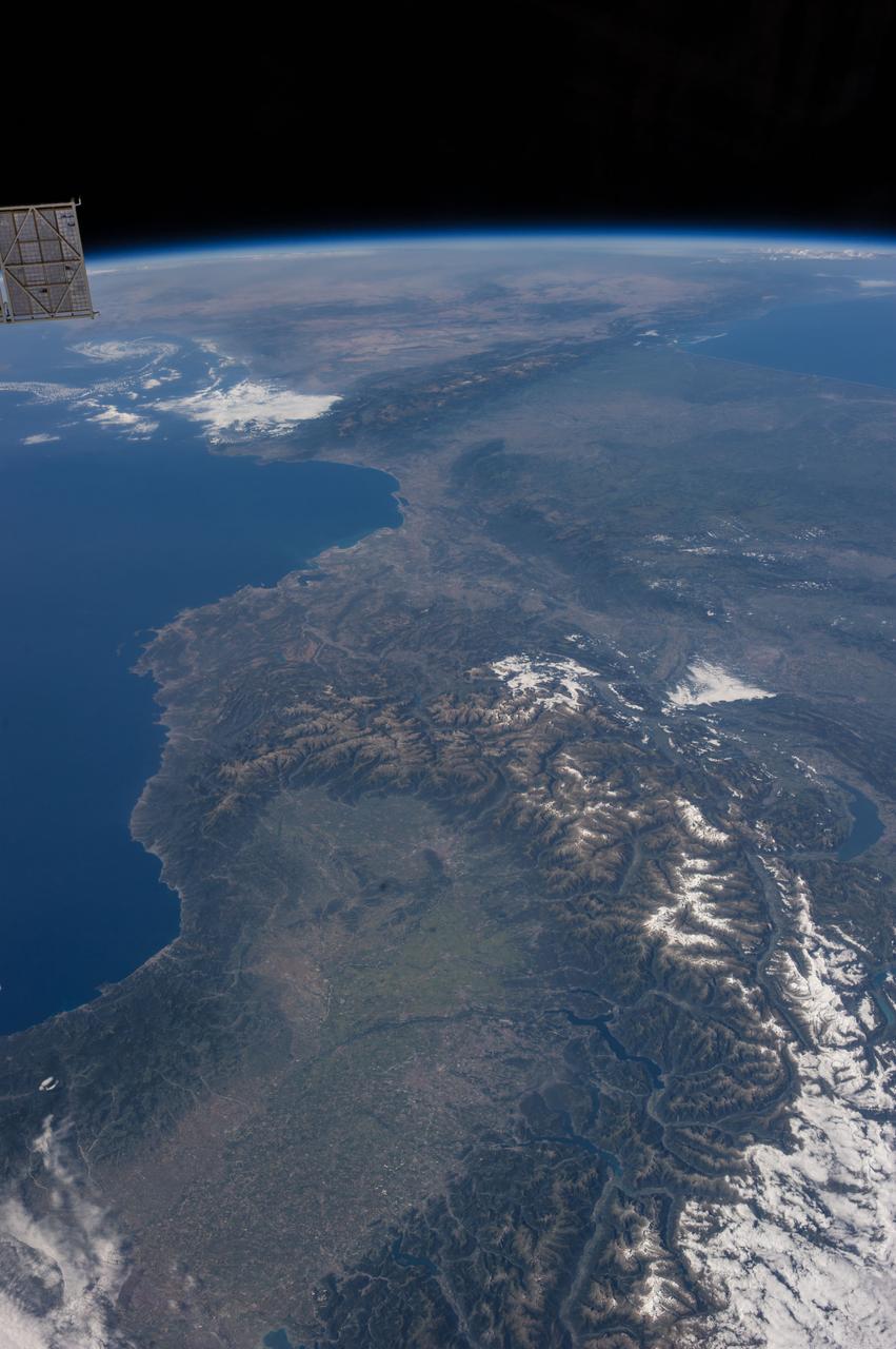
Surrounding the town of El Ejido, Almeria Province, southern Spain is a sea of greenhouses, stretching for tens of kilometers as shown in this image from NASA Terra spacecraft.
In the heart of the high plateau of Grenada in southern Spain is the small town of Orce. Archaeological excavations have discovered the remains of the earliest humans on the European continent, dating back 1.4 million years. At that time, the area was near ancient Lake Orce-Baza, and supported a rich fauna of animals, including mammoths and sabre-tooth tigers. The image was acquired August 10, 2023, covers an area of 22.6 by 23.7 km, and is located at 37.7 degrees north, 2.5 degrees west. https://photojournal.jpl.nasa.gov/catalog/PIA26286
The Advanced Spaceborne Thermal Emission and Reflection Radiometer instrument aboard NASA Terra spacecraft captured this image of the Rio Tinto river in southwestern Spain which originates in the Sierra Morena mountains of Andalusia.
The world largest solar power tower recently began operating outside Seville, Spain -- and it marks a historic moment in the saga of renewable energy. This image was acquired by NASA Terra spacecraft.
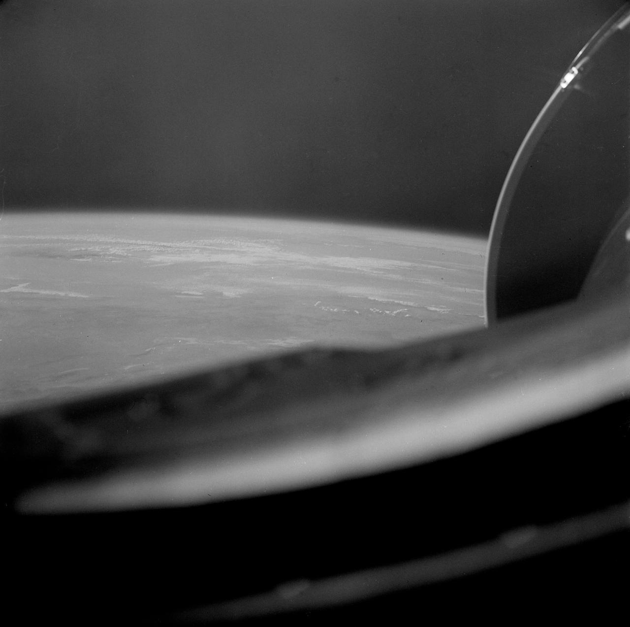
S66-45749 (18 July 1966) --- Straits of Gibraltar, Mediterranean Sea, Spain in background, Algeria and Morocco in foreground as seen from Gemini-10 spacecraft. Photo credit: NASA
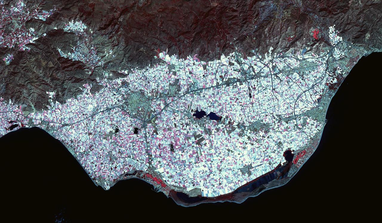
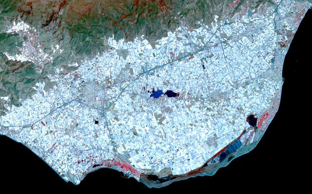
Poniente Almeriense in Almeria, Spain is also known as the Sea of Plastic due to the multitude of greenhouses that cover the area. Typical agricultural products grown under plastic are watermelons, eggplants, zucchinis, cucumbers, peppers and tomatoes. The image was acquired April 19, 2019, covers an area of 22 by 37.5 km, and is located at 36.8 degrees north, 2.7 degrees west. https://photojournal.jpl.nasa.gov/catalog/PIA25791
The white, mottled area in the right-center of this image from NASA Shuttle Radar Topography Mission SRTM is Madrid, the capital of Spain.
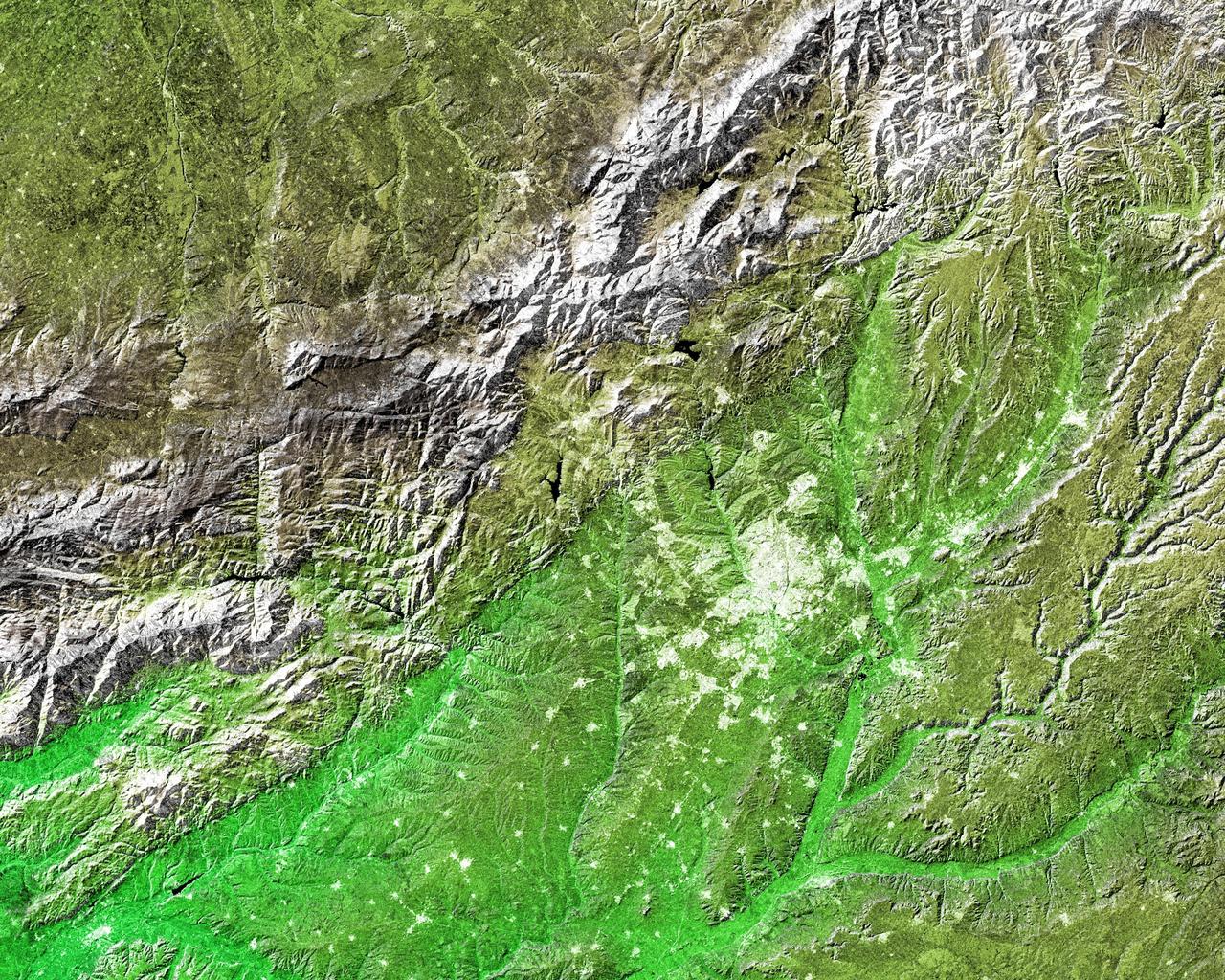
This ASTER image, acquired on August 1, 2000, covers an area of 57 by 29 km and covers part of the central Pyrenees in Spain. The Pyrenees in southwestern Europe extend for about 435 kilometers (about 270 miles) from the Bay of Biscay to the Mediterranean Sea, separating the Iberian Peninsula from the rest of Europe. The Pyrenees form most of the boundary between France and Spain, and encompass the tiny principality of Andorra. Approximately two-thirds of the mountains lie in Spain. The central Pyrenees extend to the Collines du Perche and contain the highest peaks of the system, including Pico de Aneto, the highest at 3,404 meters (11,168 feet). ASTER bands 4, 3 and 2 were displayed in red, green and blue. In this combination, snow is blue, vegetation is green, bare rocks are pink and dark blue, and clouds are white. The image is located at 42.6 degrees north latitude and 0.6 degrees east longitude. http://photojournal.jpl.nasa.gov/catalog/PIA11162
This set of images from the La Sagra Sky Survey, operated by the Astronomical Observatory of Mallorca in Spain, shows the passage of asteroid 2012 DA14 shortly after its closest, and safe, approach to Earth.
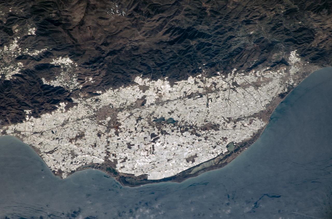
ISS008-E-14686 (7 February 2004) --- This image featuring southern Spain was photographed by an Expedition 8 crewmember on the International Space Station (ISS). Over the past 50 years, the small coastal plain (campo), some 30 kilometers southwest of the city of Almeria, has been intensively developed for agriculture. The area has a dry mild, Mediterranean climate and is further sheltered on the north by the Sierra de Gador. Note the dense, bright pattern of thousands of greenhouses extending from the shoreline right up to the base of the mountains and even into some of the smaller valleys. Saltpan operations can also be seen in the long coastal lagoons.
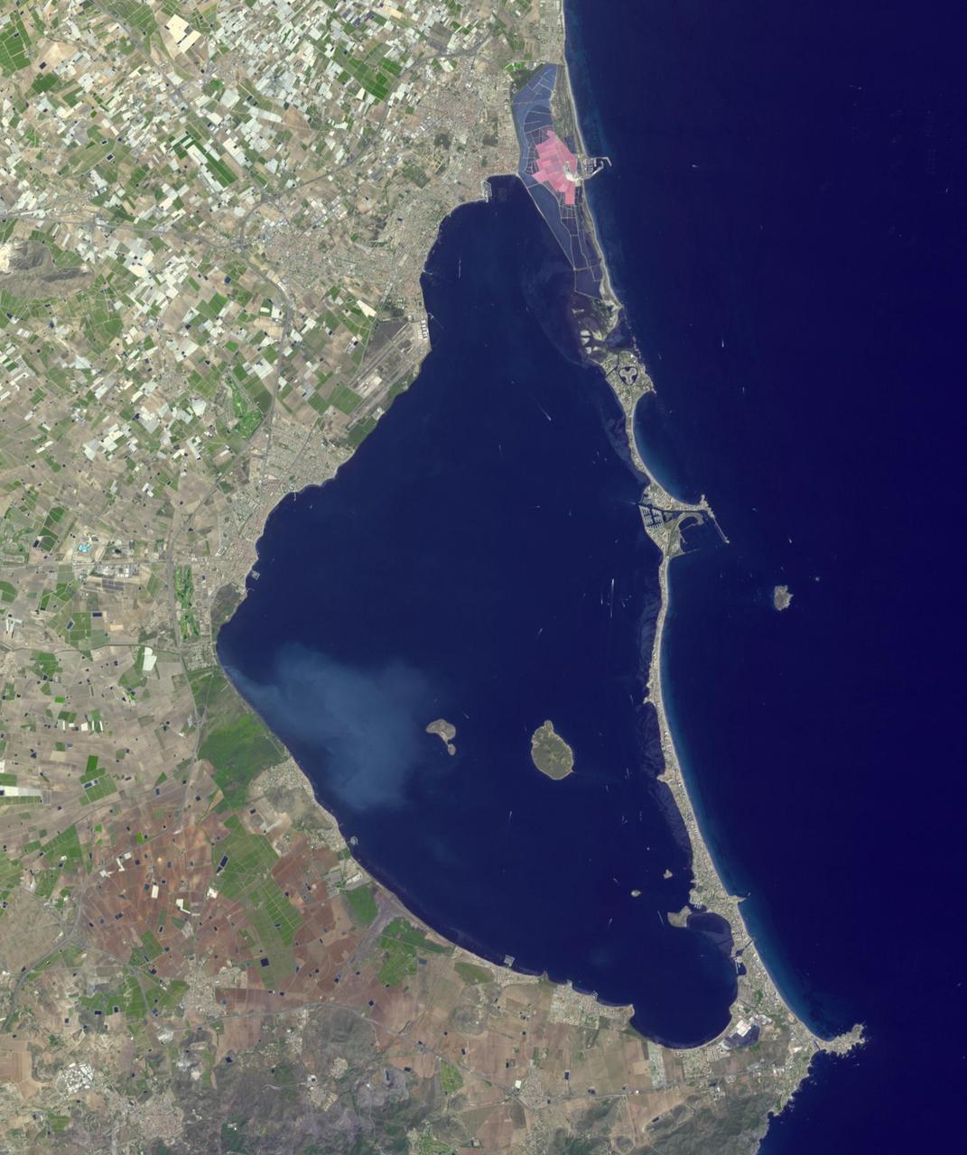
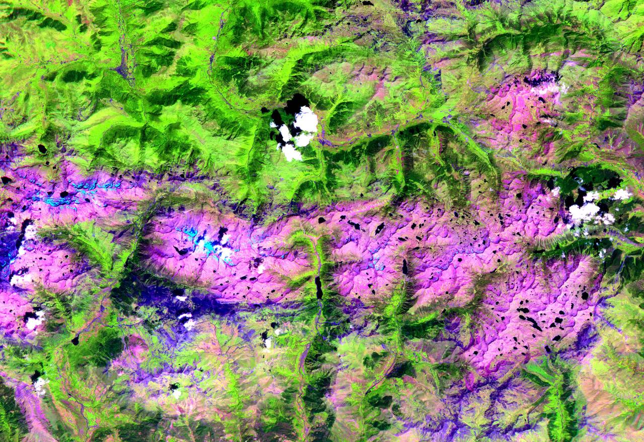
Mar Menor, in southeast Spain, is Europe's largest coastal saltwater lagoon. For the past 40 years, Mar Menor has faced severe contamination from agricultural runoff, leading to large algal blooms, and ecological degradation. Now, major restoration and prevention programs are in place to restore the lagoon, and try to reverse the damage. The image was acquired August 24, 2023, covers an area of 22.6 by 27.4 km, and is located at 37.7 degrees north, 0.8 degrees west. With its 14 spectral bands from the visible to the thermal infrared wavelength region and its high spatial resolution of about 50 to 300 feet (15 to 90 meters), ASTER images Earth to map and monitor the changing surface of our planet. ASTER is one of five Earth-observing instruments launched Dec. 18, 1999, on Terra. The instrument was built by Japan's Ministry of Economy, Trade and Industry. A joint U.S./Japan science team is responsible for validation and calibration of the instrument and data products. The broad spectral coverage and high spectral resolution of ASTER provides scientists in numerous disciplines with critical information for surface mapping and monitoring of dynamic conditions and temporal change. Example applications are monitoring glacial advances and retreats; monitoring potentially active volcanoes; identifying crop stress; determining cloud morphology and physical properties; wetlands evaluation; thermal pollution monitoring; coral reef degradation; surface temperature mapping of soils and geology; and measuring surface heat balance. https://photojournal.jpl.nasa.gov/catalog/PIA26009
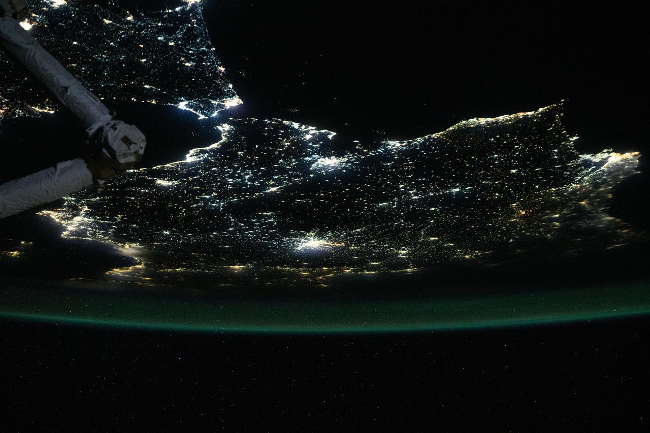
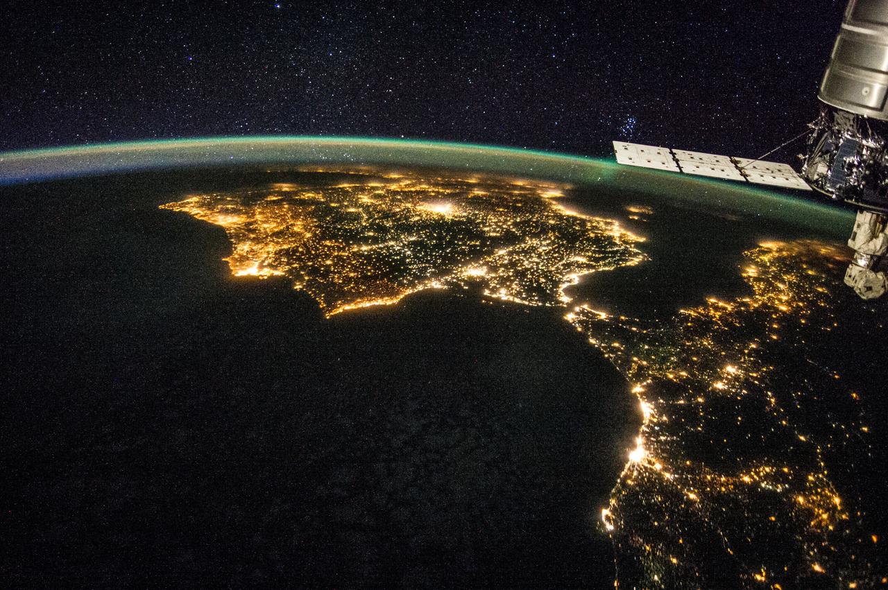
iss073e0686324 (Aug. 30, 2025) --- The nighttime coastal lights of Morocco and Spain, where the Atlantic Ocean meets the Mediterranean Sea at the Strait of Gibraltar, are pictured at approximately 1:36 a.m. local time as the International Space Station orbited 260 miles above the Moroccan coast.
iss071e217183 (June 25, 2024) -- As the International Space Station orbited 263 miles above Earth, NASA astronaut Butch Wilmore captured this image of Spain and Morocco. The Strait of Gibraltar separates the two countries and connects the Atlantic Ocean to the Mediterranean Sea.
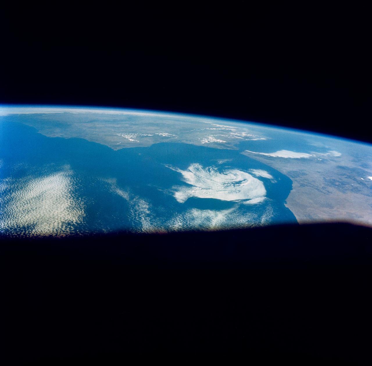
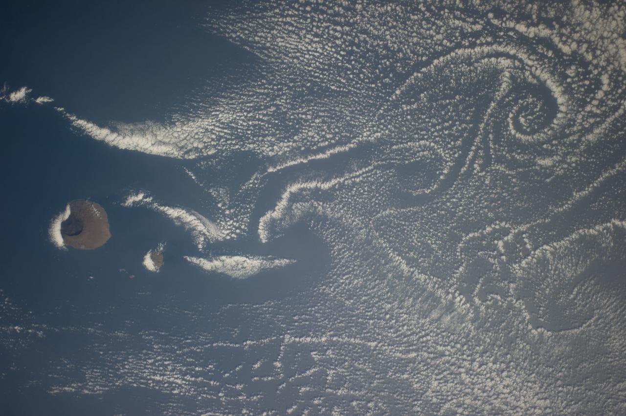
S66-46044 (18-21 July 1966) --- Straits of Gibraltar and Spain ? Portugal (left), Morocco (right), Atlantic Ocean (foreground), and unique vortex, as seen from the Gemini-10 spacecraft. Taken with J.A. Maurer 70mm camera, using Eastman Kodak, Ektachrome, MS (S.O. 217) color film. Photo credit: NASA
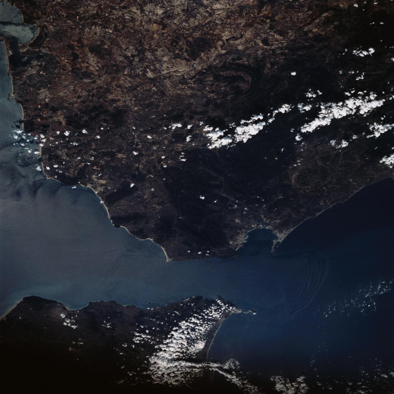
STS-56 Earth observation taken aboard Discovery, Orbiter Vehicle (OV) 103, is of the Strait of Gibraltar. A small bank of clouds marks the passage between Spain and Morocco at the western edge of the Mediterranean Sea. This passage, one of the two Pilars of Hercules of the Ancient Greeks, is now known as the Strait of Gibraltar. The cities of Cadiz on the Atlantic Coast of Spain and Malaga on the Mediterranean coast, as well as Tangier, Morocco (facing the strait), can be seen. According to NASA scientists studying the STS-56 photos, a subtle difference in the water color on the Atlantic side suggests that a pulse of surface water had recently flowed out of the Mediterranean into the Atlantic.
Swift currents flow through the Strait of Gibraltar, producing complicated patterns in the surface waters. Some of those patterns are highlighted in the sunglint in this photograph. The Mediterranian Sea is on the upper right, the Atlantic Ocean in in the lower left. Few features can be seen on the Mediterranian side, but current shears (straight lines coming off Spain), several sets of internal waves (impinging on the Spanish continental shelf) and ship wakes can be seen on the Atlantic side, west of Cadiz. Both Tangier and Cadiz show up in the sunglint as well.
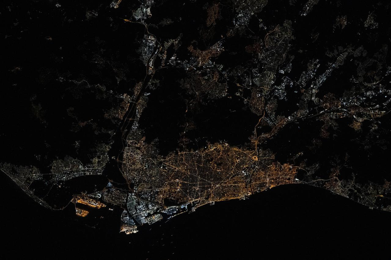
iss073e0078528 (May 17, 2025) --- Barcelona, Spain's second most-populous city with a metropolitan population of 5.74 million on the Balearic Sea coast, is pictured at approximately 1:33 a.m. local time from the International Space Station as it orbited 261 miles above the Mediterranean Sea.
STS058-73-009 (18 Oct-1 Nov 1993) --- Atlantic water flowing with the tide through the Strait of Gibraltar into the Mediterranean generates internal waves as depicted in this photo. The incoming cool, less dense Atlantic water flows over the warm, more saline Mediterranean water. As the tide moves into the Strait of Gibraltar it encounters the Camarinal Sill, which is like a cliff under water, south of Camarinal Point, Spain. Internal waves are generated at the Sill and travel along the density boundary between the Atlantic water and the Mediterranean water. Internal waves have very little effect on the sea surface, except for gentle slopes and slight differences in roughness. We can see them in the Space Shuttle photos because of sunglint which reflects off the water. Internal waves smooth out some of the capillary waves at the surface in bands. The sun reflects more brightly from these smooth areas showing us the pattern of the underwater waves. The Bay of Cadiz on the southwest coast of Spain, the Rock of Gibraltar, and the Moroccan coast are also visible in this photo.
STS059-238-074 (9-20 April 1994) --- The Atlantic Ocean, Straits of Gibraltar, and Alboran Sea (the westernmost portion of the Mediterranean Sea) separate Spain on the left from Morocco on the right. Algeciras Harbor is the prominent notch cut out of the eastern end of the north shore of the Strait; the Rock of Gibraltar is the tiny arrowhead that separates the notch from the Alboran Sea. The Sierra Nevada, farther away down the Spanish coast, lives up to its name in this April scene. The difference in elevation between the Sierra Morena and the Guadalquivir River valley is highlighted nicely by cumulus clouds. Tangier, Morocco can be seen as a light-toned spot on the southern shore of the Strait, near the entrance to the Atlantic Ocean. Hasselblad photograph.
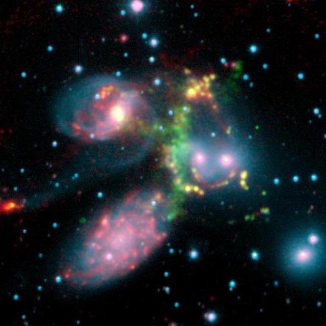
The false-color composite image of the Stephan’s Quintet galaxy cluster is made up of data from NASA Spitzer Space Telescope and a ground-based telescope in Spain.
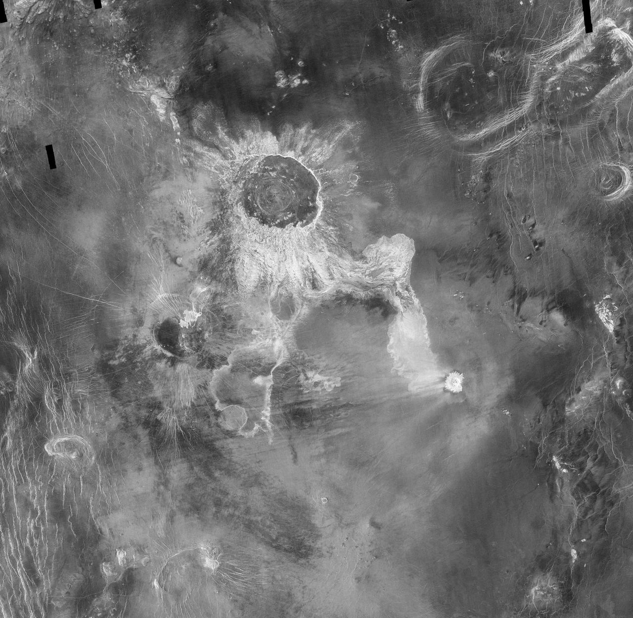
Crater Isabella is seen in this radar image from NASA Magellan spacecraft. The second largest impact crater on Venus, the crater is named in honor of the 15th Century queen of Spain, Isabella of Castile.
This image from NASA EarthKAM shows Lisbon, the capital of Portugal. The superb natural harbor at Lisbon is a commercially important European port handling much of the import-export traffic for Portugal and Spain.
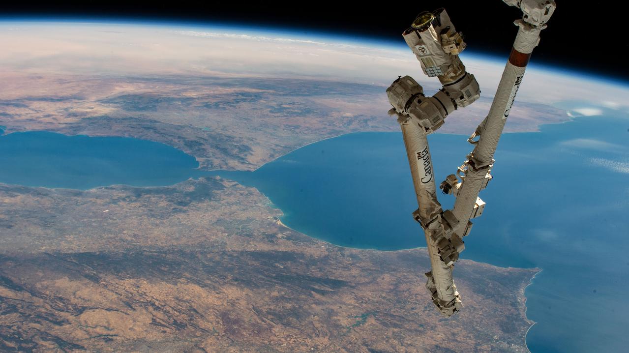
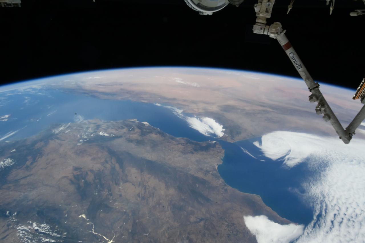
iss067e270597 (Aug. 18, 2022) --- The Canadarm2 robotic arm extends from the International Space Station, orbiting 259 miles above the northern coast of Spain, in this photograph of the Strait of Gibraltar which separates the Atlantic Ocean (right) from the Mediterranean Sea and the European nation of Spain (bottom) from the African country of Morocco.
iss074e0425752 (March 29, 2026) --- The Strait of Gibraltar separates the European nation of Spain (left) from the African nation of Morocco (right) and connects the Atlantic Ocean to the Mediterranean Sea. The International Space Station was orbiting 266 miles above Spain at the time of this photograph. Credit: NASA
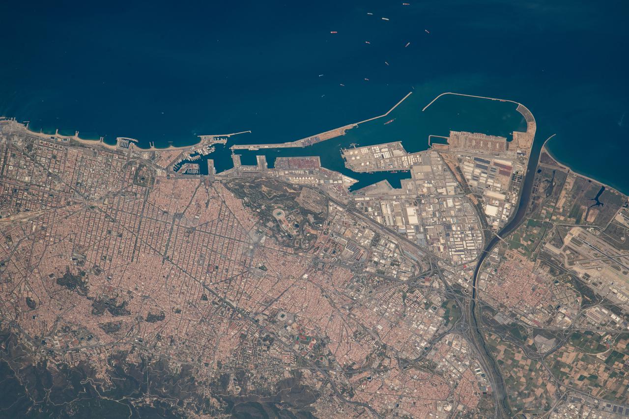
iss067e030640 (April 26, 2022) --- Barcelona, Spain, on the Balaeric Sea coast, is pictured from the International Space Station as it orbited 260 miles above the Mediterranean Sea.
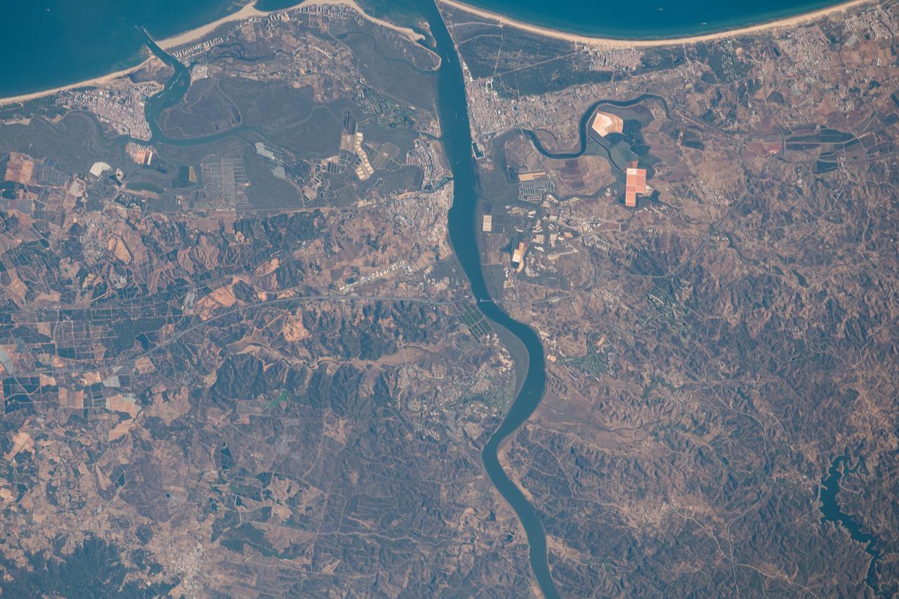
iss063e070330 (Aug. 13, 2020) --- The Guadiana River flows into the Gulf of Cádiz in the Atlantic Ocean and is the border for the southern coastal portions of Portugal (right) and Spain (left)
iss067e290430 (Aug. 26, 2022) --- The International Space Station flies into an orbital sunrise 261 miles above the Atlantic Ocean off the coast of northwestern Spain.
iss064e000399 (Oct. 25, 2020) --- Valencia, Spain is pictured from the International Space Station moments before the orbital lab crossed over the Mediterranean Sea.
ISS040-E-081001 (25 July 2014) --- One of the Expedition 40 crew members aboard the Earth-orbiting International Space Station was aiming his camera almost straight down when he recorded this view of parts of Spain (top), Morocco (bottom) and the Strait of Gibraltar (center) at 08:04:35 GMT on July 25, 2014. Gibraltar and the Alboran Sea are on the right side of the frame. Cadiz, Spain is almost under clouds on the Bay of Cadiz above and to the left of frame center.
ISS030-E-030428 (31 Dec. 2011) --- This high oblique panorama shows Morocco and Spain as photographed by the Expedition 30 crew members aboard the International Space Station. The Atlantic Ocean, Straits of Gibraltar and Alboran Sea (the westernmost portion of the Mediterranean Sea) separate Spain on the right from Morocco on the left. Algeciras Harbor is the prominent notch cut out of the eastern end of the north shore of the Strait. A Russian spacecraft, docked to the orbital outpost, is in the upper left corner.
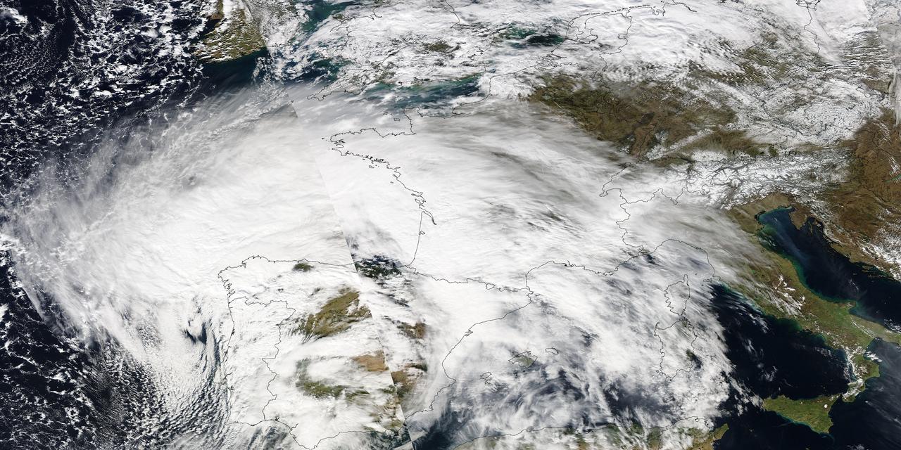
Image acquired February 27, 2010: An extratropical cyclone named Xynthia brought hurricane-force winds and high waves to Western Europe at the end of February 2010, CNN reported. Winds as fast as 200 kilometers (125 miles) per hour reached as far inland as Paris, and at the storm’s peak, hurricane-force winds extended from Portugal to the Netherlands. Hundreds of people had to take refuge from rising waters on their rooftops. By March 1, at least 58 people had died, some of them struck by falling trees. Most of the deaths occurred in France, but the storm also caused casualties in England, Germany, Belgium, Spain, and Portugal. The Moderate Resolution Imaging Spectroradiometer (MODIS) on NASA’s Aqua satellite captured this image of Western Europe, acquired in two separate overpasses on February 27, 2010. MODIS captured the eastern half of the image around 10:50 UTC, and the western half about 12:30 UTC. Forming a giant comma shape, clouds stretch from the Atlantic Ocean to northern Italy. NASA image courtesy MODIS Rapid Response Team at NASA Goddard Space Flight Center. Caption by Michon Scott. Instrument: Aqua - MODIS For more information related to this image go to: <a href="http://earthobservatory.nasa.gov/NaturalHazards/view.php?id=42881" rel="nofollow">earthobservatory.nasa.gov/NaturalHazards/view.php?id=42881</a>
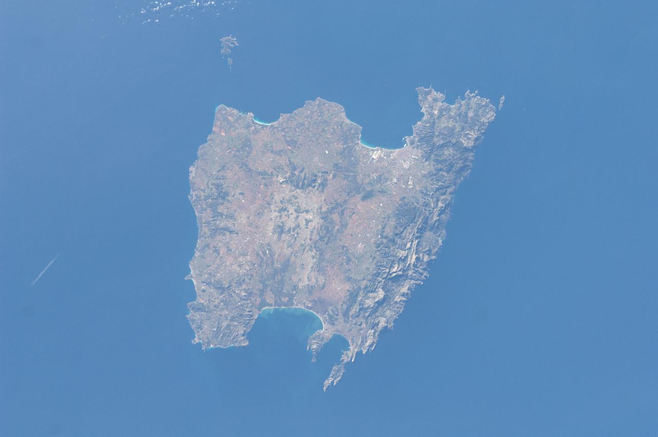
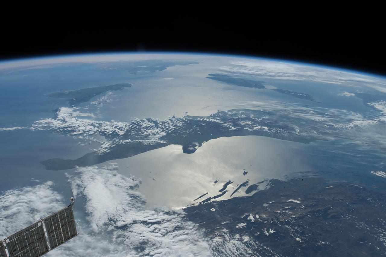
ISS030-E-030290 (31 Dec. 2011) --- Majorca in the Balearic Islands (Spain) is featured in this image photographed by an Expedition 30 crew member aboard the International Space Station. The Balearic Islands are an archipelago located to the southwest of Spain in the Mediterranean Sea. Catalan – the native tongue – and Spanish are the official languages. The islands are an autonomous community and province of Spain, located approximately midway between the southeastern coastline of Spain and the northern coastline of Algeria. This photograph highlights the large island of Majorca (approximately 5,400 square kilometers; also known as Mallorca in Spanish) on which the capital city of Palma is located (center). The small island of Cabrera to the southwest of Majorca (upper left) hosts the Parc Nacional de l’Arxipelag de Cabrera (site mainly in Spanish). Like the other Balearic Islands, Majorca is a popular holiday destination for the European community with tourism forming a major part of the island’s economy. The island’s physiography offers many recreational opportunities – mountainous regions are present along the northwest coastline and eastern third, while much of the central part of the island is flat. Diving is also a popular activity. The central region includes agricultural lands (tan, light brown, and green, center), forested patches and corridors (dark green, center), and urban centers (gray). In addition to Majorca, the other major islands of the archipelago include Ibiza, Formentera, and Minorca.

Sensors on two finger-like mini-booms extending horizontally from the mast of NASA Mars rover Curiosity will monitor wind speed, wind direction and air temperature; image taken during installation of the instrument inside a clean room at NASA JPL.
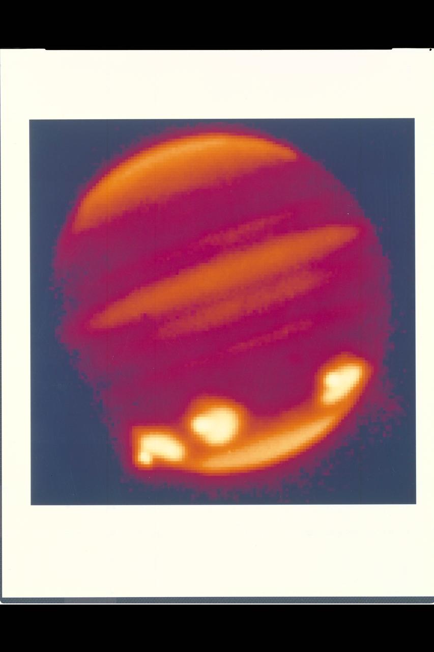
Credit: Calar Alto Observatory Spectacular first view of Fragment Q impacts on Jupiter. Infrared image in the 2.3m micron methane band taken using MAGIC on the 3.5m telescope, Calar Alto Observatory, Spain.
Earth Observation taken during a day pass by the Expedition 40 crew aboard the International Space Station (ISS). On crewmember's Flickr page - From Spain to Italy in a single glimpse.
ISS040-E-011996 (14 June 2014) --- One of the Expedition 40 crew members aboard the Earth-orbiting International Space Station recorded this image of the Strait of Gibraltar, showing parts of Morocco and Spain, on June 14, 2014.

European Space Agency astronaut Pedro Duque of Spain, smiles at a reporter's question during a prelaunch news conference, Friday, Oct. 17, 2003, in Baikonur, Kazakhstan. Photo Credit (NASA/Bill Ingalls)
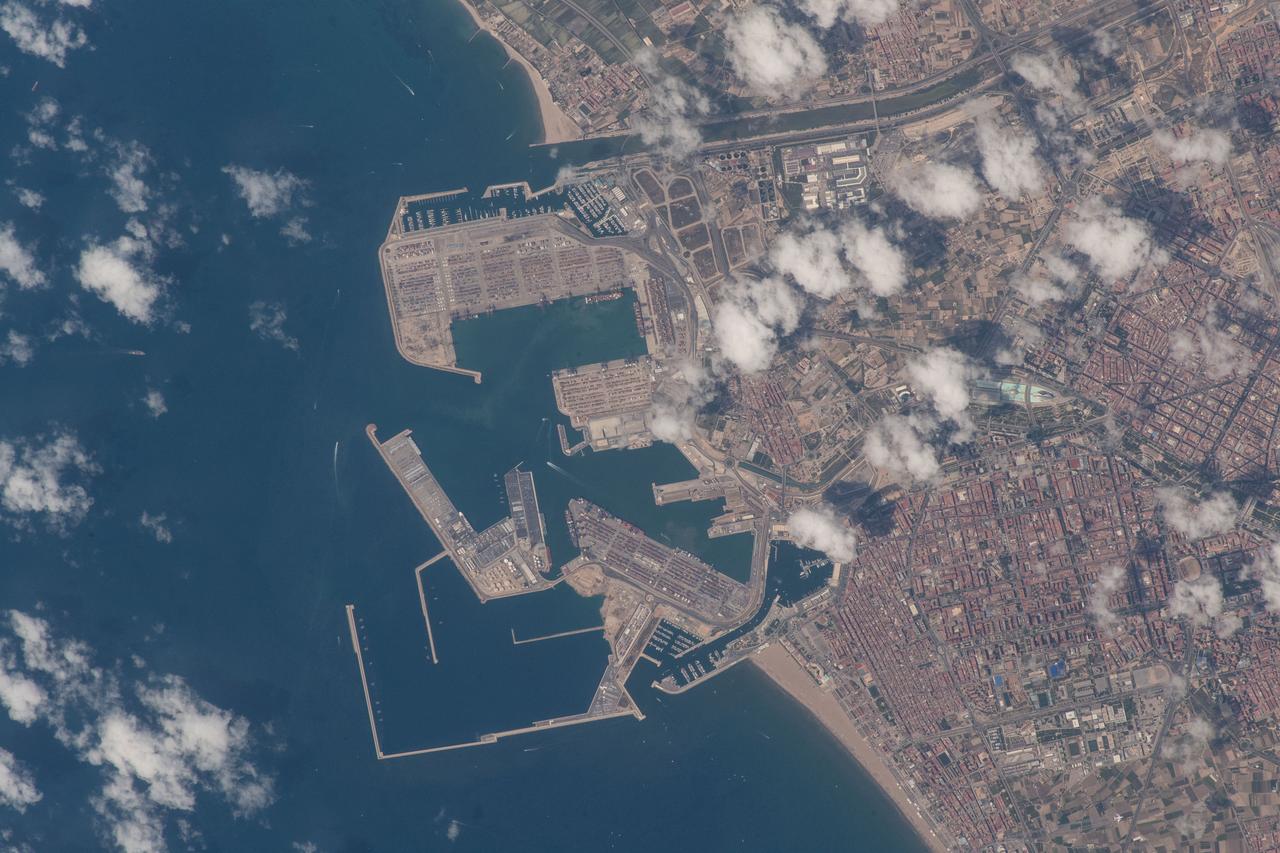
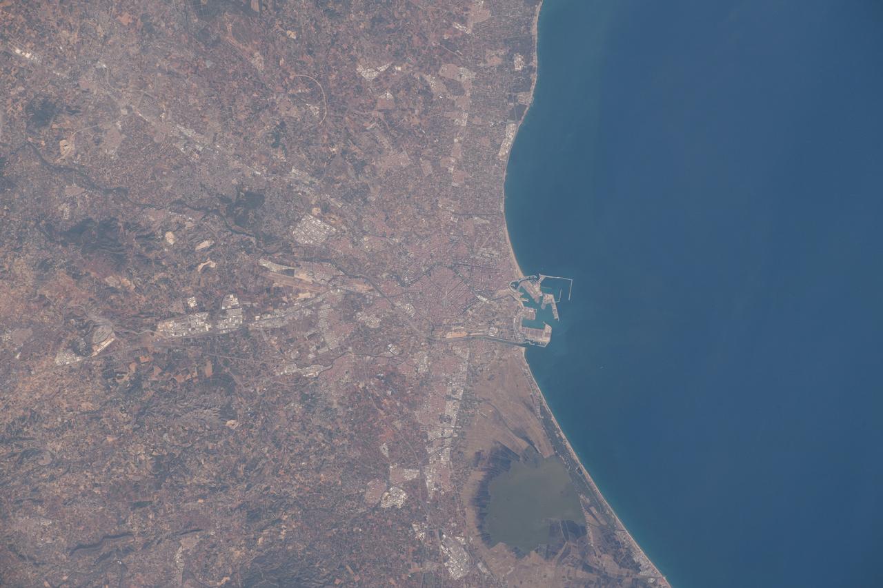
iss056e032465 (June 16, 2018) --- An Expedition 56 crew member photographed the Port de Valencia in the Spanish city of Valencia as the International Space Station orbited across the Mediterranean coast of Spain.

iss055e006226 (March 29, 2018) --- A portion of a Russian solar array peeks out on the side of this photograph of Earth as the International Space Station orbited off the northwest coast of Spain.
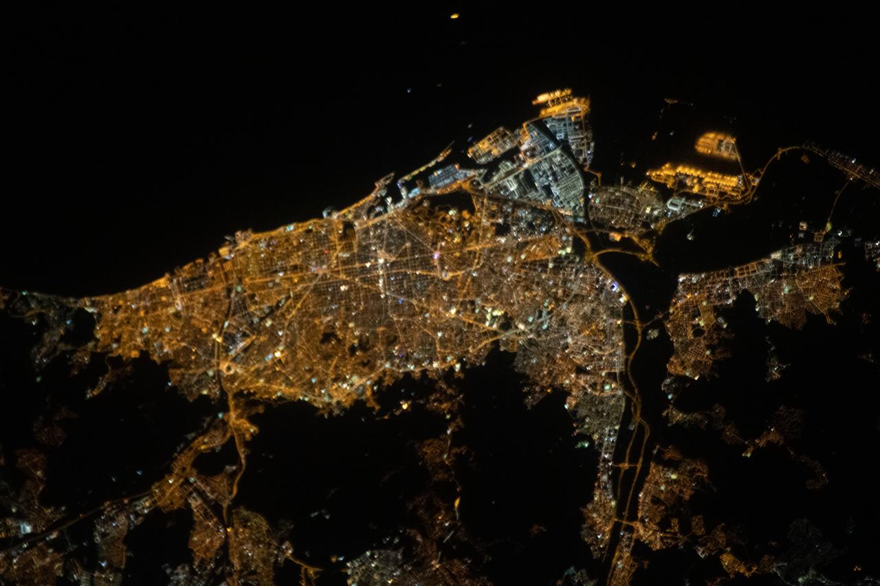
iss063e088813 (Sept. 15, 2020) --- This nighttime view of Barcelona, Spain, on the coast of the Balearic Sea, was taken from the International Space Station as it orbited above the east coast of the Spanish nation.
ISS040-E-010889 (12 June 2014) --- One of the Expedition 40 crew members aboard the Earth-orbiting International Space Station recorded this image of the Strait of Gibraltar, showing parts of Morocco and Spain, on June 12, 2014.
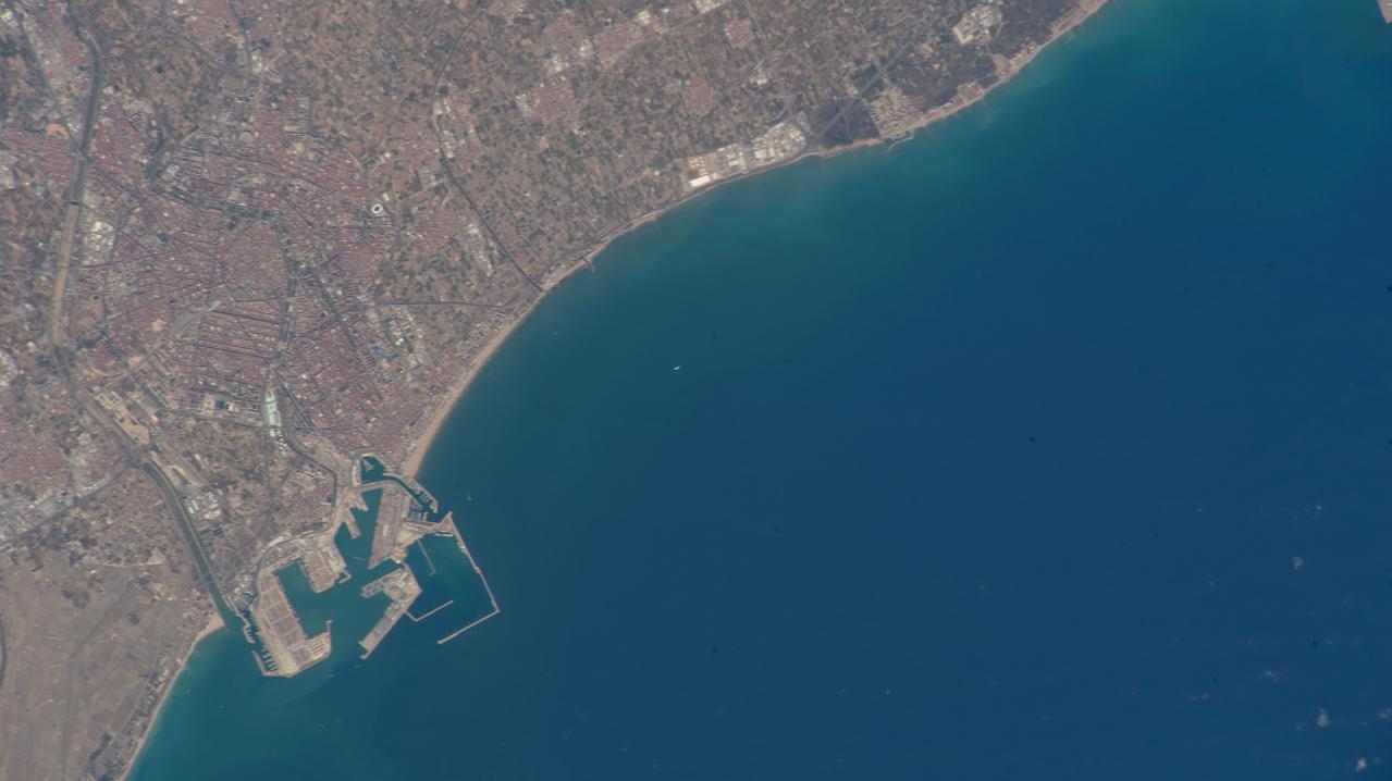
iss069e001453 (April 8, 2023) --- The port city of Valencia on Spain's Balearic Sea coast is pictured from an external high definition camera on the International Space Station as it orbited 263 miles above.
iss055e012690 (April 6, 2018) --- This Earth view taken by an Expedition 55 crew member aboard the International Space Station looks over southeastern Europe, across Italy and into the Mediterranean Sea toward France and Spain.
Earth Observation taken during a day pass by the Expedition 40 crew aboard the International Space Station (ISS). Folder lists this group as: Brazil, Africa, Volcanoes, Gibralter, Spain, Portugal.
S65-45737 (22 Aug. 1965) --- Looking northeast, the Strait of Gibraltar, Morocco (foreground) and Spain (background) are photographed from the Gemini-5 spacecraft during its 14th revolution of Earth.
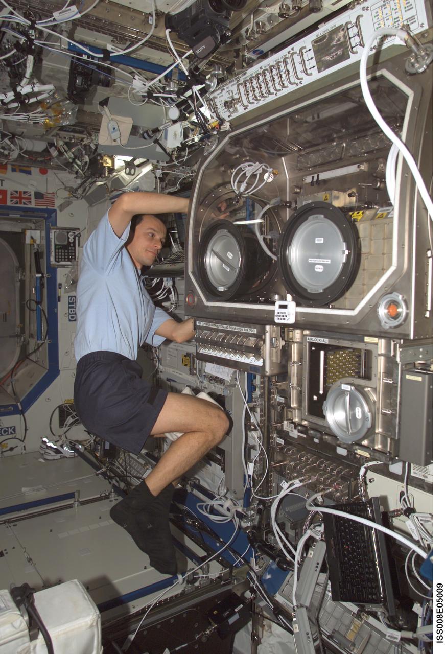
ISS008-E-05009 (27 October 2003) --- European Space Agency (ESA) astronaut Pedro Duque of Spain works with the Microgravity Science Glovebox (MSG) in the Destiny laboratory on the International Space Station (ISS).
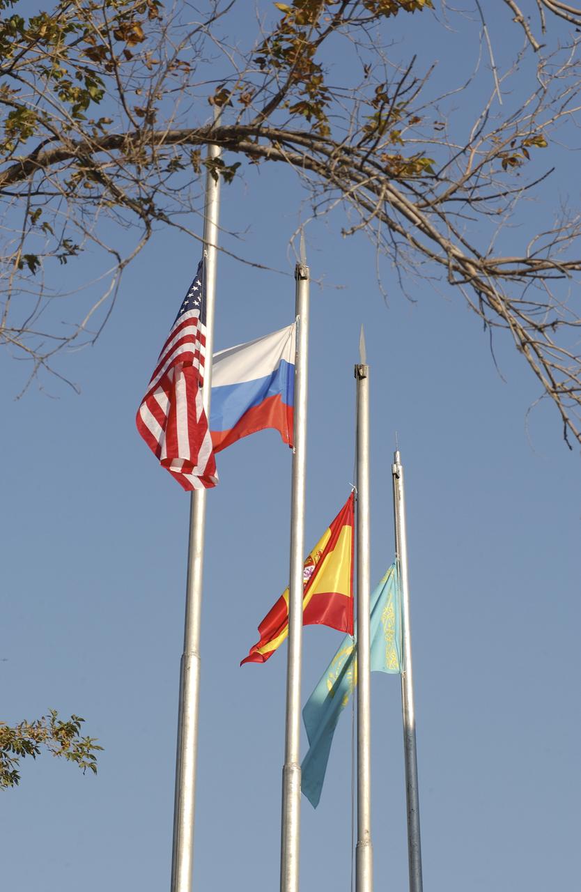
The flags of the United States, Russia, Spain and Kazakhstan fly outside the Cosmonaut Hotel, Tuesday, Oct. 14, 2003, in Baikonur, Kazakhstan following a traditional flag-raising ceremony. Photo Credit (NASA/Bill Ingalls)
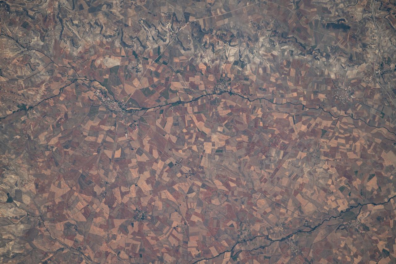
iss061e004419 (Oct. 8, 2019) --- The cities of Villadiego, Villegas and Sasamon along the Rio Brulles are pictured in the Province of Burgos in northern Spain. The International Space Station was orbiting 254 miles above the historic and archaeologically significant region.
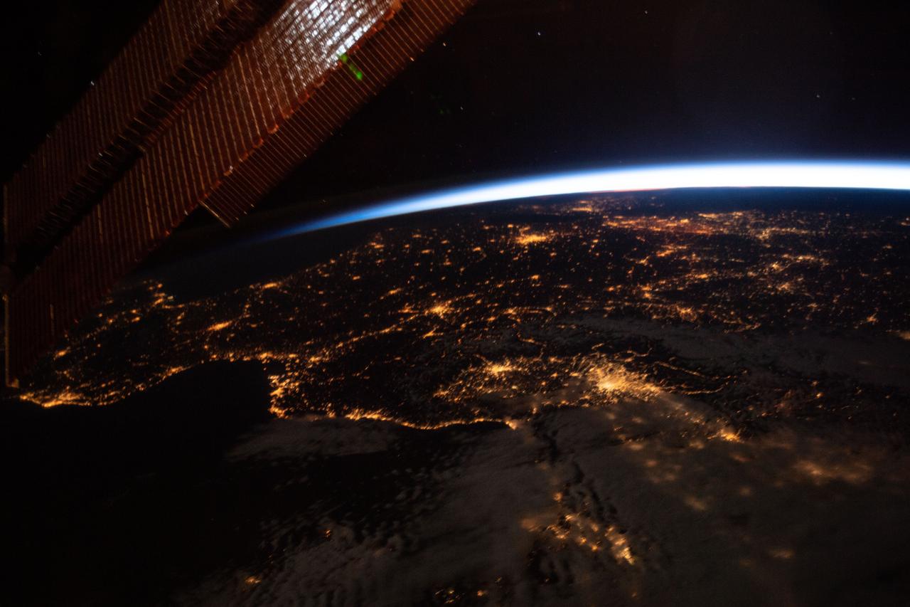
iss059e061476 (May 13, 2019) --- This oblique nighttime view of Western Europe and the well-lit coasts (from left) of Spain, France and Italy was taken from the International Space Station as it orbited 256 miles above the Mediterranean Sea.
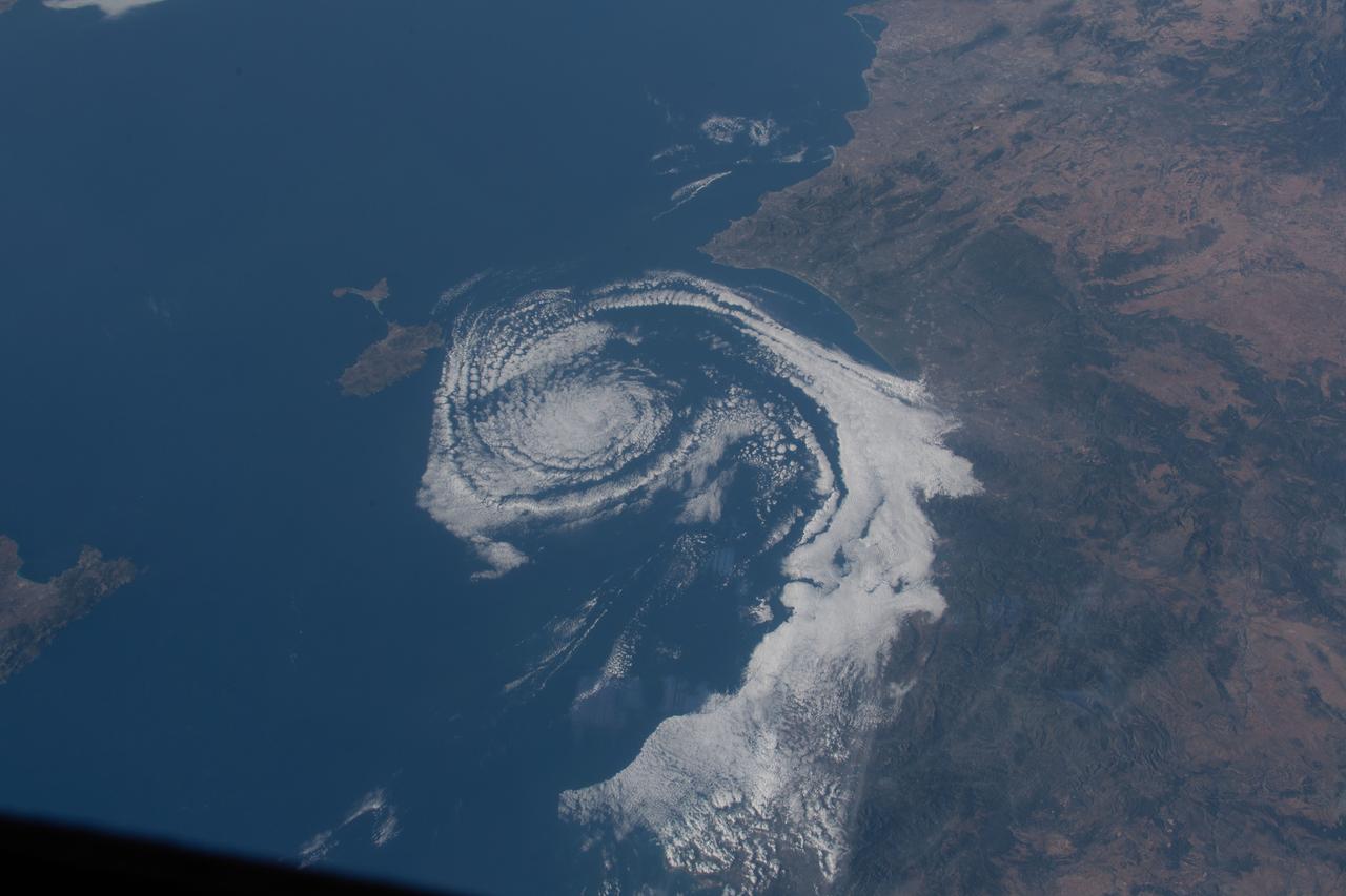
iss063e031610 (June 21, 2020) --- A cloud formation spirals in the Balearic Sea between Valencia, Spain, and the island of Ibiza as the International Space Station orbited above southern Europe.
STS077-718-088 (19-29 May 1996) --- A popular photographic target of Space Shuttle astronauts has always been the Strait of Gibraltar seen at center in this wide photograph, shot from the Space Shuttle Endeavour. Spain is to the north (right) and Morocco to the south. The strait is 36 miles (58 kilometers) long and narrows to 8 miles (13 kilometers) at it’s most narrow point. The winds in the strait are either easterly or westerly. The British colony of Gibraltar is the semi-circular feature north of the strait. Gibraltar is considered to be one of the Pillars of Hercules. The white colored area to the southeast of Gibraltar on the Moroccan coast is the city of Tanger (Tangier). The snow covered mountains in Spain are the Sistemas Penibeticos.
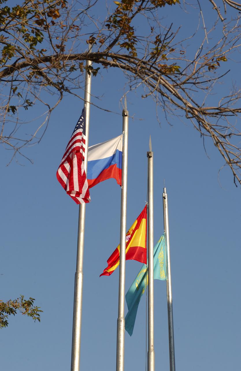
October 14, 2003. Cosmonaut Hotel, Baikonur, Kazakhstan. The flags of the United States, Russia, Spain and Kazakhstan fly outside the Cosmonaut Hotel Oct. 14, 2003 after they were raised by astronauts and cosmonauts in a traditional prelaunch ritual prior to the launch Saturday of the Soyuz TMA-3 vehicle to the International Space Station. The Soyuz will carry Expedition 8 Commander and NASA Science Officer Mike Foale, Expedition 8 Soyuz Commander Alexander Kaleri and European Space Agency Astronaut Pedro Duque of Spain to the ISS. Photo Credit: "NASA/Bill Ingalls"
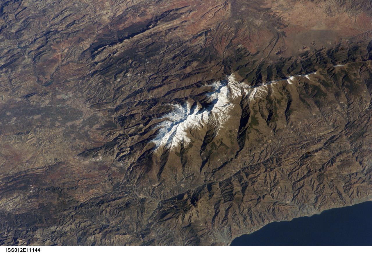
ISS012-E-11144 (11 Dec. 2005) --- Sierra Nevada, Spain is featured in this image photographed by an Expedition 12 crew member on the International Space Station. According to scientists, the Sierra Nevada, part of the Betic Cordillera of southern Spain, was formed during the Alpine Orogeny (or mountain-building event) that also formed the European Alps to the east and the Atlas Mountains of northern Africa across the Mediterranean Sea to the south. The Sierra as observed today formed during the Tertiary Period (65 to 1.8 million years ago) during collision of the African and Eurasian continental plates. The former Tethys Sea also closed during this time period, the scientists say, and the Mediterranean Sea is the largest surviving remnant basin of the ancient Tethys. The Sierra Nevada in the Granada province of Spain is perhaps the southernmost skiing location in all of Europe. Veleta Peak, at an elevation of 3,398 meters above sea level, is a popular destination for skiers and snowboarders. The rapid transition from lofty ski runs to Mediterranean beaches within a few hours’ drive has made the Sierra Nevada region popular for both outdoor and urban tourism. This photograph depicts the Veleta Peak region of the range and illustrates the sharp contrast between the snow capped mountains, adjacent dry lowlands to the west and north, and the Mediterranean Sea to the south.

Expedition 8 Commander and NASA Science Officer Michael Foale, left, and European Space Agency astronaut Pedro Duque of Spain participate in the traditional raising of the flags at the Cosmonaut Hotel, Tuesday, Oct. 14, 2003, in Baikonur, Kazakhstan. Photo Credit (NASA/Bill Ingalls)
ISS040-E-016324 (20 June 2014) --- One of the Expedition 40 crew members aboard the Earth-orbiting International Space Station recorded this oblique panorama of the Strait of Gibraltar, showing parts of Morocco and Spain, on June 20, 2014.
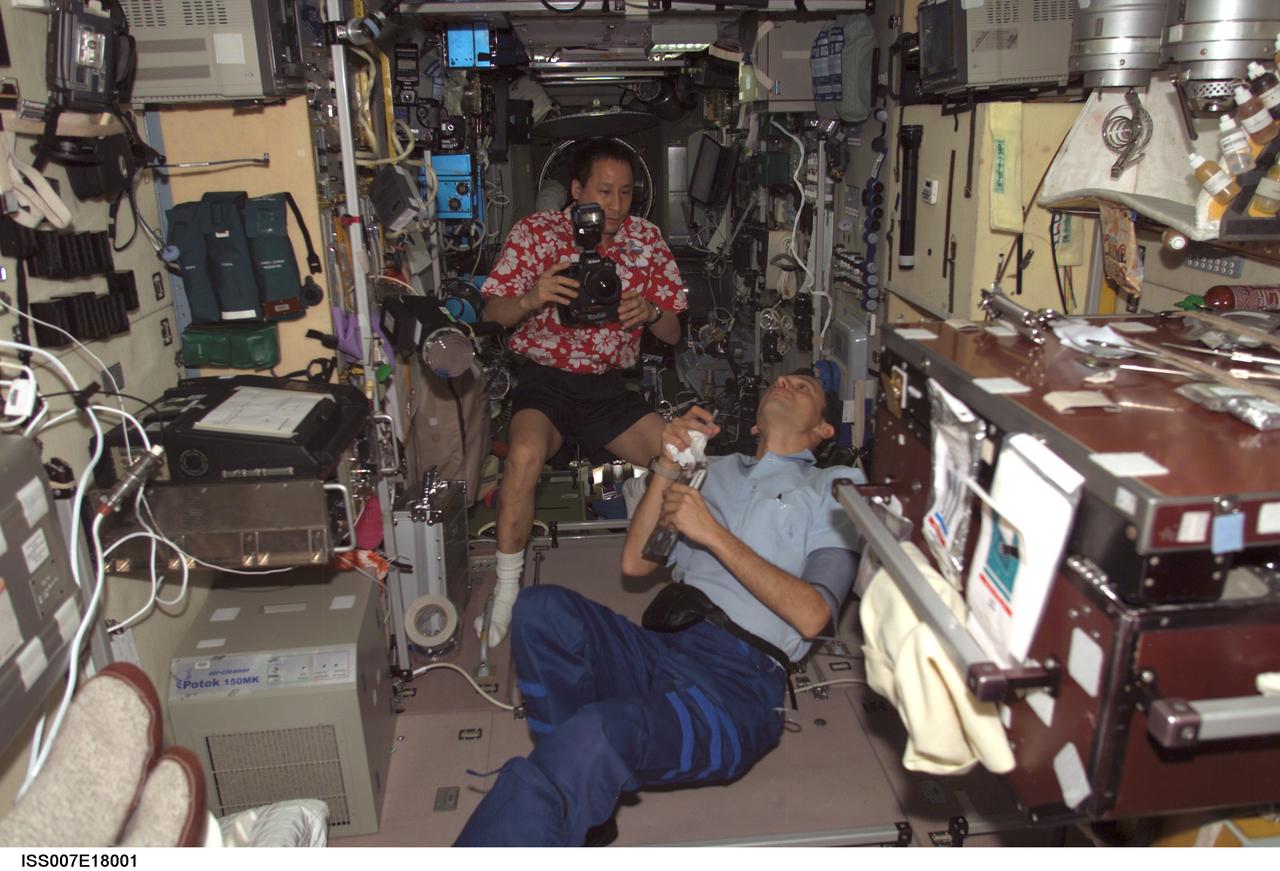
ISS007-E-18001 (25 October 2003) --- Astronaut Edward T. Lu (with camera), Expedition 7 NASA ISS science officer and flight engineer, and European Space Agency (ESA) astronaut Pedro Duque of Spain observe a bubble of liquid floating freely in the Zvezda Service Module on the International Space Station (ISS).
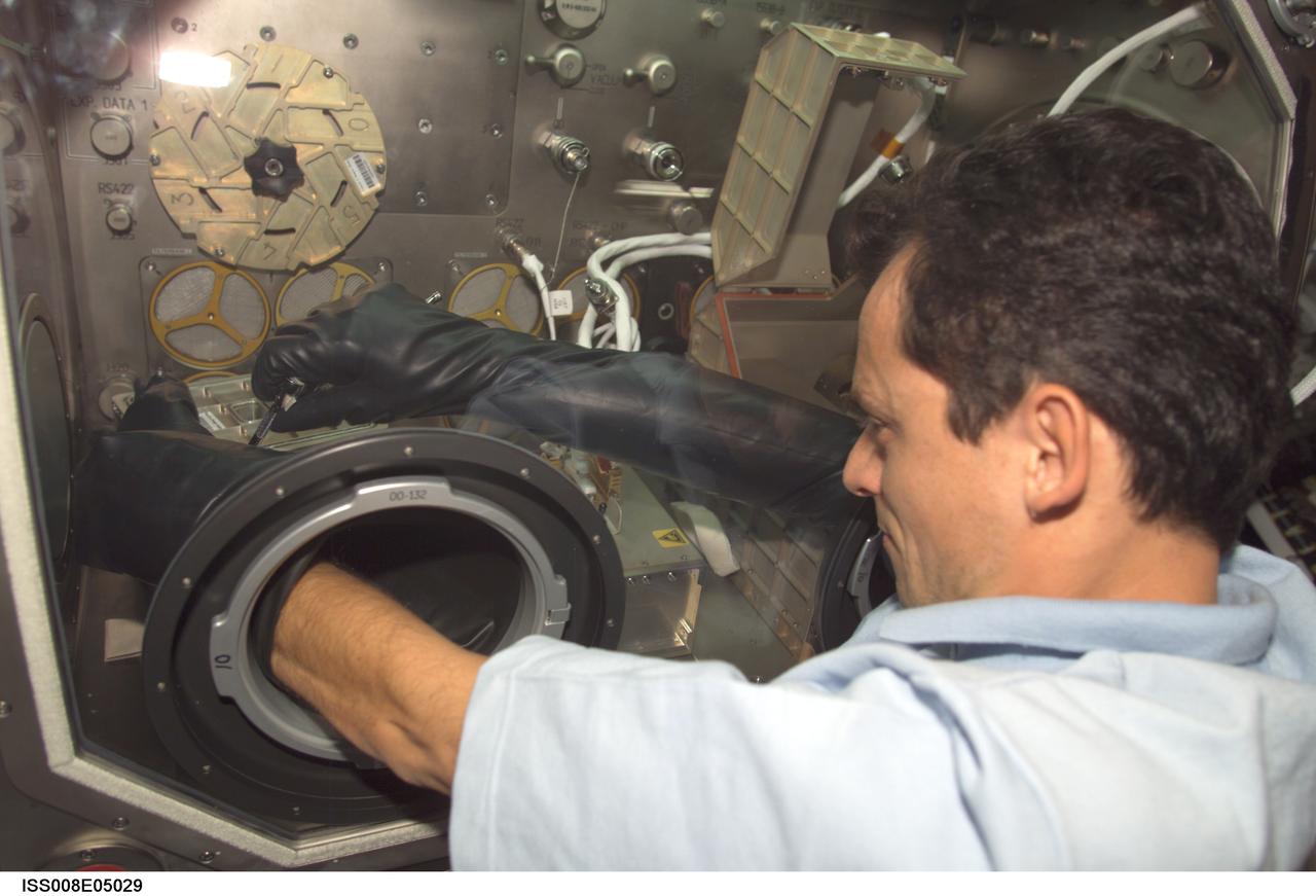
ISS008-E-05029 (27 October 2003) --- European Space Agency (ESA) astronaut Pedro Duque of Spain works with the Cervantes mission experiment PROMISS in the Microgravity Science Glovebox (MSG) in the Destiny laboratory on the International Space Station (ISS). This experiment will investigate the growth processes of proteins in weightless conditions.
iss059e038134 (April 30, 2019) --- Looking from northwest to southeast (bottom to top), this oblique view shows portions of Western Europe, the Atlantic Ocean, the Mediterranean Sea and North Africa. More specific regions such as Portugal, Spain, the Strait of Gibraltar, Morocco and Algeria are seen as the International Space Station orbited 257 miles above the Atlantic.

iss073e1197974 (Dec. 2, 2025) --- The Soyuz MS-28 crew spacecraft carrying NASA astronaut Chris Williams and Roscosmos cosmonauts Sergey Kud-Sverchkov and Sergei Mikaev approaches the International Space Station 263 miles above the Mediterranean Sea near the coast of Barcelona, Spain.

ISS008-E-05015 (27 October 2003) --- European Space Agency (ESA) astronaut Pedro Duque of Spain works with the Cervantes mission experiment PROMISS in the Microgravity Science Glovebox (MSG) in the Destiny laboratory on the International Space Station (ISS). This experiment will investigate the growth processes of proteins in weightless conditions.
iss062e005579 (Feb. 11, 2020) --- The Strait of Gibraltar connects the Atlantic Ocean with the Mediterranean Sea and separates Spain on the European continent from Morocco on the African continent. The International Space Station was orbiting 265 miles above the Atlantic off the coast of Lisbon, Portugal, when this photograph was taken.

iss073e0880216 (Oct. 10, 2025) --- JAXA (Japan Aerospace Exploration Agency) astronaut and Expedition 73 Flight Engineer Kimiya Yui points a camera out a cupola window and photographs external International Space Station hardware. The orbital outpost was soaring 263 miles above the Atlantic Ocean northwest of Spain at the time of this photograph.
Expedition 8 Soyuz Commander and Flight Engineer Alexander Kaleri, left, Expedition 8 Commander Michael Foale, European Space Agency Astronaut Pedro Duque of Spain, right, along with Valery Korzun, Chief of Cosmonauts, arrive in Baikonur, Kazakhstan, Sunday, Oct. 12, 2003. Photo Credit (NASA/Bill Ingalls)

Expedition 8 Soyuz Commander and Flight Engineer Alexander Kaleri, center, Expedition 8 Commander Michael Foale, European Space Agency astronaut Pedro Duque of Spain, right, along with Valery Korzun, Chief of Cosmonauts, arrive in Baikonur, Kazakhstan, Sunday, Oct. 12, 2003. Photo Credit (NASA/Bill Ingalls)

iss073e1197951 (Dec. 2, 2025) --- The Soyuz MS-28 crew spacecraft carrying NASA astronaut Chris Williams and Roscosmos cosmonauts Sergey Kud-Sverchkov and Sergei Mikaev approaches the International Space Station 263 miles above the Mediterranean Sea in between Spain and Morocco.
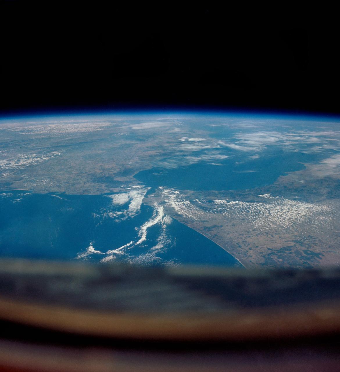
iss071e082829 (May 16, 2024) --- The Strait of Gibraltar separates the European nation of Spain from the African nation of Morocco and connects the Atlantic Ocean with the Medirrranean Sea. The International Space Station was orbiting 259 miles above North Africa at the time of this photograph.
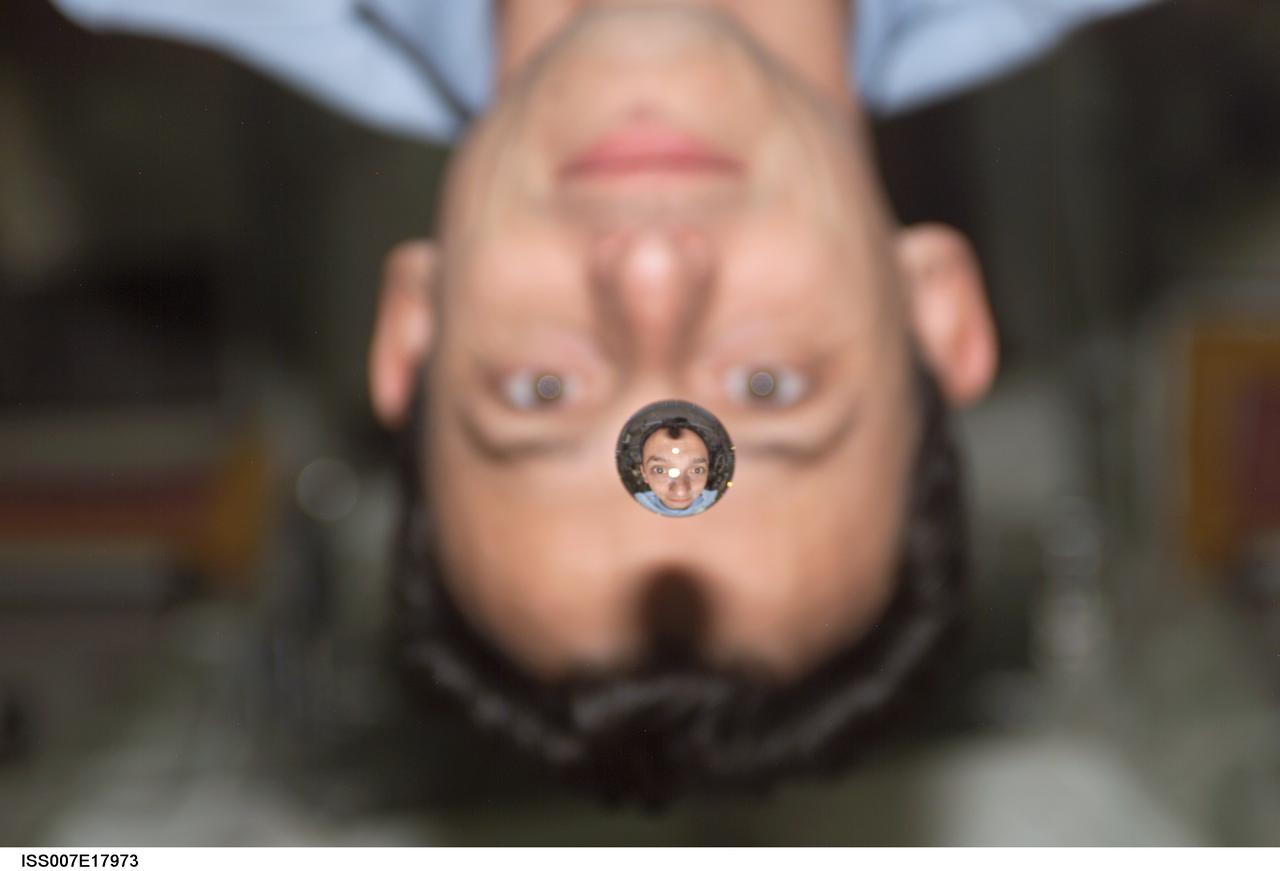
ISS007-E-17973 (25 October 2003) --- European Space Agency (ESA) astronaut Pedro Duque of Spain watches a water bubble float between him and the camera, showing his image refracted, on the International Space Station (ISS).
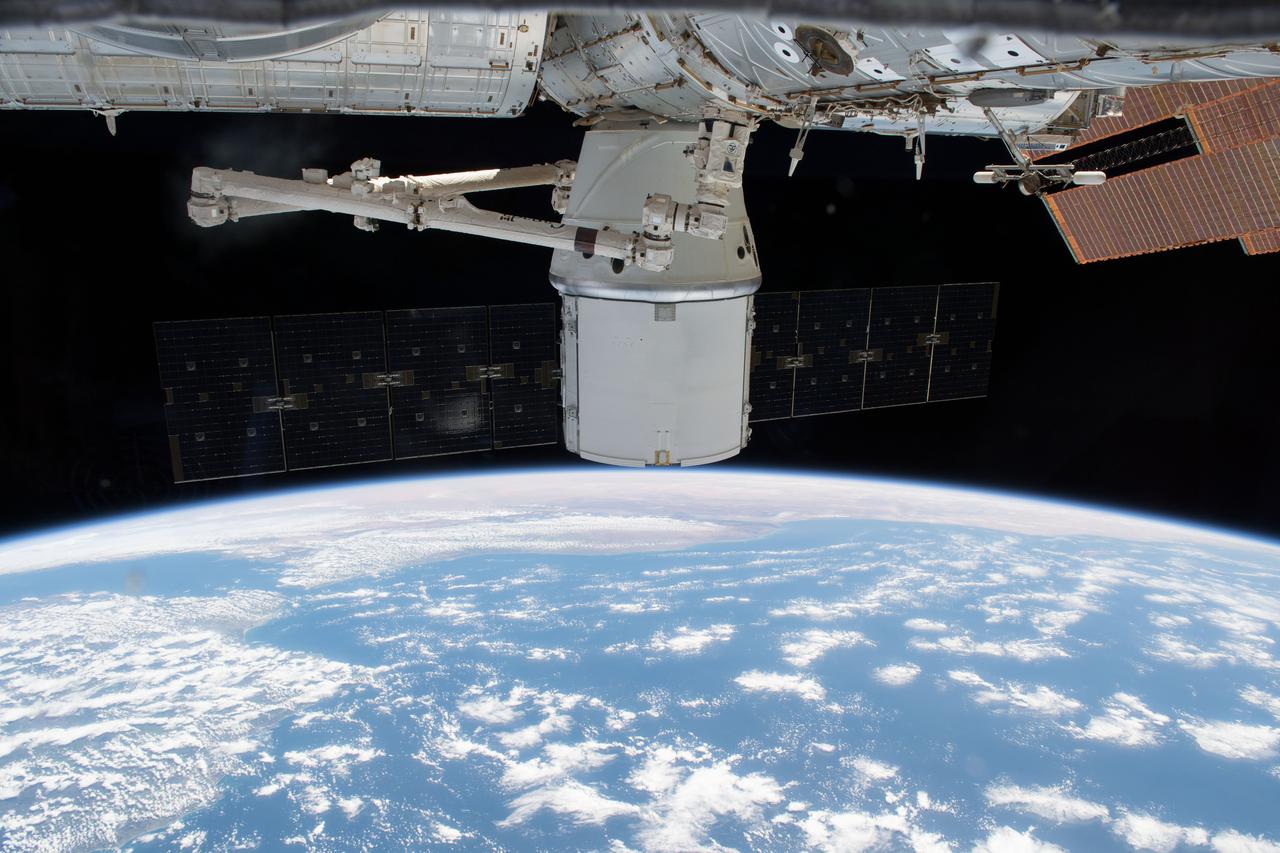
iss055e035437 (April 29, 2018) --- The SpaceX Dragon resupply ship was gripped by the Canadarm2 robotic arm on April 27, 2018 in preparation for its detachment from the Harmony module and its release back to Earth for splashdown and retrieval in the Pacific Ocean. The coasts of Spain and Portugal are seen as the International Space Station orbited over the Atlantic Ocean.
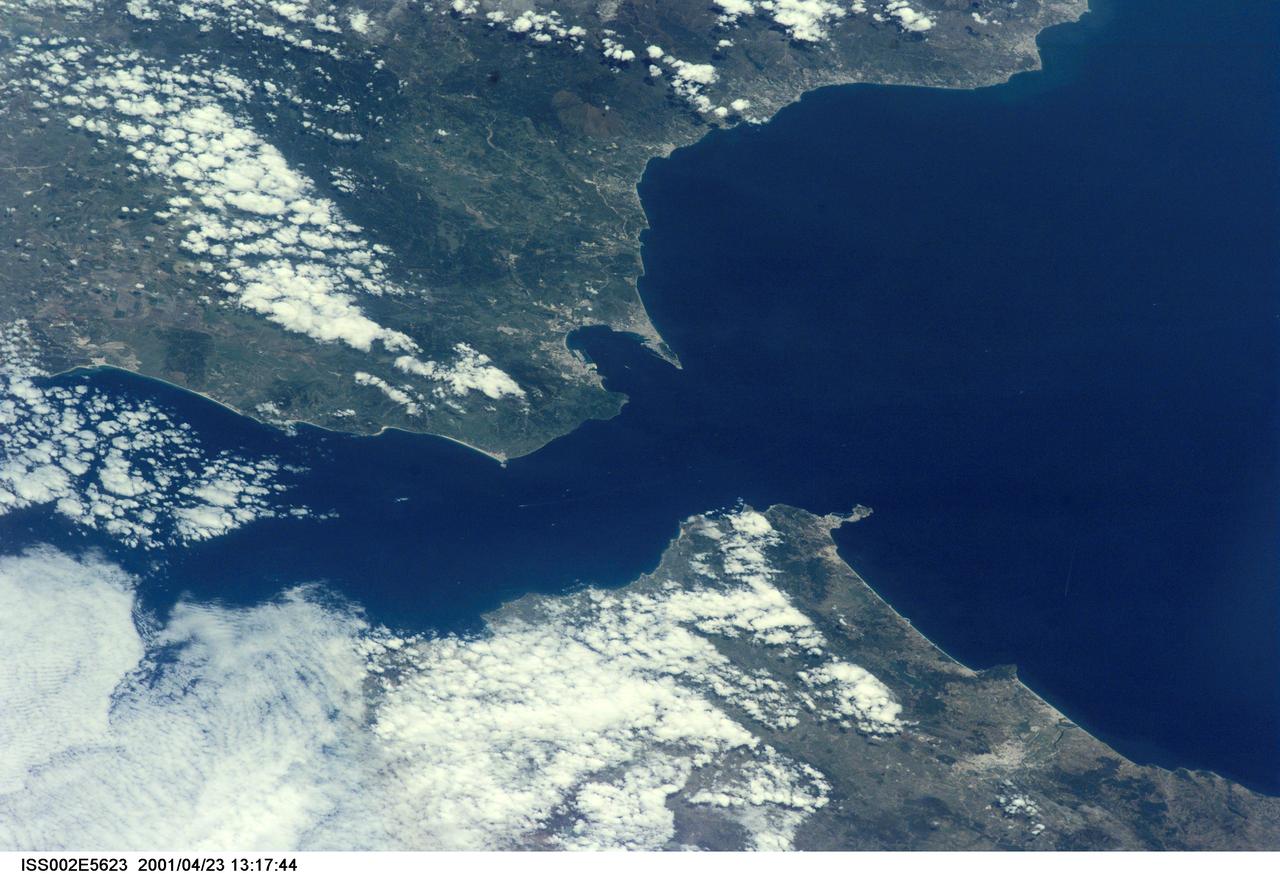
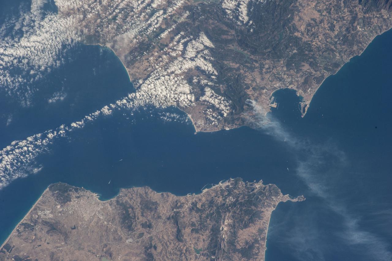
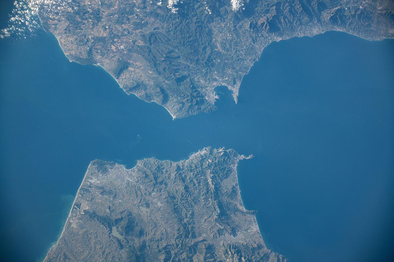
ISS002-E-5623 (23 April 2001) --- The Strait of Gibraltar, with part of Spain and all of Gibraltar at upper left and upper center, respectively, and portions of Morocco at bottom, was photographed with a digital still camera by the Expedition Two crew onboard the International Space Station (ISS).
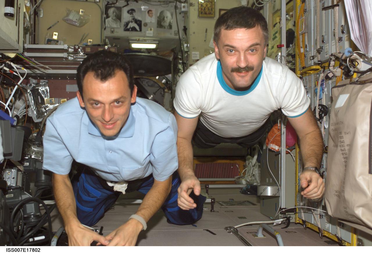
ISS007-E-17802 (22 October 2003) --- European Space Agency (ESA) astronaut Pedro Duque (left) of Spain and cosmonaut Alexander Y. Kaleri, Expedition 8 flight engineer representing Rosaviakosmos, float in the Zvezda Service Module on the International Space Station (ISS).

ISS007-E-17878 (October 2003) --- European Space Agency (ESA) astronaut Pedro Duque of Spain uses a communication system in the Zvezda Service Module on the International Space Station (ISS). Though the exact date is unavailable, the scene was recorded about midway through Duque’s scheduled time on the outpost.
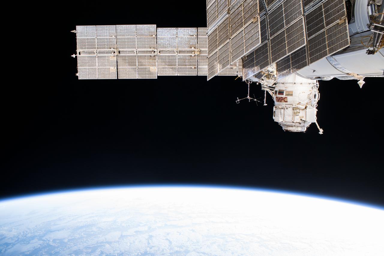
iss055e006234 (March 29, 2018) --- The Russian segment of the International Space Station is photographed as the complex orbited off the northwest coast of Spain. The dominant Russian segment features seen in this picture include the Pirs docking compartment and the solar arrays belonging to the Zarya and Zvezda modules.
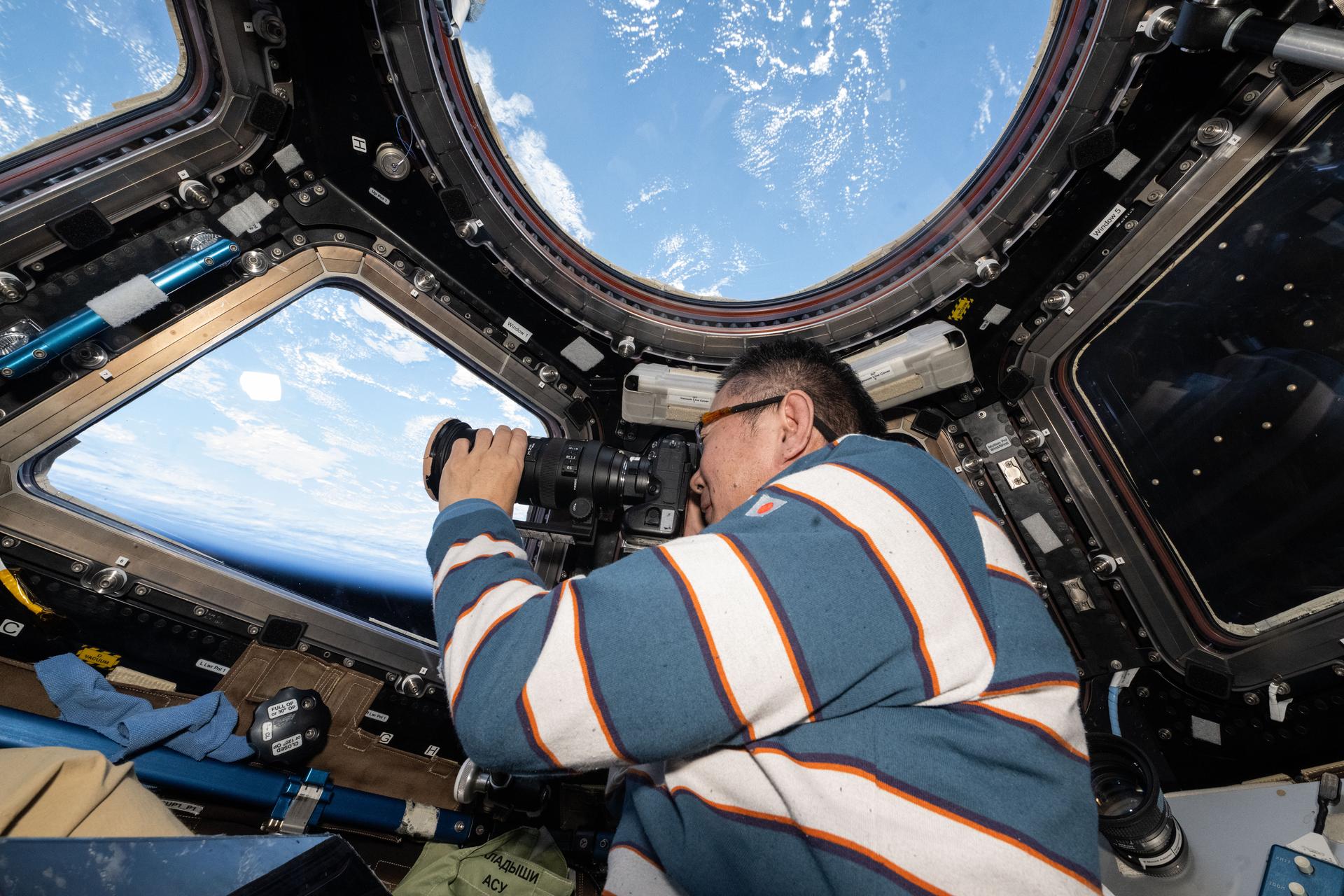
iss073e0880196 (Oct. 10, 2025) --- JAXA (Japan Aerospace Exploration Agency) astronaut and Expedition 73 Flight Engineer Kimiya Yui points a camera out a cupola window and photographs external International Space Station hardware. The orbital outpost was soaring 262 miles above the Atlantic Ocean west of Spain at the time of this photograph.

Expedition 8 Soyuz Commander and Flight Engineer Alexander Kaleri, left, Expedition 8 Commander Michael Foale, European Space Agency astronaut Pedro Duque of Spain, right, along with Valery Korzun, Chief of Cosmonauts, rear, arrive in Baikonur, Kazakhstan, Sunday, Oct. 12, 2003. Photo Credit (NASA/Bill Ingalls)
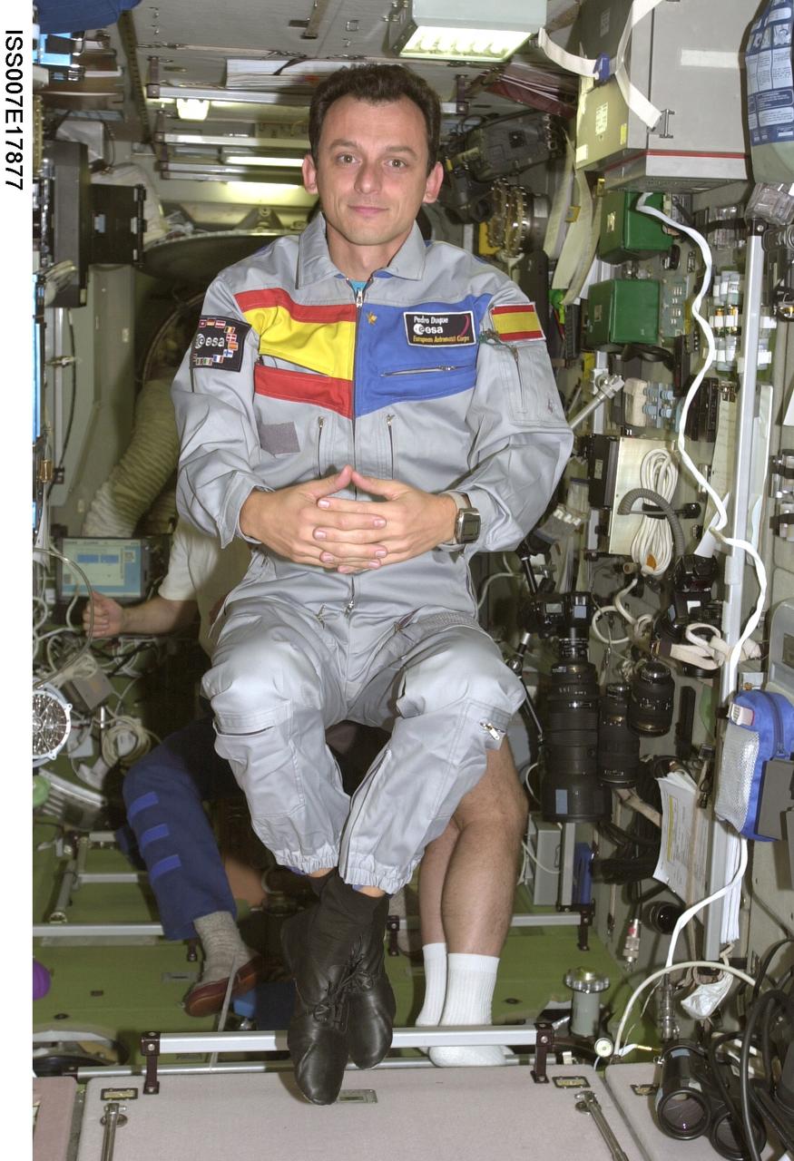
ISS007-E-17877 (October 2003) --- European Space Agency (ESA) astronaut Pedro Duque of Spain floats in the Zvezda Service Module on the International Space Station (ISS). Though the exact date is unavailable, the scene was recorded about midway through Duque’s scheduled time on the outpost.

This is a picture of Hurricane Florence at its peak, over the open waters of the North Atlantic. This hurricane never made landfall over the United States, however after the storm became extra-tropical, it's moisture combined with a storm system over parts of Europe and caused large amounts of flooding across Spain and France.
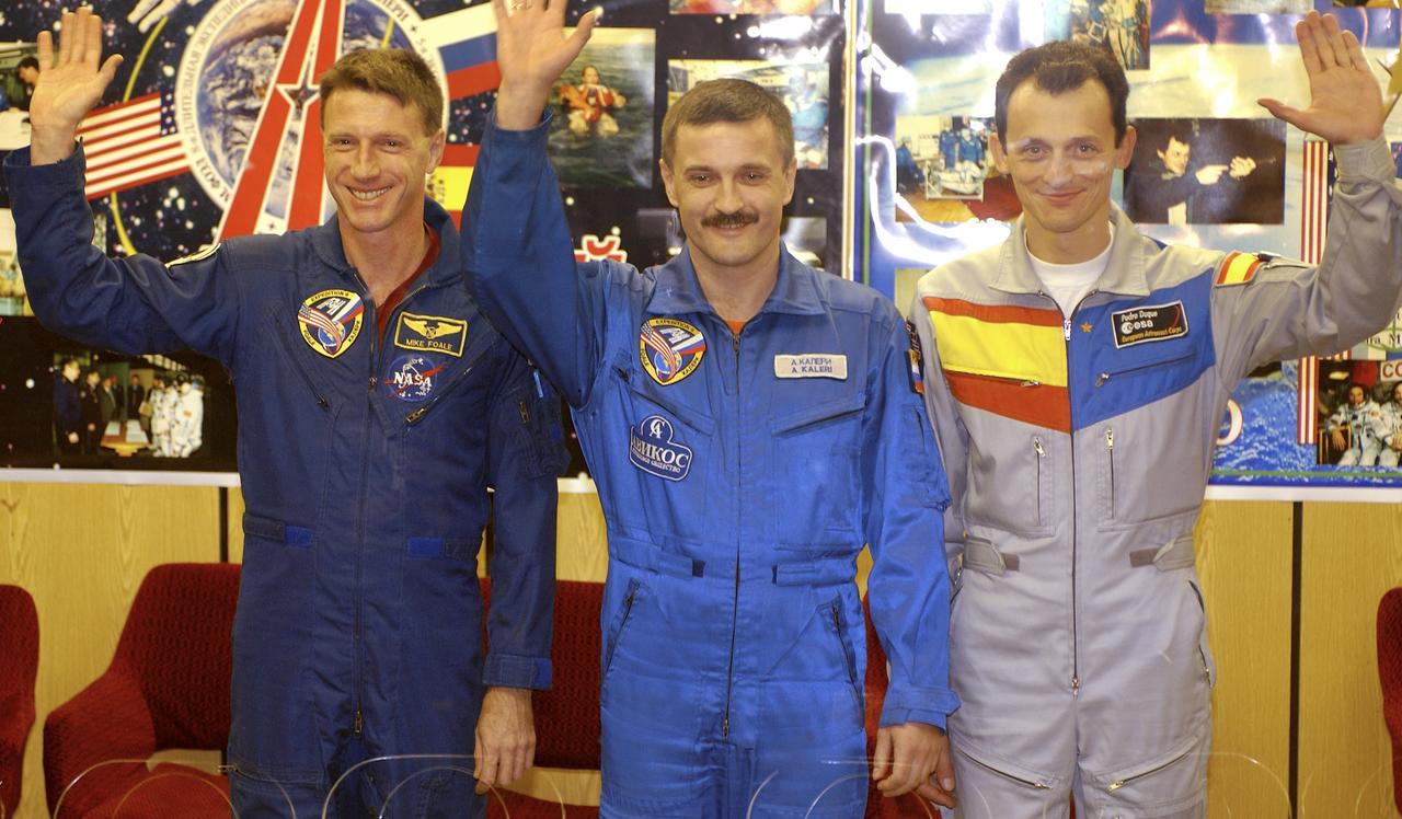
Expedition 8 Commander and NASA Science Officer Michael Foale, left, Expedition 8 Soyuz Commander Alexander Kaleri and European Space Agency astronaut Pedro Duque of Spain, right, wave to reporters at the conclusion of a prelaunch news conference, Friday, Oct. 17, 2003 in Baikonur, Kazakhstan. Photo Credit (NASA/Bill Ingalls)
iss056e032555 (June 19, 2018) --- The tiny city-state of Monaco was pictured as the International Space Station orbited over the Mediterranean coasts of Spain, France and Italy. Landmarks in this frame include the district of Monte Carlo, the Louis II Stadium and the Port de Fontvieille.
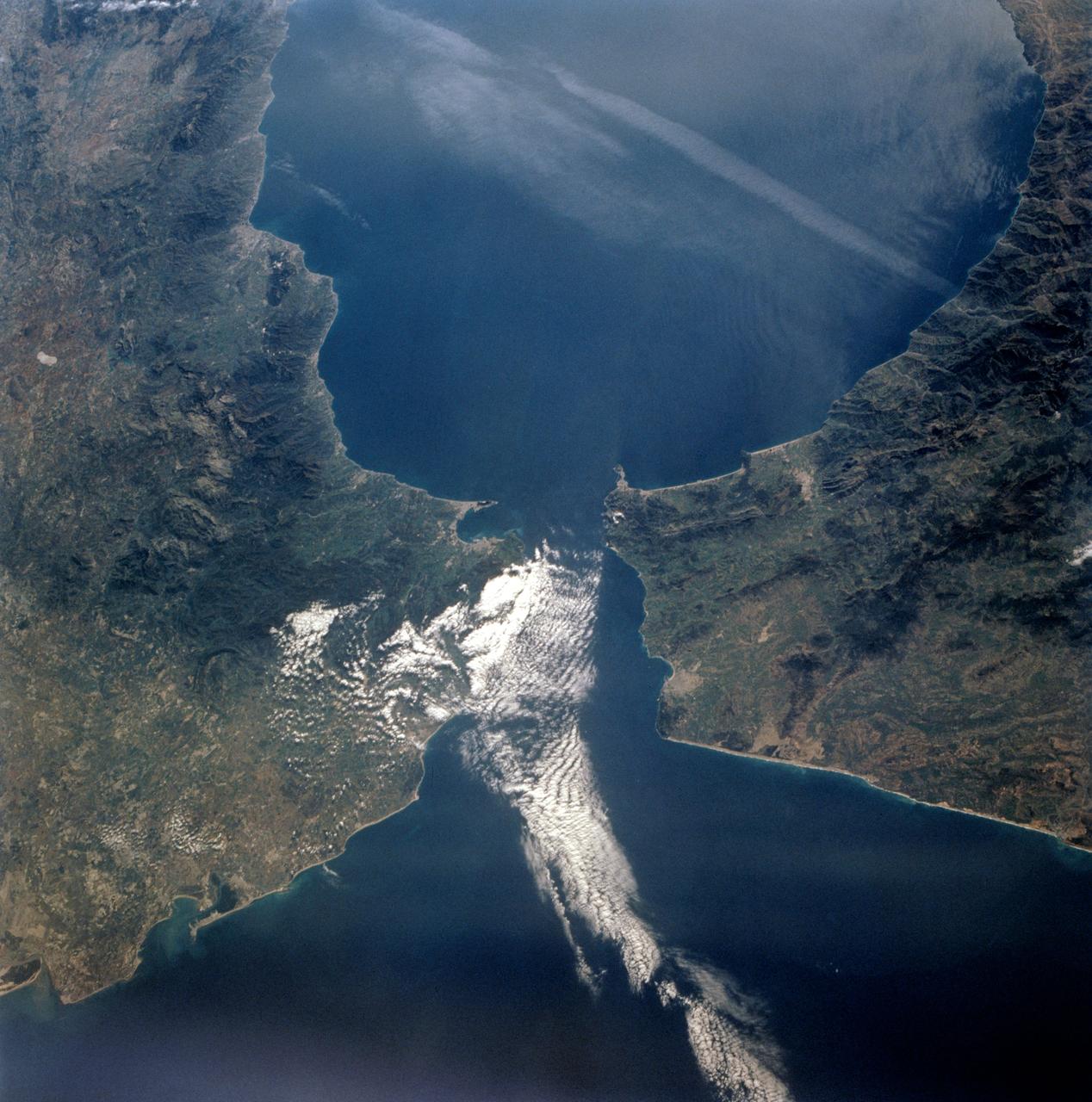
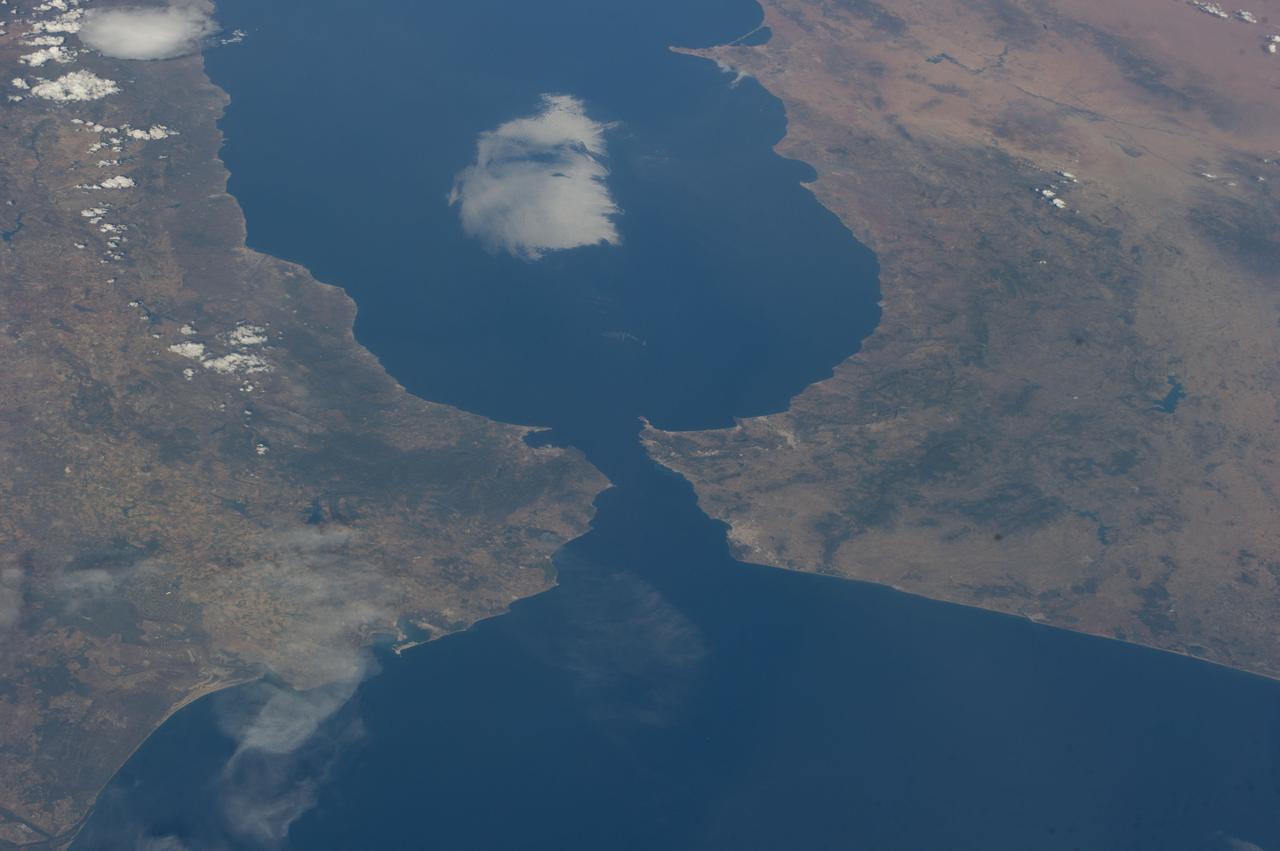
The Strait of Gibraltar separates Spain from Morocco. This image, acquired on July 5, 2000, covers an area 34 kilometers (21 miles) wide and 59 kilometers (37 miles) long in three bands of the reflected visible and infrared wavelength region. The promontory on the eastern side of the conspicuous Spanish port is the Rock of Gibraltar. Once one of the two classical Pillars of Hercules, the Rock was crowned with silver columns by Phoenician mariners to mark the limits of safe navigation for the ancient Mediterranean peoples. The rocky promontory still commands the western entrance to the Mediterranean Sea. The rocky limestone and shale ridge rises abruptly from the sea, to a maximum elevation of 426 meters (1,398 feet). A British colony, Gibraltar occupies a narrow strip of land at the southernmost tip of the Iberian Peninsula. It is separated from the Spanish mainland by a neutral zone contained on a narrow, sandy isthmus. Because of its strategic location and formidable topography, Gibraltar serves mainly as a British fortress. Most of its sparse land is taken up by air and naval installations, and the civilian population is small. http://photojournal.jpl.nasa.gov/catalog/PIA02657
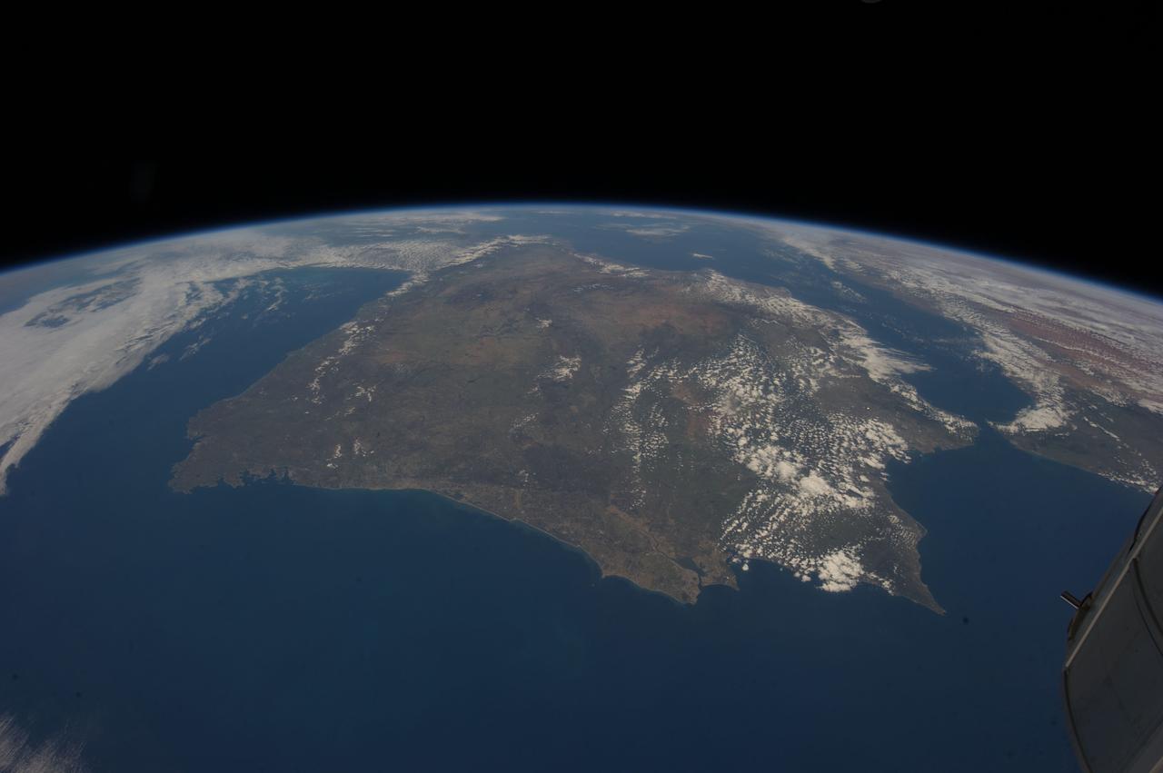
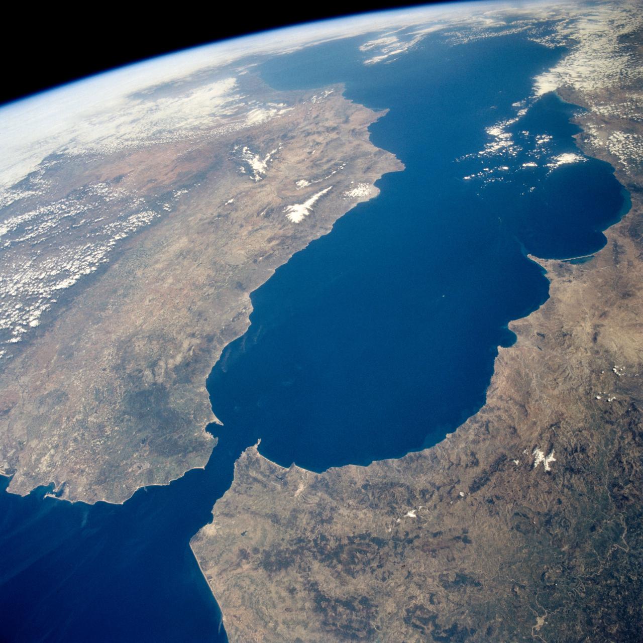
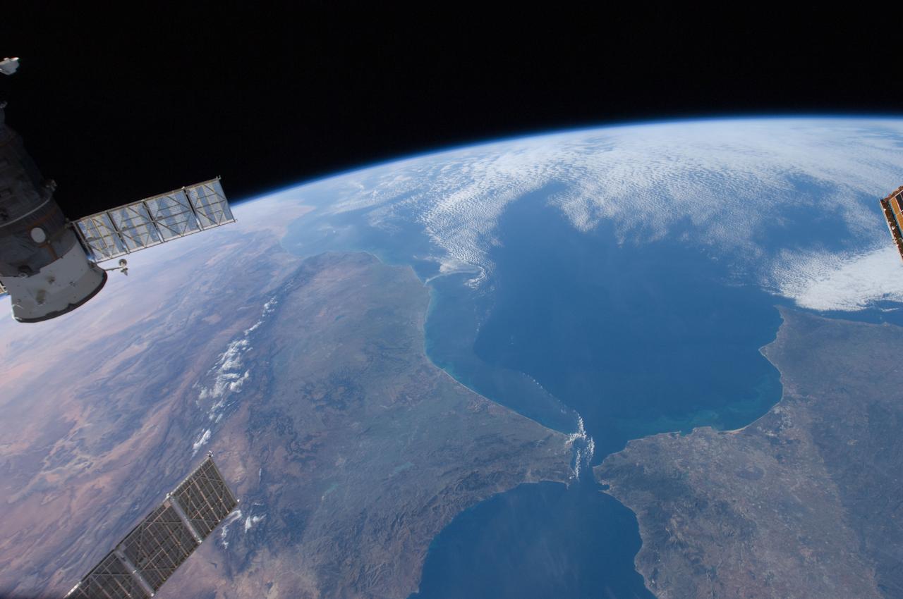
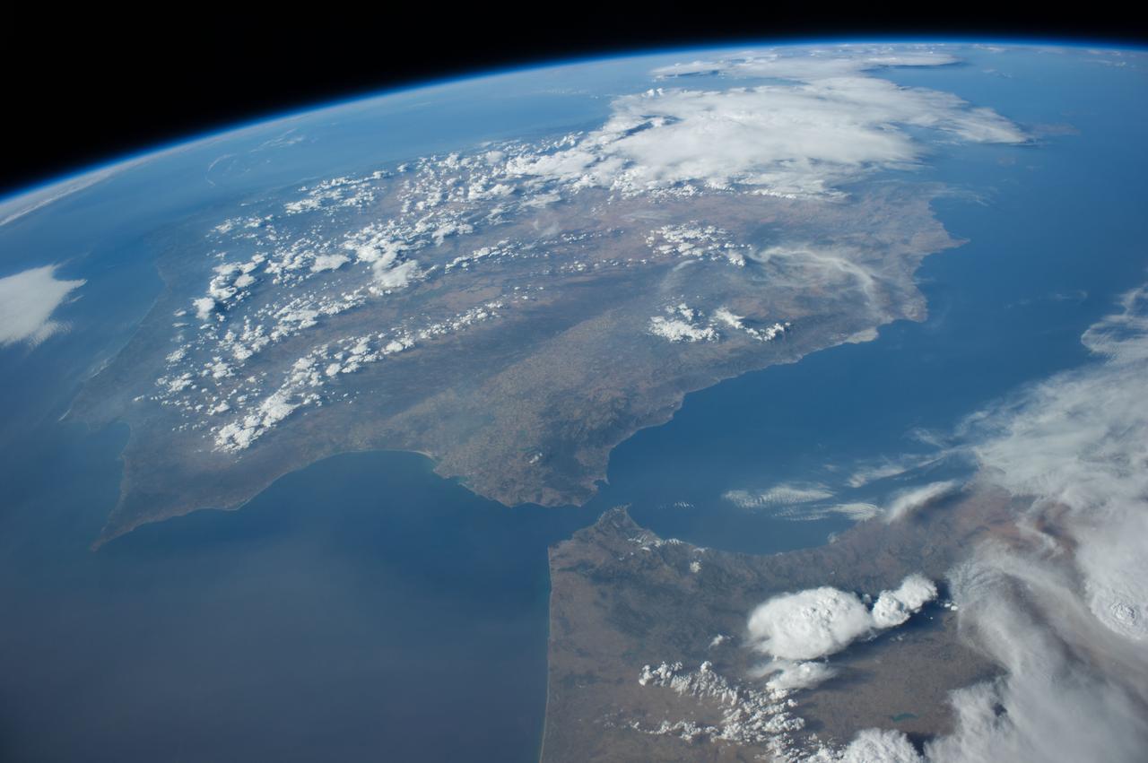
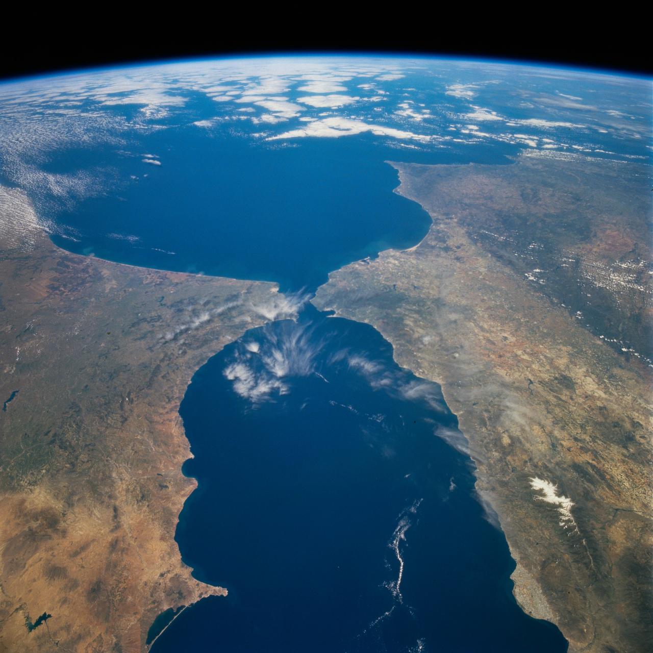
ISS035-E-027420 (23 April 2013) --- One of the Expedition 35 crew members aboard the International Space Station photographed this high oblique image of the Iberian Peninsula on April 23, 2013. This is one of the very few pictures in the history of the decades old NASA-managed human-tended space program that shows the entire peninsula, with Portugal, Spain and Gibraltar. The Strait of Gibraltar (right center) is a narrow strait that connects the Atlantic Ocean to the Mediterranean Sea and separates Gibraltar and Spain in Europe from Morocco (far right center)in Africa. Europe and Africa are separated by 7.7 nautical miles (14.3 kilometers or 8.9 statute miles) of ocean at the strait's narrowest point. A small part of France is barely visible at the horizon (top center).
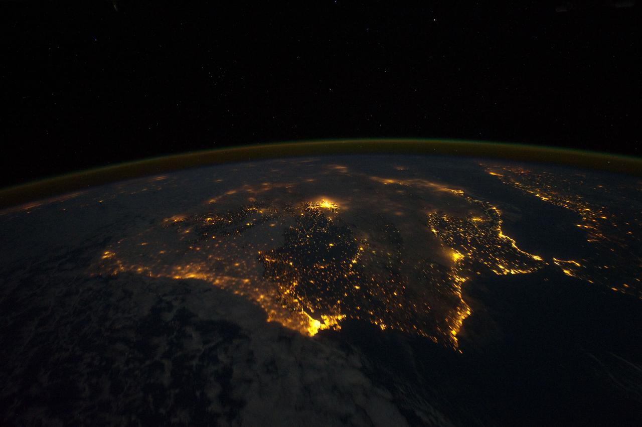
ISS030-E-010008 (4 Dec. 2011) --- One of the Expedition 30 crew members aboard the Earth-orbiting International Space Station photographed this night time scene of the Iberian Peninsula on Dec. 4, 2011. The city lights of Spain and Portugal define the peninsula. Several large metropolitan areas are visible, marked by their relatively large and brightly lit areas, such as two capital cities -- Madrid, Spain, located near the center of the peninsula?s interior, and Lisbon, Portugal, located along the southwestern coastline. Ancient Seville, visible at image right to the north of the approximately 14 kilometer-wide Strait of Gibraltar, is one of the largest cities in Spain. All together, the Principality of Andorra, the Kingdom of Spain and the Portuguese Republic total approximately 590,000 square kilometers of landmass. The peninsula is bounded by the Atlantic Ocean to the northwest, west, and southwest and the Mediterranean Sea to the east. Its northeastern boundary with the rest of continental Europe is marked by the Pyrenees mountain range. The view is looking outwards from the orbital outpost toward the east. The network of smaller cities and towns in the interior and along the coastline attest to the large extent of human presence on the Iberian landscape. Blurring of the city lights is caused by thin cloud cover (image left and center), while the cloud tops are dimly illuminated by moonlight. Though obscured, the lights of France are visible near the horizon line at image upper left, while the lights of northern Africa are more clearly discernable at image right. The gold to green line of airglow, caused by excitation of upper atmosphere gas molecules by ultraviolet radiation, parallels the horizon line (or Earth limb).
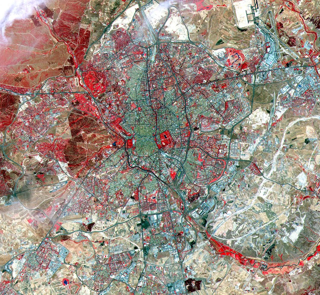
This ASTER image was acquired on July 5, 2000 and covers an area of 25 by 24 km over Madrid, Spain. A historic capital city, Madrid is renowned for its unique charm and its exhilarating cultural life. In the 10th century, a Moorish fortress called Magerit was first built on the site, a plateau 656 meters (2,150 feet) above sea level. Spanish Christians seized the city a century later, although Madrid remained relatively unimportant until 1561. It was then that the Spanish king Philip II chose it as the national capital, largely because of its geographic location in the very heart of the country. Some historic structures from this and later periods still grace the narrow streets of the old section of Madrid, although the Spanish Civil War exacted a heavy toll on the city. The image is located at 40.4 degrees north latitude and 3.7 degrees west longitude. http://photojournal.jpl.nasa.gov/catalog/PIA11163

Aboard the International Space Station (ISS), European Space Agency astronaut Pedro Duque of Spain watches a water bubble float between a camera and himself. The bubble shows his reflection (reversed). Duque was launched aboard a Russian Soyuz TMA-3 spacecraft from the Baikonur Cosmodrome, Kazakhstan on October 18th, along with expedition-8 crew members Michael C. Foale, Mission Commander and NASA ISS Science Officer, and Cosmonaut Alexander Y. Kaleri, Soyuz Commander and flight engineer.

Expedition 8 Commander and NASA Science Officer Michael Foale is seen at the Baikonur Cosmodrome in Kazakhstan. Foale, Expedition 8 Soyuz Commander Alexander Kaleri and European Space Agency astronaut Pedro Duque of Spain were launched on a Soyuz TMA-3 vehicle to the International Space Station, arriving on Oct. 20. Photo Credit (NASA/Bill Ingalls)

S129-E-009177 (25 Nov. 2009) --- Astronaut Randy Bresnik, STS-129 mission specialist, is pictured onboard the space shuttle Atlantis shortly before the shuttle and the station began their post-undocking relative separation. Undocking of the two spacecraft occurred at 3:53 a.m. (CST) on Nov. 25, 2009. Some scenes in the series show parts of the Mediterranean Sea and Africa and Spain in the background.
ISS040-E-081305 (26 July 2014) --- One of the Expedition 40 crew members aboard the International Space Station recorded this early evening photo showing part of the Cygnus cargo carrier built by Orbital Sciences Corp. as well as almost the entire Iberian Peninsula (Spain, and Portugal) on July 26, 2014. Part of northern Africa is visible at lower right, and the Strait of Gibraltar can be seen right of center frame.

Expedition 8 Commander and NASA Science Officer Michael Foale, left and Expedition 8 Soyuz Commander Alexander Kaleri share a moment while suiting up prior to departing for the launch pad with European Space Agency astronaut Pedro Duque of Spain, Saturday, Oct. 8, 2003, at the Baikonur Cosmodrome in Kazakhstan. The trio were launched on a Soyuz TMA-3 vehicle to the International Space Station, arriving on Oct. 20. Photo Credit (NASA/Bill Ingalls)

S129-E-009262 (25 Nov. 2009) --- This is one of a series of images featuring the International Space Station photographed soon after the space shuttle Atlantis and the station began their post-undocking relative separation. Undocking of the two spacecraft occurred at 3:53 a.m. (CST) on Nov. 25, 2009. Some scenes in the series show parts of the Mediterranean Sea and Africa and Spain in the background.
The Soyuz TMA-2 spacecraft carrying cosmonaut Yuri I. Malenchenko, Expedition 7 Mission Commander; astronaut Edward T. Lu, NASA International Space Station Science Officer and Flight Engineer; and European Space Agency (ESA) astronaut Pedro Duque of Spain floats to a landing in Kazakhstan on Monday, October 27, 2003 at 9:41 p.m. (EST). Photo Credit: (NASA/Bill Ingalls)

Expedition 8 Soyuz Commander Alexander Kaleri, left foreground, European Space Agency astronaut Pedro Duque of Spain and Expedition 8 Commander and NASA Science Officer Michael Foale walk to a bus at the Baikonur Cosmodrome in Kazakhstan, Saturday, Oct. 18, 2003, for transportation to the launch pad to liftoff in a Soyuz TMA-3 vehicle to the International Space Station. The trio arrived at the ISS Oct. 20. Photo Credit (NASA/Bill Ingalls)
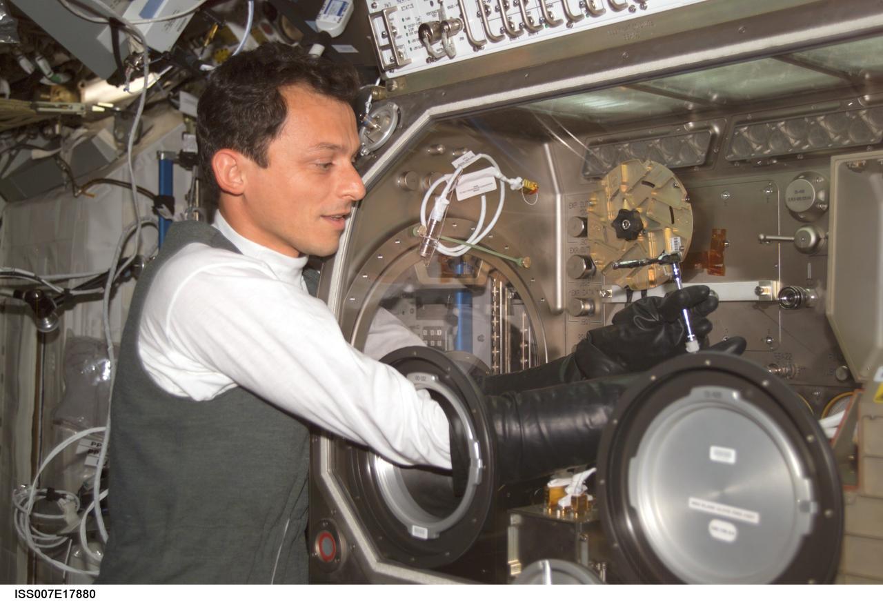
ISS007-E-17880 (20 October 2003) --- European Space Agency (ESA) astronaut Pedro Duque of Spain prepares to set up the Cervantes program of tests (consisting of 20 commercial experiments) by starting with the Microgravity Science Glovebox (MSB) in the Destiny laboratory on the International Space Station (ISS). Duque is working on the PROMISS experiment, which will investigate the growth processes of proteins during weightless conditions.
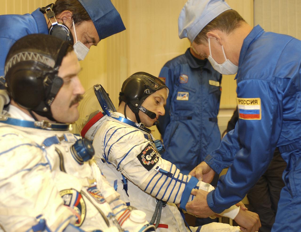
Expedition 8 Soyuz Commander Alexander Kaleri, left and European Space Agency astronaut Pedro Duque of Spain suit up for launch, Saturday, Oct. 18, 2003, prior to departure for the launch pad at the Baikonur Cosmodrome in Kazakhstan. Expedition 8 Commander and NASA Science Officer Mike Foale, Kaleri and Duque. were launched on the Soyuz TMA-3 vehicle to the International Space Station, arriving on Oct. 20. Photo Credit (NASA/Bill Ingalls)

October 13, 2003. Baikonur Cosmodrome, Kazakhstan. Expedition 8 Commander and NASA Science Officer Mike Foale (left), Expedition 8 Soyuz Commander Alexander Kaleri (center) and European Space Agency Astronaut Pedro Duque of Spain (right) pose inside the Soyuz TMA-3 vehicle in a processing facility at the Baikonur Cosmodrome in Kazakhstan Oct. 13, 2003 during a prelaunch inspection. The trio will be launched to the International Space Station on Oct. 18. Photo Credit"NASA/Bill Ingalls"
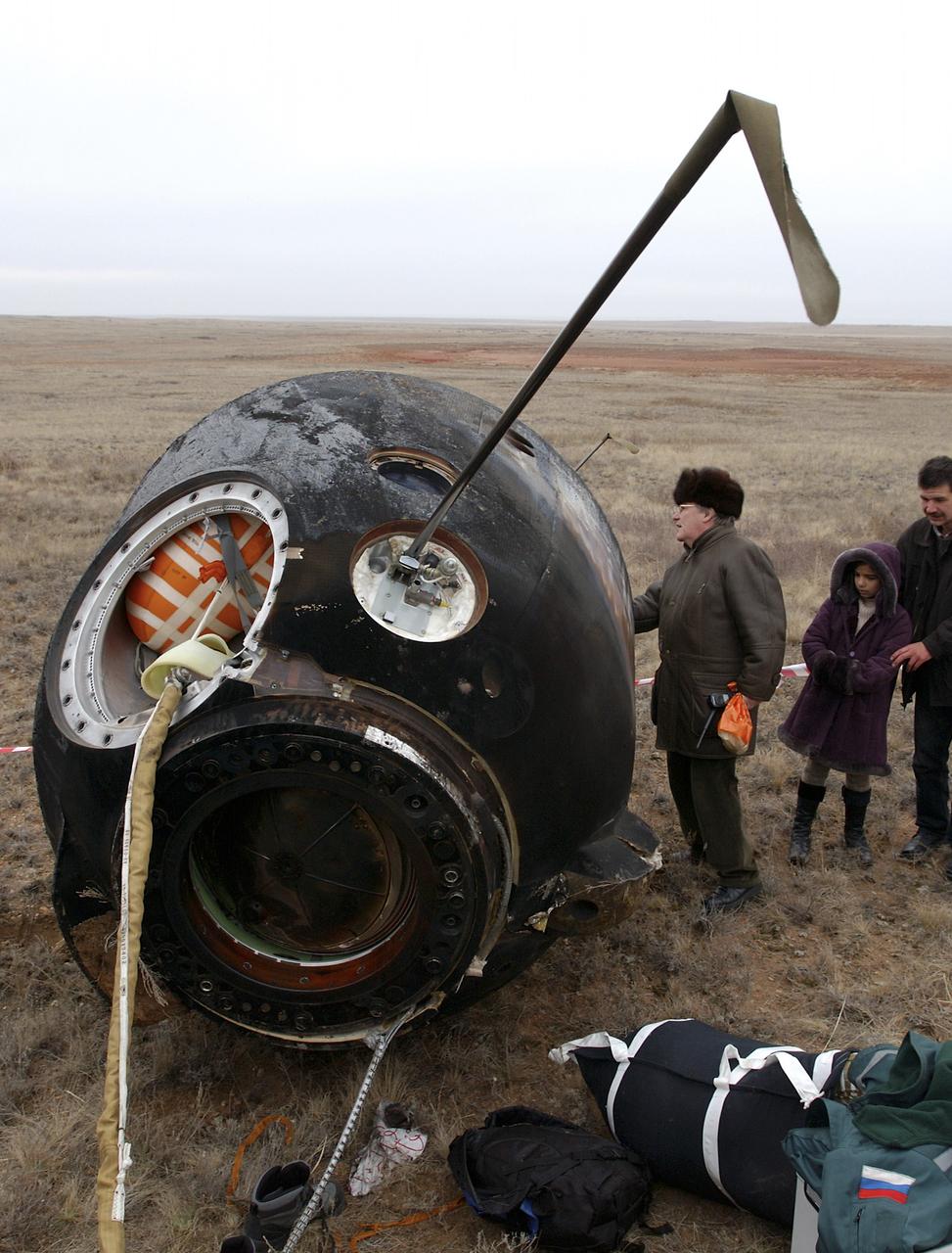
The Soyuz TMA-2 spacecraft carrying cosmonaut Yuri I. Malenchenko, Expedition 7 Mission Commander; astronaut Edward T. Lu, NASA International Space Station Science Officer and Flight Engineer; and European Space Agency (ESA) astronaut Pedro Duque of Spain is photographed on the ground after landing in Kazakhstan on Monday, October 27, 2003 at 9:41 p.m. (EST). Photo Credit: (NASA/Bill Ingalls)

October 13, 2003. Baikonur Cosmodrome, Kazakhstan. European Space Agency Astronaut Pedro Duque of Spain climbs into the Soyuz TMA-3 vehicle in a processing facility at the Baikonur Cosmodrome in Kazakhstan on Oct. 13, 2003 during prelaunch training with his crew mates, Expedition 8 Commander and NASA Science Officer Mike Foale and Expedition 8 soyuz Commander Alexander Kaleri. The trio will be launched on Oct. 18 to the International Space Station. Photo Credit"NASA/Bill Ingalls"
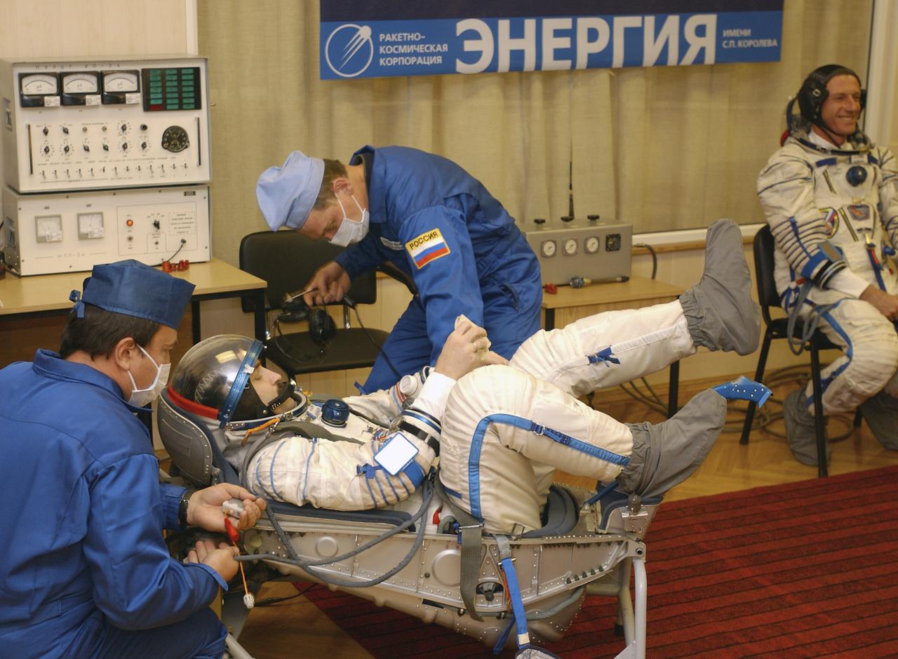
Technicians conduct a leak check on the spacesuit of Expedition 8 Soyuz Commander Alexander Kaleri at the Baikonur Cosmodrome, Saturday, Oct. 18, 2003, prior to his departure for the launch pad with Expedition 8 Commander and NASA Science Officer Mike Foale and European Space Agency astronaut Pedro Duque of Spain. The trio were launched on a Soyuz TMA-3 vehicle to the International Space Station, arriving on Oct. 20. Photo Credit (NASA/Bill Ingalls)
October 12, 2003, Star City, Russia. Expedition 8 Commander Michael Foale (right) and Expedition 8 Soyuz Commander and Flight Engineer Alexander Kaleri (center) are joined by European Space Agency Astronaut Pedro Duque of Spain at the Gagarin Cosmonaut Training Center outside Moscow to pose for pictures prior to their departure for the Baikonur Cosmodrome in Kazakhstan for the October 18th launch on a Soyuz rocket to the International Space Station. Photo Credit: "NASA/Bill Ingalls"

European Space Agency astronaut Pedro Duque of Spain suits up for launch, Saturday, Oct. 18, 2003, at the Baikonur Cosmodrome in Kazakhstan prior to his departure for the launch pad with Expedition 8 Commander and NASA Science Officer Mike Foale and Soyuz Commander Alexander Kaleri. The trio were launched on the Soyuz TMA-3 vehicle to the International Space Station, arriving on Oct. 20. Photo Credit (NASA/Bill Ingalls)