
Sisyphi Spine
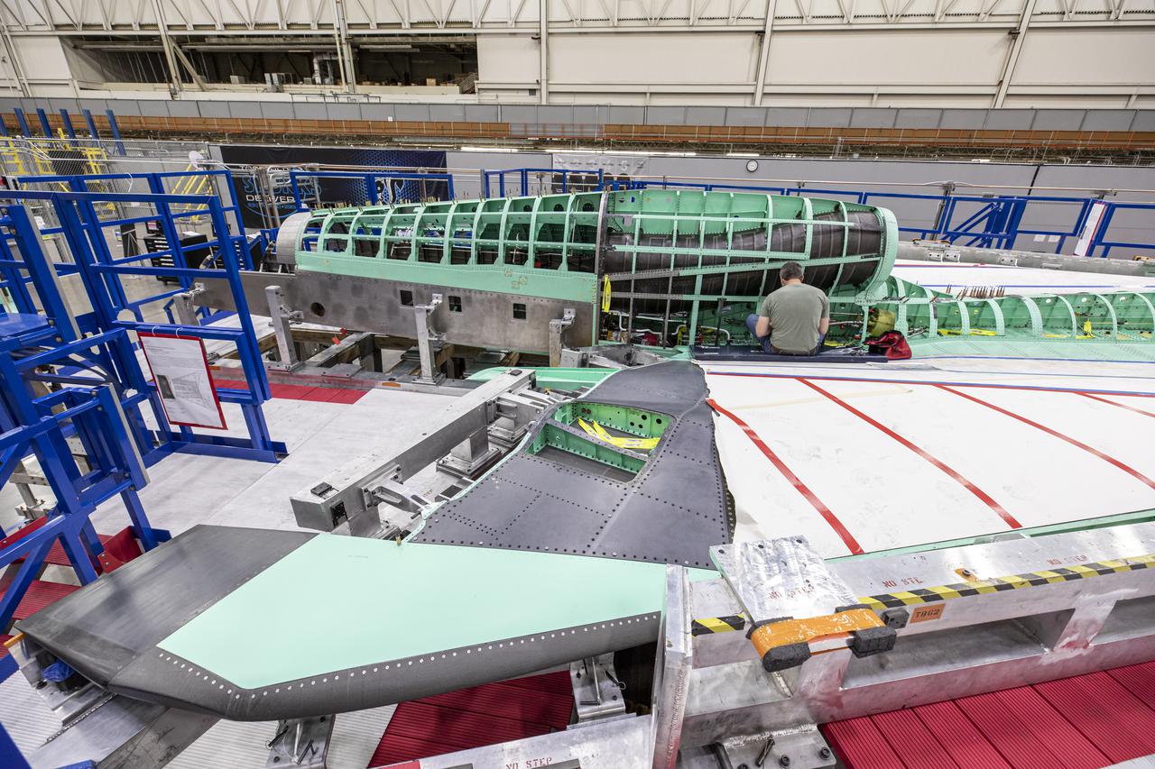
Pictured here is a side view of the X-59 spine and engine inlet during assembly. Lockheed Martin Photography By Garry Tice 1011 Lockheed Way, Palmdale, Ca. 93599 Event: SEG 210 Forebody, SEG 430 Spine, SEG 500 Empennage Date: 6/08/2021
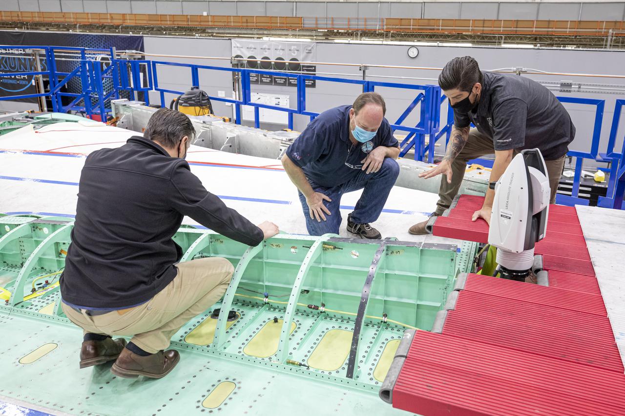
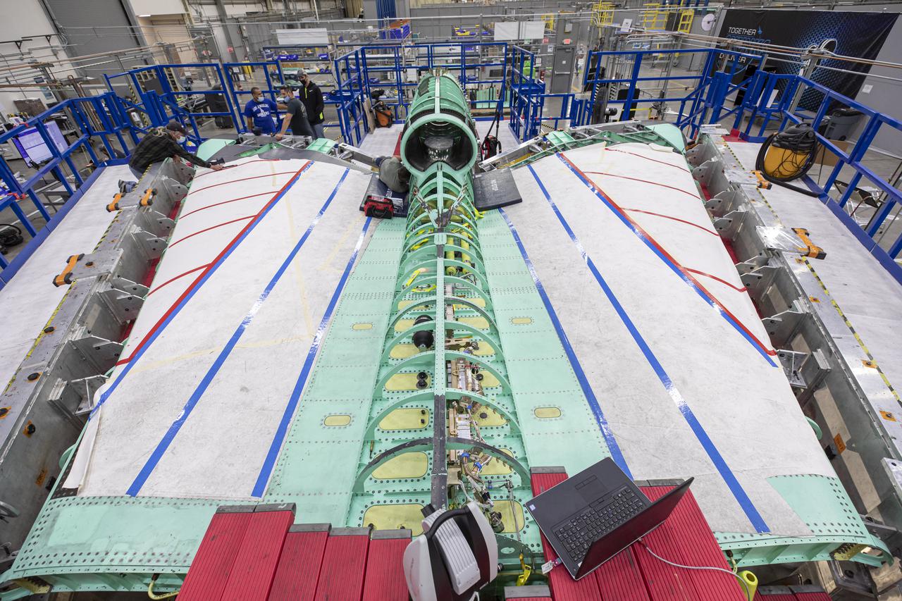
Technicians work with a laser measuring system on the X-59 spine. The X-59 Quiet SuperSonic Technology, or QueSST, aircraft is under construction at Lockheed Martin Skunk Works in Palmdale, California, and will fly to demonstrate the ability to fly supersonic while reducing the loud sonic boom to a quiet sonic thump. Lockheed Martin Photography By Garry Tice 1011 Lockheed Way, Palmdale, Ca. 93599 Event: SEG 400 Main Wing Assembly, SEG 430 Spine, SEG 500 Empennage Date: 4/28/2021
Lockheed Martin Photography By Garry Tice 1011 Lockheed Way, Palmdale, Ca. 93599 Event: SEG 400 Main Wing Assembly, SEG 430 Spine, SEG 500 Empennage Date: 4/28/2021 Additional Info:
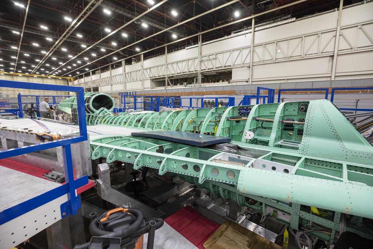
Here is a wide shot of the wing, engine and engine inlet area of NASA’s X-59 Quiet SuperSonic Technology or QueSST aircraft. The aircraft, under construction at Lockheed Martin Skunk Works in Palmdale, California, will fly to demonstrate the ability to fly supersonic while reducing the loud sonic boom to a quiet sonic thump. Lockheed Martin Photography By Garry Tice 1011 Lockheed Way, Palmdale, Ca. 93599 Event: SEG 400 Main Wing Assembly, SEG 430 Spine, SEG 500 Empennage Date: 4/28/2021
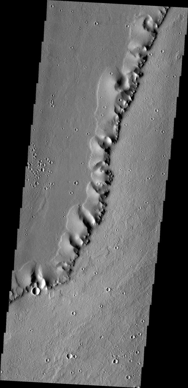
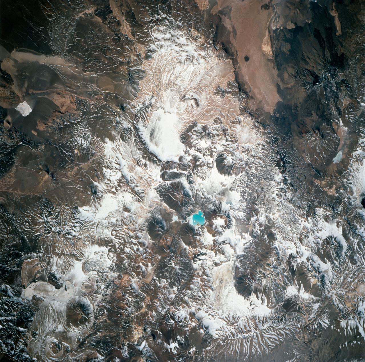
This image from NASA 2001 Mars Odyssey spacecraft of a ridge in the Tharsis region called Uranius Dorsum reminds one of a skeletal spine.

The ridge in this image captured by NASA 2001 Mars Odyssey spacecraft shows the Tharsis region called Uranius Dorsum reminds one of a skeletal spine.

Sending chills down the spine of all arachnophobes is the Tarantula nebula, seen in this image from NASA Wide-field Infrared Survey Explorer; the nebula is the largest star-forming region known in our entire Local Group of galaxies.
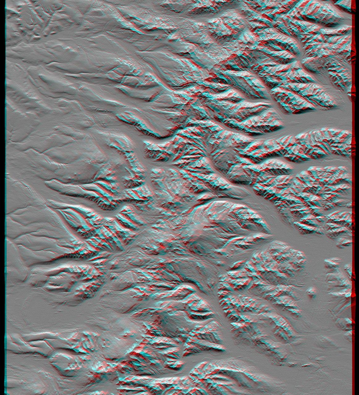
This anaglyph, from NASA Shuttle Radar Topography Mission, shows the Kamchatka Peninsula in eastern Russia. Sredinnyy Khrebet, the mountain range that makes up the spine of the peninsula. 3D glasses are necessary to view this image.
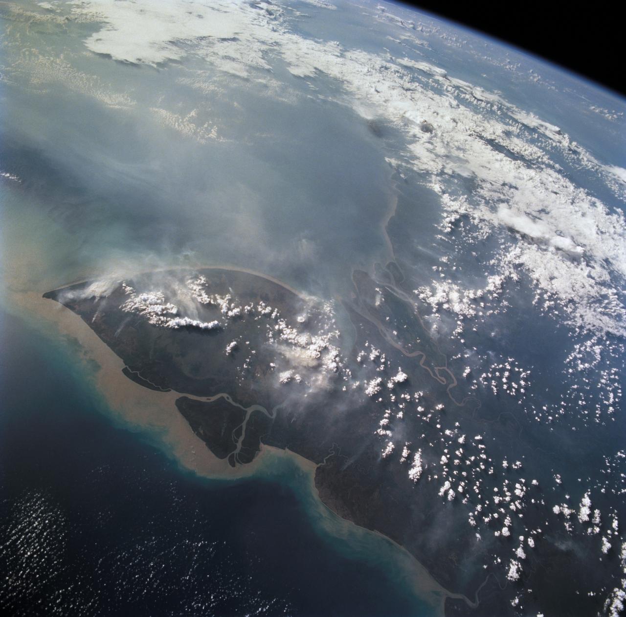
STS068-261-062 (30 September-11 October 1994) --- Vals Cape (left) is the prominent point of the island of New Guinea (Indonesia's Irian Jaya) that juts southwest into the Arafura Sea, pointing towards Australia. The part of New Guinea in this northwest-looking view is entirely low-lying swampland with very low population density. The Digul River, snaking across the middle of the view, drains the high mountain chain, which runs along the spine of the island.
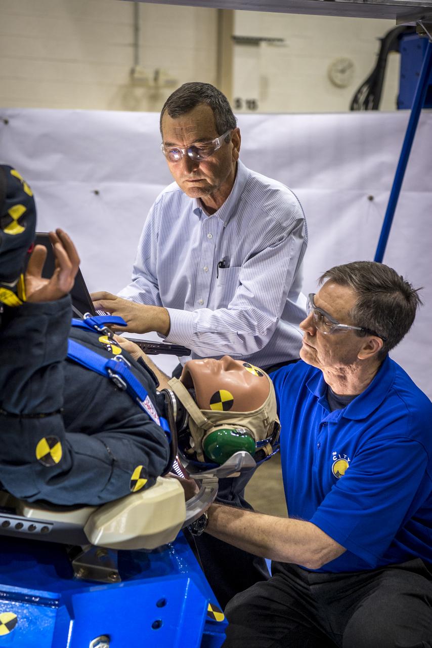
Engineers working with Boeing's CST-100 Starliner test the spacecraft's seat design in Mesa, Arizona, focusing on how the spacecraft seats would protect an astronaut's head, neck and spine during the 240-mile descent from the International Space Station. The company incorporated test dummies for a detailed analysis of impacts on a crew returning to earth. The human-sized dummies were equipped with sensitive instrumentation and secured in the seats for 30 drop tests at varying heights, angles, velocities and seat orientations in order to mimic actual landing conditions. High-speed cameras captured the footage for further analysis. The Starliner spacecraft is being developed in partnership with NASA's Commercial Crew Program.
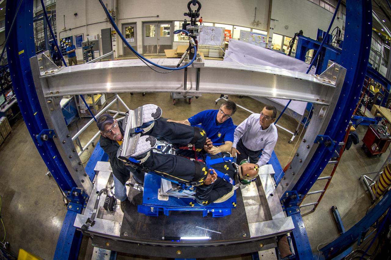
Engineers working with Boeing's CST-100 Starliner test the spacecraft's seat design in Mesa, Arizona, focusing on how the spacecraft seats would protect an astronaut's head, neck and spine during the 240-mile descent from the International Space Station. The company incorporated test dummies for a detailed analysis of impacts on a crew returning to earth. The human-sized dummies were equipped with sensitive instrumentation and secured in the seats for 30 drop tests at varying heights, angles, velocities and seat orientations in order to mimic actual landing conditions. High-speed cameras captured the footage for further analysis. The Starliner spacecraft is being developed in partnership with NASA's Commercial Crew Program.
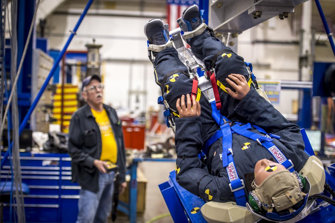
Engineers working with Boeing's CST-100 Starliner test the spacecraft's seat design in Mesa, Arizona, focusing on how the spacecraft seats would protect an astronaut's head, neck and spine during the 240-mile descent from the International Space Station. The company incorporated test dummies for a detailed analysis of impacts on a crew returning to earth. The human-sized dummies were equipped with sensitive instrumentation and secured in the seats for 30 drop tests at varying heights, angles, velocities and seat orientations in order to mimic actual landing conditions. High-speed cameras captured the footage for further analysis. The Starliner spacecraft is being developed in partnership with NASA's Commercial Crew Program.

STS082-723-071 (11-21 Feb. 1997) --- The island of Hispaniola appears left center in this wide-angle view, photographed with a 70mm handheld camera from the Earth-orbiting Space Shuttle Discovery. The prominent cape is Cap-a-Foux, the northwest point of Haiti. The cloud is broken by the mountainous spine of the island. Smoke from bush fires appears in the valleys between the ridges. The coppery tinge of light reflected off the sea surface indicates pollution in the air -- probably industrial pollutants from North America which are typically fed around from the Atlantic seaboard into the Caribbean from the east.

Engineers working with Boeing's CST-100 Starliner test the spacecraft's seat design in Mesa, Arizona, focusing on how the spacecraft seats would protect an astronaut's head, neck and spine during the 240-mile descent from the International Space Station. The company incorporated test dummies for a detailed analysis of impacts on a crew returning to earth. The human-sized dummies were equipped with sensitive instrumentation and secured in the seats for 30 drop tests at varying heights, angles, velocities and seat orientations in order to mimic actual landing conditions. High-speed cameras captured the footage for further analysis. The Starliner spacecraft is being developed in partnership with NASA's Commercial Crew Program.
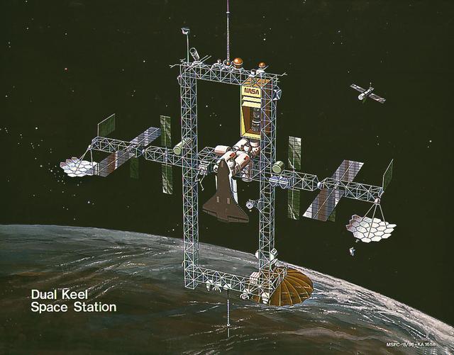
In response to President Reagan's directive to NASA to develop a permanent marned Space Station within a decade, part of the State of the Union message to Congress on January 25, 1984, NASA and the Administration adopted a phased approach to Station development. This approach provided an initial capability at reduced costs, to be followed by an enhanced Space Station capability in the future. This illustration depicts a configuration with enhanced capabilities. It builds on the horizontal boom and module pattern of the revised baseline. This configuration would feature dual keels, two vertical spines 105-meters long joined by upper and lower booms. The structure carrying the modules would become a transverse boom of a basically rectangular structure. The two new booms, 45-meters in length, would provide extensive accommodations for attached payloads, and would offer a wide field of view. Power would be increased significantly, with the addition if a 50-kW solar dynamic power system.

ISS007-E-14867 (13 September 2003) --- This view featuring Noumea, New Caledonia was taken by one of the Expedition 7 crewmembers onboard the International Space Station (ISS). The mountains forming the spine of the island of Grande Terre contain large reserves of nickel and chromium, and New Caledonia mines are one of the world’s greatest producers of nickel. This image shows details of New Caledonia’s main city, Noumea, which is built on a peninsula that juts into the lagoon on the southwest side of the island. The reefs here face localized problems from pollution and overfishing. The tourism industry is very important to the economy of Noumea, with extensive hotel development in the city and along the southeast coast of Grand Terre. The picture shows how urban development extends to the steep slopes of the coastal hills.
STS070-717-011 (13-22 JULY 1995) --- Volcanic landscapes with a thin dusting of snow appear in this near-vertical view of the dry, high spine of the Andes Mountains at around 28 degrees south latitude. Strong westerly winds (from left) have blown the snow off the highest volcanic peaks (center and bottom): many of these peaks rise higher than 20,000 feet. A small, dry lake appears top right, the white color derived from salts. The border between Argentina and Chile winds from volcano to volcano and passes just left of the small blue lake (left center). Black lava flows can be detected bottom right. The larger area of brown-pink rocks (bottom rock) is also an area of volcanic rocks, of a type known as ash flow tuffs which are violently extruded, often in volumes measured in cubic kilometers.
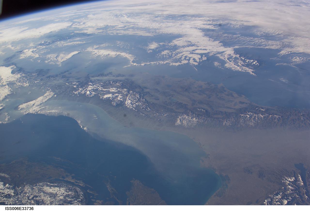
ISS006-E-33736 (25 February 2003) --- The boot of Italy crosses the image in this southwest-looking view taken by an Expedition Six crewmember onboard the International Space Station (ISS). The spine of Italy is highlighted with snow and the largely cloud-covered Mediterranean Sea is at the top. The Adriatic Sea transverses most of the bottom of the image and Sicily appears top left beyond the toe of the boot. The heel lies out of the left side of the image. Corsica and Sardinia appear right of center partly under cloud. The floor of the Po River valley, lower right, is obscured by haze. Experience gained from similar haze events, in which atmospheric pressure, humidity and visibility and atmospheric chemistry were known, suggests that the haze as industrial smog. Industrial haze from the urban region of the central and upper Po valley accumulates to visible concentrations under conditions of high atmospheric pressure and the surrounding mountains prevent easy dispersal. This view illustrates the markedly different color and texture of cloud versus industrial aerosol haze.
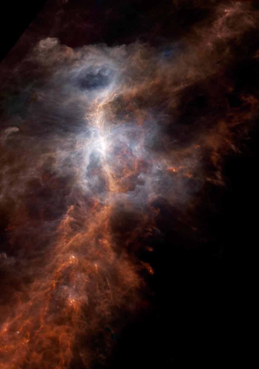
The dusty side of the Sword of Orion is illuminated in this striking infrared image from the European Space Agency's Hershel Space Observatory. This immense nebula is the closest large region of star formation, situated about 1,500 light years away in the constellation of Orion. The parts that are easily observed in visible light, known alternatively as the Orion Nebula or Messier 42, correspond to the light blue regions. This is the glow from the warmest dust, illuminated by clusters of hot stars that have only recently been born in this chaotic region. The red spine of material running from corner to corner reveals colder, denser filaments of dust and gas that are scattered throughout the Orion nebula. In visible light this would be a dark, opaque feature, hiding the reservoir of material from which stars have recently formed and will continue to form in the future. Herschel data from the PACS instrument observations, at wavelengths of 100 and 160 microns, is displayed in blue and green, respectively, while SPIRE 250-micron data is shown in red. Within the inset image, the emission from ionized carbon atoms (C+), overlaid in yellow, was isolated and mapped out from spectrographic data obtained by the HIFI instrument. http://photojournal.jpl.nasa.gov/catalog/PIA21073
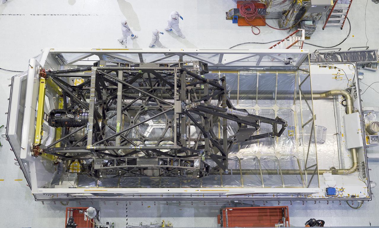
The James Webb Space Telescope's "spine" or backplane arrived on Aug. 25 at NASA's Goddard Space Flight Center in Greenbelt, Maryland from Northrop Grumman. Credits: NASA Goddard/Chris Gunn Read more: <a href="http://go.nasa.gov/1K2v8J2" rel="nofollow">go.nasa.gov/1K2v8J2</a> <b><a href="http://www.nasa.gov/audience/formedia/features/MP_Photo_Guidelines.html" rel="nofollow">NASA image use policy.</a></b> <b><a href="http://www.nasa.gov/centers/goddard/home/index.html" rel="nofollow">NASA Goddard Space Flight Center</a></b> enables NASA’s mission through four scientific endeavors: Earth Science, Heliophysics, Solar System Exploration, and Astrophysics. Goddard plays a leading role in NASA’s accomplishments by contributing compelling scientific knowledge to advance the Agency’s mission. <b>Follow us on <a href="http://twitter.com/NASAGoddardPix" rel="nofollow">Twitter</a></b> <b>Like us on <a href="http://www.facebook.com/pages/Greenbelt-MD/NASA-Goddard/395013845897?ref=tsd" rel="nofollow">Facebook</a></b> <b>Find us on <a href="http://instagrid.me/nasagoddard/?vm=grid" rel="nofollow">Instagram</a></b>
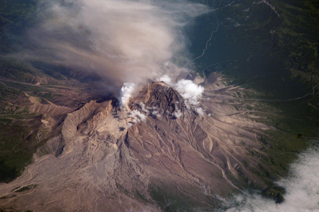
ISS015-E-16913 (10 July 2007) --- Shiveluch Volcano, Kamchatka, Russian Far East is featured in this image photographed by an Expedition 15 crewmember on the International Space Station. Shiveluch is one of the biggest and most active of a line of volcanoes along the spine of the Kamchatka peninsula in easternmost Russia. In turn the volcanoes and peninsula are part of the tectonically active "Ring of Fire" that almost surrounds the Pacific Ocean, denoted by active volcanoes and frequent earthquakes. Shiveluch occupies the point where the northeast-trending Kamchatka volcanic line intersects the northwest-trending Aleutian volcanic line. Junctions such as this are typically points of intense volcanic activity. According to scientists, the summit rocks of Shiveluch have been dated at approximately 65,000 years old. Lava layers on the sides of the volcano reveal at least 60 major eruptions in the last 10,000 years, making it the most active volcano in the 2,200 kilometer distance that includes the Kamchatka peninsula and the Kuril island chain. Shiveluch rises from almost sea level to well above 3,200 miles (summit altitude 3,283 miles) and is often capped with snow. In this summer image however, the full volcano is visible, actively erupting ash and steam in late June or early July, 2007. The dull brown plume extending from the north of the volcano summit is most likely a combination of ash and steam (top). The two larger white plumes near the summit are dominantly steam, a common adjunct to eruptions, as rain and melted snow percolate down to the hot interior of the volcano. The sides of the volcano show many eroded stream channels. The south slope also reveals a long sloping apron of collapsed material, or pyroclastic flows. Such debris flows have repeatedly slid down and covered the south side of the volcano during major eruptions when the summit lava domes explode and collapse (this occurred during major eruptions in 1854 and 1964). Regrowth of the forest on the south slope (note the contrast with the eastern slope) has been foiled by the combined effects of continued volcanic activity, instability of the debris flows and the short growing season.

On February 25, 2016, the Operational Land Imager (OLI) on the Landsat 8 satellite acquired this natural-color image of Biscayne National Park. The park encompasses the northernmost Florida Keys, starting from Miami to just north of Key Largo. The keys run like a spine through the center of the park, with Biscayne Bay to the west and the Atlantic Ocean to the east. The water-covered areas span more than 660 square kilometers (250 square miles) of the park, making it the largest marine park in the U.S. National Park System. Biscayne protects the longest stretch of mangrove forest on the U.S. East Coast, and one of the most extensive stretches of coral reef in the world. Read more: <a href="http://go.nasa.gov/1SWs1a3" rel="nofollow">go.nasa.gov/1SWs1a3</a> Credit: NASA/Landsat8 <b><a href="http://www.nasa.gov/audience/formedia/features/MP_Photo_Guidelines.html" rel="nofollow">NASA image use policy.</a></b> <b><a href="http://www.nasa.gov/centers/goddard/home/index.html" rel="nofollow">NASA Goddard Space Flight Center</a></b> enables NASA’s mission through four scientific endeavors: Earth Science, Heliophysics, Solar System Exploration, and Astrophysics. Goddard plays a leading role in NASA’s accomplishments by contributing compelling scientific knowledge to advance the Agency’s mission. <b>Follow us on <a href="http://twitter.com/NASAGoddardPix" rel="nofollow">Twitter</a></b> <b>Like us on <a href="http://www.facebook.com/pages/Greenbelt-MD/NASA-Goddard/395013845897?ref=tsd" rel="nofollow">Facebook</a></b> <b>Find us on <a href="http://instagrid.me/nasagoddard/?vm=grid" rel="nofollow">Instagram</a></b>
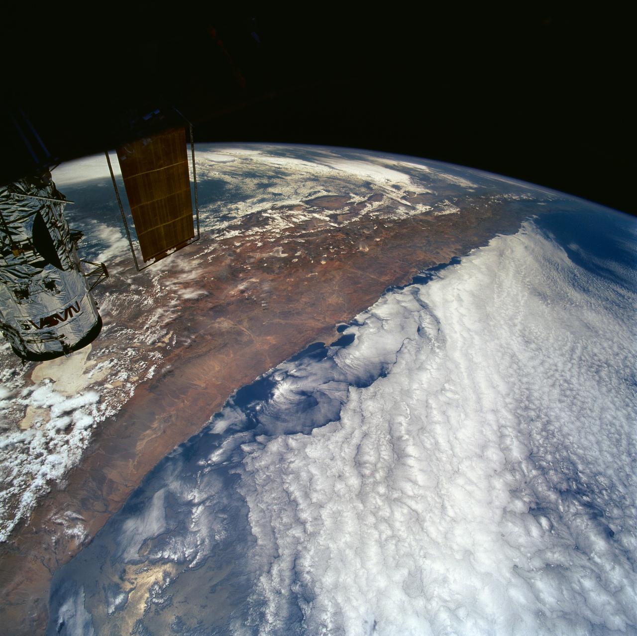
STS061-101-023 (8 Dec 1993) --- This color photograph is a spectacular, panoramic (southeastern view) shot that features the northern half of the country of Chile and the Andes Mountains of South America. The Atacama Desert, one of the driest regions on earth, is clearly visible along the northern Chilean coast. This desert extends from roughly Arica in the north to the city of Caldera in the south, a distance of six hundred miles. Some parts of this very arid region go for more than twenty years without measurable precipitation. It is an area of dramatic and abrupt elevation changes. For example, from the waters edge there is an escarpment of the coastal plateau that rises like an unbroken wall two or three thousand feet above the Pacific Ocean. From the coastal plateau, there is an even more dramatic increase in elevation -- from two thousand feet above sea level to an average elevation of thirteen thousand feet above sea level in the Bolivian Altiplano. This elevation change occurs within a one hundred to two hundred mile distance from the Pacific Ocean. The north-south trending spine of the Andes Mountains can be seen on this photograph. Several of the volcanic peaks in this mountain chain exceed 20,000 feet above sea level. Interspersed with these volcanic peaks, numerous dry lake beds (salars) can be seen as highly reflective surfaces. The largest of these salars (Salar de Uyuni) is visible at the edge of the Hubble Space Telescope (HST). Offshore, the cold Peruvian current produces low stratus clouds that can be found along this coastline at certain times of the year. This is the same type of meteorological phenomena that is found along the southern California coast and the Skeleton coast of southwestern Africa.
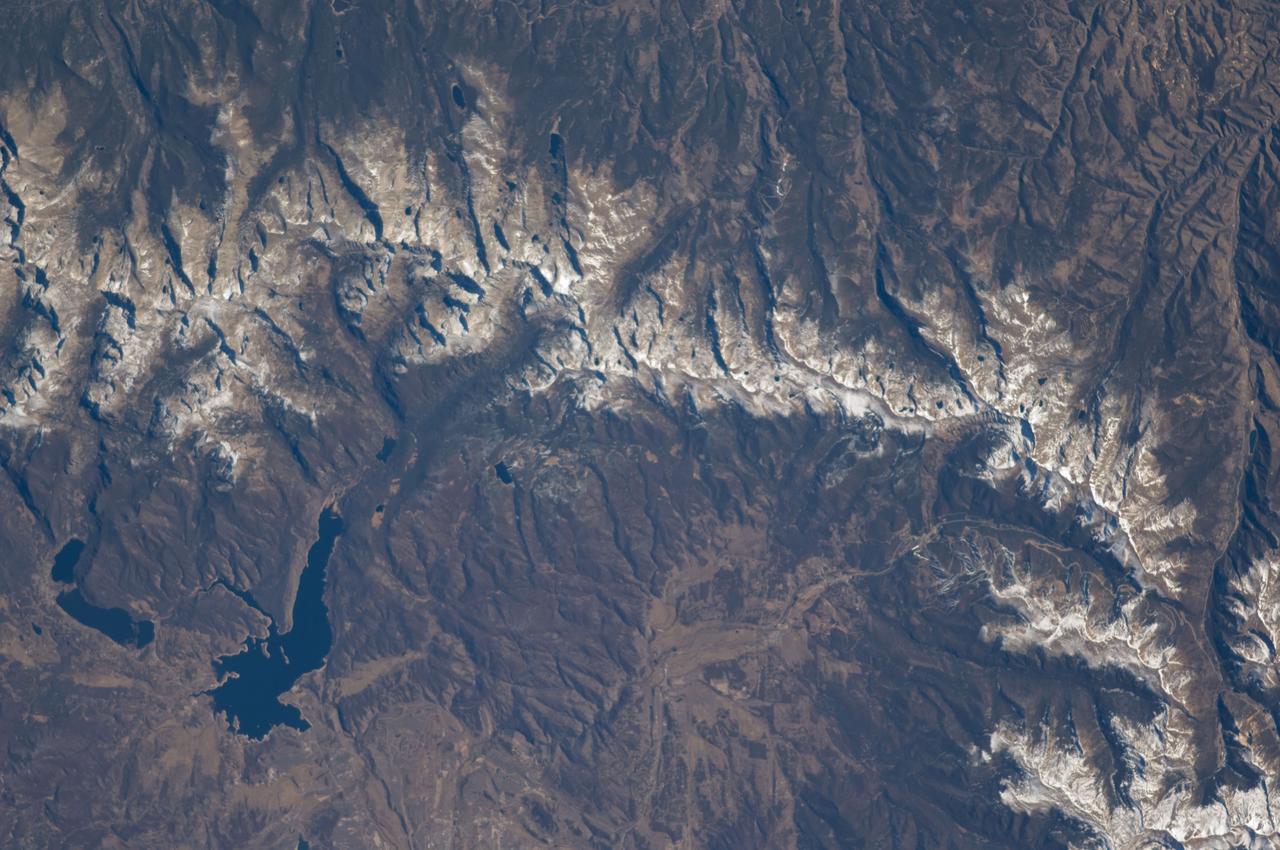
ISS018-E-005660 (28 Oct. 2008) --- The Great Divide of the Rocky Mountains in Colorado is featured in this image photographed by an Expedition 18 crewmember on the International Space Station. This view highlights a portion of the Great Divide in the Rocky Mountains approximately 31 kilometers due west of Boulder, Colorado. The Great Divide is one of four continental divides recognized by geographers and hydrologists in North America -- the others being the Northern, Eastern, and Saint Lawrence Seaway Divides -- but it is still generally (and erroneously) known as "the" Continental Divide. The Great Divide is a hydrologic boundary defined by the ultimate destination of precipitation -- rainfall on the western side of the Divide flows to the Pacific Ocean, while rainfall on the eastern side of the Divide flows to the Gulf of Mexico. It is easy to visualize such a boundary traced along the high ridges of the Rocky Mountains, but in regions of less topography more detailed study of the local geomorphology and hydrology are required to map the location of the Divide. This portion of the Rocky Mountains also hosts the Niwot Ridge Long Term Ecological Research (LTER) site. Part of the National Science Foundation LTER program, the Niwot Ridge LTER site studies climate interactions with tundra and alpine ecosystems. Niwot Ridge is visible in this image as a large eastward spur off the central spine of the mountains. The entire Niwot LTER site is located at elevations higher than 3000 m, and includes an active cirque glacier and glacial landforms, tarns (glacial lakes), and permafrost. Lake Granby, located to the west of the Great Divide, is a reservoir on the Colorado River and the second-largest manmade body of water in the state of Colorado. Storage of water began in 1949. Today, the Lake is popular location for fishing, boating and camping.
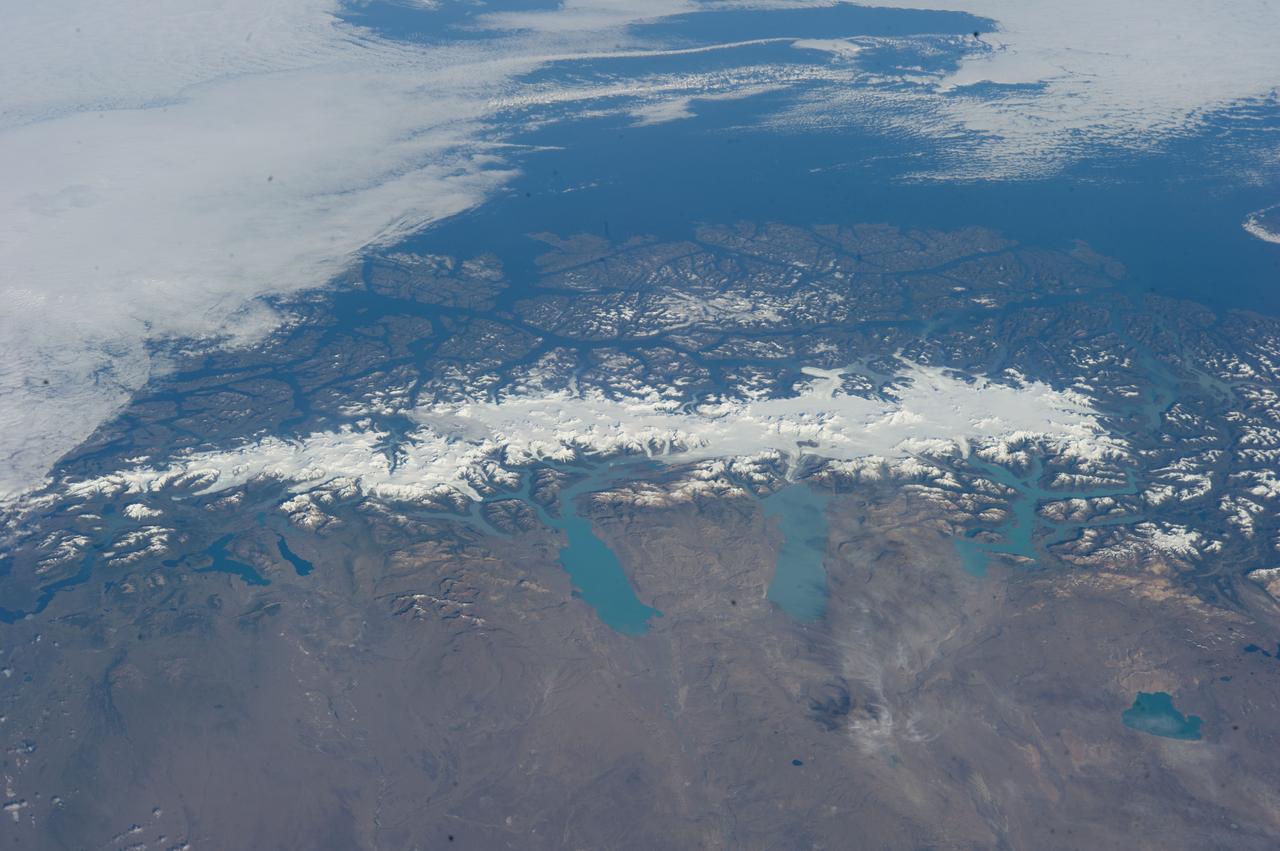
ISS038-E-047324 (13 Feb. 2014) --- This grand panorama of the Southern Patagonia Icefield (center) was imaged by an Expedition 38 crew member on the International Space Station on one of the rare clear days in the southern Andes Mountains. With an area of 13,000 square kilometers, the icefield is the largest temperate ice sheet in the Southern Hemisphere. Storms that swirl into the region from the southern Pacific Ocean (top) bring rain and snow (equivalent to a total of 2-11 meters of rainfall per year) resulting in the buildup of the ice sheet shown here (center). During the ice ages the glaciers were far larger. Geologists now know that ice tongues extended far onto the plains in the foreground, completely filling the great Patagonian lakes on repeated occasions. Similarly, ice tongues extended into the dense network of fjords (arms of the sea) on the Pacific side of the icefield. Ice tongues today appear tiny compared to the view that an "ice age" astronaut would have seen. A study of the surface topography of sixty-three glaciers, based on Shuttle Radar Topography Mission (SRTM) data, compared data from 2000 to data from studies going back about 30 years (1968-1975). Many glacier tongues showed significant annual "retreat" of their ice fronts, a familiar signal of climate change. The study also revealed that the almost invisible loss by glacier thinning is far more significant in explaining ice loss. The researchers concluded that volume loss by frontal collapse is 4-10 times smaller than that caused by thinning. Scaled over the entire icefield, including frontal loss (so-called calving when ice masses collapse into the lakes), it was calculated that 13.5 cubic kilometers of ice was lost each year over the study period. This number becomes more meaningful compared with the rate measured in the last five years of the study (1995-2000), when the rate increased almost threefold, averaging 38.7 cubic kilometers per year. Extrapolating results from the low altitude glacier tongues implies that the high plateau ice on the spine of the Andes is thinning as well. In the decade since this study the often-imaged Upsala Glacier has retreated a further three kilometers, as shown recently in images taken by crew members aboard the space station. Glacier Pio X, named for Pope Pius X, is the only large glacier that is growing in length.
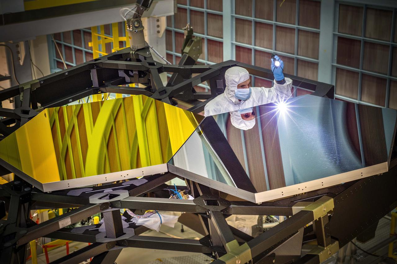
Inside NASA's Goddard Space Flight Center's giant clean room in Greenbelt, Md., JWST Optical Engineer Larkin Carey from Ball Aerospace, examines two test mirror segments recently placed on a black composite structure. This black composite structure is called the James Webb Space Telescope's “Pathfinder” and acts as a spine supporting the telescope's primary mirror segments. The Pathfinder is a non-flight prototype. The mirrors were placed on Pathfinder using a robotic arm move that involved highly trained engineers and technicians from Exelis, Northrop Grumman and NASA. "Getting this right is critical to proving we are ready to start assembling the flight mirrors onto the flight structure next summer," said Lee Feinberg, NASA's Optical Telescope Element Manager at NASA Goddard. "This is the first space telescope that has ever been built with a light-weighted segmented primary mirror, so learning how to do this is a groundbreaking capability for not only the Webb telescope but for potential future space telescopes." The James Webb Space Telescope is the successor to NASA's Hubble Space Telescope. It will be the most powerful space telescope ever built. Webb is an international project led by NASA with its partners, the European Space Agency and the Canadian Space Agency. For more information about the Webb telescope, visit: <a href="http://www.jwst.nasa.gov" rel="nofollow">www.jwst.nasa.gov</a> or <a href="http://www.nasa.gov/webb" rel="nofollow">www.nasa.gov/webb</a> Credit: NASA/Chris Gunn <b><a href="http://www.nasa.gov/audience/formedia/features/MP_Photo_Guidelines.html" rel="nofollow">NASA image use policy.</a></b> <b><a href="http://www.nasa.gov/centers/goddard/home/index.html" rel="nofollow">NASA Goddard Space Flight Center</a></b> enables NASA’s mission through four scientific endeavors: Earth Science, Heliophysics, Solar System Exploration, and Astrophysics. Goddard plays a leading role in NASA’s accomplishments by contributing compelling scientific knowledge to advance the Agency’s mission. <b>Follow us on <a href="http://twitter.com/NASAGoddardPix" rel="nofollow">Twitter</a></b> <b>Like us on <a href="http://www.facebook.com/pages/Greenbelt-MD/NASA-Goddard/395013845897?ref=tsd" rel="nofollow">Facebook</a></b> <b>Find us on <a href="http://instagram.com/nasagoddard?vm=grid" rel="nofollow">Instagram</a></b>
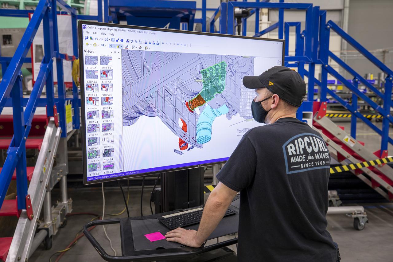
A Lockheed Martin technician looks at the connector installation on the cad model of the X-59 airplane. The aircraft, under construction at Lockheed Martin Skunk Works in Palmdale, California, will demonstrate the ability to fly supersonic while reducing the loud sonic boom to a quiet sonic thump.