
The Tsugaru Iwaki Skyline is a toll road in northern Japan, which partially ascends Mount Iwaki stratovolcano, and is notable for its steep gradient and 69 hairpin turns. The road ascends 806 meters over an average gradient of 8.66%, with some sections going up to 10%. The Tsugaru Iwaki Skyline has been considered one of the most dangerous mountain roads in the world. (Wikipedia) The image was acquired May 26, 2015, and is located at 40.6 degrees north, 140.3 degrees east. https://photojournal.jpl.nasa.gov/catalog/PIA22385
iss073e0118994 (May 17, 2025) --- The snow-capped Mount Damavand, a dormant stratovolcano and Iran's highest peak less than 50 miles from the nation's capital of Tehran, is pictiured from the International Space Station as it orbited 261 miles above the Caspian Sea.
iss074e0454554 (April 10, 2026) --- The snow‑covered Kronotsky, a major stratovolcano on the Kamchatka Peninsula in Russia, is pictured from the International Space Station as it orbited 267 miles above the Pacific Ocean. Kronotsky is known for its picturesque, near‑perfect symmetry, comparable to Japan’s Mount Fuji. Credit: NASA/Chris Williams
Anatahan is a stratovolcano that erupted in May 2003, forming a new crater. This image is from NASA Terra satellite.
Takawangha is a 1450 m stratovolcano on Tanaga Island, Alaska. On November 18, the Alaska Volcano Observatory raised the Volcano Alert Level to Advisory based on increased seismicity. The image was acquired September 13, 2021, covers an area of 40.8 by 44.9 km, and is located at 51.9N, 178W. https://photojournal.jpl.nasa.gov/catalog/PIA25560
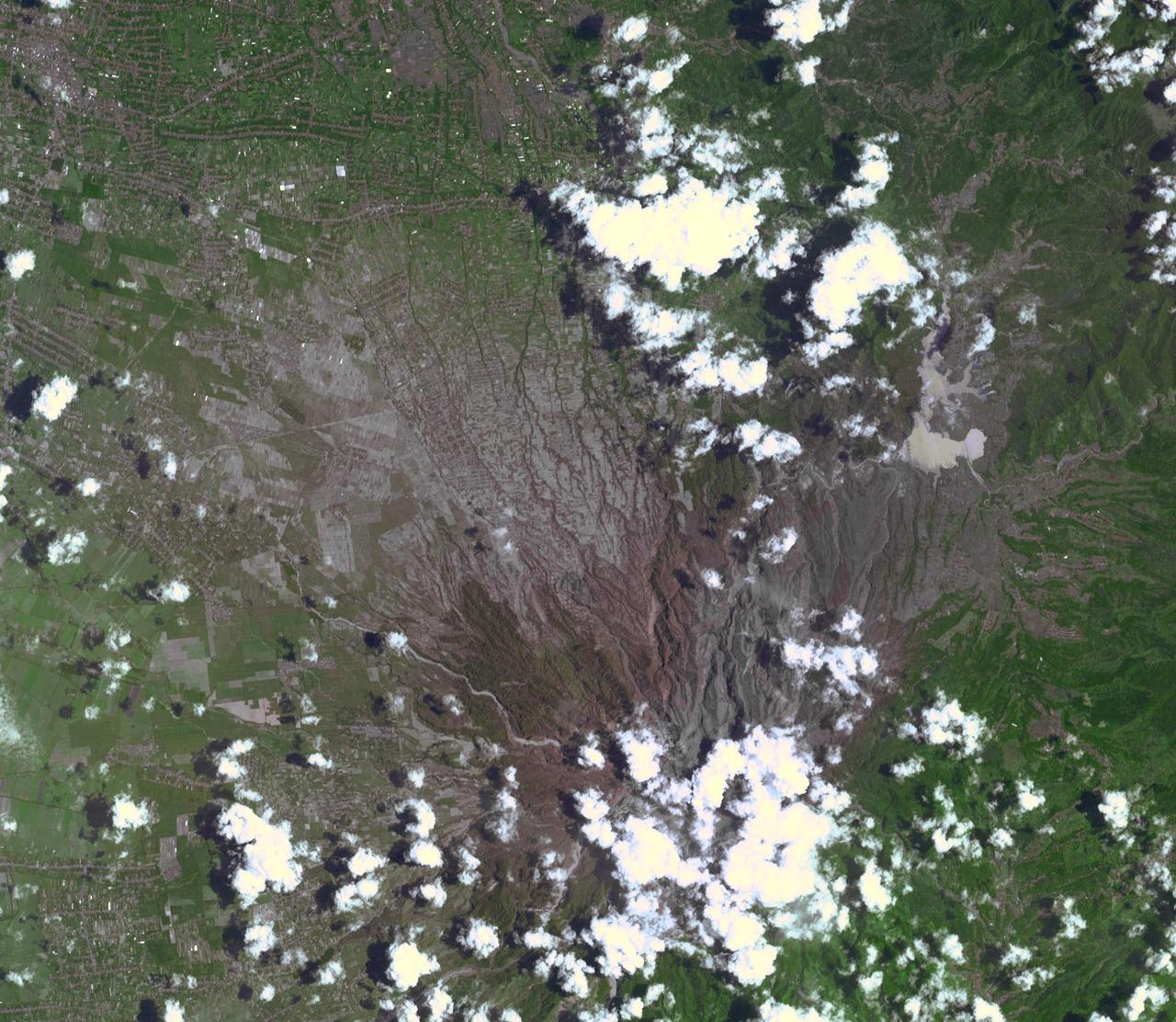
On Feb. 13, 2014, violent eruption of Kelud stratovolcano in Java, Indonesia sent volcanic ash covering an area of 70,000 square miles, prompting the evacuation of tens of thousands of people. This image is from NASA Terra spacecraft.
This image acquired by NASA Terra spacecraft is of Mount Sinabung, a stratovolcano located in Indonesia. In late 2013, a lava dome formed on the summit. In early January 2014, the volcano erupted, and it erupted again in early February.
On Feb. 25, 2011, NASA Terra spacecraft captured this image of a large ash-laden eruption plume drifting towards the northeast from Kizimen volcano, an isolated stratovolcano, in Kamchatka, Russia.
Nabro volcano in the African nation of Eritrea began erupting June 12, 2011, the first-ever recorded eruption of this stratovolcano. This image was acquired by NASA Terra spacecraft on July 5, 2011.
Nabro volcano, Eritrea, in the Horn of Africa, began erupting June 12, 2011, the first-ever recorded eruption of this stratovolcano. This image was acquired by NASA Terra spacecraft on June 19, 2011.
Llullaillaco is a stratovolcano at the border of Argentina and Chile. It lies on a high plateau close to the Atacama Desert. At an elevation of 6723 m ASL, it is the second highest active volcano in the world. About 150,000 years ago the volcano's southeastern flank collapsed, producing a debris avalanche that traveled 25 kilometers. The youngest dated rocks are about 5600 years old; but there are local reports of activity from the 1800s. The perspective image looking east was acquired December 19, 2014 and is located at 24.7 degrees south, 68.5 degrees west. https://photojournal.jpl.nasa.gov/catalog/PIA22721
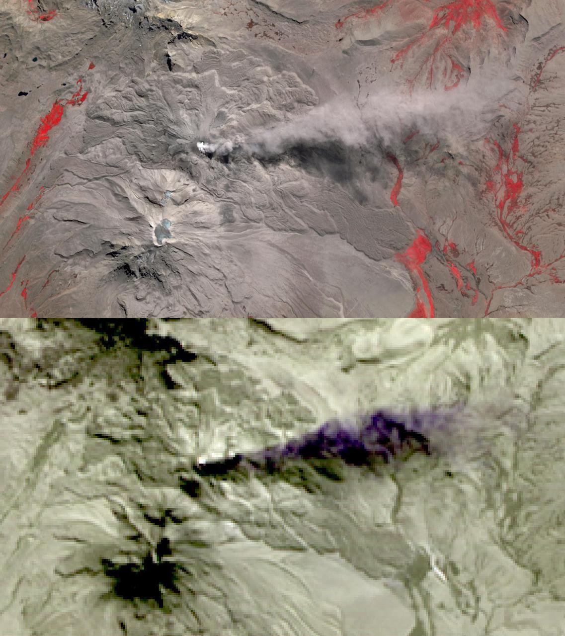
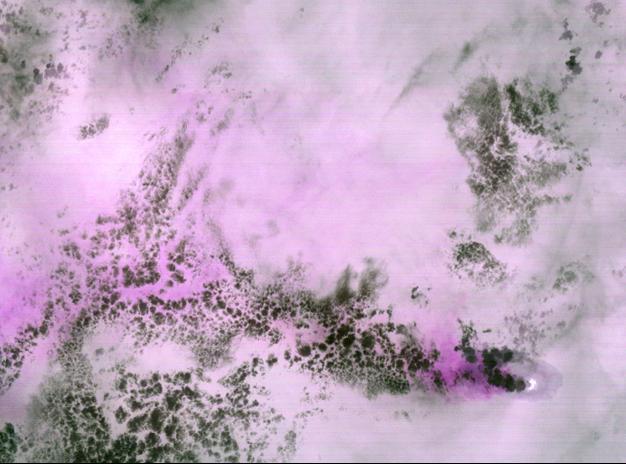
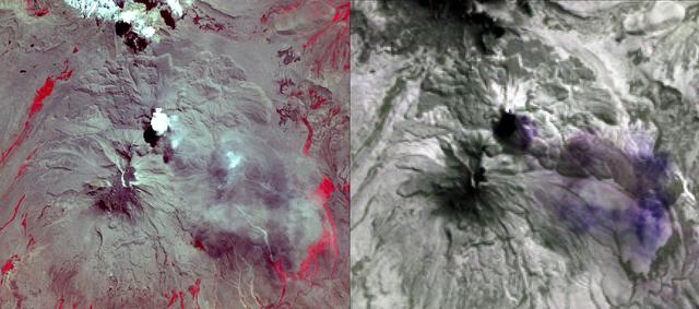
In this image of Peru's Sabancaya stratovolcano, acquired May 13, 2020, the years-long eruption continues. In the top image, Sabancaya has a bright white cloud in its caldera. The greyish cloud to the east is an ash plume. The Ampato volcano, with its prominent summit caldera, is to the south. The red areas are vegetation. The lower thermal infrared composite image shows the plume in purple, indicating that it is dominantly composed of ash and water vapor. A bright hotspot can be seen in the summit caldera of Sabancaya. The images cover an area of 13.5 by 24 kilometers, and are located at 15.8 degrees south, 71.9 degrees west. https://photojournal.jpl.nasa.gov/catalog/PIA24866
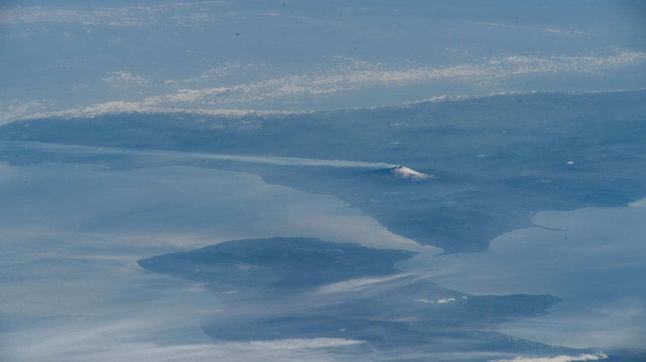
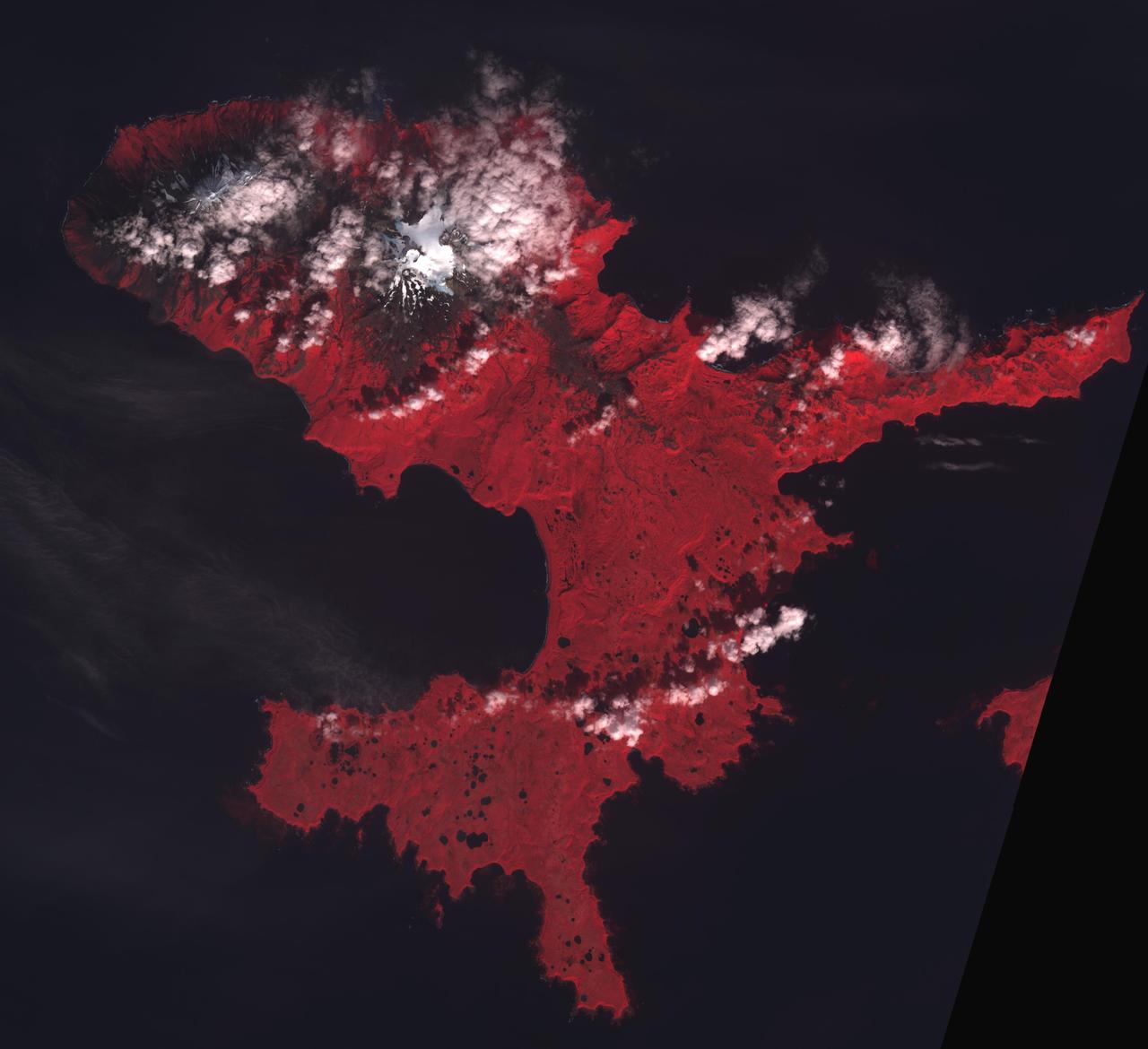
iss069e000127 (March 30, 2023) --- Mount Etna, an active stratovolcano on Italy's island of Sicily, billows smoke in this oblique photograph from the International Space Station as it orbited 262 miles above the Black Sea coast of Ukraine.
iss068e053501 (Feb. 12, 2023) --- The potentially active stratovolcano Toussidé and the Trou au Natron depression in the Tibesti Mountains are pictured from the International Space Station as it orbited 263 miles above the African nation of Chad.
iss069e000129 (March 30, 2023) --- Mount Etna, an active stratovolcano on Italy's island of Sicily, billows smoke in this photograph from the International Space Station as it orbited 262 miles above.
iss069e060816 (August 15, 2023) -- Mount Baker reaches over 10,700 feet of elevation in the state of Washington. The active glacier-covered stratovolcano was seen from the International Space Station as it orbited 265 miles above.
iss064e000441 (Oct. 25, 2020) --- The International Space Station was orbiting above the African nation of Chad at the time this photograph was taken of the potentially active stratovolcano Toussidé (center top) in the Tibesti Mountains
Tofua Island in the central part of the Tonga Islands group is the summit of a large stratovolcano that contains a 5-km-wide caldera. Three post-caldera cones were constructed at the northern end of a caldera lake. The easternmost cone produced lava flows, some of which have traveled into the caldera lake. The current eruption period began in October 2015 and has more recently consisted of thermal activity. The image was acquired October 10, 2023, covers an area of 11.6 by 12 km, and is located at 19.7 degrees south, 175.1 degrees west. https://photojournal.jpl.nasa.gov/catalog/PIA26393
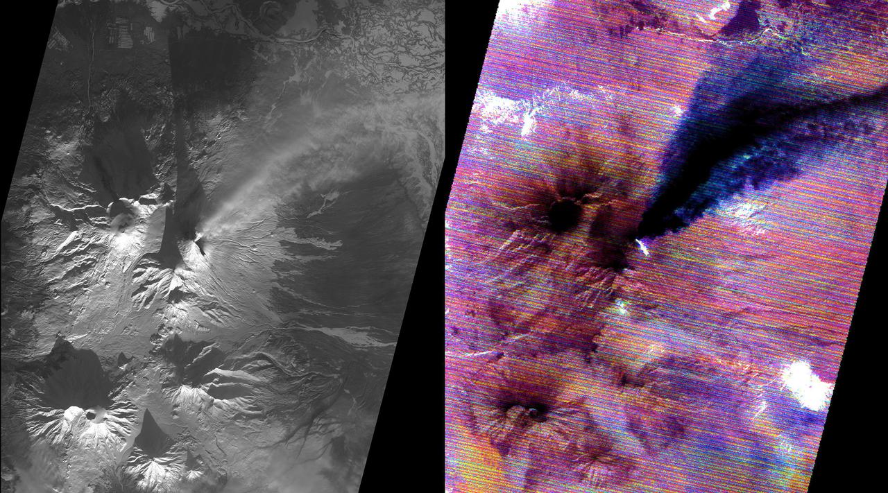
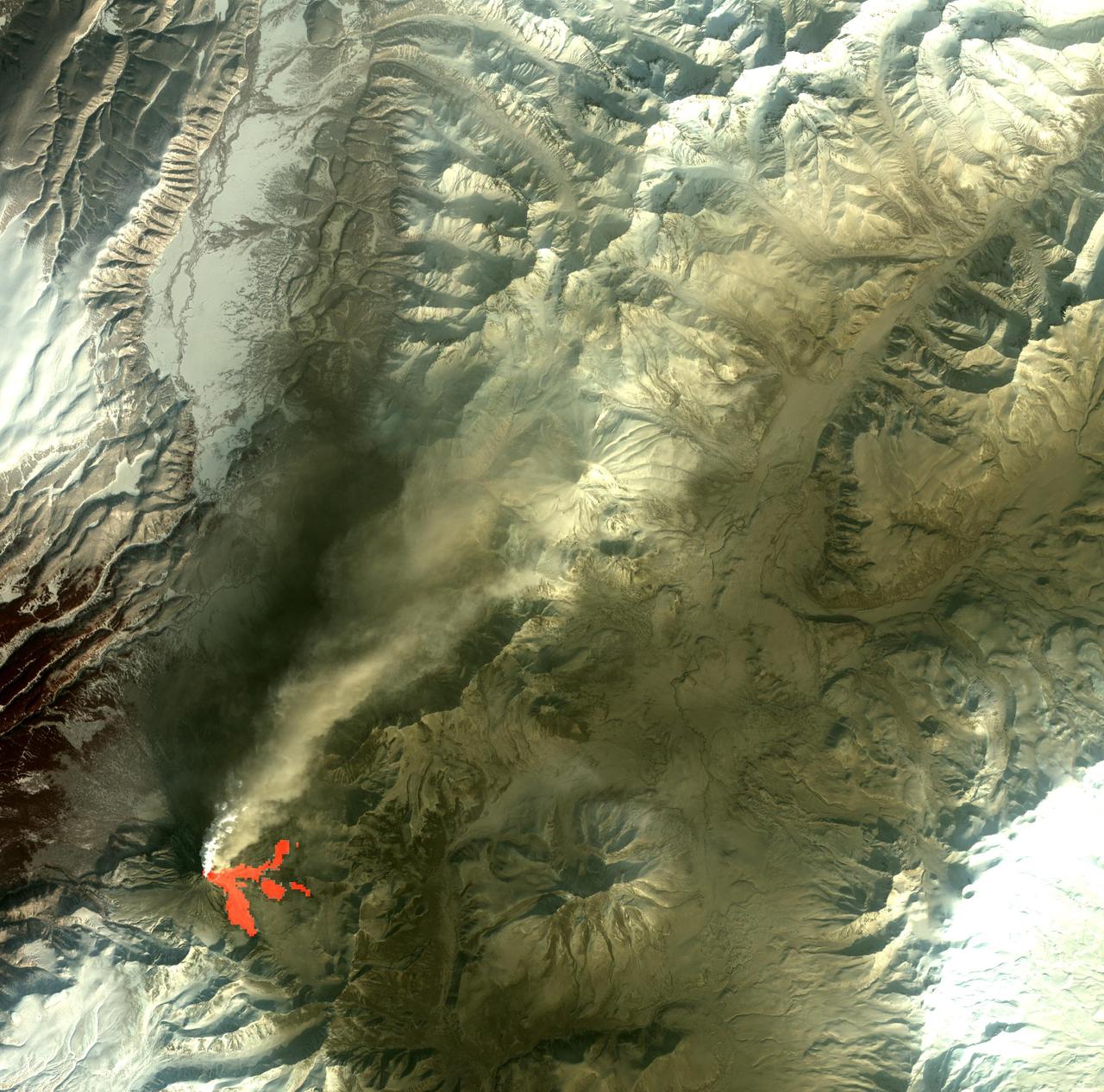
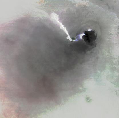
Kamchatka, Russia hosts some of the most active volcanoes on earth. Among those is Kliuchevskoi stratovolcano, erupting almost constantly, and the tallest volcano in Kamchatka. In this snow-covered winter image (left), an eruption plume rising to 7.5 km, is streaming from the summit in a northeast direction. The thermal infrared image (right) reveals additional information: the bright material on the east side of the summit is a hot, recent lava flow; the eruption plume is displayed in blue, revealing its composition as dominated by ice mixed with ash. The thermal data are noisy because of the very low signal from the cold scene. The data were acquired December 2, 2020, cover an area of 27 by 30 km, and are located at 56.1 degrees north, 160.7 degrees east. https://photojournal.jpl.nasa.gov/catalog/PIA24282
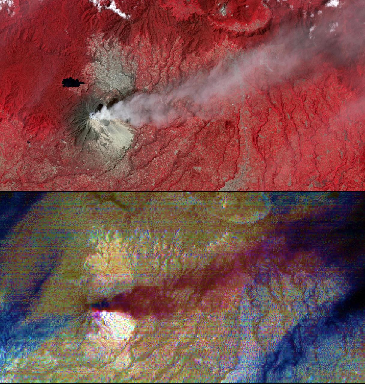
NASA's Advanced Spaceborne Thermal Emission and Reflection Radiometer (ASTER) acquired this image of Peru's Sabancaya stratovolcano on April 10, 2019. Sabancaya has been erupting regularly for several months, sending ash plumes high into the air. At the time this image was taken, the plume reached an altitude of 9100 meters (9950 yards) and was moving southeastward. In the left image, Sabancaya is under the bright round white cloud. The greyish clouds to the southeast are ash plumes. The Ampato volcano, with its prominent summit caldera, is to the south. The red areas are vegetation. The right thermal image shows the plume in purple, indicating that it is dominantly composed of sulfur dioxide gas. A bright hotspot can be seen directly north of the black (cold) cloud over Sabancaya. The image covers an area of 19.5 by 17.2 kilometers (12 miles by 11 miles), and is located at 15.8 degrees south, 71.9 degrees west. https://photojournal.jpl.nasa.gov/catalog/PIA23143
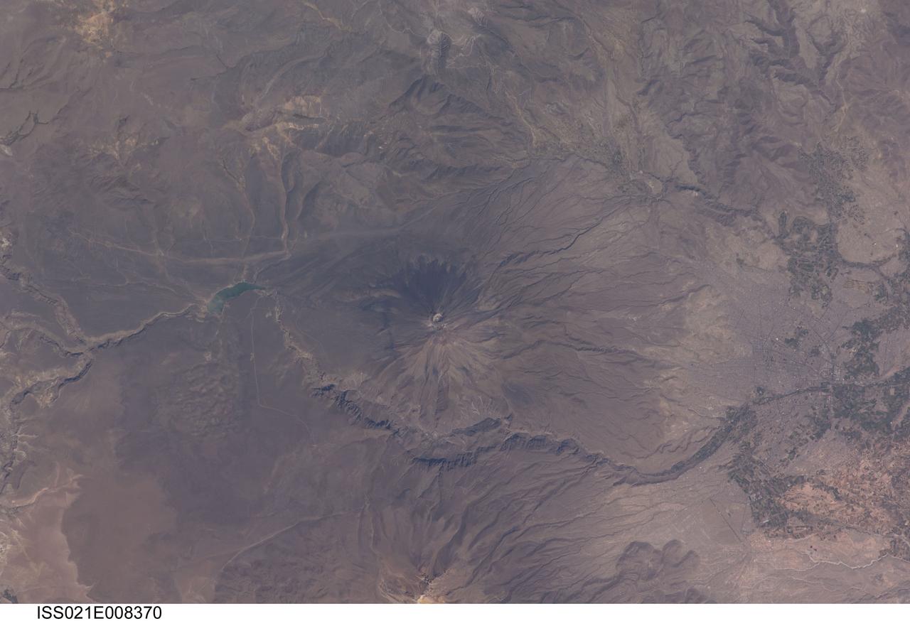
ISS021-E-008370 (16 Oct. 2009) --- El Misti volcano in Peru is featured in this image photographed by an Expedition 21 crew member on the International Space Station. The symmetric conical shape of El Misti is typical of a stratovolcano ? a type of volcano characterized by interlayered lavas and products of explosive eruptions, such as ash and pyroclastic flow deposits. Stratovolcanoes are usually located on the continental crust above a subducting tectonic plate. Magma feeding the stratovolcanoes of the Andes Mountains ? including 5,822 meter-high El Misti ? is associated with ongoing subduction of the Nazca Plate beneath the South American Plate. El Misti?s most recent -- and relatively minor -- eruption occurred in 1985. The city center of Arequipa, Peru lies only 17 kilometers away from the summit of El Misti; the gray urban area is bordered by green agricultural fields (right). With almost one million residents in 2009, it is the second city of Peru in terms of population. Much of the building stone for Arequipa, known locally as sillar, is quarried from nearby pyroclastic flow deposits that are white in color. Arequipa is known as ?the White City? because of the prevalence of this building material. The Chili River extends northeastwards from the city center, and flows through a canyon (left) between El Misti volcano and Nevado Chachani to the north.
iss074e0319896 (Feb. 21, 2026) --- La Malinche Volcano, east of Mexico City, is a dormant, heavily eroded stratovolcano estimated to be about 30 to 35 million years old. The International Space Station was orbiting 259 miles above Oaxaca when this photograph was taken. Credit: NASA/Jessica Meir
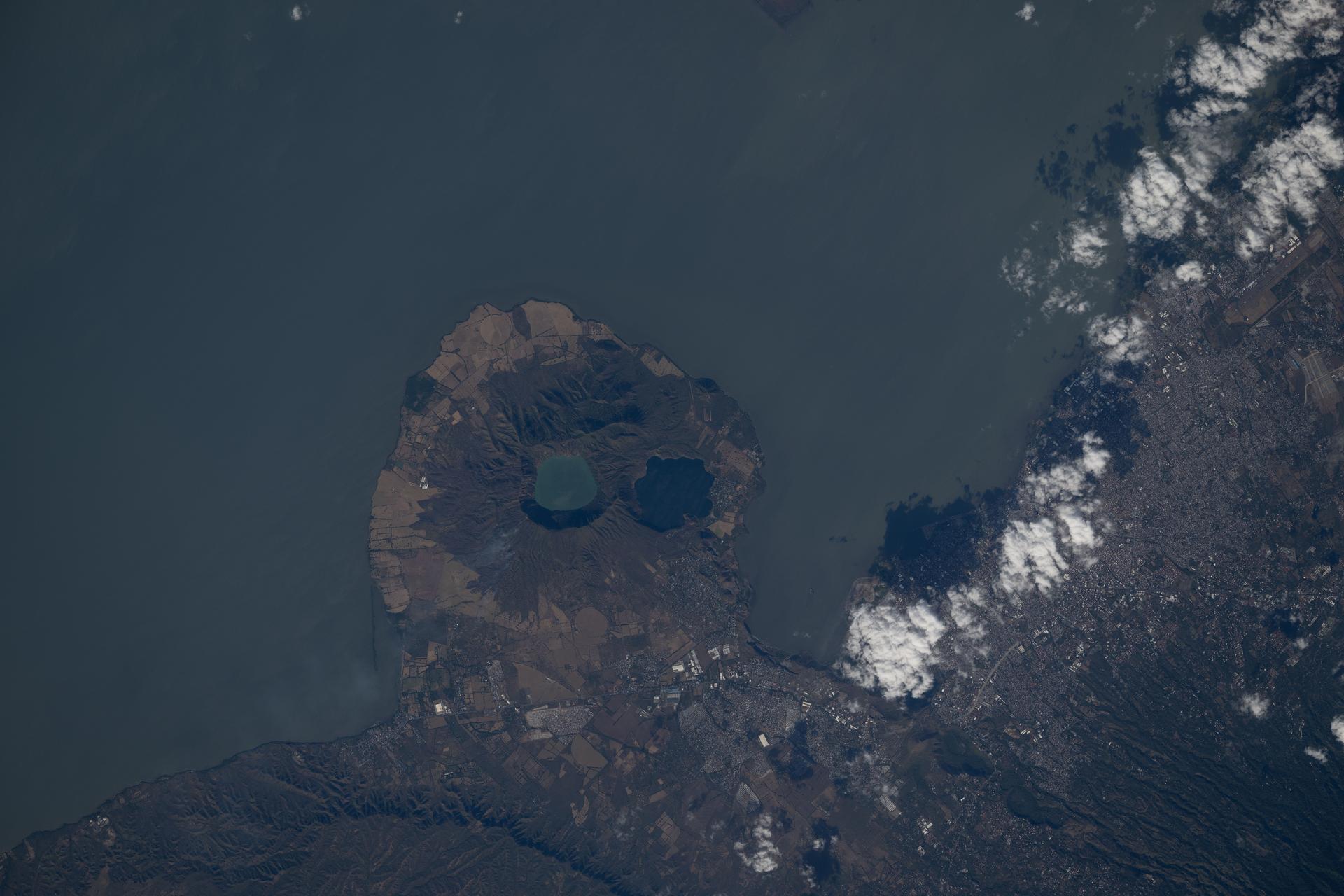
iss074e0312836 (Feb. 10, 2026) --- The Apoyeque mountain peak—a dormant stratovolcano with a crater lake—located in the Chiltepe Peninsula Nature Reserve near Managua, Nicaragua, is shown from the International Space Station as it orbited 261 miles above Central America. Credit: NASA/Chris Williams
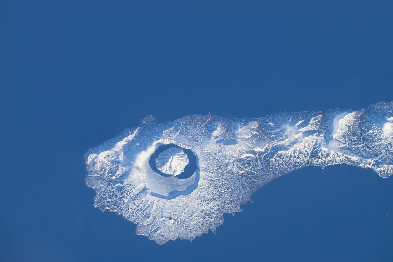
iss071e046424 (April 29, 2024) --- The snow-covered Onekotan Island, part of Russia's Kuril Islands, is home to the Tao-Rusyr Caldera stratovolcano in this photograph. Inside the caldera is the Krenitsyna Volcano peak surrounded by the partially ice-covered Kol'tsevoe Lake. The International Space Station was orbiting 259 miles above the Pacific Ocean at the time of this photograph.
iss068e008954 (Oct. 5, 2022) --- The Mounts of Cantal, the remnants of Europe's largest stratovolcano made up of several summits in southern France, is pictured from the International Space Station as it orbited 263 miles above. Credit: NASA/Kjell Lindgren
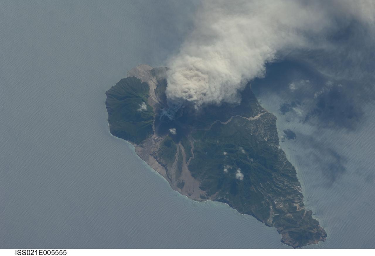
ISS021-E-005555 (11 Oct. 2009) --- This picture of the active Soufriere Hills volcano on Montserrat Island was photographed on Oct. 11, 2009 by the Expedition 21 crew members onboard the International Space Station. Meteorologists and other scientists note that this area is nearly always cloudy so it is considered rare when astronauts get good images of the plumes or volcanic activity. Soufriere Hills is identified as a "stratovolcano" by geologists because it is built of layers (the “strato” part of the name) of both lavas and pyroclastic flows from older eruptions. Another name for this kind of volcano is a "composite volcano" referring to the fact that when it erupts it produces both lava and fragmented deposits during explosive eruptions. Scientists point out that the magma feeding the Soufriere Hills volcano is created by the subduction of local tectonic plates – stratovolcanoes are commonly associated with this type of geologic environment. Photo credit: NASA
Today's VIS image shows a cross section of Elysium Mons, including part of the summit caldera. Unlike the Tharsis volcanoes to the east, there are very few identifiable lava flows on the flanks of the Elysium Mons. In profile the volcano looks like Mt. Fuji in Japan. Mt. Fuji is a stratovolcano. A stratovolcano, also known as a composite volcano, is a conical volcano built up by multiple layers of lava and ash erupting solely from the summit caldera. The Tharsis volcanoes are shield volcanoes, which will host flank eruptions, but rarely ash eruptions. Elysium Mons is 12.6km (7.8 miles) tall. For comparison, Mt. Fuji is 3.7 km (2.3 miles) tall. Orbit Number: 93908 Latitude: 24.4791 Longitude: 146.667 Instrument: VIS Captured: 2023-02-14 16:41 https://photojournal.jpl.nasa.gov/catalog/PIA25925
Today's VIS image shows a cross section of Elysium Mons, including the entire summit caldera. Unlike the Tharsis volcanoes to east, there are very few identifiable lava flows on the flanks of the Elysium Mons. In profile the volcano looks like Mt. Fuji in Japan. Mt. Fuji is a stratovolcano. A stratovolcano, also known as a composite volcano, is a conical volcano built up by multiple layers of lava and ash erupting solely from the summit caldera. The Tharsis volcanoes are shield volcanoes, which will host flank eruptions, but rarely ash eruptions. Elysium Mons is 12.6km (7.8 miles) tall. For comparison, Mt. Fuji is 3.7 km (2.3 miles) tall. Orbit Number: 86633 Latitude: 24.5225 Longitude: 146.837 Instrument: VIS Captured: 2021-06-25 16:09 https://photojournal.jpl.nasa.gov/catalog/PIA24959
Today's VIS image shows a cross section of Elysium Mons, including part of the summit caldera. Unlike the Tharsis volcanoes to east, there are very few identifiable lava flows on the flanks of the Elysium Mons. In profile the volcano looks like Mt. Fuji in Japan. Mt. Fuji is a stratovolcano. A stratovolcano, also known as a composite volcano, is a conical volcano built up by multiple layers of lava and ash erupting solely from the summit caldera. The Tharsis volcanoes are shield volcanoes, which will host flank eruptions, but rarely ash eruptions. Elysium Mons is 12.6km (7.8 miles) tall. For comparison, Mt. Fuji is 3.7 km (2.3 miles) tall. Orbit Number: 94794 Latitude: 24.68 Longitude: 146.541 Instrument: VIS Captured: 2023-04-28 15:31 https://photojournal.jpl.nasa.gov/catalog/PIA26171
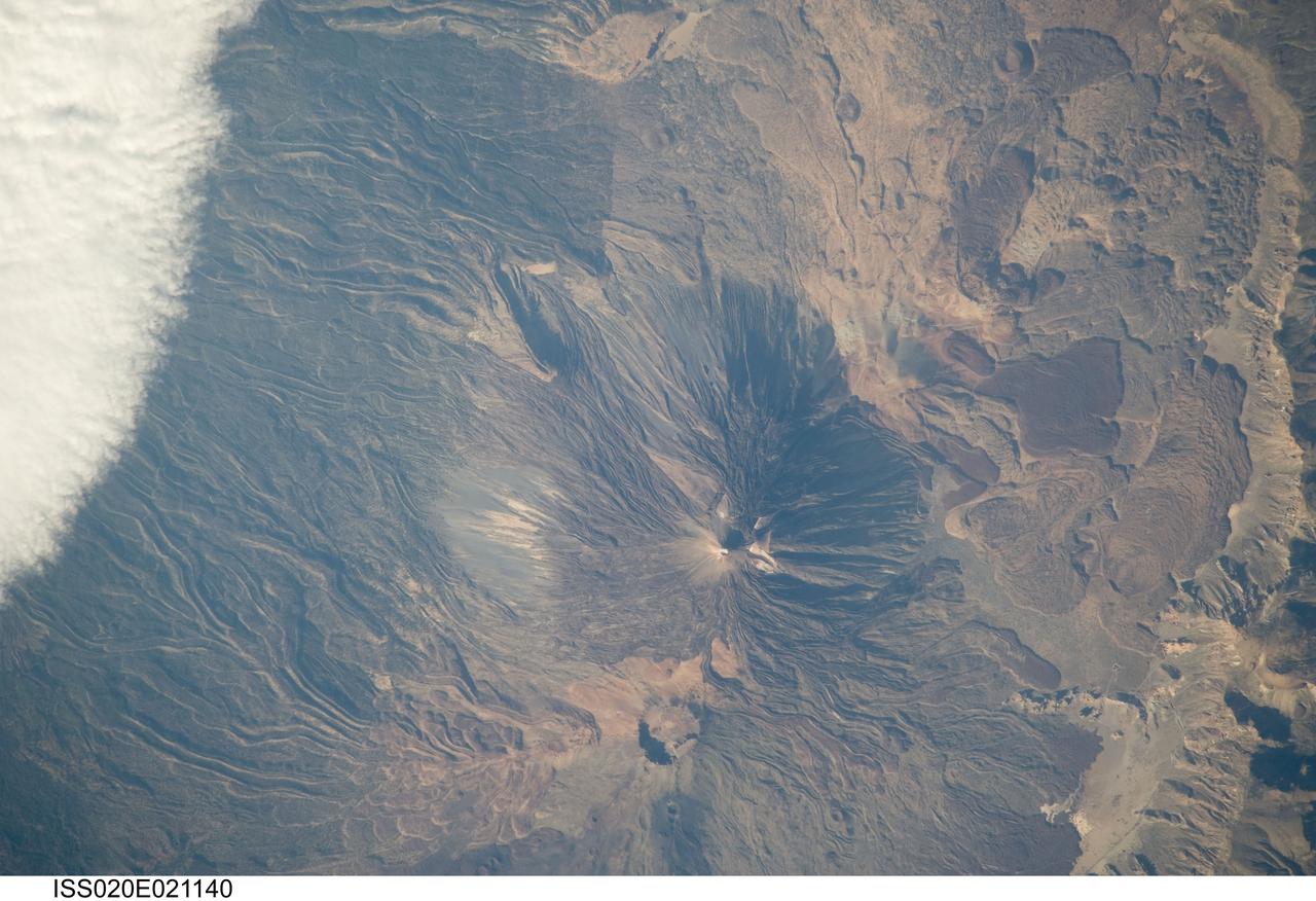
ISS020-E-021140 (15 July 2009) --- Teide Volcano on the Canary Islands of Spain is featured in this image photographed by an Expedition 20 crew member on the International Space Station. This detailed photograph features two stratovolcanoes ? Pico de Teide and Pico Viejo ? located on Tenerife Island, part of the Canary Islands of Spain. Stratovolcanoes are steep-sided; typically conical structures formed by interlayered lavas and fragmented rock material from explosive eruptions. Pico de Teide has a relatively sharp peak, whereas an explosion crater forms the summit of Pico Viejo. The two stratovolcanoes formed within an even larger volcanic structure known as the Las Ca?adas caldera ? a large collapse depression typically formed when a major eruption completely empties the underlying magma chamber of a volcano. The last eruption of Teide occurred in 1909. NASA scientists point out sinuous flow levees marking individual lava flows. The scientists consider the flow levees as perhaps the most striking volcanic features visible in the image. Flow levees are formed when the outer edges of a channelized lava flow cool and harden while the still-molten interior continues to flow downhill ? numerous examples radiate outwards from the peaks of both Pico de Teide and Pico Viejo. Brown to tan overlapping lava flows and domes are visible to the east-southeast of the Teide stratovolcano. Increased seismicity, carbon dioxide emissions, and fumarolic activity within the Las Ca?adas caldera and along the northwestern flanks of the volcano were observed in 2004. Monitoring of the volcano to detect renewal of activity is ongoing.
ISS036-E-009390 (18 June 2013) --- One of the Expedition 36 crew members used a 180mm lens to photograph this vertical view of the island of Pico, the second largest of the Portuguese Azores in the North Atlantic Ocean. Mt. Pico, a prominent 2351-meter-high stratovolcano on the eastern end of Pico Island is the highest volcano in the Azores. Madalena is a municipality along the coast, home to about 6,000 inhabitants.
iss067e147189 (June 21, 2022) --- The Parinacota and Pomerape stratovolcanoes (top to bottom) are pictured from the International Space Station as it orbited 263 miles above the South American nation of Chile. Parinacota is a dormant volcano on the Chile-Bolivia border and its peak is about 20,800 feet. Pomerape, last active over 100,000 years ago, is also on the Chile- Bolivia border with an elevation of about 20,600 feet. At top left, is Chungará Lake in northern Chile which rests about 14,800 feet above sea level.
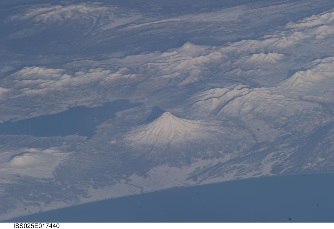
ISS025-E-017440 (19 Nov. 2010) --- Kamchatka volcanoes are featured in this image photographed by an Expedition 25 crew member on the International Space Station. This striking photograph features several snow-covered volcanoes located on the Kamchatka Peninsula of the Russian Federation, as seen from the orbital perspective of the International Space Station (ISS). This image also illustrates one of the unique attributes provided by the ISS – the ability to view Earth landscapes at an angle, rather than the “straight down” view typical of many orbital satellite-based sensors. This oblique view, together with shadows cast by the volcanoes and other mountains provides perspective about the setting and a sense of topography of the region, especially highlighting the symmetrical cones of Kronotsky (center) and Kizimen (top right) stratovolcanoes. Kizimen Volcano last erupted in 1928, while Kronotsky Volcano—one of the largest on the peninsula—last erupted in 1923. Schmidt Volcano, located to the north of Kronotsky, has the morphology of a shield volcano and is not known to have erupted during the period of historical record. To the south of Kronotsky is Krasheninnikov Volcano, comprised of two overlapping stratovolcanoes that formed within an earlier caldera. Scientists believe Krasheninnikov may have last erupted in 1550. The two summit craters of the stratovolcanoes are clearly visible in this image (lower left). Lake Kronotsky (left) is Kamchatka’s largest lake; it was formed when lava flows from Kronotsky Volcano dammed the Listvenichnaya River. The Kamchatka Peninsula lies along the so-called “Ring of Fire” in the Pacific Ocean. The Ring of Fire is characterized by the presence of active volcanoes and frequent earthquakes; these are associated with the many active subduction and transform boundary zones that ring the Pacific tectonic plate. According to scientists, there are currently 114 volcanoes identified on the Kamchatka Peninsula that have erupted during the Holocene Epoch (approximately 12,000 years ago to the present).
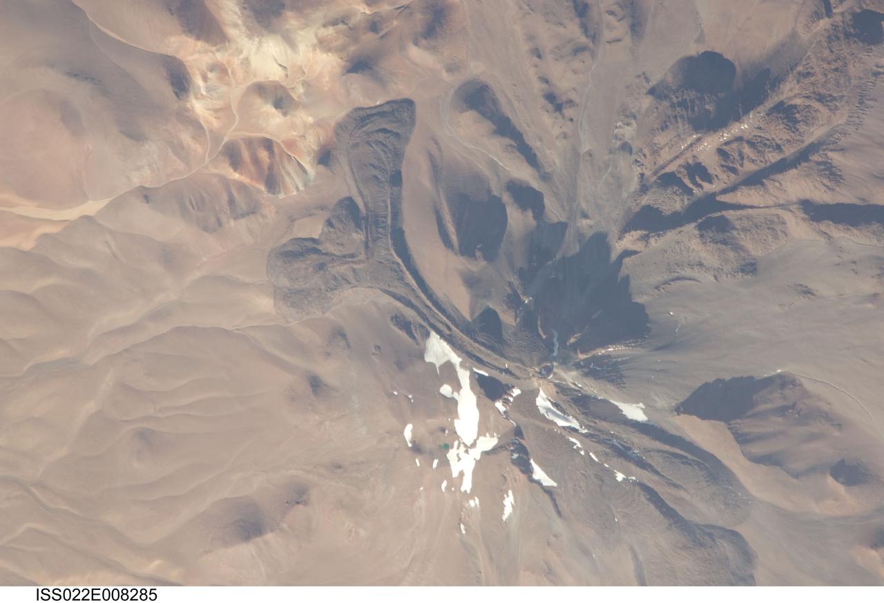
ISS022-E-008285 (9 Dec. 2009) --- Llullaillaco volcano on the Argentina-Chile border is featured in this image photographed by an Expedition 22 crew member on the International Space Station. The summit of Llullaillaco volcano has an elevation of 6,739 meters above sea level, making it the highest historically active volcano in the world. The current Llullaillaco stratovolcano ? a typically high, cone-shaped volcano built from successive layers of thick lava flows and eruption products like ash and rock fragments ? is built on top of an older stratovolcano. The last explosive eruption of the volcano occurred in 1877 based on historical records. This detailed photograph of Llullaillaco illustrates an interesting volcanic feature known as a coulee (top left). Coulees are formed from highly viscous, thick lavas that flow onto a steep surface; as they flow slowly downwards, the top of the flow cools and forms a series of parallel ridges oriented at 90 degrees to the direction of flow (somewhat similar in appearance to the pleats of an accordion). The sides of the flow can also cool faster than the center, leading to the formation of wall-like structures known as flow levees (center).
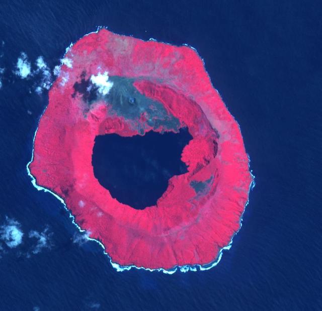
The Kuril Islands are a volcanic archipelago, stretching 1300 km from Hokkaido, Japan to Kamchatka, Russia. They are part of the Pacific Ring of Fire, the result of subduction of the Pacific Plate under the Okhotsk Plate along the Kuril Trench. At the southern end of Onekotan Island is the Tao-Rusyr Caldera stratovolcano, with its 7500 year old caldera lake. The most recent eruption was in 1952. The smaller Kharimkotan Island to the southwest last erupted in 1933. Collapse of this volcano created a horseshoe-shaped crater, and caused a tsunami that killed two people on a near-by island. The image was acquired June 4, 2012; the enlargement covers an area of 17 by 18.5 km, and is located at 49.3 degrees north, 154.7 degrees east. https://photojournal.jpl.nasa.gov/catalog/PIA24020

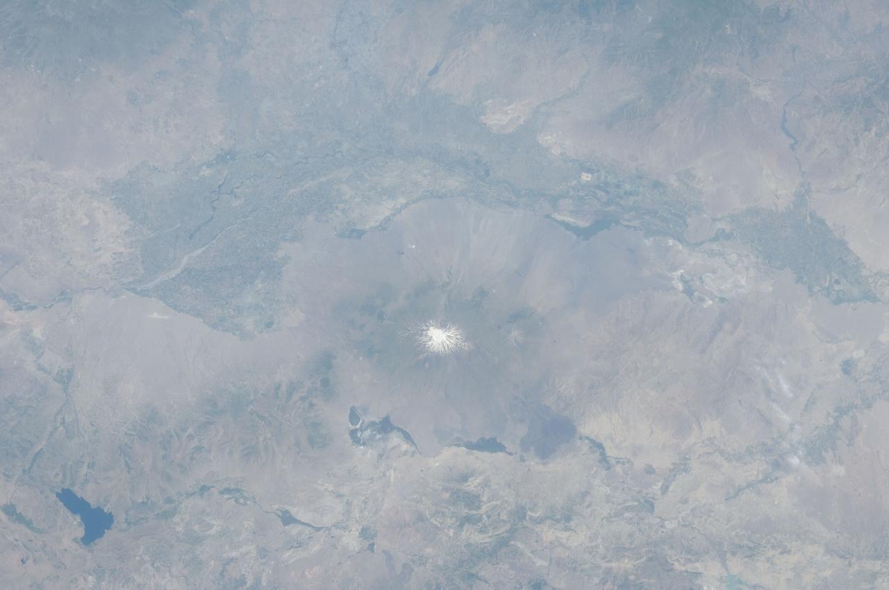
Lake Ilopango is a crater lake which fills a volcanic caldera in central El Salvador, immediately east of the capital city San Salvador. The caldera collapsed most recently in about 500 AD, producing 20 times as much ash as the Mount St. Helens eruption, and blanketing an area of at least 10,000 square kilometers waist-deep in ash. The only historical eruption occurred in 1879, forming lava domes, now islets in the lake. Quetzaltepec is the stratovolcano just west of the city. Its last eruption in 1917 produced lavas flowing down the northwest flank, and evaporated the crater lake. The image was acquired March 5, 2006, covers an area of 27 by 42 km, and is located at 13.7 degrees north, 89.1 degrees west. http://photojournal.jpl.nasa.gov/catalog/PIA19237
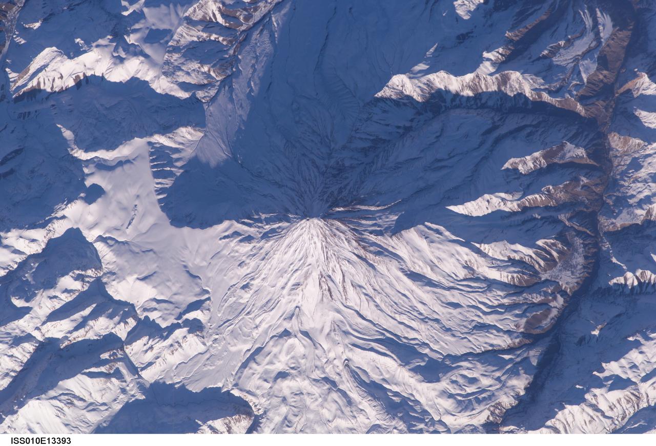
ISS010-E-13393 (15 January 2005) --- Mt. Damavand, Iran is featured in this image photographed by an Expedition 10 crewmember on the International Space Station (ISS). Located approximately 50 kilometers to the northeast of Tehran, Mt. Damavand is an impressive stratovolcano that reaches 5,670 meters (18,598 feet) in elevation. Damavand, which is part of the Alborz mountain range that borders the Caspian Sea to the north, is believed by scientists to be a young volcano that has mostly formed during the Holocene Epoch (over approximately the last 10,000 years). The western flank of the volcano includes solidified lava flows with flow levees – “walls” formed as the side edges of flowing lava cooled rapidly, forming a chute that channeled the hotter interior lava. Two such flows with well-defined levees are highlighted by snow on the mountainside (center). Damavand is the highest peak in Iran and the highest volcano in the Middle East.
ISS035-E-18006 (8 April 2013) --- One of the Expedition 35 crew members aboard the Earth-orbiting International Space Station photographed this image of Tata Sabaya Volcano, located in the Altiplano region of Bolivia. The volcano rises to a summit elevation of 5430 meters above sea level. While its current form is that of a “youthful” stratovolcano, the regional geological evidence indicates an older, eventful history, according to scientists. The scientists say that prior to approximately 12,000 years ago (during the late Pleistocene Epoch), a large debris avalanche was formed by collapse of the ancestral Tata Sabaya volcano. Debris from the avalanche swept into the nearby Salar de Coipasa –at that time filled with a lake larger than today – significantly changing its northwestern coastline. Timing of the event is obtained from tufa deposits formed on debris islands during a high stand of the Coipasa lake – illustrating the geological principle of cross-cutting relationships, in that the debris avalanche had to have occurred before the tufa deposits were formed in the lake. The Tata Sabaya stratovolcano is located at image center. Several young lava flows are visible on the northwestern and western flanks of the volcano. Peaks visible to the northeast and southwest appear to be volcanoes as well, but unlike Tata Sabaya there is no record of recent activity from either of them (according to the Smithsonian National Museum of Natural History’s Global Volcanism Program). As the Altiplano became more arid and the Coipasa Lake shrank, much of the hummocky terrain of the debris avalanche became exposed over an area of more than 300 square kilometers. The hummocky terrain is clearly visible at image right. White salt deposits of the salar surround many of the individual hummocks, making them “islands” once again.
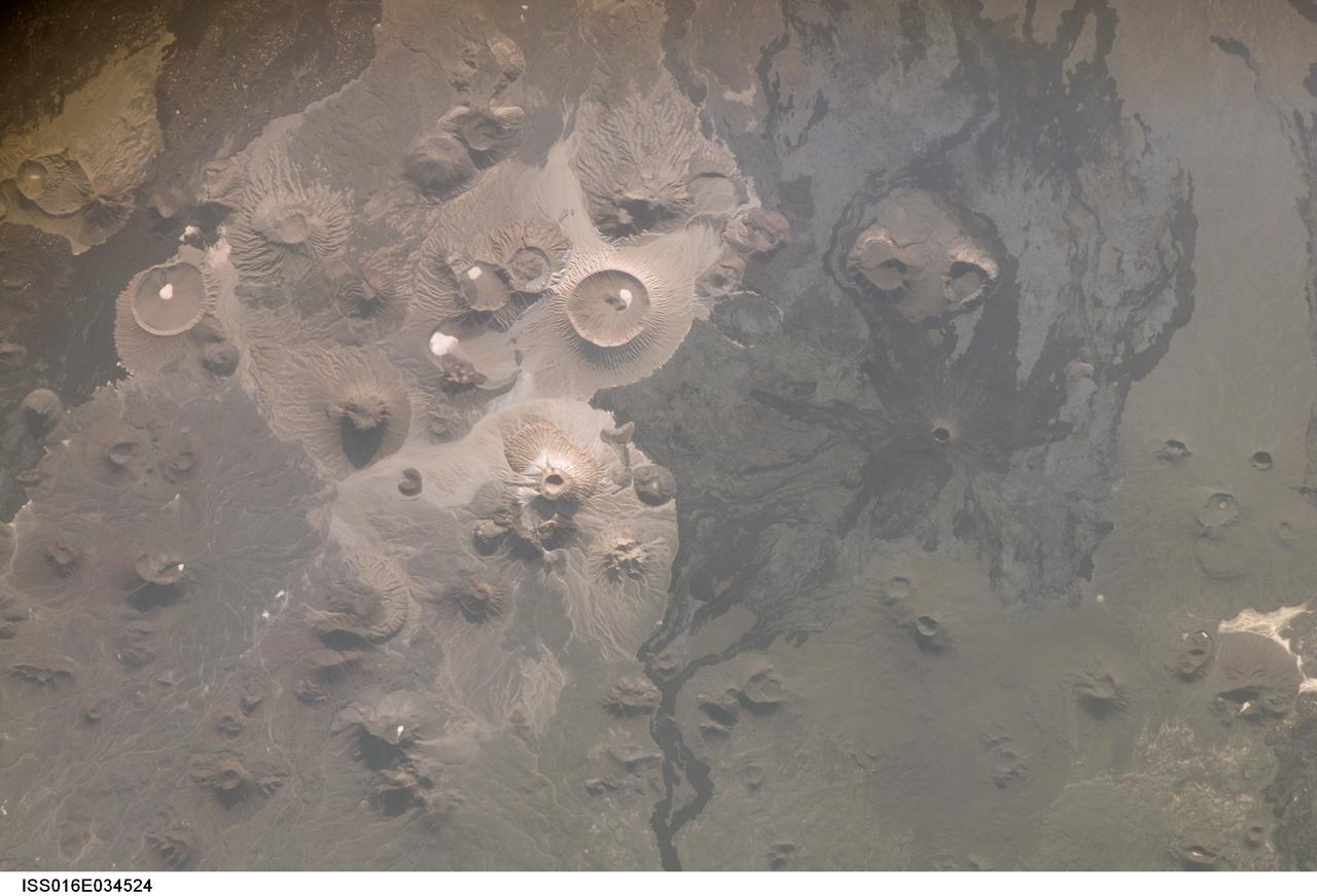
ISS016-E-034524 (31 March 2008) --- Harrat Khaybar, Saudi Arabia is featured in this image photographed by an Expedition 16 crewmember on the International Space Station. The western half of the Arabian peninsula contains not only large expanses of sand and gravel, but extensive lava fields known as haraat (harrat for a named field). One such field is the 14,000-square kilometer Harrat Khaybar, located approximately 137 kilometers to the northeast of the city of Al Madinah (Medina). According to scientists, the volcanic field was formed by eruptions along a 100-kilometer long north-south linear vent system over the past 5 million years; the most recent recorded eruption took place between 600 - 700 A.D. Harrat Khaybar contains a wide range of volcanic rock types and spectacular landforms, several of which are represented in this view. Jabal al Quidr is built from several generations of dark, fluid basalt lava flows; the flows surround the 322--meter high stratovolcano (Jabal is translated as "mountain" in Arabic). Jabal Abyad, in the center of the image, was formed from a more viscous, silica-rich lava classified as a rhyolite. While Jabal al Quidr exhibits the textbook cone shape of a stratovolcano, Jabal Abyad is a lava dome -- a rounded mass of thicker, more solidified lava flows. To the west (top center) is the impressive Jabal Bayda'. This symmetric structure is a tuff cone, formed by eruption of lava in the presence of water. This leads to the production of wet, sticky pyroclastic deposits that can build a steep cone structure, particularly if the deposits consolidate quickly. White deposits visible in the crater of Jabal Bayda' (and two other locations to the south) are formed from sand and silt that accumulate in shallow, protected depressions. The presence of tuff cones -- together with other volcanic features indicative of water -- in the Harrat Khaybar suggest that the local climate was much wetter during some periods of volcanic activity. Today, however, the regional climate is hyperarid -- little to no yearly precipitation -- leading to an almost total lack of vegetation.
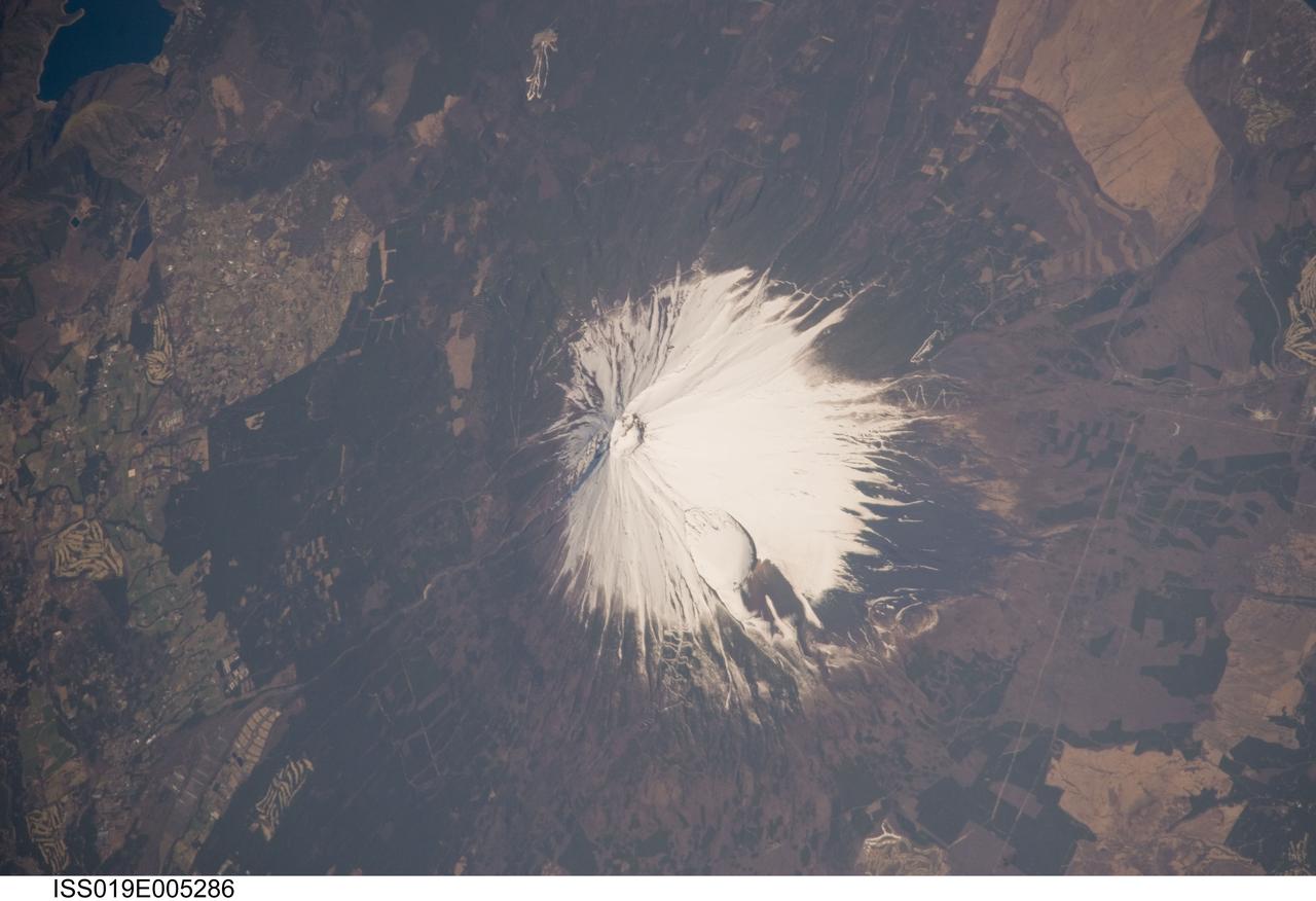
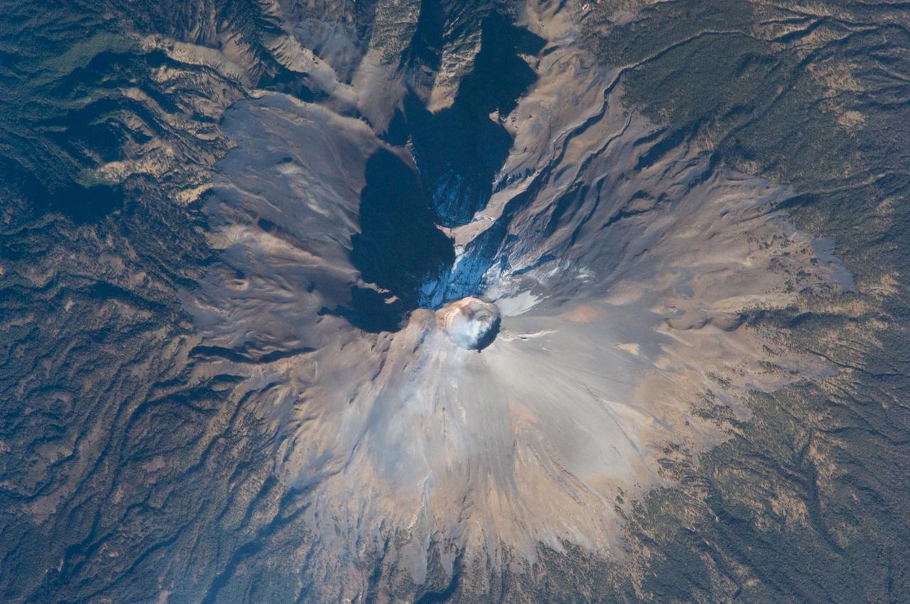
ISS019-E-005286 (8 April 2009) --- Mount Fuji, Japan is featured in this image photographed by an Expedition 19 crew member on the International Space Station. The 3,776 meters high Mount Fuji volcano, located on the island of Honshu in Japan, is one of the world?s classic examples of a stratovolcano. The volcano?s steep, conical profile is the result of numerous interlayered lava flows and explosive eruption products ? such as ash, cinders, and volcanic bombs ? building up the volcano over time. The steep profile is possible because of the relatively high viscosity of the volcanic rocks typically associated with stratovolcanoes. This leads to thick sequences of lava flows near the eruptive vent that build the cone structure, rather than low viscosity flows that spread out over the landscape and build lower-profile shield volcanoes. According to scientists, Mount Fuji, or Fuji-san in Japan, is actually comprised of several overlapping volcanoes that began erupting in the Pleistocene Epoch (1.8 million to approximately 10,000 years ago). Scientists believe that the currently active volcano, known as Younger Fuji, began forming approximately 11,000 to 8,000 years ago. The most recent explosive activity occurred in 1707, creating Hoei Crater on the southeastern flank of the volcano (center). This eruption deposited ash on Edo (present-day Tokyo) located 95 kilometers to the northeast. While there have been no further eruptions of Mount Fuji, steam was observed at the summit during 1780?1820, and the volcano is considered active. This oblique photograph illustrates the snow-covered southeastern flank of the volcano; the northeastern flank can be seen here. A representation of the topography of Mt. Fuji and its surroundings can be viewed here.
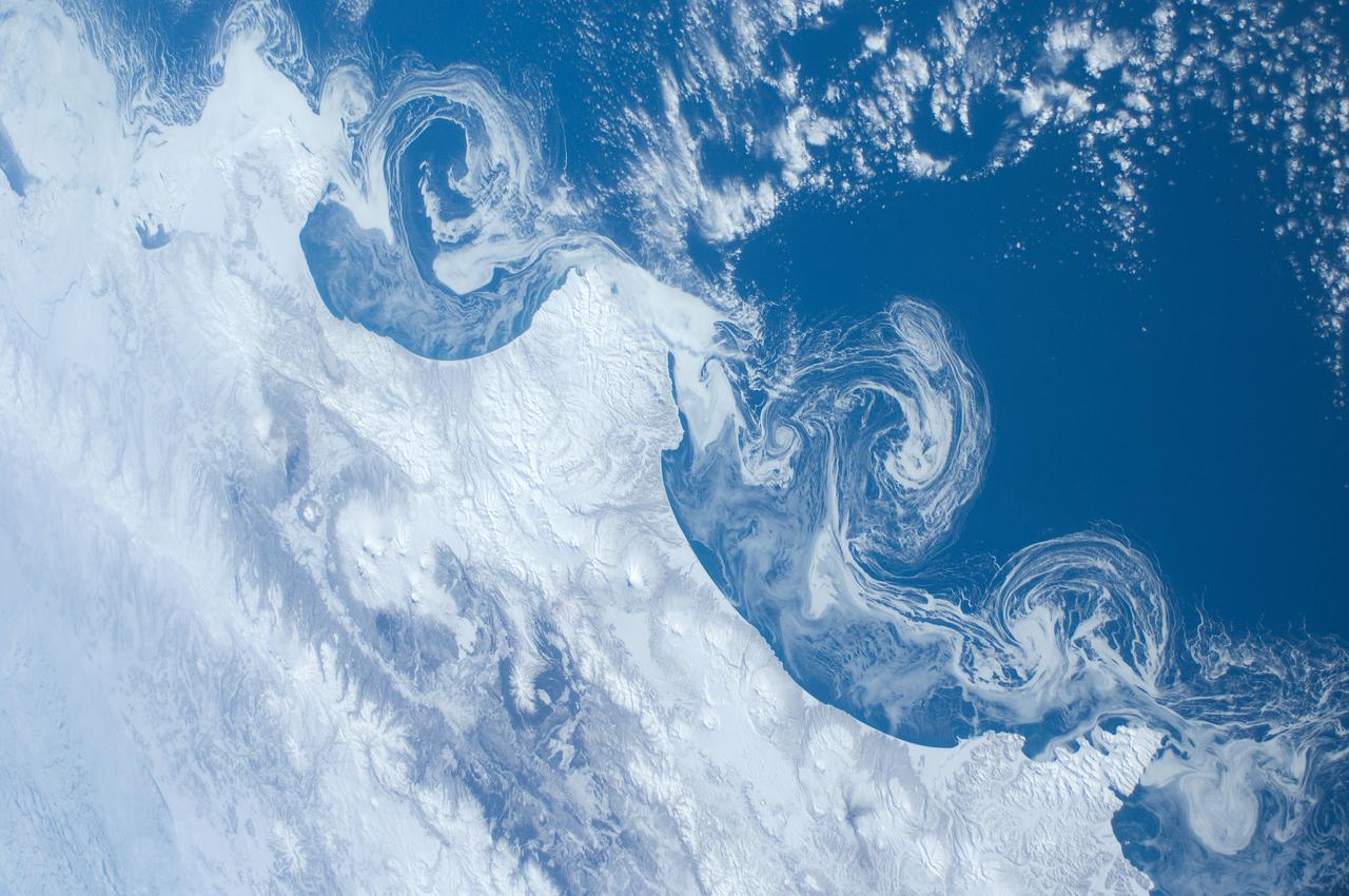
ISS030-E-162344 (15 March 2012) --- Ice floes along the Kamchatka coastline are featured in this image photographed by an Expedition 30 crew member on the International Space Station. The vantage point from orbit frequently affords the opportunity to observe processes that are impossible to see on the ground – or in this case the northeastern Pacific Ocean. The winter season blankets the Kamchatka Peninsula of Russia in snow, but significant amounts of sea ice can also form and collect along the coastline. As ice floes grind against each other, they produce smaller floes that can be moved by wind and water currents acting along the coastline. The irregular southeastern coastline of Kamchatka helps to produce large circular eddy currents from the main southwestward-flowing Kamchatka current. Three such eddies are clearly highlighted by surface ice floe patterns at center. The ice patterns are very difficult (and dangerous) to navigate in an ocean vessel – while the floes may look thin and delicate from the space station vantage point, even the smaller ice chunks are likely several meters across. White clouds at top right are distinguished from the sea ice and snow cover in the image by their high brightness and discontinuous nature. The Kamchatka Peninsula also hosts many currently and historically active stratovolcanoes. Kliuchevskoi Volcano, the highest in Kamchatka (summit elevation 4,835 meters) and one of the most active, had its most recent confirmed eruption in June of 2011, while Karymsky Volcano to the south likely produced ash plumes days before this image was taken; the snow cover near the volcano to the south and east of the summit is darkened, probably due to a cover of fresh ash, or melted away altogether (bottom center). In contrast, Kronotsky Volcano – a “textbook” symmetrical cone-shaped stratovolcano – last erupted in 1923.
ISS018-E-035716 (24 Feb. 2009) --- Minchinmavida and Chaiten Volcanoes in Chile are featured in this image photographed by an Expedition 18 crewmember on the International Space Station. The Andes mountain chain along the western coastline of South America includes numerous active stratovolcanoes. The majority of these volcanoes are formed, and fed, by magma generated as the oceanic Nazca tectonic plate moves northeastward and plunges beneath the less dense South American continental tectonic plate (a process known as subduction). The line of Andean volcanoes marks the approximate location of the subduction zone. This astronaut photograph highlights two volcanoes located near the southern boundary of the Nazca ? South America subduction zone in southern Chile. Dominating the scene is the massive Minchinmavida stratovolcano at center. An eruption of this glaciated volcano was observed by Charles Darwin during his Galapagos Island voyage in 1834; the last recorded eruption took place the following year. The white, snow covered summit of Minchinmavida is blanketed by gray ash erupted from its much smaller but now active neighbor to the west, Volcan (volcano) Chaiten. The historically inactive Chaiten volcano, characterized by a large lava dome within a caldera (an emptied and collapsed magma chamber beneath a volcano) roared back to life unexpectedly on May 2, 2008, generating dense ash plumes and forcing the evacuation of the nearby town of Chaiten. Volcanic activity continues at Chaiten, including partial collapse of a new lava dome and generation of a pyroclastic flow several days before this photograph was taken. A steam and ash plume is visible extending to the northeast from the eruptive center of the volcano.
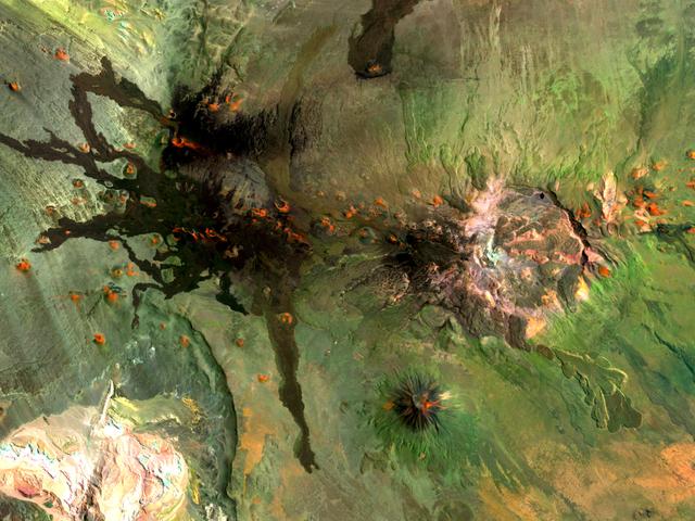
Situated in the southern Andes Mountains, the Payún volcanic field of Argentina is a complex landscape that formed over hundreds of thousands of years. Sprawling over 5,200 square kilometers (2,000 square miles), Payún is a massive shield volcano—a broad formation resembling an ancient warrior shield. This false-color image is a composite of observations acquired on February 7 and March 20, 2001 by the Enhanced Thematic Mapper Plus on the Landsat 7 satellite. It was made from a combination of visible and infrared light, where green indicates vegetation, black indicates lava flows, and orange is bare rock rich in iron oxides. Part of the back-arc volcanism of the Andes, Payún lies about 530 kilometers (330 miles) east from where the Nazca plate subducts below the South America plate. Not surprisingly, a volcanic zone extends over some 1,000 kilometers (600 miles) north-to-south in this region. According to a study published in 2010, the regional geology and chemical composition of the rocks indicate that the volcanic field likely formed within the past 300,000 years. The dominant feature of the volcanic field is Payún Matru, an elliptical caldera measuring roughly 9 by 7 kilometers (6 by 4 miles). Geologists surmise that the caldera formed after the old magma chamber emptied and the summit collapsed. Southwest of the caldera is a stratovolcano composed of alternating layers of compacted ash, hardened lava, and rocks ejected during previous eruptions. This stratovolcano, Payún, rises to 3,680 meters (12,073 feet) above sea level. (The entire volcanic field sits at 2,000 meters, or 6,600 feet.) The stratovolcano may be the most prominent feature in the volcanic field but it is by no means the only one. More than 300 eruptive features litter the shield volcano, most of them occupying an east-west line. West of Payún Matru is an area known as Los Volcanes, a mass of strombolian cones and basaltic lava flows. Image courtesy Michael P. Taylor, Landsat Data Continuity Mission Project Office, NASA Goddard Space Flight Center. Caption by Michon Scott with information from Michael Abrams, NASA Jet Propulsion Laboratory. Instrument: Landsat 7 - ETM+ To read more go to: <a href="http://1.usa.gov/UO8CbF" rel="nofollow">1.usa.gov/UO8CbF</a> Credit: <b><a href="http://www.earthobservatory.nasa.gov/" rel="nofollow"> NASA Earth Observatory</a></b> <b><a href="http://www.nasa.gov/audience/formedia/features/MP_Photo_Guidelines.html" rel="nofollow">NASA image use policy.</a></b> <b><a href="http://www.nasa.gov/centers/goddard/home/index.html" rel="nofollow">NASA Goddard Space Flight Center</a></b> enables NASA’s mission through four scientific endeavors: Earth Science, Heliophysics, Solar System Exploration, and Astrophysics. Goddard plays a leading role in NASA’s accomplishments by contributing compelling scientific knowledge to advance the Agency’s mission. <b>Follow us on <a href="http://twitter.com/NASA_GoddardPix" rel="nofollow">Twitter</a></b> <b>Like us on <a href="http://www.facebook.com/pages/Greenbelt-MD/NASA-Goddard/395013845897?ref=tsd" rel="nofollow">Facebook</a></b> <b>Find us on <a href="http://instagram.com/nasagoddard?vm=grid" rel="nofollow">Instagram</a></b>
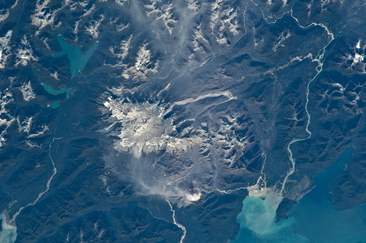
ISS033-E-018010 (3 Nov. 2012) --- Volcanoes in central Kamchatka are featured in this image photographed by an Expedition 33 crew member on the International Space Station. The snow-covered peaks of several volcanoes of the central Kamchatka Peninsula are visible standing above a fairly uniform cloud deck that obscures the surrounding lowlands. In addition to the rippled cloud patterns caused by interactions of air currents and the volcanoes, a steam and ash plume is visible at center extending north-northeast from the relatively low summit (2,882 meters above sea level) of Bezymianny volcano. Volcanic activity in this part of Russia is relatively frequent, and well monitored by Russia’s Kamchatka Volcanic Eruption Response Team (KVERT). The KVERT website provides updated information about the activity levels on the peninsula, including aviation alerts and webcams. Directly to the north and northeast of Bezymianny, the much larger and taller stratovolcanoes Kamen (4,585 meters above sea level) and Kliuchevskoi (4,835 meters above sea level) are visible. Kliuchevskoi, Kamchatka’s most active volcano, last erupted in 2011 whereas neighboring Kamen has not erupted during the recorded history of the region. An explosive eruption from the summit of the large volcanic massif of Ushkovsky (3,943 meters above sea level; left) northwest of Bezymianny occurred in 1890; this is the most recent activity at this volcano. To the south of Bezymianny, the peaks of Zimina (3,081 meters above sea level) and Udina (2,923 meters above sea level) volcanoes are just visible above the cloud deck; no historical eruptions are known from either volcanic center. While the large Tobalchik volcano to the southwest (bottom center) is largely formed from a basaltic shield volcano, its highest peak (3,682 meters above sea level) is formed from an older stratovolcano. Tobalchik last erupted in 1976. While this image may look like it was taken from the normal altitude of a passenger jet, the space station was located approximately 417 kilometers above the southeastern Sea of Okhotsk; projected downwards to Earth’s surface, the space station was located over 700 kilometers to the southwest of the volcanoes in the image. The combination of low viewing angle from the orbital outpost, shadows, and height and distance from the volcanoes contributes to the appearance of topographic relief visible in the image.
ISS034-E-005496 (30 Nov. 2012) --- An eruption at the Ulawun volcano, New Britain Island, Papua New Guinea is featured in this image photographed by an Expedition 34 crew member on the International Space Station. Numerous volcanoes contribute to the landmass of the island of New Britain, the largest in the Bismarck Archipelago of Papua New Guinea. One of the most active of these volcanoes, Ulawun, is also the highest with a summit elevation of 2,334 meters. This photograph was taken during the most recent phase of volcanic activity at Ulawun. A white steam and ash plume extends from the summit crater of the stratovolcano towards the northwest (center; note the image is oriented such that north is towards the lower left). The plume begins to broaden as it passes the southwestern coast of Lolobau Island approximately 23 kilometers downwind from its source. Ulawun volcano is also known as “the Father”, with the Bamus volcano to the southwest also known as “the South Son”. The summit of Bamus is obscured by white cumulus clouds (not of volcanic origin) in this image. While Ulawun has been active since at least 1700, the most recent eruptive activity at Bamus occurred in the late 19th century. A large region of ocean surface highlighted by sunglint – sunlight reflecting off the water surface, lending it a mirror-like appearance– is visible to the north-northeast of Ulawun (lower left).
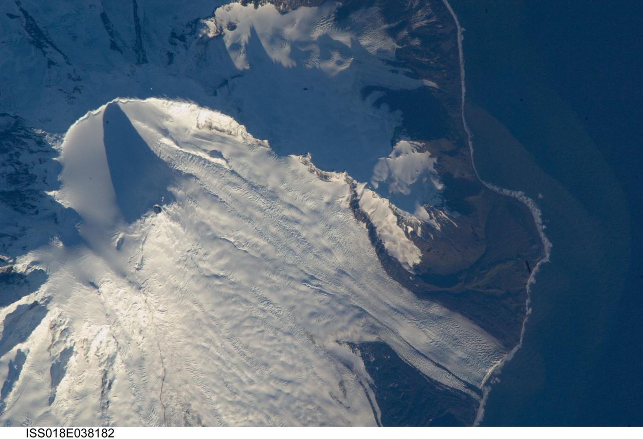
ISS018-E-038182 (28 Feb. 2009) --- Mawson Peak, Heard Island is featured in this image photographed by an Expedition 18 crewmember on the International Space Station. Heard Island is located in the southern Indian Ocean, approximately 1,550 kilometers to the north of Antarctica. The island is a visible part of the Kerguelen Plateau, a submerged feature on the seafloor formed by large amounts of volcanic rock erupted over a geologically short time period within an oceanic tectonic plate ? features like these are termed large igneous provinces by geologists. Most of Heard Island is formed from volcanic rocks associated with the Big Ben stratovolcano. The northeastern slopes of the volcano are visible in shadow at the top left of this detailed astronaut photograph. Recent observed volcanic activity at Heard Island has occurred at 2,745 meters high Mawson Peak, which sits within a breached caldera (collapsed and empty magma chamber beneath a volcano) on the southwestern side of the Big Ben volcano ? the shadow cast by Mawson Peak in the image points directly to the crescent-shaped caldera rim. Detailed geologic study of the Big Ben volcano is made difficult by the presence of several glaciers, including Gotley and Lied Glaciers on the southwestern slopes. This image, taken during Southern Hemisphere summer, also reveals some of the non-glaciated, light to dark brown volcanic rock forming the island on either side of Gotley Glacier.
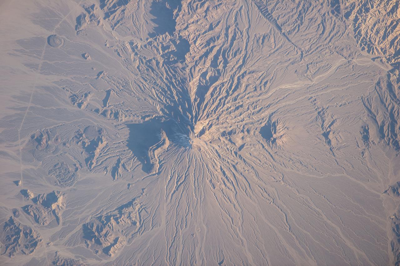
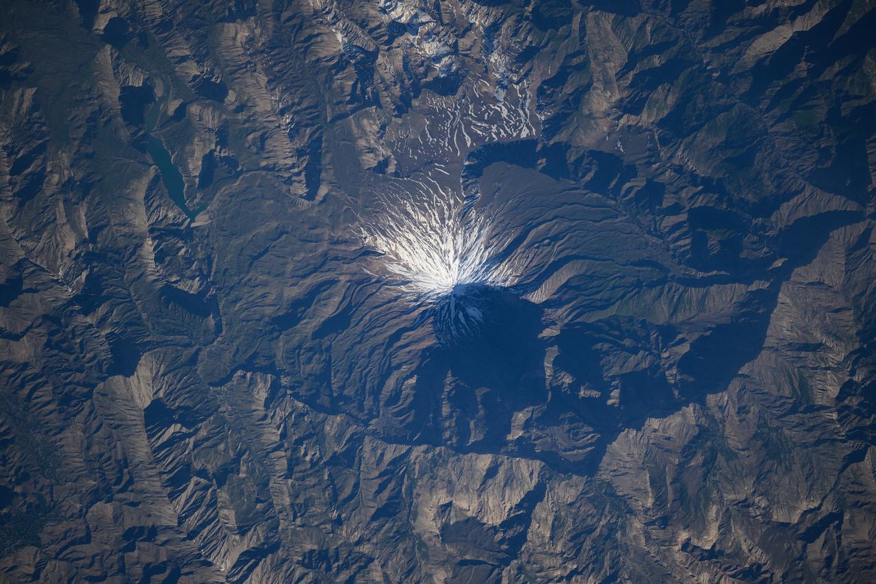
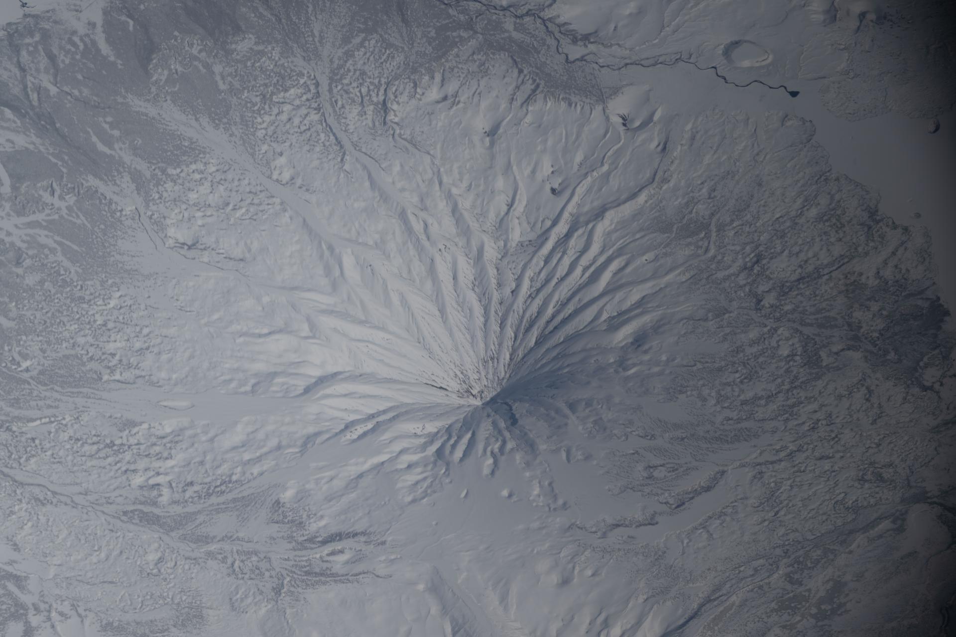
ISS038-E-025895 (5 Jan. 2014) --- Bazman volcano in Iran is featured in this image photographed by an Expedition 38 crew member on the International Space Station. Bazman volcano is located in a remote southern region within the Bazman Protected Area of Sistan and Baluchestan Provinces. While the volcano has the classic cone shape associated with stratovolcanoes, it is also heavily dissected by channels that extend downwards from the 3,490-meter-above-sea-level summit. This radial drainage pattern - looking similar to the spokes of a bicycle wheel - is readily observed in this photograph. Such patterns can form around high, symmetric peaks when water runoff and erosion is not constrained by the resistance of geologic materials or barriers to flow, leading to essentially even distribution of water runoff channels around the central peak. While there is no historical record of volcanism at Bazman, and no geologic record of eruptive activity within the past 10,000 years, some fumarolic activity - gas and steam emissions - have been reported, according to the Smithsonian Institution National Museum of Natural History's Global Volcanism Program. The summit of the volcano is marked by a well-formed explosion crater, and lava cones formed on the flanks of the main volcano are associated with well-preserved lava flows-a particularly striking example is visible on the north flank of Bazman at center. Together, these observations and features are suggestive that Bazman may be a dormant, rather than extinct, volcano.
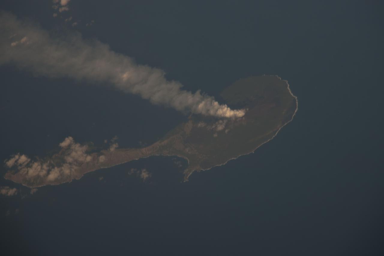
ISS030-E-122047 (6 March 2012) --- Pagan Island, Northern Marianas is featured in this image photographed by an Expedition 30 crew member on the International Space Station. A steam plume flows south from the peak of Pagan Island’s northernmost volcano in this photograph. Pagan is part of the Commonwealth of the Northern Marianas, an island chain of volcanoes that form the margin between the Pacific Ocean (to the east) and the Philippine Sea (to the west). Pagan is made up of two stratovolcanoes separated by an isthmus, and is one of the more volcanically active islands. The last eruption was in 2010, but the island was completely evacuated in 1981 when a large eruption forced the small Micronesian community to flee. According to NASA scientists, the islands themselves mark the tectonic boundary where the old, cold Pacific plate is subducted beneath the younger, less dense Philippine Sea crust at the Marianas Trench. The subduction results in substantial volcanic activity on the upper plate, forming the island arc of the Marianas. Considered to be one of the type examples for an oceanic subduction zone, the Marianas Trench includes the deepest spot in Earth’s oceans (more than 10,000 meters). The foreshortened appearance of the island is due to the viewing angle and distance from the space station, which was located over the Pacific Ocean approximately 480 kilometers to the southeast of Pagan Island when the image was taken.
ISS018-E-028898 (7 Feb. 2009) --- The summit of Popocatepetl Volcano in Mexico is featured in this image photographed by an Expedition 18 crewmember on the International Space Station. Volcano Popocatepetl, a large stratovolcano located approximately 70 kilometers to the southeast of Mexico City, is considered by many volcanologists to be ?the planet?s riskiest volcano?. The volcano warrants this distinction because of its proximity to one of the most densely populated megacities on Earth (population near 23 million in 2009). The variety of potential volcanic hazards at Popocatepetl is also considerable, including explosive eruptions of ash, pyroclastic flows (hot, fluidized masses of rock and gas that flow rapidly downhill), and debris avalanches. This detailed photograph of the summit crater of Popocatepetl (center) also highlights Ventorillo and Noroccidental Glaciers ? together with ice on nearby Iztaccihuatl Volcano and Pico de Orizaba (Mexico?s highest peak and the highest volcano in North America), these are the only mountain glaciers in tropical North America. The presence of glaciers on Popocatepetl is also connected with another volcanic hazard ? the creation of dangerous mudflows, or lahars, should the ice melt during eruptive activity. At the time this image was taken, steam and ash plumes were observed at the volcano ? a faint white steam plume is visible against gray ash deposits on the eastern and southern flanks of the volcano.
ISS018-E-010206 (3 Dec. 2008) --- Mount Nemrut in Turkey is featured in this image photographed by an Expedition 18 crewmember on the International Space Station. This detailed view centers on the summit caldera of Mount Nemrut (Nemrut Dagi in Turkish), a stratovolcano located in the eastern Anatolia region of Turkey along the shoreline of Lake Van. Winter snow blankets the 2,948 meter elevation summit of the mountain, highlighting the brown caldera rim (a caldera is a large, usually circular or elliptical, collapse feature caused by the rapid emptying of an underlying magma chamber). The snow also highlights the irregular shape and wrinkled surfaces of several lava flows present in the eastern portion of the caldera. Lava flows associated with Mt. Nemrut range in composition from thin, fluid basalt to thick, glassy obsidian. A coldwater caldera lake occupies the western half of the summit. The geologic record at Mt. Nemrut indicates numerous prehistoric explosive eruptions during the Holocene Epoch ?which, according to scientists, began approximately 10,000 years ago and extends to the present day ? with eruption of lava last observed during 1441. The last well-documented explosive eruption occurred during 1650. Volcanism at Mt. Nemrut is the result of tectonic activity associated with the collision of the Arabian and Eurasian Plates; this collision is ongoing, and the presence of a warm water lake in the caldera suggests that the volcano is merely quiescent at present.
ISS041-E-049111 (30 Sept. 2014) --- One of the Expedition 41 crew members onboard the International Space Station, flying at an altitude of 226 nautical miles, exposed this image of Mount Egmont Volcano, New Zealand, using a focal length setting of 200mm. Sometimes referred to as Mount Taranaki, the land feature is a young stratovolcano that began to form 70,000 years ago, according to volcanists. Located in southwest North Island, New Zealand, Mount Egmont, at 8,261 feet (2,518 meters) is the second tallest volcanic mountain in New Zealand. Perpetually snow-capped, the volcano last erupted in 1755. Mount Egmont has a history of a major size eruption occurring every 340 years, with numerous minor ones in between. The volcano has had three major cone collapses in the last 25,000 years with the last collapse occurring 6,970 years ago. With each collapse, thick layers of ash and lava crumbled into thick, muddy avalanches called lahars. These lahars have reached the coastline 25 miles (40 kilometers) to the west and north of the volcano. Egmont is surrounded by forest, especially on its lower flanks, which is part of a National Park. The pastureland that circles the park is used for dairy farming.
ISS031-E-041959 (18 May 2012) --- Alaid Volcano in the Kuril Islands of the Russian Federation is featured in this image photographed by an Expedition 31 crew member on the International Space Station. The Kurils chain extends from the Kamchatka Peninsula to the islands of Japan, and contains numerous active volcanoes along its length. Alaid is the highest (2,339 meters above sea level) volcano in the Kuril chain, as well as being the northernmost. The textbook conic morphology of this stratovolcano is marred only by the summit crater, which is breached to the south (center) and highlighted by snow cover. The volcano rises 3,000 meters directly from the floor of the Sea of Okhotsk, with the uppermost part of the volcanic edifice exposed as an island. Much of the sea surface surrounding the volcano has a silver-gray appearance. This mirror-like appearance is due to sunglint, where light reflects off the sea surface and is scattered directly towards the observer onboard the space station. Sunglint is largely absent from a zone directly to the west of the volcano, most likely due to surface wind or water current patterns that change the roughness?and light scattering properties?of the water surface in this area. Volcanoes in the Kurils, and similar island arcs in the Pacific ?ring of fire?, are fed by magma generated along the boundary between two tectonic plates, where one plate is being driven beneath the other (a process known as subduction). Alaid Volcano has been historically active with the most recent confirmed explosive activity occurring in 1996.
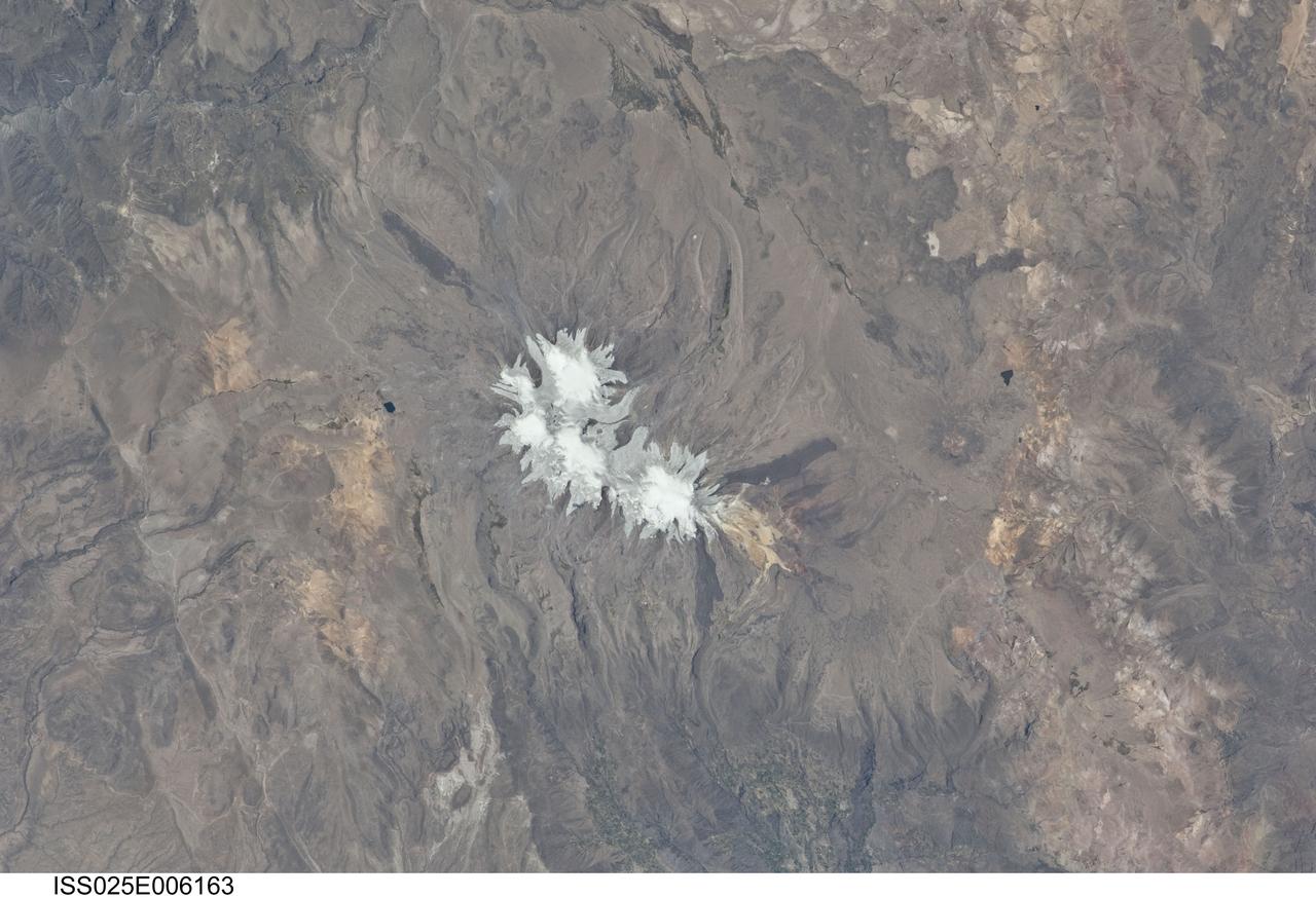
ISS025-E-006163 (6 Oct. 2010) --- Nevado Coropuna, Peru is featured in this image photographed by an Expedition 25 crew member on the International Space Station. Nevado (“snowy” or “snowy peak” in Spanish) Coropuna is the highest volcanic peak in Peru – the summit elevation is 6,377 meters above sea level. Rather than being a single stratovolcano, Coropuna is a volcanic complex of numerous summit cones. The complex covers an area of 240 square kilometers within the Ampato mountain range (Cordillera Ampato) in southeast-central Peru. While the exact date of the volcano’s last eruption is not known, lava flows (black, at center and upper left) along the northern, southern, and western flanks of the complex are thought to have been emplaced during the early Holocene Epoch – the current geologic time period which began approximately 12,000 years ago, according to scientists. Coropuna also hosts several summit glaciers and icefields (white to gray, center) that contrast sharply with the dark rock outcrops and surface deposits at lower elevations. Glacial deposits and lateral moraines on the flanks of Coropuna indicate that glaciers once extended to much lower elevations than are observed today. Scientists believe that careful mapping and surface exposure age-dating of these glacial deposits and landforms provides data on the timing of ice advances and retreats in the tropics near the end of the Pleistocene Epoch (extending from approximately 2.5 million to approximately 12,000 years ago). In turn, this information can be compared with other paleoclimate records to obtain a better understanding of how Earth’s global climate has changed over geologic time.
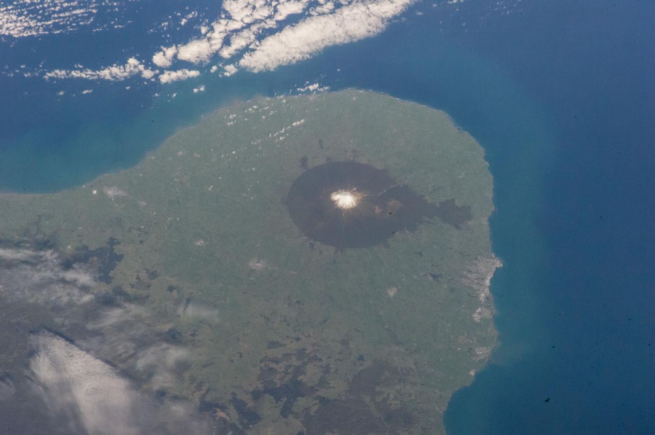
ISS016-E-010894 (17 Nov. 2007) --- Cosiguina Volcano, Nicaragua is featured in this image photographed by an Expedition 16 crewmember on the International Space Station. Three Central American countries (El Salvador, Honduras, and Nicaragua) include coastline along the Gulf of Fonseca that opens into the Pacific Ocean. The southern boundary of the Gulf is a peninsula formed by the Cosiguina volcano illustrated in this view. Cosiguina is a stratovolcano, typically tall cone-shaped structures formed by alternating layers of solidified lava and volcanic rocks (ash, pyroclastic flows, breccias) produced by explosive eruptions. The summit crater is filled with a lake (Laguna Cosiguina). The volcano last erupted in 1859, but its most famous activity occurred in 1835 when it produced the largest historical eruption in Nicaragua. Ash from the 1835 eruption has been found in Mexico, Costa Rica, and Jamaica. The volcano has been quiet since 1859, only an instant in terms of geological time. An earthquake swarm was measured near Cosiguina in 2002, indicating that tectonic forces are still active in the region although the volcano is somewhat isolated from the line of more recently active Central American volcanoes to the northwest and southeast. Intermittently observed gas bubbles in Laguna Cosiguina, and a hot spring along the eastern flank of the volcano are the only indicators of hydrothermal activity at the volcano. The fairly uniform vegetation cover (green) on the volcano's sides also attest to a general lack of gas emissions or "hot spots" on the 872 meter high cone, according to NASA scientists who study the photos downlinked from the orbital outpost.
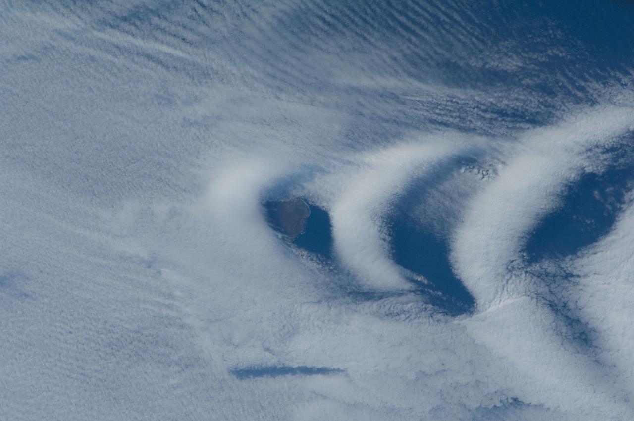
ISS030-E-193144 (25 March 2012) --- Wave clouds near Ile aux Cochons are featured in this image photographed by an Expedition 30 crew member on the International Space Station. This photograph illustrates the formation of wave clouds in the wake—or downwind side—of Ile aux Cochons (“Isle of Pigs”) located in the Southern Indian Ocean. The island is approximately located 3,000 kilometers southeast of the southern tip of the African continent and 2,300 kilometers northwest of Antarctica. The island itself, of which only a part of the eastern coastline is visible at center, is volcanic in origin with a summit elevation of 775 meters above sea level. According to scientists, the Ile aux Cochons stratovolcano is thought to have erupted within the last 12,000 years; however no historical activity has been recorded. The summit elevation is high enough for the land surface to interact with cloud layers and winds flowing past the island. Two major cloud layers are visible; a lower, more uniform layer consists of roughly parallel cloud “streets” that suggest a westerly flow pattern of air. When the air mass encounters the Ile aux Cochons, moisture-laden air rises and cools, causing more water vapor to condense into clouds. As the air mass passes over the summit of Ile aux Cochons and descends, it may encounter alternating moist and dry air layers, enabling the formation of the discontinuous chevron-shaped wave clouds in the wake of the island. While their appearance suggests that the clouds are forming in the wake of the island and moving eastwards, in fact it is the air mass that is moving, with clouds forming in regions of moist air and dissipating in dry regions. Ile aux Cochons is the westernmost of the islands that form the subantarctic Crozet Archipelago (part of the French Southern and Antarctic Lands). Accept for occasional research visits, the island is uninhabited. The island is an important breeding site for seabirds, including the world’s largest King Penguin colony.
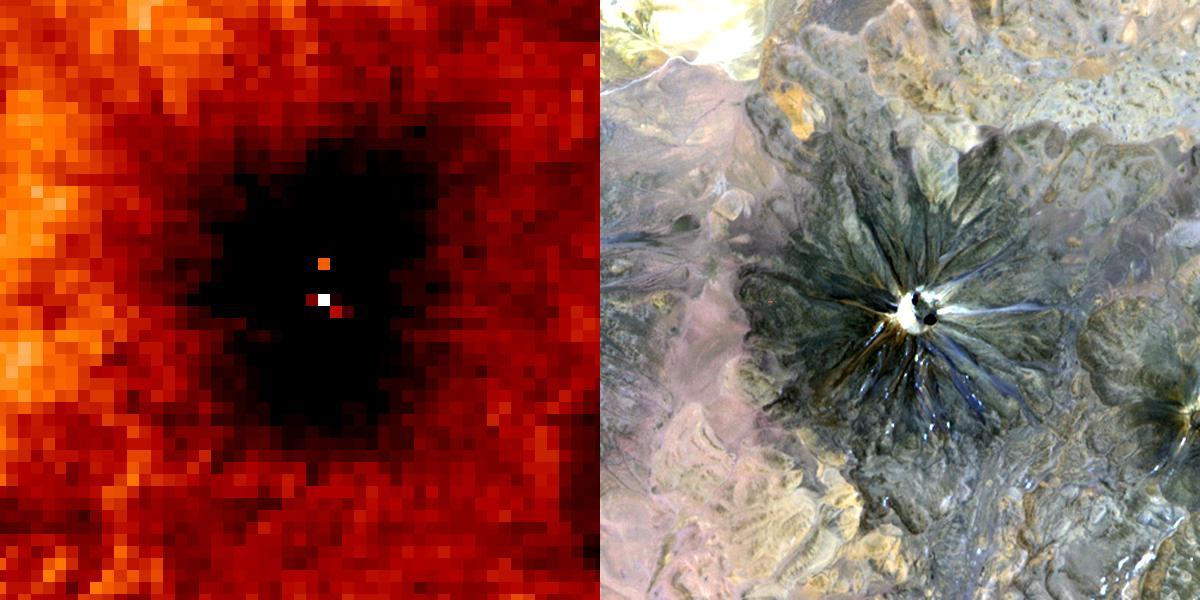
A January 6, 2002 ASTER nighttime thermal infrared image of Chiliques volcano in Chile shows a hot spot in the summit crater and several others along the upper flanks of the edifice, indicating new volcanic activity. Examination of an earlier nighttime thermal infrared image from May 24, 2000 showed no thermal anomaly. Chiliques volcano was previously thought to be dormant. Rising to an elevation of 5778 m, Chiliques is a simple stratovolcano with a 500-m-diameter circular summit crater. This mountain is one of the most important high altitude ceremonial centers of the Incas. It is rarely visited due to its difficult accessibility. Climbing to the summit along Inca trails, numerous ruins are encountered; at the summit there are a series of constructions used for rituals. There is a beautiful lagoon in the crater that is almost always frozen. The daytime image was acquired on November 19, 2000 and was created by displaying ASTER bands 1,2 and 3 in blue, green and red. The nighttime image was acquired January 6, 2002, and is a color-coded display of a single thermal infrared band. The hottest areas are white, and colder areas are darker shades of red. Both images cover an area of 7.5 x 7.5 km, and are centered at 23.6 degrees south latitude, 67.6 degrees west longitude. Both images cover an area of 7.5 x 7.5 km, and are centered at 23.6 degrees south latitude, 67.6 degrees west longitude. http://photojournal.jpl.nasa.gov/catalog/PIA03493
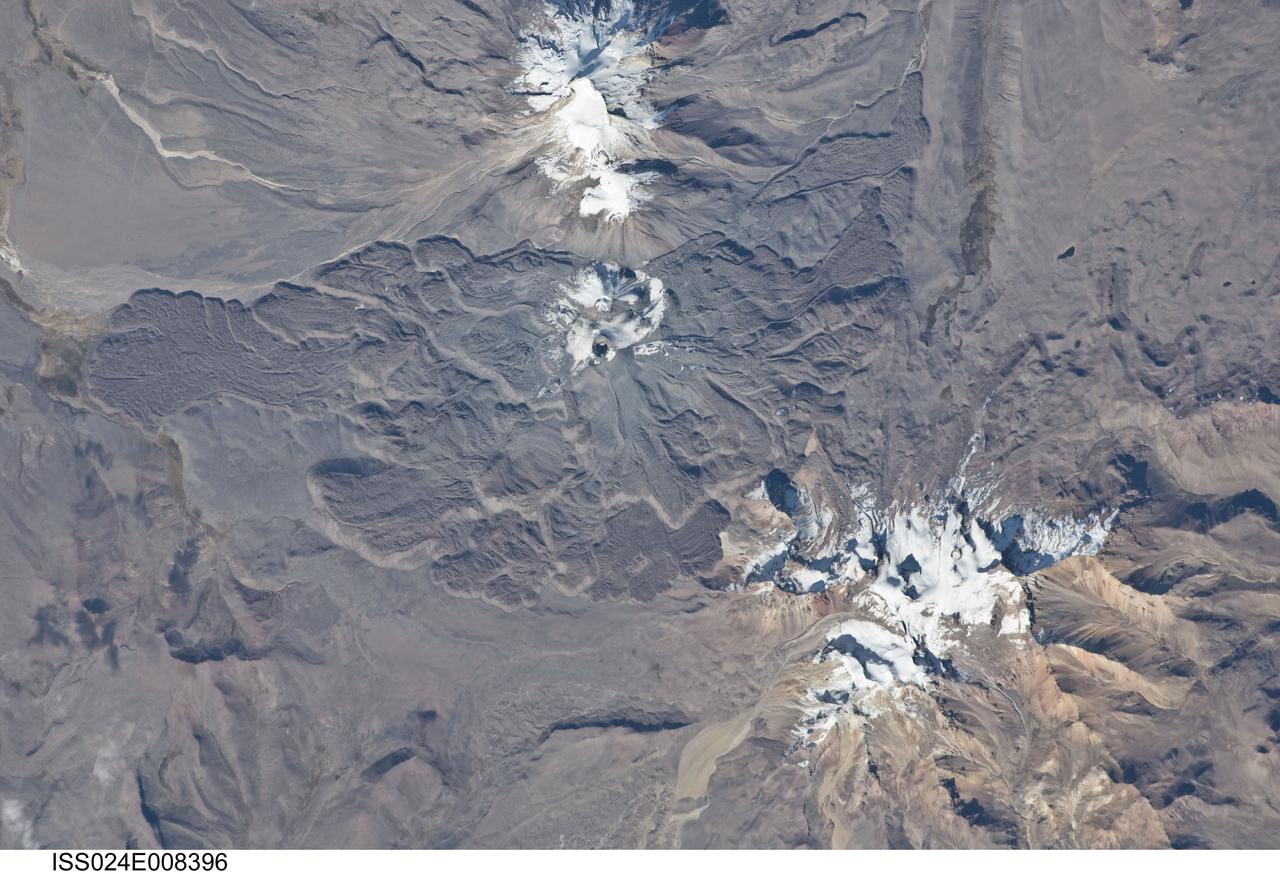
ISS024-E-008396 (15 July 2010) --- Sabancaya volcano in Peru is featured in this image photographed by an Expedition 24 crew member on the International Space Station. The 5,967-meter-high Sabancaya stratovolcano (or Nevado Sabancaya) is located in southern Peru approximately 70 kilometers to the northwest of the city of Arequipa. The name Sabancaya means ?tongue of fire? in the Quechua Indian language. Sabancaya is part of a volcanic complex that includes two other nearby (and older) volcanoes, neither of which has been active historically; in this detailed photograph, Nevado Ampato is visible to the south (top center) and the lower flanks of Nevado Hualca Hualca are visible to the north (bottom right). The snowy peaks of the three volcanoes provide a stark contrast to the surrounding desert of the Puna Plateau. Sabancaya?s first historical record of an eruption dates to 1750. The most recent eruptive activity at the volcano occurred in July 2003 and deposited ash on the volcano?s summit and northeastern flank. Volcanism at Sabancaya is fueled by magma generated at the subduction zone between the Nazca and South American tectonic plates. Magma can erupt to the surface and form lava flows through the volcano?s summit (frequently forming a crater) but can also erupt from lava domes and flank vents along the volcano?s sides. Lava has issued from all of these points at Sabancaya, forming numerous gray to dark brown lobate flows that extend in all directions except southwards (center).
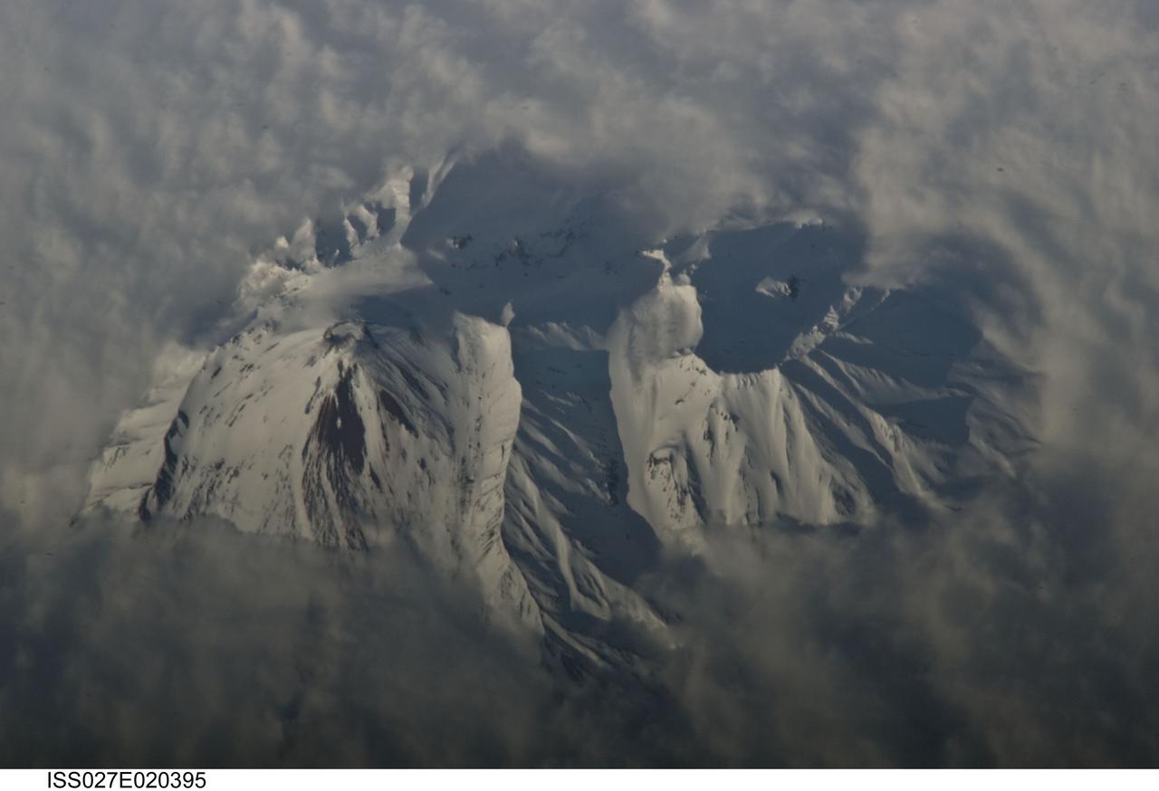
ISS027-E-020395 (2 May 2011) --- Avachinsky Volcano, Kamchatka Peninsula, Russia is featured in this image photographed by an Expedition 27 crew member on the International Space Station. The Kamchatka Peninsula, located along the Pacific ?ring of fire?, includes more than 100 identified volcanoes. While most of these volcanoes are not actively erupting, many are considered to be dangerous due to their past eruptive history and proximity to population centers and air travel corridors. This detailed photograph highlights the summit crater and snow-covered upper slopes of the Avachinsky stratovolcano exposed above a surrounding cloud deck. The 2,741-meter-high Avachinsky volcano has an extensive historical and geological record of eruptions with the latest activity observed in 2008. The large city of Petropavlovsk, Kamchatka is located approximately 25 kilometers to the southwest and, according to scientists, is built over approximately 30,000 ? 40,000 year old debris avalanche deposits that originated from Avachinsky ? suggesting that the city may be at risk from a similar hazard in the future. To the southeast (right), the large breached crater of Kozelsky Volcano is also visible above the clouds. Kozelsky is a parasitic cone, formed by the eruption of material from vents along the flank of Avachinsky volcano. The topography of the volcanoes is accentuated by shadows produced by the relatively low sun angle, and by the oblique viewing angle. Oblique images are taken looking outwards at an angle from the International Space Station, rather than the ?straight down? (or nadir) view typical of most orbital Earth-observing sensor systems.
ISS028-E-015023 (8 July 2011) --- The Aras River and Turkey-Armenia-Iran border region are featured in this image photographed by an Expedition 28 crew member on the International Space Station. This photograph highlights a segment of the international border between Turkey to the south-southwest and Armenia to the north-northeast. The Aras River is the physical expression of the closed border between the two countries. Extensive green agricultural fields are common on both sides of the river (top), as well as a number of gray to tan urban areas including Artashat and Armavir in Armenia and Igdir in Turkey. While there have been efforts to normalize diplomatic relations between the two countries in recent years, the Armenia-Turkey border remains officially closed. The dominant geographic feature in the region is Mt. Ararat, also known as Agri Dagi. The peak of Ararat, a large stratovolcano that last erupted in 1840 according to historical records, is located approximately 40 kilometers to the south of the Armenia-Turkey border. A lower peak to the east, known as Lesser or Little Ararat, is also volcanic in origin. Dark gray lava flows to the south of Mt. Ararat are located near the Turkish border with Iran. While this border is also closed along much of its length, official crossing points allow relatively easy travel between the two countries. The white, glacier-clad peak of Mt. Ararat is evident at center; dark green areas on the lower slopes indicate where vegetation cover is abundant. A large lake, Balik Golu or Fish Lake, is visible to the west (lower left).
ISS036-E-007165 (11 June 2013) --- Nevados de Chillan, Chile is featured in this image photographed by an Expedition 36 crew member on the International Space Station. This photograph highlights a large volcanic area located near the Chile-Argentina border. Like other historically active volcanoes in the central Andes ranges, the Nevados de Chillan were created by upwelling magma generated by eastward subduction of the dense oceanic crust of the Pacific basin beneath the less dense continental crust of South America. Rising magmas associated with this type of tectonic environment frequently erupt explosively, forming widespread ash and ignimbrite layers. They can also produce less explosive eruptions that form voluminous lava flows – layering together with explosively erupted deposits to build the classic cone-shaped edifice of a stratovolcano over geologic time. The Nevados de Chillan includes three distinct volcanic structures, built within three overlapping calderas that extend along a north-northwest to south-southeast line. The snow-capped volcanic complex sits within the glaciated terrain of the central Andes – glacial valleys are visible at upper left, upper right, and lower right. The northwestern end of the chain is occupied by the 3,212-meter-high Cerro Blanco (also known as Volcan Nevado). The 3,089-meter-high Volcan Viejo (also known as Volcan Chillan) sits at the southeastern end; this volcano was active during the 17th-19th centuries. A group of lava domes known as Volcan Nuevo formed to the northwest of Volcan Viejo between 1906-1945, followed by an even younger dome complex that formed between 1973-1986 (Volcan Arrau; not indicated on the image). The last reported volcanic activity at Nevados de Chillan took place in 2009 (according to the Smithsonian Institution’s Global Volcanism Network).
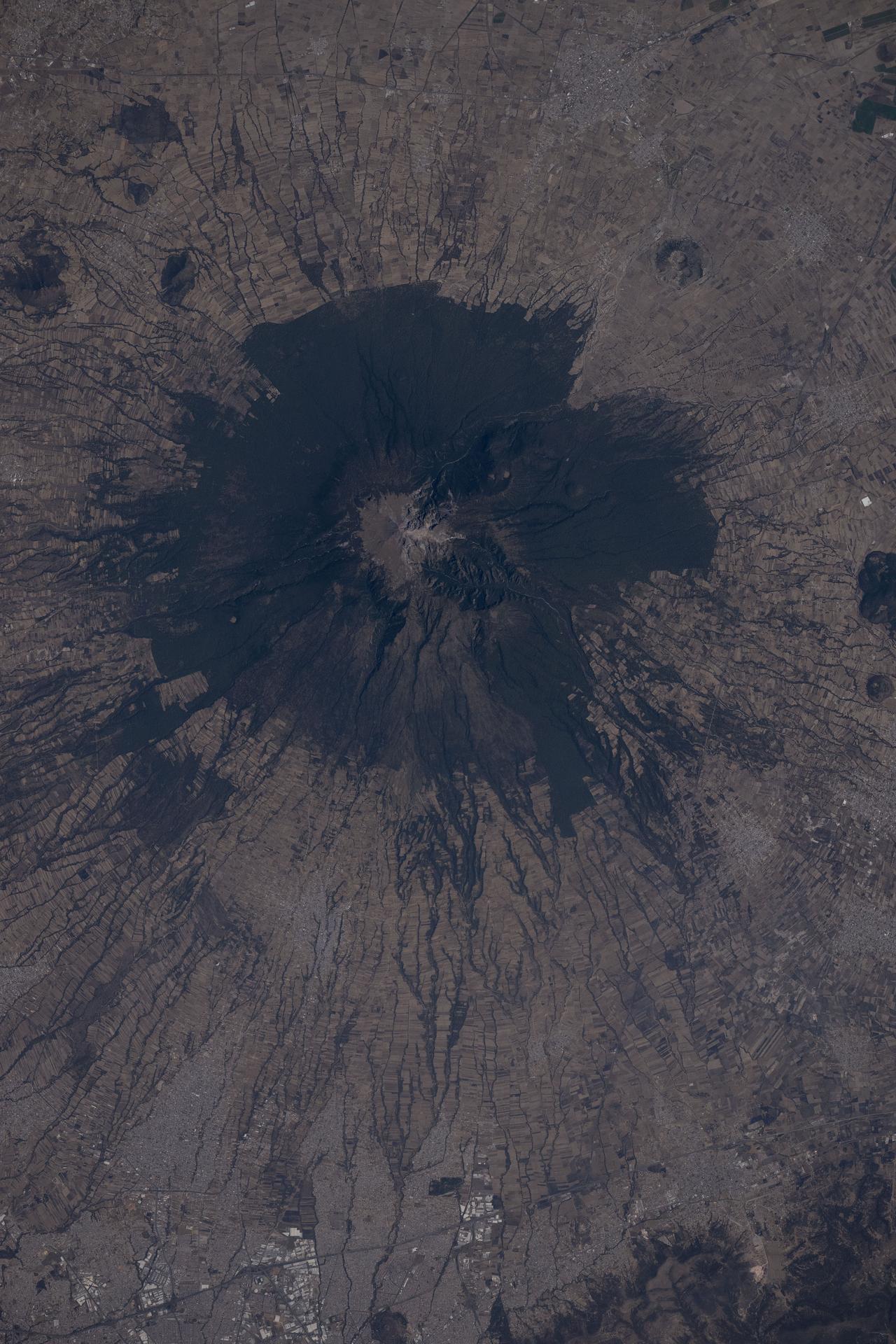
ISS037-E-022473 (29 Oct. 2013) --- La Malinche Volcano, Mexico is featured in this image photo graphed by an Expedition 37 crew member on the International Space Station. Located approximately 30 kilometers to the northeast of the city of Puebla, the summit of Volcan la Malinche rises to an elevation of 4,461 meters above sea level. This detailed photograph highlights the snow-dusted summit, and the deep canyons that cut into the flanks of this eroded stratovolcano. La Malinche has not been historically active, but radiometric dating of volcanic rocks and deposits associated with the structure indicate a most recent eruption near the end of the 12th century. NASA scientists cite evidence that lahars, or mudflows, associated with an eruption about 3,100 years ago, affected Pre-Columbian settlements in the nearby Puebla basin. The volcano is enclosed within La Malinche National Park situated within parts of the states of Puebla and Tlaxcala; extensive green forest cover is visible on the lower flanks of the volcano. Access to the volcano is available through roadways, and it is frequently used as a training peak by climbers prior to attempting higher summits. The rectangular outlines of agricultural fields are visible forming an outer ring around the forested area. While the volcano appears to be quiescent, its relatively recent (in geological terms) eruptive activity, and location within the Trans-Mexican Volcanic Belt– a tectonically active region with several current and historically active volcanoes including Popocatepetl to the west and Pico de Orizaba to the east - suggests that future activity is still possible and could potentially pose a threat to the nearby city of Puebla.
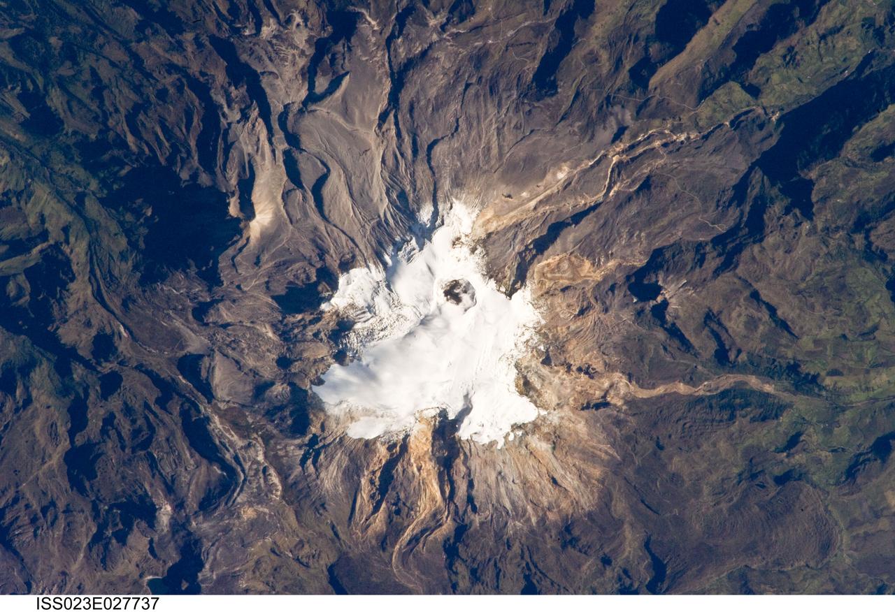
ISS023-E-027737 (23 April 2010) --- Nevado del Ruiz volcano in Colombia is featured in this image photographed by an Expedition 23 crew member on the International Space Station. The large Nevado del Ruiz volcano (center) is located approximately 140 kilometers to the northwest of the capital city of Bogota and covers an area of over 200 square kilometers. Nevado del Ruiz is a stratovolcano – a type of volcano built from successive layers of lava, ash, and pyroclastic flow deposits – formed by magma generated above the boundary between the subducting Nazca and overriding South American tectonic plates. The historical record of eruptions extends back to 1570, but the most damaging eruption in recent times took place in 1985. On Nov. 13, 1985, an explosive eruption at the Arenas Crater (center) melted ice and snow at the summit of the volcano. This lead to the formation of mudflows (or lahars) that swept tens of kilometers down river valleys along the volcano’s flanks, resulting in the deaths of at least 23,000 people. Most of the fatalities occurred in the town of Armero which was completely inundated by lahars. Eruptive activity at Nevado del Ruiz may have occurred in 1994, but this is not confirmed. The volcano’s summit and upper flanks are covered by several glaciers that appear as a white mass surrounding the one-kilometer-wide Arenas Crater; meltwater from these glaciers has incised the gray to tan ash and pyroclastic flow deposits mantling the lower slopes. A well-defined lava flow is visible at lower right. This photograph was taken at approximately 7:45 a.m. local time when the sun was still fairly low above the horizon, leading to shadowing to the west of topographic high points.
NASA image acquired June 16, 2010. Papua New Guinea’s Manam Volcano released a thin, faint plume on June 16, 2010, as clouds clustered at the volcano’s summit. The Advanced Land Imager (ALI) on NASA’s Earth Observing-1 (EO-1) satellite took this picture the same day. Rivulets of brown rock interrupt the carpet of green vegetation on the volcano’s slopes. Opaque white clouds partially obscure the satellite’s view of Manam. The clouds may result from water vapor from the volcano, but may also have formed independent of volcanic activity. The volcanic plume appears as a thin, blue-gray veil extending toward the northwest over the Bismarck Sea. Located 13 kilometers (8 miles) off the coast of mainland Papua New Guinea, Manam forms an island 10 kilometers (6 miles) wide. It is a stratovolcano. The volcano has two summit craters, and although both are active, most historical eruptions have arisen from the southern crater. NASA Earth Observatory image created by Jesse Allen, using EO-1 ALI data provided courtesy of the NASA EO-1 team. Caption by Michon Scott. Instrument: EO-1 - ALI To view the full image go to: <a href="http://earthobservatory.nasa.gov/NaturalHazards/view.php?id=44307&src=nhrss" rel="nofollow">earthobservatory.nasa.gov/NaturalHazards/view.php?id=4430...</a> <b><a href="http://www.nasa.gov/centers/goddard/home/index.html" rel="nofollow">NASA Goddard Space Flight Center</a></b> is home to the nation's largest organization of combined scientists, engineers and technologists that build spacecraft, instruments and new technology to study the Earth, the sun, our solar system, and the universe.
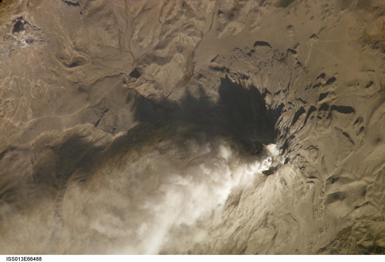
ISS013-E-66488 (14 Aug. 2006) --- Ash cloud from Ubinas Volcano, Peru is featured in this image photographed by an Expedition 13 crewmember on the International Space Station (ISS). Subduction of the Nazca tectonic plate along the western coast of South America forms the high Peruvian Andes, and also produces magma feeding a chain of historically active volcanoes along the western front of the mountains. The most active of these volcanoes in Peru is Ubinas. A typical steep-sided stratovolcano comprised primarily of layers of silica-rich lava flows, it has a summit elevation of 5,672 meters. The volcanic cone appears distinctively truncated or flat-topped in profile -- the result of a relatively small eruption that evacuated a magma reservoir near the summit. Following removal of the magma, the summit material collapsed downwards to form the current 1.4 kilometer-wide summit caldera. This oblique image (looking at an angle from the ISS) captures an ash cloud first observed on satellite imagery at 11:00 GMT on Aug. 14, 2006; this image was acquired one hour and 45 minutes later. The ash cloud resulted in the issuing of an aviation hazard warning by the Buenos Aires Volcanic Ash Advisory Center. Modern activity at Ubinas is characterized by these minor to moderate explosive eruptions of ash and larger pumice - a volcanic rock characterized by low density and high proportion of gas bubbles formed as the explosively-erupted parent lava cools during its transit through the air. These materials blanket the volcanic cone and surrounding area, giving this image an overall gray appearance. Shadowing of the western flank of Ubinas throws several lava flows into sharp relief, and highlights the steep slopes at the flow fronts -- a common characteristic of silica-rich, thick, and slow-moving lavas. NASA researchers note that the most recent major eruption of Ubinas occurred in 1969, however the historical record of activity extends back to the 16th century.
The tiny Aleutian island of Bogoslof in Alaska, erupting regularly since December 2016, produced fresh activity on Sunday, May 28, 2017. Bogoslof is a stratovolcano fueled by the subduction of the Pacific Plate under the North American Plate and forms part of the larger Aleutian Arc, which includes more than 60 volcanoes on the Aleutian Islands and the Aleutian Range on the Alaska mainland. Previous to its recent period of activity, Bogoslof had last erupted in 1992, and its above-water surface area was a mere 0.11 square miles (0.29 square kilometers). As of March 11, the most recent data available, the area of the island had tripled to 0.38 square miles (0.98 square kilometers). The event on May 28 produced an ash cloud that reached 40,000 feet (12 km) in altitude, causing the Alaskan Volcano Observatory to issue a red alert for air travel in the area. Volcanic ash can cause major damage to aircraft engines, and the region is close to several major air routes between North America and Asia. On May 28, 2017, at approximately 2:23 p.m. local time, NASA's Terra satellite passed over Bogoslof, less than 10 minutes after the eruption began. MISR has nine cameras that view Earth at different angles. It takes slightly less than seven minutes for all nine cameras to view the same location on Earth. An animation made from the images from the nine MISR cameras, captured between 2:19 and 2:26 p.m., demonstrates how the angled views give a glimpse of the underside of the growing plume of volcanic ash, showing the eruption column widening into the cloud at the top. The animation is available at https://photojournal.jpl.nasa.gov/catalog/PIA21655
ISS029-E-020003 (7 Oct. 2011) --- Parinacota Volcano in the Chile-Bolivia border region, South America is featured in this image photographed by an Expedition 29 crew member on the International Space Station. Volcan Parinacota (?flamingo lake? in the regional Aymara language) is a potentially active stratovolcano located on the Altiplano, a high plateau situated within the Andes Mountains of west-central South America. While no direct observations of eruptive activity are recorded, surface exposure age-dating of lava flows suggests that activity occurred as recently as 290 AD approximately 300 years, according to scientists. Local Aymara stories also suggest that the volcano has erupted during the past 1,000 years. This detailed photograph highlights the symmetrical cone of Parinacota, with its well-developed summit crater (elevation 6,348 meters above sea level) at center. Dark brown to dark gray surfaces to the east and west of the summit include lava flows, pyroclastic deposits, and ash. A companion volcano, Pomerape, is located across a low saddle to the north ? scientists believe this volcano last erupted during the Pleistocene Epoch (extending from approximately 3 million to 12,000 years ago). The summits of both volcanoes are covered by white permanent snowpack and small glaciers. Together, the two volcanoes form the Nevados de Payachata volcanic area. Eruptive activity at Parinacota has directly influenced development of the local landscape beyond the emplacement of volcanic deposits ? approximately 8,000 years ago the western flank of the volcano collapsed, creating a debris avalanche that traveled 22 kilometers to the west. This debris avalanche blocked drainages, leading to the formation of Lake Chungara to the south (upper right). The uneven, hummocky surface of the debris avalanche deposit provides ample catchments for water, as evidenced by the numerous small ponds and Cotacotani Lake to the west.
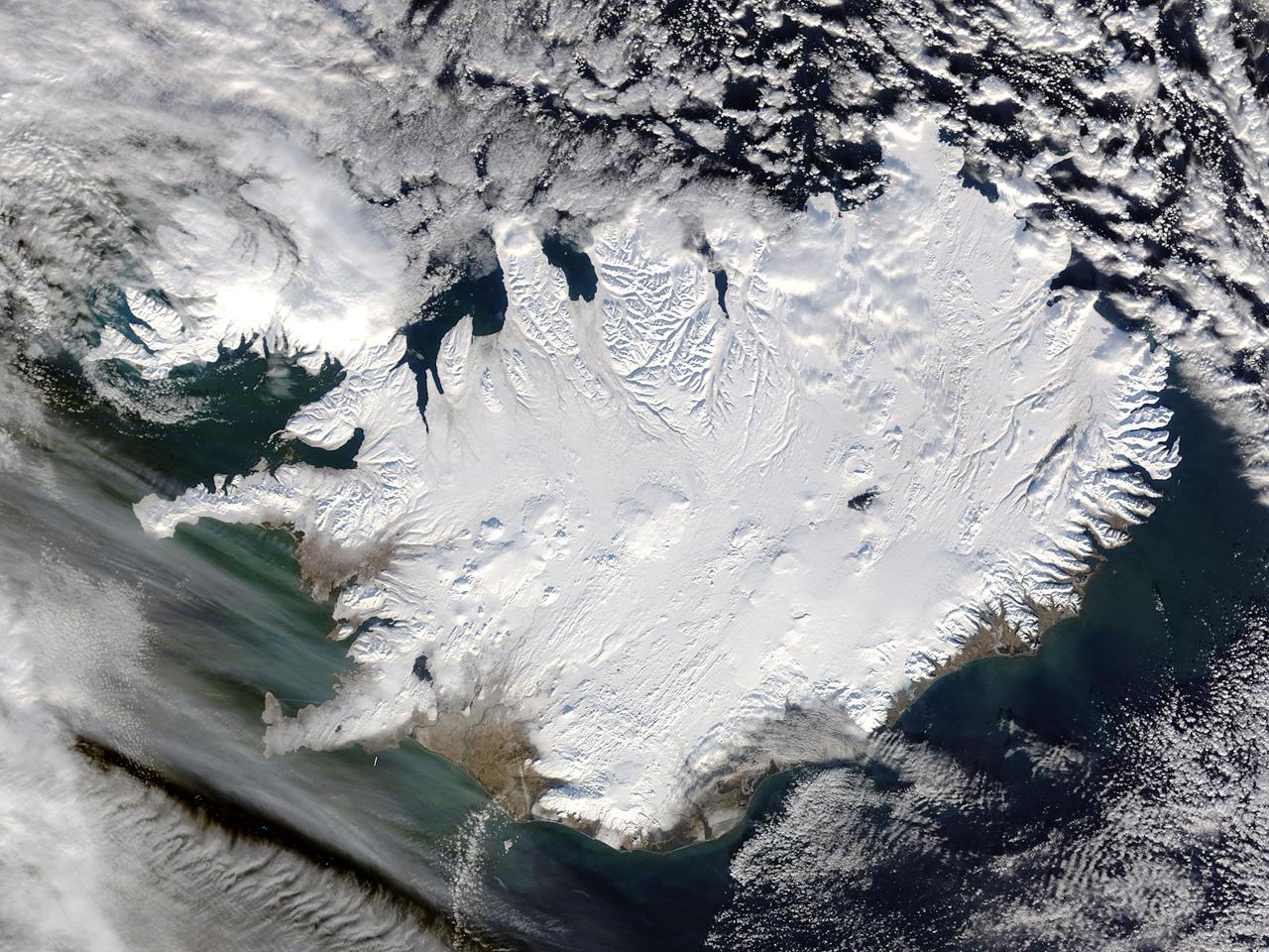
Iceland, dressed in winter white, peaked through a hole in a complex system of clouds in late February, 2015. The Moderate Resolution Imaging Spectroradiometer (MODIS) aboard NASA’s Terra satellite captured this true-color image on February 21 as it passed over the region. Ice and snow covers Iceland almost entirely, except for coastal regions in the southwest and southeast. The extensive, roughly H-shaped area in the southeast section of the island is Vatnajökull, Iceland’s largest glacier. Hidden underneath the ice lies Bardarbunga, a large subglacial stratovolcano. On August 31, 2014 the volcano began an eruption at two fissures to the north of the glacier and deposited a lava field that measured about 131 feet (40 meters) at its thickest points, and covered an area about 33 sq. mi (85 sq. km) by the time the eruption ended on February 27, 2015. The massive lava flow left its mark on Iceland – the cooled lava can be seen as the roughly oval black area to the north of the Vatnajökull glacier. Credit: NASA/GSFC/Jeff Schmaltz/MODIS Land Rapid Response Team <b><a href="http://www.nasa.gov/audience/formedia/features/MP_Photo_Guidelines.html" rel="nofollow">NASA image use policy.</a></b> <b><a href="http://www.nasa.gov/centers/goddard/home/index.html" rel="nofollow">NASA Goddard Space Flight Center</a></b> enables NASA’s mission through four scientific endeavors: Earth Science, Heliophysics, Solar System Exploration, and Astrophysics. Goddard plays a leading role in NASA’s accomplishments by contributing compelling scientific knowledge to advance the Agency’s mission. <b>Follow us on <a href="http://twitter.com/NASAGoddardPix" rel="nofollow">Twitter</a></b> <b>Like us on <a href="http://www.facebook.com/pages/Greenbelt-MD/NASA-Goddard/395013845897?ref=tsd" rel="nofollow">Facebook</a></b> <b>Find us on <a href="http://instagram.com/nasagoddard?vm=grid" rel="nofollow">Instagram</a></b>
ISS014-E-11872 (11 Jan. 2007) --- Pagan Island, Northern Mariana Islands, is featured in this image photographed by an Expedition 14 crewmember on the International Space Station. According to scientists, the Mariana Islands are part a volcanic island arc -- surface volcanoes formed from magma generation as one tectonic plate is overridden (or subducted) beneath another. In the case of the Mariana Islands, the Pacific Plate is being subducted beneath the Philippine Plate along the famously deep Mariana Trench (more than 11 kilometers below sea level). Pagan Island (right) is comprised of two stratovolcanoes (tall, typically cone-shaped structures formed by layers of dense crystallized lava and less-dense ash and pumice) connected by a narrow isthmus of land. Mount Pagan, the larger of the two volcanoes, forms the northeastern portion of the island and has been the most active historically. The most recent major eruption took place in 1981, but since then numerous steam- and ash-producing events have been observed at the volcano -- the latest reported one occurring between Dec. 5-8, 2006. This image records volcanic activity on Jan. 11, 2007 that produced a thin plume (most probably steam, say NASA scientists, possibly with minor ash content) that extended westwards away from Mount Pagan. The island is sparsely populated, and monitored for volcanic activity by the United States Geological Survey and the Commonwealth of the Mariana Islands.
ISS030-E-030265 (31 Dec. 2011) --- The Payun Matru Volcanic Field in Argentina is featured in this image photographed by an Expedition 30 crew member on the International Space Station. The Payun Matru (3,680 meters above sea level) and Payun Liso (3,715 meters above sea level) stratovolcanoes are the highest points of the Payun Matru Volcanic Field located in west-central Argentina, approximately 140 kilometers to the east of the Andes mountain chain. This photograph illustrates some of the striking geological features of the field visible from space. The summit of Payun Matru is dominated by a roughly 15 kilometer-in-diameter caldera (center), formed by an explosive eruption sometime after approximately 168,000 years ago. Several dark lava flows, erupted from smaller vents and fissures, are visible in the northwestern part of the volcanic field. One distinct flow, erupted from Volcan Santa Maria located to the northwest of Payun Matru, is approximately 15 kilometers long. A number of small cinder cones, appearing as brown dots due to the short lens used, are built on older lava flows (grey) to the northeast of Payun Matru. While there is no recorded historical observation of the most recent volcanic activity in the field, oral histories suggest that activity was witnessed by indigenous peoples. Most Andean volcanoes—and earthquakes—follow the trend of the greater Andes chain of mountains, and are aligned roughly N-S above the tectonic boundary between the subducting (descending) Nazca Plate and the overriding South American Plate as is predicted from plate tectonic theory. Other major volcanic centers located some distance away from the major trend typically result from more complex geological processes associated with the subduction zone, and can provide additional insight into the subduction process.

NASA image acquired Sept 7, 2010 Shiveluch (also spelled Sheveluch) is one of the largest and most active volcanoes on Russia’s Kamchatka Peninsula. It has been spewing ash and steam intermittently—with occasional dome collapses, pyroclastic flows, and lava flows, as well—for the past decade. Shiveluch is a stratovolcano, a steep-sloped formation of alternating layers of hardened lava, ash, and rocks thrown out by earlier eruptions. A lava dome has been growing southwest of the 3,283-meter (10,771-foot) summit. The Advanced Land Imager (ALI) on NASA’s Earth Observing-1 (EO-1) satellite acquired this image on September 7, 2010. Brown and tan debris—perhaps ash falls, perhaps mud from lahars—covers the southern landscape of the volcano, while the hills on the northern side remain covered in snow and ice. The Kamchatkan Volcanic Eruption Response Team (KVERT) reported that seismic activity at Shiveluch was "above background levels" from September 3-10. Ash plumes rose to an altitude of 6.5 kilometers (21,300 feet) on September 3-4, and gas-and-ash plumes were reported on September 7, when this image was acquired. According to the Smithsonian Institution's volcano program, at least 60 large eruptions of Shiveluch have occurred during the current Holocene Epoch of geological history. Intermittent explosive eruptions began in the 1990s, and the largest historical eruptions from Shiveluch occurred in 1854 and 1964. NASA Earth Observatory image created by Jesse Allen and Robert Simmon, using EO-1 ALI data provided courtesy of the NASA EO-1 team. Caption by Mike Carlowicz. Instrument: EO-1 - ALI Credit: NASA Earth Observatory NASA Goddard Space Flight Center contributes to NASA’s mission through four scientific endeavors: Earth Science, Heliophysics, Solar System Exploration, and Astrophysics. Goddard plays a leading role in NASA’s endeavors by providing compelling scientific knowledge to advance the Agency’s mission. Follow us on Twitter Join us on Facebook
ISS020-E-028123 (5 Aug. 2009) --- Mount Hood, Oregon is featured in this image photographed by an Expedition 20 crew member on the International Space Station. Mount Hood is located within the Cascade Range of the western United States, and is the highest peak (3,426 m) in Oregon. The Cascade Range is characterized by a line of volcanoes associated with a slab of oceanic crust that is subducting, or descending underneath, the westward moving continental crust of North America. Magma generated by the subduction process rises upward through the crust and feeds a line of active volcanoes that extends from northern California in the United States to southern British Columbia in Canada. While hot springs and steam vents are still active on Mount Hood, the last eruption from the volcano occurred in 1866. The volcano is considered dormant, but still actively monitored. Separate phases of eruptive activity produced pyroclastic flows and lahars ? mudflows ? that carried erupted materials down all of the major rivers draining the volcano. Gray volcanic deposits extend southwards along the banks of the White River (upper right), and form several prominent ridges along the southeast to southwest flanks of the volcano. The deposits contrast sharply with the green vegetated lower flanks of the volcano. The Mount Hood stratovolcano ? a typically cone-shaped volcanic structure formed by interlayered lava flows and explosive eruption deposits ? hosts twelve mapped glaciers along its upper flanks (center). Like other glaciers in the Pacific Northwest, the Hood glaciers have been receding due to global warming, and have lost an estimated 61 percent of their volume over the past century. The predicted loss of glacial meltwater under future warming scenarios will have significant effects on regional hydrology and water supplies.
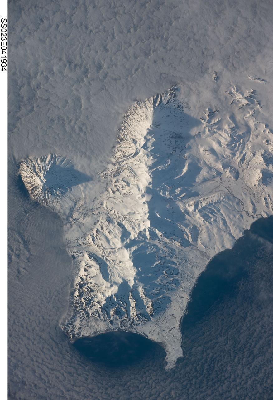
ISS023-E-041934 (12 May 2010) --- Southern Paramushir Island in the Kuril island chain in Russia is featured in this image photographed by an Expedition 23 crew member on the International Space Station. The Kuril island chain consists of a line of volcanoes, many of which have been historically active, that extends from the Kamchatka Peninsula to northern Japan. This line of island volcanoes is known to geologists as an island arc. Island arcs form along an active geologic boundary, typically marked by a deep undersea trench, between two tectonic plates with one being driven beneath the other (a process called subduction). Magma generated by this process feeds volcanoes ? and eventually, volcanic islands ? over the subduction boundary. Paramushir Island in the northern Kurils is an example of a large island built by several volcanoes over geologic time. This photograph shows the southern end of Paramushir Island after a snowfall. There are four major volcanic centers that form this part of the island. Fuss Peak (center left) is an isolated stratovolcano connected to the main island via an isthmus. The last recorded historical eruption of Fuss Peak was in 1854. The southern tip of the island is occupied by the Karpinsky Group of three volcanic centers. A minor eruption of ash following an earthquake occurred on this part of the island in 1952. The Lomonosov Group to the northeast (center) includes four cinder cones and a lava dome that produced several lava flows extending from the central ridge to the east, northeast, west, and southeast. There have been no recorded historical eruptions from the Lomonosov Group of volcanoes. The most recent volcanic activity (in 2008) occurred at the Chikurachki cone located along the northern coastline of the island at top center. The summit of this volcano (1816 meters above sea level) is the highest on Paramushir Island. Much of the Sea of Okhotsk visible in the image is covered with low clouds that typically form around the islands in the Kuril chain. The clouds are generated by moisture-laden air passing over the cool sea/ocean water and typically wrap around the volcanic islands.
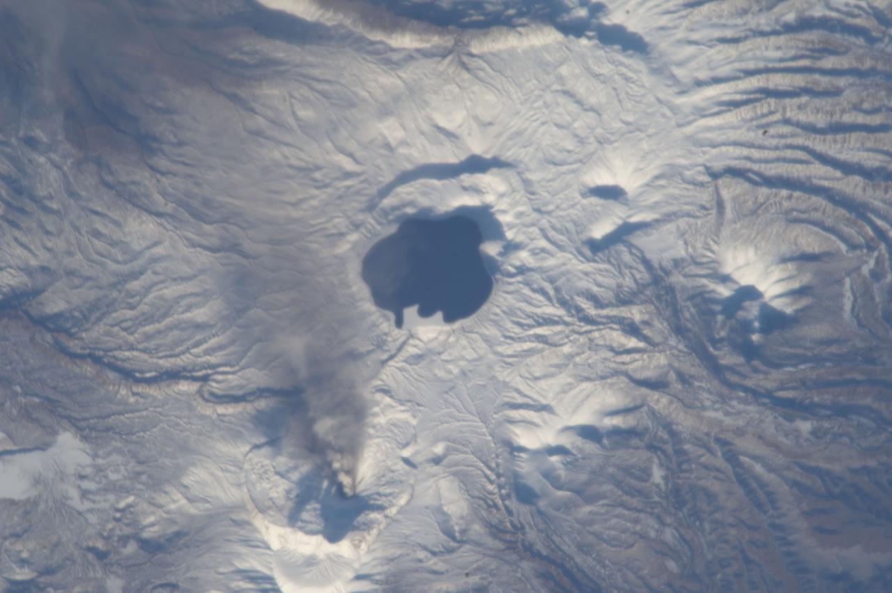
ISS033-E-019822 (9 Nov. 2012) --- An eruption plume from the Karymsky volcano on the Kamchatka Peninsula in the Russian Federation is visible in this image photographed by an Expedition 33 crew member on the International Space Station. The Karymsky stratovolcano stands 1,536 meters above sea level, with most eruptions and occasional lava flows originating from the summit. Karymsky is the most active of Kamchatka’s eastern volcanoes, with almost constant (on a geologic time scale) volcanism occurring since at least the late 18th century when the historical record for the region begins. In light of the high levels of volcanic activity on the Kamchatka Peninsula, the Kamchatka Volcanic Eruption Response Team (KVERT) monitors the activity levels of several volcanoes and issues updates including aviation alerts and webcams. KVERT reported moderate seismic activity at Karymsky during 2-9 Nov. 2012; such activity can indicate movement of magma beneath or within a volcanic structure and can indicate that an eruption is imminent. The Tokyo Volcanic Ash Advisory Center (VAAC) subsequently reported an explosive eruption at Karymsky on Nov. 9, 2012 at 22:15 GMT. This photograph of the resulting ash plume was taken approximately one hour and 35 minutes after the eruption began. The plume extends from the summit of Karymsky (bottom center) to the southeast, with brown ash deposits darkening the snow cover below the plume. The Akademia Nauk caldera – now filled with water to form the present-day Karymsky Lake - is located to the south of Karymsky volcano. Calderas are formed by explosive eruption and emptying of a volcano’s magma chamber – leading to collapse of the structure to form a large crater-like depression. Akademia Nauk last erupted in 1996.
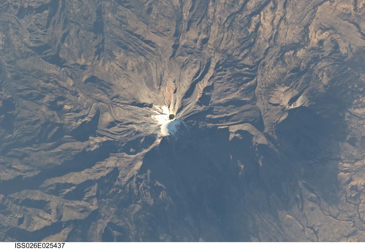
ISS026-E-025437 (10 Feb. 2011) --- Pico de Orizaba, Mexico is featured in this image photographed by an Expedition 26 crew member on the International Space Station. The snow and ice-clad peak of Pico de Orizaba (also known as Citlaltepetl) boasts a summit elevation of 5,675 meters (18,619 feet) above sea level, making it the highest peak in Mexico and North America’s highest volcano. It is also one of three volcanic peaks in Mexico—together with Popocatepetl and Iztaccihuatl—that retain summit glaciers. Pico de Orizaba is part of the Trans-Mexican Volcanic Belt that extends roughly east-west across Mexico. The last recorded eruption took place in 1846; while the volcano is considered dormant at present, geologists continue to investigate the potential hazards associated with a renewal of activity. Shadows accentuate several features of the Pico de Orizaba stratovolcano visible in this photograph from the space station. The 300-meter-deep summit crater is clearly visible against surrounding ice and snow cover at center. Several lava flows extend down the flanks of the volcano, made readily visible by prominent cooling ridges along their sides known as flow levees—one of the most clearly visible examples is located on the southwest flank of the cone. The extinct Sierra Negra volcano to the southwest has a summit elevation of 4,640 meters (15,223 feet) above sea level; while not as lofty as Pico de Orizaba, it is also one of Mexico’s highest peaks.
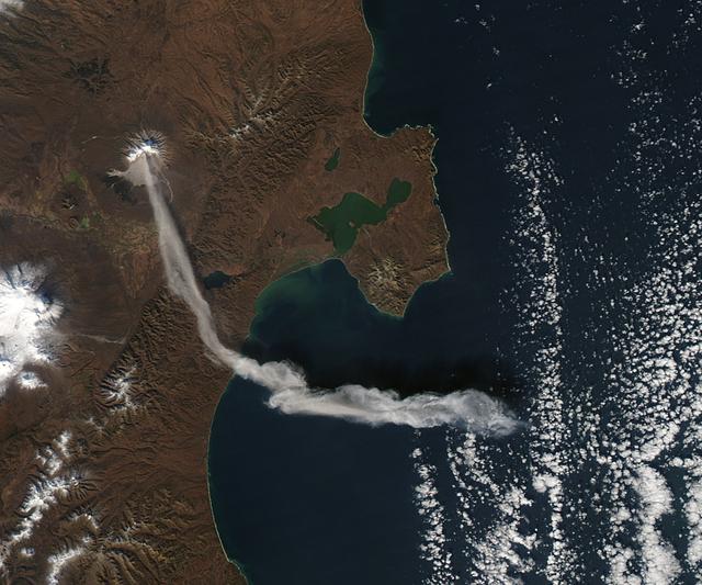
When NASA’s Terra satellite passed over Russia’s Kamchatka Peninsula at noon local time (00:00 Universal Time) on October 6, 2012, Shilveluch Volcano was quiet. By the time NASA’s Aqua satellite passed over the area two hours later (bottom image), the volcano had erupted and sent a plume of ash over the Kamchatskiy Zaliv. The plume traveled about 90 kilometers (55 miles) toward the south-southeast, where a change in wind direction began pushing the plume toward the east. On October 6, 2012, the Kamchatka Volcanic Emergency Response Team (KVERT) reported that the ash plume from Shiveluch reached an altitude of 3 kilometers (9,800 feet) above sea level, and had traveled some 220 kilometers (140 miles) from the volcano summit. Shiveluch (also spelled Sheveluch) ranks among the biggest and most active volcanoes on the Kamchatka Peninsula. Rising to 3,283 meters (10,771 feet) above sea level, Shiveluch is a stratovolcano composed of alternating layers of hardened lava, compacted ash, and rocks ejected by previous eruptions. The beige-colored expanse of rock on the volcano’s southern slopes (visible in both images) is due to an explosive eruption that occurred in 1964. Part of Shiveluch’s southern flank collapsed, and the light-colored rock is avalanche debris left by that event. High-resolution imagery of Shiveluch shows very little vegetation within that avalanche zone. On October 6, 2012, KVERT cited observations from the Moderate Resolution Imaging Spectroradiometer (MODIS) instruments on Terra and Aqua in detecting the Shiveluch eruption. This was not the first time that MODIS observed a Shiveluch eruption shortly after it started. In 2007, MODIS captured an image within minutes of the eruption’s start, before winds could blow the ash away from the summit. When NASA’s Terra satellite passed over Russia’s Kamchatka Peninsula at noon local time (00:00 Universal Time) on October 6, 2012, Shilveluch Volcano was quiet (top image). By the time NASA’s Aqua satellite passed over the area two hours later (bottom image), the volcano had erupted and sent a plume of ash over the Kamchatskiy Zaliv. The plume traveled about 90 kilometers (55 miles) toward the south-southeast, where a change in wind direction began pushing the plume toward the east. On October 6, 2012, the Kamchatka Volcanic Emergency Response Team (KVERT) reported that the ash plume from Shiveluch reached an altitude of 3 kilometers (9,800 feet) above sea level, and had traveled some 220 kilometers (140 miles) from the volcano summit. Shiveluch (also spelled Sheveluch) ranks among the biggest and most active volcanoes on the Kamchatka Peninsula. Rising to 3,283 meters (10,771 feet) above sea level, Shiveluch is a stratovolcano composed of alternating layers of hardened lava, compacted ash, and rocks ejected by previous eruptions. The beige-colored expanse of rock on the volcano’s southern slopes (visible in both images) is due to an explosive eruption that occurred in 1964. Part of Shiveluch’s southern flank collapsed, and the light-colored rock is avalanche debris left by that event. High-resolution imagery of Shiveluch shows very little vegetation within that avalanche zone. On October 6, 2012, KVERT cited observations from the Moderate Resolution Imaging Spectroradiometer (MODIS) instruments on Terra and Aqua in detecting the Shiveluch eruption. This was not the first time that MODIS observed a Shiveluch eruption shortly after it started. In 2007, MODIS captured an image within minutes of the eruption’s start, before winds could blow the ash away from the summit. Credit: <b><a href="http://www.earthobservatory.nasa.gov/" rel="nofollow"> NASA Earth Observatory</a></b> <b><a href="http://www.nasa.gov/audience/formedia/features/MP_Photo_Guidelines.html" rel="nofollow">NASA image use policy.</a></b> <b><a href="http://www.nasa.gov/centers/goddard/home/index.html" rel="nofollow">NASA Goddard Space Flight Center</a></b> enables NASA’s mission through four scientific endeavors: Earth Science, Heliophysics, Solar System Exploration, and Astrophysics. Goddard plays a leading role in NASA’s accomplishments by contributing compelling scientific knowledge to advance the Agency’s mission. <b>Follow us on <a href="http://twitter.com/NASA_GoddardPix" rel="nofollow">Twitter</a></b> <b>Like us on <a href="http://www.facebook.com/pages/Greenbelt-MD/NASA-Goddard/395013845897?ref=tsd" rel="nofollow">Facebook</a></b> <b>Find us on <a href="http://instagrid.me/nasagoddard/?vm=grid" rel="nofollow">Instagram</a></b>
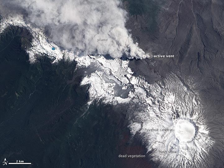
NASA image acquired December 23, 2011 In early June 2011, Chile’s Puyehue-Cordón Caulle Volcano erupted explosively, sending volcanic ash around the Southern Hemisphere. In late December 2011, activity at the volcano had calmed, but volcanic ash and steam continued to pour through the fissure that opened several months earlier. The Advanced Land Imager (ALI) on NASA’s Earth Observing-1 (EO-1) satellite captured this natural-color image on December 23, 2011. The active fissure lies northwest of the Puyehue caldera, and a plume blows from the fissure toward the west and north. This image shows not just ash but also snow on the volcano surface, including the caldera. Because volcanic ash regularly coats the land surface, the pristine snow probably fell recently. In a bulletin issued December 26, 2011, Chile’s Servicio Nacional de Geología y Minería (SERNAGEOMIN) characterized the activity over the previous 24 hours as a minor eruption of low intensity. Reaching an altitude of 2,236 meters (7,336 feet), Puyehue-Cordón Caulle is a stratovolcano, a steep-sloped, conical volcano composed of layers of ash, lava, and rocks released by previous eruptions. This volcano comprises part of the largest active geothermal area in the southern Andes. NASA Earth Observatory image created by Jesse Allen, using EO-1 ALI data provided courtesy of the NASA EO-1 team. Caption by Michon Scott. Instrument: EO-1 - ALI To view more images from this event go here: <a href="http://earthobservatory.nasa.gov/NaturalHazards/event.php?id=50859" rel="nofollow">earthobservatory.nasa.gov/NaturalHazards/event.php?id=50859</a> Credit: <b><a href="http://www.earthobservatory.nasa.gov/" rel="nofollow"> NASA Earth Observatory</a></b> <b><a href="http://www.nasa.gov/audience/formedia/features/MP_Photo_Guidelines.html" rel="nofollow">NASA image use policy.</a></b> <b><a href="http://www.nasa.gov/centers/goddard/home/index.html" rel="nofollow">NASA Goddard Space Flight Center</a></b> enables NASA’s mission through four scientific endeavors: Earth Science, Heliophysics, Solar System Exploration, and Astrophysics. Goddard plays a leading role in NASA’s accomplishments by contributing compelling scientific knowledge to advance the Agency’s mission. <b>Follow us on <a href="http://twitter.com/NASA_GoddardPix" rel="nofollow">Twitter</a></b> <b>Like us on <a href="http://www.facebook.com/pages/Greenbelt-MD/NASA-Goddard/395013845897?ref=tsd" rel="nofollow">Facebook</a></b> <b>Find us on <a href="http://instagrid.me/nasagoddard/?vm=grid" rel="nofollow">Instagram</a></b>
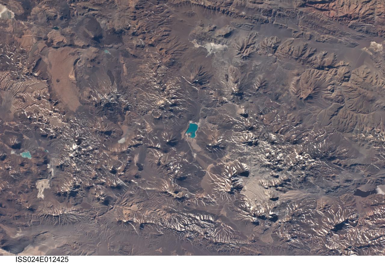
ISS024-E-012425 (22 Aug. 2010) --- This photograph, featuring a landscape in the central Andes mountains near the Chile/Argentina border dominated by numerous volcanoes and associated landforms, was photographed by an Expedition 24 crew member on the International Space Station. Layers of older sedimentary rocks are visible to the southeast (upper right). Many of the volcanic cones show grooves eroded by water to form gullies. Such erosion has occurred since the host volcano was built up, indicating that most volcanoes in this view have been inactive for centuries or millennia. A few volcanoes exhibit much less erosion, and even show tongues of recent, dark lava flows (top left). According to scientists, two of these volcanoes, Cerro el Condor and Peinado have likely erupted within approximately the last 12,000 years (the Holocene Epoch). Also visible in the image is the world’s highest active volcano, Nevado Ojos del Salado, with a summit at 6,887 meters above sea level. The most recent confirmed eruption of this volcano has been dated to 700 (approximately 300 years), but minor eruptive activity may have occurred as recently as 1993. Stratovolcanoes such as Cerro el Condor, Peinado, and Nevado Ojos del Salado are formed partly by buildup of lava flows and partly by buildup of explosively vented material dropping back down onto the surface. One type of material associated with explosive eruptions is welded tuff, which is formed by molten and fragmented rock that accumulates on the ground and later solidifies. A large tuff sheet is visible at top left. Formed very rapidly, these sheets have been termed “instant landscapes.” So active has the Andean volcanic system been that the origin of many of the tuffs in the Andes cannot be pinpointed since source vents have been overprinted by subsequent volcanic events. The volcanic landscape also shows that the erosive work of rivers—and glaciers repeatedly in the recent past—is slower than the opposite processes of the upward building of the volcanoes. The bright blue, nearly 7-kilometer-long lake near the center of the image is known as Laguna Verde. This and other less obvious lakes indicate that water (snowmelt or direct precipitation) is unable to reach the sea, but is rather impounded in the depressions between the volcanic edifices.
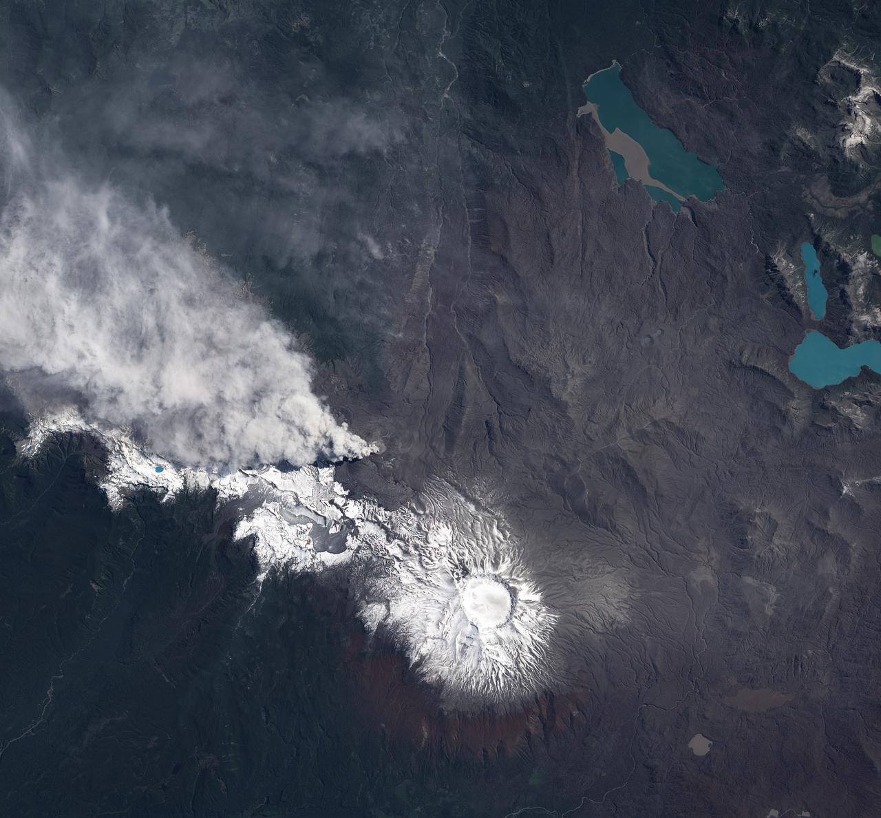
NASA image acquired December 23, 2011 In early June 2011, Chile’s Puyehue-Cordón Caulle Volcano erupted explosively, sending volcanic ash around the Southern Hemisphere. In late December 2011, activity at the volcano had calmed, but volcanic ash and steam continued to pour through the fissure that opened several months earlier. The Advanced Land Imager (ALI) on NASA’s Earth Observing-1 (EO-1) satellite captured this natural-color image on December 23, 2011. The active fissure lies northwest of the Puyehue caldera, and a plume blows from the fissure toward the west and north. This image shows not just ash but also snow on the volcano surface, including the caldera. Because volcanic ash regularly coats the land surface, the pristine snow probably fell recently. In a bulletin issued December 26, 2011, Chile’s Servicio Nacional de Geología y Minería (SERNAGEOMIN) characterized the activity over the previous 24 hours as a minor eruption of low intensity. Reaching an altitude of 2,236 meters (7,336 feet), Puyehue-Cordón Caulle is a stratovolcano, a steep-sloped, conical volcano composed of layers of ash, lava, and rocks released by previous eruptions. This volcano comprises part of the largest active geothermal area in the southern Andes. NASA Earth Observatory image created by Jesse Allen, using EO-1 ALI data provided courtesy of the NASA EO-1 team. Caption by Michon Scott. Instrument: EO-1 - ALI To view more images from this event go here: <a href="http://earthobservatory.nasa.gov/NaturalHazards/event.php?id=50859" rel="nofollow">earthobservatory.nasa.gov/NaturalHazards/event.php?id=50859</a> Credit: <b><a href="http://www.earthobservatory.nasa.gov/" rel="nofollow"> NASA Earth Observatory</a></b> <b><a href="http://www.nasa.gov/audience/formedia/features/MP_Photo_Guidelines.html" rel="nofollow">NASA image use policy.</a></b> <b><a href="http://www.nasa.gov/centers/goddard/home/index.html" rel="nofollow">NASA Goddard Space Flight Center</a></b> enables NASA’s mission through four scientific endeavors: Earth Science, Heliophysics, Solar System Exploration, and Astrophysics. Goddard plays a leading role in NASA’s accomplishments by contributing compelling scientific knowledge to advance the Agency’s mission. <b>Follow us on <a href="http://twitter.com/NASA_GoddardPix" rel="nofollow">Twitter</a></b> <b>Like us on <a href="http://www.facebook.com/pages/Greenbelt-MD/NASA-Goddard/395013845897?ref=tsd" rel="nofollow">Facebook</a></b> <b>Find us on <a href="http://instagrid.me/nasagoddard/?vm=grid" rel="nofollow">Instagram</a></b>
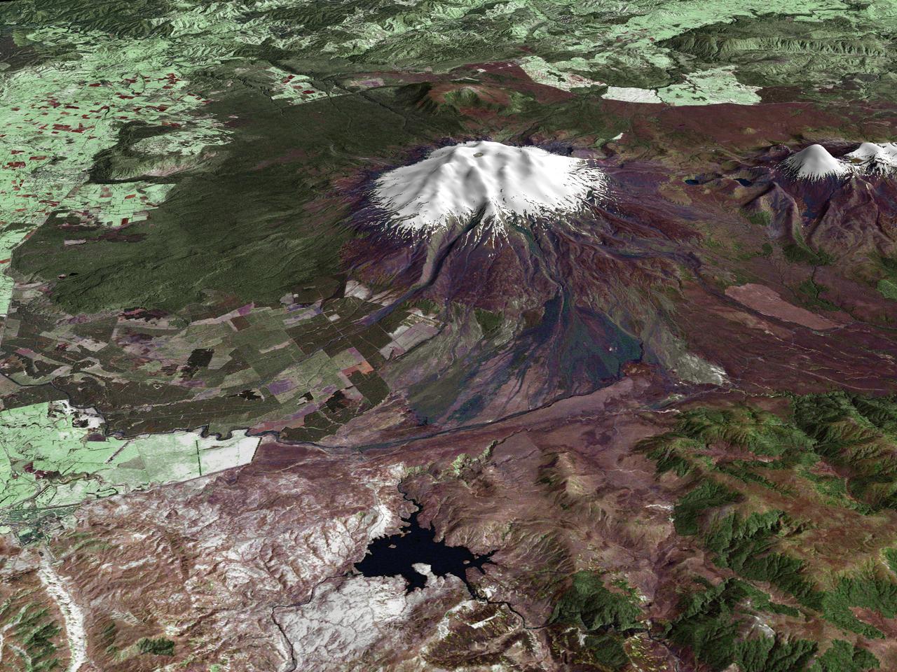
All around the world, people live in places where the threat of natural disaster is high. On the North Island of New Zealand, the Mount Ruapehu volcano is just such a threat. A towering, active stratovolcano (the classic cone-shaped volcano), snow-capped Ruapehu Volcano is pictured in this enhanced-color image. The image is made from topography data collected by the Shuttle Radar Topography Mission aboard the Space Shuttle Endeavour, launched on February 11, 2000, and imagery collected by the Landsat satellite on October 23, 2002. Ruapehu is one of New Zealand’s most active volcanoes, with ten eruptions since 1861. The eruptions aren’t the only threat from the volcano, however. Among the most serious threats is a volcanic mudflow called a lahar. In between eruptions, a lake forms in the volcano’s caldera from melting snow. If a previous eruption has deposited a dam of ash, rocks and mud in the lake’s natural overflow point, then the lake becomes dangerously full, held back only by the temporary dam. In this scene, the lake is nestled among the ridges at the top of the volcano. Eventually, the dam gives way and a massive flow of mud and debris churns down the mountain toward farmland and towns below. Scientists estimate that Ruapehu has experienced 60 lahars in the last 150 years. A devastating lahar in 1953 killed more than 150 people, who died when a passenger train plunged into a ravine when a railroad bridge was taken out by the lahar. The flank of the volcano below the lake is deeply carved by the path of previous lahars; the gouge can be seen just left of image center. Currently scientists in the region are predicting that the lake will overflow in a lahar sometime in the next year. There is great controversy about how to deal with the threat. News reports from the region indicate that the government is planning to invest in a high-tech warning system that will alert those who might be affected well in advance of any catastrophic release. Others feel that the government should combat the threat through engineering at the top of the mountain, for example, by undertaking a controlled release of the lake. Credit Landsat data provided courtesy of the University of Maryland Global Land Cover Facility Landsat processing by Laura Rocchio, Landsat Project Science Office SRTM 3-arcsecond elevation data courtesy of SRTM Team NASA/JPL/NIMA Visualization created by Earth Observatory staff. <b><a href="http://www.nasa.gov/centers/goddard/home/index.html" rel="nofollow">NASA Goddard Space Flight Center</a></b> enables NASA’s mission through four scientific endeavors: Earth Science, Heliophysics, Solar System Exploration, and Astrophysics. Goddard plays a leading role in NASA’s accomplishments by contributing compelling scientific knowledge to advance the Agency’s mission. <b>Follow us on <a href="http://twitter.com/NASA_GoddardPix" rel="nofollow">Twitter</a></b> <b>Join us on <a href="http://www.facebook.com/pages/Greenbelt-MD/NASA-Goddard/395013845897?ref=tsd" rel="nofollow">Facebook</a></b>