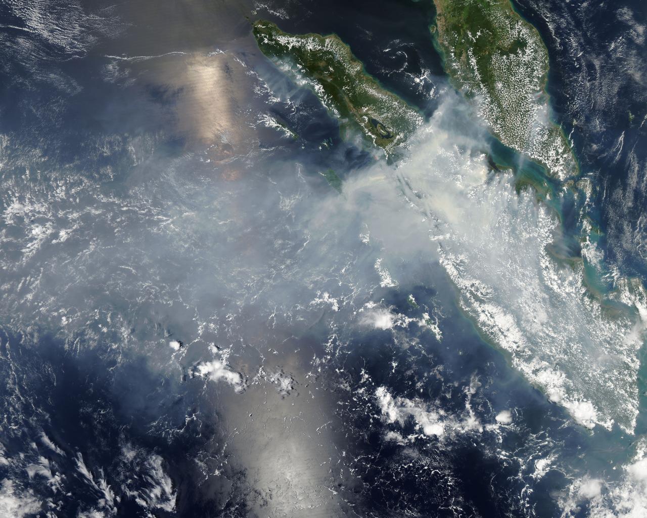
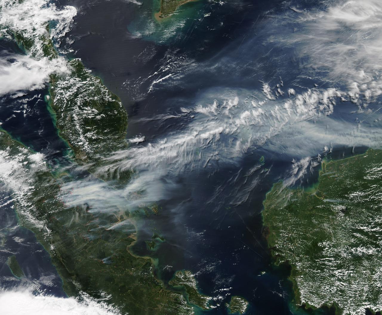
Fires burning in Sumatra continued to pour smoke over the region in mid-March, 2014, bringing air quality to dangerous levels. The Moderate Resolution Imaging Spectroradiometer (MODIS) aboard NASA’s Aqua satellite captured this true-color image of the smoke and haze across the region on March 12. According to the Jakarta Post, on March 12 the Sumatra Environmental Laboratory reported that 10 of 12 spots in Riau had an air quality of index above 300 on the Pollutant Standards Index (PSI), which is considered hazardous. Hazardous air quality had been recorded in some of the locations for 11 consecutive days. The province of Riau is located in the central eastern coast of Sumatra and, in this image, is hidden under thick bands of light gray smoke. Intense fires, reported as deliberately set to clear land, were burning in the Giam Siak Kecil-Bukit Batu biosphere reserve. This reserve contains over 700,000 hectares of sensitive peat forest that sustains a wide range of plant and animal species, including the Sumatra tiger, elephant, tapir and sun bear. With visibility as low as 500 m (1640 ft), 58 flights were cancelled in Pekanbaru, the capital of Riau province, on March 11. Schools were closed across the region, with 43,000 students affected in Payakumbuh, West Sumatra. On March 14, Selangor, Malaysia closed 203 schools, affecting 211,700 pupils, until the air quality improved. On that same day, according to Riau Health Agency, more than 55,000 residents in the province were suffering from haze-related illnesses, including acute respiratory infections, pneumonia and skin and eye irritation. Poor air quality not only affected transportation, human health and the ecosystem, but has had significant economic impacts. On March 17, Reuters reported that the poor air quality had forced Chevron, the country’s biggest oil producer, to close hundreds of its wells. As a result, Indonesia’s crude oil output dropped to 790,000 barrels per day (bpd) – significantly lower than the 870,000 bpd target. Although slash-and-burn techniques, which use fire to clear land, is illegal in Indonesia, the practice is still widespread, with approximately 99% of fires in Sumatra considered to be intentionally set. This year’s early agricultural fires began in February in Riau Province, home to palm-oil and pulpwood plantations. The emergency has prompted strong government response, including a shoot-on-sight order for any suspects involved in land burning activities that resisted arrest. According to the Jakarta Post, police have named as many as 60 suspected-fire starters in Riau. Credit: NASA/GSFC/Jeff Schmaltz/MODIS Land Rapid Response Team <b><a href="http://www.nasa.gov/audience/formedia/features/MP_Photo_Guidelines.html" rel="nofollow">NASA image use policy.</a></b> <b><a href="http://www.nasa.gov/centers/goddard/home/index.html" rel="nofollow">NASA Goddard Space Flight Center</a></b> enables NASA’s mission through four scientific endeavors: Earth Science, Heliophysics, Solar System Exploration, and Astrophysics. Goddard plays a leading role in NASA’s accomplishments by contributing compelling scientific knowledge to advance the Agency’s mission. <b>Follow us on <a href="http://twitter.com/NASAGoddardPix" rel="nofollow">Twitter</a></b> <b>Like us on <a href="http://www.facebook.com/pages/Greenbelt-MD/NASA-Goddard/395013845897?ref=tsd" rel="nofollow">Facebook</a></b> <b>Find us on <a href="http://instagram.com/nasagoddard?vm=grid" rel="nofollow">Instagram</a></b>
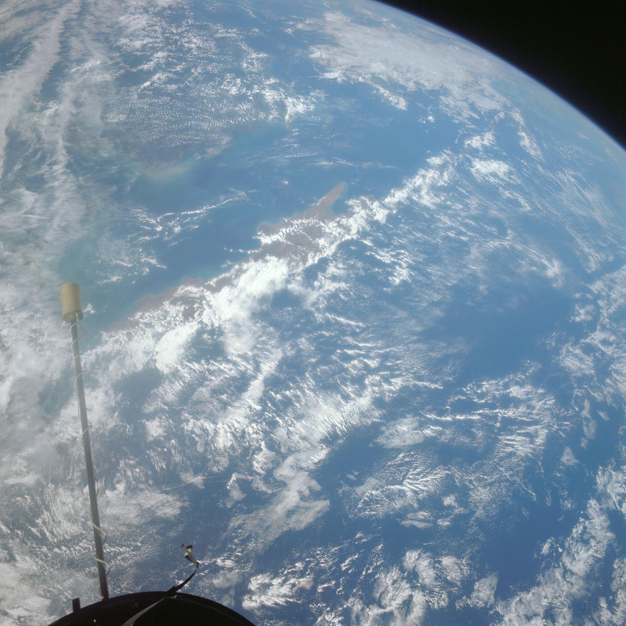
Middle school students across the country photographed the fires and smoke over southern Sumatra from a camera aboard the Space Shuttle Atlantis September 27, 1997.
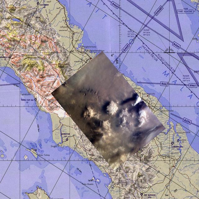
This map corresponds to NASA KidSat image MET 00215424 of the northern regions of Sumatra that was captured on Sept., 1997 during the Shuttle flight STS-86.

Middle school students across the country photographed the fires and smoke over southern Sumatra from a camera aboard the Space Shuttle Atlantis September 27, 1997.
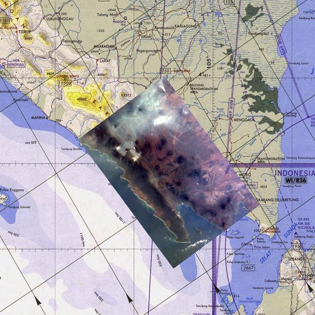
Middle school students across the country photographed the fires and smoke over southern Sumatra from a camera aboard the Space Shuttle Atlantis September 27, 1997.
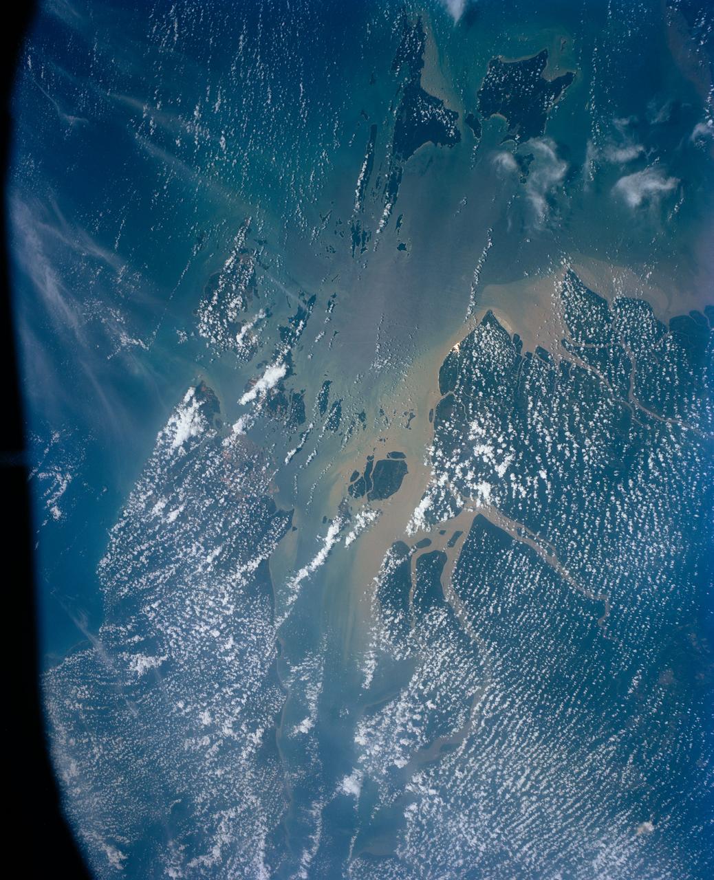
This view shows the area around Northeastern Sumatra, Indonesia (1.0N, 104.0E). The city of Singapore and the Singapore Strait is in the center at the southern tip of the Malay Peninsula. The Singapore Strait is the eastern extension of the Strait of Malacca and separates the Malay Peninsula from Sumatra. Large sediment plumes from the rivers attest to the local soil erosion and industrial dumping ofd wastes.
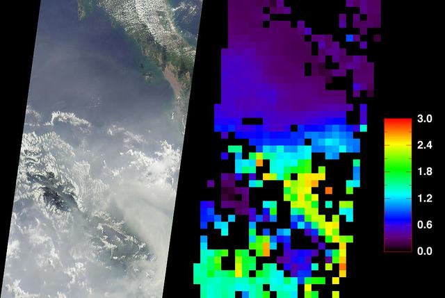
These data products from NASA Terra satellite document the presence of airborne particulates on March 13, 2002, during Terra orbit 11880. At least once a year for a period lasting from a week to several months, northern Sumatra is obscured by smoke and
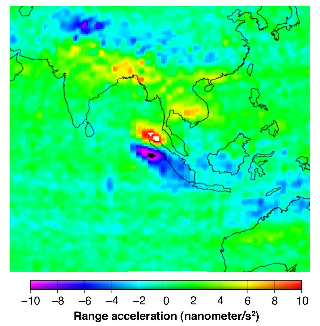
This figure shows the effect of the December 2004 great Sumatra earthquake on the Earth’s gravity field as observed by NASA GRACE.
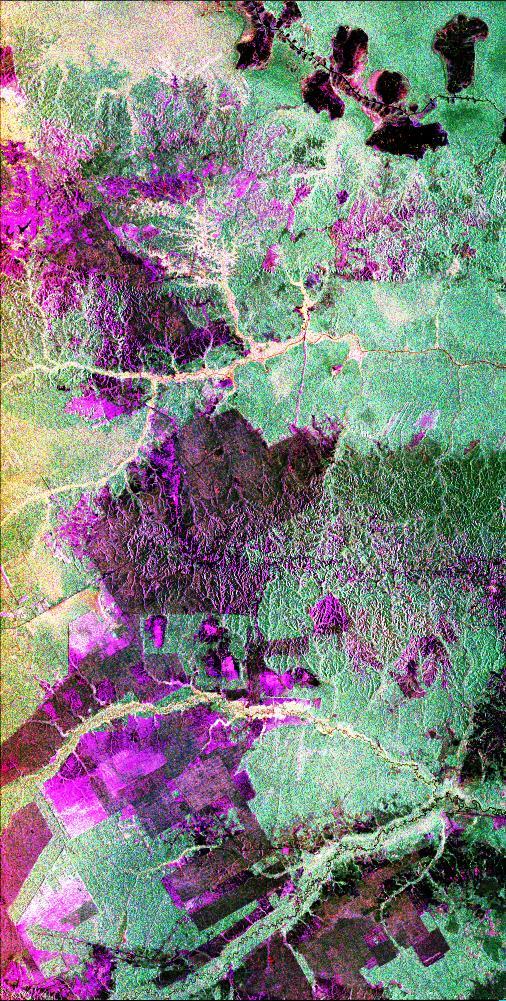
This is a radar image of the central part of the island of Sumatra in Indonesia that shows how the tropical rainforest typical of this country is being impacted by human activity. Native forest appears in green in this image, while prominent pink areas represent places where the native forest has been cleared. The large rectangular areas have been cleared for palm oil plantations. The bright pink zones are areas that have been cleared since 1989, while the dark pink zones are areas that were cleared before 1989. These radar data were processed as part of an effort to assist oil and gas companies working in the area to assess the environmental impact of both their drilling operations and the activities of the local population. Radar images are useful in these areas because heavy cloud cover and the persistent smoke and haze associated with deforestation have prevented usable visible-light imagery from being acquired since 1989. The dark shapes in the upper right (northeast) corner of the image are a chain of lakes in flat coastal marshes. This image was acquired in October 1994 by the Spaceborne Imaging Radar C/X-Band Synthetic Aperture Radar (SIR-C/X-SAR) onboard the space shuttle Endeavour. Environmental changes can be easily documented by comparing this image with visible-light data that were acquired in previous years by the Landsat satellite. The image is centered at 0.9 degrees north latitude and 101.3 degrees east longitude. The area shown is 50 kilometers by 100 kilometers (31 miles by 62 miles). The colors in the image are assigned to different frequencies and polarizations of the radar as follows: red is L-band horizontally transmitted, horizontally received; green is L-band horizontally transmitted, vertically received; blue is L-band vertically transmitted, vertically received. SIR-C/X-SAR, a joint mission of the German, Italian and United States space agencies, is part of NASA's Mission to Planet Earth program. http://photojournal.jpl.nasa.gov/catalog/PIA01797
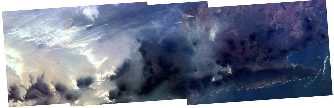
Middle school students across the country photographed the fires and smoke over southern Sumatra from a camera aboard the Space Shuttle Atlantis September 27, 1997.
On 26 December 2004, a magnitude 9.0 earthquake occurred off the west coast of Sumatra, Indonesia. These views were acquired by NASA Terra spacecraft.
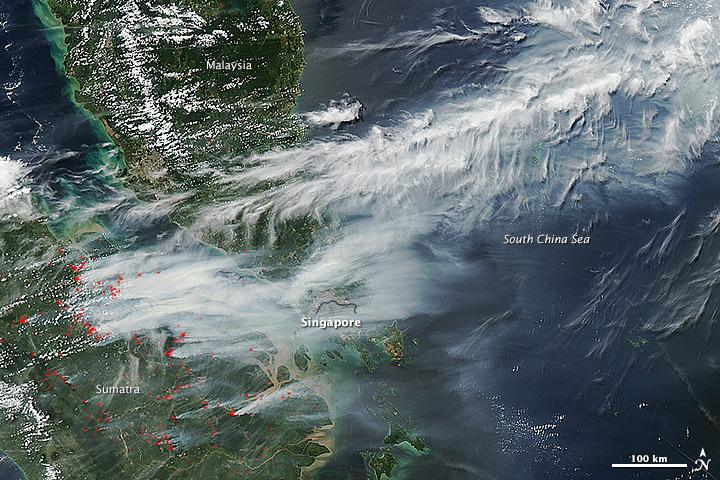
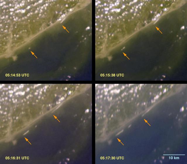
On June 19, 2013, NASA’s Aqua satellite captured a striking image of smoke billowing from illegal wildfires on the Indonesian island of Sumatra. The smoke blew east toward southern Malaysia and Singapore, and news media reported that thick clouds of haze had descended on Singapore, pushing pollution levels to record levels. Singapore’s primary measure of pollution, the Pollutant Standards Index (PSI)—a uniform measure of key pollutants similar to the Air Quality Index (AQI) used by the U.S. Environmental Protection Agency—spiked to 371 on the afternoon of June 20, 2013, the highest level ever recorded. The previous record occurred in 1997, when the index hit 226. Health experts consider any level above 300 to be “hazardous” to human health. Levels above 200 are considered “very unhealthy.” The image above was captured by the Moderate Resolution Imaging Spectroradiometer (MODIS), an instrument that observes the entire surface of Earth’s every 1 to 2 days. The image was captured during the afternoon at 6:30 UTC (2:30 p.m. local time). Though local laws prohibit it, farmers in Sumatra often burn forests during the dry season to prepare soil for new crops. The BBC reported that Singapore’s Prime Minister Lee Hsien Loong warned that the haze could “easily last for several weeks and quite possibly longer until the dry season ends in Sumatra.” NASA image by Jeff Schmaltz, LANCE/EOSDIS Rapid Response. Caption by Adam Voiland. Credit: <b><a href="http://www.earthobservatory.nasa.gov/" rel="nofollow"> NASA Earth Observatory</a></b> Instrument: Aqua - MODIS <b><a href="http://www.nasa.gov/audience/formedia/features/MP_Photo_Guidelines.html" rel="nofollow">NASA image use policy.</a></b> <b><a href="http://www.nasa.gov/centers/goddard/home/index.html" rel="nofollow">NASA Goddard Space Flight Center</a></b> enables NASA’s mission through four scientific endeavors: Earth Science, Heliophysics, Solar System Exploration, and Astrophysics. Goddard plays a leading role in NASA’s accomplishments by contributing compelling scientific knowledge to advance the Agency’s mission. <b>Follow us on <a href="http://twitter.com/NASA_GoddardPix" rel="nofollow">Twitter</a></b> <b>Like us on <a href="http://www.facebook.com/pages/Greenbelt-MD/NASA-Goddard/395013845897?ref=tsd" rel="nofollow">Facebook</a></b> <b>Find us on <a href="http://instagram.com/nasagoddard?vm=grid" rel="nofollow">Instagram</a></b>
On June 19, 2013, NASA’s Aqua satellite captured a striking image of smoke billowing from illegal wildfires on the Indonesian island of Sumatra. The smoke blew east toward southern Malaysia and Singapore, and news media reported that thick clouds of haze had descended on Singapore, pushing pollution levels to record levels. Singapore’s primary measure of pollution, the Pollutant Standards Index (PSI)—a uniform measure of key pollutants similar to the Air Quality Index (AQI) used by the U.S. Environmental Protection Agency—spiked to 371 on the afternoon of June 20, 2013, the highest level ever recorded. The previous record occurred in 1997, when the index hit 226. Health experts consider any level above 300 to be “hazardous” to human health. Levels above 200 are considered “very unhealthy.” The image above was captured by the Moderate Resolution Imaging Spectroradiometer (MODIS), an instrument that observes the entire surface of Earth’s every 1 to 2 days. The image was captured during the afternoon at 6:30 UTC (2:30 p.m. local time). Though local laws prohibit it, farmers in Sumatra often burn forests during the dry season to prepare soil for new crops. The BBC reported that Singapore’s Prime Minister Lee Hsien Loong warned that the haze could “easily last for several weeks and quite possibly longer until the dry season ends in Sumatra.” NASA image by Jeff Schmaltz, LANCE/EOSDIS Rapid Response. Caption by Adam Voiland. Credit: <b><a href="http://www.earthobservatory.nasa.gov/" rel="nofollow"> NASA Earth Observatory</a></b> Instrument: Aqua - MODIS <b><a href="http://www.nasa.gov/audience/formedia/features/MP_Photo_Guidelines.html" rel="nofollow">NASA image use policy.</a></b> <b><a href="http://www.nasa.gov/centers/goddard/home/index.html" rel="nofollow">NASA Goddard Space Flight Center</a></b> enables NASA’s mission through four scientific endeavors: Earth Science, Heliophysics, Solar System Exploration, and Astrophysics. Goddard plays a leading role in NASA’s accomplishments by contributing compelling scientific knowledge to advance the Agency’s mission. <b>Follow us on <a href="http://twitter.com/NASA_GoddardPix" rel="nofollow">Twitter</a></b> <b>Like us on <a href="http://www.facebook.com/pages/Greenbelt-MD/NASA-Goddard/395013845897?ref=tsd" rel="nofollow">Facebook</a></b> <b>Find us on <a href="http://instagram.com/nasagoddard?vm=grid" rel="nofollow">Instagram</a></b>
The initial tsunami waves resulting from the undersea earthquake that occurred at 00:58:53 UTC Coordinated Universal Time on 26 December 2004 off the island of Sumatra, Indonesia, as seen by NASA Terra spacecraft.
As the Space Shuttle Atlantis flew over the Indonesian archipelago on Saturday, Sept. 27, 1997, middle school students across the country used NASA Kidsat camera to photograph the fires and smoke that blanket the island of Sumatra.
ISS010-E-13088 (15 January 2005) --- Tsunami damage, northwestern Sumatra (Indonesia) is featured in this image photographed by an Expedition 10 crewmember on the International Space Station. On December 26, 2004 a large (magnitude 9.0) earthquake occurred off the western coast of Sumatra in the Indian Ocean. Scientists believe the earthquake was caused by the release of stresses accumulated as the India tectonic plate is overridden by the Burma tectonic plate. Movement of the seafloor due to the earthquake generated a tsunami, or seismic sea wave, that affected coastal regions around the Indian Ocean. The northwestern Sumatra coastline in particular suffered extensive damage and loss of life. This photo, along with image ISS010-E-13079, illustrates damage along the southwestern coast of Aceh Province in the vicinity of the city of Lho’ Kruet, Indonesia. The image captures the sunglint illuminating the Indian Ocean and standing water inland (light gray). Distortion and scale differences are caused by increased obliquity of the view from the Station.
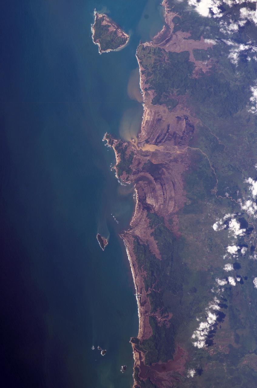
ISS010-E-13079 (15 January 2005) --- Tsunami damage, northwestern Sumatra (Indonesia) is featured in this image photographed by an Expedition 10 crewmember on the International Space Station (ISS). On December 26, 2004 a large (magnitude 9.0) earthquake occurred off the western coast of Sumatra in the Indian Ocean. Scientists believe the earthquake was caused by the release of stresses accumulated as the India tectonic plate is overridden by the Burma tectonic plate. Movement of the seafloor due to the earthquake generated a tsunami, or seismic sea wave, that affected coastal regions around the Indian Ocean. The northwestern Sumatra coastline in particular suffered extensive damage and loss of life. This photo, along with image ISS010-E-13088, illustrates damage along the southwestern coast of Aceh Province in the vicinity of the city of Lho’ Kruet, Indonesia. Large areas of bare and disturbed soil (brownish gray) previously covered with vegetation are visible along the coastline. Embayments in the coastline were particularly hard hit, while adjacent headlands were less affected.

iss071e077638 (May 14, 2024) --- The first rays of an orbital sunrise break through Earth's atmosphere highlighting the cloud tops in this photograph from the International Space Station as it soared 256 miles above the Indian Ocean off the coast of Sumatra, Indonesia.
S66-54692 (14 Sept. 1966) --- Indonesian Islands (partial cloud cover): Sumatra, Java, Bali, Borneo, and Sumbawa, as photographed from the Gemini-11 spacecraft during its 26th revolution of Earth, at an altitude of 570 nautical miles. Photo credit: NASA
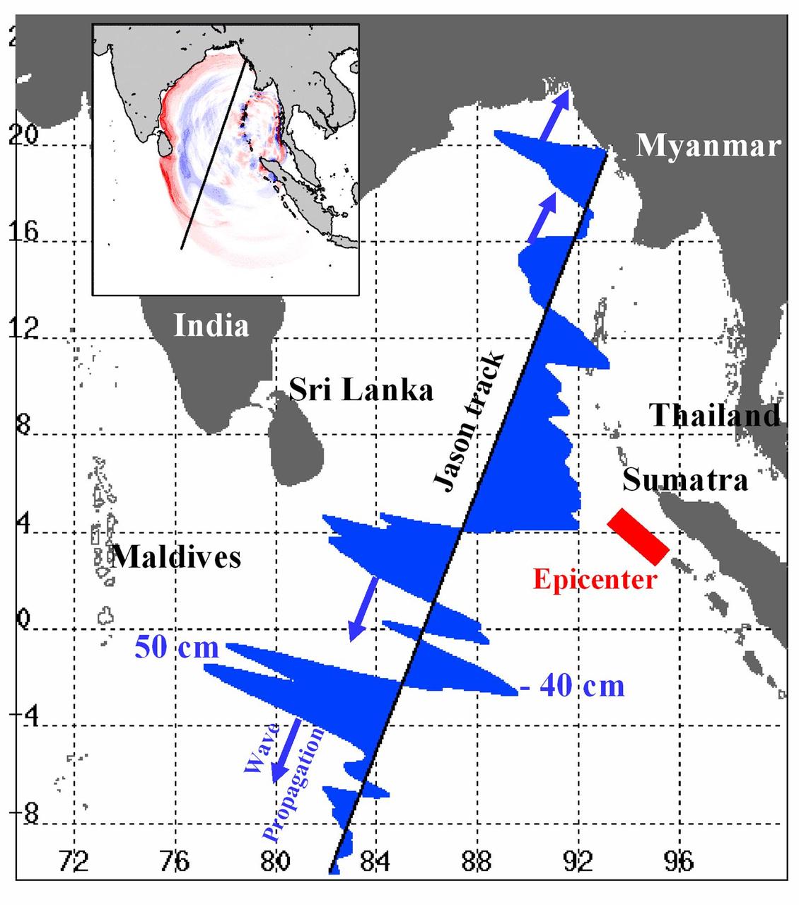
Displayed in blue color is the height of sea surface (shown in blue) measured by the Jason satellite two hours after the initial magnitude 9 earthquake hit the region (shown in red) southwest of Sumatra on December 26, 2004. The data were taken by a radar altimeter onboard the satellite along a track traversing the Indian Ocean when the tsunami waves had just filled the entire Bay of Bengal (see the model simulation inset image). The data shown are the changes of sea surface height from previous observations made along the same track 20-30 days before the earthquake, reflecting the signals of the tsunami waves. The maximum height of the leading wave crest was about 50 cm (or 1.6 ft), followed by a trough of sea surface depression of 40 cm. The directions of wave propagation along the satellite track are shown by the blue arrows. http://photojournal.jpl.nasa.gov/catalog/PIA07219

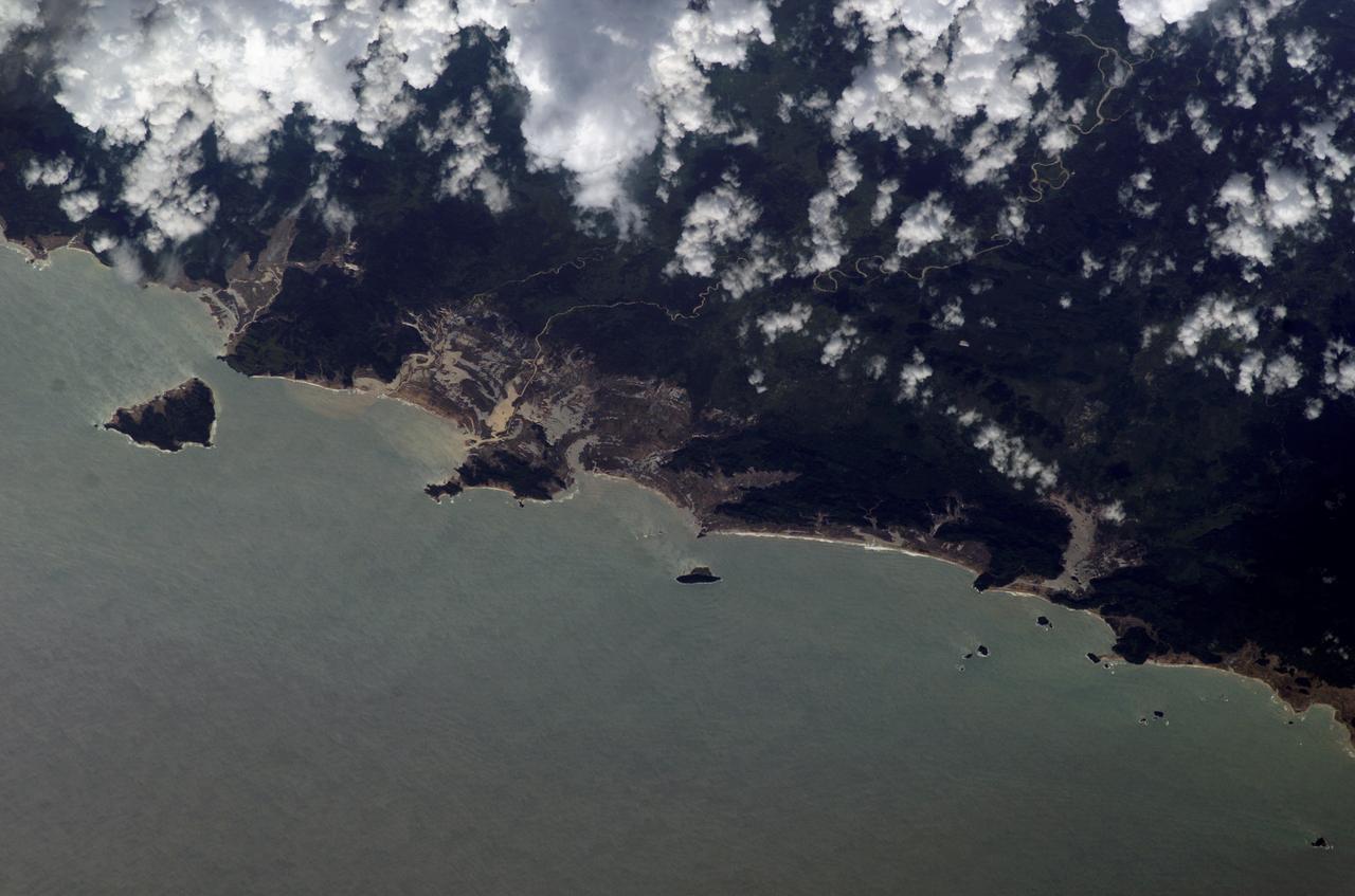
ISS010-E-12730 (11 January 2005) --- One of a series of post-tsunami digital still images photographed from the International Space Station on January 11, 2005. This image is centered at 4.53 degrees north latitude and 95.75 degrees east longitude and is the northwest coast of Sumatra. Some tsunami damage, at least in the form of the lack of vegetation, can be seen along the coast.

iss073e0695491 (Sept. 1, 2025) --- The Canadarm2 robotic arm with Dextre, its fine-tuned robotic hand attached, is pictured extending from the International Space Station as it orbited 258 miles above the Indian Ocean southwest of the Indonesian island of Sumatra. The Earth's horizon is highlighted by the atmospheric glow with a set of the orbital outpost's main solar arrays and a partially obscured SpaceX Dragon cargo spacecraft in the foreground.

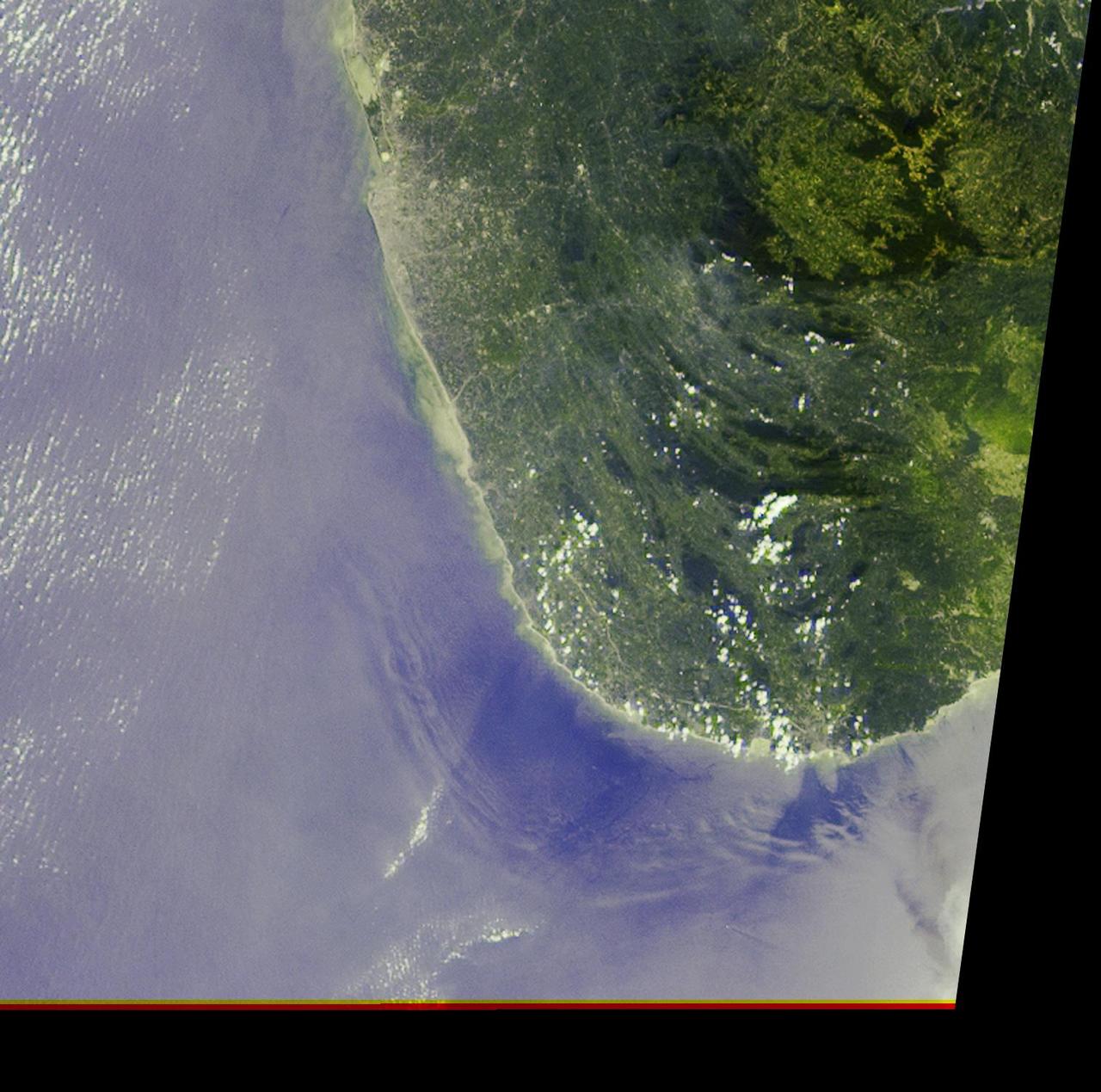
ISS010E12880 (13 January 2005) --- One of a series of post-tsunami digital still images which were photographed from the International Space Station on January 13, 2005 . This image is centered at 4.04 degrees north latitude and 96.28 degrees east longitude on the northwest coast of Sumatra. According to NASA scientists studying the ISS imagery, the frame shows a devegetated coastal condition, caused by the tsunami.

ISS010E12884 (13 January 2005) --- One of a series of post-tsunami digital still images which were photographed from the International Space Station on January 13, 2005 . This image is centered at 4.16 degrees north latitude and 96.15 degrees east longitude on the northwest coast of Sumatra. According to NASA scientists studying the ISS imagery, the frame shows a devegetated coastal condition, caused by the tsunami.

ISS010E12876 (13 January 2005) --- One of a series of post-tsunami digital still images which were photographed from the International Space Station on January 13, 2005. This image is centered at 4.07 degrees north latitude and 96.23 degrees east longitude on the northwest coast of Sumatra. According to NASA scientists studying the ISS imagery, the frame shows a devegetated coastal condition, caused by the tsunami.