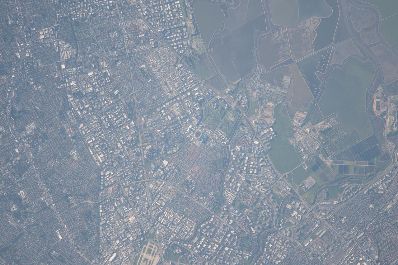
ISS046e035715 (02/08/2016) --- NASA astronaut Scott Kelly acquired this image of Santa Clara, California on Feb. 8, 2016. He tweeted: "Got to see the #SuperBowl in person after all! But at 17,500MPH, it didn't last long. #YearInSpace

Landsat 7 image of Phoenix, Arizona acquired November 28, 2014. Landsat 7 is a U.S. satellite used to acquire remotely sensed images of the Earth's land surface and surrounding coastal regions. It is maintained by the Landsat 7 Project Science Office at the NASA Goddard Space Flight Center in Greenbelt, MD. Landsat satellites have been acquiring images of the Earth’s land surface since 1972. Currently there are more than 2 million Landsat images in the National Satellite Land Remote Sensing Data Archive. For more information visit: <a href="http://landsat.usgs.gov/" rel="nofollow">landsat.usgs.gov/</a>..To learn more about the Landsat satellite go to:.<a href="http://landsat.gsfc.nasa.gov/" rel="nofollow">landsat.gsfc.nasa.gov/</a> Credit: NASA/GSFC/Landsat 7 <b><a href="http://www.nasa.gov/audience/formedia/features/MP_Photo_Guidelines.html" rel="nofollow">NASA image use policy.</a></b> <b><a href="http://www.nasa.gov/centers/goddard/home/index.html" rel="nofollow">NASA Goddard Space Flight Center</a></b> enables NASA’s mission through four scientific endeavors: Earth Science, Heliophysics, Solar System Exploration, and Astrophysics. Goddard plays a leading role in NASA’s accomplishments by contributing compelling scientific knowledge to advance the Agency’s mission. <b>Follow us on <a href="http://twitter.com/NASAGoddardPix" rel="nofollow">Twitter</a></b> <b>Like us on <a href="http://www.facebook.com/pages/Greenbelt-MD/NASA-Goddard/395013845897?ref=tsd" rel="nofollow">Facebook</a></b> <b>Find us on <a href="http://instagrid.me/nasagoddard/?vm=grid" rel="nofollow">Instagram</a></b>
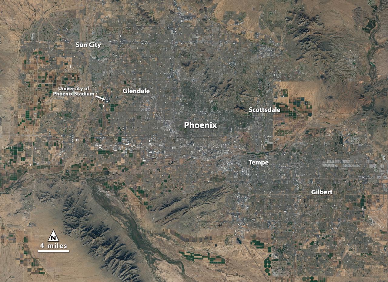
Landsat 7 image of Phoenix, Arizona acquired November 28, 2014. Landsat 7 is a U.S. satellite used to acquire remotely sensed images of the Earth's land surface and surrounding coastal regions. It is maintained by the Landsat 7 Project Science Office at the NASA Goddard Space Flight Center in Greenbelt, MD. Landsat satellites have been acquiring images of the Earth’s land surface since 1972. Currently there are more than 2 million Landsat images in the National Satellite Land Remote Sensing Data Archive. For more information visit: <a href="http://landsat.usgs.gov/" rel="nofollow">landsat.usgs.gov/</a>..To learn more about the Landsat satellite go to:.<a href="http://landsat.gsfc.nasa.gov/" rel="nofollow">landsat.gsfc.nasa.gov/</a> Credit: NASA/GSFC/Landsat 7 <b><a href="http://www.nasa.gov/audience/formedia/features/MP_Photo_Guidelines.html" rel="nofollow">NASA image use policy.</a></b> <b><a href="http://www.nasa.gov/centers/goddard/home/index.html" rel="nofollow">NASA Goddard Space Flight Center</a></b> enables NASA’s mission through four scientific endeavors: Earth Science, Heliophysics, Solar System Exploration, and Astrophysics. Goddard plays a leading role in NASA’s accomplishments by contributing compelling scientific knowledge to advance the Agency’s mission. <b>Follow us on <a href="http://twitter.com/NASAGoddardPix" rel="nofollow">Twitter</a></b> <b>Like us on <a href="http://www.facebook.com/pages/Greenbelt-MD/NASA-Goddard/395013845897?ref=tsd" rel="nofollow">Facebook</a></b> <b>Find us on <a href="http://instagrid.me/nasagoddard/?vm=grid" rel="nofollow">Instagram</a></b>
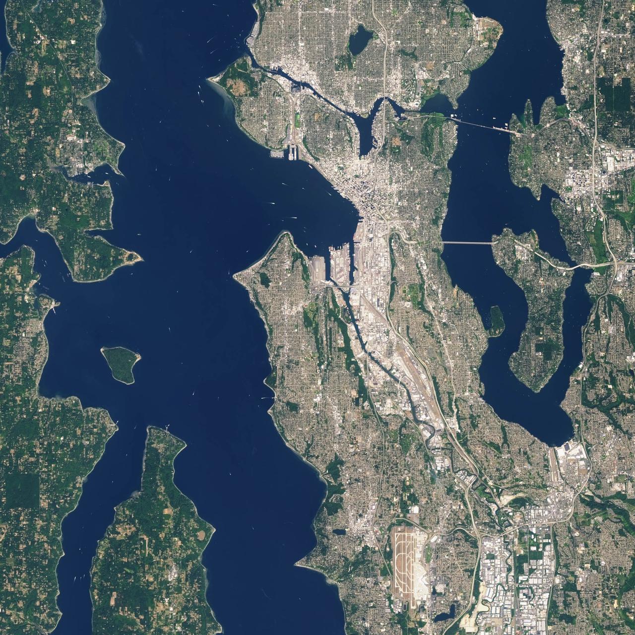
Landsat 7 image of Seattle, Washington acquired August 23, 2014. Landsat 7 is a U.S. satellite used to acquire remotely sensed images of the Earth's land surface and surrounding coastal regions. It is maintained by the Landsat 7 Project Science Office at the NASA Goddard Space Flight Center in Greenbelt, MD. Landsat satellites have been acquiring images of the Earth’s land surface since 1972. Currently there are more than 2 million Landsat images in the National Satellite Land Remote Sensing Data Archive. For more information visit: <a href="http://landsat.usgs.gov/" rel="nofollow">landsat.usgs.gov/</a>..To learn more about the Landsat satellite go to:.<a href="http://landsat.gsfc.nasa.gov/" rel="nofollow">landsat.gsfc.nasa.gov/</a> Credit: NASA/GSFC/Landsat 7 <b><a href="http://www.nasa.gov/audience/formedia/features/MP_Photo_Guidelines.html" rel="nofollow">NASA image use policy.</a></b> <b><a href="http://www.nasa.gov/centers/goddard/home/index.html" rel="nofollow">NASA Goddard Space Flight Center</a></b> enables NASA’s mission through four scientific endeavors: Earth Science, Heliophysics, Solar System Exploration, and Astrophysics. Goddard plays a leading role in NASA’s accomplishments by contributing compelling scientific knowledge to advance the Agency’s mission. <b>Follow us on <a href="http://twitter.com/NASAGoddardPix" rel="nofollow">Twitter</a></b> <b>Like us on <a href="http://www.facebook.com/pages/Greenbelt-MD/NASA-Goddard/395013845897?ref=tsd" rel="nofollow">Facebook</a></b> <b>Find us on <a href="http://instagrid.me/nasagoddard/?vm=grid" rel="nofollow">Instagram</a></b>
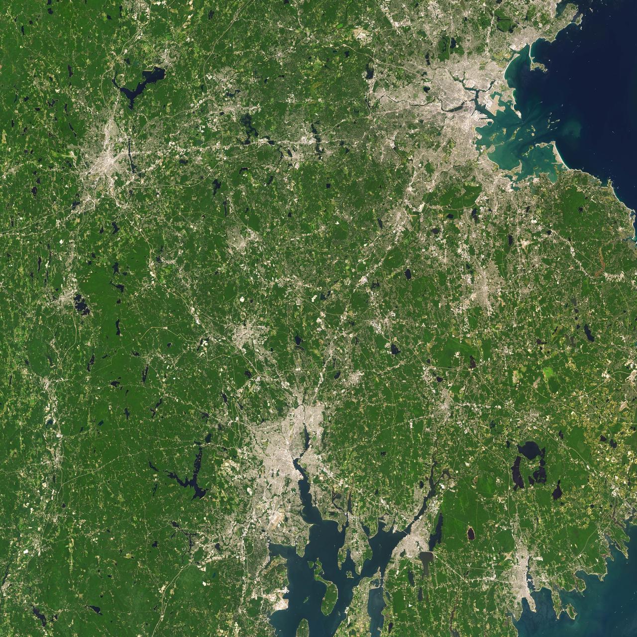
Landsat 7 image of Boston/Providence area acquired August 25, 2014. Landsat 7 is a U.S. satellite used to acquire remotely sensed images of the Earth's land surface and surrounding coastal regions. It is maintained by the Landsat 7 Project Science Office at the NASA Goddard Space Flight Center in Greenbelt, MD...Landsat satellites have been acquiring images of the Earth’s land surface since 1972. Currently there are more than 2 million Landsat images in the National Satellite Land Remote Sensing Data Archive. For more information visit: <a href="http://landsat.usgs.gov/" rel="nofollow">landsat.usgs.gov/</a>..To learn more about the Landsat satellite go to:.<a href="http://landsat.gsfc.nasa.gov/" rel="nofollow">landsat.gsfc.nasa.gov/</a> Credit: NASA/GSFC/Landsat 7 <b><a href="http://www.nasa.gov/audience/formedia/features/MP_Photo_Guidelines.html" rel="nofollow">NASA image use policy.</a></b> <b><a href="http://www.nasa.gov/centers/goddard/home/index.html" rel="nofollow">NASA Goddard Space Flight Center</a></b> enables NASA’s mission through four scientific endeavors: Earth Science, Heliophysics, Solar System Exploration, and Astrophysics. Goddard plays a leading role in NASA’s accomplishments by contributing compelling scientific knowledge to advance the Agency’s mission. <b>Follow us on <a href="http://twitter.com/NASAGoddardPix" rel="nofollow">Twitter</a></b> <b>Like us on <a href="http://www.facebook.com/pages/Greenbelt-MD/NASA-Goddard/395013845897?ref=tsd" rel="nofollow">Facebook</a></b> <b>Find us on <a href="http://instagrid.me/nasagoddard/?vm=grid" rel="nofollow">Instagram</a></b>
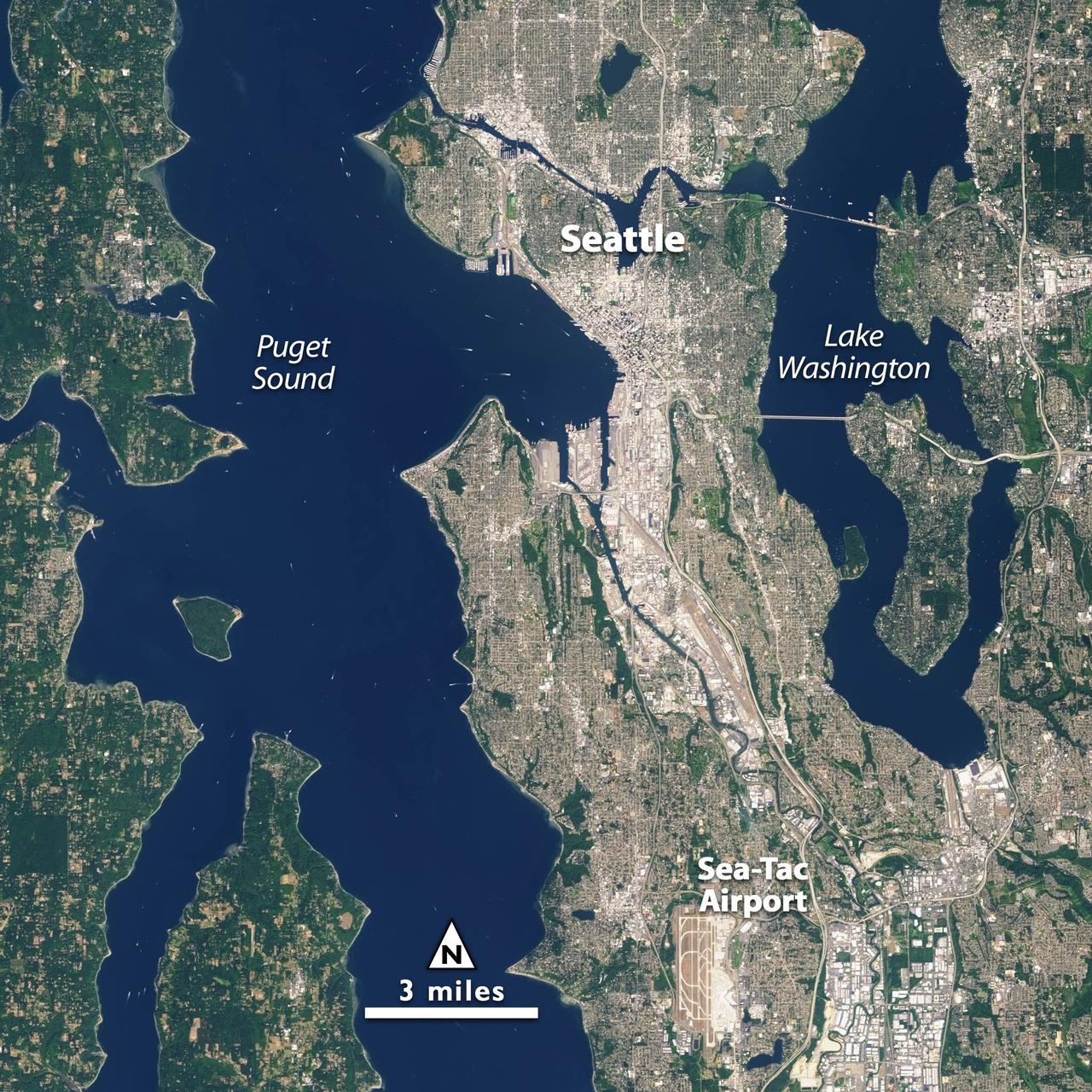
Landsat 7 image of Seattle, Washington acquired August 23, 2014. Landsat 7 is a U.S. satellite used to acquire remotely sensed images of the Earth's land surface and surrounding coastal regions. It is maintained by the Landsat 7 Project Science Office at the NASA Goddard Space Flight Center in Greenbelt, MD. Landsat satellites have been acquiring images of the Earth’s land surface since 1972. Currently there are more than 2 million Landsat images in the National Satellite Land Remote Sensing Data Archive. For more information visit: <a href="http://landsat.usgs.gov/" rel="nofollow">landsat.usgs.gov/</a>..To learn more about the Landsat satellite go to:.<a href="http://landsat.gsfc.nasa.gov/" rel="nofollow">landsat.gsfc.nasa.gov/</a> Credit: NASA/GSFC/Landsat 7 <b><a href="http://www.nasa.gov/audience/formedia/features/MP_Photo_Guidelines.html" rel="nofollow">NASA image use policy.</a></b> <b><a href="http://www.nasa.gov/centers/goddard/home/index.html" rel="nofollow">NASA Goddard Space Flight Center</a></b> enables NASA’s mission through four scientific endeavors: Earth Science, Heliophysics, Solar System Exploration, and Astrophysics. Goddard plays a leading role in NASA’s accomplishments by contributing compelling scientific knowledge to advance the Agency’s mission. <b>Follow us on <a href="http://twitter.com/NASAGoddardPix" rel="nofollow">Twitter</a></b> <b>Like us on <a href="http://www.facebook.com/pages/Greenbelt-MD/NASA-Goddard/395013845897?ref=tsd" rel="nofollow">Facebook</a></b> <b>Find us on <a href="http://instagrid.me/nasagoddard/?vm=grid" rel="nofollow">Instagram</a></b>
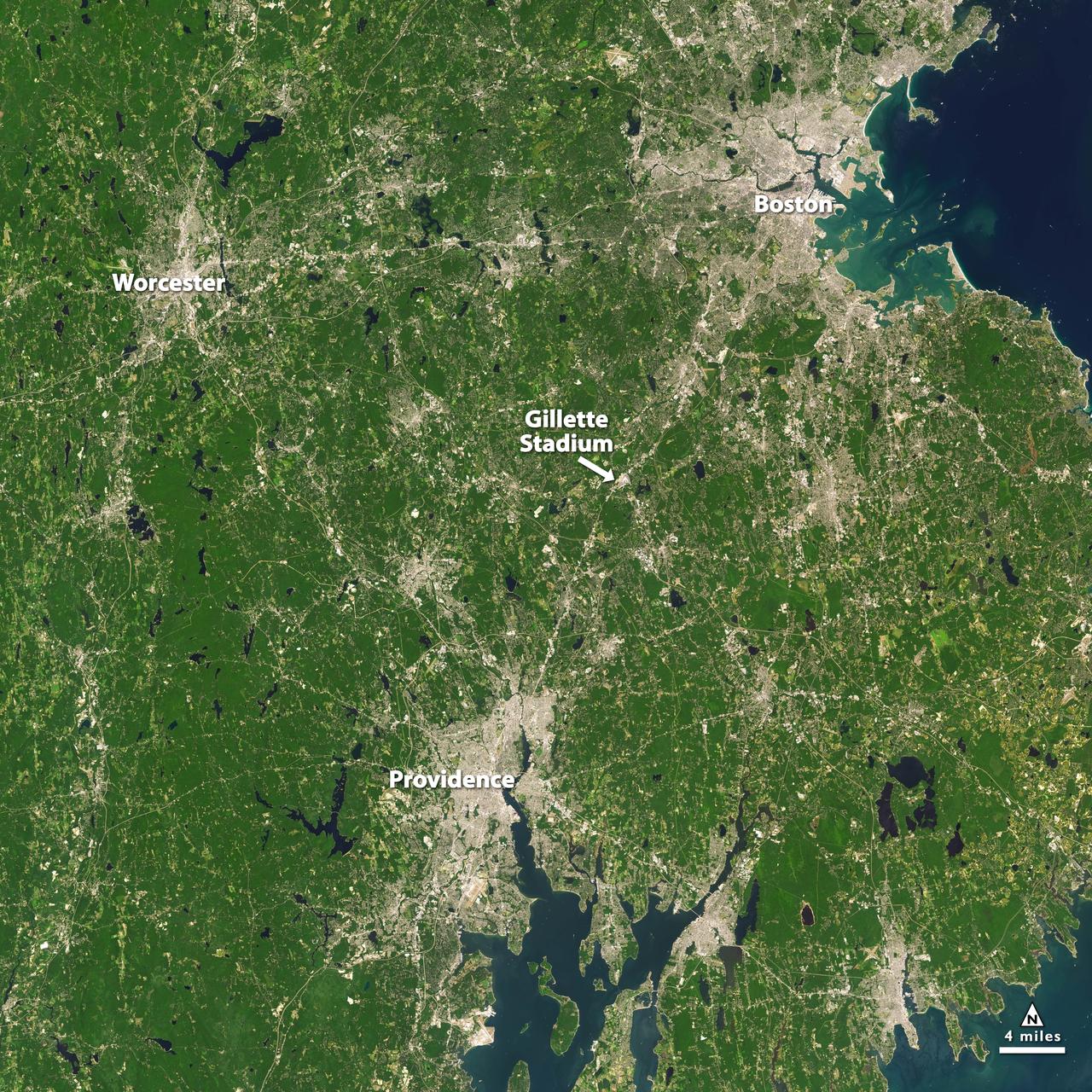
Landsat 7 image of Boston/Providence area acquired August 25, 2014. Landsat 7 is a U.S. satellite used to acquire remotely sensed images of the Earth's land surface and surrounding coastal regions. It is maintained by the Landsat 7 Project Science Office at the NASA Goddard Space Flight Center in Greenbelt, MD. Landsat satellites have been acquiring images of the Earth’s land surface since 1972. Currently there are more than 2 million Landsat images in the National Satellite Land Remote Sensing Data Archive. For more information visit: <a href="http://landsat.usgs.gov/" rel="nofollow">landsat.usgs.gov/</a>..To learn more about the Landsat satellite go to:.<a href="http://landsat.gsfc.nasa.gov/" rel="nofollow">landsat.gsfc.nasa.gov/</a> Credit: NASA/GSFC/Landsat 7 <b><a href="http://www.nasa.gov/audience/formedia/features/MP_Photo_Guidelines.html" rel="nofollow">NASA image use policy.</a></b> <b><a href="http://www.nasa.gov/centers/goddard/home/index.html" rel="nofollow">NASA Goddard Space Flight Center</a></b> enables NASA’s mission through four scientific endeavors: Earth Science, Heliophysics, Solar System Exploration, and Astrophysics. Goddard plays a leading role in NASA’s accomplishments by contributing compelling scientific knowledge to advance the Agency’s mission. <b>Follow us on <a href="http://twitter.com/NASAGoddardPix" rel="nofollow">Twitter</a></b> <b>Like us on <a href="http://www.facebook.com/pages/Greenbelt-MD/NASA-Goddard/395013845897?ref=tsd" rel="nofollow">Facebook</a></b> <b>Find us on <a href="http://instagrid.me/nasagoddard/?vm=grid" rel="nofollow">Instagram</a></b>

Landsat 7 image of the Santa Clara area acquired Nov 16, 2015. Landsat 7 is a U.S. satellite used to acquire remotely sensed images of the Earth's land surface and surrounding coastal regions. It is maintained by the Landsat 7 Project Science Office at the NASA Goddard Space Flight Center in Greenbelt, MD...Landsat satellites have been acquiring images of the Earth’s land surface since 1972. Currently there are more than 2 million Landsat images in the National Satellite Land Remote Sensing Data Archive. For more information visit: <a href="http://landsat.usgs.gov/" rel="nofollow">landsat.usgs.gov/</a>..To learn more about the Landsat satellite go to:.<a href="http://landsat.gsfc.nasa.gov/" rel="nofollow">landsat.gsfc.nasa.gov/</a> Credit: NASA/GSFC/Landsat 7 <b><a href="http://www.nasa.gov/audience/formedia/features/MP_Photo_Guidelines.html" rel="nofollow">NASA image use policy.</a></b> <b><a href="http://www.nasa.gov/centers/goddard/home/index.html" rel="nofollow">NASA Goddard Space Flight Center</a></b> enables NASA’s mission through four scientific endeavors: Earth Science, Heliophysics, Solar System Exploration, and Astrophysics. Goddard plays a leading role in NASA’s accomplishments by contributing compelling scientific knowledge to advance the Agency’s mission. <b>Follow us on <a href="http://twitter.com/NASAGoddardPix" rel="nofollow">Twitter</a></b> <b>Like us on <a href="http://www.facebook.com/pages/Greenbelt-MD/NASA-Goddard/395013845897?ref=tsd" rel="nofollow">Facebook</a></b> <b>Find us on <a href="http://instagrid.me/nasagoddard/?vm=grid" rel="nofollow">Instagram</a></b>
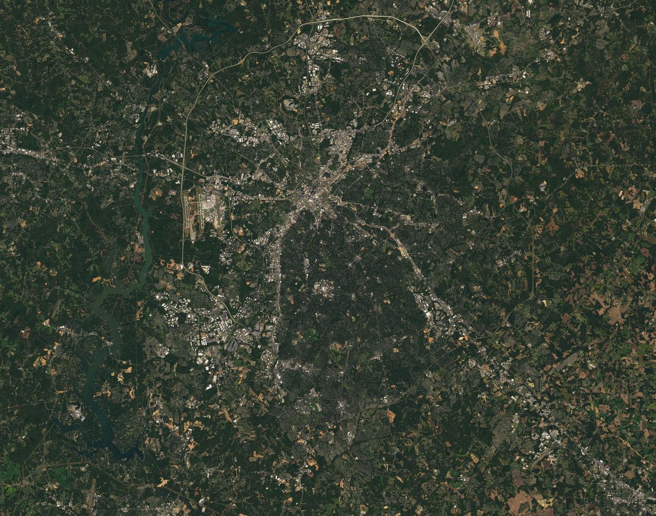
Landsat 7 image of the Charlotte, NC area acquired Oct 18, 2015. Landsat 7 is a U.S. satellite used to acquire remotely sensed images of the Earth's land surface and surrounding coastal regions. It is maintained by the Landsat 7 Project Science Office at the NASA Goddard Space Flight Center in Greenbelt, MD...Landsat satellites have been acquiring images of the Earth’s land surface since 1972. Currently there are more than 2 million Landsat images in the National Satellite Land Remote Sensing Data Archive. For more information visit: <a href="http://landsat.usgs.gov/" rel="nofollow">landsat.usgs.gov/</a>..To learn more about the Landsat satellite go to:.<a href="http://landsat.gsfc.nasa.gov/" rel="nofollow">landsat.gsfc.nasa.gov/</a> Credit: NASA/GSFC/Landsat 7 <b><a href="http://www.nasa.gov/audience/formedia/features/MP_Photo_Guidelines.html" rel="nofollow">NASA image use policy.</a></b> <b><a href="http://www.nasa.gov/centers/goddard/home/index.html" rel="nofollow">NASA Goddard Space Flight Center</a></b> enables NASA’s mission through four scientific endeavors: Earth Science, Heliophysics, Solar System Exploration, and Astrophysics. Goddard plays a leading role in NASA’s accomplishments by contributing compelling scientific knowledge to advance the Agency’s mission. <b>Follow us on <a href="http://twitter.com/NASAGoddardPix" rel="nofollow">Twitter</a></b> <b>Like us on <a href="http://www.facebook.com/pages/Greenbelt-MD/NASA-Goddard/395013845897?ref=tsd" rel="nofollow">Facebook</a></b> <b>Find us on <a href="http://instagrid.me/nasagoddard/?vm=grid" rel="nofollow">Instagram</a></b>
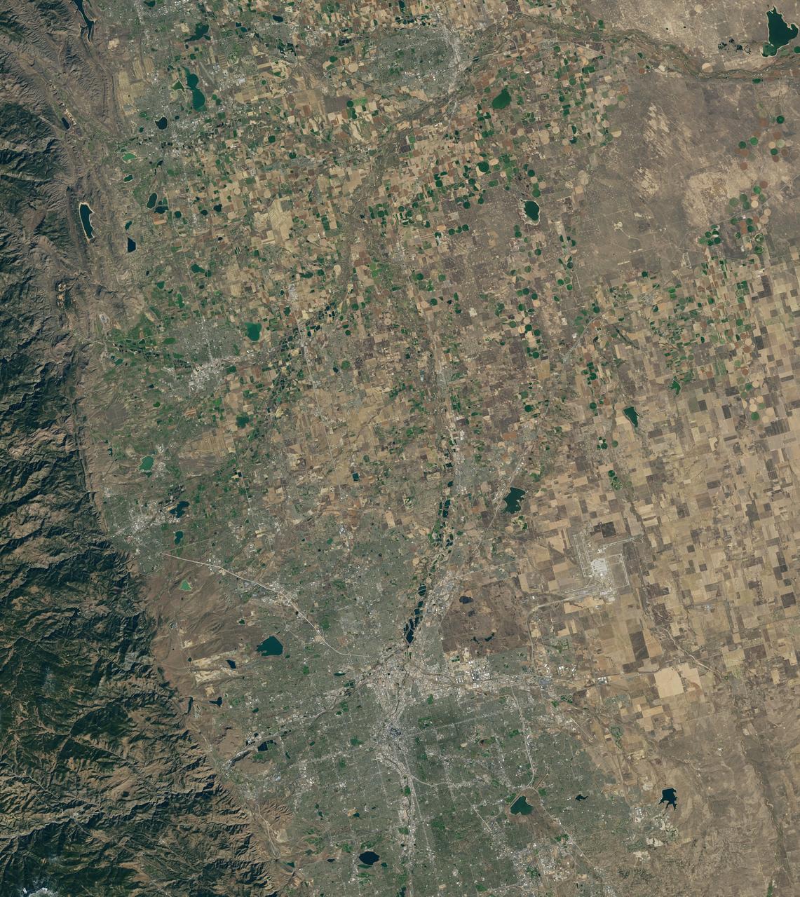
Landsat 7 image of Denver area acquired Nov 3, 2015. Landsat 7 is a U.S. satellite used to acquire remotely sensed images of the Earth's land surface and surrounding coastal regions. It is maintained by the Landsat 7 Project Science Office at the NASA Goddard Space Flight Center in Greenbelt, MD...Landsat satellites have been acquiring images of the Earth’s land surface since 1972. Currently there are more than 2 million Landsat images in the National Satellite Land Remote Sensing Data Archive. For more information visit: <a href="http://landsat.usgs.gov/" rel="nofollow">landsat.usgs.gov/</a>..To learn more about the Landsat satellite go to:.<a href="http://landsat.gsfc.nasa.gov/" rel="nofollow">landsat.gsfc.nasa.gov/</a> Credit: NASA/GSFC/Landsat 7 <b><a href="http://www.nasa.gov/audience/formedia/features/MP_Photo_Guidelines.html" rel="nofollow">NASA image use policy.</a></b> <b><a href="http://www.nasa.gov/centers/goddard/home/index.html" rel="nofollow">NASA Goddard Space Flight Center</a></b> enables NASA’s mission through four scientific endeavors: Earth Science, Heliophysics, Solar System Exploration, and Astrophysics. Goddard plays a leading role in NASA’s accomplishments by contributing compelling scientific knowledge to advance the Agency’s mission. <b>Follow us on <a href="http://twitter.com/NASAGoddardPix" rel="nofollow">Twitter</a></b> <b>Like us on <a href="http://www.facebook.com/pages/Greenbelt-MD/NASA-Goddard/395013845897?ref=tsd" rel="nofollow">Facebook</a></b> <b>Find us on <a href="http://instagrid.me/nasagoddard/?vm=grid" rel="nofollow">Instagram</a></b>