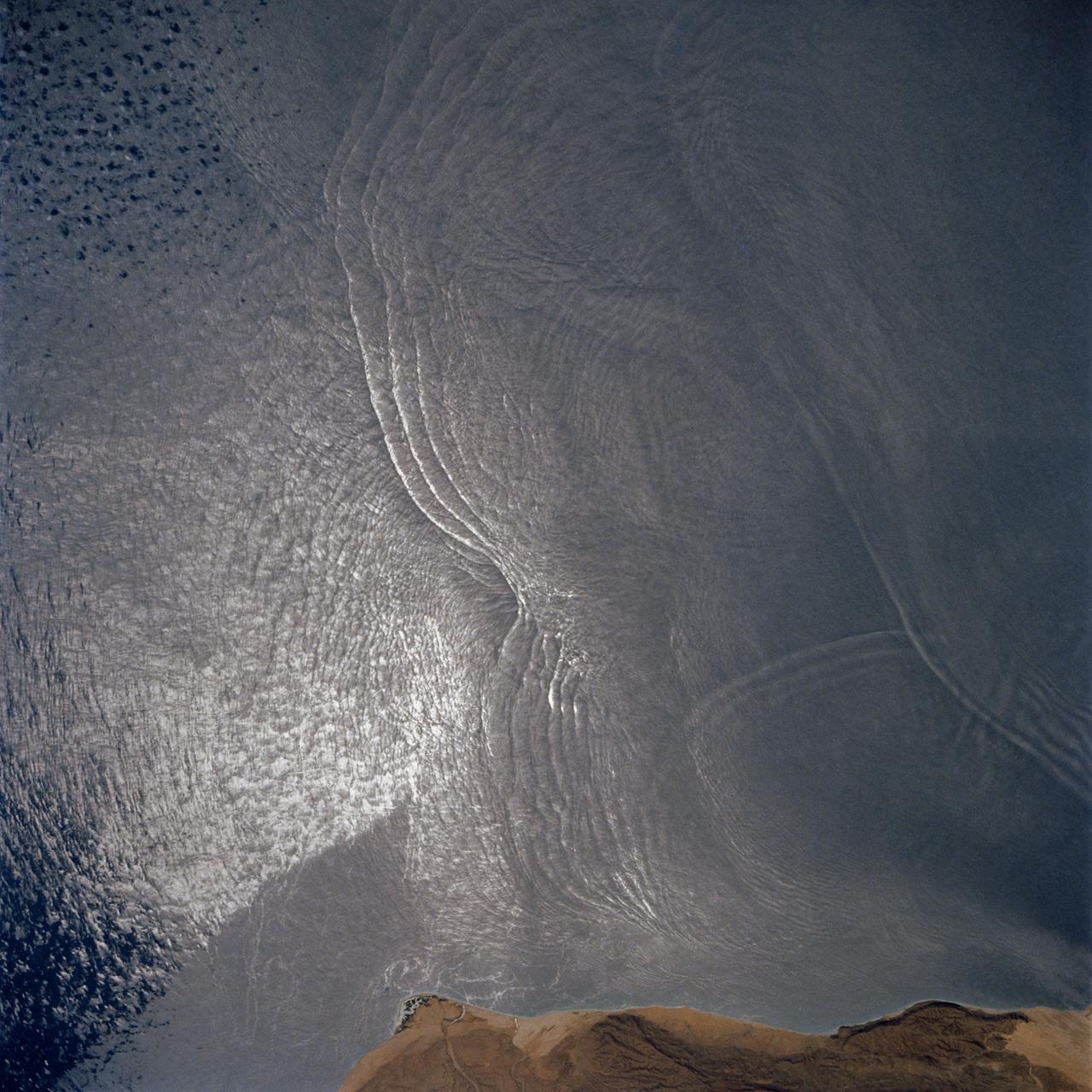
The arculate fronts of these apparently converging internal waves off the northeast coast of Somalia (11.5N, 51.5E) probably were produced by interaction with two parallel submarine canyons off the Horn of Africa. Internal waves are packets of tidally generated waves traveling within the ocean at varying depths and are not detectable by any surface disturbance.
STS077-744-046 (19-29 May 1996) --- This view shows ship wakes off the coast of Fort Myers, Florida. The Sun glint reflecting off the ocean surfaces allowed man-made features to be seen and photographed by the astronaut crew members. When a ship or boat goes through the water it disturbs the surface of the water which causes the Sun?s rays to reflect back differently than the surrounding waters. Photographed on a weekend, this image illustrates how popular recreational boating is around the Fort Myers area.
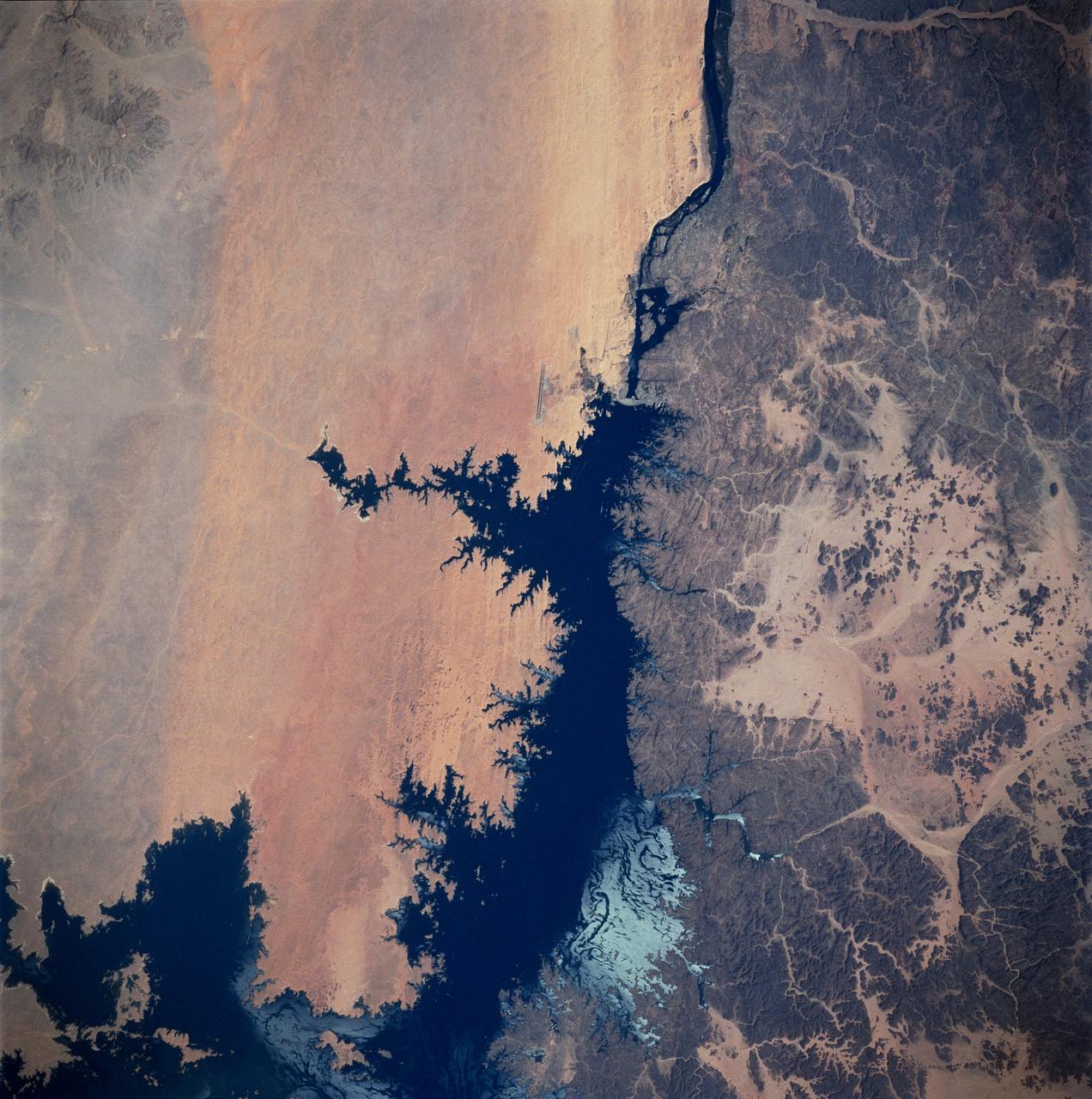
STS083-747-026 (4-8 April 1997) --- Aswan Dam and Lake Nasser along the Nile River, Egypt. The Aswan Dam controls the flow of the Nile River forming Lake Nasser. Lake Nasser is reaching relatively high water levels due to the plentiful rains since December 1996 in Kenya, near the headwaters of the Nile river. The light colored areas in the Lake are where the sun is reflecting off the surface of the water. These areas are fairly calm and not disturbed by wind gusts enabling the sunglint to show water current patterns on the surface. The Aswan runway is seen as a dark set of lines west of the Aswan Dam.
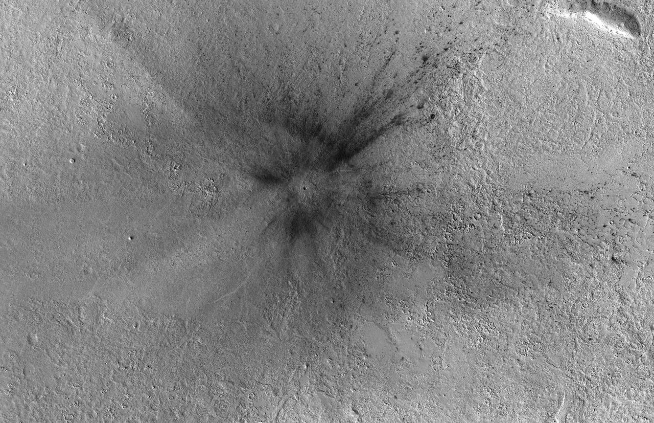
HiRISE commonly takes images of recent craters on Mars, which are usually found by the MRO Context Camera where they disturb surface dust. An impact site in this area was first imaged in December 2017. A year and a half later, the scene looks totally different! Dust has eroded from the surface, probably due to the planet-encircling dust storm from 2018. The dark spots around the fresh craters have vanished because they only affected the dust that has since disappeared. See if you can find the craters in the new image by comparing with the old one. https://photojournal.jpl.nasa.gov/catalog/PIA23233
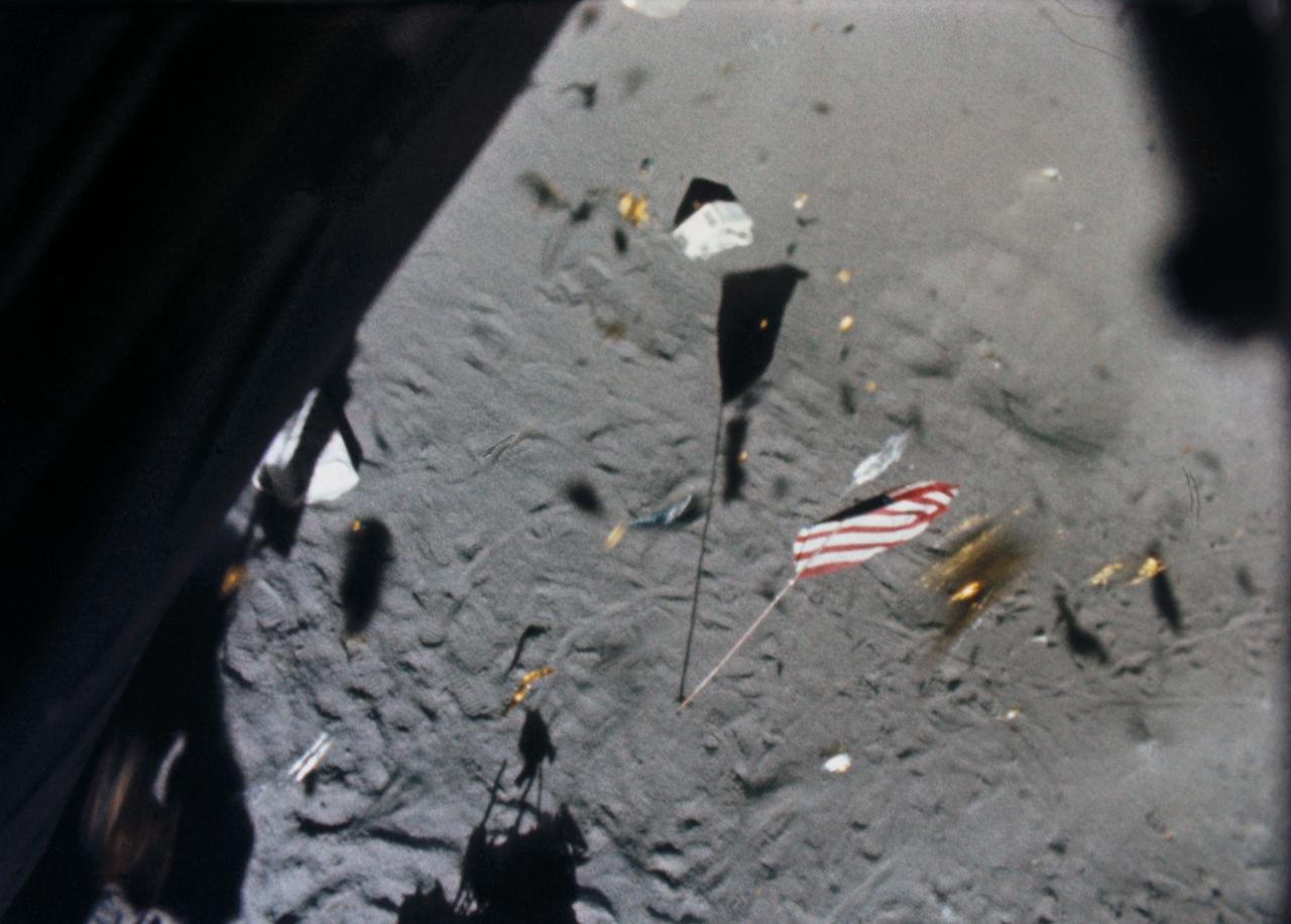
S71-19500 (6 Feb. 1971) --- The Apollo 14 Lunar Module (LM) ascent stage lifts off the lunar surface and the powerful LM engine causes a brief force of wind which scatters gold-colored foil, covering the LM, and disturbs the U.S. flag. This picture was taken from film exposed by the 16mm data acquisition camera - which was mounted inside the LM.
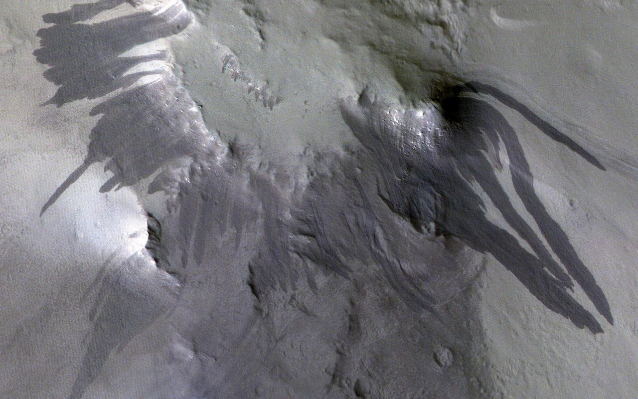
This image captured by NASA 2001 Mars Odyssey spacecraft shows the inner rim of an unnamed crater on the western margin of Daedalia Planum. Numerous dark streaks are visible on the faces of the inner rim. A possible mode of formation of these features is the down slope movement of a block/rock that disturbs the surface dust revealing the darker rock beneath. Orbit Number: 63851 Latitude: -11.9984 Longitude: 213.542 Instrument: VIS Captured: 2016-05-06 07:05 http://photojournal.jpl.nasa.gov/catalog/PIA20775
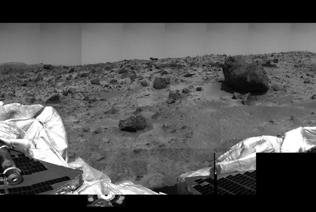
This image of the Martian surface was taken by the Imager for Mars Pathfinder (IMP) before sunset on July 4, 1997 (Sol 1), the spacecraft's first day on Mars. The airbags have been partially retracted, and portions the petal holding the undeployed rover Sojourner can be seen at lower left. The rock in the center of the image may be a future target for chemical analysis. The soil in the foreground has been disturbed by the movement of the airbags as they retracted. http://photojournal.jpl.nasa.gov/catalog/PIA00619
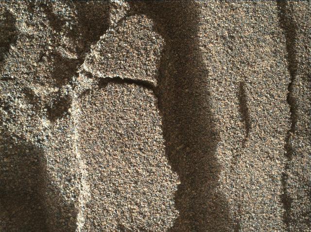
This view shows grains of sand where NASA's Curiosity Mars rover was driven into a shallow sand sheet near a large dune. The disturbance by the wheel exposed interior material of the sand body, including finer sand grains than on the undisturbed surface. Sunlight is coming from the left. The scene covers an area 1.3 inches by 1.0 inch (3.3 by 2.5 centimeters). This is a focus-merge product from Curiosity's Mars Hand Lens Imager (MAHLI), combining multiple images taken at different focus settings to yield sharper focus at varying distances from the lens. The component images were taken on Dec. 3, 2015, during the 1,182nd Martian day, or sol, of Curiosity's work on Mars. http://photojournal.jpl.nasa.gov/catalog/PIA20170
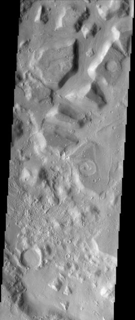
This image shows the dissected interior of a crater in the Cydonia region of Mars. The flat-topped buttes and mesas in the northern portion of the image were once a continuous layer of material that filled the crater. Since deposition, the material has been disturbed and dissected. The process that causes such landforms is not well known, but likely involves frozen subsurface water that may have found its way to the surface. The surfaces on the mesas are not rough, suggesting that the whole scene is mantled with fine dust, masking the details that may give clues to whether surface water was involved at some point in the past. Small recent channels can be seen in the lower left. This is an indication of relatively recent small-scale surface activity, which has been could have been volcanic, fluvial, or some process involving subsurface volatiles (ice). http://photojournal.jpl.nasa.gov/catalog/PIA04030
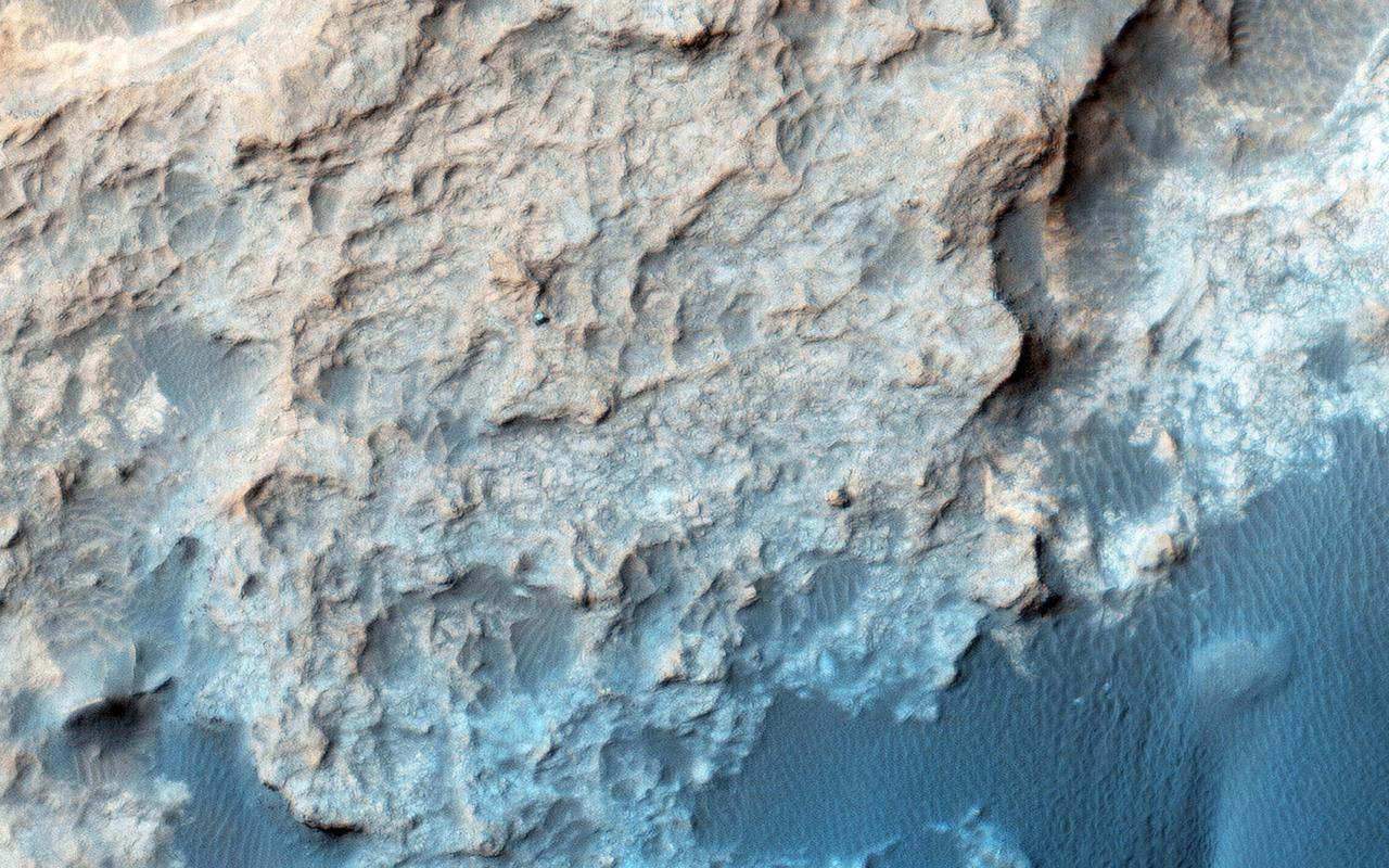
This image from NASA Mars Reconnaissance Orbiter spacecraft shows the Curiosity rover currently located on the Naukluft Plateau just north of the Bagnold Dune field. Its position was captured by HiRISE on 25 March 2016 (MSL Sol 1291. Views from the surface at this location are available here and here.) The rover is within sandstone outcrops informally named the "Stimson Formation." There are no obvious rover tracks in the HiRISE views indicating that this bedrock contains little dust that otherwise could be disturbed by the rover wheels as has been seen earlier in Curiosity's traverse. http://photojournal.jpl.nasa.gov/catalog/PIA20738

Some of the prominences that float like lazy clouds above the solar surface suddenly erupt and break away from the Sun in cataclysmic action. The trigger of this coronal transient, like many others seen by Skylab's coronagraph, was an eruptive prominence that surged outward from the limb of the Sun, ejecting matter that disturbed the outer corona. This image is of the surge in action in ultraviolet light of ionized helium. Simultaneous observations like this made possible an almost immediate understanding of the new-found cosmic phenomenon. The elbow prominence was accidentally photographed by Astronaut Garriott (Skylab-3) while observing a small flare near the limb of the Sun beneath the mighty arch on August 9, 1973.

The NASA C-140 JetStar research aircraft (top) is followed by a NASA Learjet equipped with acoustic sensors during one of several tests of advanced propellors mounted on the vertical pylon atop the JetStar's fuselage. Several advanced prop designs were tested on the JetStar in 1982 by NASA's Dryden Flight Research Facility (DFRF), Edwards, California, to study the effects of noise created by propellors on aircraft structures and cabin interiors. To assess possible noise problems with the subscale turbofan, DFRF technicians mounted microphones on both the JetStar and the Learjet chase plane. DFRF then made measurements at close range and at longer distances. The data enabled structural changes and flightpath modifications.
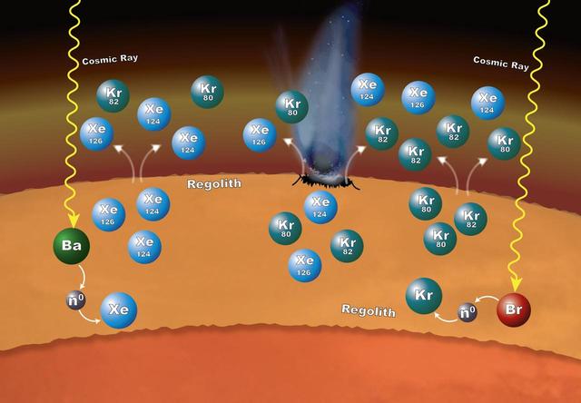
Chemistry that takes place in the surface material on Mars can explain why particular xenon (Xe) and krypton (Kr) isotopes are more abundant in the Martian atmosphere than expected. The isotopes -- variants that have different numbers of neutrons -- are formed in the loose rocks and material that make up the regolith -- the surface layer down to solid rock. The chemistry begins when cosmic rays penetrate into the surface material. If the cosmic rays strike an atom of barium (Ba), the barium can lose one or more of its neutrons (n0). Atoms of xenon can pick up some of those neutrons – a process called neutron capture – to form the isotopes xenon-124 and xenon-126. In the same way, atoms of bromine (Br) can lose some of their neutrons to krypton, leading to the formation of krypton-80 and krypton-82 isotopes. These isotopes can enter the atmosphere when the regolith is disturbed by impacts and abrasion, allowing gas to escape. http://photojournal.jpl.nasa.gov/catalog/PIA20847
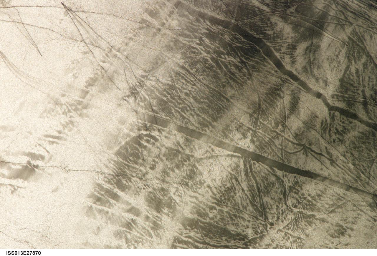
ISS013-E-27870 (28 May 2006) --- Considerable sunglint emphasizes features on Lake Erie in this image photographed by an Expedition 13 crewmember on the International Space Station. This detailed, south-looking image shows features on the surface of Lake Erie, about 30 miles west of Cleveland, Ohio. This view shows tight-V-shaped wakes of small craft. It also shows broad patterns of larger craft, probably large freighters carrying cargo that displace and disturb more water during passage. These larger wakes are aligned with the direct course between Detroit (out of frame) and Cleveland (out of frame). Some of the broad, ill-defined swaths of light and dark are streaks of wind-roughened water, which reflect the Sun differently.
Meteorites hit Mars and create small craters like the one we've imaged here. Usually we spot these new craters in lower-resolution images from the Context Camera because the impact disturbs dust on the surface and creates a dark mark that's much bigger than the crater. This meteorite hit a dusty area and made a crater, but did something a little more special to the surrounding dust. We can see dozens of dark, dust-free, streaks on slopes surrounding the crater. These slope streaks form when dust slumps downhill and happen naturally on a regular basis. In this case though, the impact and explosion that made the crater seems to have set off many of these downhill slumps of dust simultaneously. This could have happened from the explosion's blast wave passing through the air or the shaking of the ground that it caused. https://photojournal.jpl.nasa.gov/catalog/PIA24382
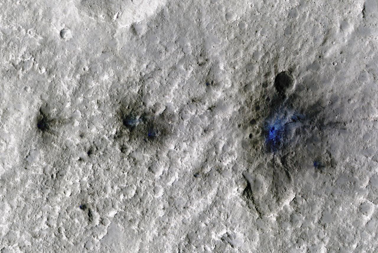
The craters seen here in blue were formed by a meteoroid impact on Mars on Sept. 5, 2021. The impact was the first to be detected by NASA's InSight mission; the image was taken later by NASA's Mars Reconnaissance Orbiter using its High Resolution Imaging Science Experiment (HiRISE) camera. The initial impact itself created a small marsquake that was detected by InSight's seismometer. The instrument recorded seismological data that showed the moment the meteoroid entered Mars' atmosphere, its explosion into pieces in the atmosphere, and finally, the impact that created a series of at least three craters in the surface. MRO then flew over the approximate site where the impact was "felt" to look for darkened patches of ground using its Context Camera. After finding this location, HiRISE captured the scene in color. The ground is not actually blue; this enhanced-color image highlights certain hues in the scene to make details more visible to the human eye – in this case, dust and soil disturbed by the impact. https://photojournal.jpl.nasa.gov/catalog/PIA25408
CAPE CANAVERAL, Fla. – In the Granular Mechanics and Regolith Operations (GMRO) Lab at NASA's Kennedy Space Center in Florida, pieces of the Surveyor 3 spacecraft returned from the lunar surface on the Apollo 12 mission are available for examination by the lab's staff. The GMRO Lab is one of several labs located in NASA's Space Life Sciences Laboratory (SLSL) facility. The lab is staffed by three physicists, six mechanical or aerospace engineers and several technicians who are studying how the rocket exhaust of landing vehicles affects lunar and Martian science missions, including the sandblasting of instruments with soil and dust ejecta and the disturbance or contamination of soil beneath the lander. For more information on the GMRO Lab, see p. 7 of the Spaceport News dated Nov. 11, 2011, at http://www.nasa.gov/centers/kennedy/pdf/603285main_nov11-2011.pdf. Photo credit: NASA/Jim Grossmann
The Context Camera onboard MRO has been discovering new impact sites on Mars, followed up with HiRISE images. Usually these sites are discovered as new dark spots from removal or disturbance of bright dust, but a few show up as new bright spots. These craters may have bright ejecta from exposure of shallow subsurface materials, below a thin dark cover. An alternate theory—that this is a particle size effect—is unlikely because the bright materials are also distinctly redder than surrounding areas, and because ejecta is typically more coarse-grained, which would make the surface darker rather than brighter. The new crater visible here is about 13 meters in diameter. The color has been enhanced for this cutout. https://photojournal.jpl.nasa.gov/catalog/PIA24619

CAPE CANAVERAL, Fla. – In the Granular Mechanics and Regolith Operations (GMRO) Lab at NASA's Kennedy Space Center in Florida, a piece of the Surveyor 3 spacecraft returned from the lunar surface on the Apollo 12 mission is available for examination by the lab's staff. The GMRO Lab is one of several labs located in NASA's Space Life Sciences Laboratory (SLSL) facility. The lab is staffed by three physicists, six mechanical or aerospace engineers and several technicians who are studying how the rocket exhaust of landing vehicles affects lunar and Martian science missions, including the sandblasting of instruments with soil and dust ejecta and the disturbance or contamination of soil beneath the lander. For more information on the GMRO Lab, see p. 7 of the Spaceport News dated Nov. 11, 2011, at http://www.nasa.gov/centers/kennedy/pdf/603285main_nov11-2011.pdf. Photo credit: NASA/Jim Grossmann
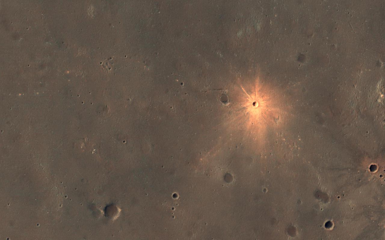
This meteoroid impact crater on Mars was discovered using the black-and-white Context Camera aboard NASA's Mars Reconnaissance Orbiter (MRO). The Context Camera took this image showing the impact, which occurred Dec. 24, 2021, in a region called Amazonis Planitia. Relying on data from the Mars Color Imager camera, also aboard MRO, along with seismic data from NASA's InSight lander, scientists were able to determine when this particular crater formed. Looking closely at the crater's rim, white specks could be detected that suggested the presence of water ice (which was later confirmed by MRO's High-Resolution Imaging Science Experiment, or HiRISE, camera). Debris thrown during the impact can be seen reaching as far as 23 miles (37 kilometers) away. The disturbance seen in the surface suggests the meteoroid was traveling towards the northeast when it hit the ground, throwing the longest streaks of debris in that direction. https://photojournal.jpl.nasa.gov/catalog/PIA25584
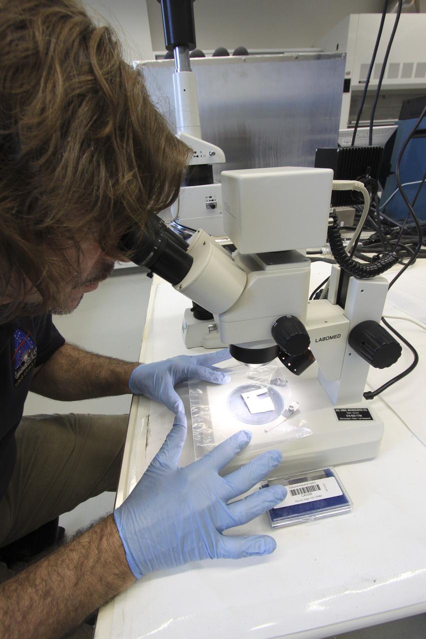
CAPE CANAVERAL, Fla. – In the Granular Mechanics and Regolith Operations (GMRO) Lab at NASA's Kennedy Space Center in Florida, Dr. Philip Metzger examines under a microscope a piece of the Surveyor 3 spacecraft returned from the lunar surface on the Apollo 12 mission. The GMRO Lab is one of several labs located in NASA's Space Life Sciences Laboratory (SLSL) facility. The lab is staffed by three physicists, six mechanical or aerospace engineers and several technicians who are studying how the rocket exhaust of landing vehicles affects lunar and Martian science missions, including the sandblasting of instruments with soil and dust ejecta and the disturbance or contamination of soil beneath the lander. For more information on the GMRO Lab, see p. 7 of the Spaceport News dated Nov. 11, 2011, at http://www.nasa.gov/centers/kennedy/pdf/603285main_nov11-2011.pdf. Photo credit: NASA/Jim Grossmann
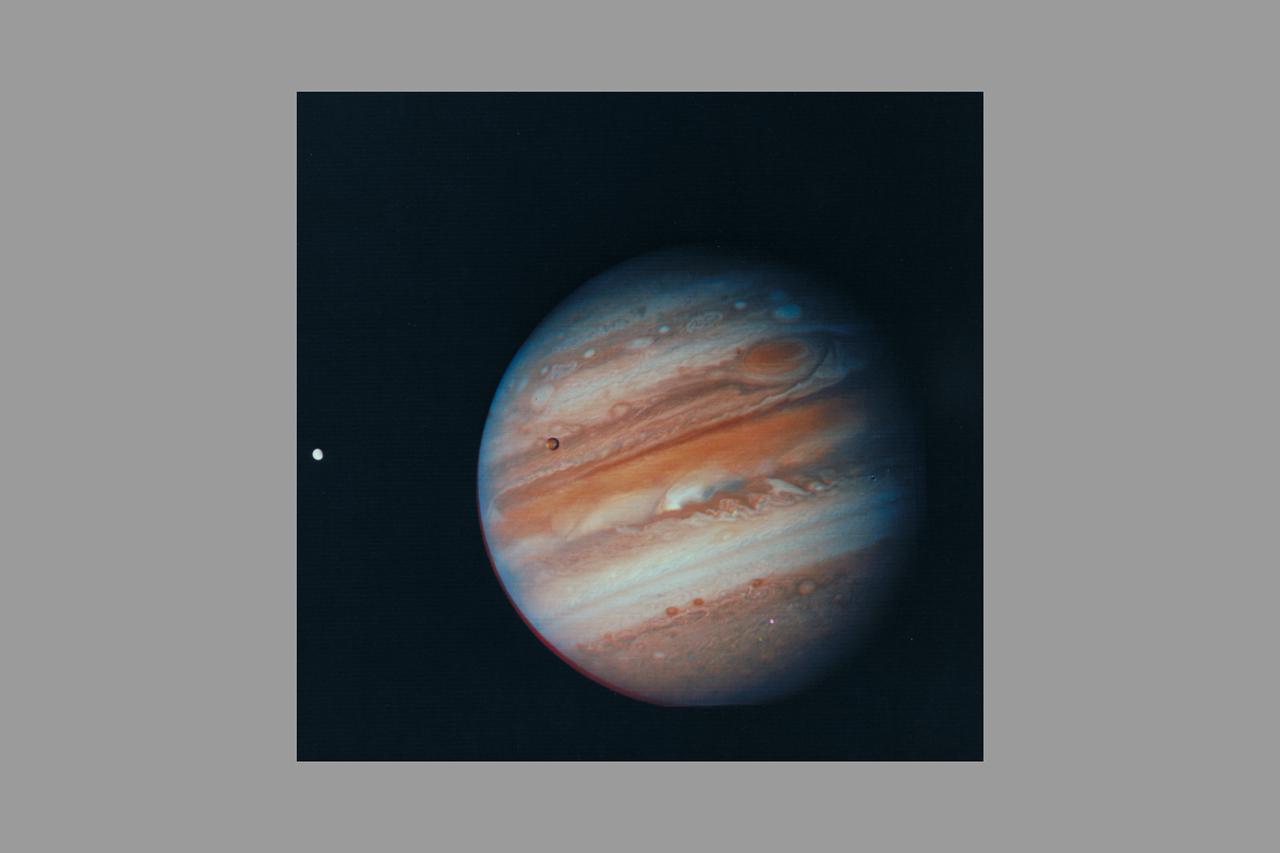
Photo by Voyager 1 (JPL) Jupiter, its Great Red Spot and three of its four largest satellites are visible in this photo taken Feb 5, 1979 by Voyager 1. The spacecraft was 28.4 million kilomters (17.5 million miles) from the planet at the time. The inner-most large satellite, Io, can be seen against Jupiter's disk. Io is distinguished by its bright, brown-yellow surface. To the right of Jupiter is the satellite Europa, also very bright but with fainter surface markings. The darkest satellite, Callisto (still nearly twice as bright as Earth's Moon), is barely visible at the bottom left of the picture. Callisto shows a bright patch in its northern hemisphere. All tThree orbit Jupiter in the equatorial plane, and appear in their present position because Voyageris above the plane. All three satellites show the same face to Jupiter always -- just as Earth's Moon always shows us the same face. In this photo we see the sides of the satellites that always face away from the planet. Jupiter's colorfully banded atmosphere displays complex patterns highlighted by the Great Red Spot, a large, circulating atmospheric disturbance. This photo was assembled from three black and white negatives by the Image Processing Lab at Jet Propulsion Laboratory. JPL manages and controls the Voyage Project for NASA's Office of Space Science. (ref: P-21083)
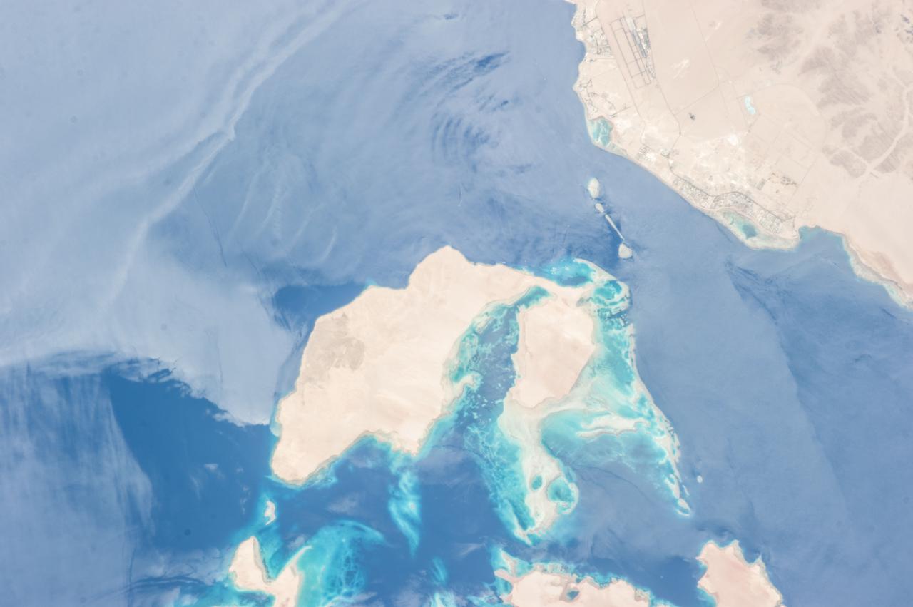
ISS036-E-010628 (24 June 2013) --- Strait of Tiran, Red Sea and Gulf of Aqaba are featured in this image photographed by an Expedition 36 crew member on the International Space Station. The approximately six-kilometer wide Strait of Tiran (also known as the Straits of Tiran) between the Egyptian mainland and Tiran Island separates the Gulf of Aqaba from the Red Sea, and provides two channels (290 meters and 73 meters deep, respectively) navigable by large ships bound for ports in Jordan and Israel. A smaller passage also exists between the east side of Tiran Island and Saudi Arabia, but this a single channel that is 16 meters deep. Due to its strategic position, control of the Strait has been an important factor in historical conflicts of the region, such as the Suez Crisis in 1956 and the Six-Day War in 1967. This photograph illustrates the morphology of the Strait. The relatively clear, deep-water passages of the western Strait of Tiran are visible at right, while the more sinuous shallow-water passage on the Saudi Arabia side can be seen at bottom center. Light blue to turquoise areas around Tiran Island indicate shallow water, while the island itself is arid and largely free of vegetation. Coral reefs are also found in the Straits of Tiran and are a popular diving destination. The silvery sheen on the water surface within the Strait and the south of Tiran Island is sunglint – light reflecting off the water surface back towards the observer on the space station. Disturbance to the water surface, as well as presence of substances such as oils and surfactants, can change the reflective properties of the water surface and highlight both surface waves and subsurface currents. For example, a large wave set is highlighted by sunglint at upper left.

CAPE CANAVERAL, Fla. – The engines of U.S. Navy NP-3D Orion aircraft are started in preparation for takeoff from the Skid Strip at Cape Canaveral Air Force Station. The plane will fly below space shuttle Discovery as it approaches Kennedy Space Center for landing following the STS-119 mission. Onboard instruments will check the orbiter’s exterior temperatures and a long-range infrared camera will remotely monitor heating to the shuttle’s lower surface, part of the boundary layer transition flight experiment. For the experiment, a heat shield tile with a “speed bump” on it was installed under Discovery’s left wing to intentionally disturb the airflow in a controlled manner and make the airflow turbulent. The tile, a BRI-18, was originally developed as a potential heat shield upgrade on the orbiters and is being considered for use on the Constellation Program’s Orion crew exploration vehicles. The data will determine if a protuberance on a BRI-18 tile is safe to fly and will be used to verify and improve design efforts for future spacecraft. Photo credit: NASA/Jim Grossmann

ISS014-E-13598 (29 Jan. 2007) --- Montevideo, Uruguay is featured in this image photographed by an Expedition 14 crewmember on the International Space Station. Reflective roofing materials and dark asphalt streets outline the urban grid pattern of Uruguay's capital city of Montevideo in this image. The city may be viewed as a precursor of the predicted global population shift from dominantly rural to urban environments (by 2030, according to recent United Nations estimates) -- nearly half of Uruguay's total population now lives in the Montevideo metropolitan area. Located on the southern coastline of Uruguay along the Rio de la Plata, Montevideo Bay provides an important harbor and port facilities for transport of South American agricultural products. This view is of sufficient resolution (approximately 7 meters/pixel) to discriminate between dark green canopied tree cover and light green grass - important information for study of urban ecology and climate, as well as city water use planning - in a large golf course located at the southern edge of the city (near center right). Sediment plumes along the coastline to the southeast of the city are also visible; rough patterns in the water surface of Montevideo Bay and the Rio de la Plata are a combination of wind disturbance and sediments.

CAPE CANAVERAL, Fla. -- A U.S. Navy NP-3D Orion aircraft prepares for takeoff from the Skid Strip at Cape Canaveral Air Force Station. The plane will fly below space shuttle Discovery as it approaches Kennedy Space Center for landing following the STS-119 mission. Onboard instruments will check the orbiter’s exterior temperatures and a long-range infrared camera will remotely monitor heating to the shuttle’s lower surface, part of the boundary layer transition flight experiment. For the experiment, a heat shield tile with a “speed bump” on it was installed under Discovery’s left wing to intentionally disturb the airflow in a controlled manner and make the airflow turbulent. The tile, a BRI-18, was originally developed as a potential heat shield upgrade on the orbiters and is being considered for use on the Constellation Program’s Orion crew exploration vehicles. The data will determine if a protuberance on a BRI-18 tile is safe to fly and will be used to verify and improve design efforts for future spacecraft. Photo credit: NASA/Jim Grossmann
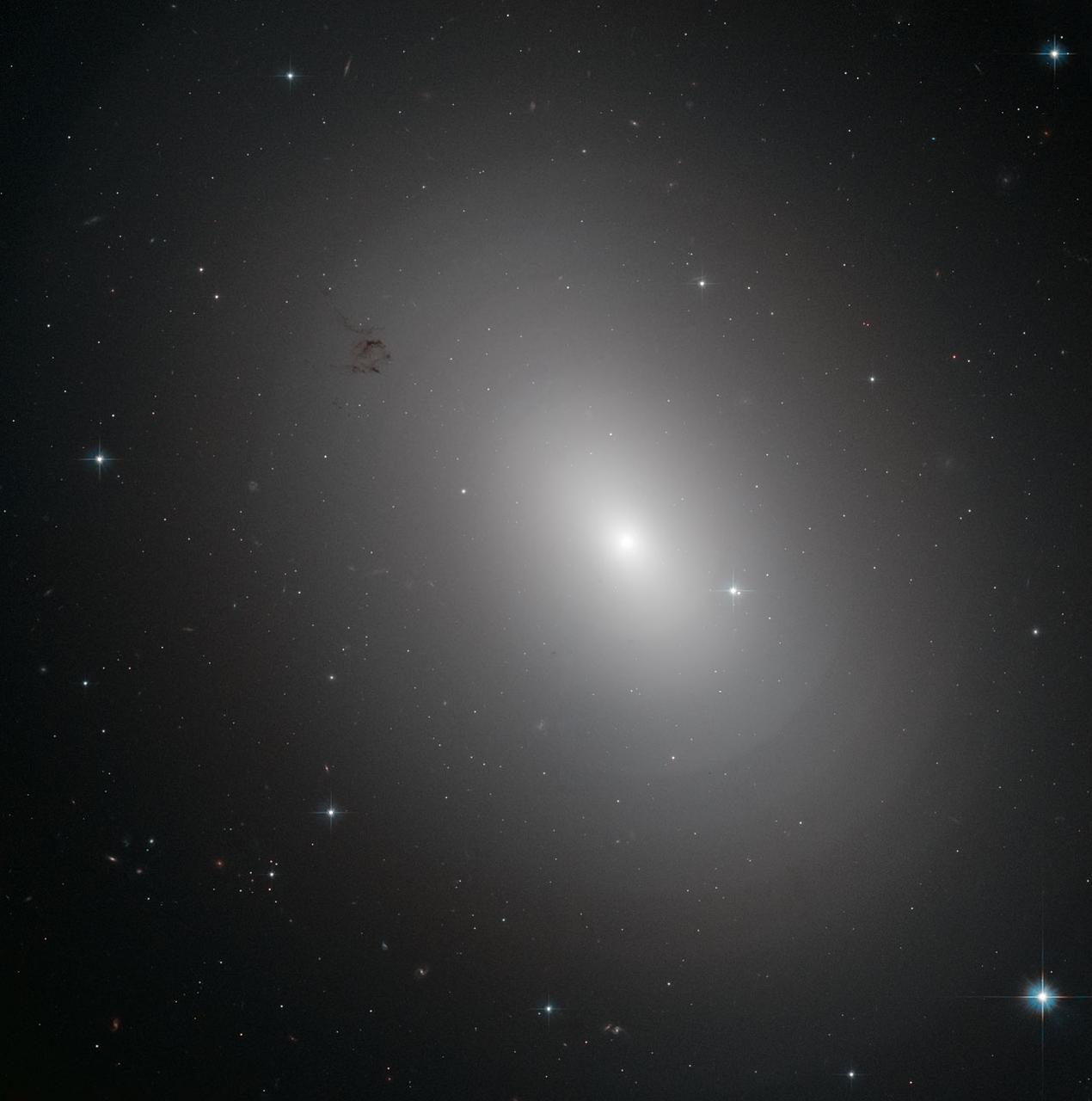
The glowing object in this Hubble Space Telescope image is an elliptical galaxy called NGC 3923. It is located over 90 million light-years away in the constellation of Hydra. NGC 3923 is an example of a shell galaxy where the stars in its halo are arranged in layers. Finding concentric shells of stars enclosing a galaxy is quite common and is observed in many elliptical galaxies. In fact, every tenth elliptical galaxy exhibits this onion-like structure, which has never been observed in spiral galaxies. The shell-like structures are thought to develop as a consequence of galactic cannibalism, when a larger galaxy ingests a smaller companion. As the two centers approach, they initially oscillate about a common center, and this oscillation ripples outwards forming the shells of stars just as ripples on a pond spread when the surface is disturbed. NGC 3923 has over twenty shells, with only a few of the outer ones visible in this image, and its shells are much more subtle than those of other shell galaxies. The shells of this galaxy are also interestingly symmetrical, while other shell galaxies are more skewed. Credit: ESA/Hubble & NASA

CAPE CANAVERAL, Fla. – A U.S. Navy NP-3D Orion aircraft takes off from the Skid Strip at Cape Canaveral Air Force Station. The plane will fly below space shuttle Discovery as it approaches Kennedy Space Center for landing following the STS-119 mission. Onboard instruments will check the orbiter’s exterior temperatures and a long-range infrared camera will remotely monitor heating to the shuttle’s lower surface, part of the boundary layer transition flight experiment. For the experiment, a heat shield tile with a “speed bump” on it was installed under Discovery’s left wing to intentionally disturb the airflow in a controlled manner and make the airflow turbulent. The tile, a BRI-18, was originally developed as a potential heat shield upgrade on the orbiters and is being considered for use on the Constellation Program’s Orion crew exploration vehicles. The data will determine if a protuberance on a BRI-18 tile is safe to fly and will be used to verify and improve design efforts for future spacecraft. Photo credit: NASA/Jim Grossmann

CAPE CANAVERAL, Fla. – A U.S. Navy NP-3D Orion aircraft taxies to the runway of the Skid Strip at Cape Canaveral Air Force Station in preparation for takeoff. The plane will fly below space shuttle Discovery as it approaches Kennedy Space Center for landing following the STS-119 mission. Onboard instruments will check the orbiter’s exterior temperatures and a long-range infrared camera will remotely monitor heating to the shuttle’s lower surface, part of the boundary layer transition flight experiment. For the experiment, a heat shield tile with a “speed bump” on it was installed under Discovery’s left wing to intentionally disturb the airflow in a controlled manner and make the airflow turbulent. The tile, a BRI-18, was originally developed as a potential heat shield upgrade on the orbiters and is being considered for use on the Constellation Program’s Orion crew exploration vehicles. The data will determine if a protuberance on a BRI-18 tile is safe to fly and will be used to verify and improve design efforts for future spacecraft. Photo credit: NASA/Jim Grossmann

ISS025-E-005259 (28 Sept. 2010) --- Pyramid Lake in Nevada is featured in this image photographed by an Expedition 25 crew member on the International Space Station (ISS). Pyramid Lake, located in western Nevada near the California border, is a remnant of the ancient and much larger Lake Lahontan. According to scientists, Lake Lahontan formed during the last Ice Age when the regional climate of Nevada was significantly cooler and wetter than today—abundant precipitation and low rates of evaporation led to the formation of numerous lakes that began to coalesce as they overfilled their original basins. Pyramid Lake and the nearby now-dry Lake Winnemucca are two of seven lakes that formed Lake Lahontan. At its highest water level, during the late Pleistocene Epoch (approximately 15,000 years ago), Lake Lahontan covered much of western Nevada and extended into California, according to scientists. The deepest part of Lake Lahontan survives today as the perennial Pyramid Lake. Pyramid Lake is well known to geologists because of the spectacular tufa—calcium carbonate—deposits found here; the lake takes its name from one such pyramid-shaped deposit. Tufa is a rock formed by precipitation of calcium carbonate from spring water, lake water, or a combination of the two. Over time, these deposits can develop a wide variety of forms including mounds, towers, sheets, reefs and coatings on other rocks. These may then be exposed when the water level drops due to changes in regional climate, diversion of water for human use, or both (Mono Lake in California for example). This photograph also captures sunglint—light reflected off of a water surface back towards the observer on the space station—on the northern and southeastern ends of the lake. Two large spiral whorls are visible in sunglint at the northern end of the lake; these likely trace surface wind patterns disturbing the water surface that cause localized variations in the amount of light reflected back to the ISS.
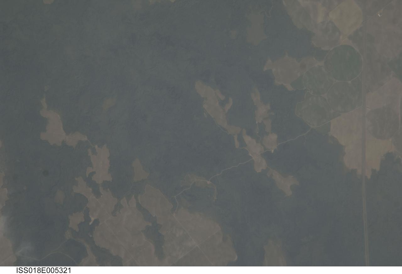
ISS018-E-005321 (24 Oct. 2008) --- The Hell's Half Acre Lava Field in Idaho is featured in this image photographed by an Expedition 18 crewmember on the International Space Station. Located in eastern Idaho, the Hell's Half Acre Lava Field is the easternmost large field associated with the Snake River Plain that arcs across the center of the state. The abundant lava flows and other volcanic rocks of the Snake River Plain are thought to be the result of southwest passage of the North American tectonic plate over a fixed mantle plume or "hotspot". According to scientists, Volcanism attributed to the hotspot began approximately 15 million years ago in the western portion of the Plain, with lava fields becoming younger to the east -- with lavas erupted approximately 4,100 years ago, Hell's Half Acre is one of the youngest lava fields. Today, the center of hotspot volcanism is located in Yellowstone National Park and feeds the extensive geyser system there. Portions of the Hell's Half Acre Lava Field are designated as a National Natural Landmark and Wilderness Study Area. This detailed photograph illustrates the forbidding landscape of the basaltic lava field -- the complex ridge patterns of the black to grey-green flow surfaces, comprised of ropy pahoehoe and blocky A a lava, are clearly visible. Regions of tan soil surrounded by lava are known as kipukas -- these "islands" are windows onto the older underlaying soil surface as they were never covered by lava. The kipukas are used for agriculture (both crops and grazing) -- several green fields are visible to the northwest of Interstate Highway 15 (right). Light to dark mottling visible in the kipukas is most likely due to variations in moisture and disturbance by agricultural activities.

Taken Feb. 22, 2021, this image from the Mastcam-Z instrument on NASA's Perseverance rover shows the first target for analysis by the rover's SuperCam instrument. The target rock is approximately 29 inches (73 centimeters) across its longest axis. On the left side of the image, rocks characterized by holes partially filled with dark sands contrast with the lighter-toned, smoother texture of the rock on the right. The finer-grained Martian soil can also be seen surrounding the rocks, some of which was disturbed by the Mars 2020 mission descent stage engine plumes. The image colors portray an estimate of the natural color of each scene, or approximately what the scene would look like if we viewed it with human eyes. A key objective for Perseverance's mission on Mars is astrobiology, including the search for signs of ancient microbial life. The rover will characterize the planet's geology and past climate, pave the way for human exploration of the Red Planet, and be the first mission to collect and cache Martian rock and regolith (broken rock and dust). Subsequent NASA missions, in cooperation with ESA (European Space Agency), would send spacecraft to Mars to collect these sealed samples from the surface and return them to Earth for in-depth analysis. The Mars 2020 Perseverance mission is part of NASA's Moon to Mars exploration approach, which includes Artemis missions to the Moon that will help prepare for human exploration of the Red Planet. https://photojournal.jpl.nasa.gov/catalog/PIA24484
This picture of the rim of Eos Chasma in Valles Marineris shows active erosion of the Martian surface. Layered bedrock is exposed in a steep cliff on a spur of the canyon rim. Dark layers in this cliff are made up of large boulders up to 4 meters in diameter. The boulders are lined up along specific horizons, presumably individual lava flows, and are perched to descend down into the canyon upon the slightest disturbance. How long will the boulders remain poised to fall, and what will push them over the edge? Just as on Earth, the main factors that contribute to dry mass wasting erosion on Mars are frost heaving and thermal expansion and contraction due to changes in temperature. The temperature changes on Mars are extreme compared to Earth, because of the lack of humidity in the Martian atmosphere and the eccentricity of the Martian orbit. Each daily temperature cycle and each seasonal change from summer to winter produces a cycle of expansion and contraction that pushes the boulders gradually closer to the brink. Inevitably, the boulders fall from their precarious positions and plunge into the canyons below. Most simply slide down slope and collect just below the source layers. A few are launched along downward trajectories, travelling long distances before they settle on the slopes below. These trundling boulders left behind conspicuous tracks, up to a kilometer long. The tracks resemble dashed lines or perforations, indicating that the boulders bounced as they trundled down the slopes. The visibility of the boulder tracks suggests that this process may have taken place recently. The active Martian winds quickly erased the tracks of the rover Opportunity, for example. However, the gouges produced by trundling boulders probably go much deeper than the shallow compression of soil by the wheels of a relatively lightweight rover. The boulder tracks might persist for a much longer time span than the rover tracks for this reason. Nevertheless, the tracks of the boulders suggest that erosion of the rim of Eos Chasma is a process that continues today. http://photojournal.jpl.nasa.gov/catalog/PIA21203
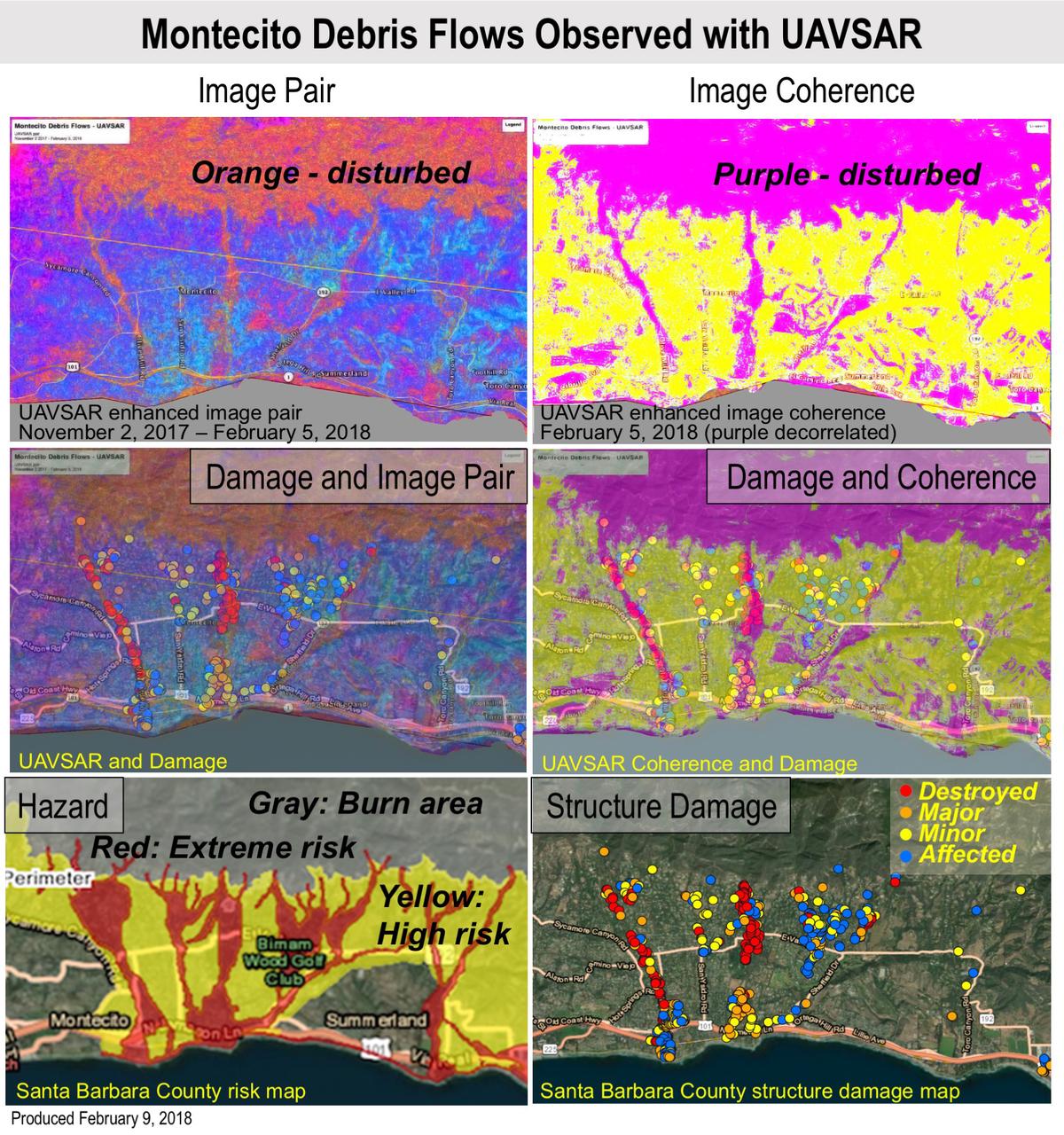
Extreme winter rains in January 2018 following the Thomas Fire in Ventura and Santa Barbara Counties caused severe debris flows, resulting in significant loss of life and considerable property damage in the town on Montecito, just east of Santa Barbara. NASA's Uninhabited Aerial Vehicle Synthetic Aperture Radar (UAVSAR) airborne radar platform detected changes caused by the debris flows between two images acquired on Nov. 2, 2017, and Feb. 5, 2018. An enhanced image pair (top left) shows disturbed areas in orange. In areas of severe surface disruption from the fire scar and debris flows the two image pairs can't be matched and decorrelate (top right). In the middle panels, the radar images are overlaid on the structure damage map produced by the County of Santa Barbara. The fire scars and damage correspond well with the risk map (lower left) and damage map (lower right). With an operational system, products such as these have the potential to augment information available for search and rescue, and for damage assessment for government agencies or the insurance industry. Radar has the advantage of being available in all weather conditions, as it can image through clouds. NASA's Uninhabited Aerial Vehicle Synthetic Aperture Radar (UAVSAR), developed and managed by the Jet Propulsion Laboratory, Pasadena, California, can record changes on the ground beneath the aircraft that occur between multiple flights, which take exactly the same flight path. The instrument is used to monitor how volcanoes, earthquakes, and other natural hazards are changing Earth. The JPL UAVSAR team collected and processed the imagery for Principal Investigator Andrea Donnellan who performed the analysis. She has been conducting ground change research using UAVSAR in this and other regions of California since 2009. https://photojournal.jpl.nasa.gov/catalog/PIA22243

STS059-S-039 (11 April 1994) --- This is a false-color composite of Prince Albert, Canada, centered at 53.91 north latitude and 104.69 west longitude. This image was acquired by the Spaceborne Imaging Radar-C and X-Band Synthetic Aperture Radar (SIR-C/X-SAR) aboard the Space Shuttle Endeavour on its 20th orbit. The area is located 40 kilometers (25 miles) north and 30 kilometers (20 miles) east of the town of Prince Albert in the Saskatchewan province of Canada. The image covers the area east of the Candle Lake, between gravel surface Highways 120 and 106 and west of 106. The area in the middle of the image covers the entire Nipawin (Narrow Hills) provincial park. The look angle of the radar is 30 degrees and the size of the image is approximately 20 kilometers by 50 kilometers (12 by 30 miles). The image was produced by using only the L-Band. The three polarization channels HH, HV and VV are illustrated by red, green and blue respectively. The changes in the intensity of each color are related to various surface conditions such as variations in forest stands, frozen or thawed condition of the surface, disturbances (fire and deforestation), and areas of re-growth. Most of the dark areas in the image are the ice-covered lakes in the region. The dark area on the top right corner of the image is the White Gull Lake north of the intersection of Highway 120 and 913. The right middle part of the image shows Lake Ispuchaw and Lower Fishing Lake. The deforested areas are also shown by dark areas in the image. Since most of the logging practice at the Prince Albert area is around the major highways, the deforested areas can be easily detected as small geometrically shaped dark regions along the roads. At the time of the SIR-C/X-SAR overpass, a major part of the forest is either frozen or undergoing the spring thaw. The L-Band HH shows a high return in the jack pine forest. The reddish areas in the image are old jack pine forest, 12-17 meters (40-55 feet) in height and 60-75 years old. The orange-greenish areas are young jack pine trees, 3-5 meters (10-16 feet) in height and 11-16 years old. The green areas are due to the relative high intensity of the HV channel which is strongly correlated with the amount of biomass. L-Band HV channel shows the biomass variations over the entire region. Most of the green areas, when compared to the forest cover maps are identified as black spruce trees. The dark blue and dark purple colors show recently harvested or re-growth areas respectively. SIR-C/X-SAR is part of NASA's Mission to Planet Earth (MTPE). SIR-C/X-SAR radars illuminate Earth with microwaves allowing detailed observations at any time, regardless of weather or sunlight conditions. SIR-C/X-SAR uses three microwave wavelengths: L-Band (24 cm), C-Band (6 cm), and X-Band (3 cm). The multi-frequency data will be used by the international scientific community to better understand the global environment and how it is changing. The SIR-C/X-SAR data, complemented by aircraft and ground studies, will give scientists clearer insights into those environmental changes which are caused by nature and those changes which are induced by human activity. SIR-C was developed by NASA's Jet Propulsion Laboratory (JPL). X-SAR was developed by the Dornire and Alenia Spazio Companies for the German Space Agency, Deutsche Agentur fuer Raumfahrtangelegenheiten (DARA), and the Italian Space Agency, Agenzia Spaziale Italiana (ASI). JPL Photo ID: P-43886

This stunning image, captured by the NASA/ESA Hubble Space Telescope’s Advanced Camera for Surveys (ACS), shows part of the sky in the constellation of Sagittarius (The Archer). The region is rendered in exquisite detail — deep red and bright blue stars are scattered across the frame, set against a background of thousands of more distant stars and galaxies. Two features are particularly striking: the colors of the stars, and the dramatic crosses that burst from the centers of the brightest bodies. While some of the colors in this frame have been enhanced and tweaked during the process of creating the image from the observational data, different stars do indeed glow in different colors. Stars differ in color according to their surface temperature: very hot stars are blue or white, while cooler stars are redder. They may be cooler because they are smaller, or because they are very old and have entered the red giant phase, when an old star expands and cools dramatically as its core collapses. The crosses are nothing to do with the stars themselves, and, because Hubble orbits above Earth’s atmosphere, nor are they due to any kind of atmospheric disturbance. They are actually known as diffraction spikes, and are caused by the structure of the telescope itself. Like all big modern telescopes, Hubble uses mirrors to capture light and form images. Its secondary mirror is supported by struts, called telescope spiders, arranged in a cross formation, and they diffract the incoming light. Diffraction is the slight bending of light as it passes near the edge of an object. Every cross in this image is due to a single set of struts within Hubble itself! Whilst the spikes are technically an inaccuracy, many astrophotographers choose to emphasize and celebrate them as a beautiful feature of their images. Image credit: ESA/Hubble & NASA <b><a href="http://www.nasa.gov/audience/formedia/features/MP_Photo_Guidelines.html" rel="nofollow">NASA image use policy.</a></b> <b><a href="http://www.nasa.gov/centers/goddard/home/index.html" rel="nofollow">NASA Goddard Space Flight Center</a></b> enables NASA’s mission through four scientific endeavors: Earth Science, Heliophysics, Solar System Exploration, and Astrophysics. Goddard plays a leading role in NASA’s accomplishments by contributing compelling scientific knowledge to advance the Agency’s mission. <b>Follow us on <a href="http://twitter.com/NASAGoddardPix" rel="nofollow">Twitter</a></b> <b>Like us on <a href="http://www.facebook.com/pages/Greenbelt-MD/NASA-Goddard/395013845897?ref=tsd" rel="nofollow">Facebook</a></b> <b>Find us on <a href="http://instagrid.me/nasagoddard/?vm=grid" rel="nofollow">Instagram</a></b>
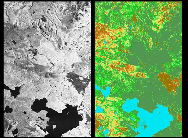
These two radar images show the majestic Yellowstone National Park, Wyoming, the oldest national park in the United States and home to the world's most spectacular geysers and hot springs. The region supports large populations of grizzly bears, elk and bison. In 1988, the park was burned by one of the most widespread fires to occur in the northern Rocky Mountains in the last 50 years. Surveys indicated that 793,880 acres of land burned. Of that, 41 percent was burned forest, with tree canopies totally consumed by the fire; 35 percent was a combination of unburned, scorched and blackened trees; 13 percent was surface burn under an unburned canopy; 6 percent was non-forest burn; and 5 percent was undifferentiated burn. Six years later, the burned areas are still clearly visible in these false-color radar images obtained by the Spaceborne Imaging Radar-C/X-band Synthetic Aperture Radar on board the space shuttle Endeavour. The image at the left was obtained using the L-band radar channel, horizontally received and vertically transmitted, on the shuttle's 39th orbit on October 2, 1994. The area shown is 45 kilometers by 71 kilometers (28 miles by 44 miles) in size and centered at 44.6 degrees north latitude, 110.7 degrees west longitude. North is toward the top of the image (to the right). Most trees in this area are lodge pole pines at different stages of fire succession. Yellowstone Lake appears as a large dark feature at the bottom of the scene. At right is a map of the forest crown, showing its biomass, or amount of vegetation, which includes foliage and branches. The map was created by inverting SIR-C data and using in situ estimates of crown biomass gathered by the Yellowstone National Biological Survey. The map is displayed on a color scale from blue (rivers and lakes with no biomass) to brown (non-forest areas with crown biomass of less than 4 tons per hectare) to light brown (areas of canopy burn with biomass of between 4 and 12 tons per hectare). Yellow indicates areas of canopy burn and mixed burn with a biomass of between 12 to 20 tons per hectare; light green is mixed burn and on-burn forest with a biomass of 20 to 35 tons per hectare; and green is non-burned forest with a biomass of greater than 35 tons per hectare. Forest recovery from the fire seems to depend on fire intensity and soil conditions. In areas of severe canopy burn and poor soil conditions, crown biomass was still low in 1994 (indicated by the brown areas at the center left), whereas in areas of mixed burn with nutrient-rich soils, seen west of Yellowstone Lake, crown biomass has increased significantly in six years (indicated by the yellow and light green areas). Imaging fire-affected regions with spaceborne radar illustrates SIR-C/X-SAR's keen abilities to monitor regrowth after a fire. Knowing the amount of carbon accumulated in the atmosphere by regenerating forest in the 20 to 50 years following a fire disturbance is also a significant factor in understanding the global carbon cycle. Measuring crown biomass is necessary to evaluate the effects of past and future fires in specific regions. http://photojournal.jpl.nasa.gov/catalog/PIA01741