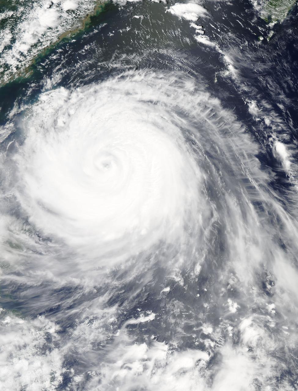
The MODIS instrument aboard NASA's Aqua satellite flew over Typhoon Soudelor on Aug. 7, 2015, at 4:40 UTC (12:40 a.m. EDT) as it was approaching Taiwan. Credits: NASA Goddard's MODIS Rapid Response Team Clouds in Typhoon Soudelor's western quadrant were already spreading over Taiwan early on August 7 when NASA's Aqua satellite passed overhead. Soudelor is expected to make landfall and cross central Taiwan today and make a second landfall in eastern China. NASA satellite imagery revealed that Soudelor's eye "opened" five more miles since August 4. On Aug. 7 at 4:40 UTC (12:40 a.m. EDT) the Moderate Resolution Imaging Spectroradiometer or MODIS instrument aboard NASA's Aqua satellite captured a visible-light image of Typhoon Soudelor as its western quadrant began brushing eastern Taiwan. The MODIS image showed Soudelor's 17-nautical-mile-wide eye and thick bands of powerful thunderstorms surrounded the storm and spiraled into the center. Just three days before, the eye was 5 nautical miles smaller when the storm was more intense. On Aug. 4 at 4:10 UTC (12:10 a.m. EDT) Aqua's MODIS image showed the eye was 12-nautical-mile-wide eye. At 1500 UTC (11 a.m. EDT) on August 7, 2015, the Joint Typhoon Warning Center (JTWC) noted that Typhoon Soudelor's maximum sustained winds increased from 90 knots (103.6 mph/166.7 kph) to 105 knots (120.8 mph / 194.5 kph). It was centered near 23.1 North latitude and 123.2 East longitude, about 183 nautical miles (210.6 miles/338.9 km) southeast of Taipei, Taiwan. It was moving to the west-northwest at 10 knots (11.5 mph/18.5 kph). For warnings and watches for Taiwan, visit the Central Weather Bureau website: <a href="http://www.cwb.gov.tw/eng/" rel="nofollow">www.cwb.gov.tw/eng/</a>. For warnings in China, visit the China Meteorological Administration website: <a href="http://www.cma.gov.cn/en" rel="nofollow">www.cma.gov.cn/en</a>. Soudelor's final landfall is expected in eastern China on Saturday, August 8. Clouds in Typhoon Soudelor's western quadrant were already spreading over Taiwan early on August 7 when NASA's Aqua satellite passed overhead. Soudelor is expected to make landfall and cross central Taiwan today and make a second landfall in eastern China. NASA satellite imagery revealed that Soudelor's eye "opened" five more miles since August 4. On Aug. 7 at 4:40 UTC (12:40 a.m. EDT) the Moderate Resolution Imaging Spectroradiometer or MODIS instrument aboard NASA's Aqua satellite captured a visible-light image of Typhoon Soudelor as its western quadrant began brushing eastern Taiwan. The MODIS image showed Soudelor's 17-nautical-mile-wide eye and thick bands of powerful thunderstorms surrounded the storm and spiraled into the center. Just three days before, the eye was 5 nautical miles smaller when the storm was more intense. On Aug. 4 at 4:10 UTC (12:10 a.m. EDT) Aqua's MODIS image showed the eye was 12-nautical-mile-wide eye. At 1500 UTC (11 a.m. EDT) on August 7, 2015, the Joint Typhoon Warning Center (JTWC) noted that Typhoon Soudelor's maximum sustained winds increased from 90 knots (103.6 mph/166.7 kph) to 105 knots (120.8 mph / 194.5 kph). It was centered near 23.1 North latitude and 123.2 East longitude, about 183 nautical miles (210.6 miles/338.9 km) southeast of Taipei, Taiwan. It was moving to the west-northwest at 10 knots (11.5 mph/18.5 kph). For warnings and watches for Taiwan, visit the Central Weather Bureau website: <a href="http://www.cwb.gov.tw/eng/" rel="nofollow">www.cwb.gov.tw/eng/</a>. For warnings in China, visit the China Meteorological Administration website: <a href="http://www.cma.gov.cn/en" rel="nofollow">www.cma.gov.cn/en</a>. Soudelor's final landfall is expected in eastern China on Saturday, August 8.

In this MODIS image from NASA's Aqua satellite, the eye of Typhoon Soudelor is seen over northwestern Taiwan on August 8, 2015 at 05:25 UTC (1:25 a.m. EDT). At that time, Soudelor had maximum sustained winds near 90 knots. It was less than 100 miles southwest of Taipei, Taiwan. Typhoon-force winds were felt up to 35 miles from the center, covering a 70 mile-wide diameter. Image credit: NASA Goddard MODIS Rapid Response Team/Jeff Schmaltz..<b><a href="http://www.nasa.gov/audience/formedia/features/MP_Photo_Guidelines.html" rel="nofollow">NASA image use policy.</a></b> <b><a href="http://www.nasa.gov/centers/goddard/home/index.html" rel="nofollow">NASA Goddard Space Flight Center</a></b> enables NASA’s mission through four scientific endeavors: Earth Science, Heliophysics, Solar System Exploration, and Astrophysics. Goddard plays a leading role in NASA’s accomplishments by contributing compelling scientific knowledge to advance the Agency’s mission. <b>Follow us on <a href="http://twitter.com/NASAGoddardPix" rel="nofollow">Twitter</a></b> <b>Like us on <a href="http://www.facebook.com/pages/Greenbelt-MD/NASA-Goddard/395013845897?ref=tsd" rel="nofollow">Facebook</a></b> <b>Find us on <a href="http://instagrid.me/nasagoddard/?vm=grid" rel="nofollow">Instagram</a></b>
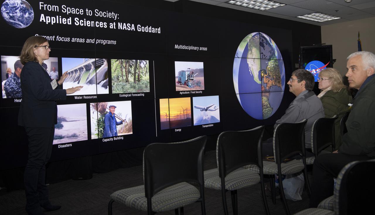
Mr. Lai Chien-Hsin Director General of Taiwan's Water Resources Agency and staff of US Bureau of Reclamation visited Goddard November 15, 2018 They toured facilties such as Hyperwall - Stephanie Uz
Mr. Lai Chien-Hsin, Director Genreal of Taiwan’s Water Resources Agency and staff US Bureau of Reclamation visited Goddard November 15, 2018 They toured Hyperwall and Earth Sciences facilities
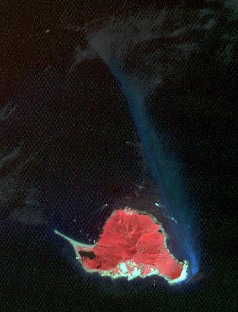
Twelve km off Taiwan's NE coast lies Turtle Island, a forest-covered volcanic island. The bluish patch of water on the island's eastern side (nicknamed the Milky Sea) marks the site of dozens of hydrothermal vents, spewing out hot, acidic water laden with heavy metals and toxic gases. The image was acquired October 4, 2020, covers an area of 10.6 by 13.9 km, and is located at 24.8 degrees north, 122 degrees east. (credit BBC News for this information) https://photojournal.jpl.nasa.gov/catalog/PIA24950

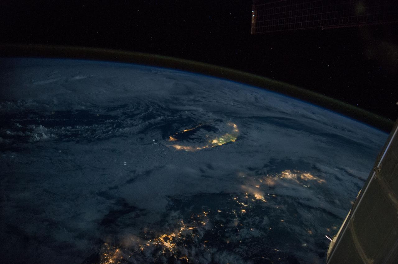
iss072e435710 (Dec. 28, 2024) --- The Taiwan Strait separates China's southeast coast from Taiwan in this photograph from the International Space Station as it orbited 257 miles above Asia. From bottom center toward the upper left, the city lights from Quanzhuo to Shanghai light up the Chinese coast. Toward right center, the city lights from Taipei to Tainan (bottom right) illuminate Taiwan's western coast. This frame was captured approximately 12:51 a.m. local time.
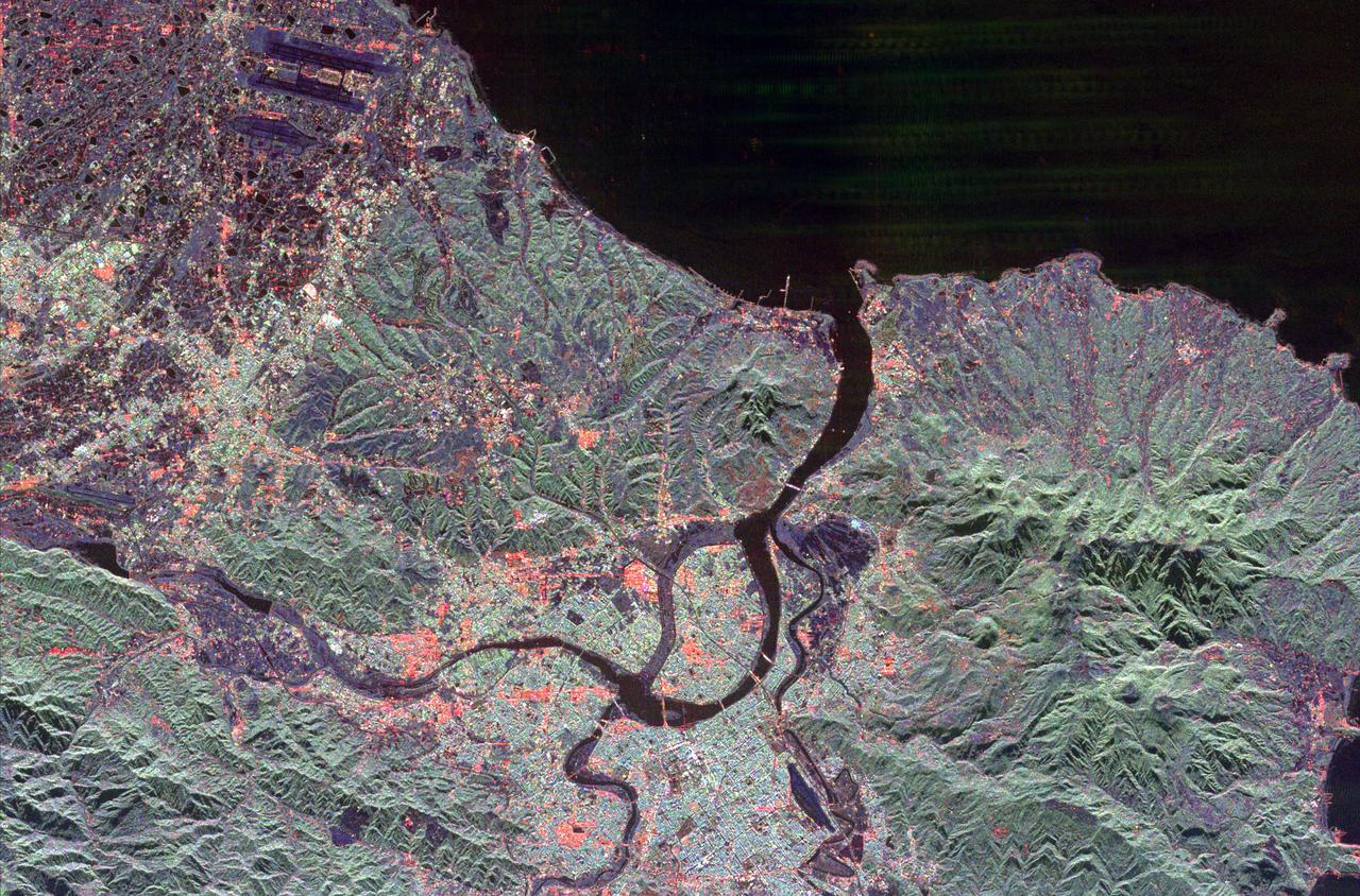
The northern end of the island country of Taiwan, including the capital city of Taipei, is shown in this spaceborne radar image. Taipei is the bright blue and red area in the lower center of the image.
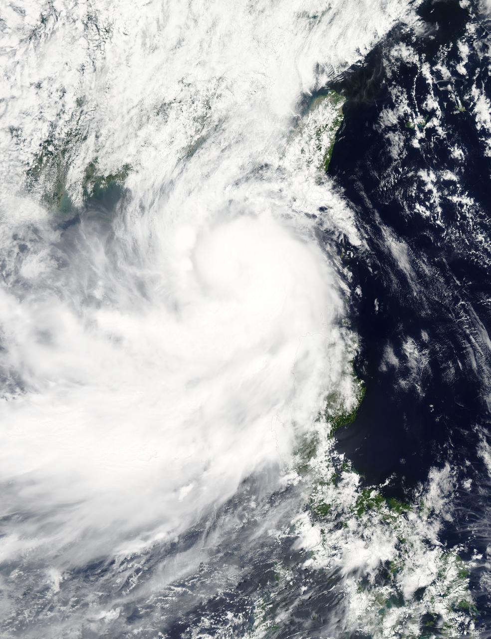
NASA's Aqua satellite captured a picture of Tropical Storm Linfa in the South China Sea on July 7 when it was between southern Taiwan and the northern Philippines. Aqua passed over Linfa on July 7 at 05:25 UTC (1:25 a.m. EDT) and the Moderate Resolution Imaging Spectroradiometer or MODIS instrument captured a visible image of the storm. Bands of thunderstorms wrapping into the center of circulation from the south, draped over western Luzon. The MODIS image showed the tight concentration of thunderstorms around Linfa's center were located over the South China Sea. Fragmented bands of thunderstorms north of the center were brushing over Southern Taiwan while clouds from another band of fragmented thunderstorms stretched northwest through the Taiwan Strait. On July 7 at 1500 UTC (11 a.m. EDT), Tropical Storm Linfa's maximum sustained winds had increased to 50 knots (57.5 mph/92.6 kph), up from 45 knots (51.7 mph/83.3 kph) six hours before. Linfa strengthened in the warm waters of the South China Sea now that its center has moved away from the northern Philippines and was no longer over land. Linfa was centered near 21.0 North latitude and 118.8 East longitude, about 277 nautical miles (319 miles/513.3 km) east-southeast of Hong Kong, China. Linfa has tracked northward at 3 knots (3.5 mph/5.5 kph). China's National Meteorological Centre has (CNMC) issued a yellow category warning of typhoon at 6:00 a.m. July 7, Beijing Time. CNMC noted that Linfa is the tenth typhoon this year and at that time it was centered about 430 km (267.2 miles) southeast of border between Fujian and Guangdong For updated warnings and watches from the China Meteorological Service, visit: <a href="http://www.cma.gov.cn/en/WeatherWarnings/" rel="nofollow">www.cma.gov.cn/en/WeatherWarnings/</a>. Linfa is moving north between Luzon and Taiwan. The Joint Typhoon Warning Center expects Linfa to strengthen to 60 knots (69 mph/111 kph) by mid-day on July 9, before weakening and then making landfall in mainland China. Credit: NASA/GSFC/Jeff Schmaltz/MODIS Land Rapid Response Team <b><a href="http://www.nasa.gov/audience/formedia/features/MP_Photo_Guidelines.html" rel="nofollow">NASA image use policy.</a></b> <b><a href="http://www.nasa.gov/centers/goddard/home/index.html" rel="nofollow">NASA Goddard Space Flight Center</a></b> enables NASA’s mission through four scientific endeavors: Earth Science, Heliophysics, Solar System Exploration, and Astrophysics. Goddard plays a leading role in NASA’s accomplishments by contributing compelling scientific knowledge to advance the Agency’s mission. <b>Follow us on <a href="http://twitter.com/NASAGoddardPix" rel="nofollow">Twitter</a></b> <b>Like us on <a href="http://www.facebook.com/pages/Greenbelt-MD/NASA-Goddard/395013845897?ref=tsd" rel="nofollow">Facebook</a></b> <b>Find us on <a href="http://instagrid.me/nasagoddard/?vm=grid" rel="nofollow">Instagram</a></b>

iss073e0983013 (Oct. 21, 2025) --- The Taiwan Strait separates the eastern coast of China’s Fujian Province (right) from the island nation of Taiwan (lower left) in this photograph taken from the International Space Station as it orbited 257 miles above Earth. The strait is a vital waterway in East Asia, supporting the fishing, shipping, and communications industries.
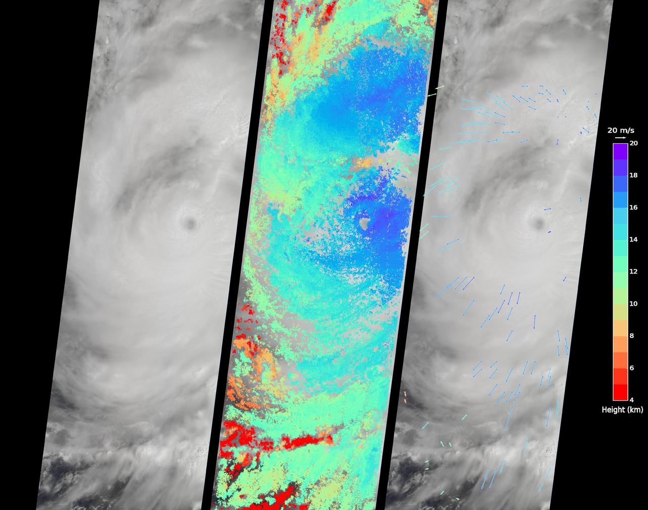
On Sept. 14, 2016, the eye of Super Typhoon Meranti passed just south of Taiwan. The enormous storm, classified as a Category 5 typhoon at the time, still caused much disruption on the island. Nearly 500,000 homes lost power, schools were closed, and most flights were cancelled. Maximum wind speeds were 180 miles per hour (290 kilometers per hour) as the storm passed, and more than 25 inches (64 centimeters) of rain fell on some areas of the country. However, the storm did not pass over Taiwan's mountainous landscape, which would have weakened it. That means it will remain strong as it heads toward mainland China, unlike Super Typhoon Nepartak in July, which weakened from a Category 5 typhoon to a tropical storm after crossing Taiwan. Meranti is currently maintaining Category 4 strength and is expected to make landfall near Shantou, Guangdong province, on Thursday, September 15. The coast of China is more vulnerable to storm surges than Taiwan due to shallower coastal waters and recent rainfall. There is risk of substantial flooding. On Sept. 14, at 10:45 AM local time, the Multi-angle Imaging SpectroRadiometer (MISR) instrument aboard NASA's Terra satellite passed directly over the eye of Meranti. On the left is a natural-color image from MISR's nadir-pointing camera. At this time the eye of Meranti was just off the southern tip of Taiwan, which is invisible under the clouds. The coast of China is barely visible through the clouds in the upper left portion of the image. The small eye and dense high clouds are both markers of the storm's power. MISR's nine cameras, each pointed at a different angle, can be used to determine the heights of clouds based on geometric shifts among the nine images. The middle panel shows these stereo-derived cloud top heights superimposed on the natural color image. The clouds of the central core of Typhoon Meranti have heights ranging between 16 and 20 kilometers (10 and 12.5 miles). It takes about seven minutes for all nine cameras to image the same location on the ground, and wind velocity can be calculated from the motion of the clouds over this seven-minute period. The right panel plots these wind velocities as vectors which indicate both direction and speed. The length of the arrow corresponds to the wind speed, which can be compared to the reference 20 meters per second (45 miles per hour) arrow in the key. Hurricanes and typhoons in the Northern Hemisphere rotate counterclockwise due to the Earth's rotation, but these wind vectors mainly show motion outward from the eye at the storm tops. This is due to the fact that hurricanes draw in moist air at low altitudes, which then flows upwards and outwards around the eye reversing direction. These data were acquired during Terra orbit 88865. http://photojournal.jpl.nasa.gov/catalog/PIA17309

On Sept. 21, Typhoon Usagi was moving between the northern Philippines and Taiwan when NASA's Aqua satellite passed overhead. NASA's AIRS instrument that flies aboard the Aqua satellite captured this near-infrared image on Sept. 21 at 505 UTC/1:05 a.m. EDT as Usagi. The near-infrared image is similar to how the clouds of the typhoon would appear in the daylight. Image Credit: NASA JPL, Ed Olsen Caption: NASA Goddard, Rob Gutro <b><a href="http://www.nasa.gov/audience/formedia/features/MP_Photo_Guidelines.html" rel="nofollow">NASA image use policy.</a></b> <b><a href="http://www.nasa.gov/centers/goddard/home/index.html" rel="nofollow">NASA Goddard Space Flight Center</a></b> enables NASA’s mission through four scientific endeavors: Earth Science, Heliophysics, Solar System Exploration, and Astrophysics. Goddard plays a leading role in NASA’s accomplishments by contributing compelling scientific knowledge to advance the Agency’s mission. <b>Follow us on <a href="http://twitter.com/NASA_GoddardPix" rel="nofollow">Twitter</a></b> <b>Like us on <a href="http://www.facebook.com/pages/Greenbelt-MD/NASA-Goddard/395013845897?ref=tsd" rel="nofollow">Facebook</a></b> <b>Find us on <a href="http://instagram.com/nasagoddard?vm=grid" rel="nofollow">Instagram</a></b>

iss073e0688699 (Aug. 26, 2025) --- The blue-green lights of fishing boats, designed to lure squid, sardines, or mackerel, dot the East China Sea and the Taiwan Strait contrasting with the coastal city lights of Taiwan and China. The International Space Station was orbiting 259 miles above the South China Sea just south of Taiwan at approximately 11:53 p.m. local time when this photograph was taken.

S63-06437 (15-16 May 1963) --- The southern portion of the island of Taiwan (Formosa), Formosa Straight and the Pacific Ocean, looking northeast, as photographed from the Mercury-Atlas 9 (MA-9) capsule by astronaut L. Gordon Cooper Jr., during his 22-orbit MA-9 spaceflight. Photo credit: NASA
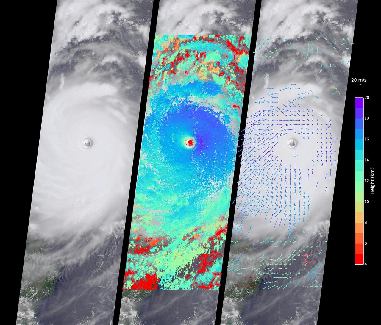
Typhoon Nepartak, the first large typhoon in the northwest Pacific this season, is currently taking aim at the east coast of Taiwan. Over the past few days, Nepartak has rapidly gained strength, growing from a tropical storm to the equivalent of a Category 5 hurricane with sustained wind speeds of more than 160 miles (258 kilometers) per hour. Taiwan's Central Weather Bureau has issued a torrential rain warning, bracing for likely flooding as 5 to 15 inches (13 to 38 centimeters) of rain are expected to fall over Taiwan during the storm's passage. Waves of up to 40 feet (12 meters) are predicted on the coast as the typhoon approaches, and air and train travel have been severely impacted. The typhoon is currently moving at about 10 miles per hour (16 kilometers) to the west-northwest, and is predicted to pass over Taiwan within the next day and then hit the coast of mainland China. Central and eastern China are poorly situated to absorb the rainfall from Nepartak after suffering the effects of severe monsoon flooding, which has killed at least 140 people in the past week. The Multi-angle Imaging SpectroRadiometer (MISR) instrument aboard NASA's Terra satellite captured this view of Typhoon Nepartak on July 7, 2016, at 10:30 a.m. local time (2:30 a.m. UTC). On the left is an image from the nadir (vertical pointing) camera, which shows the central portion of Nepartak and the storm's eye. The image is about 235 miles (378 kilometers) across. The island of Manila in the Philippines, about 250 miles (400 kilometers) south of Taiwan, is visible to the southwest of the eye. The image shows that Nepartak's center is extremely compact, rather than broken up into spiral bands as is more typical of typhoons. This means that the storm may retain more of its strength as it passes over land. MISR uses nine cameras to capture images of the typhoon from different angles. This provides a stereographic view, which can be used to determine the height of the storm's cloud tops. These heights are plotted in the middle panel, superimposed on the image. This shows that the cloud tops are relatively low, about 2.5 miles (4 kilometers), in the eye, but much higher, up to 12.5 miles (20 kilometers), just outside it. By tracking the motion of clouds as they are viewed by each of the nine cameras over about seven minutes, it is possible to also derive how fast the clouds are moving due to wind. These wind vectors are superimposed on the image in the right panel. The length of each arrow shows the wind speed at that location (compare to the 45 miles per hour or 20 meters per second arrow in the legend), and the color shows the height at which the wind is being computed. The motion of the low-level winds (red and yellow arrows) is counterclockwise, while the motion of the high winds (blue and purple arrows) is mostly clockwise. This is because hurricanes draw in warm, moist air at low altitudes, which then flows upward around the eye, releases its moisture as rain, and moves outward at high altitudes. As is typical of these types of storm systems, the inflowing low winds and the outflowing high winds spin in different directions. http://photojournal.jpl.nasa.gov/catalog/PIA20719
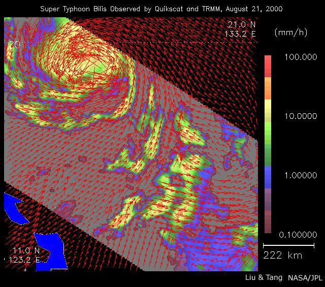
As super Typhoon Bilis, equal in strength to a category 5 hurricane, bore down on Taiwan, these images from August 21, 2000, show the massive storm most devastating components: rain and wind.
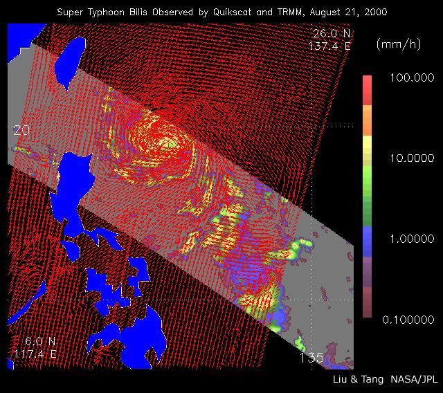
As super Typhoon Bilis, equal in strength to a category 5 hurricane, bore down on Taiwan, these images from August 21, 2000, show the massive storm most devastating components: rain and wind.

iss064e023038 (Jan. 14, 2021) --- The brightly-lit west coast of the mountainous island nation of Taiwan is pictured from the International Space Station as it orbited due north 261 miles above the East China Sea. Taipei, the capital of Taiwan, is at the far left of this image.
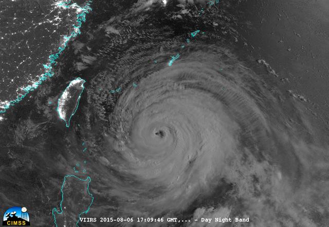
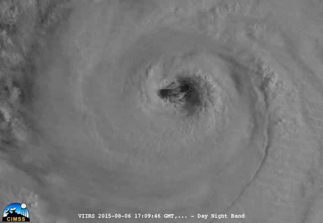
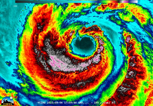
On August 6, 2015, NASA-NOAA's Suomi NPP satellite passed over powerful Typhoon Soudelor at night when it was headed toward Taiwan. The Visible Infrared Imaging Radiometer Suite (VIIRS) instrument aboard NASA-NOAA's Suomi satellite captured this night-time infrared image of the storm. At 1500 UTC (11 a.m. EDT) on August 6, 2015, Typhoon Soudelor had maximum sustained winds near 90 knots (103.6 mph/166.7 kph). It was centered near 21.3 North latitude and 127.5 East longitude, about 324 nautical miles (372.9 miles/600 km) south of Kadena Air Base, Okinawa, Japan. It was moving to the west at 10 knots (11.5 mph/18.5 kph). Taiwan is located west (left) of the powerful typhoon in this image. Credit: UWM/CIMSS/SSEC, William Straka III <b><a href="http://www.nasa.gov/audience/formedia/features/MP_Photo_Guidelines.html" rel="nofollow">NASA image use policy.</a></b> <b><a href="http://www.nasa.gov/centers/goddard/home/index.html" rel="nofollow">NASA Goddard Space Flight Center</a></b> enables NASA’s mission through four scientific endeavors: Earth Science, Heliophysics, Solar System Exploration, and Astrophysics. Goddard plays a leading role in NASA’s accomplishments by contributing compelling scientific knowledge to advance the Agency’s mission. <b>Follow us on <a href="http://twitter.com/NASAGoddardPix" rel="nofollow">Twitter</a></b> <b>Like us on <a href="http://www.facebook.com/pages/Greenbelt-MD/NASA-Goddard/395013845897?ref=tsd" rel="nofollow">Facebook</a></b> <b>Find us on <a href="http://instagrid.me/nasagoddard/?vm=grid" rel="nofollow">Instagram</a></b>

Earth observation taken during a night pass by an Expedition 36 crew member on board the International Space Station (ISS). Per Twitter message this is labeled as: Taiwan.

iss073e0848542 (Sept. 17, 2025) --- Green fishing boat lights lure squid, mackerel, and amberjack in the Taiwan Strait near China’s coast, glowing with white LED city lights from Fuzhou to Shenzhen. In contrast, Taiwan’s coast (right) from Taipei to Kaohsiung glows amber from sodium streetlights. The International Space Station captured this view from 261 miles above the East China Sea at 11:55 p.m. local time.
![ISS036-E-017957 (11 July 2013) --- One of the Expedition 36 crew members aboard the International Space Station photographed this image of Typhoon Soulik just east of northern Taiwan in the Pacific Ocean. [Editor?s update: Thousands of people were evacuated in Taiwan; and the entire island was declared an "alert zone," as Typhoon Soulik made landfall early on July 13 (local time), pounding the country with powerful winds and heavy rain].](https://images-assets.nasa.gov/image/iss036e017957/iss036e017957~medium.jpg)
ISS036-E-017957 (11 July 2013) --- One of the Expedition 36 crew members aboard the International Space Station photographed this image of Typhoon Soulik just east of northern Taiwan in the Pacific Ocean. [Editor?s update: Thousands of people were evacuated in Taiwan; and the entire island was declared an "alert zone," as Typhoon Soulik made landfall early on July 13 (local time), pounding the country with powerful winds and heavy rain].
![ISS036-E-017943 (11 July 2013) --- One of the Expedition 36 crew members aboard the International Space Station photographed this image of Typhoon Soulik just east of northern Taiwan The city of Guangzhou can be seen along the coast. [Editor?s update: Thousands of people were evacuated in Taiwan; and the entire island was declared an "alert zone," as Typhoon Soulik made landfall early on July 13 (local time), pounding the country with powerful winds and heavy rain].](https://images-assets.nasa.gov/image/iss036e017943/iss036e017943~medium.jpg)
ISS036-E-017943 (11 July 2013) --- One of the Expedition 36 crew members aboard the International Space Station photographed this image of Typhoon Soulik just east of northern Taiwan The city of Guangzhou can be seen along the coast. [Editor?s update: Thousands of people were evacuated in Taiwan; and the entire island was declared an "alert zone," as Typhoon Soulik made landfall early on July 13 (local time), pounding the country with powerful winds and heavy rain].
![ISS036-E-017952 (11 July 2013) --- One of the Expedition 36 crew members aboard the International Space Station photographed this image of Typhoon Soulik just east of northern Taiwan in the Pacific Ocean. [Editor?s update: Thousands of people were evacuated in Taiwan; and the entire island was declared an "alert zone," as Typhoon Soulik made landfall early on July 13 (local time), pounding the country with powerful winds and heavy rain].](https://images-assets.nasa.gov/image/iss036e017952/iss036e017952~medium.jpg)
ISS036-E-017952 (11 July 2013) --- One of the Expedition 36 crew members aboard the International Space Station photographed this image of Typhoon Soulik just east of northern Taiwan in the Pacific Ocean. [Editor?s update: Thousands of people were evacuated in Taiwan; and the entire island was declared an "alert zone," as Typhoon Soulik made landfall early on July 13 (local time), pounding the country with powerful winds and heavy rain].

Typhoon Haitang is shown here churning steadily towards Taiwan and China. This image shows the storm swirling wind patterns as observed by NASA QuikScat satellite on July 14, 2005, at 19:19 UTC 14:19 Eastern Daylight Time.

Earth observation taken during a night pass by the Expedition 40 crew aboard the International Space Station (ISS). Folder lists this as: Taiwan, Japan, and fishing boats at night.
iss066e158512 (March 8, 2022) --- Quanzhou, a port city on China's Taiwan Strait, split by the Jinjiang River, is pictured during an orbital night pass from the International Space Station at an altitude of 262 miles above the Asian nation.

iss071e620932 (Aug. 20, 2024) --- Lightning (at center) illuminates the storm clouds above China near the coast of the Taiwan Strait in this photograph from the International Space Station as it orbited 261 miles above the Asian nation.
Earth observation taken during a night pass by the Expedition 40 crew aboard the International Space Station. File identifies it as: Taiwan at night. This image also used in Twitter message.
iss063e052774 (July 13, 2020) --- Sunrise casts long shadows from the clouds across the Philippine Sea as the International Space Station orbited about 200 miles east of Taiwan.
S66-45868 (18-21 July 1966) --- Southern half of the island of Taiwan (Formosa) as seen from the Gemini-10 spacecraft. Taken with a J.A. Maurer 70mm camera, using Eastman Kodak, Ektachrome, MS (S.O. 217) color film. Photo credit: NASA

STS106-704-063 (9 September 2000) --- Typhoon Saomai swirls in the Pacific Ocean east of Taiwan and the Philippines. The typhoon was captured on film with a 70mm handheld camera by the STS-106 crew members aboard the Space Shuttle Atlantis on September. 9

ISS040-E-050750 (7 July 2014) --- One of the Expedition 40 crew members aboard the International Space Station photographed a series of images of Typhoon Neoguri in the vicinity of Japan and Taiwan on July 7, 2014. This oblique 35mm focal length view was photographed at 07:41:29 GMT.

iss073e0764760 (Sept. 22, 2025) --- Typhoon Ragasa with its well-defined eye is pictured southeast of Taiwan in the Philippine Sea from the International Space Station as it orbited 257 miles above. Silhouetted in the foreground, is the Soyuz MS-27 spacecraft docked to the Prichal module.
On August 6, 2015, NASA-NOAA's Suomi NPP satellite passed over powerful Typhoon Soudelor when it was headed toward Taiwan. The Visible Infrared Imaging Radiometer Suite (VIIRS) instrument aboard NASA-NOAA's Suomi satellite captured this night-time infrared close-up image of Soudelor's eye. At 1500 UTC (11 a.m. EDT) on August 6, 2015, Typhoon Soudelor had maximum sustained winds near 90 knots (103.6 mph/166.7 kph). It was centered near 21.3 North latitude and 127.5 East longitude, about 324 nautical miles (372.9 miles/600 km) south of Kadena Air Base, Okinawa, Japan. It was moving to the west at 10 knots (11.5 mph/18.5 kph). Credit: UWM/CIMSS/SSEC, William Straka III <b><a href="http://www.nasa.gov/audience/formedia/features/MP_Photo_Guidelines.html" rel="nofollow">NASA image use policy.</a></b> <b><a href="http://www.nasa.gov/centers/goddard/home/index.html" rel="nofollow">NASA Goddard Space Flight Center</a></b> enables NASA’s mission through four scientific endeavors: Earth Science, Heliophysics, Solar System Exploration, and Astrophysics. Goddard plays a leading role in NASA’s accomplishments by contributing compelling scientific knowledge to advance the Agency’s mission. <b>Follow us on <a href="http://twitter.com/NASAGoddardPix" rel="nofollow">Twitter</a></b> <b>Like us on <a href="http://www.facebook.com/pages/Greenbelt-MD/NASA-Goddard/395013845897?ref=tsd" rel="nofollow">Facebook</a></b> <b>Find us on <a href="http://instagrid.me/nasagoddard/?vm=grid" rel="nofollow">Instagram</a></b>

On August 6, 2015, NASA-NOAA's Suomi NPP satellite passed over powerful Typhoon Soudelor when it was headed toward Taiwan. The Visible Infrared Imaging Radiometer Suite (VIIRS) instrument aboard NASA-NOAA's Suomi satellite captured an infrared image of the typhoon. The infrared image that showed there were some thunderstorms within the typhoon with very cold cloud top temperatures, colder than -63F/-53C. Temperatures that cold stretch high into the troposphere and are capable of generating heavy rain. Credit: UWM/CIMSS/SSEC, William Straka III <b><a href="http://www.nasa.gov/audience/formedia/features/MP_Photo_Guidelines.html" rel="nofollow">NASA image use policy.</a></b> <b><a href="http://www.nasa.gov/centers/goddard/home/index.html" rel="nofollow">NASA Goddard Space Flight Center</a></b> enables NASA’s mission through four scientific endeavors: Earth Science, Heliophysics, Solar System Exploration, and Astrophysics. Goddard plays a leading role in NASA’s accomplishments by contributing compelling scientific knowledge to advance the Agency’s mission. <b>Follow us on <a href="http://twitter.com/NASAGoddardPix" rel="nofollow">Twitter</a></b> <b>Like us on <a href="http://www.facebook.com/pages/Greenbelt-MD/NASA-Goddard/395013845897?ref=tsd" rel="nofollow">Facebook</a></b> <b>Find us on <a href="http://instagrid.me/nasagoddard/?vm=grid" rel="nofollow">Instagram</a></b>
On August 6, 2015, NASA-NOAA's Suomi NPP satellite passed over powerful Typhoon Soudelor when it was headed toward Taiwan. The Visible Infrared Imaging Radiometer Suite (VIIRS) instrument aboard NASA-NOAA's Suomi satellite captured this night-time infrared close-up image of Soudelor's eye. The infrared image that showed there were some thunderstorms within the typhoon with very cold cloud top temperatures, colder than -63F/-53C. Temperatures that cold stretch high into the troposphere and are capable of generating heavy rain. At 1500 UTC (11 a.m. EDT) on August 6, 2015, Typhoon Soudelor had maximum sustained winds near 90 knots (103.6 mph/166.7 kph). It was centered near 21.3 North latitude and 127.5 East longitude, about 324 nautical miles (372.9 miles/600 km) south of Kadena Air Base, Okinawa, Japan. It was moving to the west at 10 knots (11.5 mph/18.5 kph). Credit: UWM/CIMSS/SSEC, William Straka III <b><a href="http://www.nasa.gov/audience/formedia/features/MP_Photo_Guidelines.html" rel="nofollow">NASA image use policy.</a></b> <b><a href="http://www.nasa.gov/centers/goddard/home/index.html" rel="nofollow">NASA Goddard Space Flight Center</a></b> enables NASA’s mission through four scientific endeavors: Earth Science, Heliophysics, Solar System Exploration, and Astrophysics. Goddard plays a leading role in NASA’s accomplishments by contributing compelling scientific knowledge to advance the Agency’s mission. <b>Follow us on <a href="http://twitter.com/NASAGoddardPix" rel="nofollow">Twitter</a></b> <b>Like us on <a href="http://www.facebook.com/pages/Greenbelt-MD/NASA-Goddard/395013845897?ref=tsd" rel="nofollow">Facebook</a></b> <b>Find us on <a href="http://instagrid.me/nasagoddard/?vm=grid" rel="nofollow">Instagram</a></b>
The southern half of the island of Okinawa, Japan (26.5N, 128.0E) can be seen in this nearly cloud free view. Okinawa is part of the Ryuku Islands which extend from Taiwan northeastward to Kyushu, southernmost of the Japanese Home Islands. The large military base at Kadena, with large runways, is visible near the center of the scene. Kadena is one of several emergency landing sites around the world for the space shuttle.

ISS040-E-081424 (27 July 2014) --- From an altitude of 223 nautical miles, one of the Expedition 40 crew members aboard the International Space Station on July 27, 2014 recorded this oblique night image of Taiwan (center foreground) and part of mainland China. Hundreds of fishing vessels, perhaps for harvesting both fish and squid as well as other forms of marine life, are seen in clusters throughout the panorama. Two lightning storms -- one on either side of the image -- are also visible.

On August 9 at 03:00 UTC (Aug. 8 at 11 p.m. EDT) the MODIS instrument aboard NASA's Terra satellite passed over the remnant clouds of Typhoon Soudelor when it was over eastern China. By 22:35 UTC (6:35 p.m. EDT) on August 8, 2015, Typhoon Soudelor had made landfall in eastern China and was rapidly dissipating. Maximum sustained winds had dropped to 45 knots (51.7 mph/83.3 kph) after landfall, making it a tropical storm. Image credit: NASA Goddard MODIS Rapid Response Team/Jeff Schmaltz..<b><a href="http://www.nasa.gov/audience/formedia/features/MP_Photo_Guidelines.html" rel="nofollow">NASA image use policy.</a></b> <b><a href="http://www.nasa.gov/centers/goddard/home/index.html" rel="nofollow">NASA Goddard Space Flight Center</a></b> enables NASA’s mission through four scientific endeavors: Earth Science, Heliophysics, Solar System Exploration, and Astrophysics. Goddard plays a leading role in NASA’s accomplishments by contributing compelling scientific knowledge to advance the Agency’s mission. <b>Follow us on <a href="http://twitter.com/NASAGoddardPix" rel="nofollow">Twitter</a></b> <b>Like us on <a href="http://www.facebook.com/pages/Greenbelt-MD/NASA-Goddard/395013845897?ref=tsd" rel="nofollow">Facebook</a></b> <b>Find us on <a href="http://instagrid.me/nasagoddard/?vm=grid" rel="nofollow">Instagram</a></b>

On Saturday, Sept. 21, TRMM captured rainfall data on Typhoon Usagi as it passed between the northern Philippines and southern Taiwan. TRMM found rain falling at a rate of over 134 mm/hr (~5.2 inches) in USAGI's eye wall. Credit: SSAI/NASA, Hal Pierce <b><a href="http://www.nasa.gov/audience/formedia/features/MP_Photo_Guidelines.html" rel="nofollow">NASA image use policy.</a></b> <b><a href="http://www.nasa.gov/centers/goddard/home/index.html" rel="nofollow">NASA Goddard Space Flight Center</a></b> enables NASA’s mission through four scientific endeavors: Earth Science, Heliophysics, Solar System Exploration, and Astrophysics. Goddard plays a leading role in NASA’s accomplishments by contributing compelling scientific knowledge to advance the Agency’s mission. <b>Follow us on <a href="http://twitter.com/NASA_GoddardPix" rel="nofollow">Twitter</a></b> <b>Like us on <a href="http://www.facebook.com/pages/Greenbelt-MD/NASA-Goddard/395013845897?ref=tsd" rel="nofollow">Facebook</a></b> <b>Find us on <a href="http://instagram.com/nasagoddard?vm=grid" rel="nofollow">Instagram</a></b>
On July 9 at 02:05 UTC (July 8 at 10:05 p.m. EDT) the MODIS instrument aboard NASA's Terra satellite captured an image of Typhoon Chan-Hom east of Taiwan. The image clearly showed an eye with powerful bands of thunderstorms spiraling into the center of circulation. At 1500 UTC (11 a.m. EDT) on July 9, Typhoon Chan-Hom's maximum sustained winds were near 100 knots (115.1 mph/185.2 kph) and the storm continued to strengthen. Chan-Hom was centered near 24.2 North latitude and 127.6 East longitude, about 138 nautical miles (158.8 miles/255.6 km) southwest of Kadena Air Force Base, Iwo to, and has tracked westward at 13 knots (15 mph/24 kph). Read more: <a href="http://go.nasa.gov/1LYNdr0" rel="nofollow">go.nasa.gov/1LYNdr0</a> <b><a href="http://go.nasa.gov/1LYNZV6" rel="nofollow">NASA image use policy.</a></b> <b><a href="http://go.nasa.gov/1LYNXMW" rel="nofollow">NASA Goddard Space Flight Center</a></b> enables NASA’s mission through four scientific endeavors: Earth Science, Heliophysics, Solar System Exploration, and Astrophysics. Goddard plays a leading role in NASA’s accomplishments by contributing compelling scientific knowledge to advance the Agency’s mission. <b>Follow us on <a href="http://go.nasa.gov/1LYNZV9" rel="nofollow">Twitter</a></b> <b>Like us on <a href="http://go.nasa.gov/1LYNXN0" rel="nofollow">Facebook</a></b> <b>Find us on <a href="http://go.nasa.gov/1LYNZVc" rel="nofollow">Instagram</a></b>
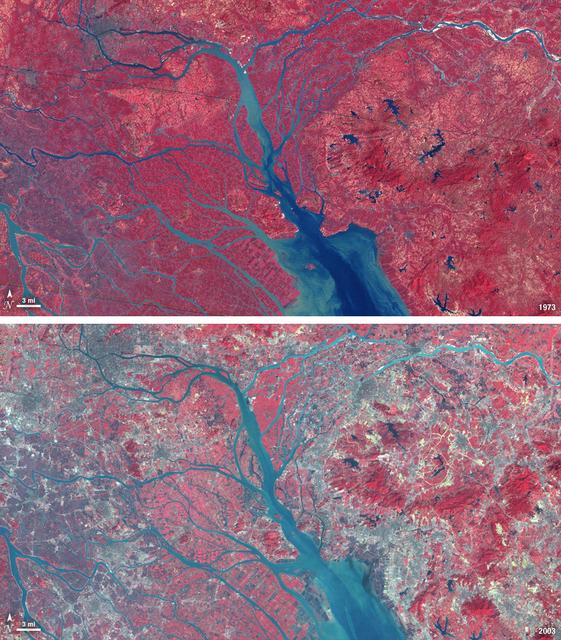
In 1979, China established two special economic zones around the Pearl River Delta, north of Hong Kong. This image, taken by Landsat 3 on October 19, 1973, shows that the region was rural when the zone was established. Plant-covered land, which is red in this false-color image, dominates the scene. Square grids are agriculture. By January 10, 2003, when Landsat 7 took this image, the Pearl River Delta was a densely populated urban corridor with several large cities. The urban areas are gray in this image. The region is a major manufacturing center with an economy the size of Taiwan’s. As of 2010, the Pearl River Economic Zone had a population of 36 million people. ---- NASA and the U.S. Department of the Interior through the U.S. Geological Survey (USGS) jointly manage Landsat, and the USGS preserves a 40-year archive of Landsat images that is freely available over the Internet. The next Landsat satellite, now known as the Landsat Data Continuity Mission (LDCM) and later to be called Landsat 8, is scheduled for launch in 2013. In honor of Landsat’s 40th anniversary in July 2012, the USGS released the LandsatLook viewer – a quick, simple way to go forward and backward in time, pulling images of anywhere in the world out of the Landsat archive. <b><a href="http://www.nasa.gov/audience/formedia/features/MP_Photo_Guidelines.html" rel="nofollow">NASA image use policy.</a></b> <b><a href="http://www.nasa.gov/centers/goddard/home/index.html" rel="nofollow">NASA Goddard Space Flight Center</a></b> enables NASA’s mission through four scientific endeavors: Earth Science, Heliophysics, Solar System Exploration, and Astrophysics. Goddard plays a leading role in NASA’s accomplishments by contributing compelling scientific knowledge to advance the Agency’s mission. <b>Follow us on <a href="http://twitter.com/NASA_GoddardPix" rel="nofollow">Twitter</a></b> <b>Like us on <a href="http://www.facebook.com/pages/Greenbelt-MD/NASA-Goddard/395013845897?ref=tsd" rel="nofollow">Facebook</a></b> <b>Find us on <a href="http://instagrid.me/nasagoddard/?vm=grid" rel="nofollow">Instagram</a></b>

NASA satellite imagery from July 10 revealed a very clear and cloudless eye in the Northwestern Pacific’s Typhoon Soulik as it moves toward a landfall in China by the end of the week. The Moderate Resolution Imaging Spectroradiometer (MODIS) instrument aboard NASA’s Terra satellite captured a visible image of Typhoon Soulik and its clear eye on July 10, 2013 at 2:10 UTC as it continues to move through the northwestern Pacific Ocean. Soulik’s round eye is about 25 nautical miles (28.7 miles/46.3 km) wide. Typhoon Soulik’s maximum sustained winds have increased dramatically over the last 24 hours and at 1500 UTC (11 a.m. EDT) on July 10, were blowing at 120 knots (138 mph/222 kph). According to the Joint Typhoon Warning Center, Soulik’s powerful winds are creating seas over 40 feet (12.2 meters) high in the northwestern Pacific Ocean. Soulik’s center was near 21.9 north latitude and 132.9 east longitude, about 420 nautical miles (483.3 miles/777.7 km) southeast of Kadena Air Base, Japan. Soulik is moving to the west-northwest at 13 knots (15 mph/24 kph). Soulik is tracking west-northwest along the southern edge of a subtropical ridge (elongated area) of high pressure. The ridge of high pressure stretches from east to west and westward over the Ryukyu Islands and into the East China Sea along about 30 north latitude. Soulik is still expected to make a landfall in southeastern China on July 12 or 13 after passing north of Taiwan. Text credit: Rob Gutro More info about the storm: <a href="http://1.usa.gov/12mvQcC" rel="nofollow">1.usa.gov/12mvQcC</a> <b><a href="http://www.nasa.gov/audience/formedia/features/MP_Photo_Guidelines.html" rel="nofollow">NASA image use policy.</a></b> <b><a href="http://www.nasa.gov/centers/goddard/home/index.html" rel="nofollow">NASA Goddard Space Flight Center</a></b> enables NASA’s mission through four scientific endeavors: Earth Science, Heliophysics, Solar System Exploration, and Astrophysics. Goddard plays a leading role in NASA’s accomplishments by contributing compelling scientific knowledge to advance the Agency’s mission. <b>Follow us on <a href="http://twitter.com/NASA_GoddardPix" rel="nofollow">Twitter</a></b> <b>Like us on <a href="http://www.facebook.com/pages/Greenbelt-MD/NASA-Goddard/395013845897?ref=tsd" rel="nofollow">Facebook</a></b> <b>Find us on <a href="http://instagram.com/nasagoddard?vm=grid" rel="nofollow">Instagram</a></b>