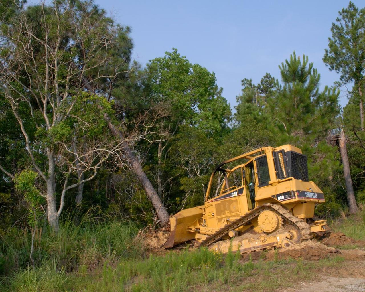
Tree clearing for the site of the new A-3 Test Stand at Stennis Space center began June 13. NASA's first new large rocket engine test stand to be built since the site's inception, A-3 construction begins a historic era for America's largest rocket engine test complex. The 300-foot-tall structure is scheduled for completion in August 2010. A-3 will perform altitude tests on the Constellation's J-2X engine that will power the upper stage of the Ares I crew launch vehicle and earth departure stage of the Ares V cargo launch vehicle. The Constellation Program, NASA's plan for carrying out the nation's Vision for Space Exploration, will return humans to the moon and eventually carry them to Mars and beyond.

SL2-05-390 (22 June 1973) --- Greater Detroit (42.0N, 82.5W) is located at the southeastern border of Michigan on the Detroit River across from Windsor, Ontario, Canada and Lake Huron to the north. The river connecting Lake Erie is a channel left over from the Ice Age Glaciers. The land use pattern in this scene is typical of this part of the upper Midwest. The once extensive forests have been cleared for farmland and pasture, but narrow rows of trees still line farm boundaries. Photo credit: NASA
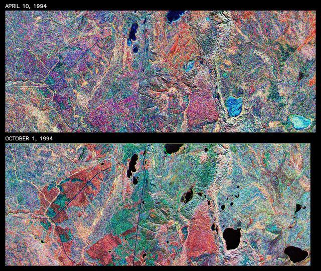
This is a comparison of images over Prince Albert, produced by NASA Spaceborne Imaging Radar-C and X-band Synthetic Aperture Radar aboard the space shuttle Endeavour on its 20th orbit on April 10, 1994. The area is centered at 53.91 degrees north latitude and 104.69 degrees west longitude and is located 40 kilometers (25 miles) north and 30 kilometers (18.5 miles) east of the town of Prince Albert in the Saskatchewan province of Canada. The image covers the area east of Candle Lake, between the gravel highway of 120 and west of highway 106. The area imaged is near the southern limit of the boreal forest. The boreal forest of North America is a continuous vegetation belt at high latitudes stretching across the continent from the Atlantic shoreline of central Labrador and then westward across Canada to the interior mountains and central coastal plains of Alaska. The forest is also part of a larger northern hemisphere circumpolar boreal forest belt. Coniferous trees dominate the entire forest but deciduous trees are also present. During the month of April, the forest experiences seasonal changes from a frozen condition to a thawed condition. The trees are completely frozen over the winter season and the forest floor is covered by snow. As the average temperature rises in the spring, the trees are thawed and the snow melts. This transition has an impact on the rate of moisture evaporation and release of carbon dioxide into the atmosphere. In late September and early October, the boreal forest experiences a relatively different seasonal change. At this time, the leaves on deciduous trees start changing color and dropping off. The soil and trees are quite often moist due to frequent rainfall and cloud cover. The evaporation of moisture and carbon dioxide into the atmosphere also diminishes at this time. SIR-C/X-SAR is sensitive to the moisture of soil and vegetation and can sense this freeze-thaw cycle and the summer-fall seasonal transition over forested areas in particular. Optical sensors, by contrast, are blind to these regions, which are perpetually obscured by thick cloud cover. These changes were detected by comparing the April and October color composite images of L-band data in red, C-band data in green and X-band (vertically received and transmitted) in blue. The changes in intensity of each color over lakes, various forest stands and clear cuts in the two images is striking. Lakes such as Lake Heiberg, Crabtree Lake and Williams Lake, in the right middle part of the image, are frozen in April (appearing in bright blue) and melted (appearing in black) in October. The higher intensity of blue over lakes in April is due to low penetration of the X-band (vertically received and transmitted) and the radar's high sensitivity to surface features. Forest stands also exhibit major changes between the two images. The red areas in the October image are old jack pine canopies that cause higher return at L-band because of their moist condition in late summer compared to their partially frozen condition in April (in purple). Similarly, in the areas near the middle of the image, where black spruce and mixed aspen and jack pine trees dominate, the contrast between blue in October and red and green in April is an indication that the top of the canopy (needles and branches) were frozen in April and moist in October. The changes due to deforestation by logging companies or natural fires can also be detected by comparing the images. For example, the small blue area near the intersection of Harding Road and Highway 120 is the result of logging which occurred after the April data was acquired. The surface area of clear cut is approximately 4 hectares, which is calculated from the high-resolution capability of the radar images and verified by scientists participating in field work during the mission. http://photojournal.jpl.nasa.gov/catalog/PIA01732
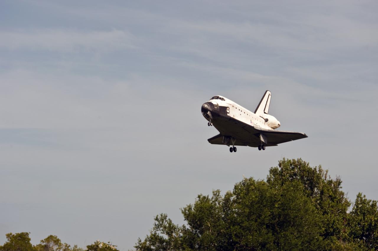
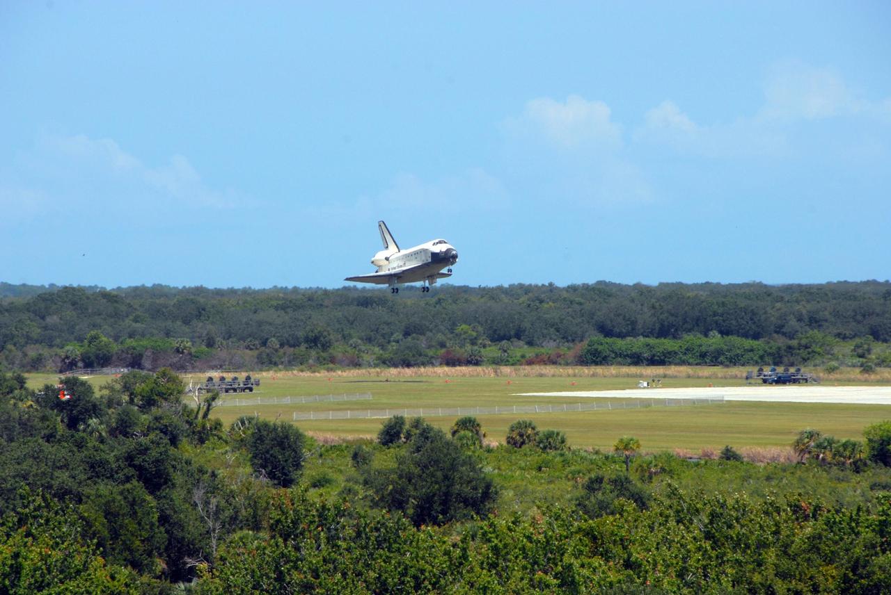
CAPE CANAVERAL, Fla. – Space shuttle Endeavour clears the trees as it heads for a landing on Runway 15 at NASA's Kennedy Space Center in Florida. The landing completes Endeavour's 16-day, 6.5-million mile journey on the STS-127 mission to the International Space Station. Endeavour landed on orbit 248. Main gear touchdown was at 10:48:08 a.m. EDT. Nose gear touchdown was at 10:48:21 a.m. and wheels stop was at 10:49:13 a.m. Endeavour delivered the Japanese Experiment Module's Exposed Facility and the Experiment Logistics Module-Exposed Section to the International Space Station. The mission was the 29th flight to the station, the 23rd flight of Endeavour and the 127th in the Space Shuttle Program, as well as the 71st landing at Kennedy. Photo credit: NASA/Tony Gray
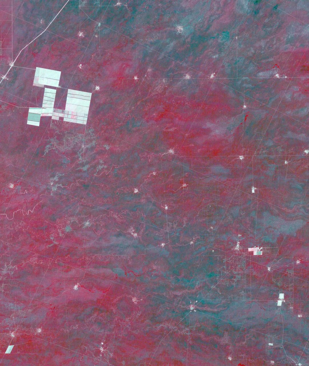
In northern Argentina's Salta province, the chaco forests, made up of shrubs and hardwood trees, once thrived in the region. In the past 30 years, large-scale farming and ranch operators have cleared broad areas of the chaco, and replaced with industrial-scale raising of crops and livestock. The December 1, 1989 Landsat TM image is dominiated by traditional puestos, settlements consisting of a few dwellings and small-scale crops located near a well. The November 19, 2019 ASTER image shows large fields arranged in a grid pattern. The chaco forest has almost disappeared. The images cover an area of 22.2 by 27.8 km, and are located at 24.9 degrees south, 63.5 degrees west. https://photojournal.jpl.nasa.gov/catalog/PIA23756
KENNEDY SPACE CENTER, FLA. -- Endeavour clears the trees as it approaches landing on runway 15 at NASA's Kennedy Space Center. The Space Shuttle Endeavour crew, led by Commander Scott Kelly, completes a 13-day mission to the International Space Station. The STS-118 mission began Aug. 8 and installed a new gyroscope, an external spare parts platform and another truss segment to the expanding station. Endeavour's main gear touched down at 12:32:16 p.m. EDT. Nose gear touchdown was at 12:32:29 p.m. and wheel stop was at 12:33:20 p.m. Endeavour traveled nearly 5.3 million miles, landing on orbit 201. STS-118 was the 119th space shuttle flight, the 22nd flight to the station, the 20th flight for Endeavour and the second of four missions planned for 2007. This was the 65th landing of an orbiter at Kennedy. Photo credit: NASA/Ken Thornsley

KENNEDY SPACE CENTER, FLA. -- Framed by the trees across the water, Space Shuttle Endeavour clears the lightning mast on Launch Pad 39A as it roars into the sky on mission STS-118. Liftoff of Endeavour was on time at 6:36 p.m. EDT. The mission is the 22nd shuttle flight to the International Space Station. It will continue space station construction by delivering a third starboard truss segment, S5, and other payloads such as the SPACEHAB module and the external stowage platform 3. The 11-day mission may be extended to as many as 14 depending on the test of the Station-to-Shuttle Power Transfer System that will allow the docked shuttle to draw electrical power from the station and extend its visits to the orbiting lab. Photo credit: NASA/Sandra Joseph, Tony Gray, Robert Murray
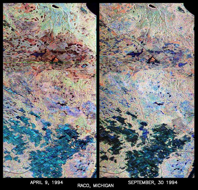
These are two false-color composites of Raco, Michigan, located at the eastern end of Michigan upper peninsula, west of Sault Ste. Marie and south of Whitefish Bay on Lake Superior. The two images (centered at 46.39 degrees north latitude, 84.88 degrees west longitude) show significant seasonal changes in the mid-latitude region of mixed deciduous and coniferous forests. The images were acquired by the Spaceborne Imaging Radar-C and X-band Synthetic Aperture Radar (SIR-C/X-SAR) aboard the shuttle Endeavour on the sixth orbit of each mission. In these images, red is L-band (23 cm) with horizontal/vertical polarization; green is C-band (6 cm) with horizontal/vertical polarization; blue is C-band with horizontal/horizontal polarization. The region shown is largely forested and includes a large portion of Hiawatha National Forest, as well as an agricultural region near the bottom of each image. In early April, the area was snow-covered with up to 50 centimeters (19.5 inches) of snow in forest clearings and agricultural fields. Buds had not yet broken on deciduous trees, but the trees were not frozen and sap was generally flowing. Lake Superior, in the upper right, and the small inland lakes were frozen and snow-covered on April 9, 1994. By the end of September, deciduous trees were just beginning to change color after a relatively wet period. Leaf loss was estimated at about 30 percent, depending on the species, and the soil was moist to wet after a heavy rainfall on September 28, 1994. Most agricultural fields were covered with grasses of up to 60 centimeters (23 inches) in height. In the two images the colors are related to the types of land cover (i.e. vegetation type) and the brightness is related to the amount of plant material and its relative moisture content. Significant seasonal changes between early spring and early fall are illustrated by this pair of images. For the agricultural region near the bottom of the images, the change from snow-cover to moist soil with short vegetation cover is shown by the color change from blue to green and blue. The green color corresponds to significant increases in vegetation cover and field-to-field differences in blue are the result of differences in surface roughness and soil moisture. In the forested areas, many of the conifer forests appear similar in both images (red pine forests appear red in both images). However, there is more blue and green in the September 30, 1994 image as a consequence of greater foliage and more moisture in the forest crowns. Lowland conifer forests (spruce and northern white cedars) appear as bright green in both images. Deciduous forests produce very strong radar returns at these frequencies and polarization combinations, resulting in a nearly white appearance on the images (the specific color mix is related to the local species mix). In the September 30, 1994 image, the areas of deciduous forest appear darker than in the April image because of the weaker radar signal from the foliage in the crown layer. The clear-cut areas (shown in April by the irregularly shaped dark areas in the center) change dramatically in appearance due to loss of snow cover and increases in soil moisture and vegetation cover by the end of September. http://photojournal.jpl.nasa.gov/catalog/PIA01730
KENNEDY SPACE CENTER, FLA. - The 19-stories-tall Atlas V launch vehicle leaps above the trees near Launch Complex 41 at Cape Canaveral Air Force Station in Florida, propelling the two-ton Mars Reconnaissance Orbiter (MRO) into a clear blue Florida sky and eventual orbit around Mars. Liftoff was at 7:43 a.m. EDT. All systems performed nominally for NASA's first launch of an Atlas V on an interplanetary mission. MRO established radio contact with controllers 61 minutes after launch and within four minutes of separation from the upper stage. Initial contact came through an antenna at the Japan Aerospace Exploration Agency's Uchinoura Space Center in southern Japan. Mars is 72 million miles from Earth today, but the spacecraft will travel more than four times that distance on its outbound-arc trajectory to intercept the red planet on March 10, 2006. The orbiter carries six scientific instruments for examining the surface, atmosphere and subsurface of Mars in unprecedented detail from low orbit. NASA expects to get several times more data about Mars from MRO than from all previous Martian missions combined. Researchers will use the instruments to learn more about the history and distribution of Mars' water. That information will improve understanding of planetary climate change and will help guide the quest to answer whether Mars ever supported life. The orbiter will also evaluate potential landing sites for future missions.
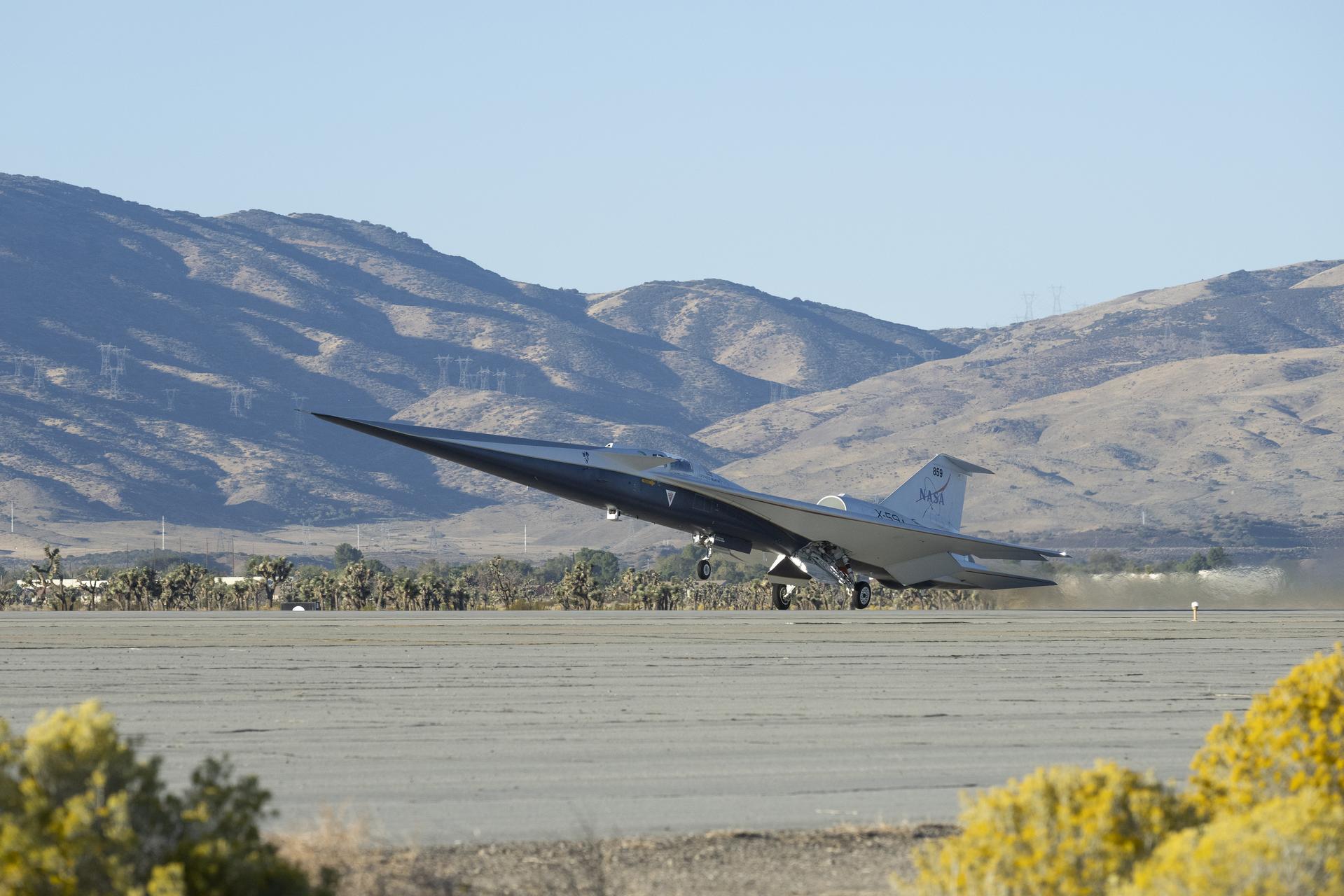
NASA’s X-59 quiet supersonic research aircraft lifts off for its first flight Tuesday, Oct. 28, 2025, from U.S. Air Force Plant 42 in Palmdale, California. The aircraft’s first flight marks the start of flight testing for NASA’s Quesst mission, the result of years of design, integration, and ground testing and begins a new chapter in NASA’s aeronautics research legacy.