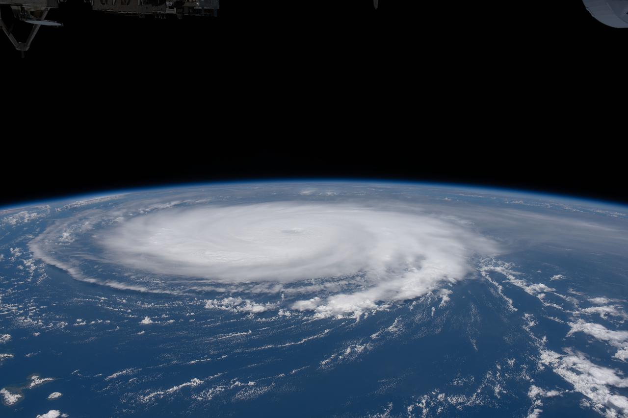
iss065e432549 (Sept. 29, 2021) --- The International Space Station orbits 259 miles above Trinidad and Tobago as Hurricane Sam churned in the Atlantic Ocean.
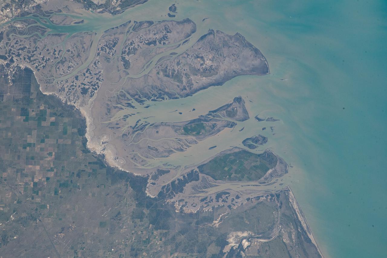
iss067e301734 (Aug. 30, 2022) --- The Bahia Blanca, including the three islands of Bermejo, Trinidad, and Anadna, on the coast of Argentina, are pictured from the International Space Station as it orbited 267 miles above the Atlantic Ocean.
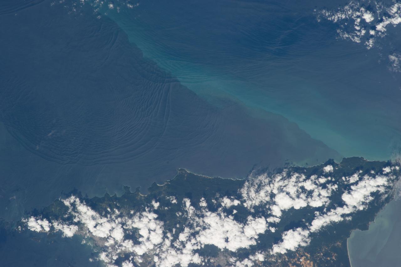
ISS034-E-032377 (18 Jan. 2013) --- Internal waves off Northern Trinidad are featured in this image photographed by an Expedition 34 crew member on the International Space Station. This photograph shows the north coast of the island of Trinidad in the southeastern Caribbean Sea, where heating of the land is setting off the growth of cumulus clouds. The light blue northwest-southeast trending plume at center is sediment from one of the rivers that flows into the sea here. Adjacent to, and appearing to cross the sediment plume, a series of subtle interacting arcs can be seen in the sea. These are known as internal waves which are the surface manifestation of slow waves moving tens of meters beneath the sea surface. These produce enough of an effect on the sea surface to be seen from space, but only where they are enhanced due to reflection of sunlight, or sunglint, back towards the space station. The image shows at least three sets of internal waves interacting. The most prominent set (top left) shows a “packet” of several waves moving from the northwest due to the tidal flow towards the north coast of Trinidad. Two less prominent, younger sets can be seen further out to sea. A very broad set enters the view from the north and northeast, and interacts at top center with the first set. All the internal waves are probably caused by the shelf break near Tobago (outside the image to top right). The shelf break is the step between shallow seas (around continents and islands) and the deep ocean. It is the line at which tides usually start to generate internal waves. The sediment plume at center is embedded in the Equatorial Current (also known as the Guyana Current) and is transporting material to the northwest—in almost the opposite direction to the movement of the internal waves. The current flows strongly from east to west around Trinidad, all the way from equatorial Africa, driven by year-round easterly winds. Seafarers in the vicinity of Trinidad are warned that the current, and its local reverse eddies, make navigation of smaller craft in these waters complicated and sometimes dangerous.
S66-46054 (18 July 1966) --- Venezuela, British Guyana, Surinam and Trinidad, as seen from the Gemini-10 spacecraft. On the left is the mouth of the Orinoco River in Venezuela. Mouth of Essequibo River in British Guyana is in right center. Photo credit: NASA

iss067e362302 (Sept. 15, 2022) --- The Soyuz MS-21 crew ship is pictured attached to the Prichal docking module as the International Space Station orbited 259 miles above the Caribbean Sea in between the island nations of Grenada and Trinidad and Tobago..
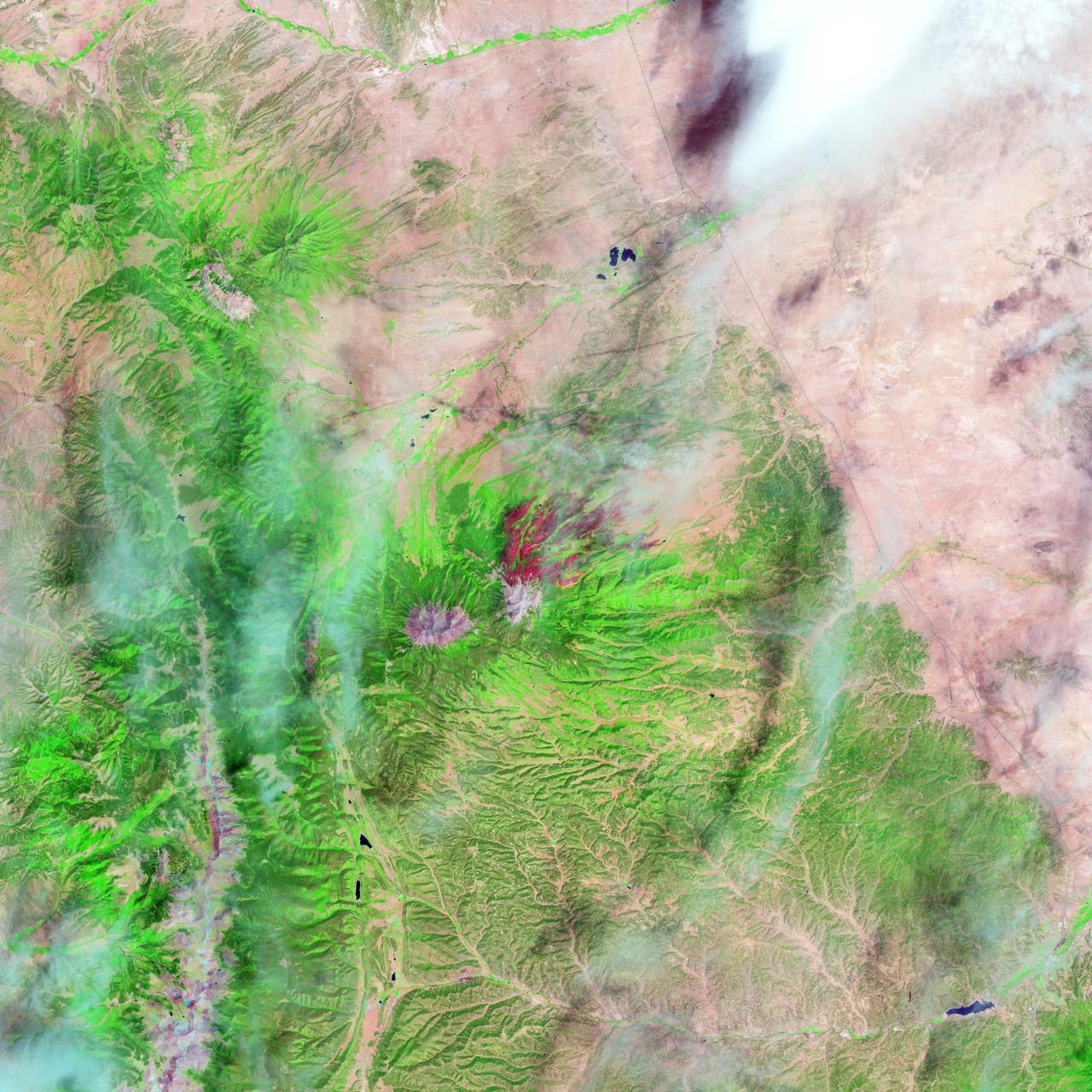
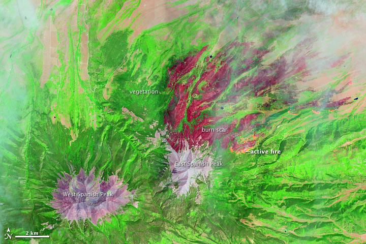
On June 22, 2013, the Operational Land Imager (OLI) on Landsat 8 captured this false-color image of the East Peak fire burning in southern Colorado near Trinidad. Burned areas appear dark red, while actively burning areas look orange. Dark green areas are forests; light green areas are grasslands. Lightning ignited the blaze on June 19, 2013. By June 25, it had burned nearly 13,500 acres (5,500 hectares). NASA Earth Observatory image by Jesse Allen and Robert Simmon, using Landsat data from the U.S. Geological Survey. Caption by Adam Voiland. Instrument: Landsat 8 - OLI More images from this event: <a href="http://1.usa.gov/14DesQC" rel="nofollow">1.usa.gov/14DesQC</a> Credit: <b><a href="http://www.earthobservatory.nasa.gov/" rel="nofollow"> NASA Earth Observatory</a></b> <b><a href="http://www.nasa.gov/audience/formedia/features/MP_Photo_Guidelines.html" rel="nofollow">NASA image use policy.</a></b> <b><a href="http://www.nasa.gov/centers/goddard/home/index.html" rel="nofollow">NASA Goddard Space Flight Center</a></b> enables NASA’s mission through four scientific endeavors: Earth Science, Heliophysics, Solar System Exploration, and Astrophysics. Goddard plays a leading role in NASA’s accomplishments by contributing compelling scientific knowledge to advance the Agency’s mission. <b>Follow us on <a href="http://twitter.com/NASA_GoddardPix" rel="nofollow">Twitter</a></b> <b>Like us on <a href="http://www.facebook.com/pages/Greenbelt-MD/NASA-Goddard/395013845897?ref=tsd" rel="nofollow">Facebook</a></b> <b>Find us on <a href="http://instagram.com/nasagoddard?vm=grid" rel="nofollow">Instagram</a></b>
On June 22, 2013, the Operational Land Imager (OLI) on Landsat 8 captured this false-color image of the East Peak fire burning in southern Colorado near Trinidad. Burned areas appear dark red, while actively burning areas look orange. Dark green areas are forests; light green areas are grasslands. Lightning ignited the blaze on June 19, 2013. By June 25, it had burned nearly 13,500 acres (5,500 hectares). NASA Earth Observatory image by Jesse Allen and Robert Simmon, using Landsat data from the U.S. Geological Survey. Caption by Adam Voiland. Instrument: Landsat 8 - OLI More images from this event: <a href="http://1.usa.gov/14DesQC" rel="nofollow">1.usa.gov/14DesQC</a> Credit: <b><a href="http://www.earthobservatory.nasa.gov/" rel="nofollow"> NASA Earth Observatory</a></b> <b><a href="http://www.nasa.gov/audience/formedia/features/MP_Photo_Guidelines.html" rel="nofollow">NASA image use policy.</a></b> <b><a href="http://www.nasa.gov/centers/goddard/home/index.html" rel="nofollow">NASA Goddard Space Flight Center</a></b> enables NASA’s mission through four scientific endeavors: Earth Science, Heliophysics, Solar System Exploration, and Astrophysics. Goddard plays a leading role in NASA’s accomplishments by contributing compelling scientific knowledge to advance the Agency’s mission. <b>Follow us on <a href="http://twitter.com/NASA_GoddardPix" rel="nofollow">Twitter</a></b> <b>Like us on <a href="http://www.facebook.com/pages/Greenbelt-MD/NASA-Goddard/395013845897?ref=tsd" rel="nofollow">Facebook</a></b> <b>Find us on <a href="http://instagram.com/nasagoddard?vm=grid" rel="nofollow">Instagram</a></b>

KENNEDY SPACE CENTER, FLA. -- Following the Flight Readiness Review for the STS-117 mission, NASA officials presented the decisions of NASA senior managers in a press conference. Seen here are (from left) Katherine Trinidad, of NASA Public Affairs, who moderated; Bill Gerstenmaier, associate administrator of NASA Space Operations Mission; Wayne Hale, Space Shuttle Program manager; and Mike Leinbach, Shuttle Launch Director. Gerstenmaier confirmed the launch time and date of Space Shuttle Atlantis at 7:38 p.m. EDT on June 8. Photo credit: NASA/Kim Shiflett
S73-34295 (June 1973) --- A vertical view of a portion of northern California reproduced from data taken from the Skylab Multispectral Scanner, experiment S192, in the Skylab space station in Earth orbit. This view is the most westerly one-third of Frame No. 001, Roll No. 518, S192, Skylab 2. Frame No. 001 extends from the Pacific coast at the Eureka area southeasterly 175 nautical miles to the Feather River drainage basin. Included in this view are Eureka, Trinidad, Klamath & Trinity Rivers and the Coastal Range mountains. This non-photographic image is a color composite of channels 2 (visible), 7, and 12 (infrared) from the Earth Resources Experiments Package (EREP) S192 scanner. The scanner techniques assist with spectral signature identification and mapping of ground truth targets in agriculture, forestry, geology, hydrology and oceanography. Photo credit: NASA