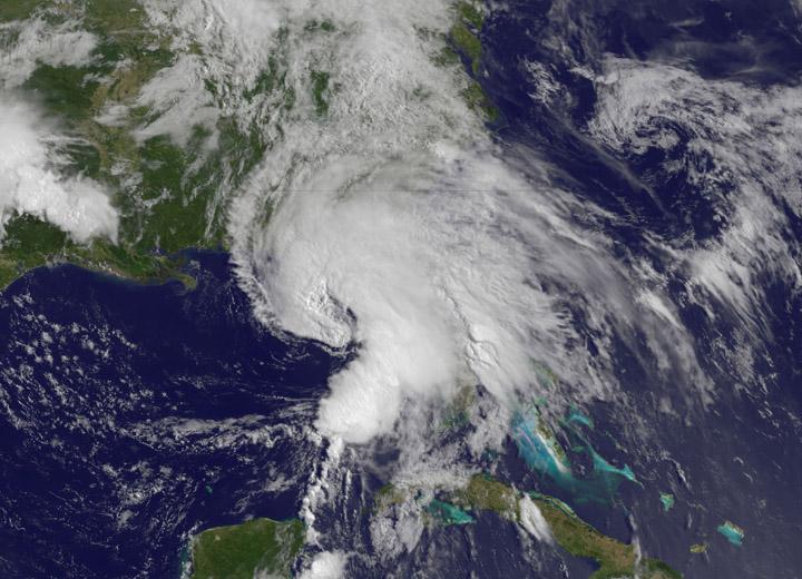
This NOAA GOES-East satellite animation shows the development of System 91L into Tropical Storm Andrea over the course of 3 days from June 4 to June 6, just after Andrea was officially designated a tropical storm. Credit: NASA's GOES Project --- NASA Sees Heavy Rainfall in Tropical Storm Andrea NASA’s TRMM satellite passed over Tropical Storm Andrea right after it was named, while NASA’s Terra satellite captured a visible image of the storm’s reach hours beforehand. TRMM measures rainfall from space and saw that rainfall rates in the southern part of the storm was falling at almost 5 inches per hour. NASA’s Terra satellite passed over Tropical Storm Andrea on June 5 at 16:25 UTC (12:25 p.m. EDT) and the Moderate Resolution Imaging Spectroradiometer or MODIS instrument, captured a visible image of the storm. At that time, Andrea’s clouds had already extended over more than half of Florida. At 8 p.m. EDT on Wednesday, June 5, System 91L became the first tropical storm of the Atlantic Ocean hurricane season. Tropical Storm Andrea was centered near 25.5 North and 86.5 West, about 300 miles (485 km) southwest of Tampa, Fla. At the time Andrea intensified into a tropical storm, its maximum sustained winds were near 40 mph (65 kph). Full updates can be found at NASA's Hurricane page: <a href="http://www.nasa.gov/hurricane" rel="nofollow">www.nasa.gov/hurricane</a> Rob Gutro NASA’s Goddard Space Flight Center
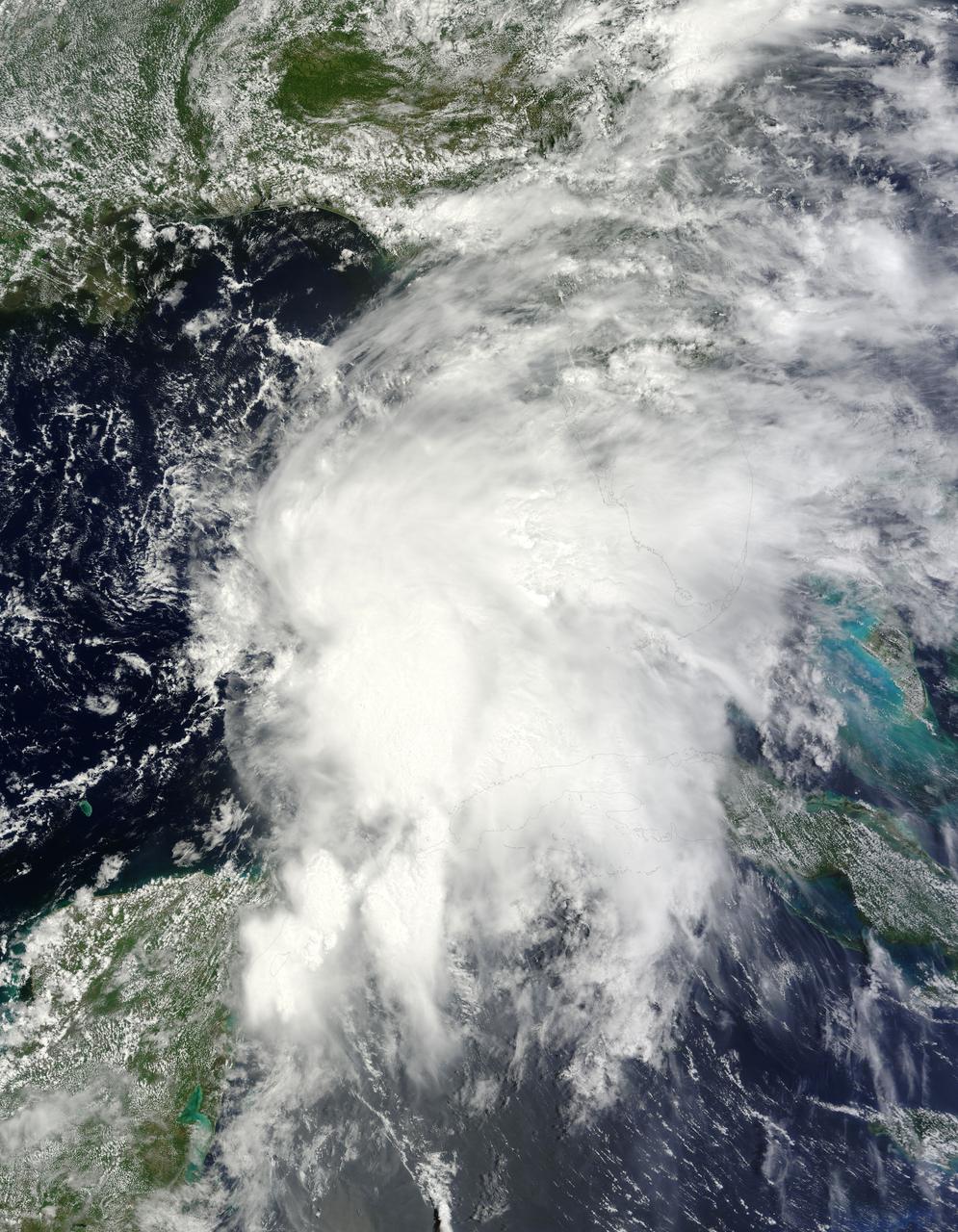
This is a satellite image from the MODIS instrument aboard NASA's Terra satellite of Tropical Storm Andrea that was captured today, June 7 at 12:10 p.m. EDT- as Andrea makes its way up the U.S. East coast. At this time, Andrea was centered over North Carolina. Credit: NASA Goddard MODIS Rapid Response Team <b><a href="http://www.nasa.gov/audience/formedia/features/MP_Photo_Guidelines.html" rel="nofollow">NASA image use policy.</a></b> <b><a href="http://www.nasa.gov/centers/goddard/home/index.html" rel="nofollow">NASA Goddard Space Flight Center</a></b> enables NASA’s mission through four scientific endeavors: Earth Science, Heliophysics, Solar System Exploration, and Astrophysics. Goddard plays a leading role in NASA’s accomplishments by contributing compelling scientific knowledge to advance the Agency’s mission. <b>Follow us on <a href="http://twitter.com/NASA_GoddardPix" rel="nofollow">Twitter</a></b> <b>Like us on <a href="http://www.facebook.com/pages/Greenbelt-MD/NASA-Goddard/395013845897?ref=tsd" rel="nofollow">Facebook</a></b> <b>Find us on <a href="http://instagram.com/nasagoddard?vm=grid" rel="nofollow">Instagram</a></b>
NASA’s Terra satellite passed over Tropical Storm Andrea on June 5 at 16:25 UTC (12:25 p.m. EDT) and the MODIS instrument captured this visible image of the storm. Andrea’s clouds had already extended over more than half of Florida. Credit: NASA Goddard MODIS Rapid Response Team --- NASA Sees Heavy Rainfall in Tropical Storm Andrea NASA’s TRMM satellite passed over Tropical Storm Andrea right after it was named, while NASA’s Terra satellite captured a visible image of the storm’s reach hours beforehand. TRMM measures rainfall from space and saw that rainfall rates in the southern part of the storm was falling at almost 5 inches per hour. NASA’s Terra satellite passed over Tropical Storm Andrea on June 5 at 16:25 UTC (12:25 p.m. EDT) and the Moderate Resolution Imaging Spectroradiometer or MODIS instrument, captured a visible image of the storm. At that time, Andrea’s clouds had already extended over more than half of Florida. At 8 p.m. EDT on Wednesday, June 5, System 91L became the first tropical storm of the Atlantic Ocean hurricane season. Tropical Storm Andrea was centered near 25.5 North and 86.5 West, about 300 miles (485 km) southwest of Tampa, Fla. At the time Andrea intensified into a tropical storm, its maximum sustained winds were near 40 mph (65 kph). Full updates can be found at NASA's Hurricane page: <a href="http://www.nasa.gov/hurricane" rel="nofollow">www.nasa.gov/hurricane</a> Rob Gutro NASA’s Goddard Space Flight Center
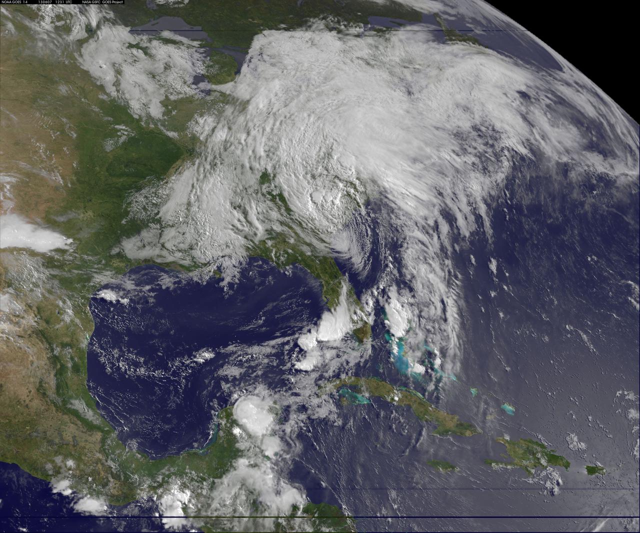
This image of tropical storm Andrea was assembled from data collected by NOAA's GOES-14 satellite at 8:31 a.m. EDT on June 7, when the storm's center was about 35 miles north-northwest of Charleston, S.C. Credit: NASA/NOAA GOES Project <b><a href="http://www.nasa.gov/audience/formedia/features/MP_Photo_Guidelines.html" rel="nofollow">NASA image use policy.</a></b> <b><a href="http://www.nasa.gov/centers/goddard/home/index.html" rel="nofollow">NASA Goddard Space Flight Center</a></b> enables NASA’s mission through four scientific endeavors: Earth Science, Heliophysics, Solar System Exploration, and Astrophysics. Goddard plays a leading role in NASA’s accomplishments by contributing compelling scientific knowledge to advance the Agency’s mission. <b>Follow us on <a href="http://twitter.com/NASA_GoddardPix" rel="nofollow">Twitter</a></b> <b>Like us on <a href="http://www.facebook.com/pages/Greenbelt-MD/NASA-Goddard/395013845897?ref=tsd" rel="nofollow">Facebook</a></b> <b>Find us on <a href="http://instagram.com/nasagoddard?vm=grid" rel="nofollow">Instagram</a></b>