
Dr. Paul Bate, Chief Executive Officer UK Space Agency (UKSA) speaks in a Heads of Agency panel during the 37th Space Symposium, Wednesday, April 6, 2022, in Colorado Springs, Colorado. Photo Credit: (NASA/Bill Ingalls)

Ian Annett, Acting CEO for Programme Delivery, UK Space Agency (UKSA) gives remarks in a Heads of Agency panel discussion, during the 36th Space Symposium, Wednesday, Aug. 25, 2021, in Colorado Springs, Colorado. Photo Credit: (NASA/Bill Ingalls)
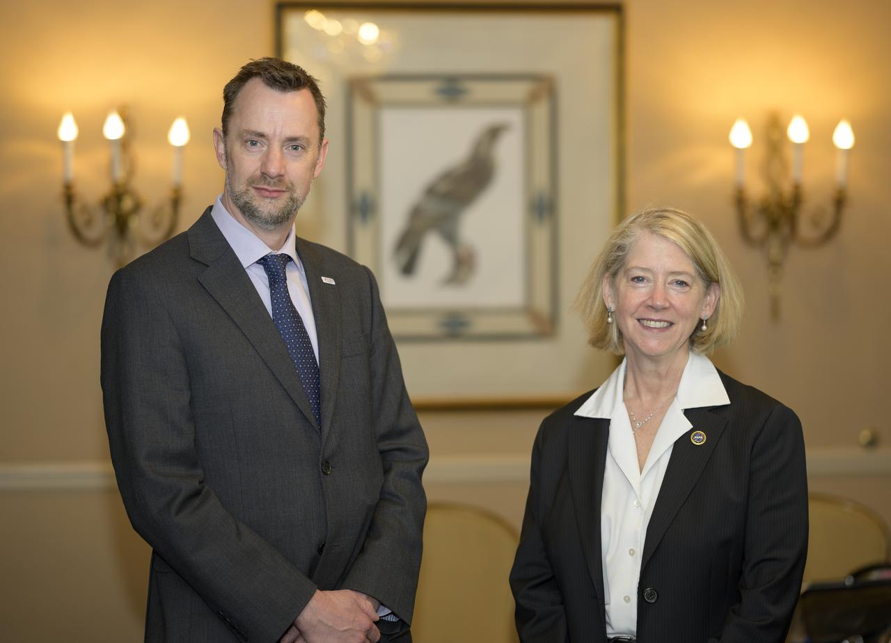
Dr. Paul Bate, Chief Executive Officer UK Space Agency (UKSA), left, and NASA Deputy Administrator Pam Melroy, pose for a photograph prior to starting at meeting during the 37th Space Symposium, Tuesday, April 5, 2022, in Colorado Springs, Colorado. Photo Credit: (NASA/Bill Ingalls)
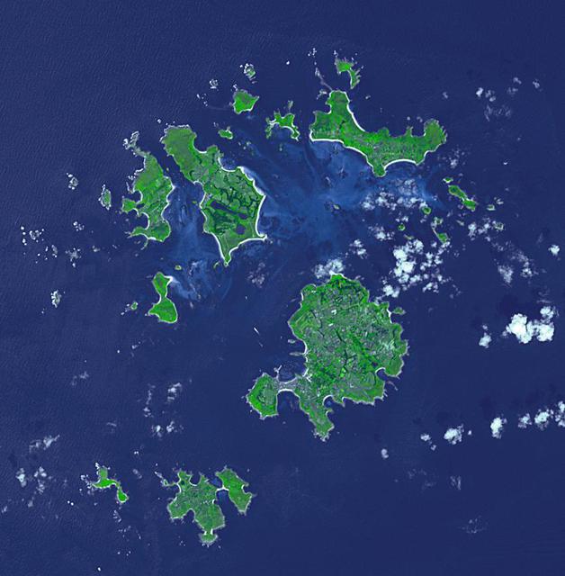
The Isles of Scilly are an archipelago of 145 islands that lies 28 km off the tip of Cornwall. Scilly is part of the Duchy of Cornwall under the stewardship of the Prince of Wales, who owns all the lands, and collects rents or leases from all 2200 residents. Tourism now accounts for 85% of the islands' income. The image was acquired July 8, 2019, covers an area of 12.8 by 13 km, and is located at 49.9 degrees north, 6.3 degrees west. https://photojournal.jpl.nasa.gov/catalog/PIA24867
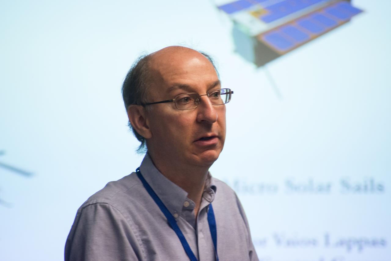
LES JOHNSON INTRODUCES PROFESSOR VARIOS LAPP, UNIVERSITY OF SURREY, UK, PRIME INVESTIGATOR OF SOLAR SAIL TECHNOLOGY

Professor John Beddington, UK (United Kingdom) Government Chief Scientist Advisor visit to Ames in Bldg N-200 Boyd Room

Professor John Beddington, UK (United Kingdom) Government Chief Scientist Advisor visit to Ames with John Hinein N-200 Boyd Room

Professor John Beddington, UK (United Kingdom) Government Chief Scientist Advisor visit to Ames in Bldg N-200 Boyd Room

Professor John Beddington, UK (United Kingdom) Government Chief Scientist Advisor visit to Ames in Bldg N-200 Boyd Room

PHOTO DATE: 11/28/12 LOCATION: B9 ARGOS/POGO LAB SUBJECT: ESA astronaut (UK) Timothy Peake during ISS EVA PGT/ARGOS training. PHOTOGRAPHER:Geeseman
Professor John Beddington, UK (United Kingdom) Government Chief Scientist Advisor visit to Ames on tour of the Small Satellites area Bldg 45 (and a lunar lander prototype LADEE)

PHOTO DATE: 11/28/12 LOCATION: B9 ARGOS/POGO LAB SUBJECT: ESA astronaut (UK) Timothy Peake during ISS EVA PGT/ARGOS training. PHOTOGRAPHER:Geeseman

PHOTO DATE: 11/28/12 LOCATION: B9 ARGOS/POGO LAB SUBJECT: ESA astronaut (UK) Timothy Peake during ISS EVA PGT/ARGOS training. PHOTOGRAPHER:Geeseman

Professor John Beddington, UK (United Kingdom) Government Chief Scientist Advisor visit to Ames on tour of the Small Satellites area Bldg 45 with John Hine of Ames Research Center
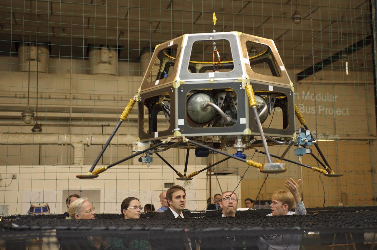
Professor John Beddington, UK (United Kingdom) Government Chief Scientist Advisor visit to Ames on tour of the Small Satellites area Bldg 45 (and a lunar lander prototype LADEE)

Professor John Beddington, UK (United Kingdom) Government Chief Scientist Advisor visit to Ames on tour of the Small Satellites area Bldg 45 (and a lunar lander prototype)
Professor John Beddington, UK (United Kingdom) Government Chief Scientist Advisor visit to Ames on tour of the Small Satellites area Bldg 45 with John Hine of Ames Research Center

Professor John Beddington, UK (United Kingdom) Government Chief Scientist Advisor visit to Ames on tour of the Small Satellites area Bldg 45 with ______and Ames Center Director Pete Worden (and a lunar lander prototype)

PHOTO DATE: 11/28/12 LOCATION: B9 ARGOS/POGO LAB SUBJECT: ESA astronaut (UK) Timothy Peake during ISS EVA PGT/ARGOS training. PHOTOGRAPHER:Geeseman

Professor John Beddington, UK (United Kingdom) Government Chief Scientist Advisor visit to Ames on tour of the Small Satellites area Bldg 45 (and a lunar lander prototype LADEE)
PHOTO DATE: 11/28/12 LOCATION: B9 ARGOS/POGO LAB SUBJECT: ESA astronaut (UK) Timothy Peake during ISS EVA PGT/ARGOS training. PHOTOGRAPHER:Geeseman

Professor John Beddington, UK (United Kingdom) Government Chief Scientist Advisor visit to Ames on tour of the Small Satellites area Bldg 45 with John Hine of Ames Research Center

PHOTO DATE: 11/28/12 LOCATION: B9 ARGOS/POGO LAB SUBJECT: ESA astronaut (UK) Timothy Peake during ISS EVA PGT/ARGOS training. PHOTOGRAPHER:Geeseman

Professor John Beddington, UK (United Kingdom) Government Chief Scientist Advisor visit to Ames - greeted by Ames Center Director Pete Worden in Bldg N-200 Boyd Room

Dr Aubrey de Grey presents a Director's Colloquium to the NASA Ames Research Center staff entitled 'Prospects for defeating aging altogether' Dr. de Grey is a British bomedical gerontologist educated at Cambridge University in the UK. A video of the presentation is currently available at the NASA Ames Library.

Dr Aubrey de Grey presents a Director's Colloquium to the NASA Ames Research Center staff entitled 'Prospects for defeating aging altogether' Dr. de Grey is a British bomedical gerontologist educated at Cambridge University in the UK. A video of the presentation is currently available at the NASA Ames Library.

Dr Aubrey de Grey presents a Director's Colloquium to the NASA Ames Research Center staff entitled 'Prospects for defeating aging altogether' Dr. de Grey is a British bomedical gerontologist educated at Cambridge University in the UK. A video of the presentation is currently available at the NASA Ames Library.

Dr Aubrey de Grey presents a Director's Colloquium to the NASA Ames Research Center staff entitled 'Prospects for defeating aging altogether' Dr. de Grey is a British bomedical gerontologist educated at Cambridge University in the UK. A video of the presentation is currently available at the NASA Ames Library.
The SpaceX Falcon 9 rocket, carrying the Surface Water and Ocean Topography (SWOT) satellite, soars upward after lifting off from Space Launch Complex-4 East at Vandenberg Space Force Base in California on Dec. 16, 2022, at 3:46 a.m. PST. A collaboration between NASA and the French space agency Centre National d’Études Spatiales (CNES), with contributions from the Canadian Space Agency and the UK Space Agency, SWOT will be the first satellite to survey nearly all water on Earth’s surface. The satellite will help researchers understand how much water flows in and out of Earth’s freshwater bodies and will provide insight into the ocean’s role in climate change. The instruments onboard will measure the height of water in lakes, rivers, reservoirs, and the ocean, and will observe ocean features in higher definition than ever before. NASA’s Launch Services Program, based at the agency’s Kennedy Space Center in Florida, is managing the launch service.
The first stage of the SpaceX Falcon 9 rocket lands at Vandenberg Space Force Base's landing zone 4 following the successful launch of the Surface Water and Ocean Topography (SWOT) satellite on Dec. 16, 2022. A collaboration between NASA and the French space agency Centre National d’Études Spatiales (CNES), with contributions from the Canadian Space Agency and the UK Space Agency, SWOT will be the first satellite to survey nearly all water on Earth’s surface. The satellite will help researchers understand how much water flows in and out of Earth’s freshwater bodies and will provide insight into the ocean’s role in climate change. The instruments onboard will measure the height of water in lakes, rivers, reservoirs, and the ocean, and will observe ocean features in higher definition than ever before. NASA’s Launch Services Program, based at the agency’s Kennedy Space Center in Florida, is managing the launch service.
The SpaceX Falcon 9 rocket, carrying the Surface Water and Ocean Topography (SWOT) satellite, lifts off from Space Launch Complex-4 East at Vandenberg Space Force Base in California on Dec. 16, 2022, at 3:46 a.m. PST. A collaboration between NASA and the French space agency Centre National d’Études Spatiales (CNES), with contributions from the Canadian Space Agency and the UK Space Agency, SWOT will be the first satellite to survey nearly all water on Earth’s surface. The satellite will help researchers understand how much water flows in and out of Earth’s freshwater bodies and will provide insight into the ocean’s role in climate change. The instruments onboard will measure the height of water in lakes, rivers, reservoirs, and the ocean, and will observe ocean features in higher definition than ever before. NASA’s Launch Services Program, based at the agency’s Kennedy Space Center in Florida, is managing the launch service.
The SpaceX Falcon 9 rocket, carrying the Surface Water and Ocean Topography (SWOT) satellite, lifts off from Space Launch Complex-4 East at Vandenberg Space Force Base in California on Dec. 16, 2022, at 3:46 a.m. PST. A collaboration between NASA and the French space agency Centre National d’Études Spatiales (CNES), with contributions from the Canadian Space Agency and the UK Space Agency, SWOT will be the first satellite to survey nearly all water on Earth’s surface. The satellite will help researchers understand how much water flows in and out of Earth’s freshwater bodies and will provide insight into the ocean’s role in climate change. The instruments onboard will measure the height of water in lakes, rivers, reservoirs, and the ocean, and will observe ocean features in higher definition than ever before. NASA’s Launch Services Program, based at the agency’s Kennedy Space Center in Florida, is managing the launch service.
The SpaceX Falcon 9 rocket, carrying the Surface Water and Ocean Topography (SWOT) satellite, lifts off from Space Launch Complex-4 East at Vandenberg Space Force Base in California on Dec. 16, 2022, at 3:46 a.m. PST. A collaboration between NASA and the French space agency Centre National d’Études Spatiales (CNES), with contributions from the Canadian Space Agency and the UK Space Agency, SWOT will be the first satellite to survey nearly all water on Earth’s surface. The satellite will help researchers understand how much water flows in and out of Earth’s freshwater bodies and will provide insight into the ocean’s role in climate change. The instruments onboard will measure the height of water in lakes, rivers, reservoirs, and the ocean, and will observe ocean features in higher definition than ever before. NASA’s Launch Services Program, based at the agency’s Kennedy Space Center in Florida, is managing the launch service.
The SpaceX Falcon 9 rocket, carrying the Surface Water and Ocean Topography (SWOT) satellite, lifts off from Space Launch Complex-4 East at Vandenberg Space Force Base in California on Dec. 16, 2022, at 3:46 a.m. PST. A collaboration between NASA and the French space agency Centre National d’Études Spatiales (CNES), with contributions from the Canadian Space Agency and the UK Space Agency, SWOT will be the first satellite to survey nearly all water on Earth’s surface. The satellite will help researchers understand how much water flows in and out of Earth’s freshwater bodies and will provide insight into the ocean’s role in climate change. The instruments onboard will measure the height of water in lakes, rivers, reservoirs, and the ocean, and will observe ocean features in higher definition than ever before. NASA’s Launch Services Program, based at the agency’s Kennedy Space Center in Florida, is managing the launch service.

Jasmine Hopkins, NASA Communications, moderates a science briefing held by NASA and the French space agency Centre National d’Études Spatiales (CNES) for the Surface Water and Ocean Topography (SWOT) mission on Dec. 13, 2022, at Vandenberg Space Force Base in California. SWOT is scheduled to launch on a SpaceX Falcon 9 from Space Launch Complex-4 East at Vandenberg on Dec. 15, 2022, at 3:46 a.m. PST. SWOT will be NASA’s first global survey of nearly all water on Earth’s surface. Scientists plan to use its observations to better understand the global water cycle, furnish insight into the ocean’s role in how climate change unfolds, and provide a global inventory of water resources. The SWOT mission is a collaborative effort between NASA and CNES with contributions from the Canadian Space Agency and the UK Space Agency. NASA’s Launch Services Program, based at the agency’s Kennedy Space Center in Florida, is managing the launch service.
CAPE CANAVERAL, Fla. -- At Cape Canaveral Air Force Station in Florida, British engineers conduct tests on the United Kingdom Subsatellite, part of the three-spacecraft international Active Magnetospheric Particle Tracer Explorer AMPTE mission scheduled for launch on Aug. 9, 1984 aboard a Delta rocket. The 172-pound UKS contains a comprehensive set of plasma measuring instruments to record the effects of chemical clouds released by the West German built Ion Release Module. The other AMPTE spacecraft – the Charged Composition Explorer CCEUnited States) – will operate far below, from inside the Earth’s magnetosphere, where it will track the ionized clouds as it is swept along by the solar wind. With the CCE studying this activity from below, and the IRM and UKS studying it from above, scientists expect to acquire valuable new data on exactly how the solar wind interacts with the Earth’s magnetic fields. Photo Credit: NASA

Heads of Agency participate in a panel discussion, from left, Dr. Josef Aschbacher, Director General, European Space Agency (ESA); Dr. Philippe Baptiste, President, French Space Agency (CNES); Dr. Paul Bate, Chief Executive Officer UK Space Agency (UKSA); moderator Dr. Kathryn C. Thornton, Chairwoman, Space Foundation; Lisa Campbell, President, Canadian Space Agency (CSA); NASA Deputy Administrator Pam Melroy; Dr. Walther Pelzer, Executive Board Member and Head of the German Space Agency at the German Aerospace Center (DLR); and Dr. Hiroshi Yamakawa, President, Japan Aerospace Exploration Agency (JAXA), right, during the 37th Space Symposium, Wednesday, April 6, 2022, in Colorado Springs, Colorado. Photo Credit: (NASA/Bill Ingalls)

On the small Hebridean island of Eriskay, Scotland, the causeway linking it to the outside world was only completed 20 years ago. The isolation protected the Eriskay Pony, one of the UK's oldest and rarest breeds. It was here that in 1745, Bonny Prince Charlie first set foot in Scotland to launch his uprising to retake the British throne. The image was acquired June 17, 2013, covers an area of 9.2 by 10.2 km, and is located at 57.1 degrees north, 7.3 degrees west. https://photojournal.jpl.nasa.gov/catalog/PIA25639

NASA Deputy Administrator Pam Melroy, left, kicks off a multilateral meeting during the 37th Space Symposium, Tuesday, April 5, 2022, in Colorado Springs, Colorado. Joing NASA in the meeting were representatives from Australia, Canada, France, Germany, Italy, Japan, Mexico, Netherlands, New Zealand, Poland, Romania, Spain, and the UK. Photo Credit: (NASA/Bill Ingalls)

jsc2023e038727 (6/22/2023) --- Principal Investigator Yamanaka Tsutomu conducted online and in-person lectures for students. I-Space Essay provides students and teachers the online opportunity to create wishes, which are delivered to the International Space Station's Japanese Experimental Module Kibo. In 2022, about 8,000 students from 35 elementary, junior high and high schools in 7 countries (Japan, USA, Australia, Germany, UK, Spain, and South Africa) joined this internet-based project. Image courtesy of Mitsumura-Tosho and IHI Corporation.

Parag Vaze, SWOT project manager, Jet Propulsion Laboratory, participates in a prelaunch news conference held by NASA, SpaceX, and the French space agency Centre National d’Études Spatiales (CNES) for the Surface Water and Ocean Topography (SWOT) mission on Dec. 14, 2022, at Vandenberg Space Force Base in California. SWOT is scheduled to launch on a SpaceX Falcon 9 rocket from Space Launch Complex-4 East at Vandenberg on Dec. 15, 2022, at 3:46 a.m. PST. SWOT will be NASA’s first global survey of nearly all water on Earth’s surface. Scientists plan to use its observations to better understand the global water cycle, furnish insight into the ocean’s role in how climate change unfolds, and provide a global inventory of water resources. The SWOT mission is a collaborative effort between NASA and CNES with contributions from the Canadian Space Agency and the UK Space Agency. NASA’s Launch Services Program, based at the agency’s Kennedy Space Center in Florida, is managing the launch service.
NASA and the French space agency Centre National d’Études Spatiales (CNES) hold a science briefing on the Surface Water and Ocean Topography (SWOT) mission on Dec. 13, 2022, at Vandenberg Space Force Base in California. Participating from left are Katherine Calvin, chief scientist and senior climate advisor, NASA; Selma Cherchali, Earth observation program head, CNES; Nadya Vinogradova Shiffer, SWOT program scientist, NASA; Tamlin Pavelsky, SWOT hydrology science lead, University of North Carolina; Benjamin Hamlington, research scientist, Sea Level and Ice Group, Jet Propulsion Laboratory. SWOT is scheduled to launch on a SpaceX Falcon 9 rocket from Space Launch Complex-4 East at Vandenberg on Dec. 15, 2022, at 3:46 a.m. PST. SWOT will be NASA’s first global survey of nearly all water on Earth’s surface. Scientists plan to use its observations to better understand the global water cycle, furnish insight into the ocean’s role in how climate change unfolds, and provide a global inventory of water resources. The SWOT mission is a collaborative effort between NASA and CNES with contributions from the Canadian Space Agency and the UK Space Agency. NASA’s Launch Services Program, based at the agency’s Kennedy Space Center in Florida, is managing the launch service.
Katherine Calvin, chief scientist and senior climate advisor, NASA, participates in a science briefing held by NASA and the French space agency Centre National d’Études Spatiales (CNES) for the Surface Water and Ocean Topography (SWOT) mission on Dec. 13, 2022, at Vandenberg Space Force Base in California. SWOT is scheduled to launch on a SpaceX Falcon 9 rocket from Space Launch Complex-4 East at Vandenberg on Dec. 15, 2022, at 3:46 a.m. PST. SWOT will be NASA’s first global survey of nearly all water on Earth’s surface. Scientists plan to use its observations to better understand the global water cycle, furnish insight into the ocean’s role in how climate change unfolds, and provide a global inventory of water resources. The SWOT mission is a collaborative effort between NASA and CNES with contributions from the Canadian Space Agency and the UK Space Agency. NASA’s Launch Services Program, based at the agency’s Kennedy Space Center in Florida, is managing the launch service.

Selma Cherchali, Earth observation program head, CNES, participates in a science briefing held by NASA and the French space agency Centre National d’Études Spatiales (CNES) for the Surface Water and Ocean Topography (SWOT) mission on Dec. 13, 2022, at Vandenberg Space Force Base in California. SWOT is scheduled to launch on a SpaceX Falcon 9 rocket from Space Launch Complex-4 East at Vandenberg on Dec. 15, 2022, at 3:46 a.m. PST. SWOT will be NASA’s first global survey of nearly all water on Earth’s surface. Scientists plan to use its observations to better understand the global water cycle, furnish insight into the ocean’s role in how climate change unfolds, and provide a global inventory of water resources. The SWOT mission is a collaborative effort between NASA and CNES with contributions from the Canadian Space Agency and the UK Space Agency. NASA’s Launch Services Program, based at the agency’s Kennedy Space Center in Florida, is managing the launch service.

NASA and the French space agency Centre National d’Études Spatiales (CNES) hold a science briefing on the Surface Water and Ocean Topography (SWOT) mission on Dec. 13, 2022, at Vandenberg Space Force Base in California. Participating from left are Katherine Calvin, chief scientist and senior climate advisor, NASA; Selma Cherchali, Earth observation program head, CNES; Nadya Vinogradova Shiffer, SWOT program scientist, NASA; Tamlin Pavelsky, SWOT hydrology science lead, University of North Carolina; Benjamin Hamlington, research scientist, Sea Level and Ice Group, Jet Propulsion Laboratory. SWOT is scheduled to launch on a SpaceX Falcon 9 rocket from Space Launch Complex-4 East at Vandenberg on Dec. 15, 2022, at 3:46 a.m. PST. SWOT will be NASA’s first global survey of nearly all water on Earth’s surface. Scientists plan to use its observations to better understand the global water cycle, furnish insight into the ocean’s role in how climate change unfolds, and provide a global inventory of water resources. The SWOT mission is a collaborative effort between NASA and CNES with contributions from the Canadian Space Agency and the UK Space Agency. NASA’s Launch Services Program, based at the agency’s Kennedy Space Center in Florida, is managing the launch service.
Tamlin Pavelsky, SWOT hydrology science lead, University of North Carolina, participates in a science briefing held by NASA and the French space agency Centre National d’Études Spatiales (CNES) for the Surface Water and Ocean Topography (SWOT) mission on Dec. 13, 2022, at Vandenberg Space Force Base in California. SWOT is scheduled to launch on a SpaceX Falcon 9 rocket from Space Launch Complex-4 East at Vandenberg on Dec. 15, 2022, at 3:46 a.m. PST. SWOT will be NASA’s first global survey of nearly all water on Earth’s surface. Scientists plan to use its observations to better understand the global water cycle, furnish insight into the ocean’s role in how climate change unfolds, and provide a global inventory of water resources. The SWOT mission is a collaborative effort between NASA and CNES with contributions from the Canadian Space Agency and the UK Space Agency. NASA’s Launch Services Program, based at the agency’s Kennedy Space Center in Florida, is managing the launch service.

Nadya Vinogradova Shiffer, SWOT program scientist, NASA, participates in a science briefing held by NASA and the French space agency Centre National d’Études Spatiales (CNES) for the Surface Water and Ocean Topography (SWOT) mission on Dec. 13, 2022, at Vandenberg Space Force Base in California. SWOT is scheduled to launch on a SpaceX Falcon 9 rocket from Space Launch Complex-4 East at Vandenberg on Dec. 15, 2022, at 3:46 a.m. PST. SWOT will be NASA’s first global survey of nearly all water on Earth’s surface. Scientists plan to use its observations to better understand the global water cycle, furnish insight into the ocean’s role in how climate change unfolds, and provide a global inventory of water resources. The SWOT mission is a collaborative effort between NASA and CNES with contributions from the Canadian Space Agency and the UK Space Agency. NASA’s Launch Services Program, based at the agency’s Kennedy Space Center in Florida, is managing the launch service.

Tim Dunn, launch director, NASA’s Launch Services Program, participates in a prelaunch news conference held by NASA, SpaceX, and the French space agency Centre National d’Études Spatiales (CNES) for the Surface Water and Ocean Topography (SWOT) mission on Dec. 14, 2022, at Vandenberg Space Force Base in California. SWOT is scheduled to launch on a SpaceX Falcon 9 rocket from Space Launch Complex-4 East at Vandenberg on Dec. 15, 2022, at 3:46 a.m. PST. SWOT will be NASA’s first global survey of nearly all water on Earth’s surface. Scientists plan to use its observations to better understand the global water cycle, furnish insight into the ocean’s role in how climate change unfolds, and provide a global inventory of water resources. The SWOT mission is a collaborative effort between NASA and CNES with contributions from the Canadian Space Agency and the UK Space Agency. NASA’s Launch Services Program, based at the agency’s Kennedy Space Center in Florida, is managing the launch service.

NASA, SpaceX, and the French space agency Centre National d’Études Spatiales (CNES) hold a prelaunch news conference for the Surface Water and Ocean Topography (SWOT) mission on Dec. 14, 2022, at Vandenberg Space Force Base in California. Participating from left are Karen St. Germain, Earth Science Division director, NASA; Thierry Lafon, SWOT project manager, CNES; Tim Dunn, launch director, NASA’s Launch Services Program; Julianna Scheiman, civil satellite missions director, SpaceX; Parag Vaze, SWOT project manager, Jet Propulsion Laboratory; Capt. Max Rush, launch weather officer, U.S. Air Force. SWOT is scheduled to launch on a SpaceX Falcon 9 rocket from Space Launch Complex-4 East at Vandenberg on Dec. 15, 2022, at 3:46 a.m. PST. SWOT will be NASA’s first global survey of nearly all water on Earth’s surface. Scientists plan to use its observations to better understand the global water cycle, furnish insight into the ocean’s role in how climate change unfolds, and provide a global inventory of water resources. The SWOT mission is a collaborative effort between NASA and CNES with contributions from the Canadian Space Agency and the UK Space Agency. NASA’s Launch Services Program, based at the agency’s Kennedy Space Center in Florida, is managing the launch service.

Capt. Max Rush, launch weather officer, U.S. Air Force, participates in a prelaunch news conference held by NASA, SpaceX, and the French space agency Centre National d’Études Spatiales (CNES) for the Surface Water and Ocean Topography (SWOT) mission on Dec. 14, 2022, at Vandenberg Space Force Base in California. SWOT is scheduled to launch on a SpaceX Falcon 9 rocket from Space Launch Complex-4 East at Vandenberg on Dec. 15, 2022, at 3:46 a.m. PST. SWOT will be NASA’s first global survey of nearly all water on Earth’s surface. Scientists plan to use its observations to better understand the global water cycle, furnish insight into the ocean’s role in how climate change unfolds, and provide a global inventory of water resources. The SWOT mission is a collaborative effort between NASA and CNES with contributions from the Canadian Space Agency and the UK Space Agency. NASA’s Launch Services Program, based at the agency’s Kennedy Space Center in Florida, is managing the launch service.

Megan Cruz, NASA Communications, moderates a prelaunch news conference held by NASA, SpaceX, and the French space agency Centre National d’Études Spatiales (CNES) for the Surface Water and Ocean Topography (SWOT) mission on Dec. 14, 2022, at Vandenberg Space Force Base in California. SWOT is scheduled to launch on a SpaceX Falcon 9 rocket from Space Launch Complex-4 East at Vandenberg on Dec. 15, 2022, at 3:46 a.m. PST. SWOT will be NASA’s first global survey of nearly all water on Earth’s surface. Scientists plan to use its observations to better understand the global water cycle, furnish insight into the ocean’s role in how climate change unfolds, and provide a global inventory of water resources. The SWOT mission is a collaborative effort between NASA and CNES with contributions from the Canadian Space Agency and the UK Space Agency. NASA’s Launch Services Program, based at the agency’s Kennedy Space Center in Florida, is managing the launch service.

Karen St. Germain, Earth Science Division director, NASA, participates in a prelaunch news conference held by NASA, SpaceX, and the French space agency Centre National d’Études Spatiales (CNES) for the Surface Water and Ocean Topography (SWOT) mission on Dec. 14, 2022, at Vandenberg Space Force Base in California. SWOT is scheduled to launch on a SpaceX Falcon 9 rocket from Space Launch Complex-4 East at Vandenberg on Dec. 15, 2022, at 3:46 a.m. PST. SWOT will be NASA’s first global survey of nearly all water on Earth’s surface. Scientists plan to use its observations to better understand the global water cycle, furnish insight into the ocean’s role in how climate change unfolds, and provide a global inventory of water resources. The SWOT mission is a collaborative effort between NASA and CNES with contributions from the Canadian Space Agency and the UK Space Agency. NASA’s Launch Services Program, based at the agency’s Kennedy Space Center in Florida, is managing the launch service.
Benjamin Hamlington, research scientist, Sea Level and Ice Group, Jet Propulsion Laboratory, participates in a science briefing held by NASA and the French space agency Centre National d’Études Spatiales (CNES) for the Surface Water and Ocean Topography (SWOT) mission on Dec. 13, 2022, at Vandenberg Space Force Base in California. SWOT is scheduled to launch on a SpaceX Falcon 9 rocket from Space Launch Complex-4 East at Vandenberg on Dec. 15, 2022, at 3:46 a.m. PST. SWOT will be NASA’s first global survey of nearly all water on Earth’s surface. Scientists plan to use its observations to better understand the global water cycle, furnish insight into the ocean’s role in how climate change unfolds, and provide a global inventory of water resources. The SWOT mission is a collaborative effort between NASA and CNES with contributions from the Canadian Space Agency and the UK Space Agency. NASA’s Launch Services Program, based at the agency’s Kennedy Space Center in Florida, is managing the launch service.

Thierry Lafon, SWOT project manager, CNES, participates in a prelaunch news conference held by NASA, SpaceX, and the French space agency Centre National d’Études Spatiales (CNES) for the Surface Water and Ocean Topography (SWOT) mission on Dec. 14, 2022, at Vandenberg Space Force Base in California. SWOT is scheduled to launch on a SpaceX Falcon 9 rocket from Space Launch Complex-4 East at Vandenberg on Dec. 15, 2022, at 3:46 a.m. PST. SWOT will be NASA’s first global survey of nearly all water on Earth’s surface. Scientists plan to use its observations to better understand the global water cycle, furnish insight into the ocean’s role in how climate change unfolds, and provide a global inventory of water resources. The SWOT mission is a collaborative effort between NASA and CNES with contributions from the Canadian Space Agency and the UK Space Agency. NASA’s Launch Services Program, based at the agency’s Kennedy Space Center in Florida, is managing the launch service.

Julianna Scheiman, civil satellite missions director, SpaceX, participates in a prelaunch news conference held by NASA, SpaceX, and the French space agency Centre National d’Études Spatiales (CNES) for the Surface Water and Ocean Topography (SWOT) mission on Dec. 14, 2022, at Vandenberg Space Force Base in California. SWOT is scheduled to launch on a SpaceX Falcon 9 rocket from Space Launch Complex-4 East at Vandenberg on Dec. 15, 2022, at 3:46 a.m. PST. SWOT will be NASA’s first global survey of nearly all water on Earth’s surface. Scientists plan to use its observations to better understand the global water cycle, furnish insight into the ocean’s role in how climate change unfolds, and provide a global inventory of water resources. The SWOT mission is a collaborative effort between NASA and CNES with contributions from the Canadian Space Agency and the UK Space Agency. NASA’s Launch Services Program, based at the agency’s Kennedy Space Center in Florida, is managing the launch service.
The international Surface Water and Ocean Topography (SWOT) satellite is shown in orbit over Earth in this illustration, with sunlight glinting off one of its solar arrays and both antennas of its Ka-band Radar Interferometer (KaRIn) instrument extended. The mission is a collaborative effort between NASA and the French space agency Centre National d'Études Spatiales (CNES) – with contributions from the Canadian Space Agency (CSA) and the UK Space Agency. KaRIn is the scientific heart of the SWOT satellite, which will survey the water on more than 90% of Earth's surface, measuring the height of water in lakes, rivers, reservoirs, and the ocean. To do that, KaRIn will transmit radar pulses to Earth's surface and use its two antennas to triangulate the return signals that bounce back. Mounted at the ends of a boom 33 feet (10 meters) long, the antennas will collect data along a swath 30 miles (50 kilometers) wide on either side of the satellite. KaRIn will operate in two modes: A lower-resolution mode over the ocean will involve significant onboard processing of the data to reduce the volume of information sent during downlinks to Earth; a higher-resolution mode will be used mainly over land. Scheduled to launch from Vandenberg Space Force Base in Central California on Dec. 15, 2022, SWOT is being jointly developed by NASA and CNES, with contributions from the CSA and the UK Space Agency. NASA's Jet Propulsion Laboratory, which is managed for the agency by Caltech in Pasadena, California, leads the U.S. component of the project. For the flight system payload, NASA is providing the Ka-band Radar Interferometer (KaRIn) instrument, a GPS science receiver, a laser retroreflector, a two-beam microwave radiometer, and NASA instrument operations. CNES is providing the Doppler Orbitography and Radioposition Integrated by Satellite (DORIS) system, the dual frequency Poseidon altimeter (developed by Thales Alenia Space), the KaRIn radio-frequency subsystem (together with Thales Alenia Space and with support from the UK Space Agency), the satellite platform, and ground control segment. CSA is providing the KaRIn high-power transmitter assembly. NASA is providing the launch vehicle and associated launch services. https://photojournal.jpl.nasa.gov/catalog/PIA25595
Members of the international Surface Water and Ocean Topography (SWOT) mission test one of the antennas for the Ka-band Radar Interferometer (KaRIn) instrument in a clean room at NASA's Jet Propulsion Laboratory in Southern California. The mission is a collaborative effort between NASA and the French space agency Centre National d'Études Spatiales (CNES) – with contributions from the Canadian Space Agency (CSA) and the UK Space Agency. KaRIn is the scientific heart of the SWOT satellite, which will survey the water on more than 90% of Earth's surface, measuring the height of water in lakes, rivers, reservoirs, and the ocean. To do that, KaRIn will transmit radar pulses to Earth's surface and use its two antennas to triangulate the return signals that bounce back. Mounted at the ends of a boom 33 feet (10 meters) long, the antennas will collect data along a swath 30 miles (50 kilometers) wide on either side of the satellite. KaRIn will operate in two modes: A lower-resolution mode over the ocean will involve significant onboard processing of the data to reduce the volume of information sent during downlinks to Earth; a higher-resolution mode will be used mainly over land. Scheduled to launch from Vandenberg Space Force Base in Central California on Dec. 15, 2022, SWOT is being jointly developed by NASA and CNES, with contributions from the CSA and the UK Space Agency. NASA's Jet Propulsion Laboratory, which is managed for the agency by Caltech in Pasadena, California, leads the U.S. component of the project. For the flight system payload, NASA is providing the Ka-band Radar Interferometer (KaRIn) instrument, a GPS science receiver, a laser retroreflector, a two-beam microwave radiometer, and NASA instrument operations. CNES is providing the Doppler Orbitography and Radioposition Integrated by Satellite (DORIS) system, the dual frequency Poseidon altimeter (developed by Thales Alenia Space), the KaRIn radio-frequency subsystem (together with Thales Alenia Space and with support from the UK Space Agency), the satellite platform, and ground control segment. CSA is providing the KaRIn high-power transmitter assembly. NASA is providing the launch vehicle and associated launch services. https://photojournal.jpl.nasa.gov/catalog/PIA25594
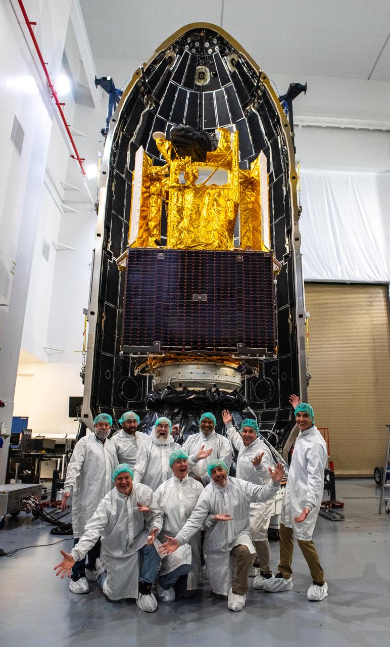
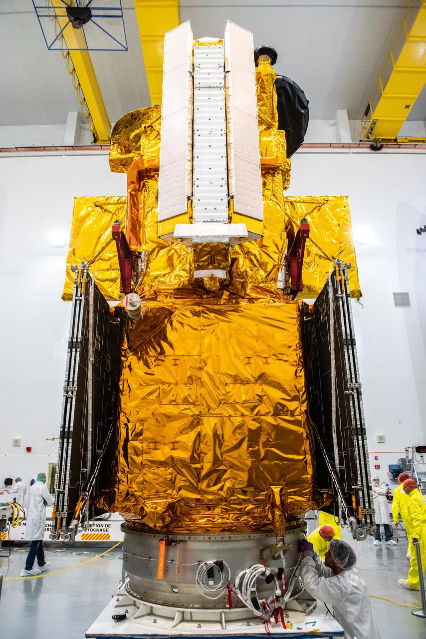
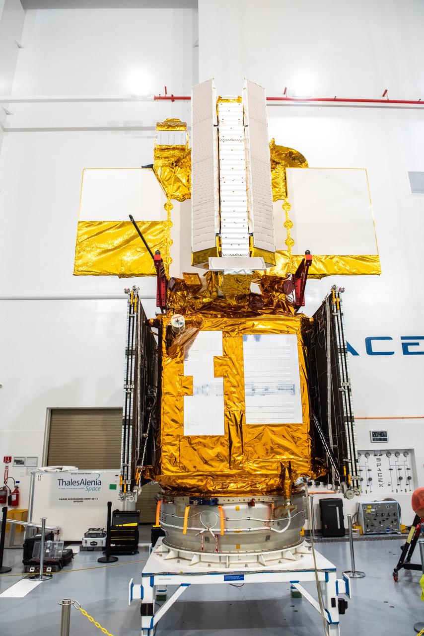
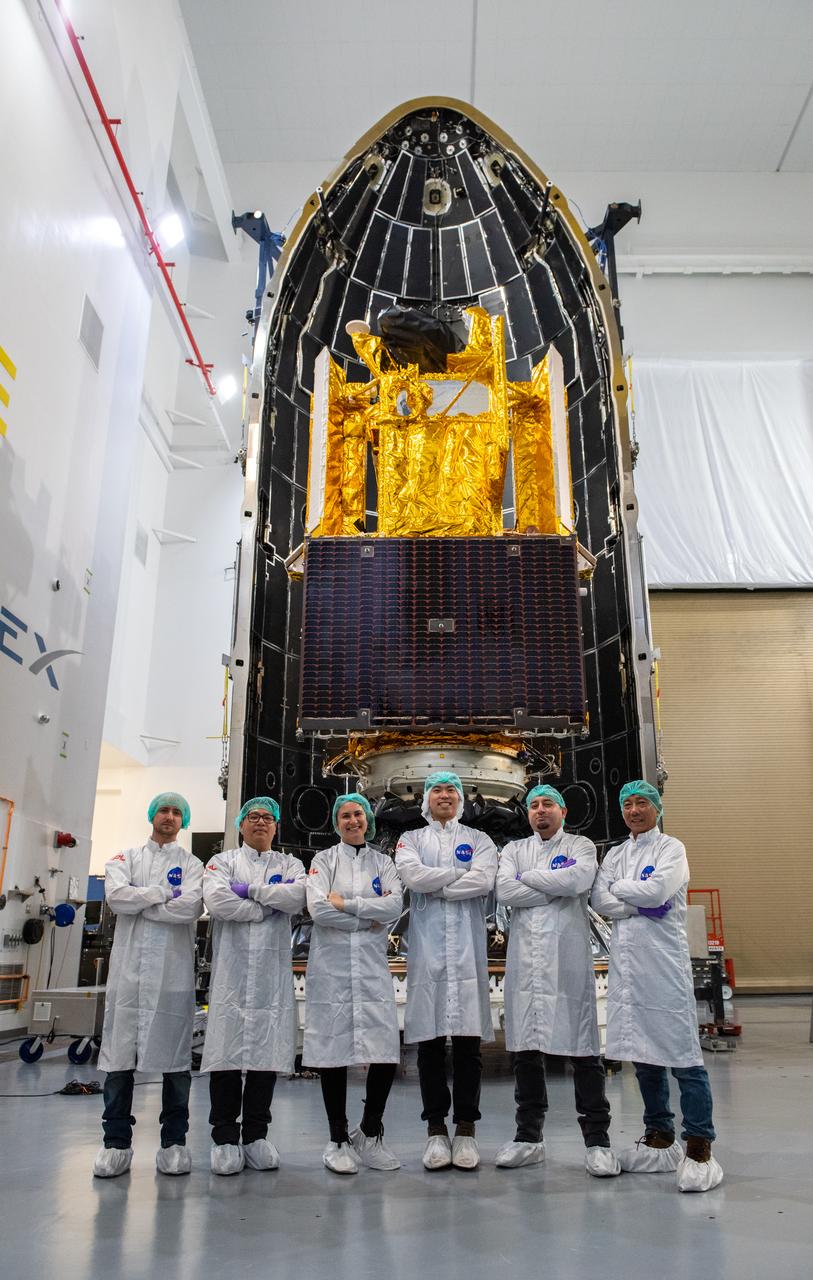
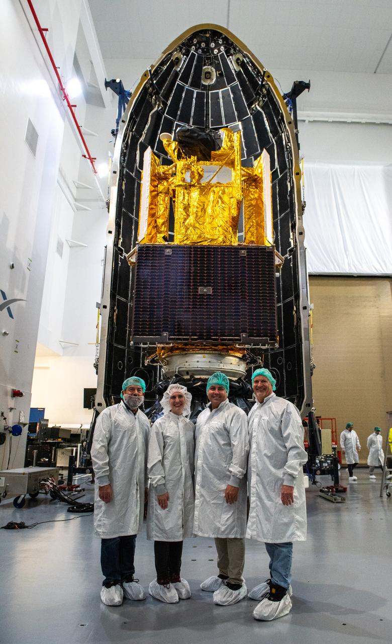
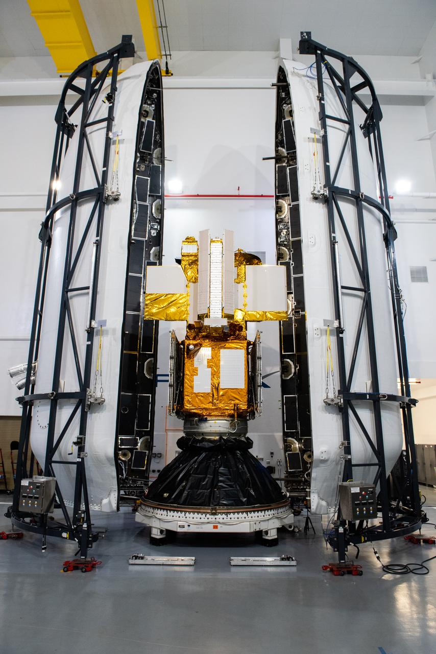
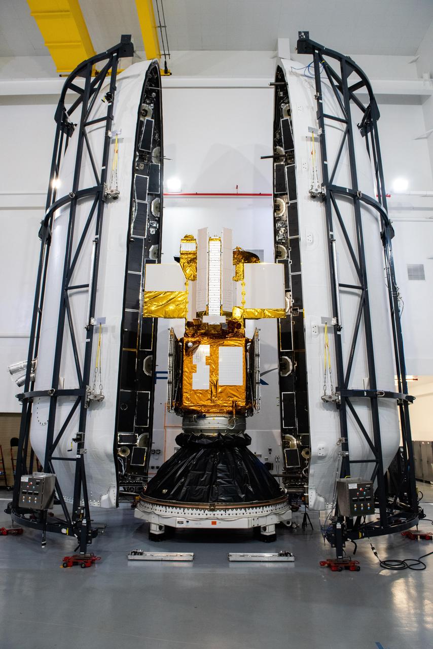
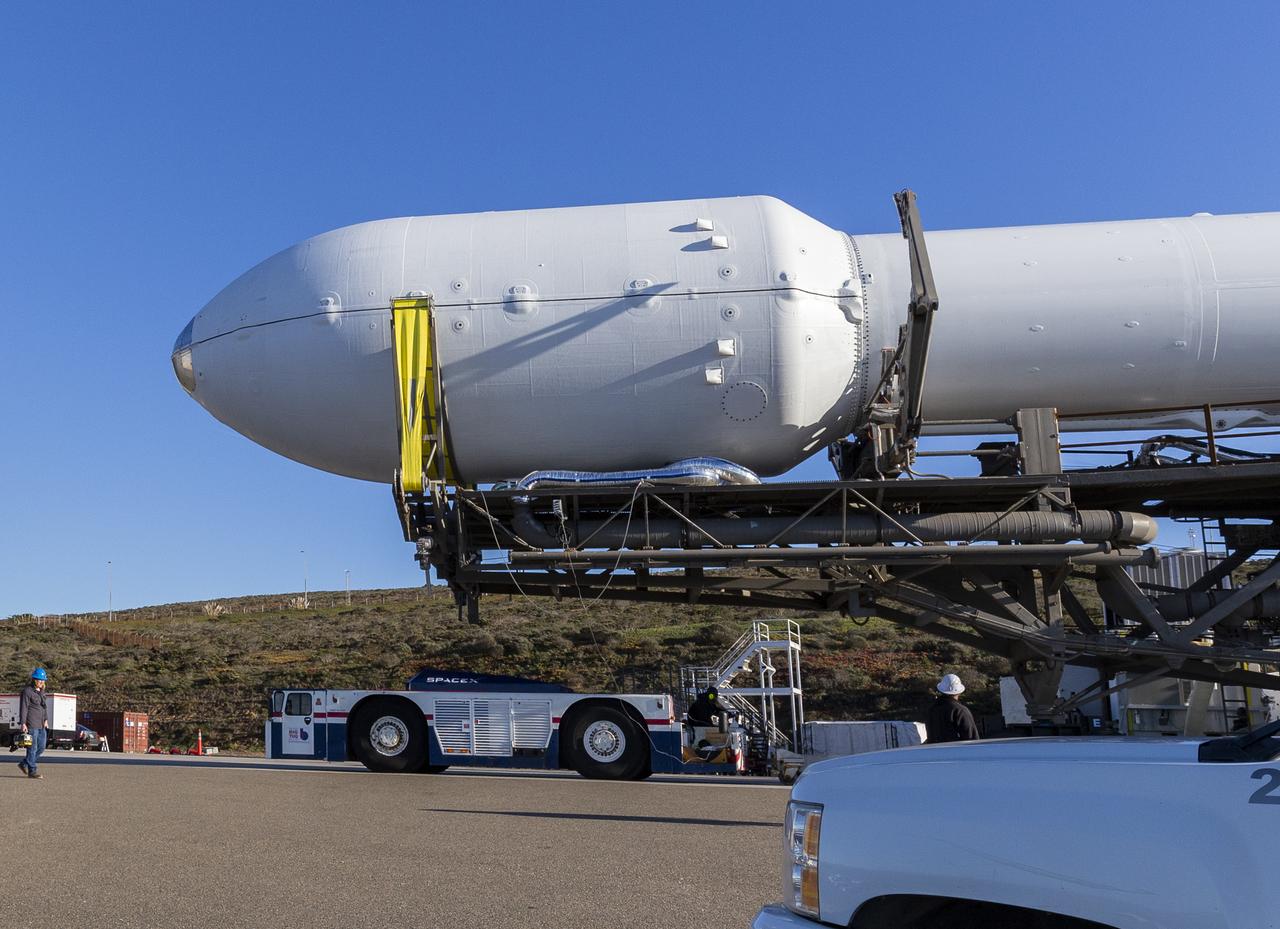
Inside the SpaceX facility at Vandenberg Space Force Base in California, the first half of the SpaceX Falcon 9 payload fairing is moved around the Surface Water and Ocean Topography (SWOT) satellite on Dec. 8, 2022. To mark the milestone, members of the processing team gather in front of the SWOT satellite. A collaboration between NASA and the French space agency Centre National d’Études Spatiales (CNES), with contributions from the Canadian Space Agency and the UK Space Agency, SWOT will be the first satellite to survey nearly all water on Earth’s surface. SWOT is scheduled to lift off aboard the SpaceX Falcon 9 rocket from Vandenberg on Dec. 15, 2022, at 3:46 a.m. PST.

Inside the SpaceX facility at Vandenberg Space Force Base in California, the first half of the SpaceX Falcon 9 payload fairing is moved around the Surface Water and Ocean Topography (SWOT) satellite on Dec. 8, 2022. To mark the milestone, members of the processing team gather in front of the SWOT satellite. A collaboration between NASA and the French space agency Centre National d’Études Spatiales (CNES), with contributions from the Canadian Space Agency and the UK Space Agency, SWOT will be the first satellite to survey nearly all water on Earth’s surface. SWOT is scheduled to lift off aboard the SpaceX Falcon 9 rocket from Vandenberg on Dec. 15, 2022, at 3:46 a.m. PST.
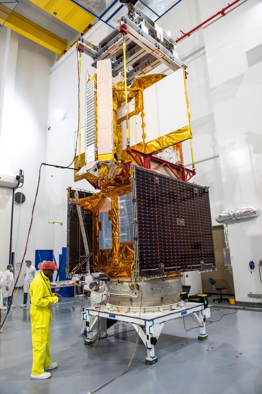
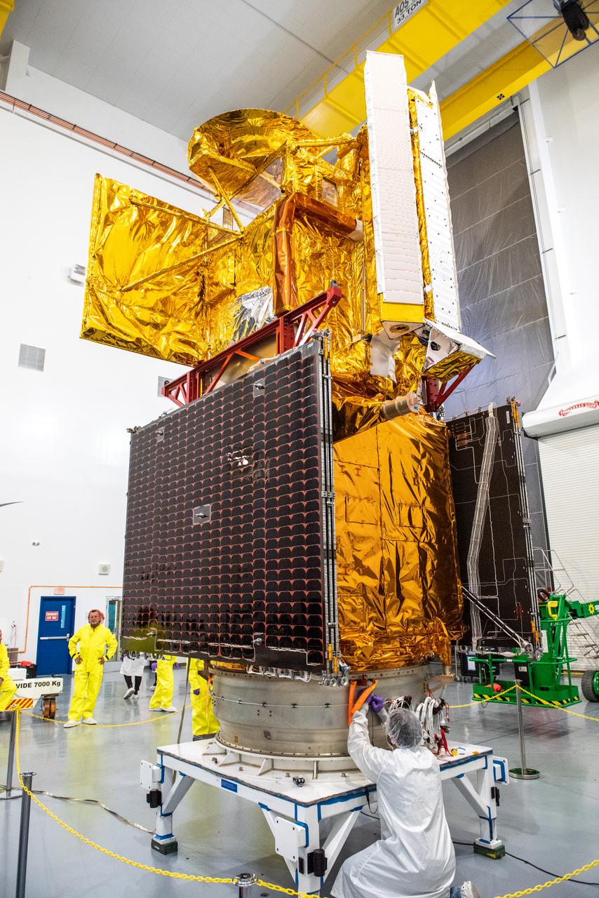
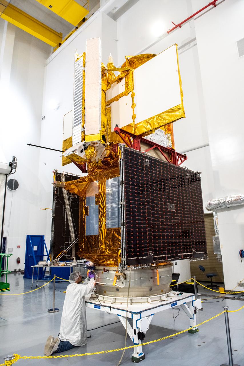
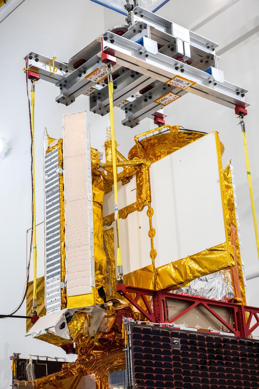
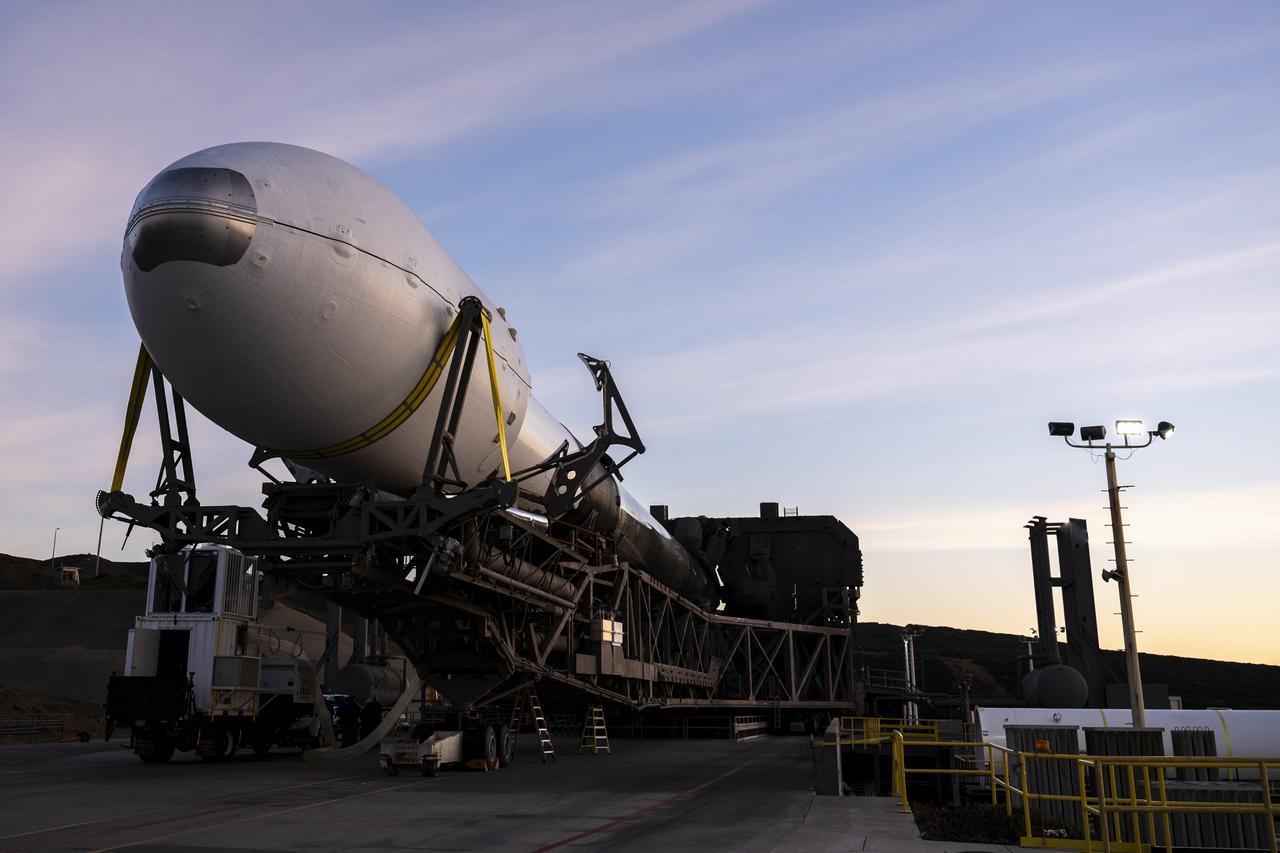
Inside the SpaceX facility at Vandenberg Space Force Base in California, a technician assists as a crane is used to lift the Surface Water and Ocean Topography (SWOT) satellite for mating to the payload adapter on Dec. 5, 2022. A collaboration between NASA and the French space agency Centre National d’Études Spatiales (CNES), with contributions from the Canadian Space Agency and the UK Space Agency, SWOT will be the first satellite to survey nearly all water on Earth’s surface. SWOT is scheduled to lift off aboard the SpaceX Falcon 9 rocket from Vandenberg on Dec. 15, 2022, at 3:46 a.m. PST.
Inside the SpaceX facility at Vandenberg Space Force Base in California, a crane is used to lift the Surface Water and Ocean Topography (SWOT) satellite for mating to the payload adapter on Dec. 5, 2022. A collaboration between NASA and the French space agency Centre National d’Études Spatiales (CNES), with contributions from the Canadian Space Agency and the UK Space Agency, SWOT will be the first satellite to survey nearly all water on Earth’s surface. SWOT is scheduled to lift off aboard the SpaceX Falcon 9 rocket from Vandenberg on Dec. 15, 2022, at 3:46 a.m. PST.
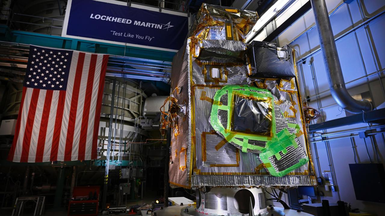
NASA's Lunar Trailblazer sits in a clean room at Lockheed Martin Space in Littleton, Colorado, shortly after being integrated with its second and final science instrument in June 2023. Called the Lunar Thermal Mapper (LTM), the instrument is visible as a black rectangular box in the upper right of the spacecraft's body. Green tape on the spacecraft will be removed before launch. Built by the University of Oxford in England and contributed by the UK Space Agency, LTM joins the High-resolution Volatiles and Minerals Moon Mapper (HVM³) that was integrated with the spacecraft late last year. Together, the instruments will enable scientists to determine the abundance, location, and form of the Moon's water. https://photojournal.jpl.nasa.gov/catalog/PIA25837
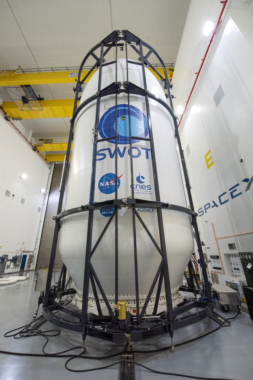
Inside the SpaceX facility at Vandenberg Space Force Base in California, decal fixtures are placed on the SpaceX Falcon 9 payload fairing of the Surface Water and Ocean Topography (SWOT) satellite on Dec. 9, 2022. A collaboration between NASA and the French space agency Centre National d’Études Spatiales (CNES), with contributions from the Canadian Space Agency and the UK Space Agency, SWOT will be the first satellite to survey nearly all water on Earth’s surface. SWOT is scheduled to lift off aboard the SpaceX Falcon 9 rocket from Vandenberg on Dec. 15, 2022, at 3:46 a.m. PST.
Inside the SpaceX facility at Vandenberg Space Force Base in California, a technician assists as a crane lowers the Surface Water and Ocean Topography (SWOT) satellite onto the payload adapter on Dec. 5, 2022. A collaboration between NASA and the French space agency Centre National d’Études Spatiales (CNES), with contributions from the Canadian Space Agency and the UK Space Agency, SWOT will be the first satellite to survey nearly all water on Earth’s surface. SWOT is scheduled to lift off aboard the SpaceX Falcon 9 rocket from Vandenberg on Dec. 15, 2022, at 3:46 a.m. PST.
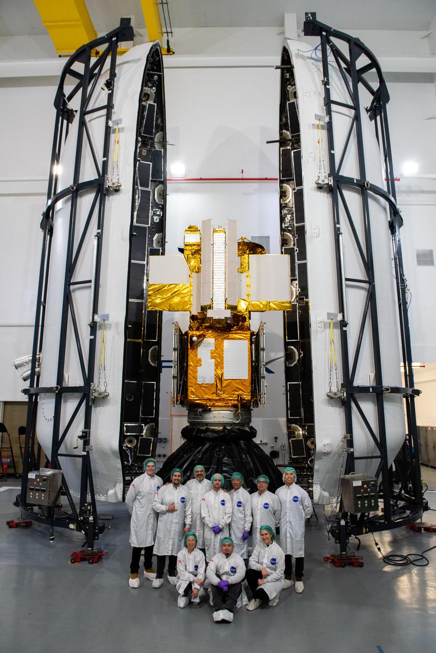
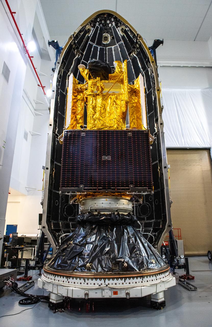
Inside the SpaceX facility at Vandenberg Space Force Base in California, both halves of the SpaceX Falcon 9 payload fairing are moved to enclose the Surface Water and Ocean Topography (SWOT) satellite on Dec. 8, 2022. To mark the milestone, members of the processing team gather in front of the SWOT satellite. A collaboration between NASA and the French space agency Centre National d’Études Spatiales (CNES), with contributions from the Canadian Space Agency and the UK Space Agency, SWOT will be the first satellite to survey nearly all water on Earth’s surface. SWOT is scheduled to lift off aboard the SpaceX Falcon 9 rocket from Vandenberg on Dec. 15, 2022, at 3:46 a.m. PST.
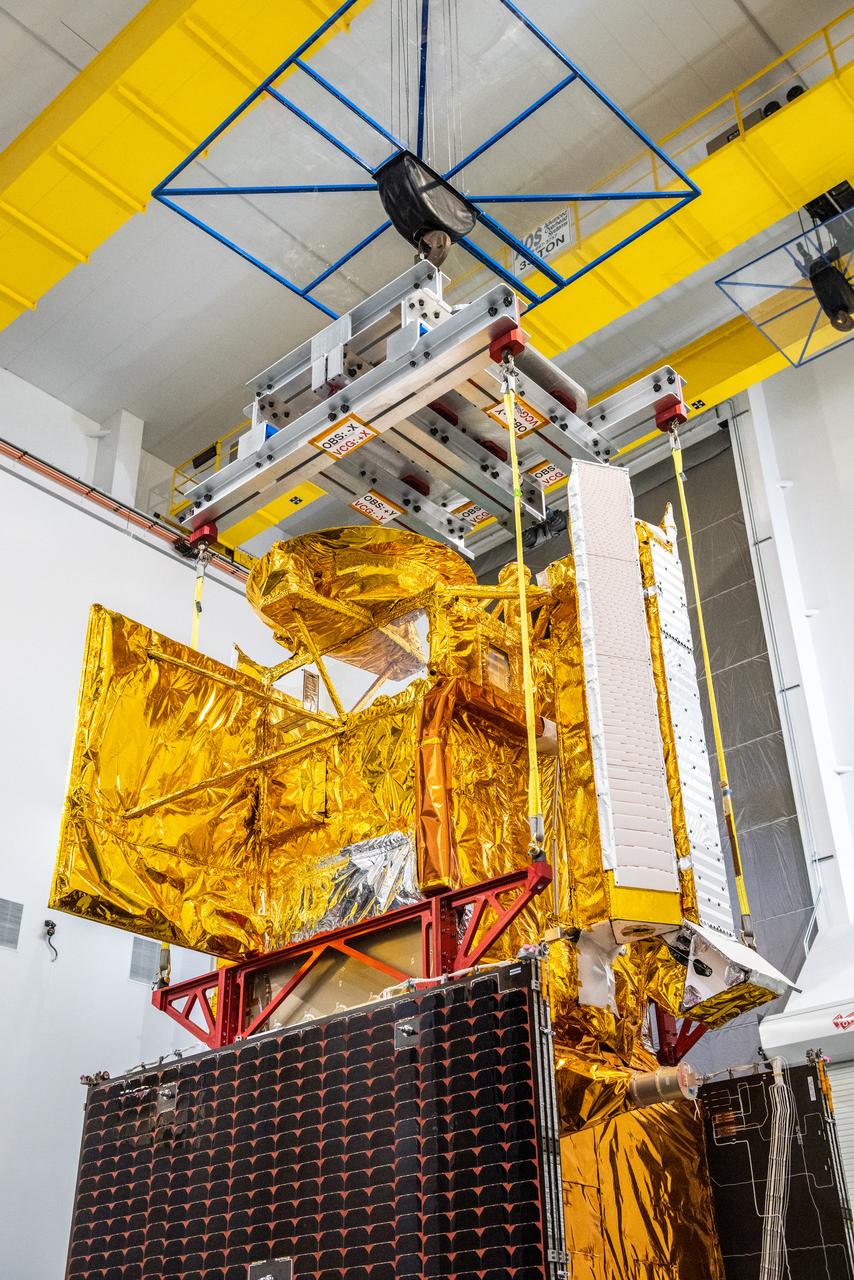
Inside the SpaceX facility at Vandenberg Space Force Base in California, a crane lifts the Surface Water and Ocean Topography (SWOT) satellite onto the payload adapter on Dec. 5, 2022. A collaboration between NASA and the French space agency Centre National d’Études Spatiales (CNES), with contributions from the Canadian Space Agency and the UK Space Agency, SWOT will be the first satellite to survey nearly all water on Earth’s surface. SWOT is scheduled to lift off aboard the SpaceX Falcon 9 rocket from Vandenberg on Dec. 15, 2022, at 3:46 a.m. PST.
Inside the SpaceX facility at Vandenberg Space Force Base in California, a crane is used to lower the Surface Water and Ocean Topography (SWOT) satellite for mating to the payload adapter on Dec. 5, 2022. A collaboration between NASA and the French space agency Centre National d’Études Spatiales (CNES), with contributions from the Canadian Space Agency and the UK Space Agency, SWOT will be the first satellite to survey nearly all water on Earth’s surface. SWOT is scheduled to lift off aboard the SpaceX Falcon 9 rocket from Vandenberg on Dec. 15, 2022, at 3:46 a.m. PST.
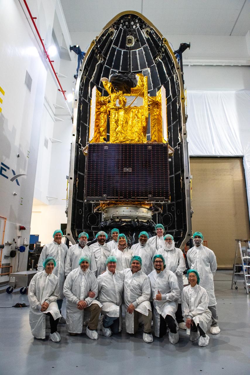
Inside the SpaceX facility at Vandenberg Space Force Base in California, the first half of the SpaceX Falcon 9 payload fairing is moved around the Surface Water and Ocean Topography (SWOT) satellite on Dec. 8, 2022. To mark the milestone, the processing team gathers in front of the SWOT satellite. A collaboration between NASA and the French space agency Centre National d’Études Spatiales (CNES), with contributions from the Canadian Space Agency and the UK Space Agency, SWOT will be the first satellite to survey nearly all water on Earth’s surface. SWOT is scheduled to lift off aboard the SpaceX Falcon 9 rocket from Vandenberg on Dec. 15, 2022, at 3:46 a.m. PST.
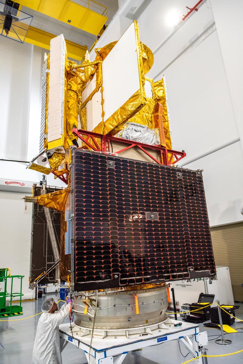
Inside the SpaceX facility at Vandenberg Space Force Base in California, a technician helps secure the Surface Water and Ocean Topography (SWOT) satellite onto the payload adapter on Dec. 5, 2022. A collaboration between NASA and the French space agency Centre National d’Études Spatiales (CNES), with contributions from the Canadian Space Agency and the UK Space Agency, SWOT will be the first satellite to survey nearly all water on Earth’s surface. SWOT is scheduled to lift off aboard the SpaceX Falcon 9 rocket from Vandenberg on Dec. 15, 2022, at 3:46 a.m. PST.
Inside the SpaceX facility at Vandenberg Space Force Base in California, the first half of the SpaceX Falcon 9 payload fairing is moved around the Surface Water and Ocean Topography (SWOT) satellite on Dec. 8, 2022. A collaboration between NASA and the French space agency Centre National d’Études Spatiales (CNES), with contributions from the Canadian Space Agency and the UK Space Agency, SWOT will be the first satellite to survey nearly all water on Earth’s surface. SWOT is scheduled to lift off aboard the SpaceX Falcon 9 rocket from Vandenberg on Dec. 15, 2022, at 3:46 a.m. PST.
Inside the SpaceX facility at Vandenberg Space Force Base in California, the first half of the SpaceX Falcon 9 payload fairing is moved around the Surface Water and Ocean Topography (SWOT) satellite on Dec. 8, 2022. To mark the milestone, members of the processing team gather in front of the SWOT satellite. A collaboration between NASA and the French space agency Centre National d’Études Spatiales (CNES), with contributions from the Canadian Space Agency and the UK Space Agency, SWOT will be the first satellite to survey nearly all water on Earth’s surface. SWOT is scheduled to lift off aboard the SpaceX Falcon 9 rocket from Vandenberg on Dec. 15, 2022, at 3:46 a.m. PST.
Inside the SpaceX facility at Vandenberg Space Force Base in California, the first half of the SpaceX Falcon 9 payload fairing is moved around the Surface Water and Ocean Topography (SWOT) satellite on Dec. 8, 2022. To mark the milestone, members of the processing team gather in front of the SWOT satellite. A collaboration between NASA and the French space agency Centre National d’Études Spatiales (CNES), with contributions from the Canadian Space Agency and the UK Space Agency, SWOT will be the first satellite to survey nearly all water on Earth’s surface. SWOT is scheduled to lift off aboard the SpaceX Falcon 9 rocket from Vandenberg on Dec. 15, 2022, at 3:46 a.m. PST.
Inside the SpaceX facility at Vandenberg Space Force Base in California, a technician assists as a crane lowers the Surface Water and Ocean Topography (SWOT) satellite onto the payload adapter on Dec. 5, 2022. A collaboration between NASA and the French space agency Centre National d’Études Spatiales (CNES), with contributions from the Canadian Space Agency and the UK Space Agency, SWOT will be the first satellite to survey nearly all water on Earth’s surface. SWOT is scheduled to lift off aboard the SpaceX Falcon 9 rocket from Vandenberg on Dec. 15, 2022, at 3:46 a.m. PST.
Inside the SpaceX facility at Vandenberg Space Force Base in California, a crane is used to lift the Surface Water and Ocean Topography (SWOT) satellite for mating to the payload adapter on Dec. 5, 2022. A collaboration between NASA and the French space agency Centre National d’Études Spatiales (CNES), with contributions from the Canadian Space Agency and the UK Space Agency, SWOT will be the first satellite to survey nearly all water on Earth’s surface. SWOT is scheduled to lift off aboard the SpaceX Falcon 9 rocket from Vandenberg on Dec. 15, 2022, at 3:46 a.m. PST.
Inside the SpaceX facility at Vandenberg Space Force Base in California, both halves of the SpaceX Falcon 9 payload fairing are moved to enclose the Surface Water and Ocean Topography (SWOT) satellite on Dec. 8, 2022. A collaboration between NASA and the French space agency Centre National d’Études Spatiales (CNES), with contributions from the Canadian Space Agency and the UK Space Agency, SWOT will be the first satellite to survey nearly all water on Earth’s surface. SWOT is scheduled to lift off aboard the SpaceX Falcon 9 rocket from Vandenberg on Dec. 15, 2022, at 3:46 a.m. PST.
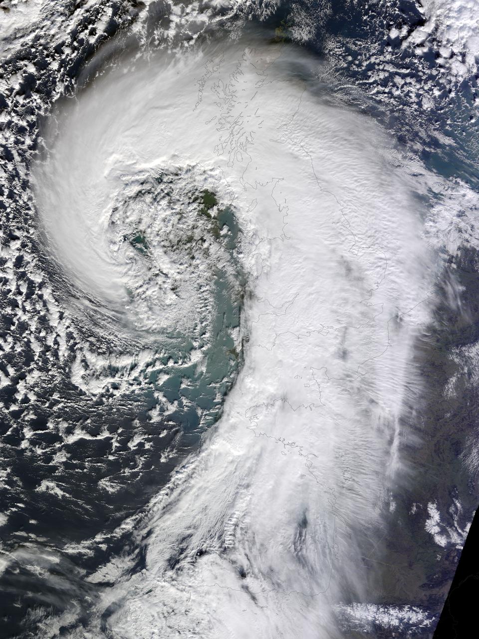
Soggy winters are not unusual in the United Kingdom, but this winter has been in a category of its own. UK Met Office meteorologists had just declared January 2014 the wettest month on record for parts of southern Britain when another series of storms swept across the area in early February. The Moderate Resolution Imaging Spectroradiometer (MODIS) on NASA’s Terra satellite captured this image of an extratropical cyclone bearing down on the United Kingdom on February 12, 2014. Mature extratropical cyclones often feature comma-shaped cloud patterns that are the product of “conveyor belt” circulation. While heavy precipitation is often present near the low-pressure head of the comma, a slot of dry air usually trails the west side of the tail. The storm brought the United Kingdom yet another round of heavy rain, as well as winds that exceeded 160 kilometers (100 miles) per hour. It snarled traffic, disrupted train service, and caused power outages for more than 700,000 people. The also exacerbated severe flooding in southern England. More than 5,800 homes have flooded since early December, according to media reports. Authorities have deployed thousands of soldiers to towns and cities in southern England to help with flood recovery. Meanwhile, the Met Office was forecasting more of the same. They warned that another system bearing heavy rain and winds was lining up to push into the United Kingdom from the southeast on Friday morning. NASA Earth Observatory image by Jesse Allen, using data from the Land Atmosphere Near real-time Capability for EOS (LANCE). Caption by Adam Voiland. More info: <a href="http://earthobservatory.nasa.gov/NaturalHazards/view.php?id=83127" rel="nofollow">earthobservatory.nasa.gov/NaturalHazards/view.php?id=83127</a> Instrument: Terra - MODIS Credit: <b><a href="http://www.earthobservatory.nasa.gov/" rel="nofollow"> NASA Earth Observatory</a></b> <b><a href="http://www.nasa.gov/audience/formedia/features/MP_Photo_Guidelines.html" rel="nofollow">NASA image use policy.</a></b> <b><a href="http://www.nasa.gov/centers/goddard/home/index.html" rel="nofollow">NASA Goddard Space Flight Center</a></b> enables NASA’s mission through four scientific endeavors: Earth Science, Heliophysics, Solar System Exploration, and Astrophysics. Goddard plays a leading role in NASA’s accomplishments by contributing compelling scientific knowledge to advance the Agency’s mission. <b>Follow us on <a href="http://twitter.com/NASAGoddardPix" rel="nofollow">Twitter</a></b> <b>Like us on <a href="http://www.facebook.com/pages/Greenbelt-MD/NASA-Goddard/395013845897?ref=tsd" rel="nofollow">Facebook</a></b> <b>Find us on <a href="http://instagrid.me/nasagoddard/?vm=grid" rel="nofollow">Instagram</a></b>
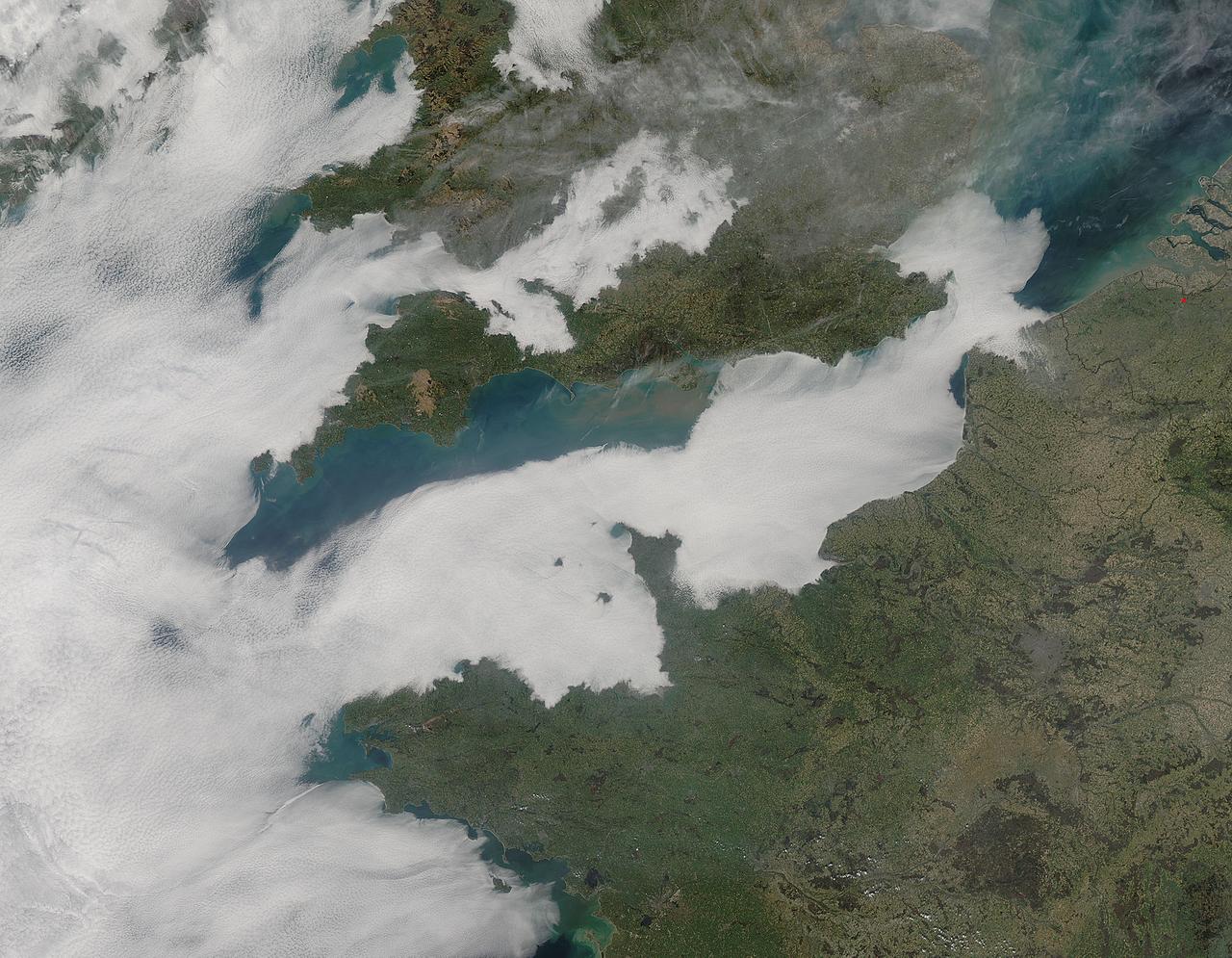
A thick blanket of low clouds covered the English Channel, Celtic Sea and Irish Sea on March 13, 2014. The fog also crept over major cities in the United Kingdom and Ireland. While citizens living in parts of Ireland, England, Wales, Scotland and Northern Ireland were posting ground-based photos of fog-shrouded landscape on social media, the internet and news outlets, the scene was also captured from space. The Moderate Resolution Imaging Spectroradiometer (MODIS) aboard NASA’s Aqua captured this true-color image of the cloudy day at 13:00 UTC (1:00 p.m. in London) on that same day. The dense fog (low clouds) affected air travel, causing the cancellation of hundreds of flights going through London City Airport, where visibility was reported at less than 100 meters (328 ft) – less than the length of an American football field. Flights were also cancelled at Heathrow, Gatwick and Manchester. A private helicopter flying to Northern Ireland went down in by the fog near the Norfolk-Suffolk border, with loss of four lives. Driving was little better in many areas, causing the Met Office to issue a yellow weather warning and to caution drivers of difficult conditions. The lowest visibility of the day was reported at Roches Point weather station. Located at the southeastern tip of Cork Harbor, Ireland, the station reported visibility of less than 50 meters (164 ft) – the length of an Olympic size swimming pool. In this image, the fog-covered Celtic Sea is located in the southwest. Ireland lies under tendrils of low cloud in the northwest corner of the image. Banks of clouds part around England, near the center of the image, and southern Wales (top and center) completely under the foggy blanket. Fog also creeps over the coasts of France, Belgium and the Netherlands on the east side of the English Channel. Credit: NASA/GSFC/Jeff Schmaltz/MODIS Land Rapid Response Team <b><a href="http://www.nasa.gov/audience/formedia/features/MP_Photo_Guidelines.html" rel="nofollow">NASA image use policy.</a></b> <b><a href="http://www.nasa.gov/centers/goddard/home/index.html" rel="nofollow">NASA Goddard Space Flight Center</a></b> enables NASA’s mission through four scientific endeavors: Earth Science, Heliophysics, Solar System Exploration, and Astrophysics. Goddard plays a leading role in NASA’s accomplishments by contributing compelling scientific knowledge to advance the Agency’s mission. <b>Follow us on <a href="http://twitter.com/NASAGoddardPix" rel="nofollow">Twitter</a></b> <b>Like us on <a href="http://www.facebook.com/pages/Greenbelt-MD/NASA-Goddard/395013845897?ref=tsd" rel="nofollow">Facebook</a></b> <b>Find us on <a href="http://instagram.com/nasagoddard?vm=grid" rel="nofollow">Instagram</a></b>
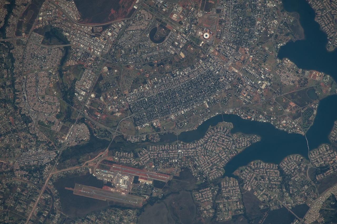
ISS040-E-005839 (28 May 2014) --- The Brasilia World Cup Stadium (top center) is featured in this image photographed by an Expedition 40 crew member on the International Space Station on May 28, 2014. Brazil?s national football stadium, the Estado Nacional, lies near the heart of the capital city of Brasilia. The new roof appears as a brilliant white ring in this image. The stadium is one of Brasilia?s largest buildings. Renovation began in 2010 and it is now the second most expensive stadium in the world, after Wembley Stadium in London, UK. To accommodate expected World Cup fans from all over the world, renovations for all modes of transportation, particularly airports, have been put in place in Brasilia and other host cities. Brasilia?s international airport can be seen lower left on the far side of Lake Paranoa. Brasilia is widely known for its modern building designs and city layout. Space station crew members have the best view of the city?s well-known ?swept wing? city layout ? giving the sense of a flying bird ? expressed in the curves of the boulevards (top). The stadium occupies the city center between the wings. The President Juscelino Kubitschek Bridge crosses the lake at bottom right. Its 1200-meter span gives scale to the city and stadium.
Technicians encapsulated the SWOT satellite, or the Surface Water and Ocean Topography mission, in its payload fairing on Dec. 8, 2022, in preparation for launch. At the SpaceX processing facility at Vandenberg Space Force Base in California, technicians completed the operation and will soon mate the fairing to the top of a Falcon 9 rocket. The fairing protects the satellite from aerodynamic pressure and heating during ascent. After the rocket escapes Earth's atmosphere, the fairing separates into two halves, which are jettisoned back to Earth. Once in orbit, SWOT will measure the height of water in freshwater bodies and the ocean on more than 90% of Earth's surface. This information will provide insights into how the ocean influences climate change; how a warming world affects lakes, rivers, and reservoirs; and how communities can better prepare for disasters, such as floods. SWOT is a collaborative effort by NASA and France's Centre National d'Études Spatiales (CNES) with contributions from the Canadian Space Agency (CSA) and UK Space Agency. Launch is targeted for Dec. 15, 2022, at 3:46 a.m. PST from Space Launch Complex 4E at Vandenberg Space Force Base. https://photojournal.jpl.nasa.gov/catalog/PIA25627

This video is a series of images showing the deployment of the solar arrays that power the international Surface Water and Ocean Topography satellite (SWOT). The mission captured the roughly 10-minute process with two of the four commercial cameras aboard the satellite (the same type used to capture NASA's Perseverance rover landing on Mars). The satellite launched Dec. 16, 2022, at 3:46 a.m. PST from Vandenberg Space Force Base in California, and the arrays started their deployment at 5:01 a.m. PST. SWOT's two solar arrays measure 48.8 feet (14.9 meters) from end to end, with a total surface area of 335 square feet (31 square meters). Extending from opposite sides of the spacecraft bus, the arrays remain pointed at the Sun via small motors. They provide 8 kilowatts of power to the satellite, which has a 1.5-kilowatt total power demand. SWOT will survey the height of water in Earth's lakes, rivers, reservoirs, and the ocean. The satellite will cover the planet's surface at least once every 21 days and has a prime mission of three years. It was jointly developed by NASA and France's Centre National d'Études Spatiales (CNES), with contributions from the Canadian Space Agency (CSA) and the UK Space Agency. Movie available at https://photojournal.jpl.nasa.gov/catalog/PIA25563

NASA image release Feb. 17, 2011 <b>To see a hd vidoe of this sprial galaxy go to: <a href="http://www.flickr.com/photos/gsfc/5453173577/">www.flickr.com/photos/gsfc/5453173577/</a></b> The Hubble Space Telescope revealed this majestic disk of stars and dust lanes in this view of the spiral galaxy NGC 2841. A bright cusp of starlight marks the galaxy's center. Spiraling outward are dust lanes that are silhouetted against the population of whitish middle-aged stars. Much younger blue stars trace the spiral arms. Notably missing are pinkish emission nebulae indicative of new star birth. It is likely that the radiation and supersonic winds from fiery, super-hot, young blue stars cleared out the remaining gas (which glows pink), and hence shut down further star formation in the regions in which they were born. NGC 2841 currently has a relatively low star formation rate compared to other spirals that are ablaze with emission nebulae. NGC 2841 lies 46 million light-years away in the constellation of Ursa Major (The Great Bear). This image was taken in 2010 through four different filters on Hubble’s Wide Field Camera 3. Wavelengths range from ultraviolet light through visible light to near-infrared light. NASA, ESA, and the Hubble Heritage (STScI/AURA)-ESA/Hubble Collaboration; Acknowledgment: M. Crockett and S. Kaviraj (Oxford University, UK), R. O’Connell (University of Virginia), B. Whitmore (STScI), and the WFC3 Scientific Oversight Committee <b><a href="http://www.nasa.gov/centers/goddard/home/index.html" rel="nofollow">NASA Goddard Space Flight Center</a></b> enables NASA’s mission through four scientific endeavors: Earth Science, Heliophysics, Solar System Exploration, and Astrophysics. Goddard plays a leading role in NASA’s accomplishments by contributing compelling scientific knowledge to advance the Agency’s mission. <b>Follow us on <a href="http://twitter.com/NASAGoddardPix" rel="nofollow">Twitter</a></b> <b>Join us on <a href="http://www.facebook.com/pages/Greenbelt-MD/NASA-Goddard/395013845897?ref=tsd" rel="nofollow">Facebook</a></b>
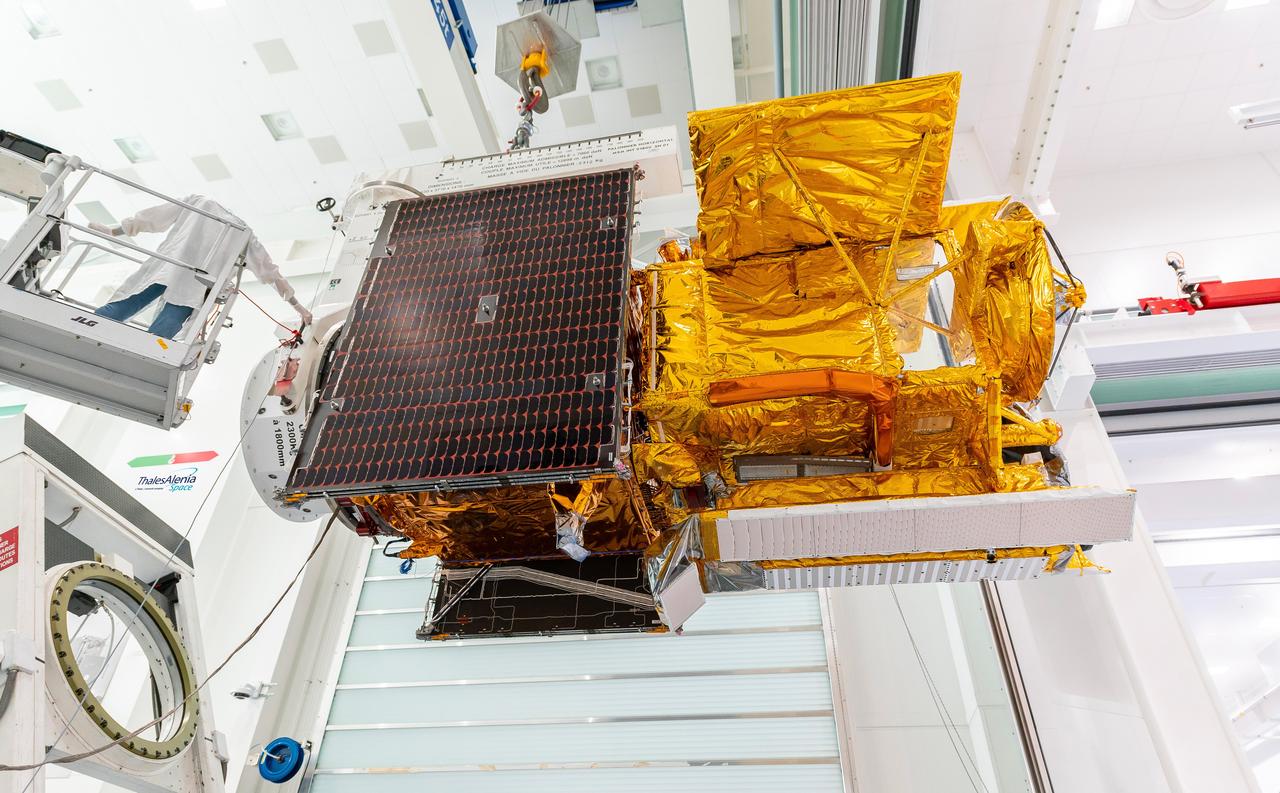
Workers in a clean room in Cannes, France, load the Surface Water and Ocean Topography (SWOT) satellite into a container in preparation for shipping the spacecraft to the U.S. SWOT is an international mission led by NASA and the French space agency Centre National d'Études Spatiales (CNES) that will survey water on more than 90% of Earth's surface. The spacecraft will view water in Earth's lakes, rivers, reservoirs, and the ocean in higher definition than ever before. The information that SWOT gathers will help inform water management decisions and prepare communities for rising seas and changing coastlines. It will also help researchers better understand the exchange of heat and carbon between the ocean and atmosphere, an important component of the role that Earth's ocean plays in the planet's climate. SWOT will launch out of the Vandenberg Space Force Base in central California no earlier than Dec. 5, 2022. SWOT is being jointly developed by NASA and CNES, with contributions from the Canadian Space Agency and the United Kingdom Space Agency. JPL, which is managed for NASA by Caltech in Pasadena, California, leads the U.S. component of the project. For the flight system payload, NASA is providing the KaRIn instrument, a GPS science receiver, a laser retroreflector, a two-beam microwave radiometer, and NASA instrument operations. CNES is providing the Doppler Orbitography and Radioposition Integrated by Satellite (DORIS) system, the dual frequency Poseidon altimeter (developed by Thales Alenia Space), the KaRIn radio-frequency subsystem (together with Thales Alenia Space and with support from the UK Space Agency), the platform, and ground control segment. CSA is providing the KaRIn high-power transmitter assembly. NASA is providing the launch vehicle and associated launch services. https://photojournal.jpl.nasa.gov/catalog/PIA24910

This animation, created in 2012, shows the increasing clarity and detail of measurements of sea height made by successive satellite altimeters launched by NASA and other agencies over the past four decades, concluding with data at the resolution possible with the Surface Water and Ocean Topography (SWOT) satellite, expected to launch in December 2022. Each new spacecraft has been able to obtain higher-resolution observations than its predecessors. Sea height is key to understanding how much, and how fast, the oceans are rising in a warming climate. The animation starts with Seasat, launched in 1978 as one of the NASA's earliest Earth-observing satellites, then moves to Geosat, a U.S. Navy spacecraft launched in 1985, and on to ERS-1, TOPEX/Poseidon, ERS-2, Jason-1, Envisat, and Jason-2. Since the end of the time period shown in the animation, subsequent satellites have continued measuring sea height, creating an ongoing, decadeslong record. In March 2022, Sentinel-6 Michael Freilich, a joint U.S.-European mission, became the official reference satellite for global sea level measurements. SWOT will be latest spacecraft to observe ocean heights from Earth orbit. Its measurements will provide unprecedented insights into the activity of small-scale currents and their impact on climate change. Researchers believe small-scale currents, which are less than 60 miles (100 kilometers) in size, have a significant influence on the ocean's ability to absorb atmospheric heat and carbon and thereby moderate global temperature change. To measure these currents, SWOT will employ the Ka-band Radar Interferometer (KaRIn), a new technology developed at NASA's Jet Propulsion Laboratory in Southern California that will offer even greater spatial resolution than previous instruments that studied the ocean. SWOT will survey the water in Earth's lakes, rivers, reservoirs, and the ocean. The satellite will cover the planet's surface twice every 21 days and has a prime mission of three years. It was jointly developed by NASA and France's Centre National d'Études Spatiales (CNES), with contributions from the Canadian Space Agency (CSA) and the UK Space Agency. JPL, a division of Caltech in Southern California, manages the U.S. portion of the mission for NASA. Animation available at https://photojournal.jpl.nasa.gov/catalog/PIA25561

Release Date: May 3, 2004 A Dying Star Shrouded by a Blanket of Hailstones Forms the Bug Nebula (NGC 6302) The Bug Nebula, NGC 6302, is one of the brightest and most extreme planetary nebulae known. The fiery, dying star at its center is shrouded by a blanket of icy hailstones. This NASA Hubble Wide Field Plantery Camera 2 image shows impressive walls of compressed gas, laced with trailing strands and bubbling outflows. Object Names: NGC 6302, Bug Nebula Image Type: Astronomical Credit: NASA, ESA and A.Zijlstra (UMIST, Manchester, UK) To learn more about this image go to: <a href="http://hubblesite.org/gallery/album/nebula/pr2004046a/" rel="nofollow">hubblesite.org/gallery/album/nebula/pr2004046a/</a> <b><a href="http://www.nasa.gov/audience/formedia/features/MP_Photo_Guidelines.html" rel="nofollow">NASA image use policy.</a></b> <b><a href="http://www.nasa.gov/centers/goddard/home/index.html" rel="nofollow">NASA Goddard Space Flight Center</a></b> enables NASA’s mission through four scientific endeavors: Earth Science, Heliophysics, Solar System Exploration, and Astrophysics. Goddard plays a leading role in NASA’s accomplishments by contributing compelling scientific knowledge to advance the Agency’s mission. <b>Follow us on <a href="http://twitter.com/NASAGoddardPix" rel="nofollow">Twitter</a></b> <b>Like us on <a href="http://www.facebook.com/pages/Greenbelt-MD/NASA-Goddard/395013845897?ref=tsd" rel="nofollow">Facebook</a></b> <b>Find us on <a href="http://instagram.com/nasagoddard?vm=grid" rel="nofollow">Instagram</a></b>
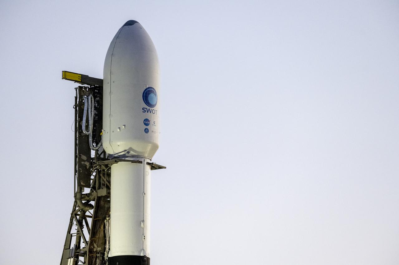
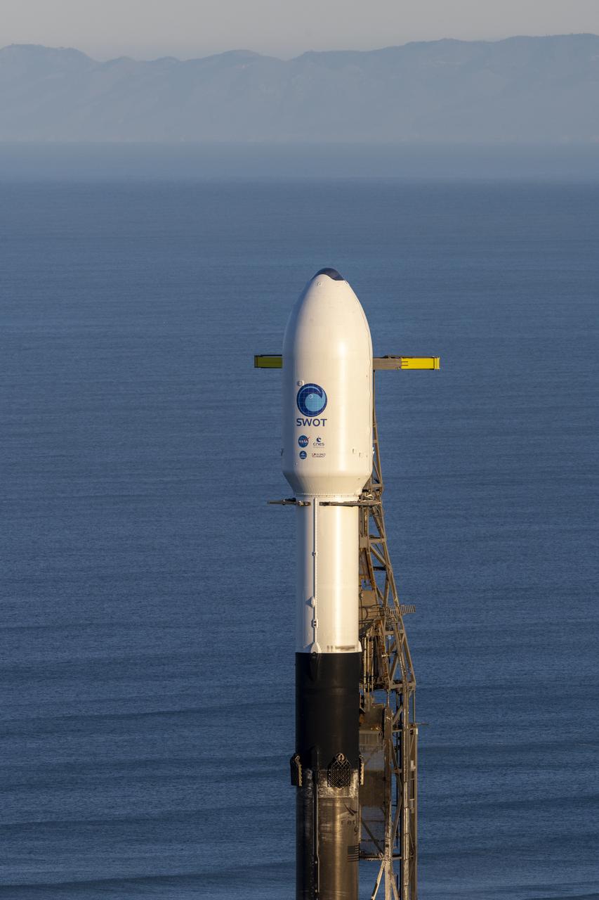
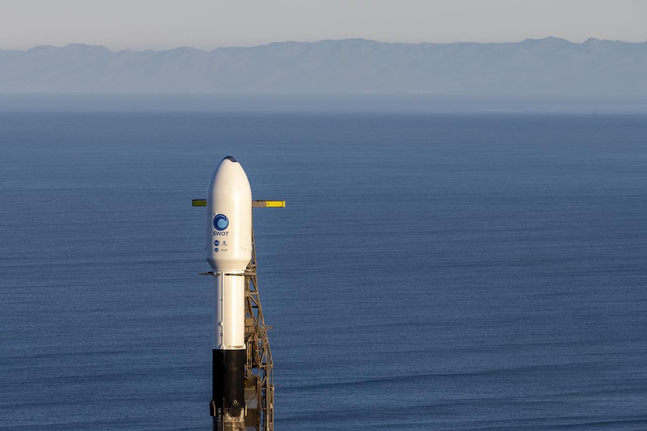
A SpaceX Falcon 9 rocket with the Surface Water and Ocean Topography (SWOT) spacecraft onboard is seen as it rolls out to the pad, Tuesday, Dec. 13, 2022, at Space Launch Complex 4E at Vandenberg Space Force Base in California. Jointly developed by NASA and Centre National D'Etudes Spatiales (CNES), with contributions from the Canadian Space Agency (CSA) and United Kingdom Space Agency, SWOT is the first satellite mission that will observe nearly all water on Earth’s surface, measuring the height of water in the planet’s lakes, rivers, reservoirs, and the ocean. Photo Credit: (NASA/Keegan Barber)

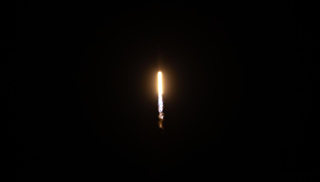
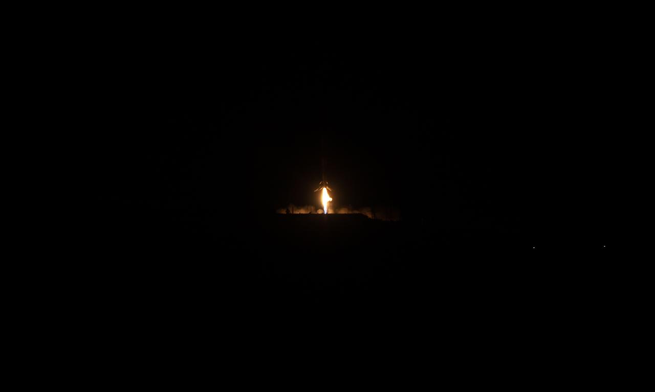
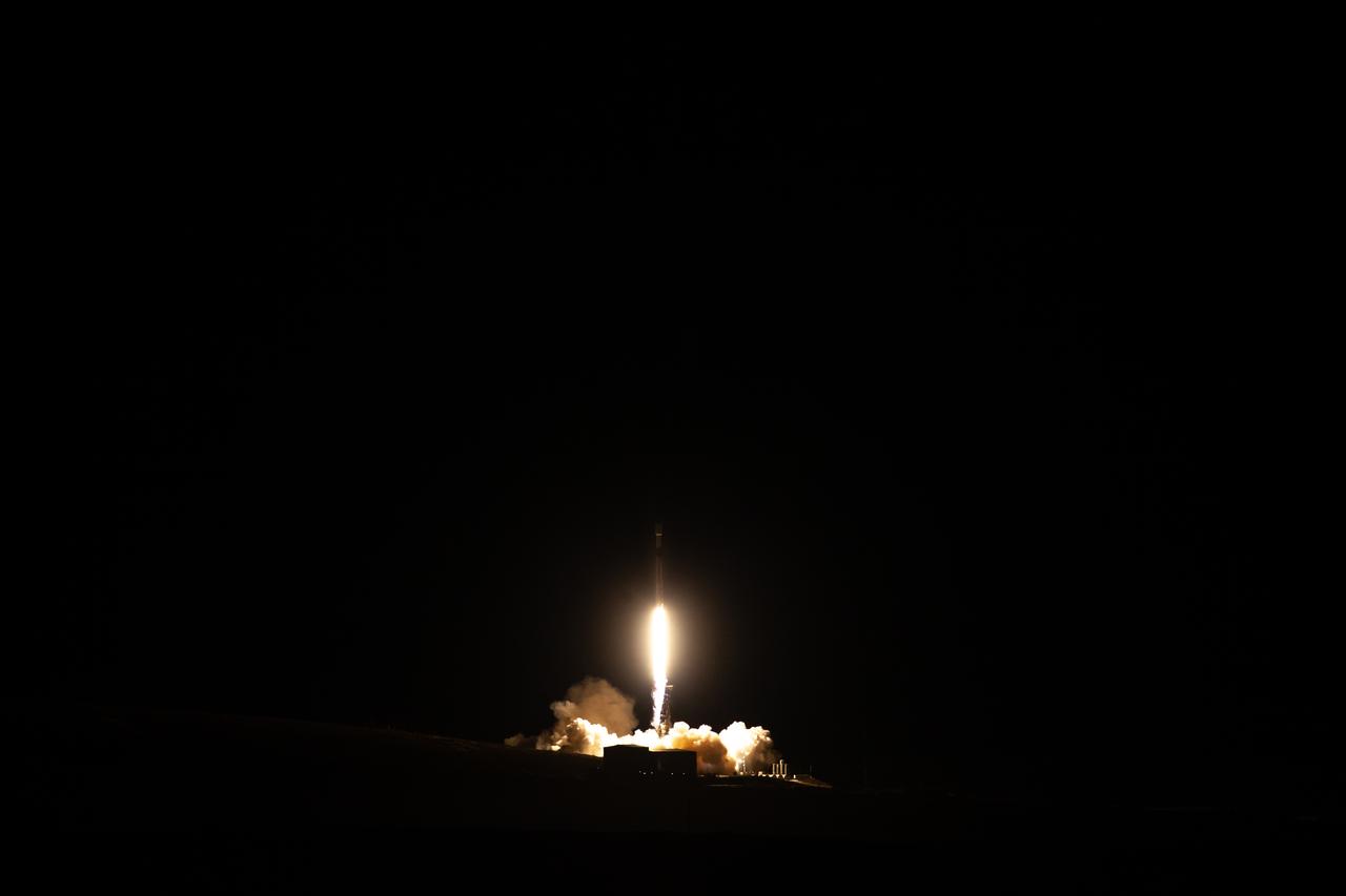
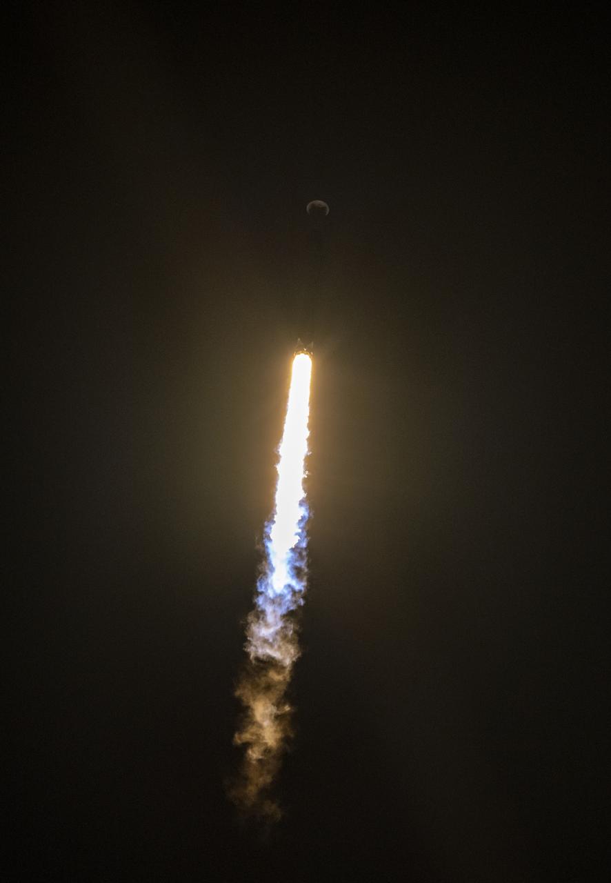
A SpaceX Falcon 9 rocket launches with the Surface Water and Ocean Topography (SWOT) spacecraft onboard, Friday, Dec. 16, 2022, from Space Launch Complex 4E at Vandenberg Space Force Base in California. Jointly developed by NASA and Centre National D'Etudes Spatiales (CNES), with contributions from the Canadian Space Agency (CSA) and United Kingdom Space Agency, SWOT is the first satellite mission that will observe nearly all water on Earth’s surface, measuring the height of water in the planet’s lakes, rivers, reservoirs, and the ocean. Photo Credit: (NASA/Keegan Barber)
A SpaceX Falcon 9 rocket with the Surface Water and Ocean Topography (SWOT) spacecraft onboard is seen as preparations for launch continue, Wednesday, Dec. 14, 2022, at Space Launch Complex 4E at Vandenberg Space Force Base in California. Jointly developed by NASA and Centre National D'Etudes Spatiales (CNES), with contributions from the Canadian Space Agency (CSA) and United Kingdom Space Agency, SWOT is the first satellite mission that will observe nearly all water on Earth’s surface, measuring the height of water in the planet’s lakes, rivers, reservoirs, and the ocean. Photo Credit: (NASA/Keegan Barber)
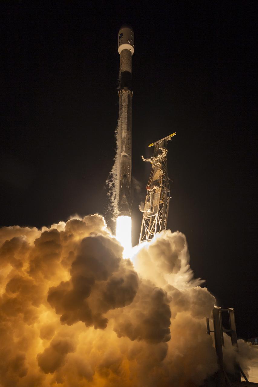
A SpaceX Falcon 9 rocket launches with the Surface Water and Ocean Topography (SWOT) spacecraft onboard, Friday, Dec. 16, 2022, from Space Launch Complex 4E at Vandenberg Space Force Base in California. Jointly developed by NASA and Centre National D'Etudes Spatiales (CNES), with contributions from the Canadian Space Agency (CSA) and United Kingdom Space Agency, SWOT is the first satellite mission that will observe nearly all water on Earth’s surface, measuring the height of water in the planet’s lakes, rivers, reservoirs, and the ocean. Photo Credit: (NASA/Keegan Barber)

A SpaceX Falcon 9 rocket launches with the Surface Water and Ocean Topography (SWOT) spacecraft onboard, Friday, Dec. 16, 2022, from Space Launch Complex 4E at Vandenberg Space Force Base in California. Jointly developed by NASA and Centre National D'Etudes Spatiales (CNES), with contributions from the Canadian Space Agency (CSA) and United Kingdom Space Agency, SWOT is the first satellite mission that will observe nearly all water on Earth’s surface, measuring the height of water in the planet’s lakes, rivers, reservoirs, and the ocean. Photo Credit: (NASA/Keegan Barber)
A SpaceX Falcon 9 rocket with the Surface Water and Ocean Topography (SWOT) spacecraft onboard is seen as it rolls out to the pad, Tuesday, Dec. 13, 2022, at Space Launch Complex 4E at Vandenberg Space Force Base in California. Jointly developed by NASA and Centre National D'Etudes Spatiales (CNES), with contributions from the Canadian Space Agency (CSA) and United Kingdom Space Agency, SWOT is the first satellite mission that will observe nearly all water on Earth’s surface, measuring the height of water in the planet’s lakes, rivers, reservoirs, and the ocean. Photo Credit: (NASA/Keegan Barber)
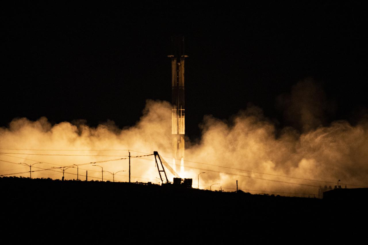
A SpaceX Falcon 9 first-stage booster returns to the landing pad following the launch of the Surface Water and Ocean Topography (SWOT) spacecraft, Friday, Dec. 16, 2022, from Space Launch Complex 4E at Vandenberg Space Force Base in California. Jointly developed by NASA and Centre National D'Etudes Spatiales (CNES), with contributions from the Canadian Space Agency (CSA) and United Kingdom Space Agency, SWOT is the first satellite mission that will observe nearly all water on Earth’s surface, measuring the height of water in the planet’s lakes, rivers, reservoirs, and the ocean. Photo Credit: (NASA/Keegan Barber)
A SpaceX Falcon 9 rocket with the Surface Water and Ocean Topography (SWOT) spacecraft onboard is seen as preparations for launch continue, Wednesday, Dec. 14, 2022, at Space Launch Complex 4E at Vandenberg Space Force Base in California. Jointly developed by NASA and Centre National D'Etudes Spatiales (CNES), with contributions from the Canadian Space Agency (CSA) and United Kingdom Space Agency, SWOT is the first satellite mission that will observe nearly all water on Earth’s surface, measuring the height of water in the planet’s lakes, rivers, reservoirs, and the ocean. Photo Credit: (NASA/Keegan Barber)
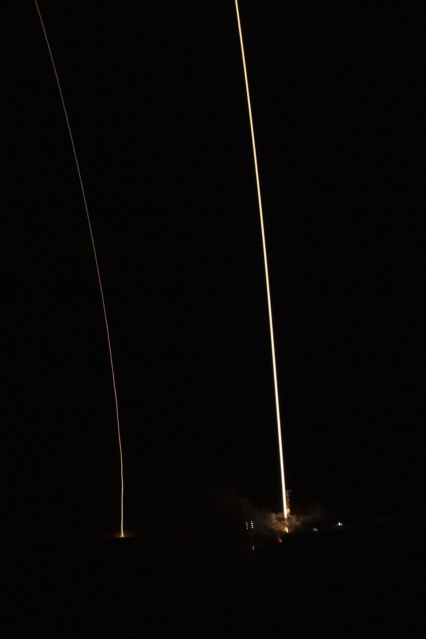
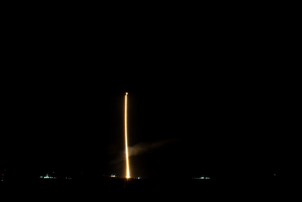
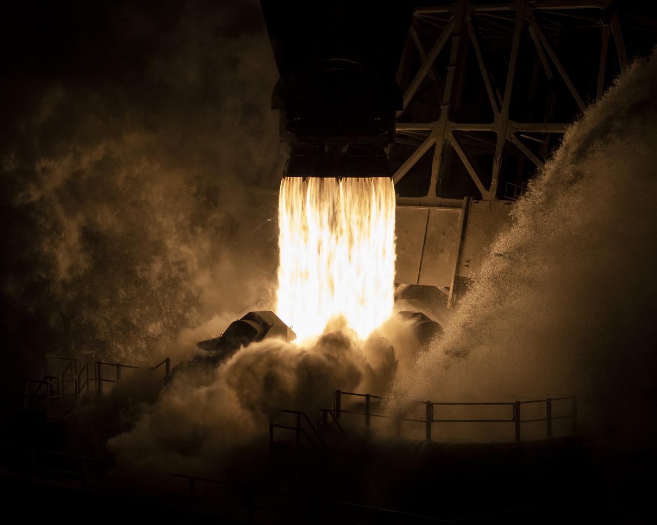
In this 8 minute exposure, A SpaceX Falcon 9 rocket launches with the Surface Water and Ocean Topography (SWOT) spacecraft onboard, right, Friday, Dec. 16, 2022, from Space Launch Complex 4E at Vandenberg Space Force Base in California. The SpaceX Falcon 9 first-stage booster is also seen, left, as it returns to the landing pad following the launch. Jointly developed by NASA and Centre National D'Etudes Spatiales (CNES), with contributions from the Canadian Space Agency (CSA) and United Kingdom Space Agency, SWOT is the first satellite mission that will observe nearly all water on Earth’s surface, measuring the height of water in the planet’s lakes, rivers, reservoirs, and the ocean. Photo Credit: (NASA/Keegan Barber)
A SpaceX Falcon 9 rocket with the Surface Water and Ocean Topography (SWOT) spacecraft onboard is seen as it rolls out to the pad, Tuesday, Dec. 13, 2022, at Space Launch Complex 4E at Vandenberg Space Force Base in California. Jointly developed by NASA and Centre National D'Etudes Spatiales (CNES), with contributions from the Canadian Space Agency (CSA) and United Kingdom Space Agency, SWOT is the first satellite mission that will observe nearly all water on Earth’s surface, measuring the height of water in the planet’s lakes, rivers, reservoirs, and the ocean. Photo Credit: (NASA/Keegan Barber)
A SpaceX Falcon 9 rocket with the Surface Water and Ocean Topography (SWOT) spacecraft onboard is seen as it rolls out to the pad, Tuesday, Dec. 13, 2022, at Space Launch Complex 4E at Vandenberg Space Force Base in California. Jointly developed by NASA and Centre National D'Etudes Spatiales (CNES), with contributions from the Canadian Space Agency (CSA) and United Kingdom Space Agency, SWOT is the first satellite mission that will observe nearly all water on Earth’s surface, measuring the height of water in the planet’s lakes, rivers, reservoirs, and the ocean. Photo Credit: (NASA/Keegan Barber)
A SpaceX Falcon 9 rocket with the Surface Water and Ocean Topography (SWOT) spacecraft onboard is seen as preparations for launch continue, Wednesday, Dec. 14, 2022, at Space Launch Complex 4E at Vandenberg Space Force Base in California. Jointly developed by NASA and Centre National D'Etudes Spatiales (CNES), with contributions from the Canadian Space Agency (CSA) and United Kingdom Space Agency, SWOT is the first satellite mission that will observe nearly all water on Earth’s surface, measuring the height of water in the planet’s lakes, rivers, reservoirs, and the ocean. Photo Credit: (NASA/Keegan Barber)
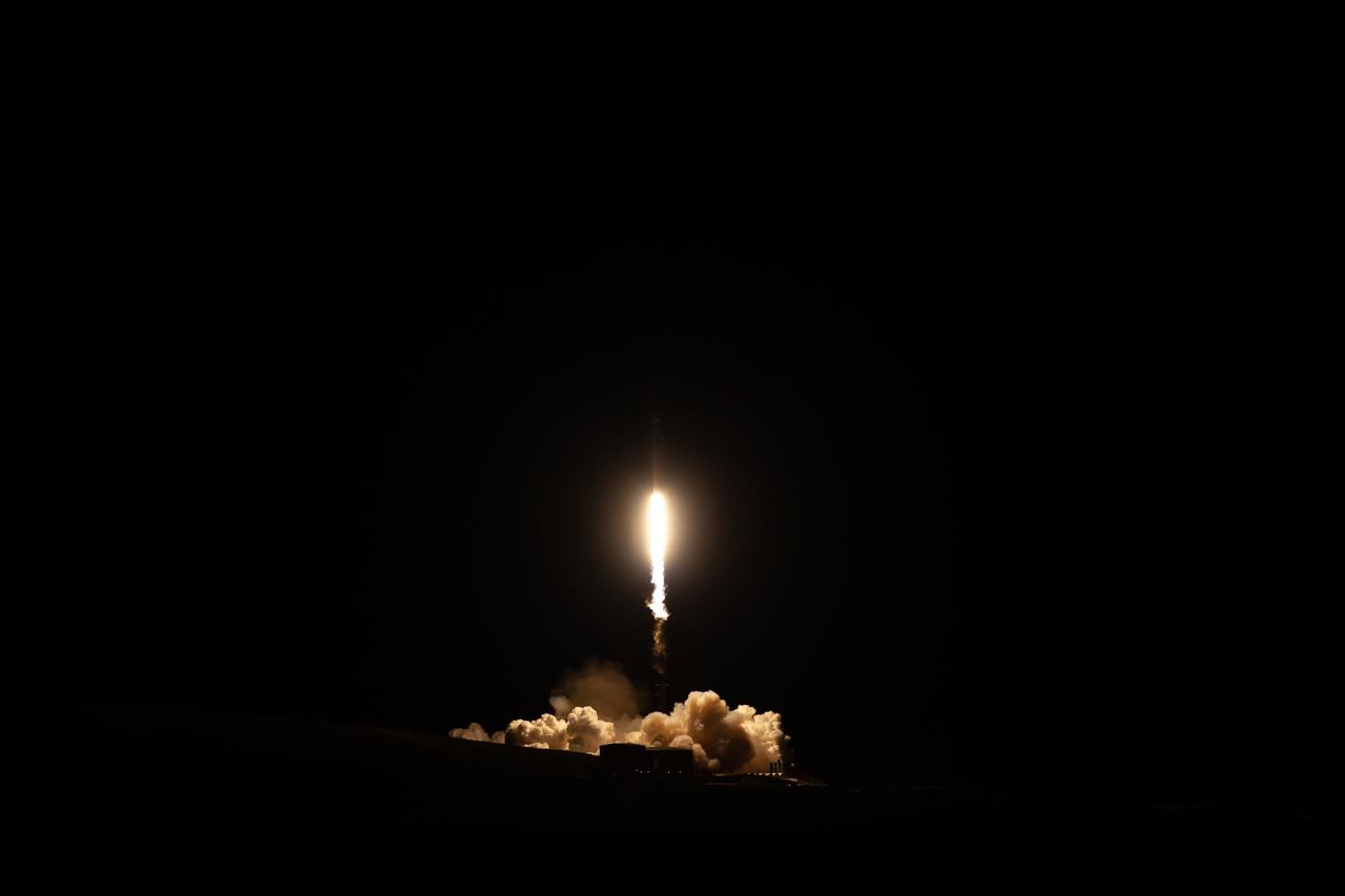
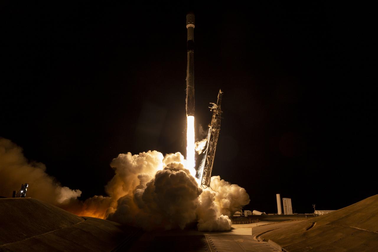
A SpaceX Falcon 9 rocket launches with the Surface Water and Ocean Topography (SWOT) spacecraft onboard, Friday, Dec. 16, 2022, from Space Launch Complex 4E at Vandenberg Space Force Base in California. Jointly developed by NASA and Centre National D'Etudes Spatiales (CNES), with contributions from the Canadian Space Agency (CSA) and United Kingdom Space Agency, SWOT is the first satellite mission that will observe nearly all water on Earth’s surface, measuring the height of water in the planet’s lakes, rivers, reservoirs, and the ocean. Photo Credit: (NASA/Keegan Barber)
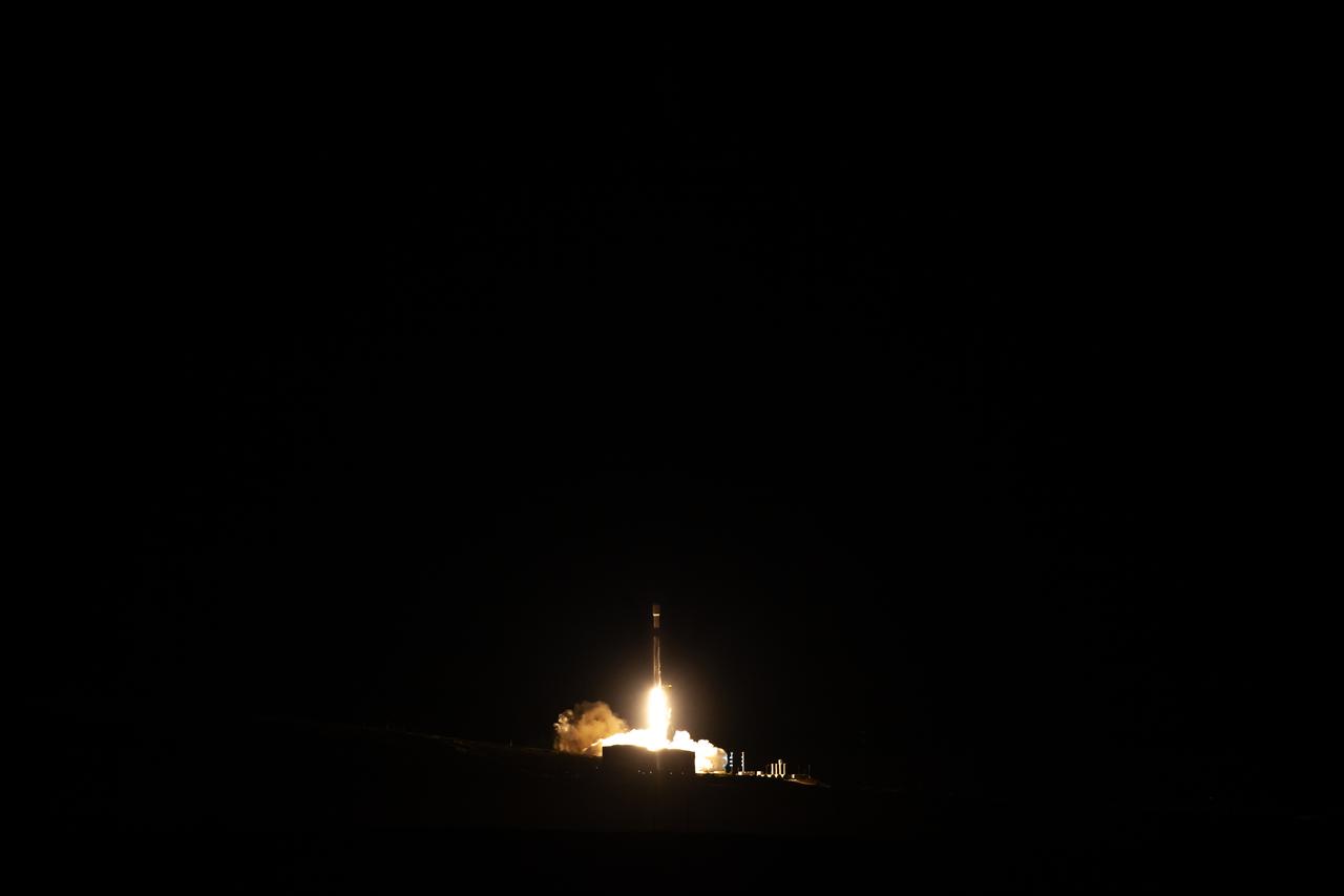
A SpaceX Falcon 9 rocket launches with the Surface Water and Ocean Topography (SWOT) spacecraft onboard, Friday, Dec. 16, 2022, from Space Launch Complex 4E at Vandenberg Space Force Base in California. Jointly developed by NASA and Centre National D'Etudes Spatiales (CNES), with contributions from the Canadian Space Agency (CSA) and United Kingdom Space Agency, SWOT is the first satellite mission that will observe nearly all water on Earth’s surface, measuring the height of water in the planet’s lakes, rivers, reservoirs, and the ocean. Photo Credit: (NASA/Keegan Barber)
A SpaceX Falcon 9 rocket launches with the Surface Water and Ocean Topography (SWOT) spacecraft onboard, Friday, Dec. 16, 2022, from Space Launch Complex 4E at Vandenberg Space Force Base in California. Jointly developed by NASA and Centre National D'Etudes Spatiales (CNES), with contributions from the Canadian Space Agency (CSA) and United Kingdom Space Agency, SWOT is the first satellite mission that will observe nearly all water on Earth’s surface, measuring the height of water in the planet’s lakes, rivers, reservoirs, and the ocean. Photo Credit: (NASA/Keegan Barber)
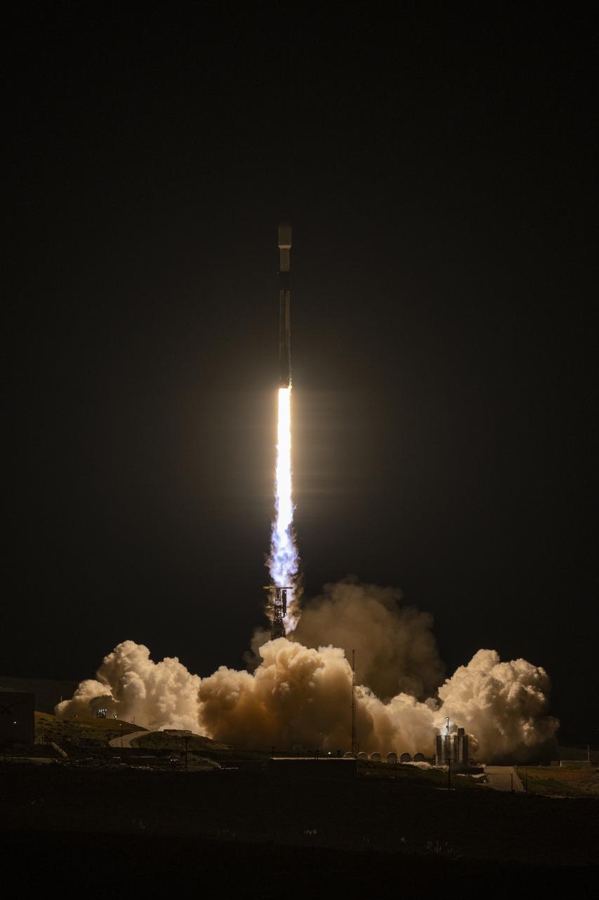
A SpaceX Falcon 9 rocket launches with the Surface Water and Ocean Topography (SWOT) spacecraft onboard, Friday, Dec. 16, 2022, from Space Launch Complex 4E at Vandenberg Space Force Base in California. Jointly developed by NASA and Centre National D'Etudes Spatiales (CNES), with contributions from the Canadian Space Agency (CSA) and United Kingdom Space Agency, SWOT is the first satellite mission that will observe nearly all water on Earth’s surface, measuring the height of water in the planet’s lakes, rivers, reservoirs, and the ocean. Photo Credit: (NASA/Keegan Barber)