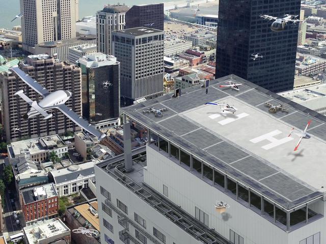
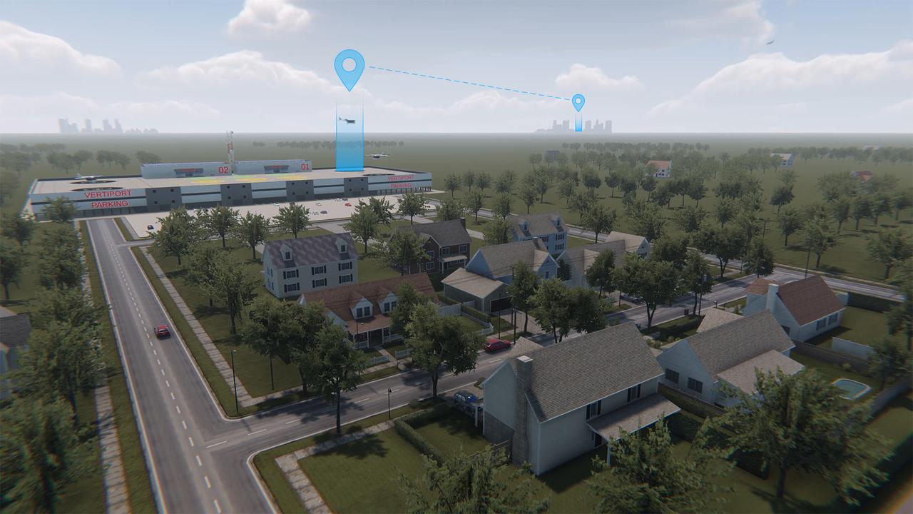
Urban air mobility means a safe and efficient system for vehicles, piloted or not, to move passengers and cargo within a city.
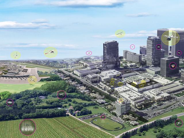
The concept of urban air mobility involves multiple aircraft safely operating within a city. (Yellow circles are vehicles with passengers; pink circles are vehicles without passengers.)
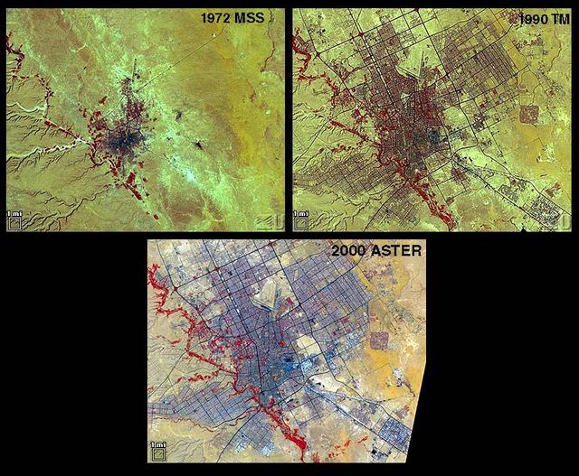
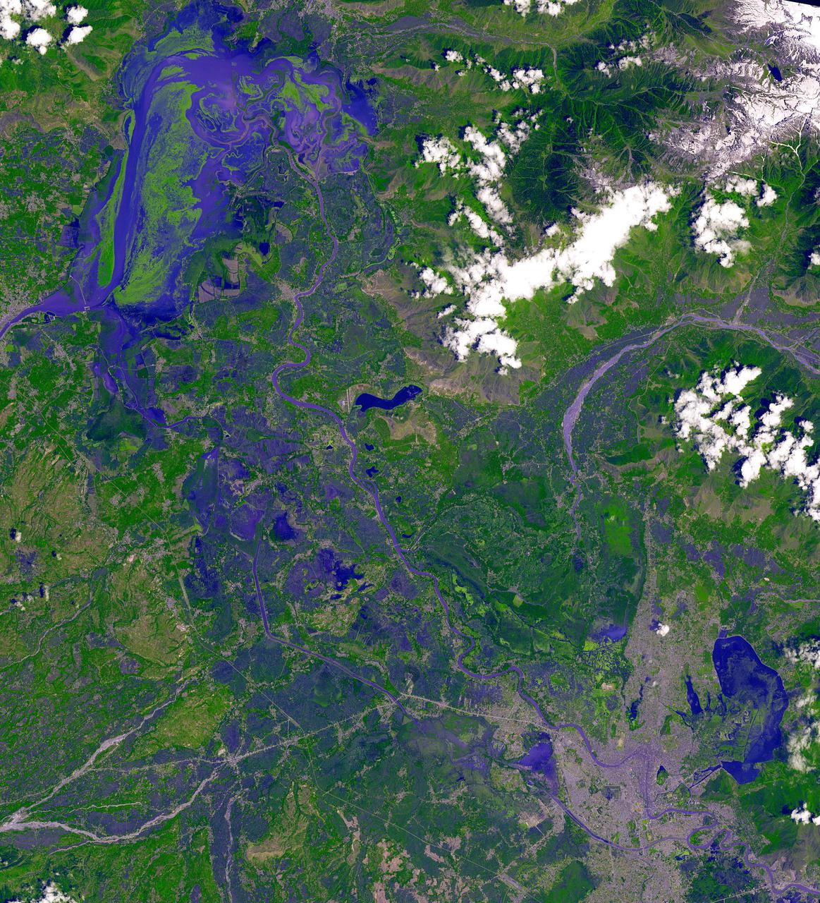
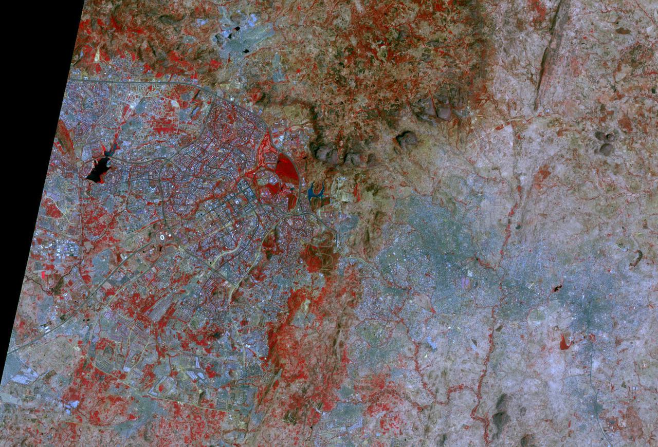
Riyadh, the national capital of Saudi Arabia, is shown in 1972, 1990 and 2000. Its population grew in these years from about a half million to more than two million. Saudi Arabia experienced urbanization later than many other countries; in the early 1970s its urban-rural ratio was still about 1:3. By 1990 that had reversed to about 3:1. The city grew through in-migration from rural areas, and from decreases in the death rate while birthrates remained high. The 1972 image is a Landsat MSS scene; the 1990 image is a Landsat Thematic Mapper scene; and the 2000 image is an ASTER scene. All three images cover an area of about 27 x 34 km. The image is centered at 24.6 degrees north latitude, 46.6 degrees east longitude. http://photojournal.jpl.nasa.gov/catalog/PIA11087
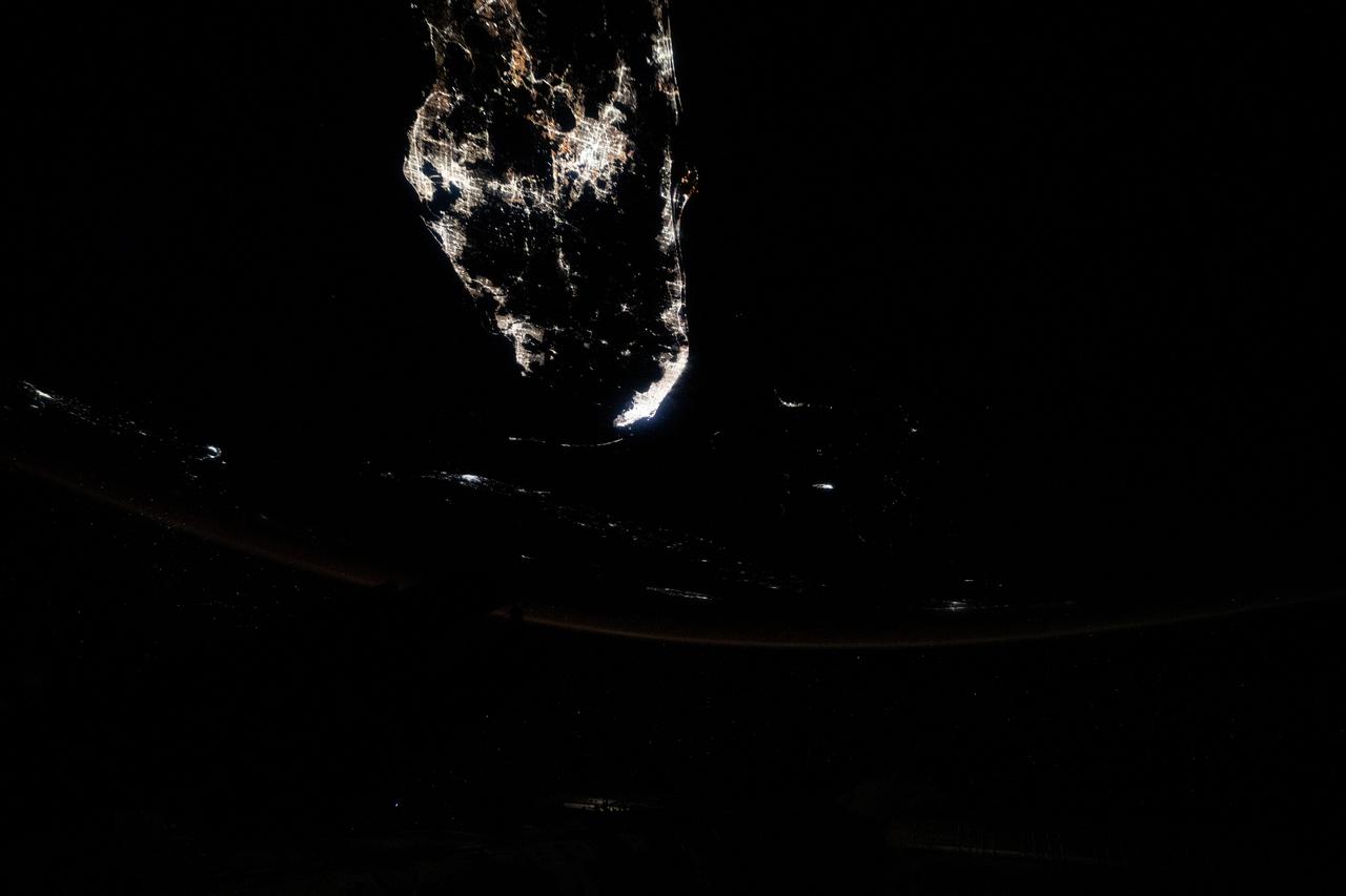
iss073e0149283 (May 21, 2025) --- Southern Florida's major urban areas of Tampa, Orlando, and Miami are pictured at approximately 1:01 a.m. local time from the International Space Station as it orbited 259 miles above the Atlantic Ocean.
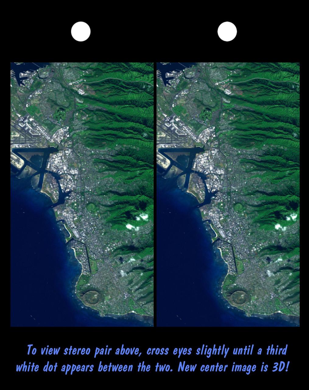
Honolulu, on the island of Oahu, is a large and growing urban area. This stereoscopic image pair, combining a Landsat image with topography measured by NASA Shuttle Radar Topography Mission SRTM, shows how topography controls the urban pattern.
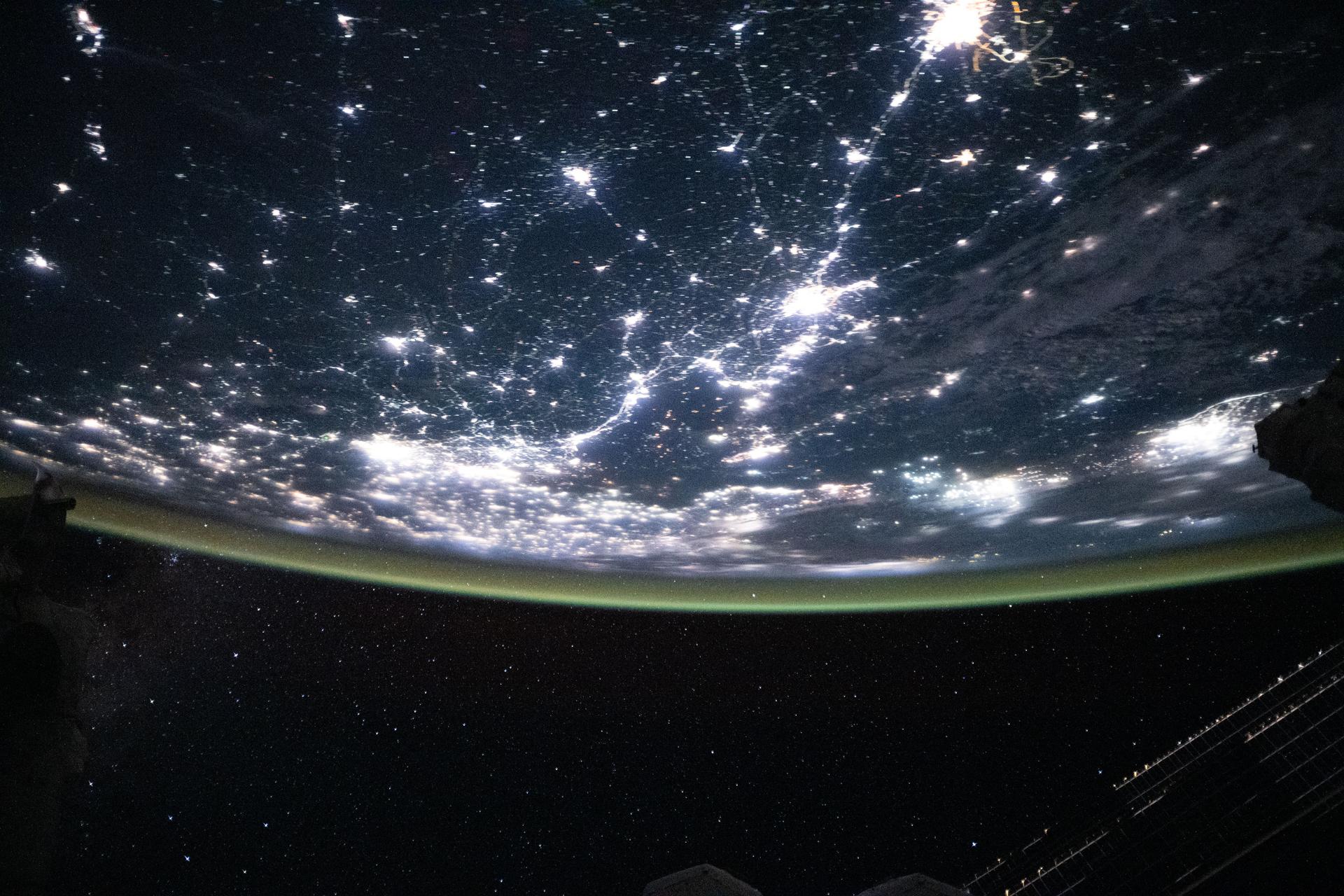
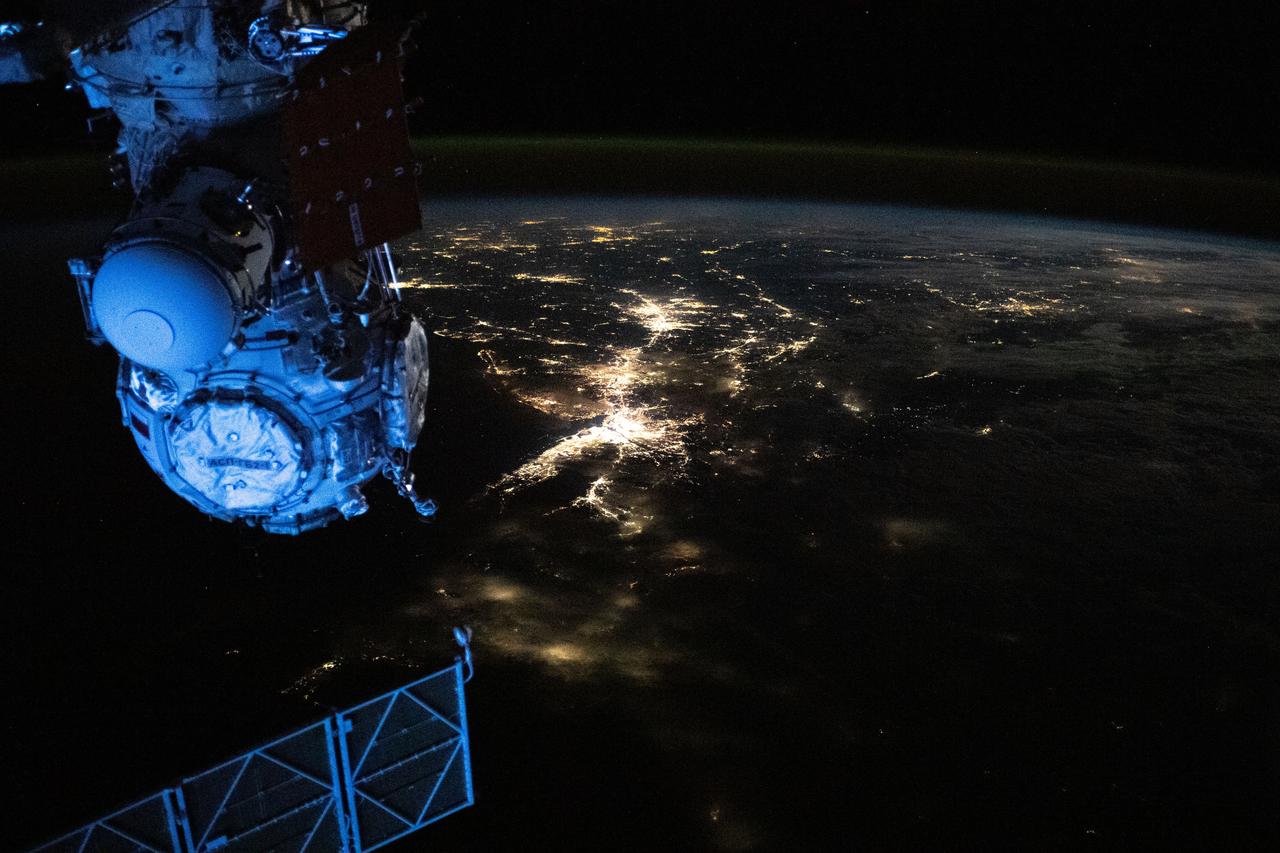
iss073e0820756 (Sept. 14, 2025) --- The densely urbanized region surrounding the Bohai Sea (center) on China's east coast includes several major metropolitan areas, from Beijing (left center) to Changchun (top right), and Seoul, South Korea (far right). A yellow-green airglow blankets Earth's horizon in this image captured from the International Space Station as it orbited 263 miles above the surface at approximately 11:06 p.m. local time.
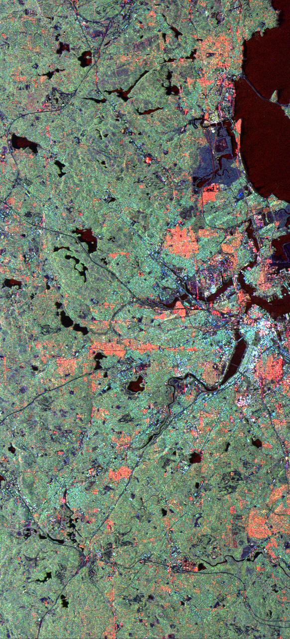
This is a spaceborne radar image of the city of Sacramento, the capital of California. Urban areas appear pink and the surrounding agricultural areas are green and blue.
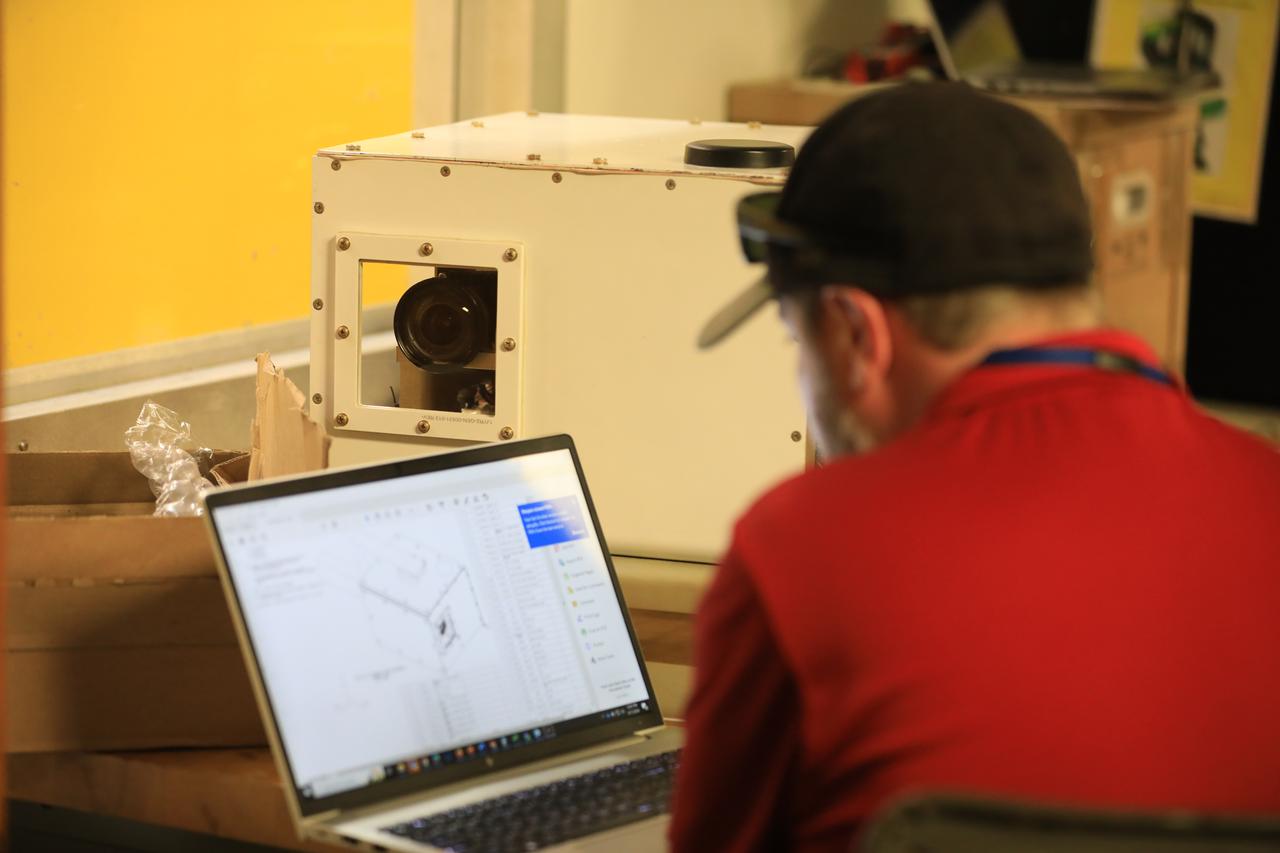
NASA researchers James Cowart and Elizabeth Nail add sensors, wiring and cameras, to the NASA Airborne Instrumentation for Real-world Video of Urban Environments (AIRVUE) sensor pod at NASA’s Armstrong Flight Research Center in Edwards, California in late February 2024. The AIRVUE pod was flown on a helicopter at NASA’s Kennedy Space Center in Florida and is used to collect data for future autonomous aircraft.
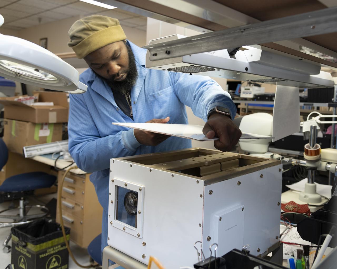
NASA researcher A.J. Jaffe prepares the NASA Airborne Instrumentation for Real-world Video of Urban Environments (AIRVUE) sensor pod for testing at NASA’s Kennedy Space Center in Cape Canaveral, Florida in April 2024. The AIRVUE pod will be used to collect data for autonomous aircraft like air taxis, drones, or other Advanced Air Mobility aircraft.
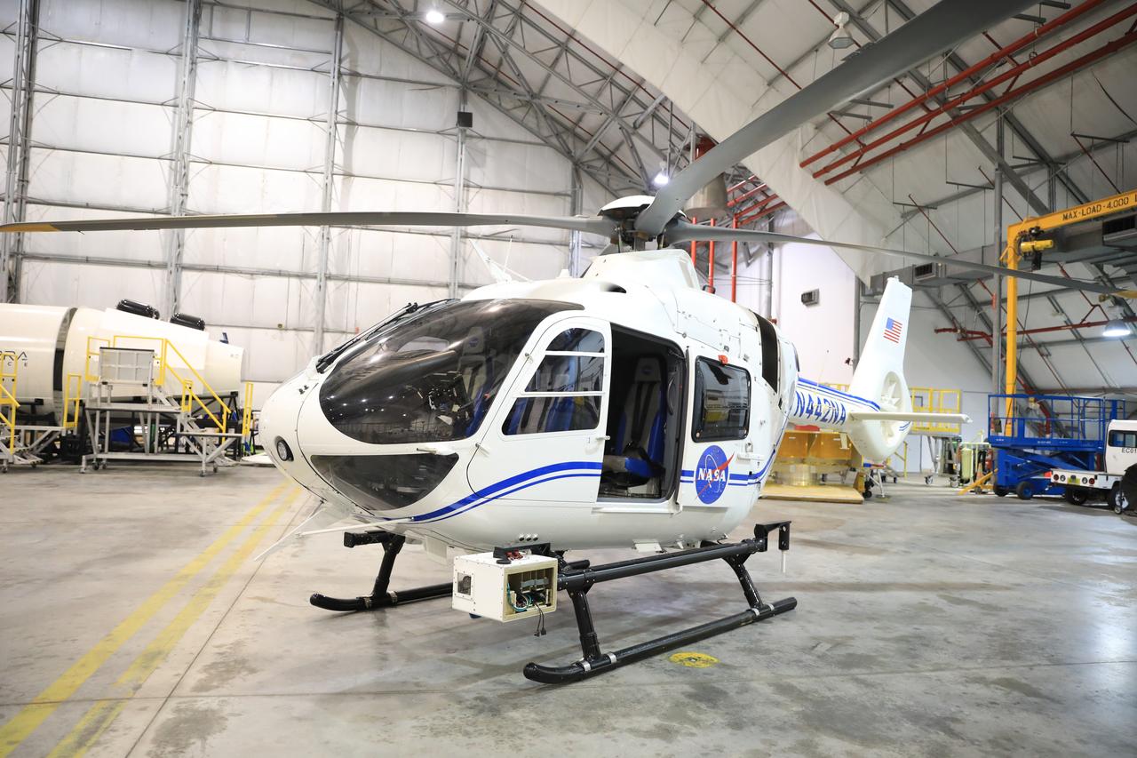
The NASA Airborne Instrumentation for Real-world Video of Urban Environments (AIRVUE) sensor pod is attached to the base of a NASA helicopter at NASA’s Kennedy Space Center in Cape Canaveral, Florida in April 2024 before a flight to test the pod’s cameras and sensors. The AIRVUE pod will be used to collect data for autonomous aircraft like air taxis, drones, or other Advanced Air Mobility aircraft.
NASA researcher James Cowart adds the top back onto the NASA Airborne Instrumentation for Real-world Video of Urban Environments (AIRVUE) sensor pod at NASA’s Armstrong Flight Research Center in Edwards, California in late February 2024. The pod houses sensors, wiring and cameras. The AIRVUE pod was flown on a helicopter at NASA’s Kennedy Space Center in Florida and is used to collect data for future autonomous aircraft.
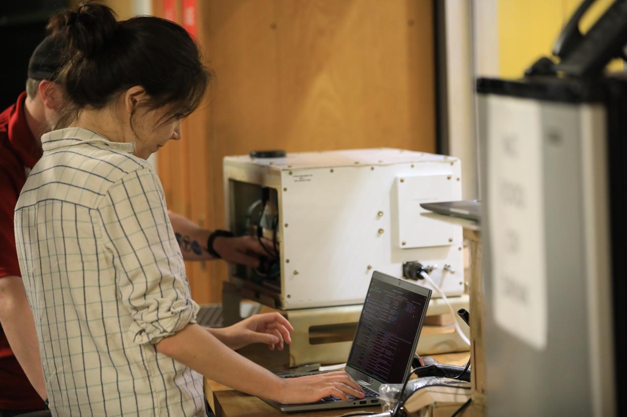
NASA researchers Elizabeth Nail (foreground) and A.J. Jaffe (background) prepare the NASA Airborne Instrumentation for Real-world Video of Urban Environments (AIRVUE) sensor pod for testing at NASA’s Kennedy Space Center in Cape Canaveral, Florida in April 2024. The AIRVUE pod will be used to collect data for autonomous aircraft like air taxis, drones, or other Advanced Air Mobility aircraft.
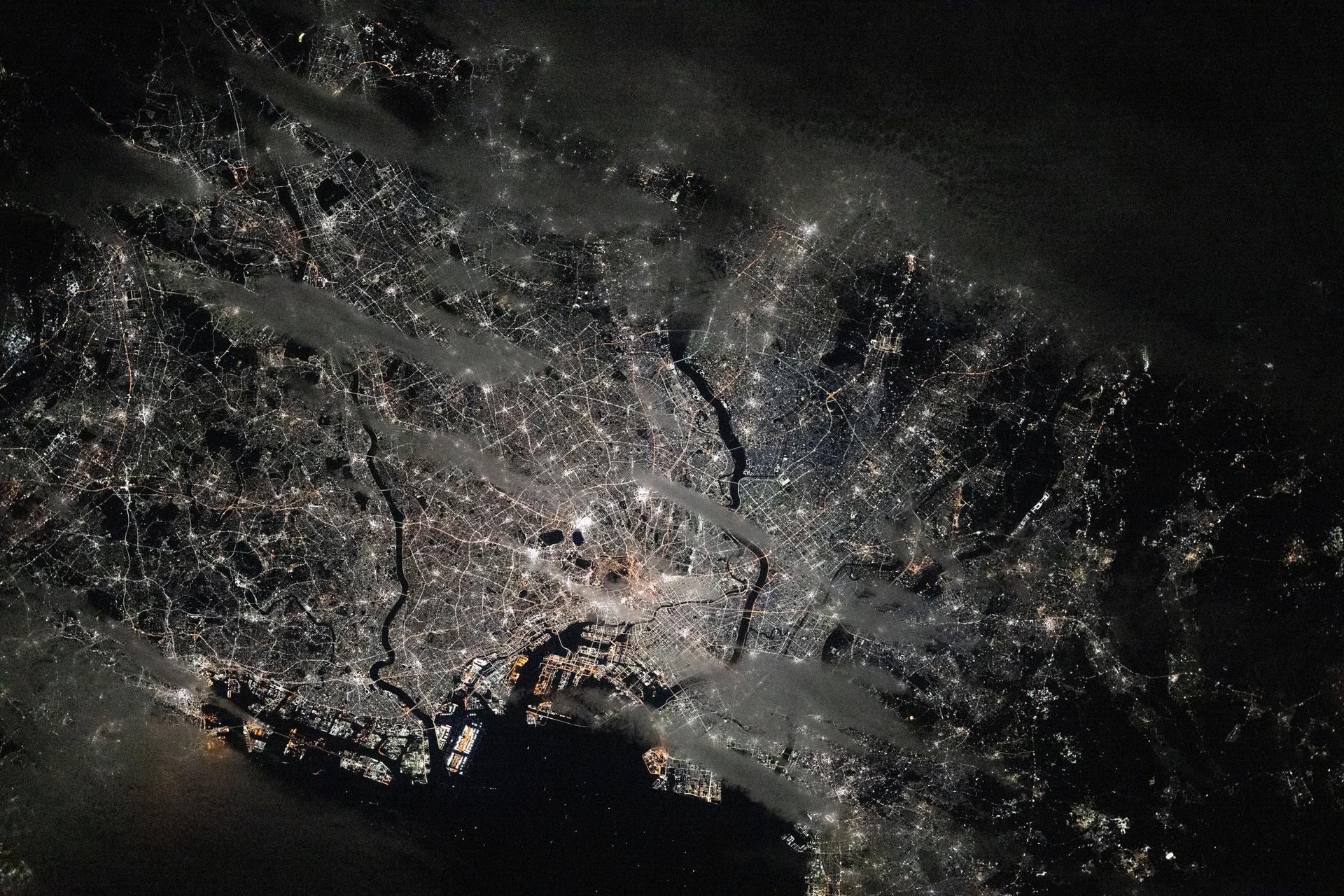
iss073e0918643 (Oct. 18, 2025) --- Tokyo, Japan, and its surrounding suburbs along Tokyo Bay light up the night, with stops along major rail lines glittering like pearls. The Greater Tokyo Area—the world’s most populated urban center with over 39 million people—is pictured at approximately 4 a.m. local time from the International Space Station as it orbited 262 miles above the island nation.
The distinctive curve of Cape Cod, Massachusetts and the greater Boston urban area are very clear of the northeastern coast of the United States in this image from NASA EarthKAM.
This spaceborne radar image of Orange County, Calif., shows the massive urbanization of this rapidly growing region located just south of Los Angeles.
These two images of the eastern part of the island of Oahu, Hawaii provide information on regional topography and show the relationship between urban development and sensitive ecosystems.
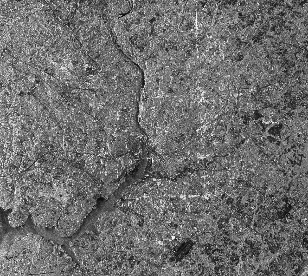
This radar image of the Washington, D.C. area demonstrates the capability of imaging radar as a useful tool for urban planners and managers to map and monitor land use patterns.
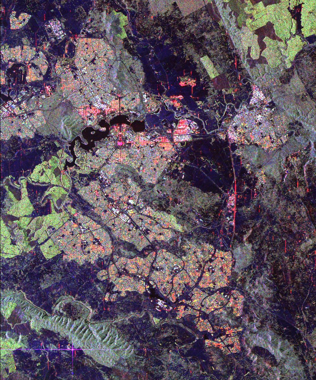
Australia capital city, Canberra, is shown in the center of this spaceborne radar image. Images like this can help urban planners assess land use patterns.
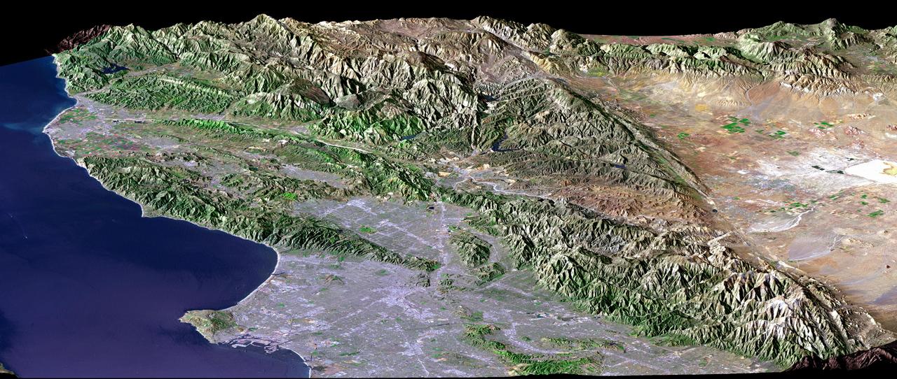
Los Angeles, Calif., is one of the world largest metropolitan areas with a population of about 15 million people. The urban areas mostly cover the coastal plains and lie within the inland valleys.
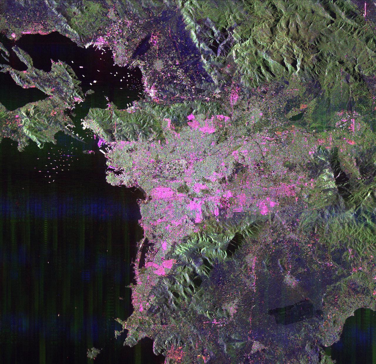
This space radar image of Athens, Greece, shows the sprawling, modern development of this ancient capital city. Densely populated urban areas appear in shades of pink and light green.
This radar image of Dublin, Ireland, shows how the radar distinguishes between densely populated urban areas and nearby areas that are relatively unsettled. In the center of the image is the city natural harbor along the Irish Sea.
This topographic acquired by NASA Shuttle Radar Topography Mission SRTM from data collected on February 16, 2000 shows the relationship of the urban area of Pasadena, California to the natural contours of the land.
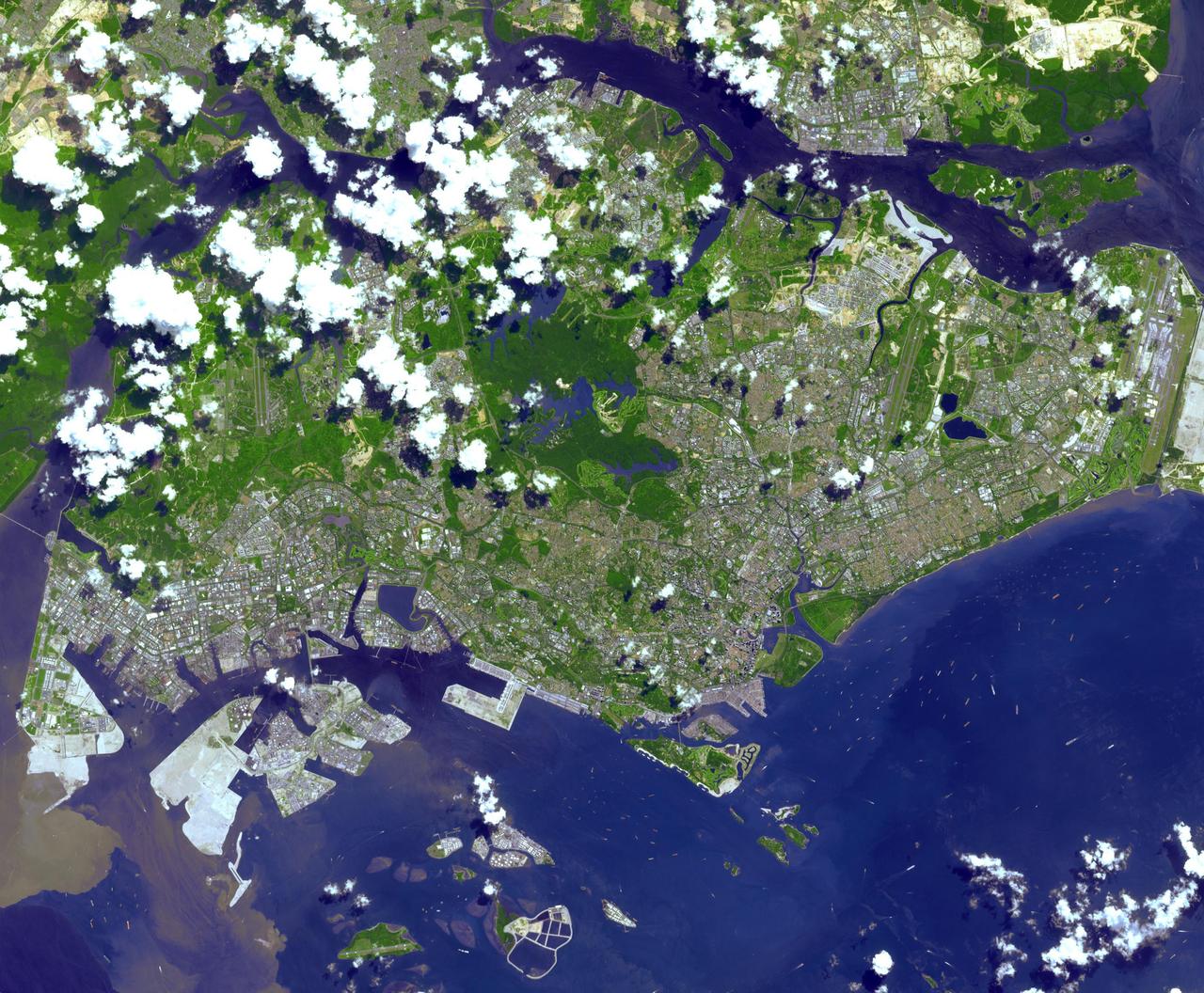
This image from NASA Terra spacecraft is of the Republic of Singapore, a city-state off the southern tip of the Malay Peninsula. An island country made up of 63 islands, the country is largely urbanized with very little rain forest left.
NASA Terra spacecraft captured this cloud-free image over the city of Sukkur, Pakistan, on Aug. 18, 2010. Sukkur, located in southeastern Pakistan Sindh Province, is visible as the grey, urbanized area in the lower left center of the image.
This radar image of the area surrounding Boston, Mass., shows how a spaceborne radar system distinguishes between densely populated urban areas and nearby areas that are relatively unsettled.

This topographic radar image acquired by NASA Shuttle Radar Topography Mission SRTM in Feb. 2000 shows the relationships of the dense urban development of Los Angeles, Calif. and the natural contours of the land.
This topographic radar image acquired by NASA Shuttle Radar Topography Mission SRTM from data collected on February 16, 2000 shows the relationship of the urban area of Pasadena, California to the natural contours of the land.
This space radar image illustrates the recent rapid urban development occurring along the lower Colorado River at the Nevada/Arizona state line. Lake Mojave is the dark feature that occupies the river valley in the upper half of the image.
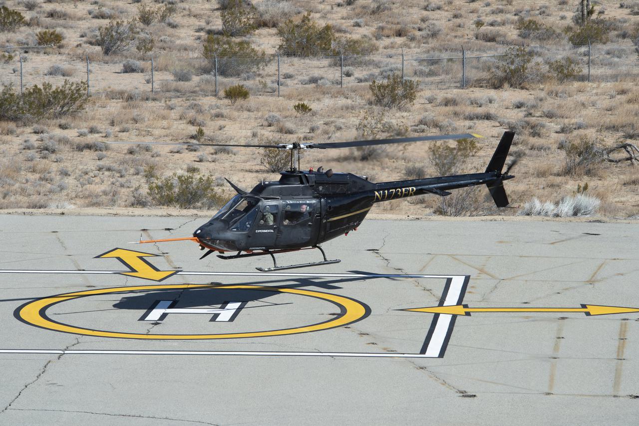
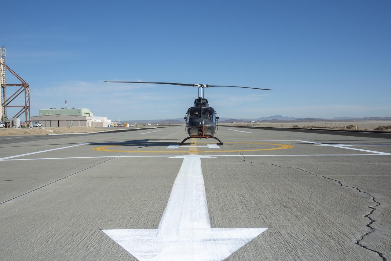
Flight Research Inc.’s Bell OH-58C Kiowa helicopter hovers over a helipad after completing an urban air mobility approach at NASA’s Armstrong Flight Research Center in California in March 2021. The Advanced Air Mobility National Campaign studied the viability of various urban air mobility approach options during a second phase called build II. This helicopter was used as a surrogate urban air mobility or air taxi vehicle.
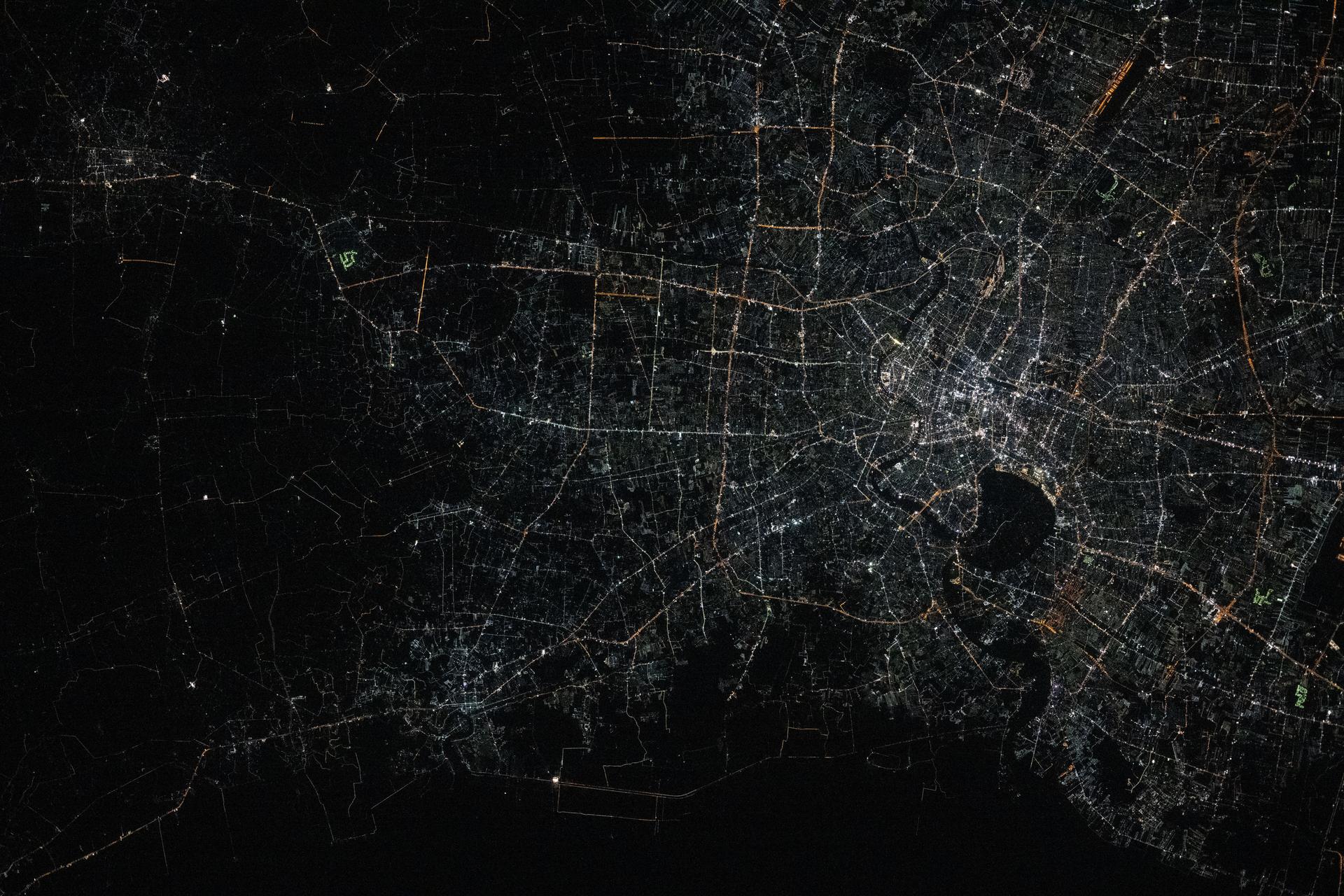
iss072e757257 (March 5, 2025) --- Bangkok, Thailand—with a metropolitan population of about 11.4 million and split by the Chao Phraya river—is pictured from the International Space Station at approximately 1:48 a.m. local time as it orbited 257 miles above the Southeast Asian nation. The dark area toward the center-right is part of the Phra Pradaeng District, a lush, green peninsula known as Bang Krachao. Preserved as an urban green space, it helps mitigate Bangkok’s pollution and urban density.
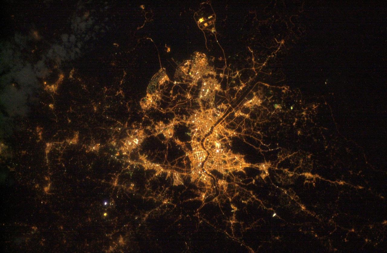
ISS010-E-12103 (25 December 2004) --- Seoul, South Korea is featured in this digital image photographed by an Expedition 10 crewmember on the International Space Station. This photograph illustrates the Seoul (originally known as Hanyang) urban area at night. Major roadways and river courses (such as the Han River) are clearly outlined by street lights, while the brightest lights indicate the downtown urban core (center of image) and large industrial complexes. Very dark regions in the image are mountains or large bodies of water.
iss072e757452 (March 6, 2025) --- Delhi, India—the second-largest metropolitan area in the world with a population of approximately 34.7 million—is pictured from the International Space Station at around 11:42 p.m. local time as it orbited 259 miles above. Home to the South Asian nation's capital and Asia’s largest spice market, Delhi is actively combating the effects of its urban heat island status through artificial intelligence, cool roof initiatives, increased tree coverage, modernized urban planning, and updated building codes.

Flight Research Inc.’s Bell OH-58C Kiowa helicopter lands on a helipad at NASA’s Armstrong Flight Research Center in California in March 2021 at the completion of an urban air mobility scenario. The Advanced Air Mobility National Campaign project conducted a second phase of research called build II. This helicopter was used as a surrogate urban air mobility vehicle to study aspects of a future air taxi mission.
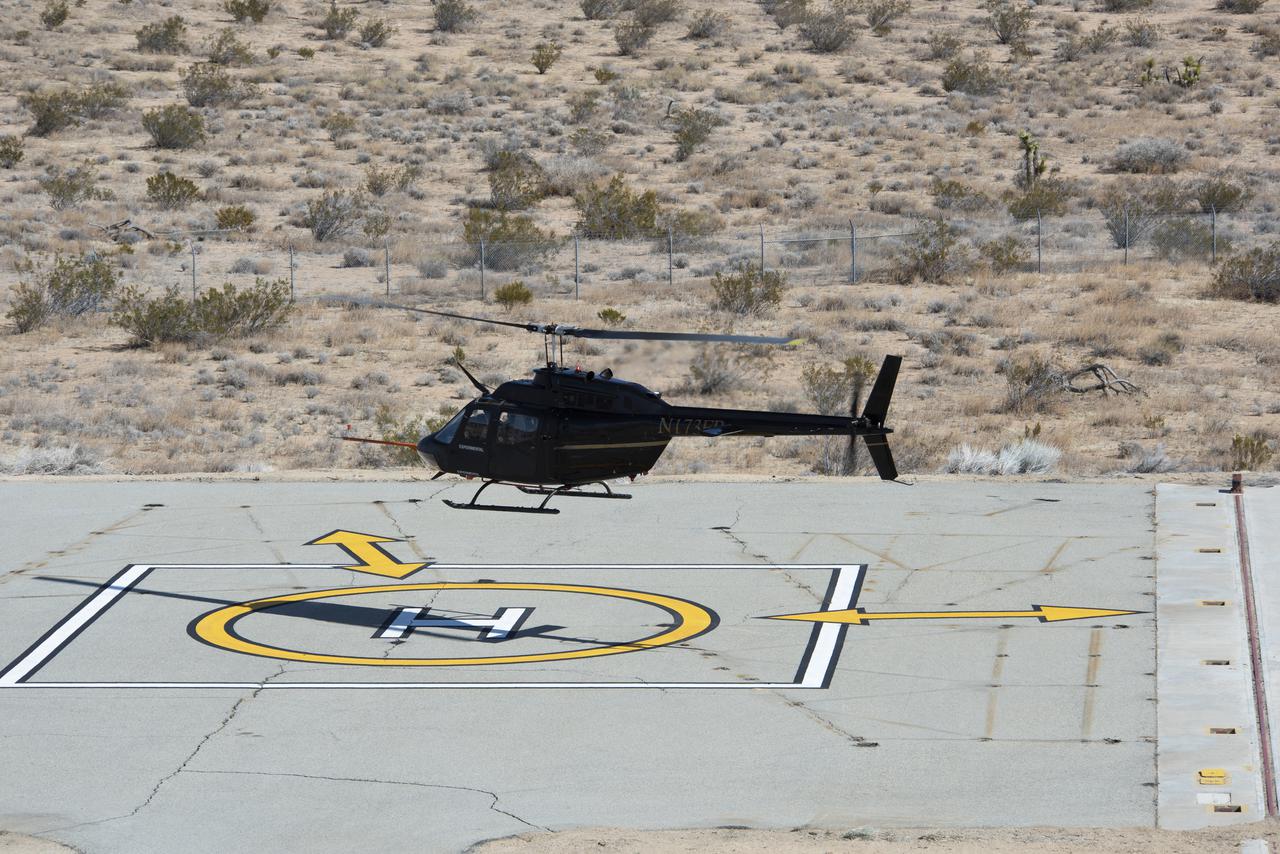
Flight Research Inc.’s Bell OH-58C Kiowa helicopter takes off from a research helipad at NASA’s Armstrong Flight Research Center in California in March 2021. The Advanced Air Mobility National Campaign project utilized several heliports and vertiports to study airspace management evolutions that could enable future urban air mobility operations. Tests were conducted during build II where this helicopter was used as a surrogate urban air mobility or air taxi vehicle.
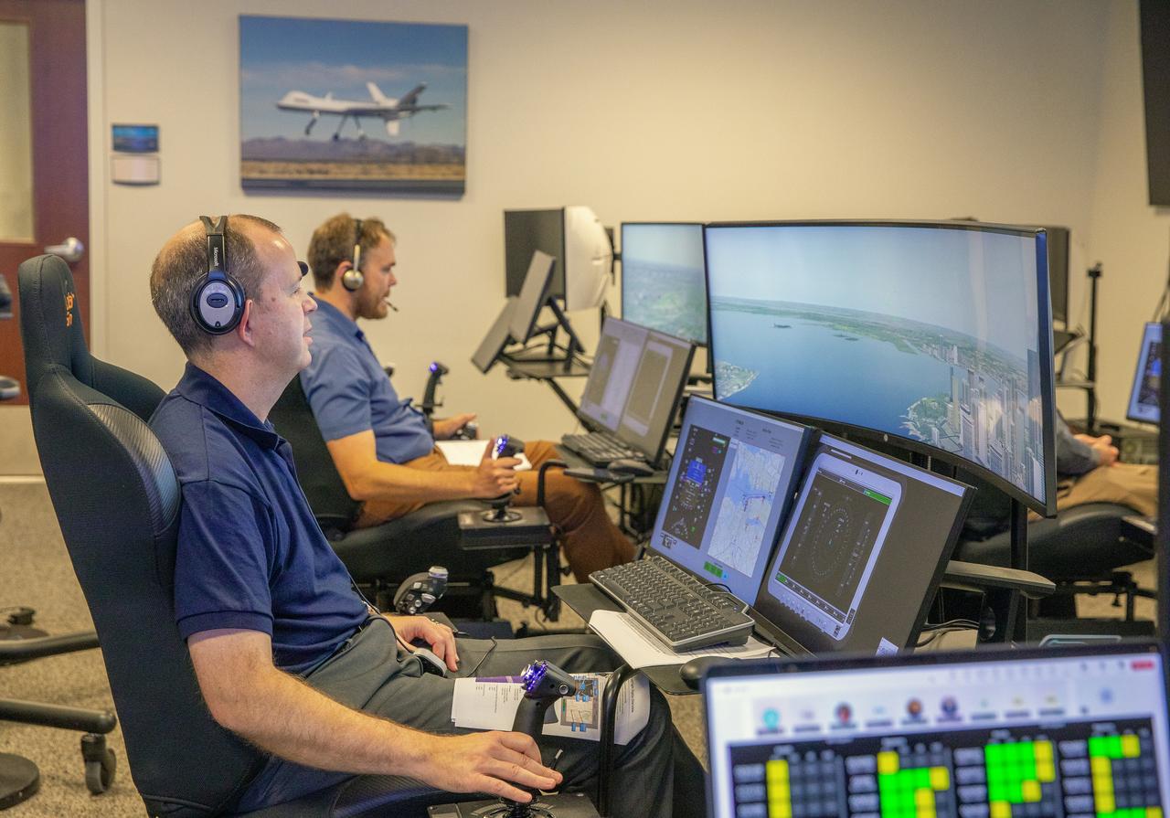
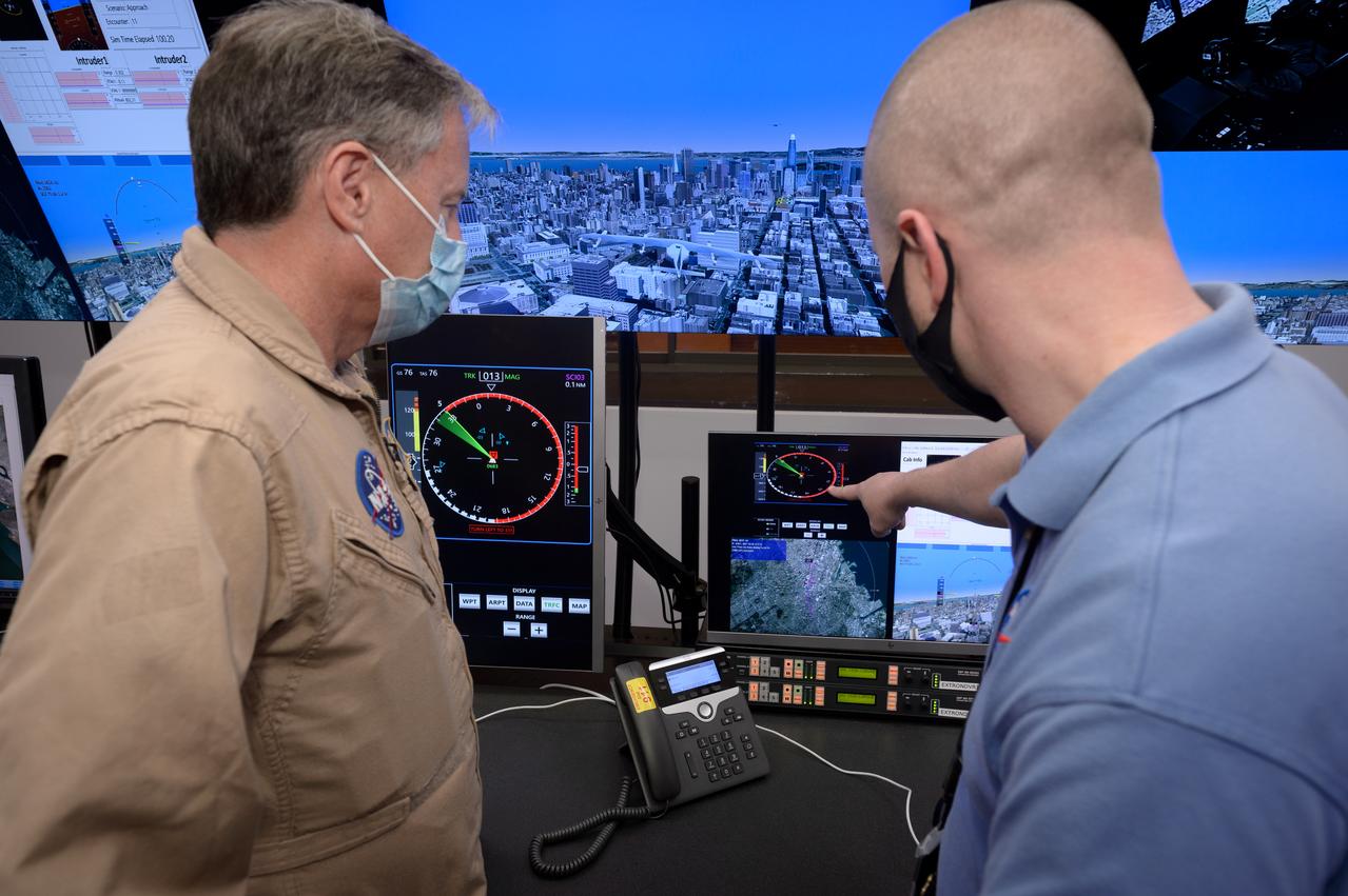
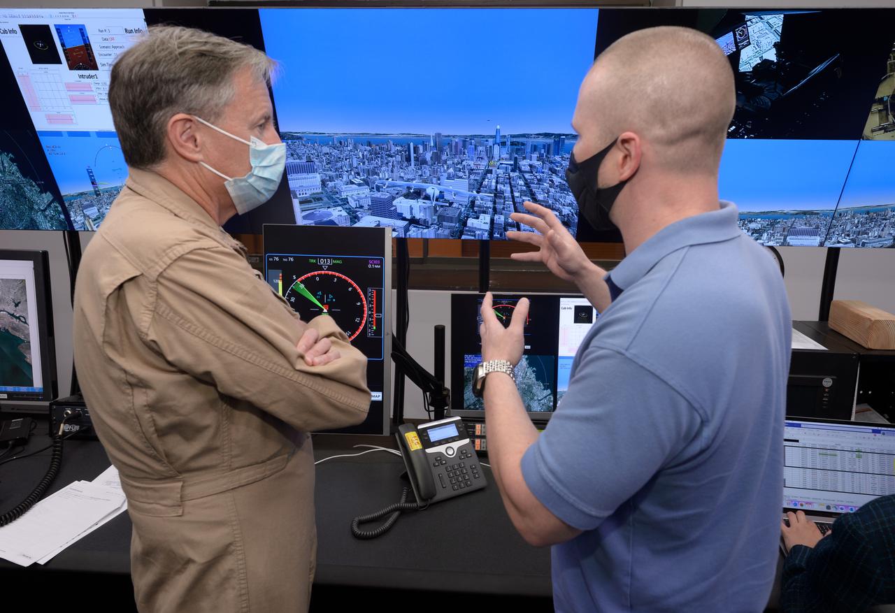
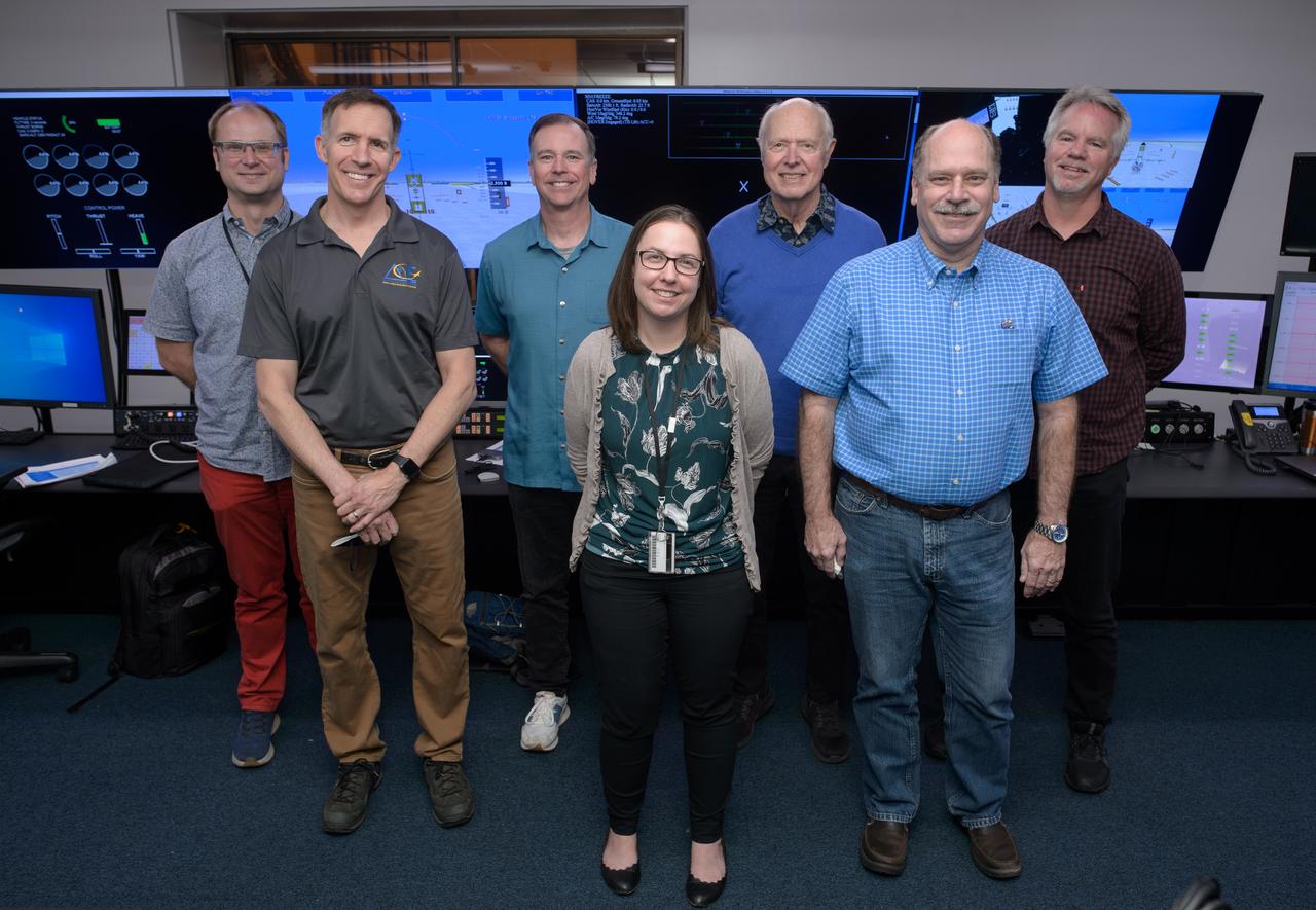
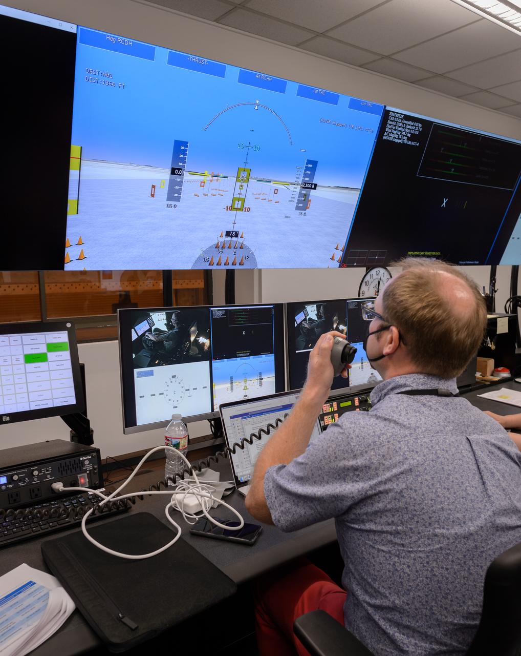
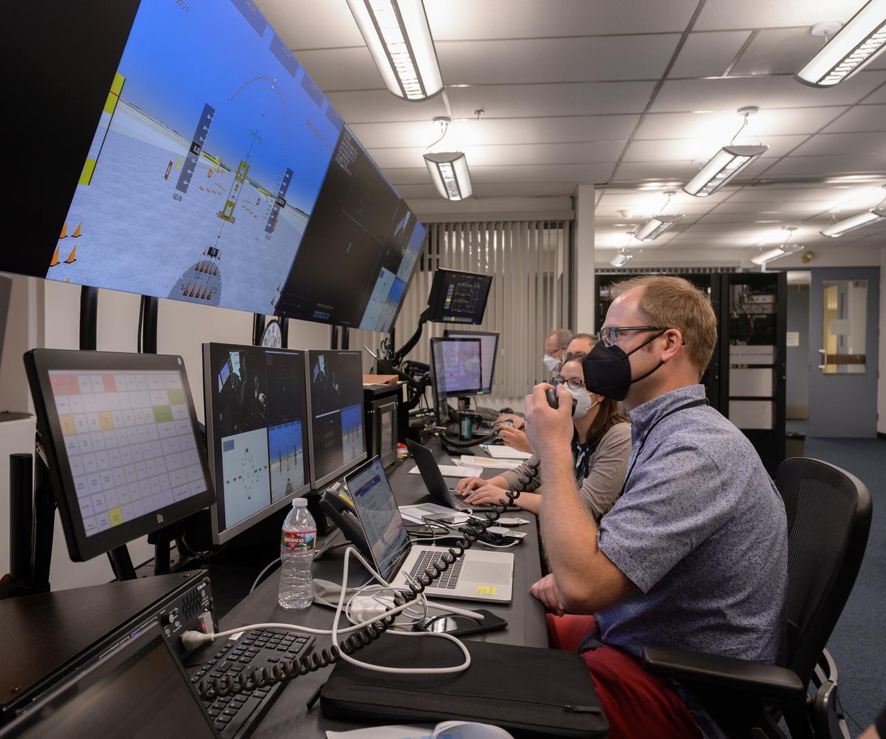
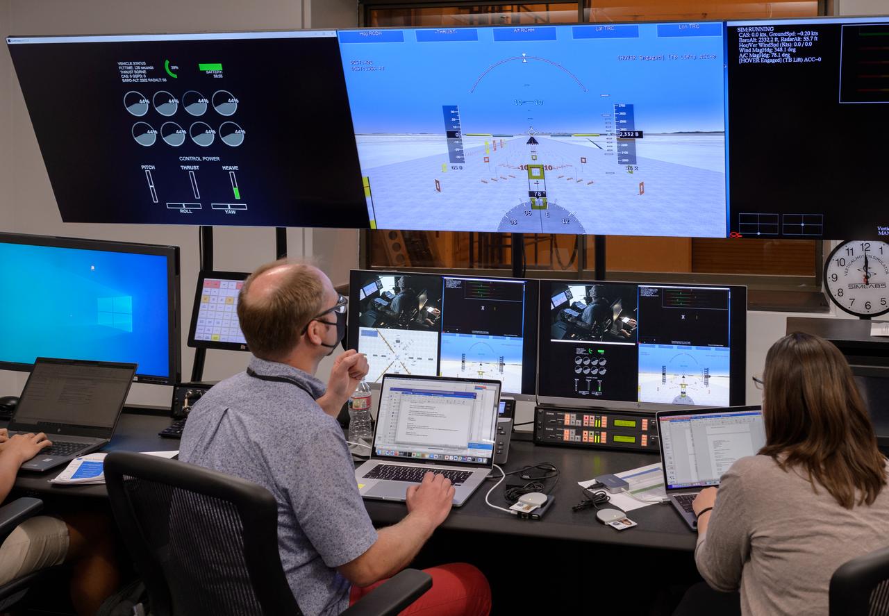
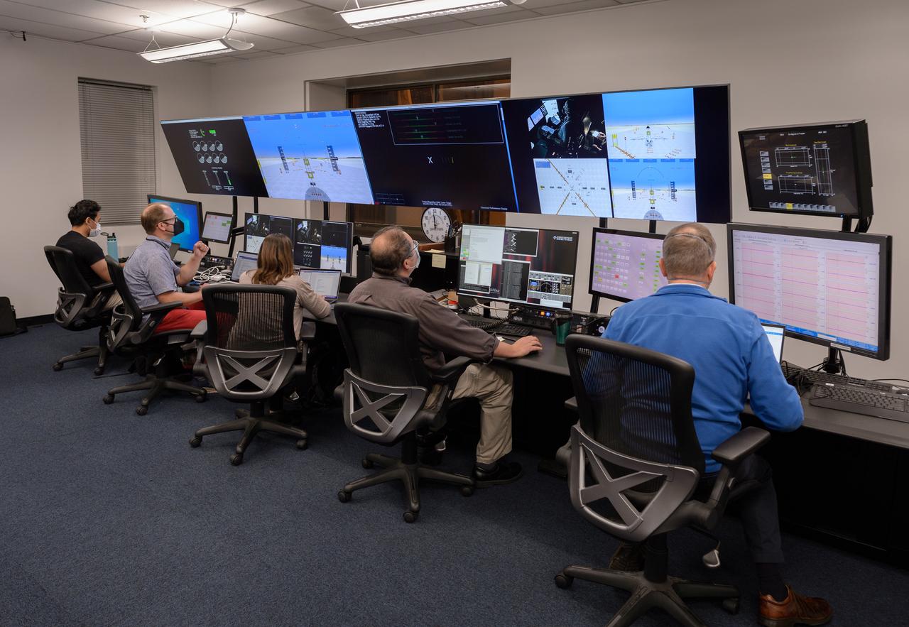
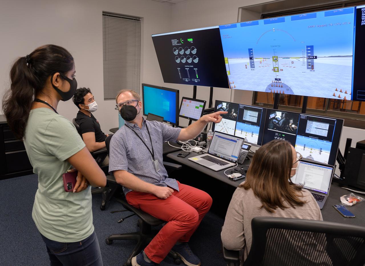
Focus on active photos –Class B Simulation Evaluation in the ATOL Lab at Langley (Also at FAA Tech Center) where team is working with one another in the lab, reviewing data on the monitors. Working the software, adjusting the software systems. Going over the shoulder to show the displays and screens as the software is running. Andy Burroughs (left) and Paul Friz in the roles of air taxi pilots running through air taxi integration simulations focusing on urban air space at NASA’s Langley Research in Hampton, Virginia on Sept. 25, 2024.
This image of San Francisco, California shows how the radar distinguishes between densely populated urban areas and nearby areas that are relatively unsettled. Downtown San Francisco is at the center and the city of Oakland is at the right across the San Francisco Bay. Some city areas, such as the South of Market, called the SOMA district in San Francisco, appear bright red due to the alignment of streets and buildings to the incoming radar beam. Various bridges in the area are also visible including the Golden Gate Bridge (left center) at the opening of San Francisco Bay, the Bay Bridge (right center) connecting San Francisco and Oakland, and the San Mateo Bridge (bottom center). All the dark areas on the image are relatively smooth water: the Pacific Ocean to the left, San Francisco Bay in the center, and various reservoirs. Two major faults bounding the San Francisco-Oakland urban areas are visible on this image. The San Andreas fault, on the San Francisco peninsula, is seen in the lower left of the image. The fault trace is the straight feature filled with linear reservoirs which appear dark. The Hayward fault is the straight feature on the right side of the image between the urban areas and the hillier terrain to the east. The image is about 42 kilometers by 58 kilometers (26 miles by 36 miles) with north toward the upper right. This area is centered at 37.83 degrees north latitude, 122.38 degrees east longitude. http://photojournal.jpl.nasa.gov/catalog/PIA01791
ISS028-E-008604 (11 June 2011) --- A night view of the southern Italian Peninsula is featured in this image photographed by an Expedition 28 crew member on the International Space Station. The Earth’s surface at night is covered with a delicate tracery of lights, particularly in regions – such as Europe – that have a long history of urban development. Large urban areas are recognizable from orbit due to extensive electric lighting and distinct street patterns; with smaller urban areas spread across the land surface and coastlines, the outlines of continental landmasses are easily discernable at night. This photograph highlights the night time appearance of the southern Italian Peninsula; the toe and heel of Italy’s “boot” are clearly defined by the lights of large cities such as Naples, Bari, and Brindisi as well as numerous smaller urban areas. The bordering Adriatic, Tyrrhenian, and Ionian Seas appear as dark regions to the east, west, and south of the boot. The city lights of Palermo and Catania on the island of Sicily are visible at image bottom center. The space station was located over an area of Romania close to the capital city of Bucharest – approximately 945 kilometers to the northeast—at the time this image was taken. Part of a docked Russian spacecraft solar panel array is visible in the foreground at left. The distance between the image subject area and the position of the photographer, as well as the viewing angle looking outwards from the space station, contributes to the distorted appearance of the Italian Peninsula and Sicily in the image.
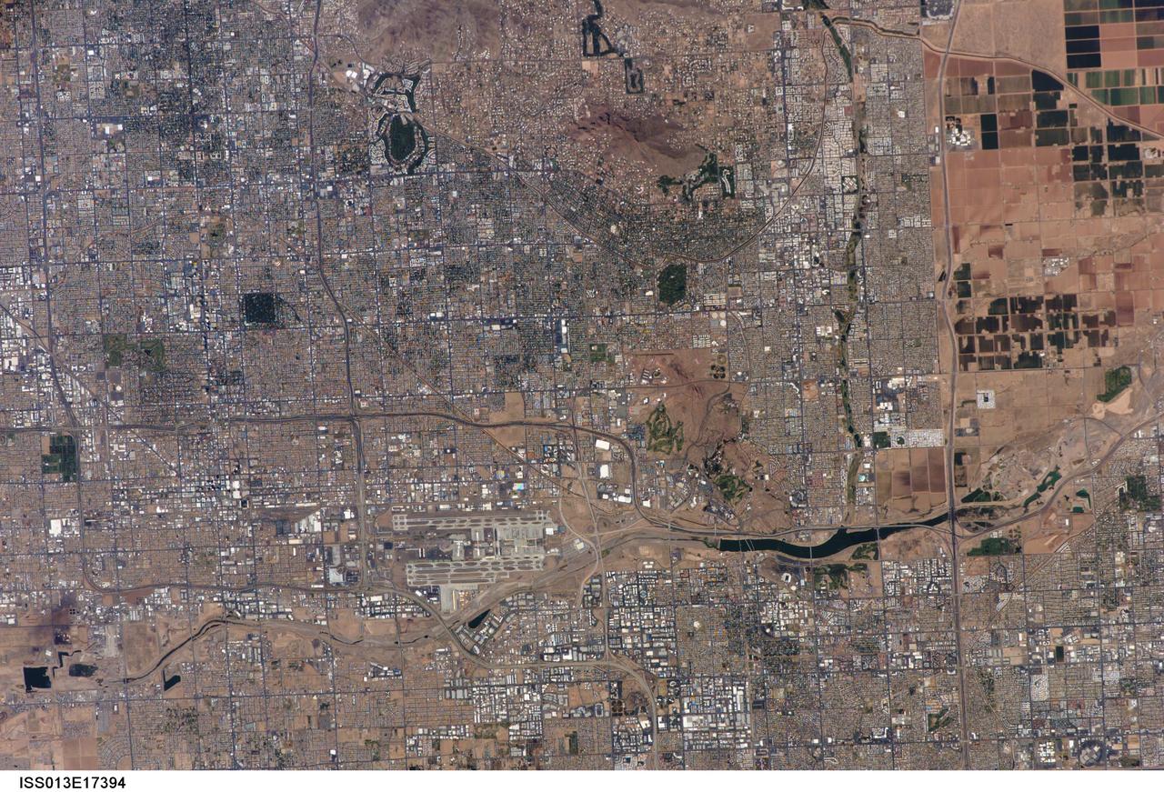
ISS013-E-17394 (10 May 2006) --- The central Phoenix Metro Area, Arizona is featured in this image photographed by an Expedition 13 crewmember on the International Space Station. The Phoenix, Arizona metropolitan area is the largest in the southwestern United States, and is comprised of 21 contiguous incorporated municipalities. Such a collection of discrete political entities forming a larger integrated urban landscape is referred to as a conurbation by urban geographers. This portion of a high resolution (approximately 9 meters/pixel) photograph (upper image) of the central metro region includes the boundary area between three of the municipalities included in the conurbation: the Cities of Phoenix (upper image, left), Tempe (upper image, center and lower right), and Scottsdale (upper image, upper right).
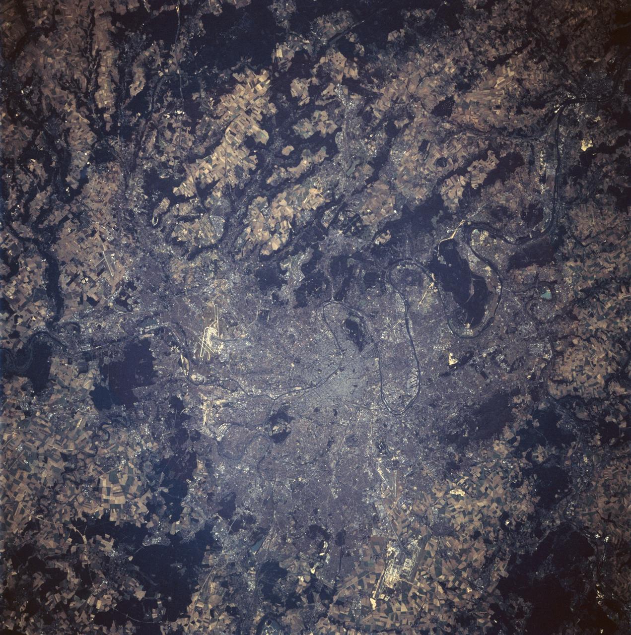
STS047-94-010 (12 - 20 Sept 1992) --- This 250mm Hasselblad color photo of Paris, France recorded during this mission, shows urban land uses in great detail. Several airports are clear, including the two major international airports of Orly and Le Bourget. Paris was founded in pre-Roman times on an island in the Seine River and continued as a Roman outpost. The easily defensible location was one of the keys to the growth of this island city. The city expanded from its island state to become a major urban center in Europe because of its location, its easy access by river traffic, and its productive hinterland.
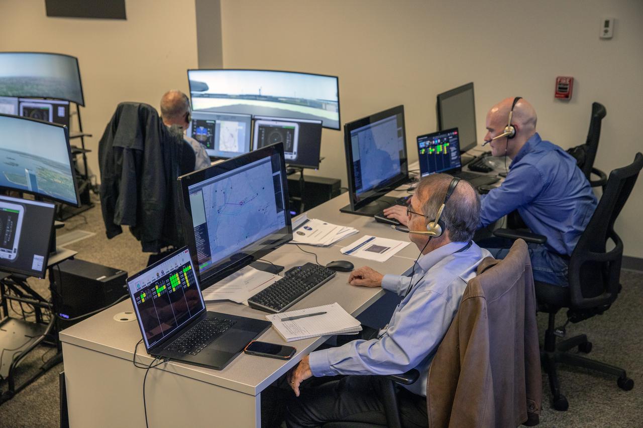
Focus on active photos –Class B Simulation Evaluation in the ATOL Lab at Langley (Also at FAA Tech Center) where team is working with one another in the lab, reviewing data on the monitors. Working the software, adjusting the software systems. Going over the shoulder to show the displays and screens as the software is running. John Foster (left) in the role of an air taxi pilot in the simulator chair with Jim Chamberlain and Terence McClain at the flight manager stations running virtual air taxi integration simulations focusing on urban air space at NASA’s Langley Research Center in Hampton, Virginia on Sept. 25, 2024.
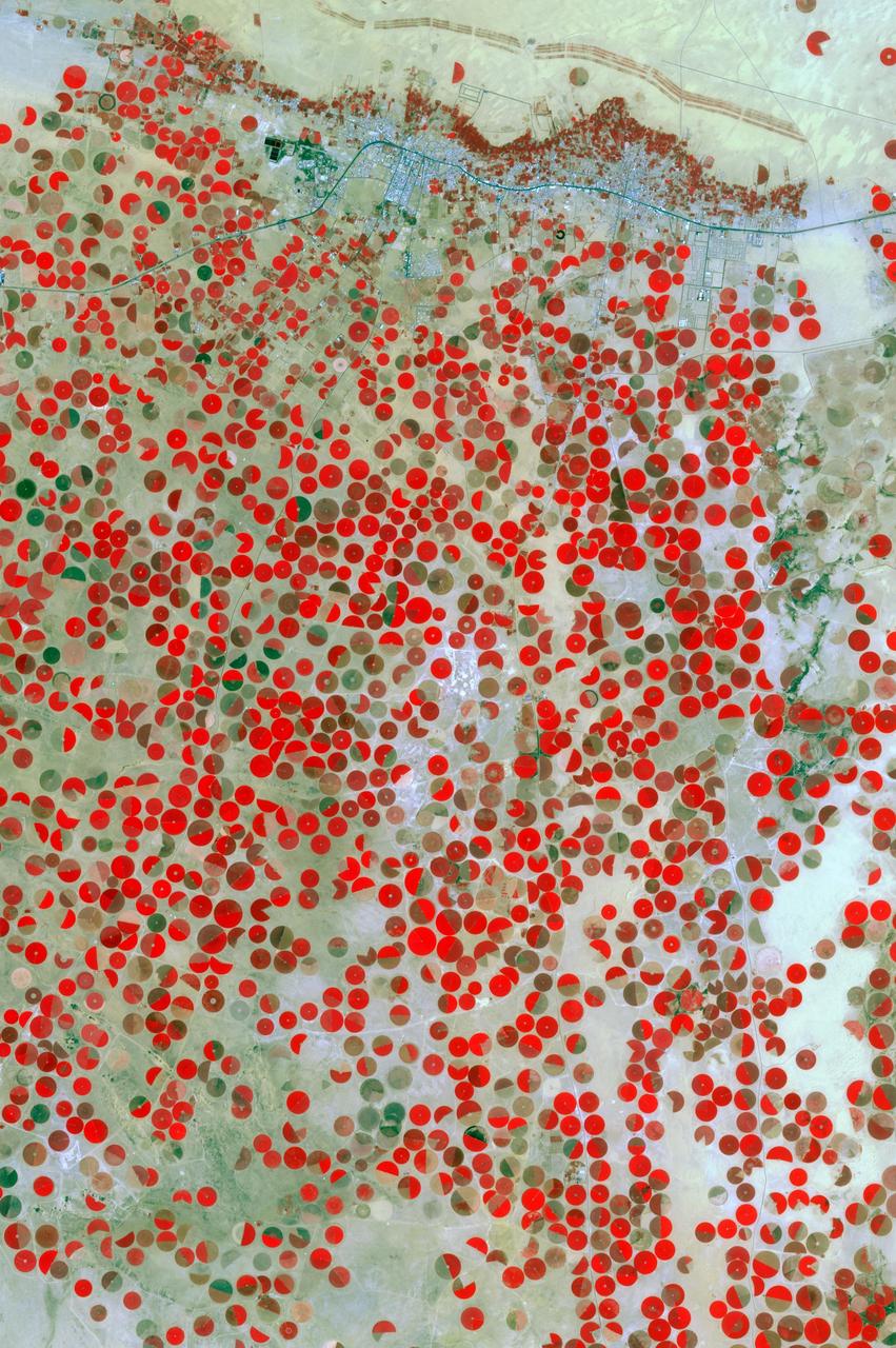
In the middle of the Arabian desert the city Green Oasis Wadi Al Dawasir is being developed as a new urban center for the Wadi Al Dawasir region of Saudi Arabia, as shown in this image from NASA Terra spacecraft. Huge solar fields supply the entire city and the surrounding region with energy. Hundreds of circular agricultural fields are fed by center pivot irrigation apparatus, drawing water from subterranean aquifers. The image was acquired March 30, 2013, covers an area of 30 x 45 km, and is located at 20.2 degrees north, 44.8 degrees east. http://photojournal.jpl.nasa.gov/catalog/PIA20077
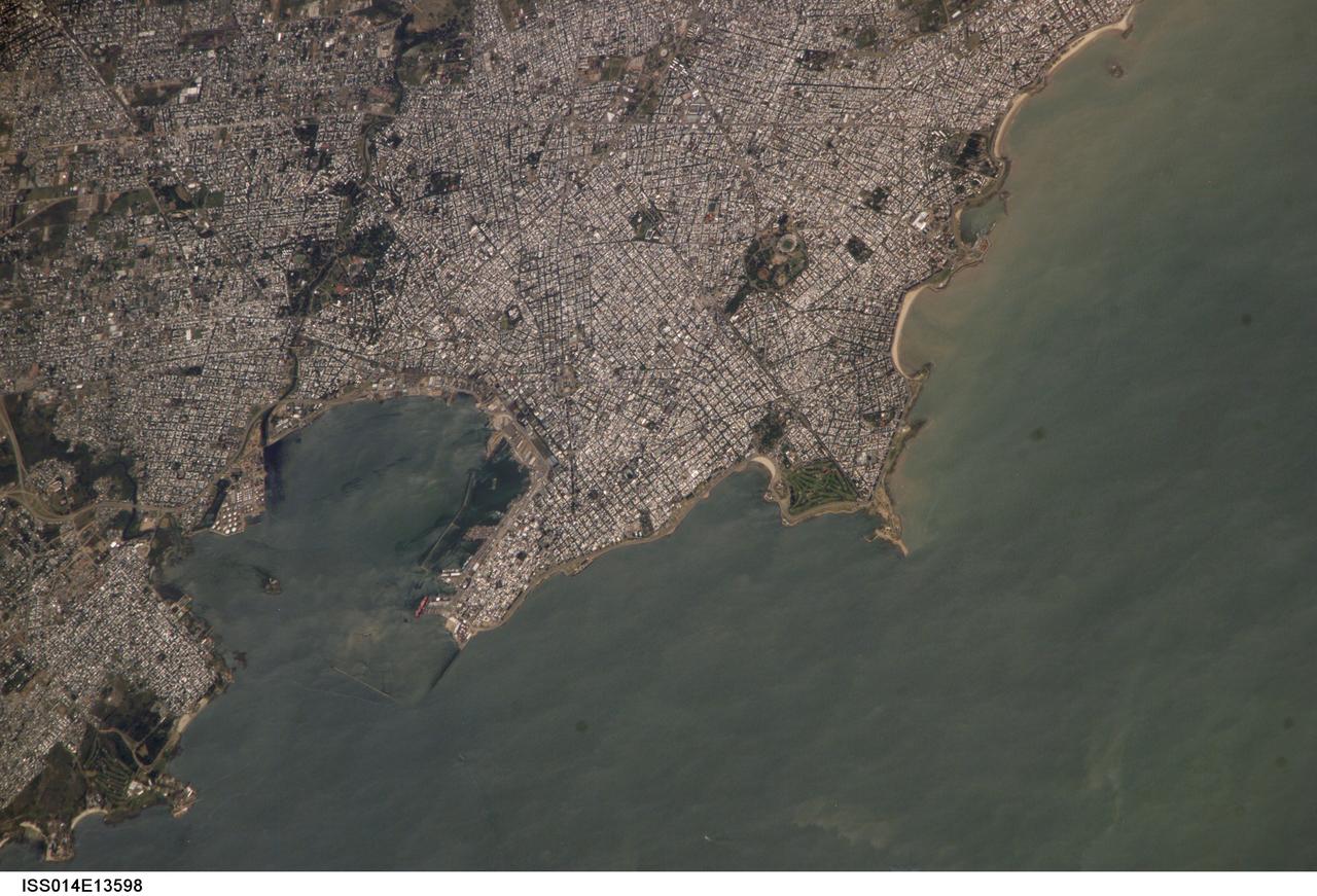
ISS014-E-13598 (29 Jan. 2007) --- Montevideo, Uruguay is featured in this image photographed by an Expedition 14 crewmember on the International Space Station. Reflective roofing materials and dark asphalt streets outline the urban grid pattern of Uruguay's capital city of Montevideo in this image. The city may be viewed as a precursor of the predicted global population shift from dominantly rural to urban environments (by 2030, according to recent United Nations estimates) -- nearly half of Uruguay's total population now lives in the Montevideo metropolitan area. Located on the southern coastline of Uruguay along the Rio de la Plata, Montevideo Bay provides an important harbor and port facilities for transport of South American agricultural products. This view is of sufficient resolution (approximately 7 meters/pixel) to discriminate between dark green canopied tree cover and light green grass - important information for study of urban ecology and climate, as well as city water use planning - in a large golf course located at the southern edge of the city (near center right). Sediment plumes along the coastline to the southeast of the city are also visible; rough patterns in the water surface of Montevideo Bay and the Rio de la Plata are a combination of wind disturbance and sediments.
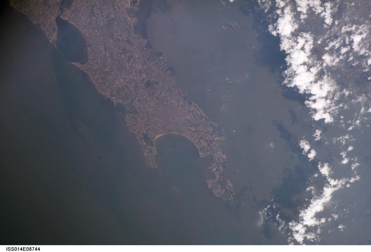
ISS014-E-08744 (28 Nov. 2006) --- Mumbai Harbor, India is featured in this image photographed by an Expedition 14 crewmember on the International Space Station. This view is one of three (frames 8741, 8742 and 8744) acquired within ten seconds of each other as the station passed over India. Mumbai (formerly known as Bombay) is a so-called mega city, with over 21 million people living in the greater Mumbai metropolitan region. Mega cities like Tokyo, New York, Sao Paulo, and Mumbai are also known as conurbations -- large contiguous areas of urban land cover formed from the growth and merging together of previously separate and distinct urban centers. The Mumbai conurbation includes several municipal entities including Bhiwandi, Kalyan, Thane, and Ulhasnagar. Located along the coast of western India on Salsette Island, Mumbai is generally considered to be the most modern of India's cities and is a major economic, transportation, and cultural center. Almost cloud-free conditions reveal the continuous urban land cover of the mega city extending north to south across Salsette Island -- a distance of nearly 50 kilometers.
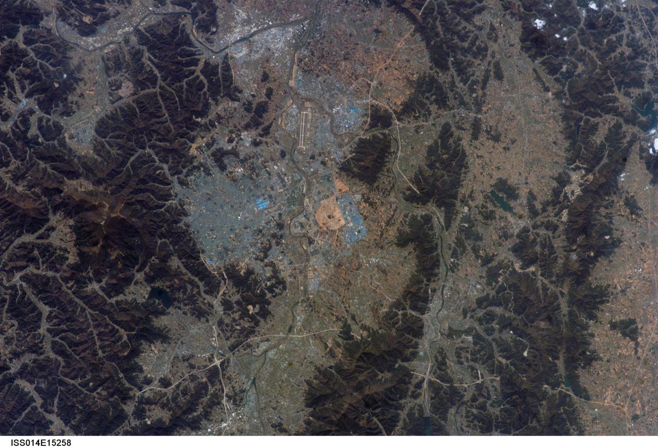
ISS014-E-15258 (26 Feb. 2007) --- Kwangju, South Korea is featured in this image photographed by an Expedition 14 crewmember on the International Space Station. The Metropolitan City of Kwangju (or Gwangju) is the fifth largest urban area in South Korea with a population of 1.4 million people. It is a major economic and cultural center for the southern portion of the country, located in a geographic basin with high mountains to the east (the mountain of Mudeungsan to the east has a peak elevation of 1,140 meters) and more open plains to the west. The city is perhaps best known to the West as the location of the Gwangju Massacre in May 1980, during which civilian demonstrators were killed by government forces. This event has led to identification of the city within South Korea as "the shrine of Korean democracy." The most notable feature in this view is an interesting blue cast to the urbanized regions. Digital photographs capture the same red, green, and blue wavelengths of reflected light that human eyes are sensitive to (known as a "true-color" image), and urban areas typically appear in tones of grey. The distinctive blue-grey color of the Kwangju metropolitan area is the result of numerous blue building rooftops, present on both small residential buildings and large industrial buildings such as those located at center and right.
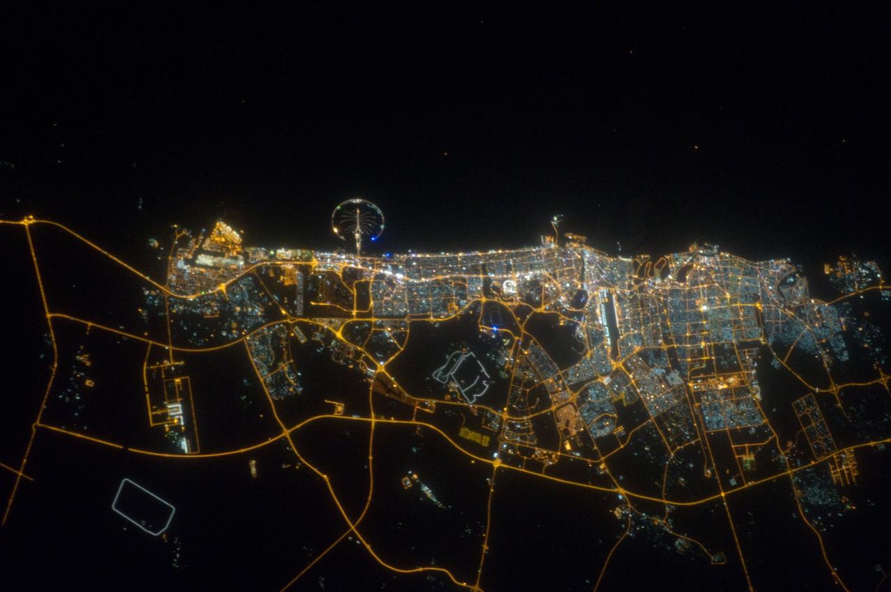
ISS032-E-023718 (11 Aug. 2012) --- The city of Dubai, United Arab Emirates, is featured in this night view photographed by an Expedition 32 crew member on the International Space Station. The city of Dubai is the largest metropolitan area in the emirate of Dubai, one of the member states of the United Arab Emirates. Dubai is located along the southern Persian Gulf on the Arabian Peninsula, and its signature city is known for high profile architectural and development projects. Among the most notable is the Palm Island Resort, a manmade peninsula and surrounding islands built from over 50 million cubic meters of sand. Two other island projects (out of frame), one similar to the Palm Island Resort and another crafted to look like a map of the world, are also visible in other space station imagery along the Dubai coastline. Orange sodium vapor lights trace out the major highways and surface street grid in and around the metropolitan area, while grey-white mercury vapor lamps fill in the commercial and residential areas. The lighted islands and peninsula of the Palm Island Resort are clearly visible along the coastline. An interesting spiral pattern of lights on the southeastern fringe of the urban area is a camel racetrack. Night time images like this are useful to climate modelers, urban planners, and geographers as they allow for simple definition of urban (densely lit) and rural (sparsely lit) areas.

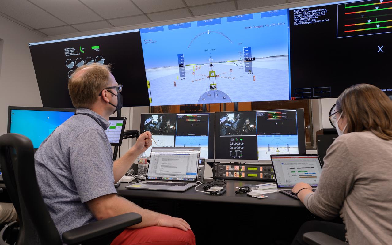
Out the window view of the ownship aircraft in the VMS’s R-Cab during the AVA-1h simulation in the VMS, N243.
Human factors engineer Casey Smith, right, and pilot Wayne Ringelberg, left, discuss simulation results during a flight debrief in the VMS control room, N243.

Pilot David Zahn fine-tunes the traffic display screen of the ownship aircraft in the VMS’s R-Cab during the AVA-1h simulation in the VMS, N243.

Traffic display screen of the ownship aircraft in the VMS’s R-Cab during the AVA-1h simulation in the VMS, N243.

Traffic display screen of the ownship aircraft in the VMS’s R-Cab during the AVA-1h simulation in the VMS, N243.

Human factors engineer Casey Smith, left, and pilot Wayne Ringelberg, right, discuss simulation results during a flight debrief in the VMS control room, N243.
Pilot David Zahn fine-tunes the traffic display screen of the ownship aircraft in the VMS’s R-Cab during the AVA-1h simulation in the VMS, N243.

David Zahn pilots the ownship aircraft in the VMS’s R-Cab during the AVA-1h simulation in the VMS, N243.

Out the window view of the ownship aircraft in the VMS’s R-Cab during the AVA-1h simulation in the VMS, N243.

AVA-1h simulation team members Megan Mitchell, left, Christian Schmitz, and Matthew Blanken, right, in the VMS control room, N243, prepare for a simulation.

David Zahn pilots the ownship aircraft in the VMS’s R-Cab during the AVA-1h simulation in the VMS, N243.
Human factors engineer Casey Smith, right, and pilot Wayne Ringelberg, left, discuss simulation results during a flight debrief in the VMS control room, N243.
Primary flight display screen, left, and traffic display screen, right, of the ownship aircraft in the VMS’s R-Cab during the AVA-1h simulation in the VMS, N243.

Human factors engineer Casey Smith, left, and pilot Wayne Ringelberg, right, discuss simulation results during a flight debrief in the VMS control room, N243.

Out the window view of the ownship aircraft in the VMS’s R-Cab during the AVA-1h simulation in the VMS, N243.

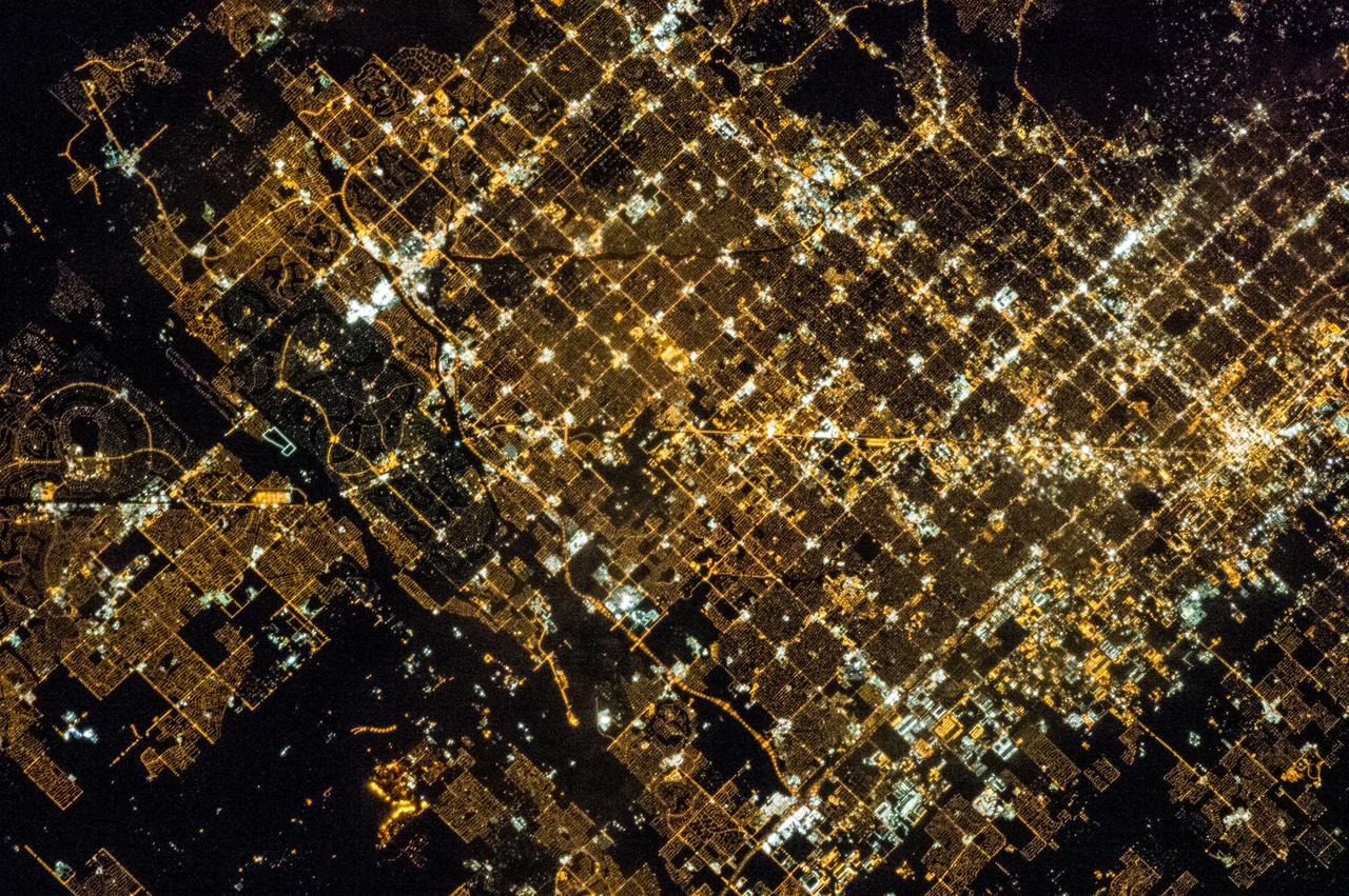
iss070e103326 (Feb. 28, 2024) --- The nightime lights of the Los Angeles, California, urban area were photographed by Expedition 70 Flight Engineer Jasmin Moghbeli of NASA as the International Space Station orbited 262 miles above the Pacific Ocean near Catalina Island.
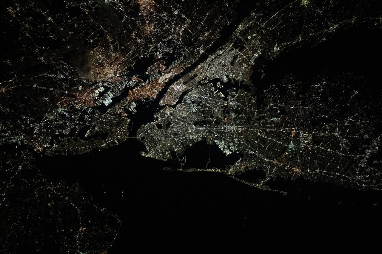
iss070e103432 (Feb. 29, 2024) --- The nightime urban lights of the New York/New Jersey metropolitan area were photographed by Expedition 70 Flight Engineer Jasmin Moghbeli of NASA as the International Space Station orbited 263 miles above the Empire State.
Advanced Air Mobility will connect both urban dwellers and rural residents by adding a new way to travel by air. As shown in this concept art, passengers could travel from rural areas into the city quicker than by car to board a commercial airliner, access medical care or to purchase goods.
iss070e013946 (Oct. 26, 2023) --- This nighttime view from the International Space Station shows the city lights of the northeastern United States and major urban areas including Long Island, New York; Philadelphia, Pennsylvania; and Washington D.C. The orbital lab was soaring 262 miles above the Pine Tree State of Maine at the time of this photograph.
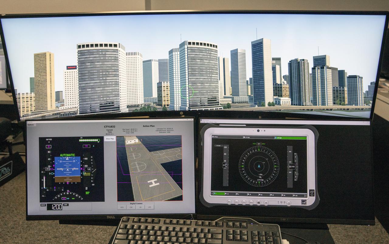
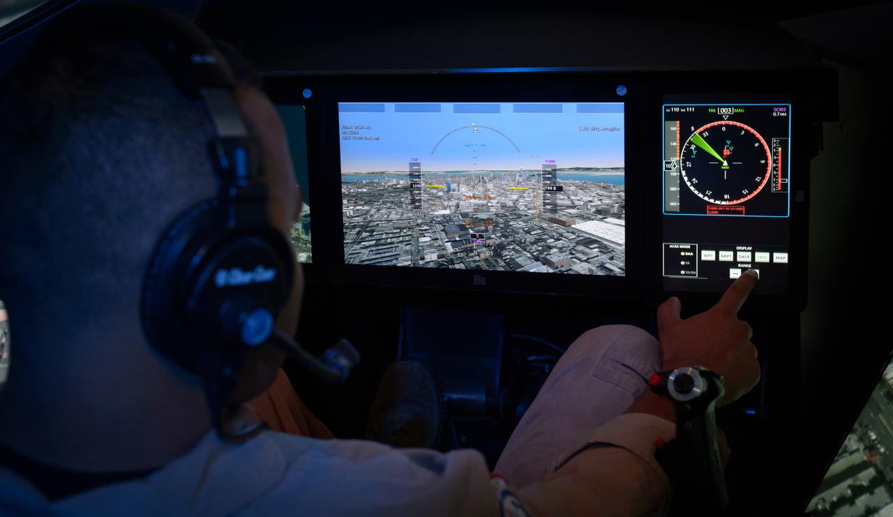
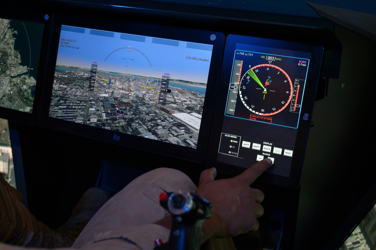
Focus on active photos –Class B Simulation Evaluation in the ATOL Lab at Langley (Also at FAA Tech Center) where team is working with one another in the lab, reviewing data on the monitors. Working the software, adjusting the software systems. Going over the shoulder to show the displays and screens as the software is running. A pilot’s point of view from the controls of the air taxi simulator. An out-the-window simulation appears on the top screen, the primary flight display on the lower left, the virtual moving map in the middle, and the detect and avoid display on the lower right at NASA’s Langley Research Center in Hampton, Virginia on Sept. 25, 2024.
STS081-750-048 (12-22 Jan. 1997) --- This photograph, made with a handheld 70mm camera aimed through the Space Shuttle Atlantis' overhead windows, shows the entire city-state of Singapore with its urban, industrial and commercial land use areas. Singapore is located at the tip of the Malay peninsula separated by Johor strait. This prosperous island state, once Asia's major trade center, is now highly industrialized despite its small area. The ideal location has made this island a hub of trade, shipping and service industries. This photograph shows the urban land uses and a large airport on the island. Several commercial harbors are seen on this photograph. The three large reservoirs in the center of the photograph are obscured by the clouds.
ISS035-E-005438 (16 March 2013) --- One of the Expedition 35 crew members on the International Space Station used a still camera with a 400 millimeter lens to record this nocturnal image of the Phoenix, Arizona area. Like many large urban areas of the central and western United States, the Phoenix metropolitan area is laid out along a regular grid of city blocks and streets. While visible during the day, this grid is most evident at night, when the pattern of street lighting is clearly visible from above – in the case of this photograph, from the low Earth orbit vantage point of the International Space Station. The urban grid form encourages growth of a city outwards along its borders, by providing optimal access to new real estate. Fueled by the adoption of widespread personal automobile use during the 20th century, the Phoenix metropolitan area today includes 25 other municipalities (many of them largely suburban and residential in character) linked by a network of surface streets and freeways. The image area includes parts of several cities in the metropolitan area including Phoenix proper (right), Glendale (center), and Peoria (left). While the major street grid is oriented north-south, the northwest-southeast oriented Grand Avenue cuts across it at image center. Grand Avenue is a major transportation corridor through the western metropolitan area; the lighting patterns of large industrial and commercial properties are visible along its length. Other brightly lit properties include large shopping centers, strip centers, and gas stations which tend to be located at the intersections of north-south and east-west trending streets. While much of the land area highlighted in this image is urbanized, there are several noticeably dark areas. The Phoenix Mountains at upper right are largely public park and recreational land. To the west (image lower left), agricultural fields provide a sharp contrast to the lit streets of neighboring residential developments. The Salt River channel appears as a dark ribbon within the urban grid at lower right.
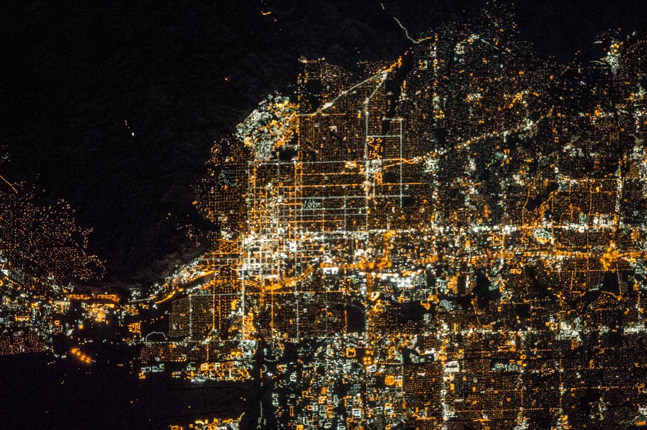
ISS038-E-016506 (12 Dec. 2013) --- A nighttime view of Salt Lake City, Utah is featured in this image photographed by an Expedition 38 crew member on the International Space Station. The Salt Lake City metropolitan area is located along the western front of the Wasatch Range in northern Utah. Viewed at night from the vantage point of the space station, the regular north-south and east-west layout of street grids typical of western U.S. cities is clearly visible. Known as "the crossroads of the West", the headquarters of The Church of Jesus Christ of Latter-day Saints (also known as the LDS Church and informally as the Mormon Church), and the state capital of Utah, Salt Lake City was founded in 1847 by Brigham Young together with other followers of the Mormon faith. The Salt Lake City metropolitan area today is included in the larger urban Wasatch Front region of Utah which includes over two million people (approximately 80 percent of the population of the state). Both the color of the city lights and their density provide clues to the character of the urban fabric -- yellow gold lights generally indicate major roadways such as Interstate Highway 15 that passes through the center of the metropolitan area (center, left to right), while bright white clusters of lights are associated with city centers, commercial, and industrial areas. In contrast, residential and suburban areas are recognizable due to diffuse and relatively dim lighting (center left). The Wasatch Range to the east is largely dark, as are several large urban parks and golf courses located within the illuminated urban areas.

ISS014-E-08741 (28 Nov. 2006) --- Mumbai, India is featured in this image photographed by an Expedition 14 crewmember on the International Space Station. This view is one of three (frames 8741, 8742 and 8744) acquired within ten seconds of each other as the station passed over India. Mumbai (formerly known as Bombay) is a so-called mega city, with over 21 million people living in the greater Mumbai metropolitan region. Mega cities like Tokyo, New York, Sao Paulo, and Mumbai are also known as conurbations -- large contiguous areas of urban land cover formed from the growth and merging together of previously separate and distinct urban centers. The Mumbai conurbation includes several municipal entities including Bhiwandi, Kalyan, Thane, and Ulhasnagar. Located along the coast of western India on Salsette Island, Mumbai is generally considered to be the most modern of India's cities and is a major economic, transportation, and cultural center. Almost cloud-free conditions reveal the continuous urban land cover of the mega city extending north to south across Salsette Island -- a distance of nearly 50 kilometers. Sanjay Gandhi National Park, bordered on three sides by the urbanized area, is the largest national park in the world located within city limits. In addition to providing a refuge for native flora and fauna, the park also includes two lakes that form part of the Mumbai drinking water system.
ISS014-E-08742 (28 Nov. 2006) --- Mumbai, India is featured in this image photographed by an Expedition 14 crewmember on the International Space Station. This view is one of three (frames 8741, 8742 and 8744) acquired within ten seconds of each other as the station passed over India. Mumbai (formerly known as Bombay) is a so-called mega city, with over 21 million people living in the greater Mumbai metropolitan region. Mega cities like Tokyo, New York, Sao Paulo, and Mumbai are also known as conurbations -- large contiguous areas of urban land cover formed from the growth and merging together of previously separate and distinct urban centers. The Mumbai conurbation includes several municipal entities including Bhiwandi, Kalyan, Thane, and Ulhasnagar. Located along the coast of western India on Salsette Island, Mumbai is generally considered to be the most modern of India's cities and is a major economic, transportation, and cultural center. Almost cloud-free conditions reveal the continuous urban land cover of the mega city extending north to south across Salsette Island -- a distance of nearly 50 kilometers. Sanjay Gandhi National Park (partially out of frame), bordered on three sides by the urbanized area, is the largest national park in the world located within city limits. In addition to providing a refuge for native flora and fauna, the park also includes two lakes that form part of the Mumbai drinking water system.
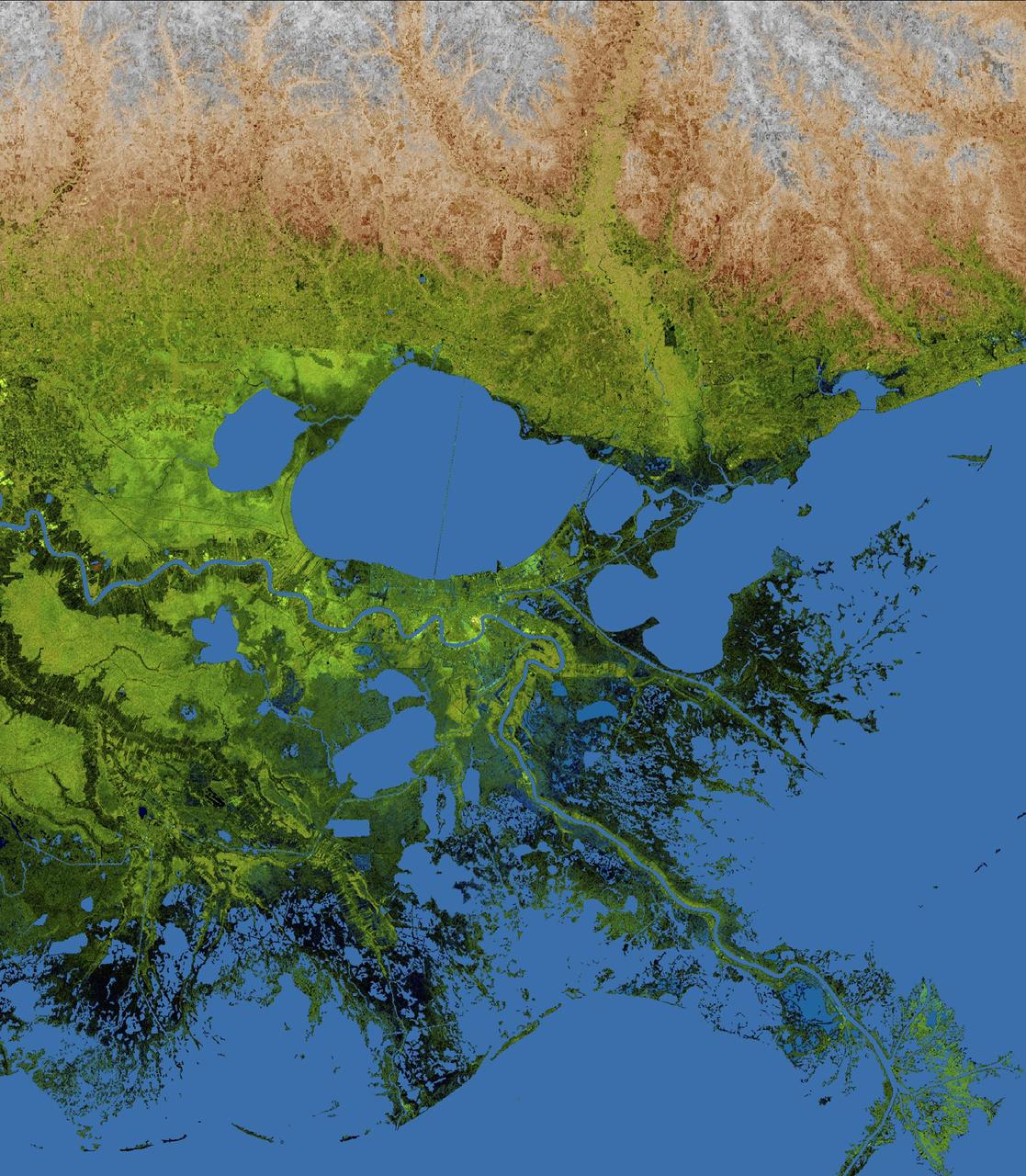
The geography of the New Orleans and Mississippi delta region is well shown in this radar image from the Shuttle Radar Topography Mission. In this image, bright areas show regions of high radar reflectivity, such as from urban areas, and elevations have been coded in color using height data also from the mission. Dark green colors indicate low elevations, rising through yellow and tan, to white at the highest elevations. New Orleans is situated along the southern shore of Lake Pontchartrain, the large, roughly circular lake near the center of the image. The line spanning the lake is the Lake Pontchartrain Causeway, the world's longest over water highway bridge. Major portions of the city of New Orleans are below sea level, and although it is protected by levees and sea walls, flooding during storm surges associated with major hurricanes is a significant concern. http://photojournal.jpl.nasa.gov/catalog/PIA04175
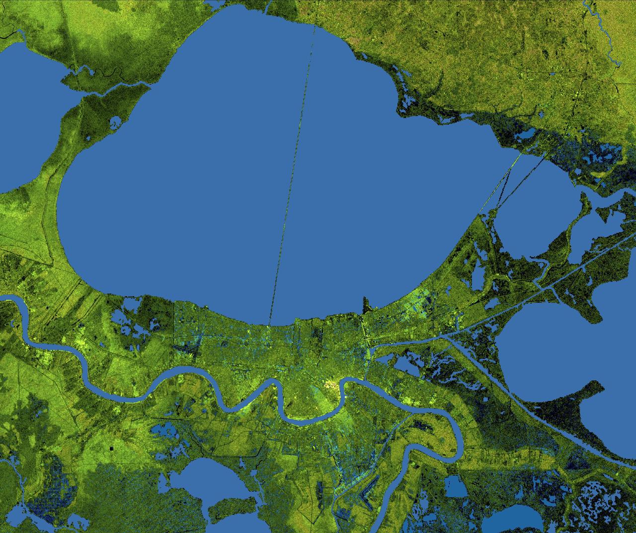
The city of New Orleans, situated on the southern shore of Lake Pontchartrain, is shown in this radar image from the Shuttle Radar Topography Mission (SRTM). In this image bright areas show regions of high radar reflectivity, such as from urban areas, and elevations have been coded in color using height data also from the SRTM mission. Dark green colors indicate low elevations, rising through yellow and tan, to white at the highest elevations. New Orleans is near the center of this scene, between the lake and the Mississippi River. The line spanning the lake is the Lake Pontchartrain Causeway, the world’s longest overwater highway bridge. Major portions of the city of New Orleans are actually below sea level, and although it is protected by levees and sea walls that are designed to protect against storm surges of 18 to 20 feet, flooding during storm surges associated with major hurricanes is a significant concern. http://photojournal.jpl.nasa.gov/catalog/PIA04174
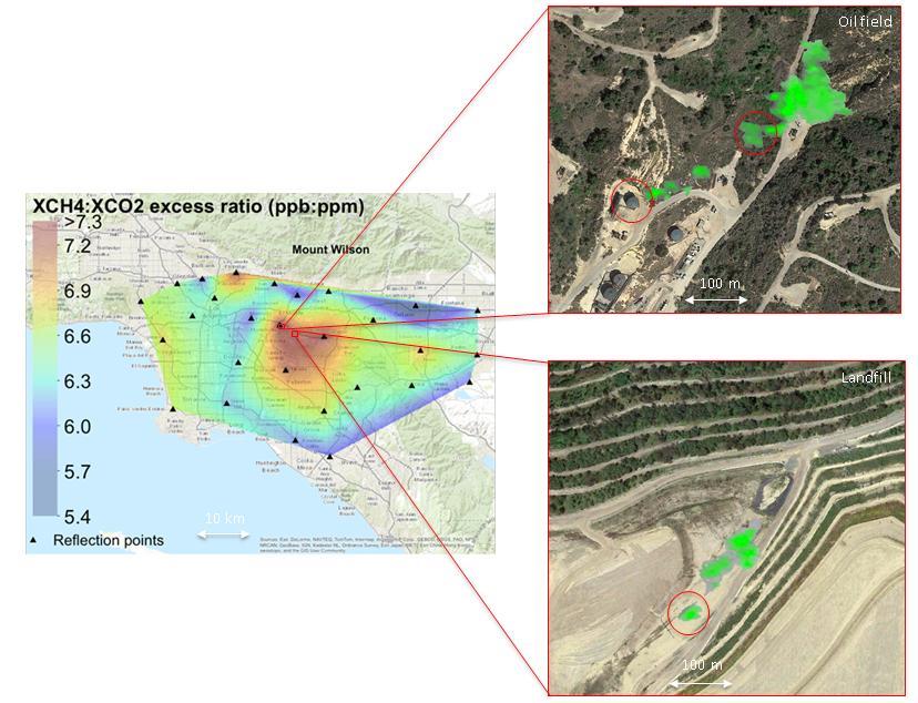
This image captured by a prototype NASA satellite instrument at NASA California Laboratory for Atmospheric Remote Sensing CLARS shows a persistent methane hotspot central red area over Los Angeles basin.
AFCM subproject simulation FAA-2 flight test team members Thomas Lombaerts, left, and Kimberlee Shish, right, in the VMS control room, N243, during a simulation.
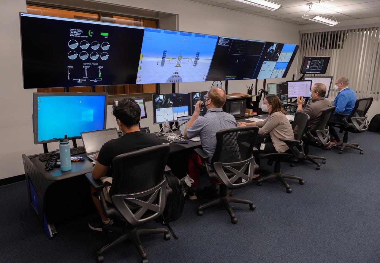
AFCM subproject simulation FAA-2 flight test team members Allen Ruan, left, Thomas Lombaerts, Kimberlee Shish, Edgar Torres, and Stephen Norris, right, in the VMS control room, N243 during a simulation.
Group photo of AFCM subproject simulation FAA-2 flight test team members Thomas Lombaerts, left, Mike Feary, Dave Sizoo, Kimberlee Shish, Loran Haworth, Mitch Soth, and Dave Webber, right, in the VMS control room, N243.
AFCM subproject simulation FAA-2 flight test team member Thomas Lombaerts in the VMS control room, N243, during a simulation.
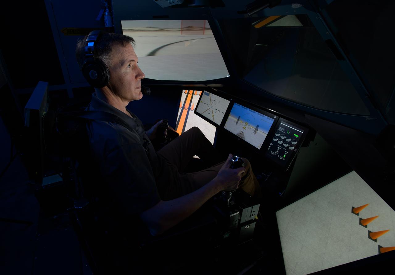
Michael Feary pilots a simulated electric vertical takeoff and landing, or eVTOL, aircraft in the VMS’s R-Cab during the AFCM subproject simulation FAA-2 flight tests in the VMS, N243.
AFCM subproject simulation FAA-2 flight test team member Thomas Lombaerts in the VMS control room, N243, during a simulation.
AFCM subproject simulation FAA-2 flight test team members Thomas Lombaerts, left, and Kimberlee Shish, right, in the VMS control room, N243, during a simulation.
AFCM subproject simulation FAA-2 flight test team members Allen Ruan, left, Thomas Lombaerts, Kimberlee Shish, Edgar Torres, and Stephen Norris, right, in the VMS control room, N243 during a simulation.
AFCM subproject simulation FAA-2 flight test team members Allen Ruan, left, Thomas Lombaerts, and Kimberlee Shish, right, in the VMS control room, N243, during a simulation.

AFCM subproject simulation FAA-2 flight test team members Allen Ruan, left, Thomas Lombaerts, and Kimberlee Shish, right, in the VMS control room, N243, during a simulation.
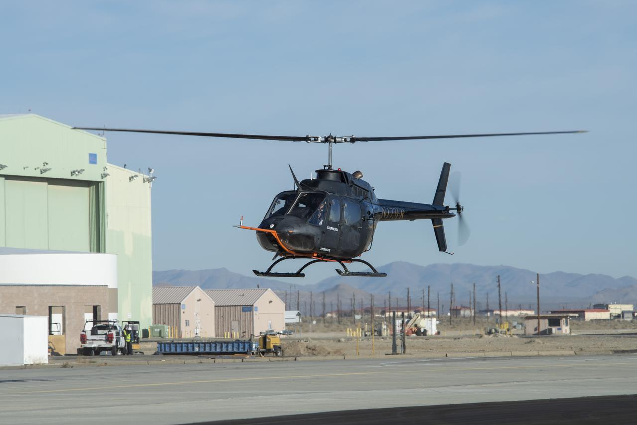
A Bell OH-58C Kiowa helicopter provided by Flight Research Inc. in Mojave, California, flies at NASA’s Armstrong Flight Research Center in California the first week of December 2020. The Advanced Air Mobility National Campaign project used the helicopter as a surrogate urban air mobility vehicle to develop a data baseline for future flight testing. Â

Sally Scalera, urban horticulture agent and master gardener coordinator from the University of Florida’s Institute of Food and Agricultural Sciences Brevard Extension Office, presents some sustainable tips and tricks for a healthy yard and garden to Kennedy Space Center employees on April 24, 2019. Held inside the Florida spaceport’s Space Station Processing Facility Conference Center, Scalera also provided information on Florida-friendly landscaping practices. The lunch and learn was available for employees to attend as part of Kennedy’s Earth Day events.
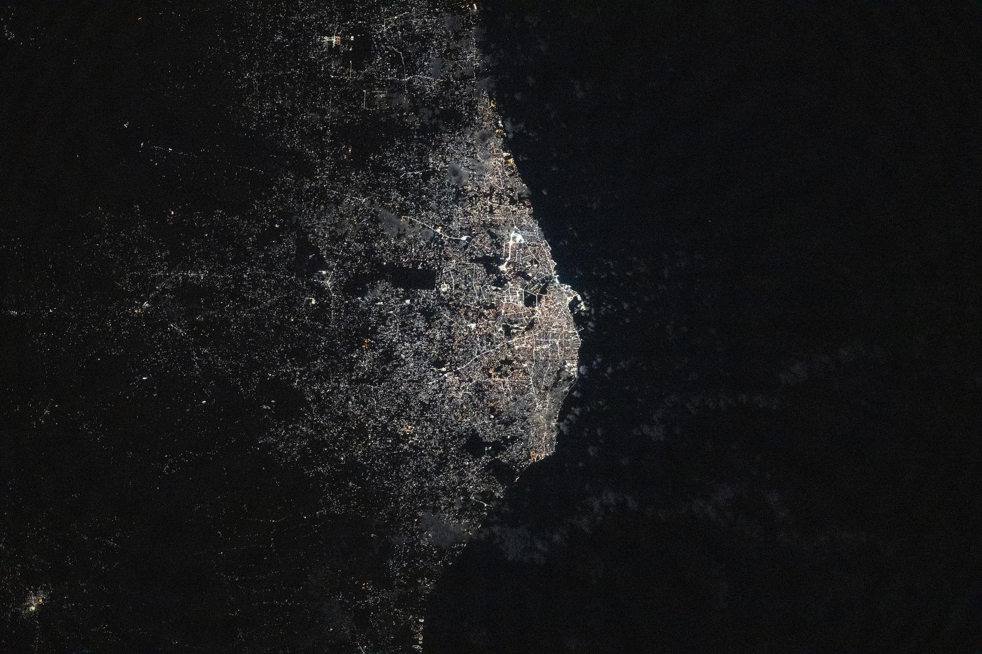
iss073e1047001 (Nov. 2, 2025) --- Tripoli, Libya—a city founded approximately 2,700 years ago on the Mediterranean Sea coast—is pictured at about 11:10 p.m. local time from the International Space Station as it orbited 259 miles above the African nation. The city’s modern, cool white lights reflect a major transition to LED and solar-powered LED lighting, part of efforts to modernize urban design, enhance safety, and support tourism infrastructure.

Kennedy Space Center employees attend a lunch and learn focused on Florida-friendly landscaping practices in the Florida spaceport’s Space Station Processing Facility Conference Center on April 24, 2019. Sally Scalera, urban horticulture agent and master gardener coordinator from the University of Florida’s Institute of Food and Agricultural Sciences Brevard Extension Office, presented information on sustainable tips and tricks for a healthy yard and garden. The lunch and learn was available for employees to attend as part of Kennedy’s Earth Day events.
A Bell OH-58C Kiowa helicopter provided by Flight Research Inc. in Mojave, California, sits on a helipad at NASA’s Armstrong Flight Research Center in California the first week of December 2020. The Advanced Air Mobility National Campaign project used the helicopter as a surrogate urban air mobility vehicle to develop and implement infrastructure, including the markings seen in the image, to support safe operations of these vehicles. Â
STS059-306-034 (9-20 April 1994) --- The radiating transportation pattern of this 20th-Century urban plan is nicely displayed in this high-resolution photograph. Light-toned spots in the desert mark oil well sites; along the south edge of the scene, some dark residue remains from the fires set during the recent Gulf War. Blown sand has nearly hidden the soot and thick oil that were deposited on the surface. Nikon photograph, 300mm lens.

KENNEDY SPACE CENTER, FLA. - This snail was photographed near the NASA Kennedy Space Center Shuttle Landing Facility. It appears to have the characteristics of the “Rosy Predator Snail,” which is found in Southeastern Texas, Louisiana, Mississippi, Alabama, Georgia, South Carolina and is widespread in Florida including the Keys. It is usually found singly in hardwood forests, roadsides and urban gardens. The Shuttle Landing Facility backs up to the Banana Creek and surrounding marshes.
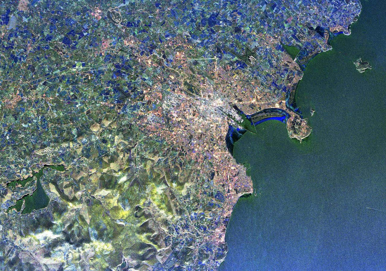
This view of the Malay Peninsula shows the city state of Singapore, Malaysia (1.5N, 104.0E) with all its urban, industrial and commercial land use areas. Singapore is located at the south tip of the Malay peninsula separated by the Johor Strait. The prosporous island state, once Asia's major trade center, is now highly industrialized despite its small size and its ideal location has made this island a hub of trade, shipping and service industries.
n Jammu and Kashmir, India, along the Jhelum River, Dal and Wular Lakes are remnants of a much larger pre-glacial lake. Wular (in the northwest) is one of the largest freshwater lakes in Asia. Dal Lake (southeast) is an urban lake in Srinagar. It is famous for its Mughal gardens and luxury houseboats. Impressive restoration projects are ongoing to reverse eutrophication. The image was acquired July 3, 2015, covers an area of 39.7 by 43.6 km, and is located at 34.2 degrees north, 74.7 degrees east. https://photojournal.jpl.nasa.gov/catalog/PIA25123

Sally Scalera, urban horticulture agent and master gardener coordinator from the University of Florida’s Institute of Food and Agricultural Sciences Brevard Extension Office, presents some sustainable tips and tricks for a healthy yard and garden to Kennedy Space Center employees on April 24, 2019. Held inside the Florida spaceport’s Space Station Processing Facility Conference Center, Scalera also provided information on Florida-friendly landscaping practices. The lunch and learn was available for employees to attend as part of Kennedy’s Earth Day events.
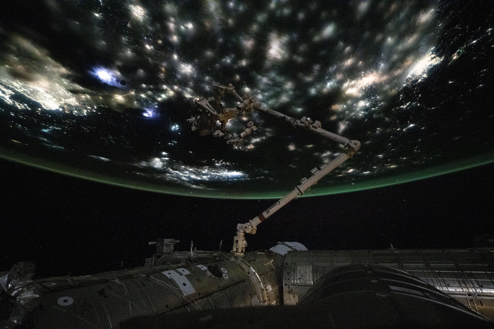
iss073e0742298 (Aug. 30, 2025) --- City lights beneath the clouds highlight the North China Plain near the Yellow Sea, where concentrated points of light mark fishing boats using illumination to attract anchovies, squid, sardines, and other species. Across the Yellow Sea, urban areas in South Korea are visible beneath a diffuse atmospheric glow near the horizon. In the foreground, the Canadarm2 robotic arm extends from a grapple fixture on the International Space Station's Harmony module.

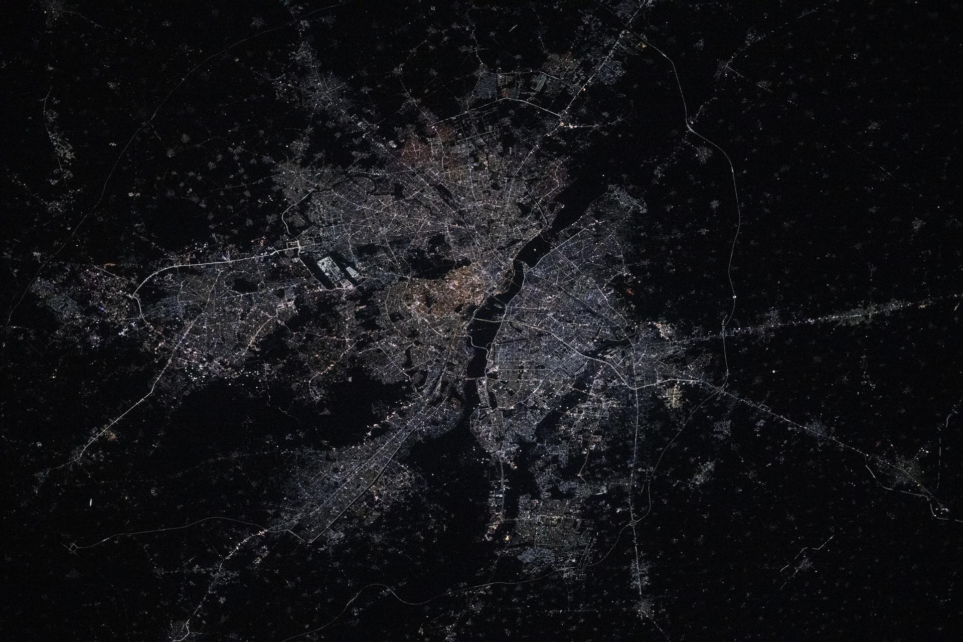
iss073e0420094 (July 3, 2025) --- Shanghai, China—the nation's largest city with a metropolitan population of approximately 24.9 million—is seen from the International Space Station at around 9:55 p.m. local time. Located where the Yangtze River meets the Yellow Sea, the city glows with urban energy. Notable landmarks include Shanghai Hongqiao International Airport near the top center and Shanghai Pudong International Airport at the bottom. The Huangpu River winds through the heart of downtown, dividing the historic Bund from the futuristic skyline of Lujiazui.

Sally Scalera, urban horticulture agent and master gardener coordinator from the University of Florida’s Institute of Food and Agricultural Sciences Brevard Extension Office, presents some sustainable tips and tricks for a healthy yard and garden to Kennedy Space Center employees on April 24, 2019. Held inside the Florida spaceport’s Space Station Processing Facility Conference Center, Scalera also provided information on Florida-friendly landscaping practices. The lunch and learn was available for employees to attend as part of Kennedy’s Earth Day events.
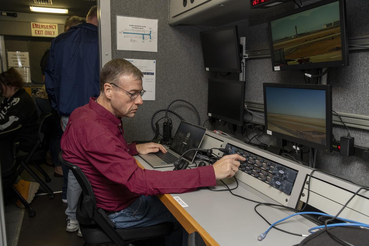
Working in the Mobile Operations Facility at NASA’s Armstrong Flight Research Center in Edwards, California, NASA Advanced Air Mobility researcher Dennis Iannicca adjusts a control board to capture Automatic Dependent Surveillance-Broadcast (ADS-B) data during test flights. The data will be used to understand ADS-B signal loss scenarios for air taxi flights in urban areas.

NASA’s Advanced Air Mobility National Campaign used this Bell OH-58 helicopter owned by Flight Research Inc. to study urban air mobility vehicle performance, flying qualities, and airspace requirements. The helicopter performed test maneuvers at NASA’s Armstrong Flight Research Center in Edwards, California, during two sessions Nov, 8-10, and Dec. 6, and 8-10.
ISS031-E-83789 (2 June 2012) --- Downlinked from the International Space Station this still image – part of a series from a mounted, automated, twilight session -- when viewed in sequence shows the flame ring associated with wild fires in the Southwest move from bottom to top-center framed at a distance by the bright urban areas of Tucson, Phoenix, El Paso-Las Cruces, and finally Albuquerque (mostly under cloud).
Abuja, the capital of Nigeria, is one of the fastest growing cities in Africa. It was developed as a planned city, replacing Lagos, the country's most populous city, as the capital in 1991. By 2000, the population was about 800,000; by 2020, the city, and its adjoining urban area of Karu to the east, had grown to over 6 million. The images were acquired December 2, 2003 and March 5, 2021. They are located at 9.1 degrees north, 7.5 degrees east, and cover an area of 25.5 by 37.5 km. https://photojournal.jpl.nasa.gov/catalog/PIA25186