Inverted Valley
Xanthe Valley
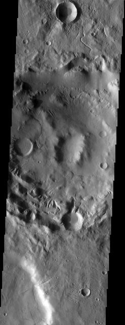
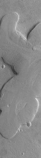
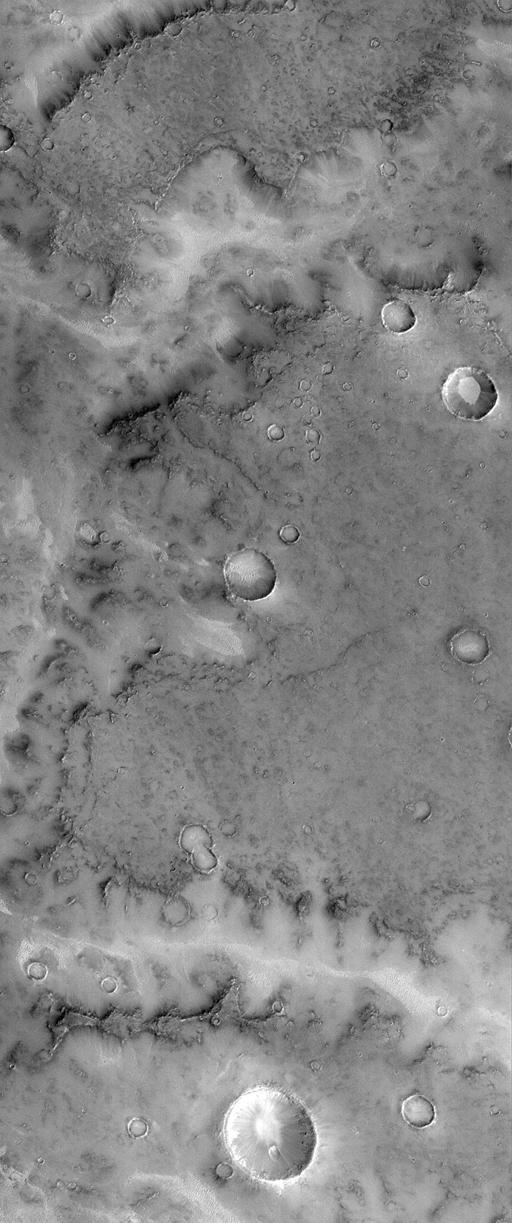
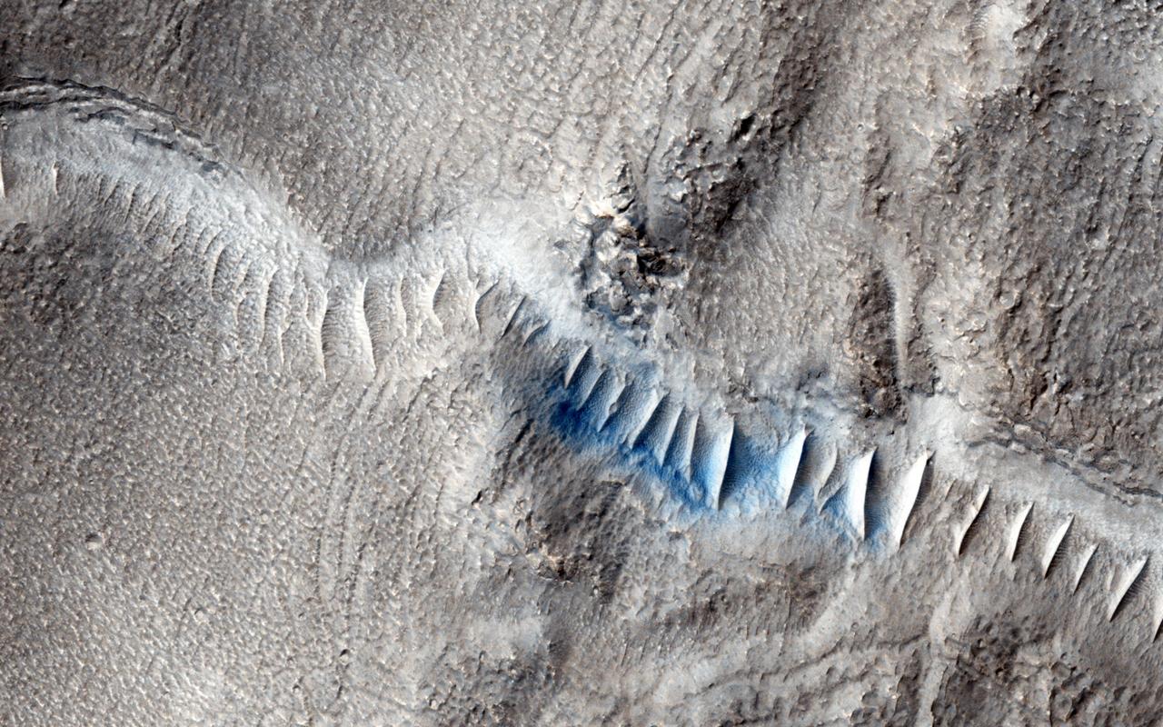
Martian Valley
Valley Networks
Valley Networks
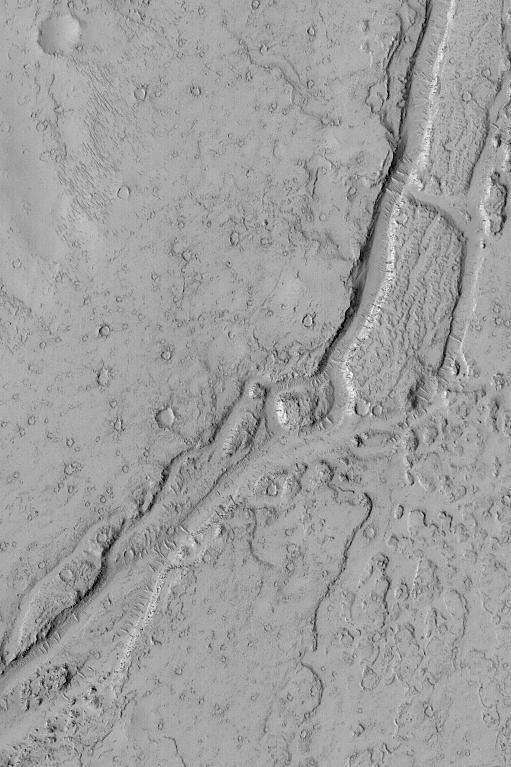
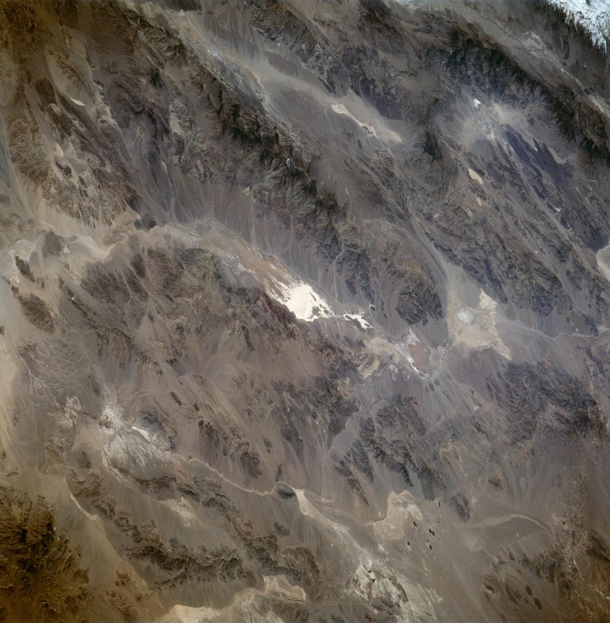
The Big Valley
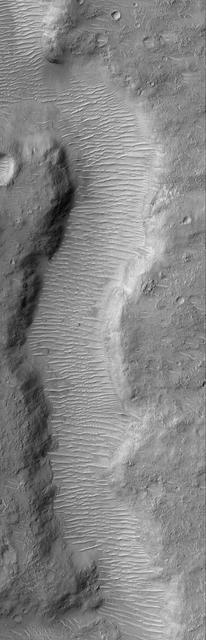
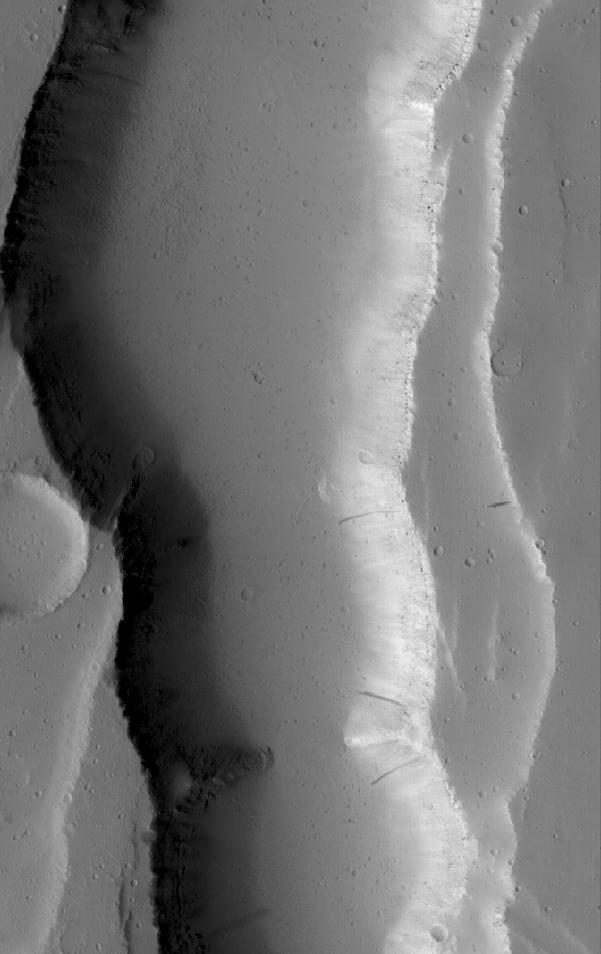
Valley Segment
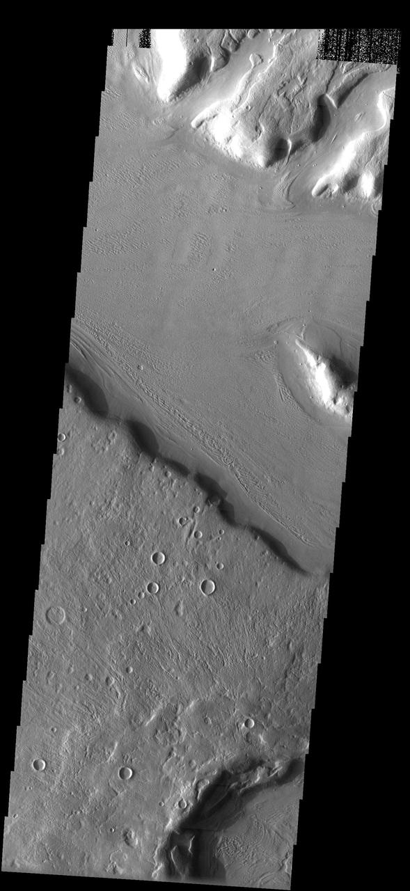
Valley Floor
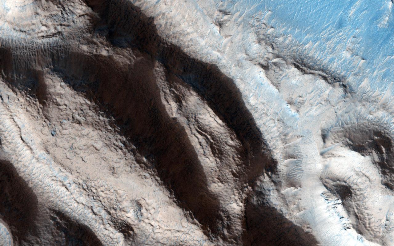
Modified Valleys
Valley Crossing
Inverted Valley
Meridiani Valleys
Ancient Valley
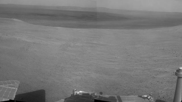
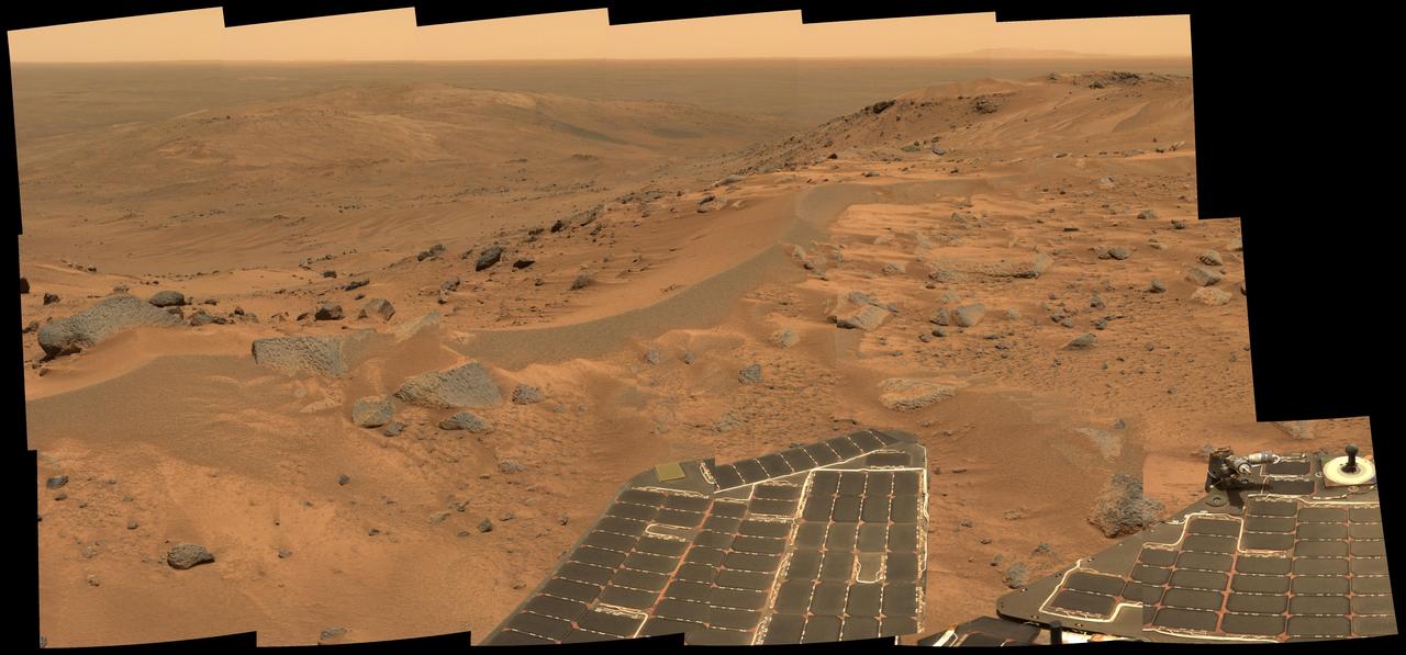
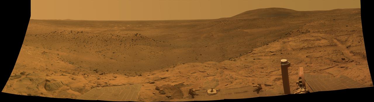
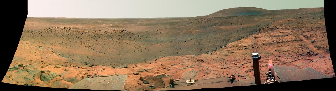
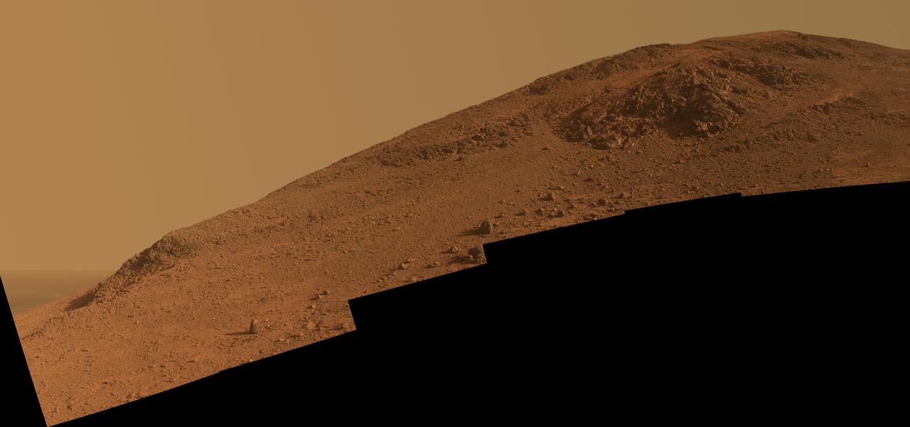
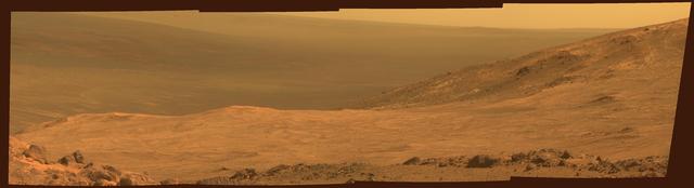
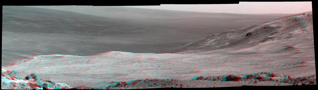
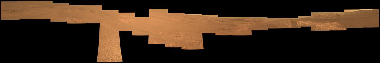
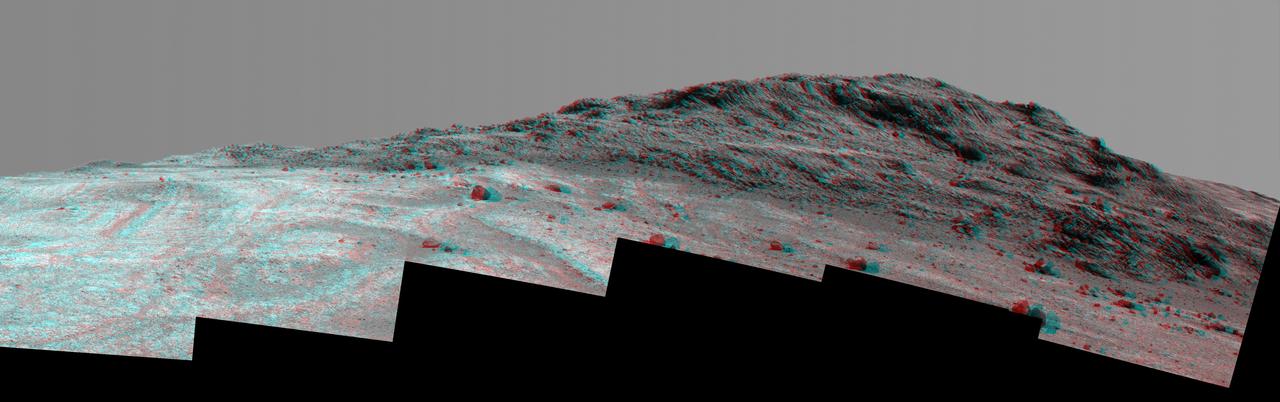
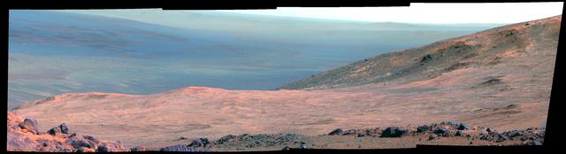
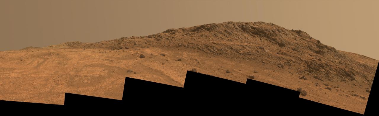
"Perseverance Valley" lies just on the other side of the dip in the crater rim visible in the left half of this 360-degree panorama from the Navigation Camera (Navcam) on NASA's Mars Exploration Rover Opportunity. As the rover arrived at this area in early May 2017, researchers began looking for clues about what process carved the valley. The rover team plans to drive Opportunity all the way down the valley into the interior of Endeavour Crater. The foreground and the area to the right are on the plain just outside of Endeavour Crater. The high point near the center of the image is called "Winnemucca," part of an Endeavour rim segment called "Cape Byron." Endeavour's interior and distant eastern rim are visible at upper left, above the notched portion of the western rim that sits directly above Perseverance Valley. The rover's Navcam took the component images of this scene on May 2 and May 3, 2017, during the 4,718th and 4,719th Martian days, or sols, of Opportunity's work on Mars, two days before a drive that brought Opportunity to the head of the valley. https://photojournal.jpl.nasa.gov/catalog/PIA21495
Valley Near Moreux
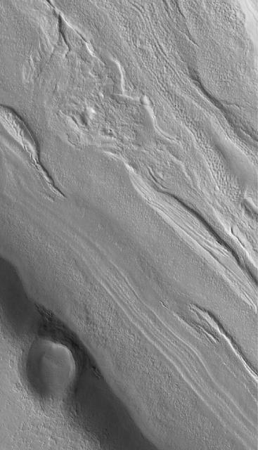
Fretted Terrain Valleys
Postcard Above Tennessee Valley
Valley South of Cerberus
Valley near Cydonia

A Valley in the Libya Montes
Corasis Fossae Valley
Old Martian Valley
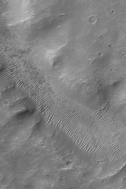
Lineated Valley Floor
Valley Near Nilus Chaos
Juncture of Valleys with Lineated Fill

Alba Patera Valleys
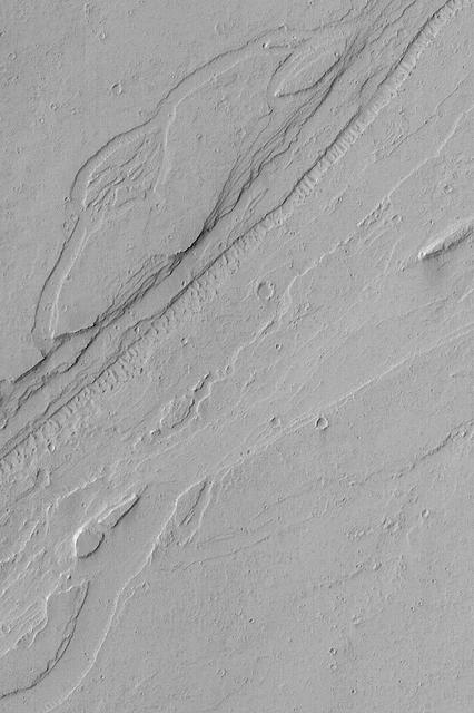
Fretted Terrain Valleys
Spirit West Valley Panorama
Fretted Terrain Valley
Valley near Olympus
Valley Near Phlegra Dorsa
Mars Water: Valley Networks
Valley near Ceraunius
Flow Along Valley Floors
Partially-Filled Valley
Inverted Valley in Arabia
Fretted Terrain Valley Floor
Moving Down Valley
Rippled Valley Floor
Fretted Terrain Valley
Dark Valley in Newton Crater
Between the Valleys of the Ancients

This frame from a movie from the Samford Valley Observatory in Brisbane, Australia, shows the progress of asteroid 2012 DA14 across the night sky as it nears its closest approach. It was taken at 12:59 UTC on Feb. 15 7:59 a.m. EST, or 4:59 a.m. PST.
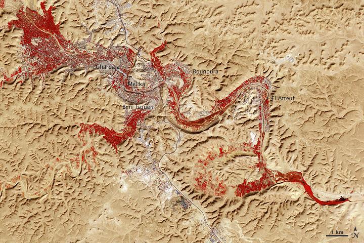
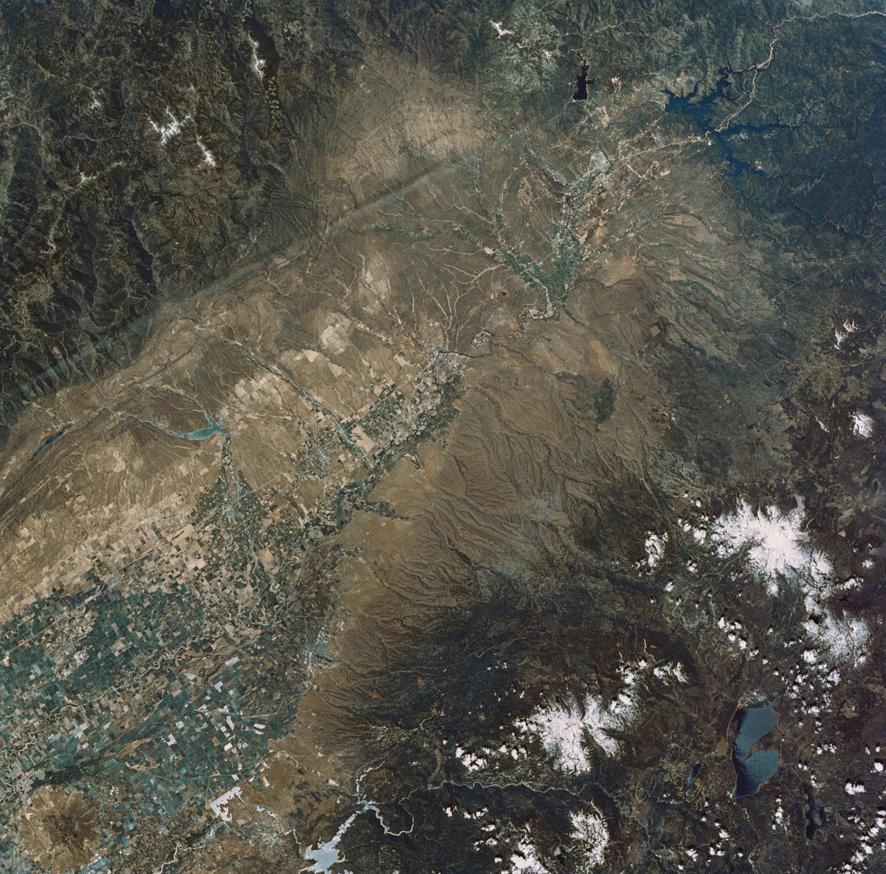
NASA image acquired Feb. 9, 2011 Less than 5 percent of Algeria’s land surface is suitable for growing crops, and most precipitation falls on the Atlas Mountains along the coast. Inland, dust-laden winds blow over rocky plains and sand seas. However, in north central Algeria—off the tip of Grand Erg Occidental and about 450 kilometers (280 miles) south of Algiers—lies a serpentine stretch of vegetation. It is the M’zab Valley, filled with palm groves and dotted with centuries-old settlements. The Advanced Spaceborne Thermal Emission and Reflection Radiometer (ASTER) on NASA’s Terra satellite captured this image of M’zab Valley on February 9, 2011. ASTER combines infrared, red, and green wavelengths of light. Bare rock ranges in color from beige to peach. Buildings and paved surfaces appear gray. Vegetation is red, and brighter shades of red indicate more robust vegetation. This oasis results from water that is otherwise in short supply in the Sahara Desert, thanks to the valley’s approximately 3,000 wells. Chemical analysis of Algerian aquifers, as well studies of topography in Algeria and Tunisia, suggest this region experienced a cooler climate in the late Pleistocene, and potentially heavy monsoon rains earlier in the Holocene. The M’zab region shows evidence of meandering rivers and pinnate drainage patterns. The vegetation lining M’zab Valley highlights this old river valley’s contours. Cool summer temperatures and monsoon rains had long since retreated from the region by eleventh century, but this valley nevertheless supported the establishment of multiple fortified settlements, or ksours. Between 1012 A.D. and 1350 A.D., locals established the ksours of El-Atteuf, Bounoura, Melika, Ghardaïa, and Beni-Isguen. Collectively these cities are now a United Nations Educational, Scientific, and Cultural Organization (UNESCO) World Heritage site. NASA Earth Observatory image by Robert Simmon and Jesse Allen, using data from the GSFC/METI/ERSDAC/JAROS, and U.S./Japan ASTER Science Team. Caption by Michon Scott. Instrument: Terra - ASTER <b>To download the full high res file go <a href="http://earthobservatory.nasa.gov/IOTD/view.php?id=51296" rel="nofollow"> here</a></b>
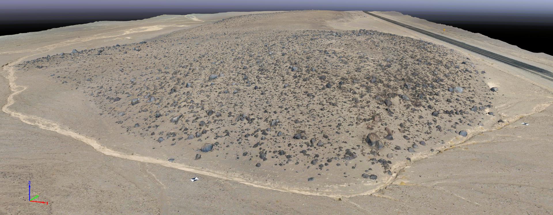
This rendering was created by research drones flying over Mars Hill, a region of Death Valley National Park that has been used by NASA’s Mars researchers since the 1970s, when the agency was preparing to land the twin Viking spacecraft. The hill’s rubbly, volcanic rock resembles the kind of inhospitable terrain that Mars rovers must navigate around and which posed a landing hazard for the Ingenuity Mars Helicopter. In September 2025, researchers from NASA’s Jet Propulsion Laboratory in Southern California flew research drones over Mars Hill as part of a test campaign to develop navigation software for future Mars rotorcraft. Being able to precisely land between rocks like those seen here is a critical capability to access similar Martian terrain in the future.
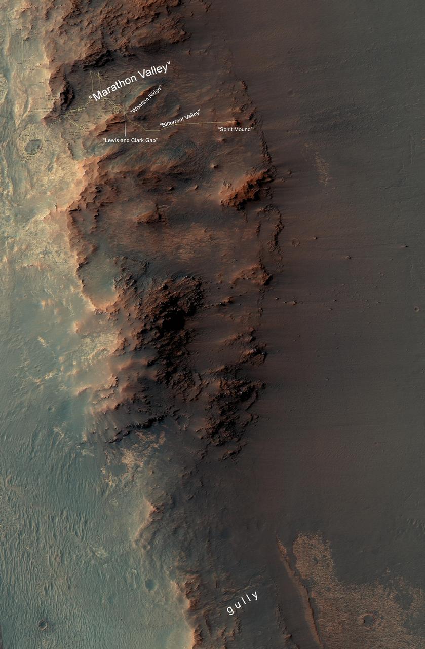
This map show a portion of Endeavour Crater's western rim that includes the "Marathon Valley" area investigated intensively by NASA's Mars Exploration Rover Opportunity in 2015 and 2016, and a fluid-carved gully that is a destination to the south for the mission. The width of the area covered in the map is about half a mile (about 800 meters). North is up. Opportunity entered the northern end of the mapped area in January 2015 and entered Marathon Valley in July 2015. A gold line on the map, which may not be visible without zooming into the image, shows the rover's route. Curiosity departed Marathon Valley in September 2016 by driving southward through "Lewis and Clark Gap" into "Bitterroot Valley." The gully near the south end of the map was incised into Endeavour's rim long ago by a fluid, possibly a water-lubricated debris flow or a flow with mostly water. Driving into this gully to learn more about that flow is one of the goals for a two-year mission extension taking Opportunity through September 2018. A map showing wider context of Opportunity's route from its January 2004 landing in Eagle Crater to Endeavour Crater and Marathon Valley is at PIA19154. The rover's traverse shown here has been mapped by Tim Parker of NASA's Jet Propulsion Laboratory, Pasadena, California, onto an image from the High Resolution Imaging Science Experiment (HiRISE) camera on NASA's Mars Reconnaissance Orbiter. http://photojournal.jpl.nasa.gov/catalog/PIA20854
This view combines several frames taken by NASA Mars rover Curiosity, looking into a valley to the west from the eastern side of a dune at the eastern end of the valley.
STS059-86-059 (9-20 April 1994) --- This oblique handheld Hasselblad 70mm photo shows Death Valley, near California's border with Nevada. The valley -- the central feature of Death Valley National Monument -- extends north to south for some 140 miles (225 kilometers). Hemmed in to the east by the Amargosa Range and to the west by the Panamints, its width varies from 5 to 15 miles (8 to 24 kilometers). Using Spaceborne Imaging Radar (SIR-C) and X-band Synthetic Aperture Radar (X-SAR) onboard the Space Shuttle Endeavour, the crew was able to record a great deal of data on this and other sites, as part of NASA's Mission to Planet Earth.
The McMurdo Dry Valleys are a row of valleys west of McMurdo Sound, Antarctica. They are so named because of their extremely low humidity and lack of snow and ice cover. This image was acquired December 8, 2002 by NASA Terra spacecraft.
The numerous valleys in this image captured by NASA 2001 Mars Odyssey spacecra are dissecting part of Aonia Terra.
Mars Fretted Terrain: Lineated Valley Fill
Ius Chasma Tributary Valleys and Adjacent Plains
Valleys and Lava Flows near Olympus Mons
Valleys on Northwest Flank of Alba Patera Volcano
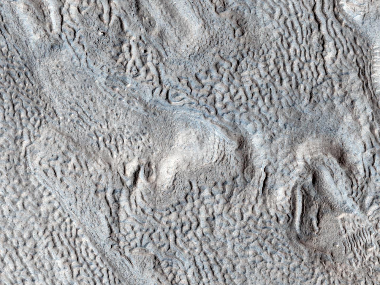
Ridges and Grooves That Wave and Buckle on a Valley Floor
Spirit West Valley Panorama False Color
Valleys on the Ejecta Blanket from Cerulli Crater
Fretted Terrain Valley in Coloe Fossae Region
Small Valley Network Near Schiaparelli Crater
Valley and Surrounding Terrain Adjacent to Schiaparelli Crater
This scene from NASA Mars Exploration Rover Opportunity looks upward at Knudsen Ridge on the southern edge of Marathon Valley from inside the valley.
STS059-S-026 (11 April 1994) --- This is an image of Death Valley, California, centered at 36.629 degrees north latitude, 117.069 degrees west longitude. The image shows Furnace Creek alluvial fan and Furnace Creek Ranch at the far right, and the sand dunes near Stove Pipe Wells at the center. The dark fork-shaped feature between Furnace Creek fan and the dunes is a smooth flood-plain which encloses Cottonball Basin. The SIR-C/X-SAR supersite is an area of extensive field investigations and has been visited by both Space Radar Lab astronaut crews. Elevations in the Valley range from 70 meters below sea level, the lowest in the United States, to more than 3300 meters above sea level. Scientists are using SIR-C/X-SAR data from Death Valley to help answer a number of different questions about the Earth's geology. One question concerns how alluvial fans are formed and change through time under the influence of climatic changes and earthquakes. Alluvial fans are gravel deposits that wash down from the mountains over time. They are visible in the image as circular, fan-shaped bright areas extending into the darker valley floor from the mountains. Information about the alluvial fans help scientists study Earth's ancient climate. Scientists know the fans are bulit up through climatic and tectonic processes and they will use the SIR-C/X-SAR data to understand the nature and rates of weathering processes on the fans, soil formation, and the transport of sand and dust by the wind. SIR-C/X-SAR's sensitivity to centimeter-scale (or inch-scale) roughness provides detailed maps of surface texture. Such information can be used to study the occurrence and movement of dust storms and sand dunes. the goal of these studies is to gain a better understanding of the record of past climatic changes and the effects of those changes on a sensitive environment. This may lead to a better ability to predict future response of the land to different potential global cimate-change scenarios. Death Valley is also one of the primary calibration sites for SIR-C/X-SAR. The bright dots near the center of the image are corner reflectors that have been set-up to calibrate the radar as the Shuttle passes overhead. Thirty triangular-shaped reflectors (they look like aluminum pyramids) have been deployed by the calibration team from JPL over a 40 kilometer by 40 kilometer area in and around Death Valley. The calibration team will also deploy transponders (electronic reflectors) and recievers to measure the radar signals from SIR-C/X-SAR on the ground. Spaceborne Imaging Radar-C and X-Synthetic Aperture Radar (SIR-C/X-SAR) is part of NASA's Mission to Planet Earth (MTPE). The radars illuminate Earth with microwaves allowing detailed observations at any time, regardless of weather or sunlight conditions. SIR-C/X-SAR uses three microwave wavelengths: L-Band (24 cm), C-Band (6 cm), and X-Band (3 cm). The multi-frequency data will be used by the international scientific community to better understand the global environment and how it is changing. The SIR-C/X-SAR data, complemented by aircraft and ground studies, will give scientists clearer insights into those environmental changes which are caused by nature and those changes which are induced by human activity. SIR-C was develpoed by NASA's Jet Propulsion Laboratory (JPL). X-SAR was developed by the Dornire and Alenia Spazio Companies for the German Space Agency, Deutsche Agentur fuer Raumfahrtangelegenheiten (DARA), and the Italian Space Agency, Agenzia Spaziale Italiana (ASI). JPL Photo ID: P-43883
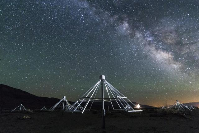
A nighttime shot shows some of the antennas of the Owens Valley Long Wavelength Array in California, with the center of our galaxy in the background. A video can be seen at https://www.youtube.com/watch?v=vXvHqyOaJrU&feature=youtu.be. http://photojournal.jpl.nasa.gov/catalog/PIA19336 Copyright: Gregg Hallinan

Pat Gaspard, a visitor relations specialist with NASA's StenniSphere visitor center, speaks to Mississippi Valley State University students. Gaspard spoke July 15 during Stennis Space Center's three-day educational outreach program at the college.
This view from NASA's Mars Exploration Rover Opportunity shows part of "Marathon Valley," a destination on the western rim of Endeavour Crater, as seen from an overlook north of the valley. The scene spans from east, at left, to southeast. It combines four pointings of the rover's panoramic camera (Pancam) on March 13, 2015, during the 3,958th Martian day, or sol, of Opportunity's work on Mars. The rover team selected Marathon Valley as a science destination because observations of this location using the Compact Reconnaissance Imaging Spectrometer for Mars (CRISM) instrument on NASA's Mars Reconnaissance Orbiter yielded evidence of clay minerals, a clue to ancient wet environments. By the time Opportunity explores Marathon Valley, the rover will have exceeded a total driving distance equivalent to an Olympic marathon. Opportunity has been exploring the Meridiani Planum region of Mars since January 2004. This version of the image is presented in approximate true color by combining exposures taken through three of the Pancam's color filters at each of the four camera pointings, using filters centered on wavelengths of 753 nanometers (near-infrared), 535 nanometers (green) and 432 nanometers (violet). http://photojournal.jpl.nasa.gov/catalog/PIA19151

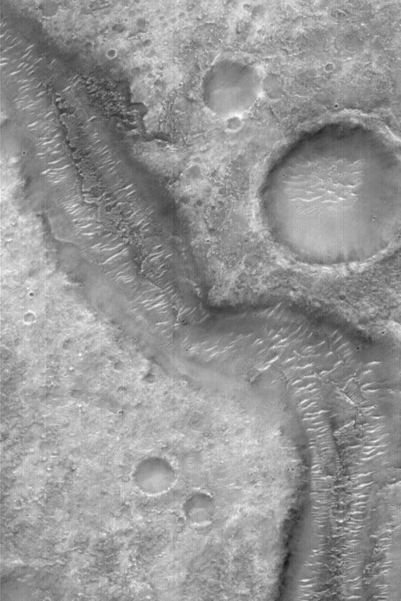
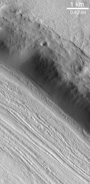
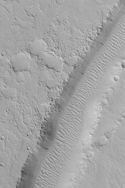
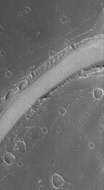
This image from NASA Mars Reconnaissance Orbiter shows a portion of a long valley system in northern Arabia Terra. The valley must be relatively young because it cuts through the ejecta of an impact crater that still retains it entire ejecta blanket, indicating the crater is also fairly young and fresh. The valley is interesting because it transitions to an inverted channel near its end point. Inverted channels form when a valley fills with materials. Later, erosion removes the surrounding terrain leaving behind higher standing and more resistant material that filled the valley. http://photojournal.jpl.nasa.gov/catalog/PIA19861
This scene in enhanced color from NASA Mars Exploration Rover Opportunity looks upward at Knudsen Ridge on the southern edge of Marathon Valley from inside the valley.

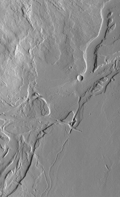
Many valleys occur all over Mars that reveal an extensive ancient history of liquid water erosion. This image from NASA Mars Reconnaissance Orbiter shows a complex valley network near Idaeus Fossae.
This image from NASA Curiosity Mars rover looks down the ramp at the northeastern end of Hidden Valley and across the sandy-floored valley to lower slopes of Mount Sharp on the horizon.

Silicon Valley technology Festival Paco Rafageles, left and Dr Pete Worden, Director Ames Research Center, right sign documents seal it with a hand shake.

Silicon Valley technology Festival Paco Rafageles, left and Dr Pete Worden, Director Ames Research Center, right sign documents.
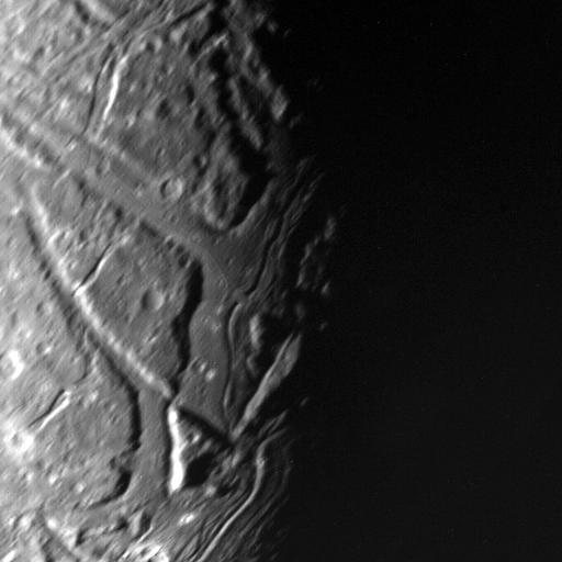
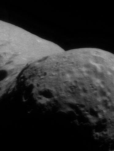
This NASA Voyager 2 view of Uranus moon Ariel terminator shows a complex array of transecting valleys with super-imposed impact craters.
This observation from NASA Mars Reconnaissance Orbiter shows enigmatic, shallowly incised valleys, found in some mid- to low-latitude regions on Mars.
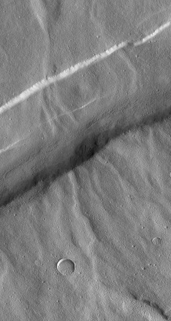
This relatively fresh, shallowly incised valley was once filled with water and/or ice and flowed to the west toward a large, local depression in northern Arabia Terra (36.5 degrees north, 0.3 degrees east). This type of valley is younger and distinct in appearance relative to the ancient valley networks that formed in the Martian highlands. Most fresh, shallow valleys like this one often appear as scattered and isolated or sparsely branched networks of individual valleys in the mid-latitudes and equatorial regions of Mars. The floor of the channel within this broader valley is covered with light-toned transverse aeolian ridges (3 kilometers across). http://photojournal.jpl.nasa.gov/catalog/PIA19301
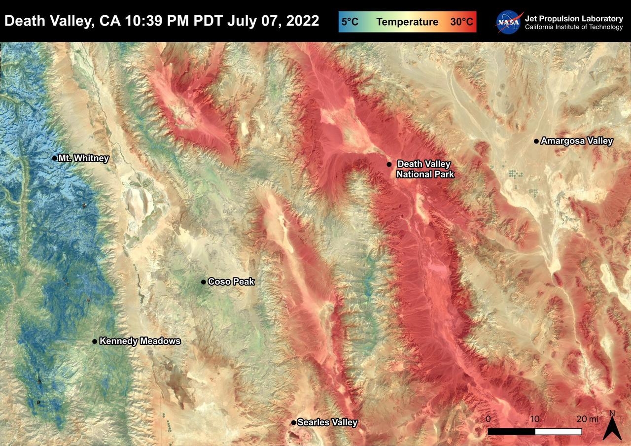
Death Valley, California is a desert valley in the Northern Mojave Desert. During the summer months, Death Valley can become one of the hottest places on Earth. Death Valley is about 85 miles from Mt. Whitney, the highest point in the contiguous United States with an elevation of 14,505 ft. This Land Surface Temperature image captured by ECOSTRESS on July 07, 2022 shows temperatures exceeding 90 degrees Fahrenheit in Death Valley and temperatures below 40 degrees Fahrenheit in the Sierra Nevada Mountain Range. ECOSTRESS is a thermal instrument on the International Space Station that measures the temperature of the ground, which is hotter than the air temperature during the day. It was launched to the space station in 2018. Its primary mission is to identify critical thresholds of water use and water stress in plants and to detect the timing, location, and predictive factors leading to plant water uptake decline and/or cessation. The nature of the high-resolution data provided by ECOSTRESS allows it to record heat related phenomena such as heat waves and wildfires. https://photojournal.jpl.nasa.gov/catalog/PIA25482
This stereo scene from NASA's Mars Exploration Rover Opportunity shows part of "Marathon Valley," a destination on the western rim of Endeavour Crater, as seen from an overlook north of the valley. The image combines views from the left eye and right eye of Opportunity's panoramic camera (Pancam) to appear three-dimensional when seen through blue-red glasses with the red lens on the left. The component Pancam images were taken on March 13, 2015, during the 3,958th Martian day, or sol, of Opportunity's work on Mars. The scene spans from east, at left, to southeast. The rover team selected Marathon Valley as a science destination because observations of this location using the Compact Reconnaissance Imaging Spectrometer for Mars (CRISM) instrument on NASA's Mars Reconnaissance Orbiter yielded evidence of clay minerals, a clue to ancient wet environments. By the time Opportunity explores Marathon Valley, the rover will have exceeded a total driving distance equivalent to an Olympic marathon. Opportunity has been exploring the Meridiani Planum region of Mars since January 2004. http://photojournal.jpl.nasa.gov/catalog/PIA19153
SL3-88-004 (July-September 1973) --- A vertical view of the Salinas River Valley area south of Monterey Bay, California area is seen in this Skylab 3 Earth Resources Experiments Package S190-B (five-inch Earth terrain camera) photograph taken from the Skylab space station in Earth orbit. The valley is an irrigated agricultural area, and is indicated by the dark-green and light-gray rectangular patterns in the centre of the picture. The city of Salinas is barely visible under the cloud cover at the top (north) end of the valley. The dark mass on the left (west) side of the valley is the Santa Lucia mountain range. The Big Sur area is on the left and partly covered by clouds. The Diablo Range forms the dark mass in the lower right (southeast) corner of the photograph. The town of Hollister is the gray area in the dark-green rectangular farm tracts which occupy the floor of the San Benito Valley in the upper right (northeast) corner of the photograph. The Salinas River flows northwestward toward Monterey Bay. The towns of Soledad, Greenfield and King City appear as gray areas along U.S. 101 in the Salinas Valley. The geology of the area is complex, and has been racked by several earthquakes resulting from movement along the San Andreas and subsidiary faults. Here, the surface expression of the San Andreas Fault can be traced from a point just west of Hollister at the contrast of dark brown and tan to a point about one inch left of the lower right (southeast) corner of the picture. Subsidiary faults are indicated by the curving trend of the rocks along the right side. The photograph will provide detailed information on land use patterns (Dr. R. Colwell, University of California, Berkeley) and fault tectonics (Dr. P. Merifield, Earth Science Res., Inc. and Dr. M. Abdel-Gawad, Rockwell International). Federal agencies participating with NASA on the EREP project are the Departments of Agriculture, Commerce, Interior, the Environmental Protection Agency and the Corps of Engineers. All EREP photography is available to the public through the Department of Interior’s Earth Resources Observations Systems Data Center, Sioux Falls, South Dakota, 57198. Photo credit: NASA
This view from within "Perseverance Valley," on the inner slope of the western rim of Endurance Crater on Mars, includes wheel tracks from the Opportunity rover's descent of the valley. The Panoramic Camera (Pancam) on Opportunity's mast took the component images of the scene during the period Sept. 4 through Oct. 6, 2017, corresponding to sols (Martian days) 4840 through 4871 of the rover's work on Mars. Perseverance Valley is a system of shallow troughs descending eastward about the length of two football fields from the crest of the crater rim to the floor of the crater. This panorama spans from northeast on the left to northwest on the right, including portions of the crater floor (eastward) in the left half and of the rim (westward) in the right half. Opportunity began descending Perseverance Valley in mid-2017 (see map) as part of an investigation into how the valley formed. Rover wheel tracks are darker brown, between two patches of bright bedrock, receding toward the horizon in the right half of the scene. This view combines multiple images taken through three different Pancam filters. The selected filters admit light centered on wavelengths of 753 nanometers (near-infrared), 535 nanometers (green) and 432 nanometers (violet). The three color bands are combined here to show approximately true color. A map and high-resolution TIFF file is available at https://photojournal.jpl.nasa.gov/catalog/PIA22074
Valley and Surrounding Terrain Adjacent to Schiaparelli Crater - High Resolution Image
Valley and Surrounding Terrain Adjacent to Schiaparelli Crater - High Resolution Image
This 3-D stereo view from NASA Mars rover Opportunity shows contrasting textures and colors of Hinners Point, at the northern edge of Marathon Valley, and swirling reddish zones on the valley floor to the left.
This stereo view from NASA Mars Exploration Rover Opportunity looks upward at Knudsen Ridge on the southern edge of Marathon Valley from inside the valley. You need 3-D glasses to view this image.
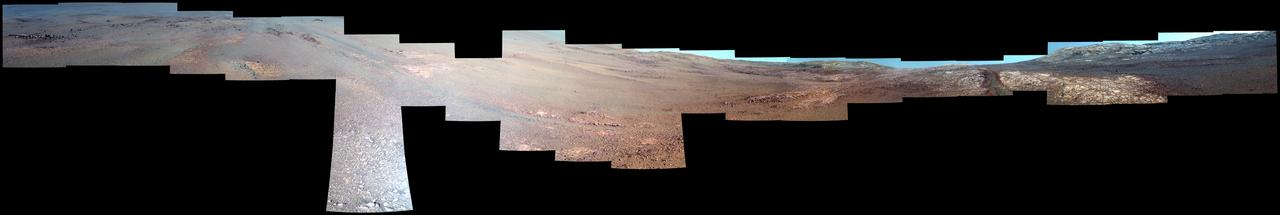
Textured rows on the ground in this portion of "Perseverance Valley" are under investigation by NASA's Mars Exploration Rover Opportunity, which used its Navigation Camera (Navcam) to take the component images of this downhill-looking scene. The rover took this image on Jan. 4, 2018, during the 4,958th Martian day, or sol, of its work on Mars, looking downhill from a position about one-third of the way down the valley. Perseverance Valley descends the inboard slope of the western rim of Endeavour Crater. A view on the same sol with the rover's front Hazard Avoidance Camera includes ground even closer to the rover at this site. Opportunity was still working close by as it reached the mission's Sol 5,000 (Feb. 16, 2018). In the portion of the valley seen here, soil and gravel have been shaped into a striped pattern in the foreground and partially bury outcrops visible in the midfield. The long dimensions of the stripes are approximately aligned with the downhill direction. The striped pattern resembles a type of feature on Earth (such as on Hawaii's Mauna Kea) that is caused by repeated cycles of freezing and thawing, though other possible origins are also under consideration for the pattern in Perseverance Valley. The view is spans from north on the left to east-southeast on the right. For scale, the foreground rock clump in the lower right is about 11 inches (28 centimeters) in width. https://photojournal.jpl.nasa.gov/catalog/PIA22217
This image shows Death Valley, California, centered at 36.629 degrees north latitude, 117.069 degrees west longitude.
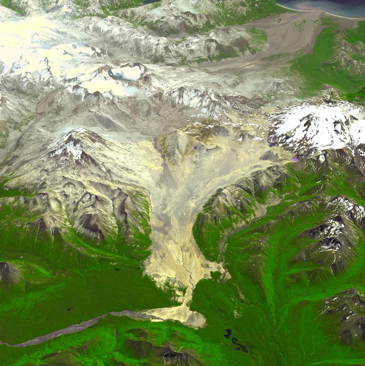
A devastating mudslide in the world-renowned Geyser Valley on the Kamchatka Peninsula virtually obliterated the natural wonder, forcing the emergency evacuation of visitors and national park personnel. This image was acquired by NASA Terra spacecraft.
Death Valley, Calif., has the lowest point in North America, Badwater at 85.5 meters 282 feet below sea level. It is also the driest and hottest location in North America. This image is from NASA Terra spacecraft.
Located 600 km south of Algiers, Algeria in the heart of the Sahara Desert, the five ksour fortified villages of the MZab Valley form an extraordinarily homogenous ensemble in this image captured by NASA Terra spacecraft.
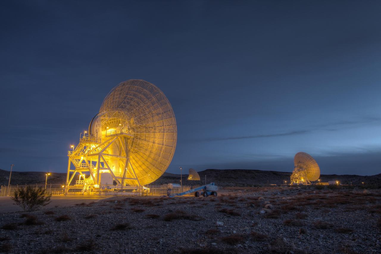
Beam Wave Guide antennas at Goldstone, known as the Beam Waveguide Cluster. They are located in an area at Goldstone called Apollo Valley. The Goldstone Deep Space Communications Complex is located in the Mojave Desert in California, USA.
SL2-04-179 (22 June 1973) --- The Sacramento Valley (40.5N, 121.5W) of California is the northern extension of the Central Valley, main agriculture region of the state. Hundreds of truck farms, vineyards and orchards can be seen throughout the length and breadth of the valley which was reclaimed from the desert by means of intensive and extensive irrigation projects. Photo credit: NASA
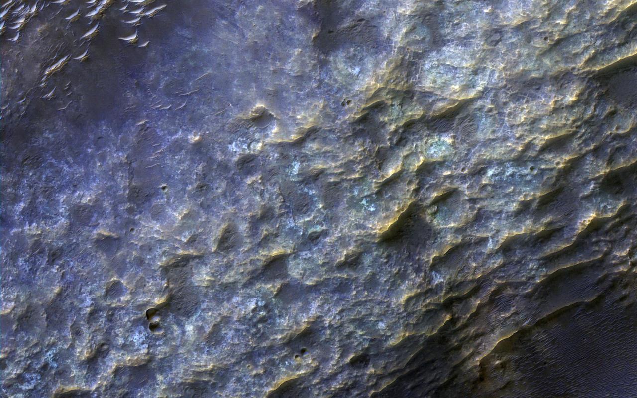
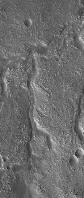
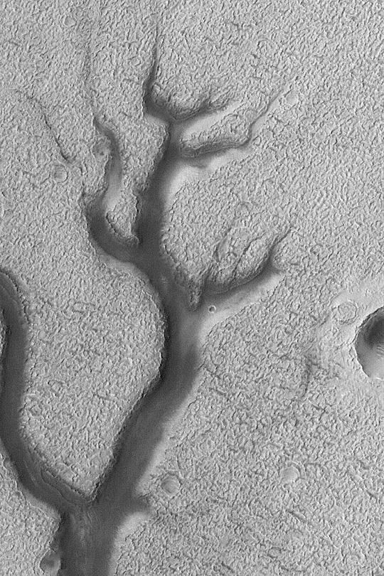
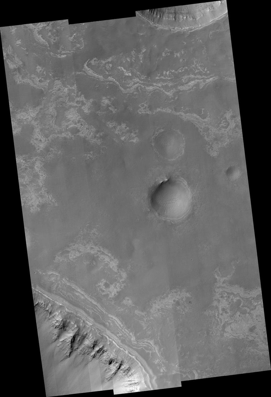
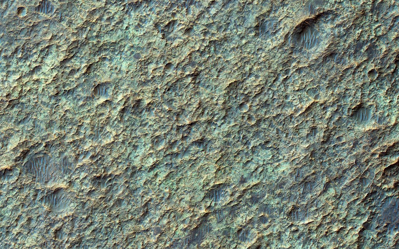
Most of the oldest terrains on Mars have eroded into branching valleys, as seen here in by NASA's Mars Reconnaisance Orbiter, much like many land regions of Earth are eroded by rain and snowmelt runoff. This is the primary evidence for major climate change on Mars billions of years ago. How the climate of Mars could have supported a warmer and wetter environment has been the subject of scientific debates for 40 years. A full-resolution enhanced color closeup reveals details in the bedrock and dunes on the valley floor (upper left). The bedrock of ancient Mars has been hardened and cemented by groundwater. https://photojournal.jpl.nasa.gov/catalog/PIA21630
This view from NASA's Mars Exploration Rover Opportunity shows part of "Marathon Valley," a destination on the western rim of Endeavour Crater, as seen from an overlook north of the valley. In this version of the image, the landscape is presented in false color to make differences in surface materials more easily visible. The scene spans from east, at left, to southeast. It combines four pointings of the rover's panoramic camera (Pancam) on March 13, 2015, during the 3,958th Martian day, or sol, of Opportunity's work on Mars. The rover team selected Marathon Valley as a science destination because observations of this location using the Compact Reconnaissance Imaging Spectrometer for Mars (CRISM) instrument on NASA's Mars Reconnaissance Orbiter yielded evidence of clay minerals, a clue to ancient wet environments. By the time Opportunity explores Marathon Valley, the rover will have exceeded a total driving distance equivalent to an Olympic marathon. Opportunity has been exploring the Meridiani Planum region of Mars since January 2004. The image combines exposures taken through three of the Pancam's color filters at each of the four camera pointings, using filters centered on wavelengths of 753 nanometers (near-infrared), 535 nanometers (green) and 432 nanometers (violet). http://photojournal.jpl.nasa.gov/catalog/PIA19152
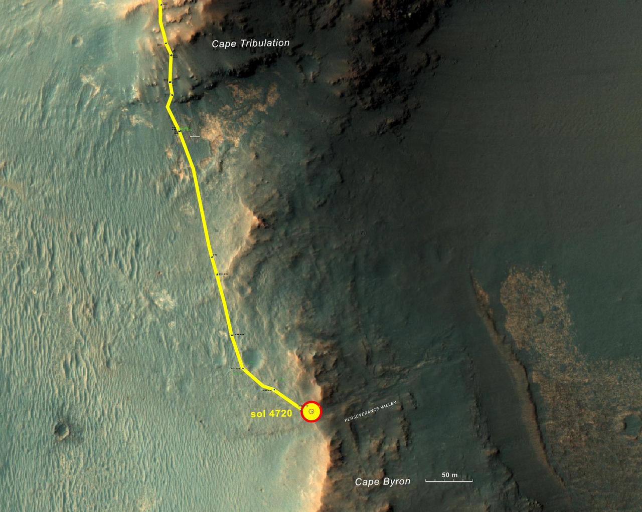
This graphic shows the route that NASA's Mars Exploration Rover Opportunity drove in its final approach to 'Perseverance Valley' on the western rim of Endeavour Crater. The map covers an area about four-tenths of a mile (two-thirds of a kilometer) wide, with the interior of the crater on the right. Opportunity entered this mapped area from the north along the gold traverse line on March 21, 2017, approaching the southern tip of the "Cape Tribulation" segment of Endeavour's rim. It reached the top of "Perseverance Valley" with a drive on Sol 4720 (the 4,720th Martian day) of the mission, on May 4, 2017. https://photojournal.jpl.nasa.gov/catalog/PIA21496
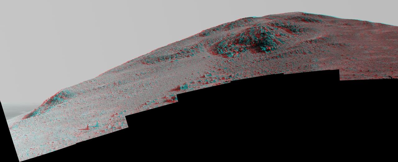
This Martian scene shows contrasting textures and colors of "Hinners Point," at the northern edge of "Marathon Valley," and swirling reddish zones on the valley floor to the left. The view combines six frames taken by the panoramic camera (Pancam) on NASA's Mars Exploration Rover Opportunity on Aug. 14, 2015, during the 4,108th Martian day, or sol, of the rover's work on Mars. The summit takes its informal name as a tribute to Noel Hinners (1935-2014). For NASA's Apollo program, Hinners played important roles in selection of landing sites on the moon and scientific training of astronauts. He then served as NASA associate administrator for space science, director of the Smithsonian National Air and Space Museum, director of NASA's Goddard Space Flight Center, NASA chief scientist and associate deputy administrator of NASA. Subsequent to responsibility for the Viking Mars missions while at NASA, he spent the latter part of his career as vice president for flight systems at Lockheed Martin, where he had responsibility for the company's roles in development and operation of NASA's Mars Global Surveyor, Mars Reconnaissance Orbiter, Mars Odyssey, Phoenix Mars Lander, Stardust and Genesis missions. Marathon Valley cuts generally east-west through the western rim of Endeavour Crater. The valley's name refers to the distance Opportunity drove from its 2004 landing site to arrival at this location in 2014. The valley was a high-priority destination for the rover mission because observations from orbit detected clay minerals there. Dark rocks on Hinners Point show a pattern dipping downward toward the interior of Endeavour, to the right from this viewing angle. The strong dip may have resulted from the violence of the impact event that excavated the crater. Brighter rocks make up the valley floor. The reddish zones there may be areas where water has altered composition. Inspections by Opportunity have found compositions there are higher in silica and lower in iron than the typical composition of rocks on Endeavour's rim. The scene spans from west-southwest at left to northwest at right. The larger of two stones close to each other in the foreground left of center is about 5 inches (12 centimeters) wide. On bright bedrock to the right of those stones, Opportunity inspected a target informally named "Pvt. George Gibson." Another inspected target, "Pvt. Silas Goodrich," is on the valley floor near the left edge of this scene. The informal names for these targets refer to members of the Lewis and Clark expedition's Corps of Discovery. This version of the image is presented in approximate true color by combing exposures taken through three of the Pancam's color filters, centered on wavelengths of 753 nanometers (near-infrared), 535 nanometers (green) and 432 nanometers (violet). http://photojournal.jpl.nasa.gov/catalog/PIA19819
"Marathon Valley" on Mars opens northeastward to a view across the floor of Endeavour Crater in this scene from the panoramic camera (Pancam) of NASA's Mars Exploration Rover Opportunity. The scene merges multiple Pancam exposures taken during the period April 16 through May 15, 2016, corresponding to sols (Martian days) 4,347 through 4,375 of Opportunity's work on Mars. It spans from north, at the left, to west-southwest, at the right. The high point in the right half of the scene is "Knudsen Ridge," which forms part of the southern edge of Marathon Valley. Portions of the northeastern and eastern rim of Endeavour crater appear on the distant horizon. Endeavour Crater is 14 miles (22 kilometers) in diameter. The fractured texture of Marathon Valley's floor is visible in the foreground. The view merges exposures taken through three of the Pancam's color filters, centered on wavelengths of 753 nanometers (near-infrared), 535 nanometers (green) and 432 nanometers (violet). It is presented in approximately true color. The rover team calls this image the mission's "Sacagawea Panorama," for the Lemhi Shoshone woman, also commemorated on U.S. dollar coins, whose assistance to the Lewis and Clark expedition helped enable its successes in 1804-1806. Many rocks and other features in Marathon Valley were informally named for members of Lewis and Clark's "Corps of Discovery" expedition. Opportunity entered Marathon Valley in July 2015. The valley's informal name was chosen because Opportunity's arrival at this point along the western rim of Endeavour Crater coincided closely with the rover surpassing marathon-footrace distance in its total driving odometry since landing on Mars in January 2004. The team's planned investigations in the valley were nearing completion when the component images for this scene were taken. http://photojournal.jpl.nasa.gov/catalog/PIA20749
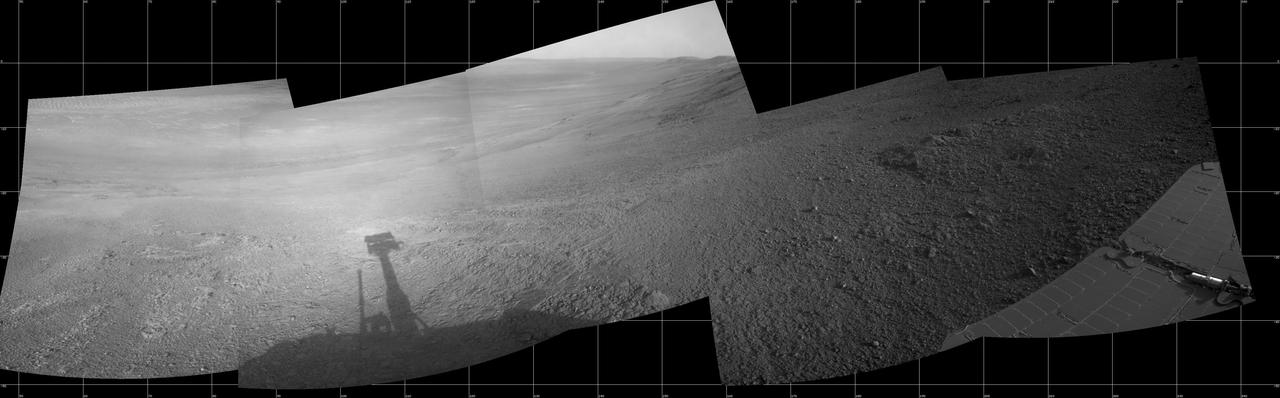
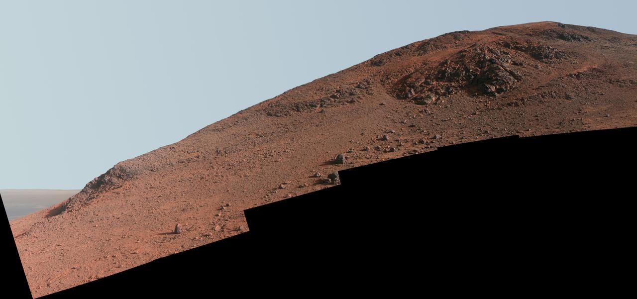
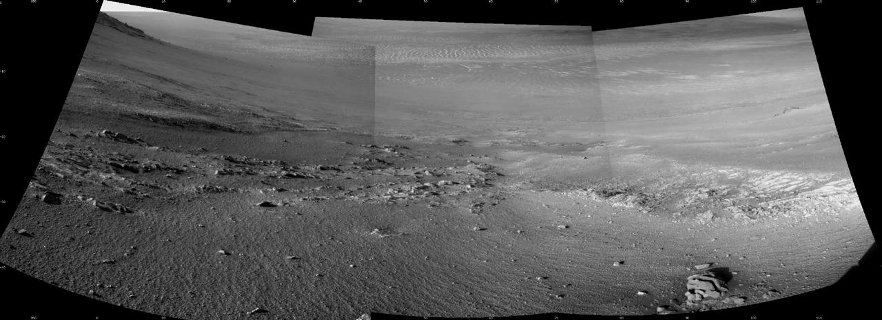
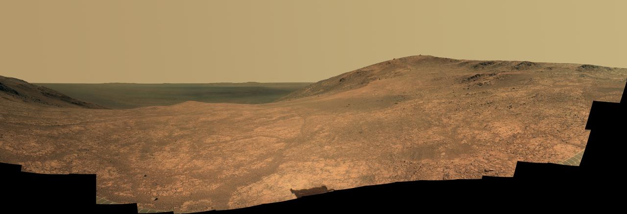
This mosaic scene combining five images from the navigation camera (Navcam) on NASA's Mars Exploration Rover Opportunity shows a view from inside the upper end of "Perseverance Valley" on the inner slope of Endeavour Crater's western rim. The valley is the main destination for the current two-year extension of the 13-year-old Opportunity mission on Mars. It was likely carved long ago by a fluid, such as water, water-lubricated debris or wind. The rover team is using Opportunity to learn more about the processes that shaped the valley. Plans call for driving the rover down the full length of the valley, about twice the length of a football field. Opportunity entered the top end of Perseverance Valley after studying the area just outside the crater rim above the valley during the spring and early summer of 2017. The images combined into this scene were taken on July 7, 2017, during the 4,782nd Martian day, or sol, of the rover's work on Mars. Opportunity had driven about 45 feet (13.8 meters) earlier that same sol. The portion of this scene to the left of the shadow of the rover's mast shows Perseverance Valley descending to the floor of Endeavour Crater. Foreground areas in the middle and right sections of the scene shows terrain details in the upper end of the valley. More distant in the center section, the rim of Endeavour Crater extends southeastward. The full scene spans from northeast at left to southwest at right. https://photojournal.jpl.nasa.gov/catalog/PIA21724
This enhanced-color view from within "Perseverance Valley," on the inner slope of the western rim of Endurance Crater on Mars, includes wheel tracks from the Opportunity rover's descent of the valley. The Panoramic Camera (Pancam) on Opportunity's mast took the component images of the scene during the period Sept. 4 through Oct. 6, 2017, corresponding to sols (Martian days) 4840 through 4871 of the rover's work on Mars. Perseverance Valley is a system of shallow troughs descending eastward about the length of two football fields from the crest of the crater rim to the floor of the crater. This panorama spans from northeast on the left to northwest on the right, including portions of the crater floor (eastward) in the left half and of the rim (westward) in the right half. Opportunity began descending Perseverance Valley in mid-2017 (see map) as part of an investigation into how the valley formed. Rover wheel tracks are darker brown, between two patches of bright bedrock, receding toward the horizon in the right half of the scene. This view combines multiple images taken through three different Pancam filters. The selected filters admit light centered on wavelengths of 753 nanometers (near-infrared), 535 nanometers (green) and 432 nanometers (violet). The three color bands are combined here with enhancement to make differences in surface materials easier to see. A map and full-resolution TIFF file are available at https://photojournal.jpl.nasa.gov/catalog/PIA22073
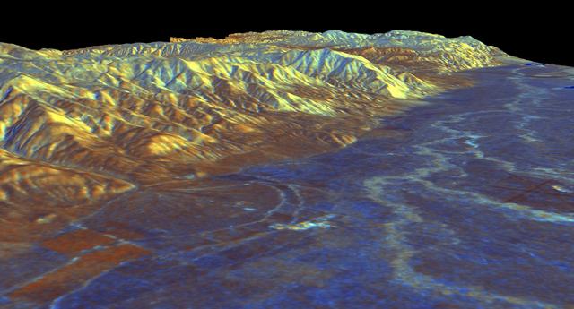
This is a three-dimensional perspective view of Owens Valley, near the town of Bishop, California that was created by combining two spaceborne radar images using a technique known as interferometry.
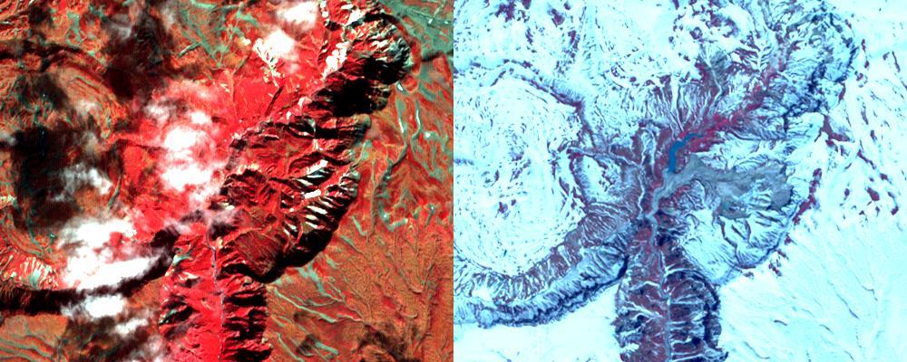
This image from NASA Mars Reconnaissance Orbiter spacecraft the valley networks on Mars are terrains eroded by flowing water billions of years ago. Where bedrock is well exposed, a variety of colors due to altered minerals and polygonal patterns.
This image acquired by NASA Terra spacecraft is of the Valley of Ten Thousand Smokes. Located in Katmai National Park, Alaska, the park is filled with ash flows from the 1912 eruption of Novarupta.
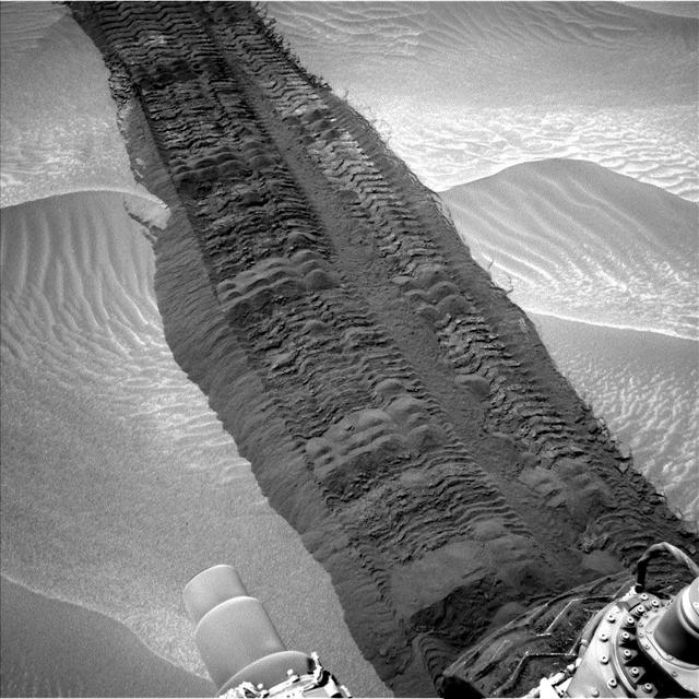
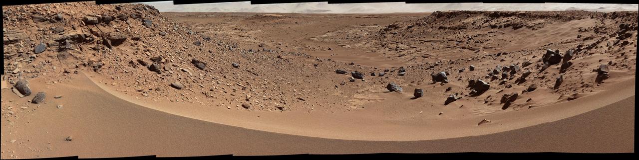
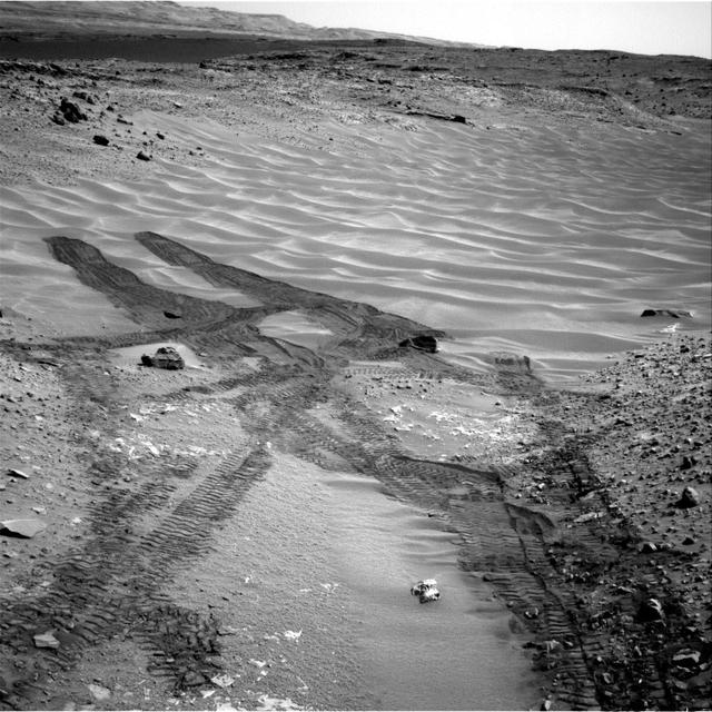
This image, taken on Aug. 4, 2014, from the Navigation Camera on NASA Curiosity Mars rover shows wheel tracks printed by the rover as it drove on the sandy floor of a lowland called Hidden Valley on the route toward Mount Sharp.