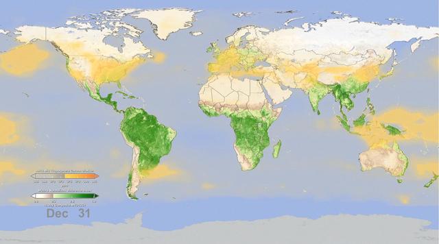
In this frame from an animation, NASA instruments show the seasonal cycle of vegetation and the concentration of carbon dioxide in the atmosphere.
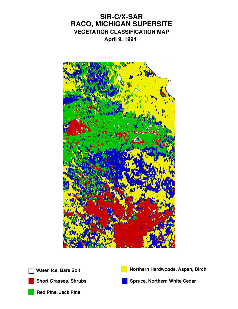
This is a vegetation map of the Raco, Michigan area produced from data acquired by NASA Spaceborne Imaging Radar C/X-Band Synthetic Aperture Radar SIR-C/X-SAR onboard space shuttle Endeavour.

ISS023-E-041808 (16 May 2010) --- NASA astronaut T.J. Creamer, Expedition 23 flight engineer, is pictured near fresh vegetables floating freely in the Unity node of the International Space Station while space shuttle Atlantis (STS-132) remains docked with the station.
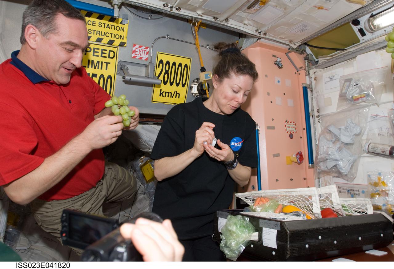
ISS023-E-041820 (16 May 2010) --- Russian cosmonaut Alexander Skvortsov and NASA astronaut Tracy Caldwell Dyson, both Expedition 23 flight engineers, enjoy fresh fruit and vegetables in the Unity node of the International Space Station while space shuttle Atlantis (STS-132) remains docked with the station.
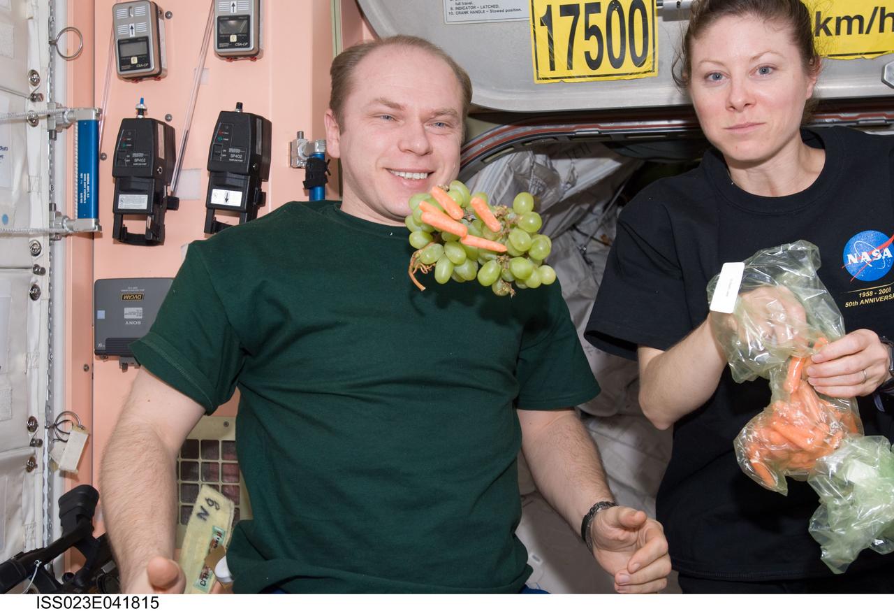
ISS023-E-041815 (16 May 2010) --- Russian cosmonaut Oleg Kotov, Expedition 23 commander; and NASA astronaut Tracy Caldwell Dyson, flight engineer, are pictured near fresh fruit and vegetables floating freely in the Unity node of the International Space Station while space shuttle Atlantis (STS-132) remains docked with the station.
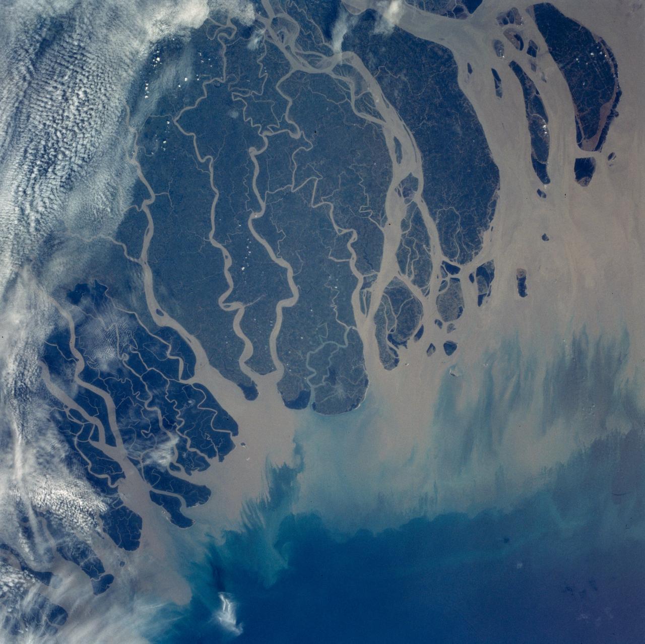
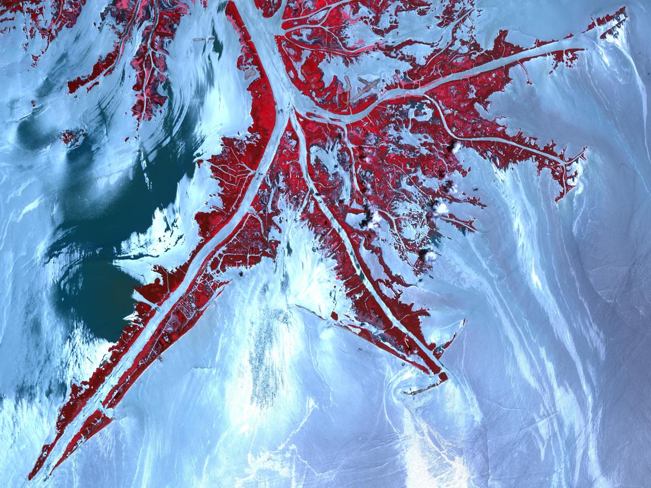
The Ganges River Delta is the largest inter-tidal delta in the world. With its extensive mangrove mud flats, swamp vegetation and sand dunes, it is characteristic of many tropical and subtropical coasts. As seen in this photograph, the tributaries and distributaries of the Ganges and Brahmaputra Rivers deposit huge amounts of silt and clay that create a shifting maze of waterways and islands in the Bay of Bengal.
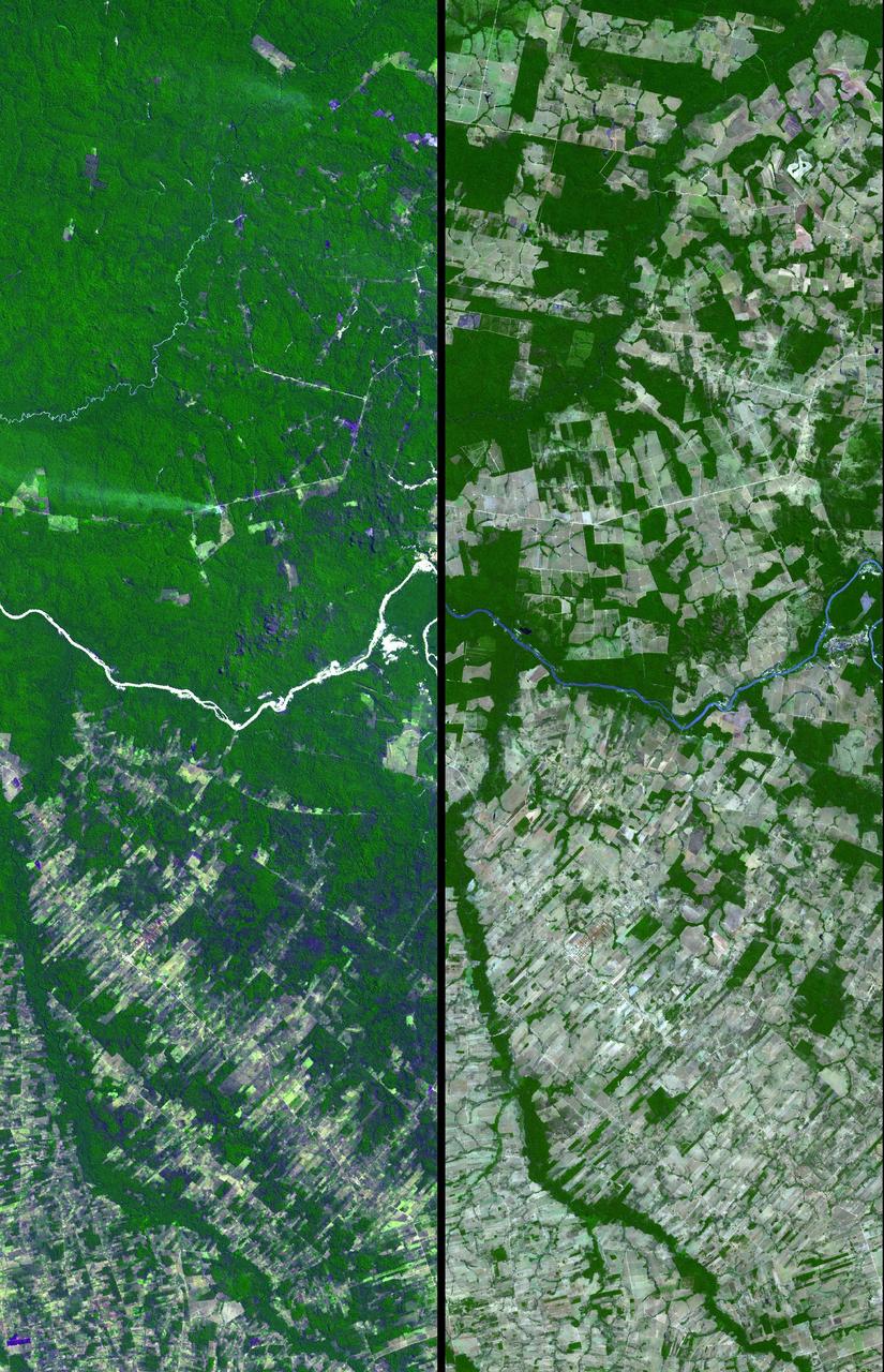
Dense green vegetation gives way to pale fields in these satellite images of deforestation in Brazil Amazon rainforest. This image is from NASA Terra satellite.
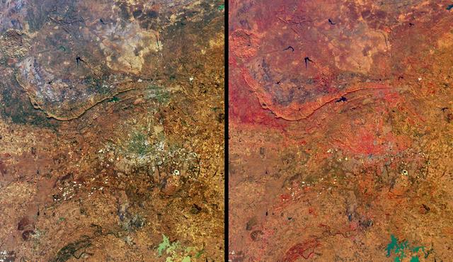
These views from NASA Terra satellite highlight a number of the land use, vegetation, and geological features found Johannesburg, Gauteng Province, South Africa.
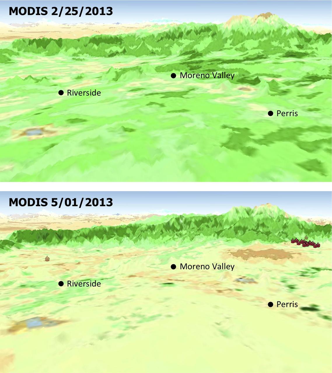
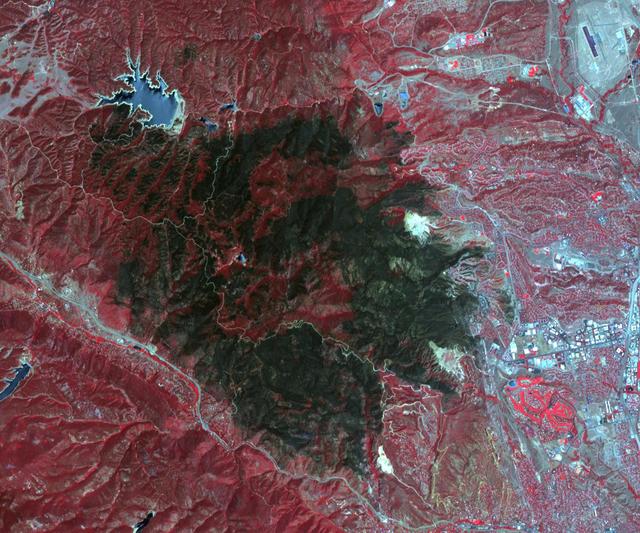
The quick dry-out of vegetation in Southern California this year is depicted in this pair of images from the Moderate Resolution Imaging Spectroradiometer MODIS sensor on NASA Aqua spacecraft.
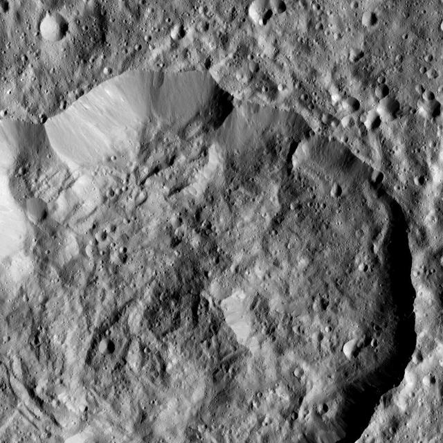
Ninsar Crater, in the northern hemisphere of Ceres, is seen this view from NASA Dawn spacecraft. Ninsar was named for a Sumerian goddess of plants and vegetation.
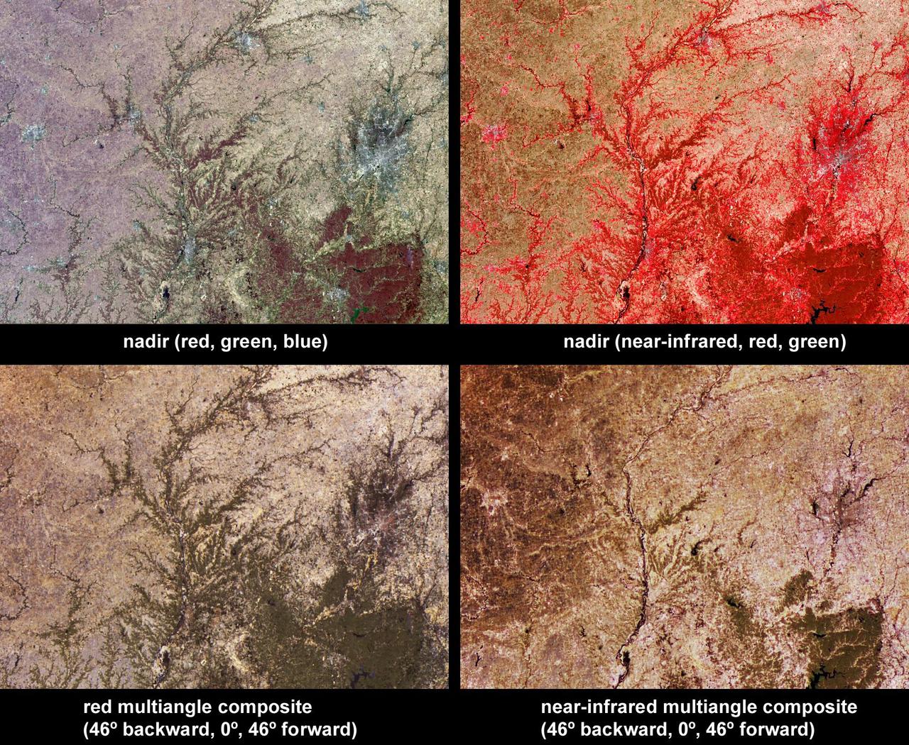
Vegetation across southeast Illinois and central Indiana is shown in this set of multispectral and multiangle images from NASA Terra spacecraft, captured on April 5, 2004.
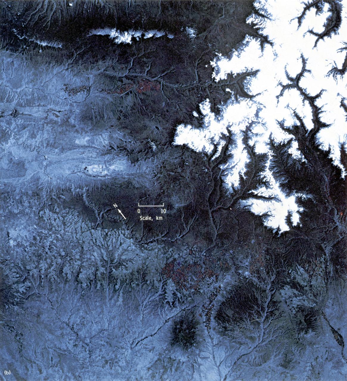
This EREP color infrared photograph of the Uncompahgre Plateau area of Colorado was taken in June of 1973 by the Earth Terrain Camera (Skylab EREP Experiment S190B) of the Skylab's Multi-spectral Photographic Facility during the Skylab-2 mission. Skylab stereoscopic data provided the best identification of vegetation complexes and delineation of vegetation boundaries, particularly in areas where changes in relief were related to changes in vegetation type (a common occurrence in wild-land vegetation communities).

SL4-93-167 (February 1974) --- A vertical view of the Kennedy Space Center and the Florida Atlantic coast area is seen in this Skylab 4 Earth Resources Experiments Package S190-B (five-inch earth terrain camera) infrared photography taken from the Skylab space station in Earth orbit. This photograph shows the major land-ocean features of the Florida coast near Vero Beach northward to Cape Canaveral and the KSC complex. The launch pads for the Skylab missions are clearly visible. Identification of living vegetation is possible through the use of the color infrared film. Various shades of red portray differences in the vegetation such as shown in the patterns in the agricultural area near Vero Beach. In the Kennedy Space Center, the nearly continuous and uniform red color shows that most of the land areas are heavily vegetated. The white coastal beach areas are strongly contrasted to the red land and the blue Atlantic Ocean. Old dunal areas in KSC are visible on Merritt Island which is separated from the Launch areas by the Banana River and the mainland by the Indian River. Federal and state highways and numerous causeways over the rivers are easily identified. The Florida mainland is partly shadowed by small white clouds which cast a pronounced shadow to the east of each cloud indicated the Sun is west of solar noon. Federal agencies participating with NASA on the EREP project are the Departments of Agriculture, Commerce, Interior, the Environmental Protection Agency and the Core of Engineers. All EREP photography is available to the public through the Department of Interior's Earth Resources Observations Systems Data Center, Sioux Falls, South Dakota, 57198. Photo credit: NASA
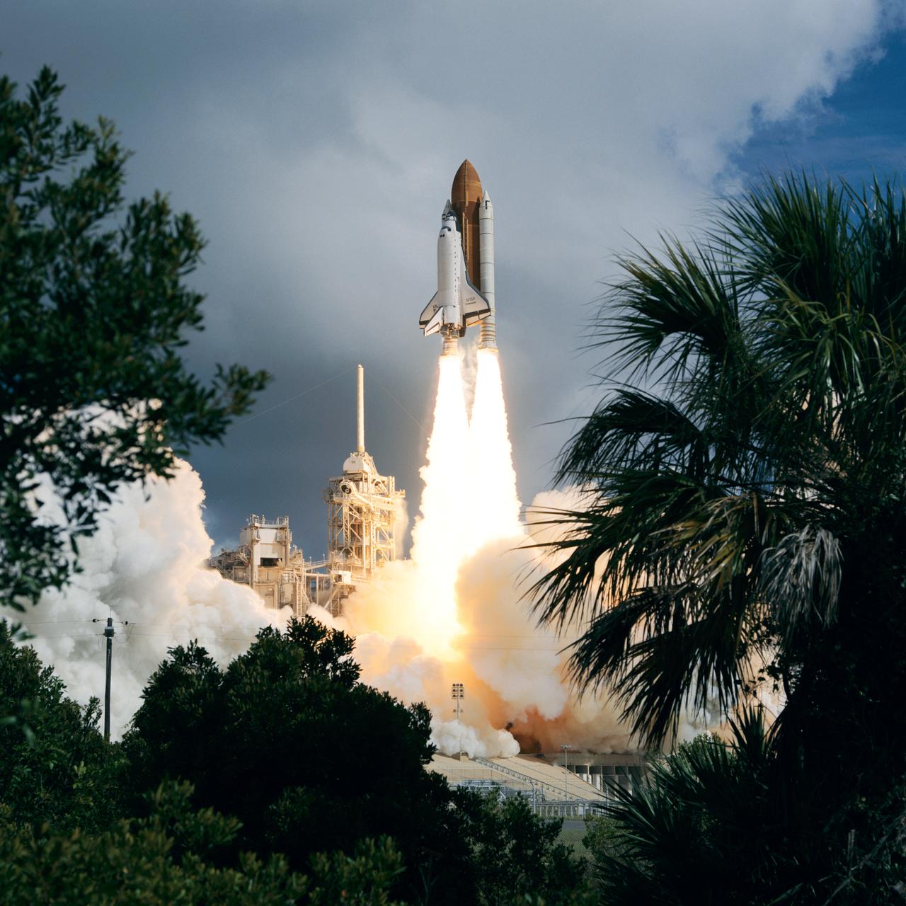
STS057-S-055 (21 June 1993) --- Framed by a variety of flora types, the Space Shuttle Endeavour lifts off Launch Pad 39B to begin the STS-57 mission. Launch occurred at 9:07:22 a.m. (EDT), June 21, 1993. The mission represents the first flight of the commercially developed SPACEHAB laboratory module and also will feature a retrieval of the European Retrievable Carrier (EURECA). Onboard for Endeavour's fourth flight are a crew of six - Ronald J. Grabe, mission commander; Brian Duffy, pilot; G. David Low, payload commander; and Nancy J. Sherlock, Peter J.K. (Jeff) Wisoff and Janice E. Voss, all mission specialists. An earlier launch attempt was scrubbed due to unacceptable weather conditions both at KSC and the overseas contingency landing sites.

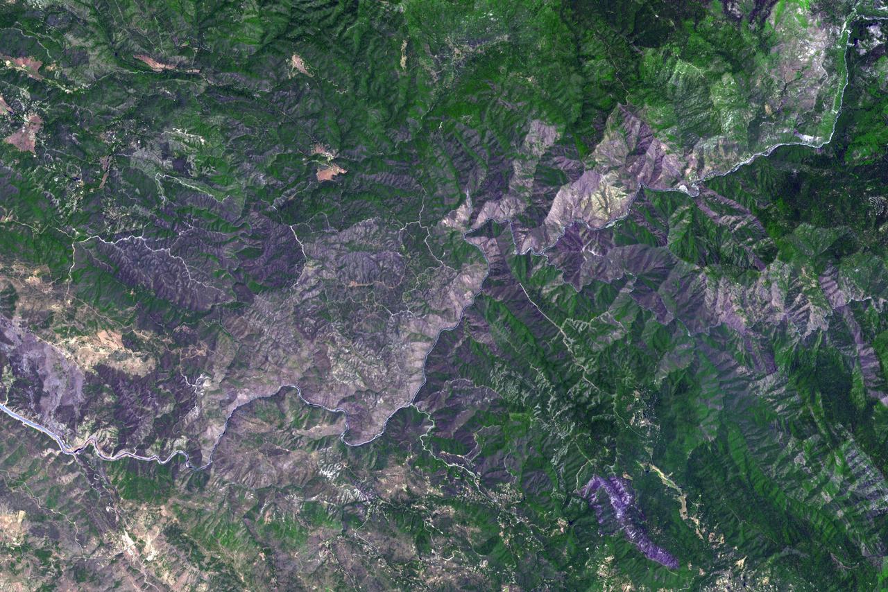
This image from NASA Terra spacecraft highlights the epicenter of a powerful magnitude 6.6 earthquake which struck Sichuan Province in southwest China on April 20, 2013. Vegetation is displayed in red; clouds and snow are in white.
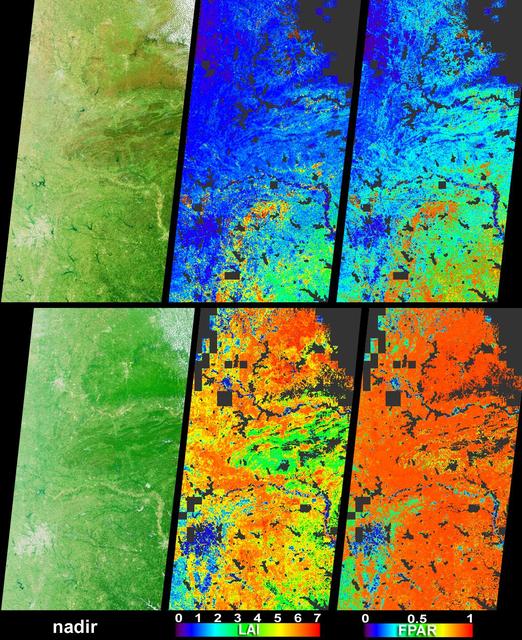
Vigorous vegetation growth in the Southern United States after heavy rains fell during April and early May, 2004, is quantified in these images and data products from NASA Terra spacecraft.
Oil from the Deepwater Horizon spill laps around the mouth of the Mississippi River Delta in this May 24, 2010, image from NASA Terra spacecraft. The oil appears silver, while vegetation is red.
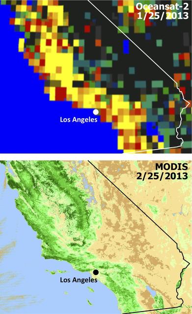
Extensive and persistent rains between Jan. 24 and Jan. 27, 2013, significantly increased soil moisture and enhanced vegetation growth in Southern California based on data from NASA Aqua spacecraft and ISRO Oceansat-2 satellite.
In this simulated natural color image of Huron, South Dakota, captured by NASA Terra spacecraft on March 20, 2010, frozen lakes and ponds appear blue, bare fields are tan, and fields with minor vegetation are gray-green.
This image, acquired by NASA Terra spacecraft, is of the Carstens, Calif. wildfire which continues to burn in the foothills west of Yosemite National Park. Vegetation is displayed in green and burned and bare areas are dark to light gray.
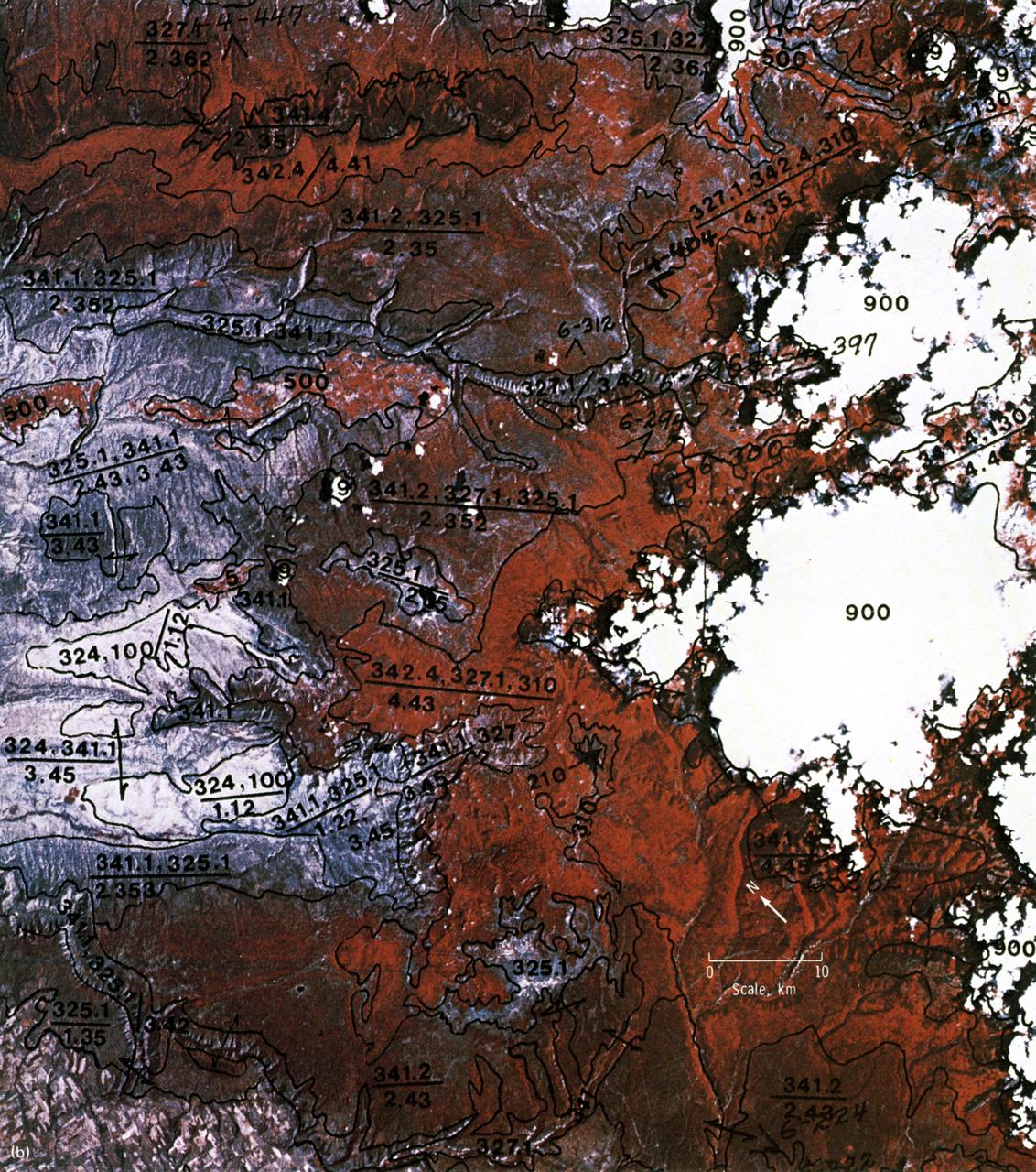
This EREP photograph of the Uncompahgre Plateau area of Colorado illustrates the land use classification using the hierarchical numbering system to depict land forms and vegetative patterns. The numerator is a three-digit number with decimal components identifying the vegetation analog or land use conditions. The denominator uses a three-component decimal system for landscape characterization.
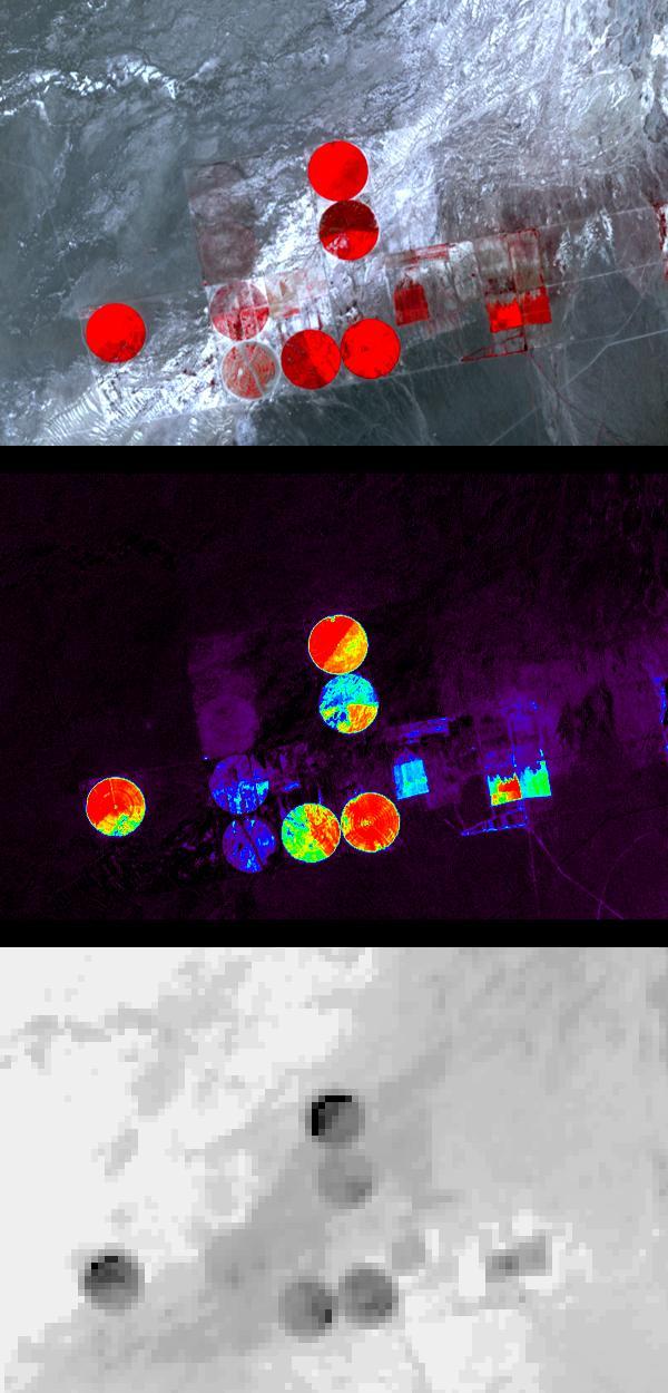
Information from images of Railroad Valley, Nevada captured on August 17, 2001 by the Advanced Spaceborne Thermal Emission and Reflection Radiometer (ASTER) may provide a powerful tool for monitoring crop health and maintenance procedures. These images cover an area of north central Nevada. The top image shows irrigated fields, with healthy vegetation in red. The middle image highlights the amount of vegetation. The color code shows highest vegetation content in red, orange, yellow, green, blue, and purple and the lowest in black. The final image is a thermal infrared channel, with warmer temperatures in white and colder in black. In the thermal image, the northernmost and westernmost fields are markedly colder on their northwest areas, even though no differences are seen in the visible image or the second, Vegetation Index image. This can be attributed to the presence of excess water, which can lead to crop damage. http://photojournal.jpl.nasa.gov/catalog/PIA03463
NASA's Advanced Spaceborne Thermal Emission and Reflection Radiometer (ASTER) instrument imaged areas burned by the Bighorn Fire north of Tucson, Arizona, on June 29. In the image, vegetation is shown in red and burned areas are shown in dark gray. It covers an area of 20 by 30 miles (33 by 48 kilometers). https://photojournal.jpl.nasa.gov/catalog/PIA23691

SL4-93-153 (February 1974) --- A vertical view of the Birmingham and central Alabama area is seen in this Skylab 4 Earth Resources Experiments Package S190-B (five-inch earth terrain camera) infrared photographed taken from the Skylab space station in Earth orbit. Illustrated here is the utility of color infrared film in depicting distribution of living vegetation in the 3,600 square mile Birmingham region. The Birmingham industrial complex, with a population of nearly 850,000, is the light gray area nestled in the valley between the northeast-trending ridges that are prominent topographic features in the southern Appalachian Mountains. The narrow ridges and adjacent valleys reflect folded and faulted sedimentary rocks, indicating the complex geological history of the region. Two major rivers and several reservoirs are easily distinguished in this photograph. Bankhand Lake, formed by a dam on the Black Warrior River, appears as bright blue west of Birmingham. Two lakes are formed by dams on the Goosa River east of Birmingham. Federal and state highways appear as thin white lines and are easily identified. Interstate 65 to Montgomery is the prominent white line extending southward from Birmingham. Power line clearings are visible in the center of the picture along the Goosa River, and can be traced northwestward to northern parts of Birmingham. The predominant deep red color of the picture is due to the reflections from living vegetation. In contrast are the light tan areas that commonly occur as rectangular patterns in the east part of the photograph and represent mature agricultural crops or grazing lands. Analysis of the photographic data from the earth terrain camera will be conducted by Dr. H. Jayroe of the Marshall Space Flight Center in developing analytical techniques. All EREP photography is available to the public through the Department of Interior's Earth Resources Observations Systems Data Center, Sioux Falls, South Dakota, 57198. Photo credit: NASA
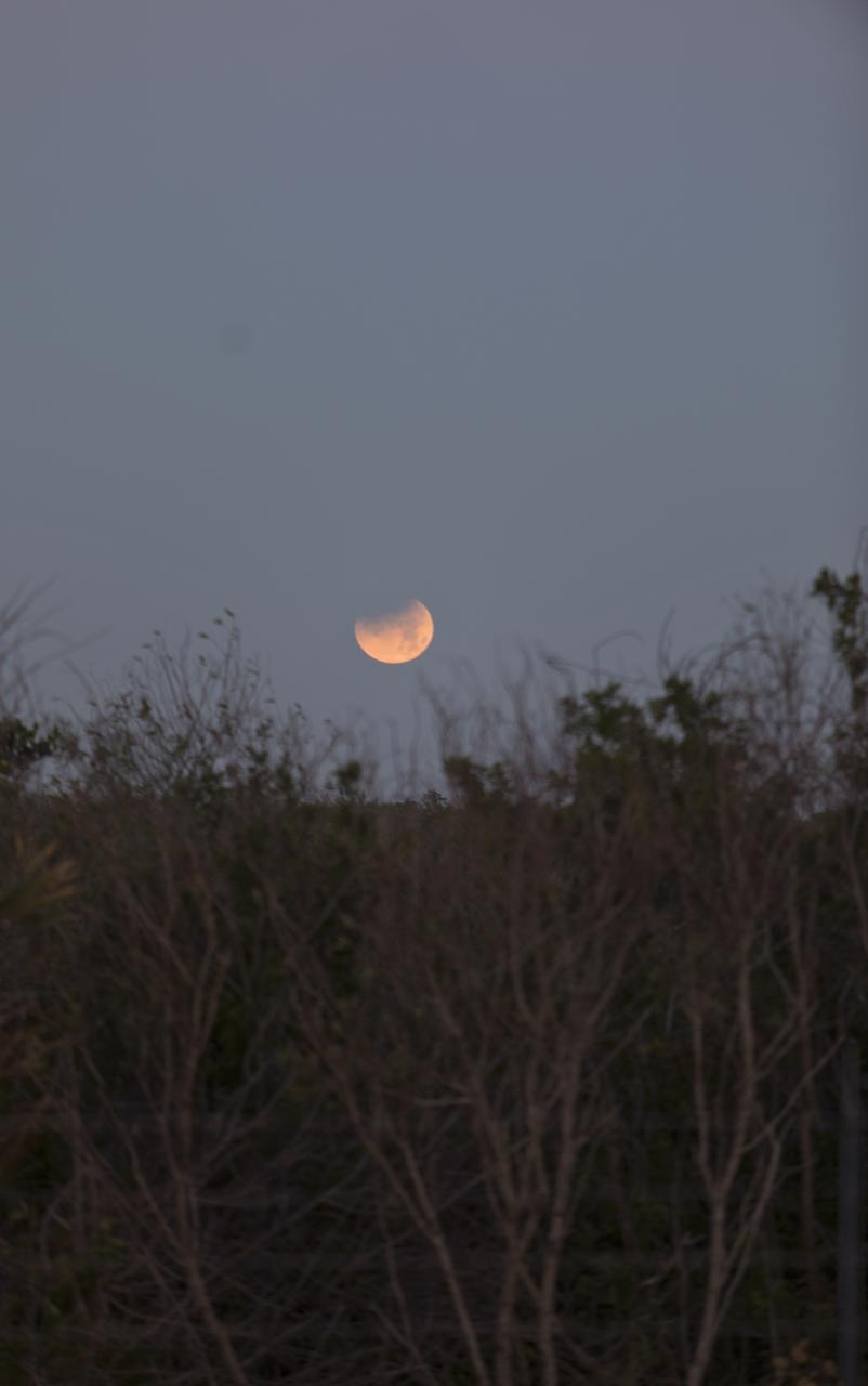
In twilight and framed by native vegetation, the Moon rises over NASA's Kennedy Space Center in Florida.

ISS023-E-041822 (16 May 2010) --- Five of the six Expedition 23 crew members are pictured in the Unity node of the International Space Station while space shuttle Atlantis (STS-132) remains docked with the station. Pictured from the left bottom are Russian cosmonaut Oleg Kotov, commander; Japan Aerospace Exploration Agency (JAXA) astronaut Soichi Noguchi, Russian cosmonaut Alexander Skvortsov, NASA astronauts Tracy Caldwell Dyson and T.J. Creamer, all flight engineers.
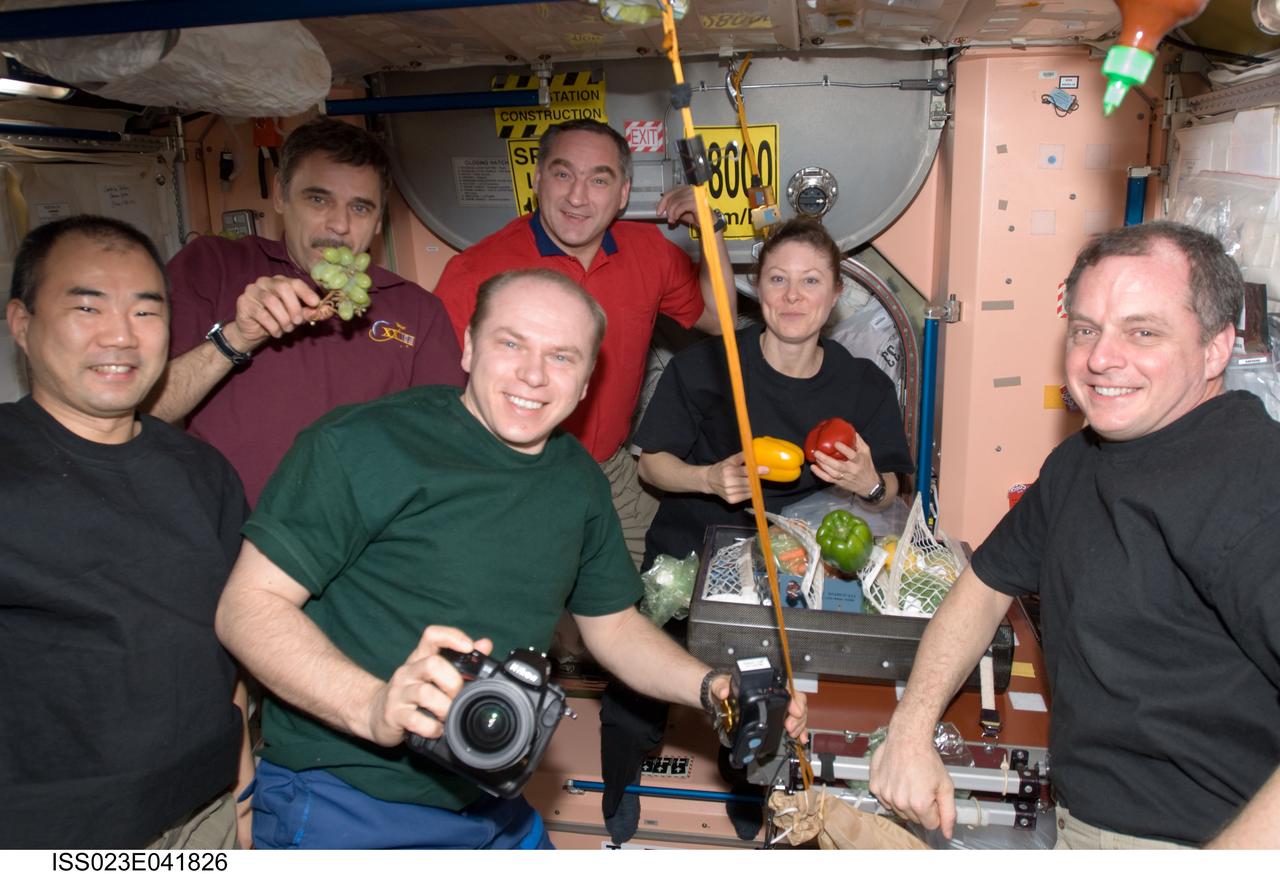
ISS023-E-041826 (16 May 2010) --- The Expedition 23 crew members are pictured in the Unity node of the International Space Station while space shuttle Atlantis (STS-132) remains docked with the station. Pictured clockwise (from the center foreground) are Russian cosmonaut Oleg Kotov, commander; Japan Aerospace Exploration Agency (JAXA) astronaut Soichi Noguchi, Russian cosmonauts Mikhail Kornienko and Alexander Skvortsov; along with NASA astronauts Tracy Caldwell Dyson and T.J. Creamer, all flight engineers.
The tri-county Riley Road wildfire burning in Texas north of Houston was 85 percent contained when NASA Terra spacecraft acquired this image on Sept. 12, 2011. Burned areas are dark gray and black; vegetation red; and bare ground and roads light gray.
Brush fires consumed nearly 750,000 acres across Southern California between October 21 and November 18, 2003. Burn scars and vegetation changes wrought by the fires are illustrated in these false-color images from NASA Terra spacecraft.

NASA Terra spacecraft acquired this image of the Wallow fire in Arizona on June 21, 2011; vegetation appears in red, bare ground in shades of tan, burned areas in black and very-dark red; and smoke from the active fire front appears gray.
NASA Terra spacecraft acquired this image of the Waldo Canyon Fire, west of Colorado Springs, Colo., being called the worst fire in Colorado history. Healthy vegetation is red, water is dark blue, streets and buildings are gray, and the burned areas are
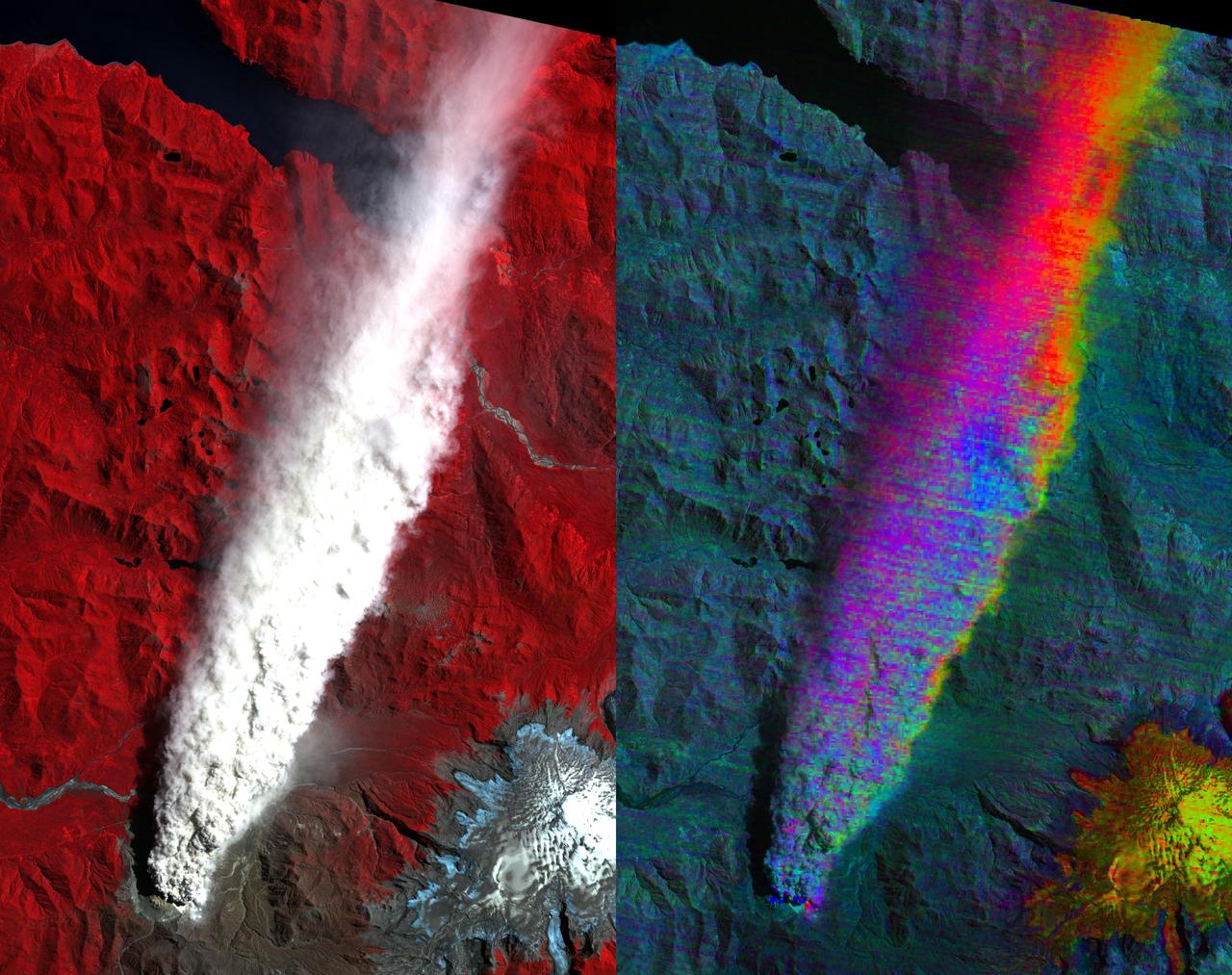
Chaiten Volcano, Chile continues to erupt after first exploding in May 2008 following about 9,000 years of inactivity. This image from NASA Terra spacecraft shows vegetation in red. You can clearly see the extent of the plume.
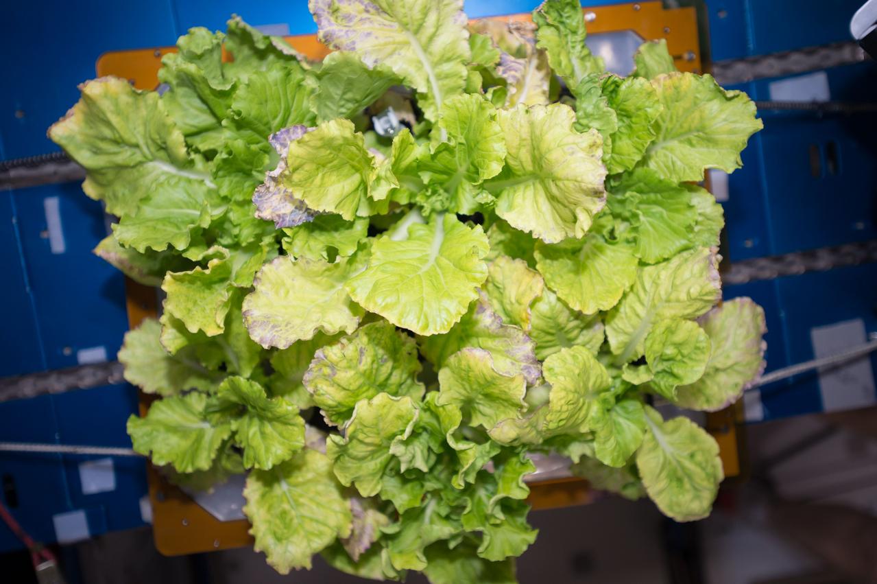
View during Plant Harvest in the Vegetable Production System (Veggie). Image was taken for the Veg-04 experiment. Photo was taken by Expedition 60 crew.
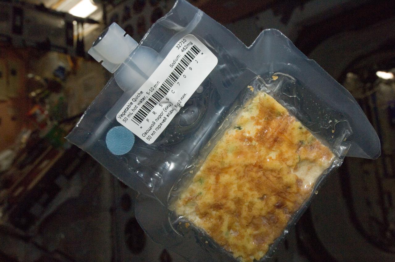
ISS032-E-019019 (12 Aug. 2012) --- A package of vegetable quiche is featured in this image photographed by an Expedition 32 crew member on the International Space Station.

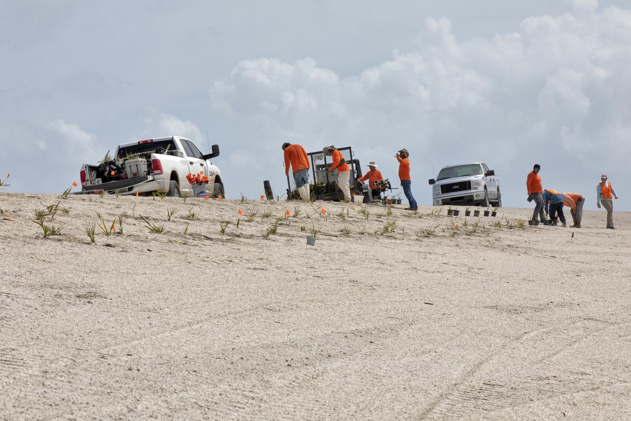
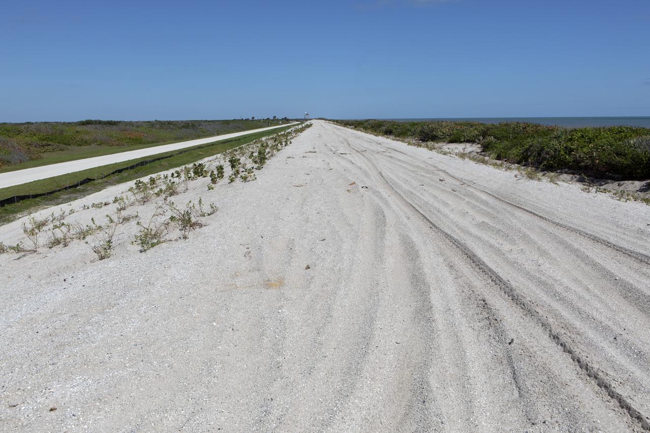
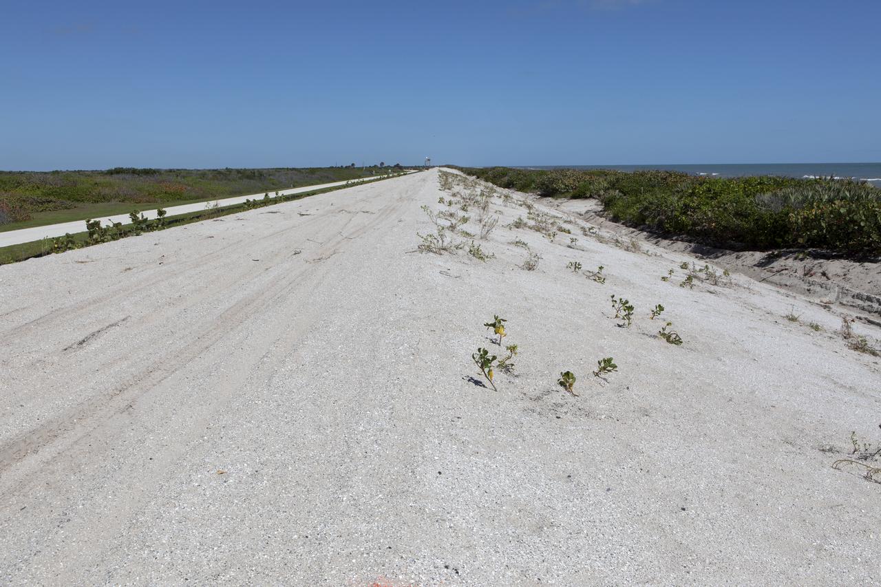
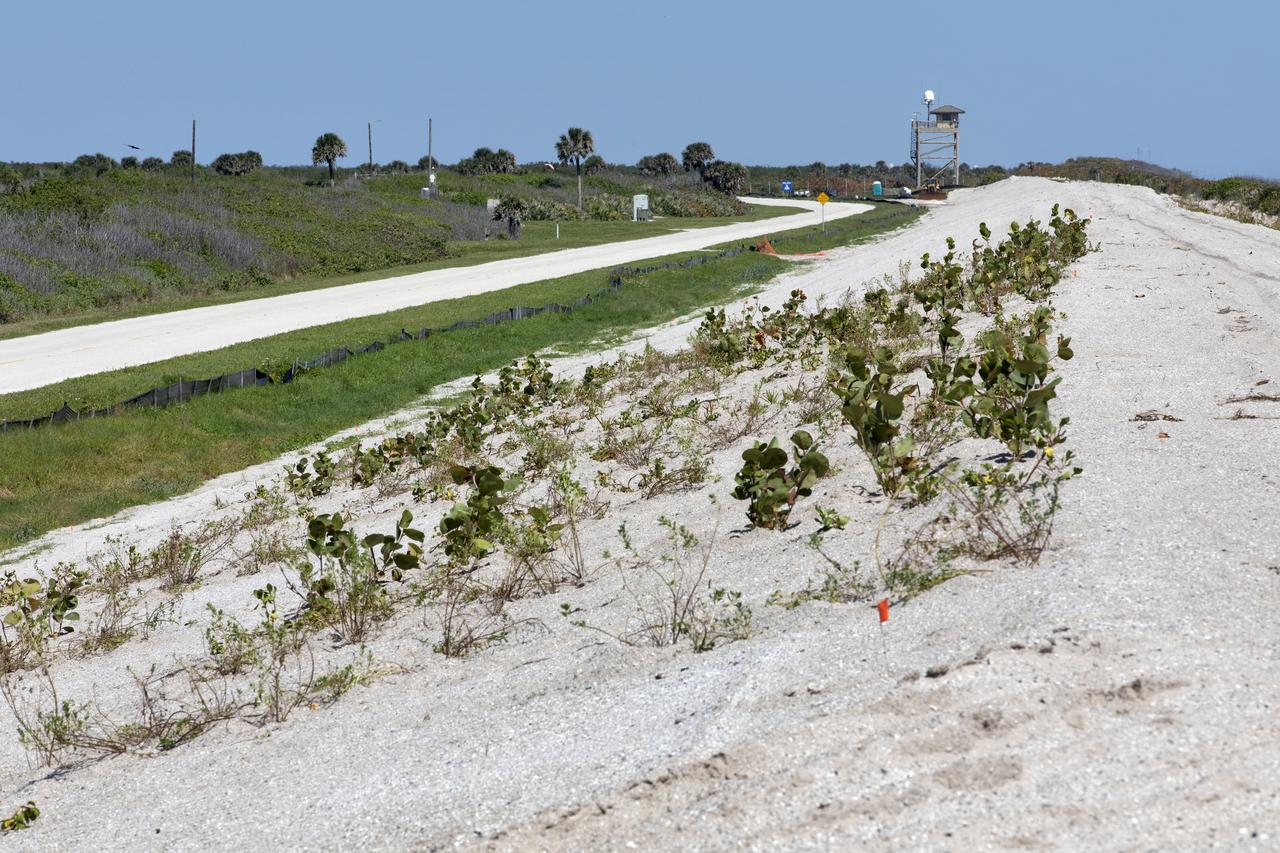
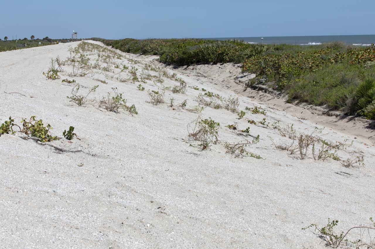
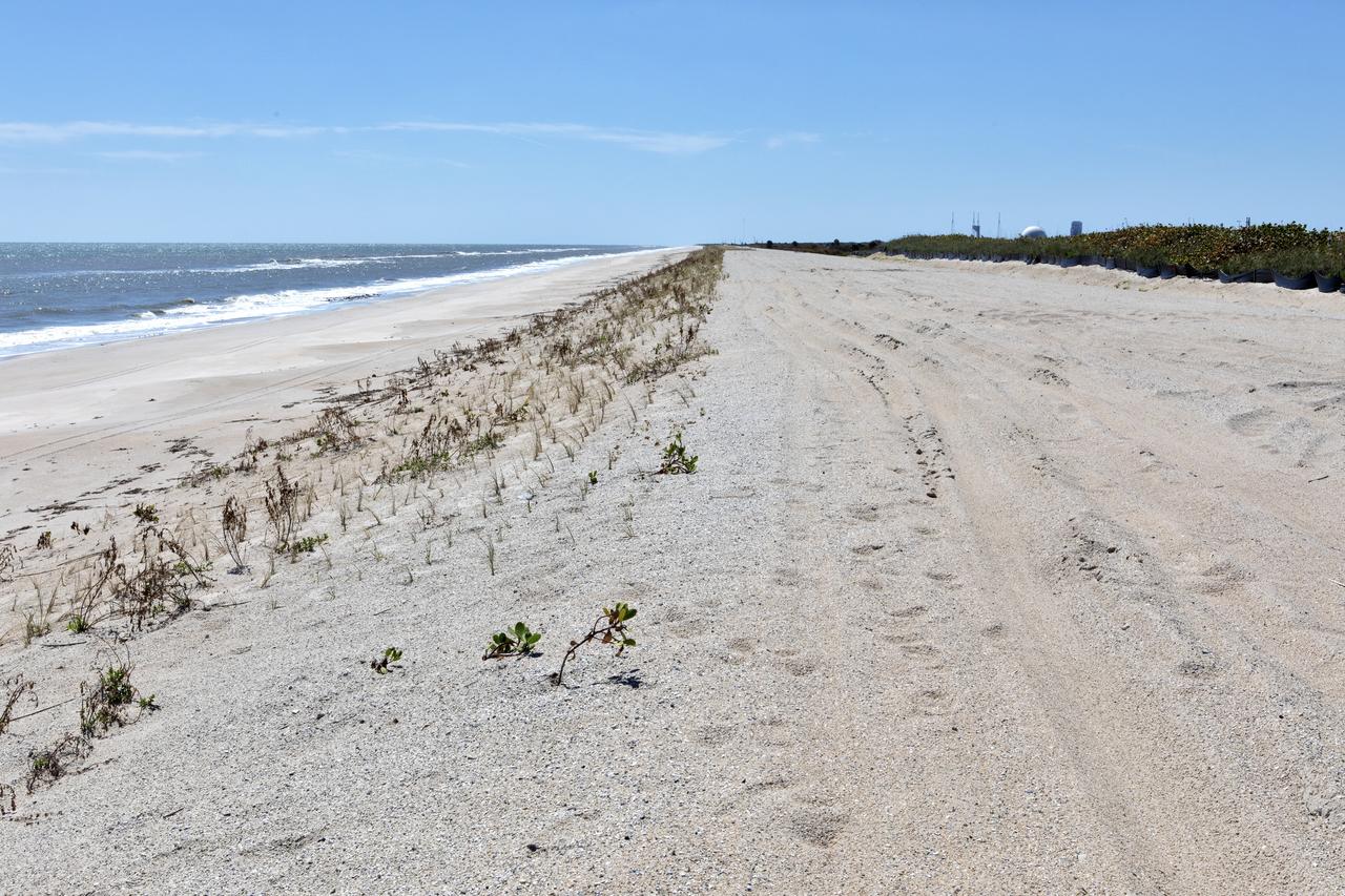
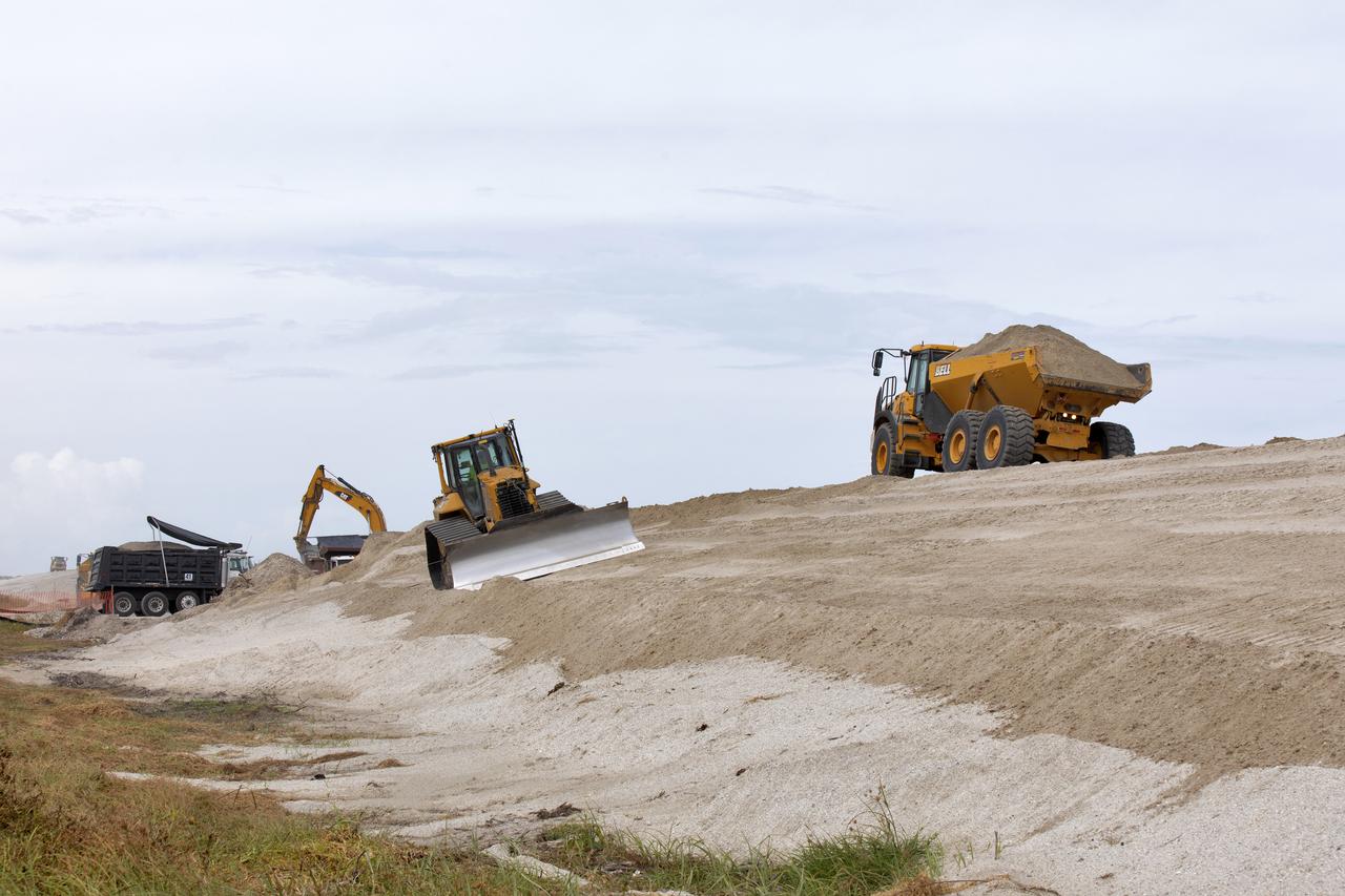
Native vegetation has been planted in the restored dunes at the north beaches at NASA’s Kennedy Space Center in Florida in this view on April 15, 2019. About 450,000 cubic yards of beach-quality sand, tested for compatibility, was transported to the space center’s beaches. After the dune was built up, native vegetation was replanted, helping to stabilize the dune and offer a habitat for Kennedy’s coastal wildlife. Dunes are affected by beach erosion and storm surge from tropical events, such as hurricanes. Restoration began in spring 2018 and was targeted to be completed by April 2019.
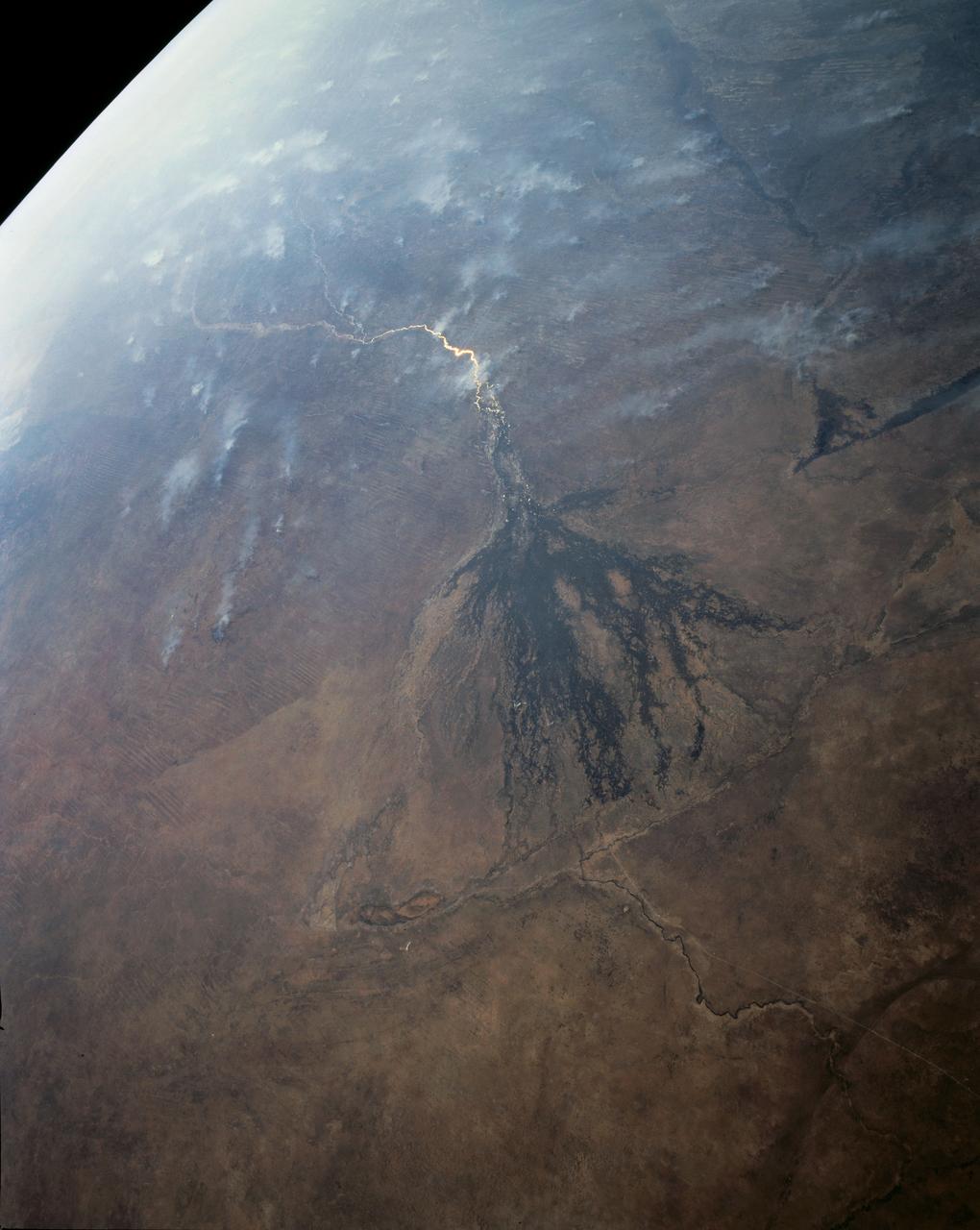
In this panoramic view of the Okavango Swamp, Botswana, (19.0S, 22.0E), the Okavango River, seen in sunglint, flows into a topographic trough to form an inland delta. Water, trapped in the meandering delta distributaries is evaporated or transpired by vegetation. In Angola to the north, the many fires of the seasonal burning of savannah vegetation for land clearing, in preparation for agriculture, has filled the atmosphere with haze and smoke.
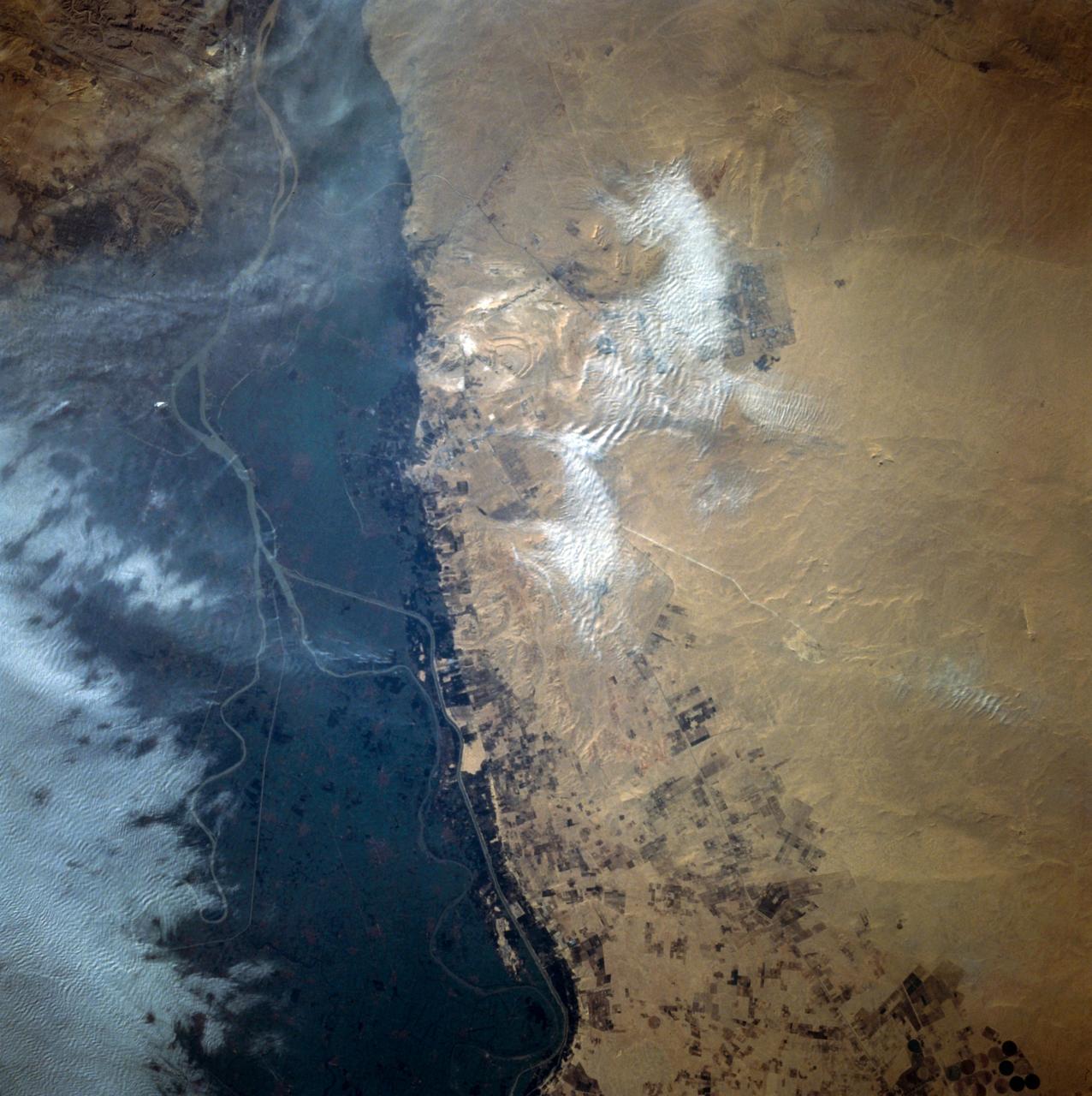
This close-up view of the intensively cultivated Nile River flood plain near Cairo presents a sharp color contrast to the virtually non-vegetated, sandy desert, located to the west of the vegetated area. Some rectangular cultivated field patterns, as well as circular center pivot irrigation patterns, can be observed northwest of the Nile River flood plain. The world famous Giza Pyramids are located near the center of this photography (see highly reflective sand surfaces).
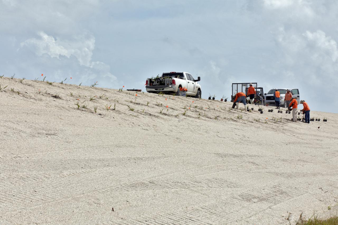
Native vegetation is being planted in a portion of the restored dunes at the north beaches at NASA’s Kennedy Space Center in Florida on Oct. 8, 2018. About 450,000 cubic yards of beach-quality sand, tested for compatibility, is being transported to the space center’s beaches. Once the dune is built up, native vegetation will be replanted, helping to stabilize the dune and offer a habitat for Kennedy’s coast wildlife. Dunes are affected by beach erosion and storm surge from tropical events, such as hurricanes. Restoration began in spring 2018 and is targeted to be completed by April 2019.
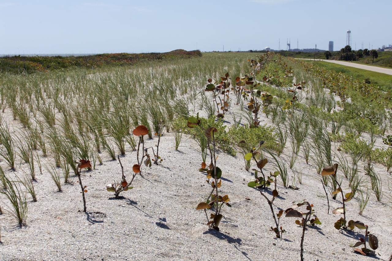
Native vegetation has been planted in the restored dunes at the north beaches at NASA’s Kennedy Space Center in Florida in this view on April 15, 2019. About 450,000 cubic yards of beach-quality sand, tested for compatibility, was transported to the space center’s beaches. After the dune was built up, native vegetation was replanted, helping to stabilize the dune and offer a habitat for Kennedy’s coastal wildlife. Dunes are affected by beach erosion and storm surge from tropical events, such as hurricanes. Restoration began in spring 2018 and was targeted to be completed by April 2019.
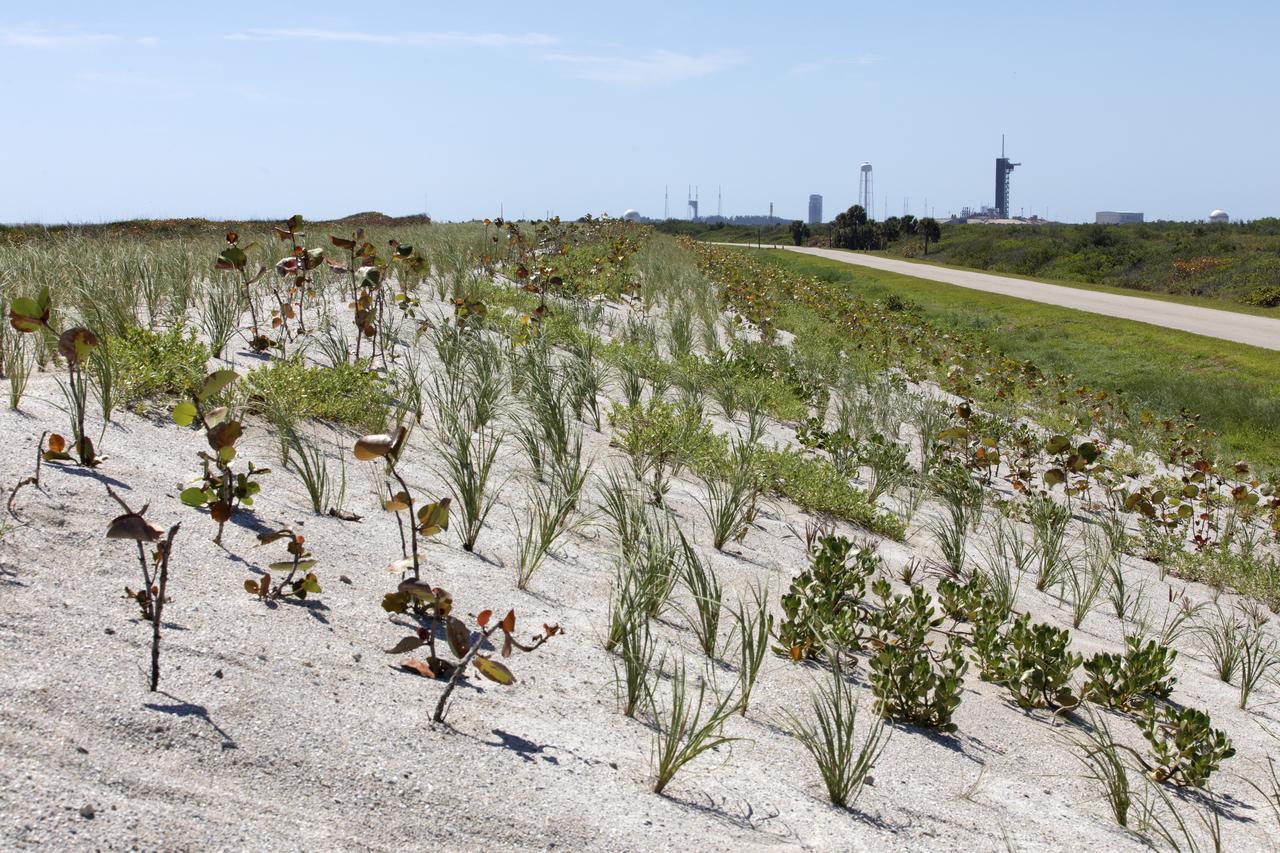
Native vegetation has been planted in the restored dunes at the north beaches at NASA’s Kennedy Space Center in Florida in this view on April 15, 2019. About 450,000 cubic yards of beach-quality sand, tested for compatibility, was transported to the space center’s beaches. After the dune was built up, native vegetation was replanted, helping to stabilize the dune and offer a habitat for Kennedy’s coastal wildlife. Dunes are affected by beach erosion and storm surge from tropical events, such as hurricanes. Restoration began in spring 2018 and was targeted to be completed by April 2019.

SL3-87-355 (July-September 1973) --- A vertical view of the eastern coast of Sicily area is seen in this Skylab 3 Earth Resources Experiments Package S190-B (five-inch earth terrain camera) infrared photograph taken from the Skylab space station in Earth orbit. Mount Etna, the highest volcano in Europe (10,958 feet), is still active as evidenced by the thin plume of smoke emanating from its crest. (The altitude is approximate because the height of the volcano changes with each eruption). On the flanks of Etna recent lava flows appear black in contrast to the older flows and volcanic debris that are red. Numerous small, circular cinder cones on the flanks represent sites of previous eruptions. Catania, on the Mediterranean coast south of Etna, is the largest of several cities and villages which appear as light-gray patches on the lower slopes of the volcano. Plano de Catania, south of the city of Catania, is outlined by polygonal light and dark agricultural tracts. Several lakes, the largest of which is Lake Pozzillo, show up as dark blue in the photograph. The unusual colors in the picture are due to the use of color infrared film in which vegetation appears red. This is very evident on the slopes of Etna, in the Monti Nebrodi area at upper let, and in the local areas in the lower part of the picture. Studies of Mount Etna and related volcanic features will be undertaken by Professor Roberto Cassinis of Servizio Geologio d?Italia, Rome. Federal agencies participating with NASA on the EREP project are the Departments of Agriculture, Commerce, Interior, the Environmental Protection Agency and the Corps of Engineers. All EREP photography is available to the public through the Department of Interior?s Earth Resources Observation Systems Data Center, Sioux Falls, South Dakota, 57198. Photo credit: NASA
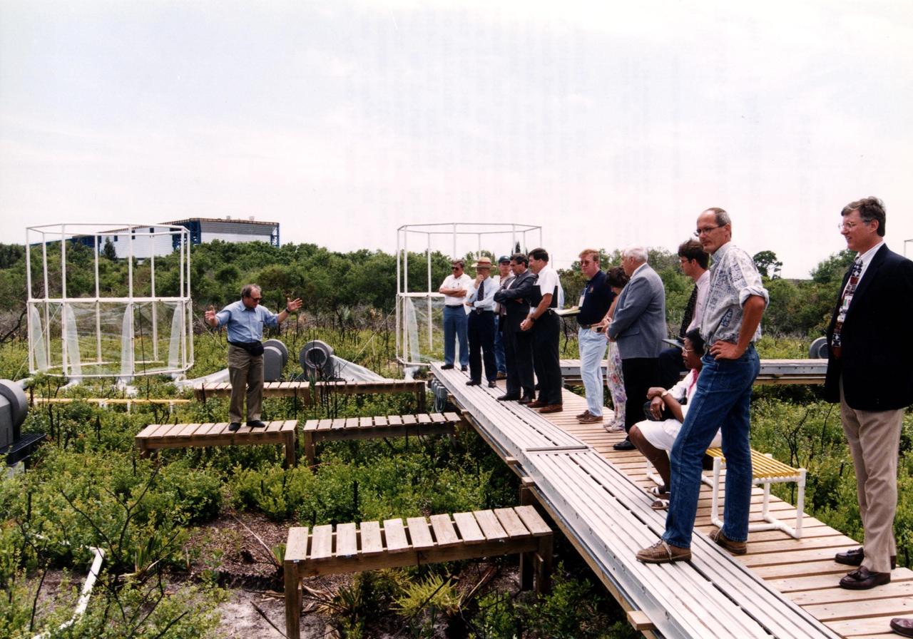
Researchers from the Smithsonian Institution hope their experiment in a local scrub oak community at KSC will yield new insights into the effects of increased carbon dioxide on natural vegetation. The experiment features a four-acre site just north of the Launch Complex 39 area. Increased amoounts of carbon dioxide are piped into 16 open-top chambers that house pristine Florida scrub vegetation, chosen because it is small and woody and fits in the chambers and can be controlled, yet has the attributes of much larger forests. Experts predict a doubling of the carbon dioxide in the Earth's atmosphere during the next century, and the three-year KSC project being conducted by the Smithsonian-led team hopes that by simulating the increase, they can determine how natural ecosystems and vegetation will respond. Also participating in the effort are KSC, academic and international organizations. The study is being funded by a Department of energy grant
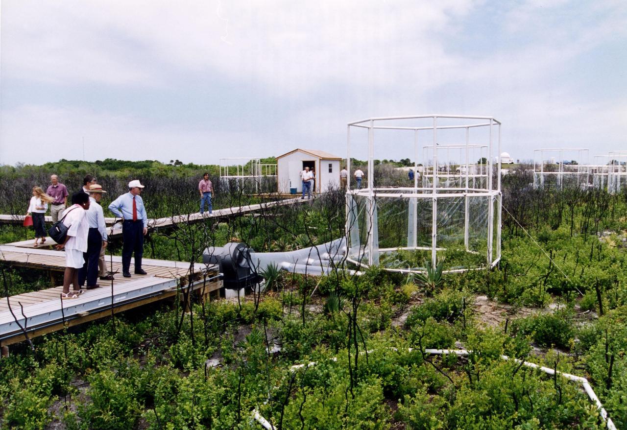
Researchers from the Smithsonian Institution hope their experiment in a local scrub oak community at KSC will yield new insights into the effects of increased carbon dioxide on natural vegetation. The experiment features a four-acre site just north of the Launch Complex 39 area. Increased amoounts of carbon dioxide are piped into 16 open-top chambers that house pristine Florida scrub vegetation, chosen because it is small and woody and fits in the chambers and can be controlled, yet has the attributes of much larger forests. Experts predict a doubling of the carbon dioxide in the Earth's atmosphere during the next century, and the three-year KSC project being conducted by the Smithsonian-led team hopes that by simulating the increase, they can determine how natural ecosystems and vegetation will respond. Also participating in the effort are KSC, academic and international organizations. The study is being funded by a Department of energy grant
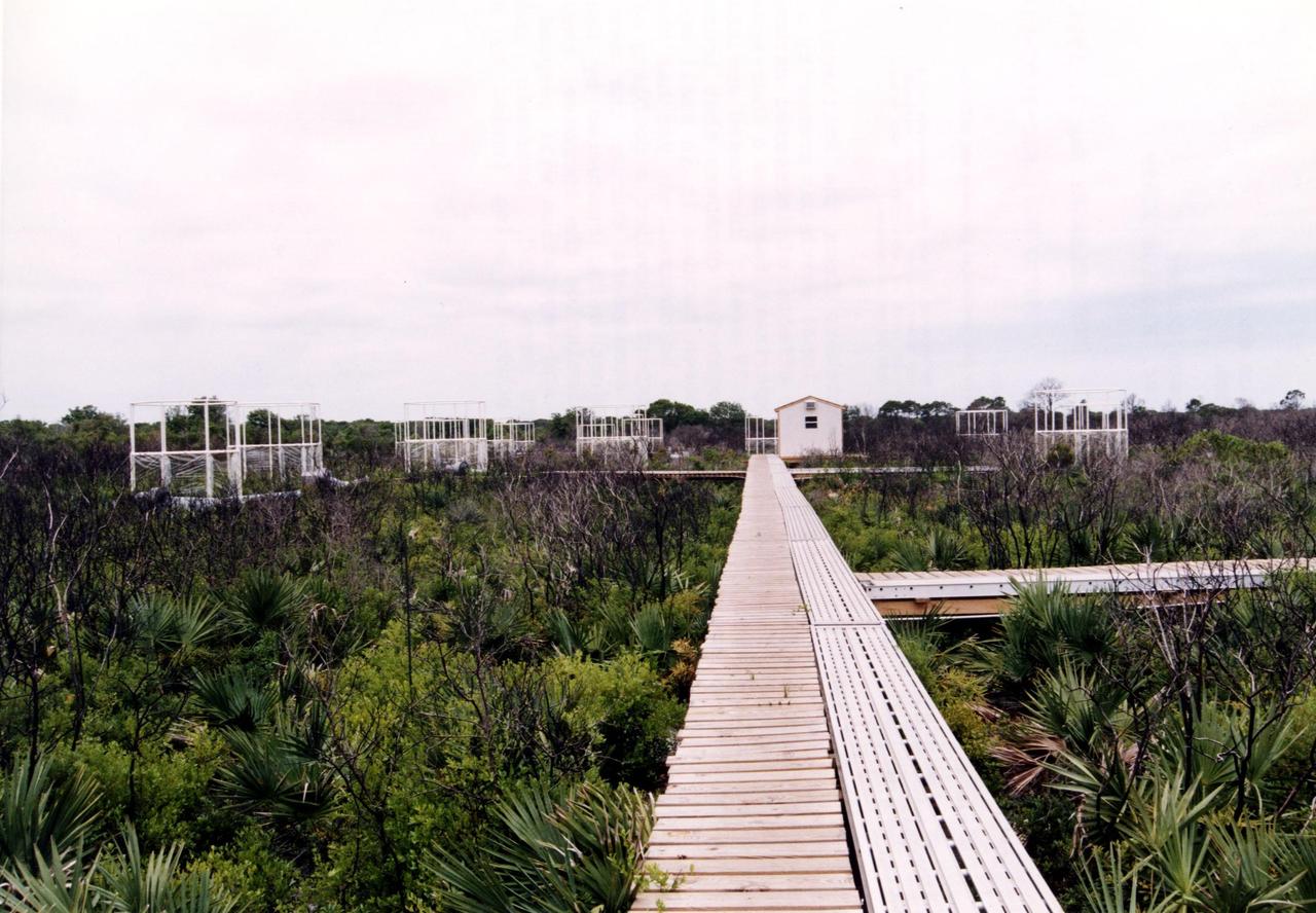
Researchers from the Smithsonian Institution hope their experiment in a local scrub oak community at KSC will yield new insights into the effects of increased carbon dioxide on natural vegetation. The experiment features a four-acre site just north of the Launch Complex 39 area. Increased amoounts of carbon dioxide are piped into 16 open-top chambers that house pristine Florida scrub vegetation, chosen because it is small and woody and fits in the chambers and can be controlled, yet has the attributes of much larger forests. Experts predict a doubling of the carbon dioxide in the Earth's atmosphere during the next century, and the three-year KSC project being conducted by the Smithsonian-led team hopes that by simulating the increase, they can determine how natural ecosystems and vegetation will respond. Also participating in the effort are KSC, academic and international organizations. The study is being funded by a Department of energy grant
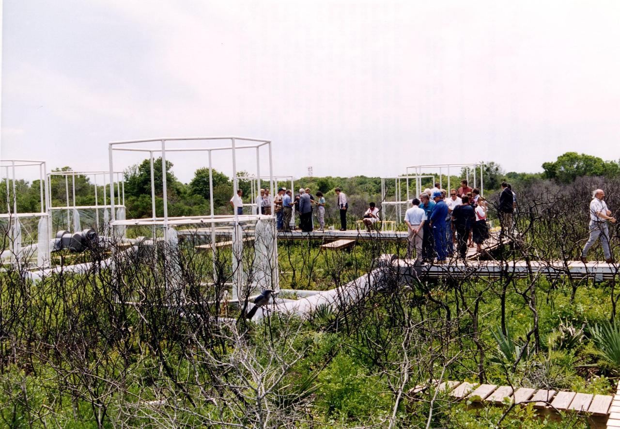
Researchers from the Smithsonian Institution hope their experiment in a local scrub oak community at KSC will yield new insights into the effects of increased carbon dioxide on natural vegetation. The experiment features a four-acre site just north of the Launch Complex 39 area. Increased amoounts of carbon dioxide are piped into 16 open-top chambers that house pristine Florida scrub vegetation, chosen because it is small and woody and fits in the chambers and can be controlled, yet has the attributes of much larger forests. Experts predict a doubling of the carbon dioxide in the Earth's atmosphere during the next century, and the three-year KSC project being conducted by the Smithsonian-led team hopes that by simulating the increase, they can determine how natural ecosystems and vegetation will respond. Also participating in the effort are KSC, academic and international organizations. The study is being funded by a Department of energy grant
Loktak Lake is the largest freshwater lake in northeast India, and is famous for the floating "phudmis," masses of vegetation, soil and organic material. The lake is a source of water for hydropower, irrigation, drinking water, and livelihood for fish farmers. The image was acquired March 19, 2018, covers an area of 20.5 by 27.3 kilometers, and is located at 24.5 degrees north, 93.8 degrees east. https://photojournal.jpl.nasa.gov/catalog/PIA22369

NASA's Dawn spacecraft views Kupalo Crater in this view of Ceres. Kupalo, which measures 16 miles (26 kilometers) across and is located at southern mid-latitudes, is named for the Slavic god of vegetation and harvest. Dawn took this image on June 2, 2016, from its low-altitude mapping orbit, at a distance of about 240 miles (385 kilometers) above the surface. The image resolution is 120 feet (35 meters) per pixel. http://photojournal.jpl.nasa.gov/catalog/PIA20944
This image, taken by NASA's Dawn spacecraft, shows a portion of the southern hemisphere of dwarf planet Ceres from an altitude of 915 miles (1,470 kilometers). The image was taken on Sept. 20, 2015, and has a resolution of 450 feet (140 meters) per pixel. Toharu crater, named for the Pawnee god of food and vegetation, can be seen at left. Its diameter is approximately 54 miles (87 kilometers). http://photojournal.jpl.nasa.gov/catalog/PIA19981
ISS044E007995 (07/05/2015) ---NASA astronaut Scott Kelly in the Unity (Node 1) module enjoying some fresh fruit and vegetables brought up to the International Space Station by the recent Russian Progress 60 spacecraft.
View of cabbage plants in the Vegetable Production System (Veggie) bellows, with the bellows secured to the Maintenance Work Area (MWA) in the Harmony Node 2. Image was taken during final harvesting operations (OPS) for the Veg-03 experiment.
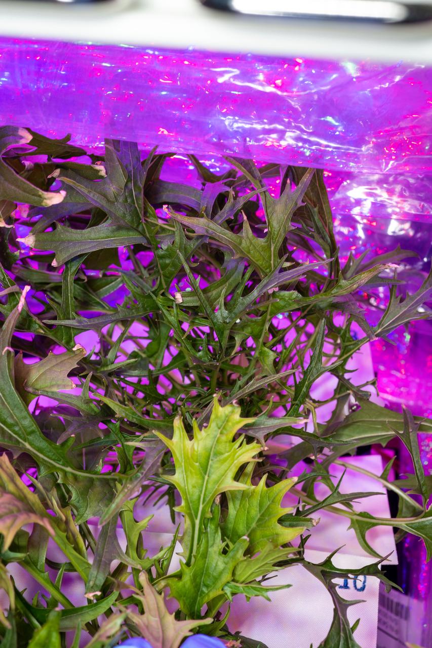
Documentation of a Mizuna mustard plant growing in Plant Pillow 8 in the Vegetable Production System (Veggie). Photo was taken prior to plant harvesting operations (OPS) for the Veg-04B experiment.
Documentation (overall view) of the Vegetable Production System (Veggie) taken during Pillow watering operations (OPS) for the Veg-04B experiment. Plant Pillows contain Mizuna mustard plants.
Indonesia produces two thirds of the world's nickel from open pit mines. In southeast Sulawesi, about 50 nickel mining companies currently operate. In order to mine nickel, large areas of trees are cut down to create open pits. The areas of deforestation appear as reddish where the iron-rich soil is exposed; surrounded by bright green areas of tropical vegetation. The image was acquired 12 September 2019, covers an area of 38.3 by 65.2 km, and is located at 3.3 degrees south, 122.3 degrees east. https://photojournal.jpl.nasa.gov/catalog/PIA26007
Native vegetation is being planted in a portion of the restored dunes at the north beaches at NASA’s Kennedy Space Center in Florida on Oct. 8, 2018. About 450,000 cubic yards of beach-quality sand, tested for compatibility, is being transported to the space center’s beaches. One the dune is built up, native coastal vegetation will be replanted, helping to stabilize the dune and offer a habitat for Kennedy’s coast wildlife. Dunes are affected by beach erosion and storm surge from tropical events, such as hurricanes. Restoration began in spring 2018 and is targeted to be completed by April 2019.
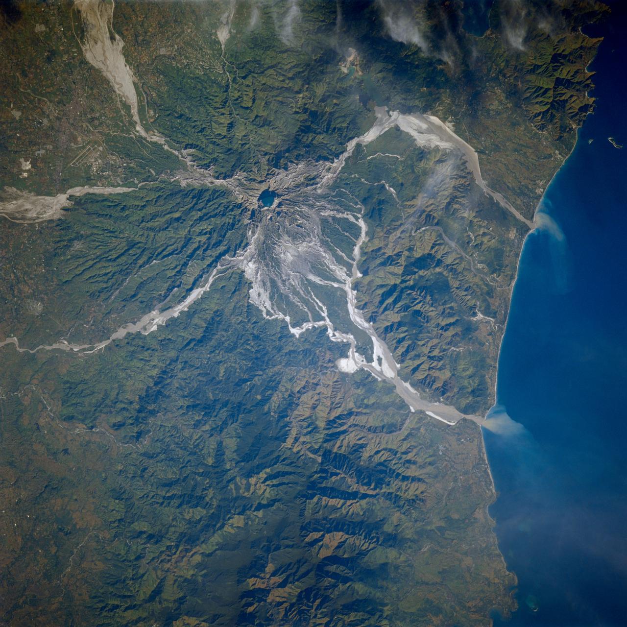
STS080-706-044 (19 Nov.-7 Dec. 1996) --- This view shows Mount Pinatubo, an active volcano in the Zambales Mountains range of western Luzon, the main island of the Philippines. Mud flows radiate out from the active volcano, which has erupted in recent years, coming down the mountain. After the eruption a lot of the vegetation was removed, causing the mountain to erode at a more rapid pace than an older mountain that has its vegetation in place. In two cases the flows reach the South China Sea, and flow down three valleys to the east. The now abandoned Clark Air Force Base is to the upper left corner. Pinatubo is about 80 miles northwest of Manila.
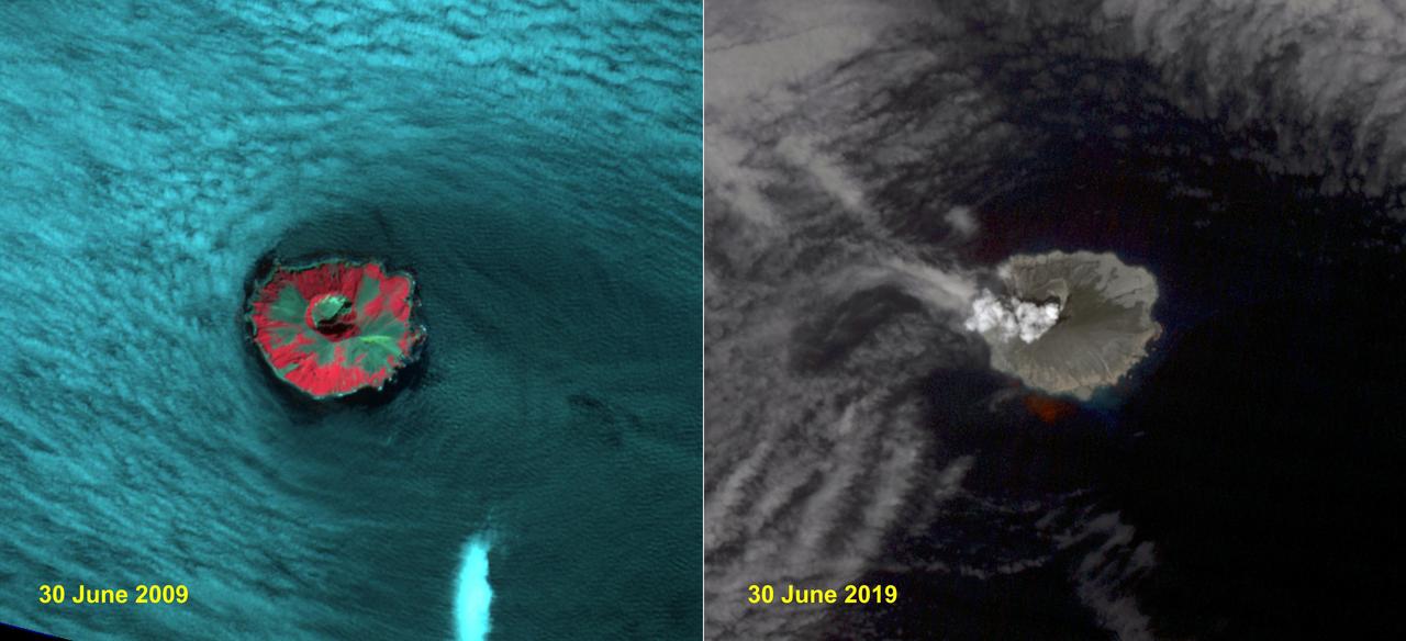
Raikoke volcanic island is near the center of the Kuril Islands in the Sea of Okhotsk in the northwest Pacific Ocean. The island is roughly circular with dimensions of 2.0 by 2.5 kilometers. On June 22, the volcano erupted with a gas and ash plume reaching 17 kilometers. The two ASTER images, acquired exactly 10 years apart on June 30, dramatically depict the changes to the island. In 2009, vegetation (red) covered most of the island. The 2019 image shows an ash and steam plume rising from the caldera. There is no trace of any vegetation, ash deposits having buried everything. The images are located at 48.3 degrees north, 153.2 degrees east. https://photojournal.jpl.nasa.gov/catalog/PIA23326
The Esperanza fire started on October 26 in the dry brush near Palm Springs, CA. By the time it was contained 6 days later, the fire had consumed 40,200 acres, and destroyed 34 homes and 20 outbuildings. Racing through grass, brush, and timber, the blaze had forced hundreds to evacuate, and it killed five firefighters who were working to protect homes. Fire officials are reporting the cause of the blaze as arson. In this ASTER image composite of visible and infrared bands, burned areas are shown in shades of red, vegetation is green, brown vegetation is brown and asphalt and concrete are blue-gray. http://photojournal.jpl.nasa.gov/catalog/PIA01900
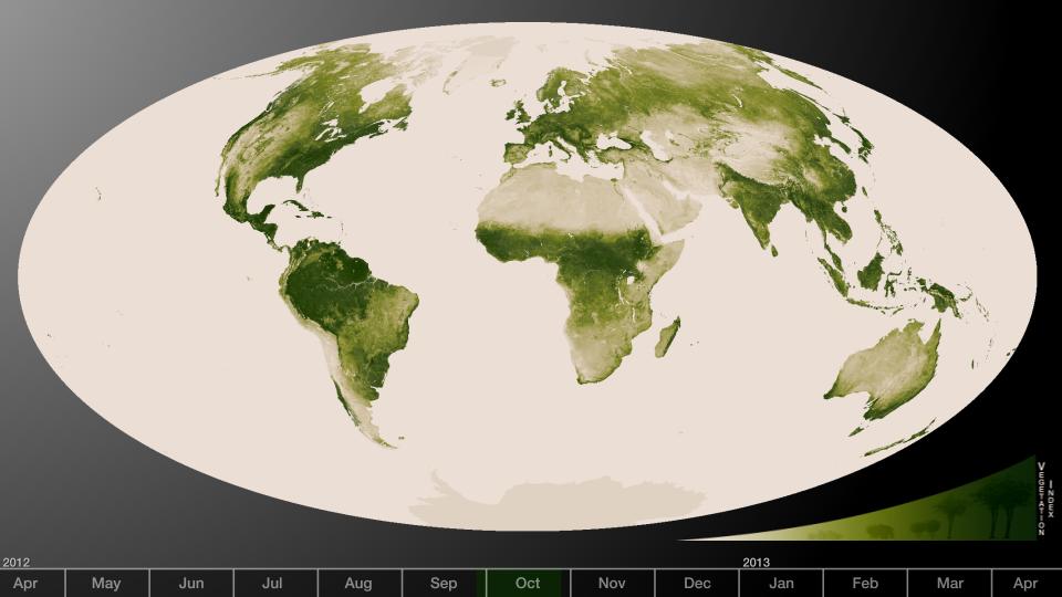
Subtle vegetation changes are visible in this year-long visualization. Large-scale patterns vary with seasons, but the local variations in green are also sensitive precipitation, drought and fire. High values of Normalized Difference Vegetation Index, or NDVI, represent dense green functioning vegetation and low NDVI values represent sparse green vegetation or vegetation under stress from limiting conditions, such as drought. The visualization was created from a year’s worth of data from April 2012 to April 2013. The information was sent back to Earth from the Visible-Infrared Imager/Radiometer Suite (VIIRS) instrument aboard the Suomi National Polar-orbiting Partnership or Suomi NPP satellite, a partnership between NASA and the National Oceanic and Atmospheric Administration, or NOAA. Credit: NASA/NOAA To read more go to: <a href="http://www.nasa.gov/mission_pages/NPP/news/vegetation.html" rel="nofollow">www.nasa.gov/mission_pages/NPP/news/vegetation.html</a> <b><a href="http://www.nasa.gov/audience/formedia/features/MP_Photo_Guidelines.html" rel="nofollow">NASA image use policy.</a></b> <b><a href="http://www.nasa.gov/centers/goddard/home/index.html" rel="nofollow">NASA Goddard Space Flight Center</a></b> enables NASA’s mission through four scientific endeavors: Earth Science, Heliophysics, Solar System Exploration, and Astrophysics. Goddard plays a leading role in NASA’s accomplishments by contributing compelling scientific knowledge to advance the Agency’s mission. <b>Follow us on <a href="http://twitter.com/NASA_GoddardPix" rel="nofollow">Twitter</a></b> <b>Like us on <a href="http://www.facebook.com/pages/Greenbelt-MD/NASA-Goddard/395013845897?ref=tsd" rel="nofollow">Facebook</a></b> <b>Find us on <a href="http://instagram.com/nasagoddard?vm=grid" rel="nofollow">Instagram</a></b>
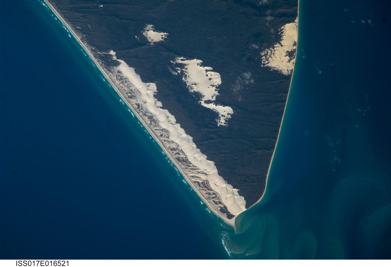
ISS017-E-016521 (15 Sept. 2008) --- Sandy Cape and Fraser Island, Australia are featured in this image photographed by an Expedition 17 crewmember on the International Space Station. Fraser Island, the world's largest sand island, includes Great Sandy National Park and is located along the coastline of Queensland, Australia. The island was designated a World Heritage site in 1992, in part due to its outstanding preservation of geological processes related to sand dune formation. According to scientists, the island's dune fields preserve a record of sand deposition and movement related to sea level rise and fall extending back over 700,000 years. In addition to sand dunes, the island also preserves an interesting range of vegetation -- including vine rainforest, stands of eucalypt trees, and mangroves -- and diverse fauna including crabs, parrots, sugar gliders and flying foxes. This view highlights the northernmost portion of the island, known as Sandy Cape. Active white sand dunes contrast with dark green vegetation that anchors older dune sets. Irregular patches of sand dunes surrounded by vegetation are known as sand blows (or blowouts), formed when the vegetation cover is disturbed -- by wind, fire, or human activities. The exposed underlying sand can then move and form new dunes, sometimes at rates of up to one meter per year. Coastal sand dune fields -- such as the one located along the eastern side of Sandy Cape (center) -- will remain active until anchored by vegetation, or until no more sand is available to form new dunes.
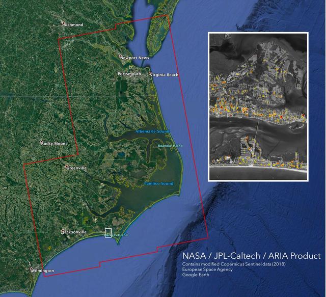
The Advanced Rapid Imaging and Analysis (ARIA) team at NASA's Jet Propulsion Laboratory in Pasadena, California, created this Damage Proxy Map (DPM) depicting areas of the Carolinas that are likely damaged (shown by red and yellow pixels) as a result of Hurricane Florence. The map is derived from synthetic aperture radar (SAR) images from the Copernicus Sentinel-1 satellites, operated by the European Space Agency (ESA). The images were taken before (September 02, 2016) and 12 hours after the hurricane's landfall (September 14, 2018 7:06 PM local time). The map covers an area of 155 miles x 210 miles (250 km x 340 km), indicated with the big red polygon. Each pixel measures about 33 yards x 33 yards (30 m x 30 m). The color variation from yellow to red indicates increasingly more significant ground surface change. Media reports provided anecdotal preliminary validation. This damage proxy map should be used as guidance to identify damaged areas, and may be less reliable over vegetated areas and flooded areas. For example, the scattered single colored pixels over vegetated areas may be false positives, and the lack of colored pixels over vegetated areas does not necessarily mean no damage. https://photojournal.jpl.nasa.gov/catalog/PIA22702
STS073-708-089 (26 October 1995) --- As evidenced by this 70mm photograph from the Earth-orbiting Space Shuttle Columbia, international borders have become easier to see from space in recent decades. This, according to NASA scientists studying the STS-73 photo collection, is particularly true in arid and semi-arid environments. The scientists go on to cite this example of the razor-sharp vegetation boundary between southern Israel and Gaza and the Sinai. The nomadic grazing practices to the south (the lighter areas of the Sinai and Gaza, top left) have removed most of the vegetation from the desert surface. On the north side of the border, Israel uses advanced irrigation techniques in Israel, mainly "trickle irrigation" by which small amounts of water are delivered directly to plant roots. These water-saving techniques have allowed precious supplies from the Jordan River to be used on farms throughout the country. Numerous fields of dark green can be seen in this detailed view. Scientists say this redistribution of the Jordan River waters has increased the Israeli vegetation cover to densities that approach those that may have been common throughout the Mid-East in wetter early Biblical times. A small portion of the Mediterranean Sea appears top right.
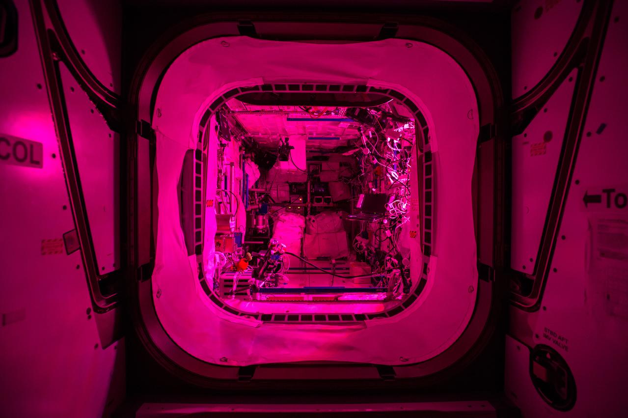
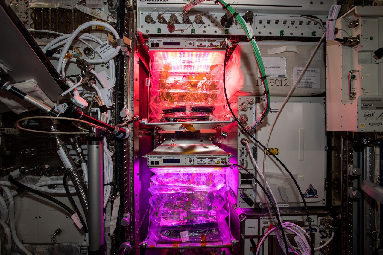
ISS042e136099 (Jan 15, 20105) -- Interior view of the Columbus European Laboratory taken during the crew's sleep period (main lights are turned off). The pink glow comes from the Vegetable Production System (Veggie) greenhouse, housed in the module.
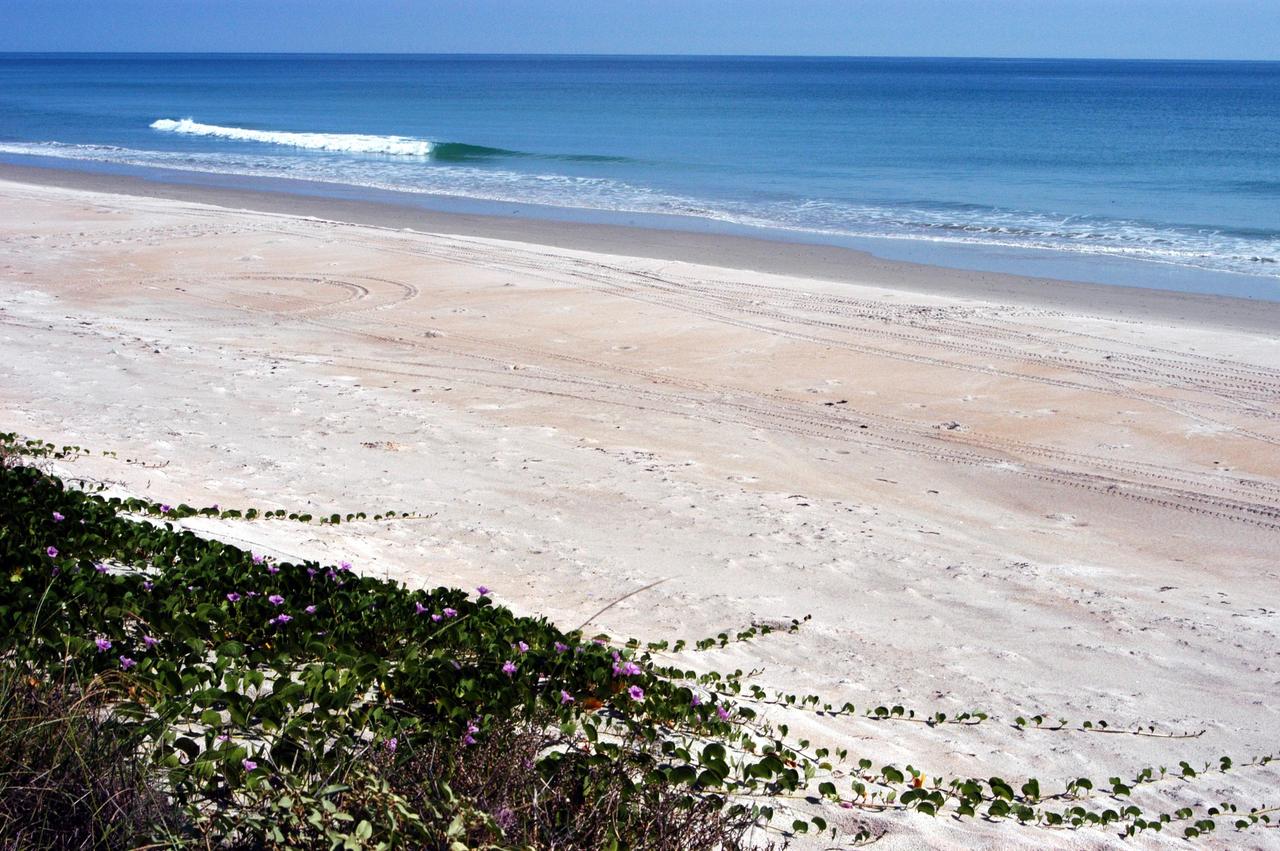
KENNEDY SPACE CENTER, FLA. - The calm blue ocean near the launch pads at KSC beckons. The sand dunes facing the Atlantic Ocean spill pink flowers down its banks. The vegetation helps prevent the dunes from eroding. The beach is part of the Canaveral National Seashore, managed by the National Wildlife Service.

iss063e001883 (April 22, 2020) --- NASA astronaut and Expedition 63 Commander Chris Cassidy services botany research hardware inside the European Space Agency's Columbus laboratory module. The Veggie PONDS research facility in Columbus supports the growing and harvesting of lettuce and mizuna greens to demonstrate reliable vegetable growth during spaceflight.

iss063e001873 (April 22, 2020) --- NASA astronaut and Expedition 63 Commander Chris Cassidy services botany research hardware inside the European Space Agency's Columbus laboratory module. The Veggie PONDS research facility in Columbus supports the growing and harvesting of lettuce and mizuna greens to demonstrate reliable vegetable growth during spaceflight.

ISS042e136094 (Jan 15, 2015) -- Interior view looking forward (FWD) in the Destiny U.S. Laboratory during the crew's sleep period, with the main lights turned off. The pink glow comes from the Vegetable Production System (Veggie) greenhouse, housed in the Columbus European Laboratory.
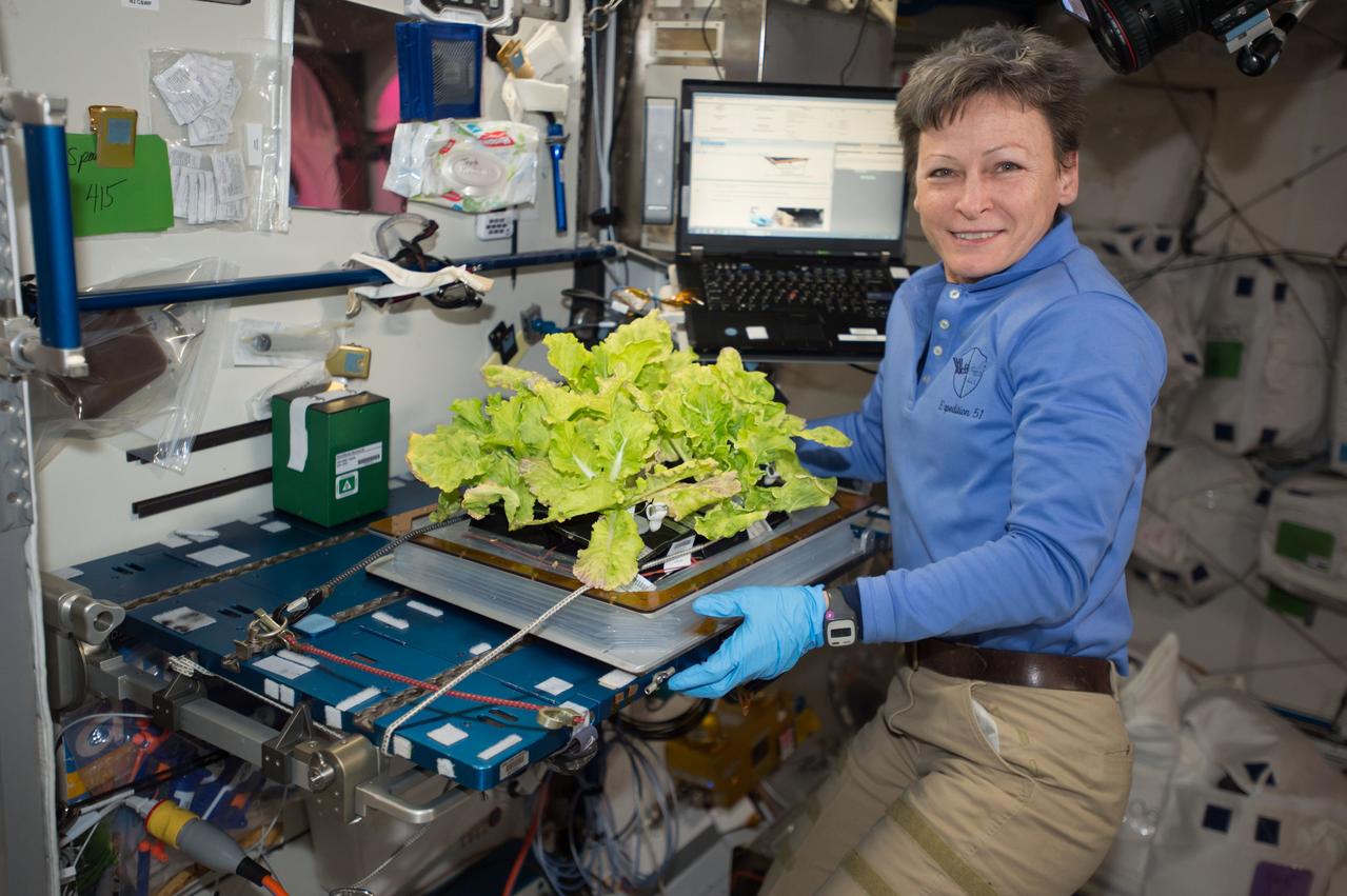
iss051e051923 (5/03/2017) --- NASA astronaut Peggy Whitson poses with cabbage plants in the Vegetable Production System (Veggie) bellows in the Harmony Node 2. Image was taken during final harvesting operations (OPS) for the Veg-03 experiment.

Interior view looking starboard (STBD) and aft in the Harmony Node 2, taken during the crew's sleep period (main lights are turned off). Hatches into the Columbus European Laboratory and Destiny U.S. Laboratory are in view. The pink glow comes from the Vegetable Production System (Veggie) greenhouse, housed in Columbus.

This image taken by NASA's Dawn spacecraft shows Emesh, a crater on Ceres. Emesh, named after the Sumerian god of vegetation and agriculture, is 12 miles (20 kilometers) wide. Located at the edge of the Vendimia Planitia, the floor of this crater is asymmetrical with terraces distributed along the eastern rim. Additionally, this image shows many subtle linear features that are likely the surface expressions of faults. These faults play a big role in shaping Ceres' craters, leading to non-circular craters such as Emesh. To the left of Emesh in this view, a much older crater of similar size has mostly been erased by impacts and their ejecta. Dawn took this image on May 11, 2016, from its low-altitude mapping orbit, at a distance of about 240 miles (385 kilometers) above the surface. The center coordinates of this image are 11 degrees north latitude, 158 degrees east longitude. https://photojournal.jpl.nasa.gov/catalog/PIA21911
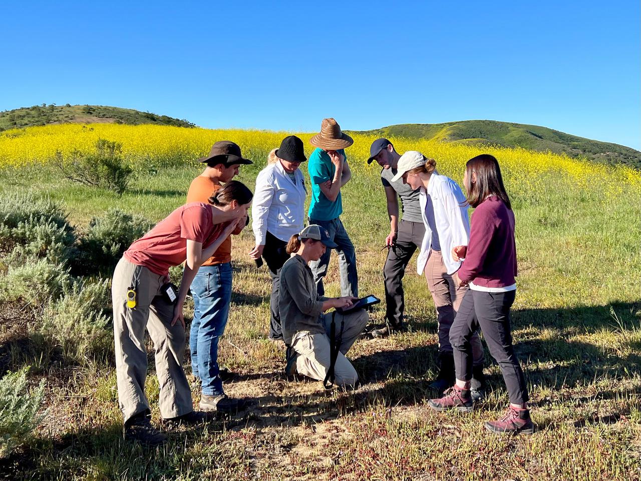
Dana Chadwick, a scientist in the water and ecosystems group at NASA's Jet Propulsion Laboratory, center, advises a field team of researchers from JPL; University of Wisconsin, Madison (UWM); University of California, Los Angeles (UCLA); University of Maryland, Baltimore County (UMBC); and University of California, Santa Barbara (UCSB) on vegetation-sampling locations at the Jack and Laura Dangermond Preserve in Santa Barbara County, California, on March 24, 2022. Chadwick and the team are working on the Surface Biology and Geology High-Frequency Time Series (SHIFT) campaign, which is jointly led by JPL, UCSB, and The Nature Conservancy. Chadwick is surrounded by, from left: Natalie Queally, a forest and wildlife ecology graduate student at UWM; Francisco Ochoa, a geography graduate student at UCLA; Petya Campbell, a research associate professor at UMBC and a research associate at NASA's Goddard Space Flight Center; Brendan Heberlein, a research intern at UWM; Renato Braghiere, a postdoctoral research scientist at JPL; Cassandra Nickles, a postdoctoral fellow at JPL; and Clare Saiki, a doctoral student at UCSB. Operating between late February and late May 2022, SHIFT combines the ability of airborne science instruments to gather data over widespread areas with the more concentrated observations scientists conduct in the field to study the functional characteristics, health, and resilience of plant communities. The sampling and analysis done by researchers on the ground and in the ocean is intended to validate data taken by AVIRIS-NG (Airborne Visible/Infrared Imaging Spectrometer-Next Generation). The instrument, designed at JPL, is collecting spectral data of vegetation it observes during weekly flights in an aircraft over a 640-square-mile (1,656-square-kilometer) study area in Santa Barbara County and coastal Pacific waters. The campaign is a pathfinder for NASA's proposed Surface Biology and Geology (SBG) mission. SHIFT will help scientists design data collection and processing algorithms for that mission, which would launch no earlier than 2028. The SHIFT data is also intended to support the research and conservation objectives of The Nature Conservancy, which owns the Dangermond Preserve, and UCSB, which operates the Sedgwick Reserve, another nature preserve within the study area. More than 60 scientists from institutions around the U.S. have indicated they intend to use the SHIFT data in their research. https://photojournal.jpl.nasa.gov/catalog/PIA25141
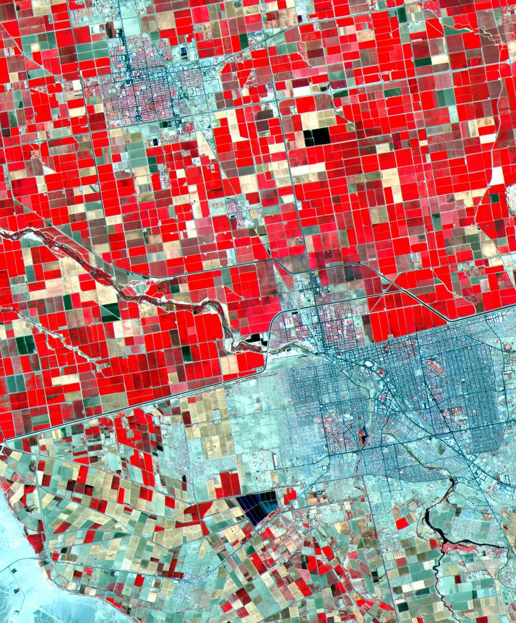
Dramatic differences in land use patterns are highlighted in this image of the U.S.-Mexico border. Lush, regularly gridded agricultural fields on the U.S. side contrast with the more barren fields of Mexico. This June 12, 2000, sub-scene combines visible and near infrared bands, displaying vegetation in red. The town of Mexicali-Calexico spans the border in the middle of the image; El Centro, California, is in the upper left. Watered by canals fed from the Colorado River, California's Imperial Valley is one of the country's major fruit and vegetable producers. This image covers an area 24 kilometers (15 miles) wide and 30 kilometers (19 miles) long in three bands of the reflected visible and infrared wavelength region. http://photojournal.jpl.nasa.gov/catalog/PIA02659
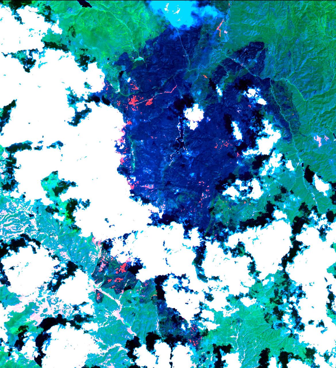
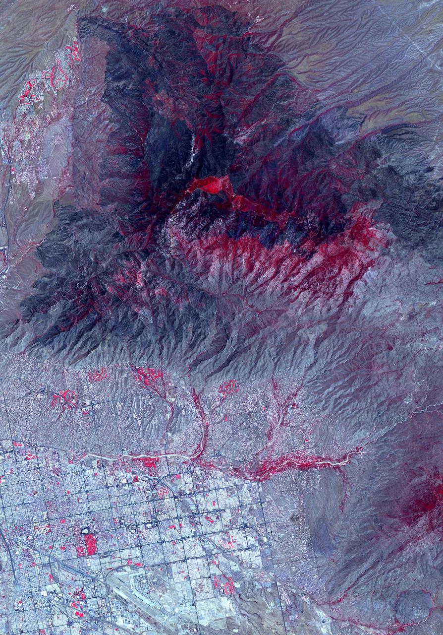
The Hayman forest fire, started on June 8, is continuing to burn in the Pike National Forest, 57 km (35 miles) south-southwest of Denver. According to the U.S. Forest Service, the fire has consumed more than 90,000 acres and has become Colorado's worst fire ever. In this ASTER image, acquired Sunday, June 16, 2002 at 10:30 am MST, the dark blue area is burned vegetation and the green areas are healthy vegetation. Red areas are active fires, and the blue cloud at the top center is smoke. Meteorological clouds are white. The image covers an area of 32.2 x 35.2 km (20.0 x 21.8 miles), and displays ASTER bands 8-3-2 in red, green and blue. http://photojournal.jpl.nasa.gov/catalog/PIA03499
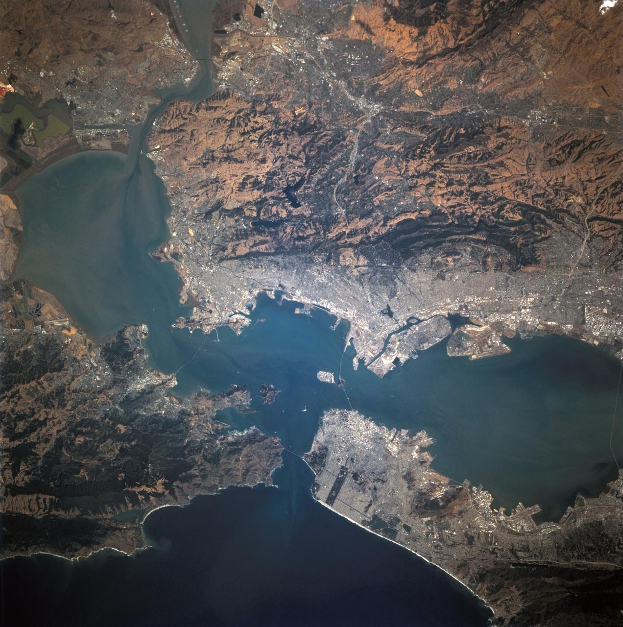
STS068-244-022 (30 September-11 October 1994) --- (San Francisco, San Pablo Bay Area) Photographed through the Space Shuttle Endeavour's flight deck windows, the heavily populated bay area is featured in this 70mm frame. The relatively low altitude of Endeavour's orbit (115 nautical miles) and the use of a 250mm lens on the Hasselblad camera allowed for capturing detail in features such as the Berkeley Marina (frame center). The region's topography is well depicted with the lowland areas heavily populated and the hills much more sparsely covered. The Oakland Hills in the right lower center appear to be re-vegetated after a devastating fire. The Golden Gate Recreation Area in the upper left also shows heavy vegetation. The three bridges across the main part of the bay and their connecting roads are prominent. Cultural features such as Golden Gate Park and the Presidio contrast with the gray of the city.
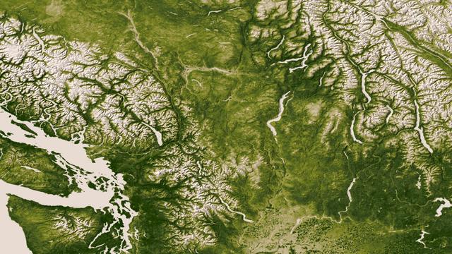
The Rocky, Cascade, and Coast Mountain Ranges dominate the landscape of the Pacific Northwest in this image created June 11-17, 2012 from the Visible-Infrared Imager/Radiometer Suite (VIIRS) instrument aboard the Suomi National Polar-orbiting Partnership or Suomi NPP satellite, a partnership between NASA and the National Oceanic and Atmospheric Administration, or NOAA. Potato and other agriculture can be seen in the bottom center of the image, as the Rockies transition to the plains of Idaho. High values of Normalized Difference Vegetation Index, or NDVI, represent dense green functioning vegetation and low NDVI values represent sparse green vegetation or vegetation under stress from limiting conditions, such as drought. Credit: NASA/NOAA To read more go to: <a href="http://www.nasa.gov/mission_pages/NPP/news/vegetation.html" rel="nofollow">www.nasa.gov/mission_pages/NPP/news/vegetation.html</a> <b><a href="http://www.nasa.gov/audience/formedia/features/MP_Photo_Guidelines.html" rel="nofollow">NASA image use policy.</a></b> <b><a href="http://www.nasa.gov/centers/goddard/home/index.html" rel="nofollow">NASA Goddard Space Flight Center</a></b> enables NASA’s mission through four scientific endeavors: Earth Science, Heliophysics, Solar System Exploration, and Astrophysics. Goddard plays a leading role in NASA’s accomplishments by contributing compelling scientific knowledge to advance the Agency’s mission. <b>Follow us on <a href="http://twitter.com/NASA_GoddardPix" rel="nofollow">Twitter</a></b> <b>Like us on <a href="http://www.facebook.com/pages/Greenbelt-MD/NASA-Goddard/395013845897?ref=tsd" rel="nofollow">Facebook</a></b> <b>Find us on <a href="http://instagram.com/nasagoddard?vm=grid" rel="nofollow">Instagram</a></b>
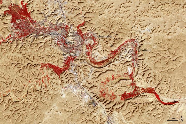
NASA image acquired Feb. 9, 2011 Less than 5 percent of Algeria’s land surface is suitable for growing crops, and most precipitation falls on the Atlas Mountains along the coast. Inland, dust-laden winds blow over rocky plains and sand seas. However, in north central Algeria—off the tip of Grand Erg Occidental and about 450 kilometers (280 miles) south of Algiers—lies a serpentine stretch of vegetation. It is the M’zab Valley, filled with palm groves and dotted with centuries-old settlements. The Advanced Spaceborne Thermal Emission and Reflection Radiometer (ASTER) on NASA’s Terra satellite captured this image of M’zab Valley on February 9, 2011. ASTER combines infrared, red, and green wavelengths of light. Bare rock ranges in color from beige to peach. Buildings and paved surfaces appear gray. Vegetation is red, and brighter shades of red indicate more robust vegetation. This oasis results from water that is otherwise in short supply in the Sahara Desert, thanks to the valley’s approximately 3,000 wells. Chemical analysis of Algerian aquifers, as well studies of topography in Algeria and Tunisia, suggest this region experienced a cooler climate in the late Pleistocene, and potentially heavy monsoon rains earlier in the Holocene. The M’zab region shows evidence of meandering rivers and pinnate drainage patterns. The vegetation lining M’zab Valley highlights this old river valley’s contours. Cool summer temperatures and monsoon rains had long since retreated from the region by eleventh century, but this valley nevertheless supported the establishment of multiple fortified settlements, or ksours. Between 1012 A.D. and 1350 A.D., locals established the ksours of El-Atteuf, Bounoura, Melika, Ghardaïa, and Beni-Isguen. Collectively these cities are now a United Nations Educational, Scientific, and Cultural Organization (UNESCO) World Heritage site. NASA Earth Observatory image by Robert Simmon and Jesse Allen, using data from the GSFC/METI/ERSDAC/JAROS, and U.S./Japan ASTER Science Team. Caption by Michon Scott. Instrument: Terra - ASTER <b>To download the full high res file go <a href="http://earthobservatory.nasa.gov/IOTD/view.php?id=51296" rel="nofollow"> here</a></b>

NASA's Airborne Visible Infrared Imaging Spectrometer instrument (AVIRIS), flying aboard a NASA Armstrong Flight Research Center high-altitude ER-2 aircraft, observed wildfires burning in Southern California on Dec. 5-7, 2017. AVIRIS is an imaging spectrometer that observes light in visible and infrared wavelengths, measuring the full spectrum of radiated energy. Unlike regular cameras with three colors, AVIRIS has 224 spectral channels, measuring contiguously from the visible through the shortwave infrared. Data from these flights, compared against measurements acquired earlier in the year, show many ways this one instrument can improve both our understanding of fire risk and the response to fires in progress. The top row in this image compilation shows pre-fire data acquired from June 2017. At top left is a visible-wavelength image similar to what our own eyes would see. The top middle image is a map of surface composition based on analyzing the full electromagnetic spectrum, revealing green vegetated areas and non-photosynthetic vegetation that is potential fuel as well as non-vegetated surfaces that may slow an advancing fire. The image at top right is a remote measurement of the water in tree canopies, a proxy for how much moisture is in the vegetation. The bottom row in the compilation shows data acquired from the Thomas fire in progress in December 2017. At bottom left is a visible wavelength image. The bottom middle image is an infrared image, with red at 2,250 nanometers showing fire energy, green at 1,650 nanometers showing the surface through the smoke, and blue at 1,000 nanometers showing the smoke itself. The image at bottom right is a fire temperature map using spectroscopic analysis to measure fire thermal emission recorded in the AVIRIS spectra. https://photojournal.jpl.nasa.gov/catalog/PIA22194
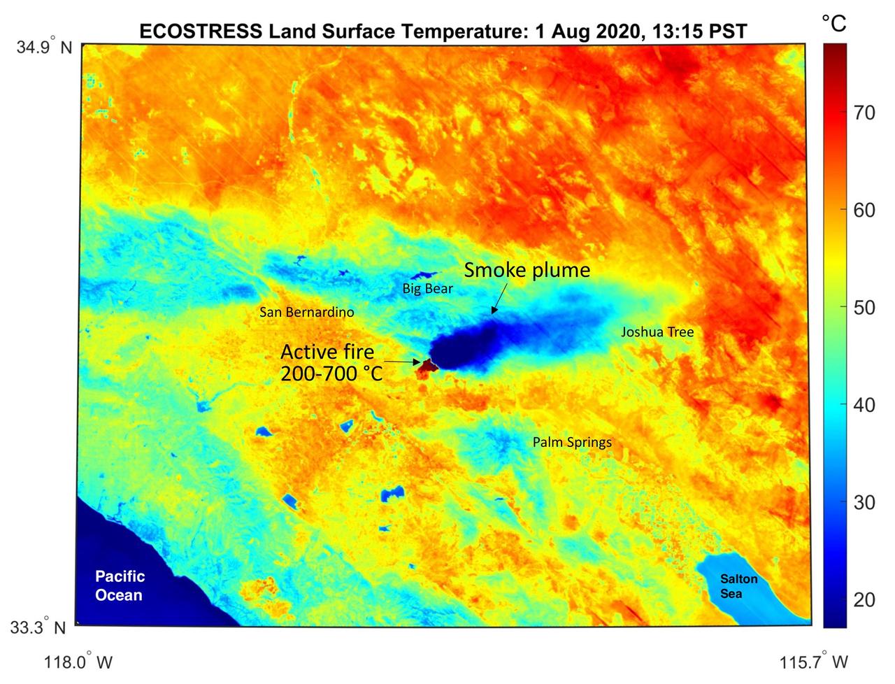
This temperature map shows the stressed and dry vegetation surrounding the Apple fire in Southern California on Aug. 1, 2020. The observation was made possible by NASA's Ecosystem Spaceborne Thermal Radiometer Experiment on Space Station (ECOSTRESS) that measured the temperature of the burn area and tracked the dark smoke plume drifting east from California to Arizona. ECOSTRESS collected this data when the space station passed over the region at about 1:15 p.m. PST on Saturday, Aug. 1, 2020, when the burn area was approximately 4,000 acres in size. Black smoke can be seen drifting east and over Joshua Tree National Park in the Mojave Desert. With a resolution of about 77 by 77 yards (70 by 70 meters), the image enables surface-temperature conditions down to the size of a football field to be studied. In the active burn area, temperatures of between 390-1290 F (200-700 C) were recorded, and in one pixel in the ECOSTRESS image of the burn zone, a peak temperature of 1387 F (753 C) was detected. Tasked with detecting plant water use and stress, ECOSTRESS measures the temperature of plants as they heat up when they run out of water. But it can also measure and track heat-related phenomena like fires, heat waves, and volcanoes. https://photojournal.jpl.nasa.gov/catalog/PIA23798
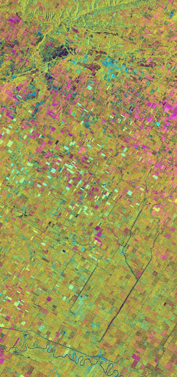
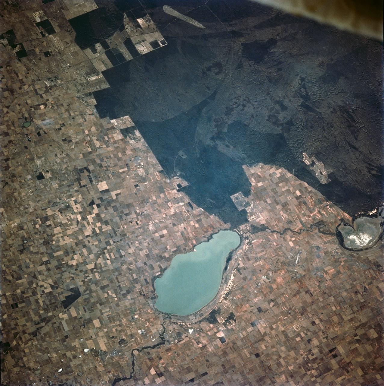
This is an X-band seasonal image of the Altona test site in Manitoba, Canada, about 80 kilometers (50 miles) south of Winnipeg. The image is centered at approximately 49 degrees north latitude and 97.5 degrees west longitude. This image was acquired by the Spaceborne Imaging Radar-C and X-band Synthetic Aperture Radar (SIR-C/X-SAR) aboard the space shuttle Endeavour on April 11, 1994, during the first flight of the radar system, and on October 2, 1994, during the second flight of SIR-C/X-SAR. The image channels have the following color assignments: red represents data acquired on April 11, 1994; green represents data acquired on October 2, 1994; blue represents the ratio of the two data sets. The test site is located in the Red River Basin and is characterized by rich farmland where a variety of crops are grown, including wheat, barley, canola, corn, sunflowers and sugar beets. This SIR-C/X-SAR research site is applying radar remote sensing to study the characteristics of vegetation and soil moisture. The seasonal comparison between the April and October 1994 data show the dramatic differences between surface conditions on the two dates. At the time of the April acquisition, almost all agricultural fields were bare and soil moisture levels were high. In October, however, soils were drier and while most crops had been harvested, some standing vegetation was still present. The areas which are cyan in color are dark in April and bright in October. These represent fields of standing biomass (amount of vegetation in a specified area) and the differences in brightness within these cyan fields represent differences in vegetation type. The very bright fields in October represent standing broadleaf crops such as corn, which had not yet been harvested. Other standing vegetation which has less biomass, such as hay and grain fields, are less bright. The magenta indicates bare soil surfaces which were wetter (brighter) in April than in October. The variations in brightness of the magenta indicate differences in the degree of soil moisture change and differences in surface roughness. This seasonal composite demonstrates the sensitivity of radar to changes in agricultural surface conditions such as soil moisture, tillage, cropping and harvesting. http://photojournal.jpl.nasa.gov/catalog/PIA01742
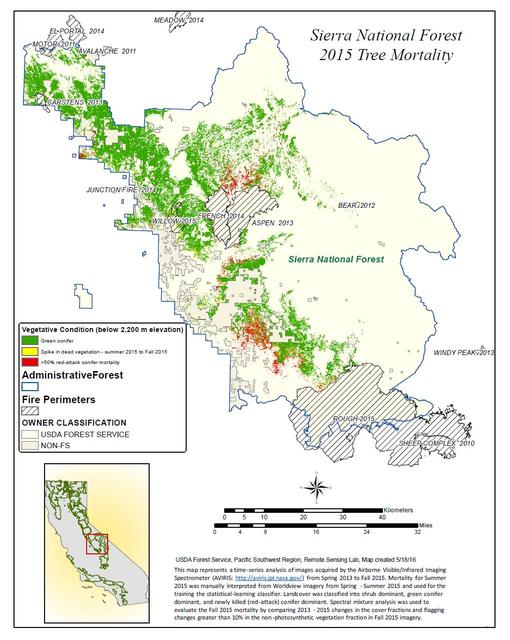
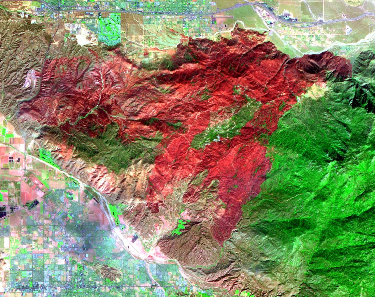
California, reveals the devastating effect of California's ongoing drought on Sierra Nevada conifer forests. The map will be used to help the U.S. Forest Service assess and respond to the impacts of increased tree mortality caused by the drought, particularly where wildlands meet urban areas within the Sierra National Forest. After several years of extreme drought, the highly stressed conifers (trees or bushes that produce cones and are usually green year-round) of the Sierra Nevada are now more susceptible to bark beetles (Dendroctonus spp.). While bark beetles killing trees in the Sierra Nevada is a natural phenomenon, the scale of mortality in the last couple of years is far greater than previously observed. The U.S. Forest Service is using recent airborne spectroscopic measurements from NASA's Airborne Visible/Infrared Imaging Spectrometer (AVIRIS) instrument aboard NASA's ER-2 aircraft, together with new advanced algorithms, to quantify this impact over this large region of rugged terrain. The high-altitude ER-2 aircraft is based at NASA's Armstrong Flight Research Center, Edwards, California. The image was created by scientists at the USFS's Pacific Southwest Region Remote Sensing Lab, McClellan, California, by performing a time series analysis of AVIRIS images. Scientists evaluated baseline tree mortality on public lands in the summer of 2015 using a machine learning algorithm called "random forest." This algorithm classifies the AVIRIS measurements as dominated by either shrubs, healthy trees or newly dead conifer trees. To quantify how much the amount of dead vegetation increased during the fall of 2015, the Forest Service scientists conducted an advanced spectral mixture analysis. This analysis evaluates each spectrum to determine the fraction of green vegetation, dead vegetation and soil. The full spectral range of AVIRIS is important to separate the signatures of soil and dead vegetation. To produce this comprehensive Sierra National Forest tree mortality map, the result from the summer of 2015 was evaluated to look for increases of more than 10 percent in dead vegetation during the fall of 2015. AVIRIS measures spectra of the Earth system to conduct advanced science research. These western U.S. AVIRIS measurements were acquired as part of NASA's Hyperspectral Infrared Imager (HyspIRI) preparatory airborne campaign. HyspIRI was one of the space missions suggested to NASA by the National Academy of Sciences in its 2007 decadal survey for Earth Science. In the future, HyspIRI could provide spectral and thermal measurements of this type globally for ecosystem research and additional science objectives. http://photojournal.jpl.nasa.gov/catalog/PIA20717
STS062-106-042 (4-18 March 1994) --- This view of southern Australia about 100 miles northwest of Melbourne shows areas of protected reserves of natural forests in the midst of agricultural crop lands. The green patch seen here has been recently burned as indicated by the irregular large scar. The impact of winds on the scar is clearly visible. This nature preserve is reported to be the home to a large number of animals including the koala bears. Similar views were shot by the STS-60 crewmembers last month. These photographs will assist earth scientists in mapping the impact of forest fires and in moniotring the recovery of burned areas.
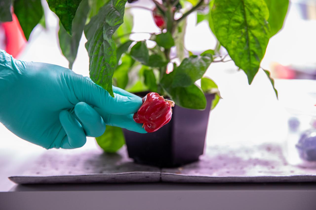
Inside the Space Station Processing Facility at NASA’s Kennedy Space Center in Florida, peppers are harvested on Jan. 15, 2020, for a growth assessment in preparation for sending them to space. As NASA prepares to send humans beyond low-Earth orbit, the ability for astronauts to grow a variety of fresh fruits and vegetables in space will be critical. Fresh produce will be an essential supplement to the crew’s pre-packaged diet during long-duration space exploration when they are away from Earth for extended periods of time.
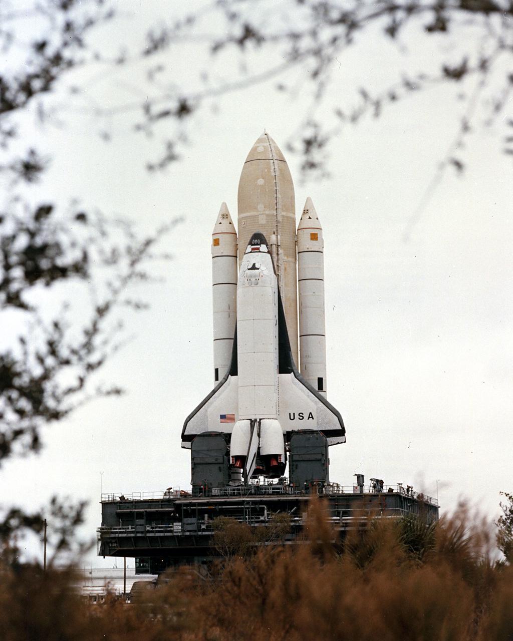
KENNEDY SPACE CENTER, FLA. - STS-1 stands framed in vegetation lining the superhighay-wide crawlerway linking the Vehicle Assembly Building with the twin pads of Launch Complex 39. The first Space Shuttle assembly emerged from the VAB shortly after 8 a.m. today for the 3.5-mile journey to Complex 39's Pad A. The Shuttle was on the hardstand at Pad A approximately seven and a half hours after rollout began. Launch is scheduled for no eariler than March 1981.
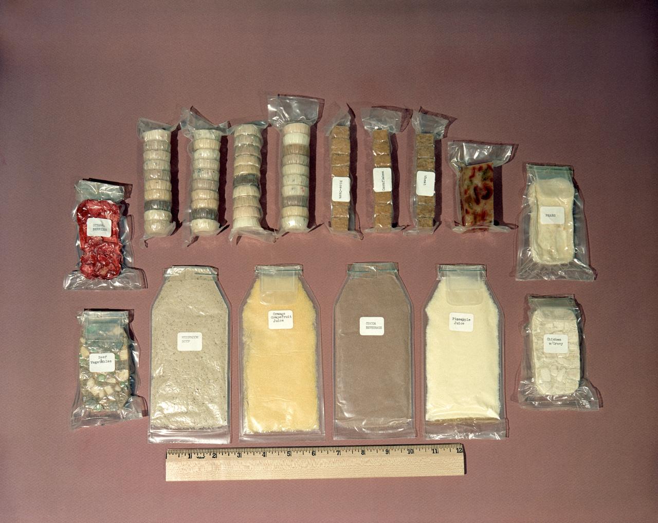
S62-08742 (1962) --- Food kit used by Mercury astronauts. Some is dehydrated and needs water, other packets are ready to eat. Size is measured relative to a ruler. Included are packets of mushroom soup, orange-grapefruit juice, cocoa beverage, pineapple juice, chicken with gravy, pears, strawberries, beef and vegetables and other assorted food containers. Photo credit: NASA
Restoration efforts are underway to the dunes at the north beaches at NASA’s Kennedy Space Center in Florida in this view on April 15, 2019. About 450,000 cubic yards of beach-quality sand, tested for compatibility, was transported to the space center’s beaches. Once the dune is built up, native coastal vegetation will be replanted, helping to stabilize the dune and offer a habitat for Kennedy’s coastal wildlife. Dunes are affected by beach erosion and storm surge from tropical events, such as hurricanes. Restoration began in spring 2018 and was targeted to be completed by April 2019.
Restoration efforts are underway to the dunes at the north beaches at NASA’s Kennedy Space Center in Florida in this view on April 15, 2019. About 450,000 cubic yards of beach-quality sand, tested for compatibility, was transported to the space center’s beaches. Once the dune is built up, native coastal vegetation will be replanted, helping to stabilize the dune and offer a habitat for Kennedy’s coastal wildlife. Dunes are affected by beach erosion and storm surge from tropical events, such as hurricanes. Restoration began in spring 2018 and was targeted to be completed by April 2019.
Restoration efforts are underway to the dunes at the north beaches at NASA’s Kennedy Space Center in Florida in this view on April 15, 2019. About 450,000 cubic yards of beach-quality sand, tested for compatibility, was transported to the space center’s beaches. After the dune was built up, native coastal vegetation was replanted, helping to stabilize the dune and offer a habitat for Kennedy’s coastal wildlife. Dunes are affected by beach erosion and storm surge from tropical events, such as hurricanes. Restoration began in spring 2018 and was targeted to be completed by April 2019.
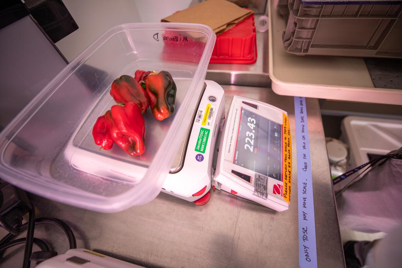
Peppers that were grown and harvested inside the Space Station Processing Facility at NASA’s Kennedy Space Center in Florida are weighed on Jan. 15, 2020, in preparation for sending them to space. As NASA prepares to send humans beyond low-Earth orbit, the ability for astronauts to grow a variety of fresh fruits and vegetables in space will be critical. Fresh produce will be an essential supplement to the crew’s pre-packaged diet during long-duration space exploration when they are away from Earth for extended periods of time.
Restoration efforts are underway to the dunes at the north beaches at NASA’s Kennedy Space Center in Florida on Oct. 8, 2018. About 450,000 cubic yards of beach-quality sand, tested for compatibility, is being transported to the space center’s beaches. One the dune is built up, native coastal vegetation will be replanted, helping to stabilize the dune and offer a habitat for Kennedy’s coast wildlife. Dunes are affected by beach erosion and storm surge from tropical events, such as hurricanes. Restoration began in spring 2018 and is targeted to be completed by April 2019.

ISS010-E-12730 (11 January 2005) --- One of a series of post-tsunami digital still images photographed from the International Space Station on January 11, 2005. This image is centered at 4.53 degrees north latitude and 95.75 degrees east longitude and is the northwest coast of Sumatra. Some tsunami damage, at least in the form of the lack of vegetation, can be seen along the coast.
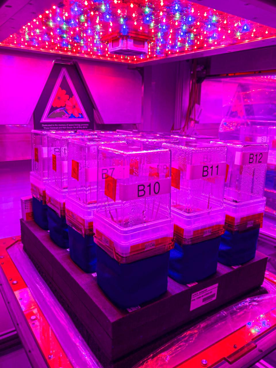
jsc2024e016235 (10/19/2022) --- The Vegetable Production System (Veggie) is used to grow Brachypodium and Setaria in the International Space Station and on Earth at NASA's Kennedy Space Center. C4 Photosynthesis in Space (C4 Space) (APEX-09) observes two plant species with differing mechanisms for capturing CO2 during photosynthesis. Researchers aim to uncover changes that occur in plant metabolism when they are exposed to microgravity, which could improve planning for bio-regenerative support systems on deep exploration missions.
NASA’s Kennedy Space Center occupies a scenic stretch of land along Florida’s east coast, including miles of pristine beaches on the Atlantic Ocean. The agency is nearing completion on a restoration project to shore up the dunes that create a natural barrier from the waves. Once the dune is built up, native coastal vegetation will be replanted, helping to stabilize the dune and offer a habitat for Kennedy’s coastal wildlife.
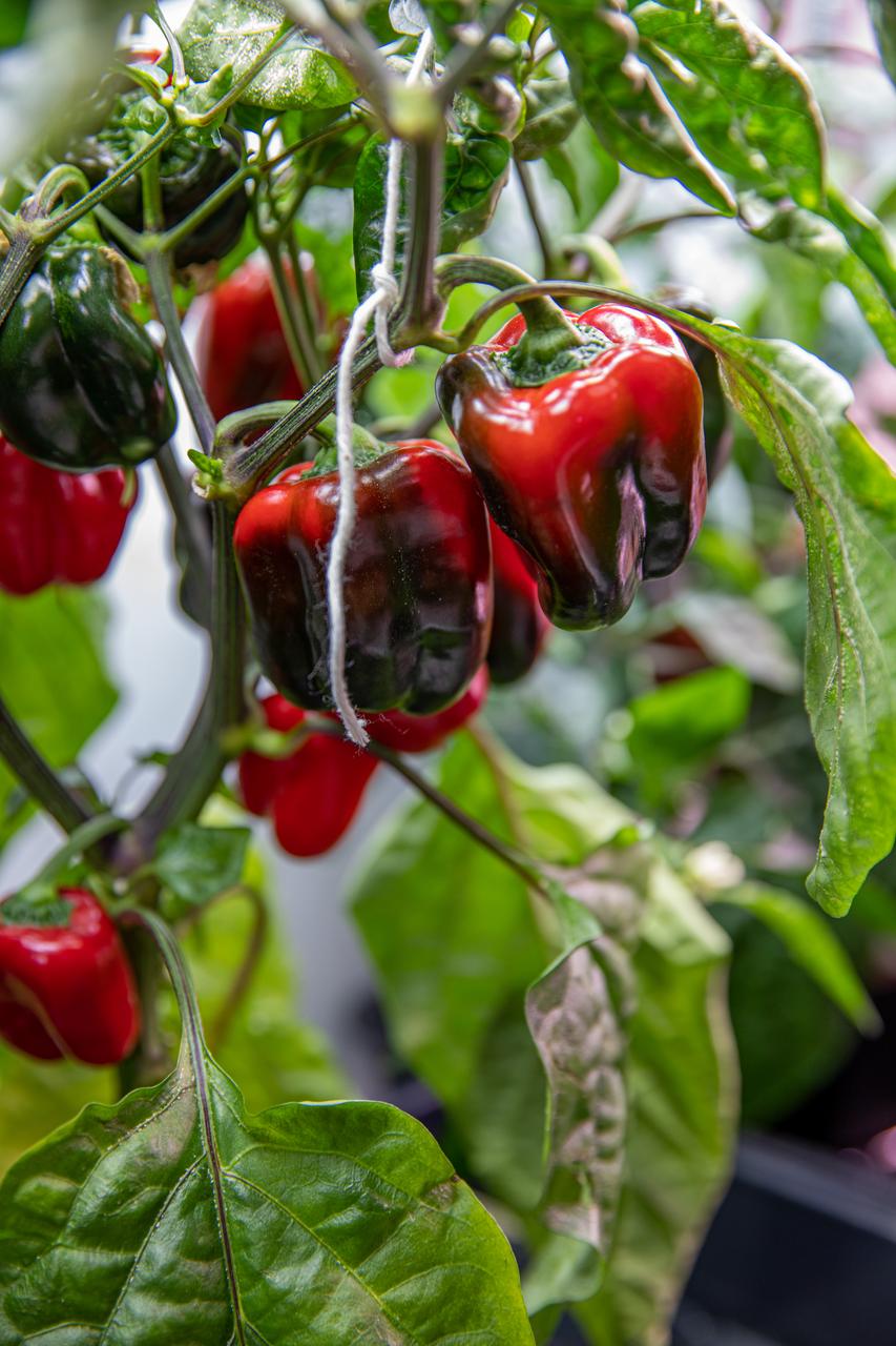
Researchers are growing green peppers inside the Space Station Processing Facility at NASA’s Kennedy Space Center in Florida on Jan. 15, 2020, in preparation for sending them to space. As NASA prepares to send humans beyond low-Earth orbit, the ability for astronauts to grow a variety of fresh fruits and vegetables in space will be critical. Fresh produce will be an essential supplement to the crew’s pre-packaged diet during long-duration space exploration when they are away from Earth for extended periods of time.

Restoration efforts are underway to the dunes at the north beaches at NASA’s Kennedy Space Center in Florida in this view on April 15, 2019. About 450,000 cubic yards of beach-quality sand, tested for compatibility, was transported to the space center’s beaches. Once the dune is built up, native coastal vegetation will be replanted, helping to stabilize the dune and offer a habitat for Kennedy’s coastal wildlife. Dunes are affected by beach erosion and storm surge from tropical events, such as hurricanes. Restoration began in spring 2018 and was targeted to be completed by April 2019.
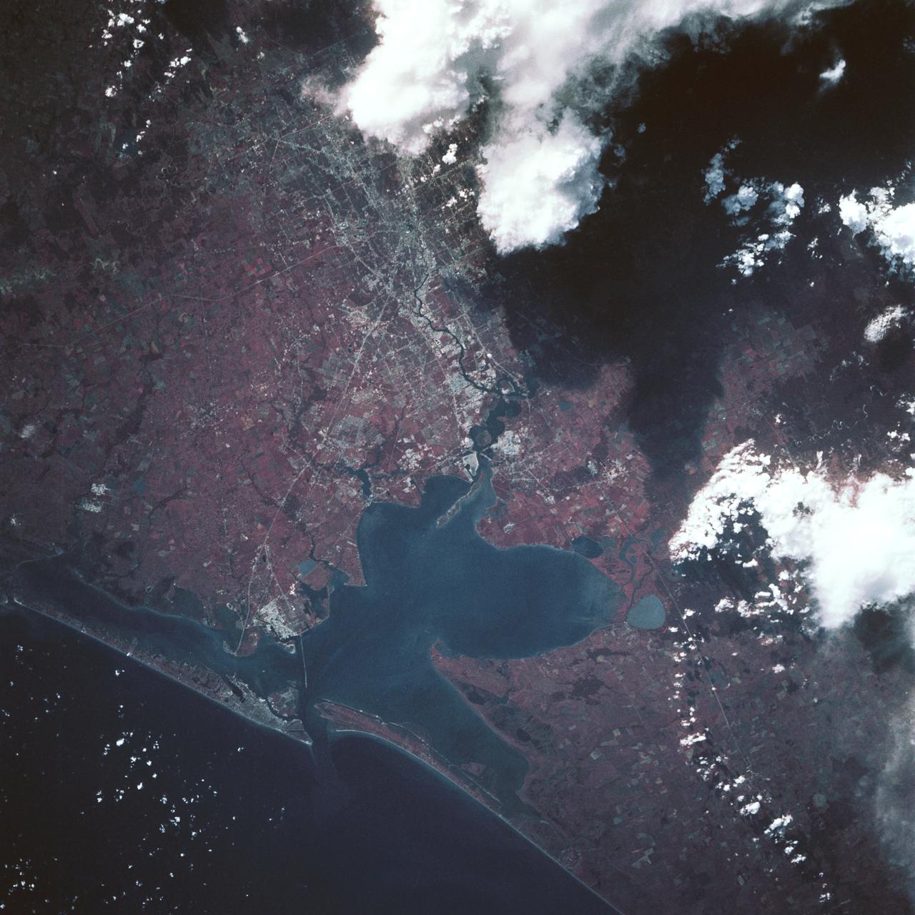
This color infrared view of Houston (29.5N, 95.0W) was taken with a dual camera mount. Compare this scene with STS048-78-034 for an analysis of the unique properties of each film type. Comparative tests such as this aids in determining the kinds of information unique to each film system and evaluates and compares photography taken through hazy atmospheres. Infrared film is best at penetrating haze, vegetation detection and producing a sharp image.
Restoration efforts are underway to the dunes at the north beaches at NASA’s Kennedy Space Center in Florida in this view on April 15, 2019. About 450,000 cubic yards of beach-quality sand, tested for compatibility, was transported to the space center’s beaches. After the dune was built up, native coastal vegetation was replanted, helping to stabilize the dune and offer a habitat for Kennedy’s coastal wildlife. Dunes are affected by beach erosion and storm surge from tropical events, such as hurricanes. Restoration began in spring 2018 and was targeted to be completed by April 2019.
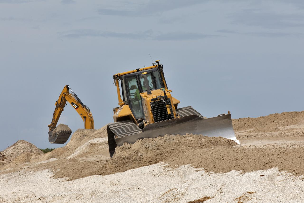
Restoration efforts are underway to the dunes at the north beaches at NASA’s Kennedy Space Center in Florida on Oct. 8, 2018. About 450,000 cubic yards of beach-quality sand, tested for compatibility, is being transported to the space center’s beaches. Once the dune is built up, native coastal vegetation will be replanted, helping to stabilize the dune and offer a habitat for Kennedy’s coast wildlife. Dunes are affected by beach erosion and storm surge from tropical events, such as hurricanes. Restoration began in spring 2018 and is targeted to be completed by April 2019.
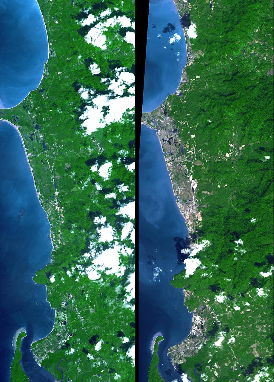
The island of Phuket on the Indian Ocean coast of Thailand is a major tourist destination and was also in the path of the tsunami that washed ashore on December 26, 2004. These simulated natural color ASTER images show a 27 kilometer (17-mile) long stretch of coast north of the Phuket airport on December 31 (right), along with an image acquired two years earlier (left). The changes along the coast are obvious where the vegetation has been stripped away. http://photojournal.jpl.nasa.gov/catalog/PIA07227
Restoration efforts are underway to the dunes at the north beaches at NASA’s Kennedy Space Center in Florida in this view on April 15, 2019. About 450,000 cubic yards of beach-quality sand, tested for compatibility, was transported to the space center’s beaches. After the dune was built up, native coastal vegetation was replanted, helping to stabilize the dune and offer a habitat for Kennedy’s coast wildlife. Dunes are affected by beach erosion and storm surge from tropical events, such as hurricanes. Restoration began in spring 2018 and was targeted to be completed by April 2019.
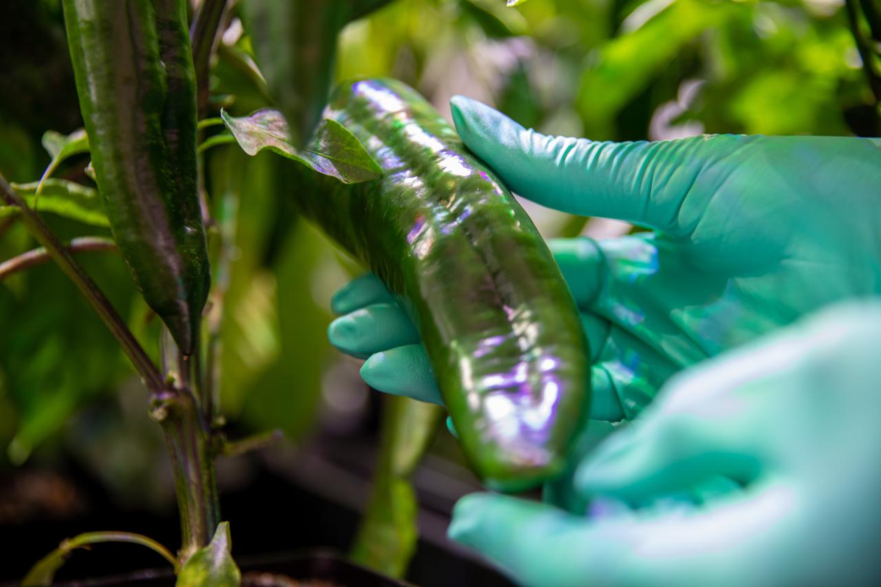
Researchers are growing green peppers inside the Space Station Processing Facility at NASA’s Kennedy Space Center in Florida on Jan. 15, 2020, in preparation for sending them to space. As NASA prepares to send humans beyond low-Earth orbit, the ability for astronauts to grow a variety of fresh fruits and vegetables in space will be critical. Fresh produce will be an essential supplement to the crew’s pre-packaged diet during long-duration space exploration when they are away from Earth for extended periods of time.
Restoration efforts are underway to the dunes at the north beaches at NASA’s Kennedy Space Center in Florida on Oct. 8, 2018. About 450,000 cubic yards of beach-quality sand, tested for compatibility, is being transported to the space center’s beaches. One the dune is built up, native coastal vegetation will be replanted, helping to stabilize the dune and offer a habitat for Kennedy’s coast wildlife. Dunes are affected by beach erosion and storm surge from tropical events, such as hurricanes. Restoration began in spring 2018 and is targeted to be completed by April 2019.