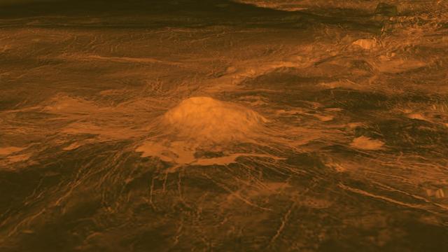
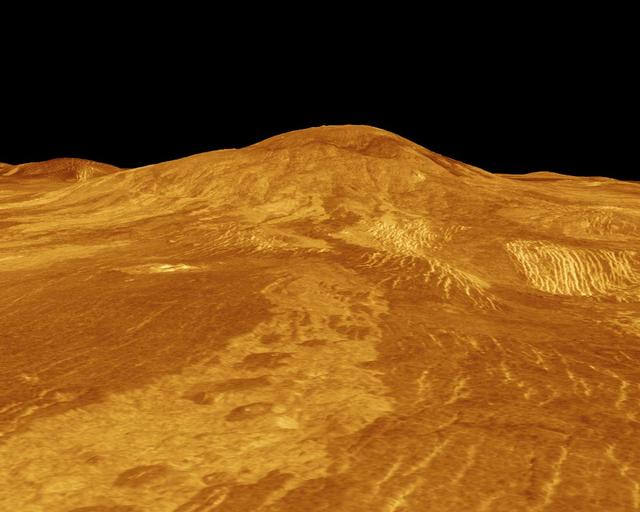
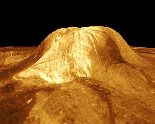
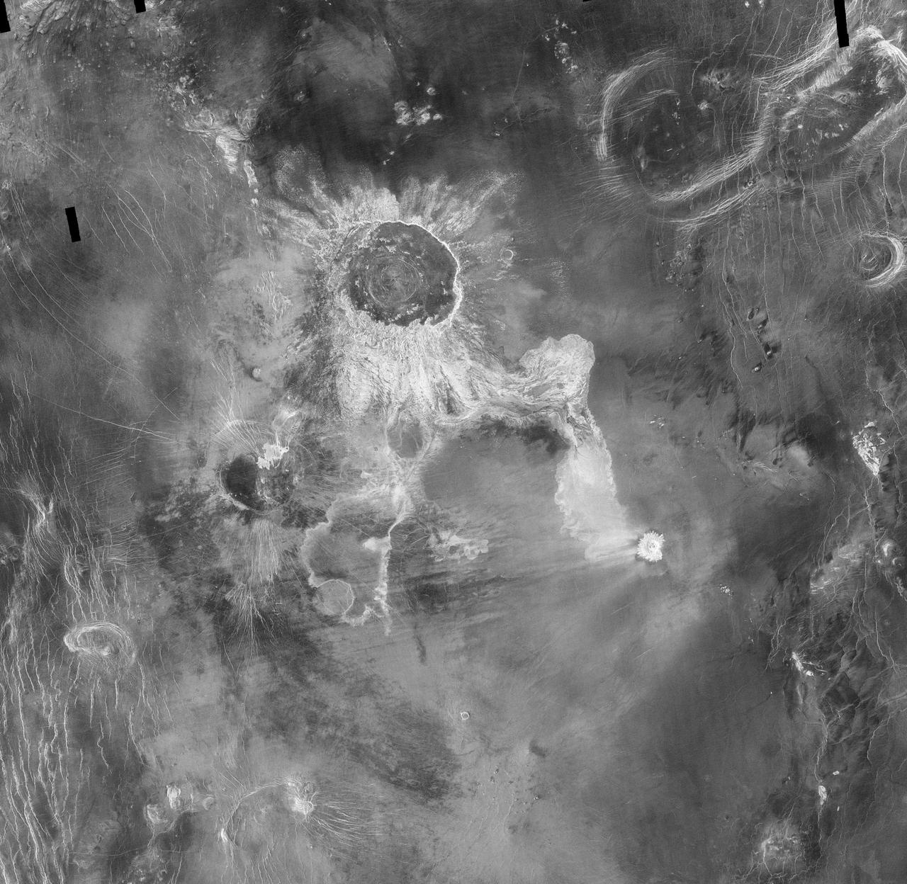
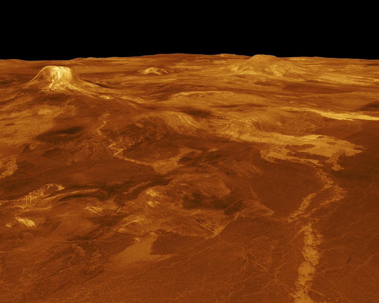
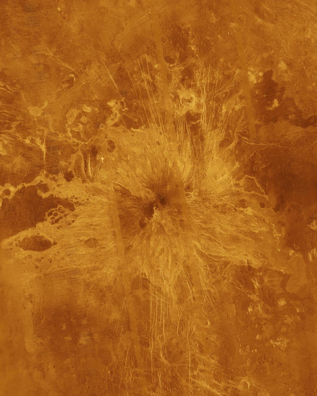
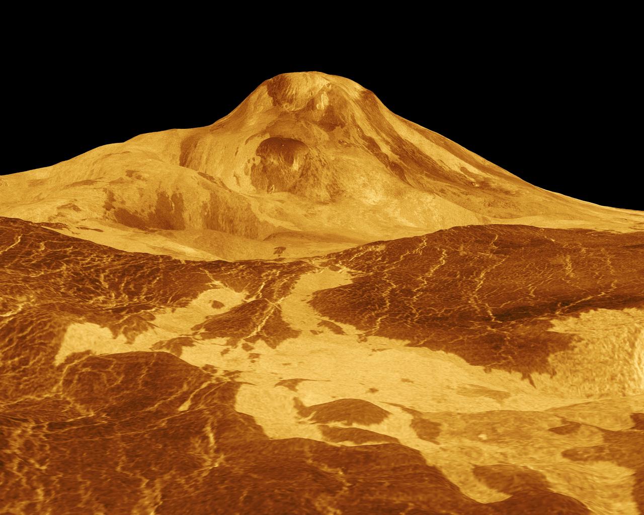
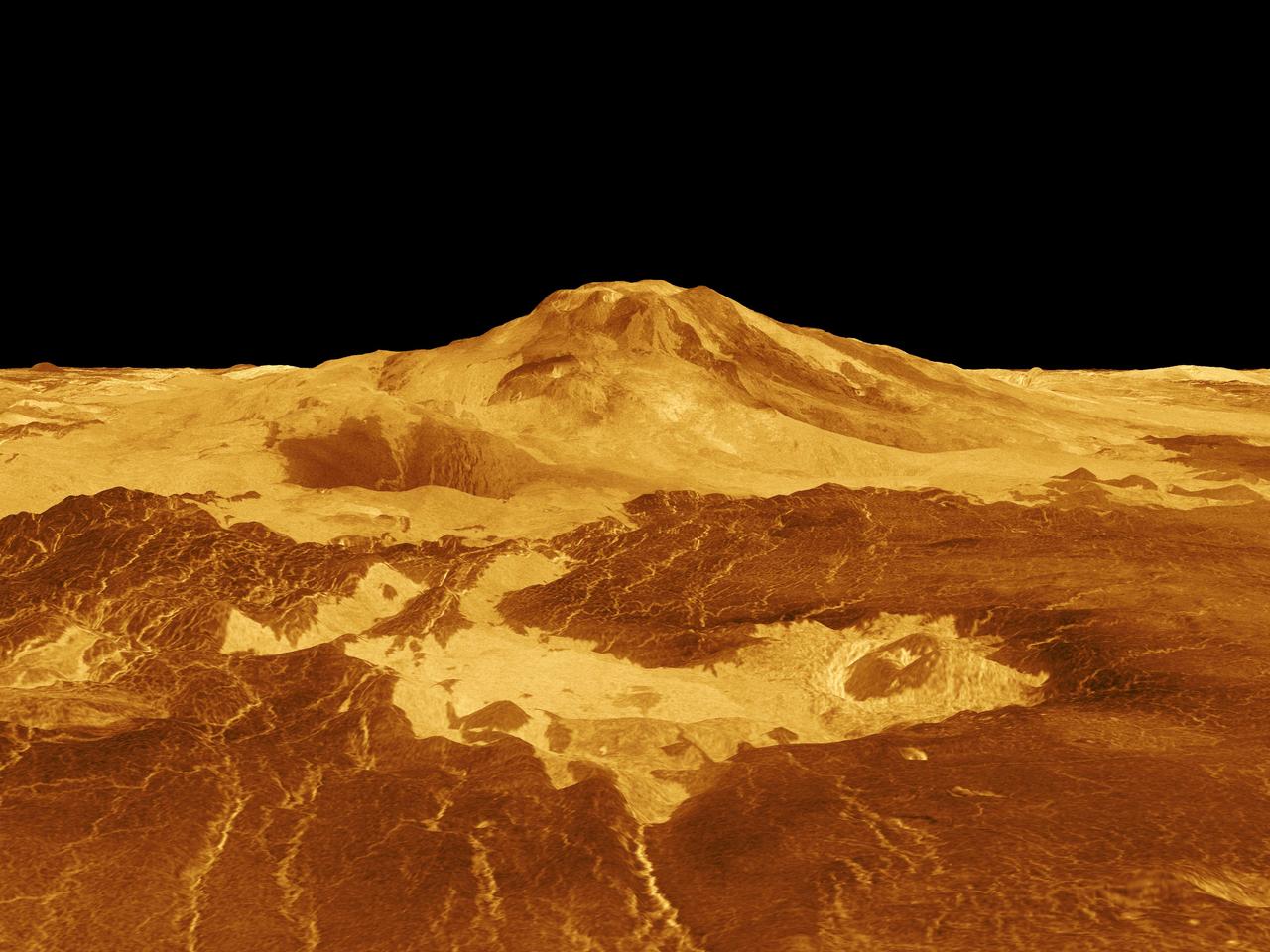
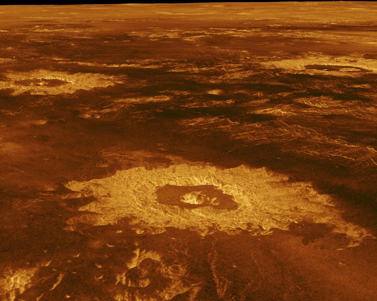
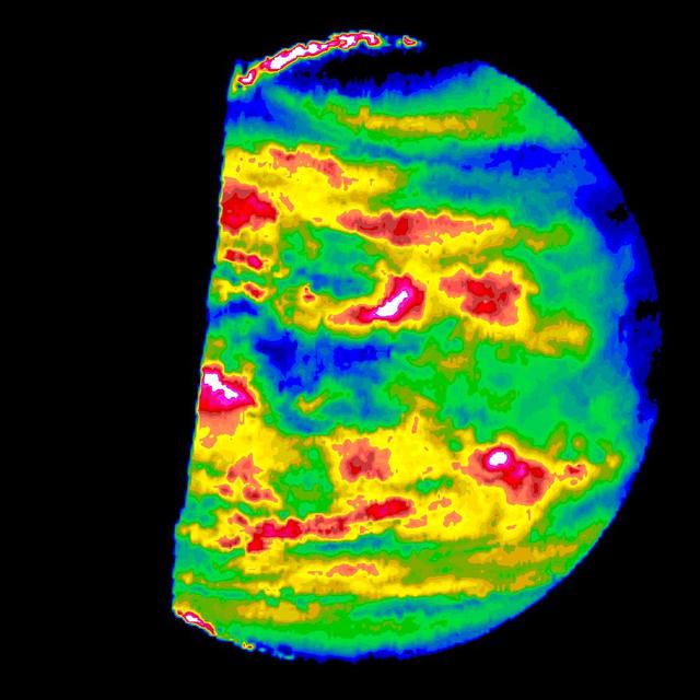
This figure shows the volcanic peak Idunn Mons in the Imdr Regio area of Venus. The topographic backbone brown color was derived from data obtained by NASA Magellan spacecraft and the overlay was derived from data from ESA Venus Express Spacecraft.
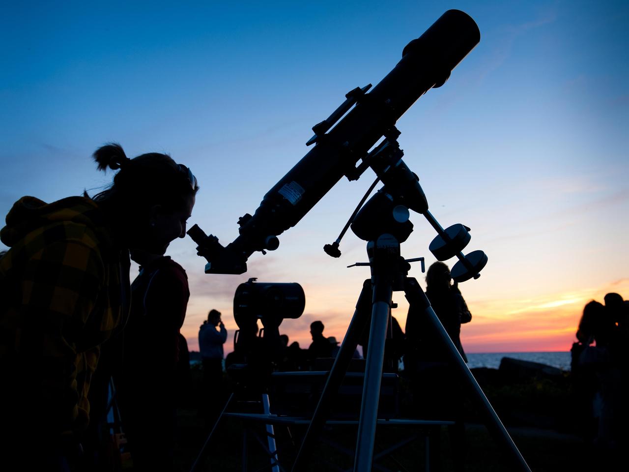
Beautiful skies prevailed on the evening of the Venus Transit when NASA Glenn brought telescopes to Edgewater Park on Lake Erie for a view of the event.
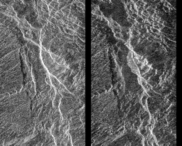
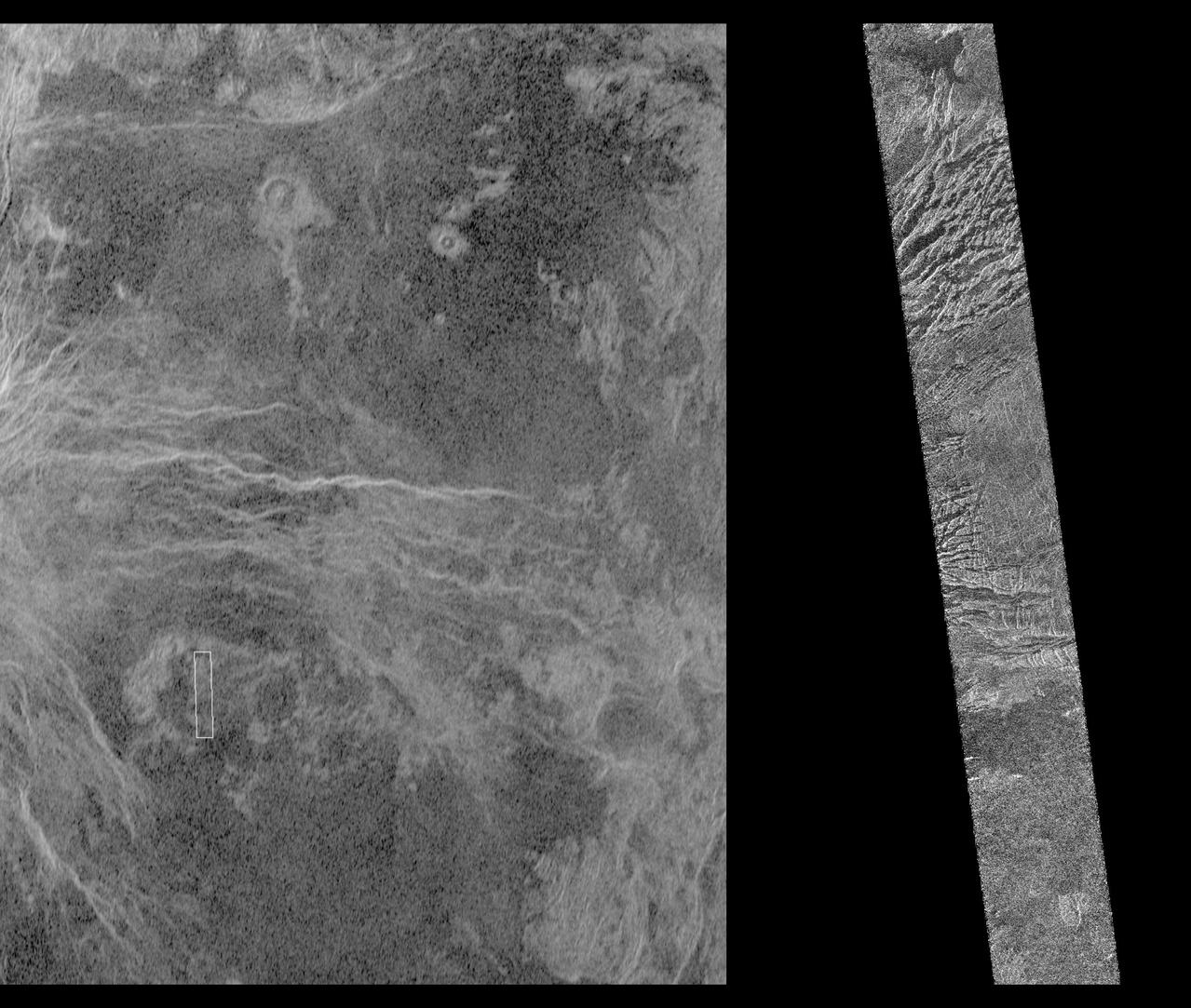
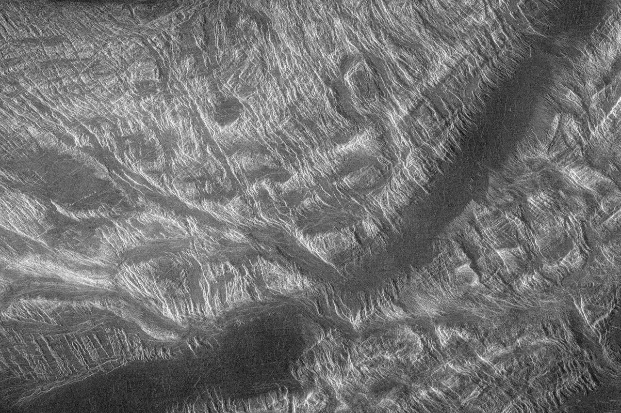
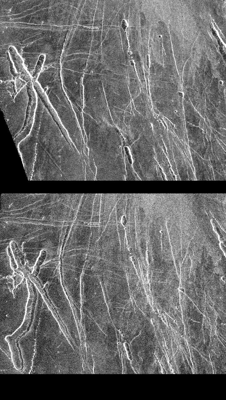
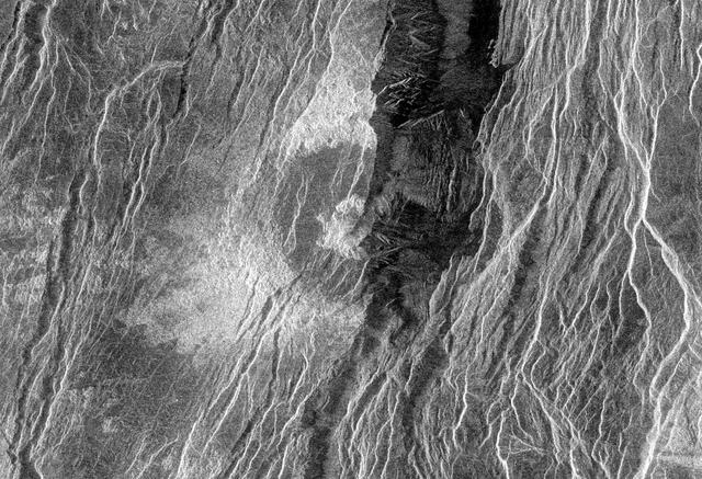
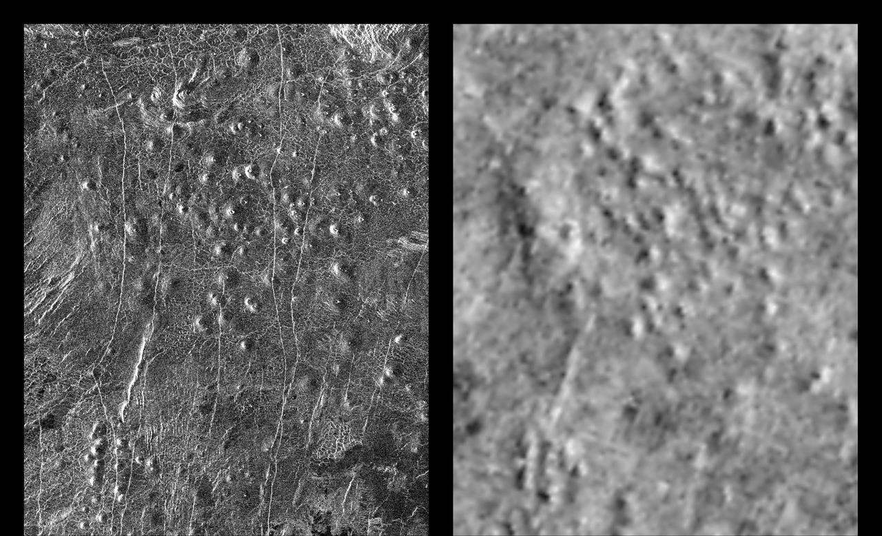
Landslides on Venus! The image on the left was taken in late November of 1990 during Magellan first trip around Venus. The image on the right was taken July 23, as the Magellan spacecraft passed over the region for the second time. http://photojournal.jpl.nasa.gov/catalog/PIA00248
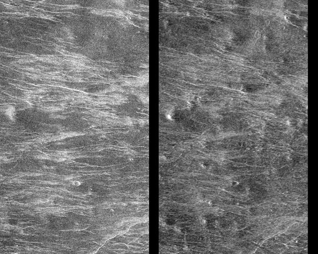
This Magellan image depicts a stereoscopic pair of an area on Venus with small volcanic domes. Stereoscopic images of Venus offer exciting new possibilities for scientific analysis of Venusian landforms. http://photojournal.jpl.nasa.gov/catalog/PIA00251

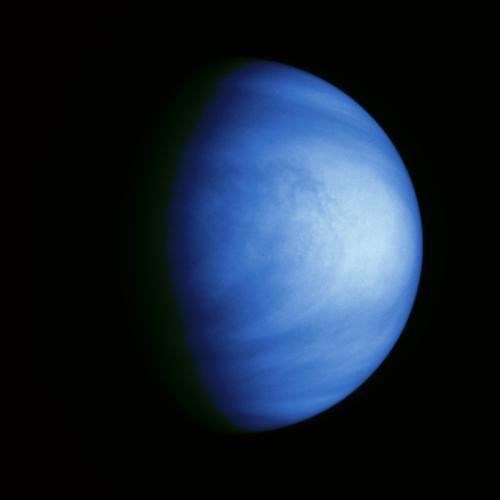
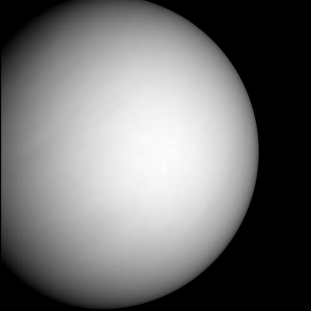
Venus Cloud Tops Viewed by Hubble. This is a NASA Hubble Space Telescope ultraviolet-light image of the planet Venus, taken on January 24 1995, when Venus was at a distance of 70.6 million miles 113.6 million kilometers from Earth.

On Oct. 24, 2006, NASA MESSENGER spacecraft came within 2,990 kilometers 1,860 miles of Venus during its second planetary encounter.
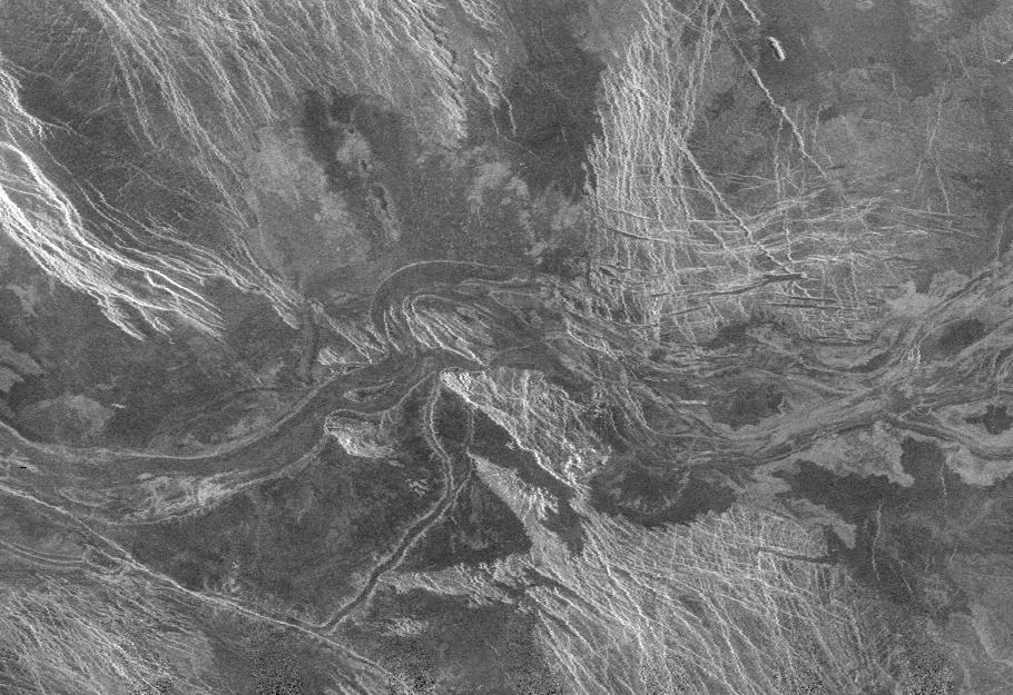
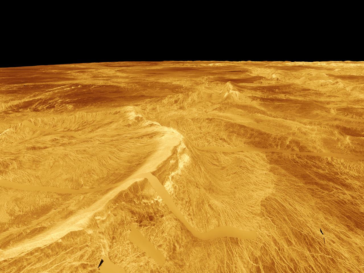
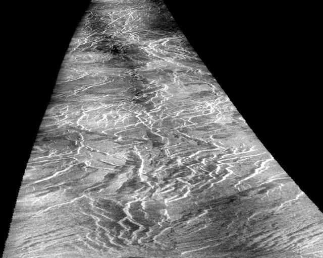
This NASA Magellan radar image mosaic is of part of Venus, centered at 51 degrees south latitude, 21 degrees east longitude. Running from west to east across the center of the image is part of a wide lava channel in the Lada Terra region of Venus. http://photojournal.jpl.nasa.gov/catalog/PIA00219
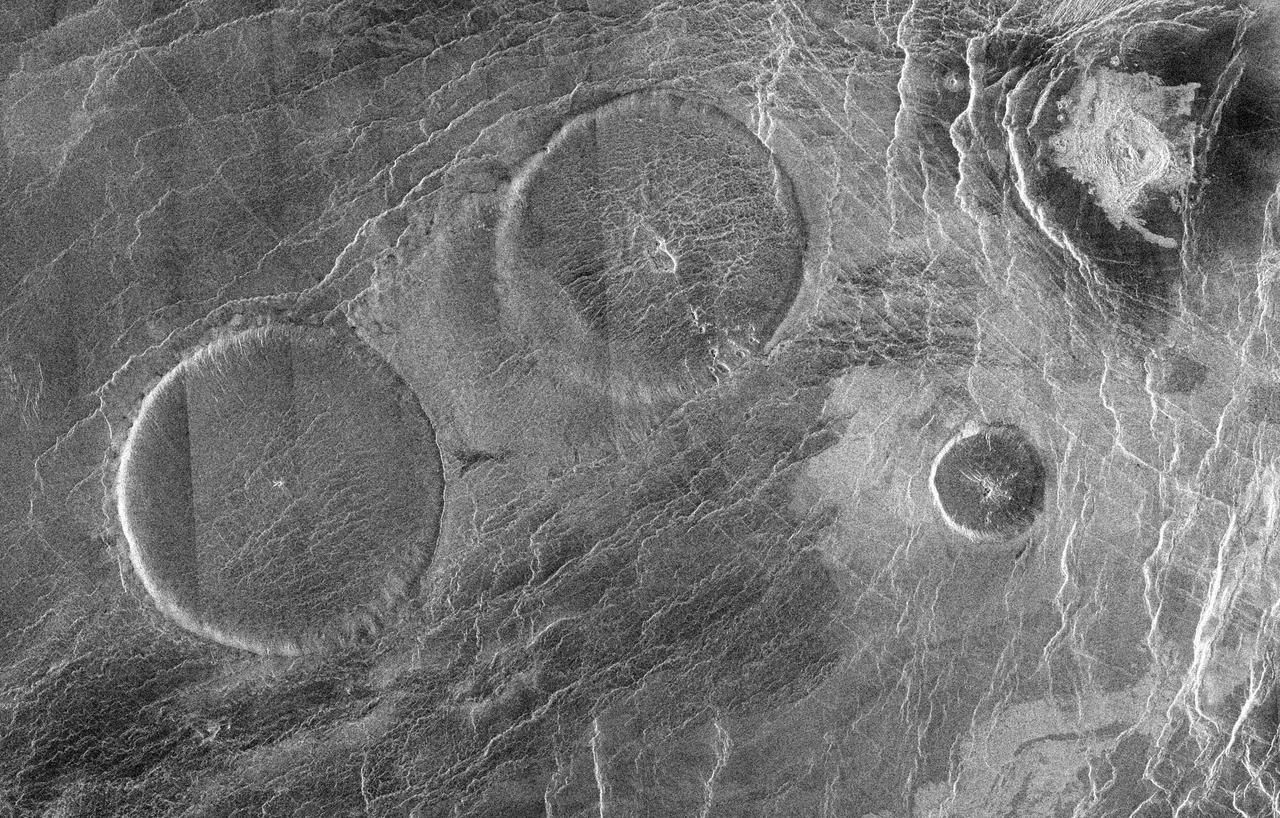
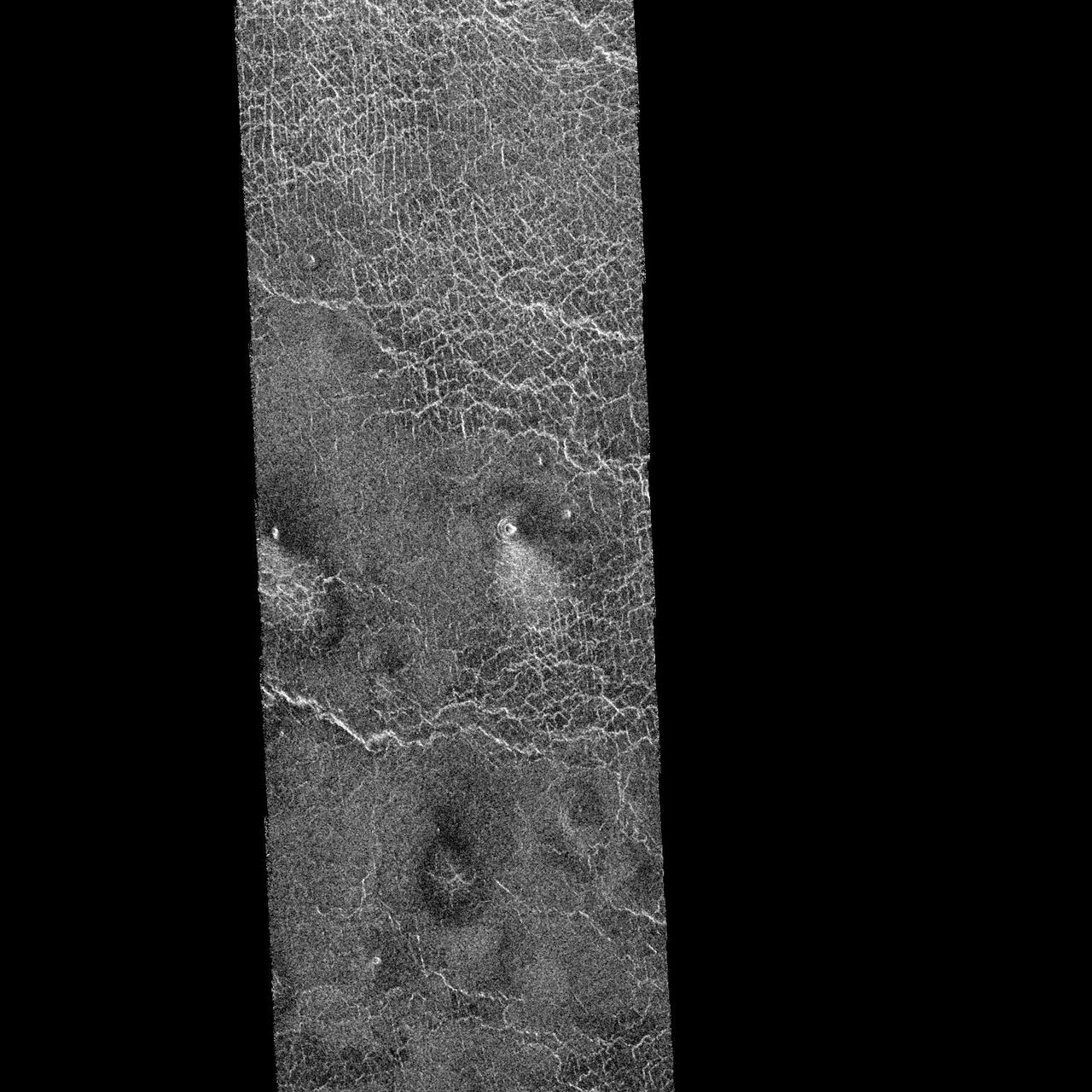
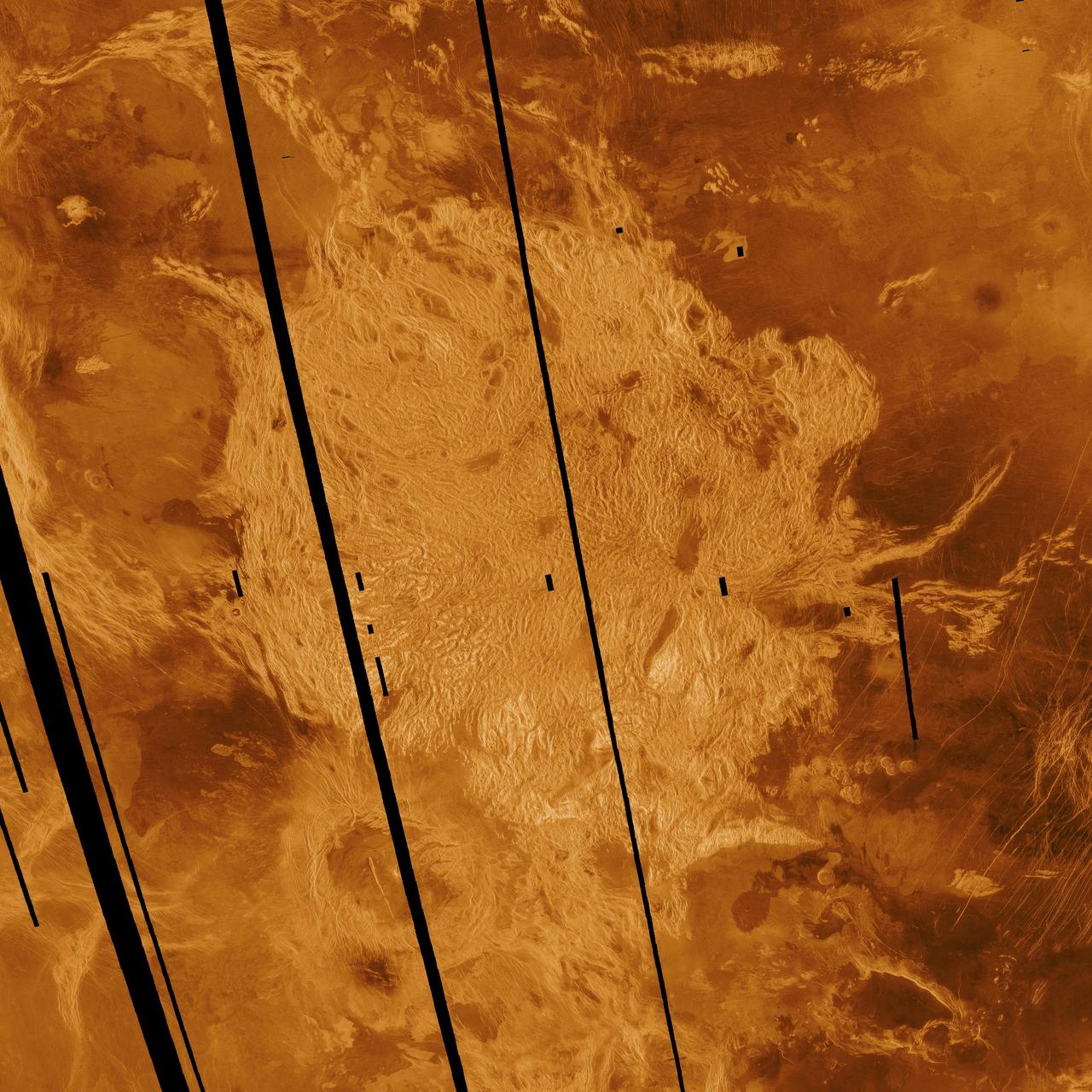
This image from NASA Magellan spacecraft is of an area located in the Eistla Region of Venus in the southern hemisphere. http://photojournal.jpl.nasa.gov/catalog/PIA00089
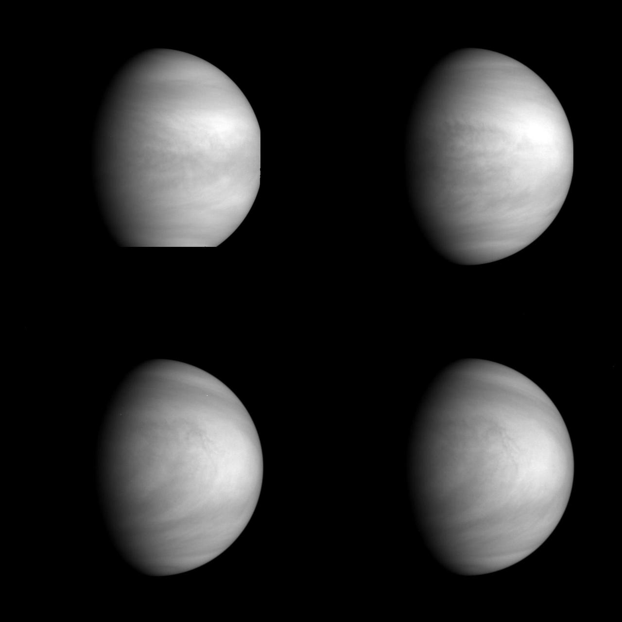
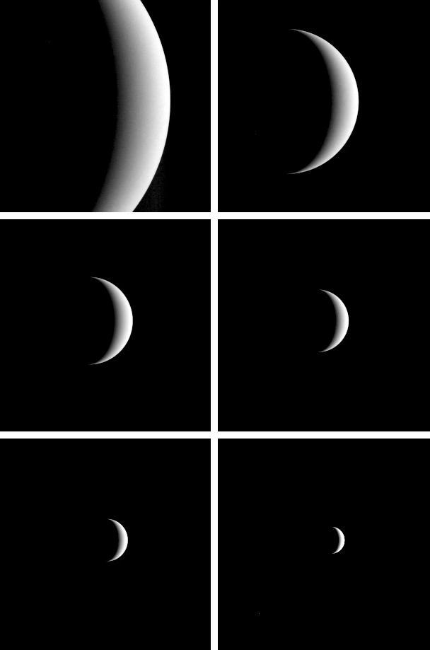
These are enhanced versions of four views of the planet Venus taken by NASA's Galileo Solid State Imaging System at distances ranging from 1.4 to 2 million miles as the spacecraft receded from Venus. http://photojournal.jpl.nasa.gov/catalog/PIA00110
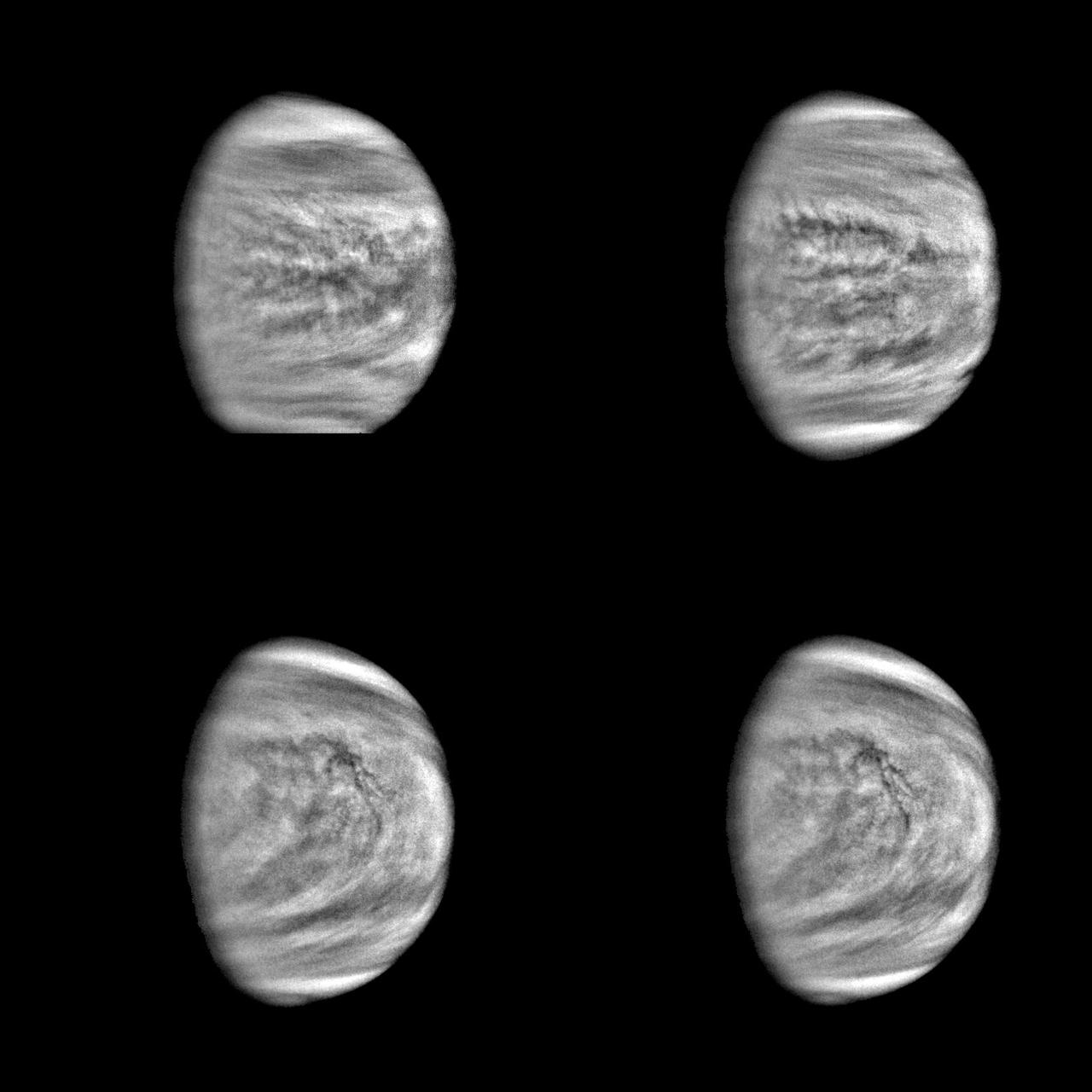
This series of pictures shows four views of the planet Venus obtained by NASA Galileo Solid State Imaging System at ranges of 1.4 to 2 million miles as the spacecraft receded from Venus. http://photojournal.jpl.nasa.gov/catalog/PIA00223

A portion of Alpha Regio is displayed in this three-dimensional perspective view of the surface of Venus from NASA Magellan spacecraft. In 1963, Alpha Regio was the first feature on Venus to be identified from Earth-based radar.
Two mosaiced pieces of NASA Magellan image strips display the area east of the Rhea Mons volcano on Venus. http://photojournal.jpl.nasa.gov/catalog/PIA00208
This image shows a comparison between NASA Magellan image right and the highest resolution Earth-based Arecibo radar image of Venus. http://photojournal.jpl.nasa.gov/catalog/PIA00207
This compressed resolution radar mosaic from NASA Magellan spacecraft shows a 600 kilometers 360 mile segment of the longest channel discovered on Venus in 1990. http://photojournal.jpl.nasa.gov/catalog/PIA00245

These images of the Venus clouds were taken by NASA Galileo Solid State Imaging System February 13,1990, at a range of about 1 million miles. The smallest detail visible is about 20 miles. They show the state of the clouds near the top of Venus cloud. http://photojournal.jpl.nasa.gov/catalog/PIA00071
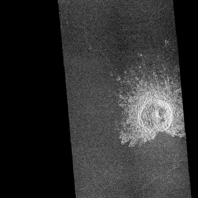
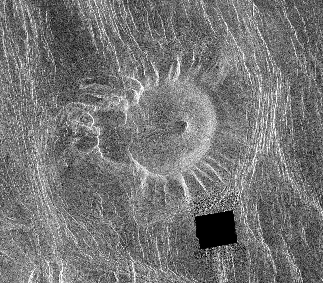
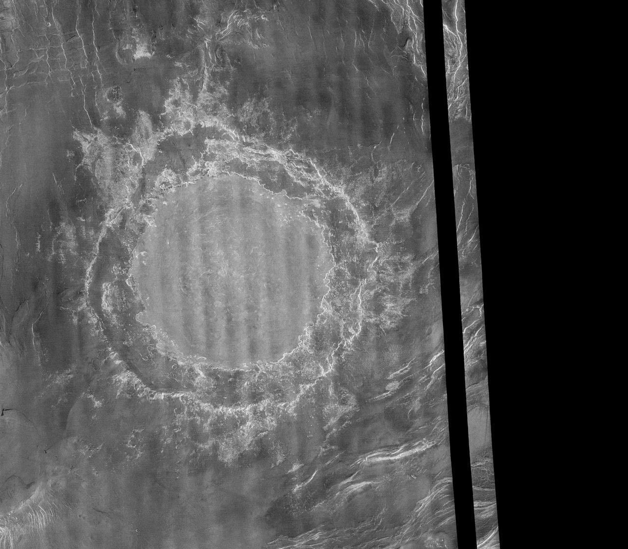
This image mosaic from NASA Magellan spacecraft is of an impact crater located in Guinevere Planitia on Venus. http://photojournal.jpl.nasa.gov/catalog/PIA00238
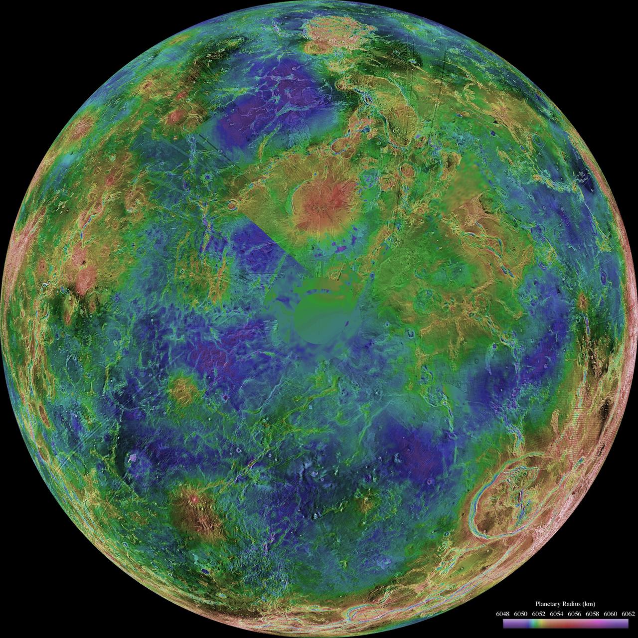
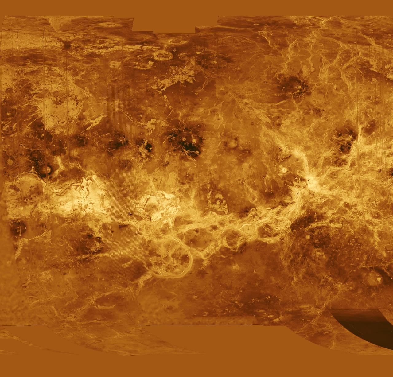
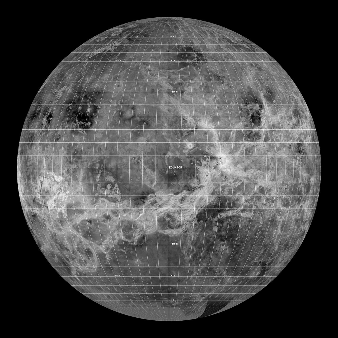
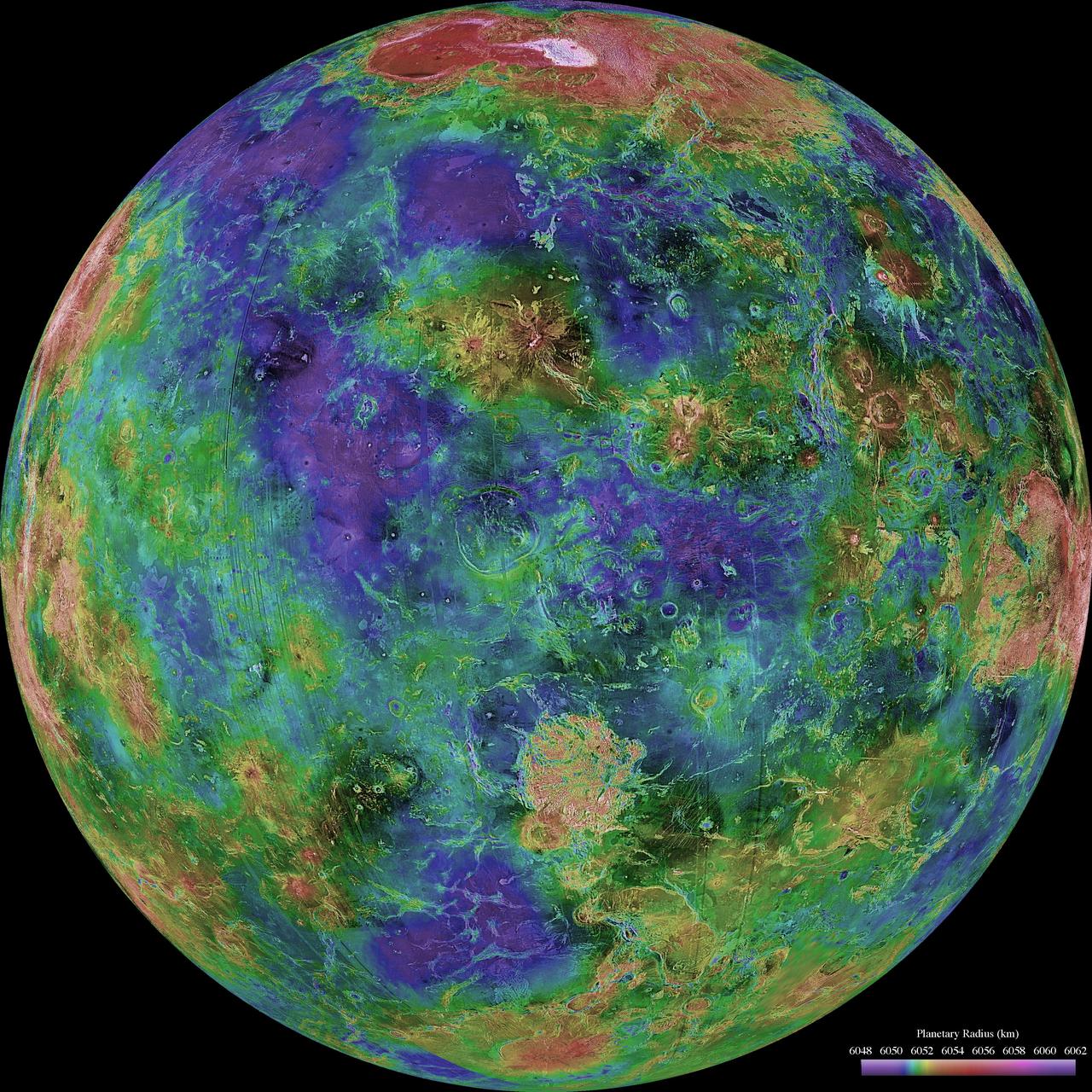
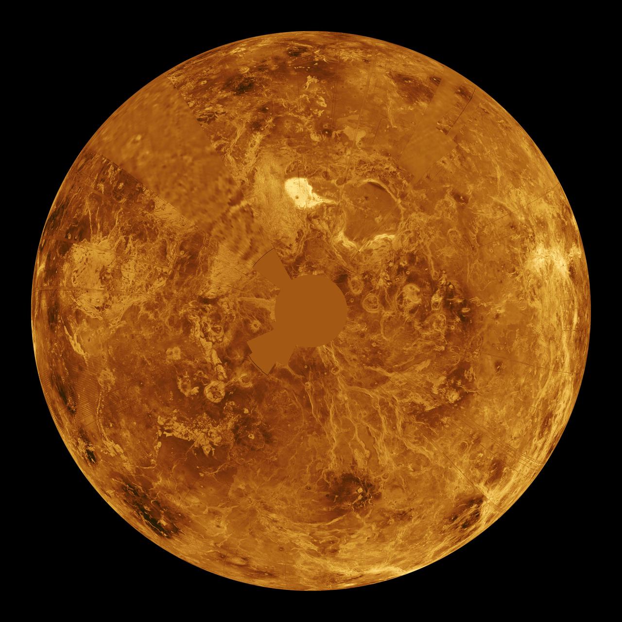
This hemispheric view of Venus, as revealed by more than a decade of radar investigations culminating in the 1990-1994 Magellan mission, is centered on the North Pole. NASA Magellan spacecraft imaged more than 98% of Venus. http://photojournal.jpl.nasa.gov/catalog/PIA00008
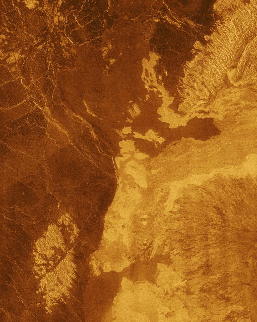
This false color image from NASA Magellan spacecraft shows a portion of Bereghinya Planitia plains in the northern hemisphere of Venus. http://photojournal.jpl.nasa.gov/catalog/PIA00259

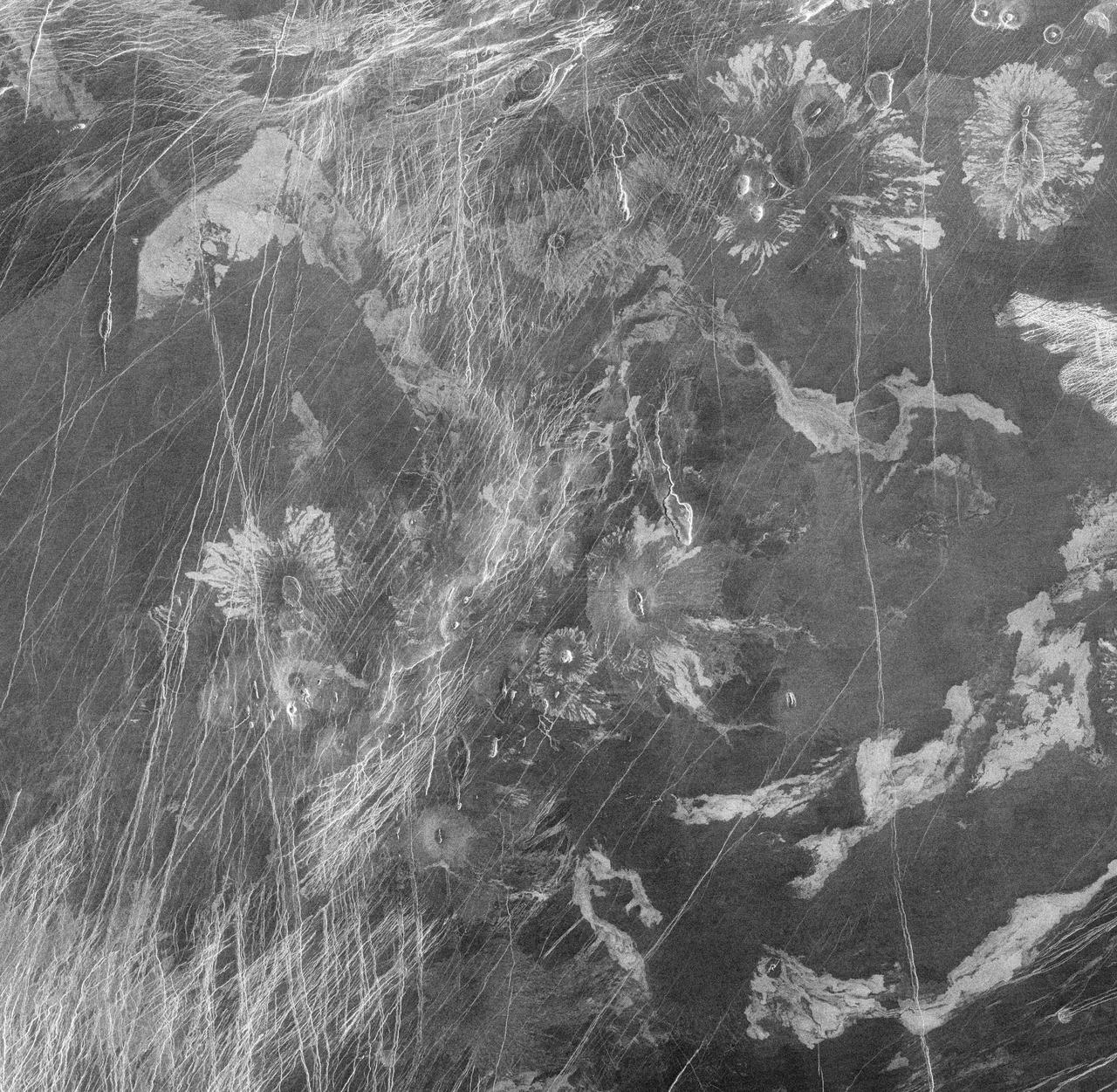
This full-resolution mosaic of Venus, obtained by NASA Magellan spacecraft, shows an area replete with diverse volcanic features. http://photojournal.jpl.nasa.gov/catalog/PIA00265
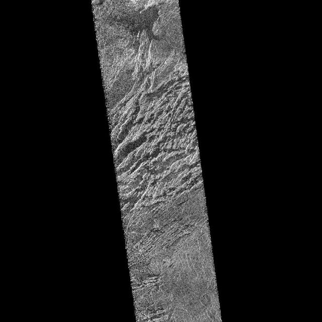
This full-resolution image from NASA Magellan spacecraft shows the northern part of the Akna Montes mountains of Venus. http://photojournal.jpl.nasa.gov/catalog/PIA00250

Three large meteorite impact craters are seen in this image obtained by NASA Magellan spacecraft of the Lavinia region of Venus. http://photojournal.jpl.nasa.gov/catalog/PIA00214
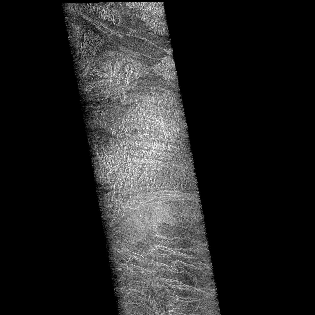
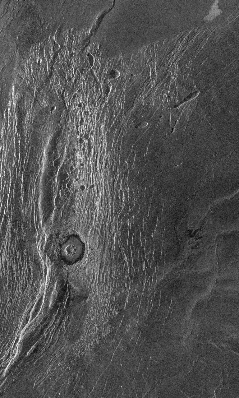
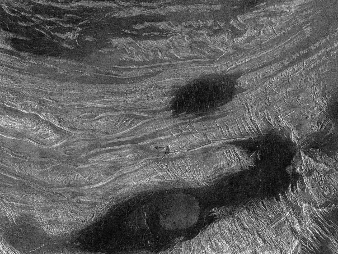
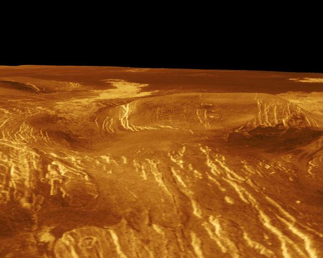
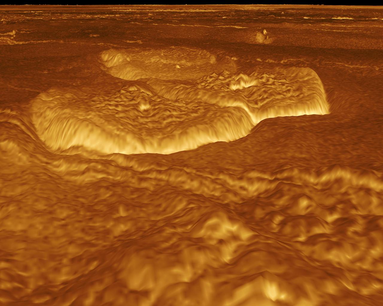
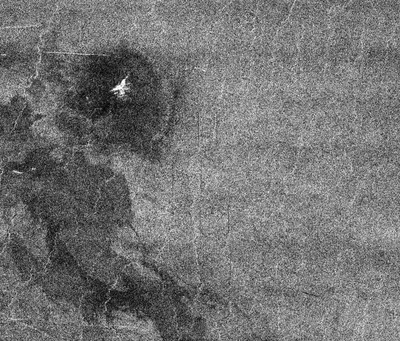
NASA Magellan spacecraft observed remnant landslide deposits apparently resulting from the collapse of volcanic structures. This radar image is centered in the southwestern Navka Region of Venus. http://photojournal.jpl.nasa.gov/catalog/PIA00262
This Magellan full resolution mosaic, centered at 12.3 north latitude, 8.3 degrees east longitude, shows an area in the Eistla region of Venus. http://photojournal.jpl.nasa.gov/catalog/PIA00084
After traveling more than 1.5 billion kilometers 948 million miles, NASA Magellan spacecraft was inserted into orbit around Venus on Aug. 10, 1990. http://photojournal.jpl.nasa.gov/catalog/PIA00205
This image from NASA Magellan spacecraft shows part of the northern boundary of Ovda Regio, one of the large highlands ringing the equator of Venus. http://photojournal.jpl.nasa.gov/catalog/PIA00242

This full resolution radar mosaic from NASA Magellan spacecraft shows a 200 kilometer 124 mile segment of a sinuous channel on Venus. http://photojournal.jpl.nasa.gov/catalog/PIA00253
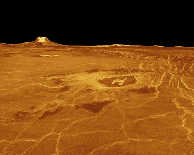
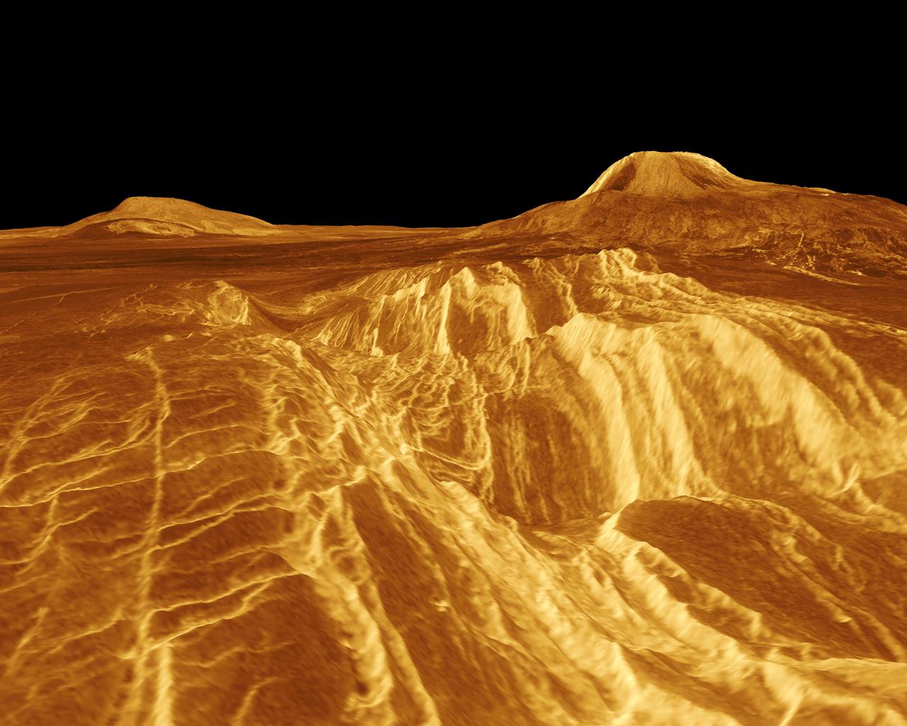
Sif Mons is displayed in this computer-simulated view obtained by NASA's Magellan spacecraft of the surface of Venus. http://photojournal.jpl.nasa.gov/catalog/PIA00108
A corona is displayed in this computer-simulated view from NASA's Magellan spacecraft of the surface of Venus. http://photojournal.jpl.nasa.gov/catalog/PIA00109
Gula Mons is displayed in this computer-simulated view from NASA Magellan spacecraft of the surface of Venus. http://photojournal.jpl.nasa.gov/catalog/PIA00234

The northern hemisphere is displayed in this global view of the surface of Venus as seen by NASA Magellan spacecraft. http://photojournal.jpl.nasa.gov/catalog/PIA00271
This colorized picture of Venus was taken Feb. 14, 1990, from a distance of almost 1.7 million miles, about 6 days after NASA's Galileo made it closest approach to the planet. http://photojournal.jpl.nasa.gov/catalog/PIA00111
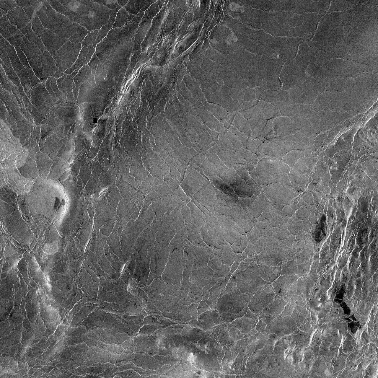
This image from NASA Magellan shows part of the interior of Ovda Regio, one of the large highlands ringing the equator of Venus. Several tectonic events formed this complex block fractured terrain. http://photojournal.jpl.nasa.gov/catalog/PIA00218
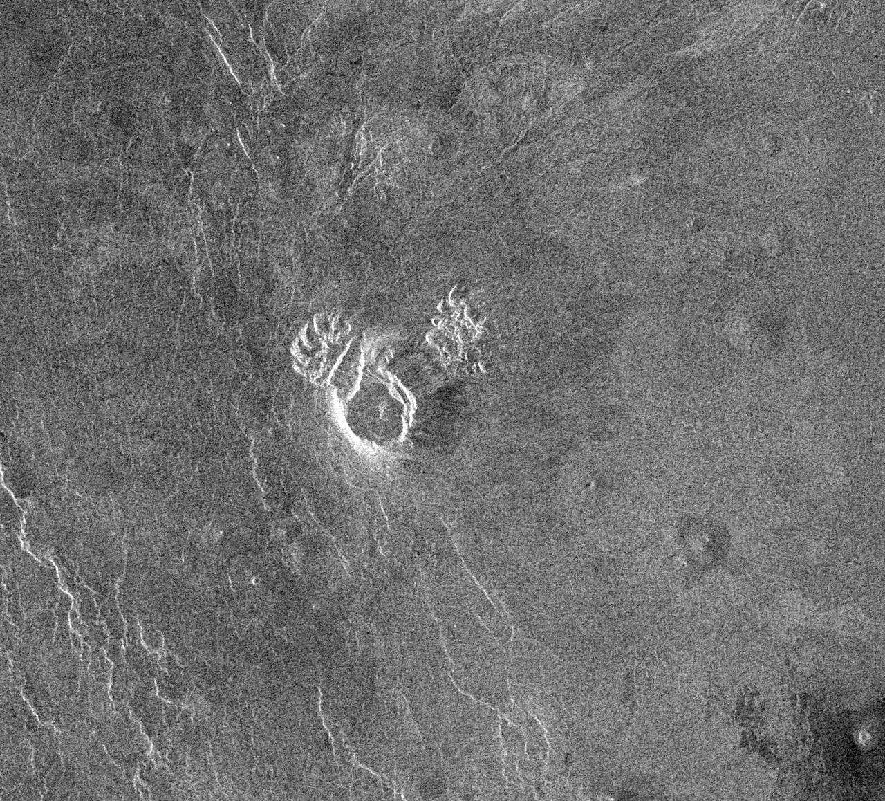
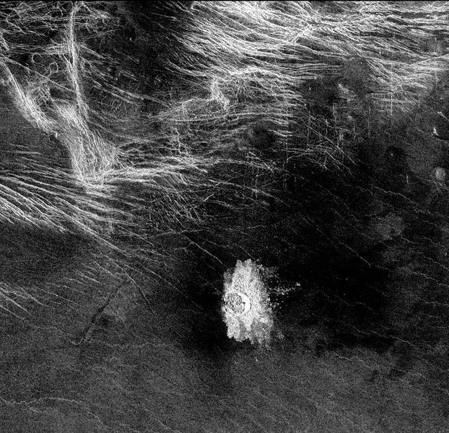
This area of Venus northeast of Ushas Mons measures 40 by 112 kilometers 25 by 70 miles and shows evidence of possible explosive volcanism as seen by NASA Magellan spacecraft. http://photojournal.jpl.nasa.gov/catalog/PIA00213
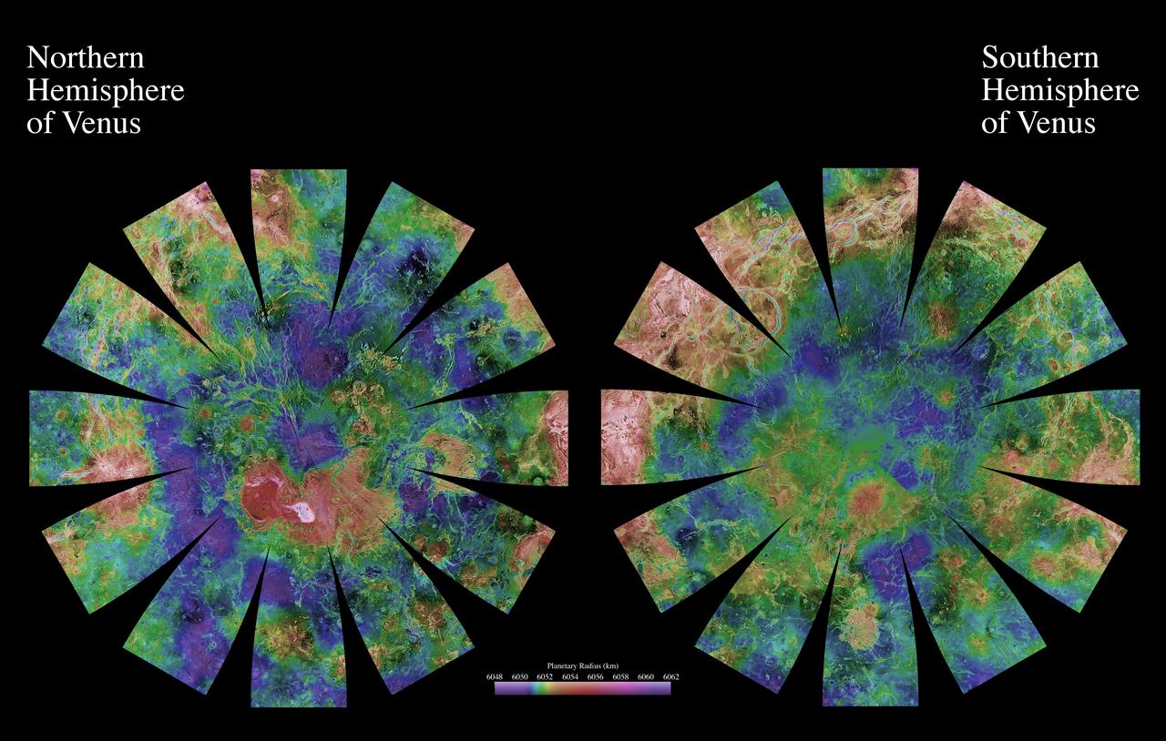
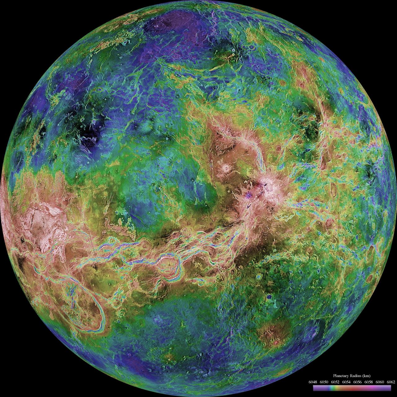
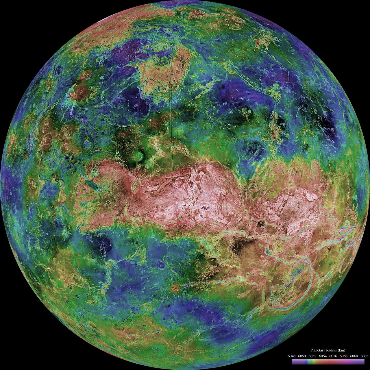
The images used for the base of this globe show the northern and southern hemispheres of Venus as revealed by more than a decade of radar investigations culminating in the 1990-1994 NASA Magellan mission.
This radar image from NASA Magellan is of part of the Phoebe region of Venus. It is a mosaic of parts of revolutions 146 and 147 acquired in the first radar test on Aug. 16, 1990. http://photojournal.jpl.nasa.gov/catalog/PIA00212
This radar image from NASA Magellan is of part of the Phoebe region of Venus. It is a mosaic of parts of revolutions 146 and 147 acquired in the first radar test on Aug. 16, 1990. http://photojournal.jpl.nasa.gov/catalog/PIA00211
NASA MESSENGER spacecraft snapped a series of images as it approached Venus on June 5. The planet is enshrouded by a global layer of clouds that obscures its surface to the MESSENGER Dual Imaging System MDIS cameras.
Crater Isabella is seen in this radar image from NASA Magellan spacecraft. The second largest impact crater on Venus, the crater is named in honor of the 15th Century queen of Spain, Isabella of Castile.
After acquiring hundreds of high-resolution images during close approach to Venus, NASA MESSENGER turned its wide-angle camera back to the planet and acquired a departure sequence.
The eastern half of the planet is displayed in this simple cylindrical map of the surface of Venus obtained by NASA Magellan spacecraft. http://photojournal.jpl.nasa.gov/catalog/PIA00256
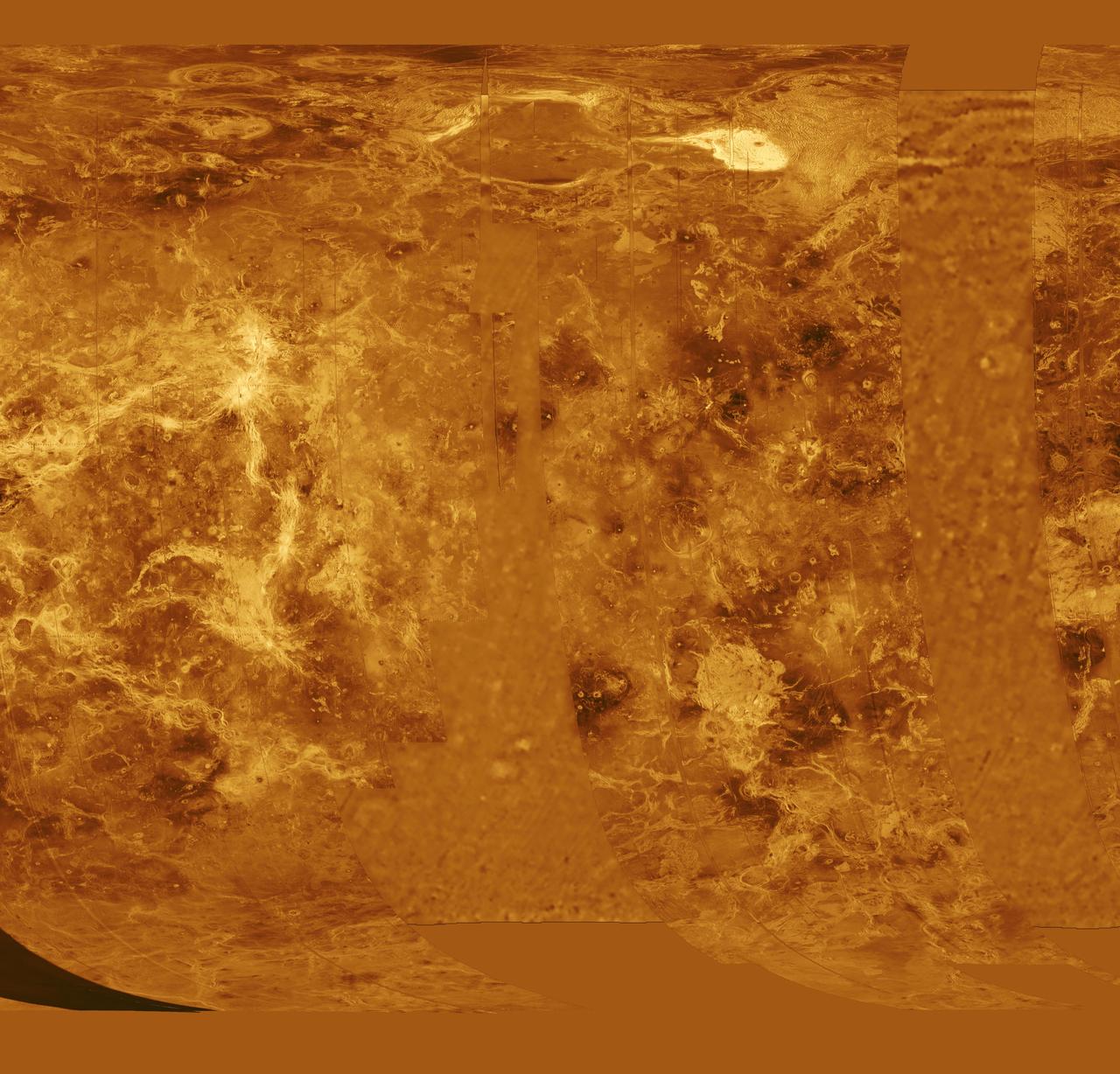
The western half of the planet is displayed in this simple cylindrical map of the surface of Venus obtained by NASA Magellan spacecraft. http://photojournal.jpl.nasa.gov/catalog/PIA00255
A portion of western Eistla Regio is displayed in this three-dimensional perspective view from NASA's Magellan spacecraft of the surface of Venus. http://photojournal.jpl.nasa.gov/catalog/PIA00102

Sapas Mons is displayed in the center of this computer-generated three-dimensional perspective view from NASA's Magellan spacecraft of the surface of Venus. http://photojournal.jpl.nasa.gov/catalog/PIA00107
A portion of western Eistla Regio is displayed in this three-dimensional perspective view of the surface of Venus as seen by NASA Magellan spacecraft. http://photojournal.jpl.nasa.gov/catalog/PIA00233
This global view of the surface of Venus is centered at 180 degrees east longitude. Magellan synthetic aperture radar mosaics from the first cycle of Magellan mapping, and a 5 degree latitude-longitude grid, are mapped onto a computer-simulated globe to create this image. Data gaps are filled with Pioneer-Venus Orbiter data, or a constant mid-range value. The image was produced by the Solar System Visualization project and the Magellan Science team at the JPL Multimission Image Processing Laboratory. http://photojournal.jpl.nasa.gov/catalog/PIA00478

As it sped away from Venus, NASA's Mariner 10 spacecraft captured this seemingly peaceful view of a planet the size of Earth, wrapped in a dense, global cloud layer. But, contrary to its serene appearance, the clouded globe of Venus is a world of intense heat, crushing atmospheric pressure and clouds of corrosive acid. This newly processed image revisits the original data with modern image processing software. A contrast-enhanced version of this view, also provided here, makes features in the planet's thick cloud cover visible in greater detail. The clouds seen here are located about 40 miles (60 kilometers) above the planet's surface, at altitudes where Earth-like atmospheric pressures and temperatures exist. They are comprised of sulfuric acid particles, as opposed to water droplets or ice crystals, as on Earth. These cloud particles are mostly white in appearance; however, patches of red-tinted clouds also can be seen. This is due to the presence of a mysterious material that absorbs light at blue and ultraviolet wavelengths. Many chemicals have been suggested for this mystery component, from sulfur compounds to even biological materials, but a consensus has yet to be reached among researchers. The clouds of Venus whip around the planet at nearly over 200 miles per hour (100 meters per second), circling the globe in about four and a half days. That these hurricane-force winds cover nearly the entire planet is another unexplained mystery, especially given that the solid planet itself rotates at a very slow 4 mph (less than 2 meters per second) — much slower than Earth's rotation rate of about 1,000 mph (450 meters per second). The winds and clouds also blow to the west, not to the east as on the Earth. This is because the planet itself rotates to the west, backward compared to Earth and most of the other planets. As the clouds travel westward, they also typically progress toward the poles; this can be seen in the Mariner 10 view as a curved spiral pattern at mid latitudes. Near the equator, instead of long streaks, areas of more clumpy, discrete clouds can be seen, indicating enhanced upwelling and cloud formation in the equatorial region, spurred on by the enhanced power of sunlight there. This view is a false color composite created by combining images taken using orange and ultraviolet spectral filters on the spacecraft's imaging camera. These were used for the red and blue channels of the color image, respectively, with the green channel synthesized by combining the other two images. Flying past Venus en route to the first-ever flyby of Mercury, Mariner 10 became the first spacecraft to use a gravity assist to change its flight path in order to reach another planet. The images used to create this view were acquired by Mariner 10 on Feb. 7 and 8, 1974, a couple of days after the spacecraft's closest approach to Venus on Feb. 5. Despite their many differences, comparisons between Earth and Venus are valuable for helping to understand their distinct climate histories. Nearly 50 years after this view was obtained, many fundamental questions about Venus remain unanswered. Did Venus have oceans long ago? How has its atmosphere evolved over time, and when did its runaway greenhouse effect begin? How does Venus lose its heat? How volcanically and tectonically active has Venus been over the last billion years? This image was processed from archived Mariner 10 data by JPL engineer Kevin M. Gill. The Mariner 10 mission was managed by NASA's Jet Propulsion Laboratory. https://photojournal.jpl.nasa.gov/catalog/PIA23791
This image from the Atla region of Venus obtained by NASA Magellan spacecraft shows several types of volcanic features and superimposed surface fractures. http://photojournal.jpl.nasa.gov/catalog/PIA00201

This picture of Venus was taken by the NASA Galileo spacecraft Solid State Imaging System on February 14, 1990, at a range of almost 1.7 million miles from the planet. http://photojournal.jpl.nasa.gov/catalog/PIA00072
This image from NASA Magellan spacecraft is of Crater Stephania, located at 51.3 degrees latitude, 333.3 degrees longitude in northern Sedna Planitia on Venus. With a diameter of 11 kilometers (6.8 miles) it is one of the smaller craters on Venus. Because many small meteoroids disintegrate during their passage through the dense atmosphere, there is an absence of craters smaller than 3 kilometers (1.9 miles) in diameter, and even craters smaller than 25 kilometers (15.5 miles) are relatively scarce. The apron of ejected material suggests that the impacting body made contact with the surface from an oblique angle. Upon closer observation it is possible to delineate secondary craters, impact scars from blocks ejected from the primary crater. A feature associated with this and many other Venusian craters is a radar-dark halo. Since dark radar return signifies a smooth surface, it has been hypothesized that an intense shock wave removed or pulverized previously rough surface material or that a blanket of fine material was deposited during or after the impact. http://photojournal.jpl.nasa.gov/catalog/PIA00475
This portion of NASA Magellan radar image strip shows a small region on Venus 20 kilometers 12.4 miles wide and 75 km 50 miles long on the east flank of a major volcanic upland called Beta Regio. http://photojournal.jpl.nasa.gov/catalog/PIA00206
Many of the impact craters of Venus revealed by NASA Magellan spacecraft have characteristics unlike craters on any other planetary body. This crater, named Adivar, is located just north of the western Aphrodite highland. http://photojournal.jpl.nasa.gov/catalog/PIA00083
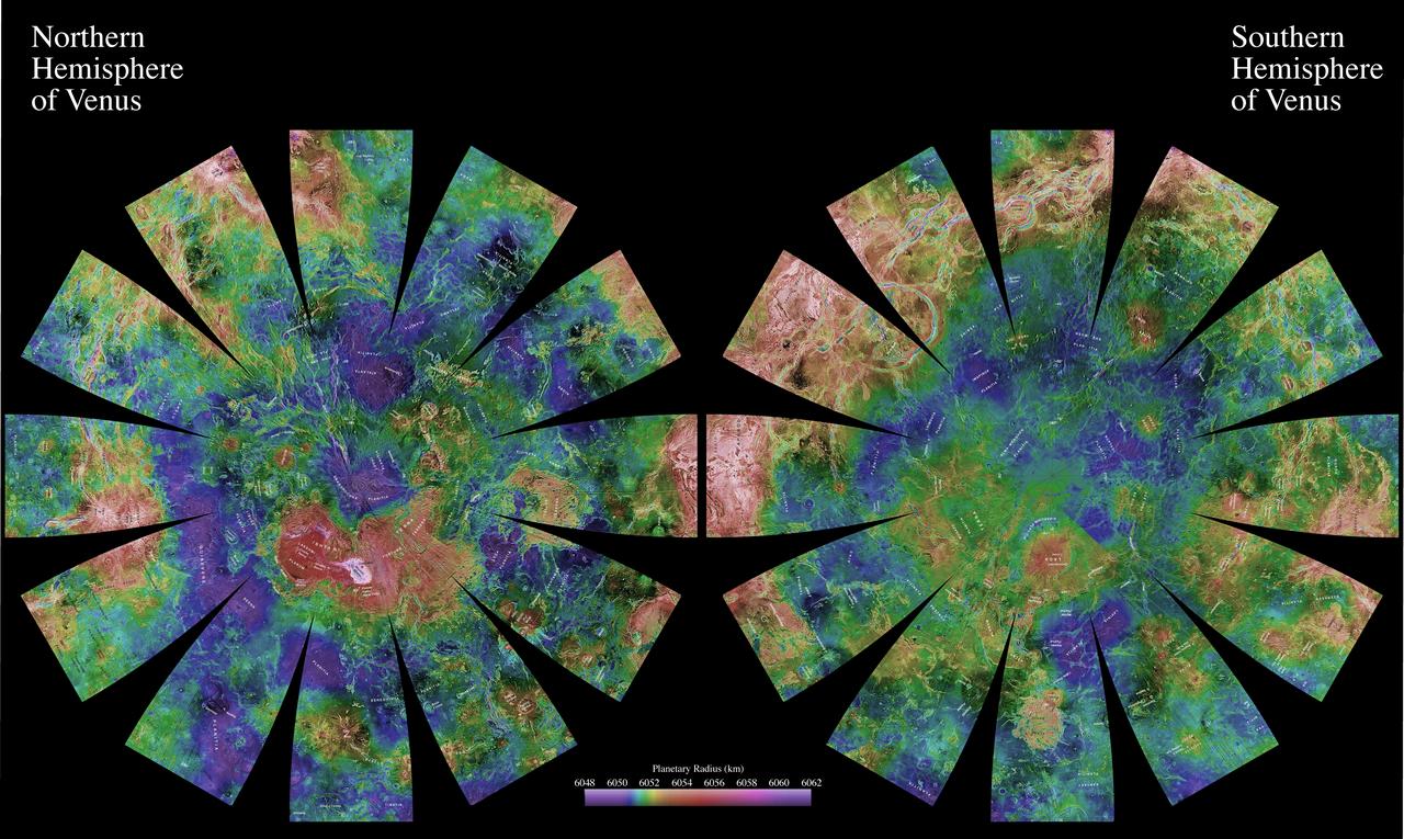
The images used for the base of this globe show the northern and southern hemispheres of Venus as revealed by more than a decade of radar investigations culminating in the 1990-1994 NASA Magellan mission.
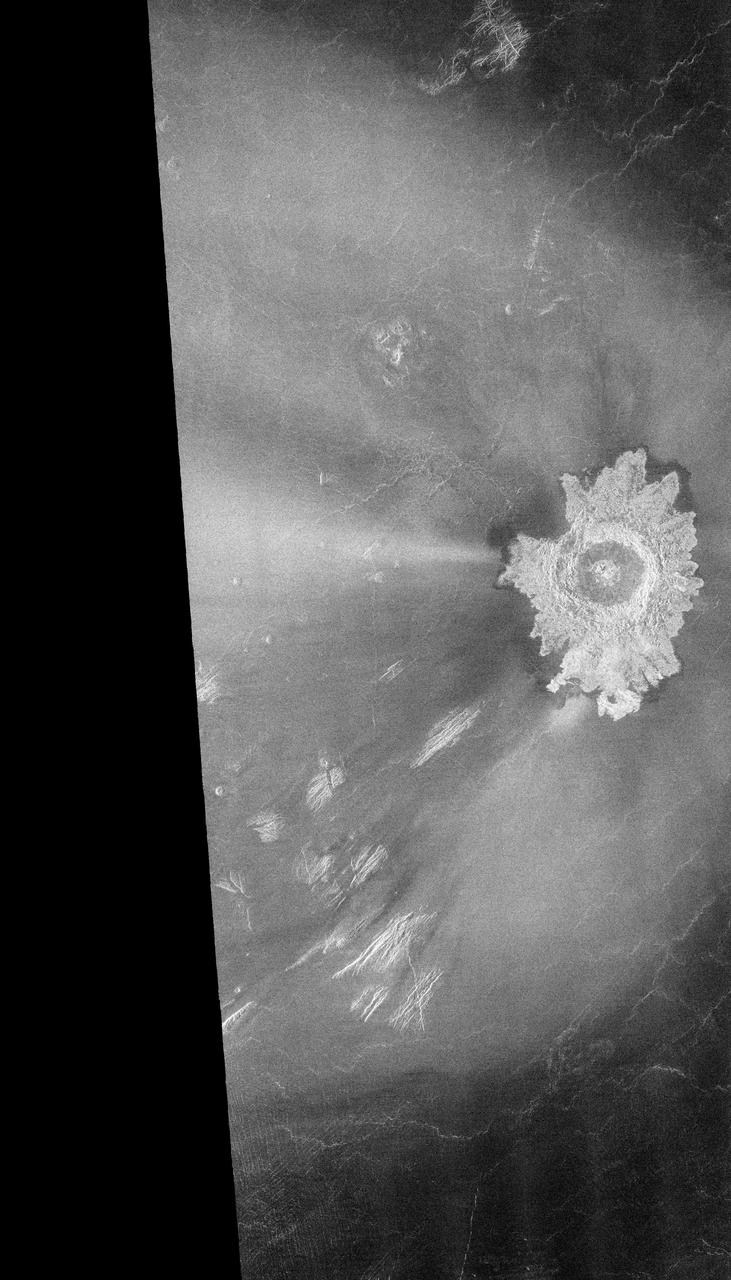
Ushas Mons, a volcano in the southern hemisphere of Venus is shown in this radar image from NASA Magellan spacecraft. The volcano is marked by numerous bright lava flows and a set of north-south trending fractures. http://photojournal.jpl.nasa.gov/catalog/PIA00272
This false color image from NASA's Magellan spacecraft shows a portion of Leda Planitia plains in the northern hemisphere of Venus, centered at 41 degrees north latitude, 52 degrees east longitude. http://photojournal.jpl.nasa.gov/catalog/PIA00105
This false-color image is a near-infrared map of lower-level clouds on the night side of Venus, obtained by NASA Galileo spacecraft as it approached the planet night side on Feb. 10, 1990. http://photojournal.jpl.nasa.gov/catalog/PIA00124
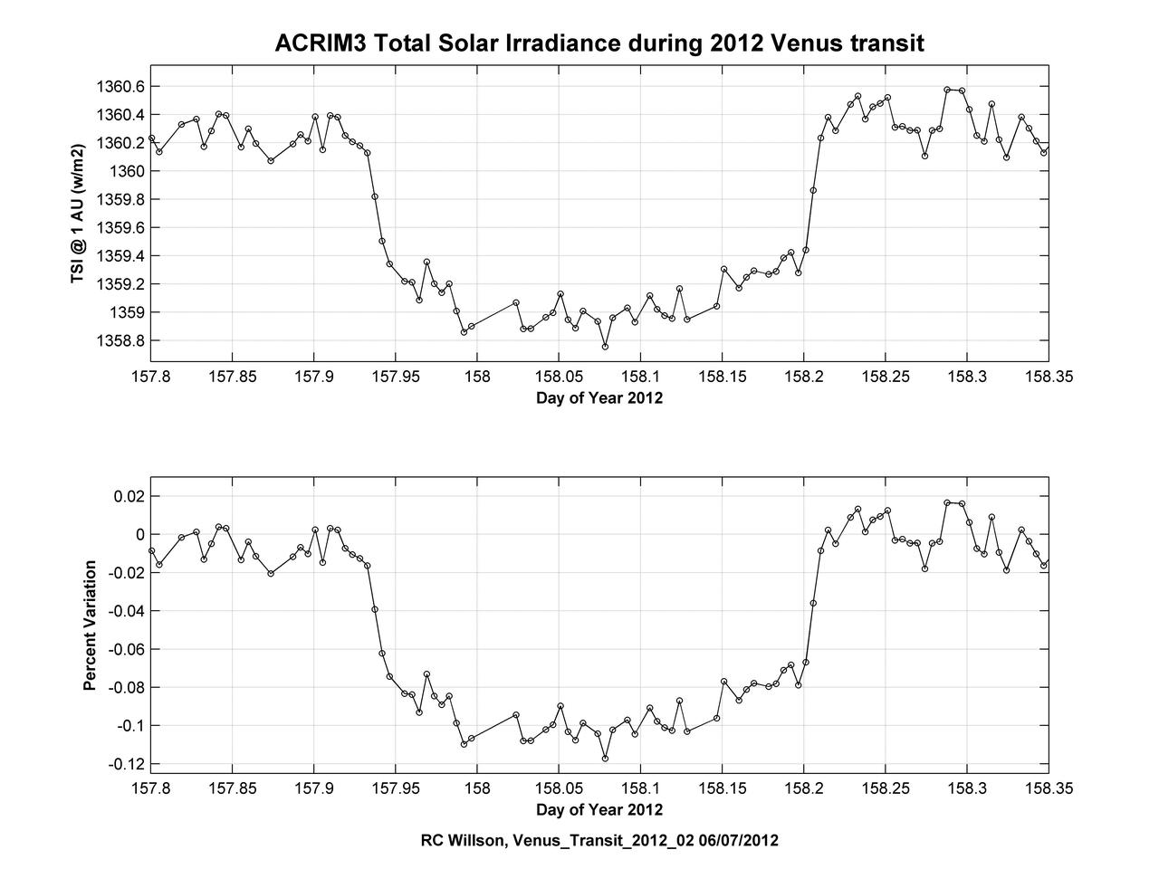
Observations of the total solar irradiance made with the ACRIM3 instrument on NASA ACRIMSAT satellite on June 5 and 6, 2012, tracked the effect of the transit of Venus, which lasted about six hours.
This false color Magellan image shows a portion of Eistla Regio region in the northern hemisphere of Venus, centered at 1 degrees south latitude, 37 degrees east longitude. http://photojournal.jpl.nasa.gov/catalog/PIA00258

The northern hemisphere is displayed in this global view of the surface of Venus as seen by NASA Magellan spacecraft. http://photojournal.jpl.nasa.gov/catalog/PIA00270
This mosaic of Magellan data in the Fortuna region of Venus, centered at 49 degrees north latitude, 2 degrees longitude, shows two coronae. Coronae are large circular or oval structures first identified in Soviet radar images of Venus. The structure on the left, Bahet Corona, is about 230 kilometers (138 miles) long and 150 kilometers (90 miles) across. A portion of Onatah Corona, over 350 kilometers (210 miles) in diameter, can be seen on the right of the mosaic. Both features are surrounded by a ring of ridges and troughs, which in places cut more radially-oriented fractures. The centers of the features also contain radial fractures as well as volcanic domes and flows. Coronae are thought to form due to the upwelling of hot material from deep in the interior of Venus. The two coronae may have formed at the same time over a single upwelling, or may indicate movement of the upwelling or the upper layers of the planet to the west over time. A 'pancake' dome, similar to low-relief domes see in the southern hemisphere, is located just to the southwest of Bahet. Resolution of the Magellan data is about 120 meters (400 feet). http://photojournal.jpl.nasa.gov/catalog/PIA00461
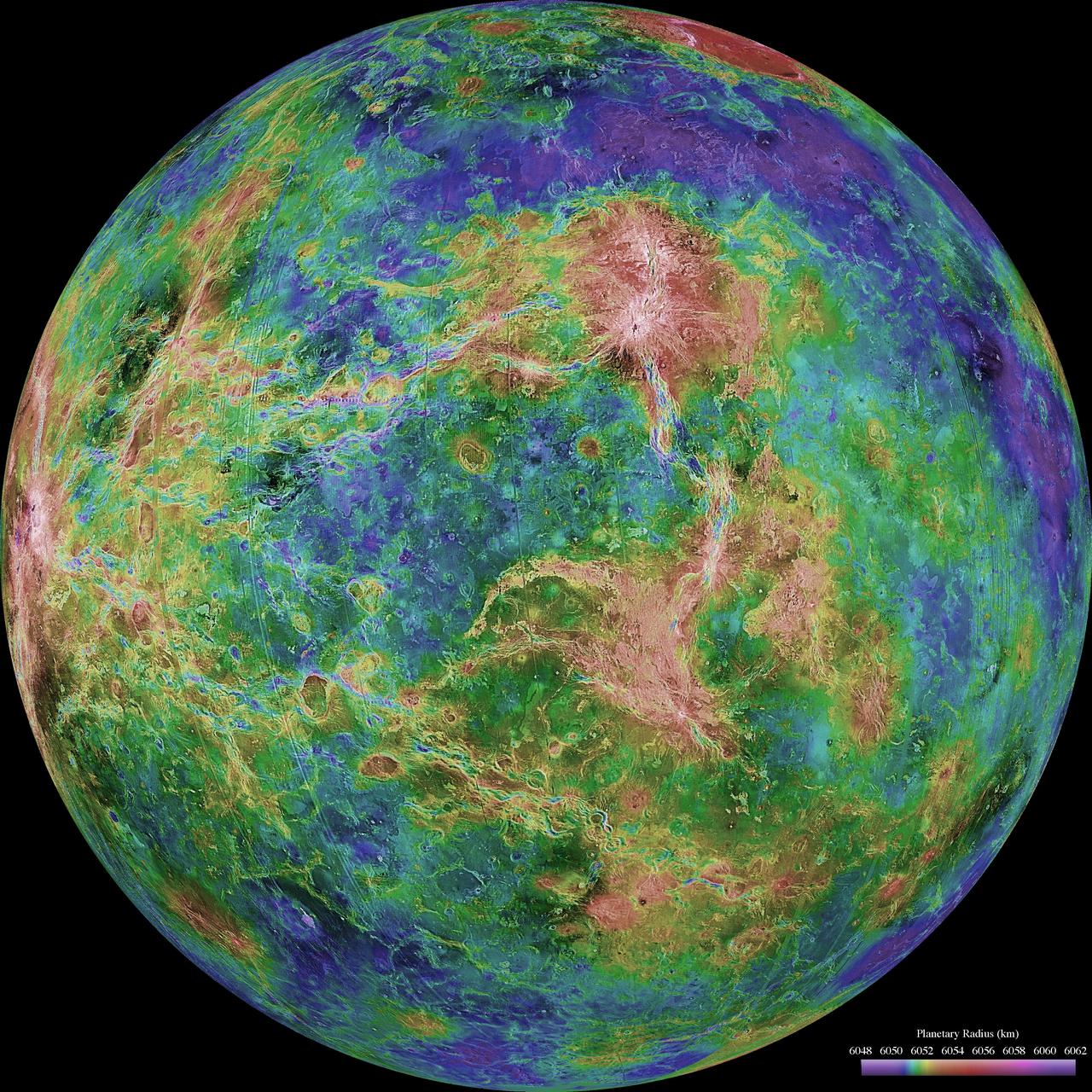
The hemispheric view of Venus, as revealed by more than a decade of radar investigations culminating in the 1990-1994 Magellan mission, is centered on the North Pole. The Magellan spacecraft imaged more than 98% of Venus at a resolution of about 100 meters; the effective resolution of this image is about 3 km. A mosaic of the Magellan images (most with illumination from the west) forms the image base. Gaps in the Magellan coverage were filled with images from the Earth-based Arecibo radar in a region centered roughly on 0 degree latitude and longitude, and with a neutral tone elsewhere (primarily near the south pole). The composite image was processed to improve contrast and to emphasize small features, and was color-coded to represent elevation. Gaps in the elevation data from the Magellan radar altimeter were filled with altimetry from the Venera spacecraft and the U.S. Pioneer Venus missions. An orthographic projection was used, simulating a distant view of one hemisphere of the planet. The Magellan mission was managed for NASA by Jet Propulsion Laboratory (JPL), Pasadena, CA. Data processed by JPL, the Massachusetts Institute of Technology, Cambridge, MA, and the U.S. Geological Survey, Flagstaff, AZ. http://photojournal.jpl.nasa.gov/catalog/PIA00007
NASA's Magellan radar image shows Alpha Regio, a topographic upland. In 1963 Alpha Regio was the first feature on Venus to be identified from Earth based radar. http://photojournal.jpl.nasa.gov/catalog/PIA00147
A portion of western Eistla Regio is shown in this three dimensional, computer-generated view of the surface of Venus. This NASA Magellan image was released on April 22, 1992. http://photojournal.jpl.nasa.gov/catalog/PIA00200
The view of Venus, after more than a decade of radar investigations culminating in the 1990-1994 NASA's Magellan mission, is centered at 180 degrees east longitude. http://photojournal.jpl.nasa.gov/catalog/PIA00159
Maat Mons is displayed in this 3-dimensional perspective view of the surface of Venus taken by NASA Magellan. The viewpoint is located north of Maat Mons. http://photojournal.jpl.nasa.gov/catalog/PIA00254
The view of Venus, after more than a decade of radar investigations culminating in the 1990-1994 NASA's Magellan mission, is centered at 270 degrees east longitude. http://photojournal.jpl.nasa.gov/catalog/PIA00160
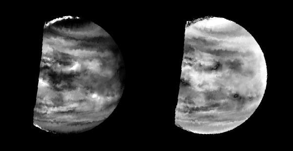
These two images of Venus from NASA Galileo spacecraft show the global structure of cloud patterns at two different depths in the upper cloud layers. http://photojournal.jpl.nasa.gov/catalog/PIA00073
Maat Mons is displayed in this computer generated three-dimensional perspective of the surface of Venus. This NASA's Magellan image was released on April 22, 1992. http://photojournal.jpl.nasa.gov/catalog/PIA00106
NASA's Magellan image mosaic shows the largest impact crater known to exist on Venus at this point in the Magellan mission. The crater is located north of Aphrodite Terra and east of Eistla Regio and was imaged during orbit 804 on November 12, 1990. http://photojournal.jpl.nasa.gov/catalog/PIA00148

This global view from NASA's Magellan spacecraft is of the surface of Venus is centered at 180 degrees east longitude. http://photojournal.jpl.nasa.gov/catalog/PIA00104
This computer-generated perspective view of Latona Corona and Dali Chasma on Venus shows NASA Magellan radar data superimposed on topography. http://photojournal.jpl.nasa.gov/catalog/PIA00268
A portion of the eastern edge of Alpha Regio is displayed in this three-dimensional perspective view of the surface of Venus from NASA Magellan spacecraft. http://photojournal.jpl.nasa.gov/catalog/PIA00246
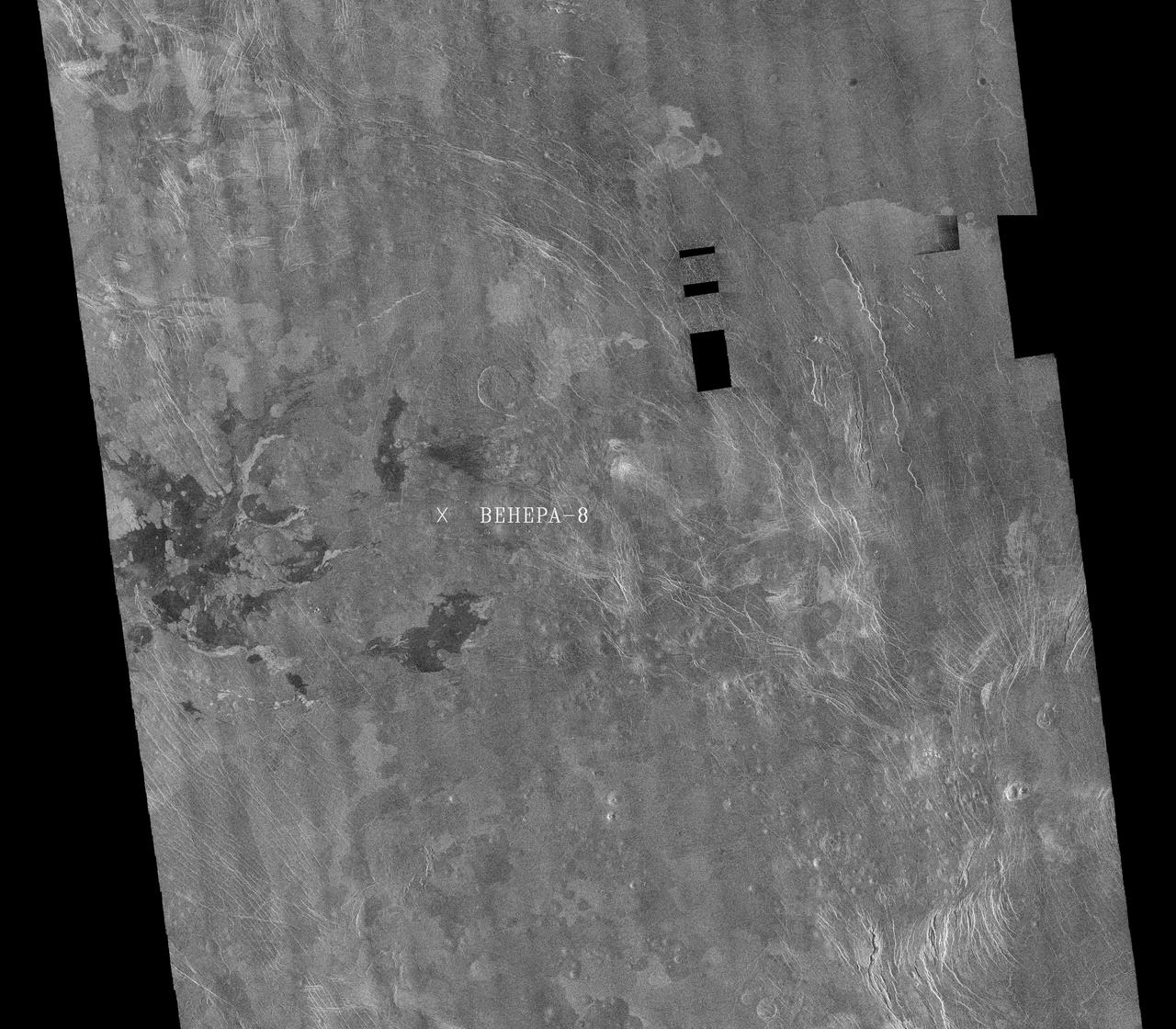
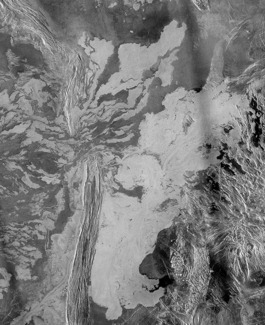
This image is a mosaic of 24 orbits of the Navka region of Venus. The image is centered at about 10 degrees south latitude and 335 degrees east longitude. The image is about 400 km (240 miles) across. 'Behepa 8' marks the approximate landing site of the Soviet Venera 8 lander, which took measurements at the surface of Venus in 1972. The Venera 8 lander measured granitic or continental-like materials at the landing site. Magellan data reveals the landing site to lie in a region of plains cut by tectonic ridges and troughs. Volcanic domes and flows are seen throughout the region. Studying the regional setting of the Venera landing sites is important in linking information about surface composition to surface morphology seen in radar images. Resolution of the Magellan data is about 120 meters (400 feet). http://photojournal.jpl.nasa.gov/catalog/PIA00460
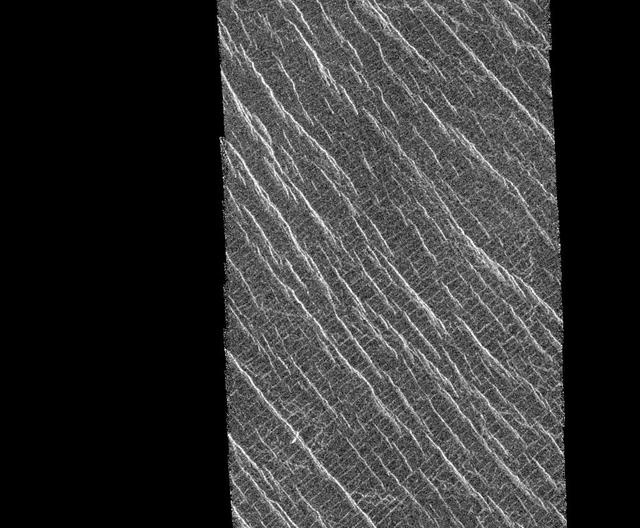
This mosaic shows an area of the Lakshmi region that is located 30 degrees north latitude and 333.3 degrees east longitude. (Longitude on Venus is measured from 0 degrees to 360 degrees east). The area shown measures about 37 kilometers (23 miles) wide and 80 kilometers (50 miles) long. Based on data from the Pioneer Venus Orbiter and the ground-based Arecibo Radar Observatory, it is known that this region is located on the low rise that separates Sedna Planitia and Guinevere Planitia, just to the west of Eistla Regio. Two sets of parallel lineations are seen intersecting almost at right angles. The fainter lineations are spaced at regular intervals of about one kilometer (0.6 mile) and extend beyond the boundary of the image. The width of the faint lineations is at the limit of resolution of the best Magellan images. The brighter, more dominant lineations are less regular and, in places, appear to begin and end where they intersect the fainter lineations. It is not clear whether the two sets of lineations are faults or fractures, but in other Magellan images, these bright lineations are associated with pit craters and volcanic features. This type of terrain has not been seen on Venus nor on other planets. North is at the top of the image. http://photojournal.jpl.nasa.gov/catalog/PIA00085
This view of the surface of Venus acquired by NASA Magellan spacecraft shows a geographically young region of lowland plains. The location is near the equator between two highland areas known as Asteria Regio and Phoebe Regio. http://photojournal.jpl.nasa.gov/catalog/PIA00237
These two radar images from NASA Magellan spacecraft are centered about 60.5 degrees south latitude and 348.8 degrees east longitude in the eastern Lavinia Region of Venus. http://photojournal.jpl.nasa.gov/catalog/PIA00247
Three impact craters are displayed in this three-dimensional perspective view from NASA's Magellan spacecraft of the surface of Venus. The center of the image is located in the northwestern portion of Lavinia Planitia. http://photojournal.jpl.nasa.gov/catalog/PIA00103
This radar image mosaic of Venus from NASA Magellan spacecraft, is in the Lada region. The mosaic shows a system of east-trending radar-bright and dark lava flows encountering and breaching a north-trending ridge belt left of center.
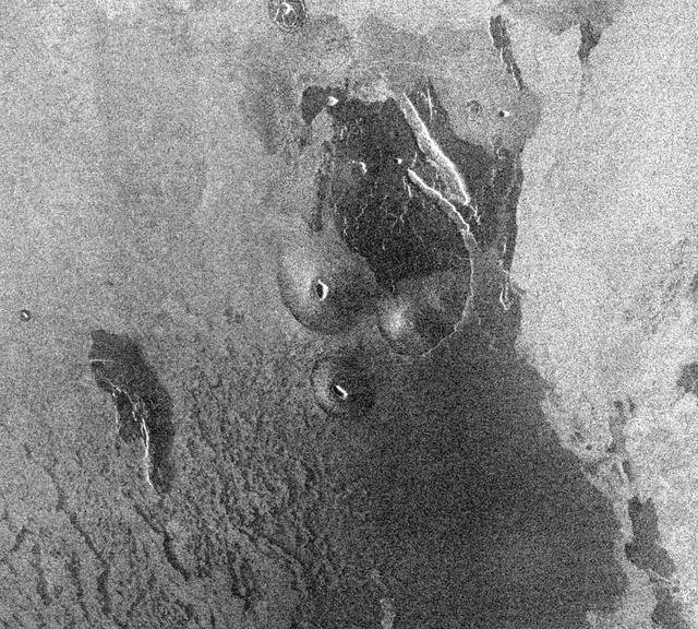
This image from NASA Magellan spacecraft is from the eastern Ovda region of Venus. The image shows some small volcanic domes on the flank of the volcano Maat.
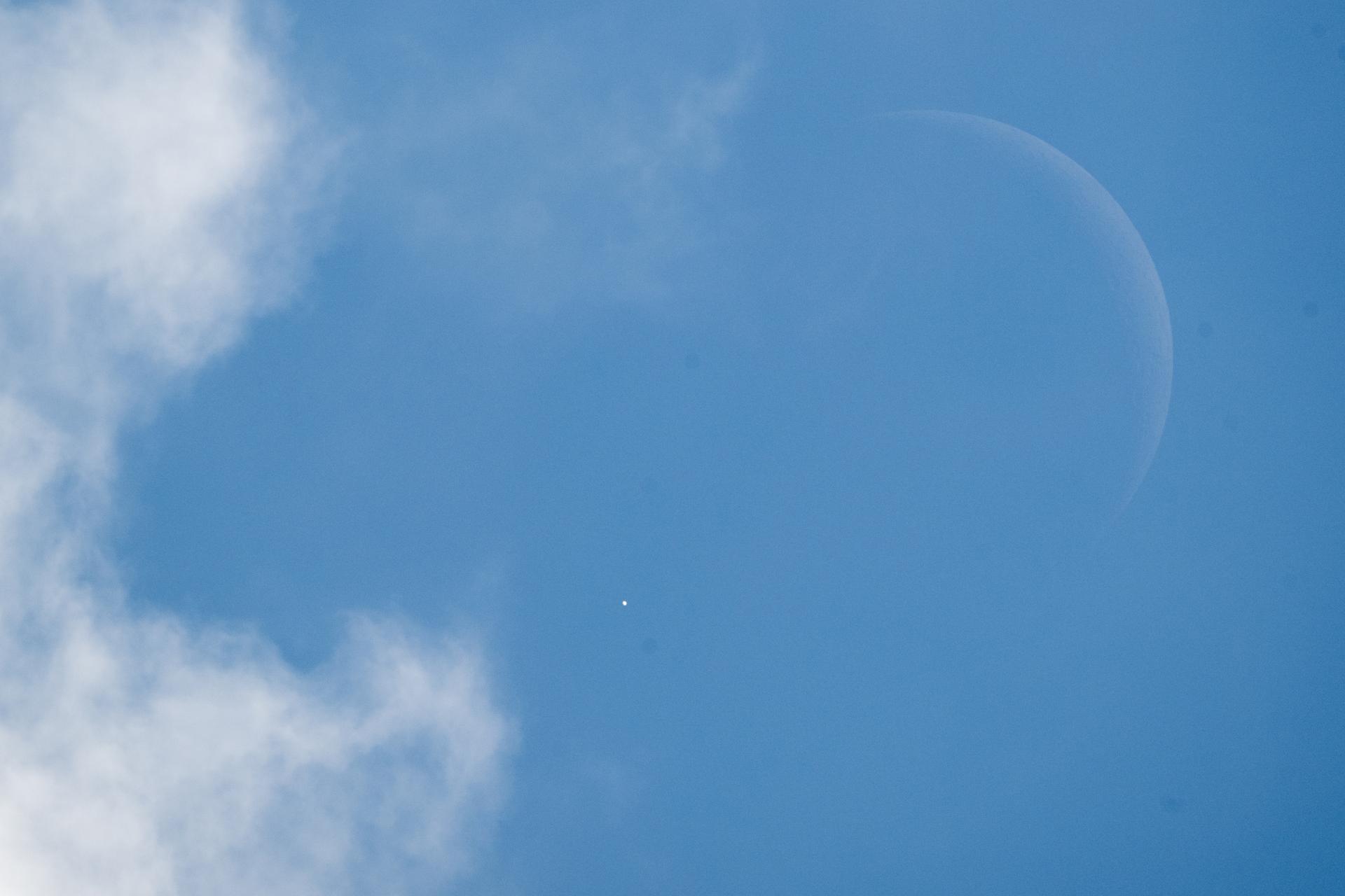
Venus is seen as disappears behind the Moon, at the start of occultation, on Wednesday, June 17, 2026, from the Mary W. Jackson NASA Headquarters building in Washington. The Moon occulted, or passed in front of, Venus for the first of three time this year. Photo Credit: (NASA/Joel Kowsky)
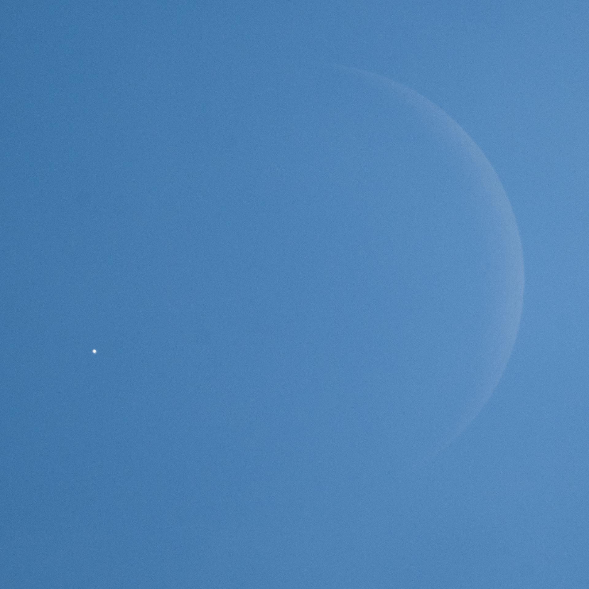
Venus is seen as disappears behind the Moon, at the start of occultation, on Wednesday, June 17, 2026, from the Mary W. Jackson NASA Headquarters building in Washington. The Moon occulted, or passed in front of, Venus for the first of three time this year. Photo Credit: (NASA/Joel Kowsky)
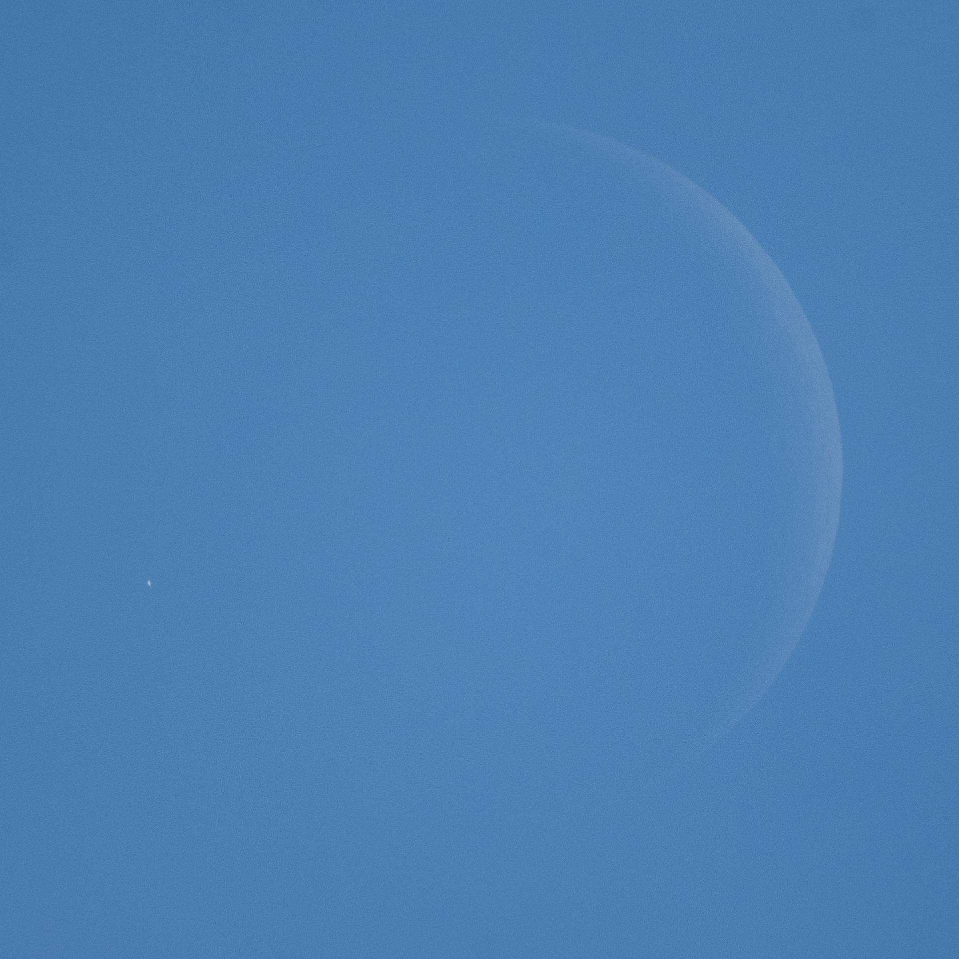
Venus is seen, during daylight, as it disappears behind the Moon, at the start of occultation, on Wednesday, June 17, 2026, from the Mary W. Jackson NASA Headquarters building in Washington. The Moon occulted, or passed in front of, Venus for the first of three time this year. Photo Credit: (NASA/Joel Kowsky)
This full resolution mosaiced image covers an area of approximately 100 kilometers by 120 kilometers (62 by 74 miles) and is located in the Lakshmi region of Venus at 47 degrees north latitude and 334 east longitude. Due to the dense Venusian atmosphere, primary impact craters of less than a 3 kilometer (2 mile) diameter are nonexistent. The dark circular region and associated central bright feature in this image are thought to be the remnants of a meteoroid smaller than the size necessary to create an impact crater entering the atmosphere at a low velocity (approximately 350 meters/second.) The central bright feature appears to be a cluster of small secondary impacts, ejecta and debris from the original meteor that broke up in the atmosphere. Even though most of the meteorite did not hit the surface, the atmospheric shock wave could be great enough to modify the surrounding region. One explanation for this radar dark circular formation, called dark margins, could be that the shock wave was energetic enough to pulverize the surface (smooth surfaces generally appear radar dark.) Another explanation is that the surface could be blanketed by a fine material that was formed by the original meteor's breakup through the atmosphere. More than half of the impact craters on Venus have associated dark margins, and most of these are prominently located left of center of the crater. This is another effect which could be caused by the dense atmosphere of Venus. http://photojournal.jpl.nasa.gov/catalog/PIA00477

NASA's Magellan full-resolution image shows Maxwell Montes, centered at 65 degrees north latitude and 6 degrees east longitude. Maxwell is the highest mountain on Venus, rising almost 11 kilometers 6.8 miles above mean planetary radius. http://photojournal.jpl.nasa.gov/catalog/PIA00149

It appeared that New Yorkers were not going to be able to see the transit of the planet Venus across the Sun, but just before the transit was over the sun broke through the clouds and Yvette Lee Kang was able to catch a glimpse of the transit on Tuesday, June 5, 2012 in New York. A transit of Venus occurs when the planet passes directly between the sun and earth. This alignment is rare, coming in pairs that are eight years apart but separated by over a century. The next Venus transit will be in December 2117. Photo Credit: (NASA/Bill Ingalls)
The hemispheric view of Venus, as revealed by more than a decade of radar investigations culminating in NASA's 1990-1994 Magellan mission, is centered at 0 degrees east longitude. http://photojournal.jpl.nasa.gov/catalog/PIA00157
The hemispheric view of Venus, as revealed by more than a decade of radar investigations culminating in NASA's 1990-1994 Magellan mission, is centered at 90 degrees east longitude. http://photojournal.jpl.nasa.gov/catalog/PIA00159
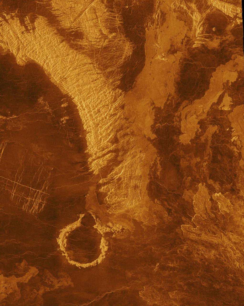
This radar image from NASA's Magellan spacecraft is of a half crater located in the rift between Rhea and Theia Montes in Beta Regio on Venus and has been cut by many fractures or faults since it was formed by the impact of a large asteroid. http://photojournal.jpl.nasa.gov/catalog/PIA00100
This image is a false color version of a near infrared map of lower level clouds on the night side of Venus, obtained by the Near Infrared Mapping Spectrometer aboard NASA's Galileo spacecraft as it approached the planet Feb. 10, 1990. http://photojournal.jpl.nasa.gov/catalog/PIA00112
These images are two versions of a near-infrared map of lower-level clouds on the night side of Venus, obtained by the Near Infrared Mapping Spectrometer aboard NASA Galileo spacecraft as it approached the planet February 10, 1990. http://photojournal.jpl.nasa.gov/catalog/PIA00222
The northern hemisphere is displayed in this global view of the surface of Venus. NASA Magellan synthetic aperture radar mosaics from the first cycle of Magellan mapping were mapped onto a computer-simulated globe to create this image. http://photojournal.jpl.nasa.gov/catalog/PIA00252
These images are two versions of a near-infrared map of lower-level clouds on the night side of Venus, obtained by the Near Infrared Mapping Spectrometer aboard NASA Galileo spacecraft as it approached the planet February 10, 1990. http://photojournal.jpl.nasa.gov/catalog/PIA00221
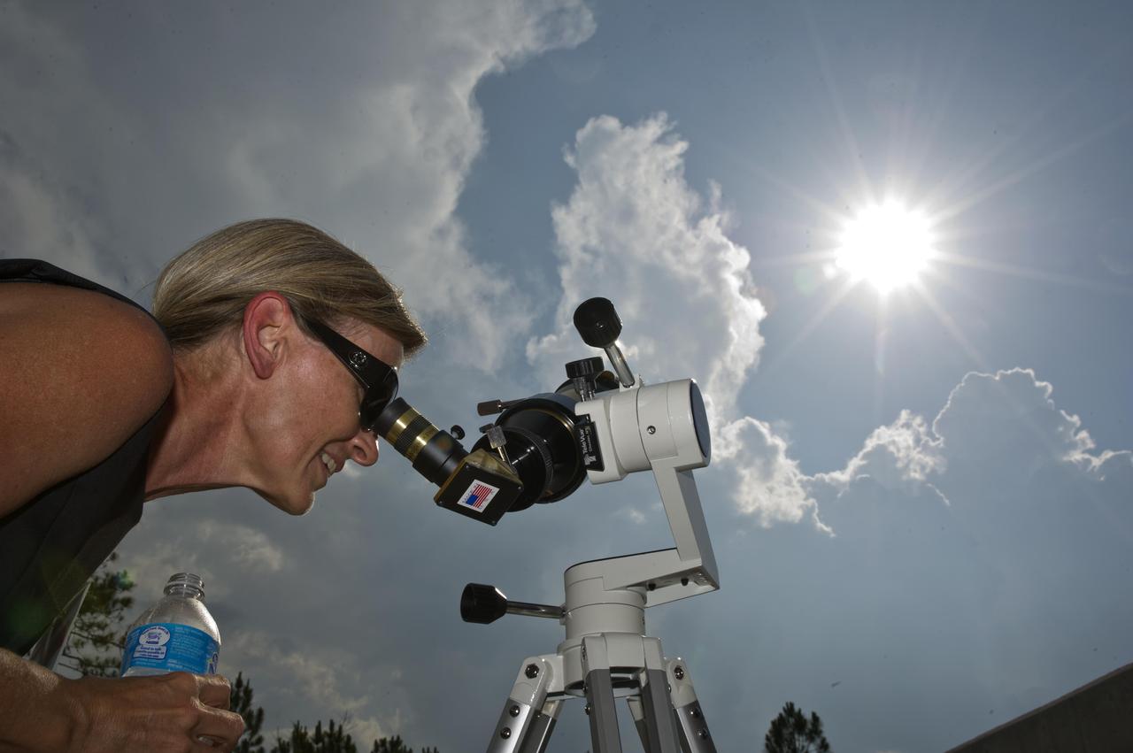
Leslie Lowes from the NASA Jet Propulsion Laboratory in Pasadena, Calif., views the June 5, 2012, Venus transit through a solar telescope. Lowes participated in an education workshop at the INFINITY at NASA Stennis Space Center visitor center and joined others to view the rare celestial event when Venus traverses the face of the sun.

Guests at the INFINITY at NASA Stennis Space Center visitor center use special solar sunglasses to catch a lifetime view of the Venus transit June 5, 2012. The rare celestial event in which the planet Venus traverses the face of the sun will not be visible from Earth again until 2117.

Leslie Lowes from the NASA Jet Propulsion Laboratory in Pasadena, Calif., views the June 5, 2012, Venus transit through a solar telescope. Lowes participated in an education workshop at the INFINITY at NASA Stennis Space Center visitor center and joined others to view the rare celestial event when Venus traverses the face of the sun.

Leslie Lowes from the NASA Jet Propulsion Laboratory in Pasadena, Calif., views the June 5, 2012, Venus transit through a solar telescope. Lowes participated in an education workshop at the INFINITY at NASA Stennis Space Center visitor center and joined others to view the rare celestial event when Venus traverses the face of the sun.

Guests at the INFINITY at NASA Stennis Space Center visitor center use special solar sunglasses to catch a lifetime view of the Venus transit June 5, 2012. The rare celestial event in which the planet Venus traverses the face of the sun will not be visible from Earth again until 2117.
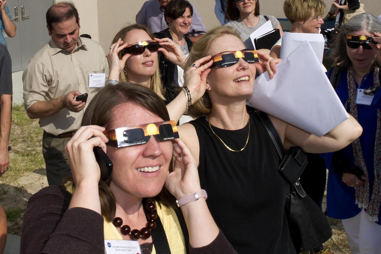
Guests at the INFINITY at NASA Stennis Space Center visitor center use special solar sunglasses to catch a lifetime view of the Venus transit June 5, 2012. The rare celestial event in which the planet Venus traverses the face of the sun will not be visible from Earth again until 2117.
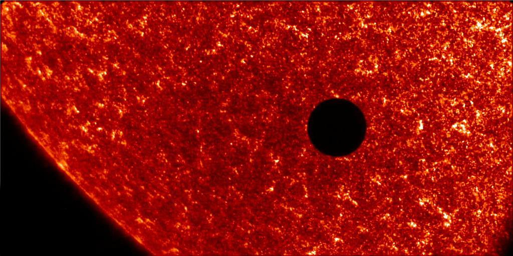
<b>To read more about the 2012 Venus Transit go to: <a href="http://sunearthday.nasa.gov/transitofvenus" rel="nofollow">sunearthday.nasa.gov/transitofvenus</a> </b> <b>Add your photos of the Transit of Venus to our Flickr Group here: <a href="http://www.flickr.com/groups/venustransit/">www.flickr.com/groups/venustransit/</a> </b> NASA FILE PHOTO Date: 8 Jun 2004 NASA's TRACE satellite captured this image of Venus crossing the face of the Sun as seen from Earth orbit. The last event occurred in 1882. The next Venus transit will be visible in 2012. This image also is a good example of the scale of Earth to the Sun since Venus and Earth are similar in size. Credit: NASA <b><a href="http://www.nasa.gov/audience/formedia/features/MP_Photo_Guidelines.html" rel="nofollow">NASA image use policy.</a></b> <b><a href="http://www.nasa.gov/centers/goddard/home/index.html" rel="nofollow">NASA Goddard Space Flight Center</a></b> enables NASA’s mission through four scientific endeavors: Earth Science, Heliophysics, Solar System Exploration, and Astrophysics. Goddard plays a leading role in NASA’s accomplishments by contributing compelling scientific knowledge to advance the Agency’s mission. <b>Follow us on <a href="http://twitter.com/NASA_GoddardPix" rel="nofollow">Twitter</a></b> <b>Like us on <a href="http://www.facebook.com/pages/Greenbelt-MD/NASA-Goddard/395013845897?ref=tsd" rel="nofollow">Facebook</a></b> <b>Find us on <a href="http://instagrid.me/nasagoddard/?vm=grid" rel="nofollow">Instagram</a></b>

This color image of the sun, Earth and Venus was taken by the Voyager 1 spacecraft Feb. 14, 1990, when it was approximately 32 degrees above the plane of the ecliptic and at a slant-range distance of approximately 4 billion miles. It is the first -- and may be the only -- time that we will ever see our solar system from such a vantage point. The image is a portion of a wide-angle image containing the sun and the region of space where the Earth and Venus were at the time with two narrow-angle pictures centered on each planet. The wide-angle was taken with the camera's darkest filter (a methane absorption band), and the shortest possible exposure (5 thousandths of a second) to avoid saturating the camera's vidicon tube with scattered sunlight. The sun is not large in the sky as seen from Voyager's perspective at the edge of the solar system but is still eight million times brighter than the brightest star in Earth's sky, Sirius. The image of the sun you see is far larger than the actual dimension of the solar disk. The result of the brightness is a bright burned out image with multiple reflections from the optics in the camera. The "rays" around the sun are a diffraction pattern of the calibration lamp which is mounted in front of the wide angle lens. The two narrow-angle frames containing the images of the Earth and Venus have been digitally mosaiced into the wide-angle image at the appropriate scale. These images were taken through three color filters and recombined to produce a color image. The violet, green and blue filters were used; exposure times were, for the Earth image, 0.72, 0.48 and 0.72 seconds, and for the Venus frame, 0.36, 0.24 and 0.36, respectively. Although the planetary pictures were taken with the narrow-angle camera (1500 mm focal length) and were not pointed directly at the sun, they show the effects of the glare from the nearby sun, in the form of long linear streaks resulting from the scattering of sunlight off parts of the camera and its sun shade. From Voyager's great distance both Earth and Venus are mere points of light, less than the size of a picture element even in the narrow-angle camera. Earth was a crescent only 0.12 pixel in size. Coincidentally, Earth lies right in the center of one of the scattered light rays resulting from taking the image so close to the sun. Detailed analysis also suggests that Voyager detected the moon as well, but it is too faint to be seen without special processing. Venus was only 0.11 pixel in diameter. The faint colored structure in both planetary frames results from sunlight scattered in the optics. http://photojournal.jpl.nasa.gov/catalog/PIA00450
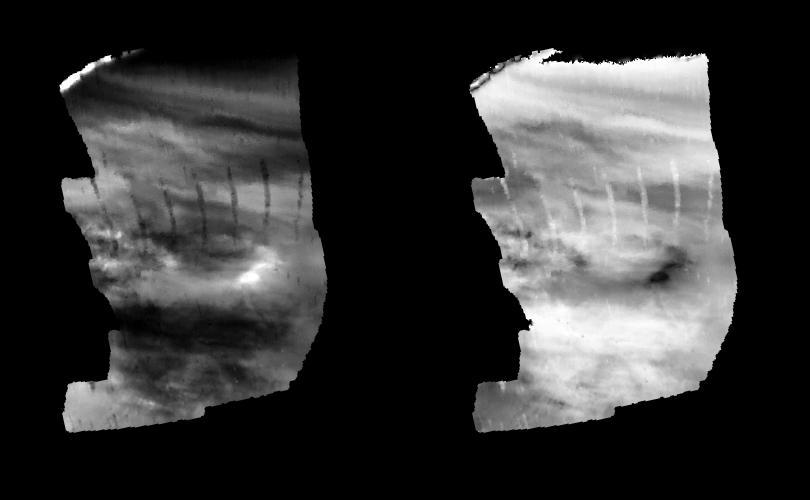
These radar images show an identical area on Venus (centered at 110 degrees longitude and 64 degrees north latitude) as imaged by the U.S. NASA Magellan spacecraft in 1991 (left) and the U.S.S.R. Venera 15/16 spacecraft in the early 1980's (right). Illumination is from the left (or west) in the Magellan image (left) and from the right (or east) in the Venera image (right). Differences in apparent shading in the images are due to differences in the two radar imaging systems. Prior to Magellan, the Venera 15/16 data was the best available for scientists studying Venus. Much greater detail is visible in the Magellan image owing to the greater resolution of the Magellan radar system. In the area seen here, approximately 200 small volcanoes, ranging in diameter from 2 to 12 kilometers (1.2 to 7.4 miles) can be identified. These volcanoes were first identified as small hills in Venera 15/16 images and were predicted to be shield-type volcanoes constructed mainly from eruptions of fluid lava flows similar to those that produce the Hawaiian Islands and sea floor volcanoes - a prediction that was confirmed by Magellan. These small shield-type volcanoes are the most abundant geologic feature on the surface of Venus, believed to number in the hundreds of thousands, perhaps millions, and are important evidence in understanding the geologic evolution of the planet. The only other planet in our Solar System with this large number of volcanoes is Earth. Clearly visible in the Magellan image are details of volcano morphology, such as variation in slope, the occurrence and size range of summit craters, and geologic age relationships between adjacent volcanoes, as well as additional volcanoes that were not identifiable in the Venera image. http://photojournal.jpl.nasa.gov/catalog/PIA00465