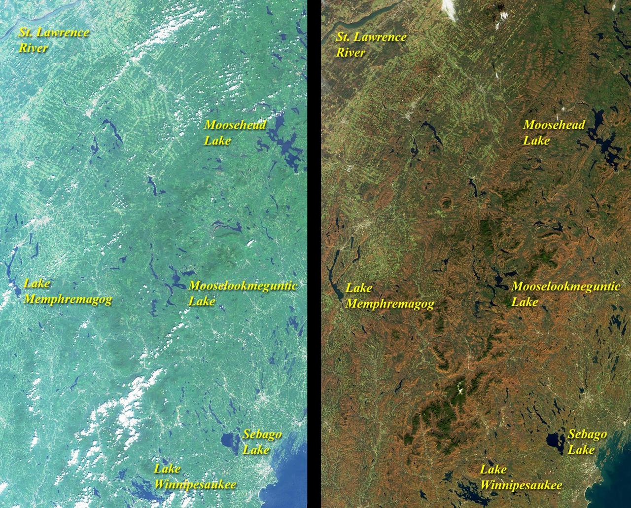
These images from NASA Terra satellite include eastern Vermont, New Hampshire, and western Maine, as well as the southeastern corner of Quebec province between August and October, 2000.
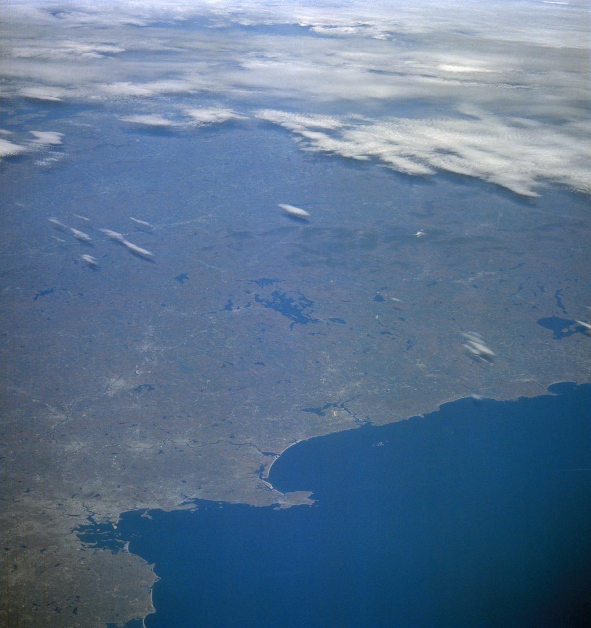
STS058-105-016 (18 Oct-1 Nov 1993) --- This photograph includes much of the heart of New England, stretching from Boston and Boston Harbor (lower left) across New Hampshire and Vermont to Lake Champlain (upper left), and up to southern Maine (Portland is just off the photo at right center). The colors in this photograph are less vivid than those in STS-58-81-038, because the color changes on the deciduous trees in central and northern New England were past their peak when this photograph was taken. North of Boston flows the Merrimack River (which forms part of the state boundary between Massachusetts and New Hampshire). It is delineated by the small industrial towns (Concord, Manchester, Nashua, Lowell) which grew up on its banks. The White Mountains of New Hampshire are seen near the center, and Mt. Washington (6,288 feet) is capped with snow.
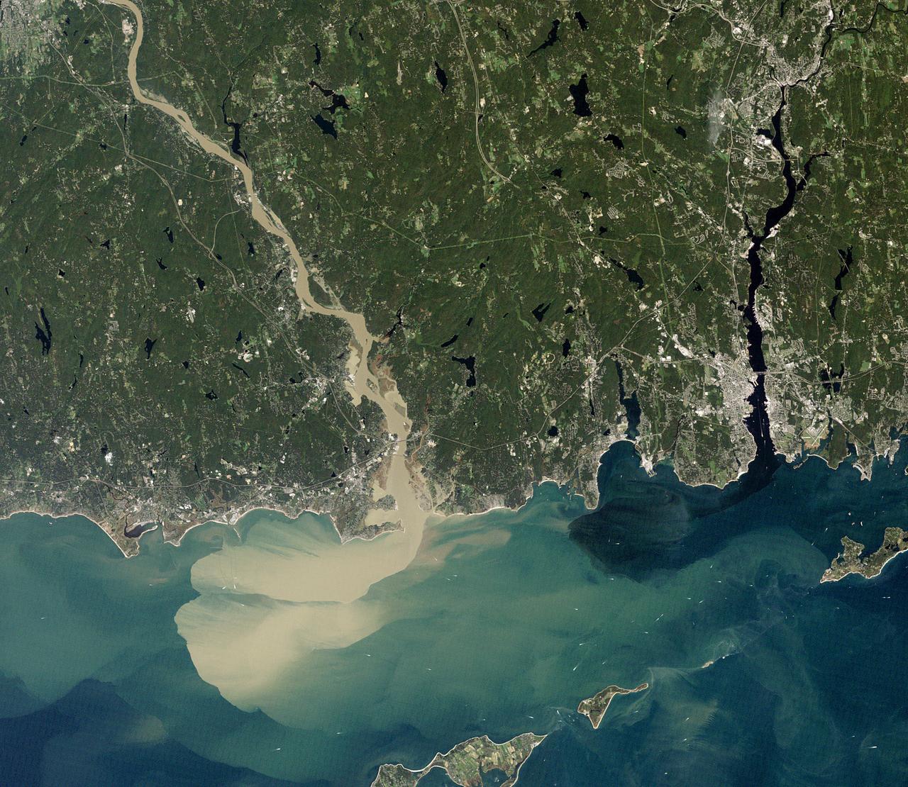
NASA image acquired September 2, 2011 To download the full high res go to: <a href="http://earthobservatory.nasa.gov/IOTD/view.php?id=52059" rel="nofollow">earthobservatory.nasa.gov/IOTD/view.php?id=52059</a> Nearly a week after Hurricane Irene drenched New England with rainfall in late August 2011, the Connecticut River was spewing muddy sediment into Long Island Sound and wrecking the region's farmland just before harvest. The Thematic Mapper on the Landsat 5 satellite acquired this true-color satellite image on September 2, 2011. With its headwaters near the Canadian border, the Connecticut River drains nearly 11,000 square miles (28,500 square kilometers) and receives water from at least 33 tributaries in Vermont, New Hampshire, Massachusetts, and Connecticut. The 410-mile river—New England's longest—enters Long Island Sound near Old Lyme, Connecticut, and is estimated to provide 70 percent of the fresh water entering the Sound. When Irene blew through the region on August 27-28, substantial portions of the Connecticut River watershed received more than 6 to 8 inches (15-20 centimeters) of rainfall, and several locations received more than 10 inches (25 centimeters). Whole towns were cut off from overland transportation—particularly upstream in Vermont, which suffered its worst flooding in 80 years. Thousands of people saw their homes flooded, if not washed off their foundations, at a time of year when rivers are usually at their lowest. Preliminary estimates of river flow at Thompsonville, Connecticut, (not shown in this image) reached 128,000 cubic feet per second (cfs) on August 30, nearly 64 times the usual flow (2,000 cfs) for early fall and the highest flow rate since May 1984. At the mouth of the river—where flow is tidal, and therefore not gauged—the peak water height reached 6.9 feet (2.1 meters) above sea level, almost a foot higher than at any time in the past 10 years. According to Suzanne O'Connell, an environmental scientist working along the Connecticut River at Wesleyan University, the torrent of water coursing through New England picked up silt and clay from the river valleys, giving it the tan color shown in the image above. At Essex, Connecticut, the turbidity (muddiness) of the water was 50 times higher than pre-Irene values. To the east, the Thames River appears to be carrying very little sediment at all on September 2. According to O'Connell, the Thames "drains glaciated terrain, so fine sediment was removed long ago." Most of the land surface in the Thames basin is "just bedrock, till, and glacial erratics." Unlike the Connecticut, areas within the Thames watershed only received 2 to 4 inches of rain in most locations. The flooding that occurred in the aftermath of Hurricane Irene inundated farmland in Massachusetts and Connecticut just before harvest time, the Associated Press noted. Crops were drowned under inches to feet of water. The substantial amounts of soil, sediment, and water deposited on land during the flood could also pose trouble for farmers in coming seasons. "It's notable that whole segments of river bank are just gone," said Andrew Fisk of the Connecticut River Watershed Council. "That's not just loss of sediment. That's land disappearing down river." <b>NASA Earth Observatory image by Robert Simmon, using Landsat 5 data from the U.S. Geological Survey Global Visualization Viewer. Caption by Michael Carlowicz, with interpretation help from Suzanne O'Connell, Wesleyan University, and Andrew Fisk, Connecticut River Watershed Council.</b> Instrument: Landsat 5 - TM Credit: <b><a href="http://www.earthobservatory.nasa.gov/" rel="nofollow"> NASA Earth Observatory</a></b> <b><a href="http://www.nasa.gov/centers/goddard/home/index.html" rel="nofollow">NASA Goddard Space Flight Center</a></b> enables NASA’s mission through four scientific endeavors: Earth Science, Heliophysics, Solar System Exploration, and Astrophysics. Goddard plays a leading role in NASA’s accomplishments by contributing compelling scientific knowledge to advance the Agency’s mission. <b>Follow us on <a href="http://twitter.com/NASA_GoddardPix" rel="nofollow">Twitter</a></b> <b>Like us on <a href="http://www.facebook.com/pages/Greenbelt-MD/NASA-Goddard/395013845897?ref=tsd" rel="nofollow">Facebook</a></b> <b>Find us on <a href="http://web.stagram.com/n/nasagoddard/?vm=grid" rel="nofollow">Instagram</a></b>

S85-38312 (September 1985) --- Logo designed for use by the 10 finalists in NASA’s Teacher in Space Project, who were at JSC for training and orientation the week of July 8–12, 1985. They are David M. Marquart, Boise High, Boise, Idaho; Michael W. Metcalf, Hazen Union School, Hardwick, Vermont; Judith Marie Garcia, Thomas Jefferson School for Science and Technology, Alexandria, Virginia; Peggy J. Lathlaen, Westwood Elementary, Friendswood, Texas; Niki Mason Wenger, Vandevender Junior High, Parkersburg, West Virginia; Barbara R. Morgan, McCall-Donnelly Elementary, McCall, Idaho; Kathleen Anne Beres, Kenwood High, Baltimore, Maryland; Richard A. Methia, New Bedford High, New Bedford, Mass.; Sharon Christa McAuliffe, Concord High, Concord, New Hampshire; and Robert S. Foerster, Cumberland Elementary School, West Lafayette, Indiana. Photo credit: NASA
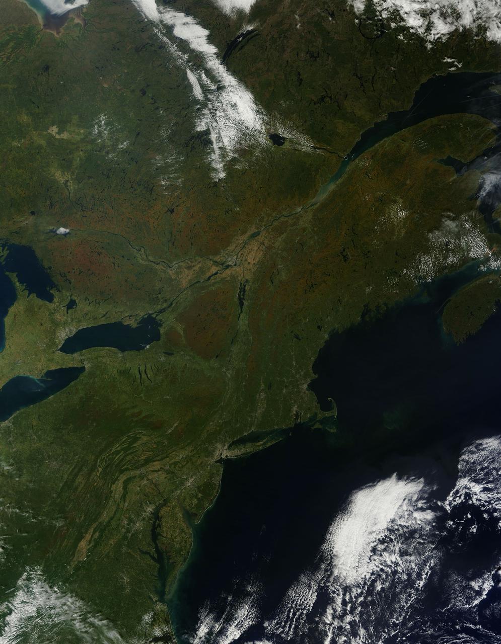
As temperatures dropped and daylight began to shorten, autumn colors began to wash over the deciduous forests of North America. The Moderate Resolution Imaging Spectroradiometer (MODIS) aboard NASA’s Terra satellite captured this true-color image of the northeastern United States and Canada on September 27, 2014. Washes of orange, brown and yellow are brightest in the Upper Peninsula of Michigan, upstate New York, New Hampshire, Vermont, Maine, and southern Quebec and Ontario. Also, faint traces of phytoplankton blooms can be seen in the offshore waters of the Atlantic Ocean. The transition of autumn leaves from green, to glowing with colors, to browning and dropping to the ground, involve several complex interactions and reactions. However, length of sunlight and the temperature changes are dominant factors. Topography also plays a role, as does latitude. Temperature tends to drop faster at higher elevations and at higher latitudes, and day length shortens more quickly at higher latitudes. Color change tends to begin in the north and sweep southward, and change begins at mountain tops then moves into valleys. As explained by the U.S. Forest Service, certain species of trees produce certain colors. Oaks generally turn red, brown, or russet; hickories become golden bronze; aspen and yellow-poplar turn golden. Maples differ by species. Red maple turns brilliant scarlet; sugar maple, orange-red; and black maple, yellow. Leaves of some trees, such as elms, simply become brown. Credit: NASA/GSFC/Jeff Schmaltz/MODIS Land Rapid Response Team <b><a href="http://www.nasa.gov/audience/formedia/features/MP_Photo_Guidelines.html" rel="nofollow">NASA image use policy.</a></b> <b><a href="http://www.nasa.gov/centers/goddard/home/index.html" rel="nofollow">NASA Goddard Space Flight Center</a></b> enables NASA’s mission through four scientific endeavors: Earth Science, Heliophysics, Solar System Exploration, and Astrophysics. Goddard plays a leading role in NASA’s accomplishments by contributing compelling scientific knowledge to advance the Agency’s mission. <b>Follow us on <a href="http://twitter.com/NASAGoddardPix" rel="nofollow">Twitter</a></b> <b>Like us on <a href="http://www.facebook.com/pages/Greenbelt-MD/NASA-Goddard/395013845897?ref=tsd" rel="nofollow">Facebook</a></b> <b>Find us on <a href="http://instagram.com/nasagoddard?vm=grid" rel="nofollow">Instagram</a></b>
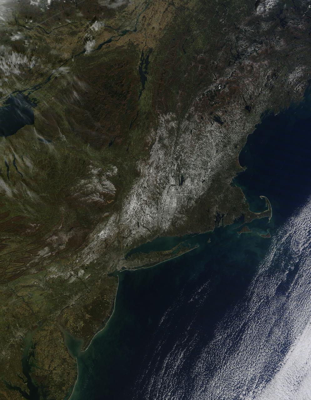
Last weekend's late October snow may have melted in Maryland, Delaware, parts of Pennsylvania and New Jersey, but residents in north central Connecticut are still dealing with the effects of the storm. According to Connecticut Light and Power, 430,868 residents were still without power today, Nov. 3, 2011. For estimated restoration times, visit their website at: <a href="http://www.cl-p.com/stormcenter/estimates/" rel="nofollow">www.cl-p.com/stormcenter/estimates/</a>. A late October snowstorm from a Nor'easter blanketed the eastern U.S. from West Virginia to Maine and broke records the weekend before Halloween Monday. NASA's Aqua satellite flew over the region on October 30 after the snow was ending in New England and captured the ghostly blanket of white. When NASA's Aqua satellite passed over the northeastern U.S. on November 2, 2011 at 2:00 p.m. EDT, the Moderate Resolution Imaging Spectroradiometer (MODIS) instrument captured a detailed image of the remaining snowfall. Snow still covers the ground in western and central Connecticut, southeastern New York, western and central Massachusetts, and parts of Vermont, New Hampshire and Maine. Over the Atlantic, cirrocumulus clouds create a diagonal border. The image was created at NASA's Goddard Space Flight Center in Greenbelt, Md. Image Credit: NASA Goddard MODIS Rapid Response Team; Caption: NASA Goddard, Rob Gutro <b><a href="http://www.nasa.gov/audience/formedia/features/MP_Photo_Guidelines.html" rel="nofollow">NASA image use policy.</a></b> <b><a href="http://www.nasa.gov/centers/goddard/home/index.html" rel="nofollow">NASA Goddard Space Flight Center</a></b> enables NASA’s mission through four scientific endeavors: Earth Science, Heliophysics, Solar System Exploration, and Astrophysics. Goddard plays a leading role in NASA’s accomplishments by contributing compelling scientific knowledge to advance the Agency’s mission. <b>Follow us on <a href="http://twitter.com/NASA_GoddardPix" rel="nofollow">Twitter</a></b> <b>Like us on <a href="http://www.facebook.com/pages/Greenbelt-MD/NASA-Goddard/395013845897?ref=tsd" rel="nofollow">Facebook</a></b> <b>Find us on <a href="http://instagrid.me/nasagoddard/?vm=grid" rel="nofollow">Instagram</a></b>