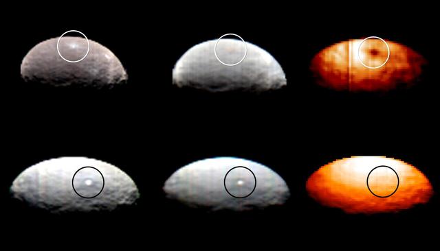
These images, from Dawn's visible and infrared mapping spectrometer (VIR), highlight two regions on Ceres containing bright spots. The top images feature a bright spot scientists have labeled "1" (located at around 4 degrees north, 8 degrees east on Ceres' surface); the bottom images feature the spot labeled "5" (located at around 20 degrees north, 240 degrees east). Spot 5 actually contains two spots, which are the brightest on Ceres. Each row shows Ceres' surface at different wavelengths. At left are images taken in visible light, close to wavelengths seen by the human eye. The center images show the same regions of Ceres in wavelengths shifted to the infrared range. The two images at right show Ceres in thermal infrared, where brighter colors represent higher temperatures. During Dawn's arrival at Ceres, VIR has been examining the relative temperatures of features on the dwarf planet's surface. Preliminary examination suggests that region 1 is cooler than the rest of Ceres' surface, but region 5 appears to be located in a region that is similar in temperature to its surroundings. The images were captured on February 19, 2015, when Dawn was nearly 29,000 miles (46,000 kilometers) from Ceres. Image scale on Ceres is about 7 miles (11 kilometers) per pixel. http://photojournal.jpl.nasa.gov/catalog/PIA19316
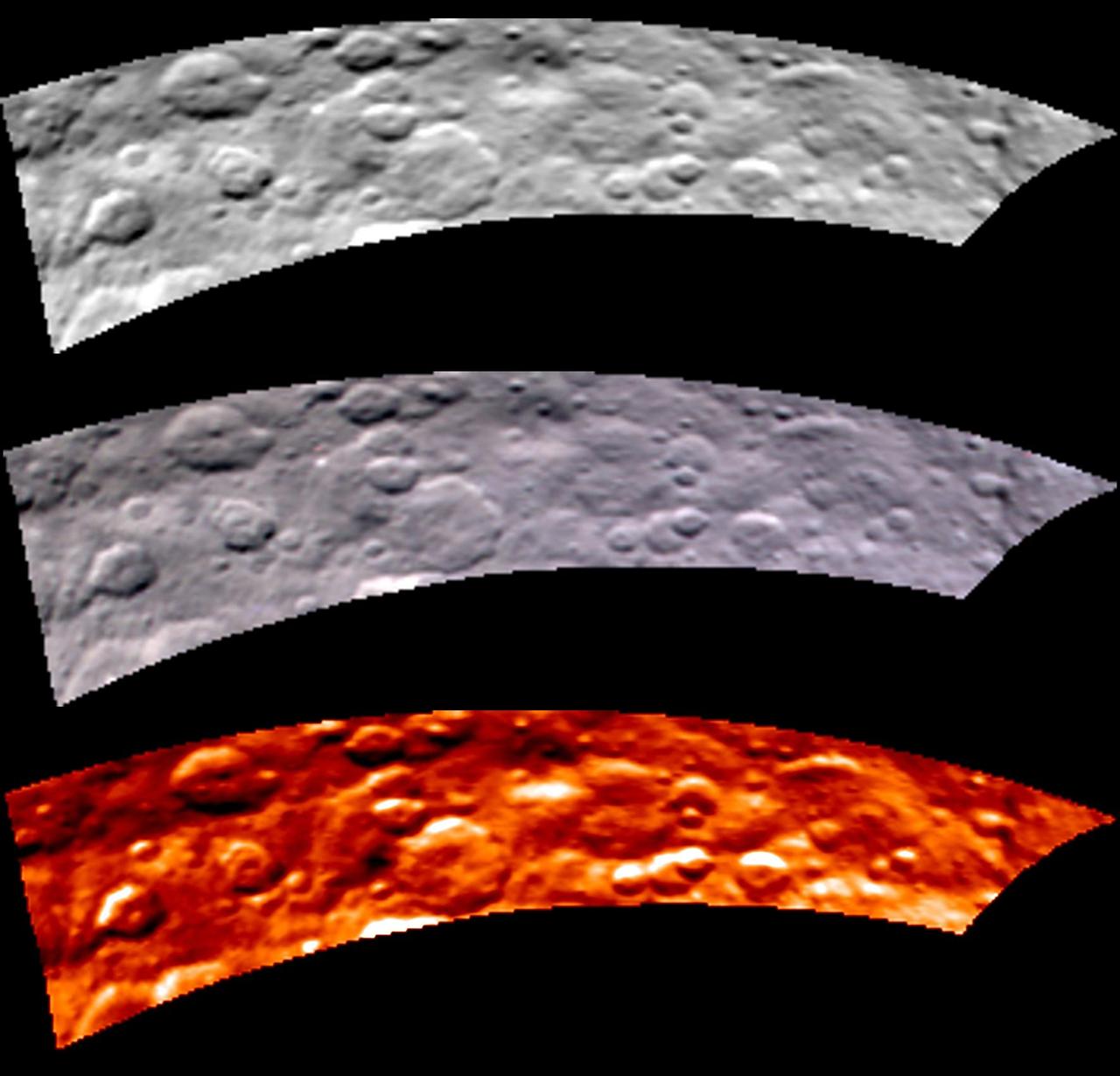
Images from Dawn's visible and infrared mapping spectrometer (VIR) show a portion of Ceres' cratered northern hemisphere, taken on May 16, 2015. From top to bottom, the views include a black-and-white image, a true-color view and a temperature image. The true-color view contains reddish dots that are image artifacts, which are not part of Ceres' surface. These images were taken at a distance of 4,500 miles (7,300 kilometers) from Ceres. They have a resolution of 1.1 miles (1.8 kilometers) per pixel. The temperature image is derived from data in the infrared light range. The lightest areas are the hottest and the darkest are the coolest. http://photojournal.jpl.nasa.gov/catalog/PIA19571
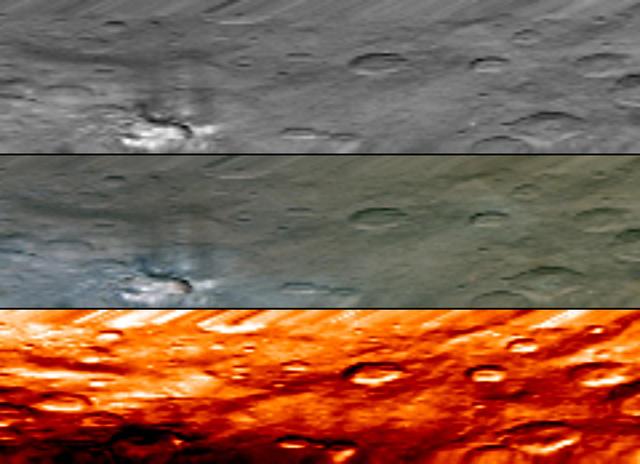
This image, from NASA Dawn visible and infrared mapping spectrometer VIR, highlights a bright region on Ceres known as Haulani, named after the Hawaiian plant goddess. Each row shows Ceres' surface at different wavelengths. On top is a black-and-white image; in the middle is a true-color image, and the bottom is in thermal infrared, where brighter colors represent higher temperatures and dark colors correspond to colder temperatures. The three images appear slightly flattened in the y-axis and smeared in the upper part due to the motion of the spacecraft. These images were taken at a distance of 2,700 miles (4,400 kilometers) from Ceres and have a resolution of about 0.6 miles (1 kilometer) per pixel. They were produced on June 6, 2015. http://photojournal.jpl.nasa.gov/catalog/PIA19608
![“I had the privilege of being the very first project manager for [the] Near Space Network (NSN), and in my current role as deputy program manager for [the] Exploration and Space Communications Division, it is still in my portfolio. NSN is one of the [agency’s two] communication and navigation networks. When we see the volume and the variety of NASA, other agency, and commercial missions supported by the network, and the science being achieved, and the exploration being enabled — when you leave for the day, you feel accomplished that you contributed [to the] agency’s goal. You contributed toward [the] nation’s priorities, such as cislunar [exploration], and then you helped humankind by enabling the science and exploration. Without communication, every satellite in this space is a black box. So, just knowing that every single day we are flowing terabytes of data through relay and direct-to-earth services directly to our [missions], enabling the exploration and achieving the science — is a great sense of accomplishment. ... Whatever role you are in, as long as you find a way to understand what mission, what goal, what objective you are contributing to, there is no bigger motivator than that. As a software programmer, normally you think that your job is to come in and write some code and solve some discrepancy reports and do the testing — and then you go home. But in the end, when you see that the program you are writing or fixing is something that controls the satellite that’s observing the sea levels and the sea temperatures or [controls] a capsule that is carrying astronauts, now you know you're actually contributing to a bigger purpose, a bigger objective. I say that to my team, whenever I have an opportunity. I share with my team that they are enabling science and exploration for dozens of missions being supported by NSN. Initially it just seems like words, but once they start realizing [their contributions] are real, I can tell you t](https://images-assets.nasa.gov/image/NHQ202402070014/NHQ202402070014~medium.jpg)
“I had the privilege of being the very first project manager for [the] Near Space Network (NSN), and in my current role as deputy program manager for [the] Exploration and Space Communications Division, it is still in my portfolio. NSN is one of the [agency’s two] communication and navigation networks. When we see the volume and the variety of NASA, other agency, and commercial missions supported by the network, and the science being achieved, and the exploration being enabled — when you leave for the day, you feel accomplished that you contributed [to the] agency’s goal. You contributed toward [the] nation’s priorities, such as cislunar [exploration], and then you helped humankind by enabling the science and exploration. Without communication, every satellite in this space is a black box. So, just knowing that every single day we are flowing terabytes of data through relay and direct-to-earth services directly to our [missions], enabling the exploration and achieving the science — is a great sense of accomplishment. ... Whatever role you are in, as long as you find a way to understand what mission, what goal, what objective you are contributing to, there is no bigger motivator than that. As a software programmer, normally you think that your job is to come in and write some code and solve some discrepancy reports and do the testing — and then you go home. But in the end, when you see that the program you are writing or fixing is something that controls the satellite that’s observing the sea levels and the sea temperatures or [controls] a capsule that is carrying astronauts, now you know you're actually contributing to a bigger purpose, a bigger objective. I say that to my team, whenever I have an opportunity. I share with my team that they are enabling science and exploration for dozens of missions being supported by NSN. Initially it just seems like words, but once they start realizing [their contributions] are real, I can tell you t
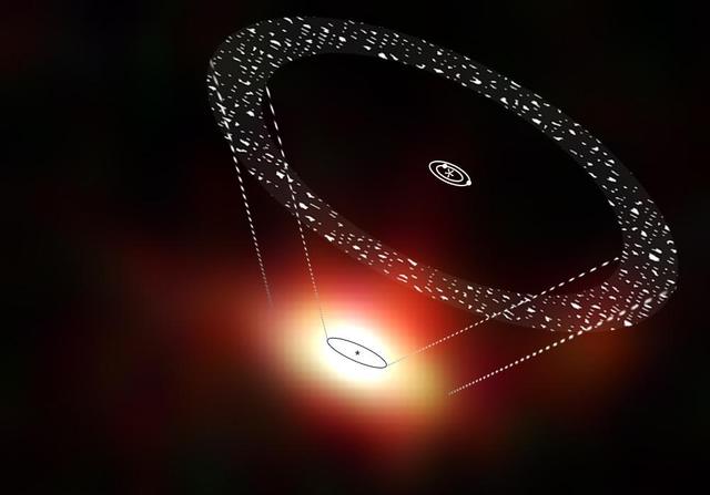
This artist impression shows the orbits of planets and comets around the star 61 Vir, superimposed on a view from the Herschel Space Telescope.
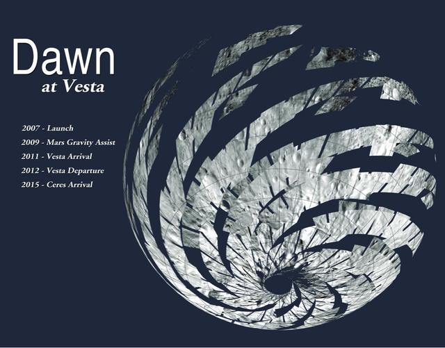
The mosaic of Visible and Infrared Spectrometer (VIR) data shows the location of the data acquired by VIR during the HAMO (high-altitude mapping orbit) phase of NASA's Dawn mission. VIR can image Vesta in a number of different wavelengths of light, ranging from the visible to the infrared part of the electromagnetic spectrum. This mosaic shows the images taken at a wavelength of 550 nanometers, which is in the visible part of the electromagnetic spectrum. During HAMO VIR obtained more than 4.6 million spectra of Vesta. It is clear from this image that the VIR observations are widely distributed across Vesta, which results in a global view of the spectral properties of Vesta's surface. http://photojournal.jpl.nasa.gov/catalog/PIA19368
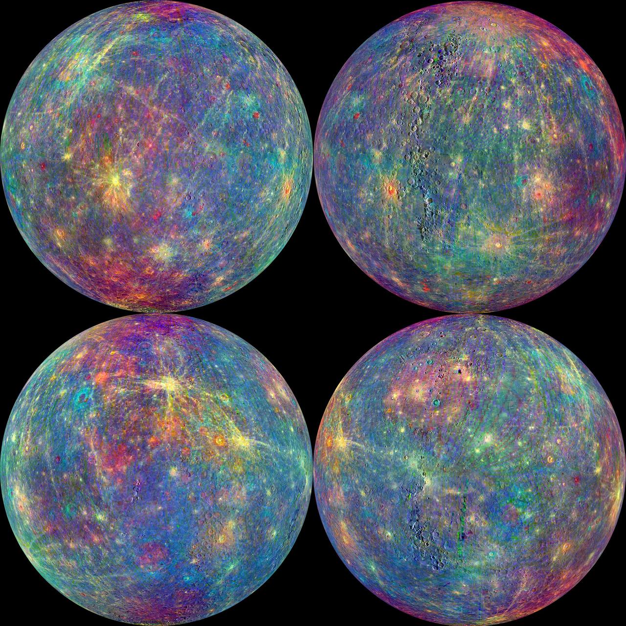
The MASCS instrument onboard NASA MESSENGER spacecraft was designed to study both the exosphere and surface of Mercury. To learn more about the minerals and surface processes on Mercury, the Visual and Infrared Spectrometer (VIRS) portion of MASCS has been diligently collecting single tracks of spectral surface measurements since MESSENGER entered orbit. The track coverage is now extensive enough that the spectral properties of both broad terrains and small, distinct features such as pyroclastic vents and fresh craters can be studied. To accentuate the geological context of the spectral measurements, the MASCS data have been overlain on the MDIS monochrome mosaic. Click on the image to explore the colorful diversity of surface materials in more detail! Instrument: Mercury Atmosphere and Surface Composition Spectrometer (MASCS) Map Projection: Orthographic VIRS Color Composite Wavelengths: 575 nm as red, 415 nm/750 nm as green, 310 nm/390 nm as blue Center Latitude (All Globes): 0° Center Longitude (Top Left Globe): 270° E Center Longitude (Top Right Globe): 0° E Center Longitude (Bottom Left Globe): 90° E Center Longitude (Bottom Right Globe): 180° E http://photojournal.jpl.nasa.gov/catalog/PIA19419

January 25, 2012 <b>*Updated February 2, 2012: According to Flickr, "The western hemisphere Blue Marble 2012 image has rocketed up to over 3.1 million views making it one of the all time most viewed images on the site after only one week."</b> A 'Blue Marble' image of the Earth taken from the VIIRS instrument aboard NASA's most recently launched Earth-observing satellite - Suomi NPP. This composite image uses a number of swaths of the Earth's surface taken on January 4, 2012. The NPP satellite was renamed 'Suomi NPP' on January 24, 2012 to honor the late Verner E. Suomi of the University of Wisconsin. Suomi NPP is NASA's next Earth-observing research satellite. It is the first of a new generation of satellites that will observe many facets of our changing Earth. Suomi NPP is carrying five instruments on board. The biggest and most important instrument is The Visible/Infrared Imager Radiometer Suite or VIIRS. To read more about NASA's Suomi NPP go to: <a href="http://www.nasa.gov/npp" rel="nofollow">www.nasa.gov/npp</a> Credit: NASA/NOAA/GSFC/Suomi NPP/VIIRS/Norman Kuring <b><a href="http://www.nasa.gov/audience/formedia/features/MP_Photo_Guidelines.html" rel="nofollow">NASA image use policy.</a></b> <b><a href="http://www.nasa.gov/centers/goddard/home/index.html" rel="nofollow">NASA Goddard Space Flight Center</a></b> enables NASA’s mission through four scientific endeavors: Earth Science, Heliophysics, Solar System Exploration, and Astrophysics. Goddard plays a leading role in NASA’s accomplishments by contributing compelling scientific knowledge to advance the Agency’s mission. <b>Follow us on <a href="http://twitter.com/NASAGoddardPix" rel="nofollow">Twitter</a></b> <b>Like us on <a href="http://www.facebook.com/pages/Greenbelt-MD/NASA-Goddard/395013845897?ref=tsd" rel="nofollow">Facebook</a></b> <b>Find us on <a href="http://instagrid.me/nasagoddard/?vm=grid" rel="nofollow">Instagram</a></b>