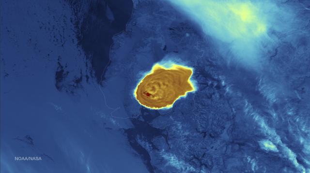
Calbuco Volcano in southern Chile has erupted for the first time since 1972, with the last major eruption occurring in 1961 that sent ash columns 12-15 kilometers high. This image was taken by the Suomi NPP satellite's VIIRS instrument in a high resolution infrared channel around 0515Z on April 23, 2015. Credit: NOAA/NASA/NPP/VIIRS
Volcano
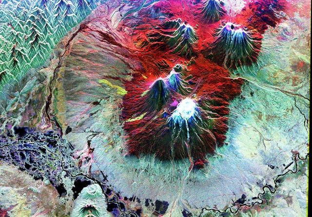
This image of the Nyiragonga volcano eruption in the Congo was acquired on January 28, 2002 by the Advanced Spaceborne Thermal Emission and Reflection Radiometer (ASTER) on NASA's Terra satellite. With its 14spectral bands from the visible to the thermal infrared wavelength region, and its high spatial resolution of 15 to 90 meters about 50 to 300 feet ), ASTER will image Earth for the next 6 years to map and monitor the changing surface of our planet. Image: A river of molten rock poured from the Nyiragongo volcano in the Congo on January 18, 2002, a day after it erupted, killing dozens, swallowing buildings and forcing hundreds of thousands to flee the town of Goma. The flow continued into Lake Kivu. The lave flows are depicted in red on the image indicating they are still hot. Two of them flowed south form the volcano's summit and went through the town of Goma. Another flow can be seen at the top of the image, flowing towards the northwest. One of Africa's most notable volcanoes, Nyiragongo contained an active lava lake in its deep summit crater that drained catastrophically through its outer flanks in 1977. Extremely fluid, fast-moving lava flows draining from the summit lava lake in 1977 killed 50 to 100 people, and several villages were destroyed. The image covers an area of 21 x 24 km and combines a thermal band in red, and two infrared bands in green and blue. http://photojournal.jpl.nasa.gov/catalog/PIA03462

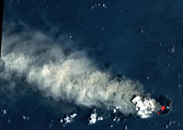
In this ASTER image of Soufriere Hills Volcano on Montserrat in the Caribbean, continued eruptive activity is evident by the extensive smoke and ash plume streaming towards the west-southwest. Significant eruptive activity began in 1995, forcing the authorities to evacuate more than 7,000 of the island's original population of 11,000. The primary risk now is to the northern part of the island and to the airport. Small rockfalls and pyroclastic flows (ash, rock and hot gases) are common at this time due to continued growth of the dome at the volcano's summit. This image was acquired on October 29, 2002 by the Advanced Spaceborne Thermal Emission and Reflection Radiometer (ASTER) on NASA's Terra satellite. With its 14 spectral bands from the visible to the thermal infrared wavelength region, and its high spatial resolution of 15 to 90 meters (about 50 to 300 feet), ASTER images Earth to map and monitor the changing surface of our planet. http://photojournal.jpl.nasa.gov/catalog/PIA03880
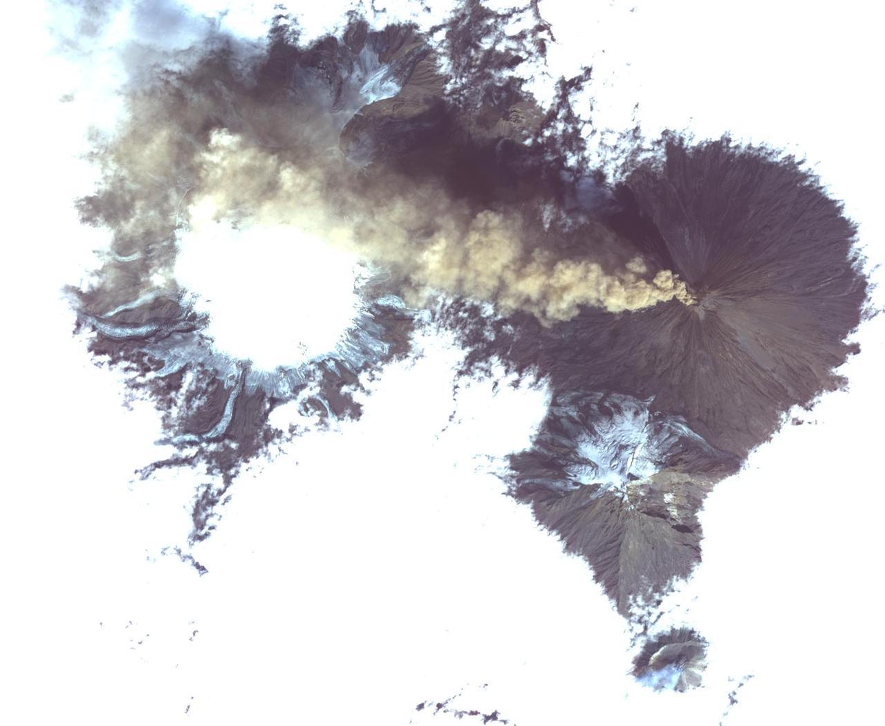
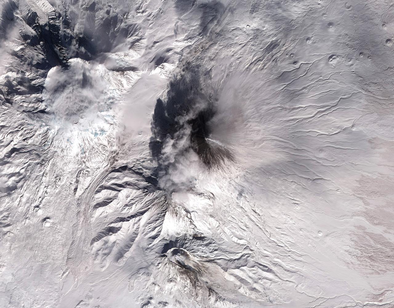
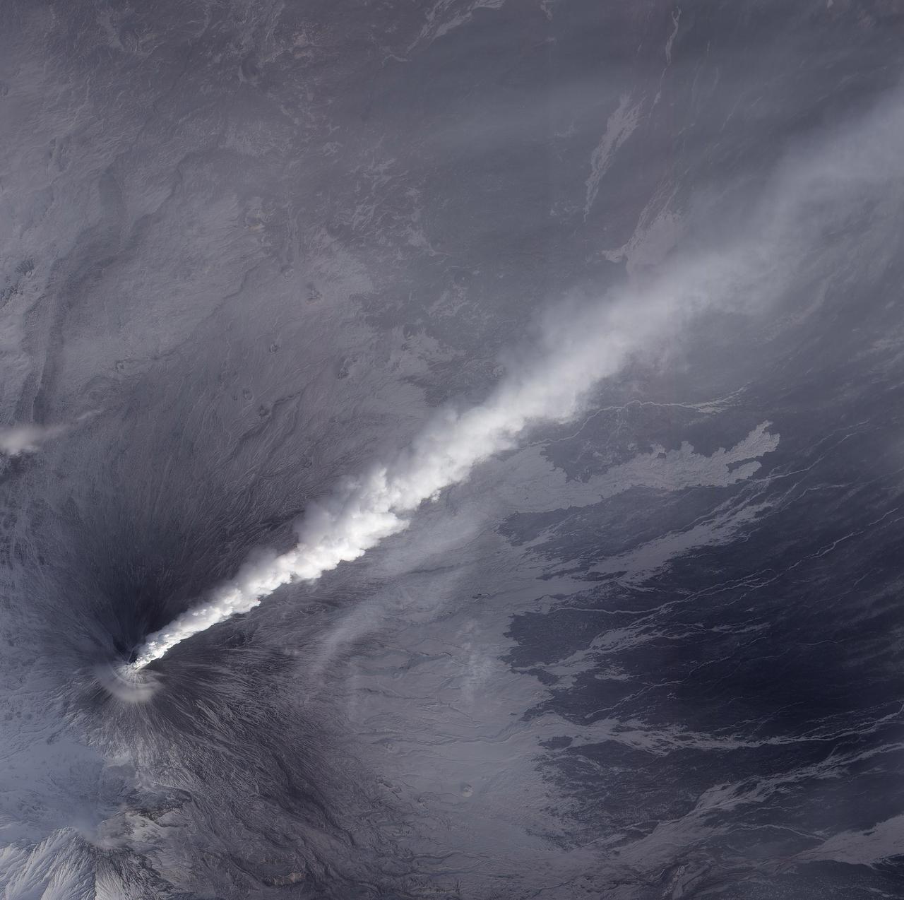
Klyuchevskoi, one of the world's most active volcanoes, is seen poking through above a solid cloud deck, with an ash plume streaming to the west. Located on the Kamchatka Peninsula in far eastern Russia, it is one of many active volcanoes on the Peninsula. Nearby, to the south, the smaller Bezymianny volcano can be seem with a small steam plume coming from its summit. The image was acquired Aug. 20, 2017, covers an area of 12 by 14 miles (19.5 by 22.7 kilometers), and is located at 56.1 degrees north, 160.6 degrees east. https://photojournal.jpl.nasa.gov/catalog/PIA21878

On the night of June 4, 2001, the Advanced Spaceborne Thermal Emission and Reflection Radiometer (ASTER) captured this thermal image of the erupting Shiveluch volcano. Located on Russia's Kamchatka Peninsula, Shiveluch rises to an altitude of 2,447 meters (8,028 feet). The active lava dome complex is seen as a bright (hot) area on the summit of the volcano. To the southwest, a second hot area is either a debris avalanche or hot ash deposit. Trailing to the west is a 25-kilometer (15-mile) ash plume, seen as a cold "cloud" streaming from the summit. At least 60 large eruptions have occurred here during the last 10,000 years; the largest historical eruptions were in 1854 and 1964. Because Kamchatka is located along the major aircraft routes between North America/Europe and Asia, this area is constantly monitored for potential ash hazards to aircraft. The area is part of the "Ring of Fire," a string of volcanoes that encircles the Pacific Ocean. The lower image is the same as the upper, except it has been color-coded: red is hot, light greens to dark green are progressively colder, and gray/black are the coldest areas. The image is located at 56.7 degrees north latitude, 161.3 degrees east longitude. http://photojournal.jpl.nasa.gov/catalog/PIA03514
Mapping a Volcano

Titan Volcano
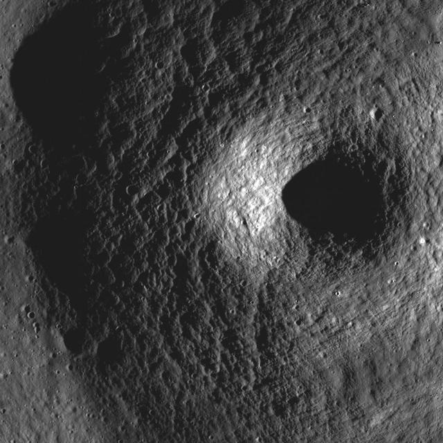
Small Volcano
Volcano Vents
A Diminutive Volcano
Small Volcano
West of Gunung Merapi, East Java, Indonesia, is the Ijen volcano, which has a one-kilometer-wide turquoise-colored acidic crater lake. The lake is the site of a labor-intensive sulfur mining operation, in which sulfur-laden baskets are carried by hand from the crater floor. The lake is recognized as the largest highly acidic crater lake in the world, with a pH of 0.5. The image was acquired 17 September 2008, covers an area of 24 by 39 kilometers, and is located at 8 degrees south, 114.2 degrees east. https://photojournal.jpl.nasa.gov/catalog/PIA21787

NASA Image acquired March 24, 2010 To learn more and to download a high res version of this image go here: <a href="http://earthobservatory.nasa.gov/IOTD/view.php?id=43252" rel="nofollow">earthobservatory.nasa.gov/IOTD/view.php?id=43252</a> Iceland’s Eyjafjallajökull Volcano burst into life for the first time in 190 years on March 20, 2010. A 500-meter- (2,000-foot) long fissure opened in the Fimmvörduháls pass to the west of the ice-covered summit of Eyjafjallajökull. Lava fountains erupted fluid magma, which quickly built several hills of bubble-filled lava rocks (scoria) along the vent. A lava flow spread northeast, spilling into Hrunagil Gully. This natural-color satellite image shows lava fountains, lava flows, a volcanic plume, and steam from vaporized snow. The image was acquired on March 24, 2010, by the Advanced Land Imager (ALI) aboard NASA’s Earth Observing-1 (EO-1) satellite. The lava fountains are orange-red, barely visible at the 10-meter (33-foot) resolution of the satellite. The scoria cones surrounding the fissure are black, as is the lava flow extending to the northeast. White volcanic gases escape from the vent and erupting lava, while a steam plume rises where the hot lava meets snow. (The bright green color along the edge of the lava flow is an artifact of the sensor.) The eruption of Eyjafjallajökull was presaged by a series of earthquakes starting in early March. Over time, the earthquakes rose towards the surface, and land near the volcano rose at least 40 millimeters (2 inches)—both indications that magma was moving underneath the volcano. The eruption continued through at least March 26th, and may continue for several more months. Previous eruptions in the area have caused flooding due to the melting of glacial ice (a Jökulhlaup), but the current eruption is in an area covered by winter snow, not permanent ice. Although some past eruptions of Eyjafjallajökull were followed by larger, explosive eruptions at nearby Katla Volcano, there is currently no sign of activity at Katla. NASA image by Robert Simmon, using ALI data from the EO-1 team. Caption by Robert Simmon. Instrument: EO-1 - ALI <b><a href="http://www.nasa.gov/centers/goddard/home/index.html" rel="nofollow">NASA Goddard Space Flight Center</a></b> is home to the nation's largest organization of combined scientists, engineers and technologists that build spacecraft, instruments and new technology to study the Earth, the sun, our solar system, and the universe.
This is an image of the Colima volcano in Jalisco, Mexico, a vigorously active volcano that erupted as recently as July 1994. The eruption partially destroyed a lava dome at the summit and deposited a new layer of ash on the volcano's southern slopes. Surrounding communities face a continuing threat of ash falls and volcanic mudflows from the volcano, which has been designated one of 15 high-risk volcanoes for scientific study during the next decade. This image was acquired by the Spaceborne Imaging Radar-C and X-band Synthetic Aperture Radar (SIR-C/X-SAR) aboard the space shuttle Endeavour on its 24th orbit on October 1, 1994. The image is centered at 19.4 degrees north latitude, 103.7 degrees west longitude. The area shown is approximately 35.7 kilometers by 37.5 kilometers (22 miles by 23 miles). This single-frequency, multi-polarized SIR-C image shows: red as L-band horizontally transmitted and received; green as L-band horizontally transmitted and vertically received; and blue as the ratio of the two channels. The summit area appears orange and the recent deposits fill the valleys along the south and southwest slopes. Observations from space are helping scientists understand the behavior of dangerous volcanoes and will be used to mitigate the effects of future eruptions on surrounding populations. http://photojournal.jpl.nasa.gov/catalog/PIA01739
On Dec. 22, 2018, Indonesia's Anak Krakatau volcano erupted and partially collapsed. NASA's Advanced Spaceborne Thermal Emission and Reflection (ASTER) instrument imaged the volcano on Jan. 13 -- several weeks after the eruption. This image shows that the crater area has closed to become a lake and the forest on the island has been destroyed by ash falls. The reddish area in the water southwest of the island is likely due to either iron-rich ash in the water or the interaction of seawater with underwater volcanic eruption products. The image covers an area of 7.5 by 8.4 miles (12.2 by 13.5 kilometers), and is located at 6.1 degrees south, 105.4 degrees east. The tsunami that followed the eruption killed more than 400 people in western Indonesia. https://photojournal.jpl.nasa.gov/catalog/PIA22821
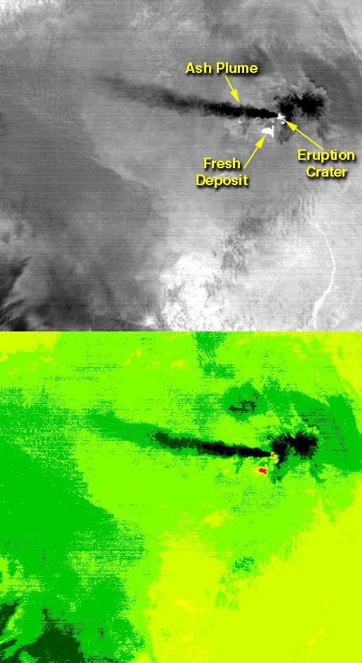
On the night of June 4, 2001 ASTER captured this thermal image of the erupting Shiveluch volcano. Located on Russia's Kamchatka Peninsula, Shiveluch rises to an altitude of 8028'. The active lava dome complex is seen as a bright (hot) area on the summit of the volcano. To the southwest, a second hot area is either a debris avalanche or hot ash deposit. Trailing to the west is a 25 km ash plume, seen as a cold "cloud" streaming from the summit. At least 60 large eruptions have occurred during the last 10,000 years; the largest historical eruptions were in 1854 and 1964. Because Kamchatka is located along the major aircraft routes between North America/Europe and the Far East, this area is constantly monitored for potential ash hazards to aircraft. The lower image is the same as the upper, except it has been color coded: red is hot, light greens to dark green are progressively colder, and gray/black are the coldest areas. The image is located at 56.7 degrees north latitude, 161.3 degrees east longitude. http://photojournal.jpl.nasa.gov/catalog/PIA02674
On Sept. 28, 2017, Manaro Voui volcano on Ambae island in Vanuatu began spewing ash in a moderate eruption, prompting authorities to order the evacuation of all 11,000 residents. This nighttime thermal infrared image from the Advanced Spaceborne Thermal Emission and Reflection Radiometer (ASTER), acquired on Oct. 7, shows a hot spot (white) on the volcano's summit crater, but no large eruption. Cold clouds are dark gray, the warmer island is gray, and the ocean, (warmer than the island), is light gray. The image covers an area of 17 by 26 miles (27 by 42.4 kilometers), and is centered at 15.4 degrees south, 167.8 degrees east. https://photojournal.jpl.nasa.gov/catalog/PIA22045
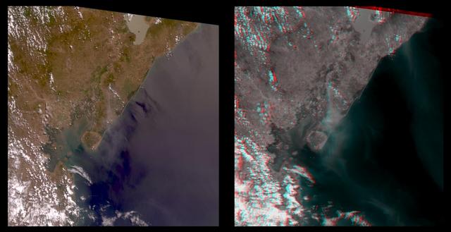
The true-color image at left is a downward-looking (nadir) view of the area around the San Cristobal volcano, which erupted the previous day. This image is oriented with east at the top and north at the left. The right image is a stereo anaglyph of the same area, created from red band multi-angle data taken by the 45.6-degree aftward and 70.5-degree aftward cameras on the Multi-angle Imaging SpectroRadiometer (MISR) instrument on NASA's Terra satellite. View this image through red/blue 3D glasses, with the red filter over the left eye. A plume from San Cristobal (approximately at image center) is much easier to see in the anaglyph, due to 3 effects: the long viewing path through the atmosphere at the oblique angles, the reduced reflection from the underlying water, and the 3D stereoscopic height separation. In this image, the plume floats between the surface and the overlying cumulus clouds. A second plume is also visible in the upper right (southeast of San Cristobal). This very thin plume may originate from the Masaya volcano, which is continually degassing at as low rate. The spatial resolution is 275 meters (300 yards). http://photojournal.jpl.nasa.gov/catalog/PIA02600
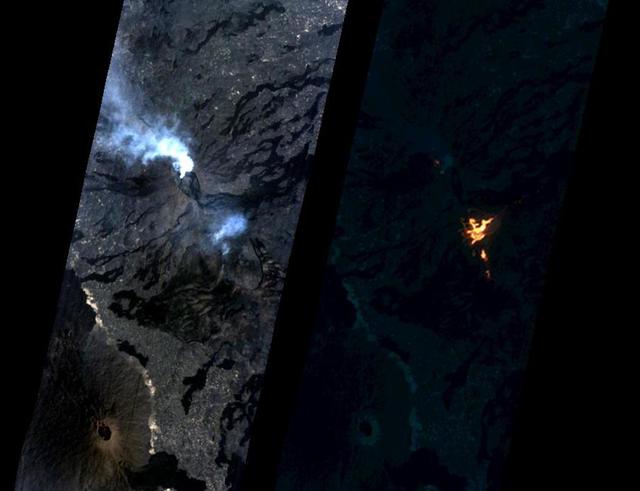
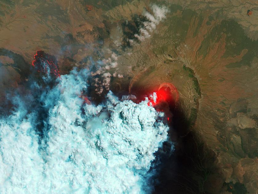
On Jan. 24, 2017, the Hyperion Imager on NASA's Earth Observing 1 (EO-1) spacecraft observed a new eruption at Erta'Ale volcano, Ethiopia, from an altitude of 438 miles (705 kilometers). Data were collected at a resolution of 98 feet (30 meters) per pixel at different visible and infrared wavelengths and were combined to create these images. A visible-wavelength image is on the left. An infrared image is shown on the right. The infrared image emphasizes the hottest areas and reveals a spectacular rift eruption, where a crack opens and lava gushes forth, fountaining into the air. The lava flows spread away from the crack. Erta'Ale is the location of a long-lived lava lake, and it remains to be seen if this survives this new eruption. The observation was scheduled via the Volcano Sensor Web, a network of sensors linked by artificial intelligence software to create an autonomous global monitoring program of satellite observations of volcanoes. The Volcano Sensor Web was alerted to this new activity by data from another spacecraft. http://photojournal.jpl.nasa.gov/catalog/PIA11239

NASA's ASTER (Advanced Spaceborne Thermal Emission and Reflection Radiometer)captured these images of Guatemala's Fuego volcano on Nov. 24, following a recent eruption. The main image shows the lava flows on the flanks of Fuego (upper left corner) in light gray. Vegetation is shown in red, clouds in white, and city and fields in dark gray. A thick ash plume rising from the peak of the volcano and more diffuse ash clouds over the southern part of the scene are also visible. The thermal infrared composite highlights the ash clouds in orange, with a dark orange cloud over the summit where the ash is thickest. White areas are relatively warmer; Fuego's summit is bright white at the active crater. https://photojournal.jpl.nasa.gov/catalog/PIA22820
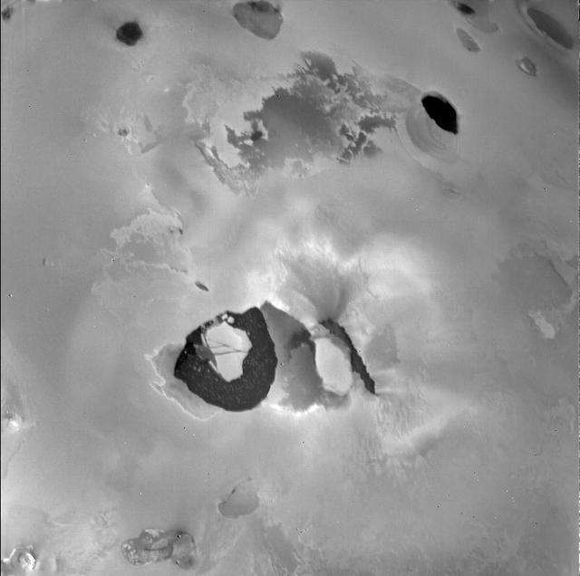
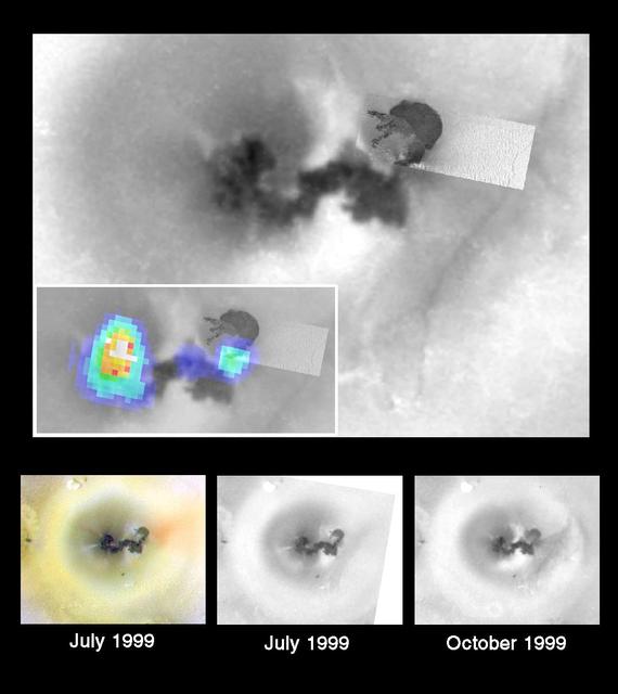
A January 6, 2002 ASTER nighttime thermal infrared image of Chiliques volcano in Chile shows a hot spot in the summit crater and several others along the upper flanks of the edifice, indicating new volcanic activity. Examination of an earlier nighttime thermal infrared image from May 24, 2000 showed no thermal anomaly. Chiliques volcano was previously thought to be dormant. Rising to an elevation of 5778 m, Chiliques is a simple stratovolcano with a 500-m-diameter circular summit crater. This mountain is one of the most important high altitude ceremonial centers of the Incas. It is rarely visited due to its difficult accessibility. Climbing to the summit along Inca trails, numerous ruins are encountered; at the summit there are a series of constructions used for rituals. There is a beautiful lagoon in the crater that is almost always frozen. The daytime image was acquired on November 19, 2000 and was created by displaying ASTER bands 1,2 and 3 in blue, green and red. The nighttime image was acquired January 6, 2002, and is a color-coded display of a single thermal infrared band. The hottest areas are white, and colder areas are darker shades of red. Both images cover an area of 7.5 x 7.5 km, and are centered at 23.6 degrees south latitude, 67.6 degrees west longitude. Both images cover an area of 7.5 x 7.5 km, and are centered at 23.6 degrees south latitude, 67.6 degrees west longitude. http://photojournal.jpl.nasa.gov/catalog/PIA03493
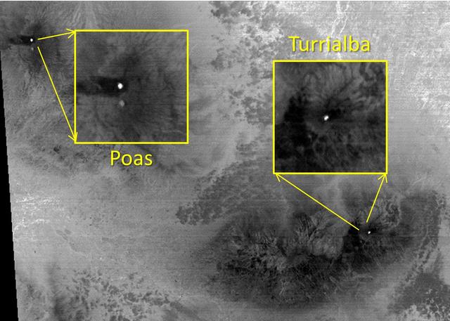
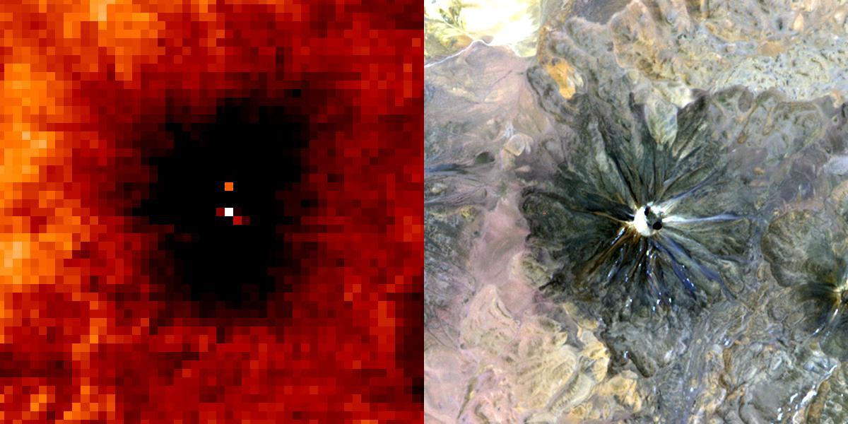
The March, 2015 eruption of Turrialba Volcano in Costa Rica caught everyone by surprise as seen in this image from the ASTER instrument onboard NASA Terra spacecraft. Activity had greatly diminished when the Advanced Spaceborne Thermal Emission and Reflection Radiometer (ASTER) instrument on NASA's Terra spacecraft acquired this nighttime thermal infrared image on April 2, 2015. The hot summit crater appears in white, indicating continued volcanic unrest. To the west, Poas Volcano's hot crater lake also appears white, though its temperature is considerably less than Turrialba's crater. The large image covers an area of 28 by 39 miles (45 by 63 kilometers); the insets 2 by 2 miles (3.1 by 3.1 kilometers). The image is centered at 10.1 degrees north, 84 degrees west. http://photojournal.jpl.nasa.gov/catalog/PIA19355

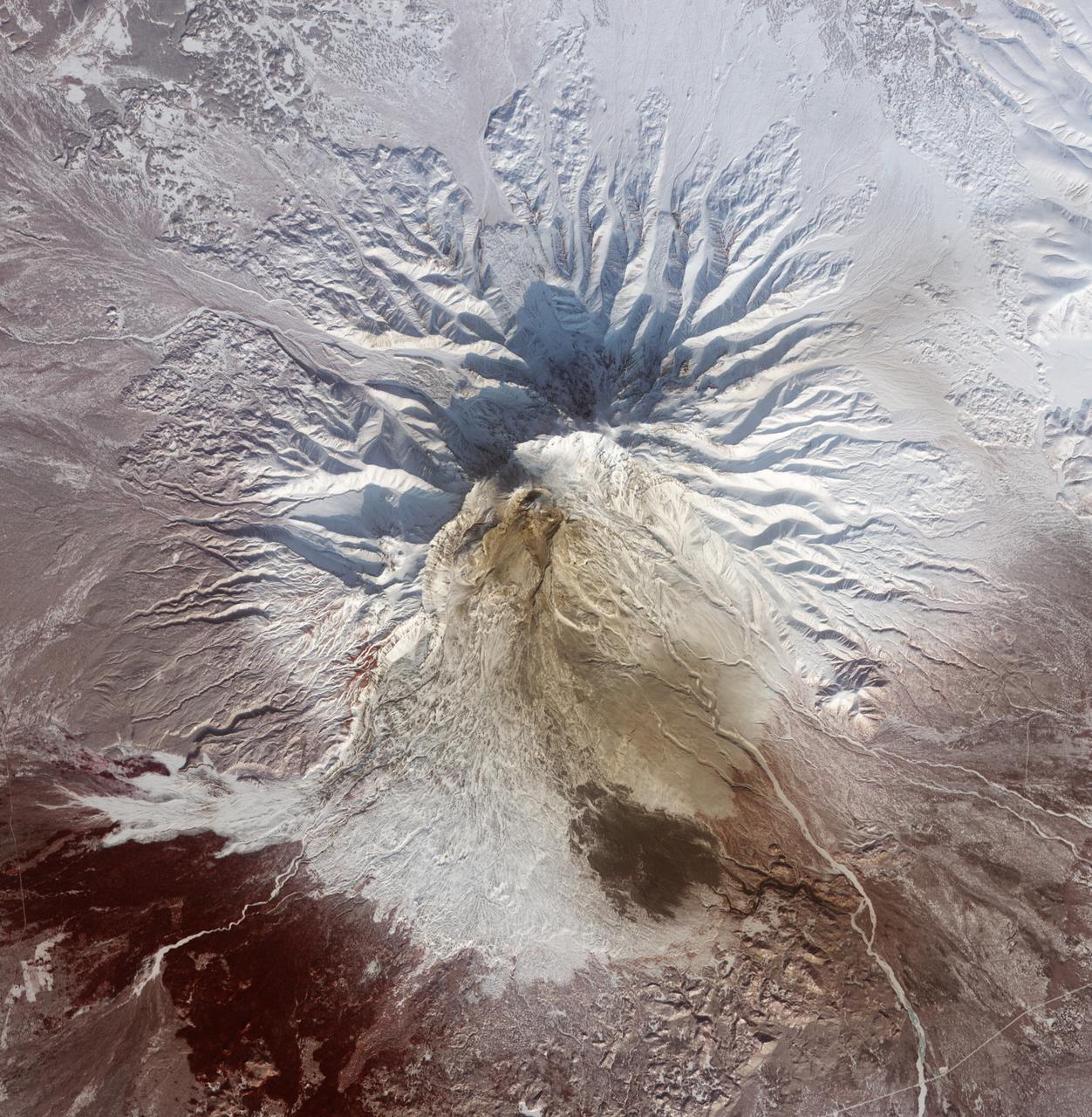
NASA image acquired Sept 7, 2010 Shiveluch (also spelled Sheveluch) is one of the largest and most active volcanoes on Russia’s Kamchatka Peninsula. It has been spewing ash and steam intermittently—with occasional dome collapses, pyroclastic flows, and lava flows, as well—for the past decade. Shiveluch is a stratovolcano, a steep-sloped formation of alternating layers of hardened lava, ash, and rocks thrown out by earlier eruptions. A lava dome has been growing southwest of the 3,283-meter (10,771-foot) summit. The Advanced Land Imager (ALI) on NASA’s Earth Observing-1 (EO-1) satellite acquired this image on September 7, 2010. Brown and tan debris—perhaps ash falls, perhaps mud from lahars—covers the southern landscape of the volcano, while the hills on the northern side remain covered in snow and ice. The Kamchatkan Volcanic Eruption Response Team (KVERT) reported that seismic activity at Shiveluch was "above background levels" from September 3-10. Ash plumes rose to an altitude of 6.5 kilometers (21,300 feet) on September 3-4, and gas-and-ash plumes were reported on September 7, when this image was acquired. According to the Smithsonian Institution's volcano program, at least 60 large eruptions of Shiveluch have occurred during the current Holocene Epoch of geological history. Intermittent explosive eruptions began in the 1990s, and the largest historical eruptions from Shiveluch occurred in 1854 and 1964. NASA Earth Observatory image created by Jesse Allen and Robert Simmon, using EO-1 ALI data provided courtesy of the NASA EO-1 team. Caption by Mike Carlowicz. Instrument: EO-1 - ALI Credit: NASA Earth Observatory NASA Goddard Space Flight Center contributes to NASA’s mission through four scientific endeavors: Earth Science, Heliophysics, Solar System Exploration, and Astrophysics. Goddard plays a leading role in NASA’s endeavors by providing compelling scientific knowledge to advance the Agency’s mission. Follow us on Twitter Join us on Facebook
Small Dusty Volcano
Small Tharsis Volcano
Small Syrian Volcano
Small Volcano in Tempe Terra
Regional View of the Tharsis Volcanoes
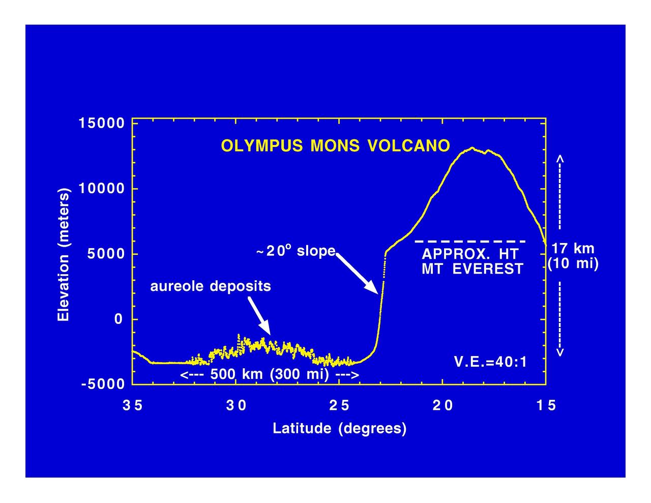
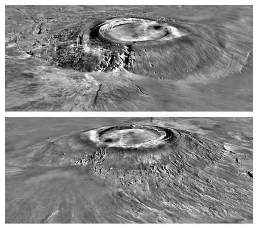
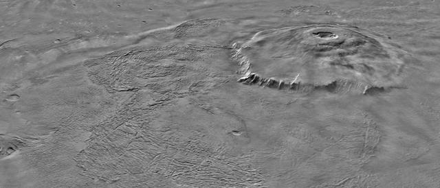
Olympus Mons Volcano
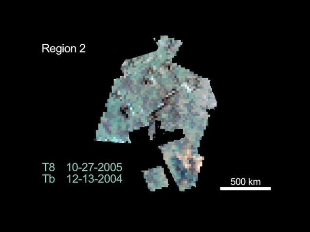
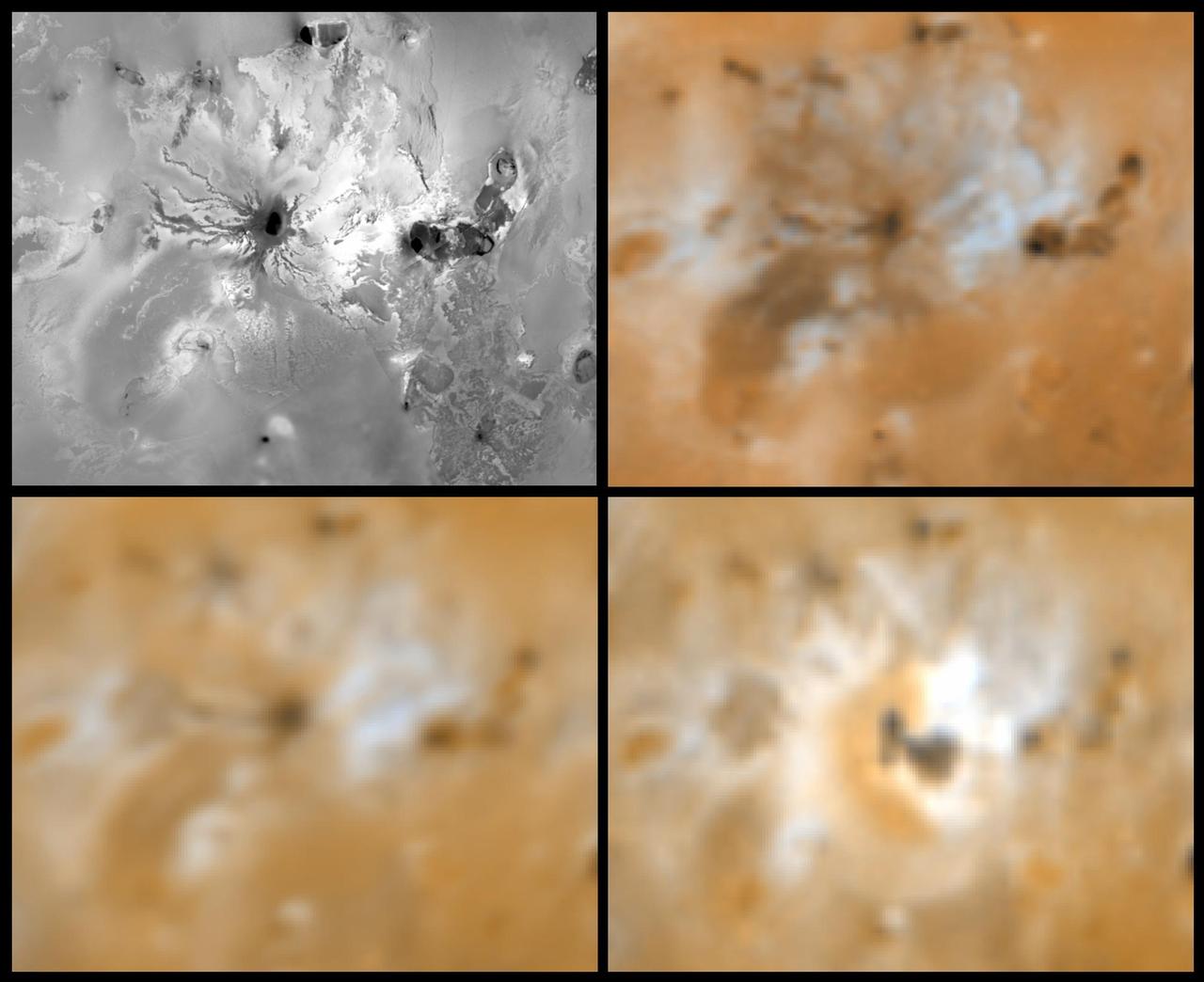
Changing volcanoes on Io
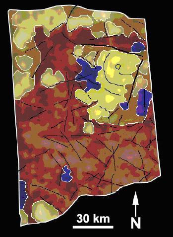
Geologic Map of Titan Volcano
Volcano Near Pavonis Mons
Topography and Volcanoes on Io color
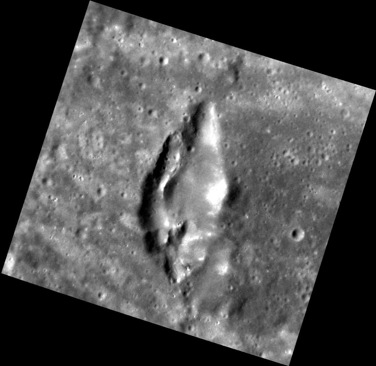
Tear-drop Volcano
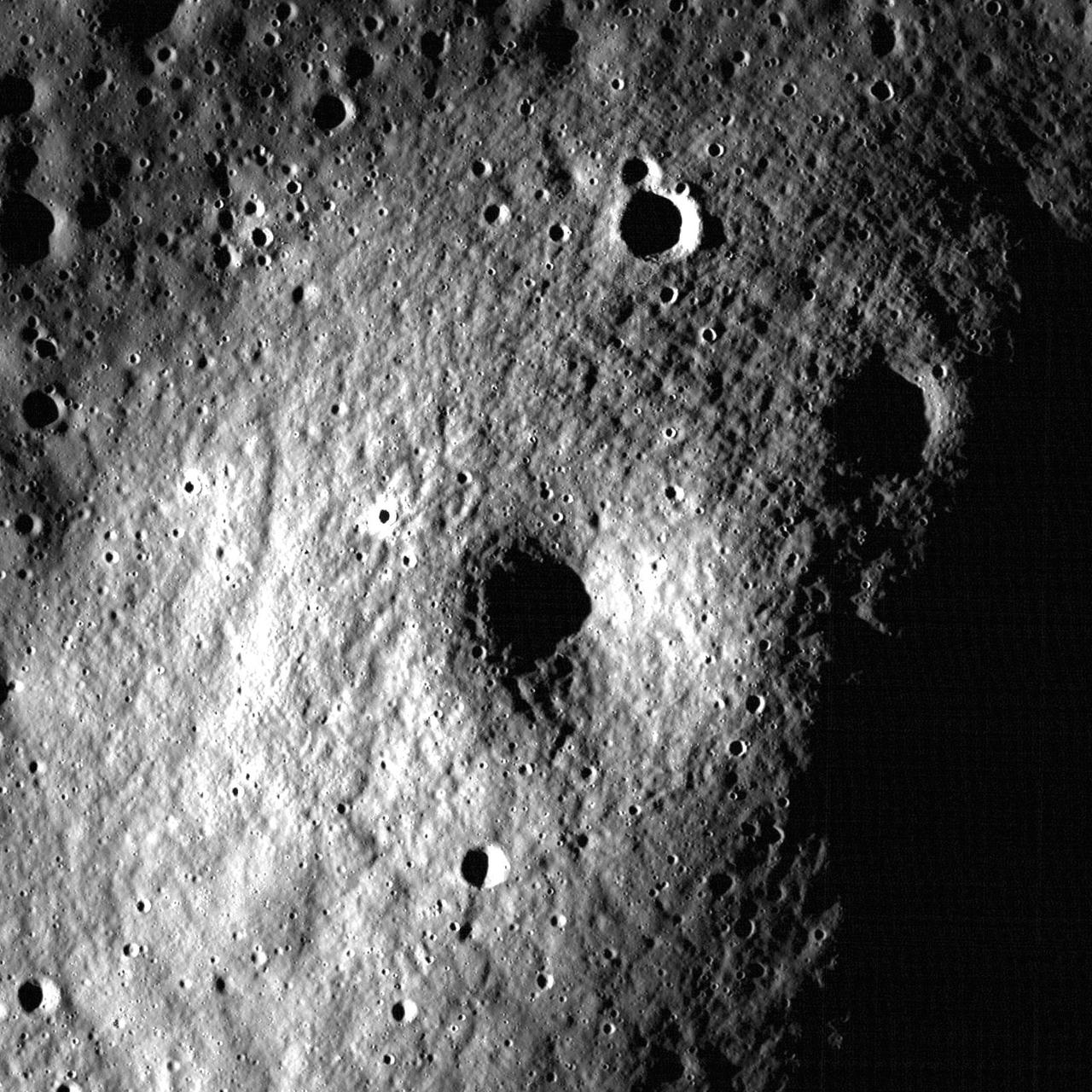
Another Small Volcano?
Volcanoes in Lacus Mortis
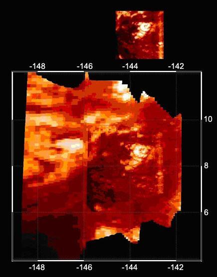
Infrared Image of Titan Volcano
Titan Chilly Volcanoes?
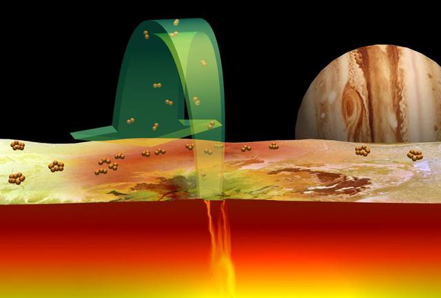
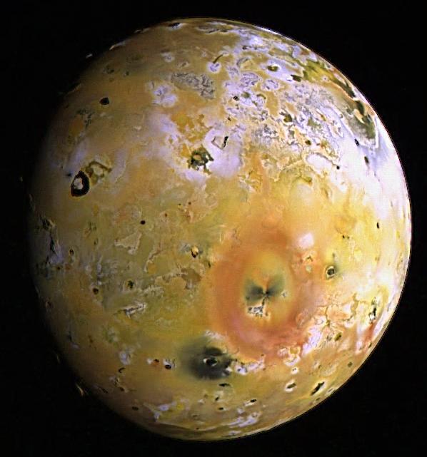
The Role of Sulfur in Io Volcanoes

Elysium Mons Volcano
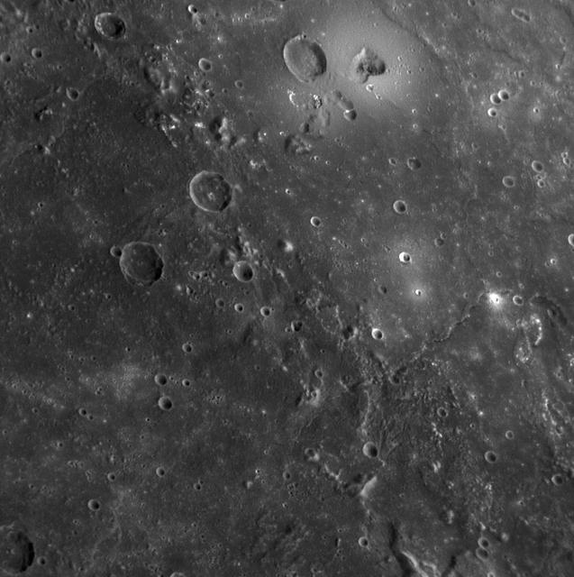
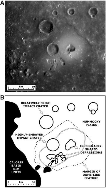
MESSENGER Discovers Volcanoes on Mercury

After a new small eruption sent an ash cloud 1.24 miles (2 kilometers) into the sky on Dec. 7, 2017, Indonesia's Mount Agung volcano quieted down. This image was acquired Dec. 8 after the latest activity by the Advanced Spaceborne Thermal Emission and Reflection Radiometer (ASTER) instrument on NASA's Terra satellite. The image shows vegetation in red colors. The summit crater has a hot spot (yellow) as detected by ASTER's thermal infrared channels. More than 65,00 residents continue to be evacuated from the volcano's danger zone in case of a major eruption. The image covers an area of 11 by 12.3 miles (17.8 by 19.8 kilometers), and is located at 8.3 degrees south, 115.5 degrees east. https://photojournal.jpl.nasa.gov/catalog/PIA22121
In this image of Peru's Sabancaya stratovolcano, acquired May 13, 2020, the years-long eruption continues. In the top image, Sabancaya has a bright white cloud in its caldera. The greyish cloud to the east is an ash plume. The Ampato volcano, with its prominent summit caldera, is to the south. The red areas are vegetation. The lower thermal infrared composite image shows the plume in purple, indicating that it is dominantly composed of ash and water vapor. A bright hotspot can be seen in the summit caldera of Sabancaya. The images cover an area of 13.5 by 24 kilometers, and are located at 15.8 degrees south, 71.9 degrees west. https://photojournal.jpl.nasa.gov/catalog/PIA24866
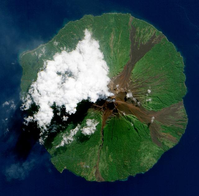
Nishinoshima is a small volcanic island located about 1000 km south of Tokyo, Japan. Eruptive activity began in December 2019, and has continued uninterrupted. ASTER captured this image of an ash and steam plume emanating from the central crater. Thermal infrared data is superposed in red on a visible-infrared color image to highlight the lava in the central crater and lava flows that have flowed down the volcano's flanks. The image was acquired July 28, 2020, covers an area of 15 by 21 km, and is located at 27.3 degrees north, 140.8 degrees east. https://photojournal.jpl.nasa.gov/catalog/PIA24017
NASA image acquired June 16, 2010. Papua New Guinea’s Manam Volcano released a thin, faint plume on June 16, 2010, as clouds clustered at the volcano’s summit. The Advanced Land Imager (ALI) on NASA’s Earth Observing-1 (EO-1) satellite took this picture the same day. Rivulets of brown rock interrupt the carpet of green vegetation on the volcano’s slopes. Opaque white clouds partially obscure the satellite’s view of Manam. The clouds may result from water vapor from the volcano, but may also have formed independent of volcanic activity. The volcanic plume appears as a thin, blue-gray veil extending toward the northwest over the Bismarck Sea. Located 13 kilometers (8 miles) off the coast of mainland Papua New Guinea, Manam forms an island 10 kilometers (6 miles) wide. It is a stratovolcano. The volcano has two summit craters, and although both are active, most historical eruptions have arisen from the southern crater. NASA Earth Observatory image created by Jesse Allen, using EO-1 ALI data provided courtesy of the NASA EO-1 team. Caption by Michon Scott. Instrument: EO-1 - ALI To view the full image go to: <a href="http://earthobservatory.nasa.gov/NaturalHazards/view.php?id=44307&src=nhrss" rel="nofollow">earthobservatory.nasa.gov/NaturalHazards/view.php?id=4430...</a> <b><a href="http://www.nasa.gov/centers/goddard/home/index.html" rel="nofollow">NASA Goddard Space Flight Center</a></b> is home to the nation's largest organization of combined scientists, engineers and technologists that build spacecraft, instruments and new technology to study the Earth, the sun, our solar system, and the universe.
Io Surface Deposits and Volcano http://photojournal.jpl.nasa.gov/catalog/PIA00361
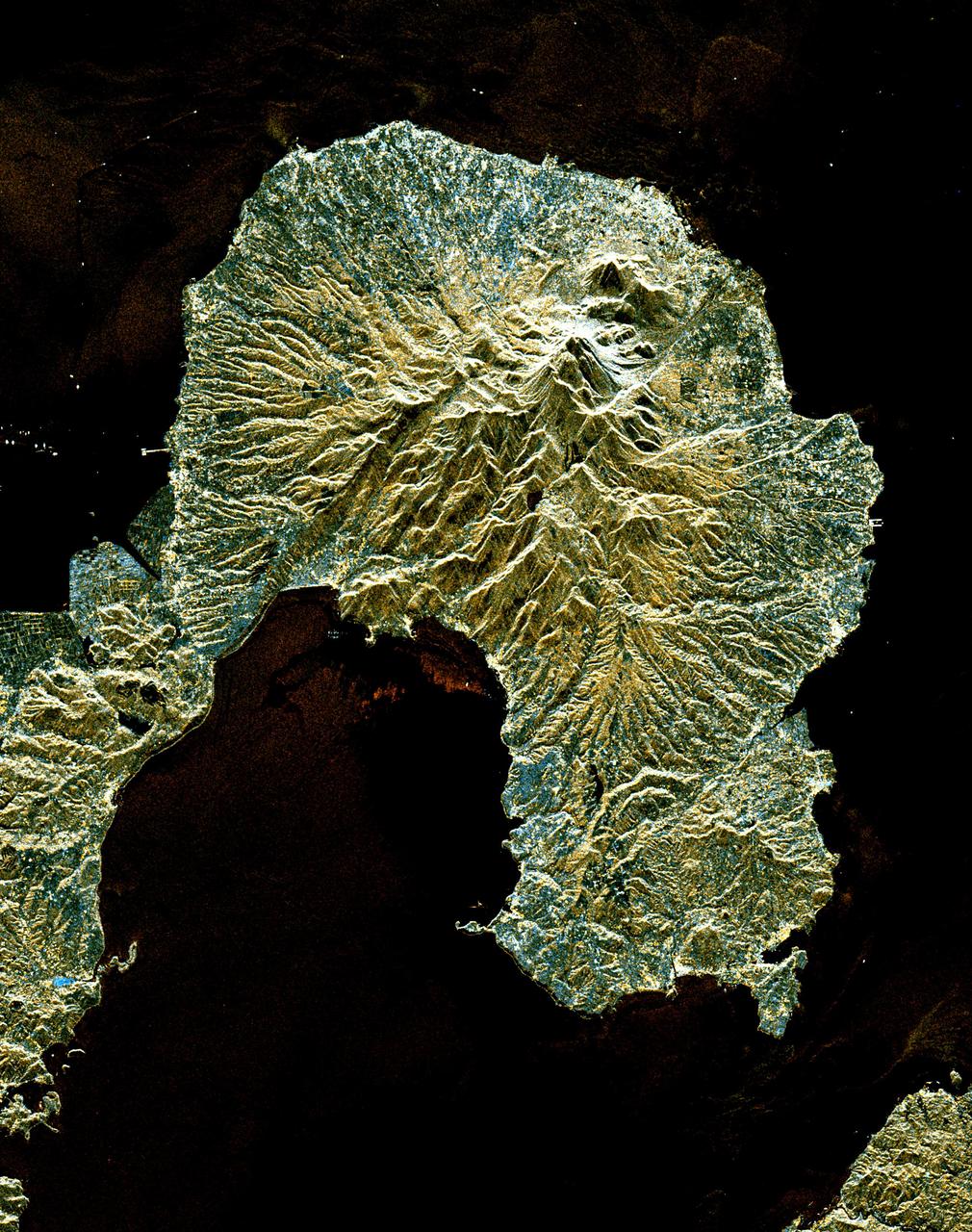
The active volcano Sakura-Jima on the island of Kyushu, Japan is shown in the center of this radar image. The volcano occupies the peninsula in the center of Kagoshima Bay, which was formed by the explosion and collapse of an ancient predecessor of today's volcano. The volcano has been in near continuous eruption since 1955. Its explosions of ash and gas are closely monitored by local authorities due to the proximity of the city of Kagoshima across a narrow strait from the volcano's center, shown below and to the left of the central peninsula in this image. City residents have grown accustomed to clearing ash deposits from sidewalks, cars and buildings following Sakura-jima's eruptions. The volcano is one of 15 identified by scientists as potentially hazardous to local populations, as part of the international "Decade Volcano" program. The image was acquired by the Spaceborne Imaging Radar-C/X-Band Synthetic Aperture Radar (SIR-C/X-SAR) onboard the space shuttle Endeavour on October 9, 1994. SIR-C/X-SAR, a joint mission of the German, Italian and the United States space agencies, is part of NASA's Mission to Planet Earth. The image is centered at 31.6 degrees North latitude and 130.6 degrees East longitude. North is toward the upper left. The area shown measures 37.5 kilometers by 46.5 kilometers (23.3 miles by 28.8 miles). The colors in the image are assigned to different frequencies and polarizations of the radar as follows: red is L-band vertically transmitted, vertically received; green is the average of L-band vertically transmitted, vertically received and C-band vertically transmitted, vertically received; blue is C-band vertically transmitted, vertically received. http://photojournal.jpl.nasa.gov/catalog/PIA01777
Shiveluch volcano on Russia’s Kamchatka Peninsula. This is a false-color satellite image, acquired by the Advanced Spaceborne Thermal Emission and Reflection Radiometer (ASTER) on March 10, 2010. To download a full high res version of this image and to learn more go to: <a href="http://earthobservatory.nasa.gov/NaturalHazards/view.php?id=43103" rel="nofollow">earthobservatory.nasa.gov/NaturalHazards/view.php?id=43103</a> Credit: NASA Earth Observatory image by Jesse Allen and Robert Simmon, based on data from the NASA/GSFC/METI/ERSDAC/JAROS, and U.S./Japan ASTER Science Team. Instrument: Terra - ASTER For more information about the Goddard Space Flight Center go here: <a href="http://www.nasa.gov/centers/goddard/home/index.html" rel="nofollow">www.nasa.gov/centers/goddard/home/index.html</a>
This is an image of the area of Kliuchevskoi volcano, Kamchatka, Russia, which began to erupt on September 30, 1994. Kliuchevskoi is the blue triangular peak in the center of the image, towards the left edge of the bright red area that delineates bare snow cover. The image was acquired by the Spaceborne Imaging Radar-C/X-band Synthetic Aperture Radar (SIR-C/X-SAR) aboard the space shuttle Endeavour on its 88th orbit on October 5, 1994. The image shows an area approximately 75 kilometers by 100 kilometers (46 miles by 62 miles) that is centered at 56.07 degrees north latitude and 160.84 degrees east longitude. North is toward the bottom of the image. The radar illumination is from the top of the image. The Kamchatka volcanoes are among the most active volcanoes in the world. The volcanic zone sits above a tectonic plate boundary, where the Pacific plate is sinking beneath the northeast edge of the Eurasian plate. The Endeavour crew obtained dramatic video and photographic images of this region during the eruption, which will assist scientists in analyzing the dynamics of the recent activity. The colors in this image were obtained using the following radar channels: red represents the L-band (horizontally transmitted and received); green represents the L-band (horizontally transmitted and vertically received); blue represents the C-band (horizontally transmitted and vertically received). In addition to Kliuchevskoi, two other active volcanoes are visible in the image. Bezymianny, the circular crater above and to the right of Kliuchevskoi, contains a slowly growing lava dome. Tolbachik is the large volcano with a dark summit crater near the upper right edge of the red snow covered area. The Kamchatka River runs from right to left across the bottom of the image. The current eruption of Kliuchevskoi included massive ejections of gas, vapor and ash, which reached altitudes of 15,000 meters (50,000 feet). Melting snow mixed with volcanic ash triggered mud flows on the flanks of the volcano. Paths of these flows can be seen as thin lines in various shades of blue and green on the north flank in the center of the image. http://photojournal.jpl.nasa.gov/catalog/PIA01765
Lava Flows On Ascraeus Mons Volcano
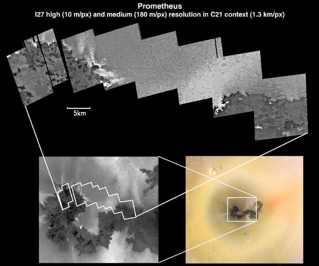
Io Prometheus Volcano at Various Resolutions
Volcanic Depression and Shield Volcano, Io
Dusty Top of Alba Patera Volcano

Tharsis Volcanoes and Valles Marineris, Mars

Mariner 9 views of shield volcano
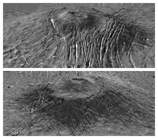
Vent at the Summit of Arsia Mons Volcano
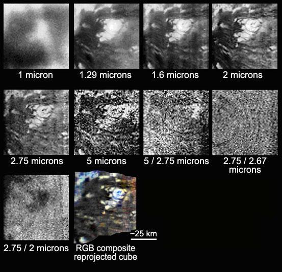
Titan Volcano in Several Infrared Wavelengths
Volcanoes Ceraunius Tholus and Uranius Tholus
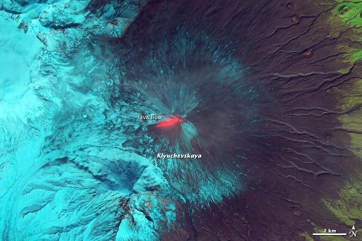
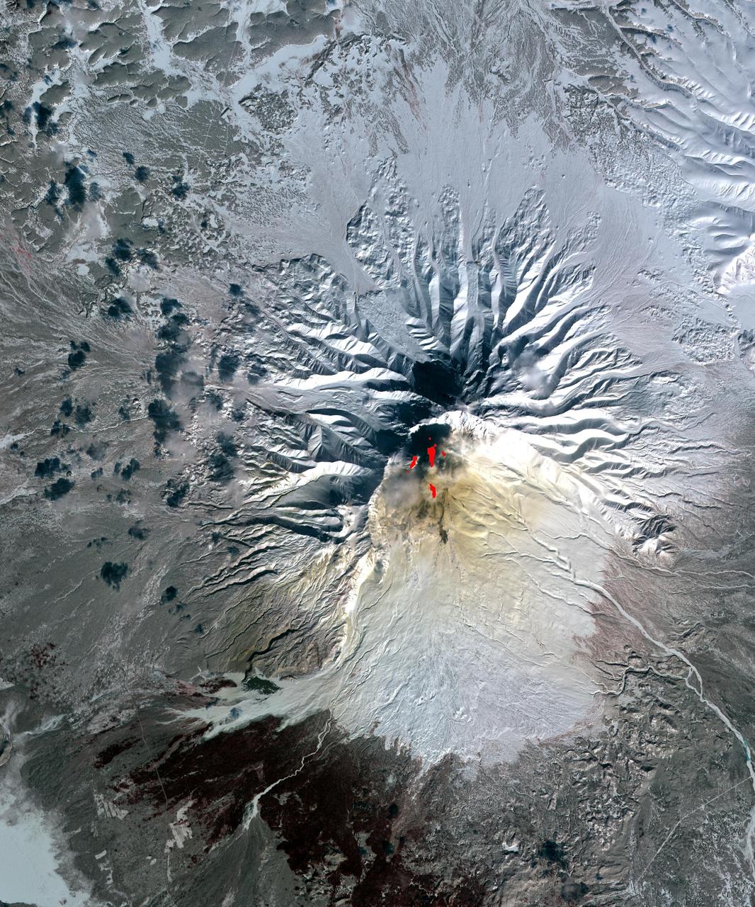
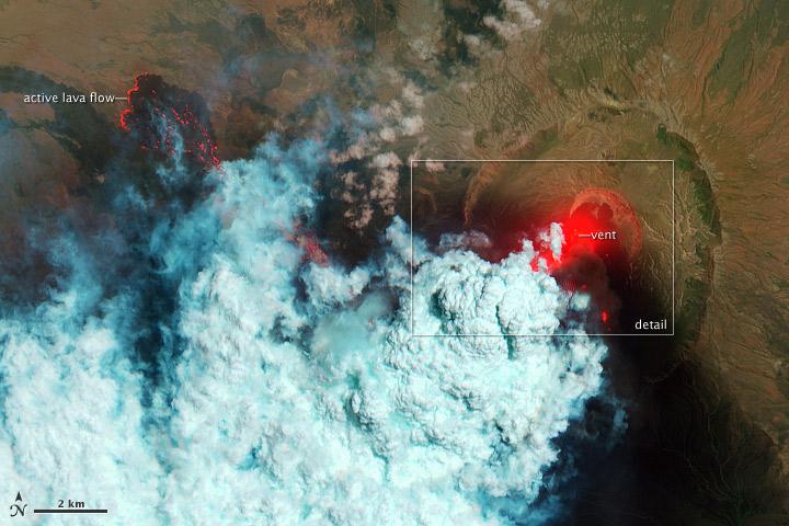
This false-color (shortwave infrared, near infrared, green) satellite image reveals an active lava flow on the western slopes of Klyuchevskaya Volcano. Klyuchevskaya is one of several active volcanoes on the Kamchatka Peninsula in far eastern Russia. The lava flow itself is bright red. Snow on Klyuchevskaya and nearby mountains is cyan, while bare ground and volcanic debris is gray or brown. Vegetation is green. The image was collected by Landsat 8 on September 9, 2013. NASA Earth Observatory image by Jesse Allen and Robert Simmon, using Instrument: Landsat 8 - OLI More info: <a href="http://1.usa.gov/1evspH7" rel="nofollow">1.usa.gov/1evspH7</a> <b><a href="http://www.nasa.gov/audience/formedia/features/MP_Photo_Guidelines.html" rel="nofollow">NASA image use policy.</a></b> <b><a href="http://www.nasa.gov/centers/goddard/home/index.html" rel="nofollow">NASA Goddard Space Flight Center</a></b> enables NASA’s mission through four scientific endeavors: Earth Science, Heliophysics, Solar System Exploration, and Astrophysics. Goddard plays a leading role in NASA’s accomplishments by contributing compelling scientific knowledge to advance the Agency’s mission. <b>Follow us on <a href="http://twitter.com/NASA_GoddardPix" rel="nofollow">Twitter</a></b> <b>Like us on <a href="http://www.facebook.com/pages/Greenbelt-MD/NASA-Goddard/395013845897?ref=tsd" rel="nofollow">Facebook</a></b> <b>Find us on <a href="http://instagram.com/nasagoddard?vm=grid" rel="nofollow">Instagram</a></b>
NASA image acquired February 25, 2011 Pyroclastic flows are some of the most fearsome hazards posed by erupting volcanoes. These avalanches of superheated ash, gas, and rock are responsible for some of the most famous volcanic disasters in history, including the burial of the ancient Roman city of Pompei and the destruction of Saint-Pierre in 1902. More recently, pyroclastic flows from Mount Merapi in Indonesia caused most of the casualties during the volcano’s 2010 eruption. The intense heat—over 1,000° Celsius (1800° Fahrenheit)—the terrific speed—up to 720 kilometers (450 miles) per hour—and the mixture of toxic gases all contribute to the deadly potential. Pyroclastic flows can incinerate, burn, or asphyxiate people who cannot get out of the flow path. This false-color satellite image from the Advanced Spaceborne Thermal Emission and Reflection Radiometer (ASTER) on the Terra satellite shows the remnants of a large pyroclastic flow on the slopes of Shiveluch Volcano. Fortunately, no one was hurt during the eruption and flow in the sparsely-populated area. ASTER detected heat from the flow during or shortly after an event on January 25, 2011. Note how the heat signatures from January line up with the dark surface deposits visible on February 25; those deposits cover more than 10 square kilometers (4 square miles). Light brown ash covers the snow above the flow deposits, and a tiny plume rises from Shiveluch’s growing lava dome. Vegetation surrounding the volcano is colored dark red. NASA Earth Observatory image by Robert Simmon, using data from the NASA/GSFC/METI/ERSDAC/JAROS, and U.S./Japan ASTER Science Team. Caption by Robert Simmon. Instrument: Terra - ASTER Credit: <b><a href="http://www.earthobservatory.nasa.gov/" rel="nofollow"> NASA Earth Observatory</a></b> <b><a href="http://www.nasa.gov/centers/goddard/home/index.html" rel="nofollow">NASA Goddard Space Flight Center</a></b> enables NASA’s mission through four scientific endeavors: Earth Science, Heliophysics, Solar System Exploration, and Astrophysics. Goddard plays a leading role in NASA’s accomplishments by contributing compelling scientific knowledge to advance the Agency’s mission. <b>Follow us on <a href="http://twitter.com/NASA_GoddardPix" rel="nofollow">Twitter</a></b> <b>Join us on <a href="http://www.facebook.com/pages/Greenbelt-MD/NASA-Goddard/395013845897?ref=tsd" rel="nofollow">Facebook</a></b>
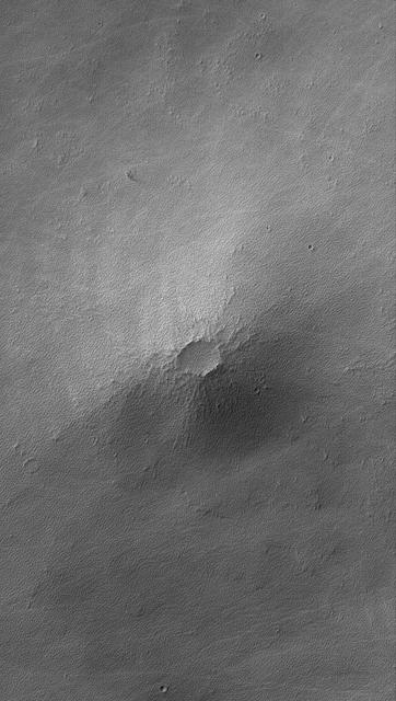
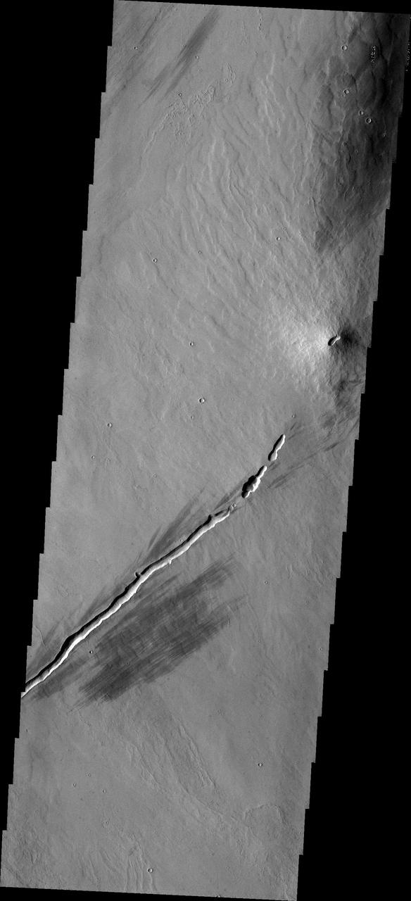
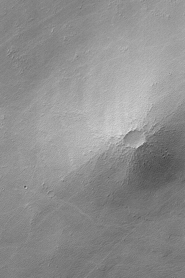
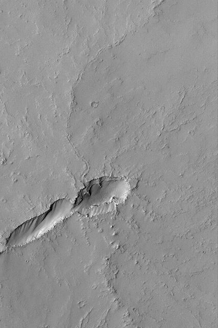
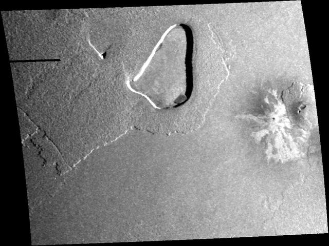
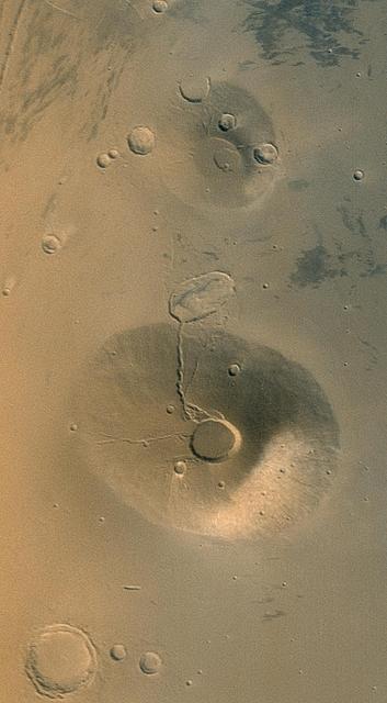
This MOC image shows a small volcano in the Syria Planum region of Mars. Today, the lava flows that compose this small volcano are nearly hidden by a mantle of rough-textured, perhaps somewhat cemented, dust

NASA satellite image acquired May 6, 2010 at 11 :55 UTC To view a detail of this image go to: <a href="http://www.flickr.com/photos/gsfc/4583711511/">www.flickr.com/photos/gsfc/4583711511/</a> NASA Satellite Sees a Darker Ash Plume From Iceland Volcano NASA's Terra satellite flew over the Eyjafjallajokull Volcano, Iceland, on May 6 at 11:55 UTC (7:55 a.m. EDT). The Moderate Resolution Imaging Spectroradiometer instrument known as MODIS that flies onboard Terra, captured a visible image of the ash plume. The plume was blowing east then southeast over the Northern Atlantic. The satellite image shows that the plume is at a lower level in the atmosphere than the clouds that lie to its east, as the brown plume appears to slide underneath the white clouds. Satellite: Terra NASA/GSFC/Jeff Schmaltz/MODIS Land Rapid Response Team To learn more about MODIS go to: <a href="http://www.nasa.gov/topics/earth/features/iceland-volcano-plume.html" rel="nofollow">www.nasa.gov/topics/earth/features/iceland-volcano-plume....</a> <b><a href="http://www.nasa.gov/centers/goddard/home/index.html" rel="nofollow">NASA Goddard Space Flight Center</a></b> is home to the nation's largest organization of combined scientists, engineers and technologists that build spacecraft, instruments and new technology to study the Earth, the sun, our solar system, and the universe.
Io - Volcano Loki and Loki Patera http://photojournal.jpl.nasa.gov/catalog/PIA00375
NASA satellite image acquired May 2, 2010 To view a detail of this image go to: <a href="http://www.flickr.com/photos/gsfc/4584266734/">www.flickr.com/photos/gsfc/4584266734/</a> Ash and steam continued billowing from Eyjafjallajökull Volcano in early May 2010. The Advanced Land Imager (ALI) on NASA’s Earth Observing-1 (EO-1) satellite captured this natural-color image on May 2, 2010. The volcano’s summit is near the left edge of this image, capped by a dark plume. The plume is dull gray-brown, indicating that its principal visible component is volcanic ash. Ash from the plume blows toward the east-southeast, passing over a charcoal-colored ash field on the land surface. Just to the north of Eyjafjallajökull’s summit are white puffs of steam, likely from surface lava flows vaporizing snow and glacial ice. On May 4, 2010, the Icelandic Meteorological Office warned that Eyjafjallajökull showed no signs of ending its eruptive activity in the near future. The Met Office reported that ash from the volcano had reached a height of 5.8 to 6.0 kilometers (19,000 to 20,000 feet) above sea level, and had spread 65 to 80 kilometers (40 to 50 miles) east-southeast of the volcano, where it impeded visibility for local residents. The Met Office also reported that lava continued flowing down a steep hill north of the crater. NASA image by Robert Simmon, using ALI data from the EO-1 team. Caption by Michon Scott. Instrument: EO-1 – ALI To view other images from the Earth Observatory go to: <a href="http://earthobservatory.nasa.gov/" rel="nofollow">earthobservatory.nasa.gov/</a> <b><a href="http://www.nasa.gov/centers/goddard/home/index.html" rel="nofollow">NASA Goddard Space Flight Center</a></b> is home to the nation's largest organization of combined scientists, engineers and technologists that build spacecraft, instruments and new technology to study the Earth, the sun, our solar system, and the universe.

Calbuco Volcano in southern Chile has erupted for the first time since 1972, with the last major eruption occurring in 1961 that sent ash columns 12-15 kilometers high. This image was taken by the Suomi NPP satellite's VIIRS instrument in a high resolution infrared channel around 0515Z on April 23, 2015. Credit: NOAA/NASA/NPP/VIIRS <b><a href="http://goes.gsfc.nasa.gov/" rel="nofollow">Credit: NOAA/NASA GOES Project</a></b> <b><a href="http://www.nasa.gov/audience/formedia/features/MP_Photo_Guidelines.html" rel="nofollow">NASA image use policy.</a></b> <b><a href="http://www.nasa.gov/centers/goddard/home/index.html" rel="nofollow">NASA Goddard Space Flight Center</a></b> enables NASA’s mission through four scientific endeavors: Earth Science, Heliophysics, Solar System Exploration, and Astrophysics. Goddard plays a leading role in NASA’s accomplishments by contributing compelling scientific knowledge to advance the Agency’s mission. <b>Follow us on <a href="http://twitter.com/NASAGoddardPix" rel="nofollow">Twitter</a></b> <b>Like us on <a href="http://www.facebook.com/pages/Greenbelt-MD/NASA-Goddard/395013845897?ref=tsd" rel="nofollow">Facebook</a></b> <b>Find us on <a href="http://instagrid.me/nasagoddard/?vm=grid" rel="nofollow">Instagram</a></b>
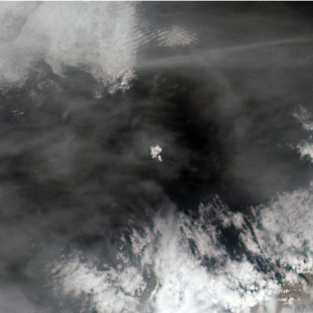
The tiny Aleutian island of Bogoslof in Alaska, erupting regularly since December 2016, produced fresh activity on Sunday, May 28, 2017. Bogoslof is a stratovolcano fueled by the subduction of the Pacific Plate under the North American Plate and forms part of the larger Aleutian Arc, which includes more than 60 volcanoes on the Aleutian Islands and the Aleutian Range on the Alaska mainland. Previous to its recent period of activity, Bogoslof had last erupted in 1992, and its above-water surface area was a mere 0.11 square miles (0.29 square kilometers). As of March 11, the most recent data available, the area of the island had tripled to 0.38 square miles (0.98 square kilometers). The event on May 28 produced an ash cloud that reached 40,000 feet (12 km) in altitude, causing the Alaskan Volcano Observatory to issue a red alert for air travel in the area. Volcanic ash can cause major damage to aircraft engines, and the region is close to several major air routes between North America and Asia. On May 28, 2017, at approximately 2:23 p.m. local time, NASA's Terra satellite passed over Bogoslof, less than 10 minutes after the eruption began. MISR has nine cameras that view Earth at different angles. It takes slightly less than seven minutes for all nine cameras to view the same location on Earth. An animation made from the images from the nine MISR cameras, captured between 2:19 and 2:26 p.m., demonstrates how the angled views give a glimpse of the underside of the growing plume of volcanic ash, showing the eruption column widening into the cloud at the top. The animation is available at https://photojournal.jpl.nasa.gov/catalog/PIA21655
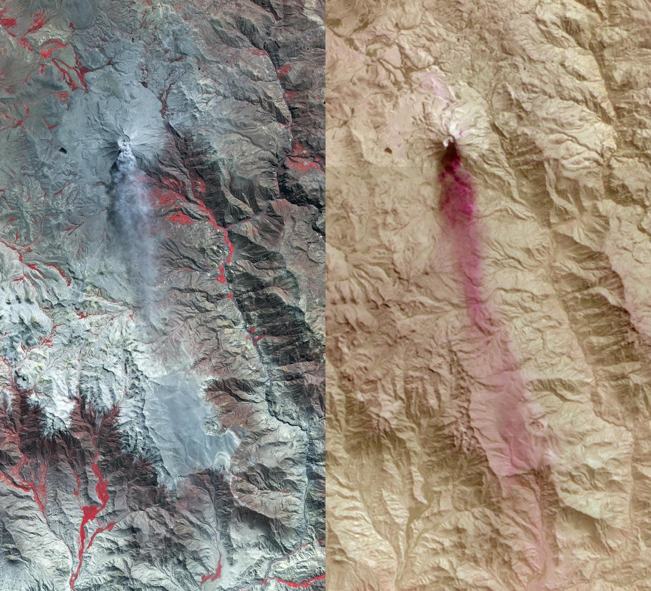
NASA image acquired June 24, 2011 Since it began erupting on June 12, 2011, emissions from Eritrea’s Nabro Volcano have drifted over much of East Africa and the Middle East. Ash has displaced residents living near the volcano and disrupted flights in the region. Despite the volcano’s widespread effects, little is known about the eruption. Nabro is located in an isolated region along the border between Eritrea and Ethiopia, and few English-language reports have been published. Satellite remote sensing is currently the only reliable way to monitor the ongoing eruption. This satellite image is among the first detailed pictures of the erupting vent and lava flows. They were acquired by the Advanced Land Imager (ALI) aboard the Earth Observing-1 (EO-1) satellite on June 24, 2011. The bright red portions of the false-color image (top) indicate hot surfaces. Hot volcanic ash glows above the vent, located in the center of Nabro’s caldera. To the west of the vent, portions of an active lava flow (particularly the front of the flow) are also hot. The speckled pattern on upstream portions of the flow are likely due to the cool, hardened crust splitting and exposing fluid lava as the flow advances. The bulbous blue-white cloud near the vent is likely composed largely of escaping water vapor that condensed as the plume rose and cooled. The whispy, cyan clouds above the lava flow are evidence of degassing from the lava. NASA Earth Observatory image by Robert Simmon, using EO-1 ALI data. Caption by Robert Simmon. Instrument: EO-1 - ALI To download the high res go here: <a href="http://earthobservatory.nasa.gov/IOTD/view.php?id=51216" rel="nofollow">earthobservatory.nasa.gov/IOTD/view.php?id=51216</a> <b><a href="http://www.nasa.gov/centers/goddard/home/index.html" rel="nofollow">NASA Goddard Space Flight Center</a></b> enables NASA’s mission through four scientific endeavors: Earth Science, Heliophysics, Solar System Exploration, and Astrophysics. Goddard plays a leading role in NASA’s accomplishments by contributing compelling scientific knowledge to advance the Agency’s mission. <b>Follow us on <a href="http://twitter.com/NASA_GoddardPix" rel="nofollow">Twitter</a></b> <b>Like us on <a href="http://www.facebook.com/pages/Greenbelt-MD/NASA-Goddard/395013845897?ref=tsd" rel="nofollow">Facebook</a></b> <b>Find us on <a href="http://web.stagram.com/n/nasagoddard/?vm=grid" rel="nofollow">Instagram</a></b>
This is a space radar image of the area around the Unzen volcano, on the west coast of Kyushu Island in southwestern Japan. Unzen, which appears in this image as a large triangular peak with a white flank near the center of the peninsula, has been continuously active since a series of powerful eruptions began in 1991. The image was acquired by the Spaceborne Imaging Radar-C/X-band Synthetic Aperture Radar (SIR-C/X-SAR) aboard the space shuttle Endeavour on its 93rd orbit on April 15, 1994. The image shows an area 41.5 kilometers by 32.8 kilometers (25.7 miles by 20.3 miles) that is centered at 32.75 degrees north latitude and 130.15 degrees east longitude. North is toward the upper left of the image. The radar illumination is from the top of the image. The colors in this image were obtained using the following radar channels: red represents the L-band (vertically transmitted and received); green represents the average of L-band and C-band (vertically transmitted and received); blue represents the C-band (vertically transmitted and received). Unzen is one of 15 "Decade" volcanoes identified by the scientific community as posing significant potential threats to large local populations. The city of Shimabara sits along the coast at the foot of Unzen on its east and northeast sides. At the summit of Unzen a dome of thick lava has been growing continuously since 1991. Collapses of the sides of this dome have generated deadly avalanches of hot gas and rock known as pyroclastic flows. Volcanologists can use radar image data to monitor the growth of lava domes, to better understand and predict potentially hazardous collapses. http://photojournal.jpl.nasa.gov/catalog/PIA00504
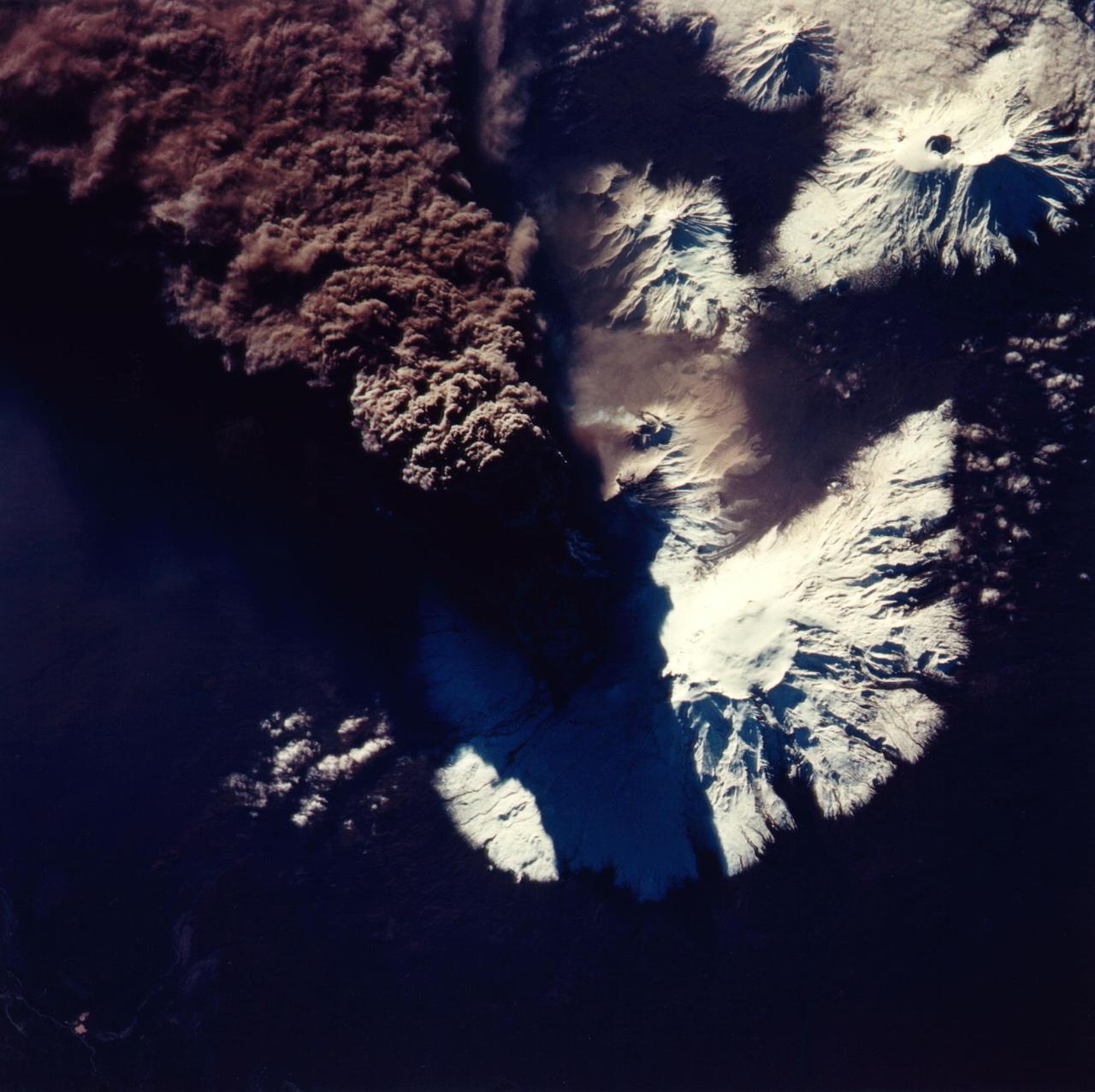
This photograph of the eruption of Kliuchevskoi volcano, Kamchatka, Russia was taken by space shuttle Endeavour astronauts during the early hours of the eruption on September 30, 1994. The ash plume, which reached heights of more than 18 kilometers (50,000 feet), is emerging from a vent on the north flank of Kliuchevskoi, partially hidden by the plume and its shadow in this view. The photograph is oriented with north toward the bottom, for comparison with the Spaceborne Imaging Radar C/X-Band Synthetic Aperture Radar (SIR-C/X-SAR) image (P-44823) that was acquired a few days later. Near the center of the photo, a small whitish steam plume may be seen emanating from the growing lava dome of a companion volcano, Bezymianny. http://photojournal.jpl.nasa.gov/catalog/PIA01766
A massive eruption of Montserrat’s Soufrière Hills Volcano covered large portions of the island in debris. The eruption was triggered by a collapse of Soufrière Hills’ summit lava dome on February 11, 2010. Pyroclastic flows raced down the northern flank of the volcano, leveling trees and destroying buildings in the village of Harris, which was abandoned after Soufrière Hills became active in 1995. The Montserrat Volcano Observatory reported that some flows, about 15 meters (49 feet) thick, reached the sea at Trant’s Bay. These flows extended the island’s coastline up to 650 meters (2,100 feet). These false-color satellite images show the southern half of Montserrat before and after the dome collapse. The top image shows Montserrat on February 21, 2010, just 10 days after the event. For comparison, the bottom image shows the same area on March 17, 2007. Red areas are vegetated, clouds are white, blue/black areas are ocean water, and gray areas are covered by flow deposits. Fresh deposits tend to be lighter than older deposits. On February 21, the drainages leading down from Soufrière Hills, including the White River Valley, the Tar River Valley, and the Belham River Valley, were filled with fresh debris. According to the Montserrat Volcano Observatory, pyroclastic flows reached the sea through Aymers Ghaut on January 18, 2010, and flows entered the sea near Plymouth on February 5, 2010. NASA Earth Observatory image by Robert Simmon, using data from the NASA/GSFC/METI/ERSDAC/JAROS, and U.S./Japan ASTER Science Team. Caption by Robert Simmon. To read more go to: <a href="http://earthobservatory.nasa.gov/IOTD/view.php?id=42792" rel="nofollow">earthobservatory.nasa.gov/IOTD/view.php?id=42792</a> <b><a href="http://www.nasa.gov/centers/goddard/home/index.html" rel="nofollow">NASA Goddard Space Flight Center</a></b> is home to the nation's largest organization of combined scientists, engineers and technologists that build spacecraft, instruments and new technology to study the Earth, the sun, our solar system, and the universe. <b>Follow us on <a href="http://twitter.com/NASA_GoddardPix" rel="nofollow">Twitter</a></b> <b>Join us on <a href="http://www.facebook.com/pages/Greenbelt-MD/NASA-Goddard/395013845897?ref=tsd" rel="nofollow">Facebook</a><b> </b></b>

NASA satellite image acquired May 6, 2010 at 11 :55 UTC To view the full view go to: <a href="http://www.nasa.gov/topics/earth/features/iceland-volcano-plume.html" rel="nofollow">www.nasa.gov/topics/earth/features/iceland-volcano-plume....</a> NASA Satellite Sees a Darker Ash Plume From Iceland Volcano NASA's Terra satellite flew over the Eyjafjallajokull Volcano, Iceland, on May 6 at 11:55 UTC (7:55 a.m. EDT). The Moderate Resolution Imaging Spectroradiometer instrument known as MODIS that flies onboard Terra, captured a visible image of the ash plume. The plume was blowing east then southeast over the Northern Atlantic. The satellite image shows that the plume is at a lower level in the atmosphere than the clouds that lie to its east, as the brown plume appears to slide underneath the white clouds. Satellite: Terra NASA/GSFC/Jeff Schmaltz/MODIS Land Rapid Response Team To learn more about MODIS go to: <a href="http://rapidfire.sci.gsfc.nasa.gov/gallery/?latest" rel="nofollow">rapidfire.sci.gsfc.nasa.gov/gallery/?latest</a> <b><a href="http://www.nasa.gov/centers/goddard/home/index.html" rel="nofollow">NASA Goddard Space Flight Center</a></b> is home to the nation's largest organization of combined scientists, engineers and technologists that build spacecraft, instruments and new technology to study the Earth, the sun, our solar system, and the universe.
This false-color image of Peru Ubinas volcano was acquired on April 14, 2014, by NASA UAVSAR. Located about 100 miles 160 kilometers from the city of Arequipa, Ubinas is Peru most active volcano.
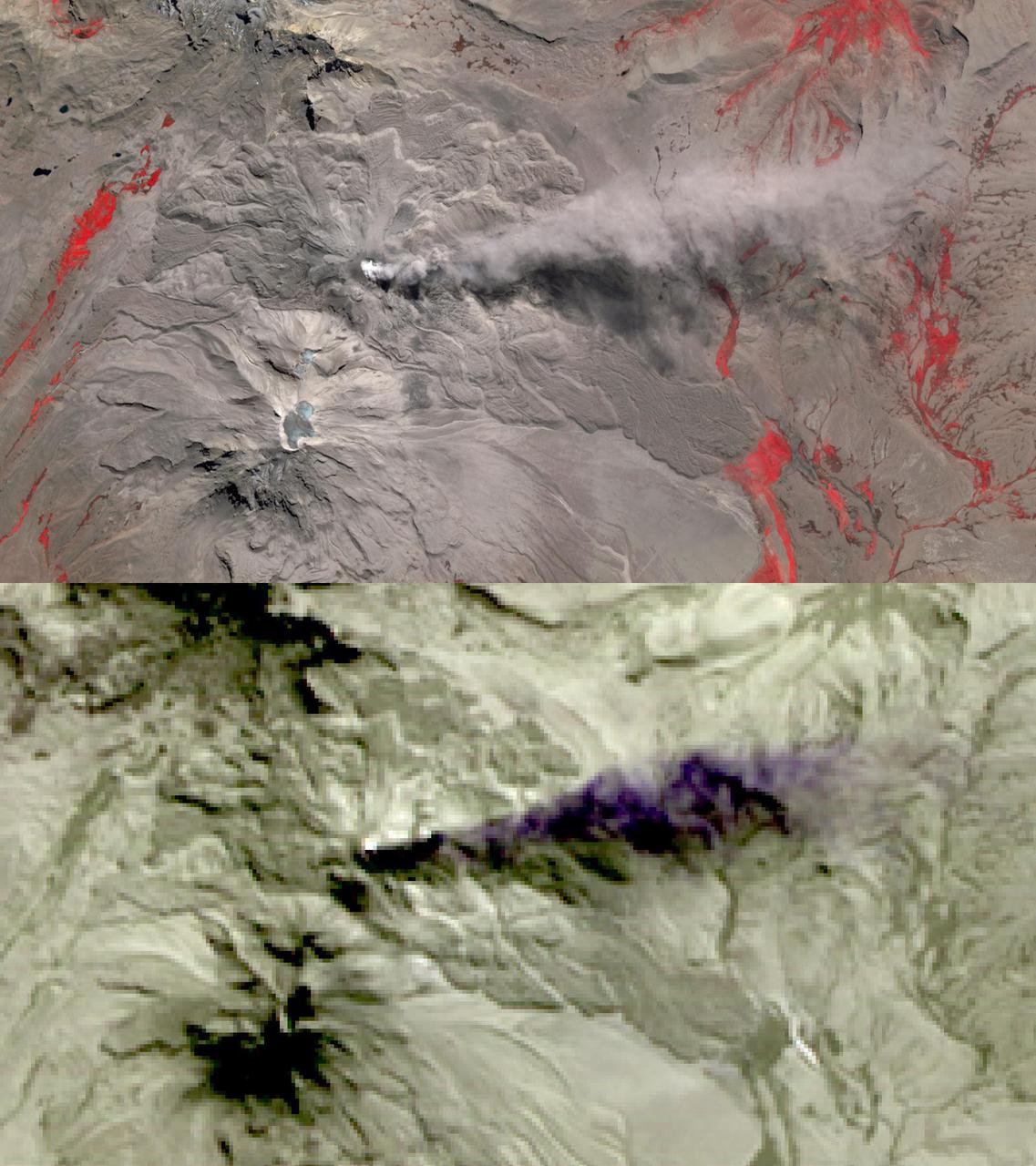
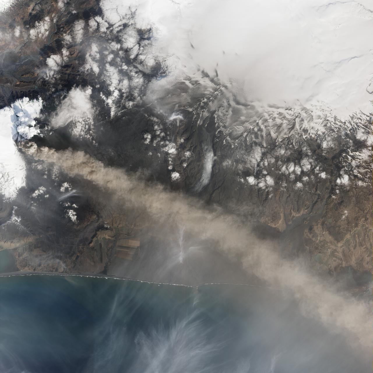
Sheveluch Volcano in Kamchatka, Siberia, is one of the frequently active volcanoes located in eastern Siberia. In this image from NASA Terra spacecraft, brownish ash covers the southern part of the mountain, under an ash-laden vertical eruption plume.
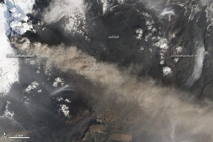
NASA satellite image acquired May 2, 2010 To see the full view of this image go to: <a href="http://www.flickr.com/photos/gsfc/4584266582/">www.flickr.com/photos/gsfc/4584266582/</a> Ash and steam continued billowing from Eyjafjallajökull Volcano in early May 2010. The Advanced Land Imager (ALI) on NASA’s Earth Observing-1 (EO-1) satellite captured this natural-color image on May 2, 2010. The volcano’s summit is near the left edge of this image, capped by a dark plume. The plume is dull gray-brown, indicating that its principal visible component is volcanic ash. Ash from the plume blows toward the east-southeast, passing over a charcoal-colored ash field on the land surface. Just to the north of Eyjafjallajökull’s summit are white puffs of steam, likely from surface lava flows vaporizing snow and glacial ice. On May 4, 2010, the Icelandic Meteorological Office warned that Eyjafjallajökull showed no signs of ending its eruptive activity in the near future. The Met Office reported that ash from the volcano had reached a height of 5.8 to 6.0 kilometers (19,000 to 20,000 feet) above sea level, and had spread 65 to 80 kilometers (40 to 50 miles) east-southeast of the volcano, where it impeded visibility for local residents. The Met Office also reported that lava continued flowing down a steep hill north of the crater. NASA image by Robert Simmon, using ALI data from the EO-1 team. Caption by Michon Scott. Instrument: EO-1 – ALI To view other images from the Earth Observatory go to: <a href="http://earthobservatory.nasa.gov/" rel="nofollow">earthobservatory.nasa.gov/</a> <b><a href="http://www.nasa.gov/centers/goddard/home/index.html" rel="nofollow">NASA Goddard Space Flight Center</a></b> is home to the nation's largest organization of combined scientists, engineers and technologists that build spacecraft, instruments and new technology to study the Earth, the sun, our solar system, and the universe.
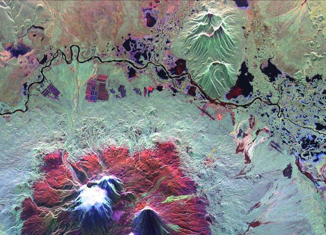
This is an image of the Kliuchevskoi volcano, Kamchatka, Russia, which began to erupt on September 30, 1994. Kliuchevskoi is the bright white peak surrounded by red slopes in the lower left portion of the image. The image was acquired by the Spaceborne Imaging Radar-C and X-band Synthetic Aperture Radar aboard the space shuttle Endeavour on its 25th orbit on October 1, 1994. The image shows an area approximately 30 kilometers by 60 kilometers (18.5 miles by 37 miles) that is centered at 56.18 degrees north latitude and 160.78 degrees east longitude. North is toward the top of the image. The Kamchatka volcanoes are among the most active volcanoes in the world. The volcanic zone sits above a tectonic plate boundary, where the Pacific plate is sinking beneath the northeast edge of the Eurasian plate. The Endeavour crew obtained dramatic video and photographic images of this region during the eruption, which will assist scientists in analyzing the dynamics of the current activity. The colors in this image were obtained using the following radar channels: red represents the L-band (horizontally transmitted and received); green represents the L-band (horizontally transmitted and vertically received); blue represents the C-band (horizontally transmitted and vertically received). The Kamchatka River runs from left to right across the image. An older, dormant volcanic region appears in green on the north side of the river. The current eruption included massive ejections of gas, vapor and ash, which reached altitudes of 20,000 meters (65,000 feet). New lava flows are visible on the flanks of Kliuchevskoi, appearing yellow/green in the image, superimposed on the red surfaces in the lower center. Melting snow triggered mudflows on the north flank of the volcano, which may threaten agricultural zones and other settlements in the valley to the north. http://photojournal.jpl.nasa.gov/catalog/PIA01731

This is an image of Taal volcano, near Manila on the island of Luzon in the Philippines. The black area in the center is Taal Lake, which nearly fills the 30-kilometer-diameter (18-mile) caldera. The caldera rim consists of deeply eroded hills and cliffs. The large island in Taal Lake, which itself contains a crater lake, is known as Volcano Island. The bright yellow patch on the southwest side of the island marks the site of an explosion crater that formed during a deadly eruption of Taal in 1965. The image was acquired by the Spaceborne Imaging Radar-C/X-band Synthetic Aperture Radar (SIR-C/X-SAR) aboard the space shuttle Endeavour on its 78th orbit on October 5, 1994. The image shows an area approximately 56 kilometers by 112 kilometers (34 miles by 68 miles) that is centered at 14.0 degrees north latitude and 121.0 degrees east longitude. North is toward the upper right of the image. The colors in this image were obtained using the following radar channels: red represents the L-band (horizontally transmitted and received); green represents the L-band (horizontally transmitted and vertically received); blue represents the C-band (horizontally transmitted and vertically received). Since 1572, Taal has erupted at least 34 times. Since early 1991, the volcano has been restless, with swarms of earthquakes, new steaming areas, ground fracturing, and increases in water temperature of the lake. Volcanologists and other local authorities are carefully monitoring Taal to understand if the current activity may foretell an eruption. Taal is one of 15 "Decade Volcanoes" that have been identified by the volcanology community as presenting large potential hazards to population centers. The bright area in the upper right of the image is the densely populated city of Manila, only 50 kilometers (30 miles) north of the central crater. http://photojournal.jpl.nasa.gov/catalog/PIA01768

Galileo Best View of Loki Volcano on Io
Valleys on Northwest Flank of Alba Patera Volcano
Ongoing Geologic Activity at Prometheus Volcano, Io
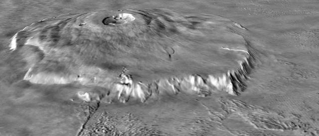
Major Martian Volcanoes from MOLA - Olympus Mons
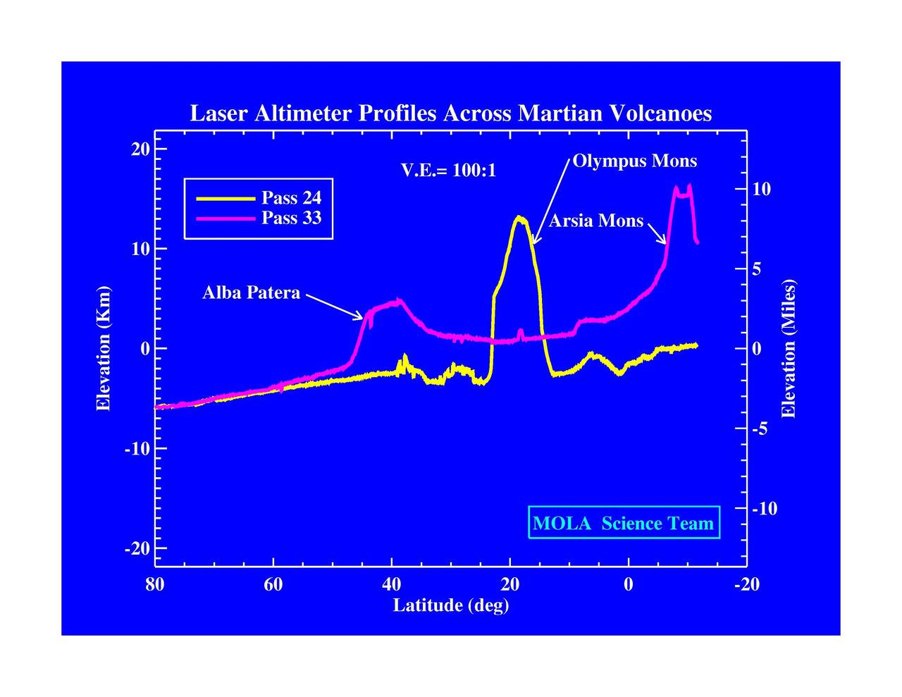
Laser Altimeter Profiles Across Martian Volcanoes
Major Martian Volcanoes from MOLA - Alba Patera
Major Martian Volcanoes from MOLA - Arsia Mons
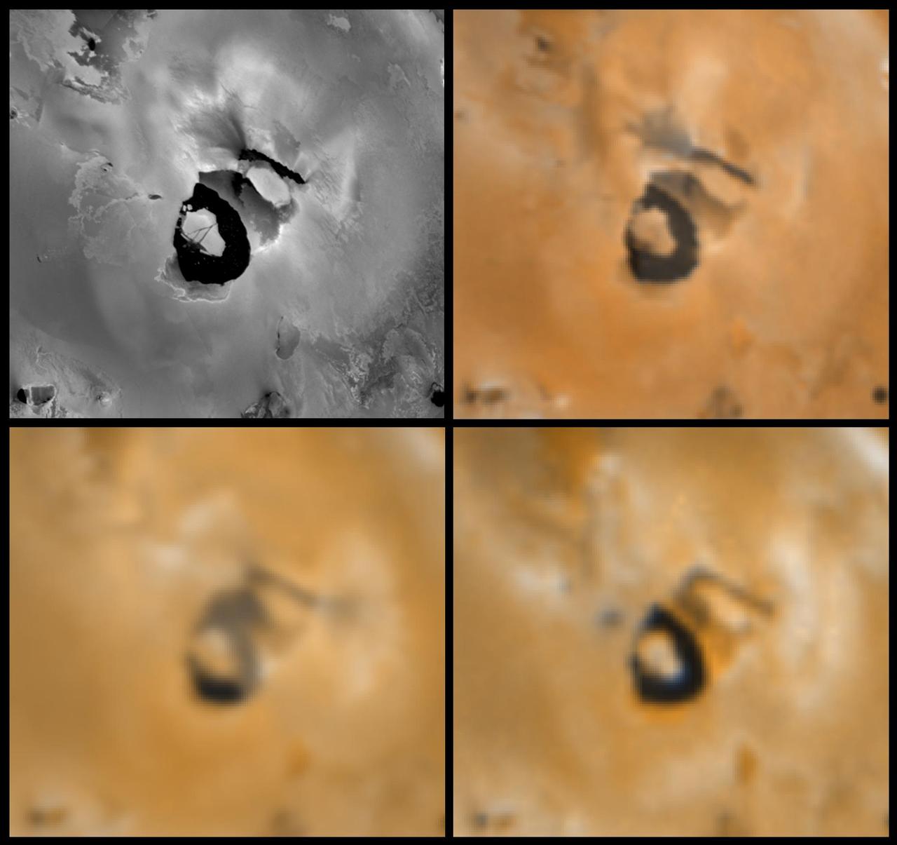
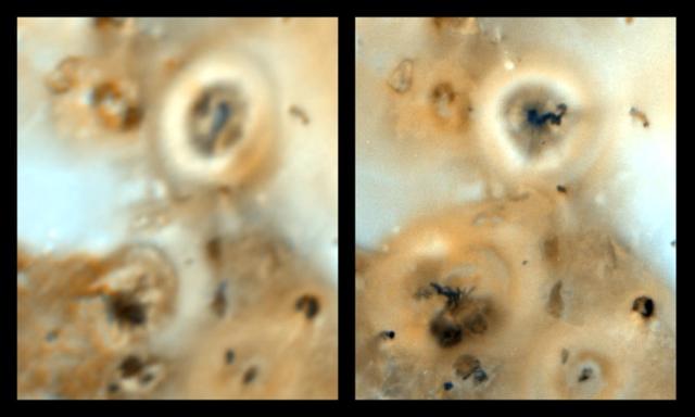
Changes near the Volcano Loki Patera on Io
Massive Resurfacing of the Ionian Volcano Ra Patera
Major Martian Volcanoes from MOLA - Olympus Mons

Hubble Space Telescope Resolves Volcanoes on Io

Galileo Discovers Caldera at Prometheus Volcano, Io
NASA image acquired June 24, 2011 Since it began erupting on June 12, 2011, emissions from Eritrea’s Nabro Volcano have drifted over much of East Africa and the Middle East. Ash has displaced residents living near the volcano and disrupted flights in the region. Despite the volcano’s widespread effects, little is known about the eruption. Nabro is located in an isolated region along the border between Eritrea and Ethiopia, and few English-language reports have been published. Satellite remote sensing is currently the only reliable way to monitor the ongoing eruption. This satellite image is among the first detailed pictures of the erupting vent and lava flows. They were acquired by the Advanced Land Imager (ALI) aboard the Earth Observing-1 (EO-1) satellite on June 24, 2011. The bright red portions of the false-color image (top) indicate hot surfaces. Hot volcanic ash glows above the vent, located in the center of Nabro’s caldera. To the west of the vent, portions of an active lava flow (particularly the front of the flow) are also hot. The speckled pattern on upstream portions of the flow are likely due to the cool, hardened crust splitting and exposing fluid lava as the flow advances. The bulbous blue-white cloud near the vent is likely composed largely of escaping water vapor that condensed as the plume rose and cooled. The whispy, cyan clouds above the lava flow are evidence of degassing from the lava. NASA Earth Observatory image by Robert Simmon, using EO-1 ALI data. Caption by Robert Simmon. Instrument: EO-1 - ALI To download the high res go here: <a href="http://earthobservatory.nasa.gov/IOTD/view.php?id=51216" rel="nofollow">earthobservatory.nasa.gov/IOTD/view.php?id=51216</a> <b><a href="http://www.nasa.gov/centers/goddard/home/index.html" rel="nofollow">NASA Goddard Space Flight Center</a></b> enables NASA’s mission through four scientific endeavors: Earth Science, Heliophysics, Solar System Exploration, and Astrophysics. Goddard plays a leading role in NASA’s accomplishments by contributing compelling scientific knowledge to advance the Agency’s mission. <b>Follow us on <a href="http://twitter.com/NASA_GoddardPix" rel="nofollow">Twitter</a></b> <b>Like us on <a href="http://www.facebook.com/pages/Greenbelt-MD/NASA-Goddard/395013845897?ref=tsd" rel="nofollow">Facebook</a></b> <b>Find us on <a href="http://web.stagram.com/n/nasagoddard/?vm=grid" rel="nofollow">Instagram</a></b>
NASA image acquired December 4, 2010 After a respite of less than a month, Klyuchevskaya Volcano resumed erupting in late November 2010. The Global Volcanism Program reported several ash plumes that rose up to 7.9 kilometers (26,000 feet) above sea level from November 25–29. According to the Kamchatka Volcanic Eruption Response Team (KVERT) seismicity was “slightly above background levels” on November 26th and 27th, and they reported observations of strombolian activity on December 1st and 2nd. A plume of ash, steam, and other volcanic gases streamed from Klyuchevskaya on December 4, 2010, visible in this natural-color image acquired by the Advanced Land Imager (ALI) aboard the Earth Observing-1 (EO-1) satellite. In the large image, a much smaller plume is visible above neighboring Bezymianny Volcano. NASA Earth Observatory image by Jesse Allen & Robert Simmon, using ALI data from the NASA EO-1 team. Caption by Robert Simmon. Instrument: EO-1 - ALI Credit: <b><a href="http://www.earthobservatory.nasa.gov/" rel="nofollow"> NASA Earth Observatory</a></b> <b><a href="http://www.nasa.gov/centers/goddard/home/index.html" rel="nofollow">NASA Goddard Space Flight Center</a></b> enables NASA’s mission through four scientific endeavors: Earth Science, Heliophysics, Solar System Exploration, and Astrophysics. Goddard plays a leading role in NASA’s accomplishments by contributing compelling scientific knowledge to advance the Agency’s mission. <b>Follow us on <a href="http://twitter.com/NASA_GoddardPix" rel="nofollow">Twitter</a></b> <b>Join us on <a href="http://www.facebook.com/pages/Greenbelt-MD/NASA-Goddard/395013845897?ref=tsd" rel="nofollow">Facebook</a></b>
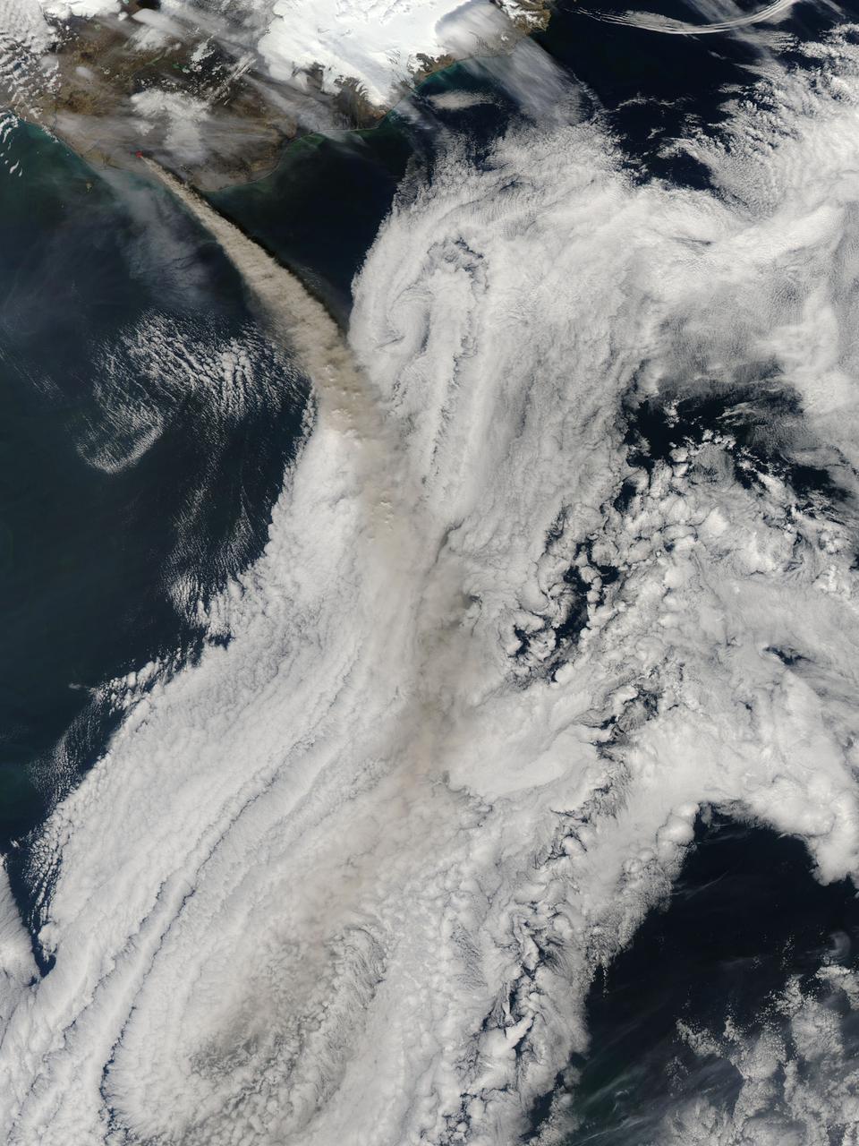
NASA image acquired May 8, 2010 at 13 :35 UTC Ash plume from Eyjafjallajokull Volcano, Iceland Satellite: Aqua NASA/GSFC/Jeff Schmaltz/MODIS Land Rapid Response Team <b><a href="http://www.nasa.gov/centers/goddard/home/index.html" rel="nofollow">NASA Goddard Space Flight Center</a></b> is home to the nation's largest organization of combined scientists, engineers and technologists that build spacecraft, instruments and new technology to study the Earth, the sun, our solar system, and the universe.
On April 28, 2014, NASA Terra spacecraft spotted signs of activity at Ubinas volcano in the Peruvian Andes. The appearance of a new lava dome in March 2014 and frequent ash emissions are signs of increasing activity at this volcano.
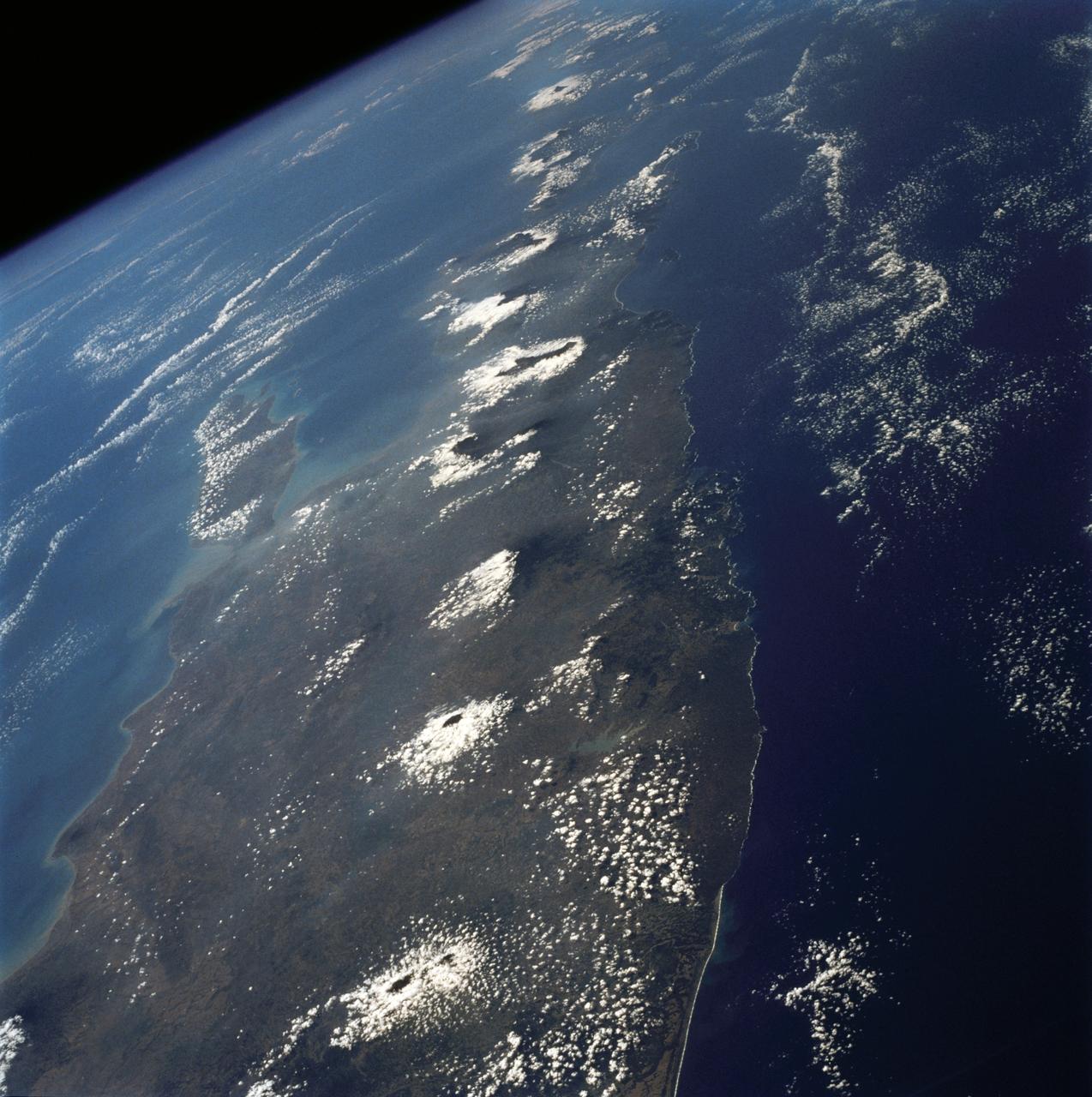
The island of Java (8.0S, 112.0E), perhaps better than any other, illustrates the volcanic origin of Pacific Island groups. Seen in this single view are at least a dozen once active volcano craters. Alignment of the craters even defines the linear fault line of Java as well as the other some 1500 islands of the Indonesian Archipelago. Deep blue water of the Indian Ocean to the south contrasts to the sediment laden waters of the Java Sea to the north.
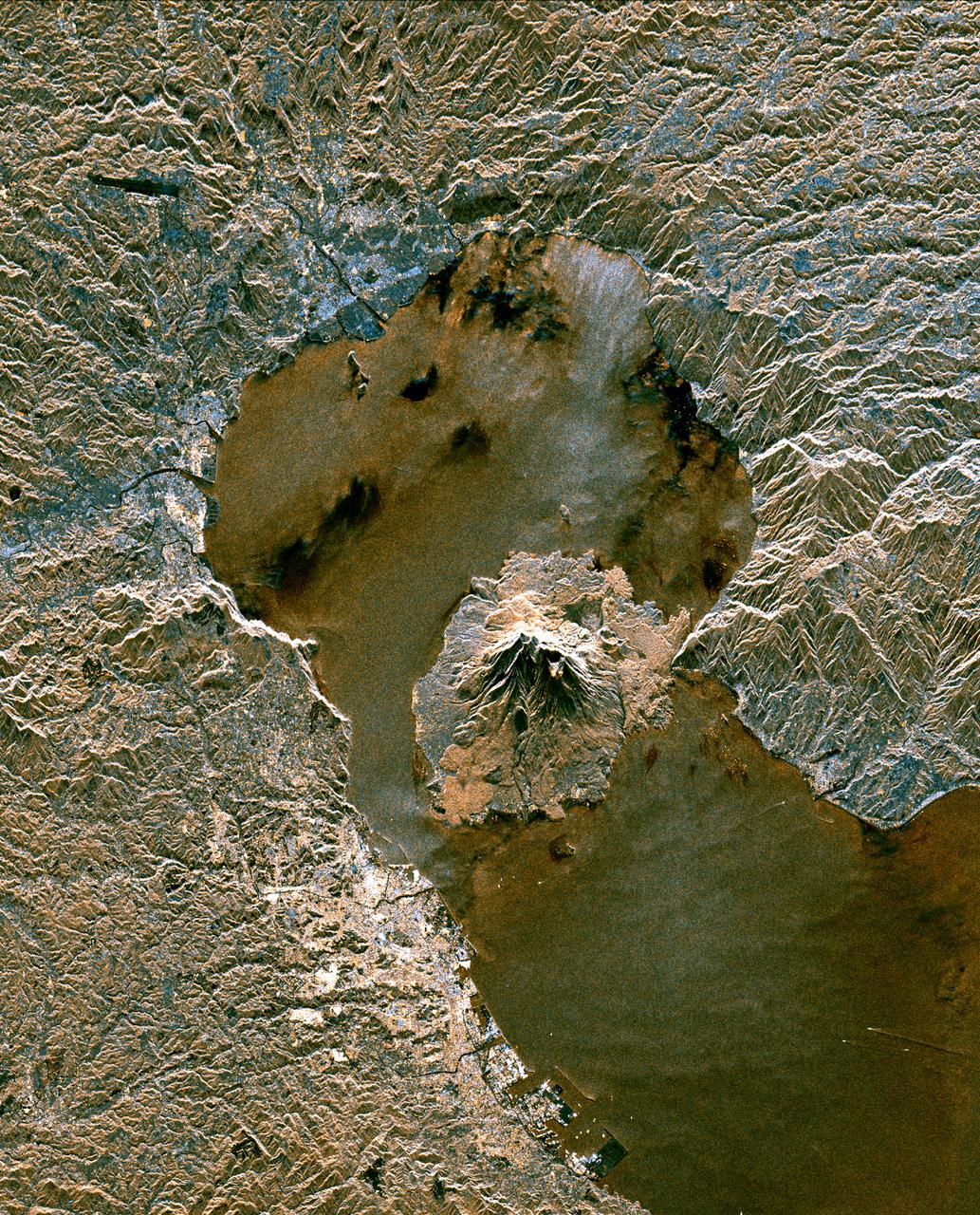
Taal Volcano in the Philippines is about 50 km south of Manila (top of image). It is the second most active volcano in the country, with 38 recorded historic eruptions. The caldera is filled by Taal Lake; Volcano Island is the active cone in the middle of the lake (bottom of image). Eruptions have occurred every year since 2019, with ash and sulfur dioxide vog at times reaching Manila. (Credit: Wikipedia) The image was acquired October 8, 2024, covers an area of 33 by 92.2 km, and is located at 14 degrees north, 121 degrees east. https://photojournal.jpl.nasa.gov/catalog/PIA26506
IDL TIFF file This false-color (shortwave infrared, near infrared, green) satellite image reveals an active lava flow on the western slopes of Klyuchevskaya Volcano. Klyuchevskaya is one of several active volcanoes on the Kamchatka Peninsula in far eastern Russia. The lava flow itself is bright red. Snow on Klyuchevskaya and nearby mountains is cyan, while bare ground and volcanic debris is gray or brown. Vegetation is green. The image was collected by Landsat 8 on September 9, 2013. NASA Earth Observatory image by Jesse Allen and Robert Simmon, using Instrument: Landsat 8 - OLI More info: <a href="http://1.usa.gov/1evspH7" rel="nofollow">1.usa.gov/1evspH7</a> <b><a href="http://www.nasa.gov/audience/formedia/features/MP_Photo_Guidelines.html" rel="nofollow">NASA image use policy.</a></b> <b><a href="http://www.nasa.gov/centers/goddard/home/index.html" rel="nofollow">NASA Goddard Space Flight Center</a></b> enables NASA’s mission through four scientific endeavors: Earth Science, Heliophysics, Solar System Exploration, and Astrophysics. Goddard plays a leading role in NASA’s accomplishments by contributing compelling scientific knowledge to advance the Agency’s mission. <b>Follow us on <a href="http://twitter.com/NASA_GoddardPix" rel="nofollow">Twitter</a></b> <b>Like us on <a href="http://www.facebook.com/pages/Greenbelt-MD/NASA-Goddard/395013845897?ref=tsd" rel="nofollow">Facebook</a></b> <b>Find us on <a href="http://instagram.com/nasagoddard?vm=grid" rel="nofollow">Instagram</a></b>
Mt. St. Helens Volcano - post eruption
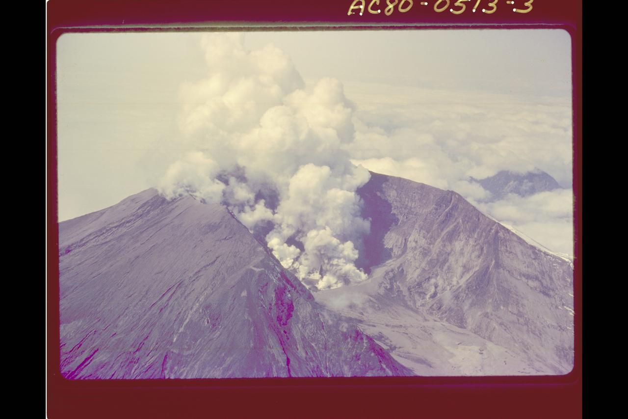
Mt. St. Helens Volcano - post eruption
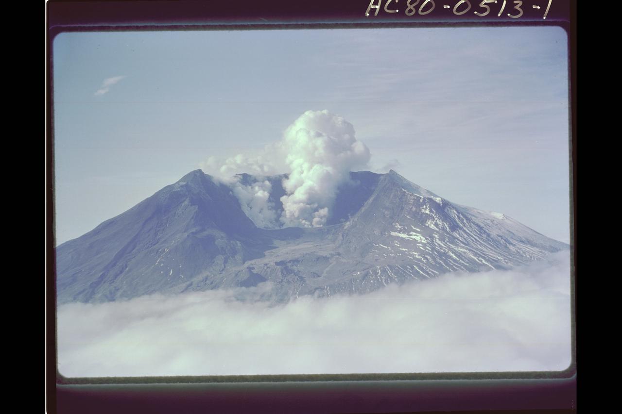
Mt. St. Helens Volcano - post eruption
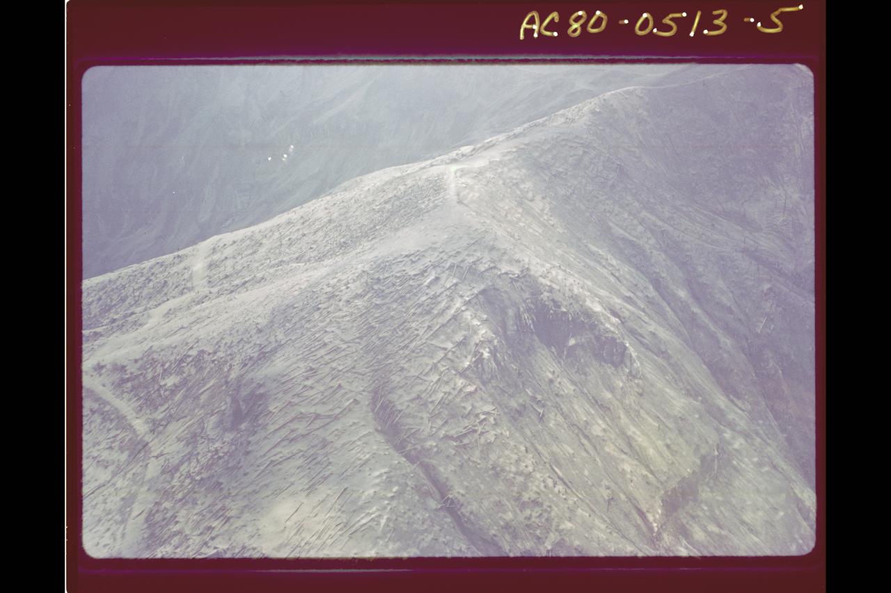
Mt. St. Helens Volcano - post eruption, forest damage