
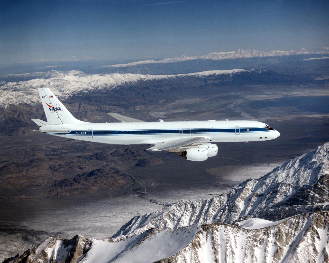
NASA DC-8 airborne laboratory flying over Mint Canyon near the snow-covered San Gabriel Mountains of California. The mostly white aircraft is silhouetted against the darker mountains in the background.
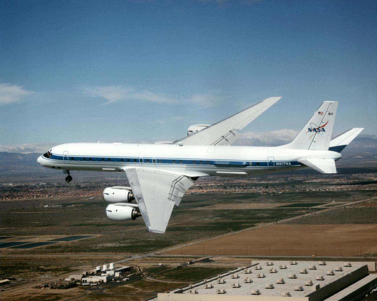
The DC-8 Airborne Laboratory in a left banking turn above the airport at Palmdale, California. The right wing is silhouetted against the blue sky, while the left wing contrasts with the desert terrain. The former airliner is a "dash-72" model and has a range of 5,400 miles. The craft can stay airborne for 12 hours and has an operational speed range between 300 and 500 knots. The research flights are made at between 500 and 41,000 feet. The aircraft can carry up to 30,000 lbs of research/science payload equipment installed in 15 mission-definable spaces.
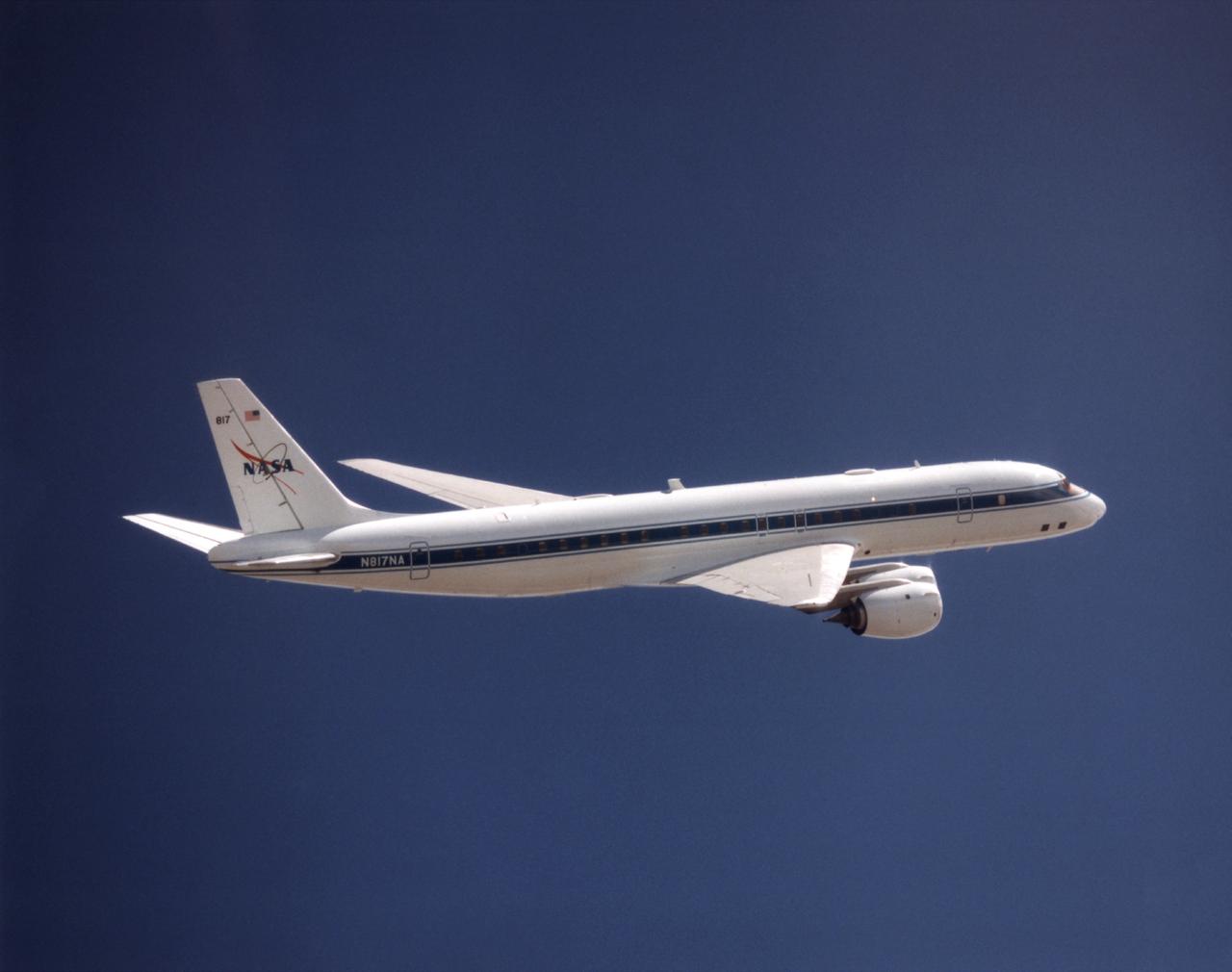
NASA's DC-8 Airborne Science platform shown against a background of a dark blue sky on February 20, 1998. The aircraft is shown from the right rear, slightly above its plane, with the right wing in the foreground and the left wing and horizontal tail in the background. The former airliner is a "dash-72" model and has a range of 5,400 miles. The craft can stay airborne for 12 hours and has an operational speed range between 300 and 500 knots. The research flights are made at between 500 and 41,000 feet. The aircraft can carry up to 30,000 lbs of research/science payload equipment installed in 15 mission-definable spaces.
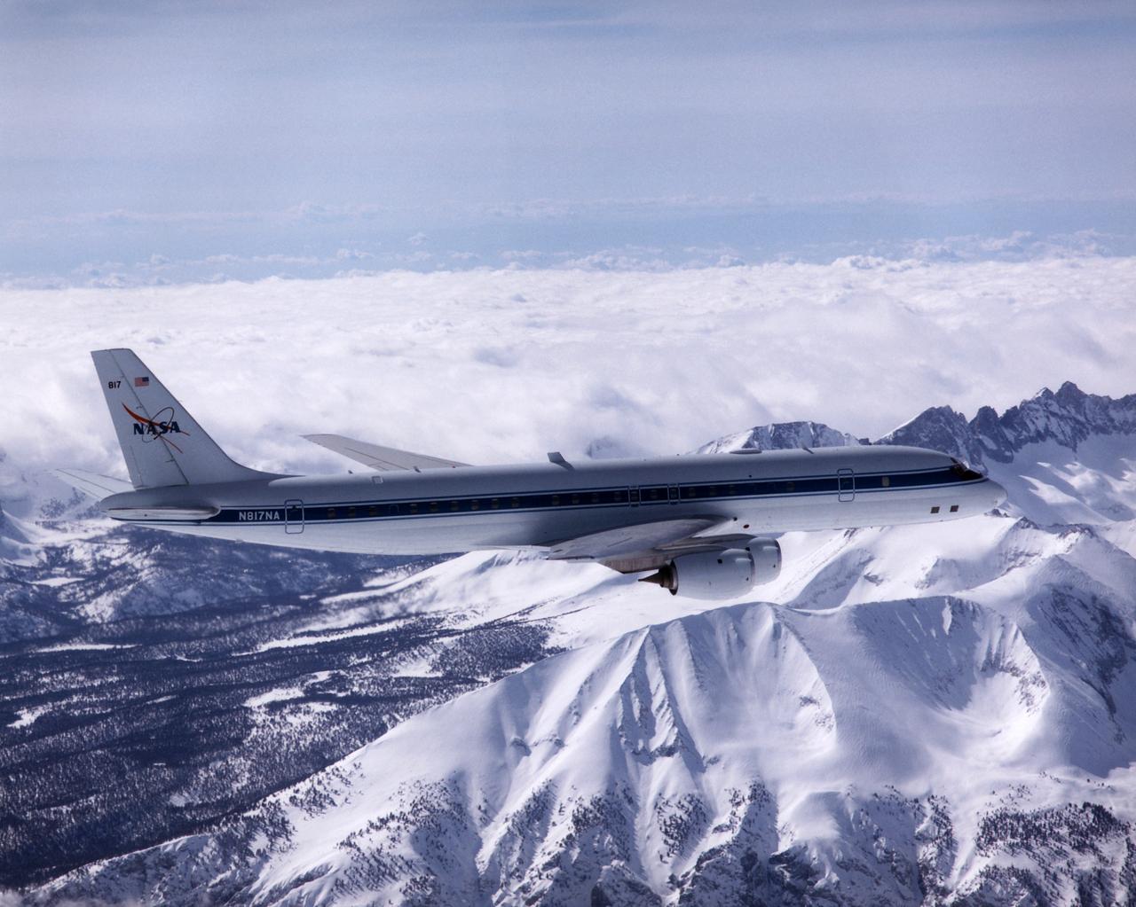
NASA's DC-8 Airborne Laboratory during a flight over the snow-covered Sierra Nevada Mountains. Over the past several years the DC-8 has conducted research missions in such diverse places as the Pacific in spring and Sweden in winter.
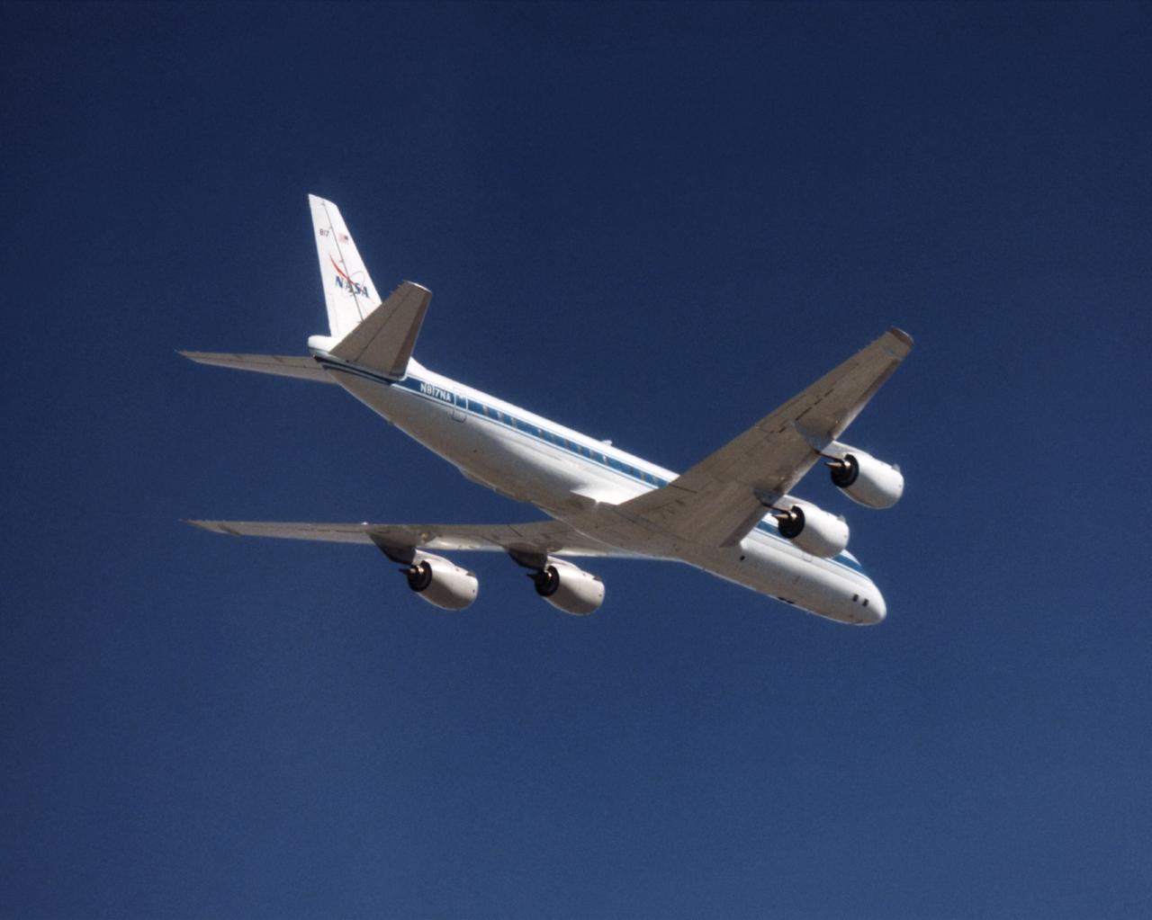
The NASA DC-8 in a right bank over the rugged Sierra Nevada Mountains. The former airliner is a "dash-72" model and has a range of 5,500 miles. The craft can stay airborne for 12 hours and has an operational speed range between 300 and 500 knots. The research flights are made at between 500 and 41,000 feet. The aircraft can carry up to 30,000 lbs of research/science payload equipment installed in 15 mission-definable spaces. In this photo, the aircraft is shown in flight from below, with the DC-8 silhouetted against a blue sky.
The DC-8 in flight near Lone Pine, Calif. In the foreground are the Sierra Nevada Mountains, covered with winter snow. In the distance are the White Mountains. The DC-8's fuselage is painted white with a dark blue stripe down the side. The wings are silver, while the engine pods are white. In this view of the airplane's right-hand side, only a few of its antennas are visible. The experimental payload can be as great as 30,000 pounds of equipment for gathering data of various sorts.
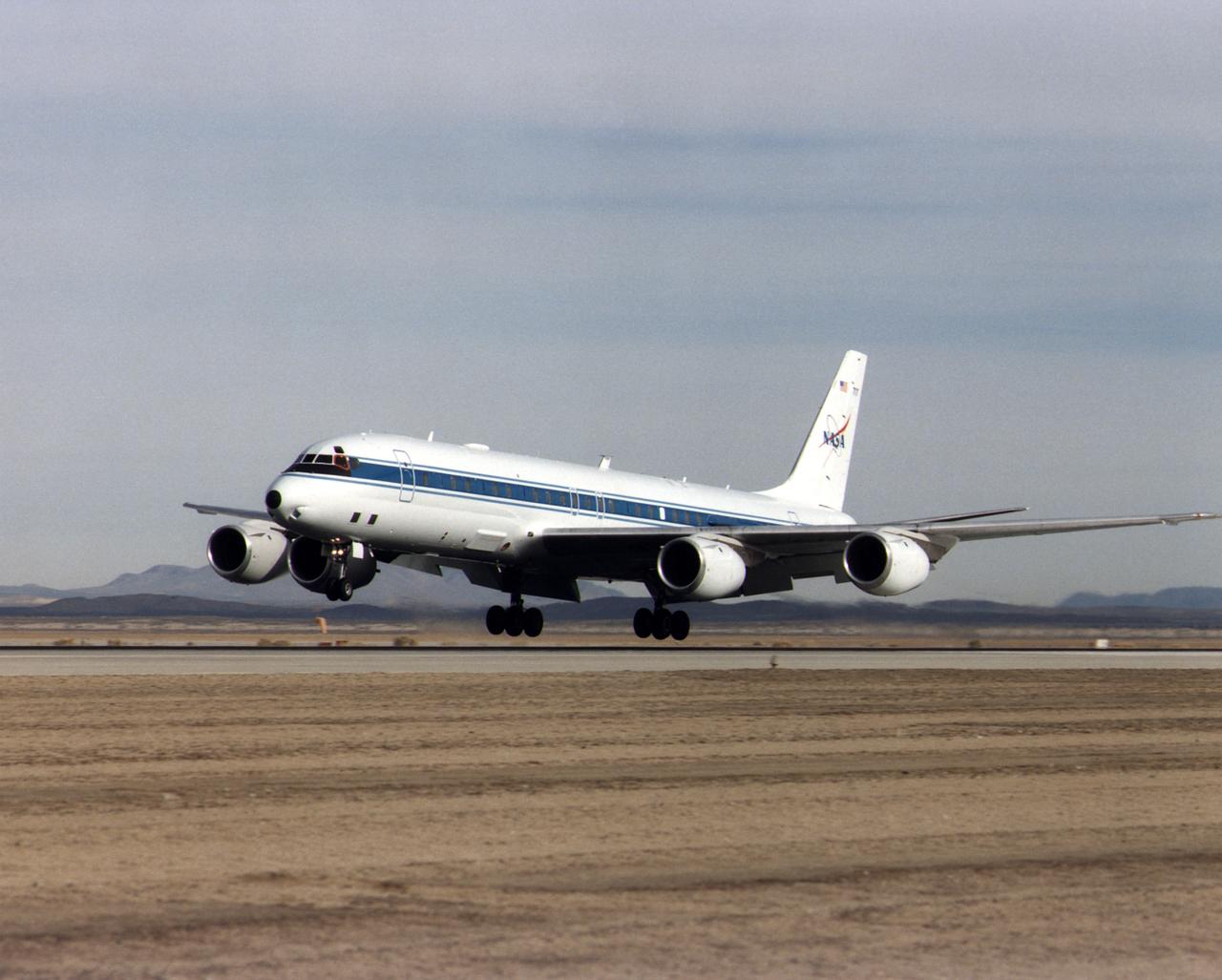
NASA's DC-8 Airborne Science platform landed at Edwards Air Force Base, California, to join the fleet of aircraft at NASA's Dryden Flight Research Center. The white aircraft with a blue stripe running horizontally from the nose to the tail is shown with its main landing gear just above the runway. The former airliner is a "dash-72" model and has a range of 5,400 miles. The craft can stay airborne for 12 hours and has an operational speed range between 300 and 500 knots. The research flights are made at between 500 and 41,000 feet. The aircraft can carry up to 30,000 lbs of research/science payload equipment installed in 15 mission-definable spaces.

This is an image of Taal volcano, near Manila on the island of Luzon in the Philippines. The black area in the center is Taal Lake, which nearly fills the 30-kilometer-diameter (18-mile) caldera. The caldera rim consists of deeply eroded hills and cliffs. The large island in Taal Lake, which itself contains a crater lake, is known as Volcano Island. The bright yellow patch on the southwest side of the island marks the site of an explosion crater that formed during a deadly eruption of Taal in 1965. The image was acquired by the Spaceborne Imaging Radar-C/X-band Synthetic Aperture Radar (SIR-C/X-SAR) aboard the space shuttle Endeavour on its 78th orbit on October 5, 1994. The image shows an area approximately 56 kilometers by 112 kilometers (34 miles by 68 miles) that is centered at 14.0 degrees north latitude and 121.0 degrees east longitude. North is toward the upper right of the image. The colors in this image were obtained using the following radar channels: red represents the L-band (horizontally transmitted and received); green represents the L-band (horizontally transmitted and vertically received); blue represents the C-band (horizontally transmitted and vertically received). Since 1572, Taal has erupted at least 34 times. Since early 1991, the volcano has been restless, with swarms of earthquakes, new steaming areas, ground fracturing, and increases in water temperature of the lake. Volcanologists and other local authorities are carefully monitoring Taal to understand if the current activity may foretell an eruption. Taal is one of 15 "Decade Volcanoes" that have been identified by the volcanology community as presenting large potential hazards to population centers. The bright area in the upper right of the image is the densely populated city of Manila, only 50 kilometers (30 miles) north of the central crater. http://photojournal.jpl.nasa.gov/catalog/PIA01768
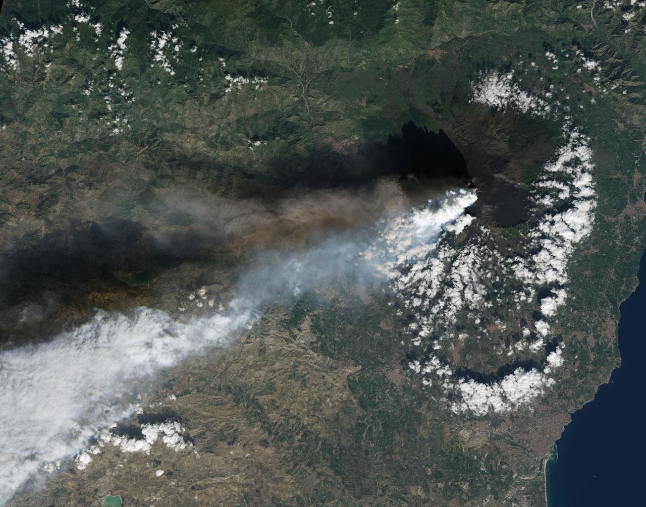
Twin volcanic plumes—one of ash, one of gas—rose from Sicily’ Mount Etna on the morning of October 26, 2013. L’Istituto Nazionale di Geofisica e Vulcanologia (INGV) Osservatorio Etneo (National Institute of Geophysics and Volcanology Etna Observatory) reported that Etna was experiencing its first paroxysm in six months. Multiple eruption columns are common at Etna, a result of complex plumbing within the volcano. The Northeast Crater, one of several on Etna’s summit, was emitting the ash column, while the New Southeast Crater was simultaneously venting mostly gas. This natural-color image collected by Landsat 8 shows the view from space at 11:38 a.m. local time. The towering, gas-rich plume cast a dark shadow over the lower, ash-rich plume and Etna’s northwestern flank. Relatively fresh lava flows (less than a century or so old) are dark gray; vegetation is green; and the tile-roofed buildings of Bronte and Biancavilla lend the towns an ochre hue. NASA Earth Observatory image by Jesse Allen and Robert Simmon, using Landsat data from the USGS Earth Explorer. Photograph ©2013, Boris Behncke. Caption by Robert Simmon with contributions from Boris Behncke. Instrument: Landsat 8 - OLI More info: <a href="http://1.usa.gov/1cEcOFi" rel="nofollow">1.usa.gov/1cEcOFi</a> Credit: <b><a href="http://www.earthobservatory.nasa.gov/" rel="nofollow"> NASA Earth Observatory</a></b> <b><a href="http://www.nasa.gov/audience/formedia/features/MP_Photo_Guidelines.html" rel="nofollow">NASA image use policy.</a></b> <b><a href="http://www.nasa.gov/centers/goddard/home/index.html" rel="nofollow">NASA Goddard Space Flight Center</a></b> enables NASA’s mission through four scientific endeavors: Earth Science, Heliophysics, Solar System Exploration, and Astrophysics. Goddard plays a leading role in NASA’s accomplishments by contributing compelling scientific knowledge to advance the Agency’s mission. <b>Follow us on <a href="http://twitter.com/NASA_GoddardPix" rel="nofollow">Twitter</a></b> <b>Like us on <a href="http://www.facebook.com/pages/Greenbelt-MD/NASA-Goddard/395013845897?ref=tsd" rel="nofollow">Facebook</a></b> <b>Find us on <a href="http://instagram.com/nasagoddard?vm=grid" rel="nofollow">Instagram</a></b>
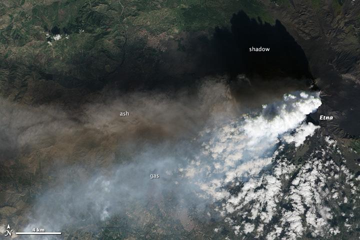
Twin volcanic plumes—one of ash, one of gas—rose from Sicily’ Mount Etna on the morning of October 26, 2013. L’Istituto Nazionale di Geofisica e Vulcanologia (INGV) Osservatorio Etneo (National Institute of Geophysics and Volcanology Etna Observatory) reported that Etna was experiencing its first paroxysm in six months. Multiple eruption columns are common at Etna, a result of complex plumbing within the volcano. The Northeast Crater, one of several on Etna’s summit, was emitting the ash column, while the New Southeast Crater was simultaneously venting mostly gas. This natural-color image collected by Landsat 8 shows the view from space at 11:38 a.m. local time. The towering, gas-rich plume cast a dark shadow over the lower, ash-rich plume and Etna’s northwestern flank. Relatively fresh lava flows (less than a century or so old) are dark gray; vegetation is green; and the tile-roofed buildings of Bronte and Biancavilla lend the towns an ochre hue. NASA Earth Observatory image by Jesse Allen and Robert Simmon, using Landsat data from the USGS Earth Explorer. Photograph ©2013, Boris Behncke. Caption by Robert Simmon with contributions from Boris Behncke. Instrument: Landsat 8 - OLI More info: <a href="http://1.usa.gov/1cEcOFi" rel="nofollow">1.usa.gov/1cEcOFi</a> Credit: <b><a href="http://www.earthobservatory.nasa.gov/" rel="nofollow"> NASA Earth Observatory</a></b> <b><a href="http://www.nasa.gov/audience/formedia/features/MP_Photo_Guidelines.html" rel="nofollow">NASA image use policy.</a></b> <b><a href="http://www.nasa.gov/centers/goddard/home/index.html" rel="nofollow">NASA Goddard Space Flight Center</a></b> enables NASA’s mission through four scientific endeavors: Earth Science, Heliophysics, Solar System Exploration, and Astrophysics. Goddard plays a leading role in NASA’s accomplishments by contributing compelling scientific knowledge to advance the Agency’s mission. <b>Follow us on <a href="http://twitter.com/NASA_GoddardPix" rel="nofollow">Twitter</a></b> <b>Like us on <a href="http://www.facebook.com/pages/Greenbelt-MD/NASA-Goddard/395013845897?ref=tsd" rel="nofollow">Facebook</a></b> <b>Find us on <a href="http://instagram.com/nasagoddard?vm=grid" rel="nofollow">Instagram</a></b>