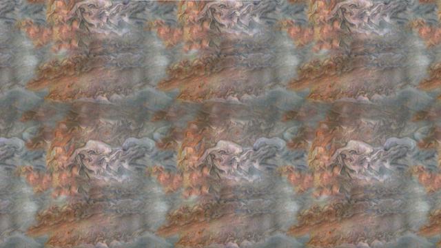
When team members from NASA's Juno mission invited the public to process JunoCam images, they did not anticipate that they would receive back such beautiful, creative expressions of art. The oranges and grayed-out regions of blue-green in this tiled and color-enhanced image resemble a color scheme much like Romantic era paintings, but more abstract. The lack of discreet objects to focus on allows the mind to seek familiar Earthly shapes, and the brightest spots seem to draw the eye. Citizen scientist Eric Jorgensen created this Jovian artwork with a JunoCam image taken when the spacecraft was at an altitude of 11,100 miles (17,800 kilometers) above Jupiter's cloudtops on Dec. 11, 2016 at 9:22 a.m. PT (12:22 p.m. ET). http://photojournal.jpl.nasa.gov/catalog/PIA21385 . - Enhanced image by Eric Jorgensen based on images provided courtesy of NASA/JPL-Caltech/SwRI/MSSS
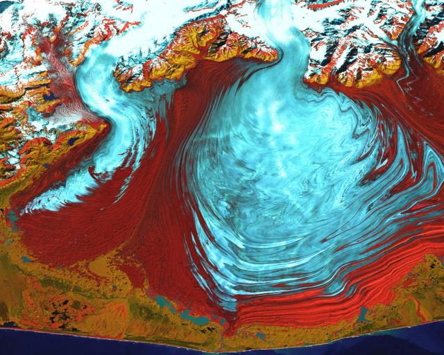
NASA image captured August 31, 2000 The tongue of the Malaspina Glacier, the largest glacier in Alaska, fills most of this image. The Malaspina lies west of Yakutat Bay and covers 1,500 sq. MI (3,880 sq. km). Credit: NASA/Landsat <b><a href="http://www.nasa.gov/centers/goddard/home/index.html" rel="nofollow">NASA Goddard Space Flight Center</a></b> enables NASA’s mission through four scientific endeavors: Earth Science, Heliophysics, Solar System Exploration, and Astrophysics. Goddard plays a leading role in NASA’s accomplishments by contributing compelling scientific knowledge to advance the Agency’s mission. <b>Follow us on <a href="http://twitter.com/NASA_GoddardPix" rel="nofollow">Twitter</a></b> <b>Join us on <a href="http://www.facebook.com/pages/Greenbelt-MD/NASA-Goddard/395013845897?ref=tsd" rel="nofollow">Facebook</a></b>
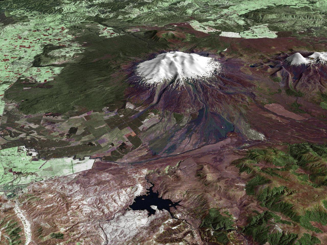
All around the world, people live in places where the threat of natural disaster is high. On the North Island of New Zealand, the Mount Ruapehu volcano is just such a threat. A towering, active stratovolcano (the classic cone-shaped volcano), snow-capped Ruapehu Volcano is pictured in this enhanced-color image. The image is made from topography data collected by the Shuttle Radar Topography Mission aboard the Space Shuttle Endeavour, launched on February 11, 2000, and imagery collected by the Landsat satellite on October 23, 2002. Ruapehu is one of New Zealand’s most active volcanoes, with ten eruptions since 1861. The eruptions aren’t the only threat from the volcano, however. Among the most serious threats is a volcanic mudflow called a lahar. In between eruptions, a lake forms in the volcano’s caldera from melting snow. If a previous eruption has deposited a dam of ash, rocks and mud in the lake’s natural overflow point, then the lake becomes dangerously full, held back only by the temporary dam. In this scene, the lake is nestled among the ridges at the top of the volcano. Eventually, the dam gives way and a massive flow of mud and debris churns down the mountain toward farmland and towns below. Scientists estimate that Ruapehu has experienced 60 lahars in the last 150 years. A devastating lahar in 1953 killed more than 150 people, who died when a passenger train plunged into a ravine when a railroad bridge was taken out by the lahar. The flank of the volcano below the lake is deeply carved by the path of previous lahars; the gouge can be seen just left of image center. Currently scientists in the region are predicting that the lake will overflow in a lahar sometime in the next year. There is great controversy about how to deal with the threat. News reports from the region indicate that the government is planning to invest in a high-tech warning system that will alert those who might be affected well in advance of any catastrophic release. Others feel that the government should combat the threat through engineering at the top of the mountain, for example, by undertaking a controlled release of the lake. Credit Landsat data provided courtesy of the University of Maryland Global Land Cover Facility Landsat processing by Laura Rocchio, Landsat Project Science Office SRTM 3-arcsecond elevation data courtesy of SRTM Team NASA/JPL/NIMA Visualization created by Earth Observatory staff. <b><a href="http://www.nasa.gov/centers/goddard/home/index.html" rel="nofollow">NASA Goddard Space Flight Center</a></b> enables NASA’s mission through four scientific endeavors: Earth Science, Heliophysics, Solar System Exploration, and Astrophysics. Goddard plays a leading role in NASA’s accomplishments by contributing compelling scientific knowledge to advance the Agency’s mission. <b>Follow us on <a href="http://twitter.com/NASA_GoddardPix" rel="nofollow">Twitter</a></b> <b>Join us on <a href="http://www.facebook.com/pages/Greenbelt-MD/NASA-Goddard/395013845897?ref=tsd" rel="nofollow">Facebook</a></b>
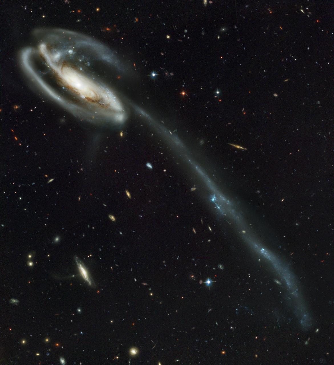
This picture of the galaxy UGC 10214 was was taken by the Advanced Camera for Surveys (ACS), which was installed aboard the Hubble Space Telescope (HST) in March 2002 during HST Servicing Mission 3B (STS-109 mission). Dubbed the "Tadpole," this spiral galaxy is unlike the textbook images of stately galaxies. Its distorted shape was caused by a small interloper, a very blue, compact galaxy visible in the upper left corner of the more massive Tadpole. The Tadpole resides about 420 million light-years away in the constellation Draco. Seen shining through the Tadpole's disk, the tiny intruder is likely a hit-and-run galaxy that is now leaving the scene of the accident. Strong gravitational forces from the interaction created the long tail of debris, consisting of stars and gas that stretch our more than 280,000 light-years. The galactic carnage and torrent of star birth are playing out against a spectacular backdrop: a "wallpaper pattern" of 6,000 galaxies. These galaxies represent twice the number of those discovered in the legendary Hubble Deep Field, the orbiting observatory's "deepest" view of the heavens, taken in 1995 by the Wide Field and planetary camera 2. The ACS picture, however, was taken in one-twelfth of the time it took to observe the original HST Deep Field. In blue light, ACS sees even fainter objects than were seen in the "deep field." The galaxies in the ACS picture, like those in the deep field, stretch back to nearly the begirning of time. Credit: NASA, H. Ford (JHU), G. Illingworth (USCS/LO), M. Clampin (STScI), G. Hartig (STScI), the ACS Science Team, and ESA.
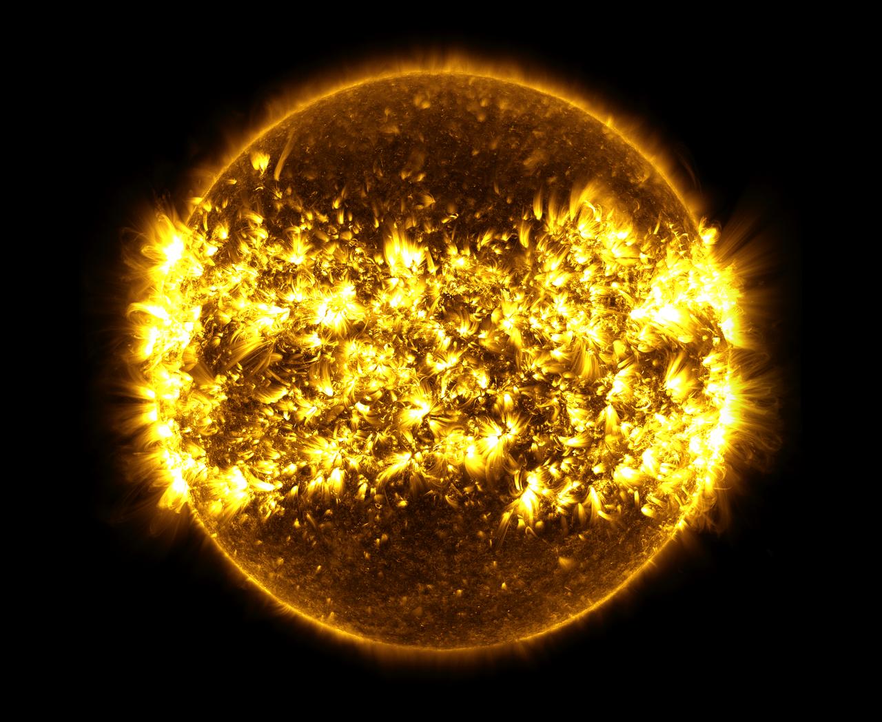
This image, is a composite of 23 separate images spanning the period of January 11, 2015 to January 21, 2016. It uses the SDO AIA wavelength of 171 angstroms and reveals the zones on the sun where active regions are most common during this part of the solar cycle. There are wallpapers sized for some phones and tablets available to download here: <a href="https://svs.gsfc.nasa.gov/cgi-bin/details.cgi?aid=12144#.Vr4_WtIQzrs.twitter" rel="nofollow">svs.gsfc.nasa.gov/cgi-bin/details.cgi?aid=12144#.Vr4_WtIQ...</a> Credit: NASA's Goddard Space Flight Center/SDO/S. Wiessinger <b><a href="http://www.nasa.gov/audience/formedia/features/MP_Photo_Guidelines.html" rel="nofollow">NASA image use policy.</a></b> <b><a href="http://www.nasa.gov/centers/goddard/home/index.html" rel="nofollow">NASA Goddard Space Flight Center</a></b> enables NASA’s mission through four scientific endeavors: Earth Science, Heliophysics, Solar System Exploration, and Astrophysics. Goddard plays a leading role in NASA’s accomplishments by contributing compelling scientific knowledge to advance the Agency’s mission. <b>Follow us on <a href="http://twitter.com/NASAGoddardPix" rel="nofollow">Twitter</a></b> <b>Like us on <a href="http://www.facebook.com/pages/Greenbelt-MD/NASA-Goddard/395013845897?ref=tsd" rel="nofollow">Facebook</a></b> <b>Find us on <a href="http://instagrid.me/nasagoddard/?vm=grid" rel="nofollow">Instagram</a></b>

January 25, 2012 <b>*Updated February 2, 2012: According to Flickr, "The western hemisphere Blue Marble 2012 image has rocketed up to over 3.1 million views making it one of the all time most viewed images on the site after only one week."</b> A 'Blue Marble' image of the Earth taken from the VIIRS instrument aboard NASA's most recently launched Earth-observing satellite - Suomi NPP. This composite image uses a number of swaths of the Earth's surface taken on January 4, 2012. The NPP satellite was renamed 'Suomi NPP' on January 24, 2012 to honor the late Verner E. Suomi of the University of Wisconsin. Suomi NPP is NASA's next Earth-observing research satellite. It is the first of a new generation of satellites that will observe many facets of our changing Earth. Suomi NPP is carrying five instruments on board. The biggest and most important instrument is The Visible/Infrared Imager Radiometer Suite or VIIRS. To read more about NASA's Suomi NPP go to: <a href="http://www.nasa.gov/npp" rel="nofollow">www.nasa.gov/npp</a> Credit: NASA/NOAA/GSFC/Suomi NPP/VIIRS/Norman Kuring <b><a href="http://www.nasa.gov/audience/formedia/features/MP_Photo_Guidelines.html" rel="nofollow">NASA image use policy.</a></b> <b><a href="http://www.nasa.gov/centers/goddard/home/index.html" rel="nofollow">NASA Goddard Space Flight Center</a></b> enables NASA’s mission through four scientific endeavors: Earth Science, Heliophysics, Solar System Exploration, and Astrophysics. Goddard plays a leading role in NASA’s accomplishments by contributing compelling scientific knowledge to advance the Agency’s mission. <b>Follow us on <a href="http://twitter.com/NASAGoddardPix" rel="nofollow">Twitter</a></b> <b>Like us on <a href="http://www.facebook.com/pages/Greenbelt-MD/NASA-Goddard/395013845897?ref=tsd" rel="nofollow">Facebook</a></b> <b>Find us on <a href="http://instagrid.me/nasagoddard/?vm=grid" rel="nofollow">Instagram</a></b>