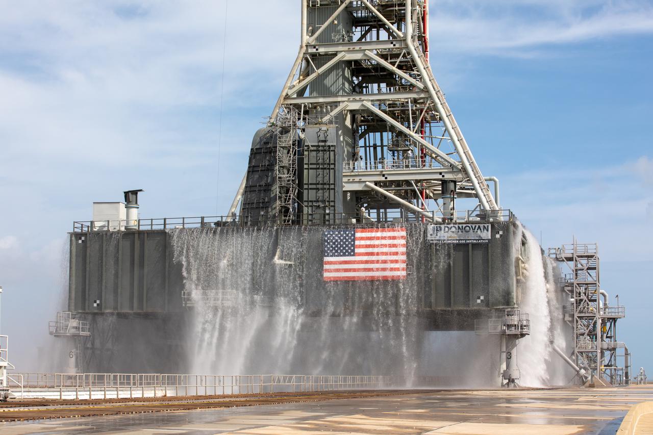
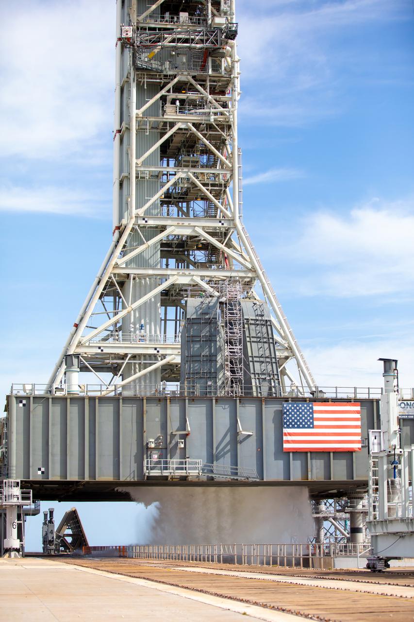
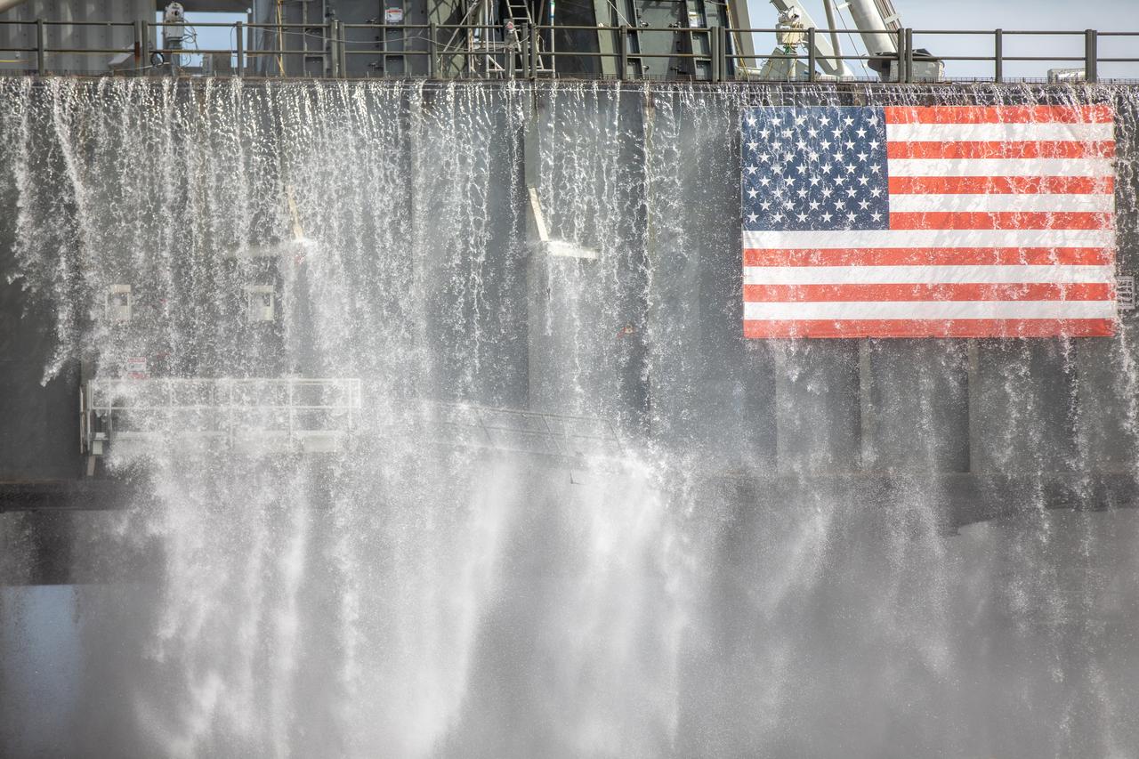
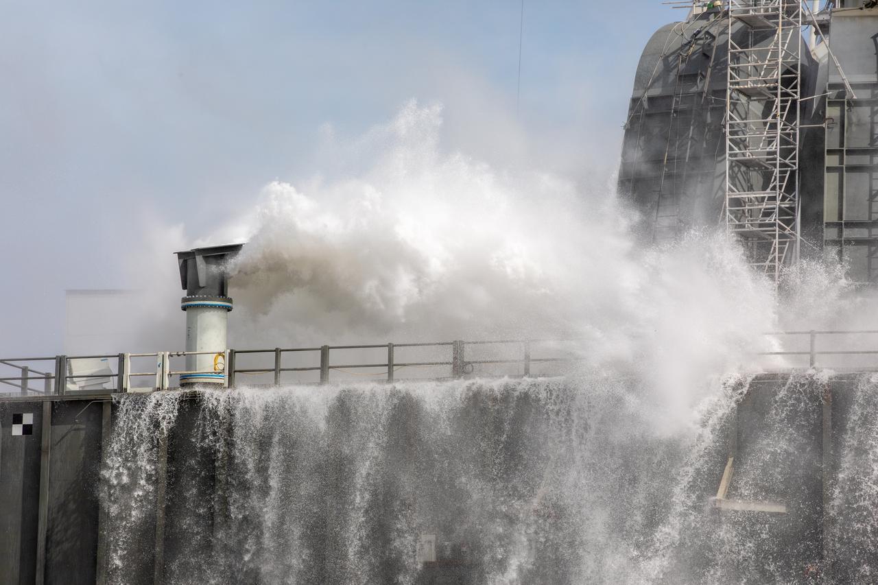
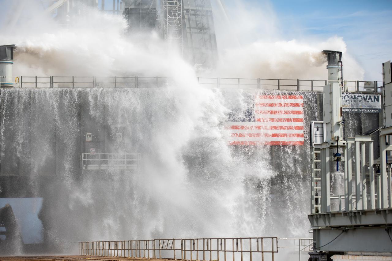
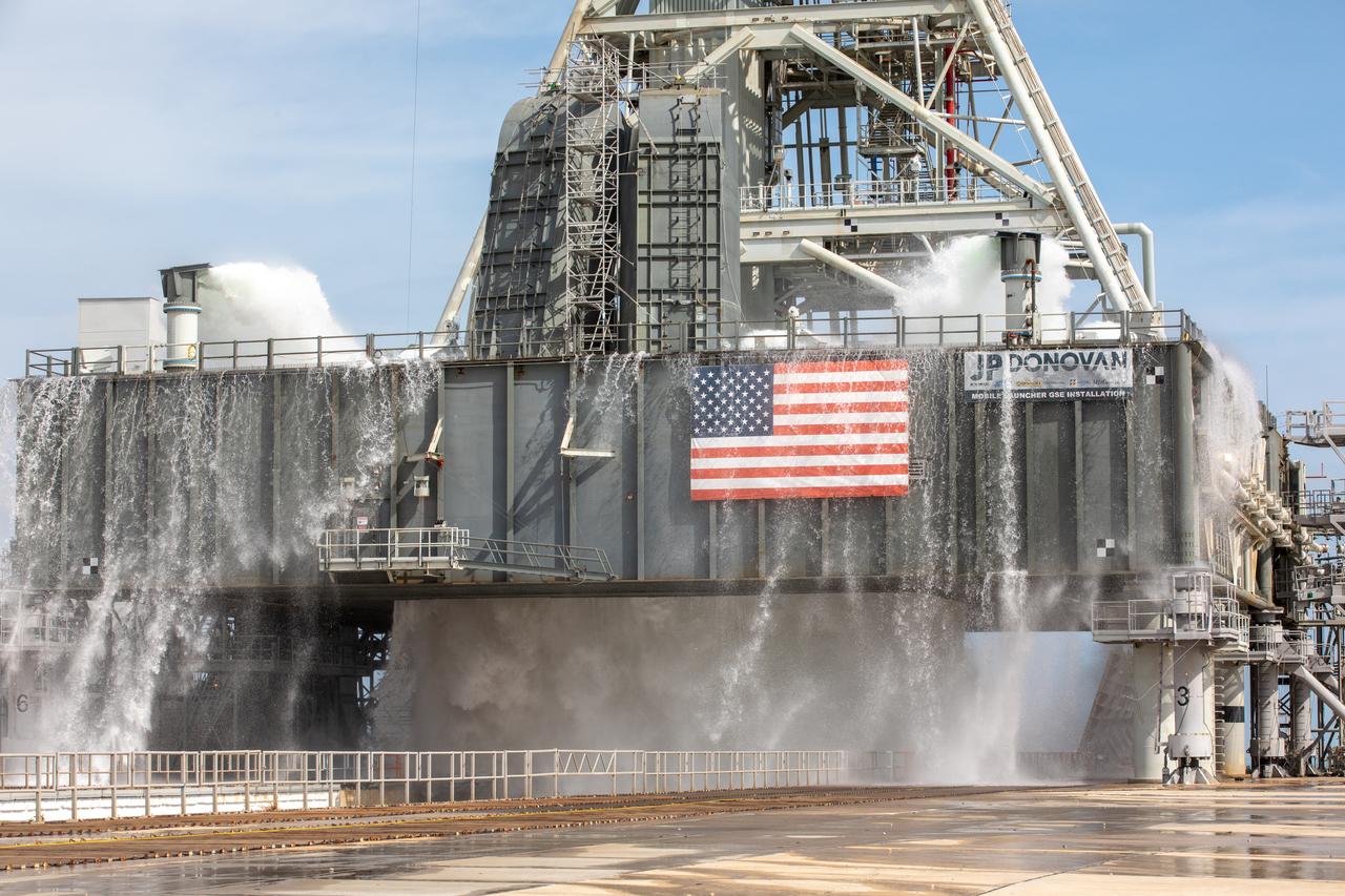
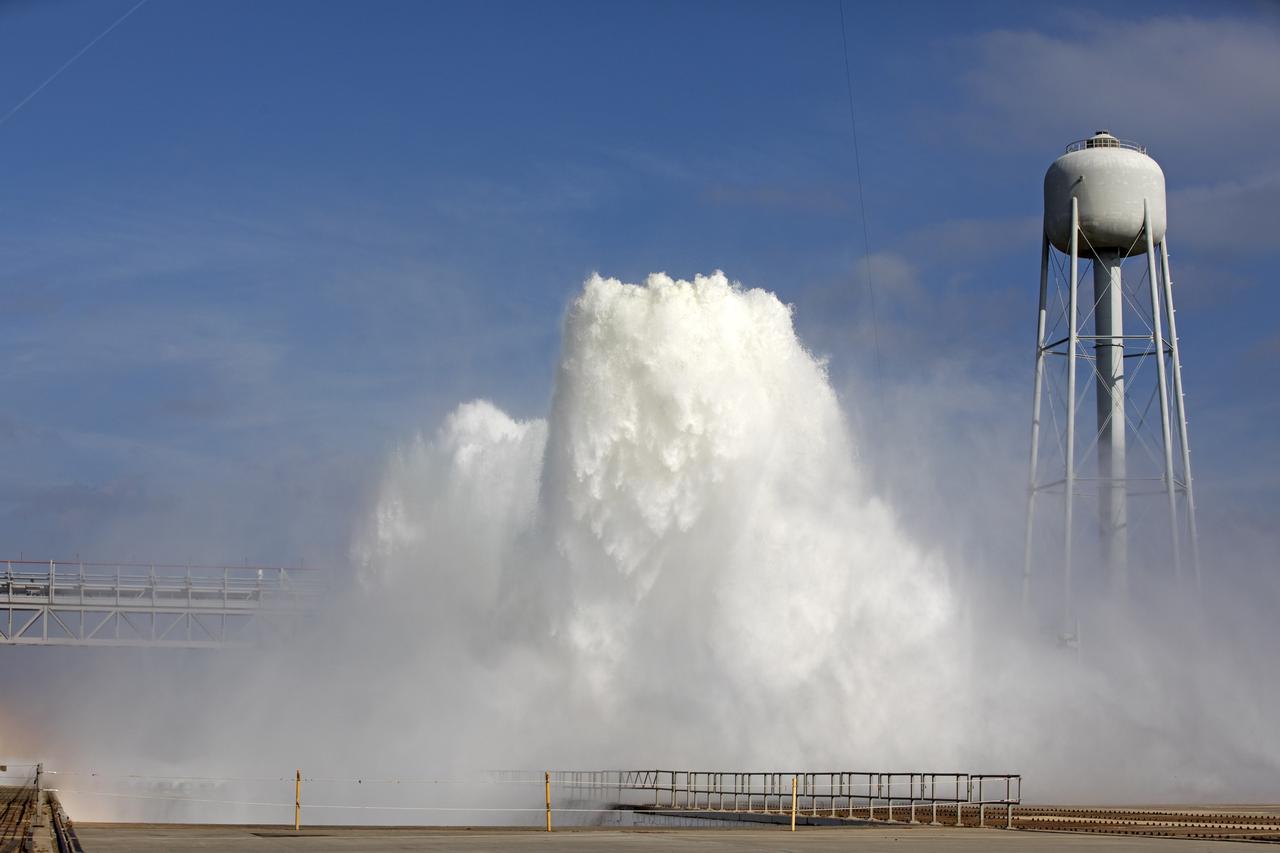
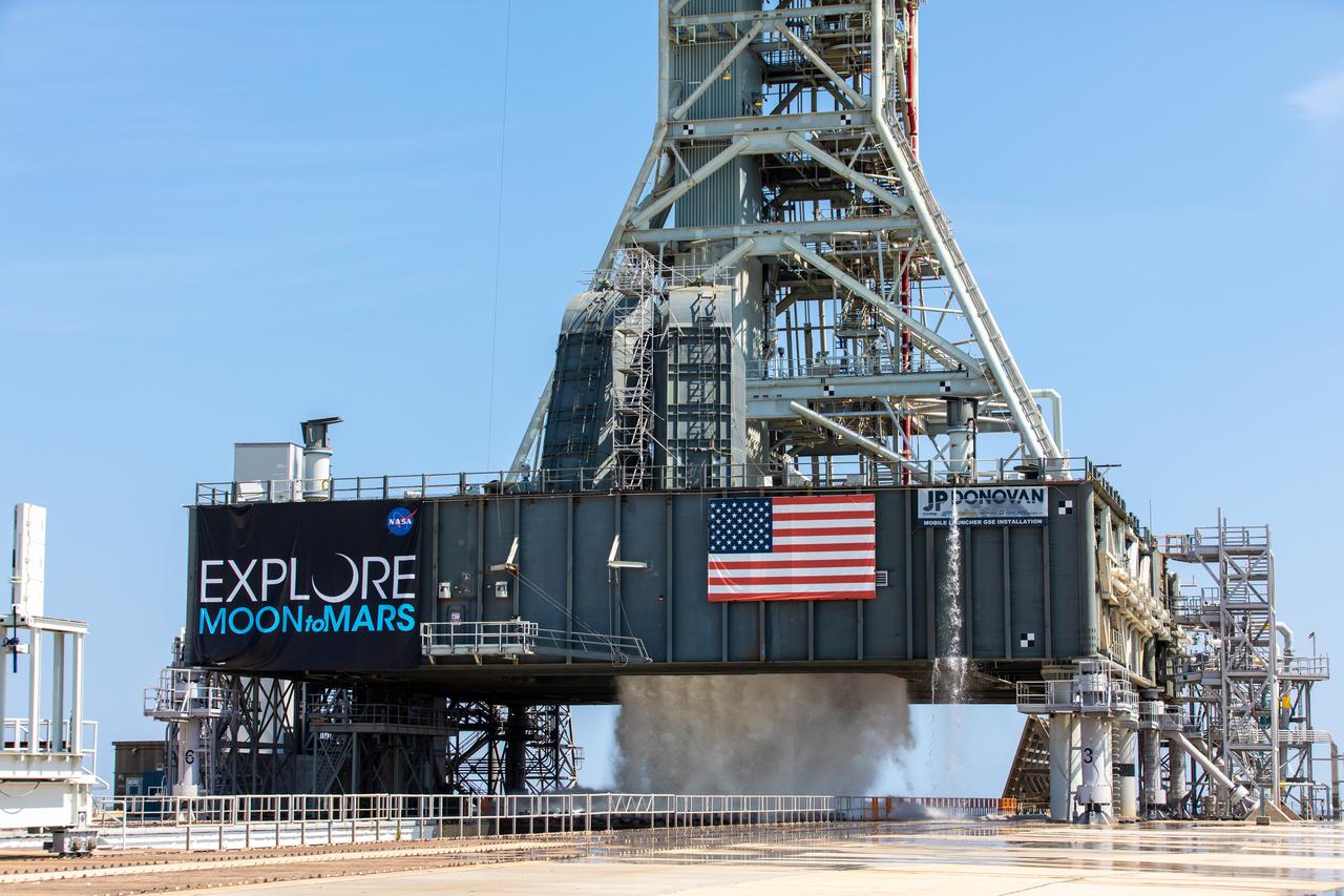
A flow test of the Ignition Overpressure Protection and Sound Suppression water deluge system is in progress at Launch Pad 39B at NASA's Kennedy Space Center in Florida, on Oct. 15, 2018. At peak flow, the water reaches about 100 feet in the air above the pad surface. It flows at high speed from a holding tank through new and modified piping and valves, the flame trench, flame deflector nozzles and mobile launcher interface risers. The testing is part of Exploration Ground System's preparation for the new Space Launch System rocket. Modifications were made to the pad after a previous wet flow test, increasing the performance of the system. During the launch of Exploration Mission-1 and subsequent missions, this water deluge system will release about 450,000 gallons of water across the mobile launcher and Flame Deflector to reduce the extreme heat and energy generated by the rocket during ignition and liftoff.
A flow test of the Ignition Overpressure Protection and Sound Suppression water deluge system is in progress at Launch Pad 39B at NASA's Kennedy Space Center in Florida, on Oct. 15, 2018. At peak flow, the water reaches about 100 feet in the air above the pad surface. It flows at high speed from a holding tank through new and modified piping and valves, the flame trench, flame deflector nozzles and mobile launcher interface risers. The testing is part of Exploration Ground System's preparation for the new Space Launch System rocket. Modifications were made to the pad after a previous wet flow test, increasing the performance of the system. During the launch of Exploration Mission-1 and subsequent missions, this water deluge system will release about 450,000 gallons of water across the mobile launcher and Flame Deflector to reduce the extreme heat and energy generated by the rocket during ignition and liftoff.

A flow test of the Ignition Overpressure Protection and Sound Suppression water deluge system is in progress at Launch Pad 39B at NASA's Kennedy Space Center in Florida, on Oct. 15, 2018. At peak flow, the water reaches about 100 feet in the air above the pad surface. It flows at high speed from a holding tank through new and modified piping and valves, the flame trench, flame deflector nozzles and mobile launcher interface risers. The testing is part of Exploration Ground System's preparation for the new Space Launch System rocket. Modifications were made to the pad after a previous wet flow test, increasing the performance of the system. During the launch of Exploration Mission-1 and subsequent missions, this water deluge system will release about 450,000 gallons of water across the mobile launcher and Flame Deflector to reduce the extreme heat and energy generated by the rocket during ignition and liftoff.

A flow test of the Ignition Overpressure Protection and Sound Suppression water deluge system is in progress at Launch Pad 39B at NASA's Kennedy Space Center in Florida, on Oct. 15, 2018. At peak flow, the water reaches about 100 feet in the air above the pad surface. It flows at high speed from a holding tank through new and modified piping and valves, the flame trench, flame deflector nozzles and mobile launcher interface risers. The testing is part of Exploration Ground System's preparation for the new Space Launch System rocket. Modifications were made to the pad after a previous wet flow test, increasing the performance of the system. During the launch of Exploration Mission-1 and subsequent missions, this water deluge system will release about 450,000 gallons of water across the mobile launcher and Flame Deflector to reduce the extreme heat and energy generated by the rocket during ignition and liftoff.
A flow test of the Ignition Overpressure Protection and Sound Suppression water deluge system is in progress at Launch Pad 39B at NASA's Kennedy Space Center in Florida, on Oct. 15, 2018. At peak flow, the water will reach about 100 feet in the air above the pad surface. It will flow at high speed from a holding tank through new and modified piping and valves, the flame trench, flame deflector nozzles and mobile launcher interface risers. The testing is part of Exploration Ground System's preparation for the new Space Launch System rocket. Modifications were made to the pad after a previous wet flow test, increasing the performance of the system. During the launch of Exploration Mission-1 and subsequent missions, this water deluge system will release about 450,000 gallons of water across the mobile launcher and Flame Deflector to reduce the extreme heat and energy generated by the rocket during ignition and liftoff.

A flow test of the Ignition Overpressure Protection and Sound Suppression water deluge system is in progress at Launch Pad 39B at NASA's Kennedy Space Center in Florida, on Oct. 15, 2018. At peak flow, the water reaches about 100 feet in the air above the pad surface. It flows at high speed from a holding tank through new and modified piping and valves, the flame trench, flame deflector nozzles and mobile launcher interface risers. The testing is part of Exploration Ground System's preparation for the new Space Launch System rocket. Modifications were made to the pad after a previous wet flow test, increasing the performance of the system. During the launch of Exploration Mission-1 and subsequent missions, this water deluge system will release about 450,000 gallons of water across the mobile launcher and Flame Deflector to reduce the extreme heat and energy generated by the rocket during ignition and liftoff.

A flow test of the Ignition Overpressure Protection and Sound Suppression water deluge system is in progress at Launch Pad 39B at NASA's Kennedy Space Center in Florida, on Oct. 15, 2018. At peak flow, the water reaches about 100 feet in the air above the pad surface. It flows at high speed from a holding tank through new and modified piping and valves, the flame trench, flame deflector nozzles and mobile launcher interface risers. The testing is part of Exploration Ground System's preparation for the new Space Launch System rocket. Modifications were made to the pad after a previous wet flow test, increasing the performance of the system. During the launch of Exploration Mission-1 and subsequent missions, this water deluge system will release about 450,000 gallons of water across the mobile launcher and Flame Deflector to reduce the extreme heat and energy generated by the rocket during ignition and liftoff.
A flow test of the Ignition Overpressure Protection and Sound Suppression water deluge system begins at Launch Pad 39B at NASA's Kennedy Space Center in Florida, on Oct. 15, 2018. At peak flow, the water will reach about 100 feet in the air above the pad surface. It will flow at high speed from a holding tank through new and modified piping and valves, the flame trench, flame deflector nozzles and mobile launcher interface risers. The testing is part of Exploration Ground System's preparation for the new Space Launch System rocket. Modifications were made to the pad after a previous wet flow test, increasing the performance of the system. During the launch of Exploration Mission-1 and subsequent missions, this water deluge system will release about 450,000 gallons of water across the mobile launcher and Flame Deflector to reduce the extreme heat and energy generated by the rocket during ignition and liftoff.
A flow test of the Ignition Overpressure Protection and Sound Suppression water deluge system begins at Launch Pad 39B at NASA's Kennedy Space Center in Florida, on Oct. 15, 2018. At peak flow, the water will reach about 100 feet in the air above the pad surface. The testing is part of Exploration Ground System's preparation for the new Space Launch System rocket. Modifications were made to the pad after a previous wet flow test, increasing the performance of the system. During the launch of Exploration Mission-1 and subsequent missions, this water deluge system will release about 450,000 gallons of water across the mobile launcher and Flame Deflector to reduce the extreme heat and energy generated by the rocket during ignition and liftoff.
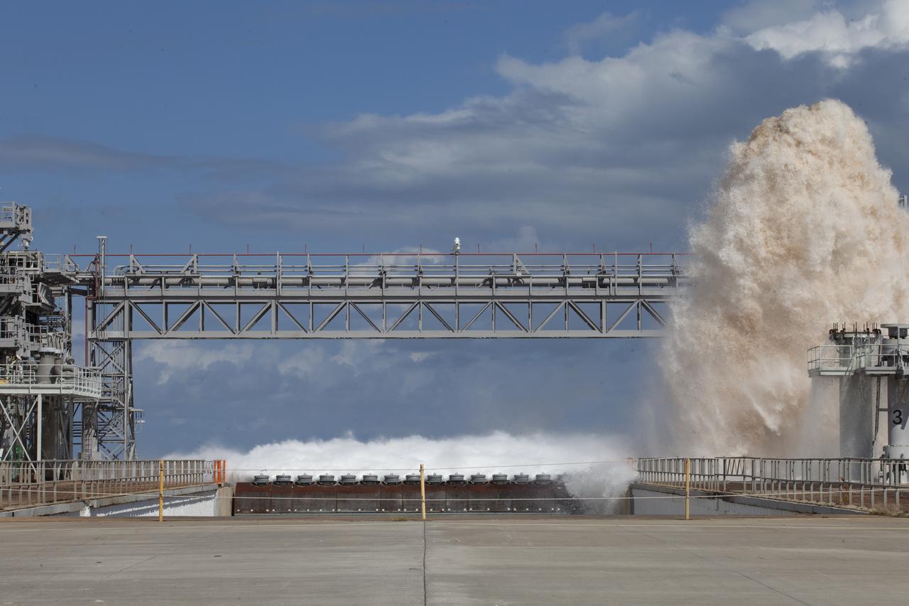
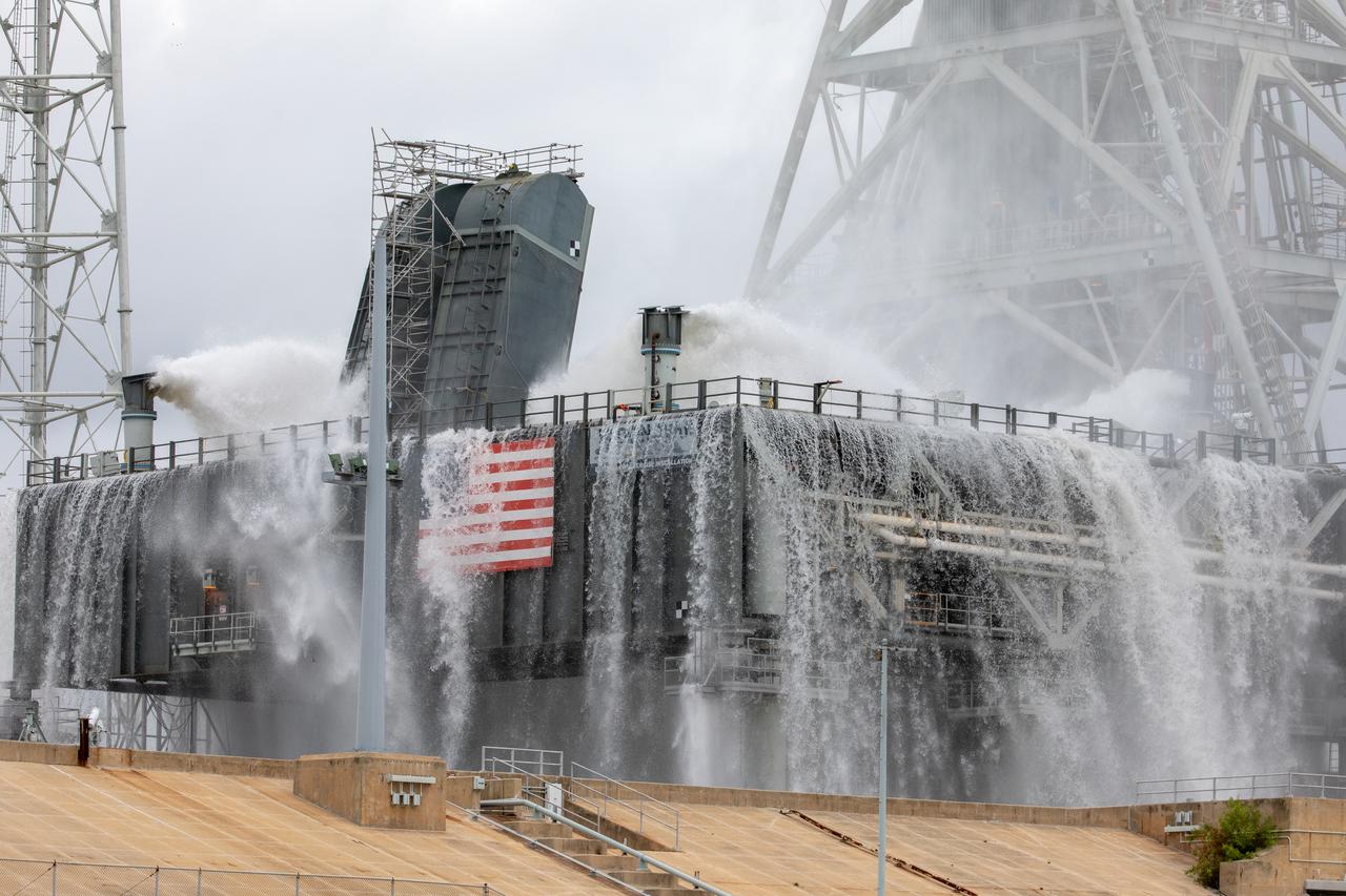
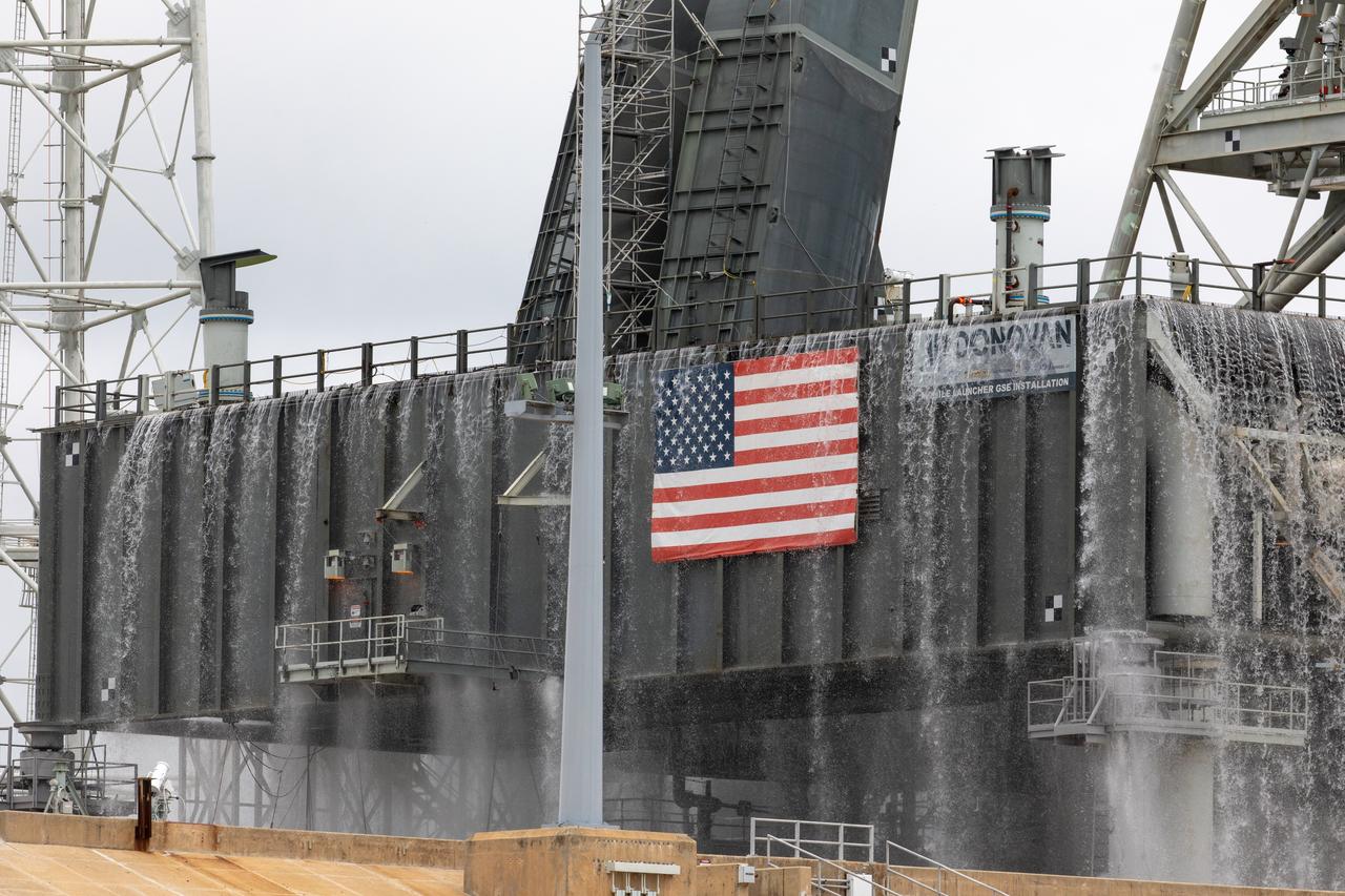
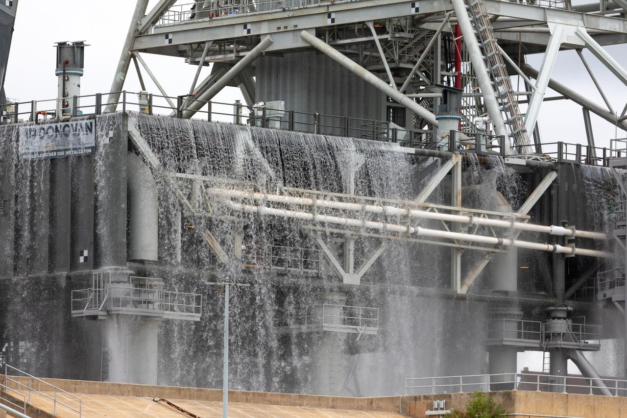
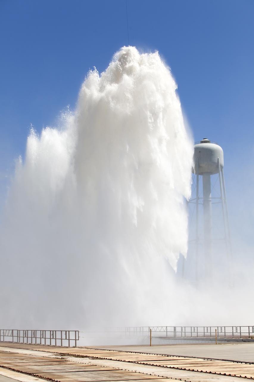
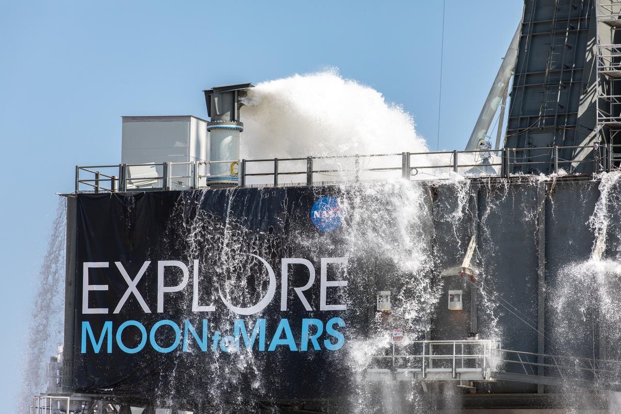
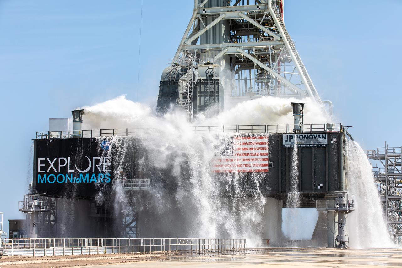
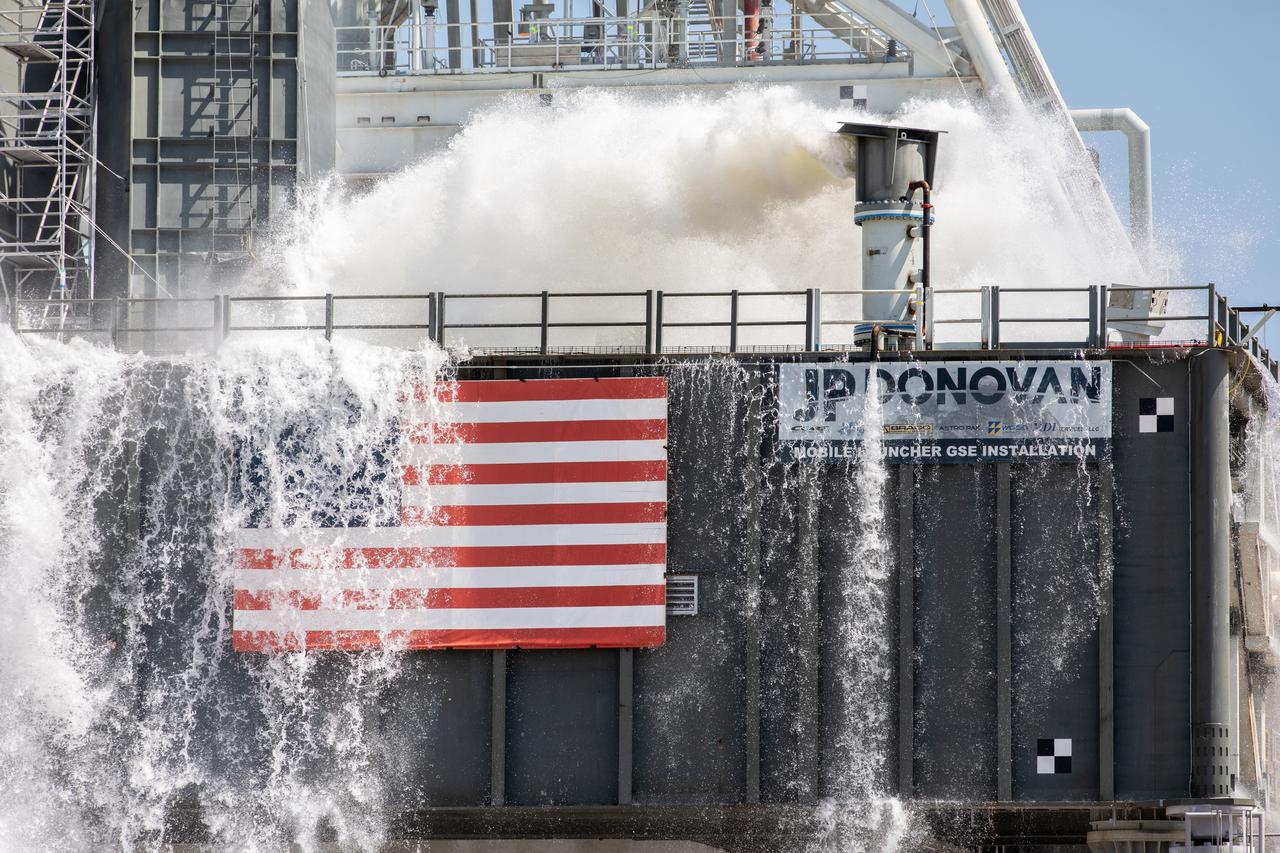
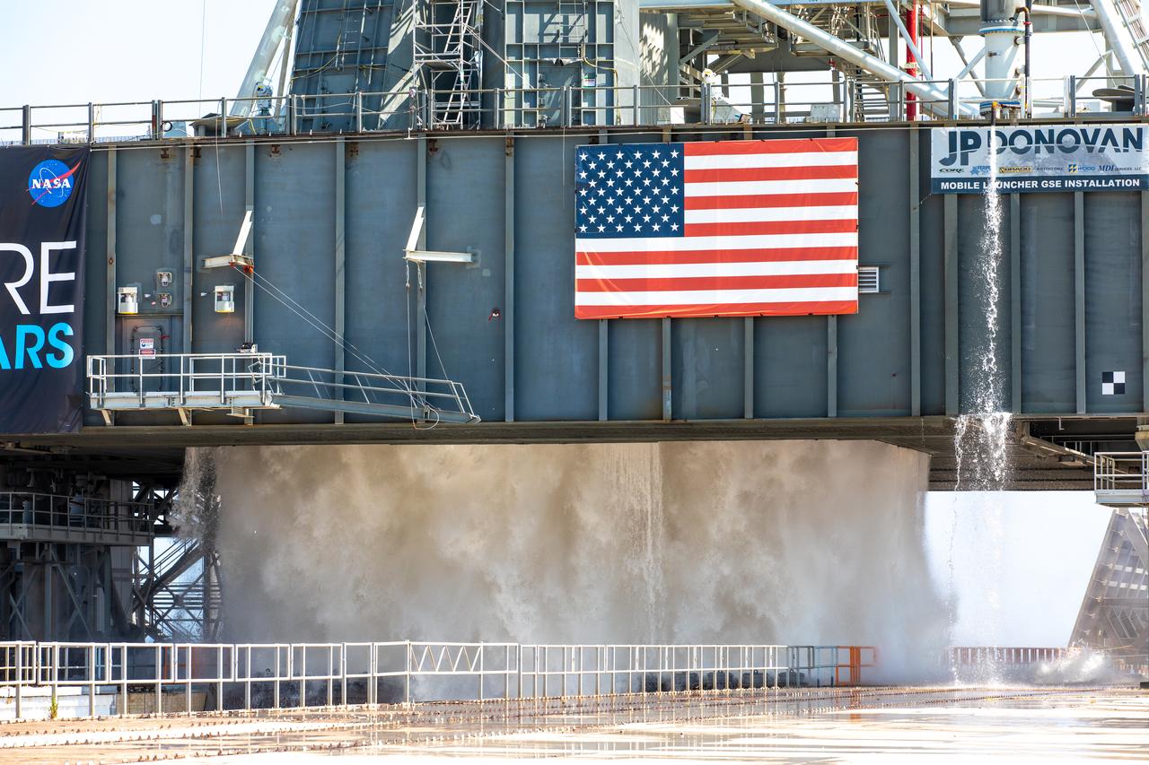
A wet flow test at Launch Pad 39B on September 13, 2019, tests the sound suppression system that will be used for launch of NASA’s Space Launch System for the Artemis I mission. During the test, about 450,000 gallons of water poured onto the Pad B flame deflector, the mobile launcher flame hole and onto the launcher’s blast deck. This was the first time the ground launch sequencer that will be used on the day of launch was used for the timing of a sound suppression test.
A wet flow test at Launch Pad 39B on September 13, 2019, tests the sound suppression system that will be used for launch of NASA’s Space Launch System for the Artemis I mission. During the test, about 450,000 gallons of water poured onto the Pad B flame deflector, the mobile launcher flame hole and onto the launcher’s blast deck. This was the first time the ground launch sequencer that will be used on the day of launch was used for the timing of a sound suppression test.
A wet flow test at Launch Pad 39B on September 13, 2019, tests the sound suppression system that will be used for launch of NASA’s Space Launch System for the Artemis I mission. During the test, about 450,000 gallons of water poured onto the Pad B flame deflector, the mobile launcher flame hole and onto the launcher’s blast deck. This was the first time the ground launch sequencer that will be used on the day of launch was used for the timing of a sound suppression test.
A wet flow test at Launch Pad 39B on September 13, 2019, tests the sound suppression system that will be used for launch of NASA’s Space Launch System for the Artemis I mission. During the test, about 450,000 gallons of water poured onto the Pad B flame deflector, the mobile launcher flame hole and onto the launcher’s blast deck. This was the first time the ground launch sequencer that will be used on the day of launch was used for the timing of a sound suppression test.
A wet flow test at Launch Pad 39B on September 13, 2019, tests the sound suppression system that will be used for launch of NASA’s Space Launch System for the Artemis I mission. During the test, about 450,000 gallons of water poured onto the Pad B flame deflector, the mobile launcher flame hole and onto the launcher’s blast deck. This was the first time the ground launch sequencer that will be used on the day of launch was used for the timing of a sound suppression test.
A wet flow test at Launch Pad 39B on September 13, 2019, tests the sound suppression system that will be used for launch of NASA’s Space Launch System for the Artemis I mission. During the test, about 450,000 gallons of water poured onto the Pad B flame deflector, the mobile launcher flame hole and onto the launcher’s blast deck. This was the first time the ground launch sequencer that will be used on the day of launch was used for the timing of a sound suppression test.
A wet flow test at Launch Pad 39B on September 13, 2019, tests the sound suppression system that will be used for launch of NASA’s Space Launch System for the Artemis I mission. During the test, about 450,000 gallons of water poured onto the Pad B flame deflector, the mobile launcher flame hole and onto the launcher’s blast deck. This was the first time the ground launch sequencer that will be used on the day of launch was used for the timing of a sound suppression test.

A wet flow test at Launch Pad 39B on September 13, 2019, tests the sound suppression system that will be used for launch of NASA’s Space Launch System for the Artemis I mission. During the test, about 450,000 gallons of water poured onto the Pad B flame deflector, the mobile launcher flame hole and onto the launcher’s blast deck. This was the first time the ground launch sequencer that will be used on the day of launch was used for the timing of a sound suppression test.
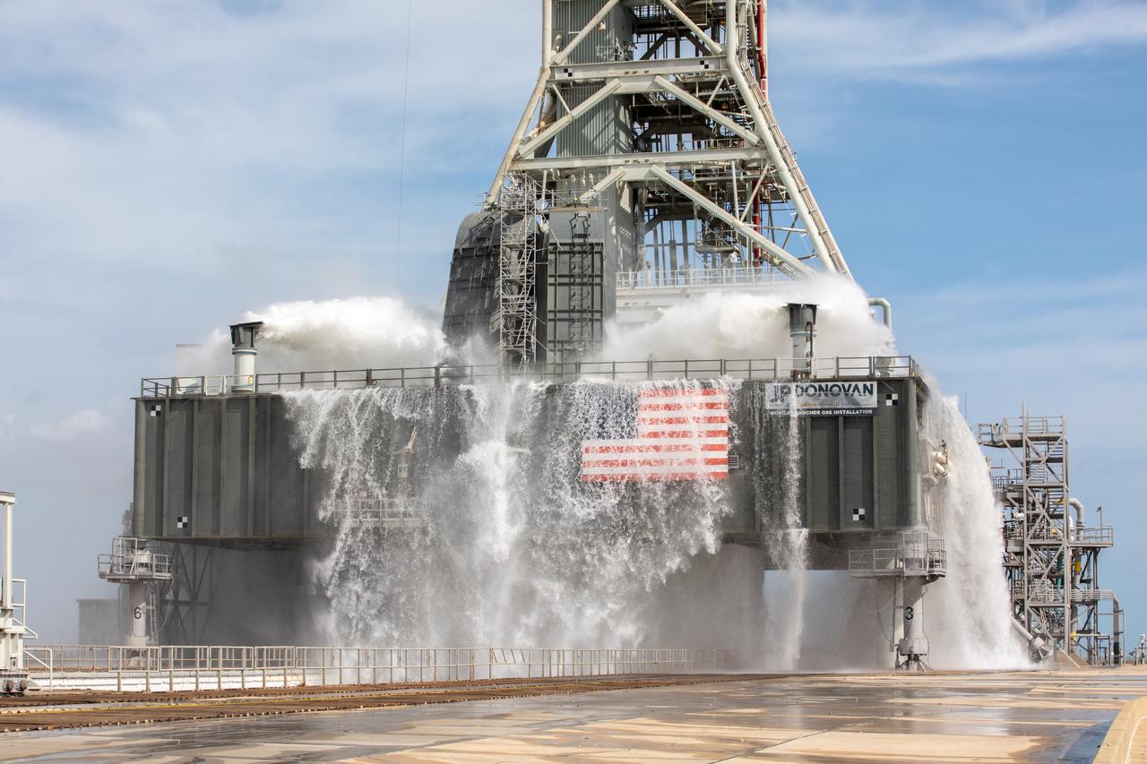
A wet flow test at Launch Pad 39B on September 13, 2019, tests the sound suppression system that will be used for launch of NASA’s Space Launch System for the Artemis I mission. During the test, about 450,000 gallons of water poured onto the Pad B flame deflector, the mobile launcher flame hole and onto the launcher’s blast deck. This was the first time the ground launch sequencer that will be used on the day of launch was used for the timing of a sound suppression test.
A wet flow test at Launch Pad 39B on September 13, 2019, tests the sound suppression system that will be used for launch of NASA’s Space Launch System for the Artemis I mission. During the test, about 450,000 gallons of water poured onto the Pad B flame deflector, the mobile launcher flame hole and onto the launcher’s blast deck. This was the first time the ground launch sequencer that will be used on the day of launch was used for the timing of a sound suppression test.
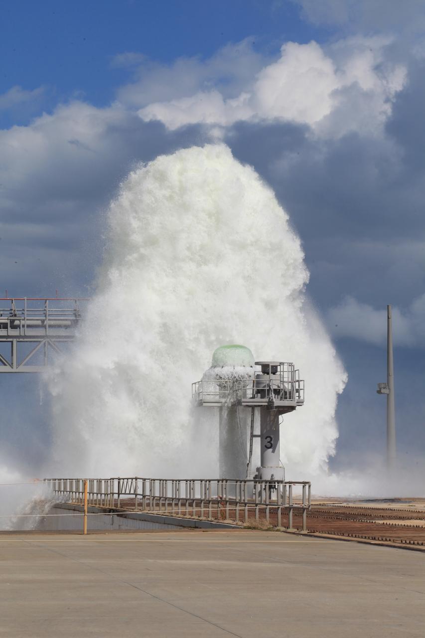
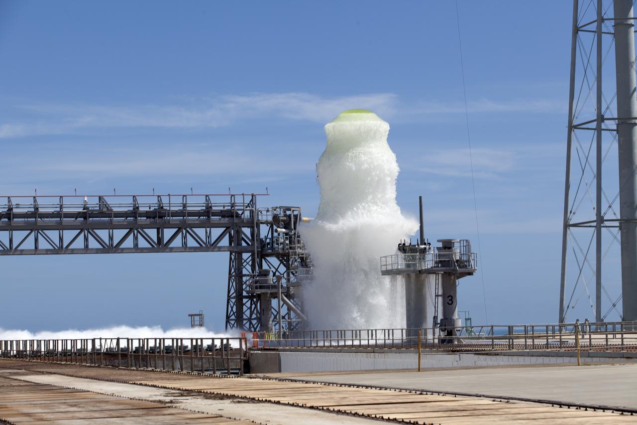
About 450,000 gallons of water flowed at high speed from a holding tank through new and modified piping and valves, the flame trench, flame deflector nozzles and mobile launcher interface risers during a wet flow test at Launch Pad 39B at NASA's Kennedy Space Center in Florida. At peak flow, the water reached about 100 feet in the air above the pad surface. The test was a milestone to confirm and baseline the performance of the Ignition Overpressure/Sound Suppression system. During launch of NASA's Space Launch System rocket and Orion spacecraft, the high-speed water flow will help protect the vehicle from the extreme acoustic and temperature environment during ignition and liftoff.

About 450,000 gallons of water flowed at high speed from a holding tank through new and modified piping and valves, the flame trench, flame deflector nozzles and mobile launcher interface risers during a wet flow test at Launch Pad 39B at NASA's Kennedy Space Center in Florida. At peak flow, the water reached about 100 feet in the air above the pad surface. The test was a milestone to confirm and baseline the performance of the Ignition Overpressure/Sound Suppression system. During launch of NASA's Space Launch System rocket and Orion spacecraft, the high-speed water flow will help protect the vehicle from the extreme acoustic and temperature environment during ignition and liftoff.
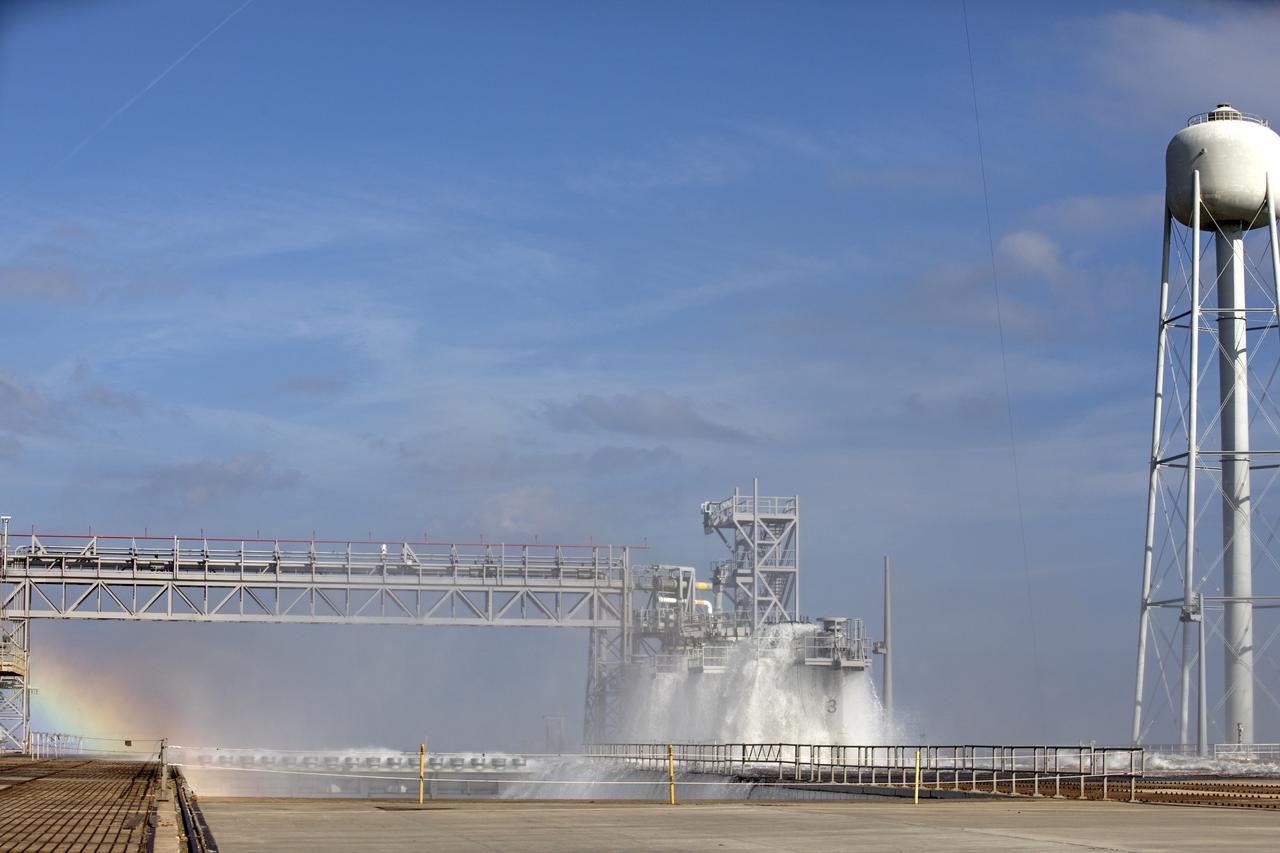
About 450,000 gallons of water flowed at high speed from a holding tank through new and modified piping and valves, the flame trench, flame deflector nozzles and mobile launcher interface risers during a wet flow test at Launch Pad 39B at NASA's Kennedy Space Center in Florida. At peak flow, the water reached about 100 feet in the air above the pad surface. The test was a milestone to confirm and baseline the performance of the Ignition Overpressure/Sound Suppression system. During launch of NASA's Space Launch System rocket and Orion spacecraft, the high-speed water flow will help protect the vehicle from the extreme acoustic and temperature environment during ignition and liftoff.

About 450,000 gallons of water flowed at high speed from a holding tank through new and modified piping and valves, the flame trench, flame deflector nozzles and mobile launcher interface risers during a wet flow test at Launch Pad 39B at NASA's Kennedy Space Center in Florida. At peak flow, the water reached about 100 feet in the air above the pad surface. The test was a milestone to confirm and baseline the performance of the Ignition Overpressure/Sound Suppression system. During launch of NASA's Space Launch System rocket and Orion spacecraft, the high-speed water flow will help protect the vehicle from the extreme acoustic and temperature environment during ignition and liftoff.
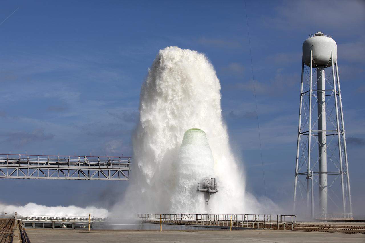
About 450,000 gallons of water flowed at high speed from a holding tank through new and modified piping and valves, the flame trench, flame deflector nozzles and mobile launcher interface risers during a wet flow test at Launch Pad 39B at NASA's Kennedy Space Center in Florida. At peak flow, the water reached about 100 feet in the air above the pad surface. The test was a milestone to confirm and baseline the performance of the Ignition Overpressure/Sound Suppression system. During launch of NASA's Space Launch System rocket and Orion spacecraft, the high-speed water flow will help protect the vehicle from the extreme acoustic and temperature environment during ignition and liftoff.
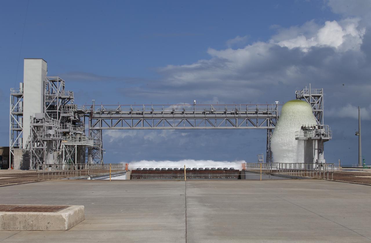
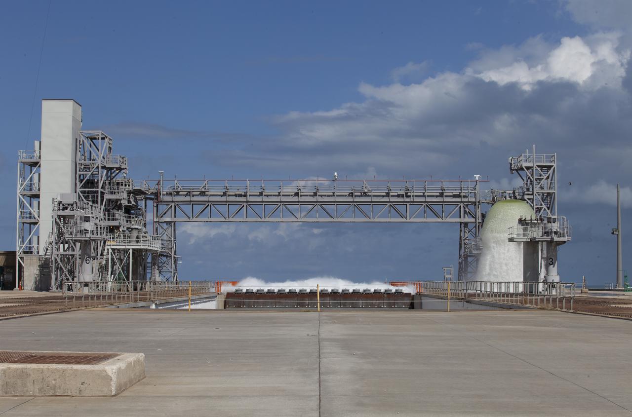
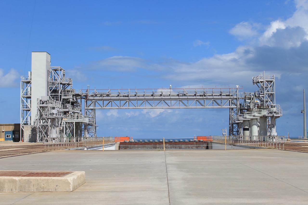
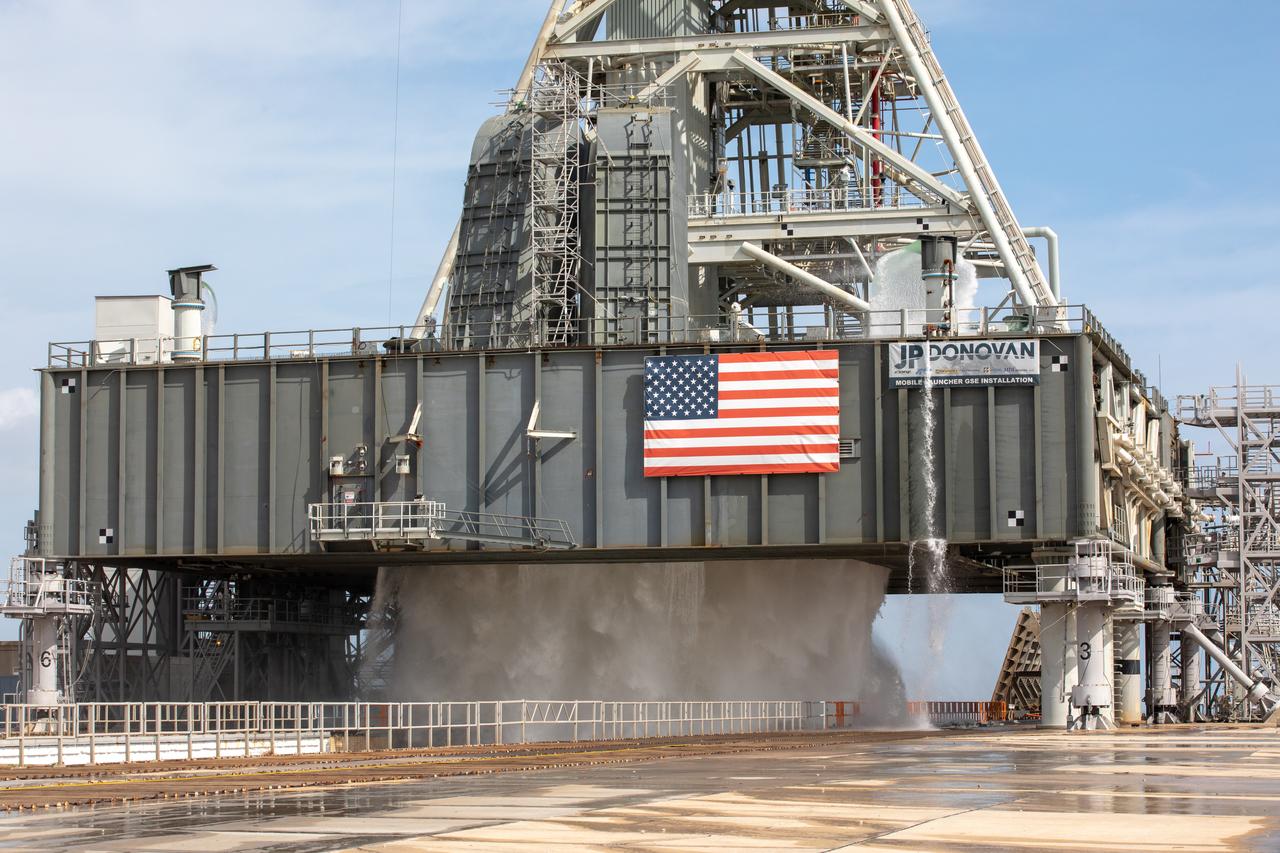
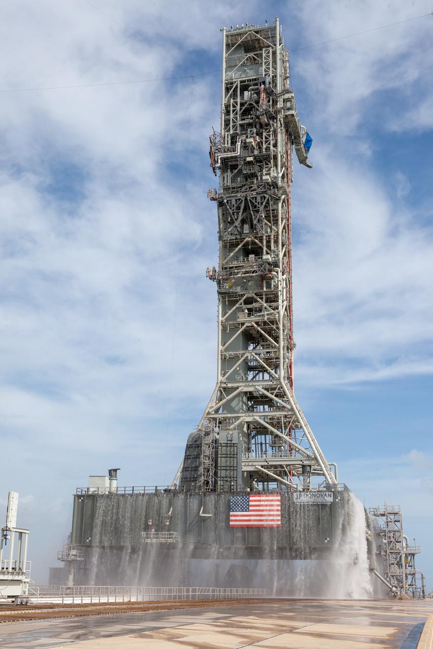
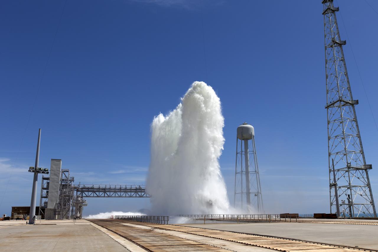
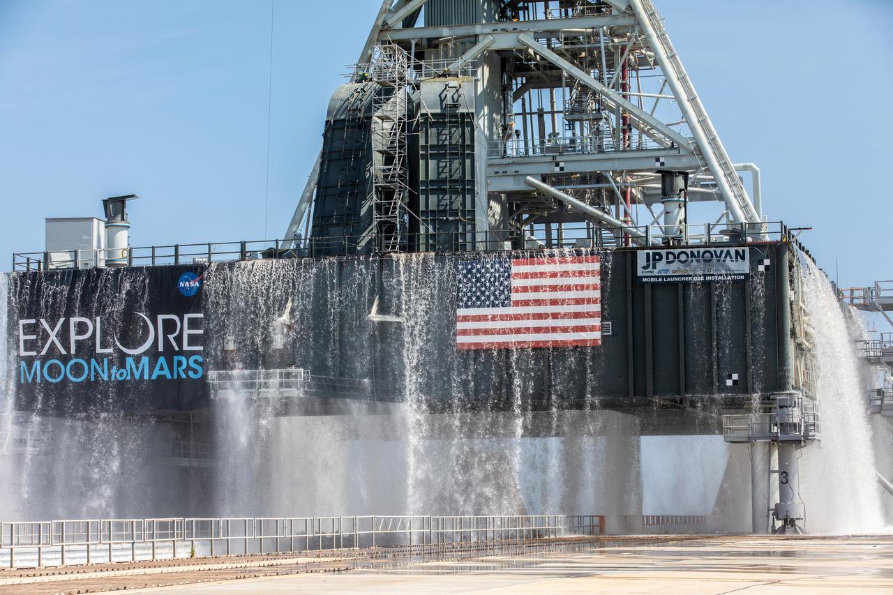
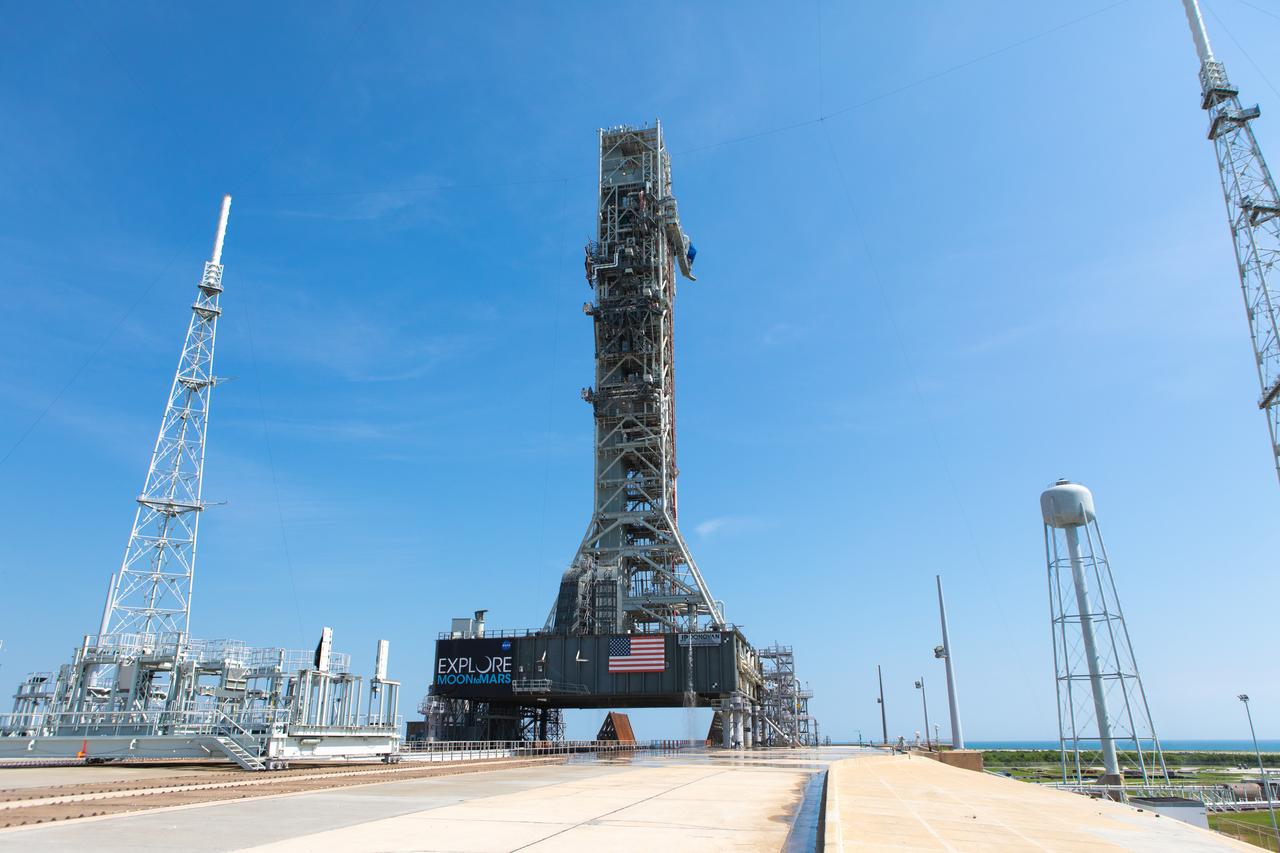
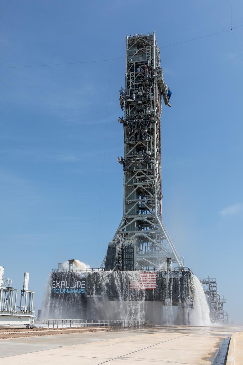
A flow test of the Ignition Overpressure Protection and Sound Suppression water deluge system is underway on the mobile launcher at Launch Pad 39B at NASA's Kennedy Space Center in Florida, on July 25, 2019. The testing is part of a series of tests that Exploration Ground System is doing to verify the system is ready for the new Space Launch System rocket. Modifications were made to the pad after a previous wet flow test, increasing the performance of the system. During the launch of Artemis 1 and subsequent missions, this water deluge system will release about 450,000 gallons of water across the mobile launcher and Flame Deflector to reduce the extreme heat and energy generated by the rocket during ignition and liftoff.
A flow test of the Ignition Overpressure Protection and Sound Suppression water deluge system is underway on the mobile launcher at Launch Pad 39B at NASA's Kennedy Space Center in Florida, on July 25, 2019. The testing is part of a series of tests that Exploration Ground System is doing to verify the system is ready for the new Space Launch System rocket. Modifications were made to the pad after a previous wet flow test, increasing the performance of the system. During the launch of Artemis 1 and subsequent missions, this water deluge system will release about 450,000 gallons of water across the mobile launcher and Flame Deflector to reduce the extreme heat and energy generated by the rocket during ignition and liftoff.
A flow test of the Ignition Overpressure Protection and Sound Suppression water deluge system is underway on the mobile launcher at Launch Pad 39B at NASA's Kennedy Space Center in Florida, on July 25, 2019. The testing is part of a series of tests that Exploration Ground System is doing to verify the system is ready for the new Space Launch System rocket. Modifications were made to the pad after a previous wet flow test, increasing the performance of the system. During the launch of Artemis 1 and subsequent missions, this water deluge system will release about 450,000 gallons of water across the mobile launcher and Flame Deflector to reduce the extreme heat and energy generated by the rocket during ignition and liftoff.
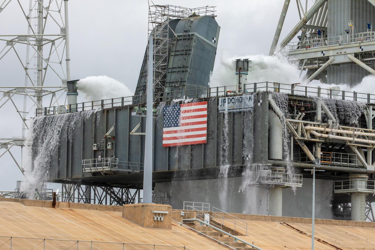
A flow test of the Ignition Overpressure Protection and Sound Suppression water deluge system begins on the mobile launcher at Launch Pad 39B at NASA's Kennedy Space Center in Florida, on July 25, 2019. The testing is part of a series of tests that Exploration Ground System is doing to verify the system is ready for the new Space Launch System rocket. Modifications were made to the pad after a previous wet flow test, increasing the performance of the system. During the launch of Artemis 1 and subsequent missions, this water deluge system will release about 450,000 gallons of water across the mobile launcher and Flame Deflector to reduce the extreme heat and energy generated by the rocket during ignition and liftoff.

A flow test of the Ignition Overpressure Protection and Sound Suppression water deluge system is underway on the mobile launcher at Launch Pad 39B at NASA's Kennedy Space Center in Florida, on July 25, 2019. The testing is part of a series of tests that Exploration Ground System is doing to verify the system is ready for the new Space Launch System rocket. Modifications were made to the pad after a previous wet flow test, increasing the performance of the system. During the launch of Artemis 1 and subsequent missions, this water deluge system will release about 450,000 gallons of water across the mobile launcher and Flame Deflector to reduce the extreme heat and energy generated by the rocket during ignition and liftoff.
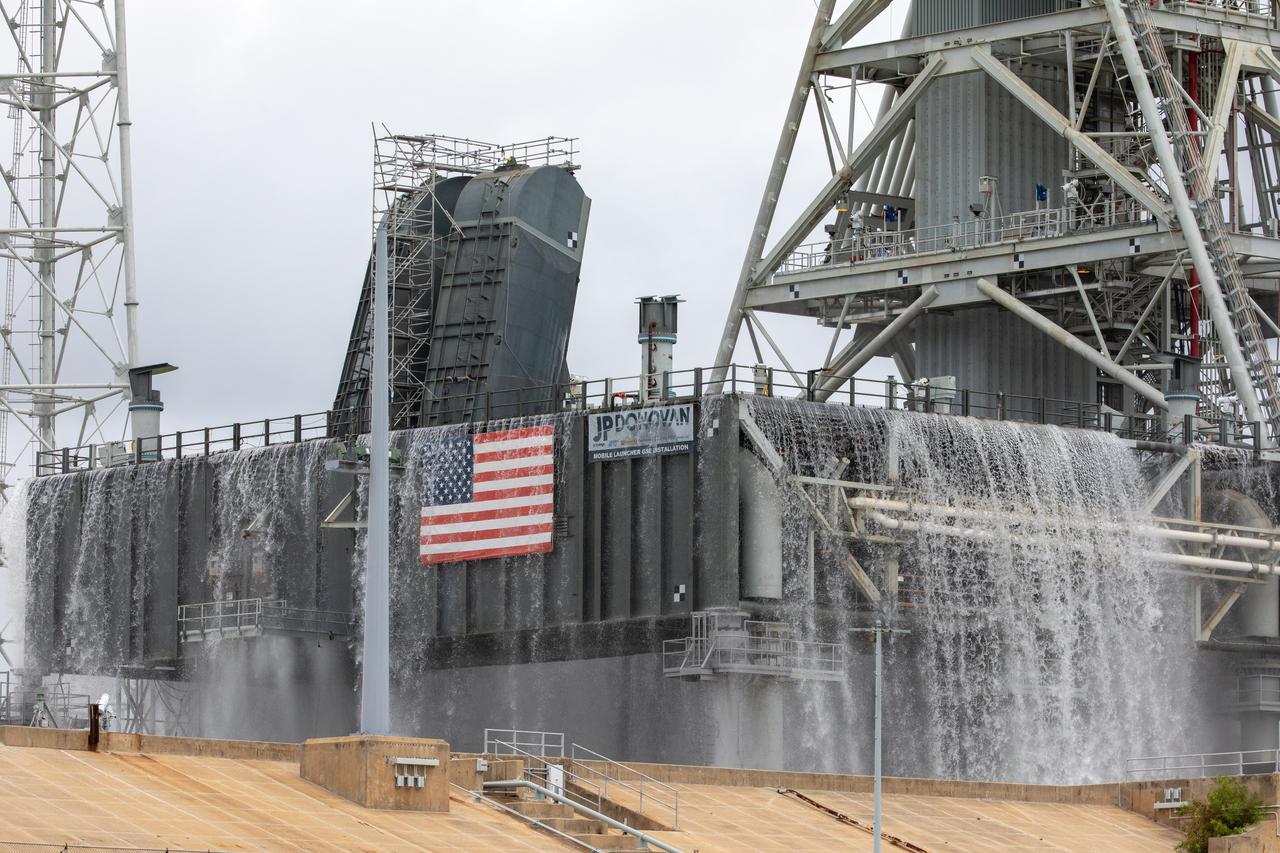
A flow test of the Ignition Overpressure Protection and Sound Suppression water deluge system is underway on the mobile launcher at Launch Pad 39B at NASA's Kennedy Space Center in Florida, on July 25, 2019. The testing is part of a series of tests that Exploration Ground System is doing to verify the system is ready for the new Space Launch System rocket. Modifications were made to the pad after a previous wet flow test, increasing the performance of the system. During the launch of Artemis 1 and subsequent missions, this water deluge system will release about 450,000 gallons of water across the mobile launcher and Flame Deflector to reduce the extreme heat and energy generated by the rocket during ignition and liftoff.
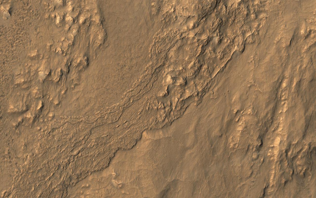
This oblique view from NASA's Mars Reconnaissance Orbiter shows a small part of the near-rim ejecta from Tooting Crater. The flow extending from upper left to lower right looks much like a typical lava flow, but doesn't emanate from a volcanic vent. Instead, this must be either melted rock from the impact event, or a wet debris flow from melting of ice. The surface is dusty so color variations are minor. https://photojournal.jpl.nasa.gov/catalog/PIA21648
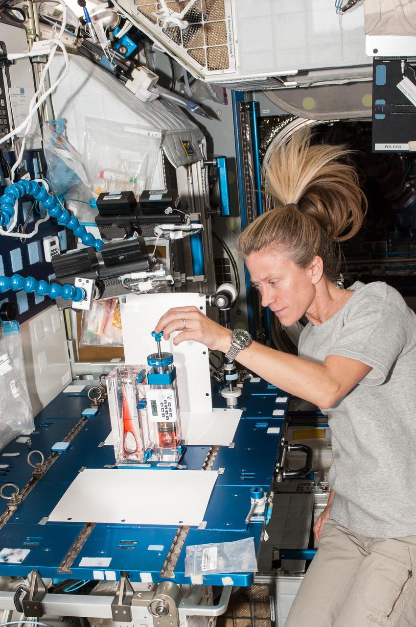
Astronaut Karen Nyberg,Expedition 36 flight engineer,works on the Capillary Flow Experiment (CFE) Vane Gap-1 (VG-1) setup in the Node 2/Harmony. The CFE-2 vessel is used to observe fluid interface and critical wetting behavior in a cylindrical chamber with elliptic cross-section and an adjustable central perforated vane. The primary objective of the Vane Gap experiments is to determine equilibrium interface configurations and critical wetting conditions for interfaces between interior corners separated by a gap.
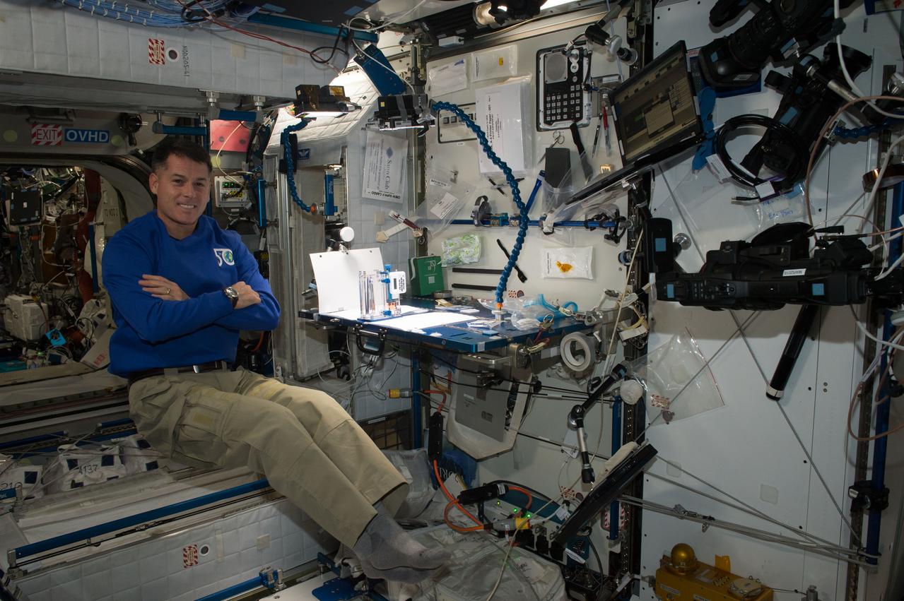
iss050e014941 (12/8/2016) --- NASA astronaut Shane Kimbrough during Capillary Flow Experiment-2 (CFE-2) with the Interior Corner Flow 1 hardware. The Capillary Flow Experiments demonstrate how capillary forces work in space, how differently shaped containers change the wicking behavior of a wetting fluid, and how such can be used to passively separate liquids and gases. Understanding how microgravity amplifies these behaviors could improve the reliability of such key processes as water purification fuel storage and supply, and general liquid transport aboard spacecraft.
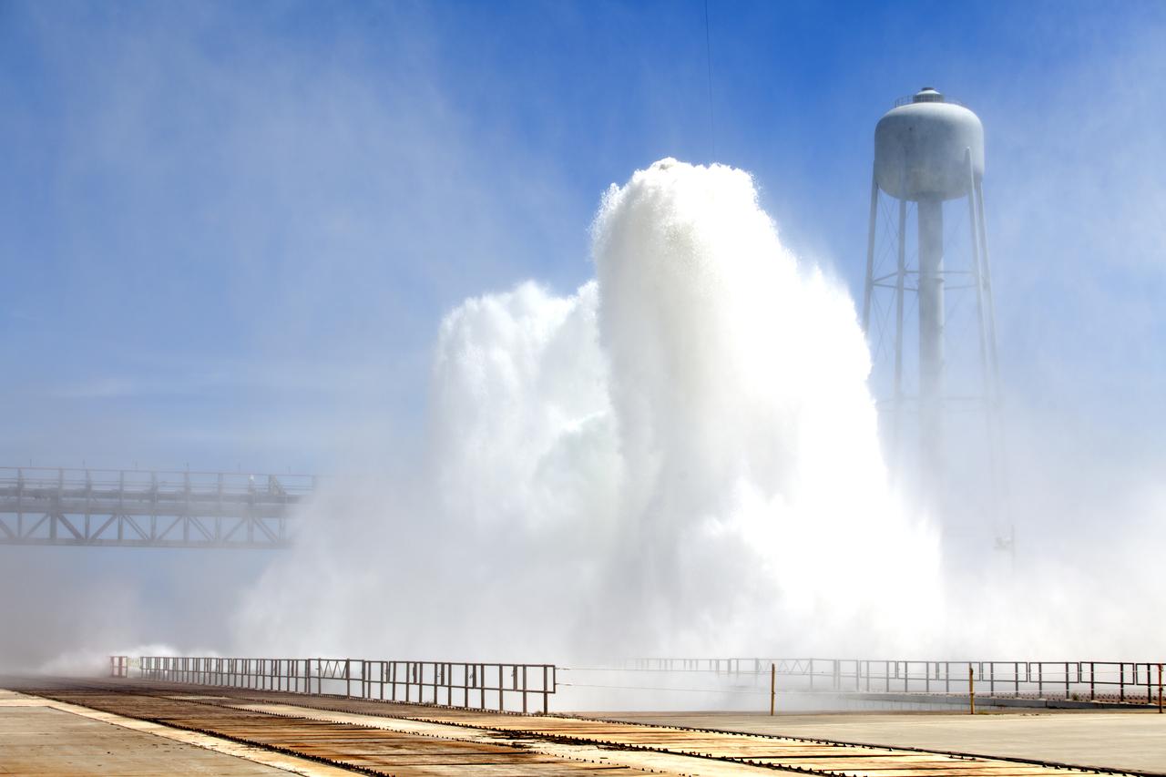
About 450,000 gallons of water flow at high speed from a holding tank through new and modified piping and valves, the flame trench, flame deflector nozzles and mobile launcher interface risers during a wet flow test on May 24, 2018, at Launch Pad 39B at NASA's Kennedy Space Center in Florida. At peak flow, the water reached about 100 feet in the air above the pad surface. The test was performed by Exploration Ground Systems to confirm the performance of the Ignition Overpressure/Sound Suppression system. During launch of NASA's Space Launch System rocket and Orion spacecraft, the high-speed water flow will help protect the vehicle from the extreme acoustic and temperature environment during ignition and liftoff.
About 450,000 gallons of water flow at high speed from a holding tank through new and modified piping and valves, the flame trench, flame deflector nozzles and mobile launcher interface risers during a wet flow test on May 24, 2018, at Launch Pad 39B at NASA's Kennedy Space Center in Florida. At peak flow, the water reached about 100 feet in the air above the pad surface. The test was performed by Exploration Ground Systems to confirm the performance of the Ignition Overpressure/Sound Suppression system. During launch of NASA's Space Launch System rocket and Orion spacecraft, the high-speed water flow will help protect the vehicle from the extreme acoustic and temperature environment during ignition and liftoff.
About 450,000 gallons of water flow at high speed from a holding tank through new and modified piping and valves, the flame trench, flame deflector nozzles and mobile launcher interface risers during a wet flow test on May 24, 2018, at Launch Pad 39B at NASA's Kennedy Space Center in Florida. At peak flow, the water reached about 100 feet in the air above the pad surface. The test was performed by Exploration Ground Systems to confirm the performance of the Ignition Overpressure/Sound Suppression system. During launch of NASA's Space Launch System rocket and Orion spacecraft, the high-speed water flow will help protect the vehicle from the extreme acoustic and temperature environment during ignition and liftoff.

About 450,000 gallons of water flow at high speed from a holding tank through new and modified piping and valves, the flame trench, flame deflector nozzles and mobile launcher interface risers during a wet flow test on May 24, 2018, at Launch Pad 39B at NASA's Kennedy Space Center in Florida. At peak flow, the water reached about 100 feet in the air above the pad surface. The test was performed by Exploration Ground Systems to confirm the performance of the Ignition Overpressure/Sound Suppression system. During launch of NASA's Space Launch System rocket and Orion spacecraft, the high-speed water flow will help protect the vehicle from the extreme acoustic and temperature environment during ignition and liftoff.
About 450,000 gallons of water flow at high speed from a holding tank through new and modified piping and valves, the flame trench, flame deflector nozzles and mobile launcher interface risers during a wet flow test on May 24, 2018, at Launch Pad 39B at NASA's Kennedy Space Center in Florida. At peak flow, the water reached about 100 feet in the air above the pad surface. The test was performed by Exploration Ground Systems to confirm the performance of the Ignition Overpressure/Sound Suppression system. During launch of NASA's Space Launch System rocket and Orion spacecraft, the high-speed water flow will help protect the vehicle from the extreme acoustic and temperature environment during ignition and liftoff.

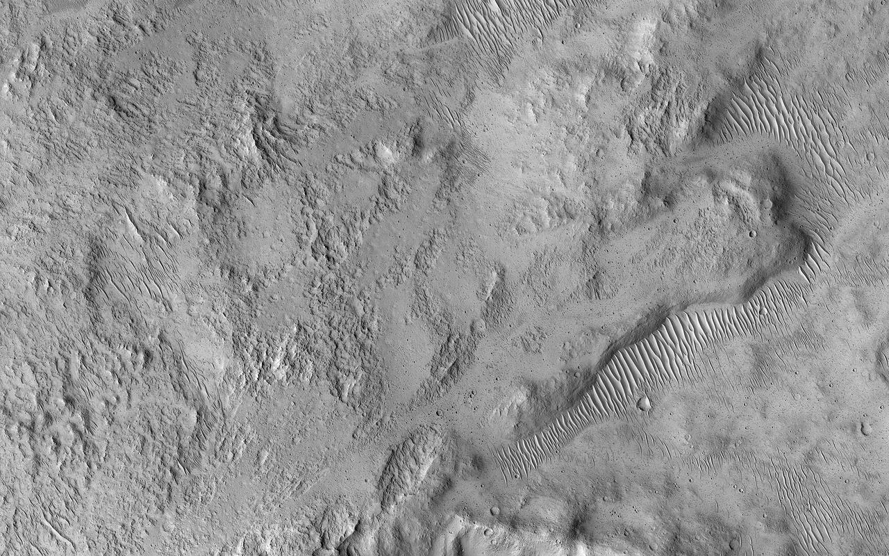
Today's VIS image shows a small channel located west of Holden Crater in Noachis Terra. The channel appears to arise from and flow to – well, nowhere. Small channel systems like this occur all over the surface of Mars. It was likely formed during the 'wet' period of Mars' history, when surface flows carved the large channels on Mars, but also lots of little channel just like this one. Orbit Number: 90745 Latitude: -25.9086 Longitude: 324.246 Instrument: VIS Captured: 2022-05-30 05:51 https://photojournal.jpl.nasa.gov/catalog/PIA25480

Chukhung is a 45 kilometer-diameter, central pit crater in Tempe Terra, having likely formed 3 billion years ago. The southern portion of the crater floor hosts a large viscous flow feature that is hypothesized to be a glacier. There are sinuous ridges that emanate from the margin of the flow feature toward the center of the crater. These ridges could be evidence of glacial meltwater preserved in the form of eskers, inverted channels formed when the softer sediments surrounding the channel deposits are eroded away. It is unclear whether the conditions for wet-based glaciation ever existed on Mars, but these ridges could be evidence that it once did. https://photojournal.jpl.nasa.gov/catalog/PIA23528
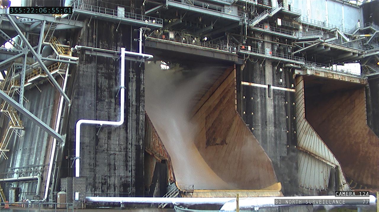
NASA’s Exploration Ground Systems conducts a water flow test with the mobile launcher at Kennedy Space Center’s Pad 39B in Florida on July 2, 2019. It is the first of nine tests to verify the sound suppression system is ready for launch of NASA’s Space Launch System for the first Artemis mission. During launch, 400,000 gallons of water will rush onto the pad to help protect the rocket, NASA’s Orion Spacecraft, mobile launcher, and launch pad from the extreme acoustic and temperature environment.
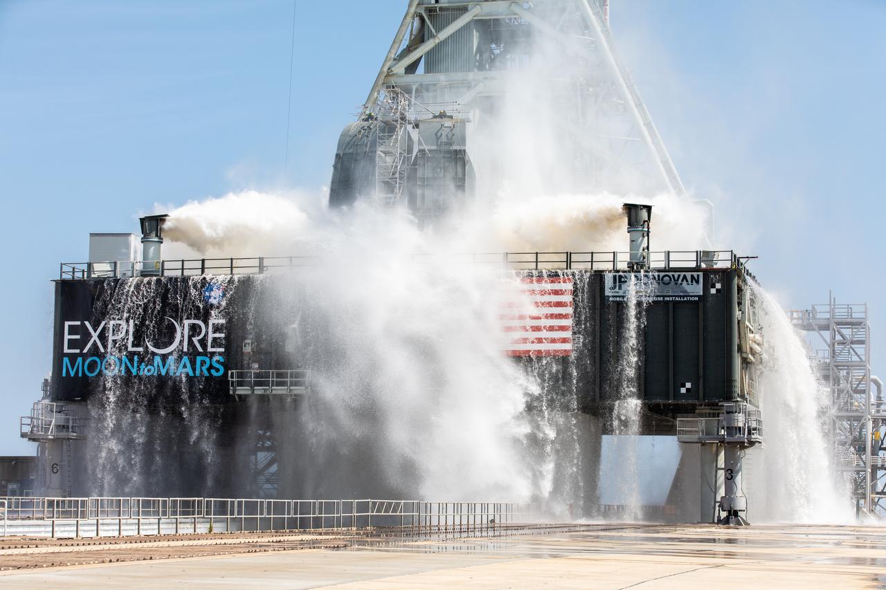
NASA’s Exploration Ground Systems conducts a water flow test with the mobile launcher at Kennedy Space Center’s Pad 39B in Florida on July 2, 2019. It is the first of nine tests to verify the sound suppression system is ready for launch of NASA’s Space Launch System for the first Artemis mission. During launch, 400,000 gallons of water will rush onto the pad to help protect the rocket, NASA’s Orion Spacecraft, mobile launcher, and launch pad from the extreme acoustic and temperature environment.
NASA’s Exploration Ground Systems conducts a water flow test with the mobile launcher at Kennedy Space Center’s Pad 39B in Florida on July 2, 2019. It is the first of nine tests to verify the sound suppression system is ready for launch of NASA’s Space Launch System for the first Artemis mission. During launch, 400,000 gallons of water will rush onto the pad to help protect the rocket, NASA’s Orion Spacecraft, mobile launcher, and launch pad from the extreme acoustic and temperature environment.
NASA’s Exploration Ground Systems conducts a water flow test with the mobile launcher at Kennedy Space Center’s Pad 39B in Florida on July 2, 2019. It is the first of nine tests to verify the sound suppression system is ready for launch of NASA’s Space Launch System for the first Artemis mission. During launch, 400,000 gallons of water will rush onto the pad to help protect the rocket, NASA’s Orion Spacecraft, mobile launcher, and launch pad from the extreme acoustic and temperature environment.
NASA’s Exploration Ground Systems conducts a water flow test with the mobile launcher at Kennedy Space Center’s Pad 39B in Florida on July 2, 2019. It is the first of nine tests to verify the sound suppression system is ready for launch of NASA’s Space Launch System for the first Artemis mission. During launch, 400,000 gallons of water will rush onto the pad to help protect the rocket, NASA’s Orion Spacecraft, mobile launcher, and launch pad from the extreme acoustic and temperature environment.
NASA’s Exploration Ground Systems conducts a water flow test with the mobile launcher at Kennedy Space Center’s Pad 39B in Florida on July 2, 2019. It is the first of nine tests to verify the sound suppression system is ready for launch of NASA’s Space Launch System for the first Artemis mission. During launch, 400,000 gallons of water will rush onto the pad to help protect the rocket, NASA’s Orion Spacecraft, mobile launcher, and launch pad from the extreme acoustic and temperature environment.
NASA’s Exploration Ground Systems conducts a water flow test with the mobile launcher at Kennedy Space Center’s Pad 39B in Florida on July 2, 2019. It is the first of nine tests to verify the sound suppression system is ready for launch of NASA’s Space Launch System for the first Artemis mission. During launch, 400,000 gallons of water will rush onto the pad to help protect the rocket, NASA’s Orion Spacecraft, mobile launcher, and launch pad from the extreme acoustic and temperature environment.
NASA’s Exploration Ground Systems conducts a water flow test with the mobile launcher at Kennedy Space Center’s Pad 39B in Florida on July 2, 2019. It is the first of nine tests to verify the sound suppression system is ready for launch of NASA’s Space Launch System for the first Artemis mission. During launch, 400,000 gallons of water will rush onto the pad to help protect the rocket, NASA’s Orion Spacecraft, mobile launcher, and launch pad from the extreme acoustic and temperature environment.
NASA’s Exploration Ground Systems conducts a water flow test with the mobile launcher at Kennedy Space Center’s Pad 39B in Florida on July 2, 2019. It is the first of nine tests to verify the sound suppression system is ready for launch of NASA’s Space Launch System for the first Artemis mission. During launch, 400,000 gallons of water will rush onto the pad to help protect the rocket, NASA’s Orion Spacecraft, mobile launcher, and launch pad from the extreme acoustic and temperature environment.
View of Flight Engineer (FE) Mike Hopkins initiating a CFE-2 (Capillary Flow Experiment - 2) Interior Corner Flow - 5 (ICF-5) test run. Liquids behave differently in space than they do on Earth, so containers that can process, hold or transport them must be designed carefully to work in microgravity. The Capillary Flow Experiment-2 furthers research on wetting, which is a liquid's ability to spread across a surface, and its impact over large length scales in strange container shapes in microgravity environments. This work will improve our capabilities to quickly and accurately predict how related processes occur, and allow us to design better systems to process liquids aboard spacecraft (i.e., liquid fuel tanks, thermals fluids, and water processing for life support). Image was released by astronaut on Twitter.

View of Flight Engineer (FE) Koichi Wakata posing for a photo during a CFE-2 (Capillary Flow Experiment - 2) Interior Corner Flow - 8 (ICF-8) test run. Liquids behave differently in space than they do on Earth, so containers that can process, hold or transport them must be designed carefully to work in microgravity. The Capillary Flow Experiment-2 furthers research on wetting, which is a liquid's ability to spread across a surface, and its impact over large length scales in strange container shapes in microgravity environments. This work will improve capabilities to quickly and accurately predict how related processes occur, and allow us to design better systems to process liquids aboard spacecraft (i.e., liquid fuel tanks, thermals fluids, and water processing for life support). Image was released by astronaut on Twitter.
The gullies in this image are within the valley wall of an ancient channel-Nirgal Vallis-a testament to flowing water in Mars' ancient past. However, the formation of gullies are still the subject of much debate with respect to their formation: "wet" vs. "dry" or even "dry" with the aid of some lubricating fluid. Gullies most commonly form in the steep walls of simple craters. Gullies are common even in cold arctic deserts on Earth (e.g., the Haughton impact structure on Devon Island). This suggests that these provocative features can form on a mostly dry Mars that is only sporadically wet. Regardless, these features bear a remarkable resemblance to flowers, including the blossom, petals, stem, and roots. Can you see it too? http://photojournal.jpl.nasa.gov/catalog/PIA19294
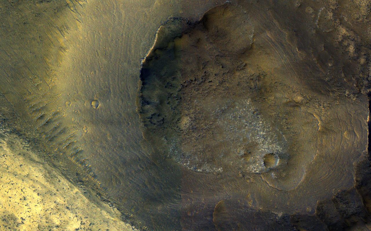
This small 2 kilometer-wide crater was sitting around, minding its own business when a meteoroid struck the ground just to the west and created a new, larger crater almost 10 kilometers in diameter (not pictured). The ejecta spraying out of the new crater landed back on the ground and then continued to flow away from the new crater, and the smaller crater was in the way of that muddy flow. You can see where much of the muddy material flowed around the crater's uplifted rim and forms a squiggly ridge, but you can also see where the mud flow slid over the rim and ponded down in the bottom of the crater. One question we don't know the answer to is: "how wet was the muddy ejecta?" Ongoing observations like this and laboratory-based experiments are trying to find the answer to that question. This image also illustrates a common theme in geology, namely, the law of superposition. Because the crater has been affected by ejecta from the larger crater to the west, the small crater had to be there first and then the second, larger crater and its ejecta had to form. This allows planetary geologists to decipher the relative ages of different landforms. Because a central goal of geology is to understand past events from present-day clues, geology is sometimes compared to forensic science. http://photojournal.jpl.nasa.gov/catalog/PIA13181

This crater is approximately 2.3 kilometers across and is located in northern Arabia Terra near where the cratered highlands meets the northern lowlands (called a "dichotomy boundary"). Small craters with an exit channel, such as this one, are nicknamed "pollywog" craters, as they resemble tadpoles. The channel is consistent with flow *out of* the crater, rather than flow *into* the crater, because 1) the valleys do not cut down to the level of the interior crater floor, and 2) there are no deposits of material on the floor associated with the mouth of the valley. This small crater was probably once filled with an ice-covered lake that overflowed, forming the exit channel. Young craters with exit channels are intriguing because they record a relatively recent (during the Amazonian epoch) wet environment on Mars. https://photojournal.jpl.nasa.gov/catalog/PIA23738
This image from NASA's Mars Reconnaissance Orbiter (MRO) shows a hill with a central crater. Such features have been interpreted as both mud volcanoes (really a sedimentary structure) and as actual volcanoes (the erupting lava kind). They occur on the floor of Valles Marineris below a closed topographic contour that could have held a lake, and the compaction of wet sediments may have created mud volcanoes. The fracture pattern of the bright flow unit surrounding the hill resembles mud cracks. However, there have also been observations from the CRISM instrument interpreted as high-temperature minerals, suggesting actual volcanism, although not necessarily at this location. Fine layers in the hill are consistent with either volcanism or mud flows. Either way, this activity is relatively recent in geologic time and may mark habitable subsurface environments. https://photojournal.jpl.nasa.gov/catalog/PIA22514
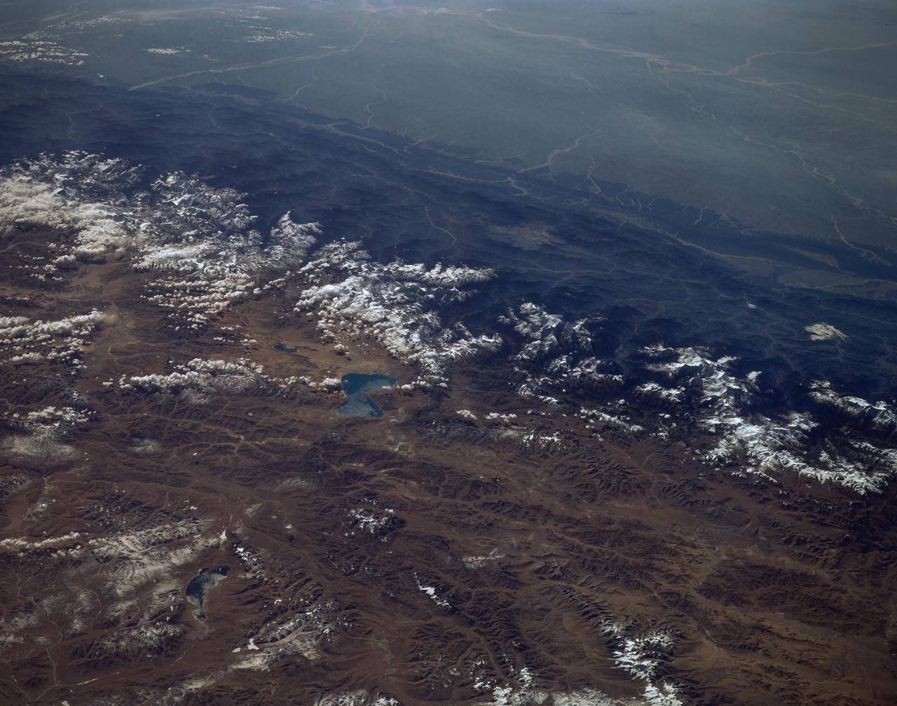
View is southeastward across China (Tibet), half of Nepal and India. The partly frozen lake near the center of the frame is Pei-Ku T'so ("Bos-tie Lake"). The central Himalaya stretches from Mount Everest on the left past Annapurna on the right. Large tributaries converge to form the Ganges River, flowing through the lowland basin south of the Himalaya. This photograph illustrates the rain shadow effect of the Himalaya Chain; wet, warm air from the Indian Ocean is driven against the mountains, lifted, and drained of water that forms ice caps, the abundant rivers, and forests of the foothills. In contrast the high plateau of Tibet is arid, composed largely of topographically-closed basins because stream flow is inadequate to form integrated drainage networks.
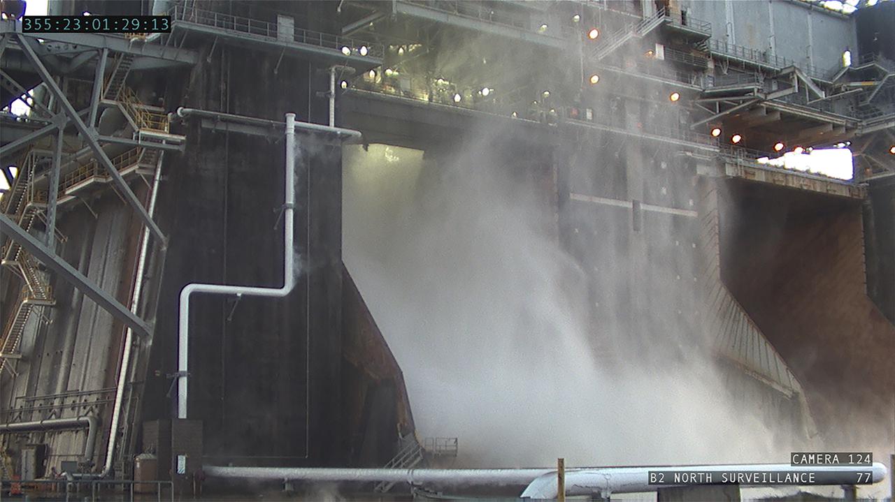
Operators at the B-2 Test Stand at Stennis Space Center near Bay St. Louis, Mississippi, conducted a wet dress rehearsal for the hot fire test of the core stage of NASA’s Space Launch System on Dec. 21, 2020. In this image, water flows from the B-2 Test Stand flame deflector, just as it will during an actual hot fire test. The hot fire will conclude a series of eight Green Run tests of all core stage systems before it is transported to Kennedy Space Center for launch on the Artemis I mission.
These sand dunes are a type of aeolian bedform and partly encircle the Martian North Pole in a region called Olympia Undae. Unlike most of the sand dunes on Mars that are made of the volcanic rock basalt, these are made of a type of sulfate mineral called gypsum. Whence the sand? Well, gypsum is a mineral that can often form from the evaporation of water that has sulfur and calcium dissolved in it. This sand was probably sourced from a northern region on Mars that used to be quite wet. The boxy gridding of the dunes indicates that the wind blows in multiple directions. Note: "Aeolian" means wind-blown and "bedform" means piles of sediment shaped by a flowing fluid (liquid or gas). http://photojournal.jpl.nasa.gov/catalog/PIA20743
Operators at the B-2 Test Stand at Stennis Space Center near Bay St. Louis, Mississippi, conducted a wet dress rehearsal for the hot fire test of the core stage of NASA’s Space Launch System on Dec. 21, 2020. In this image, water flows from the B-2 Test Stand flame deflector, just as it will during an actual hot fire test. The hot fire will conclude a series of eight Green Run tests of all core stage systems before it is transported to Kennedy Space Center for launch on the Artemis I mission.
It drains a watershed that spans eight countries and nearly 1.6 million square kilometers 600,000 square miles. The Zambezi also Zambeze is the fourth largest river in Africa, and the largest east-flowing waterway. The Operational Land Imager on the Landsat 8 satellite acquired this natural-color image of the Zambezi Delta on August 29, 2013. Sandbars and barrier spits stretch across the mouths of the delta, and suspended sediment extends tens of kilometers out into the sea. The sandy outflow turns the coastal waters to a milky blue-green compared to the deep blue of open water in the Indian Ocean. The Zambezi Delta includes 230 kilometers of coastline fronting 18,000 square kilometers (7,00 square miles) of swamps, floodplains, and even savannahs (inland). The area has long been prized by subsistence fishermen and farmers, who find fertile ground for crops like sugar and fertile waters for prawns and fish. Two species of endangered cranes and one of the largest concentration of buffalo in Africa -- among many other species of wildlife -- have found a haven in this internationally recognized wetland. However, the past six decades have brought great changes to the Zambezi Delta, which used to pour more water and sediment off of the continent. Hydropower dams upstream-most prominently, the Kariba and the Cahora Bassa-greatly reduce river flows during the wet season; they also trap sediments that would otherwise flow downstream. The result has been less water reaching the delta and the floodplains, which rely on pulses of nutrients and sediments from annual (and mostly benign) natural flooding. The change in the flow of the river affects freshwater availability and quality in the delta. Strong flows push fresh water further out into the sea and naturally keep most of a delta full of fresh (or mostly fresh) water. When that fresh flow eases, the wetlands become drier and more prone to fire. Salt water from the Indian Ocean also can penetrate further into the marsh, upsetting the ecological balance for aquatic plant and animal species. Researchers have found that the freshwater table in the delta has dropped as much as five meters in the 50 years since dams were placed on the river. Less river flow also affects the shape and extent of the delta. Today there is less sediment replenishing the marshes and beaches as they are scoured by ocean waves and tides. "What strikes me in this image is the suspended sediment offshore," said Liviu Giosan, a delta geologist at the Woods Hole Oceanographic Institution. "Sediment appears to be transferred from the delta offshore in plumes that not only originate in active river mouths but also from deactivated former mouths, now tidal channels. This shows the power of tidal scouring contributing to the slow but relentless erosion of the delta." http://photojournal.jpl.nasa.gov/catalog/PIA18155
Streamlined forms and channel bars in this Martian valley resulted from the outflow of a lake hundreds of millions years more recently than an era of Martian lakes previously confirmed, according to 2016 findings. This excerpt from an image taken by the Context Camera on NASA's Mars Reconnaissance Orbiter covers an area about 8 miles (13 kilometers) wide in the northern Arabia Terra region of Mars. The flow direction was generally northward (toward the top of this image). The channel breached a water-filled basin identified as "B" in a hydrologic-modeling map at PIA20839 and flowed toward a larger basin, informally called "Heart Lake," about 50 miles (80 kilometers) to the northwest. Researchers estimate this stream and the lakes it linked held water at some time in the range of 2 billion to 3 billion years ago. That is several hundred million to about 1 billion years later than better-known ancient lake environments on Mars, such as those documented by NASA's Curiosity rover mission. The later wet period came after it is generally thought that most of Mars' original atmosphere had been lost and most of the remaining water on the planet had frozen. Seasonal melting may have fed this stream. This is a portion of Context Camera image B18_016815_2151. http://photojournal.jpl.nasa.gov/catalog/PIA20837
ISS012-E-23057 (2 March 2006) --- Ekuma River and Etosha Pan, Namibia are featured in this close-up image photographed by an Expedition 12 crewmember on the International Space Station. Etosha Pan, northern Namibia, is a large (120 kilometers or 75 mile long) dry lakebed in the Kalahari Desert. The lake and surrounds are protected today as one of Namibia’s largest wildlife parks. Herds of elephant occupy the dense mopane woodland on the south side of the lake. Mopane trees are common throughout south-central Africa, and host the mopane worm (the larval form of the Mopane Emperor Moth)–an important source of protein for rural communities. According to scientists, about 16,000 years ago, when ice sheets were melting across Northern Hemisphere land masses, a wet climate phase in southern Africa filled Etosha Lake. Today, Etosha Pan is seldom seen with even a thin sheet of water covering the salt pan. This view shows the point where the Ekuma River flows into the salt lake. The Ekuma River is almost never seen with water, but in early 2006 rainfall twice the average amount in the river’s catchment generated flow. Greens and browns show vegetation and algae growing in different depths of water where the river enters the dry lake. Typically, little river water or sediment reaches the dry lake because water seeps into the riverbed along its 250 kilometers (155 miles) course, reducing discharge along the way. In this image, there was enough surface flow to reach the Pan, but too little water reached the mouth of the river to flow beyond the inlet bay. The unusual levels of precipitation also filled several small, usually dry lakes to the north of Etosha Pan.
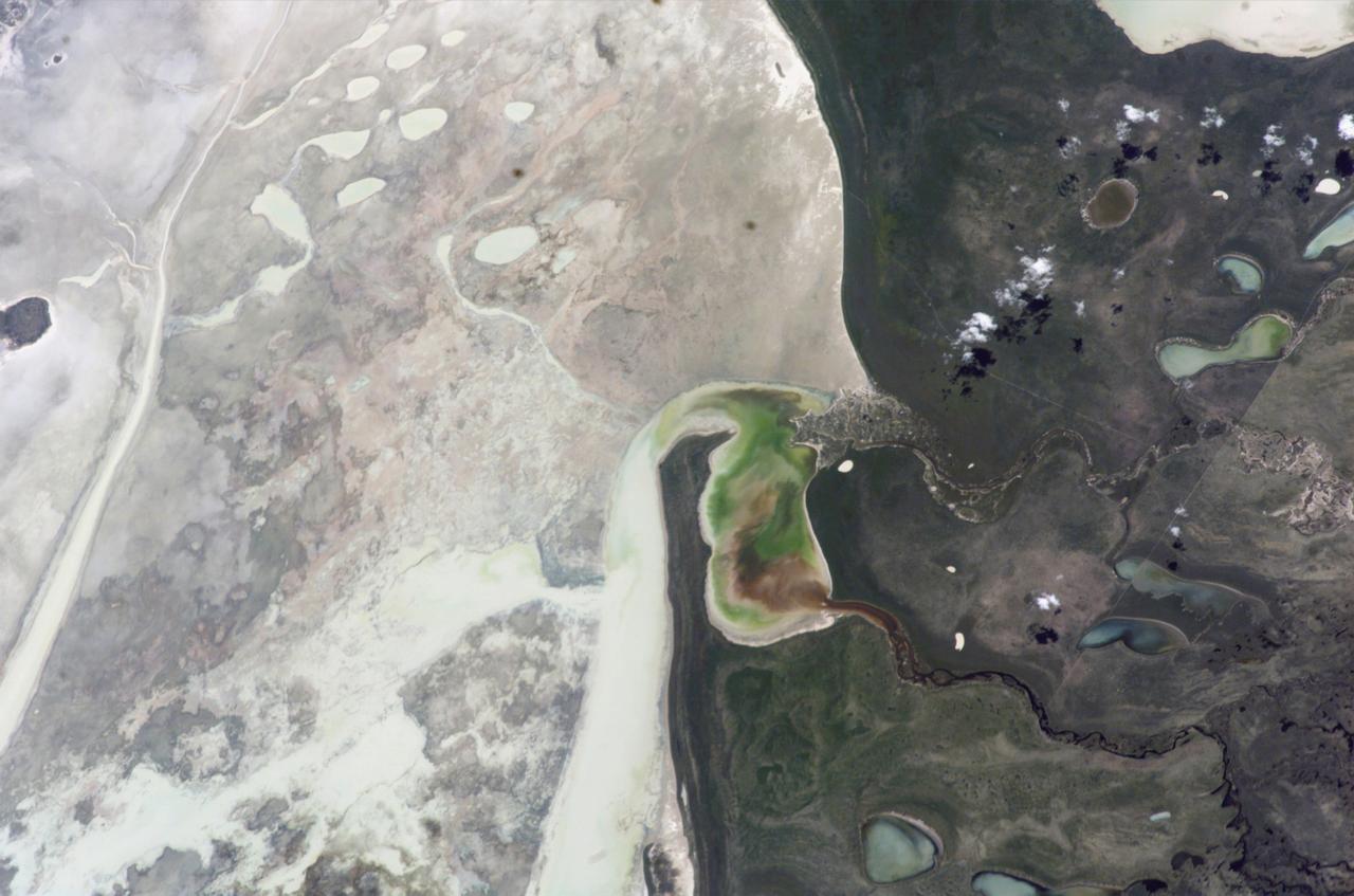
ISS016-E-034524 (31 March 2008) --- Harrat Khaybar, Saudi Arabia is featured in this image photographed by an Expedition 16 crewmember on the International Space Station. The western half of the Arabian peninsula contains not only large expanses of sand and gravel, but extensive lava fields known as haraat (harrat for a named field). One such field is the 14,000-square kilometer Harrat Khaybar, located approximately 137 kilometers to the northeast of the city of Al Madinah (Medina). According to scientists, the volcanic field was formed by eruptions along a 100-kilometer long north-south linear vent system over the past 5 million years; the most recent recorded eruption took place between 600 - 700 A.D. Harrat Khaybar contains a wide range of volcanic rock types and spectacular landforms, several of which are represented in this view. Jabal al Quidr is built from several generations of dark, fluid basalt lava flows; the flows surround the 322--meter high stratovolcano (Jabal is translated as "mountain" in Arabic). Jabal Abyad, in the center of the image, was formed from a more viscous, silica-rich lava classified as a rhyolite. While Jabal al Quidr exhibits the textbook cone shape of a stratovolcano, Jabal Abyad is a lava dome -- a rounded mass of thicker, more solidified lava flows. To the west (top center) is the impressive Jabal Bayda'. This symmetric structure is a tuff cone, formed by eruption of lava in the presence of water. This leads to the production of wet, sticky pyroclastic deposits that can build a steep cone structure, particularly if the deposits consolidate quickly. White deposits visible in the crater of Jabal Bayda' (and two other locations to the south) are formed from sand and silt that accumulate in shallow, protected depressions. The presence of tuff cones -- together with other volcanic features indicative of water -- in the Harrat Khaybar suggest that the local climate was much wetter during some periods of volcanic activity. Today, however, the regional climate is hyperarid -- little to no yearly precipitation -- leading to an almost total lack of vegetation.
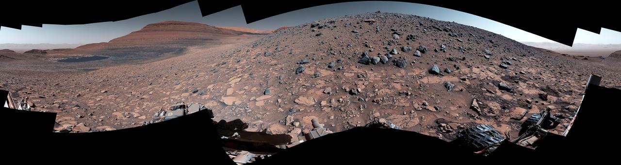
NASA's Curiosity Mars rover captured this 360-degree panorama using one of its black-and-white navigation cameras on Feb. 3, 2024, the 4,086th Martian day, or sol, of the mission. The panorama is made up of 36 images that were stitched together after being sent back to Earth. Since 2014, Curiosity has been ascending the foothills of Mount Sharp, which stands 3 miles (5 kilometers) above the floor of Gale Crater. The layers in this lower part of the mountain formed over millions of years under a changing Martian climate, providing scientists with a way to study how the presence of both water and the chemical ingredients required for life changed over time. This location is in an area Curiosity will be exploring for several months: Gediz Vallis channel. Seen from space, it resembles a winding, dry riverbed. Scientists are eager to study the area up close with Curiosity's instruments and confirm whether the channel was carved by debris flows (rapid, wet landslides) or an ancient river carrying rocks and sediment, as opposed to wind. https://photojournal.jpl.nasa.gov/catalog/PIA26246

This rendering shows the area where NASA's Curiosity Mars rover climbed a steep slope to reach a location called Gediz Vallis channel, which it began exploring for several months starting in February 2024. Imagery captured by the High-Resolution Imaging Experiment (HiRISE) camera on NASA's Mars Reconnaissance Orbiter, along with other instruments, were used to make the visualization. Since 2014, Curiosity has been ascending the foothills of Mount Sharp, which stands 3 miles (5 kilometers) above the floor of Gale Crater. The layers in this lower part of the mountain formed over millions of years under a changing Martian climate, providing scientists with a way to study how the presence of both water and the chemical ingredients required for life changed over time. This image covers part of a region on Mount Sharp enriched in sulfates, salty minerals that often form as water evaporates. At the bottom of the image is the slope Curiosity climbed to get here, which includes alternating dark and light bands of sedimentary material that scientists are still puzzling over. Above those bands is the roughly 300-foot-wide (91-meter-wide) Gediz Vallis channel. The formation's sides are filled with dark sand while its center is filled with mounds of boulders and other debris. Scientists aren't entirely sure how the channel was formed; it could have been carved into the surrounding bedrock by an ancient river or debris flows (rapid, wet landslides). The debris currently filling the channel could have been carried down the channel as debris flows or in dry avalanches. On the right side of the image, the mounds of debris form a large ridge that continues farther down Mount Sharp. The route in Figure A shows how Curiosity veered off to study the ridge up close. https://photojournal.jpl.nasa.gov/catalog/PIA26241
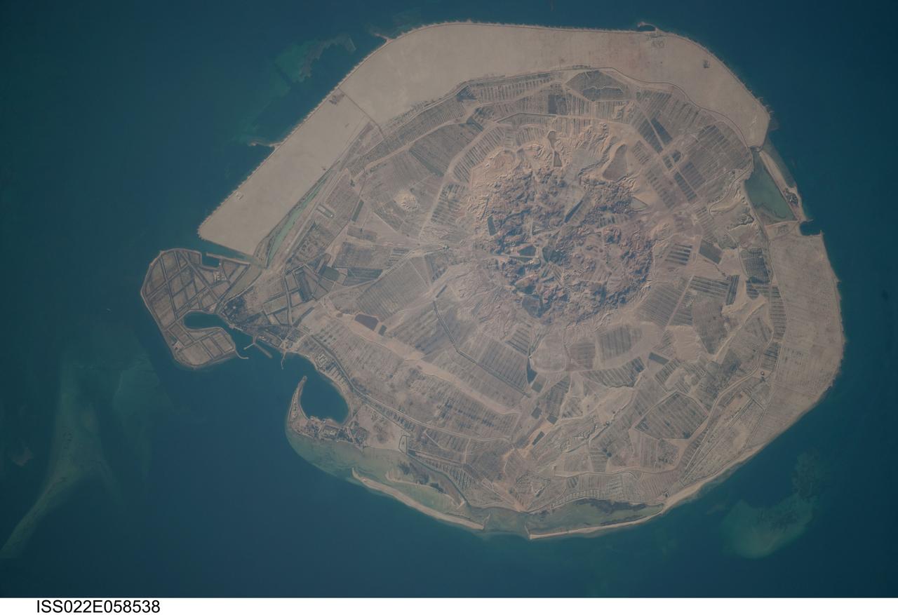
ISS022-E-058538 (31 Jan. 2010) --- Sir Bani Yas Island is featured in this image photographed by an Expedition 22 crew member on the International Space Station. Sir Bani Yas Island is located in the Persian Gulf near the western coastline of the United Arab Emirates (UAE). The approximately 14-kilometers x nine-kilometers island is the surface expression of a salt dome, and is one of several such islands in the Persian Gulf. During past periods of alternating wet and dry climate, sometimes involving areas with high rates of evaporation in enclosed basins, thick layers of salt minerals (such as halite ? common table salt, or gypsum ? a major component of wallboard) were deposited. These layers were subsequently buried by sediments; with enough overlaying material and depth of burial, the salt layers can begin to flow. Salt has lower density than the surrounding rock and it tends to flow upwards, pushing up the overlaying layers of rock to form a salt dome. While many salt domes retain a cap of the youngest rock layers at the surface, in some cases the underlaying salt extrudes onto the surface. This photograph illustrates the varying character of surfaces on the island. The central mountains of Jebel Wahid (center) mark the location of the Sir Bani Yas salt dome. The dome has breached the surface but exposed salt - primarily gypsum - is removed by erosion, leaving a rugged, insoluble cap formed from fragments of the overlaying sedimentary and volcanic rocks. Sand and silt derived from the Jebel Wahid area and surrounding gravel cover forms beaches along the outer edge of the island.
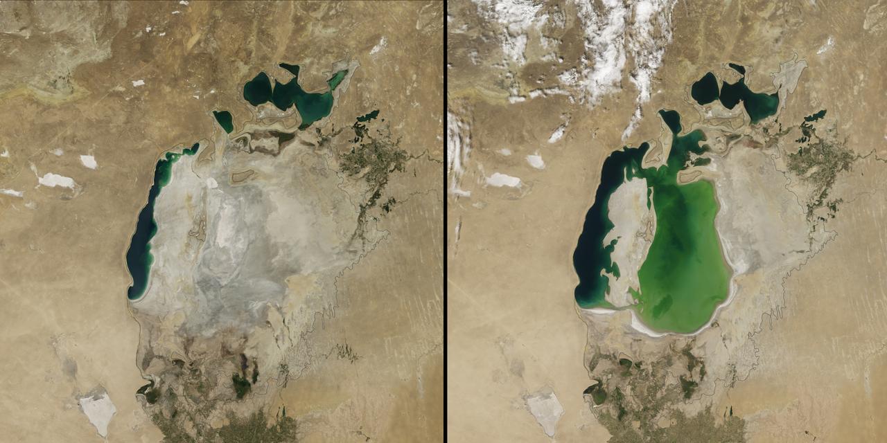
(Aral Sea: left 2014 and right 2000, 1960 extent black line) In the 1960s, the Soviet Union undertook a major water diversion project on the arid plains of Kazakhstan, Uzbekistan, and Turkmenistan. The region’s two major rivers, fed by snowmelt and precipitation in faraway mountains, were used to transform the desert into farms for cotton and other crops. Before the project, the Syr Darya and the Amu Darya rivers flowed down from the mountains, cut northwest through the Kyzylkum Desert, and finally pooled together in the lowest part of the basin. The lake they made, the Aral Sea, was once the fourth largest in the world. Although irrigation made the desert bloom, it devastated the Aral Sea. This series of images from the Moderate Resolution Imaging Spectroradiometer (MODIS) on NASA’s Terra satellite documents the changes. At the start of the series in 2000, the lake was already a fraction of its 1960 extent (black line). The Northern Aral Sea (sometimes called the Small Aral Sea) had separated from the Southern (Large) Aral Sea. The Southern Aral Sea had split into eastern and western lobes that remained tenuously connected at both ends. By 2001, the southern connection had been severed, and the shallower eastern part retreated rapidly over the next several years. Especially large retreats in the eastern lobe of the Southern Sea appear to have occurred between 2005 and 2009, when drought limited and then cut off the flow of the Amu Darya. Water levels then fluctuated annually between 2009 and 2014 in alternately dry and wet years. Dry conditions in 2014 caused the Southern Sea’s eastern lobe to completely dry up for the first time in modern times. Continue reading: <a href="http://1.usa.gov/1nLX9Ku" rel="nofollow">1.usa.gov/1nLX9Ku</a> Read more: <a href="http://1.usa.gov/1pqEnDj" rel="nofollow">1.usa.gov/1pqEnDj</a> Credit: <b><a href="http://www.earthobservatory.nasa.gov/" rel="nofollow"> NASA Earth Observatory</a></b> <b><a href="http://www.nasa.gov/audience/formedia/features/MP_Photo_Guidelines.html" rel="nofollow">NASA image use policy.</a></b> <b><a href="http://www.nasa.gov/centers/goddard/home/index.html" rel="nofollow">NASA Goddard Space Flight Center</a></b> enables NASA’s mission through four scientific endeavors: Earth Science, Heliophysics, Solar System Exploration, and Astrophysics. Goddard plays a leading role in NASA’s accomplishments by contributing compelling scientific knowledge to advance the Agency’s mission. <b>Follow us on <a href="http://twitter.com/NASAGoddardPix" rel="nofollow">Twitter</a></b> <b>Like us on <a href="http://www.facebook.com/pages/Greenbelt-MD/NASA-Goddard/395013845897?ref=tsd" rel="nofollow">Facebook</a></b> <b>Find us on <a href="http://instagram.com/nasagoddard?vm=grid" rel="nofollow">Instagram</a></b>
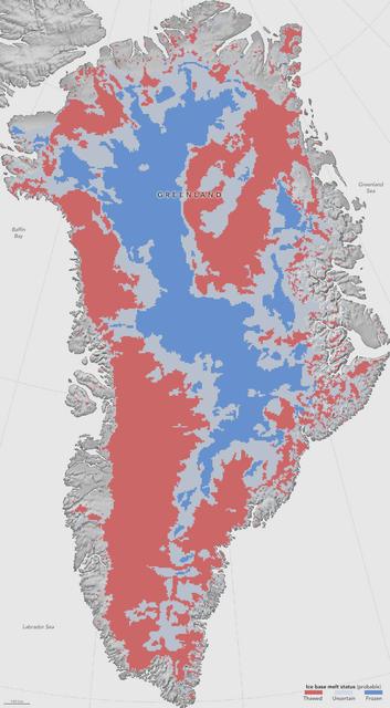
NASA researchers have helped produce the first map showing what parts of the bottom of the massive Greenland Ice Sheet are thawed – key information in better predicting how the ice sheet will react to a warming climate. Greenland’s thick ice sheet insulates the bedrock below from the cold temperatures at the surface, so the bottom of the ice is often tens of degrees warmer than at the top, because the ice bottom is slowly warmed by heat coming from the Earth’s depths. Knowing whether Greenland’s ice lies on wet, slippery ground or is anchored to dry, frozen bedrock is essential for predicting how this ice will flow in the future, But scientists have very few direct observations of the thermal conditions beneath the ice sheet, obtained through fewer than two dozen boreholes that have reached the bottom. Now, a new study synthesizes several methods to infer the Greenland Ice Sheet’s basal thermal state –whether the bottom of the ice is melted or not– leading to the first map that identifies frozen and thawed areas across the whole ice sheet. Map caption: This first-of-a-kind map, showing which parts of the bottom of the Greenland Ice Sheet are likely thawed (red), frozen (blue) or still uncertain (gray), will help scientists better predict how the ice will flow in a warming climate. Credit: NASA Earth Observatory/Jesse Allen Read more: <a href="http://go.nasa.gov/2avKgl2" rel="nofollow">go.nasa.gov/2avKgl2</a> <b><a href="http://www.nasa.gov/audience/formedia/features/MP_Photo_Guidelines.html" rel="nofollow">NASA image use policy.</a></b> <b><a href="http://www.nasa.gov/centers/goddard/home/index.html" rel="nofollow">NASA Goddard Space Flight Center</a></b> enables NASA’s mission through four scientific endeavors: Earth Science, Heliophysics, Solar System Exploration, and Astrophysics. Goddard plays a leading role in NASA’s accomplishments by contributing compelling scientific knowledge to advance the Agency’s mission. <b>Follow us on <a href="http://twitter.com/NASAGoddardPix" rel="nofollow">Twitter</a></b> <b>Like us on <a href="http://www.facebook.com/pages/Greenbelt-MD/NASA-Goddard/395013845897?ref=tsd" rel="nofollow">Facebook</a></b> <b>Find us on <a href="http://instagrid.me/nasagoddard/?vm=grid" rel="nofollow">Instagram</a></b>
NASA's Curiosity Mars rover captured this 360-degree panorama while parked below Gediz Vallis Ridge (the hill-like slope at right). After three attempts over the course of three years, the rover finally reached the ridge on its fourth try on Aug. 14, 2023, the 3,923rd Martian day, or sol, of the mission. On Aug. 19, Curiosity's Mastcam took the 136 individual images that were stitched together into this mosaic after being sent back to Earth. The color has been adjusted to match lighting conditions as the human eye would see them on Earth. Gediz Vallis Ridge was one of the last features to form on Mount Sharp, the 3-mile-tall (5-kilometer-tall) mountain that Curiosity has been ascending since 2014. The ridge preserves a record of one of the last wet periods seen on this part of Mars. Reaching the ridge was no easy feat: previous forays were stymied by knife-edged "gator-back" rocks and too-steep slopes. Arriving after one of the most difficult climbs the mission has ever faced, Curiosity spent 11 days at the ridge. It then departed to ascend higher up the mountain, where the rover will investigate Gediz Vallis Channel, through which water flowed some 3 billion years ago, carrying rocks and debris that piled up to form the ridge. https://photojournal.jpl.nasa.gov/catalog/PIA26019
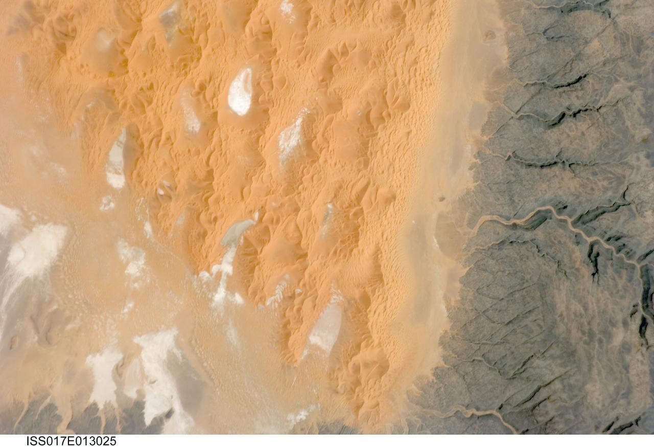
ISS017-E-013025 (12 Aug. 2008) --- The Tifernine Dune Field in Algeria is featured in this image photographed by an Expedition 17 crewmember on the International Space Station. The Tifernine Dune Field is located at the southernmost tip of the Grand Erg Oriental, a "dune sea" that occupies a large portion of the Sahara Desert in eastern Algeria. This view illustrates the interface between the yellow-orange sand dunes of the field and adjacent dark brown consolidated rocks of the Tinrhert Plateau to the south and east (right). NASA scientists point out that three distinct landform types are visible in the image, each providing information about past and present climate in the area. The oldest landform is represented by the rocks of the Tinrhert Plateau, which are characterized by a number of incised channels in the bedrock -- these formed during a wet and cool climate period, most probably by glacial meltwater streams. As the present dry and hot climate that characterizes the Sahara became established, water ceased to flow in these channels, and large amounts of drying sediment (sand, silt, and clay) were eroded and transported by predominantly northeast-southwest winds -- forming large linear dunes that roughly parallel the prevailing wind direction (center). The present climate regime is still hot and dry, but current wind directions are more variable, leading to the formation of star dunes -- recognizable by a starfish-like pattern when seem from above -- that are modifying the older large linear dunes. White to grey regions within the dune field are exposed deposits of silt and clay, together with evaporite minerals (such as halite, or common table salt) formed by evaporation of water that collected in small basins between the dunes.
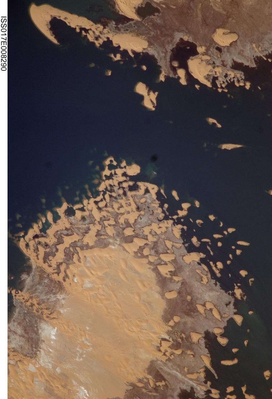
ISS017-E-008290 (31 May 2008) --- Toshka Lakes in southern Egypt are featured in this image photographed by an Expedition 17 crewmember on the International Space Station. In the late 1990s, Egypt's new manmade Toshka Lakes, fed from Lake Nasser via a new canal, grew and spilled into new basins to become four major and two smaller waterbodies extending 120 kilometers across the desert west of the Nile River in southern Egypt. Starting in 2002, astronauts have seen the lakes slowly decline, with the telltale ring of darker, moistened ground showing the previous higher water levels. The rise and fall of Toshka Lakes, and the economic development surrounding the region, are dependent on climate fluctuations and water agreements with upstream countries that, in turn, determine the long-term water flow in the lower Nile. This view, covering a distance of 11.3 kilometers from bottom to top, shows shoreline detail of the third large lake. Lake water appears deep blue to blue-green, and parallel with the shoreline is a wide brown zone which was under water until 2002. Most of the bright yellow sand dunes in the view are re-emerging as the lake level drops, most outlined visibly by thin wet margins. Still-submerged dunes can be seen as small gray blebs offshore (left center). The summit of the biggest horn-shaped dune (top left) was an island more than 5 kilometers off shore in images from 2001. The dune pattern gives a strong sense of dune migration southwards, from top left towards lower right (horns of crescent dunes point in the direction of dune movement). Dominant northerly winds drive the dunes southward, except, of course, when they are under water.

These are two false-color composites of Raco, Michigan, located at the eastern end of Michigan upper peninsula, west of Sault Ste. Marie and south of Whitefish Bay on Lake Superior. The two images (centered at 46.39 degrees north latitude, 84.88 degrees west longitude) show significant seasonal changes in the mid-latitude region of mixed deciduous and coniferous forests. The images were acquired by the Spaceborne Imaging Radar-C and X-band Synthetic Aperture Radar (SIR-C/X-SAR) aboard the shuttle Endeavour on the sixth orbit of each mission. In these images, red is L-band (23 cm) with horizontal/vertical polarization; green is C-band (6 cm) with horizontal/vertical polarization; blue is C-band with horizontal/horizontal polarization. The region shown is largely forested and includes a large portion of Hiawatha National Forest, as well as an agricultural region near the bottom of each image. In early April, the area was snow-covered with up to 50 centimeters (19.5 inches) of snow in forest clearings and agricultural fields. Buds had not yet broken on deciduous trees, but the trees were not frozen and sap was generally flowing. Lake Superior, in the upper right, and the small inland lakes were frozen and snow-covered on April 9, 1994. By the end of September, deciduous trees were just beginning to change color after a relatively wet period. Leaf loss was estimated at about 30 percent, depending on the species, and the soil was moist to wet after a heavy rainfall on September 28, 1994. Most agricultural fields were covered with grasses of up to 60 centimeters (23 inches) in height. In the two images the colors are related to the types of land cover (i.e. vegetation type) and the brightness is related to the amount of plant material and its relative moisture content. Significant seasonal changes between early spring and early fall are illustrated by this pair of images. For the agricultural region near the bottom of the images, the change from snow-cover to moist soil with short vegetation cover is shown by the color change from blue to green and blue. The green color corresponds to significant increases in vegetation cover and field-to-field differences in blue are the result of differences in surface roughness and soil moisture. In the forested areas, many of the conifer forests appear similar in both images (red pine forests appear red in both images). However, there is more blue and green in the September 30, 1994 image as a consequence of greater foliage and more moisture in the forest crowns. Lowland conifer forests (spruce and northern white cedars) appear as bright green in both images. Deciduous forests produce very strong radar returns at these frequencies and polarization combinations, resulting in a nearly white appearance on the images (the specific color mix is related to the local species mix). In the September 30, 1994 image, the areas of deciduous forest appear darker than in the April image because of the weaker radar signal from the foliage in the crown layer. The clear-cut areas (shown in April by the irregularly shaped dark areas in the center) change dramatically in appearance due to loss of snow cover and increases in soil moisture and vegetation cover by the end of September. http://photojournal.jpl.nasa.gov/catalog/PIA01730

NASA's Curiosity Mars rover used its Mastcam to capture this mosaic of Gediz Vallis on Nov. 7, 2022, the 3,646th Martian day, or sol, of the mission. In the center of the valley in this image is a pile of boulders and debris that may have been swept there by flowing water billions of years ago. Wind is thought to have carved the larger valley, which starts much higher up on Mount Sharp, the 3-mile-tall (5-kilometer-tall) Martian mountain whose foothills Curiosity has been ascending since 2014. The mountain is made up of layers, with the oldest at the bottom and the youngest at the top. Approaching this debris in the valley's interior channel is thought to be the only way that Curiosity will be able to study younger material that originated higher on the mountain than the rover will ever go. The mosaic is made up of 18 individual images that were stitched together after being sent to Earth. The color has been adjusted to match lighting conditions as the human eye would see them on Earth. https://photojournal.jpl.nasa.gov/catalog/PIA25733
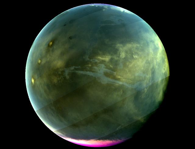
Caption: MAVEN's Imaging UltraViolet Spectrograph obtained this image of Mars on July 13, 2016, when the planet appeared nearly full when viewed from the highest altitudes in the MAVEN orbit. The ultraviolet colors of the planet have been rendered in false color, to show what we would see with ultraviolet-sensitive eyes. The ultraviolet (UV) view gives several new perspectives on Mars. Valles Marineris, a two-thousand-mile canyon system, appears prominently across the middle of the image as a blue gash. The deep canyon appears blue due to the scattering of ultraviolet light by the atmosphere, so strong that we cannot make out the bottom of the canyon. The greenish cast of the planet as a whole is a combination of the reflection of the surface plus the atmospheric scattering. The three tall Tharsis volcanoes appear near the left edge, dotted by white clouds forming as the winds flow over them. Bright white polar caps appear at both poles, typical for this season, in which there is a transition from southern-hemisphere winter to summer. The magenta-colored region visible at the south pole shows where ozone is absorbing ultraviolet light — the same property of ozone that protects life on Earth from harmful UV radiation. While ozone tends to be destroyed by chemical processes in the winter on Earth, different atmospheric chemistry at Mars caused it to build up in the winter there. A hint of ozone is also visible near the north pole; more will accumulate there as winter is coming. IUVS obtains images of Mars every orbit when the sunlit portion of the planet is visible from high altitude. Credits: NASA/Goddard/University of Colorado/LASP Read more: <a href="http://go.nasa.gov/2d9aU1N" rel="nofollow">go.nasa.gov/2d9aU1N</a> Today, NASA’s Mars Atmosphere and Volatile EvolutioN (MAVEN) mission completed one Mars year of science observations. One Mars year is just under two Earth years. MAVEN launched on Nov. 18, 2013, and went into orbit around Mars on Sept. 21, 2014. During its time at Mars, MAVEN has answered many questions about the Red Planet. “Taken together, the MAVEN results tell us that loss of gas from the atmosphere to space has been the major force behind the climate having changed from a warm, wet environment to the cold, dry one that we see today,” said Bruce Jakosky, MAVEN principal investigator, from the University of Colorado in Boulder. NASA recently declared that MAVEN had achieved mission success during its primary mission. Mission success means that the spacecraft operated as intended, made the expected science measurements, and achieved its proposed science objectives. <b><a href="http://www.nasa.gov/audience/formedia/features/MP_Photo_Guidelines.html" rel="nofollow">NASA image use policy.</a></b> <b><a href="http://www.nasa.gov/centers/goddard/home/index.html" rel="nofollow">NASA Goddard Space Flight Center</a></b> enables NASA’s mission through four scientific endeavors: Earth Science, Heliophysics, Solar System Exploration, and Astrophysics. Goddard plays a leading role in NASA’s accomplishments by contributing compelling scientific knowledge to advance the Agency’s mission. <b>Follow us on <a href="http://twitter.com/NASAGoddardPix" rel="nofollow">Twitter</a></b> <b>Like us on <a href="http://www.facebook.com/pages/Greenbelt-MD/NASA-Goddard/395013845897?ref=tsd" rel="nofollow">Facebook</a></b> <b>Find us on <a href="http://instagrid.me/nasagoddard/?vm=grid" rel="nofollow">Instagram</a></b>