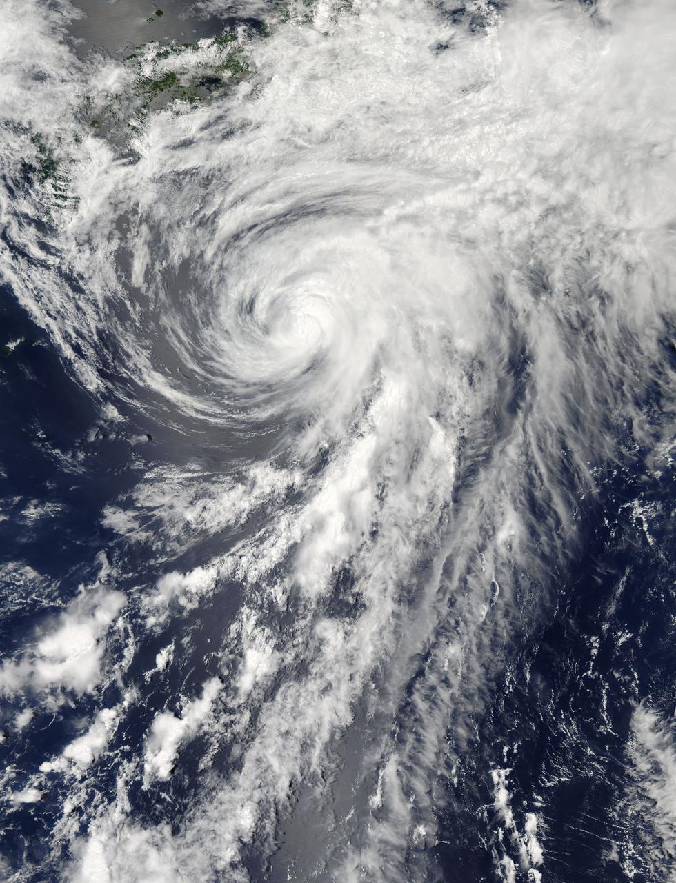
On Tuesday, June 11, 2013 Tropical Storm Yagi spun in the North Pacific Ocean just south of Japan. The Moderate Resolution Imaging Spectroradiometer (MODIS) aboard NASA’s Aqua satellite captured this beautiful true-color image of the storm on that same date at 4:10 UTC (1:10 p.m. Japan local time). The image shows a clear apostrophe-shaped cyclone, with a closed eye and somewhat elliptical shape. The clouds associated with the northern fringes of the storm draped over southeastern coastal Japan, and a long “tail” (or band) of thunderstorms fed into the center from the south. Multispectral imagery also showed tight bands of thunderstorms wrapping into the center of the storm, although the building of thunderstorms was weakening around the center. Near the same time as the image was captured, the Joint Typhoon Warning Center announced that vertical wind shear was starting to take a toll on Yagi. Northwesterly wind shear had caused the system to tilt slightly with the upper-level center displaced about 20 nautical miles east of the low-level center. Tropical Storm Yagi developed from Tropical Depression 03W in the Western North Pacific Ocean on June 6, and intensified the weekend of June 8-9, when it reached Tropical Storm status and was given the name Yagi. Also known as Dante, the storm reached the maximum wind speeds on June 10 and 11, after which it began to weaken as it moved into cooler waters. On June 14, Yagi’s remnants passed about 200 miles south of Tokyo, and brought soaking rains to the coastline of Japan’s Honshu Island. Credit: NASA/GSFC/Jeff Schmaltz/MODIS Land Rapid Response Team <b><a href="http://www.nasa.gov/audience/formedia/features/MP_Photo_Guidelines.html" rel="nofollow">NASA image use policy.</a></b> <b><a href="http://www.nasa.gov/centers/goddard/home/index.html" rel="nofollow">NASA Goddard Space Flight Center</a></b> enables NASA’s mission through four scientific endeavors: Earth Science, Heliophysics, Solar System Exploration, and Astrophysics. Goddard plays a leading role in NASA’s accomplishments by contributing compelling scientific knowledge to advance the Agency’s mission. <b>Follow us on <a href="http://twitter.com/NASA_GoddardPix" rel="nofollow">Twitter</a></b> <b>Like us on <a href="http://www.facebook.com/pages/Greenbelt-MD/NASA-Goddard/395013845897?ref=tsd" rel="nofollow">Facebook</a></b> <b>Find us on <a href="http://instagram.com/nasagoddard?vm=grid" rel="nofollow">Instagram</a></b>
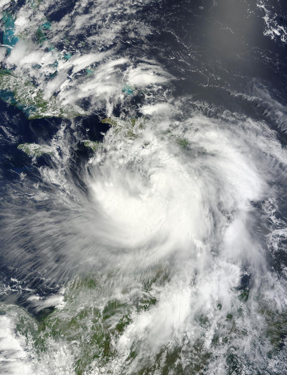
NASA's Terra satellite passed over Tropical Storm Isaac on Aug. 24 at 15:20 UTC (11:20 a.m. EDT) as it continued moving through the eastern Caribbean Sea. The MODIS instrument onboard Aqua captured this visible image. At 2 p.m. EDT on Aug. 24, Isaac's maximum sustained winds were near 60 mph (95 kmh). The National Hurricane Center noted that Isaac could strengthen later before reaching the coast of Hispaniola tonight, Aug. 24. Hispaniola is an island that contains the Dominican Republic and Haiti. Isaac is located about 135 miles (215 km) south-southeast of Port au Prince, Haiti, near latitude 16.8 north and longitude 71.4 west. Isaac is now moving toward the northwest near 14 mph (22 kmh). Isaac is expected to reach hurricane status over the weekend of Aug. 25-26 and NASA satellites will continue providing valuable temperature, rainfall, visible and infrared data. Text Credit: Rob Gutro NASA's Goddard Space Flight Center, Greenbelt, Md. <b>To read more go to: <a href="http://www.nasa.gov/mission_pages/hurricanes/archives/2012/h2012_Isaac.html" rel="nofollow">www.nasa.gov/mission_pages/hurricanes/archives/2012/h2012...</a></b> Credit: NASA Goddard MODIS Rapid Response Team <b><a href="http://www.nasa.gov/audience/formedia/features/MP_Photo_Guidelines.html" rel="nofollow">NASA image use policy.</a></b> <b><a href="http://www.nasa.gov/centers/goddard/home/index.html" rel="nofollow">NASA Goddard Space Flight Center</a></b> enables NASA’s mission through four scientific endeavors: Earth Science, Heliophysics, Solar System Exploration, and Astrophysics. Goddard plays a leading role in NASA’s accomplishments by contributing compelling scientific knowledge to advance the Agency’s mission. <b>Follow us on <a href="http://twitter.com/NASA_GoddardPix" rel="nofollow">Twitter</a></b> <b>Like us on <a href="http://www.facebook.com/pages/Greenbelt-MD/NASA-Goddard/395013845897?ref=tsd" rel="nofollow">Facebook</a></b> <b>Find us on <a href="http://instagrid.me/nasagoddard/?vm=grid" rel="nofollow">Instagram</a></b>