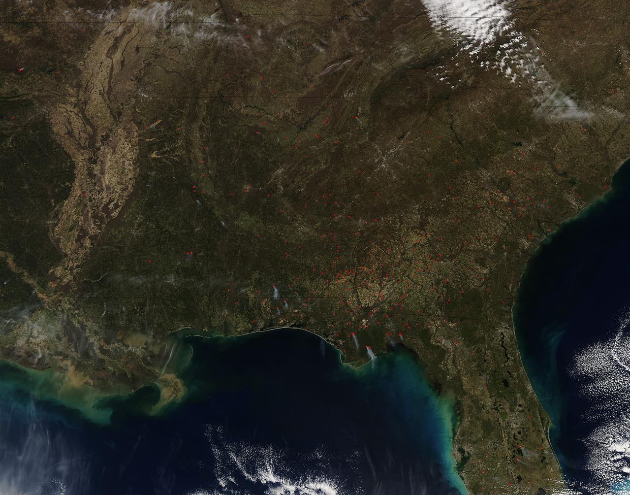
Fires both wild and prescribed dot the landscape of the southeastern portion of the United States. Wildfires are those that occur naturally with lightning strikes or are set by careless humans. Prescribed fires are those deliberately set by land management authorities to take out underlying brush and dead grass so that in the event of a wildfire there is not sufficient fuel for that fire to spread too far. The Southern Area Coordination Center for fire management has this information on its report for February 21, 2017. • Fires that have broken out recently (known as Initial Attack Activity): 198 fires for 2,292 acres • Ongoing Uncontained Large Fires: 3 fires for 5,947 acres • Other Fires reported through alternate channels: 56 fires for 1,400 acres • Prescribed Fire Activity: State and/or Federal Lands – 1,974 prescribed fires for 38,533 acres in AL, FL & GA The bulk of the fires seen in the image taken by the Aqua satellite using the onboard MODIS (Moderate Resolution Imaging Spectroradiometer) instrument on February 16, 2017 appear to be prescribed fires. Actively burning areas, detected by MODIS’s thermal bands, are outlined in red and when combined with smoke are indicative of fire. NASA image courtesy Jeff Schmaltz LANCE/EOSDIS MODIS Rapid Response Team, GSFC. Caption by Lynn Jenner with information from the Southern Area Coordination Center. <b><a href="http://www.nasa.gov/audience/formedia/features/MP_Photo_Guidelines.html" rel="nofollow">NASA image use policy.</a></b> <b><a href="http://www.nasa.gov/centers/goddard/home/index.html" rel="nofollow">NASA Goddard Space Flight Center</a></b> enables NASA’s mission through four scientific endeavors: Earth Science, Heliophysics, Solar System Exploration, and Astrophysics. Goddard plays a leading role in NASA’s accomplishments by contributing compelling scientific knowledge to advance the Agency’s mission. <b>Follow us on <a href="http://twitter.com/NASAGoddardPix" rel="nofollow">Twitter</a></b> <b>Like us on <a href="http://www.facebook.com/pages/Greenbelt-MD/NASA-Goddard/395013845897?ref=tsd" rel="nofollow">Facebook</a></b> <b>Find us on <a href="http://instagrid.me/nasagoddard/?vm=grid" rel="nofollow">Instagram</a></b>
The October fires in Northern California were some of the most destructive in the state's history. The burned area on the right side of the image is the ATLAS fire, that burned east of Napa; the fire consumed 51,000 acres and destroyed almost 500 structures. The burned area on the left is part of the Nuns fire that burned between Sonoma and Napa; it consumed 110,000 acres, and destroyed almost 7,000 structures. The images were acquired September 7, 2016 and October 28, 2017, cover an area of 34.5 by 39 kilometers, and are located near 38.3 degrees north, 122.3 degrees east. https://photojournal.jpl.nasa.gov/catalog/PIA22019
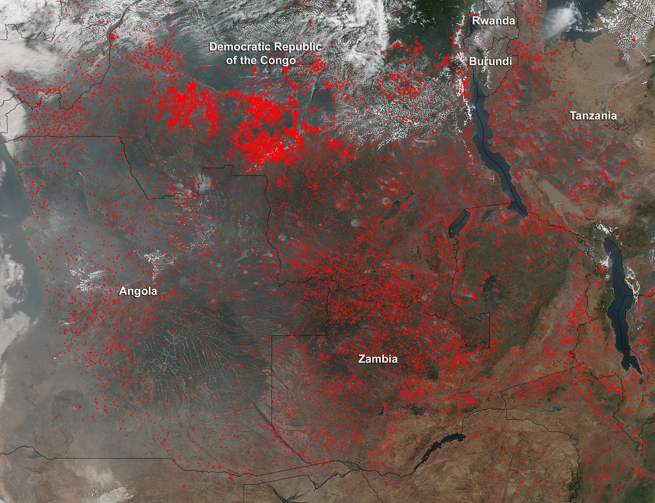
Widespread agricultural burning continues throughout central Africa. Smoke and fires in several countries were seen by the Suomi NPP satellite. Most of the fires were burning in the southern region of the Democratic Republic of the Congo, Tanzania, Zambia and Angola. NASA-NOAA's Suomi NPP satellite's Visible Infrared Imaging Radiometer Suite (VIIRS) instrument captured a look at multiple fires and smoke on August 1 at 7:55 a.m. EDT (11:55 UTC). Actively burning areas, detected by VIIRS are outlined in red. Credit: NASA/Jeff Schmaltz/NASA Goddard Rapid Response Team <b><a href="http://www.nasa.gov/audience/formedia/features/MP_Photo_Guidelines.html" rel="nofollow">NASA image use policy.</a></b> <b><a href="http://www.nasa.gov/centers/goddard/home/index.html" rel="nofollow">NASA Goddard Space Flight Center</a></b> enables NASA’s mission through four scientific endeavors: Earth Science, Heliophysics, Solar System Exploration, and Astrophysics. Goddard plays a leading role in NASA’s accomplishments by contributing compelling scientific knowledge to advance the Agency’s mission. <b>Follow us on <a href="http://twitter.com/NASAGoddardPix" rel="nofollow">Twitter</a></b> <b>Like us on <a href="http://www.facebook.com/pages/Greenbelt-MD/NASA-Goddard/395013845897?ref=tsd" rel="nofollow">Facebook</a></b> <b>Find us on <a href="http://instagrid.me/nasagoddard/?vm=grid" rel="nofollow">Instagram</a></b>
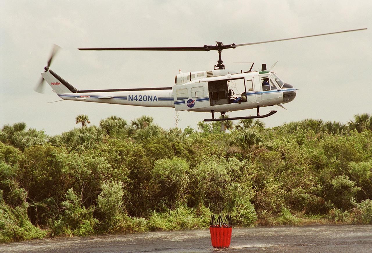
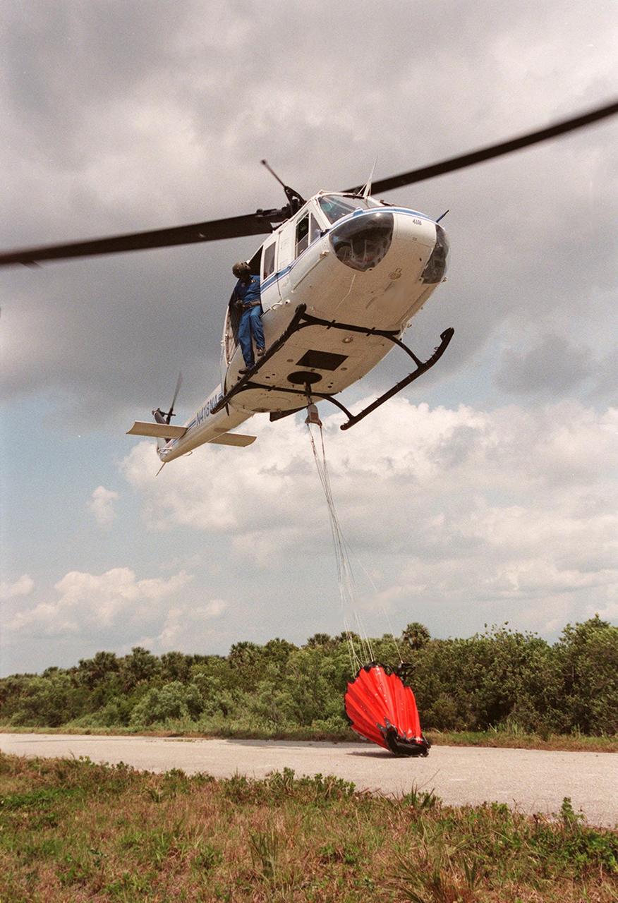
KENNEDY SPACE CENTER, FLA. -- A NASA helicopter lifts a high-impact-resistant flexible plastic bucket filled with water. The container will be used for fire protection on property and buildings at Kennedy Space Center.. Known as the "Bambi" bucket, it will also support the Fish and Wildlife Service for controlled burns plus any wild fires in the area.

KENNEDY SPACE CENTER, FLA. -- A NASA helicopter lifts a high-impact-resistant flexible plastic bucket that will be used for fire protection on property and buildings at Kennedy Space Center. Known as the "Bambi" bucket, the 324-gallon container will also support the Fish and Wildlife Service for controlled burns plus any wild fires in the area

KENNEDY SPACE CENTER, FLA. -- A NASA helicopter lifts a high-impact-resistant flexible plastic bucket filled with water. The container will be used for fire protection on property and buildings at Kennedy Space Center.. Known as the "Bambi" bucket, it will also support the Fish and Wildlife Service for controlled burns plus any wild fires in the area.
KENNEDY SPACE CENTER, FLA. -- A NASA helicopter lifts a high-impact-resistant flexible plastic bucket that will be used for fire protection on property and buildings at Kennedy Space Center. Known as the "Bambi" bucket, the 324-gallon container will also support the Fish and Wildlife Service for controlled burns plus any wild fires in the area
Earth observation taken during a day pass by an Expedition 36 crew member on board the International Space Station (ISS). Photo downlinked to folder: Colorado wild fires.
Earth observation taken during a day pass by an Expedition 36 crew member on board the International Space Station (ISS). Photo downlinked to folder: Colorado wild fires.
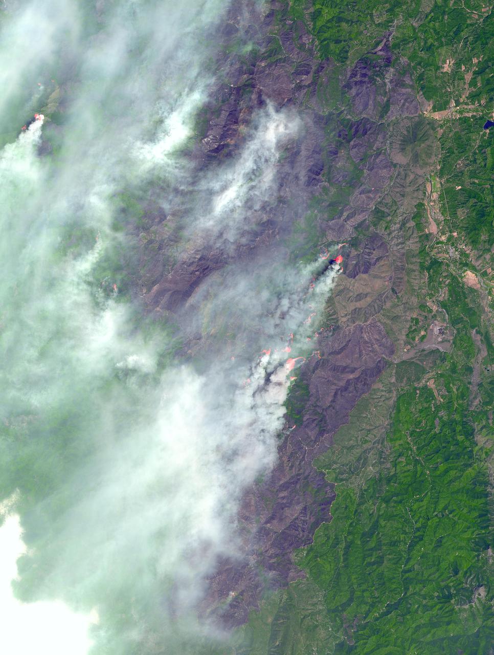
In southwest Oregon, the Biscuit Fire continues to grow. This image, acquired from the Advanced Spaceborne Thermal Emission and Reflection Radiometer (ASTER) on NASA's Terra satellite on August 14, 2002, shows the pillars of smoke arising from the fires. Active fire areas are in red. More than 6,000 fire personnel are assigned to the Biscuit Fire alone, which was 390,276 acres as of Thursday morning, August 15, and only 26 percent contained. Among the resources threatened are thousands of homes, three nationally designated wild and scenic rivers, and habitat for several categories of plants and animals at risk of extinction. Firefighters currently have no estimate as to when the fire might be contained. http://photojournal.jpl.nasa.gov/catalog/PIA03856

KENNEDY SPACE CENTER, FLA. -- A NASA helicopter releases 324 gallons of water onto a building in a simulated fire control demonstration. The high-impact-resistant flexible plastic bucket will be used for fire protection on property and buildings at Kennedy Space Center. Known as the "Bambi" bucket, it will also support the Fish and Wildlife Service for controlled burns plus any wild fires in the area.
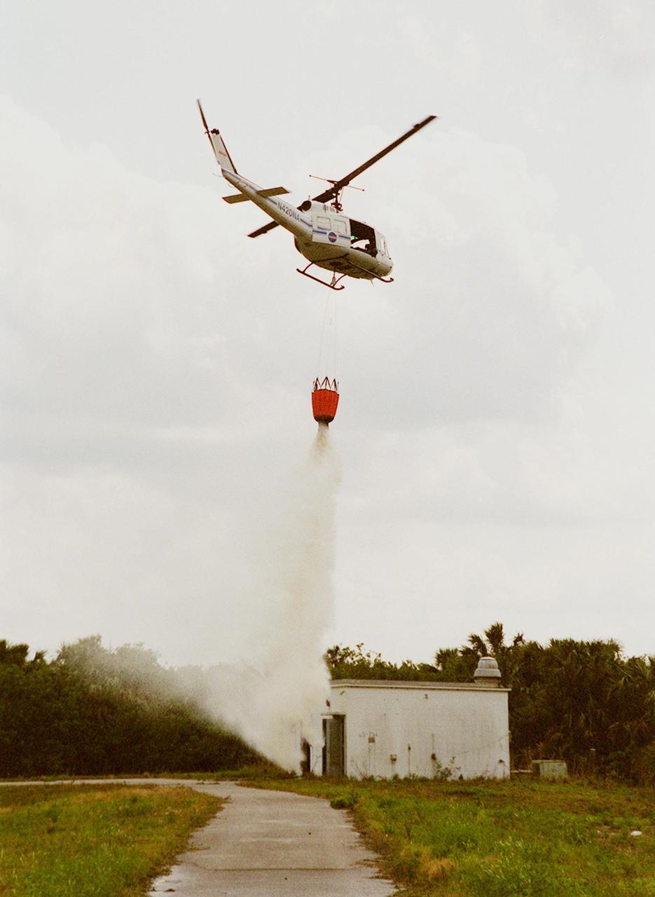
KENNEDY SPACE CENTER, FLA. -- A NASA helicopter releases 324 gallons of water onto a building in a simulated fire control demonstration. The high-impact-resistant flexible plastic bucket will be used for fire protection on property and buildings at Kennedy Space Center. Known as the "Bambi" bucket, it will also support the Fish and Wildlife Service for controlled burns plus any wild fires in the area.
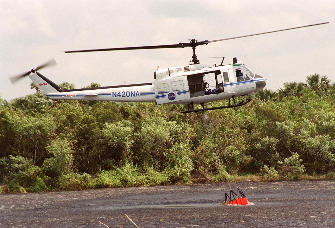
KENNEDY SPACE CENTER, FLA. -- A NASA helicopter hovers over the water while a high-impact-resistant flexible plastic bucket fills. The 324-gallon container will be used for fire protection on property and buildings at Kennedy Space Center. Known as the "Bambi" bucket, it will also support the Fish and Wildlife Service for controlled burns plus any wild fires in the area

KENNEDY SPACE CENTER, FLA. -- Workers attach a high-impact-resistant flexible plastic bucket to a NASA helicopter. Holding 324 gallons of water, it will be used for fire protection on property and buildings at Kennedy Space Center. Known as the "Bambi" bucket, it will also support the Fish and Wildlife Service for controlled burns plus any wild fires in the area.
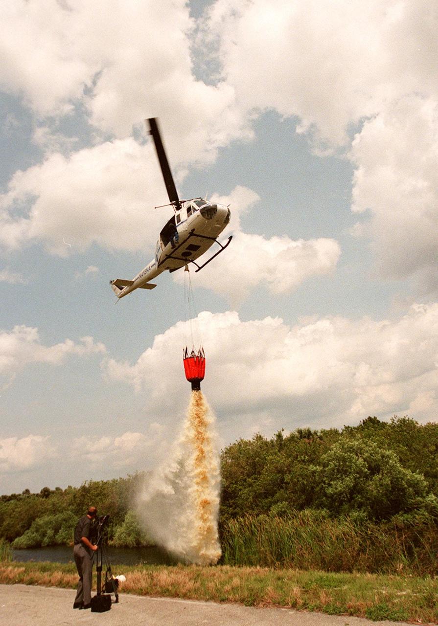
KENNEDY SPACE CENTER, FLA. -- A NASA helicopter releases the contents of the high-impact-resistant flexible plastic bucket it holds. The 324-gallon container will be used for fire protection on property and buildings at Kennedy Space Center. Known as the "Bambi" bucket, it will also support the Fish and Wildlife Service for controlled burns plus any wild fires in the area.
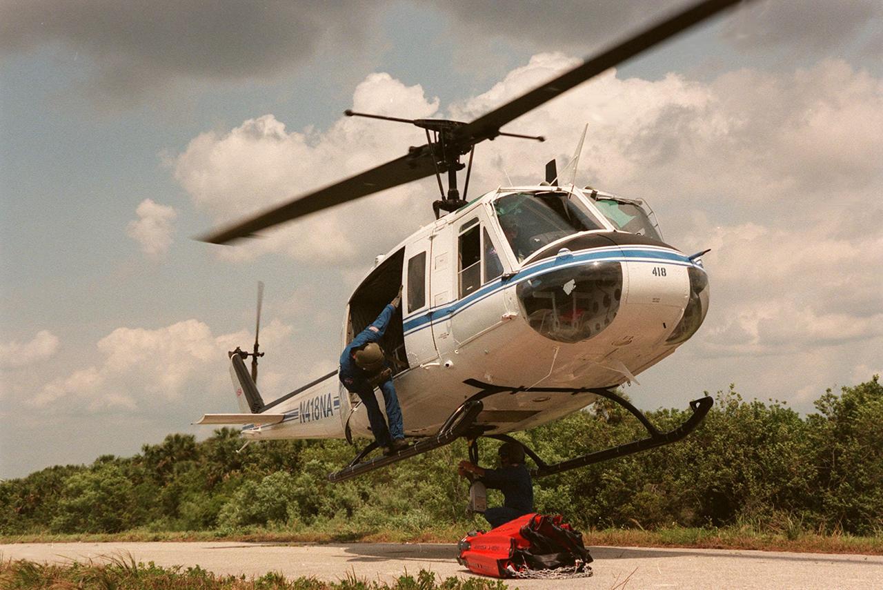
KENNEDY SPACE CENTER, FLA. -- Workers attach a high-impact-resistant flexible plastic bucket to a NASA helicopter. Holding 324 gallons of water, it will be used for fire protection on property and buildings at Kennedy Space Center. Known as the "Bambi" bucket, it will also support the Fish and Wildlife Service for controlled burns plus any wild fires in the area.

KENNEDY SPACE CENTER, FLA. -- A NASA helicopter hovers over the water while a high-impact-resistant flexible plastic bucket fills. The 324-gallon container will be used for fire protection on property and buildings at Kennedy Space Center. Known as the "Bambi" bucket, it will also support the Fish and Wildlife Service for controlled burns plus any wild fires in the area

KENNEDY SPACE CENTER, FLA. -- A NASA helicopter releases the contents of the high-impact-resistant flexible plastic bucket it holds. The 324-gallon container will be used for fire protection on property and buildings at Kennedy Space Center. Known as the "Bambi" bucket, it will also support the Fish and Wildlife Service for controlled burns plus any wild fires in the area.
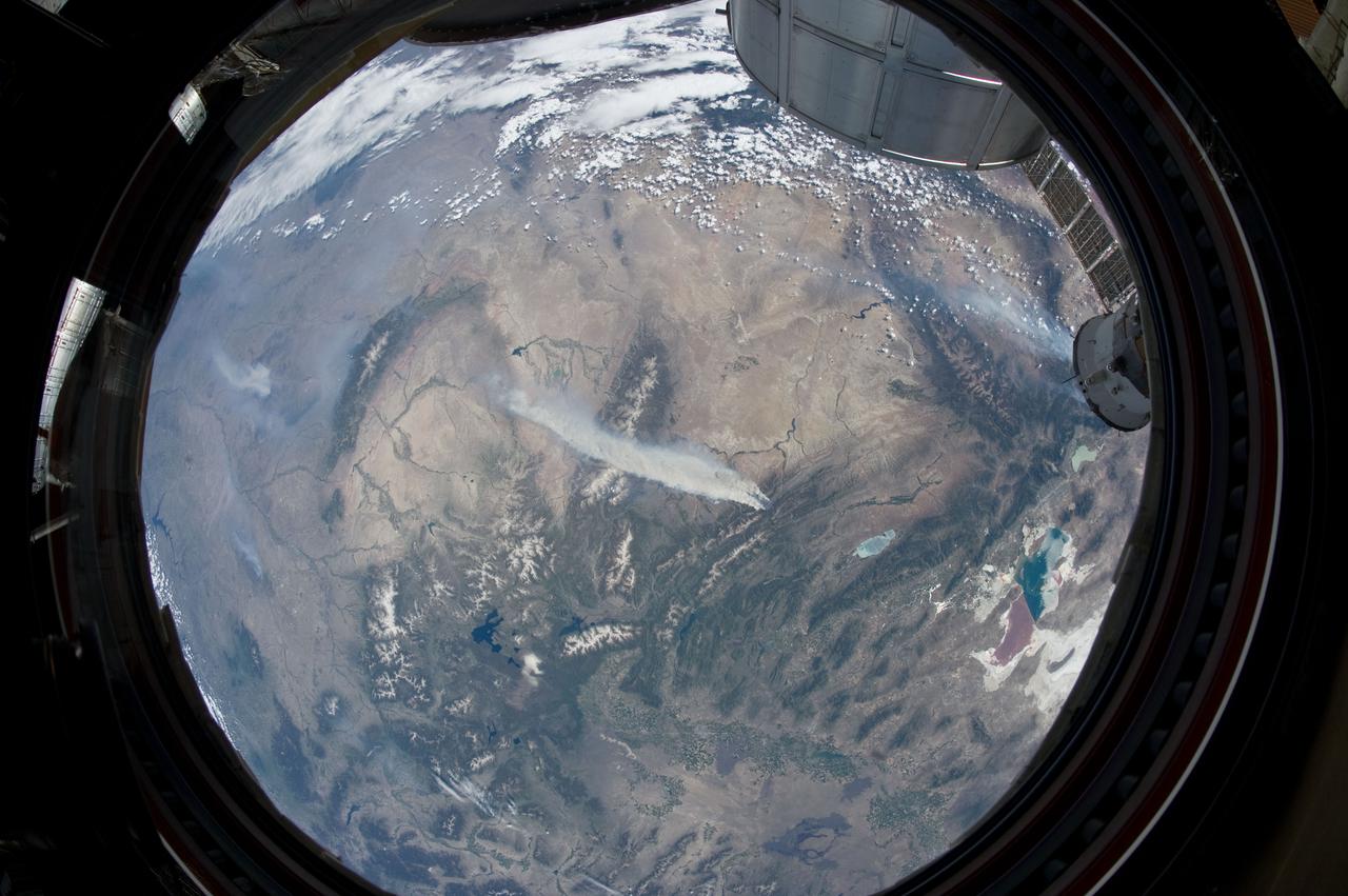
ISS031-E-146344 (27 June 2012) --- An Expedition 31 crew member aboard the International Space Station, flying approximately 240 miles above Earth, recorded a series of images of the current wild fires in the southwestern United States. For this particular image, taken from the station?s Cupola, he used a 16mm lens, which gives this view a ?fisheye? affect. The fires give rise to thick smoke plumes on the southernmost extremity of the Wyoming Range, which occupies the center of the image. Slopes of the central Salt River Range appear at left. Three helicopters and more than 100 personnel are fighting the fire, which is being managed by the Bridger?Teton National Forest.
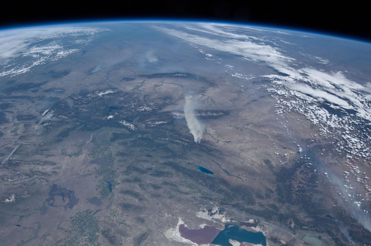
ISS031-E-146391 (27 June 2012) --- An Expedition 31 crew member aboard the International Space Station, flying approximately 240 miles above Earth, recorded a series of images of the current wild fires in the western and southwestern United States. These particular fires, of unknown cause, are burning at the south end of the Wyoming Range in southwestern Wyoming, and have affected 17,000 acres. The fires have produced two major smoke plumes, seen at center of the frame. Utah?s Great Salt Lake (bottom center) is about 120 miles away. Winds transport the smoke in a northeasterly direction.
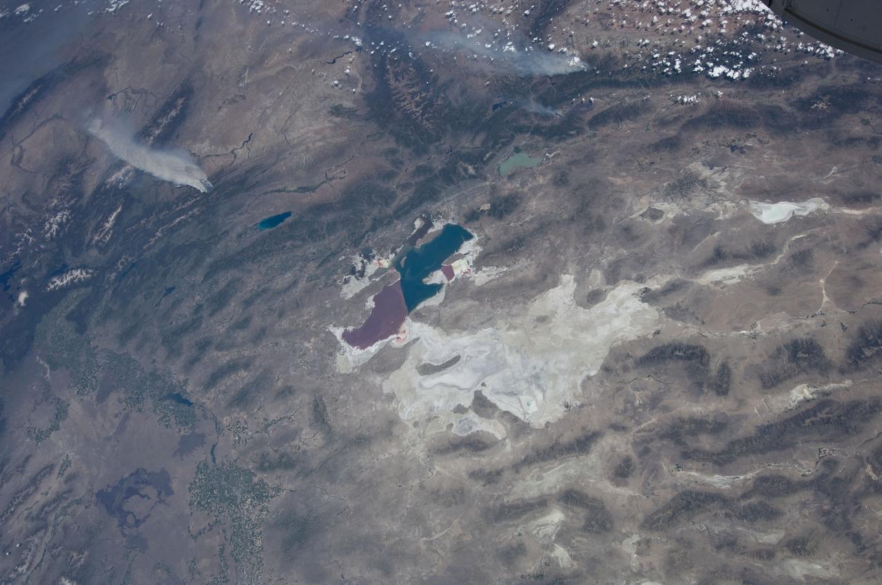
ISS031-E-146397 (27 June 2012) --- An Expedition 31 crew member aboard the International Space Station, flying approximately 240 miles above Earth, recorded a series of images of the current wild fires in the western and southwestern United States. These particular fires, of unknown cause, are burning at the south end of the Wyoming Range in southwestern Wyoming, and have affected 17,000 acres. The fires have produced two major smoke plumes, seen at upper left of the 18mm frame. Winds transport the smoke in a northeasterly direction. Utah?s Great Salt Lake (center) is about 120 miles away. Bear Lake and Utah Lake (very light blue or gray) are also visible in the frame.
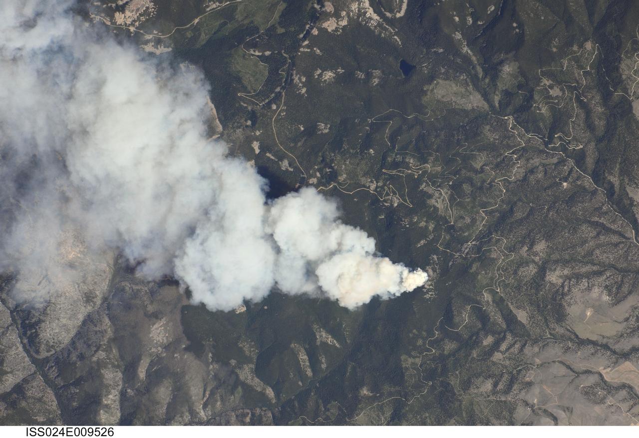
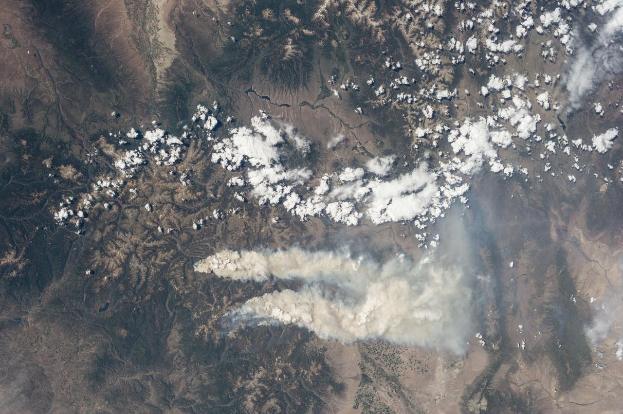
ISS024-E-009526 (25 July 2010) --- Dominic Point Fire in Montana is featured in this image photographed by an Expedition 24 crew member on the International Space Station. Lightning strikes in the forested mountains of the western United States, and human activities, can spark wild fires during the summer dry season. The Dominic Point Fire was first reported near 3:00 p.m. local time on July 25 2010. Approximately one hour later, the space station crew photographed the fire?s large smoke plume ? already extending at least eight kilometers to the east ? from orbit as they passed almost directly overhead. Forest Service fire crews, slurry bombers and helicopters were on the scene by that evening. The fire may have been started by a lightning strike, as there are no trails leading into the fire area located approximately 22 kilometers northeast of Hamilton, MT (according to local reports). As of July 26, 2010 the fire had burned approximately 283?405 hectares of the Bitterroot National Forest in western Montana. The fire is thought to have expanded quickly due to high temperatures, low humidity, and favorable winds with an abundance of deadfall ? dead trees and logs that provide readily combustible fuels ? in the area.
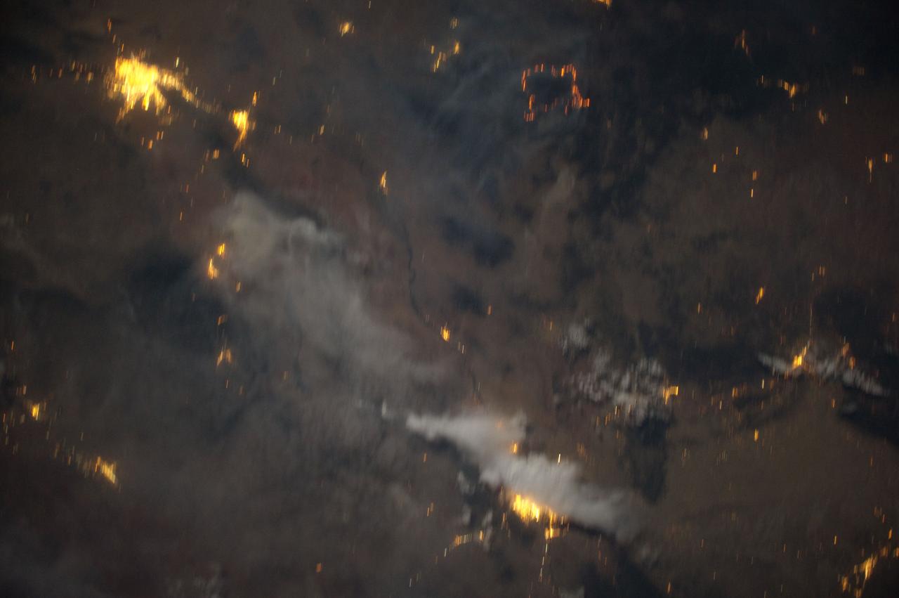
ISS031-E-83789 (2 June 2012) --- Downlinked from the International Space Station this still image – part of a series from a mounted, automated, twilight session -- when viewed in sequence shows the flame ring associated with wild fires in the Southwest move from bottom to top-center framed at a distance by the bright urban areas of Tucson, Phoenix, El Paso-Las Cruces, and finally Albuquerque (mostly under cloud).
ISS028-E-037977 (6 Sept. 2011) --- The Texas wild fires that have destroyed and continue to destroy thousands of acres of timber and prairie land, as well as hundreds of residences, are visible basically over many of the dozens of affected points across the nation's second largest state. The Expedition 28 crew members on the International Space Station, flying approximately 220 miles above Earth, recorded this wide panoramic image of Texas and beyond, from a point over the Gulf of Mexico, at 16:11:22 GMT, Sept. 6, 2011.
ISS028-E-037979 (6 Sept. 2011) --- The Texas wild fires that have destroyed and continue to destroy thousands of acres of timber and prairie land, as well as hundreds of residences, are visible basically over many of the dozens of affected points across the nation's second largest state. The Expedition 28 crew members on the International Space Station, flying approximately 220 miles above Earth, recorded this wide panoramic image of Texas and beyond, from a point over the Gulf of Mexico, at 16:18:12 GMT, Sept. 6, 2011.
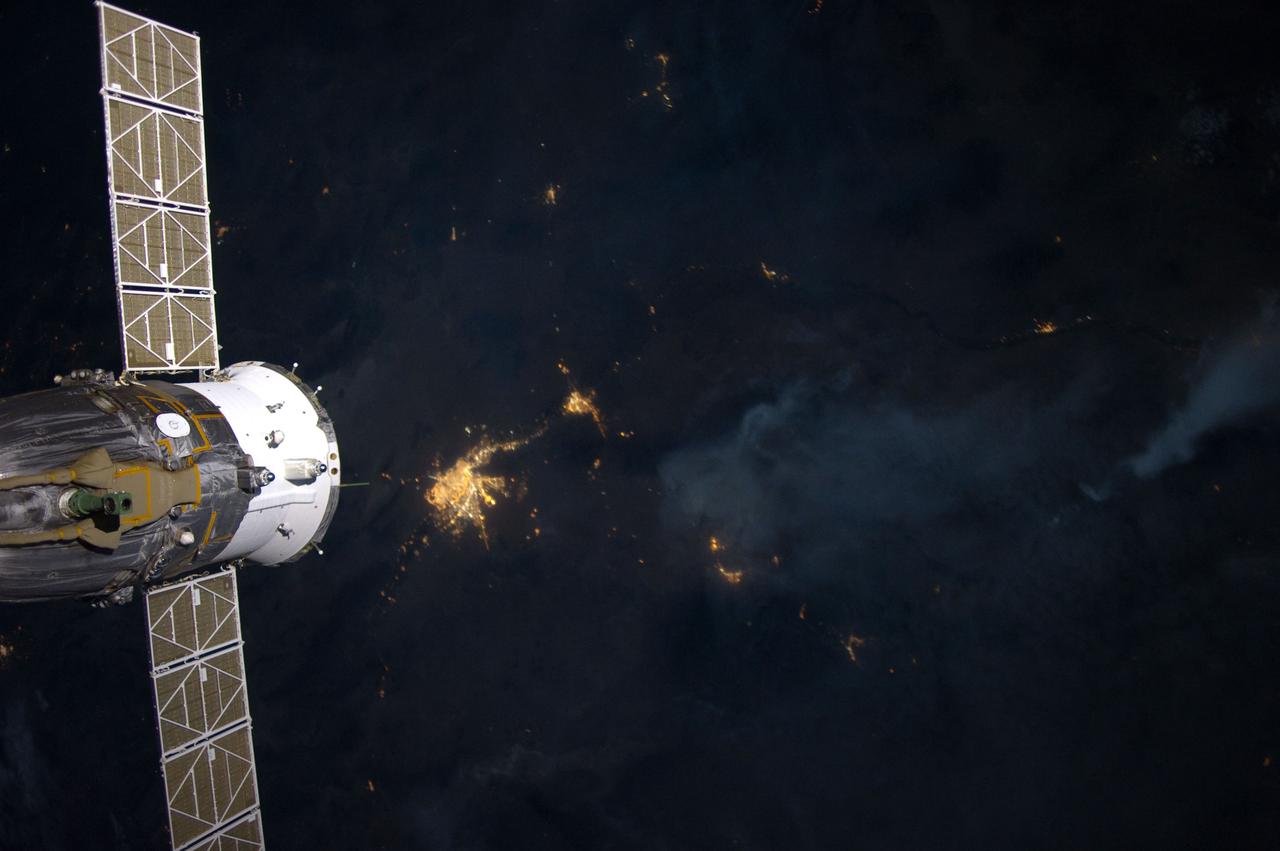
ISS031-E-84006 (2 June 2012) --- This digital image from the Expedition 31 crew aboard the International Space Station is one of a series from a mounted, automated, and nighttime session of a still camera when viewed in sequence shows the flame-ring associated with wild fires in the Southwest slip by in the upper right while the lights of the El Paso-Las Cruces rise from bottom center. A Russian spacecraft is docked to the station
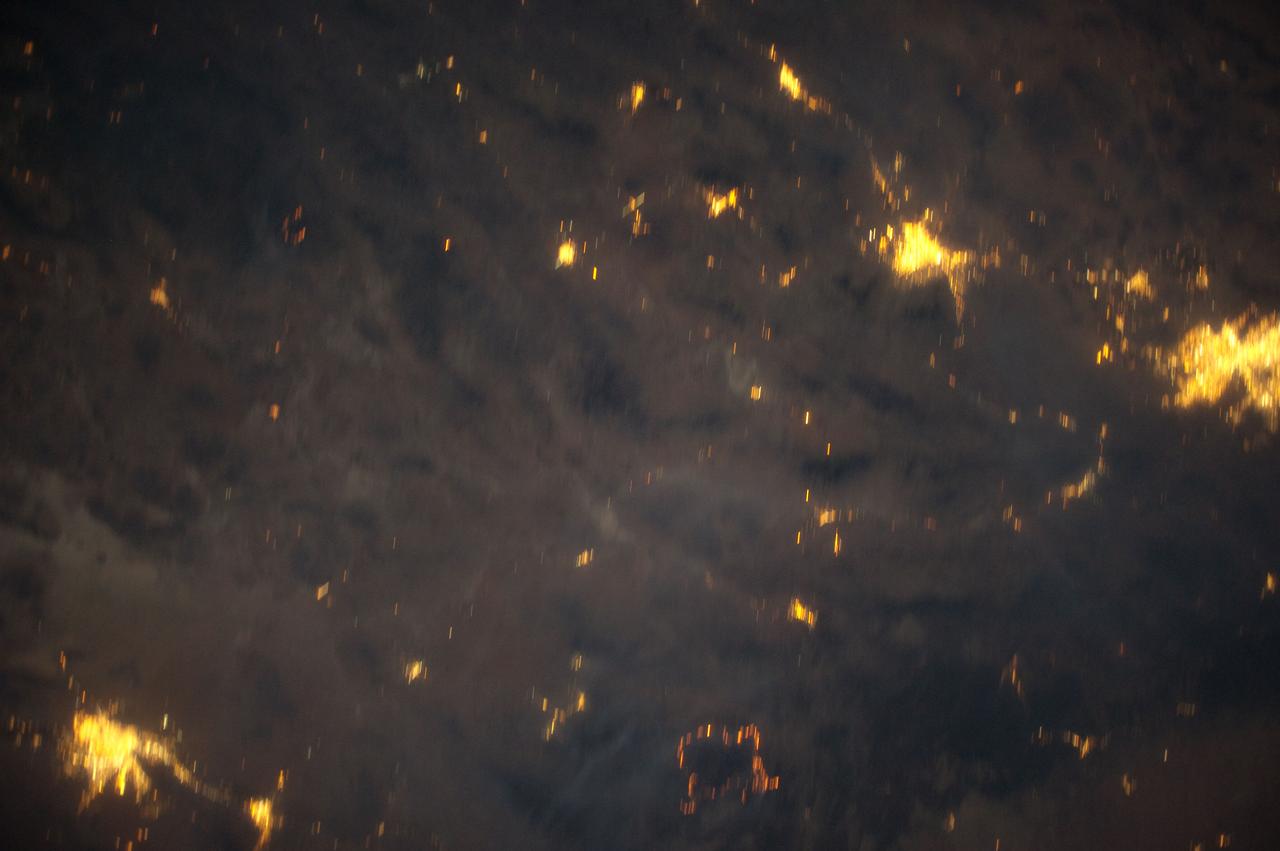
ISS031-E-83747 (2 June 2012) --- Downlinked from the International Space Station this still image -– part of a series from a mounted, automated, twilight session -- when viewed in sequence shows the flame ring associated with wild fires in the Southwest move from bottom to top-center framed at a distance by the bright urban areas of Tucson, Phoenix, El Paso-Las Cruces, and finally Albuquerque (mostly under cloud).
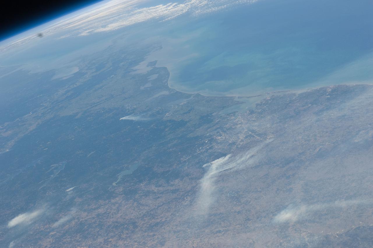
ISS028-E-043559 (7 Sept. 2011) --- This view, from the camera of an Expedition 28 crew member onboard the International Space Station, looks from the northwest toward southeast and covers many counties in southeast Texas that have been heavily affected by dozens of wild fires. Houston can be seen near frame center and the Gulf of Mexico takes up the upper right quadrant of the frame.
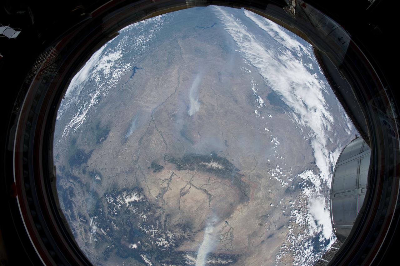
ISS031-E-146343 (27 June 2012) --- An Expedition 31 crew member aboard the International Space Station, flying approximately 240 miles above Earth, recorded a series of images of the current wild fires in the west and southwestern United States. For this particular image, taken from the station?s Cupola, he used a 16mm lens, which gives this view a ?fisheye? affect. The fires give rise to thick smoke plumes on the southernmost extremity of the Wyoming Range, which occupies the bottom left portion of the image. Three helicopters and more than 100 personnel are fighting the fire, which is being managed by the Bridger?Teton National Forest. Part of a docked Russian Soyuz spacecraft and the Multi-Purpose Logistics Module (MPLM) are at lower right.
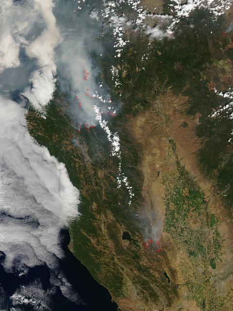
California has been hit hard the past few weeks with storms. Storms bring lightning and lightning strikes cause wildfires. Currently there are at least five fire complexes in the area including River, Fork, South, Route and Mad River. The Mad River complex is a series of seven lightning fires that started on July 30th, 2015 after a lightning storm moved through Northern California. After initial firefighters responded, 25 fires were reported and most of the fires were contained. Some additional fires might be detected from the original lightning storms in the upcoming days and will be attacked once they are found. Damage assessment is ongoing and crews will determine the extent of structures and equipment damaged or destroyed. The River Complex is managing a total of 5 fires due to fires merging together on the Shasta-Trinity and the Six Rivers National Forests. Winds from the west are expected to lift the inversion today resulting in active fire behavior. The Fork Complex consists of over 40 fires, all of which were ignited by lightning between July 29 and 31, 2015. These fires are still being identified, assessed, and prioritized. Updated acreage and information about specific fires will be published as it is known. Fire activity moderated throughout last night (8/4) with the smoke inversion layer remaining in place today. Hopefully this will create favorable conditions for fire crews to take direct fire attack on the fires edge, construct dozer line and scout for best firefighting locations on all fires in the complex. The South Complex consists of approximately nine known fires, five of which are currently over 100 acres. The fires are active and defense of structures and point protection are in progress. The weather is trapping smoke in the valley causing very poor air quality. As the smoke lifts the fire activity increases. Firefighters will continue to provide point protection on structures and to look for opportunities to build direct and indirect containment lines. The Route Complex currently stands at 12,164 acres from seven separate fires and is at 2% containment. The overall acreage has been reduced because the South Fire on the nearby South Complex is merging with the Johnson Fire in the Route Complex resulting in decreased and revised fire perimeter acreage. This natural-color satellite image collected by the Moderate Resolution Imaging Spectroradiometer (MODIS) aboard the Terra satellite shows smoke rising and drifting northwest from the various fire complexes. It was captured on August 04, 2015. Actively burning areas, detected by MODIS’s thermal bands, are outlined in red. NASA image courtesy Jeff Schmaltz, MODIS Rapid Response Team. <b><a href="http://www.nasa.gov/audience/formedia/features/MP_Photo_Guidelines.html" rel="nofollow">NASA image use policy.</a></b> <b><a href="http://www.nasa.gov/centers/goddard/home/index.html" rel="nofollow">NASA Goddard Space Flight Center</a></b> enables NASA’s mission through four scientific endeavors: Earth Science, Heliophysics, Solar System Exploration, and Astrophysics. Goddard plays a leading role in NASA’s accomplishments by contributing compelling scientific knowledge to advance the Agency’s mission. <b>Follow us on <a href="http://twitter.com/NASAGoddardPix" rel="nofollow">Twitter</a></b> <b>Like us on <a href="http://www.facebook.com/pages/Greenbelt-MD/NASA-Goddard/395013845897?ref=tsd" rel="nofollow">Facebook</a></b> <b>Find us on <a href="http://instagrid.me/nasagoddard/?vm=grid" rel="nofollow">Instagram</a></b>
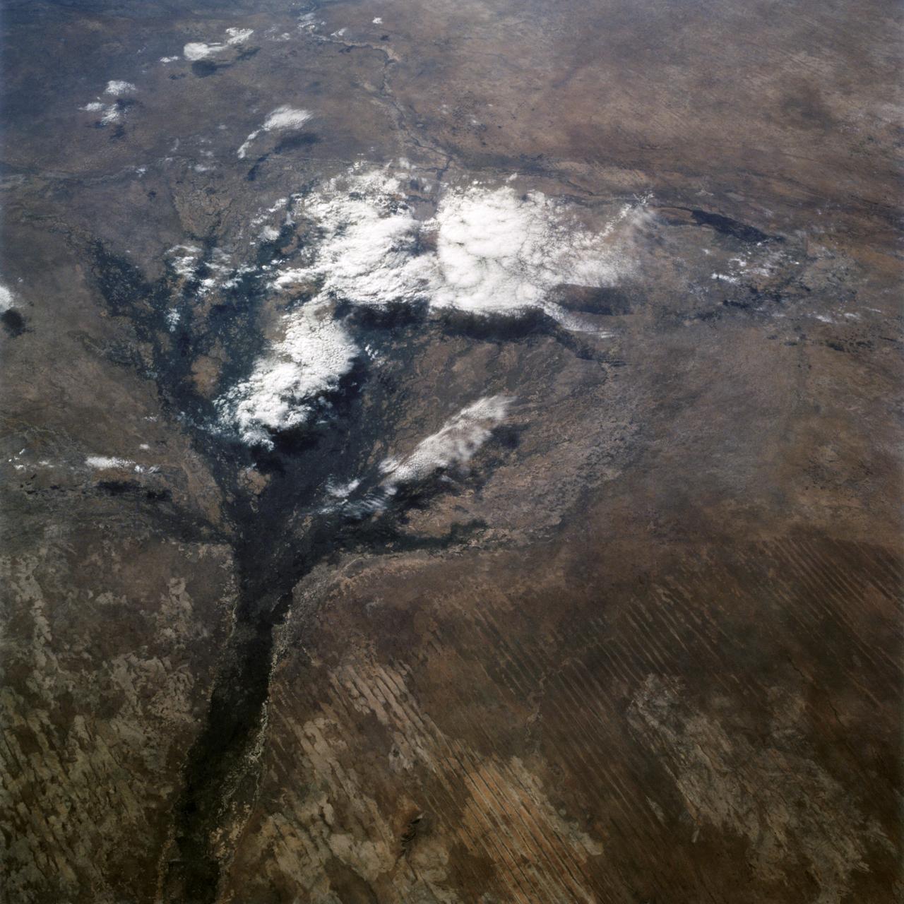
STS066-122-091 (3-14 Nov. 1994) --- This November 1994 view looking south-southeast shows clouds over the Okavango Delta area of northern Botswana. The Okavango is one of the wilder, less spoiled regions of Africa. The area still supports great herds of wild animals such as elephant, zebra and the cape buffalo. Despite conservation efforts from the stable government of Botswana, delta habitats are pressured. The Okavango River (lower left of view) brings water from the high, wet plateaus of Angola into the Kalahari Desert, and enormous inland basin. As a result of a series of small faults (upper center of the view) related to the African Rift System, the river is dammed up in the form of swampy inland delta. Here, water is consumed by evaporation, infiltration, and the swamp forests. Late summer floods take six months to slowly penetrate the 160 kilometer (95 miles) to the other end of the Delta. The visual patterns of the area are strongly linear: straight sand dunes occur in many places and can be seen across the bottom portion of the photograph. Numerous brush-fire scars produce a complex, straight-edged pattern over much of the lower portion of this view. Lake Ngami (upper right of view) was once permanently full as late as the middle 1800's. Changes in the climate of the area over the last 100 years has changed the size and shape of the inland delta.