Yardangs
Yardangs
Yardang Development

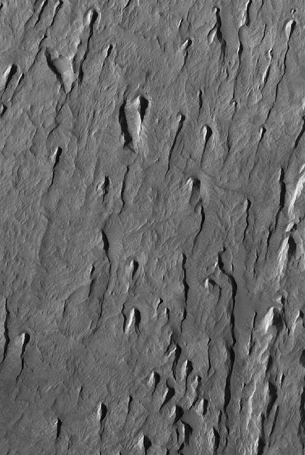
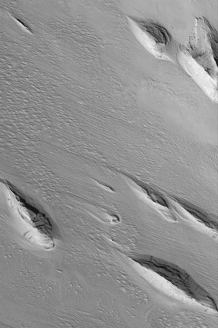
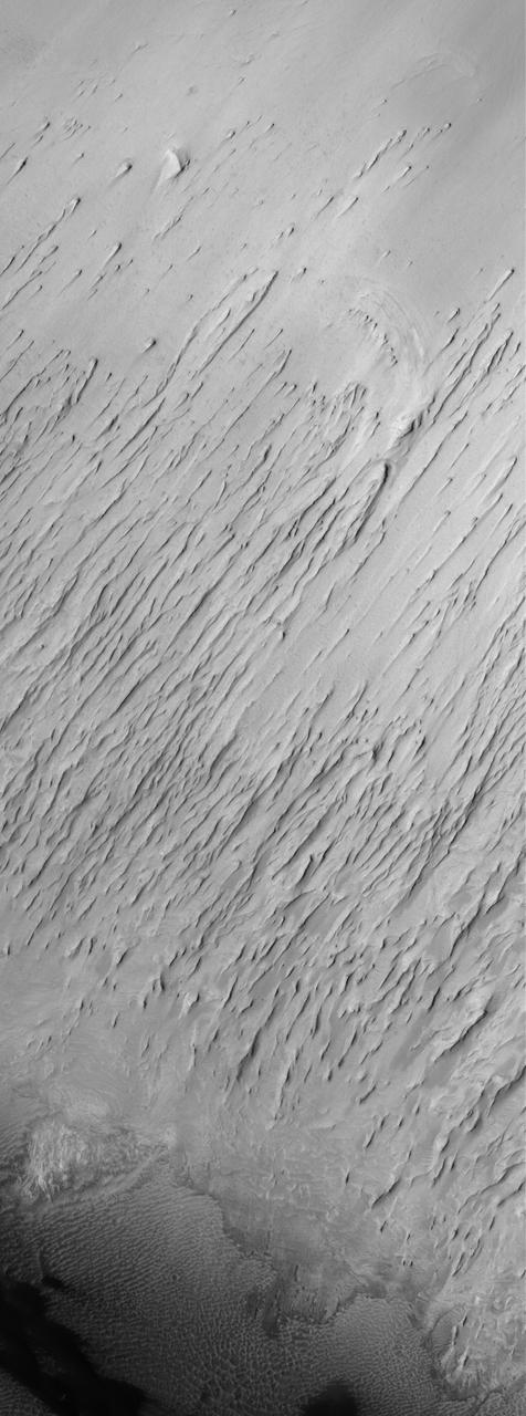
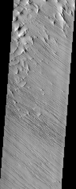
Small Yardangs
Yardangs and Exhumation
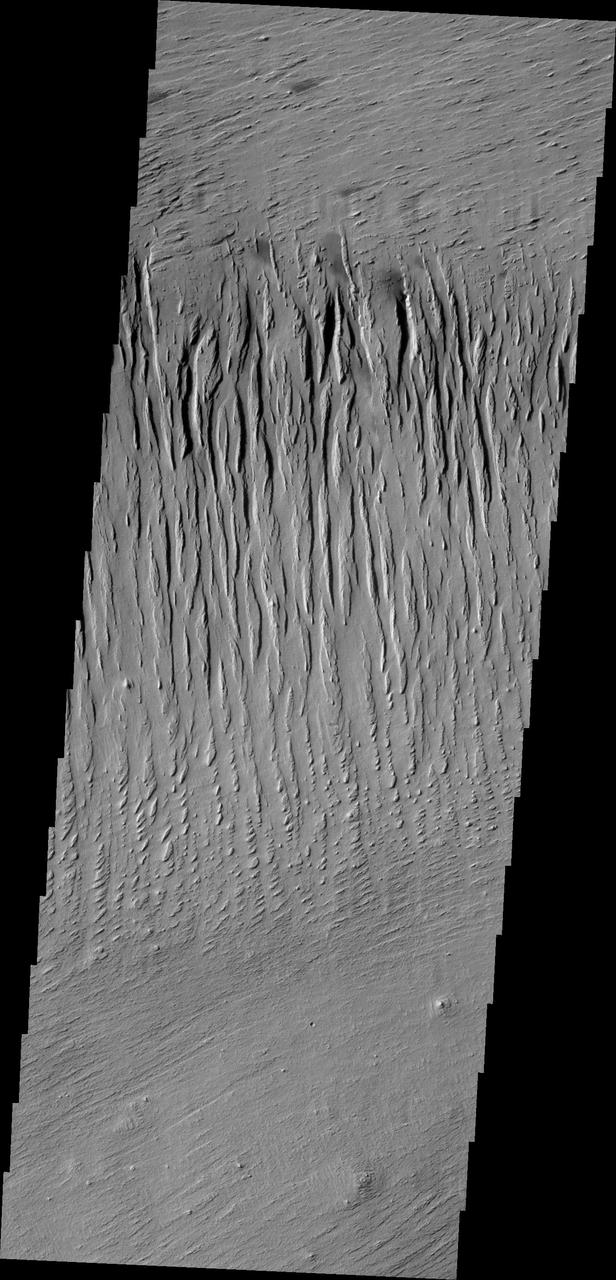
Yardangs in Aeolis
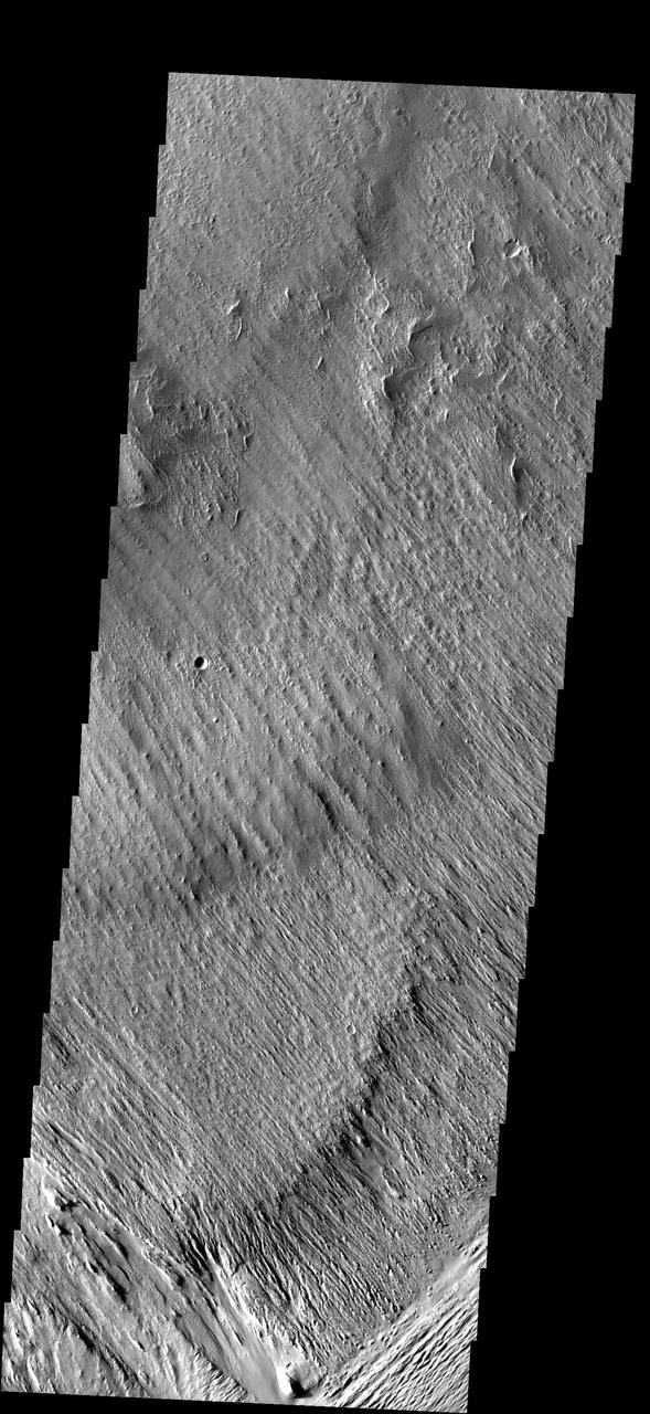
Amazonis Yardangs
Aeolis Yardangs
Tithonium Yardangs
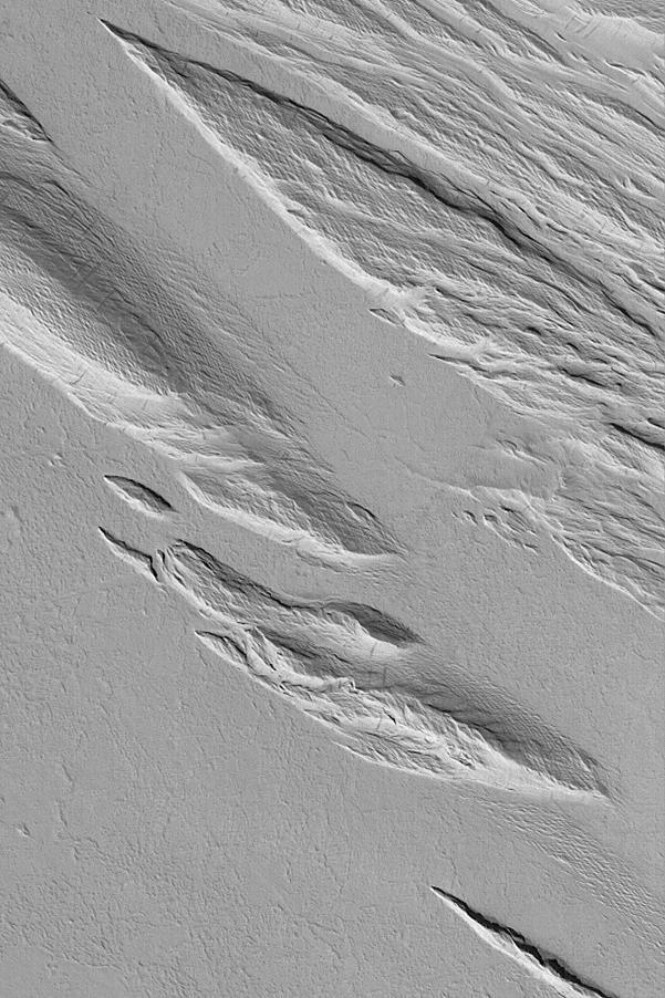
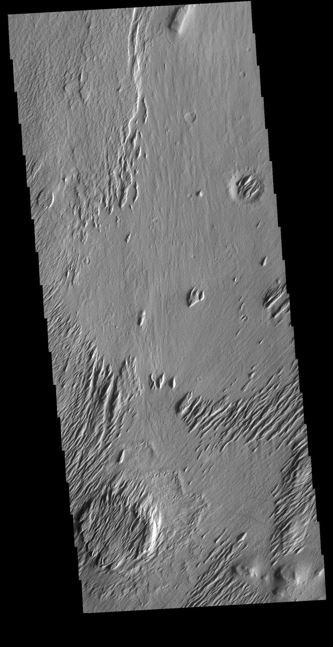
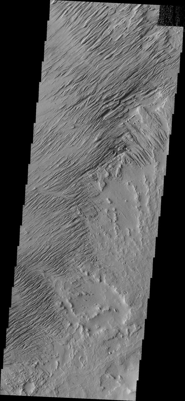
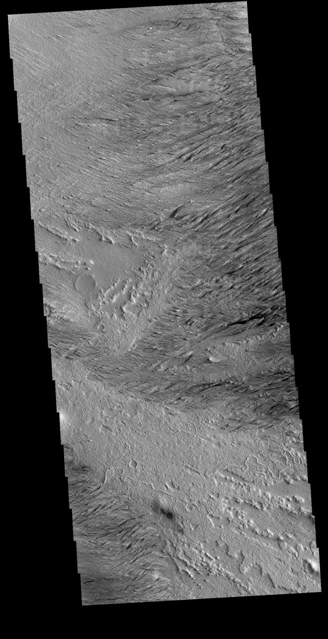
Yardangs and Crosshatching
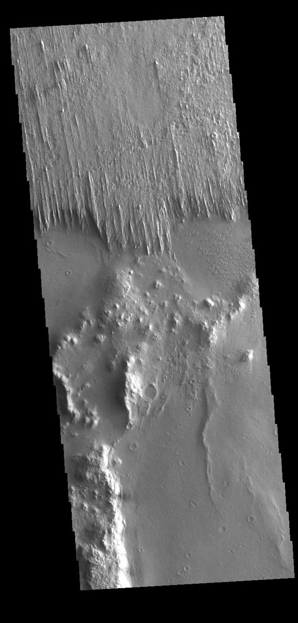
Ejecta Yardangs
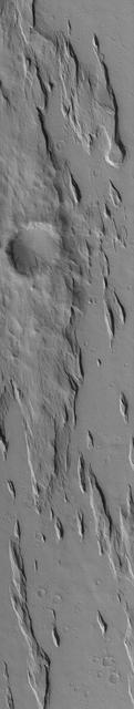
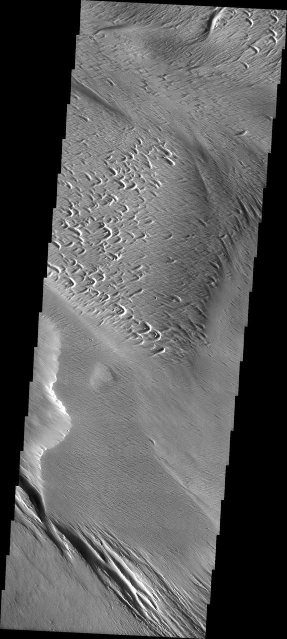
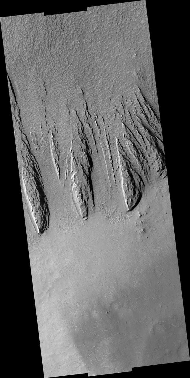
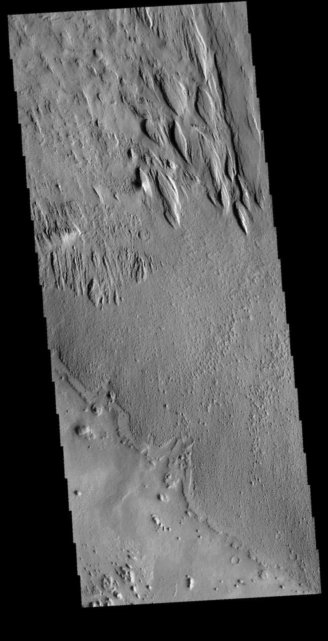
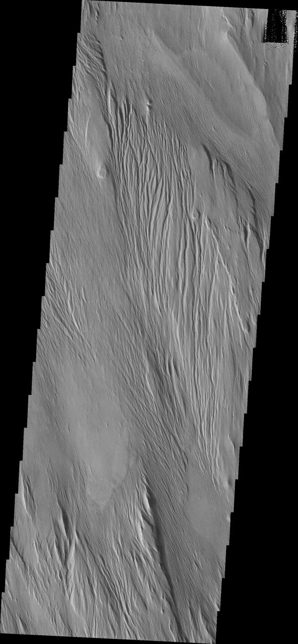
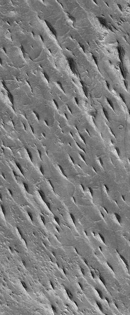
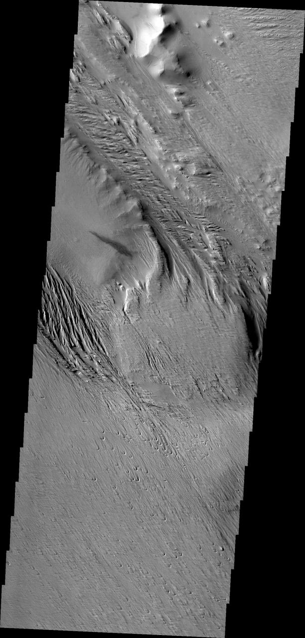
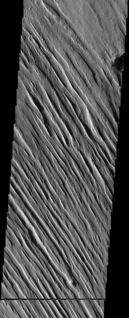
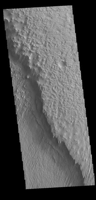
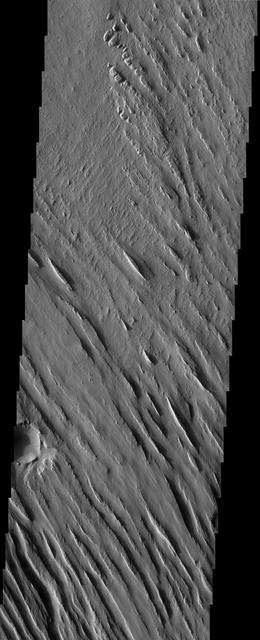
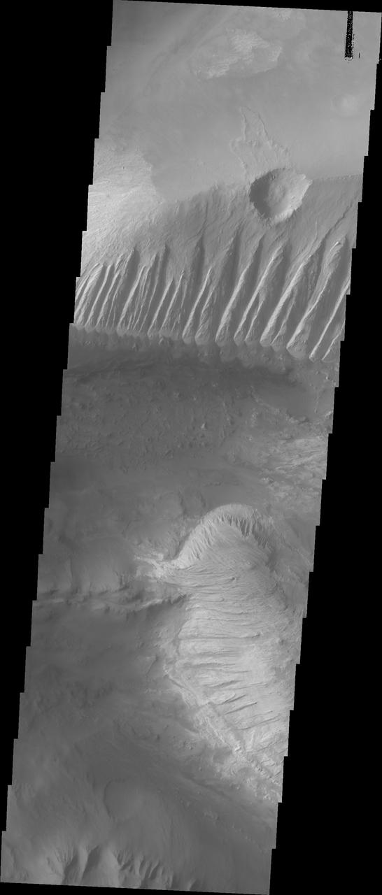
These yardangs - wind eroded ridges - are part of Eumenides Dorsum
Medusae Sulci Yardangs
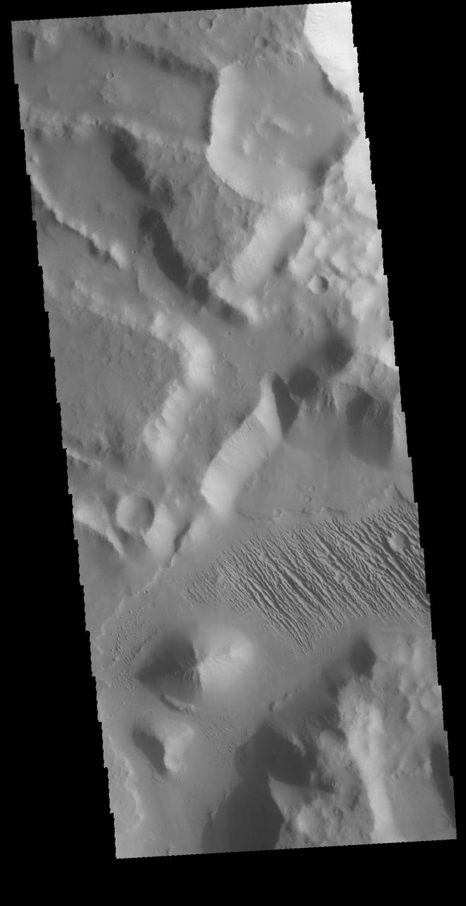
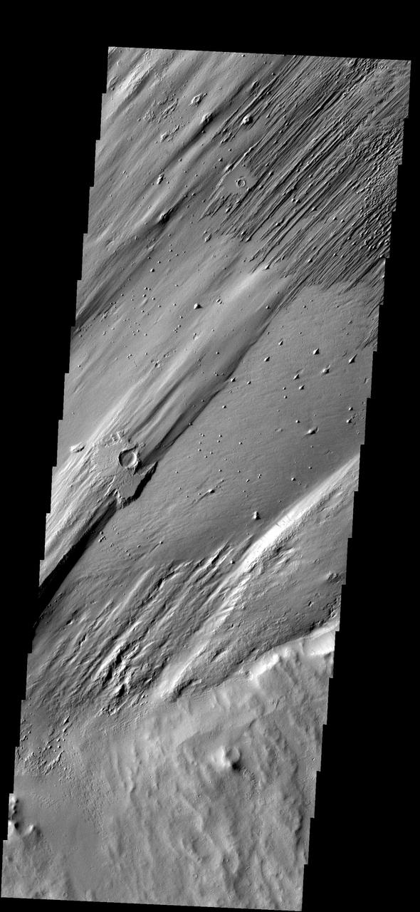
Pedestal Crater and Yardangs
Crater Floor Yardangs
Layered Yardangs in Henry Crater
Channel Floor Yardangs
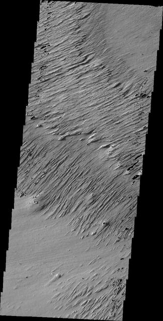
Memnonia Sulci Yardangs
West Arabian Yardangs
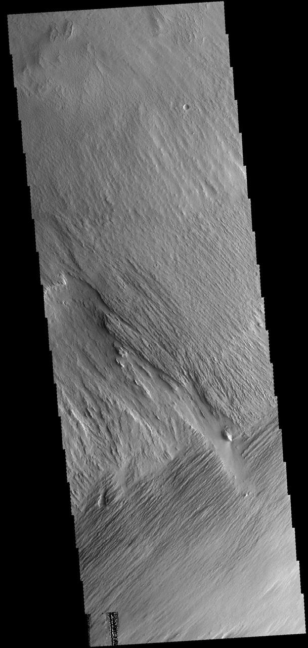
South Amazonis Yardangs
Eumenides Dorsum Yardangs
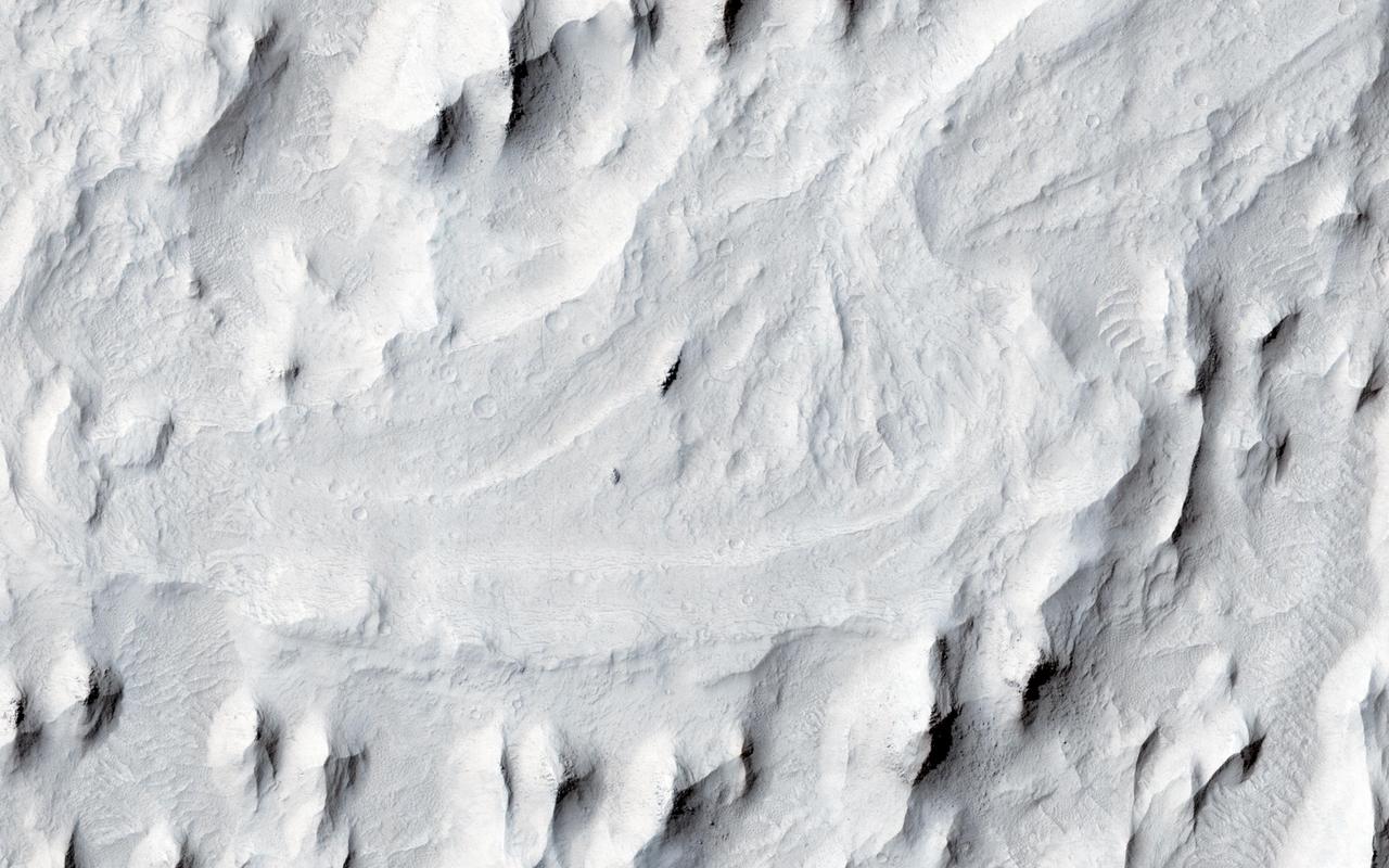
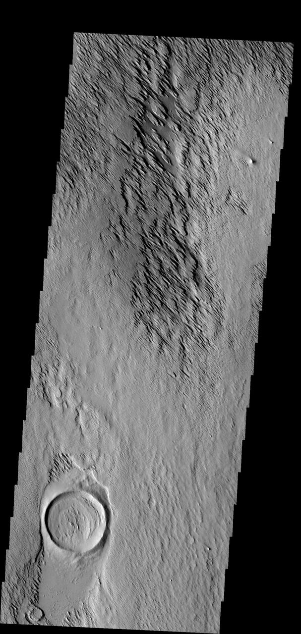
Yardangs within a Large Crater
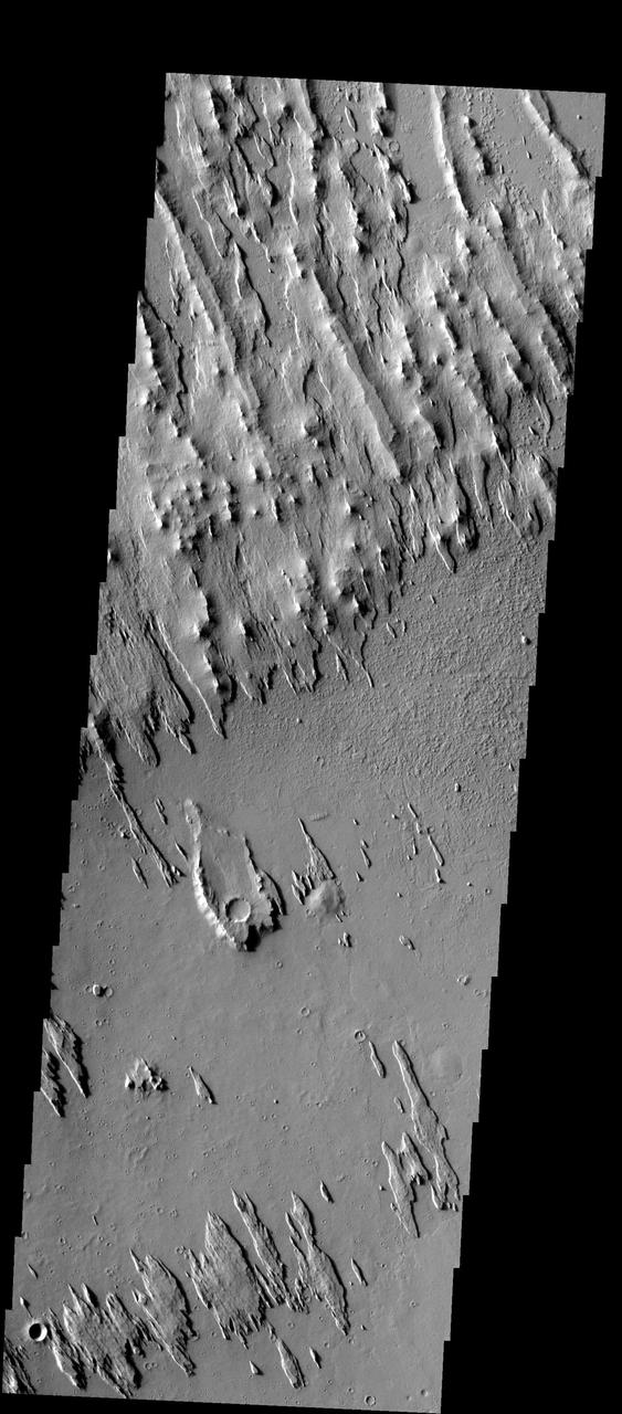
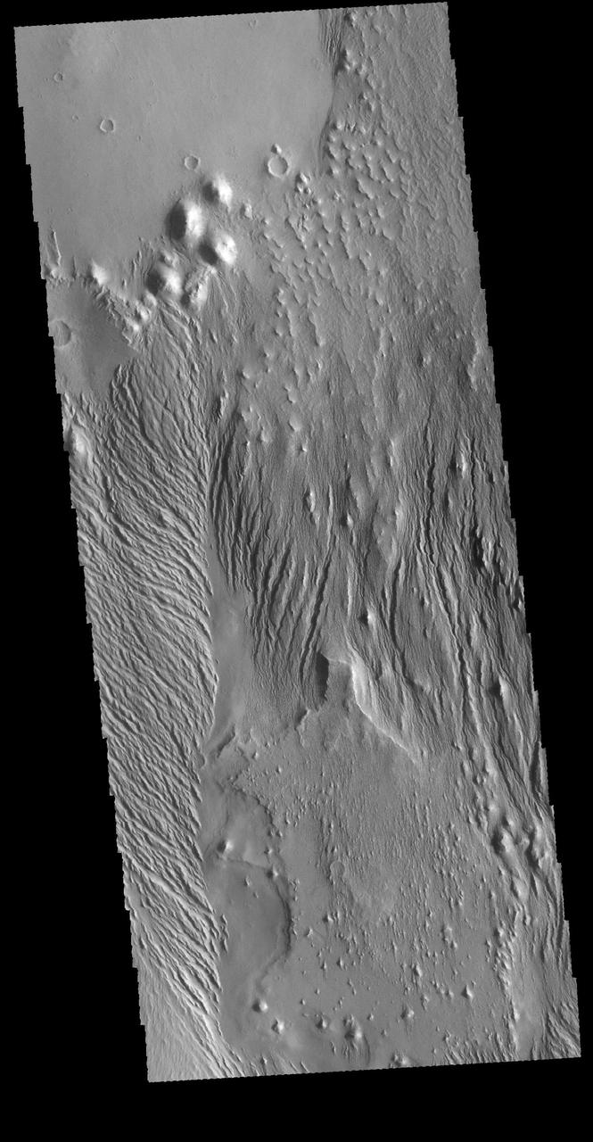
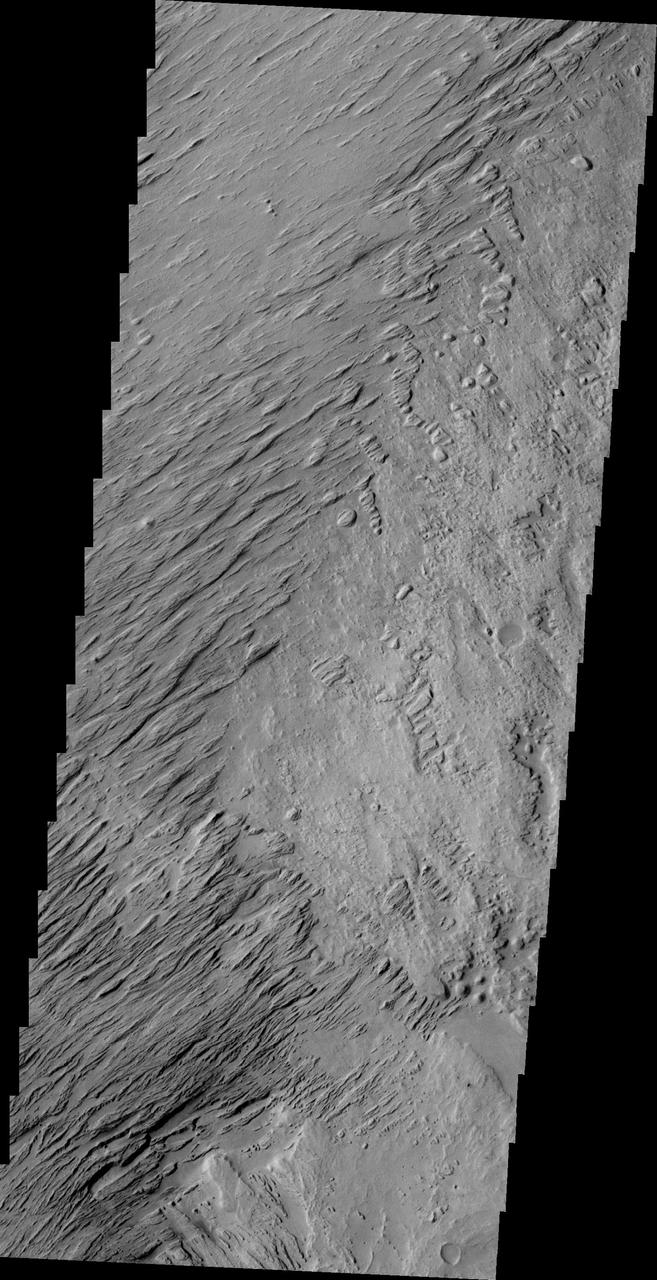
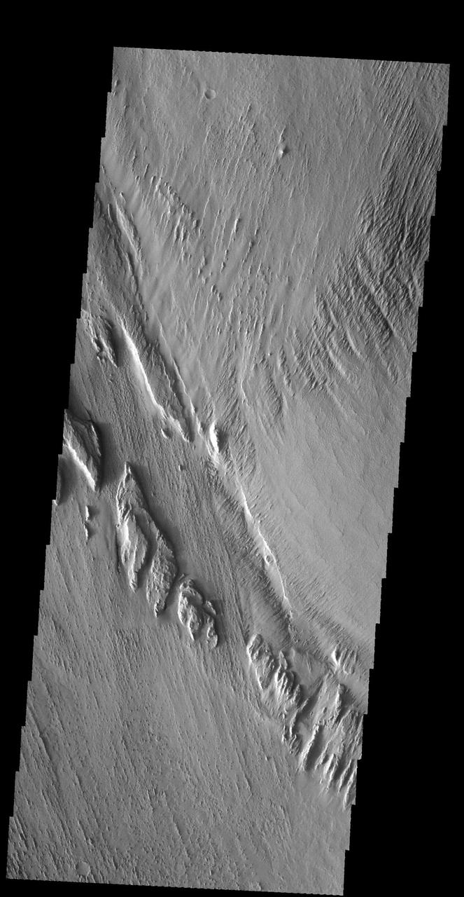
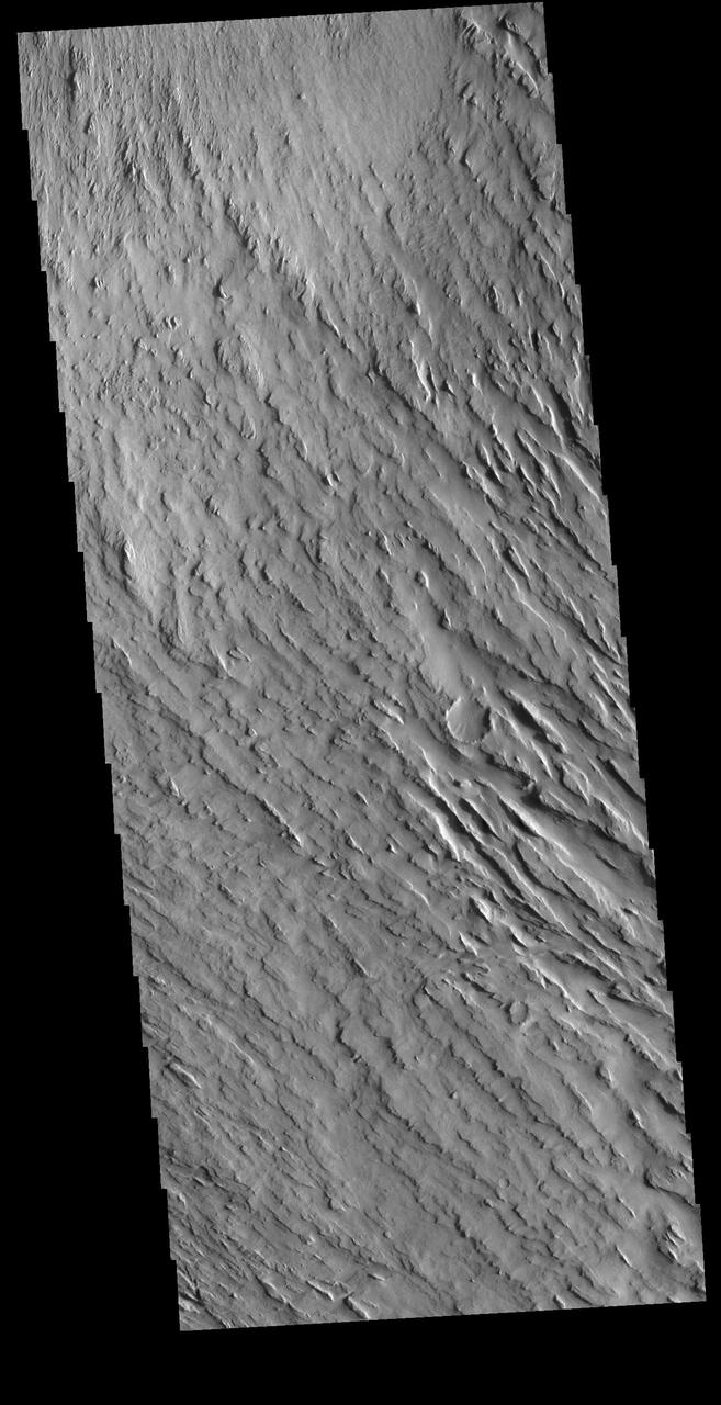
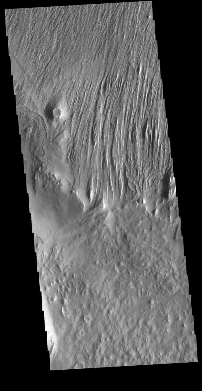
Yardangs in Gordii Dorsum Region
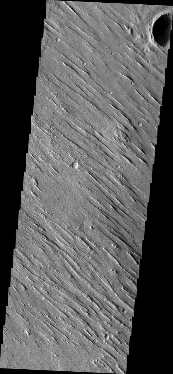
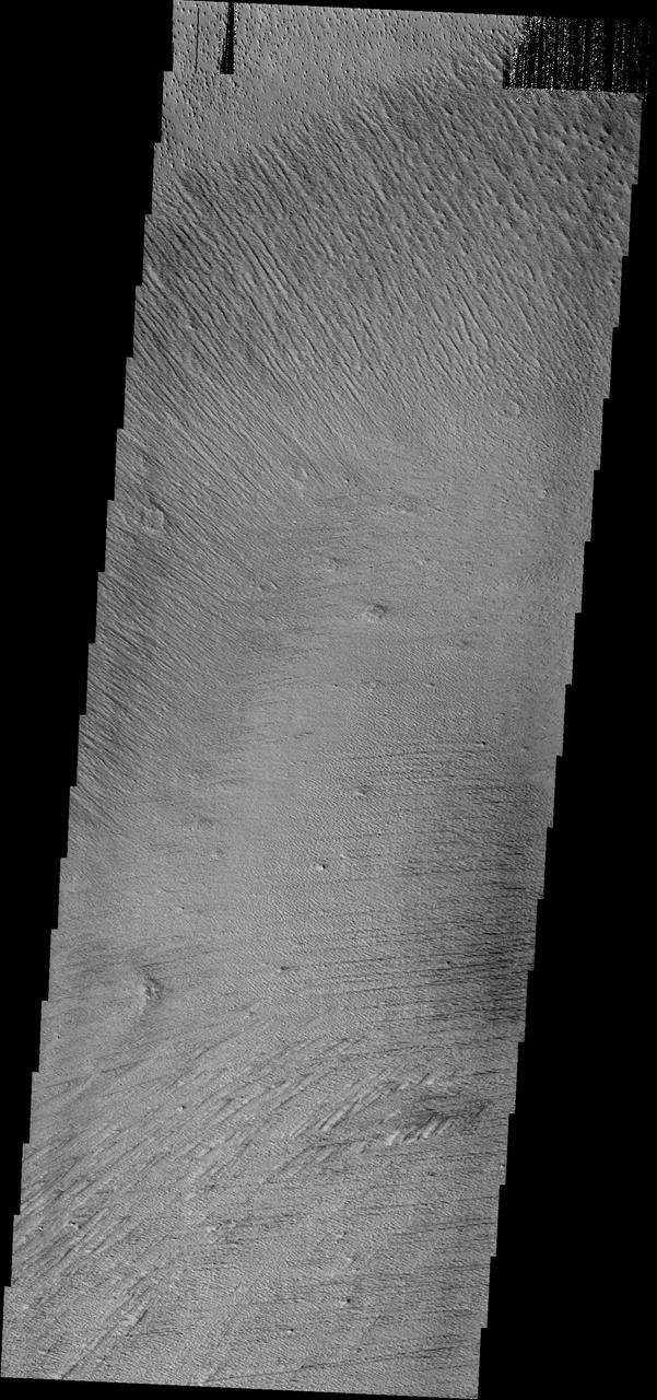
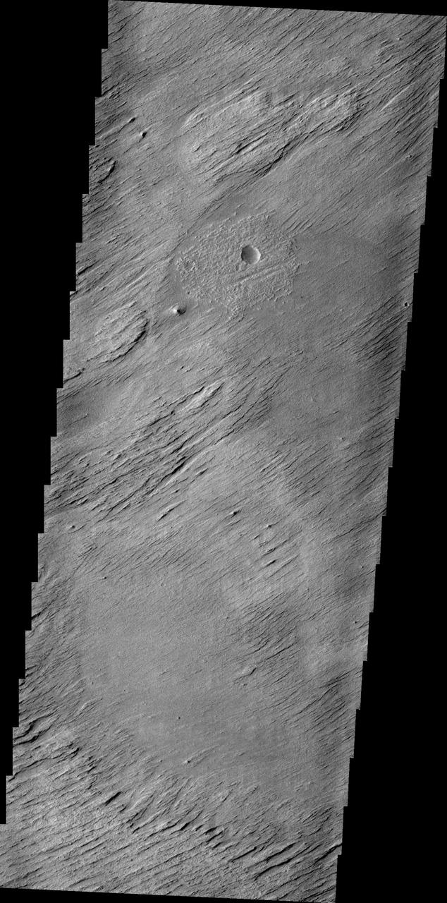
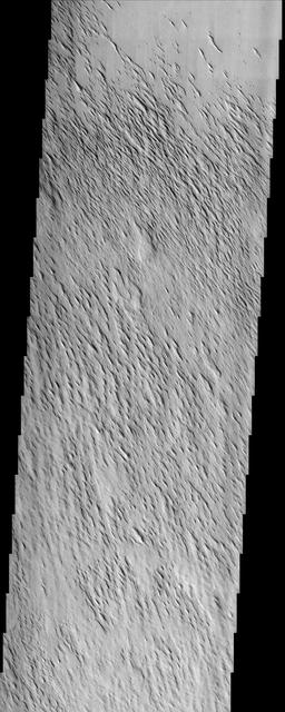
The north/south trending parallel hills and valleys in this image captured by NASA 2001 Mars Odyssey spacecraft were created by wind erosion and are called yardangs. These yardangs are located in Zephyria Planum.
Wind action in the Medusae Fossae region is creating yardangs in the easily eroded material
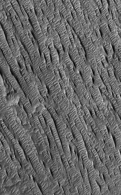
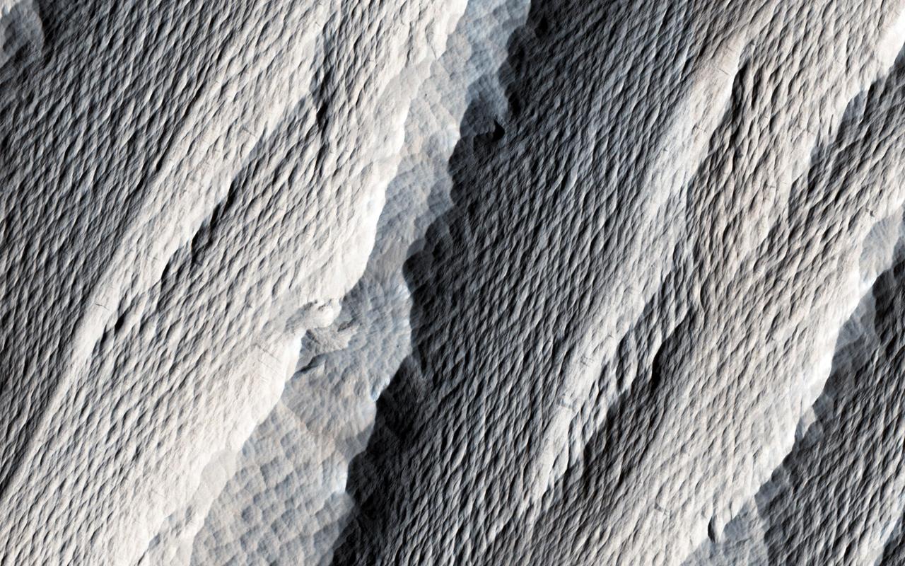
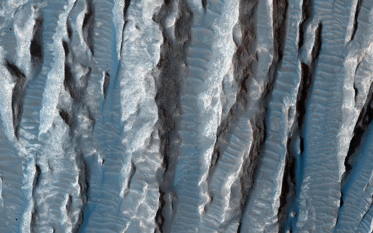
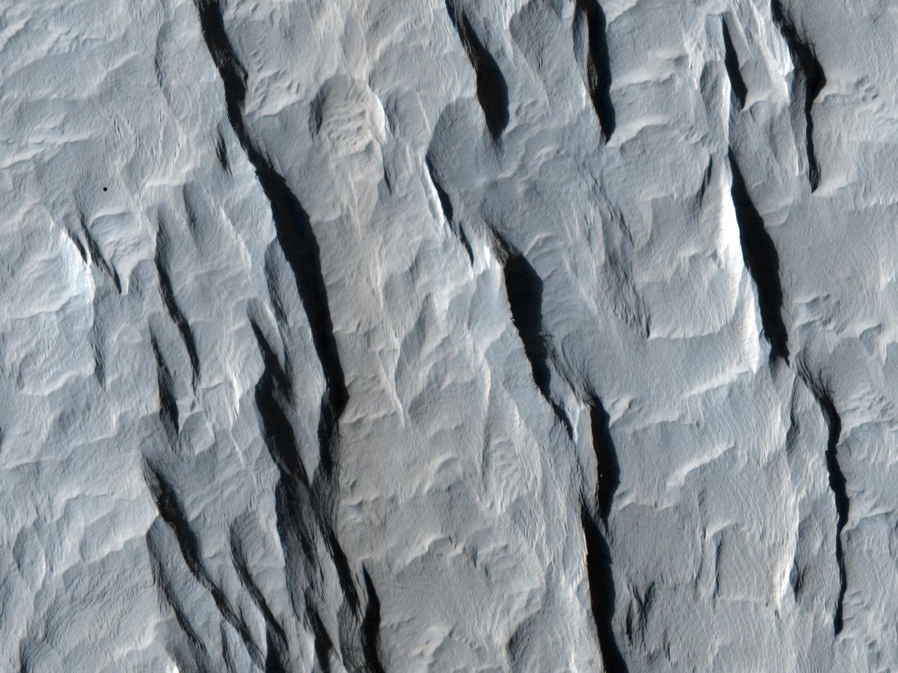
The elongated hills in this VIS image are a feature termed yardangs. Yardangs are formed by wind activity in regions where the surface material is not well cemented. The elongation indicates the direction of the wind. Orbit Number: 65299 Latitude: -10.1078 Longitude: 183.91 Instrument: VIS Captured: 2016-09-02 13:39 http://photojournal.jpl.nasa.gov/catalog/PIA21019
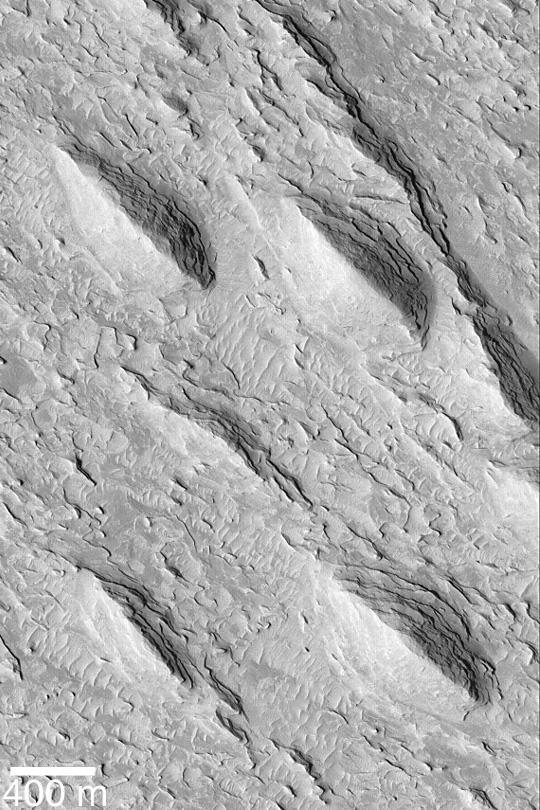
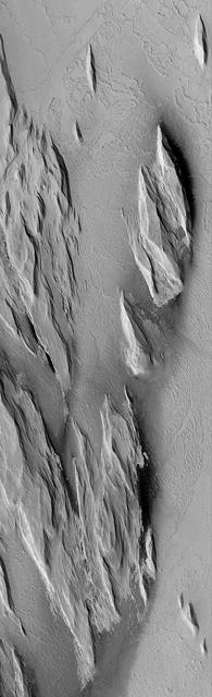
Yardangs are streamlined hills that are carved by wind erosion from bedrock. NASA Mars Reconnaissance Orbiter viewed these yardangs which can look like the hull of a boat.
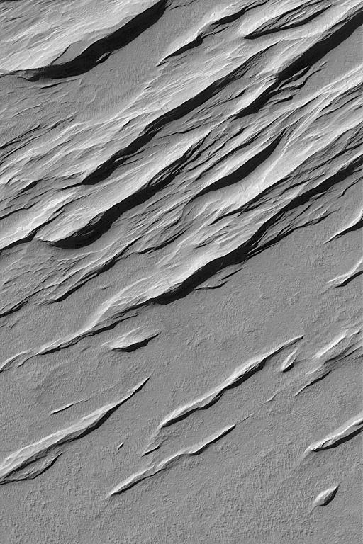
Today's VIS image is located in a region that has been heavily modified by wind action. The narrow ridge/valley system seen in this image are a feature called yardangs. Yardangs form when unidirectional winds blow across poorly cemented materials. Multiple yardang directions can indicate changes in regional wind regimes. Orbit Number: 64188 Latitude: -0.629314 Longitude: 206.572 Instrument: VIS Captured: 2016-06-03 01:20 http://photojournal.jpl.nasa.gov/catalog/PIA20799
Yardangs are present at the top of this VIS image. These features are created by long term winds scouring a poor cemented surface material into linear ridges and valleys. These yardangs are part of the Medusa Fossae Formation. It has been suggested that this region of Mars provides a large percentage of the surface dust seen around the planet. Ash falls from nearby volcanoes may have been the source of the surface materials eroded into these and other wind eroded landforms. Orbit Number: 77922 Latitude: -12.7644 Longitude: 177.96 Instrument: VIS Captured: 2019-07-09 09:43 https://photojournal.jpl.nasa.gov/catalog/PIA23398
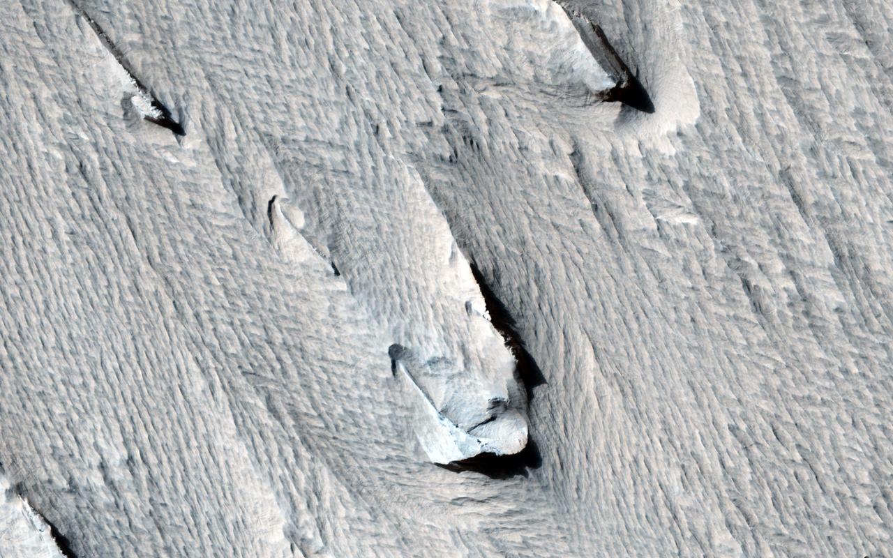
![The prominent tear-shaped features in this image from NASA's Mars Reconnaissance Orbiter (MRO) are erosional features called yardangs. Yardangs are composed of sand grains that have clumped together and have become more resistant to erosion than their surrounding materials. As the winds of Mars blow and erode away at the landscape, the more cohesive rock is left behind as a standing feature. (This Context Camera image shows several examples of yardangs that overlie the darker iron-rich material that makes up the lava plains in the southern portion of Elysium Planitia.) Resistant as they may be, the yardangs are not permanent, and will eventually be eroded away by the persistence of the Martian winds. For scientists observing the Red Planet, yardangs serve as a useful indicator of regional prevailing wind direction. The sandy structures are slowly eroded down and carved into elongated shapes that point in the downwind direction, like giant weathervanes. In this instance, the yardangs are all aligned, pointing towards north-northwest. This shows that the winds in this area generally gust in that direction. The map is projected here at a scale of 50 centimeters (19.7 inches) per pixel. [The original image scale is 55.8 centimeters (21 inches) per pixel (with 2 x 2 binning); objects on the order of 167 centimeters (65.7 inches) across are resolved.] North is up. https://photojournal.jpl.nasa.gov/catalog/PIA22119](https://images-assets.nasa.gov/image/PIA22119/PIA22119~medium.jpg)
The prominent tear-shaped features in this image from NASA's Mars Reconnaissance Orbiter (MRO) are erosional features called yardangs. Yardangs are composed of sand grains that have clumped together and have become more resistant to erosion than their surrounding materials. As the winds of Mars blow and erode away at the landscape, the more cohesive rock is left behind as a standing feature. (This Context Camera image shows several examples of yardangs that overlie the darker iron-rich material that makes up the lava plains in the southern portion of Elysium Planitia.) Resistant as they may be, the yardangs are not permanent, and will eventually be eroded away by the persistence of the Martian winds. For scientists observing the Red Planet, yardangs serve as a useful indicator of regional prevailing wind direction. The sandy structures are slowly eroded down and carved into elongated shapes that point in the downwind direction, like giant weathervanes. In this instance, the yardangs are all aligned, pointing towards north-northwest. This shows that the winds in this area generally gust in that direction. The map is projected here at a scale of 50 centimeters (19.7 inches) per pixel. [The original image scale is 55.8 centimeters (21 inches) per pixel (with 2 x 2 binning); objects on the order of 167 centimeters (65.7 inches) across are resolved.] North is up. https://photojournal.jpl.nasa.gov/catalog/PIA22119
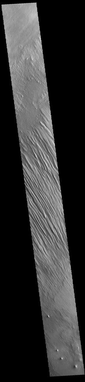
This image from NASA Mars Odyssey spacecraft shows wind erosion that has formed yardangs. These parallel sets of ridges and valley are formed by sandblasing poorly consolidated surface materials.
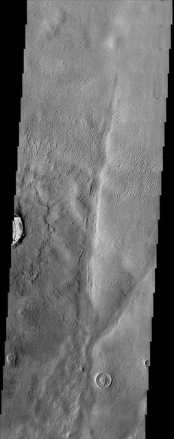
This image of Zephyria Planum, taken by NASA 2001 Mars Odyssey spacecraft, shows wind eroded yardangs.
This image from NASA 2001 Mars Odyssey spacecraft shows a region near Memnonia Sulci, which has been eroded by the wind to form linear ridges called yardangs. The two prominent directions of wind are recorded by the two directions of the ridges.
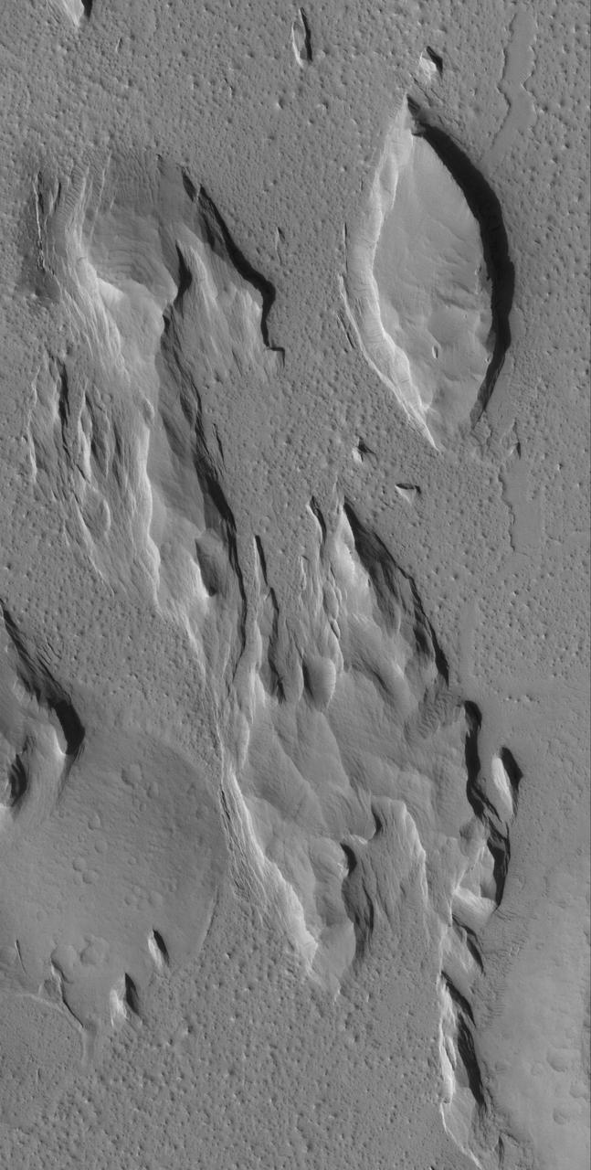
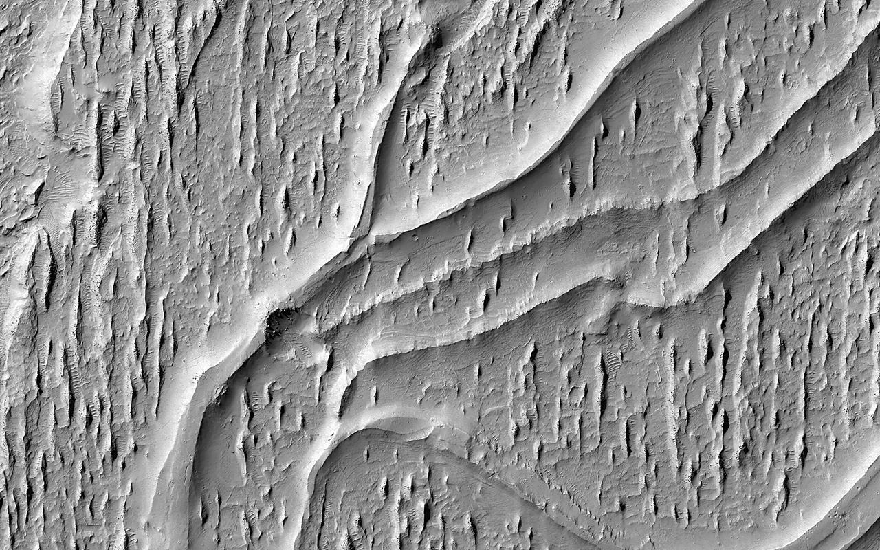
This MOC image shows the contact between a group of yardangs, tapered ridges formed by the removal of relatively easily-eroded material e.g., sedimentary rock and a concentration of dark-toned windblown sand on the floor of a crater in Terra Sabaea
NASA's Curiosity Mars rover captured this view of a geological region called the Yardang Unit using its Mast Camera, or Mastcam, on Nov. 2, 2024, the 4,352nd Martian day, or sol, of the mission. This mosaic is made up of 18 images that were stitched together after being sent back to Earth. The color has been adjusted to match lighting conditions as the human eye would see them on Earth. A yardang is an elongated ridge created by wind erosion. The Yardang Unit is a layer found at the uppermost reaches of the foothills at the base of Mount Sharp, a 3-mile-tall (5-kilometer-tall) mountain that Curiosity has been ascending since 2014. The color, texture, and tilt of the layers in the Yardang Unit make it distinct from lower layers on the mountain. Mount Sharp is an exciting place for scientists to study because it's made up of a number of layers, each representing a distinct era in the climate of ancient Mars. https://photojournal.jpl.nasa.gov/catalog/PIA26472
This observation from NASA Mars Reconnaissance Orbiter spacecraft shows a terrain of relatively smooth region that transitions into sharp ridges called yardangs on Apollonaris Patera. These ridges, aligned in the nearly same direction, are called yardangs. Yardangs are not unique to Mars. Many yardangs can be found on Earth, in very dry regions with strong prevailing winds. Yardangs are formed when a surface that is composed of materials of differing strengths (i.e., of both harder and softer materials) is shaped by the abrasive action of sand and dust carried by the wind. In this case, and given the proximity of the Apollonaris Patera volcanic center, we think that these wind-carved deposits are comprised of volcanic ash and pyroclastics that erupted from Apollonaris when it was last active in the not-too-distant geologic past. Over time, the softer materials (likely volcanic ash) were eroded away, leaving behind the harder materials in the form of elongated ridges that are parallel to the direction of the prevailing wind. The end result is a stunning, out-of-this-world display of yardangs, sculpted with the artistic chisel of the Martian wind. http://photojournal.jpl.nasa.gov/catalog/PIA19869
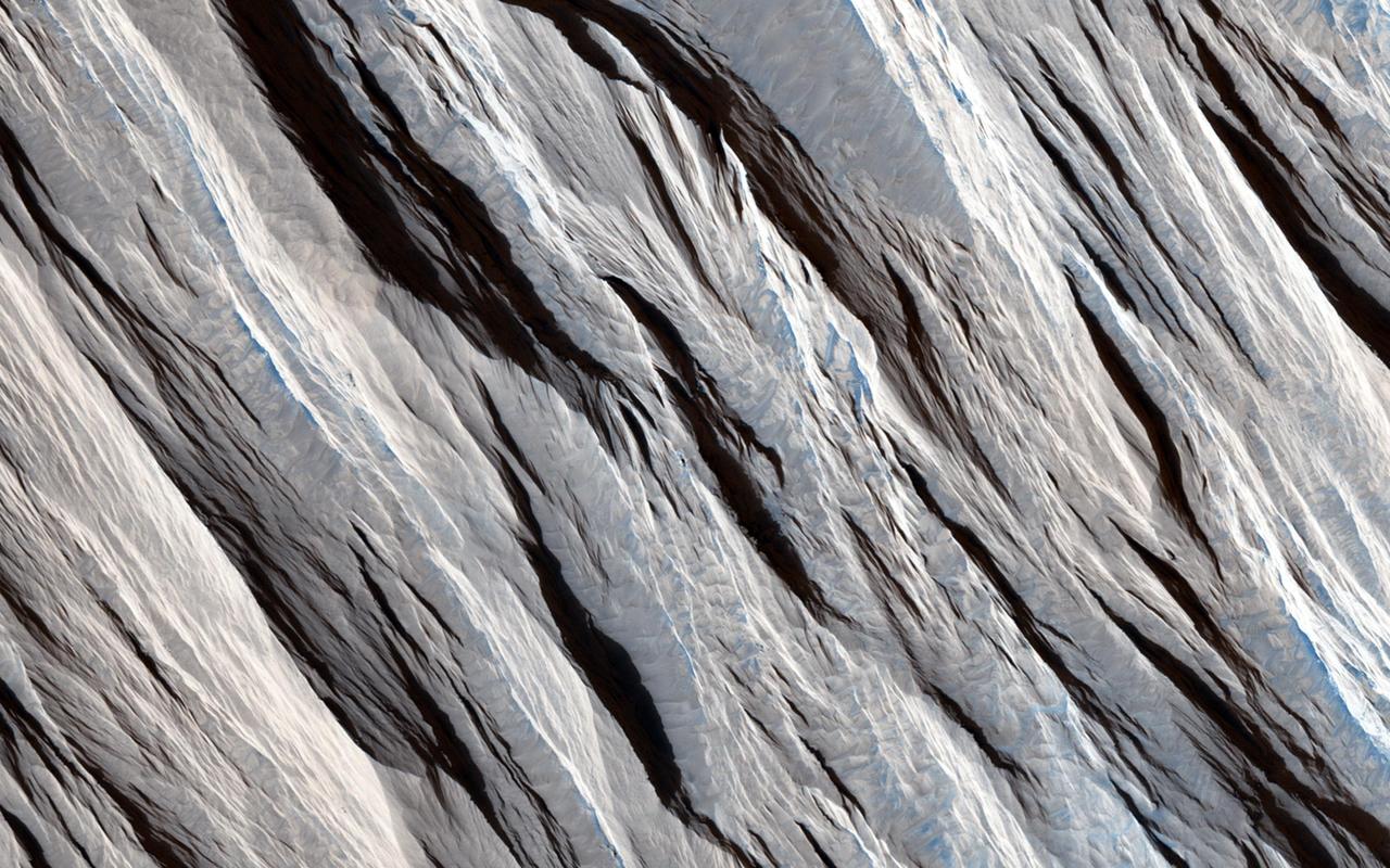
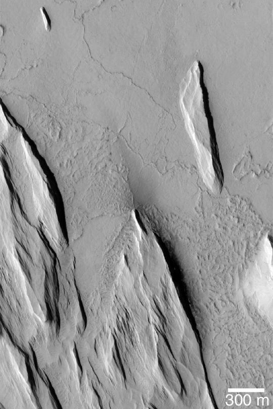
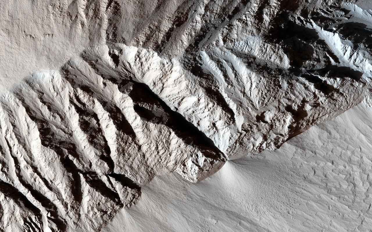
Some geological materials (like solid rock) are incredibly tough, but others (like piles of volcanic ash) are quite soft. Some materials are soft enough that they can be eroded by the wind alone and yield landscapes that look like what we see in this HiRISE image. The long straight ridges seen here are called yardangs and they form on Mars (and Earth) when the wind strips away the inter-ridge material. This process is greatly aided when the wind is also blowing sand along. The sand grains do an effective job at stripping away loose material: these ridges are literally being sandblasted. Yardangs are useful features to recognize because the tell us the direction the wind is blowing in. They take a long time to form so this direction is the dominant wind orientation averaged over a long period of time (which might be quite different that the winds on Mars today). These yardangs also tell us that the surface here is made up of loose weak material and this information, in conjunction with other data, can tell us what the material is composed of and what the history of this particular site on Mars has been. http://photojournal.jpl.nasa.gov/catalog/PIA19457
This image from NASA Mars Odyssey covers a portion of the Medusa Fossae formation, near the equator of Mars. The most characteristic feature of the Medusa Fossae formation is the abundance of yardangs, which are erosional landforms carved by wind.
This MGS MOC image shows a group of tapered ridges, known as yardangs, which formed by wind erosion of a relatively easily-eroded material, most likely sedimentary rock or volcanic ash deposits containing some fraction of sand-sized grains
Today's VIS image is located on Lucus Planum. The surface in this image has been eroded by the wind to form features called yardangs. Yardangs form in a poorly cemented material where the wind cuts linear valleys, removing some of the material and leaving parallel ridges behind. The direction of the ridge/valley is aligned with the wind direction. The dominant wind direction in this region is along a northeast/southwest trend; however, other wind directions can occur within a localized region. There is a circular feature in the lower left side of the image. This is likely the remains of a crater. Meteor impacts melt the surface and subsurface, creating a harder material then the surrounding surfaces. The remnant of the crater are still visible due to being a more resistant material. Orbit Number: 81740 Latitude: -1.61604 Longitude: 187.227 Instrument: VIS Captured: 2020-05-18 18:55 https://photojournal.jpl.nasa.gov/catalog/PIA24008
Today's VIS image is located in Aeolis Mensae, east of Gale Crater. The linear ridge/valley system near the center of the image was formed by unidirectional winds eroding poorly cemented material. This feature is called yardangs. Orbit Number: 64265 Latitude: -5.37213 Longitude: 145.043 Instrument: VIS Captured: 2016-06-09 09:32 http://photojournal.jpl.nasa.gov/catalog/PIA20806
In this region of the Olympus Mons aureole, located to the SW of the volcano, the surface has been eroded by the wind into linear landforms called yardangs. These ridges generally point in direction of the prevailing winds that carved them, in this case winds from the southeast. Yardangs typically occur on surfaces that are easily erodable, such as wind-blown dust or volcanic ash. The northeast - southwest trending ridges and valleys in the northwest corner of the image are typical of the Olympus Mons aureole. The varying concentration and shape of the yardangs in this area may be controlled by the motion of winds around these topographic features. Some crater outlines are visible near the top of this image. The rims of these craters appear to have been stripped away - indicating that the wind erosion is younger than these craters. There are two round knobs in the image, one on the bottom on the right side of the image and another about midway down on the left. These may be inverted craters, formed because the impacts caused materials underneath the crater to become harder to erode than the surrounding materials. http://photojournal.jpl.nasa.gov/catalog/PIA04036
The distinctively fluted surface and elongated hills in this image in Medusae Fossae are caused by wind erosion of a soft fine-grained rock. Called yardangs, these features are aligned with the prevailing wind direction. This wind direction would have dominated for a very long time to carve these large-scale features into the exposed rock we see today. Yardangs not only reveal the strength and direction of historic winds, but also reveal something of the host rock itself. Close inspection by HiRISE shows an absence of boulders or rubble, especially along steep yardang cliffs and buttresses. The absence of rubble and the scale of the yardangs tells us that the host rock consists only of weakly cemented fine granules in tens of meters or more thick deposits. Such deposits could have come from extended settling of volcanic ash, atmospheric dust, or accumulations of wind deposited fine sands. After a time these deposits became cemented and cohesive, illustrated by the high standing relief and exposed cliffs. http://photojournal.jpl.nasa.gov/catalog/PIA21111
Today's VIS image shows part of Apollinaris Sulci. Yardangs are present at the top of this VIS image. These features are created by long term winds scouring a poor cemented surface material into linear ridges and valleys. The direction of the ridge/valley is aligned with the wind direction, indicating the dominant wind direction in this region was north/south. These yardangs are the southern margin of Apollinaris Sulci, located south of Apollinaris Mons. It has been suggested that this region of Mars provides a large percentage of the surface dust seen around the planet. Ash falls from nearby volcanoes may have been the source of the surface materials eroded into these and other wind etched landforms. Orbit Number: 86395 Latitude: -12.5877 Longitude: 177.796 Instrument: VIS Captured: 2021-06-06 01:38 https://photojournal.jpl.nasa.gov/catalog/PIA24952
This wind-swept region of Amazonis Planitia, imaged here by NASA Mars Odyssey spacecraft, has been so uniformly dissected into yardangs that only two craters provide any indication that other processes have ever been active on the surface. http://photojournal.jpl.nasa.gov/catalog/PIA04010
One of the great strengths of the HiRISE camera onboard NASA Mars Reconnaissance Orbiter is that its high resolution can help resolve interesting questions. Here, is the platy flow material younger than the yardang-forming material?
This view of Martian surface features shaped by effects of winds was captured by the High Resolution Imaging Science Experiment (HiRISE) camera on NASA's Mars Reconnaissance Orbiter on Jan. 4, 2015. The spacecraft has been orbiting Mars since March 2006. On Feb. 7, 2015, it completed its 40,000th orbit around Mars. Several terrain types converge in this scene from the Arsinoes Chaos region of Mars, which is in the far eastern portion of Mars' Valles Marineris canyon system. The jumbled chaos terrain is likely related to massive water-carved outflow channels that started in this area and flowed north onto Mars' northern plains. The slightly curving bright terrain is composed of yardangs. Yardangs are portions of rock that have been sandblasted into long, skinny ridges by saltating (or bouncing) sand particles blowing in the wind. Transverse sand ridges lie between the yardangs (zoom in). These sand ridges are termed "transverse aeolian ridges" and are not moving in Mars' current climate. They are a mystery -- midway in height between dunes (formed from saltating sand) and ripples (formed by "splashed" sand grains). The location is at 7 degrees south latitude, 332 degrees east latitude. The image is an excerpt from HiRISE observation ESP_039563_1730. http://photojournal.jpl.nasa.gov/catalog/PIA19291
The long sharp-crested features observed in this image from NASA Mars Odyssey spacecraft are named yardangs. Yardangs form by wind erosion and typically lie in the direction of the dominant wind.
These yardangs are being formed by wind erosion of the Memnonia Sulci deposits
This MOC image shows small ridges in the Memnonia region of Mars. The ridges or yardangs, as they are called, are formed by wind erosion
The multiple trends of yardangs in this image indicate that the winds in the Elysium region have changed direction several times
This MOC image shows wind-eroded outcrops overlying lava flow surfaces located west of Olympus Mons. Outcrops with this appearance are called yardangs
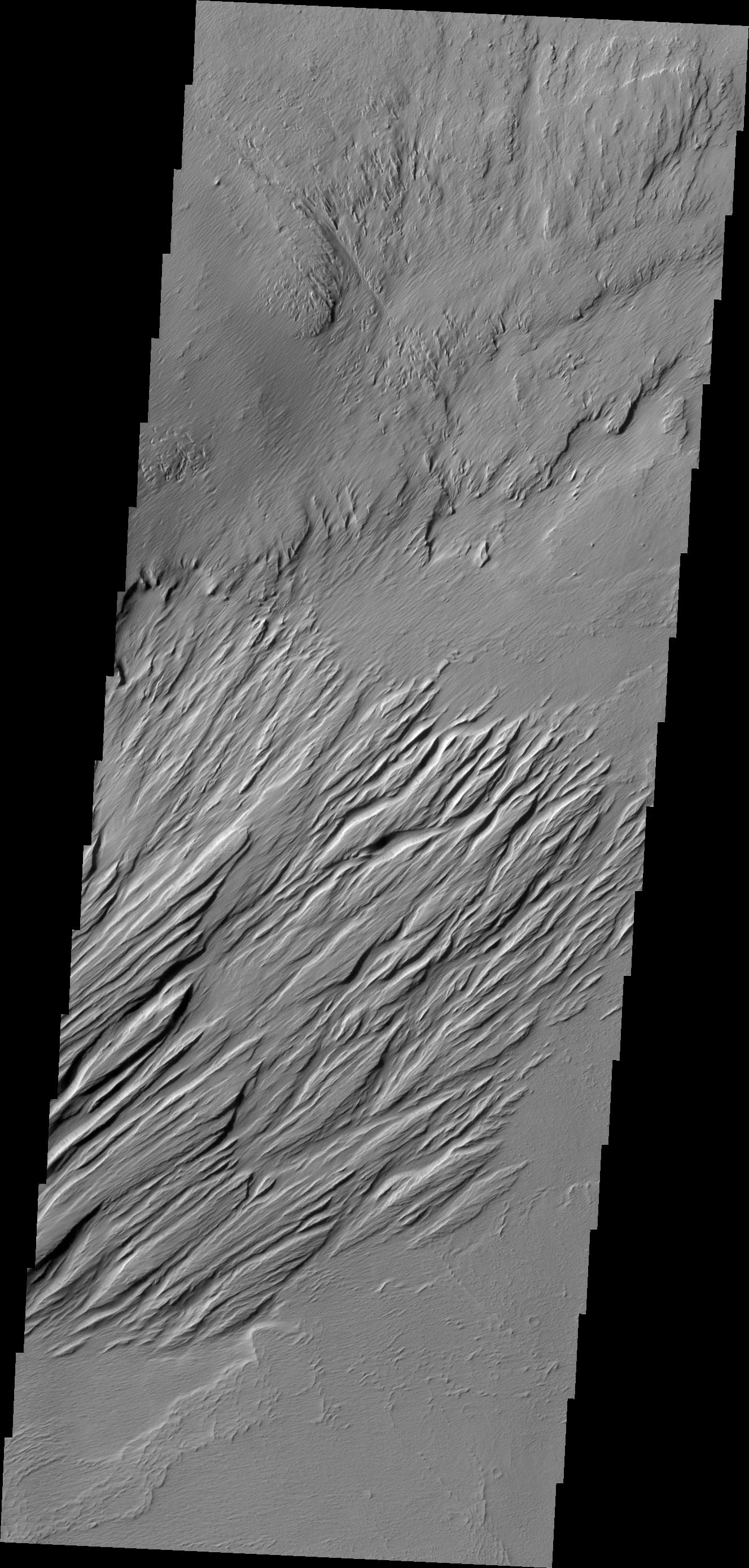
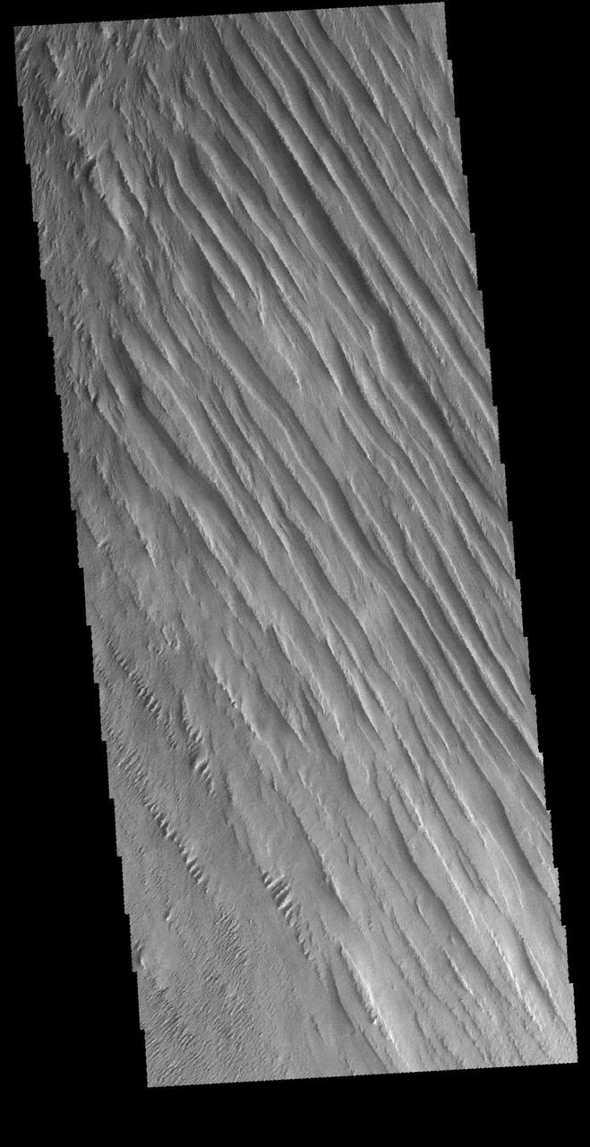
Long term winds have etched the surface in Memnonia Sulci. Partial cemented surface materials are easily eroded by the wind, forming linear ridges called yardangs. The multiple direction of yardangs in this VIS image indicate that there were at least two different wind directions in this area. Orbit Number: 59217 Latitude: -8.33112 Longitude: 186.506 Instrument: VIS Captured: 2015-04-20 15:12 http://photojournal.jpl.nasa.gov/catalog/PIA19502
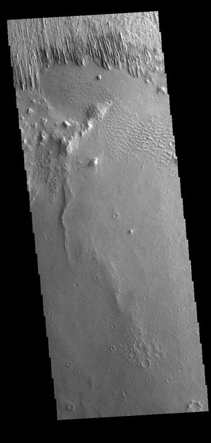
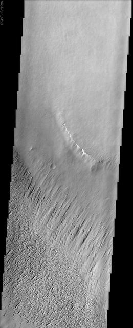
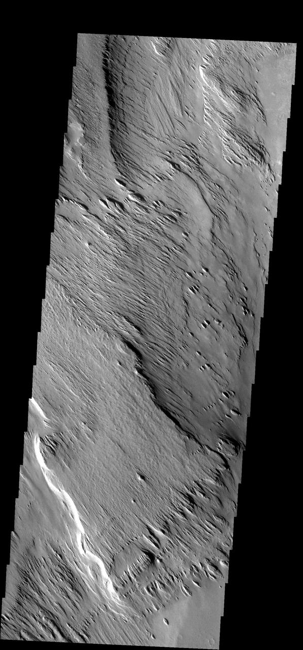
In this image from NASA Mars Reconnaissance Orbiter spacecraft, an ancient sinuous meandering river system is surrounded by features called yardangs. The yardangs are the ridge-like landforms that align approximately north-south. These features were created as the wind scoured and eroded the bedrock. The raised relief of the meandering river suggests inverted topography, likely due to lithification and cementation of the riverbed sediment. The cemented channel deposits were resistant, and thus less susceptible to erosion over time. However, the area surrounding the riverbed suggests that this area was a floodplain of weaker lithology that was subsequently eroded and shaped to the yardangs. The main meandering inverted riverbed within the image has a length of about 13 kilometers. The elevation of the channel at the top of the image is on the order of 113 meters higher than the bottom, based on Mars Orbiter Laser Altimeter (MOLA) data. This elevation difference and the increase in sinuosity of the channel shape in the southerly direction implies that the flow of the ancient river may have been heading south-southwest. http://photojournal.jpl.nasa.gov/catalog/PIA20047
The main agent of erosion on Mars today is the wind. Wind has sculpted the surface in this region into a set of hills and valleys called yardangs on Earth. This image is from NASA 2001 Mars Odyssey spacecraft.
NASA 2001 Mars Odyssey captured this region of Mars which has been eroded by the wind. Linear hills called yardangs indicate the wind direction, which varies in this area of Medusae Fossae.
Located near Amazonis Mensa, this region of Mars has undergone erosion by wind. Long linear hills being created by the wind are called yardangs in this image from NASA 2001 Mars Odyssey.
The layered deposits in this Valles Marineris canyon imaged by NASA Mars Odyssey spacecraft are heavily eroded by the wind into an impressive array of yardangs and swirling patterns of layers. The origin of the deposits remains a mystery.
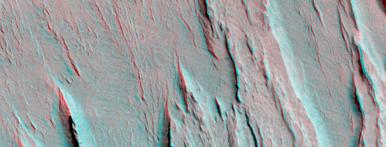
Layers of bedrock etched by wind to form sharp, elongated ridges known to geomorphologists as yardangs are commonplace in the southern Elysium Planitia/southern Amazonis region of Mars. 3D glasses are necessary to view this image.
The wind-sculpted yardangs in this scene from NASA Mars Odyssey spacecraft are part of the Medusae Fossae Formation, a regionally extensive geologic unit that probably was produced from the accumulation of volcanic ash.
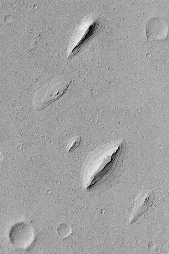
Only a portion of the ejecta remains around this crater. Wind action is creating yardangs and stripping off the surface materials in this region. The margin of Apollinaris Patera is at the bottom 1/3 of the frame
Eroded by countless years of wind action, the material in this region of Zephyria Planum is being sculpted into yardangs -- long, thin hills separated by narrow valleys. This image was captured by NASA Mars Odyssey.
Remarkable variations in the erosion of the Medusae Fossae Formation are shown in this scene from NASA Mars Odyssey spacecraft. In this region, the surface has been eroded by the wind into a series of linear ridges called yardangs.
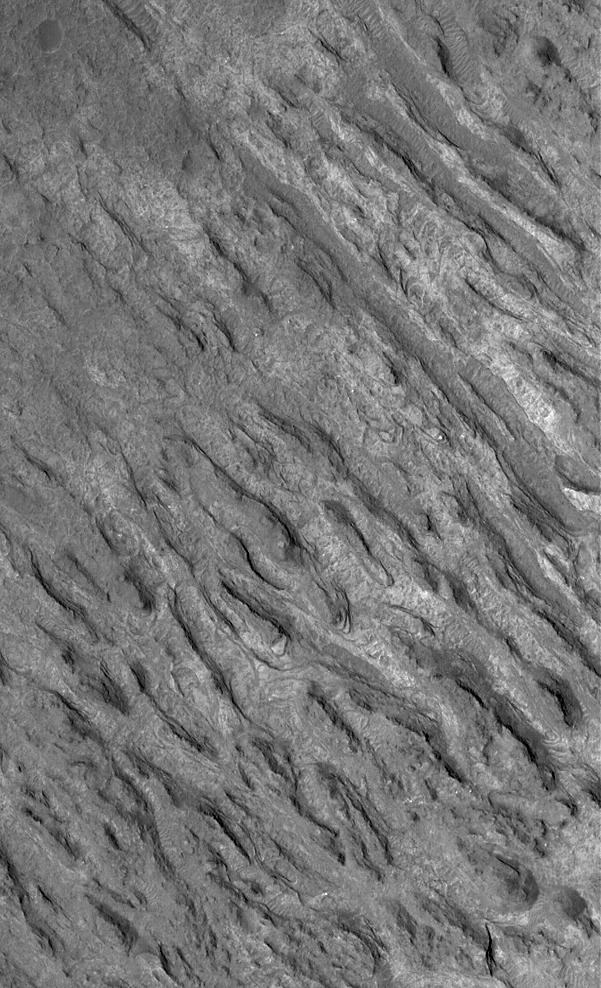
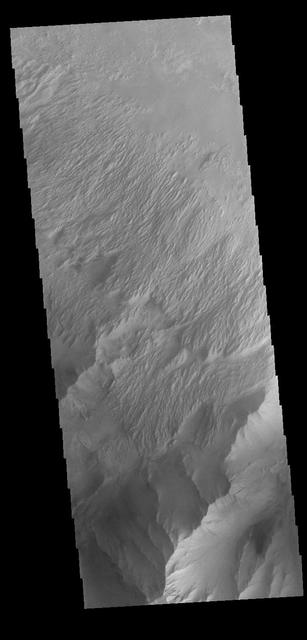
Today's VIS image shows some of the extensive wind etched terrain in Memnonia Sulci, located south west of Olympus Mons. The linear ridges are called yardangs and form by wind removal of semi-cemented material. The ridges are parallel to wind direction, so the predominate winds that created the yardangs in this image blew NW/SE. At the bottom of the image several of the ridges have been eroded into smaller ridges aligned perpendicular to the large yardangs, indicating winds at a different angle. Orbit Number: 66197 Latitude: -5.91796 Longitude: 183.886 Instrument: VIS Captured: 2016-11-15 13:08 http://photojournal.jpl.nasa.gov/catalog/PIA21283
In this image the action of the wind is forming yardangs. The top layer of material is being removed by the wind, revealing an older surface below -- like the crater at the bottom of the frame. Image information: VIS instrument. Latitude 11.2N, Longitude 199.4E. 18 meter/pixel resolution. http://photojournal.jpl.nasa.gov/catalog/PIA01328
Today's VIS image shows some of the extensive wind etched terrain in Memnonia Sulci, located southwest of Olympus Mons. The linear ridges are called yardangs and form by wind removal of semi-cemented material. The ridges are parallel to wind direction, so the predominate winds that created the yardangs in this image blew NW/SE. Orbit Number: 81216 Latitude: -7.99809 Longitude: 185.052 Instrument: VIS Captured: 2020-04-05 15:23 https://photojournal.jpl.nasa.gov/catalog/PIA23944
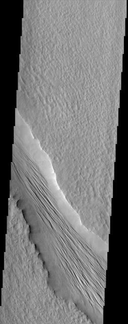
Winds in this region have modified the surface, carving valleys into a poorly cemented material. The winds in this region blew to the northeast (north is to the top of the image, and sunlight is coming from the right). These linear valleys are called yardangs. Orbit Number: 72445 Latitude: -9.22287 Longitude: 187.05 Instrument: VIS Captured: 2018-04-14 07:28 https://photojournal.jpl.nasa.gov/catalog/PIA22604
The lower elevation on the left side of this VIS image is part of Memnonia Sucli. The higher elevations to the right are on the upper part of a mesa that bounds the sulci. The image shows some of the extensive wind etched terrain in Memnonia Sulci, located south west of Olympus Mons. The linear ridges are called yardangs and form by wind removal of semi-cemented material. The ridges are parallel to wind direction, so the predominate winds that created the yardangs in this image blew NE/SW. Orbit Number: 78296 Latitude: -7.8302 Longitude: 186.694 Instrument: VIS Captured: 2019-08-09 04:54 https://photojournal.jpl.nasa.gov/catalog/PIA23471
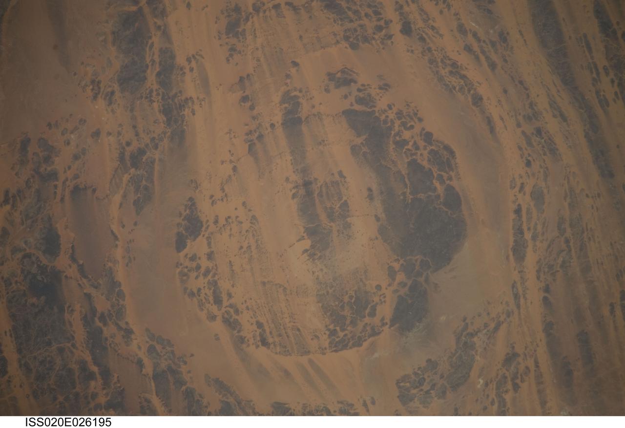
ISS020-E-026195 (25 July 2009) --- Aorounga Impact Crater is featured in this image photographed by an Expedition 20 crew member on the International Space Station. Aorounga Impact Crater is located in the Sahara Desert of north-central Chad and is one of the best preserved impact structures in the world. According to scientists, the crater is thought to be middle or upper Devonian to lower Mississippian (approximately 345 ? 370 million years old) based on the age of the sedimentary rocks deformed by the impact. Spaceborne Imaging Radar (SIR) data collected in 1994 suggests that Aorounga is one of a set of three craters formed by the same impact event. The other two suggested impact structures are buried by sand deposits. The concentric ring structure of the Aorounga crater ? renamed Aorounga South in the multiple-crater interpretation of SIR data ? is clearly visible in this detailed photograph. The central highland, or peak, of the crater is surrounded by a small sand-filled trough; this in turn is surrounded by a larger circular trough. Linear rock ridges alternating with light orange sand deposits cross the image from upper left to lower right; these are called yardangs by geomorphologists. Yardangs form by wind erosion of exposed rock layers in a unidirectional wind field. The wind blows from the northeast at Aorounga, and sand dunes formed between the yardangs are actively migrating to the southwest.
The Medusae Fossae formation, seen in this NASA Mars Odyssey image, is an enigmatic pile of eroding sediments that spans over 5,000 km 3,107 miles in discontinuous masses along the Martian equator.
This image taken by NASA Mars Reconnaissance Orbiter shows a part of a central mound in an impact crater in Arabia Terra.
Today's VIS image shows some of the extensive wind etched terrain in Memnonia Sulci, located east of Apollinaris Mons. Memnonia Sulci is part of the Medusae Fossae Formation, a region of soft, easily eroded deposits that extends for nearly 5000km (3106 miles) along the equator of Mars between Olympus Mons and Apollinaris Mons. In this region, like many others throughout the Medusae Fossae Formation, the surface has been eroded by the wind into a series of linear ridges called yardangs. The ridges generally point in direction of the prevailing winds that carved them, so the predominate winds that created the yardangs in this image blew NW/SE. The easily eroded nature of the Medusae Fossae Formation suggests that it is composed of weakly cemented particles, and was most likely formed by the deposition of wind-blown dust or volcanic ash. Orbit Number: 94406 Latitude: -5.66737 Longitude: 184.045 Instrument: VIS Captured: 2023-03-27 16:37 https://photojournal.jpl.nasa.gov/catalog/PIA26027
Multiple processes, which may have occurred billions of years apart, are reflected in this HiRISE image of Aeolis Planum. Cutting across the scene are curvilinear ridges. These likely represent ancient, meandering river channels that flowed across the surface and buried themselves over time. The channels have subsequently been exposed to the surface by the wind, forming the cross-cutting ridges. Approximately north-south across the image are a series of linear ridges called "yardangs," which are streamlined landforms that also form due to wind-driven erosion. The orientation of the yardangs reflects the prevailing wind direction when they formed. Both sets of ridges emerged from the preferential removal of softer bedrock by the wind. https://photojournal.jpl.nasa.gov/catalog/PIA25989
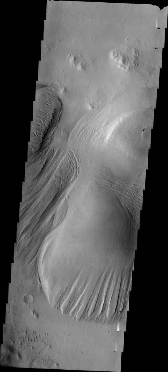
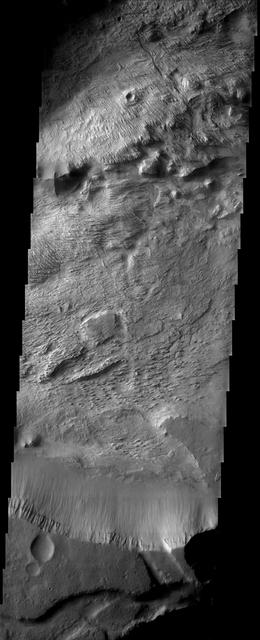
Today's image shows a cross section of Nicholson Crater. The central peak of this crater is surrounded by a layered deposit that rises 3.5km (2 miles) above the crater floor. This central mound of material has undergone extensive wind erosion, with yardangs visible on the on most of the mound. These features are created by long term winds scouring a poor cemented surface material into linear ridges and valleys. The direction of the ridge/valley is aligned with the wind direction. The dominant wind direction in this region of the mound is along a north/south trend. However, other wind directions can occur within a localized region, as evidenced by the smaller yardangs near the north side of the mound. Located on the southern edge of Amazonis Planitia, Nicholson Crater is 102km (63 miles) in diameter. Orbit Number: 85995 Latitude: 0.290091 Longitude: 195.593 Instrument: VIS Captured: 2021-05-04 03:15 https://photojournal.jpl.nasa.gov/catalog/PIA24218
This VIS image is located near Zephyria Planum. Winds of two different directions have excavated a poorly cemented surface into linear ridge features called yardangs. Examining the structure of the ridges, it appears that winds first blew from the upper left of the image. Then perhaps after a change in climate, winds blew toward the upper right, carving a new pattern on top of the older one. The ridges are not perpendicular, but intersect at a wider angle. Orbit Number: 72496 Latitude: -4.75332 Longitude: 154.461 Instrument: VIS Captured: 2018-04-18 12:20 https://photojournal.jpl.nasa.gov/catalog/PIA22612
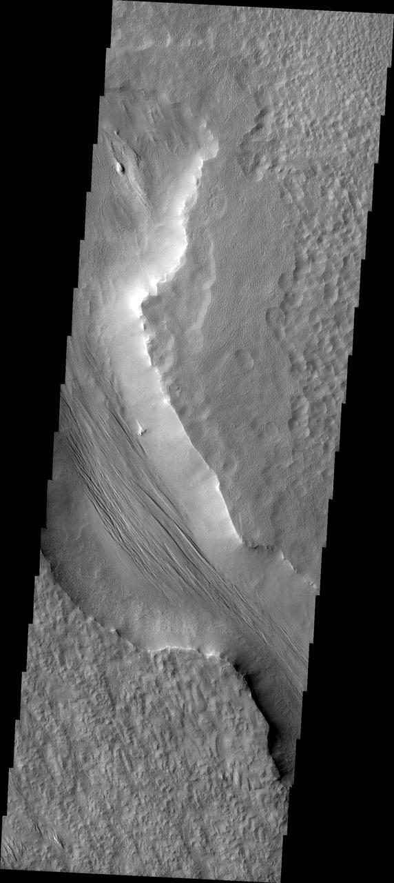
This VIS image shows part of the eastern end of Candor Chasma. The edge of the canyon is at the bottom of the image. The slopes of the chasma a eroded into a series of ridges and valleys. Winnowing of unconsolidated sediments by long term unidirectional winds can create these features. The ridge and valley system is called a yardang. Orbit Number: 74936 Latitude: -8.6632 Longitude: 294.841 Instrument: VIS Captured: 2018-11-05 12:02 https://photojournal.jpl.nasa.gov/catalog/PIA23012
Today's VIS image shows a region of wind etched materials. In regions of poorly cemented surface materials it is possible to create large features due to just the action of the wind. The equatorial region between Olympus Mons and Apollinaris Mons is dominated by wind etched regions. The direction of the wind aligns with the ridges and valleys. The dominant wind direction in this region is southeast to northwest; however, the wind direction for the upper right of the image is to the other direction. The long linear wind etched valleys are called yardangs. These features are created by long term winds scouring a poor cemented surface material into linear ridges and valleys. These yardangs are part of the Medusa Fossae Formation. It has been suggested that this region of Mars provides a large percentage of the surface dust seen around the planet. Ash falls from nearby volcanoes may have been the source of the surface materials eroded into these and other wind eroded landforms. Orbit Number: 94817 Latitude: -0.841679 Longitude: 206.486 Instrument: VIS Captured: 2023-04-30 12:50 https://photojournal.jpl.nasa.gov/catalog/PIA26177
The Tharsis Montes region on Mars is a major center of volcanic and tectonic activity. The channel in this image from NASA Mars Odyssey is west of the relatively small volcano called Biblis Patera although it shows no obvious relationship to that volcano. Instead, it may be related to the more distant, but more massive volcano Olympus Mons to the north. The channel may have hosted flowing lava at one time but now contains a material that has eroded into an impressive ridge-and-groove pattern. These features may be yardangs, landforms produced from the erosion by wind of sedimentary material. http://photojournal.jpl.nasa.gov/catalog/PIA04020
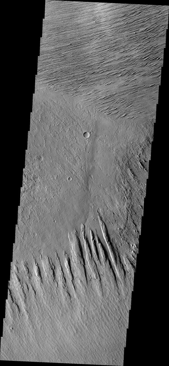
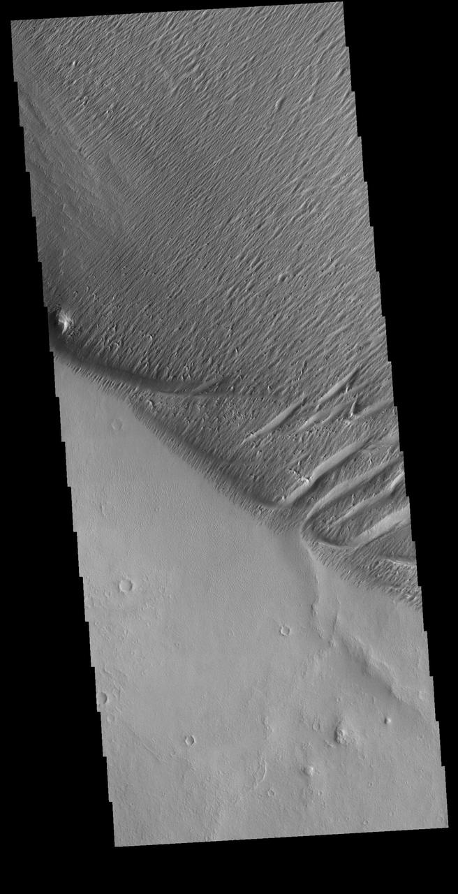
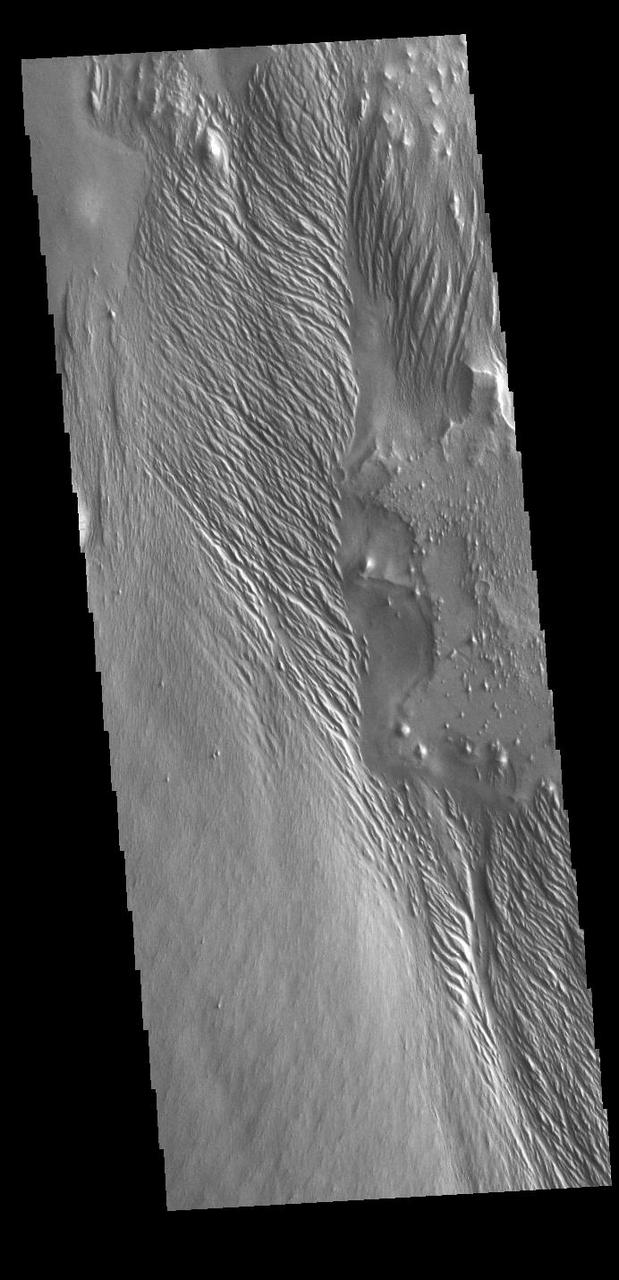
Located east of Eumenides Dorsum, this VIS image contains evidence of long term wind action and erosion. This area of Mars is dominated by poorly cemented surface material that is easily eroded by the wind. Unidirectional winds have created the linear ridge/valley system at the top half of this image. These features are called yardangs. Studies of this area propose volcanic ash eruptions from nearby volcanoes are the source of the surface material. Orbit Number: 81078 Latitude: -2.2665 Longitude: 205.439 Instrument: VIS Captured: 2020-03-25 04:51 https://photojournal.jpl.nasa.gov/catalog/PIA23929
This image shows part of eastern Candor Chasma. In the middle of the image is a set of linear ridges and valleys. These features are called yardangs and are created by uniform winds that winnow away materials. Once the valleys are formed the wind then is funneled through the valley and erosion continues more in the valley than on the ridges. At the bottom of the valleys there are sand materials covering the slope between the valleys and the surrounding chasma floor. Beyond this coating of sand there are darker sand deposits where wind has accumulated the sand into larger dunes. The brighter mesa on the right side of the image has also been wind eroded into yardangs, but are aligned in a different direction than the larger yardangs. This indicates that wind directions within the canyon have changed over time. Candor Chasma is one of the largest canyons that make up Valles Marineris. It is approximately 810 km long (503 miles) and has is divided into two regions - eastern and western Candor. Candor is located south of Ophir Chasma and north of Melas Chasma. The border with Melas Chasma contains many large landslide deposits. The floor of Candor Chasma includes a variety of landforms, including layered deposits, dunes, landslide deposits and steep sided cliffs and mesas. Many forms of erosion have shaped Chandor Chasma. There is evidence of wind and water erosion, as well as significant gravity driven mass wasting (landslides). The Odyssey spacecraft has spent over 15 years in orbit around Mars, circling the planet more than 69000 times. It holds the record for longest working spacecraft at Mars. THEMIS, the IR/VIS camera system, has collected data for the entire mission and provides images covering all seasons and lighting conditions. Over the years many features of interest have received repeated imaging, building up a suite of images covering the entire feature. From the deepest chasma to the tallest volcano, individual dunes inside craters and dune fields that encircle the north pole, channels carved by water and lava, and a variety of other feature, THEMIS has imaged them all. For the next several months the image of the day will focus on the Tharsis volcanoes, the various chasmata of Valles Marineris, and the major dunes fields. We hope you enjoy these images! Orbit Number: 10551 Latitude: -6.93639 Longitude: 288.562 Instrument: VIS Captured: 2004-05-01 02:24 https://photojournal.jpl.nasa.gov/catalog/PIA22165
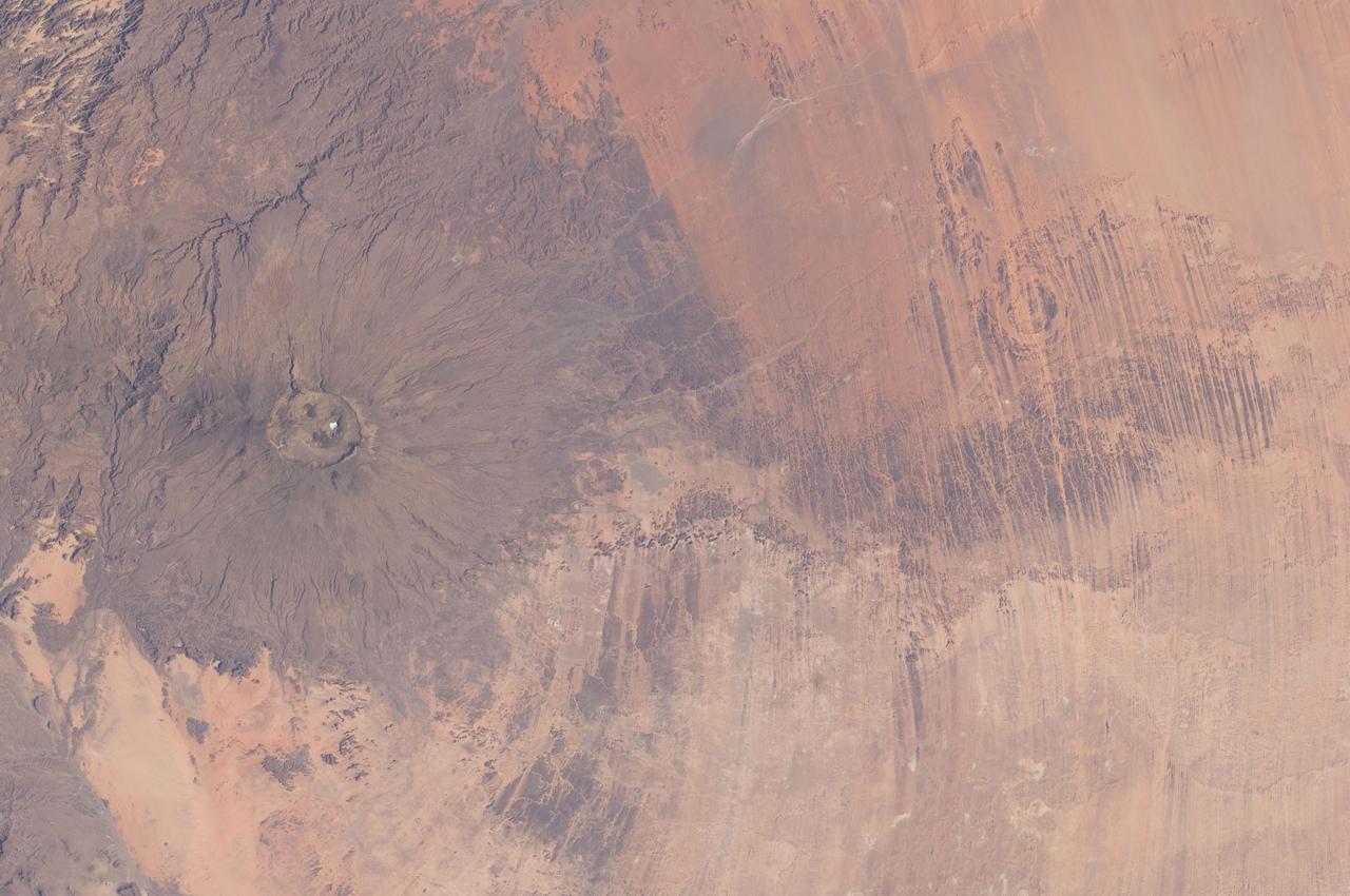
ISS030-E-005456 (26 Nov. 2011) --- Emi Koussi Volcano and Aorounga Impact Crater, Chad are featured in this image photographed by an Expedition 30 crew member on the International Space Station. This striking photograph features two examples of circular landscape features?labeled as craters?that were produced by very different geological processes. At left, the broad grey-green shield volcano of Emi Koussi is visible. The volcano is marked by three overlapping calderas formed by eruptions; these form a large oblong depression at the 3,415 meter ASL summit of the volcano. A smaller crater sits within the larger caldera depression. While volcanic activity has not been observed, nor is mentioned in the historical record, an active thermal area is located on the southern flank. The circular Aorounga Impact Crater is located approximately 110 kilometers to the southeast of Emi Koussi and has its origin in forces from above rather than eruptions from below. According to scientists, the Aorounga structure is thought to record a meteor impact approximately 345-370 million years ago. The circular feature visible at upper right may be only one of three impact craters formed by the same event ? the other two are buried by sand deposits. The linear features (lower right) that arc around Emi Koussi and overprint Aorounga and the surrounding bedrock are known as yardangs; these are rock ridges formed by wind erosion.
Click on the image for larger version This image shows a circular impact crater and an oval volcanic caldera on the southern flank of a large volcano on Mars called Pavonis Mons. The caldera is also the source of numerous finger-like lava flows and at least one sinuous lava channel. Both the caldera and the crater are degraded by aeolian (wind) erosion. The strong prevailing winds have apparently carved deep grooves into the terrain. When looking at the scene for the first time, the image seems motion blurred. However, upon a closer look, the smaller, young craters are pristine, so the image must be sharp and the "blurriness" is due to the processes acting on the terrain. This suggests that the deflation-produced grooves, along with the crater and the caldera, are old features and deflation is not very active today. Alternatively, perhaps these craters are simply too young to show signs of degradation. This deeply wind-scoured terrain type is unique to Mars. Wind-carved stream-lined landforms on Earth are called "yardangs," but they don't form extensive terrains like this one. The basaltic lavas on the flanks of this volcano have been exposed to wind for such a long time that there are no parallels on Earth. Terrestrial landscapes and terrestrial wind patterns change much more rapidly than on Mars. http://photojournal.jpl.nasa.gov/catalog/PIA21064
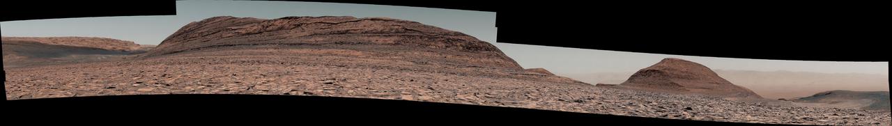
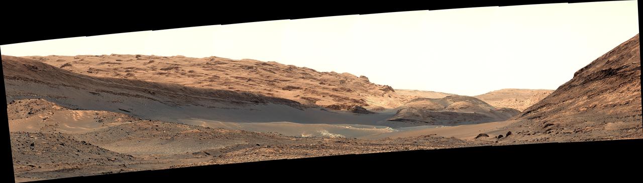
NASA's Curiosity Mars rover used its right Mast Camera, or Mastcam, to capture this panorama on Nov. 26, 2024, the 4,375th Martian day, or sol, of the mission. Made from 251 individual images containing 393 million pixels, the panorama's color has been adjusted to match lighting conditions as the human eye would see them on Earth. This is one of the largest high-resolution panoramas Curiosity has taken during its mission. Curiosity is making its way up the foothills of Mount Sharp, a 3-mile-tall (5-kilometer-tall) mountain found within Mars' Gale Crater. Dominating the scene in this image is a butte on Mount Sharp nicknamed "Texoli," which has many stratigraphic layers that scientists can study to learn more about the formation of this region of Mars. Texoli stands about 525 feet (160 meters) tall. To the right of Texoli is another butte nicknamed "Wilkerson," which is 262 feet (80 meters) tall. Curiosity will travel between the two buttes as it drives away from Gediz Vallis channel, which it has been investigating for the past year, and from Gediz Vallis (Gediz valley) itself, where it's been for four years. On the horizon beyond Texoli on the left side of the image is the Yardang Unit – a higher-elevation geologic region that Curiosity's scientists hope to visit in the years to come. On the horizon on the right side of the image, beyond Wilkerson, is the floor of Gale Crater and, visible through a dusty haze, the crater's distant northern rim. https://photojournal.jpl.nasa.gov/catalog/PIA26477
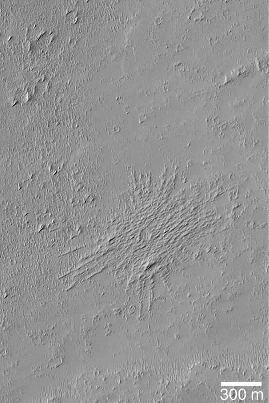
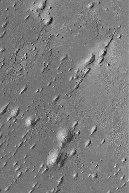
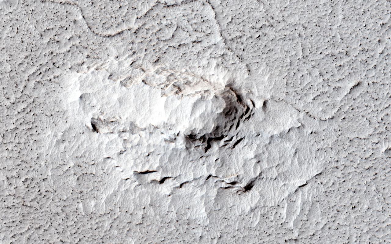
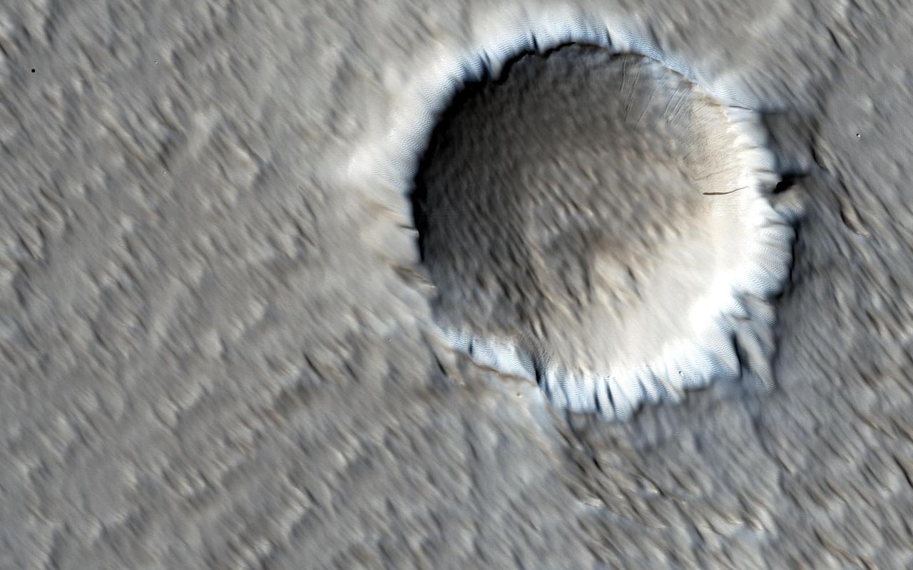
A close-up image from NASA's Mars Reconnaissance Orbiter of a recent 150-meter diameter impact crater near Amazonis Mensa and Medusae Fossae is another great example of geologic complexity of Mars. The spider web-like texture of this crater is intriguing. But what does it mean? On Earth, we have many geologic mechanisms that embrace the surface of the planet in an almost constant state of metamorphosis. Although Mars is not nearly as geologically active as Earth, it is still a host to many processes that shape its surface even today (e.g., aeolian modification, periglacial processes, recent impacts, etc.). The appearance of the ejecta of this crater is likely a combination of both the characteristics of the target material it was deposited on, and processes that modified and degraded it over time. When we look to other images in this region we find a similar texture. This texture is referred to as “yardangs†by scientists who study wind erosion. Yardangs are streamlined ridge-and-trough patterns formed by the erosion of wind dominating from a specific direction; in this particular case, from the southeast to the northwest. The specific direction of the winds is supported by regional context images that show many craters in the region have wind streak "tails" that points to the northwest. Craters of this size have been observed to form recently on Mars, so the fact that this crater is modified speaks volumes, and gives us a chance to decode some geological messages from Mars. https://photojournal.jpl.nasa.gov/catalog/PIA21759