Blue and Yellow
Fiery Yellow, Scattered Blue
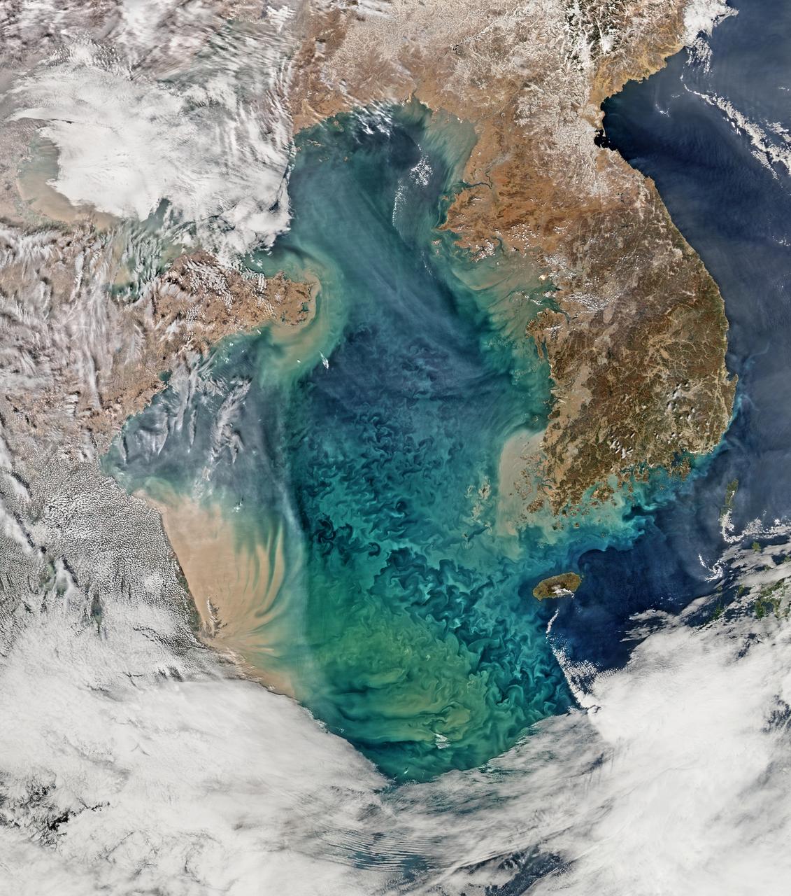
Remote sensing of ocean color in the Yellow Sea can be a challenge. Phytoplankton, suspended sediments, and dissolved organic matter color the water while various types of aerosols modify those colors before they are "seen" by orbiting radiometers. The Aqua-MODIS data used to create the above image were collected on February 24, 2015. NASA's OceanColor Web is supported by the Ocean Biology Processing Group (OBPG) at NASA's Goddard Space Flight Center. Our responsibilities include the collection, processing, calibration, validation, archive and distribution of ocean-related products from a large number of operational, satellite-based remote-sensing missions providing ocean color, sea surface temperature and sea surface salinity data to the international research community since 1996. Credit: NASA/Goddard/Ocean Color <b><a href="http://www.nasa.gov/audience/formedia/features/MP_Photo_Guidelines.html" rel="nofollow">NASA image use policy.</a></b> <b><a href="http://www.nasa.gov/centers/goddard/home/index.html" rel="nofollow">NASA Goddard Space Flight Center</a></b> enables NASA’s mission through four scientific endeavors: Earth Science, Heliophysics, Solar System Exploration, and Astrophysics. Goddard plays a leading role in NASA’s accomplishments by contributing compelling scientific knowledge to advance the Agency’s mission. <b>Follow us on <a href="http://twitter.com/NASAGoddardPix" rel="nofollow">Twitter</a></b> <b>Like us on <a href="http://www.facebook.com/pages/Greenbelt-MD/NASA-Goddard/395013845897?ref=tsd" rel="nofollow">Facebook</a></b> <b>Find us on <a href="http://instagram.com/nasagoddard?vm=grid" rel="nofollow">Instagram</a></b>

NASA image acquired September 24, 2012 City lights at night are a fairly reliable indicator of where people live. But this isn’t always the case, and the Korean Peninsula shows why. As of July 2012, South Korea’s population was estimated at roughly 49 million people, and North Korea’s population was estimated at about half that number. But where South Korea is gleaming with city lights, North Korea has hardly any lights at all—just a faint glimmer around Pyongyang. On September 24, 2012, the Visible Infrared Imaging Radiometer Suite (VIIRS) on the Suomi NPP satellite captured this nighttime view of the Korean Peninsula. This imagery is from the VIIRS “day-night band,” which detects light in a range of wavelengths from green to near-infrared and uses filtering techniques to observe signals such as gas flares, auroras, wildfires, city lights, and reflected moonlight. The wide-area image shows the Korean Peninsula, parts of China and Japan, the Yellow Sea, and the Sea of Japan. The white inset box encloses an area showing ship lights in the Yellow Sea. Many of the ships form a line, as if assembling along a watery border. Following the 1953 armistice ending the Korean War, per-capita income in South Korea rose to about 17 times the per-capital income level of North Korea, according to the U.S. Central Intelligence Agency. Worldwide, South Korea ranks 12th in electricity production, and 10th in electricity consumption, per 2011 estimates. North Korea ranks 71st in electricity production, and 73rd in electricity consumption, per 2009 estimates. NASA Earth Observatory image by Jesse Allen and Robert Simmon, using VIIRS Day-Night Band data from the Suomi National Polar-orbiting Partnership. Suomi NPP is the result of a partnership between NASA, the National Oceanic and Atmospheric Administration, and the Department of Defense. Caption by Michon Scott. Instrument: Suomi NPP - VIIRS Credit: <b><a href="http://www.earthobservatory.nasa.gov/" rel="nofollow"> NASA Earth Observatory</a></b> <b>Click here to view all of the <a href="http://earthobservatory.nasa.gov/Features/NightLights/" rel="nofollow"> Earth at Night 2012 images </a></b> <b>Click here to <a href="http://earthobservatory.nasa.gov/NaturalHazards/view.php?id=79796" rel="nofollow"> read more </a> about this image </b> <b><a href="http://www.nasa.gov/audience/formedia/features/MP_Photo_Guidelines.html" rel="nofollow">NASA image use policy.</a></b> <b><a href="http://www.nasa.gov/centers/goddard/home/index.html" rel="nofollow">NASA Goddard Space Flight Center</a></b> enables NASA’s mission through four scientific endeavors: Earth Science, Heliophysics, Solar System Exploration, and Astrophysics. Goddard plays a leading role in NASA’s accomplishments by contributing compelling scientific knowledge to advance the Agency’s mission. <b>Follow us on <a href="http://twitter.com/NASA_GoddardPix" rel="nofollow">Twitter</a></b> <b>Like us on <a href="http://www.facebook.com/pages/Greenbelt-MD/NASA-Goddard/395013845897?ref=tsd" rel="nofollow">Facebook</a></b> <b>Find us on <a href="http://instagram.com/nasagoddard?vm=grid" rel="nofollow">Instagram</a></b>
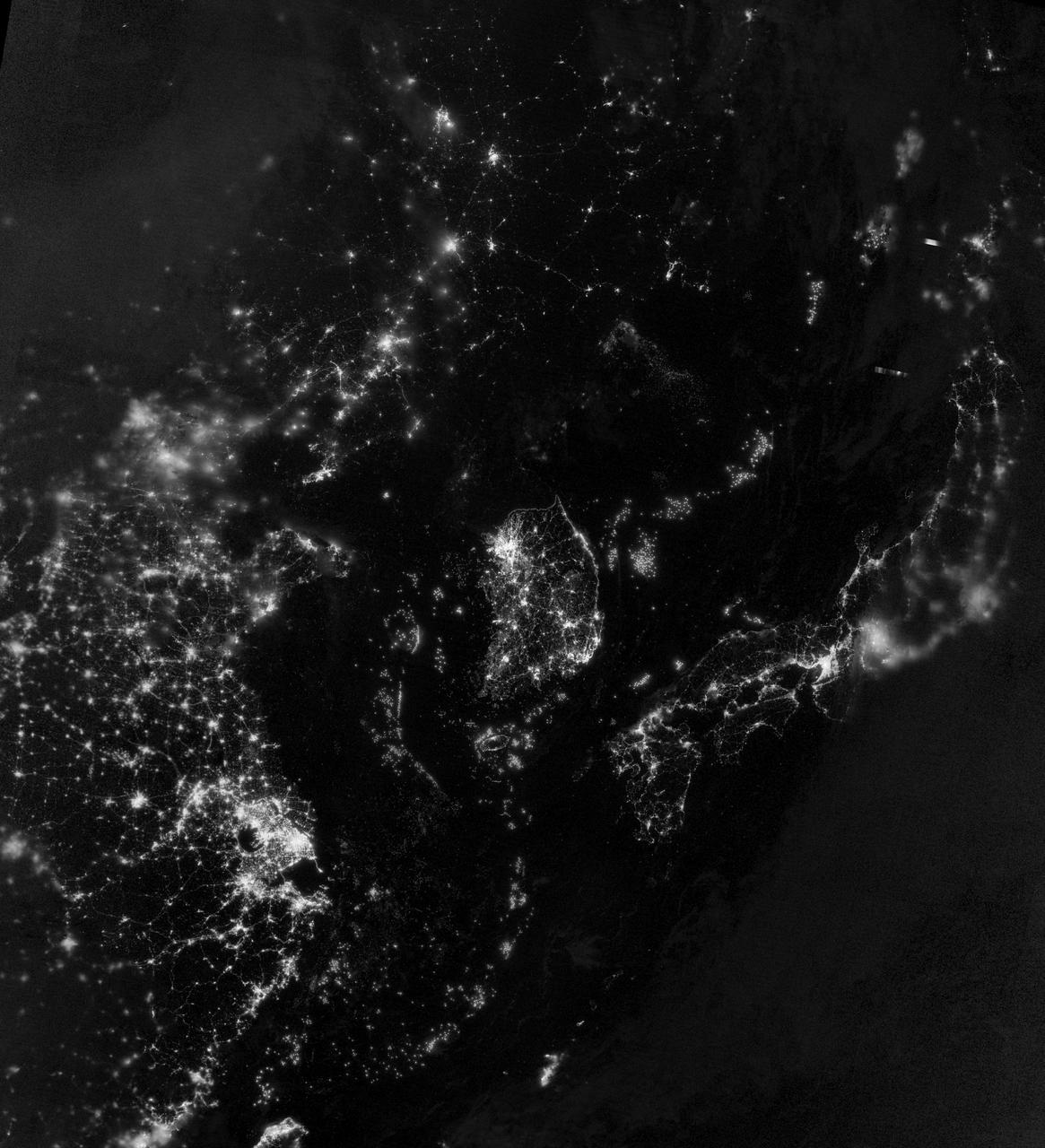
NASA image acquired September 24, 2012 City lights at night are a fairly reliable indicator of where people live. But this isn’t always the case, and the Korean Peninsula shows why. As of July 2012, South Korea’s population was estimated at roughly 49 million people, and North Korea’s population was estimated at about half that number. But where South Korea is gleaming with city lights, North Korea has hardly any lights at all—just a faint glimmer around Pyongyang. On September 24, 2012, the Visible Infrared Imaging Radiometer Suite (VIIRS) on the Suomi NPP satellite captured this nighttime view of the Korean Peninsula. This imagery is from the VIIRS “day-night band,” which detects light in a range of wavelengths from green to near-infrared and uses filtering techniques to observe signals such as gas flares, auroras, wildfires, city lights, and reflected moonlight. The wide-area image shows the Korean Peninsula, parts of China and Japan, the Yellow Sea, and the Sea of Japan. The white inset box encloses an area showing ship lights in the Yellow Sea. Many of the ships form a line, as if assembling along a watery border. Following the 1953 armistice ending the Korean War, per-capita income in South Korea rose to about 17 times the per-capital income level of North Korea, according to the U.S. Central Intelligence Agency. Worldwide, South Korea ranks 12th in electricity production, and 10th in electricity consumption, per 2011 estimates. North Korea ranks 71st in electricity production, and 73rd in electricity consumption, per 2009 estimates. NASA Earth Observatory image by Jesse Allen and Robert Simmon, using VIIRS Day-Night Band data from the Suomi National Polar-orbiting Partnership. Suomi NPP is the result of a partnership between NASA, the National Oceanic and Atmospheric Administration, and the Department of Defense. Caption by Michon Scott. Instrument: Suomi NPP - VIIRS Credit: <b><a href="http://www.earthobservatory.nasa.gov/" rel="nofollow"> NASA Earth Observatory</a></b> <b>Click here to view all of the <a href="http://earthobservatory.nasa.gov/Features/NightLights/" rel="nofollow"> Earth at Night 2012 images </a></b> <b>Click here to <a href="http://earthobservatory.nasa.gov/NaturalHazards/view.php?id=79796" rel="nofollow"> read more </a> about this image </b> <b><a href="http://www.nasa.gov/audience/formedia/features/MP_Photo_Guidelines.html" rel="nofollow">NASA image use policy.</a></b> <b><a href="http://www.nasa.gov/centers/goddard/home/index.html" rel="nofollow">NASA Goddard Space Flight Center</a></b> enables NASA’s mission through four scientific endeavors: Earth Science, Heliophysics, Solar System Exploration, and Astrophysics. Goddard plays a leading role in NASA’s accomplishments by contributing compelling scientific knowledge to advance the Agency’s mission. <b>Follow us on <a href="http://twitter.com/NASA_GoddardPix" rel="nofollow">Twitter</a></b> <b>Like us on <a href="http://www.facebook.com/pages/Greenbelt-MD/NASA-Goddard/395013845897?ref=tsd" rel="nofollow">Facebook</a></b> <b>Find us on <a href="http://instagram.com/nasagoddard?vm=grid" rel="nofollow">Instagram</a></b>
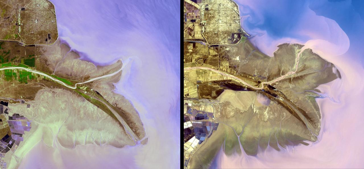
The Yellow River is the second-longest river in China, and the sixth longest in the world and makes many dramatic shifts over time. This image was taken with the ASTER instrument aboard NASA Terra spacecraft in 2009.
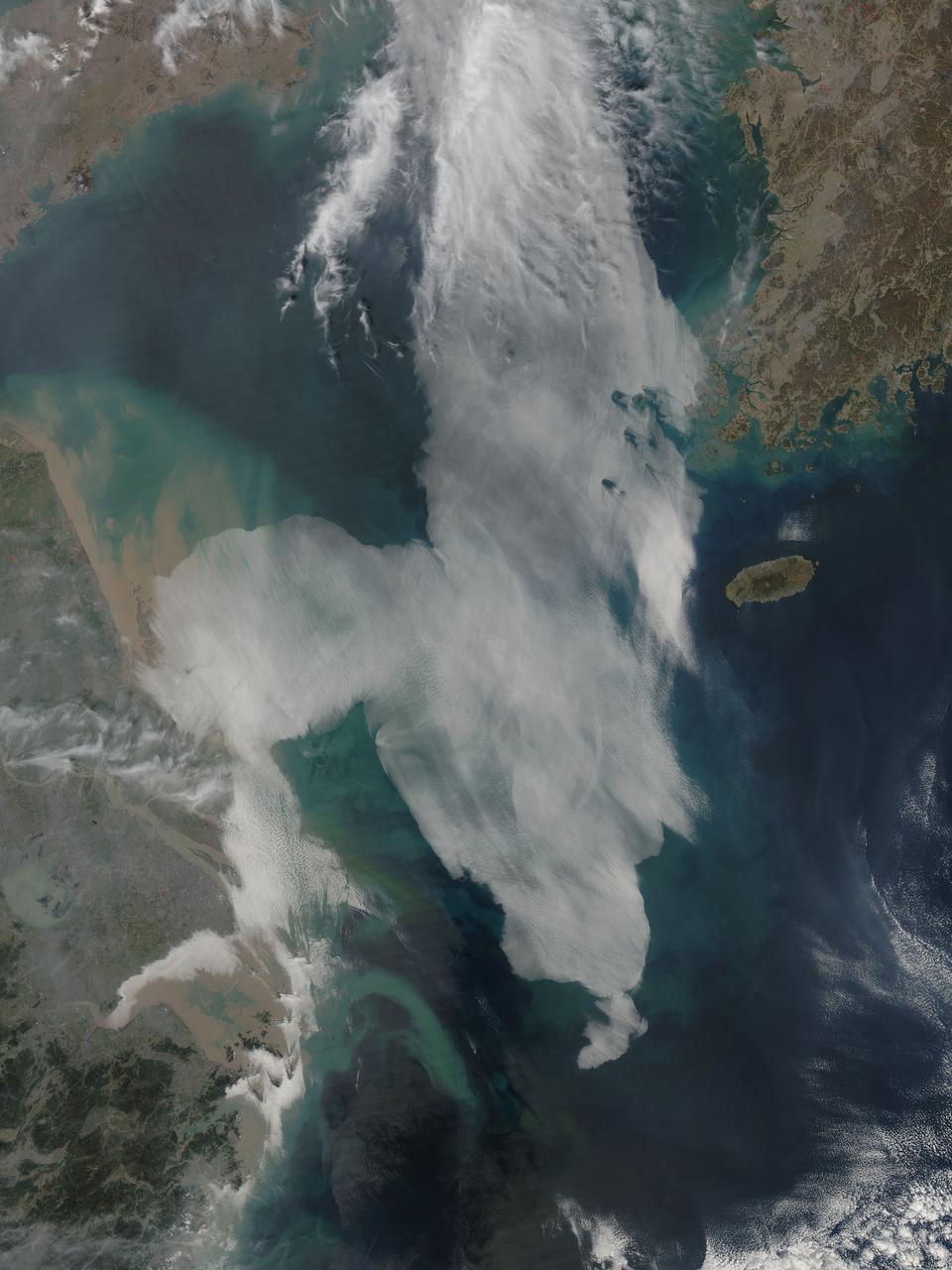
Low clouds over the Yellow Sea and the East China Sea was captured by the MODIS instrument on the Aqua satellite on April 1, 2016 at 4:55 UTC. Credit: NASA/Goddard/Jeff Schmaltz/MODIS Land Rapid Response Team <b><a href="http://www.nasa.gov/audience/formedia/features/MP_Photo_Guidelines.html" rel="nofollow">NASA image use policy.</a></b> <b><a href="http://www.nasa.gov/centers/goddard/home/index.html" rel="nofollow">NASA Goddard Space Flight Center</a></b> enables NASA’s mission through four scientific endeavors: Earth Science, Heliophysics, Solar System Exploration, and Astrophysics. Goddard plays a leading role in NASA’s accomplishments by contributing compelling scientific knowledge to advance the Agency’s mission. <b>Follow us on <a href="http://twitter.com/NASAGoddardPix" rel="nofollow">Twitter</a></b> <b>Like us on <a href="http://www.facebook.com/pages/Greenbelt-MD/NASA-Goddard/395013845897?ref=tsd" rel="nofollow">Facebook</a></b> <b>Find us on <a href="http://instagrid.me/nasagoddard/?vm=grid" rel="nofollow">Instagram</a></b>

In a laboratory simulating conditions on Jupiter's moon Europa at NASA's Jet Propulsion Laboratory in Pasadena, California, plain white table salt (sodium chloride) turned yellow (visible in a small well at the center of this photograph). The color is significant because scientists can now deduce that the yellow color previously observed on portions of the surface of Europa is actually sodium chloride. The JPL lab experiments matched temperature, pressure and electron radiation conditions at Europa's surface. https://photojournal.jpl.nasa.gov/catalog/PIA23273
This image of Jupiter moon Io and its surrounding sky is shown in false color. This image was taken on Nov. 9, 1996 through the green-yellow filter of the solid state imaging CCD system aboard NASA Galileo spacecraft.
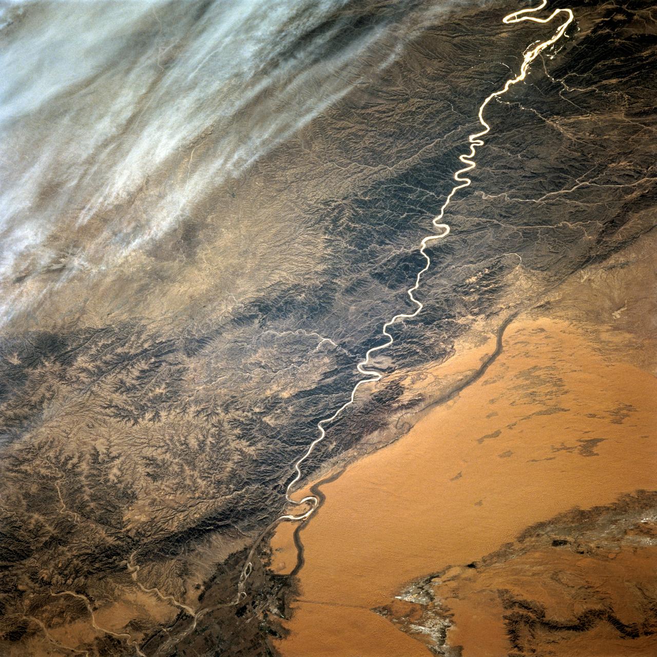
STS068-220-033 (30 September-11 October 1994) --- Photographed through the Space Shuttle Endeavour's flight deck windows, this 70mm frame shows a small section of China's Yellow River (Huang Ho) highlighted by sunglint reflection off the surface of the water. The river flows northeastward toward the village of Tung-lin-tzu. The low dissected mountains that cover more than half of this scene rise some 2,000 feet (on the average) above the valley floor. A major east-west transportation corridor (both railway and automobile) is observed traversing the landscape north of the river. This entire region is considered to be part of the Ordos Desert, actually part of the greater Gobi located just north of this area. Approximate center coordinates of this scene are 37.5 degrees north latitude and 105.0 degrees east longitude.
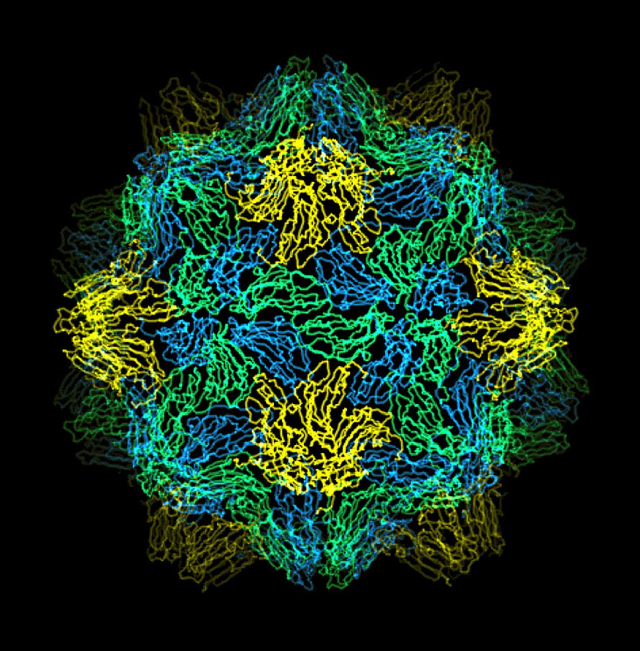
The bumpy exterior of the turnip yellow mosaic virus (TYMV) protein coat, or capsid, was defined in detail by Dr. Alexander McPherson of the University of California, Irvin using protein crystallized in space for analysis on Earth. TYMV is an icosahedral virus constructed from 180 copies of the same protein arranged into 12 clusters of five proteins (pentamers), and 20 clusters of six proteins (hexamers). The final TYMV structure led to the enexpected hypothesis that the virus release its RNA by essentially chemical-mechanical means. Most viruses have farly flat coats, but in TYMV, the fold in each protein, called the jellyroll, is clustered at the points where the protein pentamers and hexamers join. The jellyrolls are almost standing on end, producing a bumpy surface with knobs at all of the pentamers and hexamers. At the inside surface of the pentamers is a void that is not present at the hexamers. The coating had been seen in early studies of TYMV, but McPhereson's atomic structure shows much more detail. The inside surface is strikingly, and unexpectedly, different than the outside. While the pentamers contain a central viod on the inside, the hexameric units contain peptides liked to each other, forming a ring or, more accurately, rings to fill the voild. Credit: Dr. Alexander McPherson, University of California, Irvine.

iss073e0384097 (July 18, 2025) --- The sun's glint beams off the Yellow Sea coast of Jiangsu Province, China, in this photograph taken from the International Space Station as it orbited 260 miles above. In the right foreground, a set of the station's main solar arrays extends into the frame.
iss073e0982261 (Oct. 24, 2025) --- The Milky Way spans the night sky above a yellow-green airglow that blankets the Atlantic Ocean, midway between South America and Africa. This long-exposure photograph was taken from the International Space Station as it orbited 260 miles above Earth at approximately 11:19 p.m. local time.

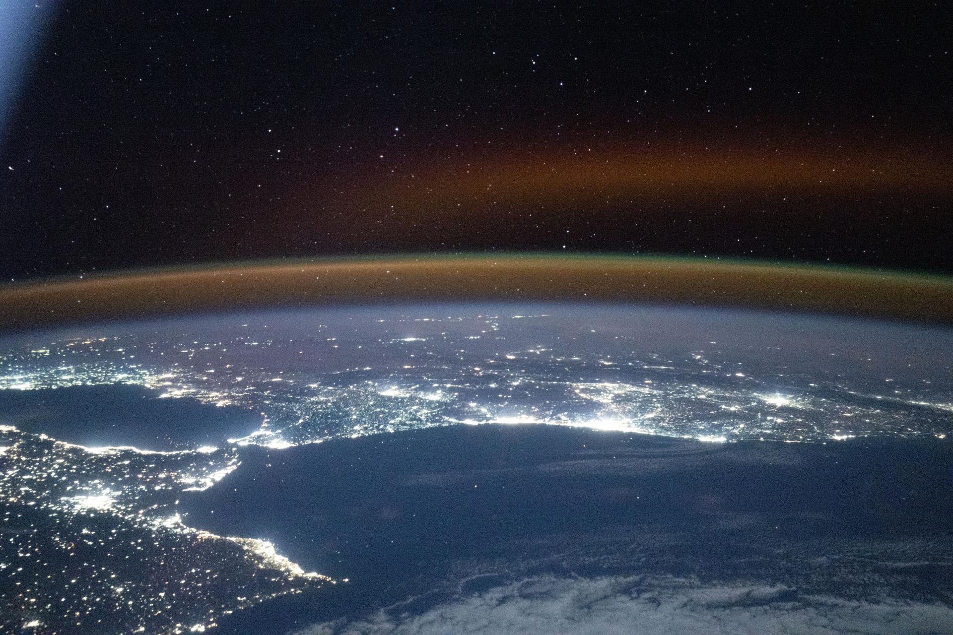
iss073e0983131 (Sept. 21, 2025) --- A partly cloudy Korean Peninsula, surrounded by the sun's glint reflecting off the Sea of Japan and the Yellow Sea, is pictured from the International Space Station as it orbited 259 miles above Earth off the coast of western Japan.
iss073e1198938 (Nov. 28, 2025) --- A yellow-red airglow blankets Earth's horizon as village lights dot the Saharan landscape of Algeria in this photograph taken at approximately 8:50 p.m. local time from the International Space Station as it orbited 261 miles above north Africa.

iss072e742488 (March 2, 2025) --- NASA astronaut and Expedition 72 Flight Engineer Don Pettit injects yellow ink into a ball of water shaped by microgravity and attached to research hardware by surface tension. Pettit was demonstrating simple space physics phenomena inside the International Space Station's Kibo laboratory module.
iss074e0472536 (April 12, 2026) --- This serene image, taken from the International Space Station as it orbited 265 miles above the Indian Ocean, highlights a yellow‑green airglow blanketing Earth’s atmosphere beneath a starry sky at approximately 2:37 a.m. local time. Credit: NASA/Chris Williams

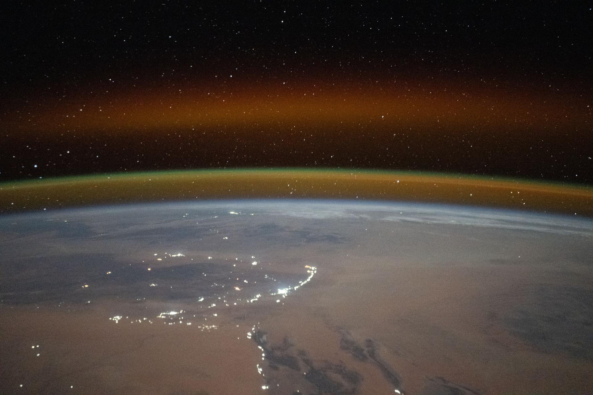
iss073e0742298 (Aug. 30, 2025) --- City lights beneath the clouds highlight the North China Plain near the Yellow Sea, where concentrated points of light mark fishing boats using illumination to attract anchovies, squid, sardines, and other species. Across the Yellow Sea, urban areas in South Korea are visible beneath a diffuse atmospheric glow near the horizon. In the foreground, the Canadarm2 robotic arm extends from a grapple fixture on the International Space Station's Harmony module.

NASA’s T-34 aircraft flown from the agency’s Armstrong Flight Research Center aims the plane toward Southern California’s Antelope Valley Poppy Reserve flying over yellow wildflowers. The aircraft was flown from the agency’s Armstrong Flight Research Center.

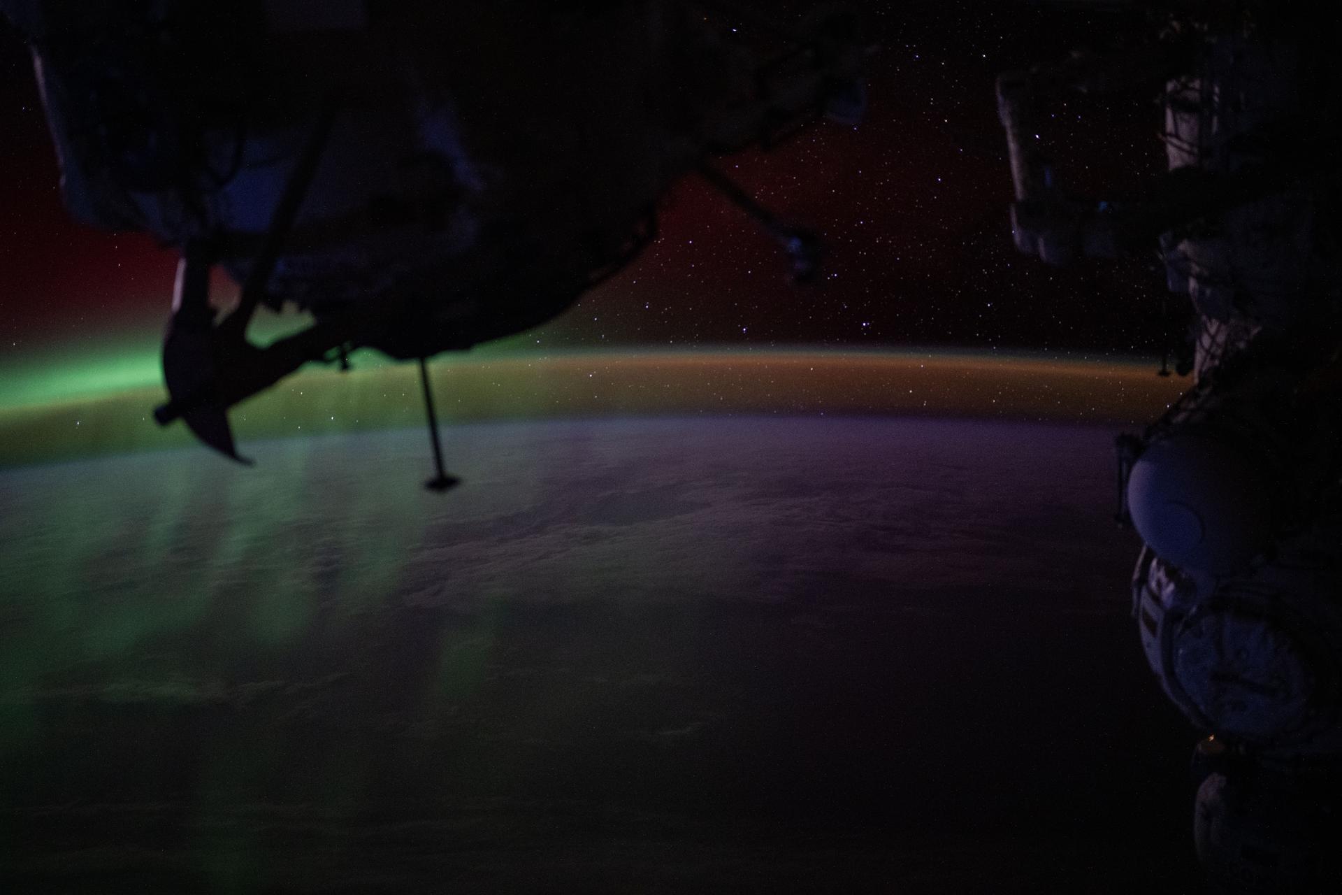
iss073e0982783 (Oct. 26, 2025) --- A red-yellow airglow blankets Earth as the last rays of an orbital sunset illuminate the atmosphere in this photograph from the International Space Station as it orbited 262 miles above the South Atlantic Ocean.
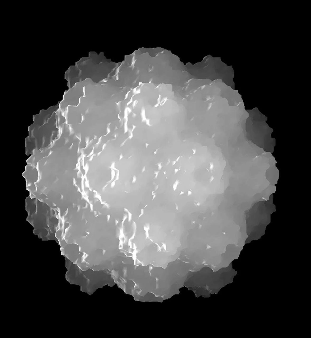
The bumpy exterior of the turnip yellow mosaic virus (TYMV) protein coat, or capsid, was defined in detail by Dr. Alexander McPherson of the University of California, Irvin using proteins crystallized in space for analysis on Earth. TYMV is an icosahedral virus constructed from 180 copies of the same protein arranged into 12 clusters of five proteins (pentamers), and 20 clusters of six proteins (hexamers). The final TYMV structure led to the unexpected hypothesis that the virus releases its RNA by essentially chemical-mechanical means. Most viruses have fairly flat coats, but in TYNV, the fold in each protein, called the jellyroll, is clustered at the points where the protein pentamers and hexamers join. The jellyrolls are almost standing on end, producing a bumpy surface with knobs at all of the pentamers and hexamers. At the inside surface of the pentamers is a void that is not present at the hexamers. The coating had been seen in early stuties of TYMV, but McPherson's atomic structure shows much more detail. The inside surface is strikingly, and unexpectedly, different than the outside. While the pentamers contain a central void on the inside, the hexameric units contain peptides linked to each other, forming a ring or, more accurately, rings to fill the void. Credit: Dr. Alexander McPherson, University of California, Irvine

iss073e0982679 (Oct. 25, 2025) --- The Milky Way spans the night sky above a bright orange-yellow airglow that blankets the city lights along the east coast of Africa, from Kenya to Somalia. The International Space Station was orbiting 259 miles above the Indian Ocean, north of Madagascar, at approximately 10:29 p.m. local time when this photograph was taken.

iss073e0982431 (Oct. 25, 2025) --- A yellow-green airglow, caused by atoms and molecules releasing energy as light after being excited by ultraviolet sunlight or cosmic rays, blankets the city lights of North America in this photograph, taken at approximately 2:18 a.m. local time from the International Space Station as it orbited 260 miles above Texas.

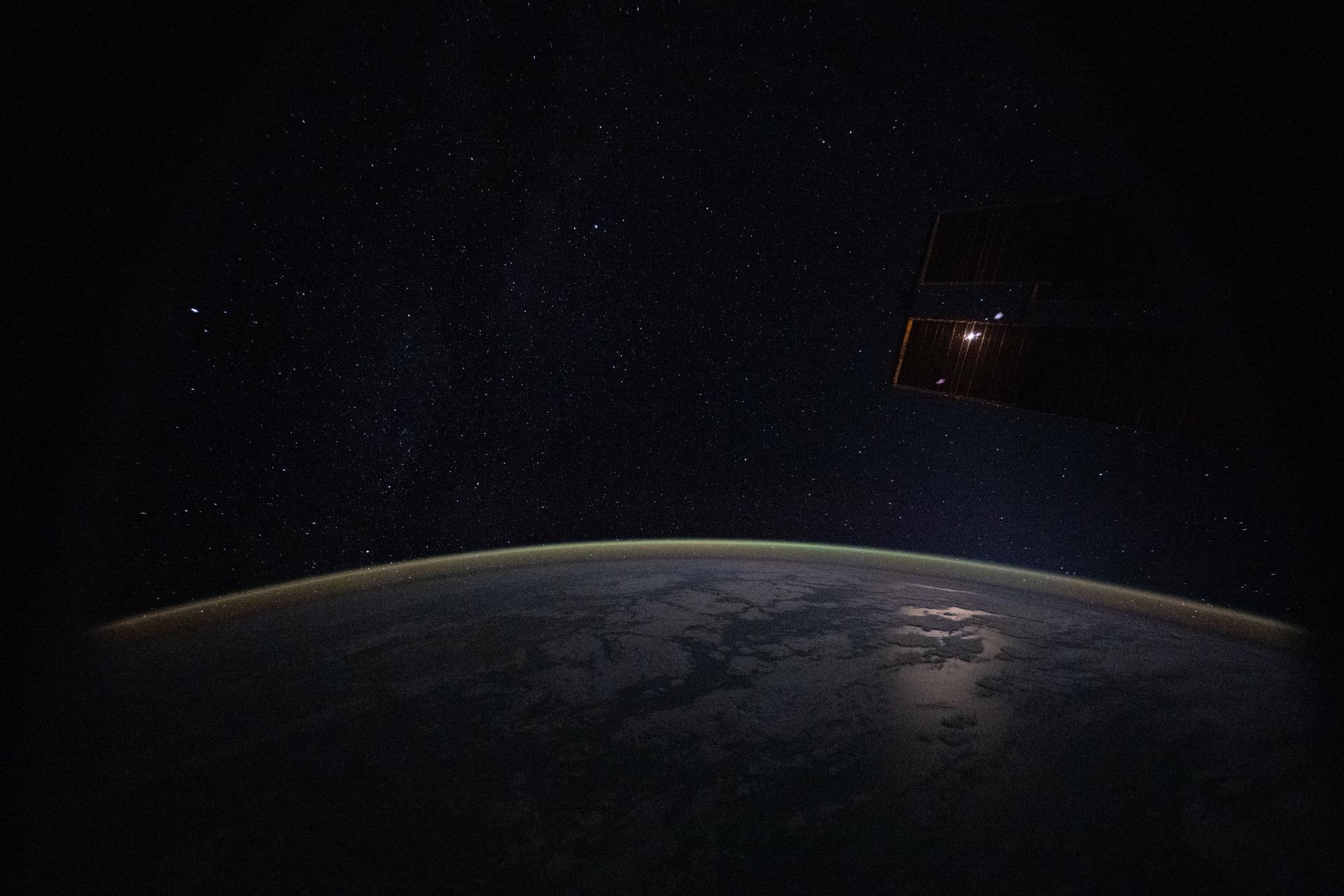
iss073e0870099 (Oct. 13, 2025) --- A yellow-green airglow blankets Earth’s horizon beneath a star-filled sky in this long-exposure photograph taken from the International Space Station as it orbited 265 miles above the cloudy Pacific Ocean off the coast of Chile. In the right foreground, the Soyuz MS-27 crew spacecraft is docked to the Prichal module, which is itself attached to the Nauka science module.

iss073e0920829 (Oct. 20, 2025) --- This celestial view from a window aboard the SpaceX Dragon crew spacecraft captures the city lights of Central Asia sparkling underneath a bright yellow airglow as an orbital sunrise begins to illuminate Earth's atmosphere underneath a starry night sky. The International Space Station was orbiting 263 miles above Uzbekistan at approximately 4:40 a.m. local time when this long-exposure photograph was taken.
iss073e0982720 (Oct. 25, 2025) --- The Persian Gulf region—from Oman to the United Arab Emirates, with Iran's southwest coast visible across the geographically important waterway—is illuminated beneath a bright yellow-green airglow. This long-exposure photograph, taken at approximately 11:40 p.m. local time from the International Space Station as it orbited 259 miles above northwestern India, also captures the starry expanse of the night sky.
iss073e0703552 (Sept. 18, 2025) --- City lights trace the Japanese coastline underneath a dim yellow-green airglow in this nighttime view across the Sea of Japan, revealing the metropolitan areas (from left to right) of Sapporo, Sendai, Tokyo, and Nagoya. The International Space Station was orbiting 262 miles above Russia’s far eastern coast when this image was captured at approximately 11:29 p.m. local time.
iss073e0824860 (Sept. 14, 2025) --- A red-yellow airglow blankets Earth's horizon above the tranquil, moonlit Philippine Sea in this photograph taken from the International Space Station at approximately 1:49 a.m. local time while orbiting 261 miles above Earth. This type of airglow is caused by chemical reactions in the upper atmosphere, often involving oxygen and hydroxyl molecules, and is typically visible in long-exposure imagery taken from orbit.
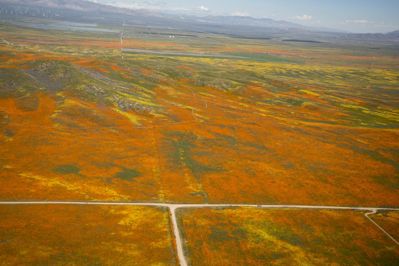
View from a NASA aircraft, TG-14, over the Superbloom of yellow wildflowers and orange poppies from the Antelope Valley in Southern California. The poppy is the state flower.
iss073e0865646 (Sept. 28, 2025) --- A wispy green aurora australis fades into a dim orange-yellow airglow above Earth’s horizon in this photograph taken at approximately 2:31 a.m. local time from the International Space Station, as it orbited 270 miles above the Indian Ocean, south of Perth, Australia.
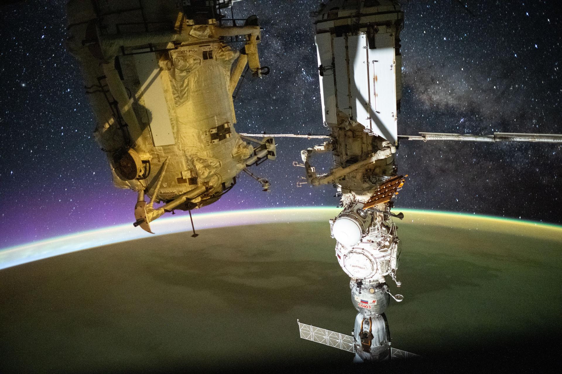
iss073e0880390 (Oct. 13, 2025) --- This long-exposure photograph captures a yellow-green airglow blanketing Earth as an orbital sunrise begins to illuminate the planet’s upper atmosphere. The Milky Way stretches across the star-filled night sky in the background, while the golden-hued Rassvet module and the Soyuz MS-27 crew spacecraft—docked to the Prichal module, itself attached to the Nauka science module—dominate the foreground. The International Space Station was orbiting 268 miles above the South Atlantic Ocean at approximately 2:45 a.m. local time when this photograph was taken.
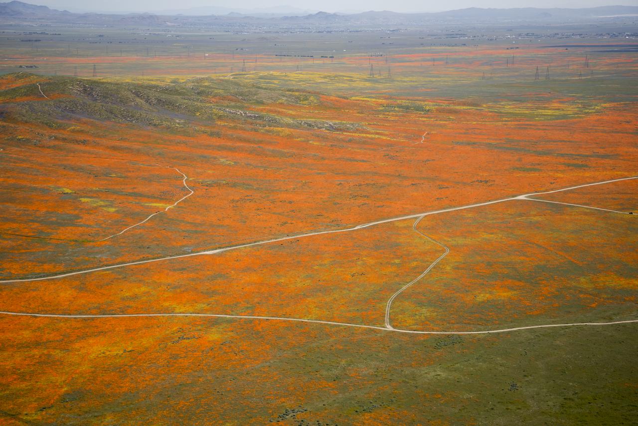
View from a NASA aircraft, TG-14, over the Superbloom of yellow wildflowers and orange poppies from the Antelope Valley in Southern California, Poppy Reserve and solar panels are in the background.
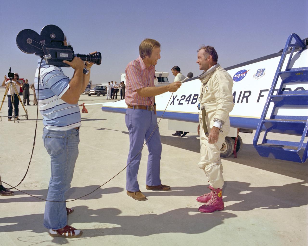
A TV reporter interviews NASA test pilot Bill Dana, wearing his infamous pink boots with yellow daisy decals, after the last powered flight of the X-24B.
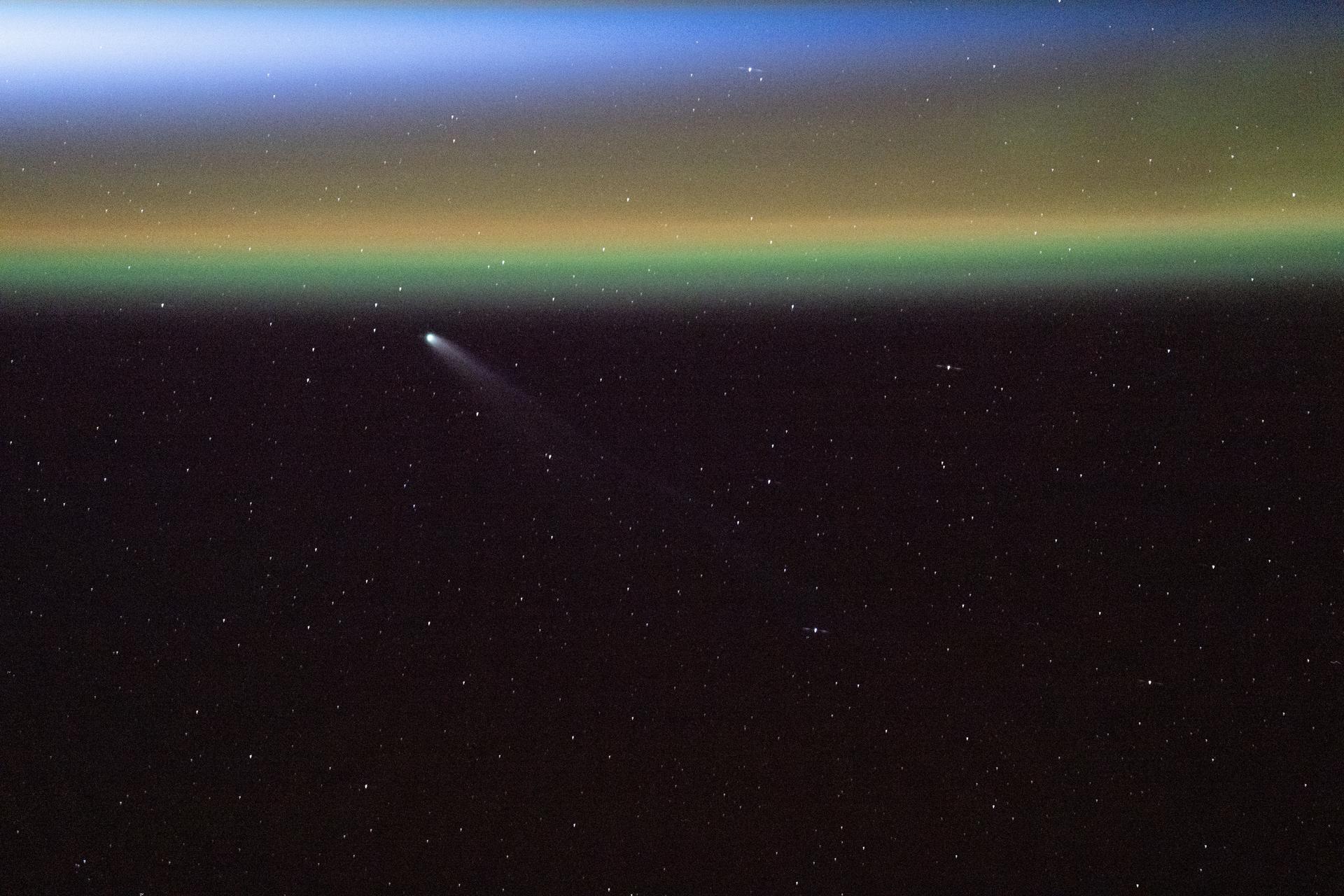
iss073e0982209 (Oct. 24, 2025) --- Comet Swan (C/2025 R2) appears above Earth’s yellow-green airglow just before an orbital sunrise, at a distance of about 27.2 million miles (43.8 million kilometers) from the planet. The International Space Station was orbiting 264 miles above the Atlantic Ocean off the coast of Canada's most easterly province of Newfoundland and Labrador when this photograph was taken.
iss073e1198911 (Nov. 28, 2025) --- A red-yellow airglow blankets Earth's horizon as the city lights of southwestern Europe and North Africa sparkle in contrast to the Atlantic Ocean and the Mediterranean Sea that separates the two continents. The International Space Station was orbiting 262 miles above the Atlantic at approximately 7:47 p.m. local time when this photograph was taken.
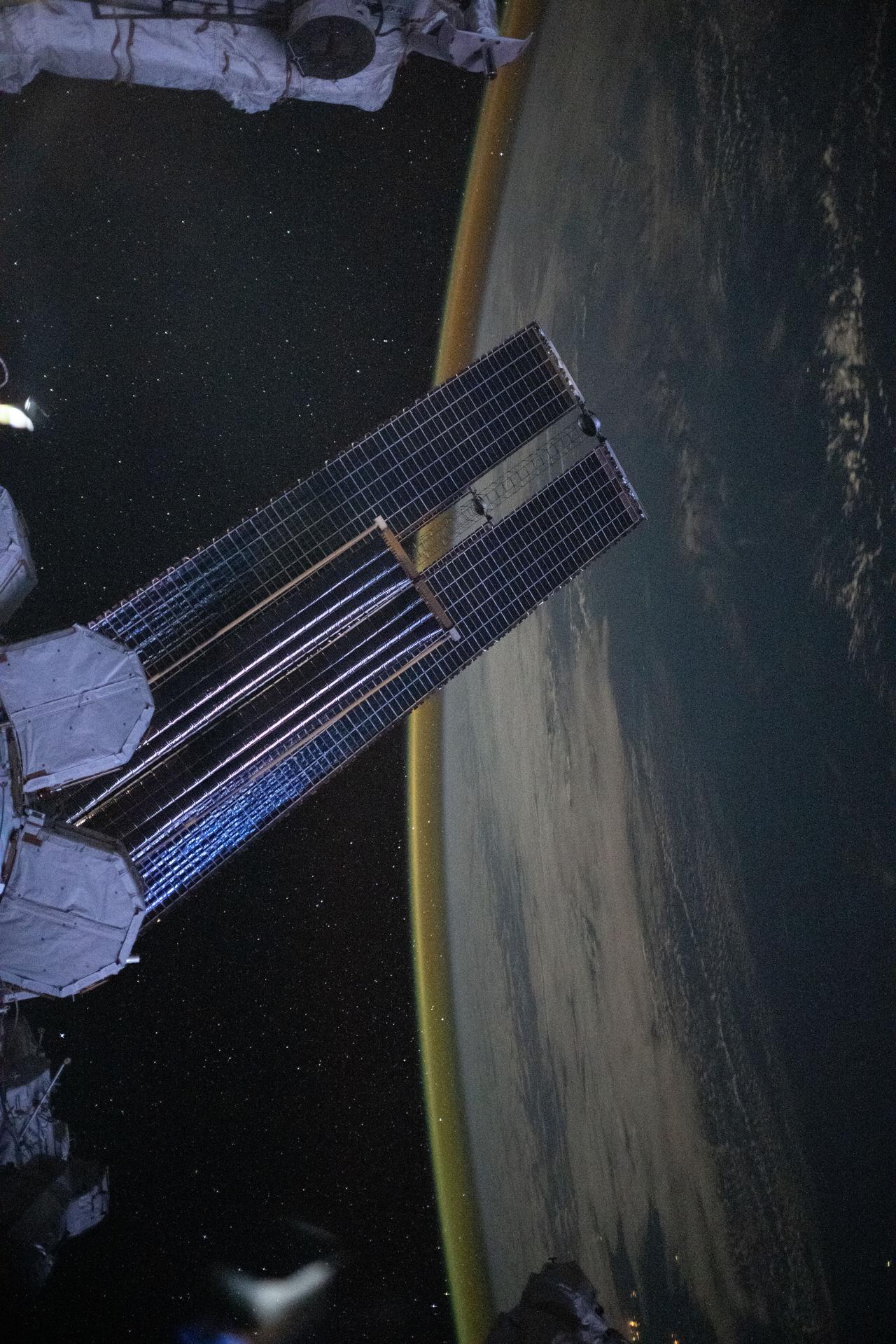
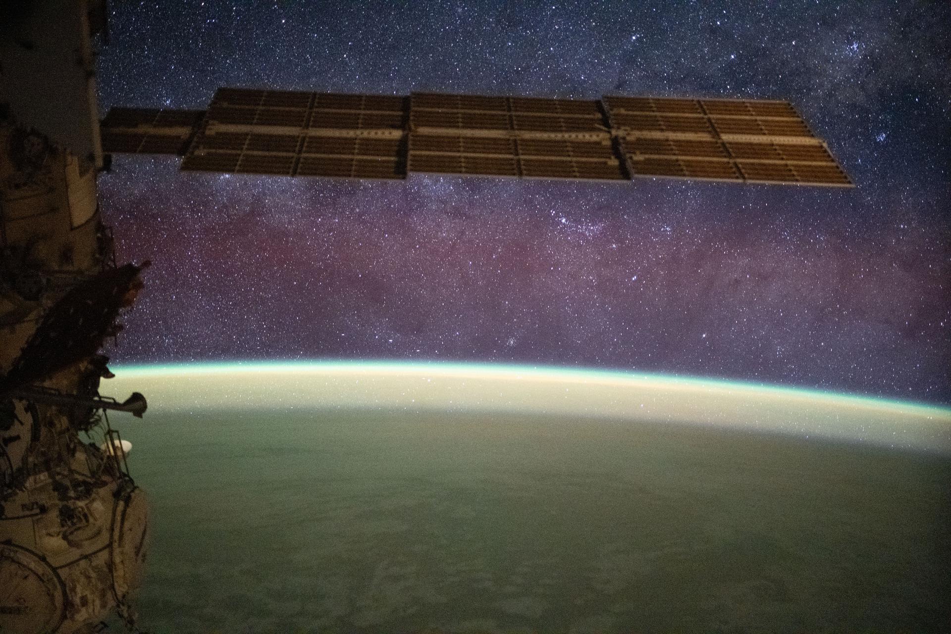
iss073e0828980 (Sept. 14, 2025) --- A dim, yellow-green airglow crowns Earth’s horizon between northwestern Australia and Indonesia’s Lesser Sunda Islands. In the foreground, a set of the orbital outpost’s main solar arrays, partially overlapped by a smaller set of roll-out solar arrays, stretches across the frame. The International Space Station was soaring 262 miles above the tranquil Indian Ocean at approximately 4:07 a.m. local time when this photograph was taken.

iss074e0043595 (Dec. 29, 2025) --- This long-duration photograph of Earth’s horizon was taken at approximately 8:30 p.m. local time from the International Space Station as it orbited 260 miles above the Indian Ocean, south of Jakarta, Indonesia. A yellow-green airglow crowns the horizon beneath a starry sky and a faint Milky Way. Credit: JAXA/Kimiya Yui
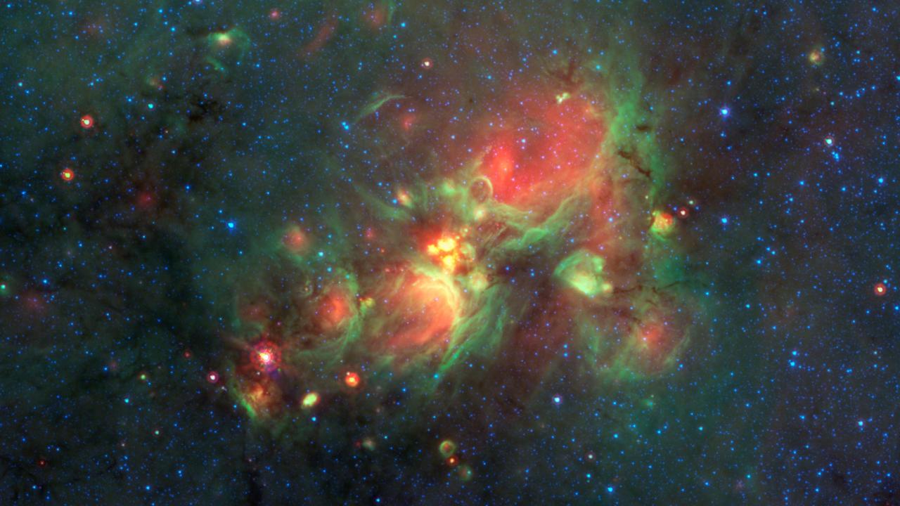
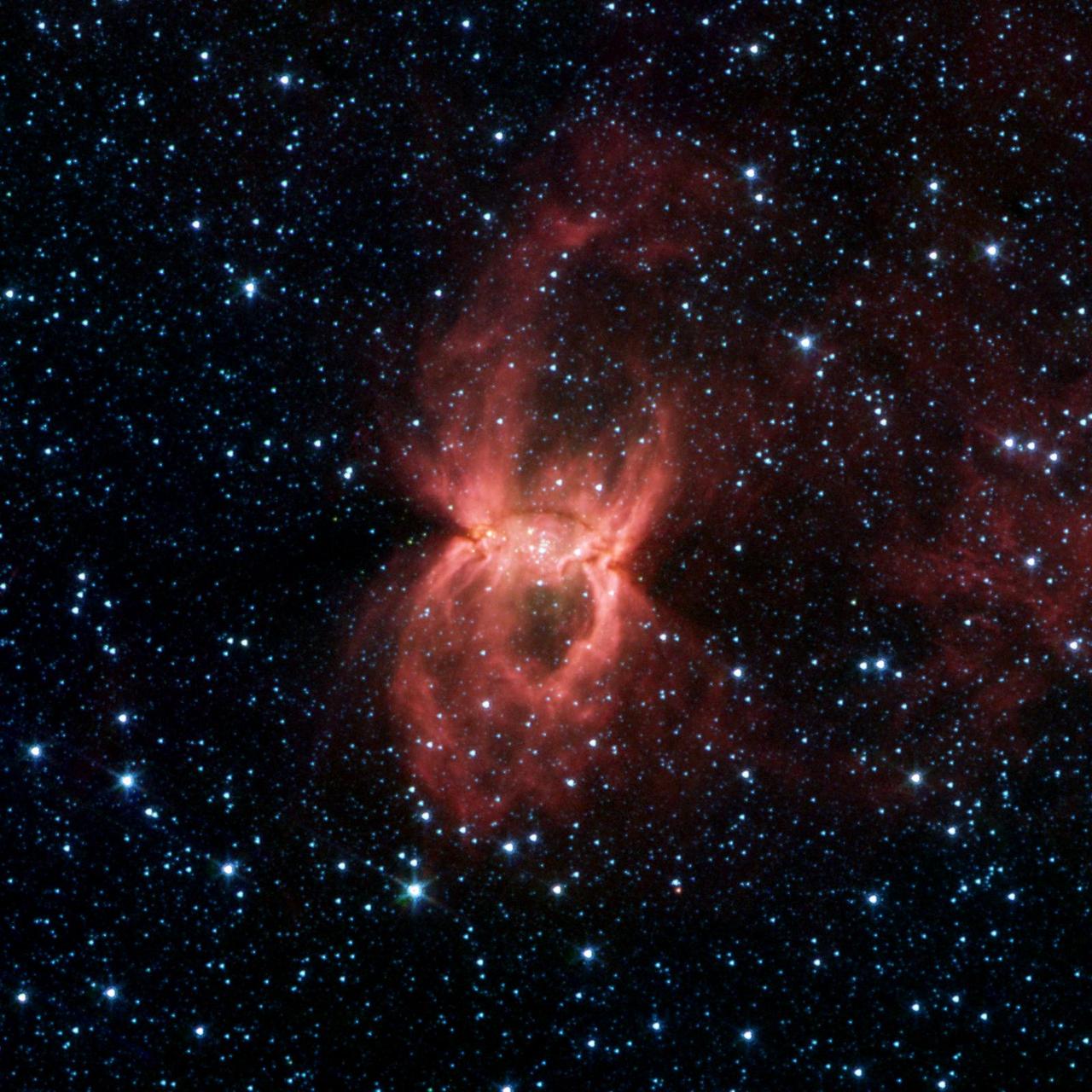
Yellow balls -- which are several hundred to thousands times the size of our solar system -- are pictured here in the center of this image taken by NASA Spitzer Space Telescope.
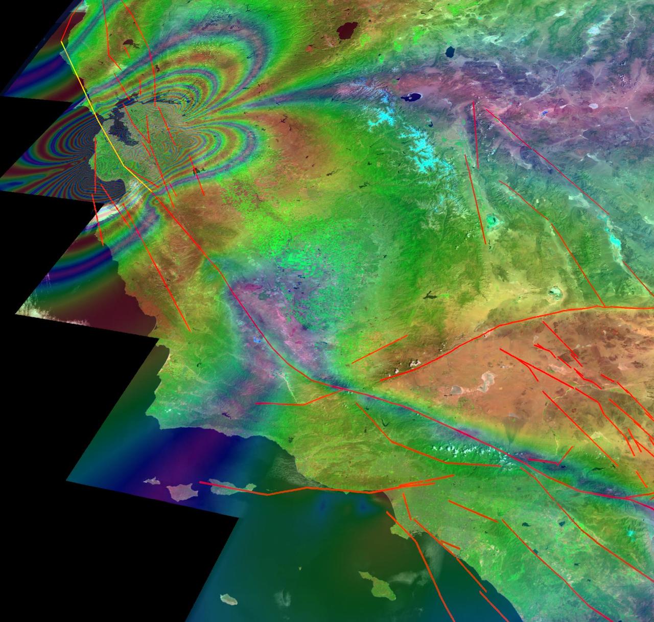
This illustration depicts synthetic aperature radar patterns of seismic deformations associated with a model earthquake on the San Francisco section of the San Andreas Fault depicted in yellow.
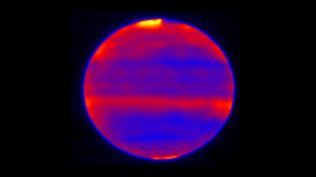
Sensitive to Jupiter's stratospheric temperatures, these infrared images were recorded by the Cooled Mid-Infrared Camera and Spectrograph (COMICS) at the Subaru Telescope on the summit of Mauna Kea, Hawaii. Scientists used red, blue and yellow to infuse this infrared image; regions of the atmosphere that are more yellow and red indicate the hotter areas. This highlights the auroral heating that occurs at Jupiter's poles, where energy from the solar wind and magnetosphere are deposited. This image was captured on Jan. 12, 2017. https://photojournal.jpl.nasa.gov/catalog/PIA22774
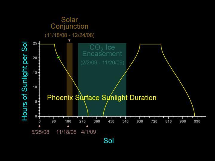
The yellow line on this graphic indicates the number of hours of sunlight each sol, or Martian day, beginning with the entire Martian day about 24 hours and 40 minutes for the first 90 sols, then declining to no sunlight by about sol 300.
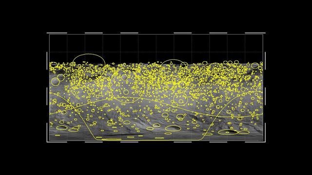
This graphic shows the global distribution of craters that hit the giant asteroid Vesta, based on data from NASA Dawn mission. The yellow circles indicate craters of 2 miles or wider, with the size of the circles indicating the size of the crater.
The impermanent waterways shown here from NASA EarthKAM are part of Oued Irharrhar, which appear to be carrying sulfur yellow and iron red deposits. The city of Amguid is located on these waterways, and all lie in the Mouydir Mountains in Algeria.

This image depicts how a mountain inside a Mars Gale Crater might have formed. At left, the crater fills with layers of sediment. Yellow is for deposits in alluvial fans, deltas, and drifts during both wet and dry periods.

In this Hubble observation, astronomers used the massive galaxy cluster MACS J0647+7015 as the giant cosmic telescope. The bright yellow galaxies near the center of the image are cluster members.

This zoomed-in view of a portion of the all-sky survey from NASA Wide-field Infrared Survey Explorer shows a collection of quasar candidates shown in yellow circles. Quasars are supermassive black holes feeding off gas and dust.
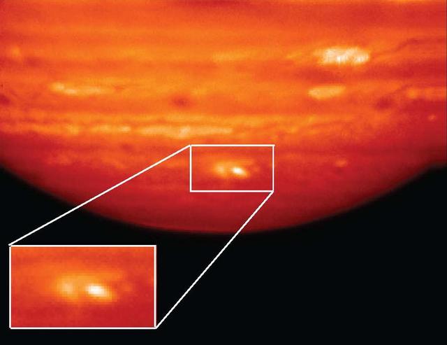
This infrared image, showing thermal radiation at a wavelength of 9.7 microns, was obtained by the Gemini North Telescope in Hawaii. The bright white and yellow features at bottom are the aftermath of an impactor hitting Jupiter on July 19, 2009.

This artist concept shows hundreds of brown dwarfs deep red, expected to be added to the population of known stars in our solar neighborhood. Our sun and other known stars appear white, yellow or red.
Young hot blue stars dominate the outer spiral arms of nearby galaxy NGC 300, while the older stars congregate in the nuclear regions which appear yellow-green in this image from NASA Galaxy Evolution Explorer.

This image from the Herschel Observatory, a European Space Agency mission, reveals some of the coldest and darkest material in our galaxy. The yellow filaments show the coldest dust dotted with the youngest embryonic stars.
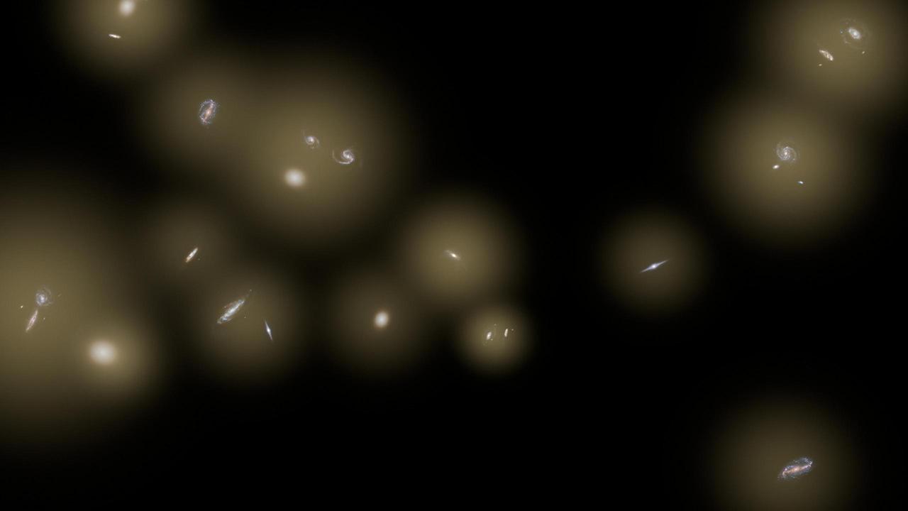
This artist concept shows a view of a number of galaxies sitting in huge halos of stars. The stars are too distant to be seen individually and instead are seen as a diffuse glow, colored yellow in this illustration.
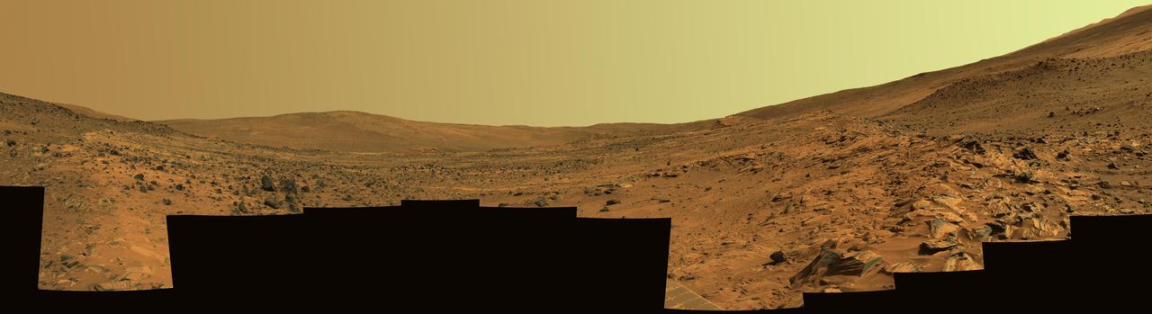
This panorama shows two reddish-brown, rock-strewn slopes on the left and right sides of a broad, U-shaped dip in the middle. In the distance are the broad slopes of McCool Hill. Above that is an orangish-yellow sky.
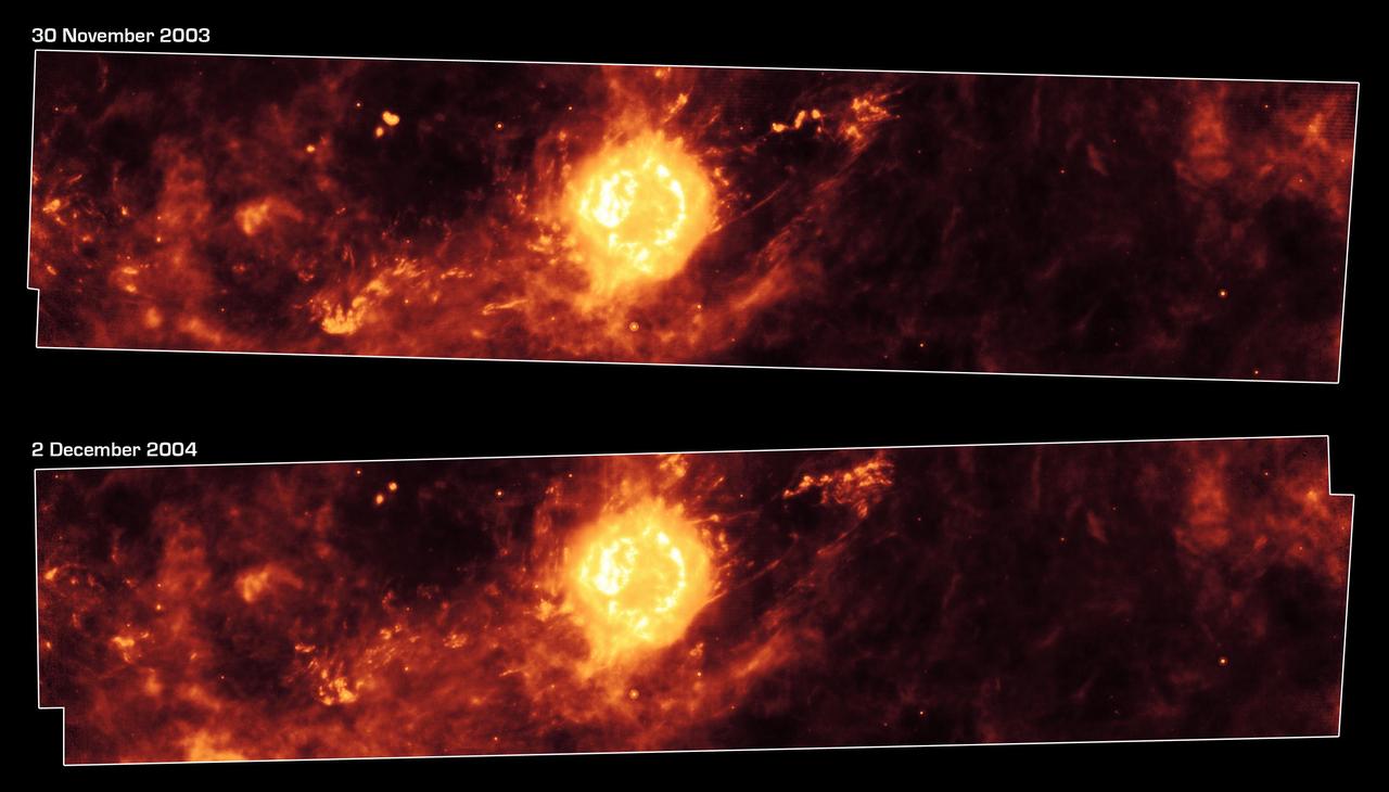
These images from NASA Spitzer Space Telescope, taken one year apart, show the supernova remnant Cassiopeia A yellow ball and surrounding clouds of dust reddish orange.
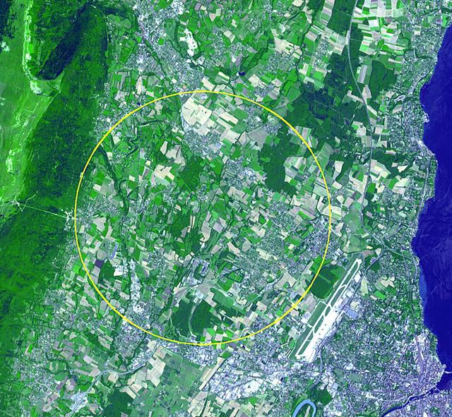
This image, acquired by NASA Terra spacecraft, is of the CERN Large Hadron Collider, the world largest and highest-energy particle accelerator laying beneath the French-Swiss border northwest of Geneva yellow circle.
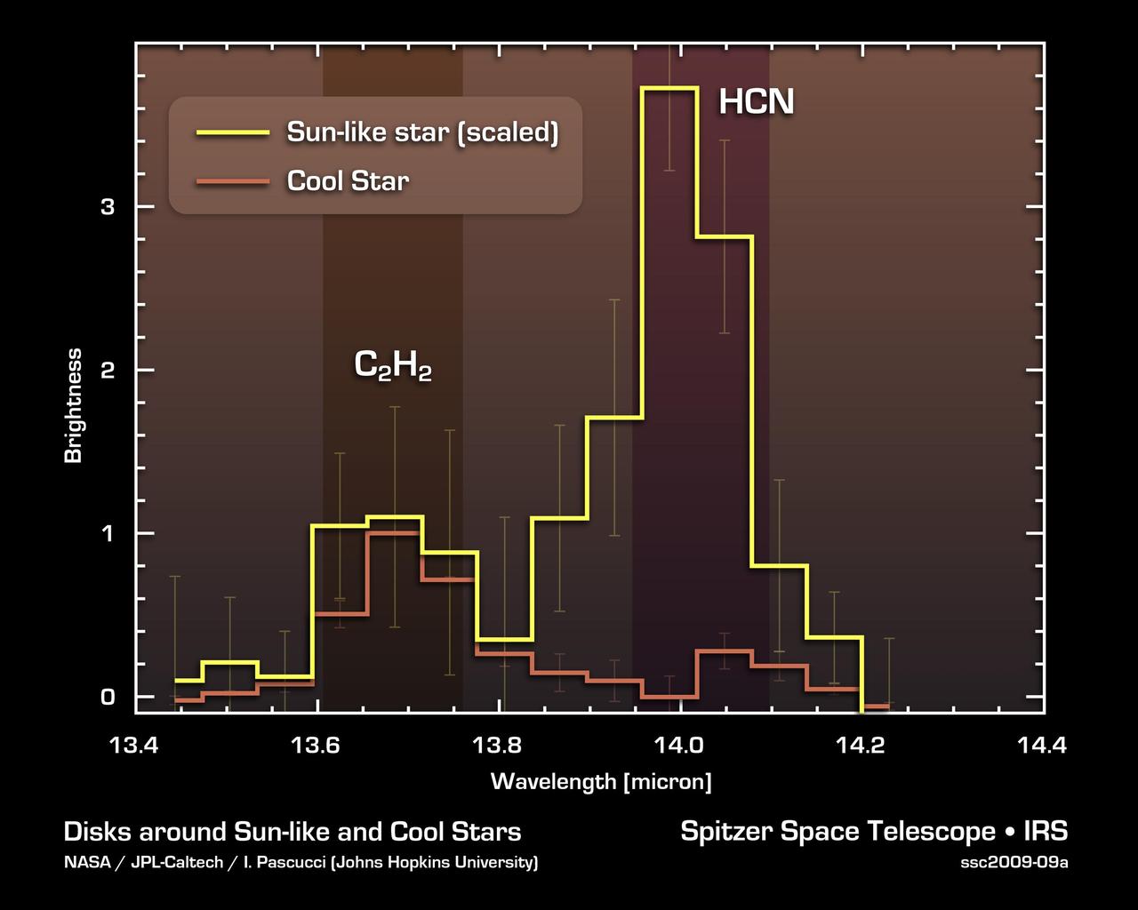
NASA Spitzer Space Telescope detected a prebiotic, or potentially life-forming, molecule called hydrogen cyanide HCN in the planet-forming disks around yellow stars like our sun, but not in the disks around cooler, reddish stars.
NASA Mercury Laser Altimeter MLA is shown ranging to Mercury surface from orbit. In this animation, yellow flashes represent near-infrared laser pulses that can reflect off terrain in shadow as well as in sunlight.
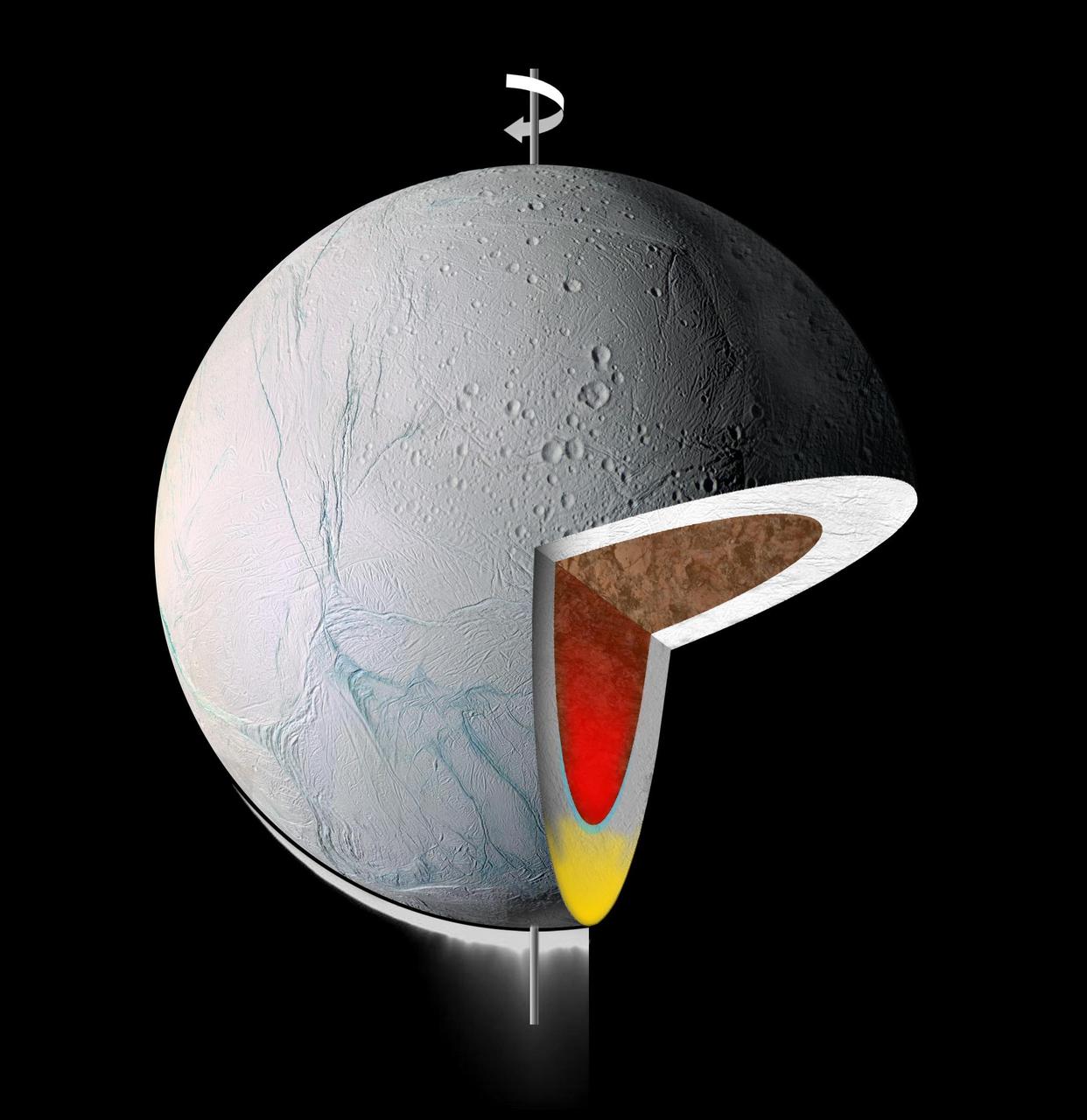
This graphic illustrates the interior of Saturn moon Enceladus. It shows warm, low-density material rising to the surface from within, in its icy shell yellow and/or its rocky core red

The route of NASA Mars Curiosity rover up the slopes of Mount Sharp on Mars is indicated in yellow in this image. The rover current position is marked with a star. This new route provides excellent access to many features in the Murray Formation.
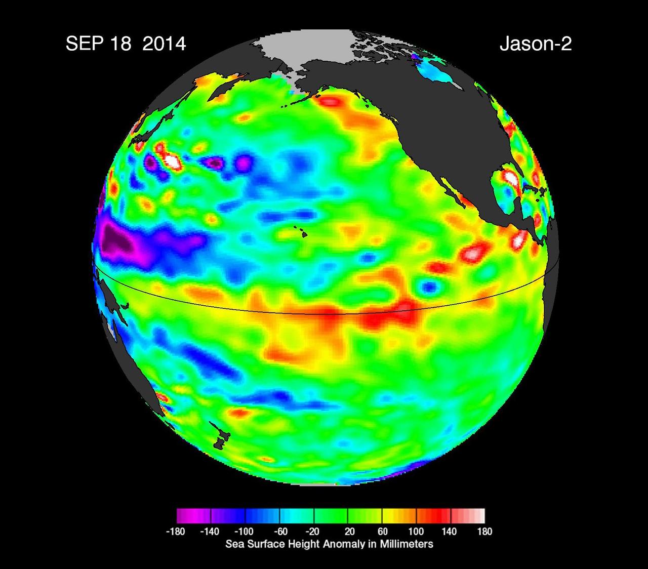
This image from NASA European Jason-2 satellite shows Kelvin waves of high sea level red/yellow crossing the Pacific Ocean at the equator. The waves can be related to El Niño events.
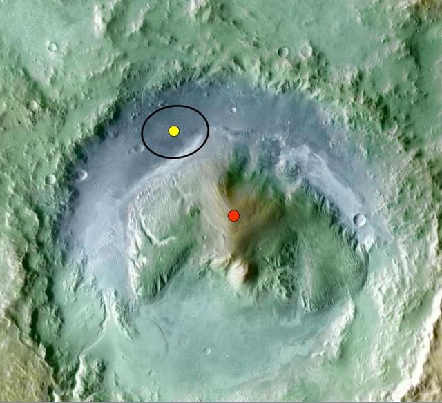
Color coding in this image of Gale Crater on Mars represents differences in elevation. The vertical difference from a low point inside the landing ellipse for NASA Mars Science Laboratory yellow dot to a high point on the mountain inside the crater.
This artist concept illustrates one of the largest smash-ups of galaxies ever observed. NASA Spitzer Space Telescope spotted the four galaxies shown here yellow blobs in the process of tangling and ultimately merging into a single gargantuan galaxy.
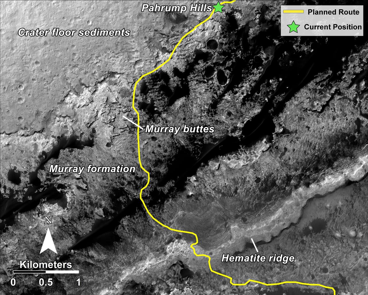
This mosaic, taken by NASA Mars Reconnaissance Orbiter, shows the planned route in yellow of NASA Curiosity rover from Pahrump Hills at the base of Mount Sharp, through the Murray Formation.
This image composite shows a warped and magnified view of a galaxy discovered by the Herschel Space Observatory, one of five such galaxies uncovered by the infrared telescope. The galaxy, referred to as SDP 81 is the yellow dot in the left image.
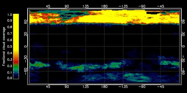
This graphic, constructed from data obtained by NASA Cassini spacecraft, shows the percentage of cloud coverage across the surface of Saturn moon Titan. The color scale from black to yellow signifies no cloud coverage to complete cloud coverage.
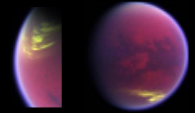
This pair of false-color images, made from data obtained by NASA Cassini spacecraft, shows clouds covering parts of Saturn moon Titan in yellow, while Titan hazy atmosphere appears magenta.

This artist conception shows the 30 Ari system, which includes four stars and a planet. The planet, a gas giant, orbits its primary star yellow in about a year time.

This false-color image from NASA Spitzer Space Telescope shows a distant galaxy yellow that houses a quasar, a super-massive black hole circled by a ring, or torus, of gas and dust.

In advance of a testing flight at NASA Dryden Flight Research Center, members of the test team prepare the engineering model of the Mars Science Laboratory descent radar on the nose gimbal of a helicopter. The yellow disks are the radar antennae.

This orthographic projection view from NASA MESSENGER spacecraft provides a look at Mercury north polar region. The yellow regions in many of the craters mark locations that show evidence for water ice, as detected by Earth-based radar observations from Arecibo Observatory in Puerto Rico. MESSENGER has collected compelling new evidence that the deposits are indeed water ice, including imaging within the permanently shaded interiors of some of the craters, such as Prokofiev and Fuller. Instrument: Mercury Dual Imaging System (MDIS) Arecibo Radar Image: In yellow (Harmon et al., 2011, Icarus 211, 37-50) http://photojournal.jpl.nasa.gov/catalog/PIA19411

art001e001451 (Nov. 27, 2022) On flight day 12, the inside of Orion shows the display of the Callisto payload. Callisto is Lockheed Martin’s technology demonstration in collaboration with Amazon and Cisco, testing voice-activated and video technology that may assist future astronauts on deep space missions.

KENNEDY SPACE CENTER, FLA. -- A tri-colored heron stands sentry in the marshes around KSC. It has slate blue feathers on most of its body except for a white chest and belly and a rust-colored neck. It has long yellow legs, a white stripe that runs up its neck and long pointed yellow bill. The bill turns blue during breeding season.The heron is one of 310 species of birds that inhabit the Merritt Island National Wildlife Refuge, which shares a boundary with KSC. The marshes and open water of the refuge also provide wintering areas for 23 species of migratory waterfowl, as well as a year-round home for great egrets, wood storks, cormorants, brown pelicans and other species of marsh and shore birds.

The yellow line on this map shows where NASA Mars Rover Opportunity has driven from the place where it landed in January 2004, inside Eagle crater, upper left end of track, to a point about 2.2 miles away from reaching the rim of Endeavour crater.
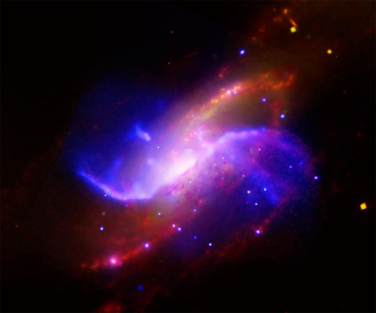
This composite image is of spiral galaxy M106 NGC 4258; optical data from the Digitized Sky Survey is yellow, radio data from the Very Large Array is purple, X-ray data from Chandra is blue, and infrared data from the Spitzer Space Telescope is red.
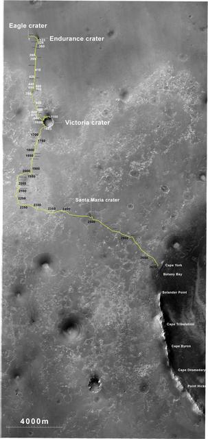
The yellow line on this map shows where NASA Mars Rover Opportunity has driven from the place where it landed in January 2004, inside Eagle crater, at the upper left end of the track, to a point approaching the rim of Endeavour crater.
NASA Spitzer Space Telescope shows two opposing bubbles being formed in opposite directions by the powerful outflows from massive groups of forming stars. The baby stars can be seen as specks of yellow where the two bubbles overlap.
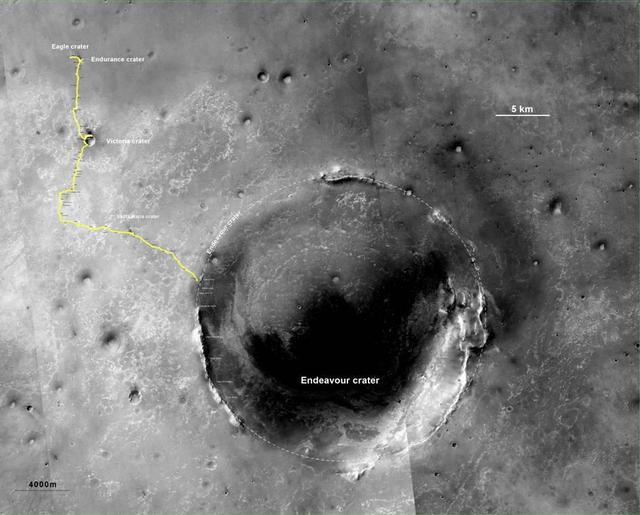
The yellow line on this map shows where NASA Mars Rover Opportunity has driven from the place where it landed in January 2004, inside Eagle crater, at the upper left end of the track, to a point approaching the rim of Endeavour crater.
A small galaxy, called Sextans A, is shown here in a multi-wavelength mosaic captured by the ESA Herschel mission. In this image, the purple shows gas; blue shows young stars and the orange and yellow dots are newly formed stars heating up dust.
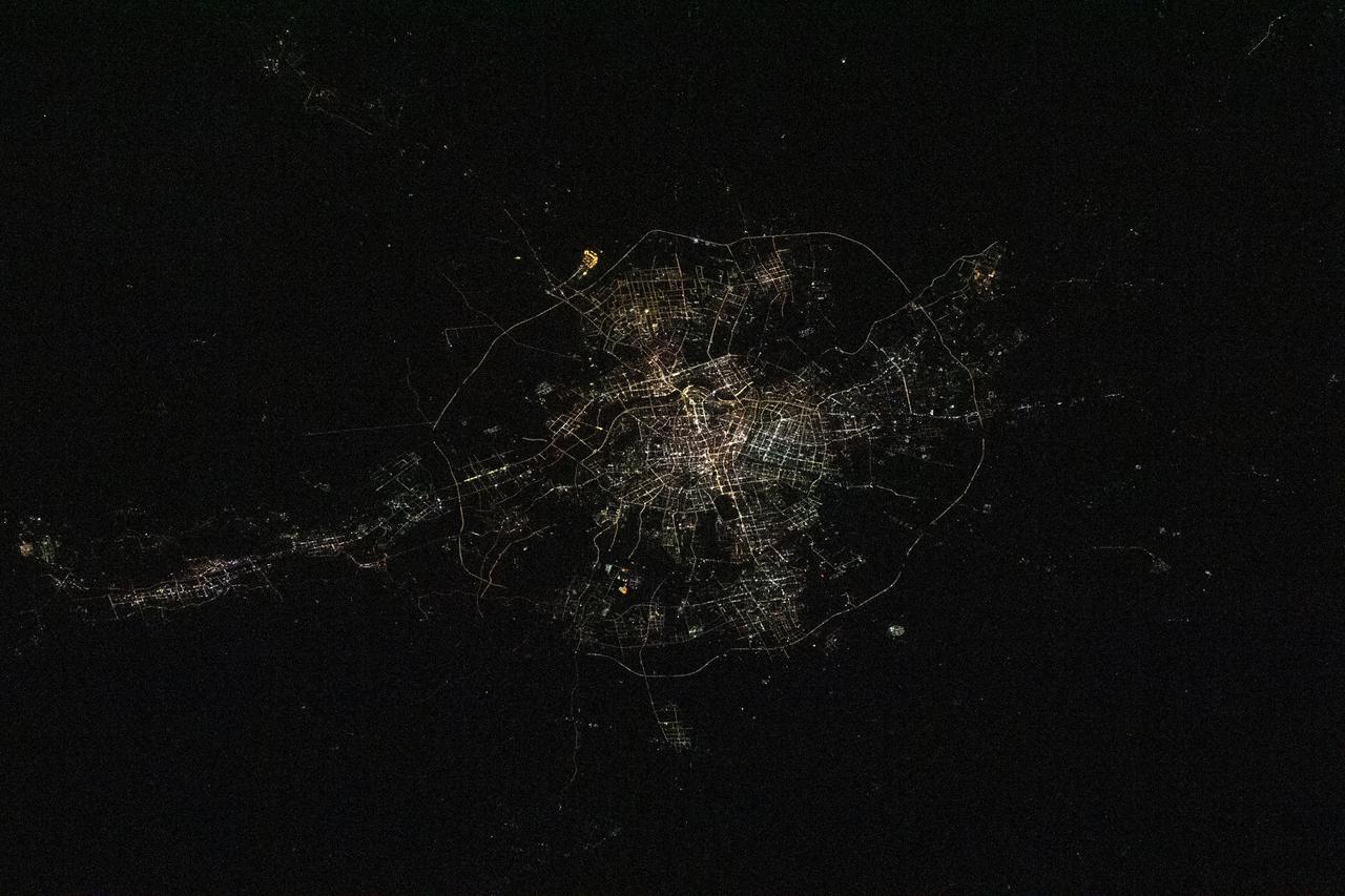
iss068e024160 (Nov. 25, 2022) --- The city lights of Shenyang, China, are pictured from the International Space Station as it orbited 258 miles above the Yellow Sea.

The concept of urban air mobility involves multiple aircraft safely operating within a city. (Yellow circles are vehicles with passengers; pink circles are vehicles without passengers.)

Yellow straps are threaded through the airframe of the modified C-141 Kuiper Airborne Observatory, (KAO) (NASA-714), before removing the cockpit on the N211 apron at Moffett Field, California.

Yellow straps fasten the cockpit of the modified C-141 Kuiper Airborne Observatory, (KAO) (NASA-714), to the trailer that carries it off the N211 apron at Moffett Field, California.
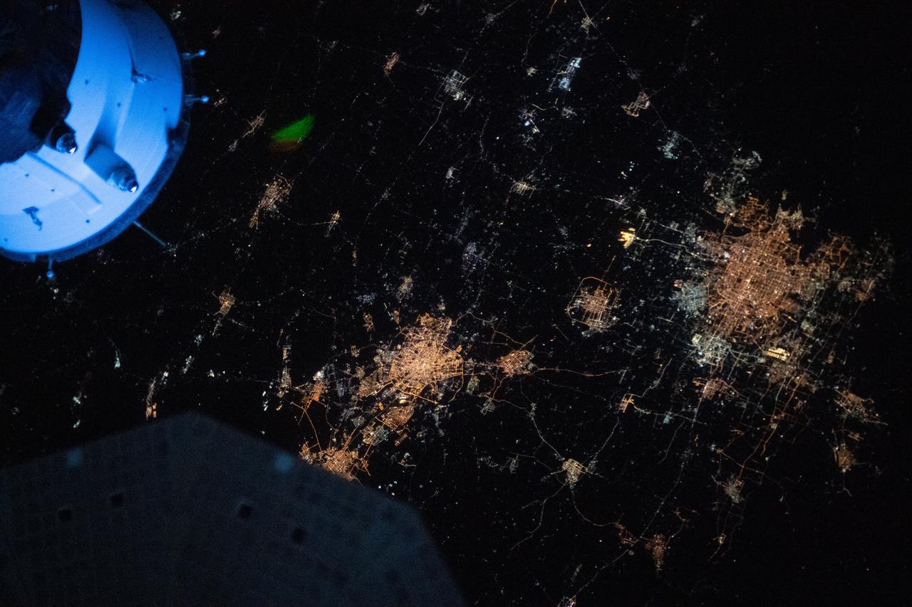
iss065e013034 (May 1, 2021) --- The night lights of Beijing and Tianjin in China are pictured from the International Space Station as it orbited 264 miles above the Asian continent near the Yellow Sea.

Yellow straps are threaded through the airframe of the modified C-141 Kuiper Airborne Observatory, (KAO) (NASA-714), before removing the cockpit on the N211 apron at Moffett Field, California.

iss067e238146 (Aug. 4, 2022) --- The sun's glint beams off the Atlantic Ocean just before it sets creating a yellow-orange hue in this photograph from the International Space Station as it orbited 258 miles above.
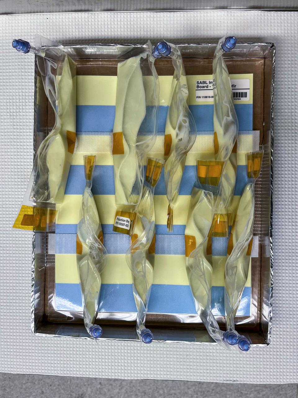
jsc2022e031236 (3/28/2022) --- A preflight image of BioNutrients-2 Yogurt Bags on SABL Tray Mockup, after 4hrs of incubation. As the yogurt organisms grow, the solution more acidic, and the pH indicator changes from blue to yellow.

Yellow straps fasten the cockpit of the modified C-141 Kuiper Airborne Observatory, (KAO) (NASA-714), to the trailer that carries it off the N211 apron at Moffett Field, California.
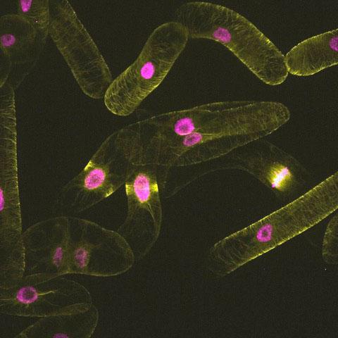
jsc2024e041792 (11/10/2022) --- microtubules and nuclei (yellow: microtubules, magenta: nuclei) for the Effects of the Space Environment on Cell Division in Plants (Plant Cell Division). Image courtesy of University of Toyama.
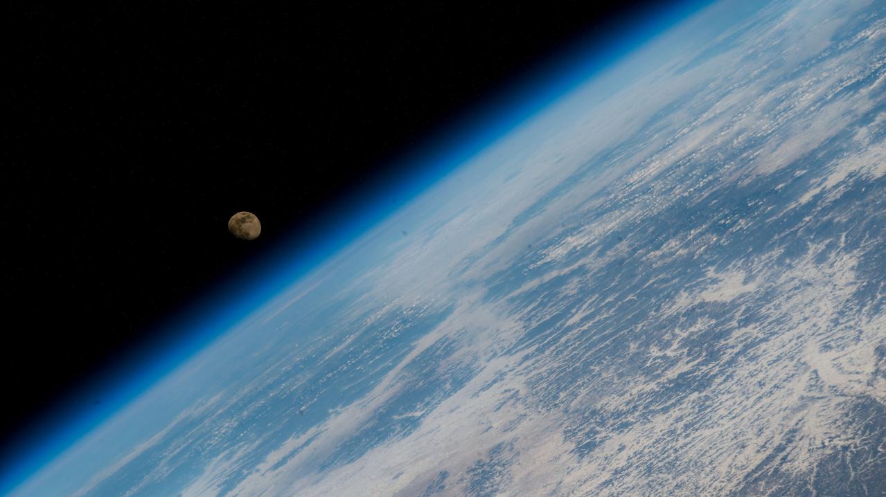
iss068e045017 (Feb. 2, 2023) -- The waxing gibbous Moon is pictured above Earth's horizon from the International Space Station as it orbited 260 miles above eastern China near the Yellow Sea coast.

Yellow straps are threaded through the airframe of the modified C-141 Kuiper Airborne Observatory, (KAO) (NASA-714), before removing the cockpit on the N211 apron at Moffett Field, California.

jsc2022e031237 (3/28/2022) --- A preflight image of BioNutrients-2 Yogurt Bags on SABL Tray Mockup, after completing 24hr incubation. The fully-yellow color of the bag’s contents indicates the yogurt has grown to completion.
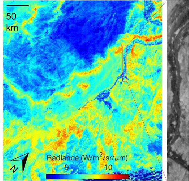
ECOSTRESS acquired this image the night of July 9, 2018, over Egypt. Yellow and red indicate generally higher temperatures. The River Nile is visible as a thin blue line on the main image. The black-and-white inset shows the level of detail available from ECOSTRESS, with the relatively cool Nile River and surrounding vegetation appearing darker. https://photojournal.jpl.nasa.gov/catalog/PIA22590

KENNEDY SPACE CENTER, FLA. -- A newly repainted NASA helicopter is transported to S.R. 3 for return to Patrick AFB. Workers painted the blades of four NASA UH-1H helicopters, changing the black to a pattern of white and yellow stripes. The pattern provides better visibility in smoke and fire conditions. When the rotors are turning, the stripes create a yellow and white circle that is more easily seen by a second helicopter from above. The helicopters, primarily used for security and medical evacuation for NASA, will be used to deliver water via buckets during brush fires. The change was made to comply with U.S. Fish and Wildlife and Department of Forestry regulations for helicopter-assisted fire control

KENNEDY SPACE CENTER, FLA. -- A NASA helicopter is secured for transfer to Ransom Road at KSC. It is one of four UH-1H helicopters that will have its blades painted, changing the black to a pattern of white and yellow stripes. The pattern provides better visibility in smoke and fire conditions. When the rotors are turning, the stripes create a yellow and white circle that is more easily seen by a second helicopter from above. The helicopters, primarily used for security and medical evacuation for NASA, will be used to deliver water via buckets during brush fires. The change was made to comply with U.S. Fish and Wildlife and Department of Forestry regulations for helicopter-assisted fire control

KENNEDY SPACE CENTER, FLA. -- Workers put the finishing touches on new paint for the blades of a NASA UH-1H helicopter. They have changed the black to a pattern of white and yellow stripes. The pattern provides better visibility in smoke and fire conditions. When the rotors are turning, the stripes create a yellow and white circle that is more easily seen from above by a second helicopter. The helicopters, primarily used for security and medical evacuation for NASA, will be used to deliver water via buckets during brush fires. The change was made to comply with U.S. Fish and Wildlife and Department of Forestry regulations for helicopter-assisted fire control

KENNEDY SPACE CENTER, FLA. -- The pilot of the NASA helicopter secures the rotary blade before the helicopter’s transfer to Ransom Road at KSC. It is one of four UH-1H helicopters that will have its blades painted, changing the black to a pattern of white and yellow stripes. The pattern provides better visibility in smoke and fire conditions. When the rotors are turning, the stripes create a yellow and white circle that is more easily seen by a second helicopter from above. The helicopters, primarily used for security and medical evacuation for NASA, will be used to deliver water via buckets during brush fires. The change was made to comply with U.S. Fish and Wildlife and Department of Forestry regulations for helicopter-assisted fire control

KENNEDY SPACE CENTER, FLA. -- A newly repainted NASA helicopter is transported to S.R. 3 for return to Patrick AFB. Workers painted the blades of four NASA UH-1H helicopters, changing the black to a pattern of white and yellow stripes. The pattern provides better visibility in smoke and fire conditions. When the rotors are turning, the stripes create a yellow and white circle that is more easily seen by a second helicopter from above. The helicopters, primarily used for security and medical evacuation for NASA, will be used to deliver water via buckets during brush fires. The change was made to comply with U.S. Fish and Wildlife and Department of Forestry regulations for helicopter-assisted fire control
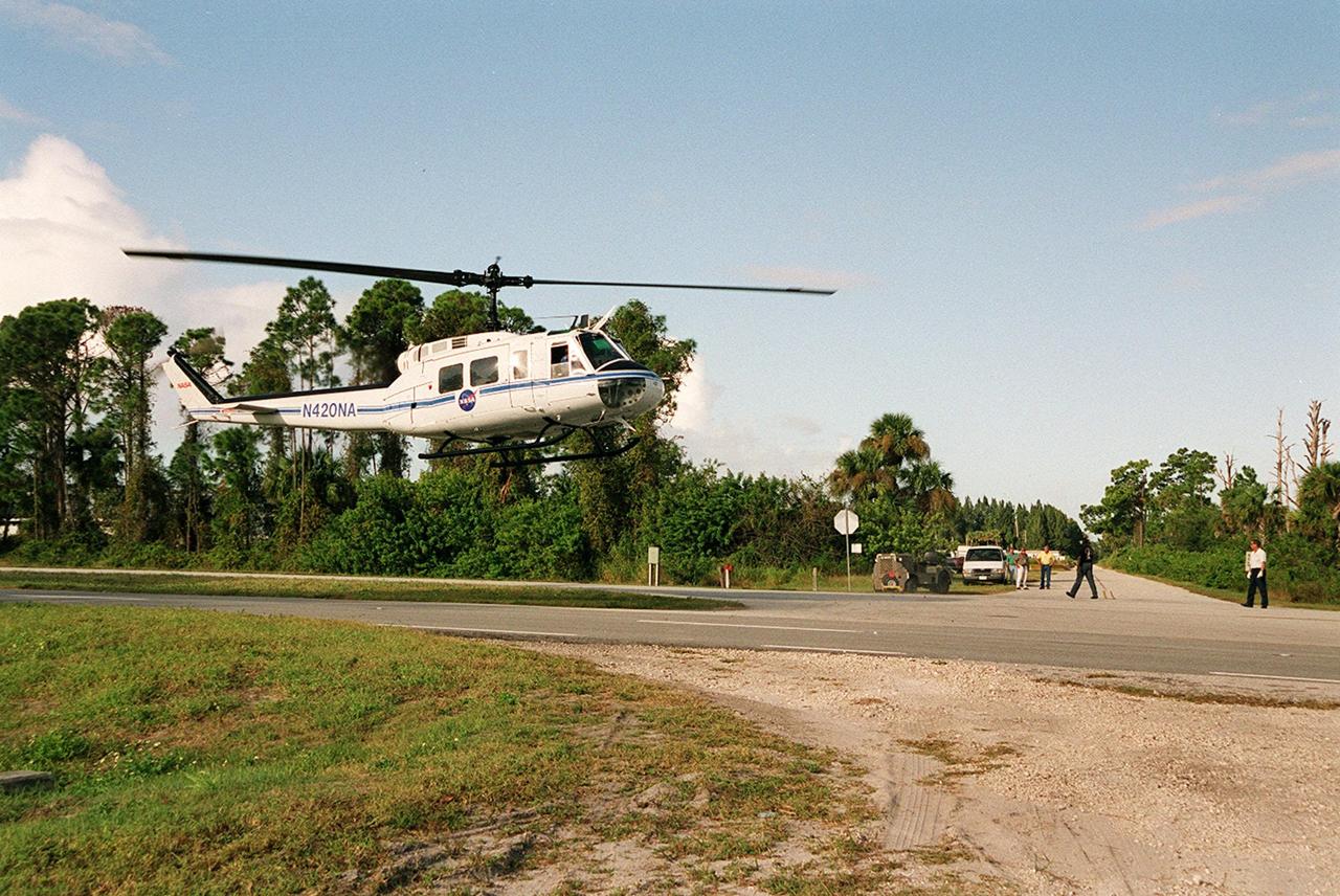
KENNEDY SPACE CENTER, FLA. -- A NASA helicopter from Patrick Air Force Base is about to land on S.R. 3. It is one of four UH-1H helicopters that will have its blades painted, changing the black to a pattern of white and yellow stripes. The pattern provides better visibility in smoke and fire conditions. When the rotors are turning, the stripes create a yellow and white circle that is more easily seen by a second helicopter from above. The helicopters, primarily used for security and medical evacuation for NASA, will be used to deliver water via buckets during brush fires. The change was made to comply with U.S. Fish and Wildlife and Department of Forestry regulations for helicopter-assisted fire control

KENNEDY SPACE CENTER, FLA. -- A NASA helicopter lands on S.R. 3 for transfer to Patrick Air Force Base. It is one of four UH-1H helicopters that will have its blades painted, changing the black to a pattern of white and yellow stripes. The pattern provides better visibility in smoke and fire conditions. When the rotors are turning, the stripes create a yellow and white circle that is more easily seen by a second helicopter from above. The helicopters, primarily used for security and medical evacuation for NASA, will be used to deliver water via buckets during brush fires. The change was made to comply with U.S. Fish and Wildlife and Department of Forestry regulations for helicopter-assisted fire control

KENNEDY SPACE CENTER, FLA. -- Workers get ready to move a NASA UH-1H helicopter outside. They have been painting the blades of four NASA UH-1H helicopters, changing the black to a pattern of white and yellow stripes. The pattern provides better visibility in smoke and fire conditions. When the rotors are turning, the stripes create a yellow and white circle that is more easily seen by a second helicopter from above. The helicopters, primarily used for security and medical evacuation for NASA, will be used to deliver water via buckets during brush fires. The change was made to comply with U.S. Fish and Wildlife and Department of Forestry regulations for helicopter-assisted fire contro
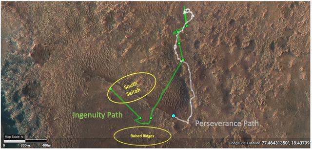
This annotated image depicts the ground tracks of NASA's Perseverance rover (white) and Ingenuity Mars Helicopter (green) since arriving on Mars on February 18, 2021. The green dots represent the locations of the helicopter's airfields during the 11 flights it has made between April 19 and August 4. The lower yellow ellipse highlights the "Raised Ridges" geologic feature that Ingenuity reconnoitered during Flight 10. The upper yellow ellipse depicts the "South Séítah" region, which Ingenuity is scheduled to fly over during its 12th sortie. https://photojournal.jpl.nasa.gov/catalog/PIA24797