
SL4-140-4111 (14 Jan. 1974) --- The Aleutian Islands area of Alaska, as photographed from the Skylab space station in Earth orbit by one of the Skylab 4 crewmen. The camera used was a hand-held Hasselblad, with SO-368 medium-speed Ektachrome. Here is another macro scale phenomenon which is difficult to observe except from a space platform. The Aleutian Islands and clouds with very elaborate van Karman vortices was photographed on Jan. 14, 1974. In addition to the vortices the waves in the clouds due to the mountains on the islands are very evident. In fact, the easiest way to find the mountains is to start with their atmospheric disturbance and work back to the mountain. Photo credit: NASA
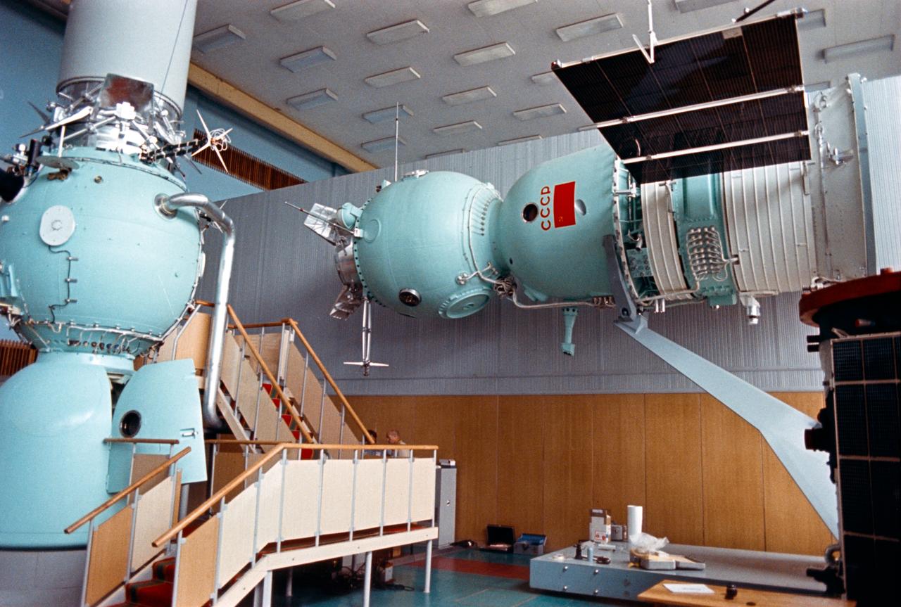
S74-24675 (June 1974) --- Two mock-ups of the USSR Soyuz spacecraft which are on display at the Cosmonaut Training Center (Star City) near Moscow. The Soyuz spacecraft mounted vertically on the left is a training mock-up. The Soyuz mounted horizontally on the right was exhibited at the Paris air show in May-June 1973 in a docked configuration with an Apollo spacecraft. The spherical-shaped section of the Soyuz is called the orbital module. The middle section with the lettering ?CCCP? (USSR) on it called the descent vehicle. Two solar panels extend out from the instrument-assembly module. The joint U.S.-USSR Apollo-Soyuz docking mission in Earth orbit is scheduled for the summer of 1975. A docking module mock-up is atop the Soyuz training mock-up on the left.
CV-990 (NASA 711) on Ames ramp at sunrise

SL4-93-153 (February 1974) --- A vertical view of the Birmingham and central Alabama area is seen in this Skylab 4 Earth Resources Experiments Package S190-B (five-inch earth terrain camera) infrared photographed taken from the Skylab space station in Earth orbit. Illustrated here is the utility of color infrared film in depicting distribution of living vegetation in the 3,600 square mile Birmingham region. The Birmingham industrial complex, with a population of nearly 850,000, is the light gray area nestled in the valley between the northeast-trending ridges that are prominent topographic features in the southern Appalachian Mountains. The narrow ridges and adjacent valleys reflect folded and faulted sedimentary rocks, indicating the complex geological history of the region. Two major rivers and several reservoirs are easily distinguished in this photograph. Bankhand Lake, formed by a dam on the Black Warrior River, appears as bright blue west of Birmingham. Two lakes are formed by dams on the Goosa River east of Birmingham. Federal and state highways appear as thin white lines and are easily identified. Interstate 65 to Montgomery is the prominent white line extending southward from Birmingham. Power line clearings are visible in the center of the picture along the Goosa River, and can be traced northwestward to northern parts of Birmingham. The predominant deep red color of the picture is due to the reflections from living vegetation. In contrast are the light tan areas that commonly occur as rectangular patterns in the east part of the photograph and represent mature agricultural crops or grazing lands. Analysis of the photographic data from the earth terrain camera will be conducted by Dr. H. Jayroe of the Marshall Space Flight Center in developing analytical techniques. All EREP photography is available to the public through the Department of Interior's Earth Resources Observations Systems Data Center, Sioux Falls, South Dakota, 57198. Photo credit: NASA
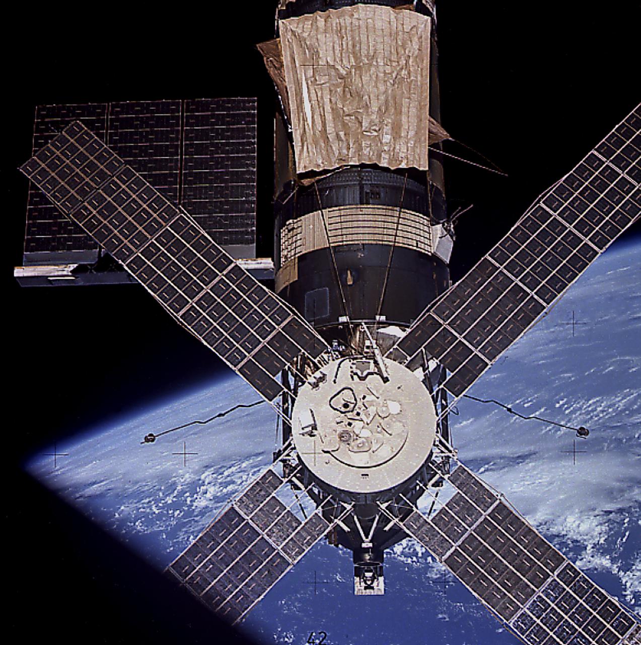
This image of Skylab in orbit was taken as the third crew (Skylab-4) departed the space station after 84 days in the orbiting laboratory. A smiling Skylab seemed to wink good-bye for the job well done.
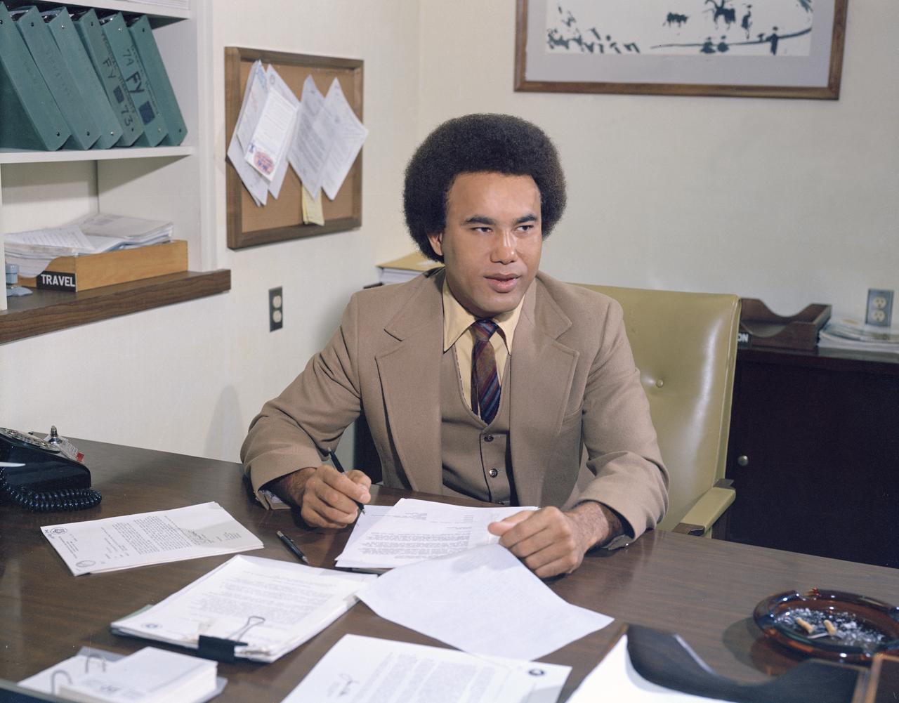
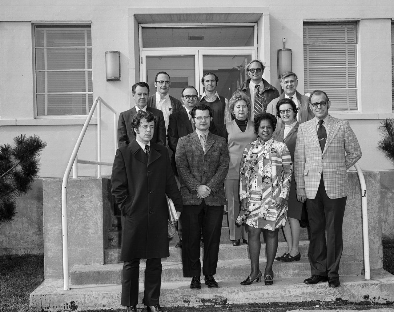
Minority Professionals at NASA Langley Research Center Samuel J. Scott at his desk working in the Office of Director for Structures, Staff Assistant.
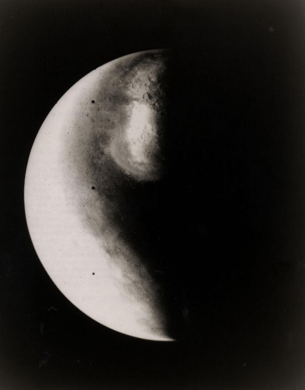
Half-Mars hangs in space 685,000 kilometers (425,000 miles) above Viking 1 as the spacecraft approaches the planet. This picture was taken at 6:40 p.m. PDT on June 16 by one of two telescope-equipped TV cameras aboard the Viking 1 Orbiter. A violet filter was used. Resolution is approximately 17 kilometers (10.5 miles) at center of disk. North is toward upper right and the south pole is in the dark to the lower left. We are looking at the morning side of the planet; that is, the planet is rotating from left to right. Toward the bottom of the image is a very bright irregular feature within a somewhat less bright circular feature. The circular feature is Hellas, a 2,000-kilometer(1,250-mile) diameter impact basin. Numerous craters are just visible within the frost-covered region. To the south of Hellas is another brighter area. This is probably an area of discontinuous frost cover around the south pole. The image is very bright toward the edge of the planet because of atmospheric scattering in the violet. Viking 1 will begin orbiting Mars on Saturday, June 19, with the landing planned for July 4. The Viking Project is managed by the NASA Langley Reseach Center, Hampton, Va.
CV-990 Galileo II arrival at Ames after first expedition - decending ramp are from top Don Anderson, Mike Bader, Dean Chapman (?), Hans Mark and unknown
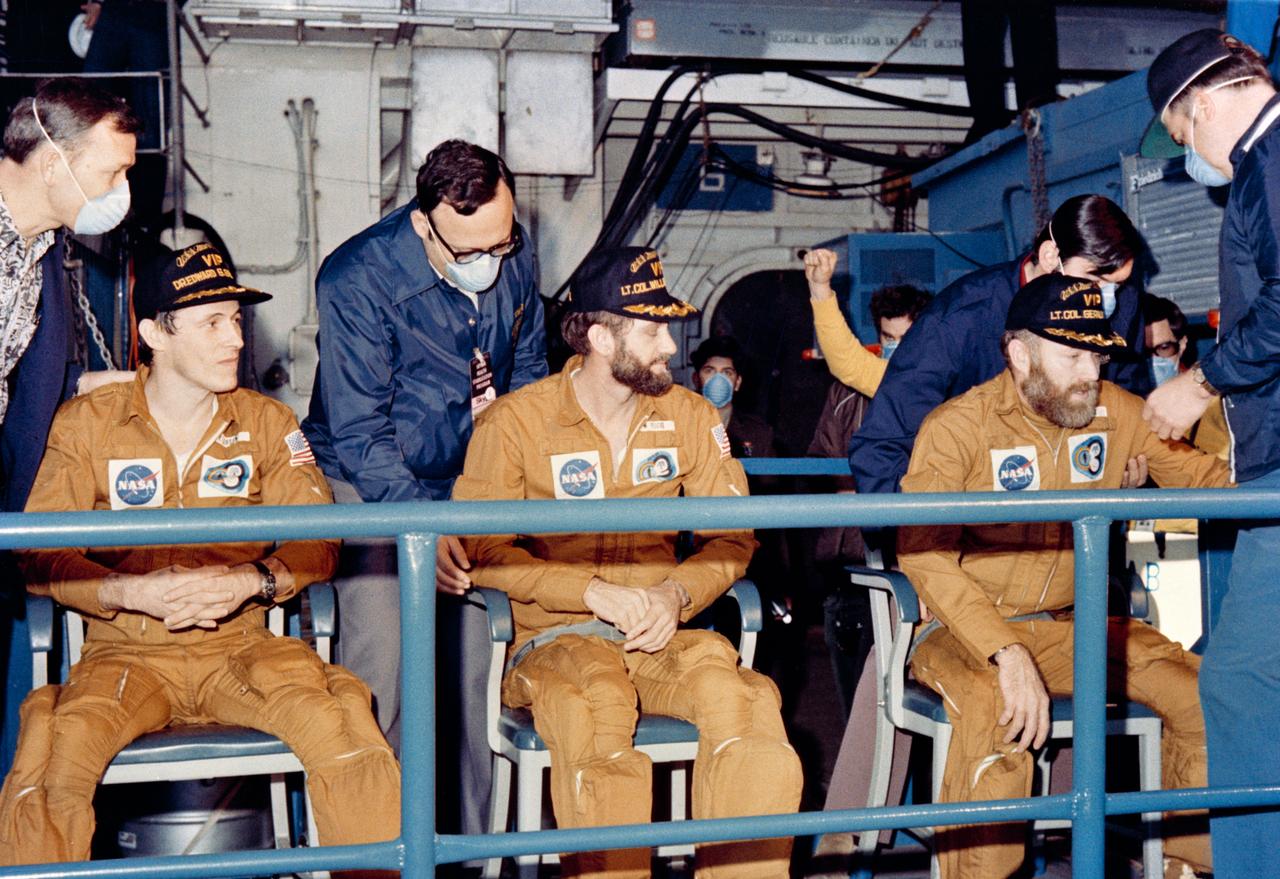
S74-17744 (8 Feb. 1974) --- The crewmen of the third and final manned Skylab mission relax on the USS New Orleans, prime recovery ship for their mission, about an hour after their Command Module splashed down at 10:17 a.m. (CDT), Feb. 8, 1974. The splashdown, which occurred 176 statute miles from San Diego, ended 84 record-setting days of flight activity aboard the Skylab space station cluster in Earth orbit. Photo credit: NASA
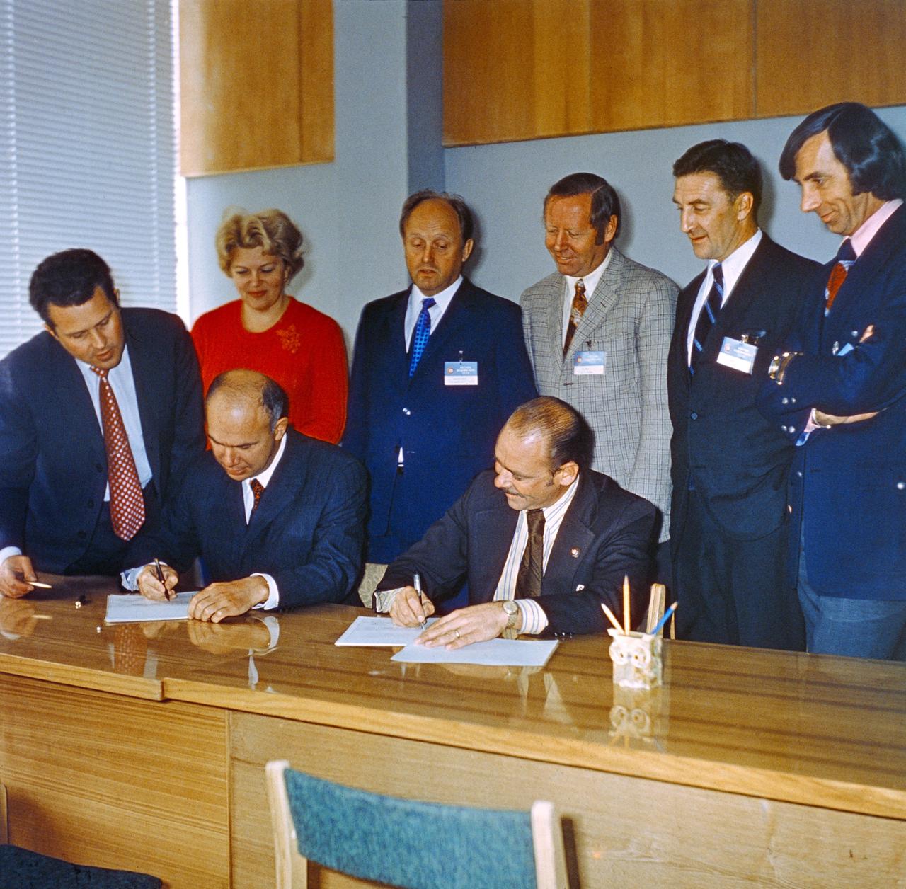
S74-29896 (September 1974) --- John P. Donnelly (seated right), NASA Assistant Administrator for Public Affairs, and Vladen S. Vereshchetin (seated left), Vice Chairman of Intercosmos, USSR Academy of Sciences, initial an agreement on information policy for the joint U.S.-USSR Apollo-Soyuz Test Project mission during ceremonies in Moscow in September 1974. Other members of the joint public affairs delegation looking on are, standing left to right, Vladimir A. Denissenko, Tatyana Klotchkovsaya, Igor P. Rumyantsev, John W. King, Nicholas Timacheff, and Robert Shafer. King is the Public Affairs Officer at the Johnson Space Center. Timacheff is the language officer with the JSC ASTP office. Shafer is NASA Deputy Assistant Administrator for Public Affairs (Television).
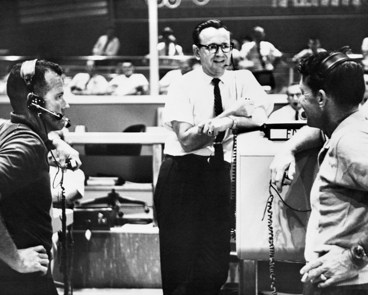
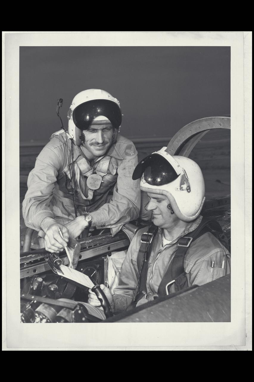
S74-33006 (19 Sept. 1962) --- Flight director Christopher C. Kraft Jr. (center), Chief of the Flight Operations Division at the Manned Spacecraft Center, Houston, discusses the Mercury-Atlas 8 (MA-8) flight plan with astronauts L. Gordon Cooper Jr. (left) and Walter M. Schirra Jr., on Sept. 19, 1962. They are standing in the Mercury Control Center at Cape Canaveral, Florida. Photo credit: NASA

Huntsville’s Jack Giles, Alabama State Senator (left), and Dr. Rocco Petrone, Marshall Space Flight Center Director (Middle), speak with Astronaut Owen Garriott who is inside the Apollo 16 Command Module on display at the Alabama Space and Rocket Center in Huntsville, Alabama. The successful Apollo 16 manned lunar landing mission took place April 16, 1972 through April 27, 1972. (Photograph courtesy of Huntsville/Madison County Public Library)
Top Plan view of Bell Rotor with Ed Verrett left frame. Test #437.
S74-23117 (6 June 1974) --- Two astronauts associated with the joint U.S.-USSR Apollo-Soyuz Test Project receive instructions in the Russian language during ASTP activity at the Johnson Space Center. They are Robert F. Overmyer, a member of the support team of the American ASTP crew, who is seated at left; and Vance D. Brand (center), the command module pilot of the American ASTP prime crew. The instructor is Anatoli Forestanko.
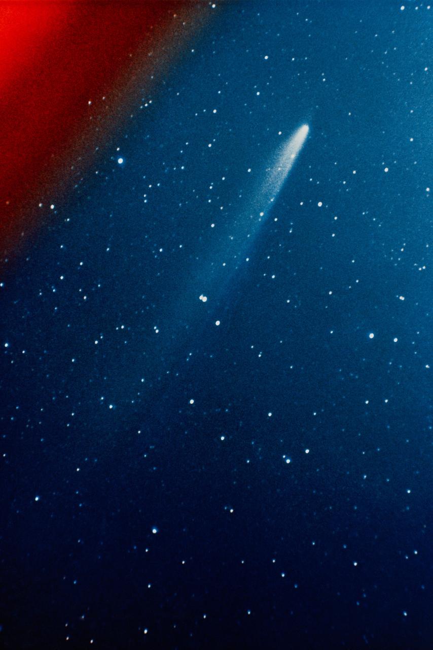
S74-17688 (11 Jan. 1974) --- This color photograph of the comet Kohoutek was taken by members of the lunar and planetary laboratory photographic team from the University of Arizona, at the Catalina Observatory with a 35mm camera on Jan. 11, 1974. Photo credit: NASA
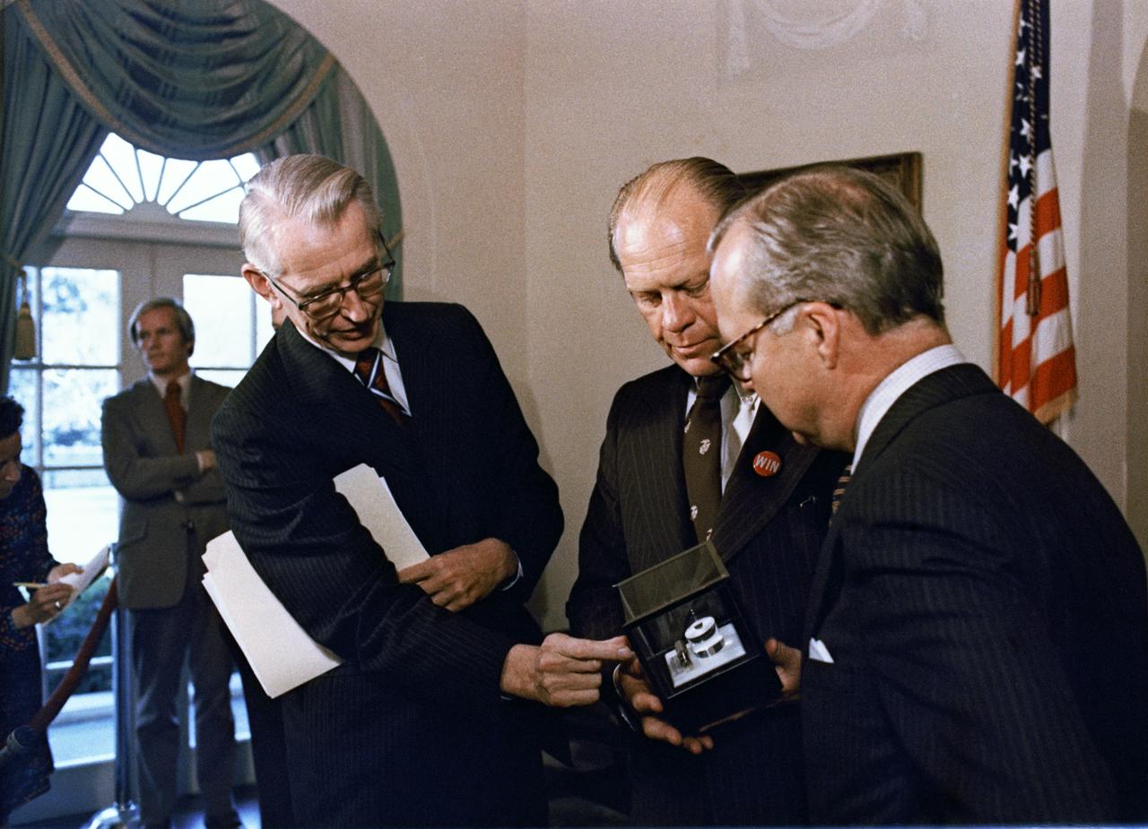
S74-34046 (October 1974) --- Dr. James C. Fletcher, left, NASA Administrator, explains the formation of the indium-antimonide crystal, manufactured in space, to President Gerald R. Ford at the White House. Standing at right is Harold Johnson, Chairman of the Massachusetts Institute of Technology. The segment of indium-antimonide is cut from a cylindrical single crystal that was partially melted and resolidified aboard the Skylab space station on Jan. 6, 1974, during the third and final manned flight. This segment is approximately one by one centimeters and about three millimeters thick. The sequence of heating and cooling was started and supervised by the members of the third Skylab crew, astronauts Gerald P. Carr, Edward G. Gibson and William R. Pogue. The crystal forming was accomplished in a special multipurpose furnace, known as the Materials Processing Facility (Skylab Technology Experiment M512). Photo credit: NASA
Boeing 747 wake vortex test-440 in thr 40x80ft. w.t. with Rufiange, Vern Rossow, Eloy Martinez
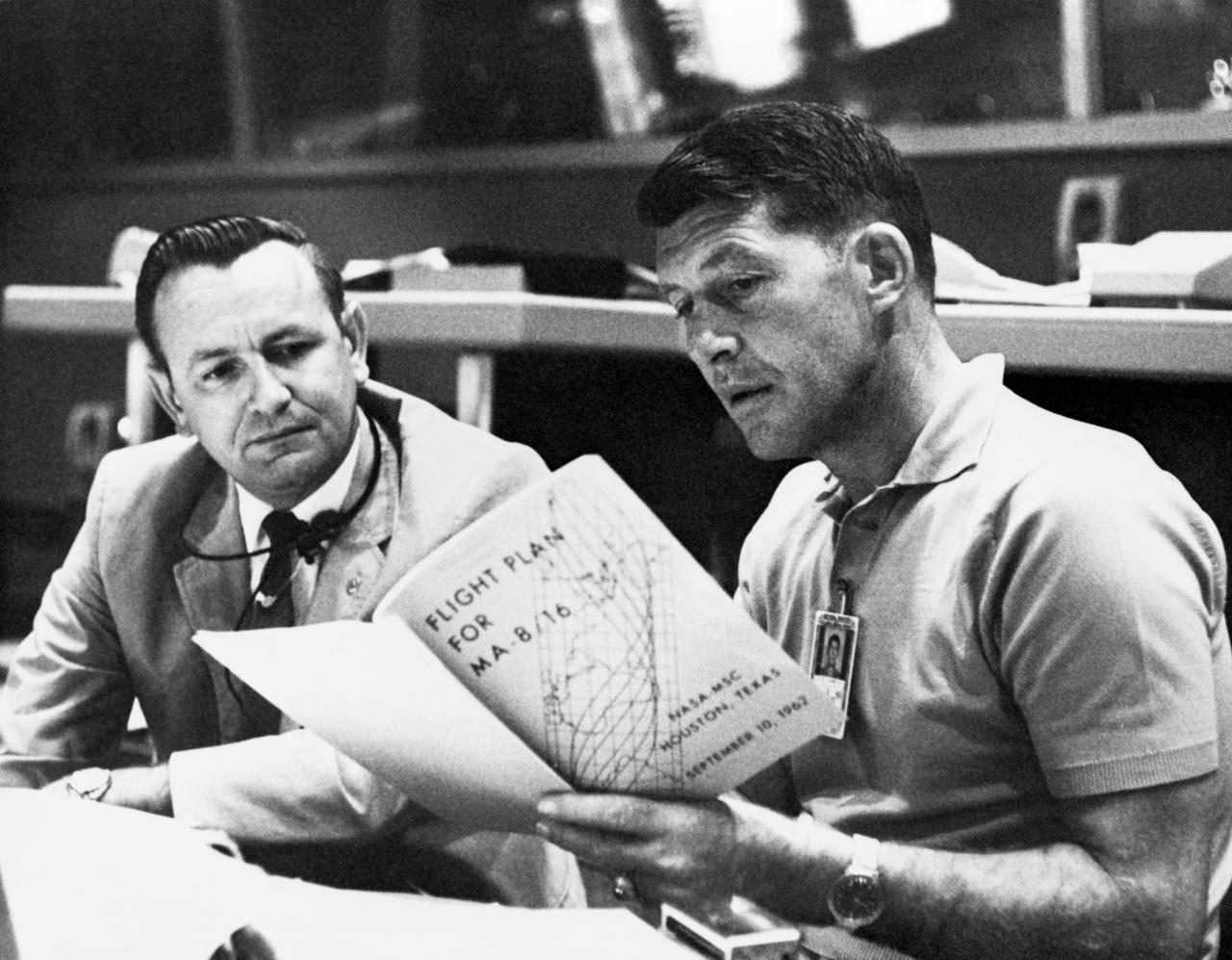
S74-33004 (19 Sept. 1962) --- Astronaut Walter M. Schirra Jr, (right), Mercury-Atlas 8 (MA-8) pilot, discusses the MA-8 flight plan with flight director Christopher C. Kraft Jr., Chief of the Flight Operations Division at the Manned Spacecraft Center, Houston, during MA-8 preflight preparations at Cape Canaveral, Florida. They are seated at a console in the Mercury Control Center. Photo credit: NASA
Minority Professionals at NASA Langley Research Center Samuel J. Scott on the right.
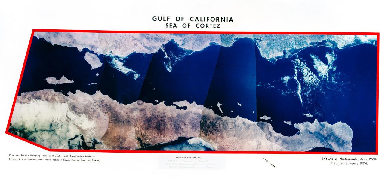
S74-23654 (22 June 1973) --- This mosaic of Baja and the Sea of Cortez in Mexico (28.0N, 112.0W) is a composite of six 70mm photos carefully pieced together to appear as one. Mosaics such as this one are useful to portray a large area in a single format instead of many photos covering only partial images. In this mosaic, almost the entire area of the Sea of Cortez, the adjacent Baja Peninsula and part of the Sonoran Desert of northwest Mexico can be seen. Photo credit: NASA

S74-17456 (3 Feb. 1974) --- Scientist-astronaut Edward G. Gibson has just egressed the Skylab EVA hatchway in this frame taken from a roll of movie film exposed by a 16mm Maurer camera. Astronaut Gerald P. Carr, Skylab 4 commander, took this picture during the final Skylab extravehicular activity (EVA) which took place on Feb. 3, 1974. Carr was above on the Apollo Telescope Mount (ATM) when he shot this frame of Gibson. Note Carr's umbilical/tether line extending from inside the space station up toward the camera. Astronaut William R. Pogue, Skylab 4 pilot, remained inside the space station during the EVA by Carr and Gibson. Photo credit: NASA

SL4-139-4072 (February 1974) --- A high oblique view of the North Atlantic coast of Canada as seen from the Skylab space station in Earth orbit. A Skylab 4 crewman used a hand-held 70mm Hasselblad camera to take this picture. The Strait of Belle Isle, near the center of the picture, separates the Island of Newfoundland from the Canadian mainland. The Strait also connects the Gulf of St. Lawrence with North Atlantic Ocean. The elongated land mass (lower center) is the northern-most peninsula of the Island of Newfoundland. The large land mass at left center is mainland Newfoundland and Quebec. Note the sea ice in the Atlantic. Snow and some ice intermittently cover the land masses, and ice plumes of brash ice or pancake ice can be seen in various shapes and formations. General terrain and ice conditions can be distinguished and evaluated up to at least 55 degrees north latitude in this north looking view. Dr. William Campbell, sea and ice expert with the U.S. Geological Survey, will use this photograph in the study of ice dynamics. Photo credit: NASA
Space Shuttle Tile Thermal Protection System testing in Ames Arc Jet facilities
Dr E. J.Smith, John Wolf (Ames) and Charles Hall (Ames) confer during press conference for Pioneer 11 Jupiter encounter
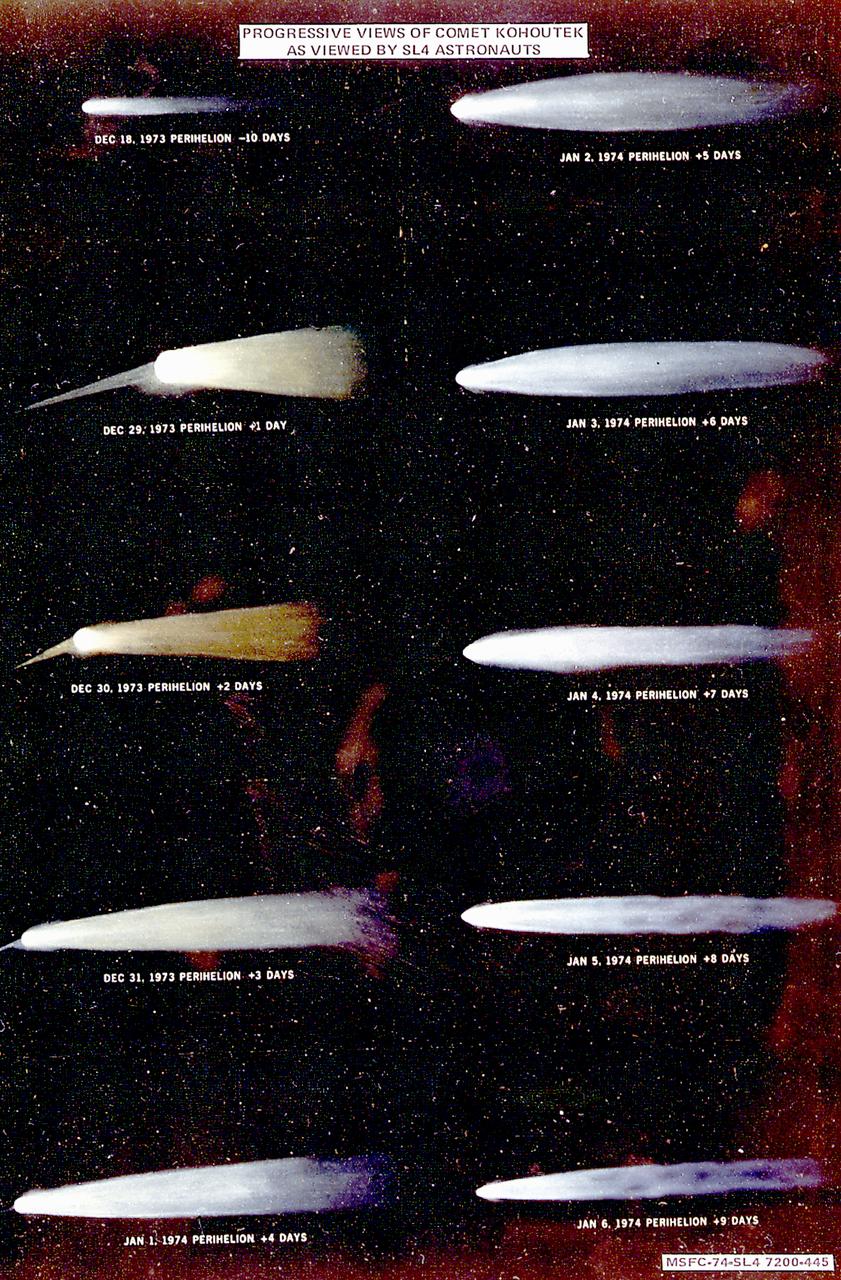
This montage is an artist's conception of progressive views of the Comet Kohoutek based on sketches and a description by Skylab-4 astronaut Edward Gibson. An early discovery of a large comet in an orbit that would reach close to the Sun at the end of 1973 prompted NASA to initiate Operation Kohoutek, a program to coordinate widespread observations of the comet from ground observatories, aircraft, balloons, rockets, unmarned satellites, and Skylab.

SL4-93-167 (February 1974) --- A vertical view of the Kennedy Space Center and the Florida Atlantic coast area is seen in this Skylab 4 Earth Resources Experiments Package S190-B (five-inch earth terrain camera) infrared photography taken from the Skylab space station in Earth orbit. This photograph shows the major land-ocean features of the Florida coast near Vero Beach northward to Cape Canaveral and the KSC complex. The launch pads for the Skylab missions are clearly visible. Identification of living vegetation is possible through the use of the color infrared film. Various shades of red portray differences in the vegetation such as shown in the patterns in the agricultural area near Vero Beach. In the Kennedy Space Center, the nearly continuous and uniform red color shows that most of the land areas are heavily vegetated. The white coastal beach areas are strongly contrasted to the red land and the blue Atlantic Ocean. Old dunal areas in KSC are visible on Merritt Island which is separated from the Launch areas by the Banana River and the mainland by the Indian River. Federal and state highways and numerous causeways over the rivers are easily identified. The Florida mainland is partly shadowed by small white clouds which cast a pronounced shadow to the east of each cloud indicated the Sun is west of solar noon. Federal agencies participating with NASA on the EREP project are the Departments of Agriculture, Commerce, Interior, the Environmental Protection Agency and the Core of Engineers. All EREP photography is available to the public through the Department of Interior's Earth Resources Observations Systems Data Center, Sioux Falls, South Dakota, 57198. Photo credit: NASA
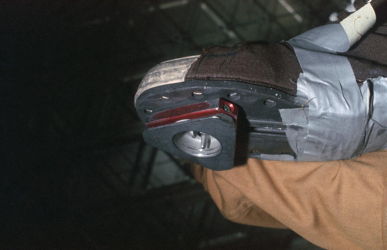
SL4-149-5036 (February 1974) --- View of triangle-shaped cleat taped on the bottom of a shoe of a Skylab 4 crew member. Photo credit: NASA
SL4-142-4577 (28 Jan. 1974) --- Two large ice islands in the vicinity of South Georgia Island in the South Atlantic Ocean, as photographed from the Skylab space station in Earth orbit by one of the Skylab 4 crewmen. The camera used was a hand-held 70mm Hasselblad, with SO-368 medium-speed Ektachrome. One of the ice islands is partially obscured by clouds. Ice islands were observed as large as 45 by 60 kilometers (27 x 37 miles) and as far north as 45 degrees south latitude. The size and distribution of the "small" icebergs (to a ship they would look very large) can be used to study the local winds and currents. Recent research has suggested the possibility of towing such Antarctic icebergs to selected areas and using them as water supplies. One such iceberg would contain many times the water as in Lake Powell. Photo credit: NASA
Dr. John A. Simpson and Dr James Van Allen discuss Pioneer 11 Mission to Juiter and Saturn during morning briefing.
CAPE CANAVERAL, Fla. -- Mating of the Symphonie spacecraft. Photo credit: NASA
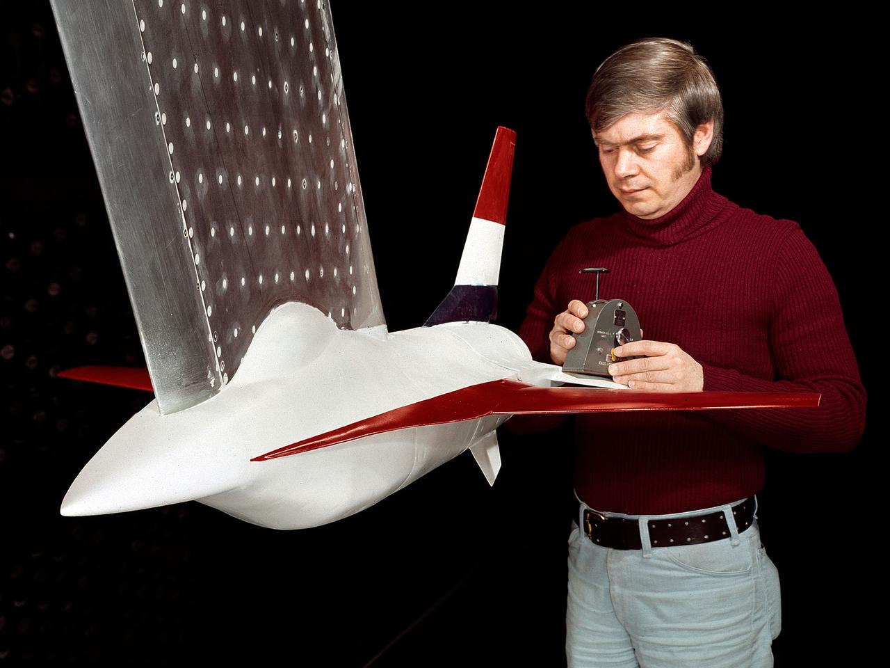
A model of the General Dynamics YF-16 Fighting Falcon in the test section of the 8- by 6-Foot Supersonic Wind Tunnel at the National Aeronautics and Space Administration (NASA) Lewis Research Center. The YF-16 was General Dynamics response to the military’s 1972 request for proposals to design a new 20,000-pound fighter jet with exceptional acceleration, turn rate, and range. The aircraft included innovative design elements to help pilots survive turns up to 9Gs, a new frameless bubble canopy, and a Pratt and Whitney 24,000-pound thrust F-100 engine. The YF-16 made its initial flight in February 1974, just six weeks before this photograph, at Edwards Air Force Base. Less than a year later, the Air Force ordered 650 of the aircraft, designated as F-16 Fighting Falcons. The March and April 1974 tests in the 8- by 6-foot tunnel analyzed the aircraft’s fixed-shroud ejector nozzle. The fixed-nozzle area limited drag, but also limited the nozzle’s internal performance. NASA researchers identified and assessed aerodynamic and aerodynamic-propulsion interaction uncertainties associated the prototype concept. YF-16 models were also tested extensively in the 11- by 11-Foot Transonic Wind Tunnel and 9- by 7-Foot Supersonic Wind Tunnel at Ames Research Center and the 12-Foot Pressure Wind Tunnel at Langley Research Center.
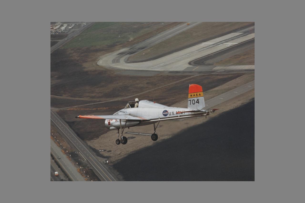
X-14B NASA-704: A Bell single-place, open cockpit, twin-engine, jet-lift VTOL aircraft over Highway 101 in approach to Moffett Field, California. The X-14 was used by NASA Ames Research Center to advance state-of-the-art jet-powered VTOL aircraft.
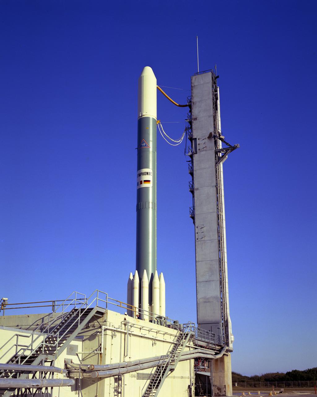
CAPE CANAVERAL, Fla. -- Prelaunch of Symphonie-A on Complex 17-B, a communications satellite for Franco-German industrial consortium. Photo credit: NASA
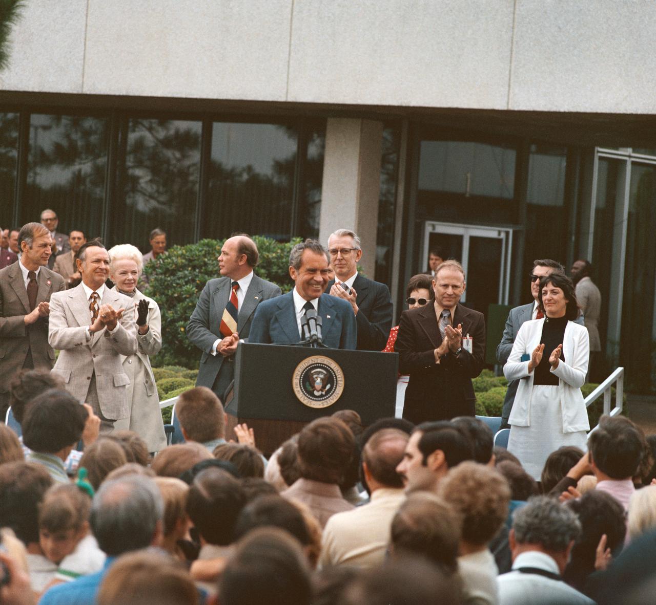
Five (5) views of President Richard M. Nixon during his visit to the JSC. These views show the President as he addresses a crowd of employees and visitors outside of Building 1 Auditorium. Dr. Christopher C. Kraft, Fletcher, and Astronaut Gerald Carr, with Pete Clements, George Abbey, and Jack Waite in the background is also seen with the President. 1. Pres. Richard M. Nixon 2. Dr. Christopher C. Kraft JSC, HOUSTON, TX
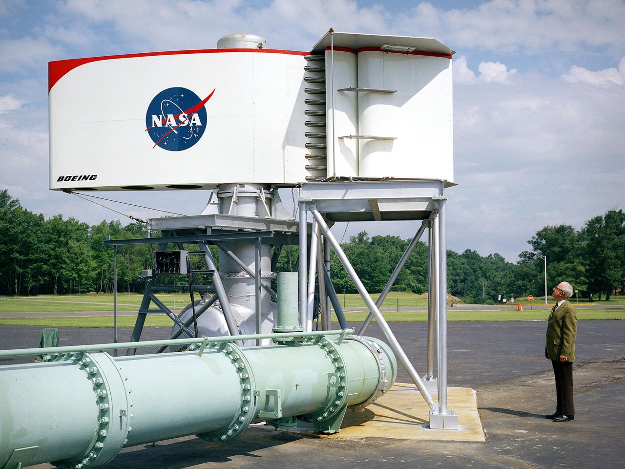
The augmentor wing concept was introduced during the early 1960s to enhance the performance of vertical and short takeoff (VSTOL) aircraft. The leading edge of the wing has full-span vertical flaps, and the trailing edge has double-slotted flaps. This provides aircraft with more control in takeoff and landing conditions. The augmentor wing also produced lower noise levels than other VSTOL designs. In the early 1970s Boeing Corporation built a Buffalo C-8A augmentor wing research aircraft for Ames Research Center. Researches at Lewis Research Center concentrated their efforts on reducing the noise levels of the wing. They initially used small-scale models to develop optimal nozzle screening methods. They then examined the nozzle designs on a large-scale model, seen here on an external test stand. This test stand included an airflow system, nozzle, the augmentor wing, and a muffler system below to reduce the atmospheric noise levels. The augmentor was lined with noise-reducing acoustic panels. The Lewis researchers were able to adjust the airflow to simulate conditions at takeoff and landing. Once the conditions were stabilized they took noise measurements from microphones placed in all directions from the wing, including an aircraft flying over. They found that the results coincided with the earlier small-scale studies for landing situations but not takeoffs. The acoustic panels were found to be successful.
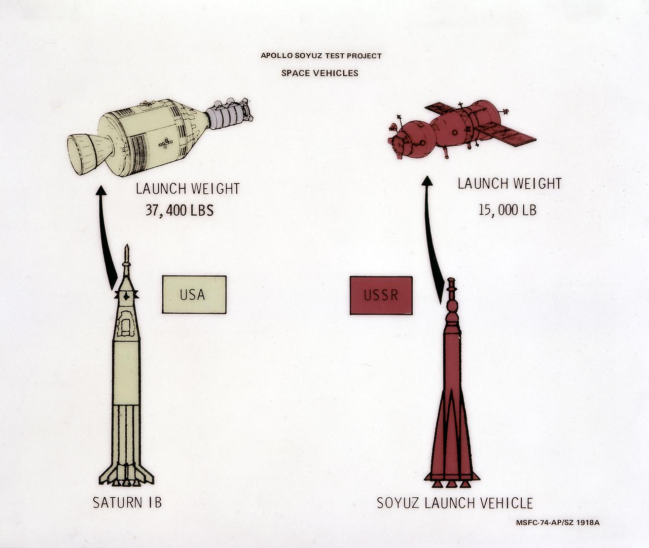
This illustration depicts a comparison of two space vehicles, the U.S.'s Saturn IB launch vehicle and the U.S.S.R.'s Soyuz launch vehicle, for the Apollo-Soyuz Test Project. The ASTP was the first international docking of the U.S.'s Apollo spacecraft and the U.S.S.R.'s Soyuz spacecraft in space. A joint engineering team from the two countries met to develop a docking system that permitted the two spacecraft to link in space and allowed the two crews to travel from one spacecraft to the other. This system entailed developing a large habitable Docking Module (DM) to be carried on the Apollo spacecraft to facilitate the joining of two dissimilar spacecraft. The Marshall Space Flight Center was responsible for development and sustaining engineering of the Saturn IB launch vehicle during the mission.
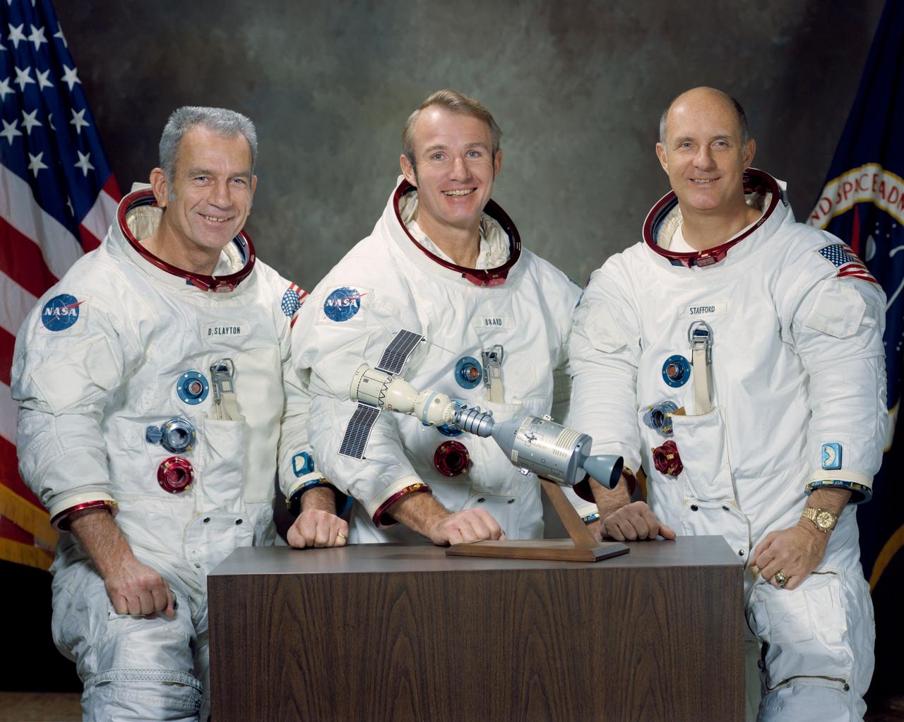
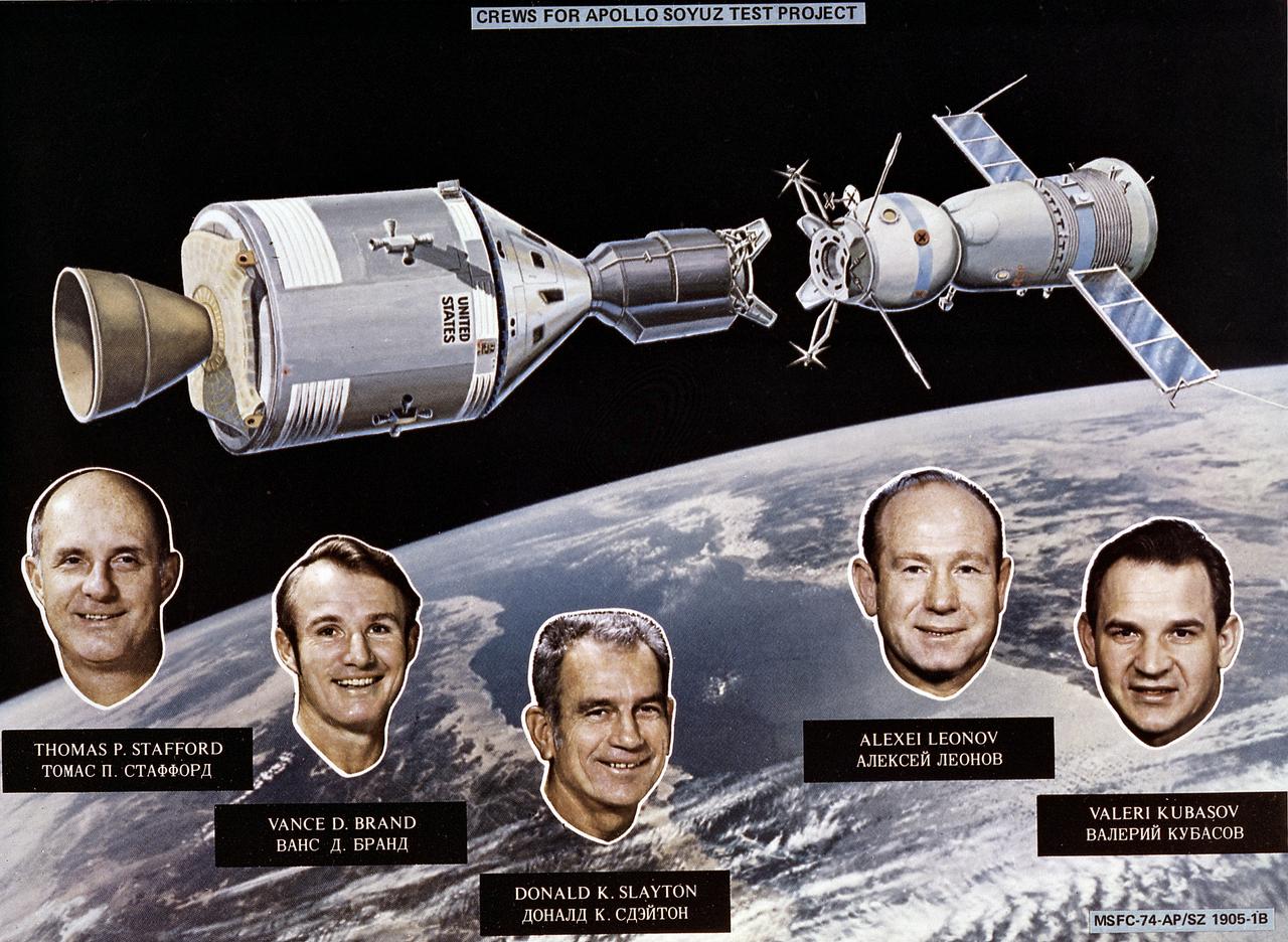
S74-15241 (January 1974) --- These three NASA astronauts are the United States flight crew for the 1975 Apollo-Soyuz Test Project (ASTP) mission. The prime crew members for the joint United States - Soviet Union spaceflight are, left to right, Donald K. Slayton, docking module pilot; Vance D. Brand, command module pilot; and Thomas P. Stafford, commander. The American and Soviet crews will visit one another?s spacecraft while the Soyuz and Apollo are docked in Earth orbit for a maximum of two days. The ASTP mission is designed to test equipment and techniques that will establish international crew rescue capability in space, as well as permit future cooperative scientific missions.
S74-24913 (August 1973) --- An artist's concept illustrating an Apollo-type spacecraft (left) about to dock with a Soviet Soyuz-type spacecraft. A recent agreement between the United States (USA) and the Union of Soviet Socialist Republic (USSR) provides for the docking in space of the Soyuz and Apollo-type spacecraft in Earth orbit in 1975. The joint space venture is called the Apollo-Soyuz Test Project (ASTP).
SL4-138-3846 (February 1974) --- A near vertical view of the snow-covered northwest corner of Wyoming as seen from the Skylab space station in Earth orbit. A Skylab 4 crewman used a hand-held 70mm Hasselblad camera to take this picture. A small portion of Montana and Idaho is seen in this photograph also. The dark area is Yellowstone National Park. The largest body of water is Yellowstone Lake. The Absaroka Range is immediately east and northeast of Yellowstone Lake. The elongated range in the eastern part of the picture is the Big Horn Mountain range. The Wind River Range is at bottom center. The Grand Teton National Park area is almost straight south of Yellowstone Lake. Approximately 30 per cent of the state of Wyoming can be seen in this photograph. Photo credit: NASA
S74-28972 (20 Sept. 1974) --- Astronaut Vance D. Brand (foreground) and cosmonaut Aleksandr S. Ivanchenko are seated in the Docking Module trainer in Building 35 during Apollo-Soyuz Test Project simulation training at the Johnson Space Center. Brand is the command module pilot of the American ASTP prime crew. Ivanchenko is the engineer on the Soviet ASTP fourth crew (backup). During the exercise the American ASTP crew and the Soviet ASTP crew simulated docking the Apollo and Soyuz in Earth orbit and transferring to each other?s spacecraft. The Docking Module is designed to link the Apollo and Soyuz spacecraft. The ASTP crewmen are training in both the U.S. and USSR for the joint mission scheduled for the summer of 1975. This view is looking from inside the Command Module into the Docking Module. The hatchway loading into the Soyuz spacecraft orbital module mock-up is in the background.
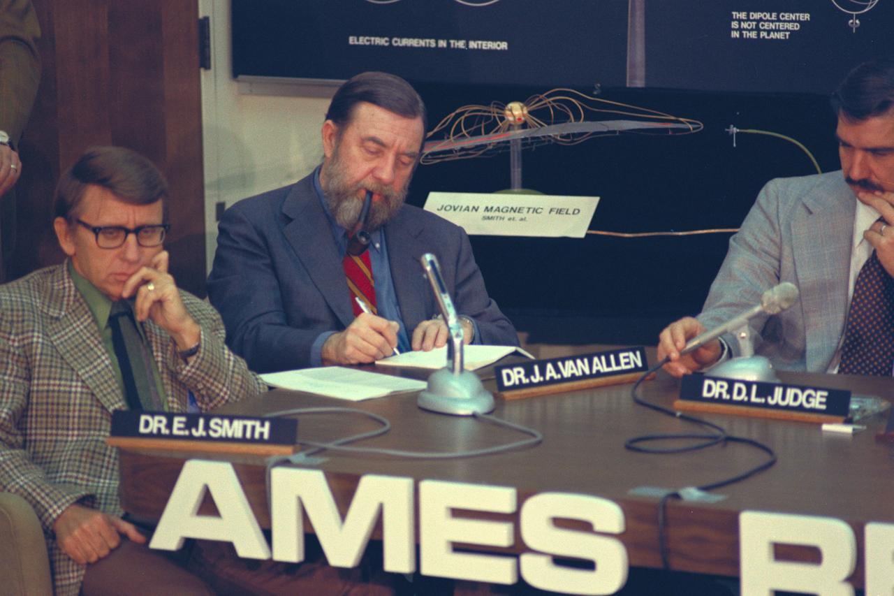
Pioneer 11 Mission to Jupiter: encounter briefing with (L-R) Dr. E. J. Smith, Dr J. A. Van Allen, and Dr D. L. Judge
CV-990 Galileo II arrival at Ames after first expedition

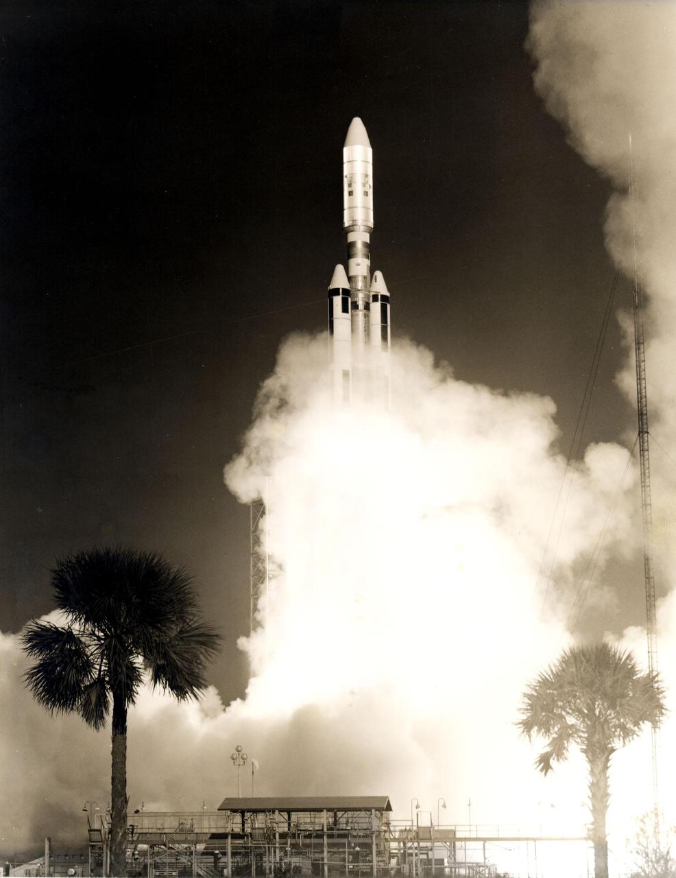
An Air Force Titan III-C lifted off from Complex 40 at Cape Canaveral Air Force Station at 9:00 A.M. EDT today to launch Application Technology Satellite 6, first in a new generation of NASA Communications satellites. (1.3-13)(Test 7670)
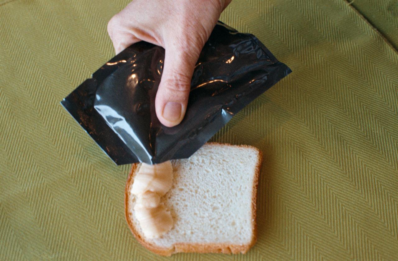
S74-25635 (August 1974) --- A close-up view of cheddar cheese spread, one of the items of food selected for the Apollo-Soyuz Test Project mission scheduled for the summer of 1975. This food item was carried on the Apollo missions also.
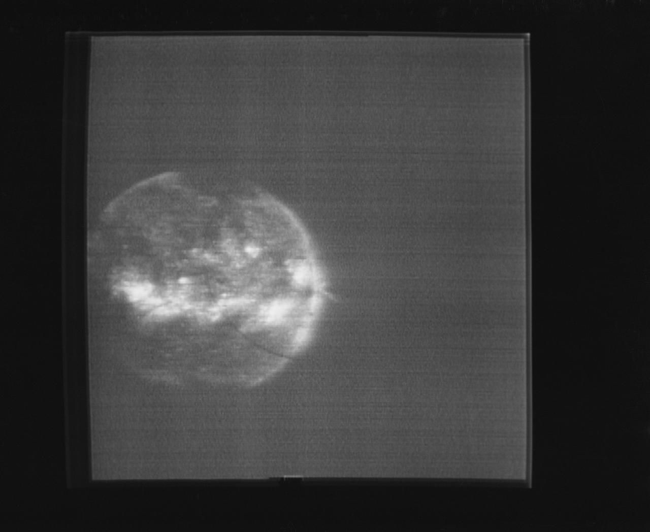
S74-15696 (1974) --- The solar disk photographed through the Skylab S082 Ultraviolet Spectrograph/Heliograph can be seen in this reproduction taken from a television tranmission made by a TV camera aboard the Skylab space station in Earth orbit. The S082 experiment is located in the Apollo Telescope Mount. This spectroheliogram shows specific emission features greatly enhanced over photographs of the solar disk in white light. Photo credit: NASA
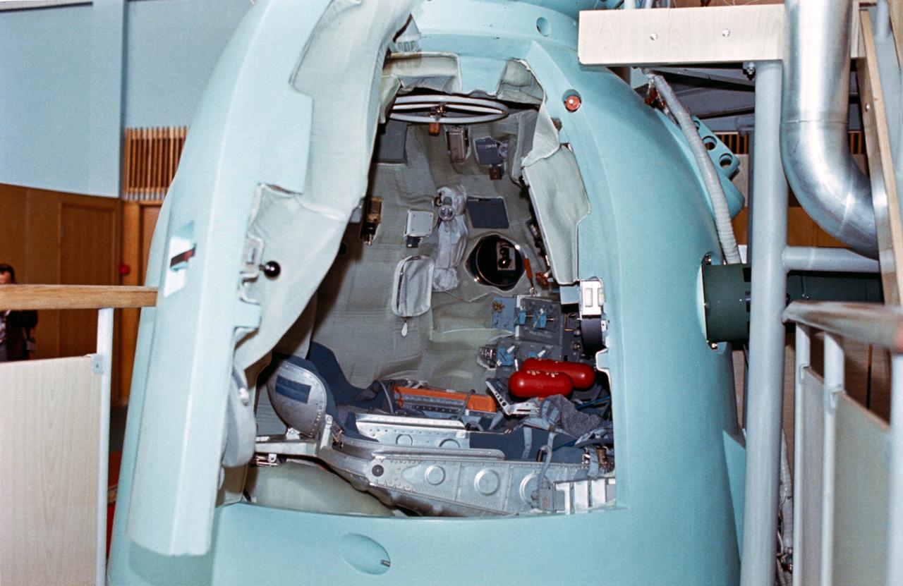
S74-24677 (June 1974) --- A close-up view of the descent vehicle of the Soyuz spacecraft training mock-up on display at the Cosmonuat Training Center (Star City) near Moscow. The open hatch reveals the interior arrangement of the middle section of the Soviet spacecraft. The first (fore) section of the Soyuz is called the orbital module; and the third (aft) section is the instrument-assembly module. The joint U.S.-USSR Apollo-Soyuz docking mission in Earth orbit is scheduled for the summer of 1975.
S74-15064 (28 Dec. 1973) --- Dr. Lubos Kohoutek, discoverer of the Comet Kohoutek, is seen in the Mission Operations Control Room in the Mission Control Center during a visit to the Johnson Space Center. He is talking over a radio-telephone with the Skylab 4 crewmen in the Skylab space station in Earth orbit. Professor Kohoutek, a well-known Czechoslovakian astronomer who works at the Hamburg Observatory in West Germany, discussed the comet with astronauts Gerald P. Carr, Edward G. Gibson and William R. Pogue. One of the major objectives of the Skylab 4 mission is to monitor the passing of the Comet Kohoutek. Dr. Zdenek Sekania, who accompanied Dr. Kohoutek on the visit to JSC, is on the telephone in the left background. Dr. Sekania is with the Smithsonian Observatory in Cambridge, Massachusetts. Photo credit: NASA
S74-15520 --- Left to right Gene Kranz, Gene Cernan, Karla Garnuch, Harrison Schmitt, George Abbey, and Sigurd A. Sjoberg watching the dedication of the Apollo 17 flag to the Mission Control Center. Photo credit: NASA
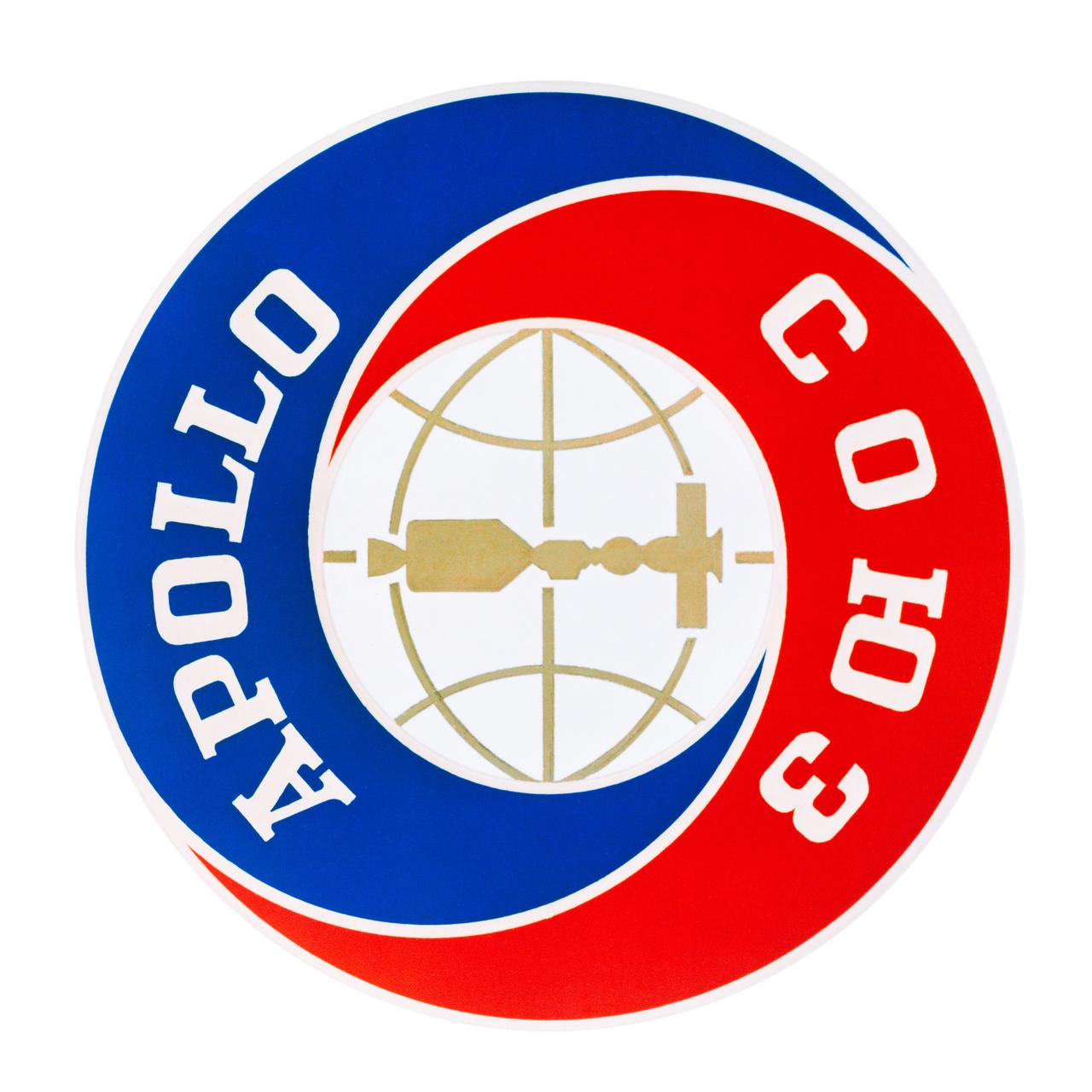
S74-17843 (March 1974) --- This is the official emblem of the Apollo-Soyuz Test Project chosen by NASA and the Soviet Academy of Sciences. The joint U.S.-USSR space mission is scheduled to be flown in July 1975. Of circular design, the emblem has the words Apollo in English and Soyuz in Russian around a center disc which depicts the two spacecraft docked together in Earth orbit. The Apollo-Soyuz Test Project will be carried out by a Soviet Soyuz spacecraft and a U.S. Apollo spacecraft which will rendezvous and dock in orbit. Soyuz and Apollo will remain docked for as long as two days in which period, the three Apollo astronauts will enter Soyuz and the two Soyuz cosmonauts will visit Apollo via a docking module. The Russian word "soyuz" means "union" in English.
SL4-139-4029 (10 Jan. 1974) --- An oblique view of the State of Florida, looking northward up the peninsula, as photographed from the Skylab space station in Earth orbit by one of the Skylab 4 crewman. The camera used was a hand-held 70mm Hasselblad, with SO-368 medium-speed Ektachrome. This view shows almost the entire state, except the panhandle region. The Bahama Banks area appears in the southeast part of the picture as the light blue water. Andros Island in the Bahamas group is the island in the lower right corner. The Gulfstream flows between Florida and the Bahama Banks. This fast-moving, warm-water current transports energy from the tropics to the northern latitudes. The effect of the warmer Gulfstream waters on the atmosphere is seen as increased convection (caused by the warmer water heating the air from below) resulting in the fair weather cumulus seen confined primarily over the Gulfstream. A portion of Cuba is seen in the lower left corner of the picture. Photo credit: NASA
Space Shuttle Two Percent Plumes Model in the 11ft W.T. (Test-01)
Photograph taken February 06, 1974. High Speed Aircraft Division Personnel, Mary Jackson is one of the people in the front row of this group. Mary Jackson belonged to the Theoretical Performance Group, High Speed Aircraft Division, Office of Director for Aeronautics at time of photo. First row: Steve Wornom, Dick Barnwell, Mary Jackson, and Bud Bobbitt; Second row: Bernie Klunker, Perry Newman, Branch secretary, Frances Keeter, and Ruby Davis, Branch mathematician; Third row: Dennis Allison, Jim Keller, Jerry South, and Cas Czarnecki.
C-141 KAO in early morning flight home to Ames Research Center
SL4-138-3875 (February 1974) --- A color oblique photograph looking east over the Rocky Mountains and Great Plains. This view covers a portion of the States of Colorado, Wyoming, and Nebraska. A Skylab 4 crewmen took this picture with a hand-held 70mm Hasselblad camera. This entire region, covered with a blanket of snow, depicts much of the structural and topographic features of the Rocky Mountain chain. Man's only apparent change to the snow pattern seen here is the (right center) metropolitan areas of Denver and Colorado Springs, Colorado, which can be observed along the eastern edge of the mountain front. Grand Junction, Colorado on the western slope of the Rocky Mountains is just off the photograph at left center bottom. The major inter-montane valleys of South Park (right center), Middle Park (center), and North Park (left center) are clearly visible and separate the Colorado Rockies Front Range from the high rugged mountains can be discovered such as Pikes Peak near right border (center), Mt. Cunnison region, circular feature accentuated by the Cunnison River (dark) in the right center (bottom) of the photograph. The snow covered peaks of Mts. Harvard, Princeton and Yale form the high region of the Collegiate Range which is the pronounced mountain area in the right center. Snow cover not only enhances mountain features but also the drainage patterns. East of Denver (right corner) the sinuous trace of the South Platte River (center) and its junction with the North Platte River near North Platte, Nebraska. Lake McConaughy in Nebraska is the body of water (black) near the river intersection. The trace of the Republic River in southern Nebraska is visible near the right corner of the photography. Geologic and hydro logic studies using this photograph will be conducted by Dr. Roger Morrison, U.S. Geological Survey. Photo credit: NASA
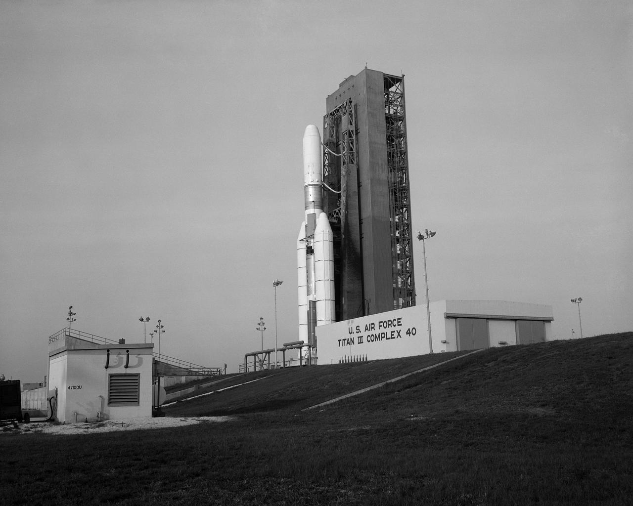
A Titan III-C stands poised on Complex 40 at Cape Canaveral Air Force Station for the launch of Application Technology Satellite-F, first in a new generation of NASA communications satellites. (1.3-2)

Minority Professionals at NASA Langley Research Center Christine Darden
The first Titan_Centaur lifted off from Complex 41 at Cape Kennedy Air Force Station at 9:48 a.m. EDT today. The Titan stages burned as programmed, but when the Centaur stage failed to ignite, it was destroyed by the Range Safety Officer. The new NASA rocket was launched on a proof flight designed to prepare it for twin Viking launches to Mars in 1975 and other missions involving heavy unmanned payloads. The 160-foot-tall rocket combines the Air Force Titan III with the NASA high-energy Centaur final stage. The twin solid rocket boosters have a combined liftoff thrust of 2.4 million pounds. Aboard Titan_Centaur on its proof flight were a dynamic simulator of the Viking spacecraft and a small scientific satellite (SPHYNX) designed to determine how high voltage solar cells, insulators and conductors are affected by the charged particles in space. Launch was conducted by KSC's Unmanned Launch Operations Directorate.

Artist: Rick Guidice Pioneer 10 Crosses the Asteriod Belt: If spacecraft are to visit the outer Solar System, they must cross the asteroid belt between Mars and Jpiter. The Pioneer mission was faced with the question of just how dangerous this astroid belt would be to a spacecraft passing throught it. Note: used in NASA SP-349 'Pioneer Odyssey - Encounter with a Giant' fig. 1-24 and SP-446 ' Pioneer - First to Jupiter, Saturn, and Beyond' fig 1-24
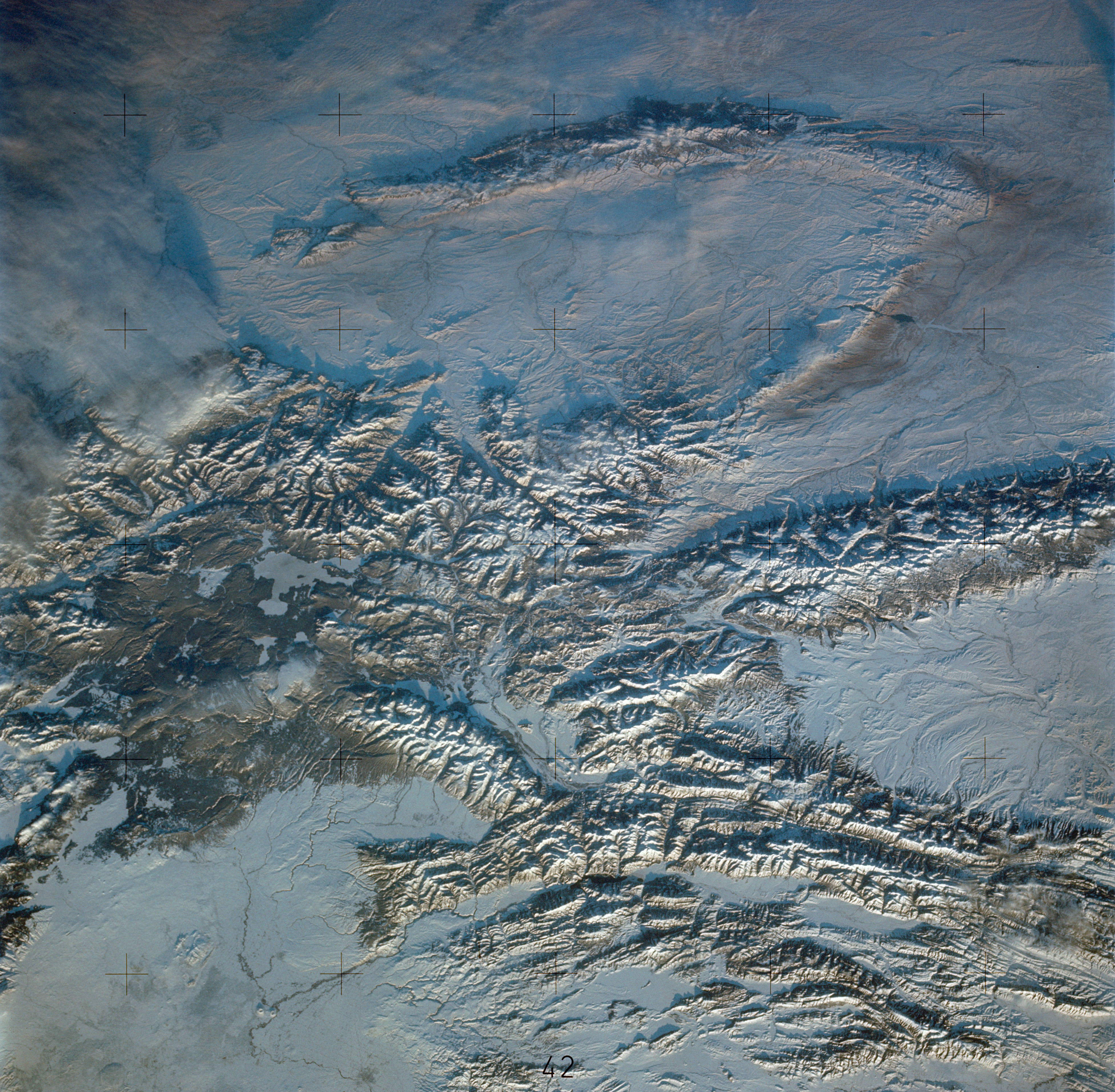
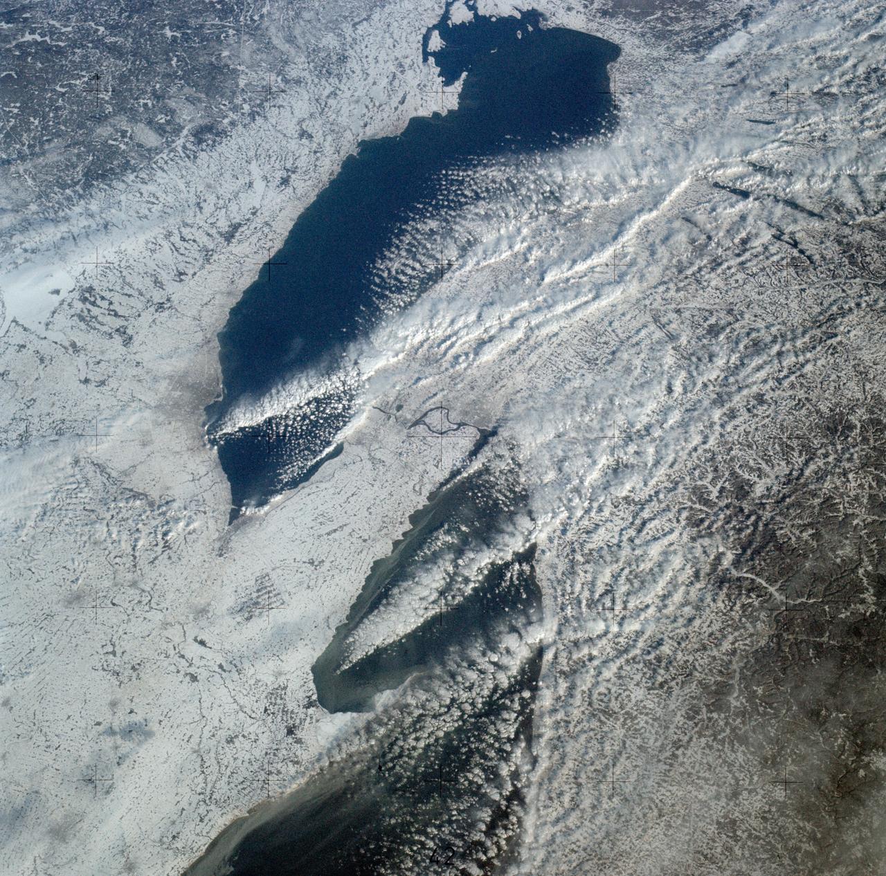
SL4-140-4110 (January 1974) --- View of the USSR, Siberia area from Skylab 4. Other areas seen are Ozero, Kanka, Ussiriysk, the Sea of Japan and Kavalerovo (45.5N, 135.5E). Photo credit: NASA
View taken in Building 2, Room 135, during a Shuttle briefing. Shuttle officials Robert Thompson and Aaron Cohen and Astronaut John Young are seen as panel for the Shuttle briefing with various models of the Space Shuttle Program display in front of them. 1. Robert Thompson 2. Aaron Cohen 3. Astronaut John Young JSC, HOUSTON, TX
Portrait Dr. Dean Chapman in his office
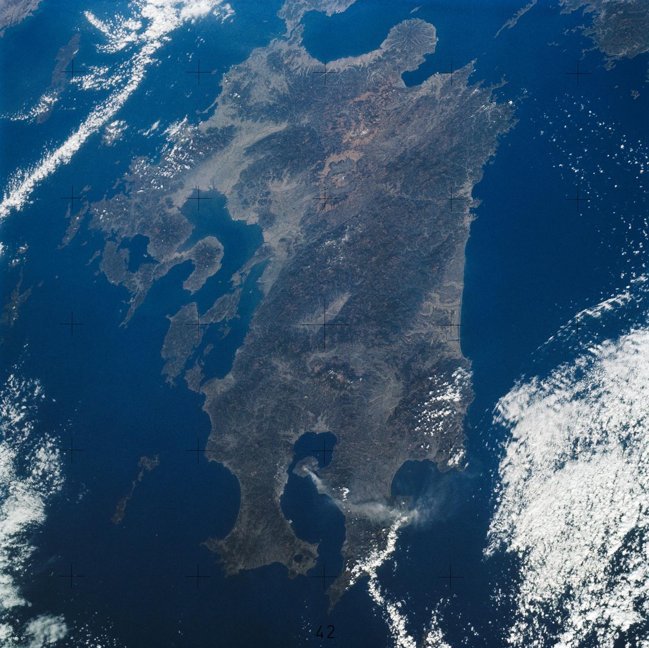
SL4-139-3942 (7 Jan. 1974) --- This oblique view of the Island of Kyushu, Japan, was taken from the Earth-orbiting Skylab space station on Jan. 8, 1974 during its third manning. A plume from the volcano Sakurajima (bottom center) is clearly seen as it extends about 80 kilometers (50 miles) east from the volcano. (EDITOR'S NOTE: On Jan. 10, 2013, a little over 39 years after this 1974 photo was made from the Skylab space station, Expedition 34 crew members aboard the International Space Station took a similar picture (frame no. ISS034-E-027139) featuring smoke rising from the same volcano, with much of the island of Kyushu visible. Interesting comparisons can be made between the two photos, at least as far as the devices used to record them. The Skylab image was made by one of the three Skylab 4 crew members with a hand-held camera using a 100-mm lens and 70-mm color film, whereas the station photo was taken with 180-mm lens on a digital still camera, hand-held by one of the six crew members). Photo credit: NASA
S74-32481 (November 1974) --- These two men are flight directors for the joint U.S.-USSR Apollo-Soyuz Test Project mission scheduled for July 1975. Cosmonaut Aleksey A. Yeliseyev (left) is the Soviet ASTP senior flight director; M.P. Frank is the American ASTP senior flight director. They are seated beside a Docking Module training mock-up in Building 35 at the Johnson Space Center. Cosmonaut Yeliseyev was head of a delegation of USSR flight controllers who were at JSC for two weeks of ASTP training.
Ames Pilot George Cooper and Randy VAn Dyke
KENNEDY SPACE CENTER, FLA. -- The Centaur high-energy third stage for Titan_Centaur 3 is mated with its Titan rocket in the Vehicle Integration Building in the Titan III complex at Cape Canaveral Air Force Station. Titan_Centaur 3 and Titan_Centaur 4 will launch twin Viking spacecraft to Mars in the late summer of 1975. Launch will be by KSC's Unmanned Launch Operations Directorate from Complex 41.
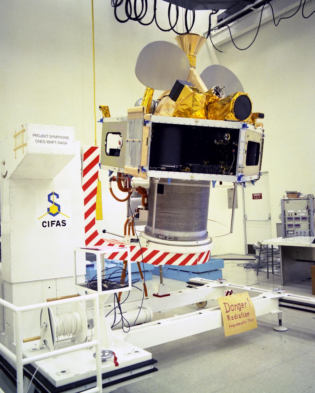
CAPE CANAVERAL, Fla. -- Symphonie-A, a Franco-German communications satellite scheduled for launch by KSC's Unmanned Launch Operations Directorate no earlier than Dec. 17, was uncrated at Cape Canaveral Air Force Station today. The spacecraft is undergoing checkout at Hangar S at CCAFS. Launch is scheduled atop a Delta rocket from Complex 17-B. Photo credit: NASA
S74-17457 (3 Feb. 1974) --- This view of the Skylab 4 Command/Service Module in a docked configuration is a frame from a roll of movie film exposed by a 16mm Maurer camera. The other four components of the Skylab space station in Earth orbit are out of view to the right. This picture was taken by astronaut Gerald P. Carr, Skylab 4 commander, during the final Skylab extravehicular activity (EVA) which took place on Feb. 3, 1974. The crew members -- Gerald Carr, Edward Gibson and William Pogue -- were the first NASA astronauts to spend New Year's in space. A week earlier, they became the first crew to perform an EVA on Christmas day. Photo credit: NASA
S74-20797 (23 April 1974) --- Candidate food items being considered for the joint U.S.-USSR Apollo-Soyuz Test Project mission are sampled by three ASTP crewmen in Building 4 at the Johnson Space Center. They are, left to right, cosmonaut Valeriy N. Kubasov, engineer on the Soviet ASTP crew; astronaut Vance D. Brand, command module pilot of the American ASTP crew; and cosmonaut Aleksey A. Leonov, commander of the Soviet ASTP crew. Kubasov is marking a food rating chart on which the crewmen mark their choices, likes and dislikes of the food being sampled. Brand is drinking orange juice from an accordion-like dispenser. Leonov is eating butter cookies. The two Soviet crewmen will have an opportunity to eat with the three American crewmen while the Apollo and Soyuz spacecraft are docked in Earth orbit. Leonov and Kubasov will dine on food being chosen individually by them now.
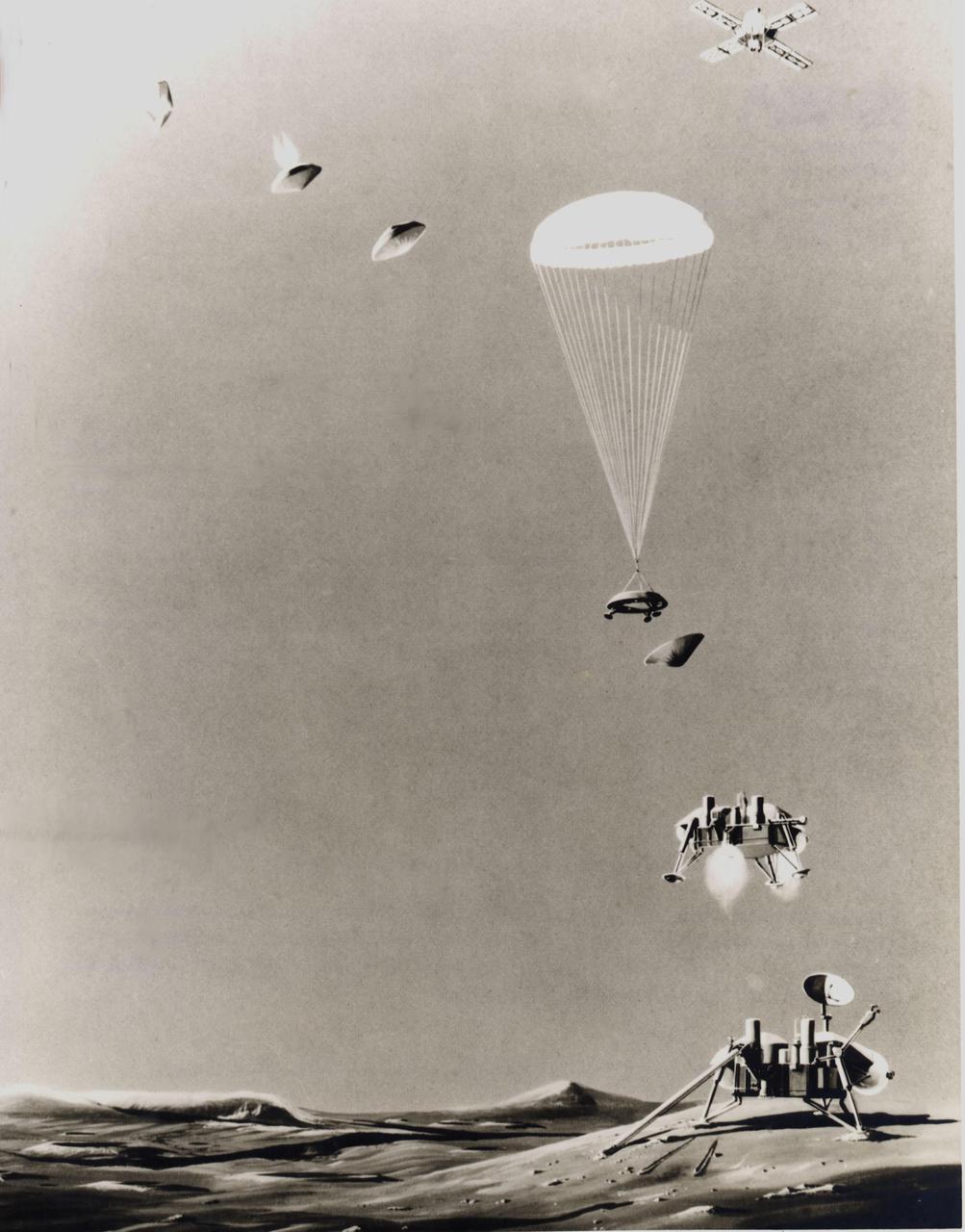
This is an artist's conception of the sequence of events that will take place just prior to landing a life-detection laboratory on the surface of Mars on July 4, 1976. Above right, the Viking spacecraft, composed of an orbiter and a lander, has been in orbit around the Red Planet since June 19, 1976, taking pictures of the planned landing site to ascertain its safety before releasing the lander (top, left) for its threeto five-hour descent. Protected by aeroshells, the heat-sterilized lander hurtles into the thin Martian atmosphere at a speed of about 10,000 mph, to be slowed first by aerodynamic drag until the shell is discarded, then by parachute (center) and finally by retrorockets to assure a gentle landing. Instruments will study the structure and composition of the Martian atmosphere as the lander drifts down. Viking 2 is scheduled to arrive at Mars on Aug. 7 and touch down on the surface on Sept. 4.
The National Aeronautics and Space Administration (NASA) Lewis Research Center’s Convair F-106B Delta Dart equipped with air sampling equipment in the mid-1970s. NASA Lewis created and managed the Global Air Sampling Program (GASP) in 1972 in partnership with several airline companies. NASA researchers used the airliners’ Boeing 747 aircraft to gather air samples to determine the amount of pollution present in the stratosphere. Private companies developed the air sampling equipment for the GASP program, and Lewis created a particle collector. The collector was flight tested on NASA Lewis’ F-106B in the summer of 1973. The sampling equipment was automatically operated once the proper altitude was achieved. The sampling instruments collected dust particles in the air so their chemical composition could be analyzed. The equipment analyzed one second’s worth of data at a time. The researchers also monitored carbon monoxide, monozide, ozone, and water vapor. The 747 flights began in December 1974 and soon included four airlines flying routes all over the globe. The F-106B augmented the airline data with sampling of its own, seen here. It gathered samples throughout this period from locations such as New Mexico, Texas, Michigan, and Ohio. In July 1977 the F-106B flew eight GASP flights in nine days over Alaska to supplement the earlier data gathered by the airlines.
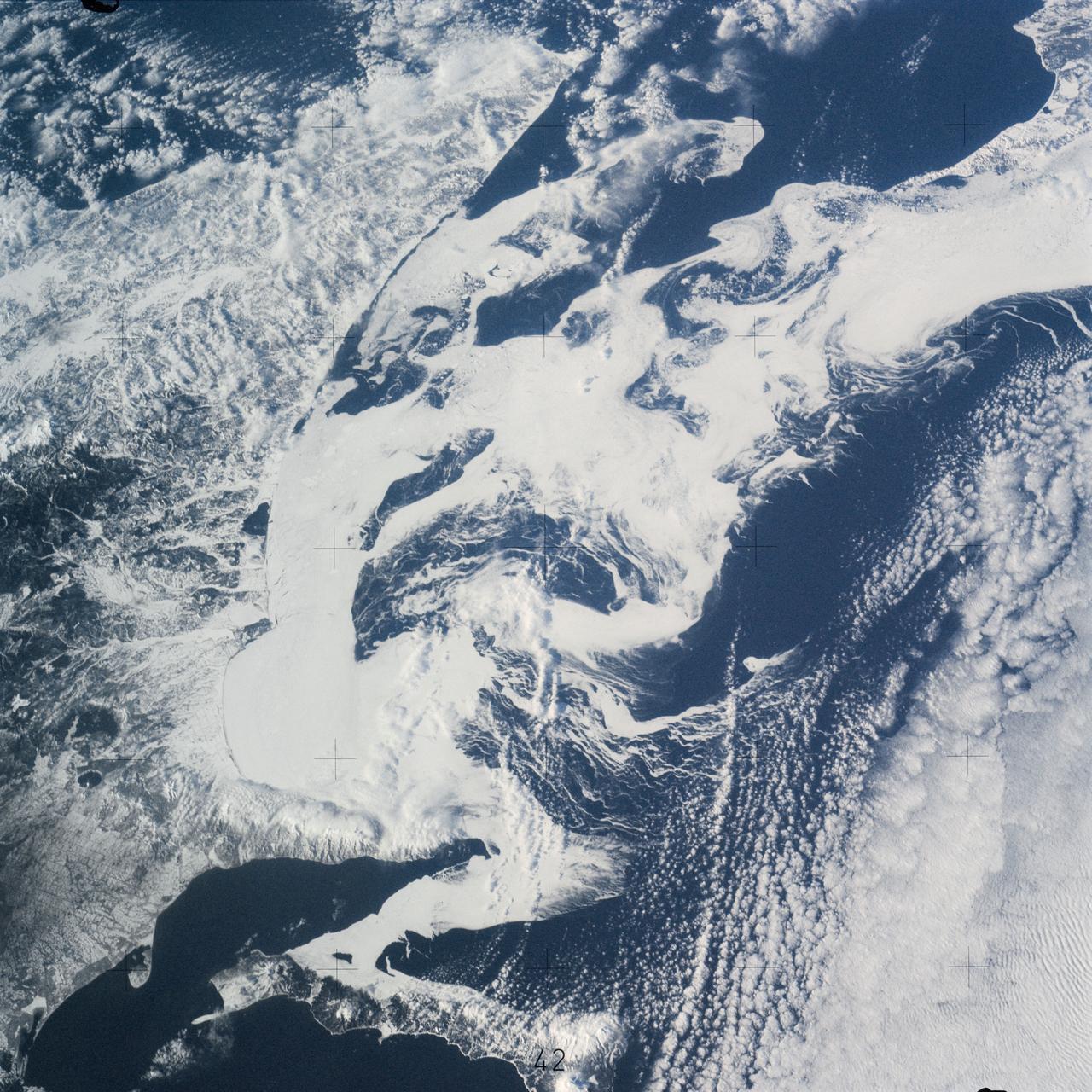
SL4-139-3989 (February 1974) --- An oblique view of a portion of the Great Lakes area as seen from the Skylab space station in Earth orbit. This picture was taken with a hand-held 70mm Hasselblad camera. Lake Erie is in the foreground; and Lake Ontario is in the background. The Niagara Falls area is in the center of the photograph. Portions of Pennsylvania, New York, and Ontario, Canada are visible, but under nearly complete snow cover. Major structural features, drainage patterns, road systems and the cities of Buffalo and Toronto are easily distinguished and actually enhanced by the snow. At the time this picture was taken, these two Great Lakes had no observable ice, although cloud formations partially mask the southern shores of the two bodies of water. James Barnes, a snow-pattern expert, will analyze Skylab photographs like this one to gain further knowledge of snow cover over land masses. Photo credit: NASA
Portrait Dr. Dean Chapman in his office
S74-32049 (8 Sept. 1974) --- The Apollo Command Module for the Apollo-Soyuz Test Project mission goes through receiving, inspection and checkout procedures in the Manned Spacecraft Operations Building at the Kennedy Space Center. The spacecraft had just arrived by air from the Rockwell International plant at Downey, California. The Apollo spacecraft (Command Module, Service Module and Docking Module), with astronauts Thomas P. Stafford, Vance D. Brand and Donald K. Slayton aboard, will dock in Earth orbit with a Soviet Soyuz spacecraft during the joint U.S.-USSR ASTP flight scheduled for July 1975. The Soviet and American crews will visit one another?s spacecraft.
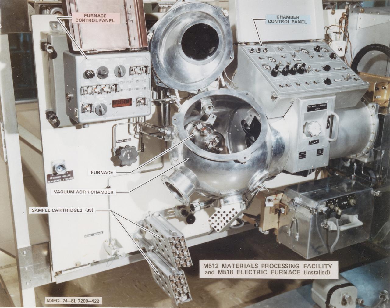
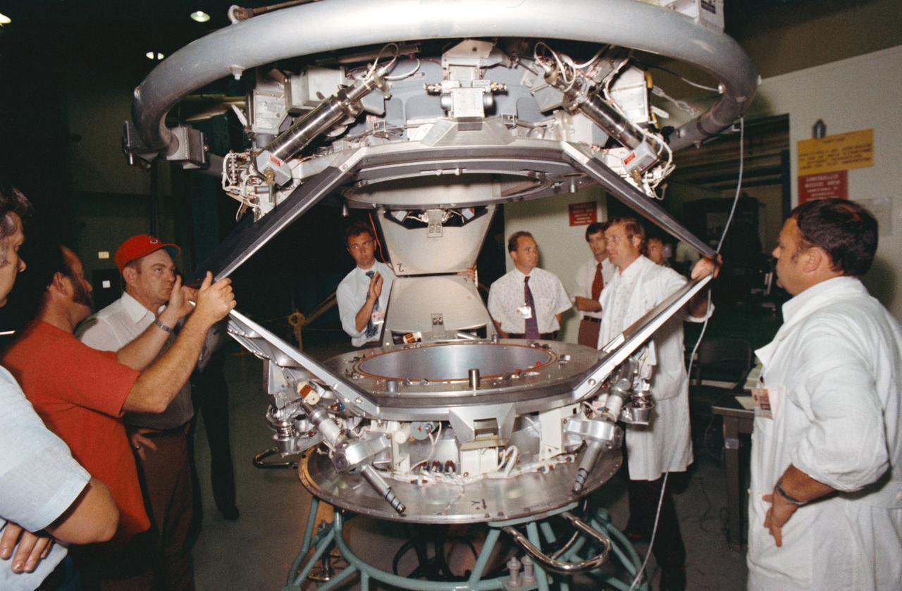
This photograph shows the Skylab Materials Processing Facility (M512) and the Multipurpose Furnace System (M518). This facility, located in the Multiple Docking Adapter, was developed for Skylab,and accommodated 14 different experiments that were carried out during the three marned missions. The abilities to melt and mix without the contaminating effects of containers, to suppress thermal convection and buoyancy in fluids, and to take advantage of electrostatic and magnetic forces and otherwise masked by gravitation opened the way to new knowledge of material properties and processes. This beginning would ultimately lead to the production of valuable new materials for use on Earth.
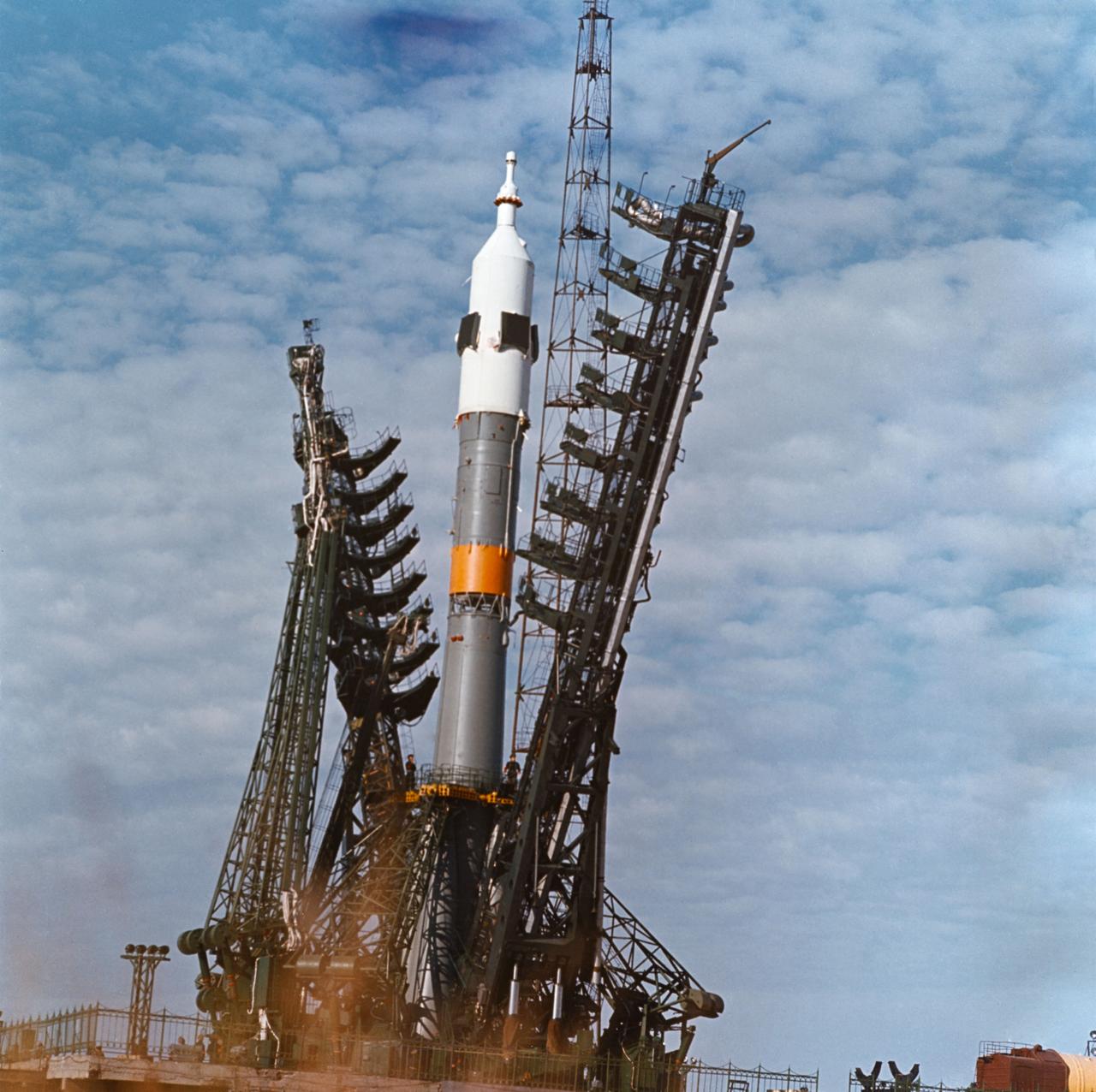
S75-32339 (28 Jan. 1974) --- A low-angle view of a launch pad at the Baikonur Cosmodrome in Kazakhstan showing the installation of a Soyuz spacecraft and its launch vehicle. The 49.3-meter-high (162 feet) space vehicle is composed of the three-stage booster, a three-module, two-man Soyuz spacecraft and a launch escape system. The weight of the space vehicle at launch is approximately 300,000 kilograms. The first stage vacuum thrust is about 1,000,400 newtons, the second stage is 956,500 newtons, and the third stage is 299,000 newtons. This earlier Soyuz mission illustrates the approximate launch configuration of the Soviet Union?s Apollo-Soyuz Test Project (ASTP) Soyuz space vehicle. PHOTO COURTESY: USSR ACADEMY OF SCIENCES
S74-18098 (1974) --- Graphical representation of an ultraviolet photograph depicting a solar flare, using the Skylab 4 Earth Observation Experiment equipment. Photo credit: NASA
Minority Professionals at NASA Langley Research Center Christine Darden environmental portrait.
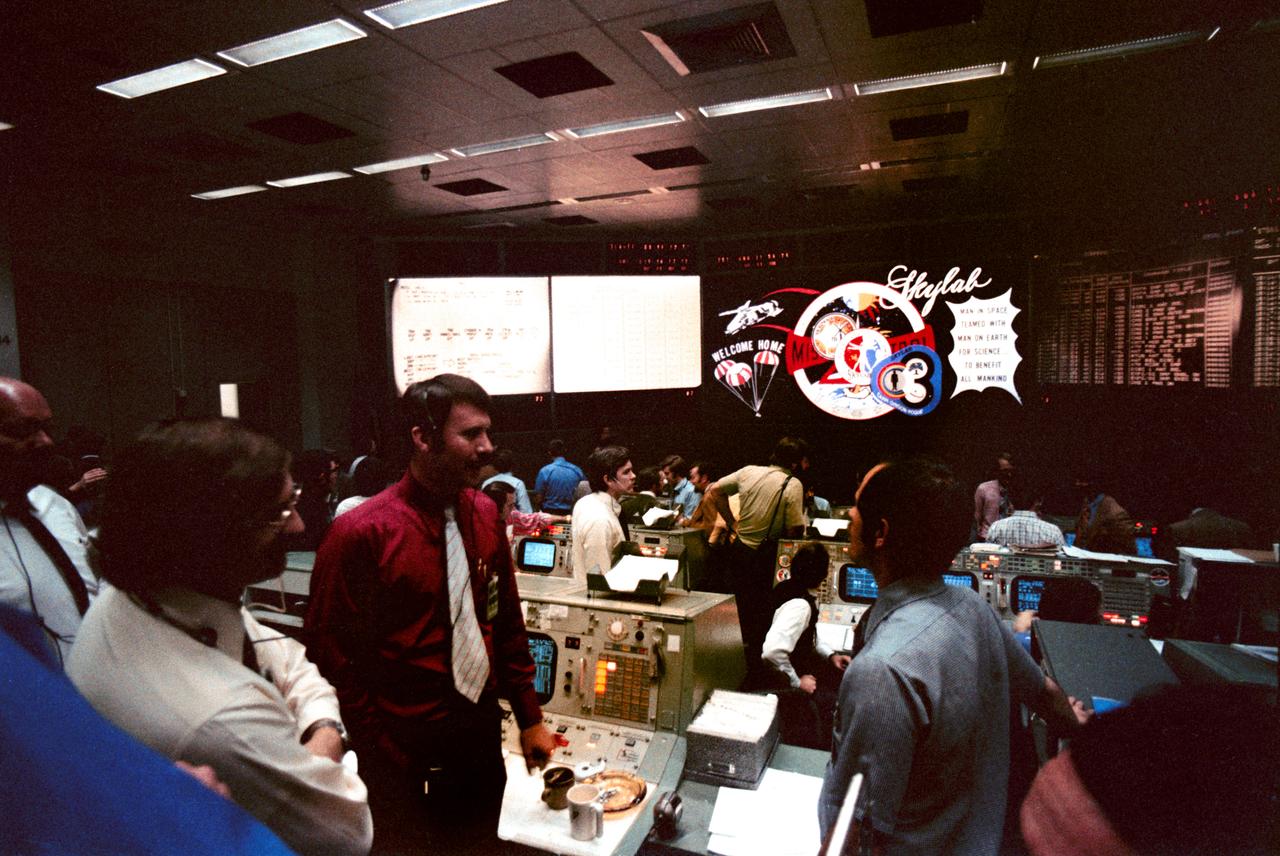
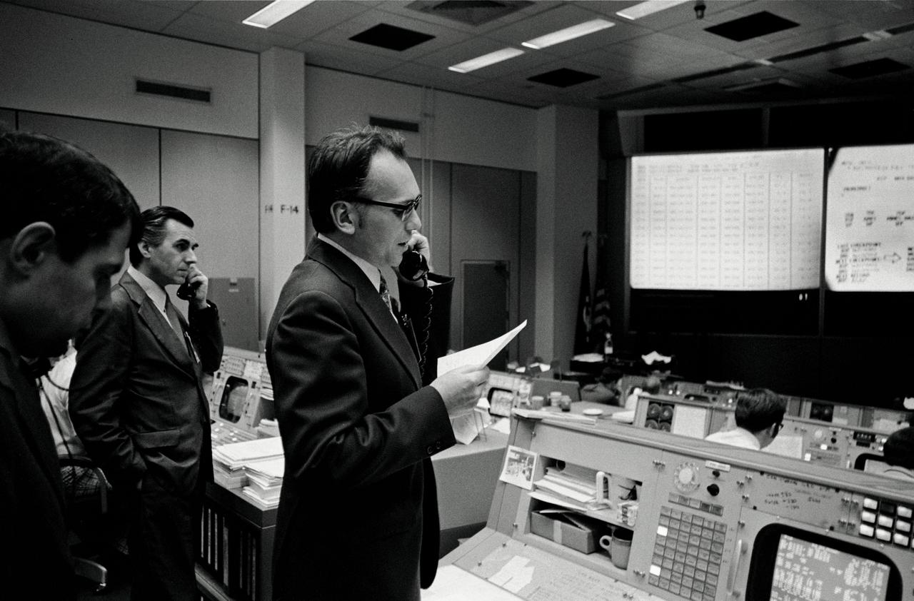
S74-19160 (8 Feb. 1974) --- An overall view of activity in the Mission Operations Control Room in the Mission Control Counter following the successful splashdown of the Skylab 4 command module in the Pacific Ocean. The three flight controllers in the foreground, left to right, are flight director Neil B. Hutchinson; flight director Donald R. Puddy; and astronaut Robert L. Crippen, a spacecraft communicator (CAPCOM). Astronauts Gerald P. Carr, Edward G. Gibson and William R. Pogue had just completed an 84-day mission with the Skylab space station in Earth orbit. Photo credit: NASA
S74-28811 (23 Sept. 1974) --- The five prime crewmen of the joint U.S.-USSR Apollo-Soyuz Test Project mission are photographed in the Flight Crew Training Facility, Building 35, at the Johnson Space Center during ASTP crew training activity. They are, left to right, astronaut Donald K. Slayton, docking module pilot of the American crew; cosmonaut Valeriy N. Kubasov, engineer on the Soviet crew; cosmonaut Aleksey A. Leonov, commander of the Soviet crew; astronaut Thomas P. Stafford, commander of the American crew; and astronaut Vance D. Brand, command module pilot of the American crew.
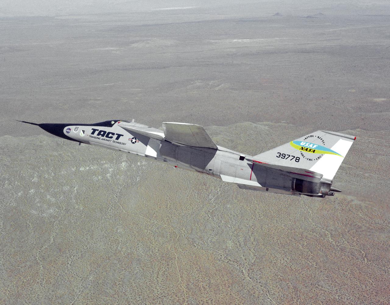
The General Dynamics TACT/F-111A Aardvark is seen In a banking-turn over the California Mojave desert. This photograph affords a good view of the supercritical wing airfoil shape. Starting in 1971 the NASA Flight Research Center and the Air Force undertook a major research and flight testing program, using F-111A (#63-9778), which would span almost 20 years before completion. Intense interest over the results coming from the NASA F-8 supercritical wing program spurred NASA and the Air Force to modify the General Dynamics F-111A to explore the application of supercritical wing technology to maneuverable military aircraft. This flight program was called Transonic Aircraft Technology (TACT).
SL4-93-067 (16 Nov. 1973-8 Feb. 1974) --- A spectacular winter view of the Flagstaff, Arizona area is seen in this Skylab 4 Earth Resources Experiments package S190-B (five-inch earth terrain camera) infrared photograph taken from the Skylab space station in Earth orbit. Included in the scene are the San Francisco Mountains, Oak Creek Canyon, Painted Desert and Meteor Crater. The infrared picture depicts in red living vegetation, in white the snow, and in bright blue the water. Major features identified in this photograph are Humphrey's peak, top center, Flagstaff at foot of the peak, Sunset Crater volcanic field with numerous vents and craters right of Flagstaff and Meteor Crater (right center). Within the mountainous areas several clear areas generally rectangular are visible and represent the areas where lumbering has removed the forest. The thin white line extending from left corner to Sunset Crater fields is the power transmission line cleared area. Roads are subdued and are not easily visible. Photo credit: NASA
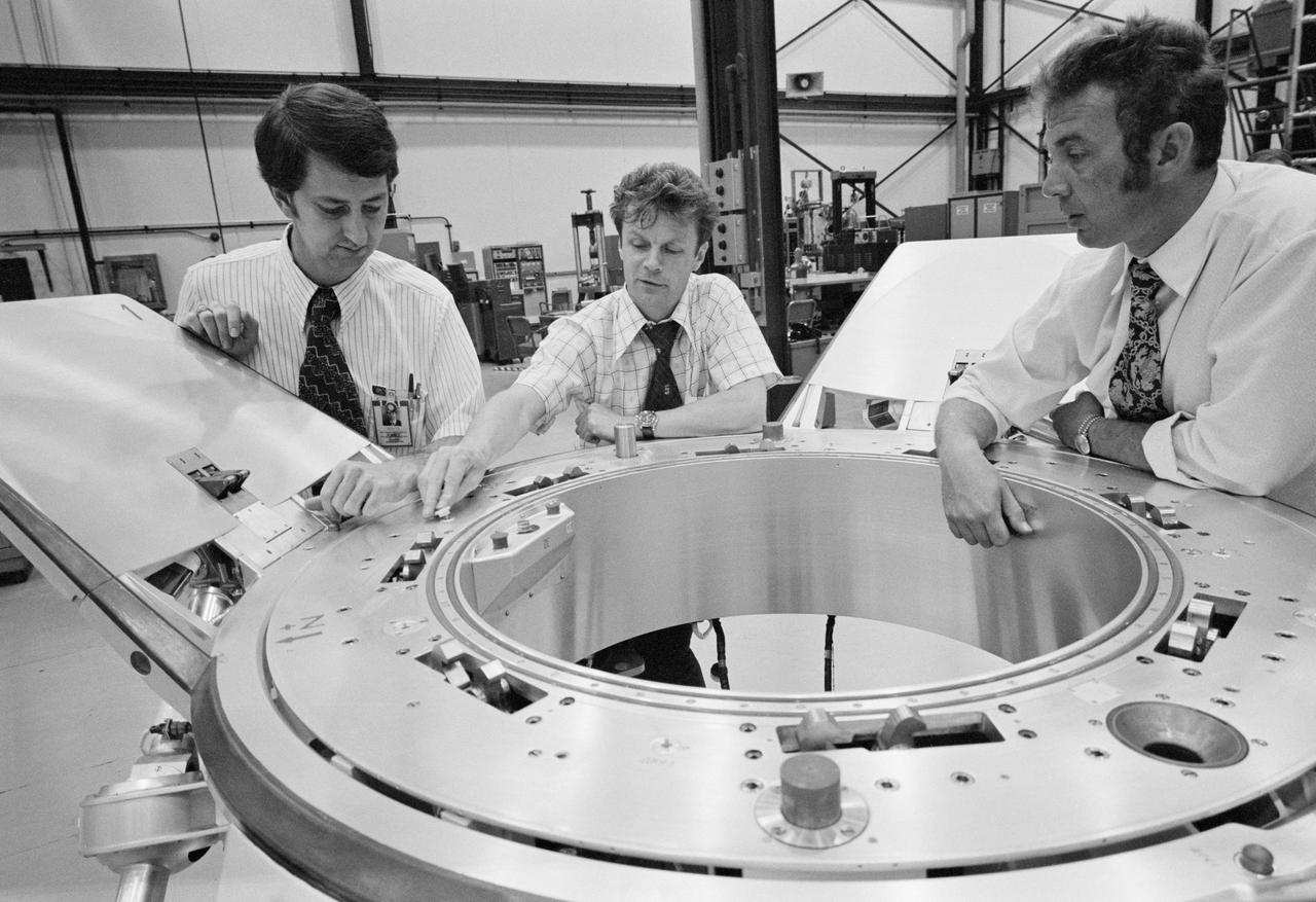
S74-24671 (10 July 1974) --- Three Apollo-Soyuz Test Project (ASTP) engineers look over a Soyuz spacecraft docking system prior to an ASTP docking mechanism fitness test conducted in Building 13 at the Johnson Space Center (JSC). They are (left to right) Robert White, Vladimir Syromyatnikov and Yevgeniy Bobrov. White is the American chairman of ASTP Working Group Number 3, and Syromyatnikov is his Soviet counterpart. This working group is concerned with ASTP docking problems and procedures. White is with JSC's Spacecraft Design Division. Syromyatnikov is senior researcher of the Soviet State Research Institute of Machine Building. Bobrov is a junior researcher with the Institute of Machine Building. The joint United States - USSR ASTP docking mission in Earth orbit is scheduled for the summer of 1975.
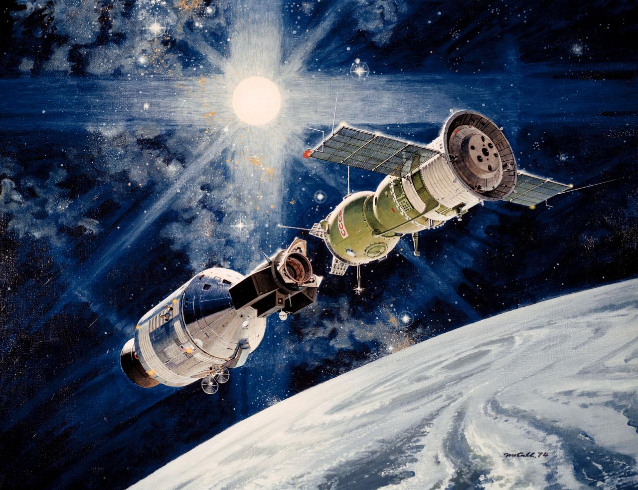
This artist's concept depicts the Apollo-Soyuz Test Project (ASTP) with insets of photographs of three U.S. astronauts (Thomas Stafford, Vance Brand, and Donald Slayton) and two U.S.S.R. cosmonauts (Alexei Leonov and Valeri Kubasov). The objective of the ASTP mission was to accomplish the first docking of a standardized international system, the U.S.'s Apollo spacecraft and the U.S.S.R.'s Soyuz spacecraft, in space. The Soyuz spacecraft was launched from the Baikonur Cosmodrome near Tyuratam in the Kazakh, Soviet Socialist Republic, at 8:20 a.m. (EDT) on July 15, 1975. The Apollo spacecraft was launched from Launch Complex 39B, Kennedy Space Center, Florida, at 3:50 p.m. (EDT) on July 15, 1975. The Primary objectives of the ASTP were achieved. They performed spacecraft rendezvous, docking and undocking, conducted intervehicular crew transfer, and demonstrated the interaction of U.S. and U.S.S.R. control centers and spacecraft crews. The mission marked the last use of a Saturn launch vehicle. The Marshall Space Flight Center was responsible for development and sustaining engineering of the Saturn IB launch vehicle during the mission.

Minority Professionals at NASA Langley Research Center. Samuel J. Scott working in the Office of Director for Structures, Staff Assistant is at the board.
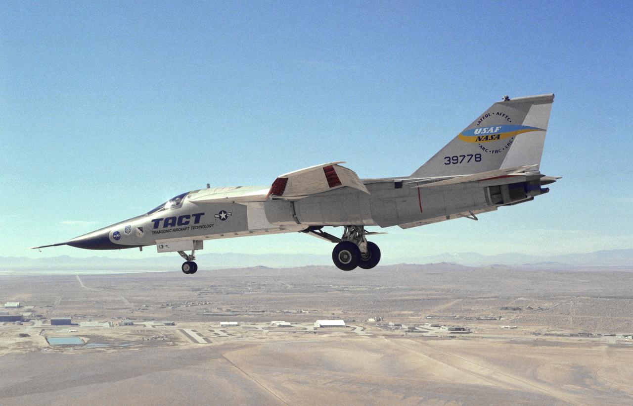
This photograph shows a modified General Dynamics TACT/F-111A Aardvaark with supercritical wings installed. The aircraft, with flaps and landing gear down, is in a decending turn over Rogers Dry Lakebed at Edwards Air Force Base. Starting in 1971 the NASA Flight Research Center and the Air Force undertook a major research and flight testing program, using F-111A (#63-9778), which would span almost 20 years before completion. Intense interest over the results coming from the NASA F-8 supercritical wing program spurred NASA and the Air Force to modify the General Dynamics-Convair F-111A to explore the application of supercritical wing technology to maneuverable military aircraft. This flight program was called Transonic Aircraft Technology (TACT).
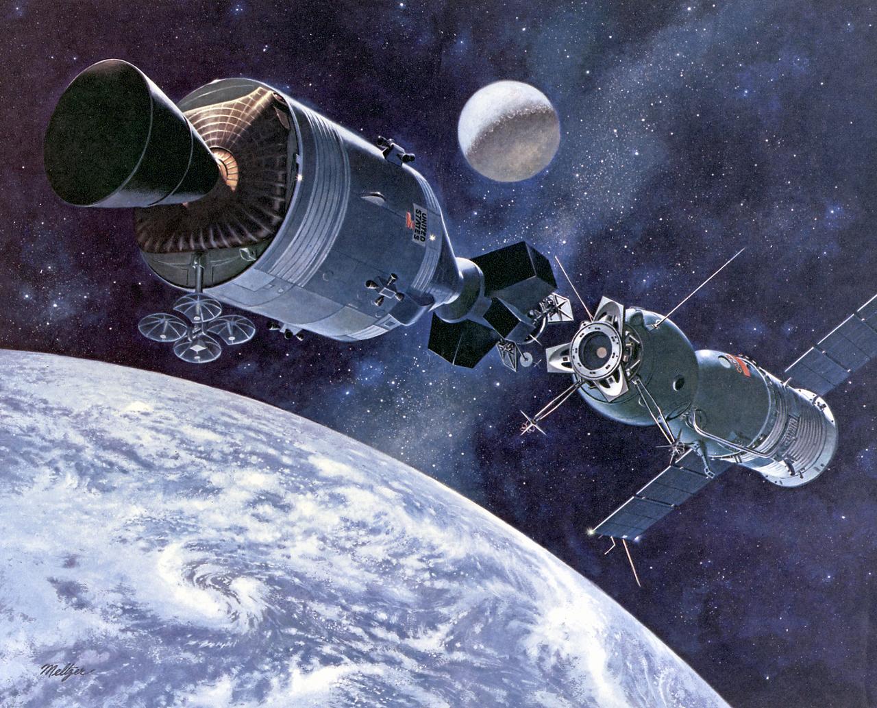
This artist's concept depicts the Apollo-Soyuz Test Project (ASTP), the first international docking of the U.S.'s Apollo spacecraft and the U.S.S.R.'s Soyuz spacecraft in space. The objective of the ASTP mission was to provide the basis for a standardized international system for docking of marned spacecraft. The Soyuz spacecraft, with Cosmonauts Alexei Leonov and Valeri Kubasov aboard, was launched from the Baikonur Cosmodrome near Tyuratam in the Kazakh, Soviet Socialist Republic, at 8:20 a.m. (EDT) on July 15, 1975. The Apollo spacecraft, with Astronauts Thomas Stafford, Vance Brand, and Donald Slayton aboard, was launched from Launch Complex 39B, Kennedy Space Center, Florida, at 3:50 p.m. (EDT) on July 15, 1975. The Primary objectives of the ASTP were achieved. They performed spacecraft rendezvous, docking and undocking, conducted intervehicular crew transfer, and demonstrated the interaction of U.S. and U.S.S.R. control centers and spacecraft crews. The mission marked the last use of a Saturn launch vehicle. The Marshall Space Flight Center was responsible for development and sustaining engineering of the Saturn IB launch vehicle during the mission.
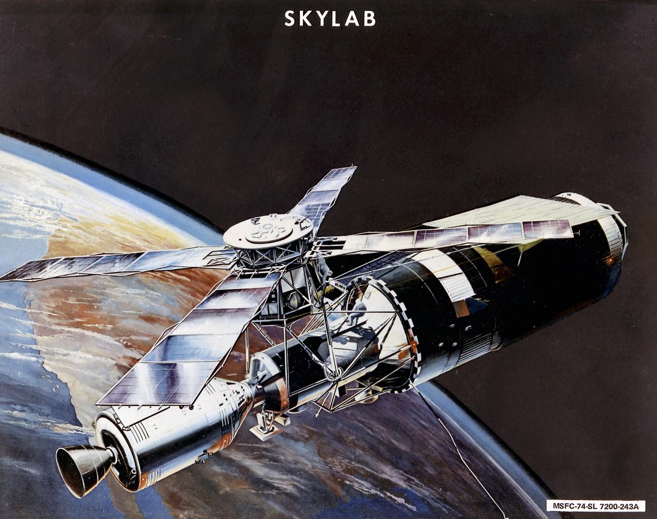
This image is an artist's concept of the Skylab in orbit. In an early effort to extend the use of Apollo for further applications, NASA established the Apollo Applications Program (AAP) in August of 1965. The AAP was to include long duration Earth orbital missions during which astronauts would carry out scientific, technological, and engineering experiments in space by utilizing modified Saturn launch vehicles and the Apollo spacecraft. Established in 1970, the Skylab program was the forerurner of the AAP. The goals of the Skylab were to enrich our scientific knowledge of the Earth, the Sun, the stars, and cosmic space; to study the effects of weightlessness on living organisms, including man; to study the effects of the processing and manufacturing of materials utilizing the absence of gravity; and to conduct Earth resource observations. The Skylab also conducted 19 selected experiments submitted by high school students. Skylab's 3 different 3-man crews spent up to 84 days in Earth orbit. The Marshall Space Flight Center (MSFC) had responsibility for developing and integrating most of the major components of the Skylab: the Orbital Workshop (OWS), Airlock Module (AM), Multiple Docking Adapter (MDA), Apollo Telescope Mount (ATM), Payload Shroud (PS), and most of the experiments. MSFC was also responsible for providing the Saturn IB launch vehicles for three Apollo spacecraft and crews and a Saturn V launch vehicle for the Skylab.
SL4-136-3475 (February 1974) --- A vertical view of the Gulf coast area of Louisiana (29.0N, 92.0W) as seen from the Skylab space station in Earth orbit. A Skylab 4 crewman used a hand-held 70mm Hasselblad camera to take this picture. This view extends from White Lake and Pecan Island (bottom border) eastward to the Mississippi River delta (top left). Atchafalaya Bay (red) is in the center. The Bayou Teche area is included in this view. A prominent feature of this photograph is two large white smoke plumes extending from Louisiana south into the Gulf of Mexico. The larger smoke plume originates on the southern shore of Vermillion Bay. The other plume extends from the southern shore of Marsh Island. The prononced narrow width and length of the plumes indicate that a strong offshore wind is present. Approximately 100 miles of the plumes are visible in this photograph; but they probably extend well into the Gulf of Mexico. Photo credit: NASA
SL4-92-300 (February 1974) --- A near vertical view of the Mobile Bay, Alabama area is seen in this Skylab 4 Earth Resources Experiments Package S190-B (five-inch earth terrain camera) photograph taken from the Skylab space station in Earth orbit. North of Mobile the Tombigbee and Alabama Rivers join to form the Mobile River. Detailed configuration of the individual stream channels and boundaries can be defined as the Mobile River flows into Mobile Bay, and thence into the Gulf of Mexico. The Mobile River Valley with its numerous stream channels is a distinct light shade in contrast to the dark green shade of the adjacent areas. The red coloration of Mobile Bay reflects the sediment load carried into the Bay by the rivers. Variations in red color indicate sediment load and the current paths within Mobile Bay. The waterly movement of the along shore currents at the mouth of Mobile Bay is shown by the contrasting light blue of the sediment-laden current and the blue of the Gulf predominately. Agricultural areas east and west of Mobile Bay are characterized by a rectangular pattern in green to white shades. Color variations may reflect the type and growth cycle of crops. Agricultural areas (light gray-greens) are also clearly visible in other parts of the photograph. Interstate 10 extends from near Pascagoula, Mississippi eastward through Mobile to the outskirts of Pensacola, Florida. Analysis of the EREP photographic data will be undertaken by the U.S. Corps of Engineers to determine bay dynamic processes. Federal agencies participating with NASA on the EREP project are the Departments of Agriculture, Commerce, Interior, the Environmental Protection Agency and the Corps of Engineers. All EREP photography is available to the public through the Department of Interior's Earth Resources Observations Systems Data Center, Sioux Falls, South Dakota. 57198 Photo credit: NASA
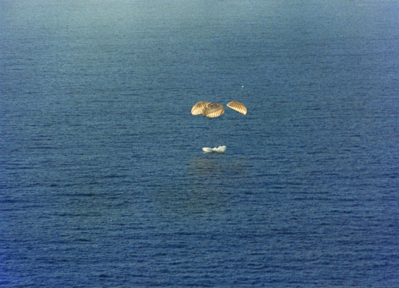
S74-17741 (8 Feb. 1974) --- The Skylab 4 Command Module splashes down in the Pacific Ocean southwest of San Diego, California at 10:17 a.m., Feb. 8, 1974. Photo credit: NASA
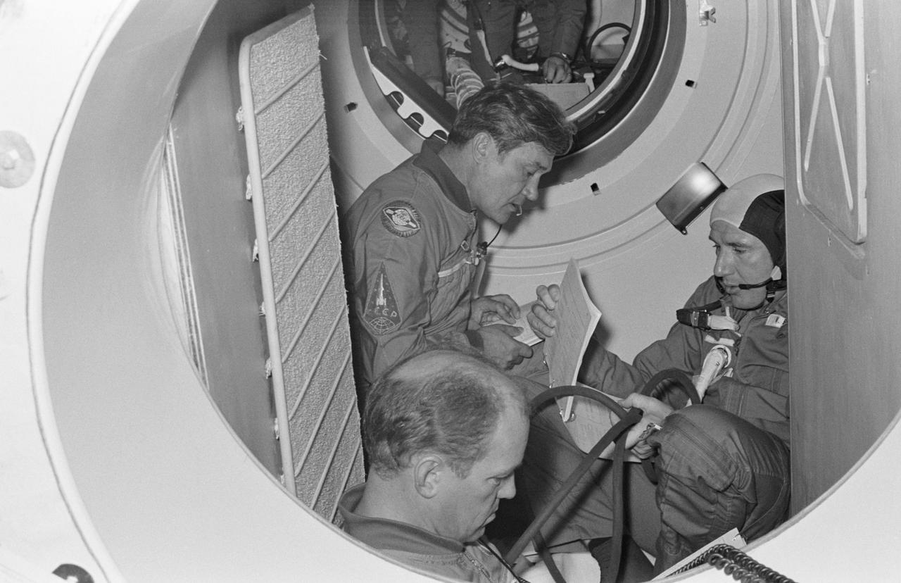
S74-28649 (16 Sept. 1974) --- Three crewmen of the Apollo-Soyuz Test Project are seated in a Soviet Soyuz spacecraft orbital module mock-up in Building 35 during ASTP simulation training at the Johnson Space Center. They are cosmonaut Anatoliy V. Filipchenko (left background), commander of the Soviet ASTP second (backup) crew; cosmonaut Nikolay N. Rukavishnikov (left foreground), engineer on the crew; and astronaut Vance D. Brand (right), command module pilot of the American ASTP prime crew. The hatch in the background leads to the Docking Module. During the exercise the American ASTP crew and the Soviet ASTP crew simulated docking the Apollo and Soyuz in Earth orbit and transferring to each other?s spacecraft. Here, Brand is visiting the Soyuz spacecraft. The crewmen are training in both the U.S. and the USSR for the joint mission scheduled for the summer of 1975.
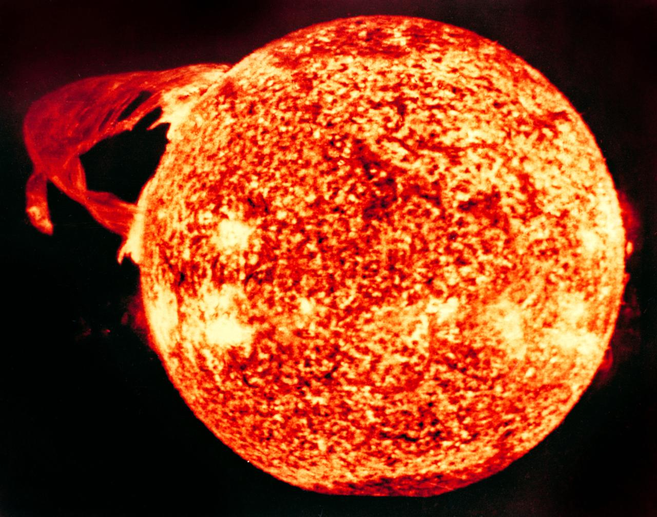
S74-23458 (19 Dec. 1973) --- This photograph of the sun, taken on Dec. 19, 1973, during the third and final manned Skylab mission (Skylab 4), shows one of the most spectacular solar flares ever recorded, spanning more than 588,000 kilometers (365,000 miles) across the solar surface. The last picture, taken some 17 hours earlier, showed this feature as a large quiescent prominence on the eastern side of the sun. The flare gives the distinct impression of a twisted sheet of gas in the process of unwinding itself. Skylab photographs such quiescent features erupt from the sun. In this photograph the solar poles are distinguished by a relative absence of supergranulation network, and a much darker tone than the central portions of the disk. Several active regions are seen on the eastern side of the disk. The photograph was taken in the light of ionized helium by the extreme ultraviolet spectroheliograph instrument of the United States Naval Research Laboratory. Photo credit: NASA
S74-25394 (10 July 1974) --- A group of American and Soviet engineers of the Apollo-Soyuz Test Project working group three examines an ASTP docking set-up following a docking mechanism fitness test conducted in Building 13 at the Johnson Space Center. Working Group No. 3 is concerned with ASTP docking problems and techniques. The joint U.S.-USSR ASTP docking mission in Earth orbit is scheduled for the summer of 1975. The Apollo docking mechanism is atop the Soyuz docking mechanism.
SL4-141-4340 (20 Jan. 1974) --- An oblique view of the southern part of the Sea of Okhotsk, north of Japan, as photographed from the Skylab space station in Earth orbit by one of the Skylab 4 crewmen. The camera used was a hand-held 70mm Hasselblad, and SO-368 medium-speed Ektachrome. NORTH IS AT THE TOP WHEN THE PICTURE IS HELD WITH THE LARGEST LAND MASS AT THE BOTTOM. Most of the land area is Hokkaido Island, Japan. The southern tip of Sakhalin Island (Soviet Union) is in the northwest corner. This photograph was taken to aid in the study of the formation of sea ice. Comparison of these photographs will be made with observations made during a joint USSR-U.S. experiment in the Bering Sea a year earlier. Observations in the Sea of Okhotsk are of interest because the ice has a morphology similar to that of the Bering Sea. Photo credit: NASA
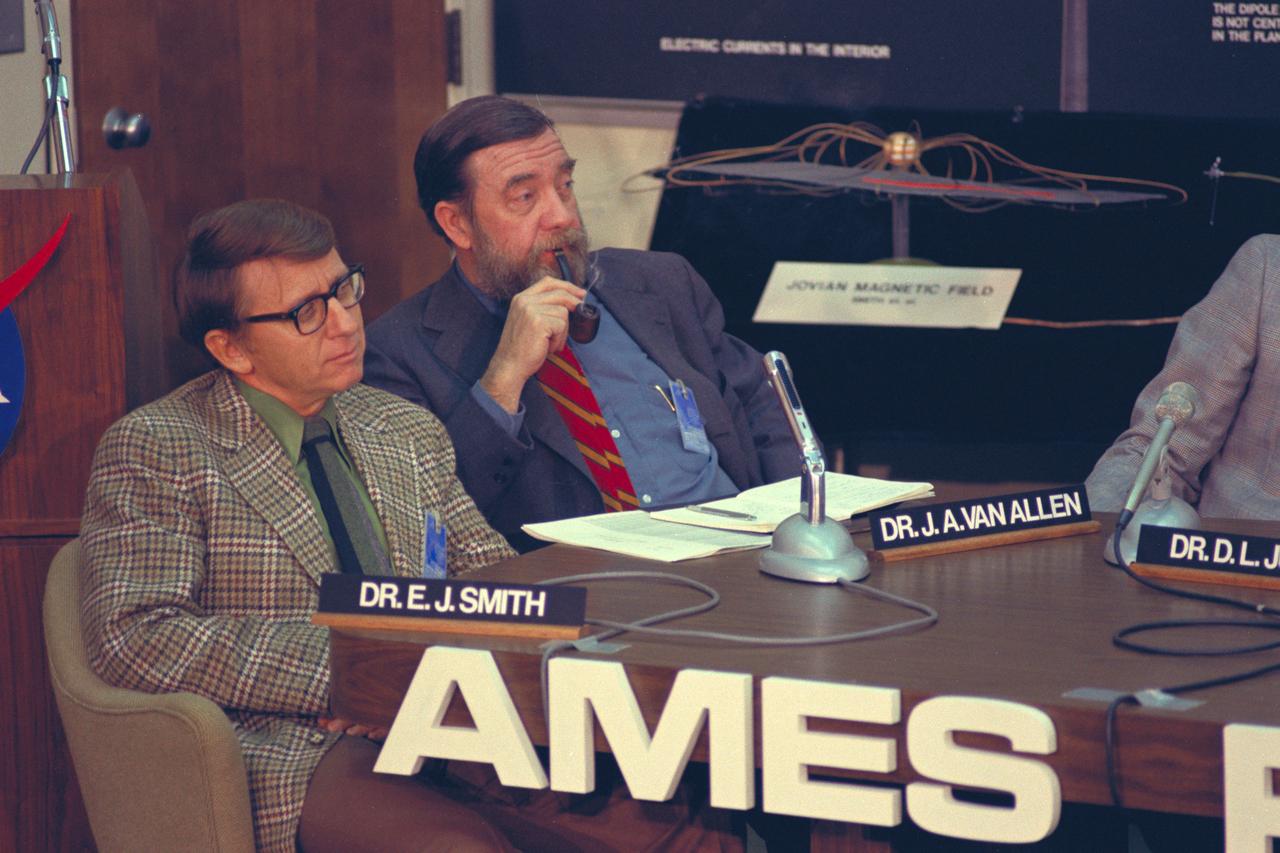
Dr. E. J. Smith (L) Dr. James Van Allen (R) during press conference for Pioneer 11 Jupiter encounter
Portrait of Floyd L. Thompson NASA Langley Center Director
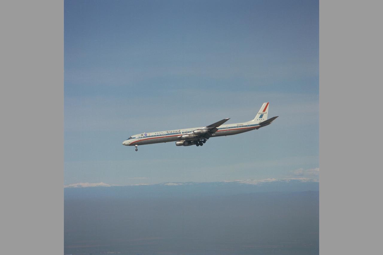
United Airlines DC-8 (N8099U) Two Segment Evaluation. In-Flight Thrust Reversing, Steep Approach Research. The thrust reversing concept was applied to the DC-8 Commercial transport to achieve the rapid descent capability required for FAA certificaiton. Note: Used in publication in Flight Research at Ames; 57 Years of Development and Validation of Aeronautical Technology NASA SP-1998-3300 fig 96
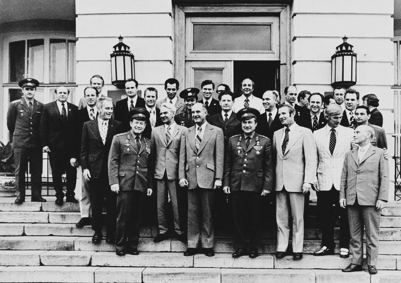
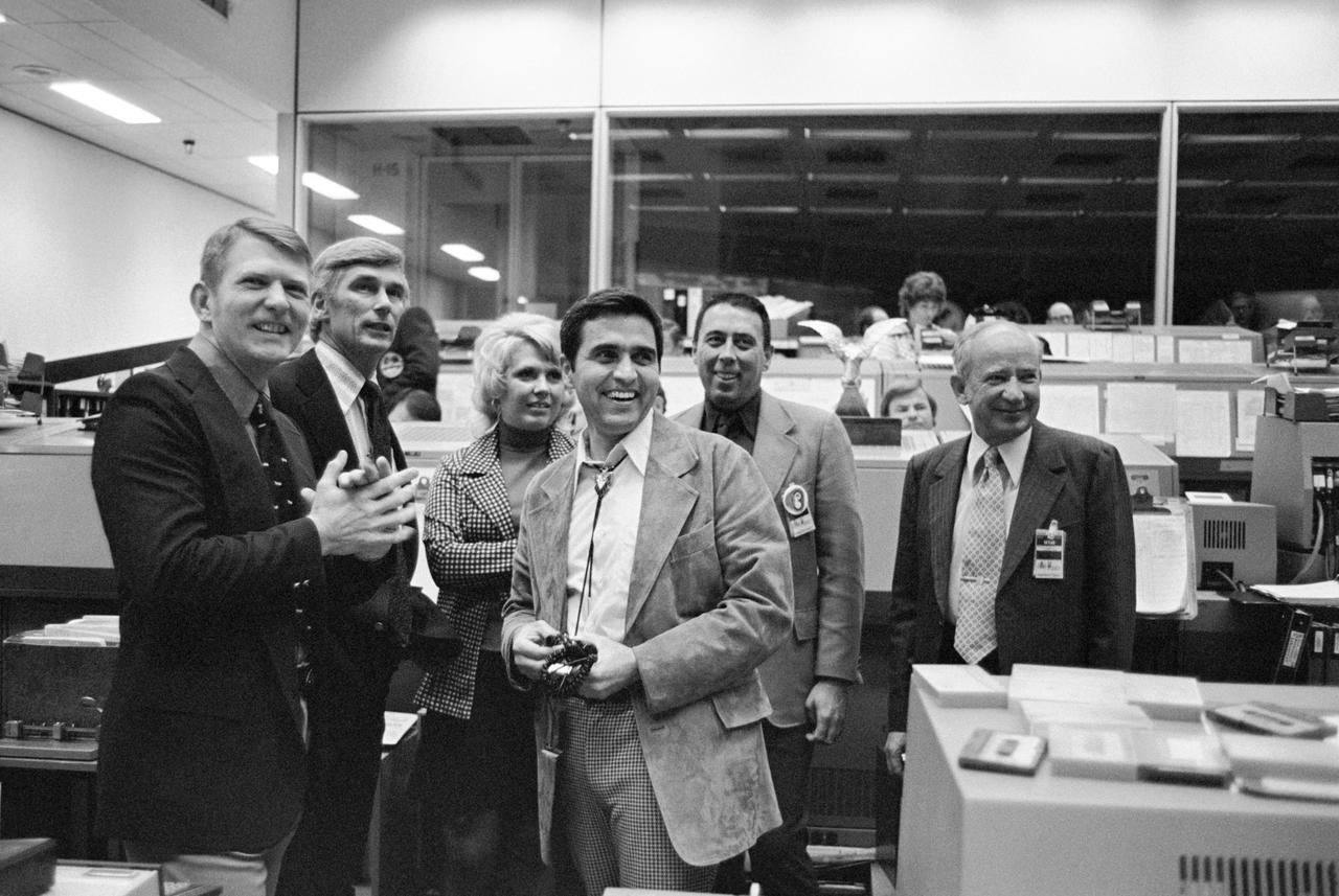
S74-24948 (4 July 1974) --- A group of astronauts from the Apollo-Soyuz Test Project office at the Johnson Space Center are photographed with their Soviet hosts after attending a reception at the USSR Academy of Sciences in Moscow. They are standing on the front steps of the scientific institution. The Americans were in the Soviet Union to take part in ASTP familiarization training at the Cosmonaut Training Center near Moscow. PHOTO COURTESY: USSR ACADEMY OF SCIENCES
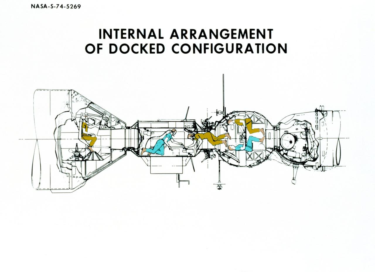
S74-05269 (December 1974) --- An artist?s drawing illustrating the internal arrangement of the Apollo and Soyuz spacecraft in Earth orbit in a docked configuration. The three American Apollo crewmen and the two Soviet Soyuz crewmen will transfer to each other?s spacecraft during the July 1975 ASTP mission. The four Apollo-Soyuz Test Project visible components are, left to right, the Apollo Command Module, the Docking Module, the Soyuz Orbital Module and the Soyuz Descent Vehicle.
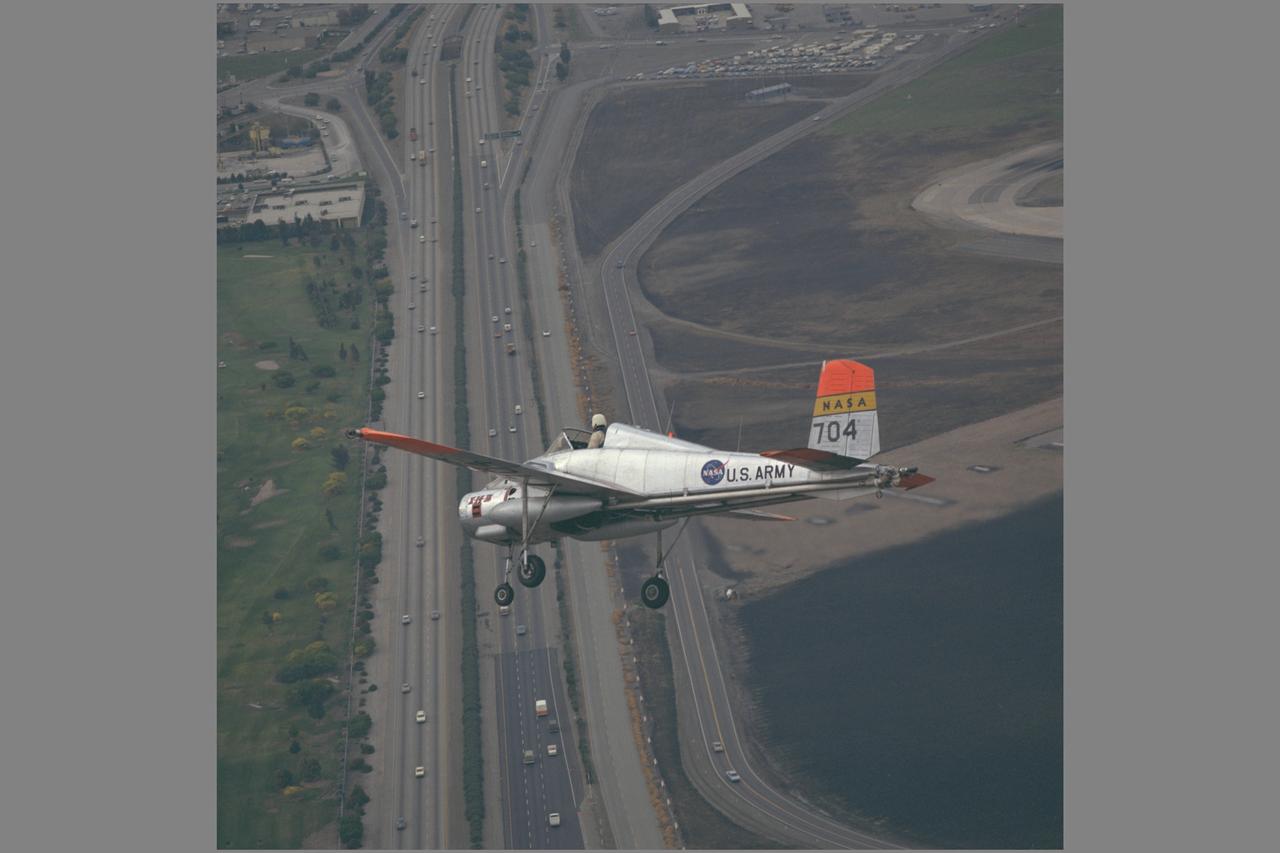
X-14B NASA-704: A Bell single-place, open cockpit, twin-engine, jet-lift VTOL aircraft over Highway 101 in approach to Moffett Field, California. The X-14 was used by NASA Ames Research Center to advance state-of-the-art jet-powered VTOL aircraft.