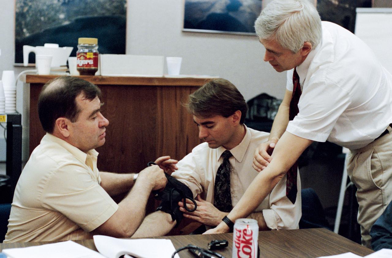
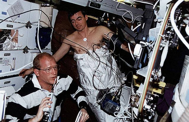
Using Dr. Dave E. Ward, a JSC physician, as a test subject, cosmonaut Gennadiy M. Strekalov (left), rehearses the taking of blood pressure. This is a service he will likely be performing a great deal next year when he boards Russia's Mir Space Station, in Earth-orbit, as Mir 18 flight engineer.
STS068-155-011 (30 September-11 October 1994) --- (Okanagan Lake, British Columbia) View southward down the lake; Vernon is in the foreground, Kelowna just before the bend in the lake, and Penticton at the far end of the lake. Green crops are still vigorous despite the season (early October); clear-cuts dot the forested hillsides.
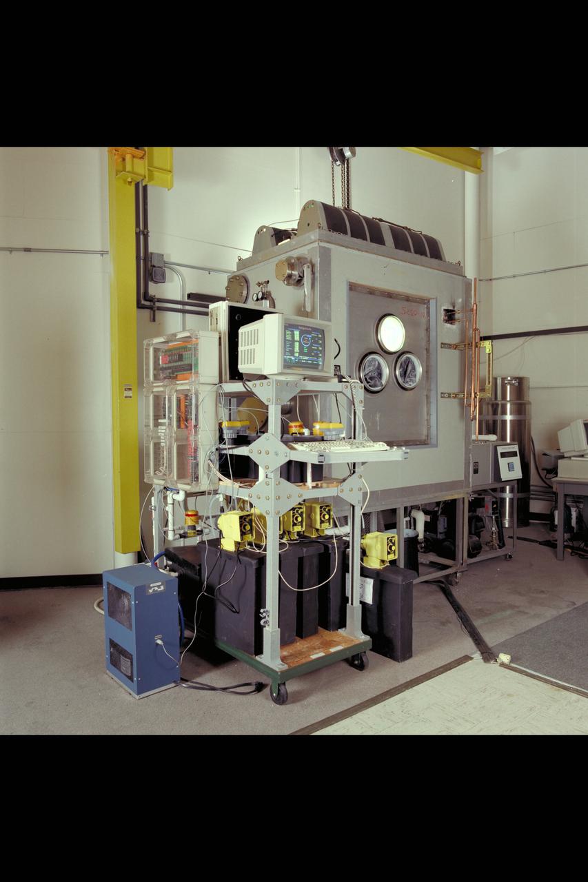
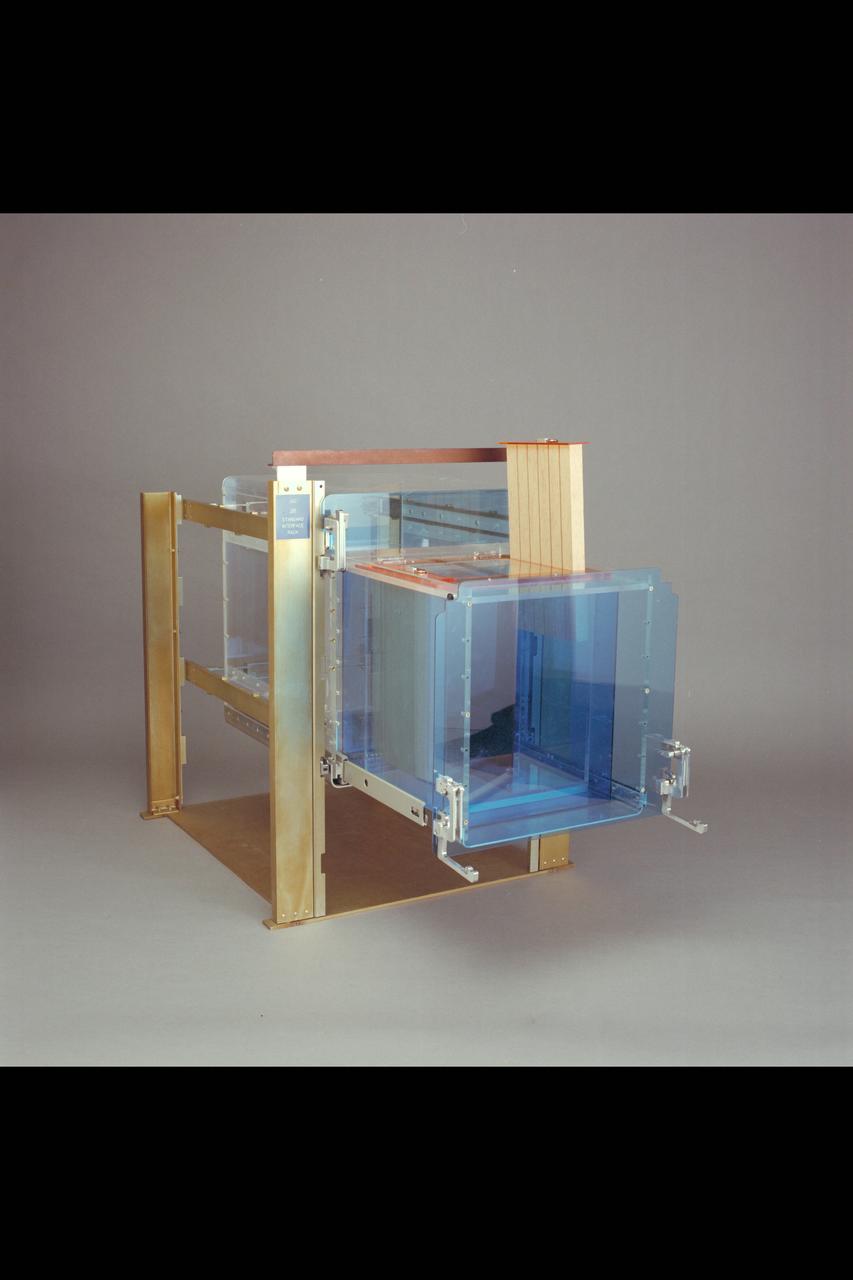
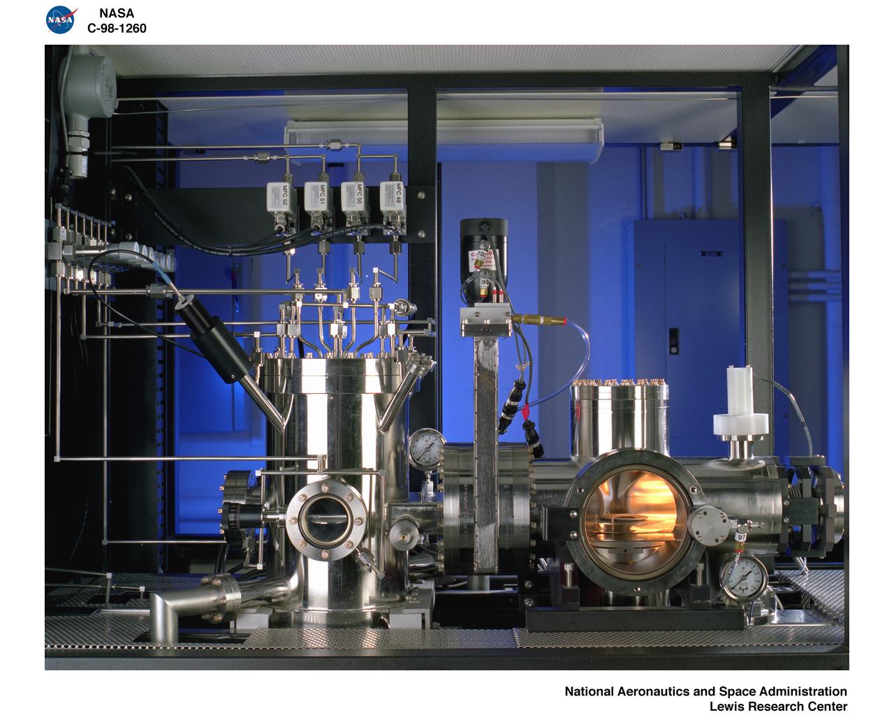
Advanced Life Support Division Equipment
Astronaut and mission specialist Catherine G. Coleman,attired in a high fidelity training version of the Extravehicular Mobility Unit (EMU) space suit, trains for a contingency space walk at the Johnson Space Center’s (JSC) Weightless Environment Training Facility (WET-F). This particular training was in preparation for the STS-73 mission. The STS-73 mission was the second flight of the United States Microgravity Laboratory (USML-2), managed by scientists and engineers from the Marshall Space Flight Center.
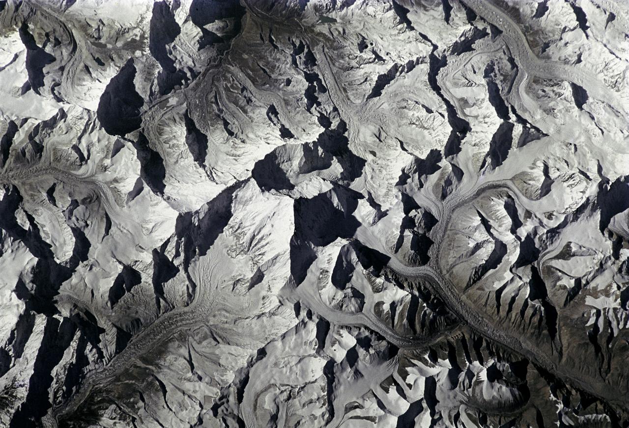
STS066-208-025 (3-14 Nov. 1994) --- Mount Everest, the highest mountain in the world at 8,848 meters, was photographed by the crew members aboard the Space Shuttle Atlantis from 165 nautical miles above Earth. Also seen are Cho Oyu (8,153 meters) northwest of Everest, and other peaks in what has been called the "Roof of the World". Abundant details of glacier surfaces, including moraines, crevasse fields and ice falls are displayed for study. Crew members onboard Atlantis were astronauts Donald R. McMonagle, Curtis L. Brown, Jr., Ellen Ochoa, Scott E. Parazynski and Joseph R. Tanner, along with Jean-François Clervoy of the European Space Agency (ESA). The six astronauts spent 11-days in Earth-orbit in support of the Atmospheric Laboratory for Applications and Science (ATLAS-3) mission.
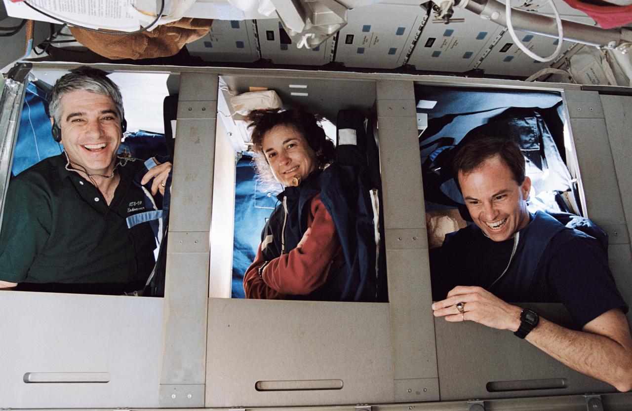
STS059-22-004 (9-20 April 1994) --- Half of Space Shuttle Endeavour's crew of six astronauts are pictured in bunks on the middeck. With the picture held horizontally, the red shift crew members pictured are, left to right, astronauts Sidney M. Gutierrez, mission commander; Linda M. Godwin, payload commander; and Kevin P. Chilton, pilot.
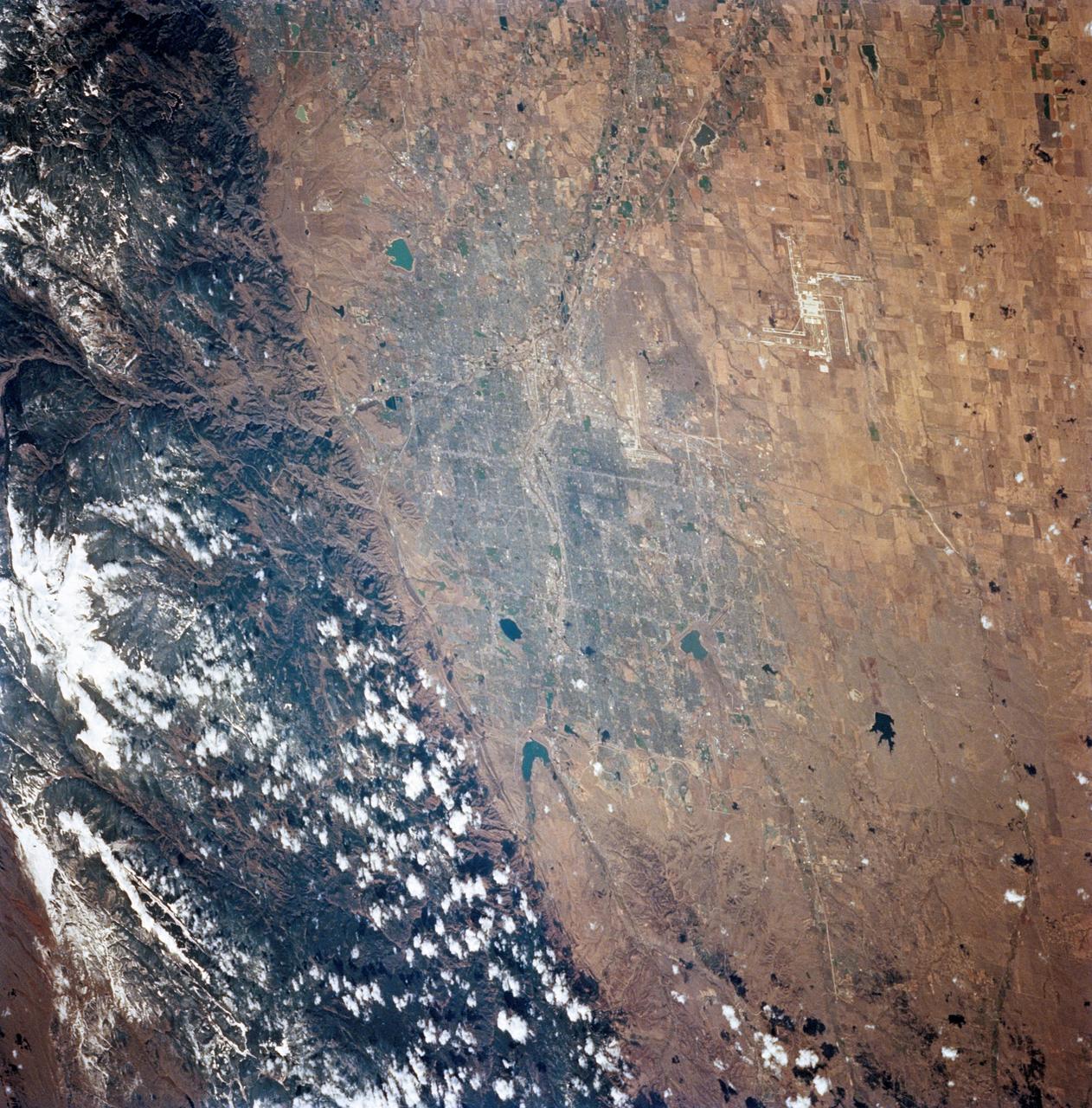
STS068-248-092 (30 September-11 October 1994) --- The location of Denver, Colorado - on the western edge of the High Plains, at the junction of the South Platte River and Clear Creek east of the Rocky Mountains - is graphically displayed. Mount Evans and its surroundings are already covered by snow on October 8, 1994. Clear Creek was one of the first areas in the Rockies where gold was discovered by American prospectors in the 19th century, which led to the settlement of Denver. The growth of 20th century Denver, dominantly to the west and south, is apparent. Stapleton Field, close to downtown Denver, is being replaced by the new regional airport well out on the plains.
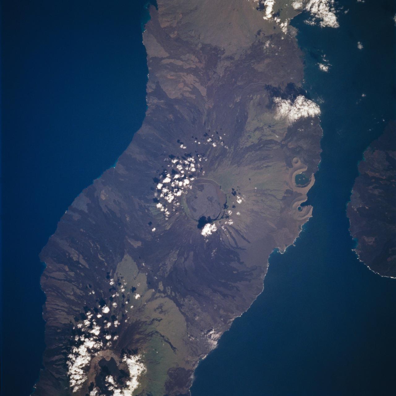
STS059-213-019 (9-20 April 1994) --- SRL scientists will use these photographs with the radar imagery to discriminate among different ages of basalt flows, and different ecosystems of shrub communities, on these equatorial volcanic islands. Aims are twofold: to understand the history of physical and biological systems on the islands themselves, and to extend what is learned to other, less-well-known areas globally. Hasselblad photograph.
KENNEDY SPACE CENTER, FLA. -- STS-60: Discovery
Dryden-built surgical suture instrument
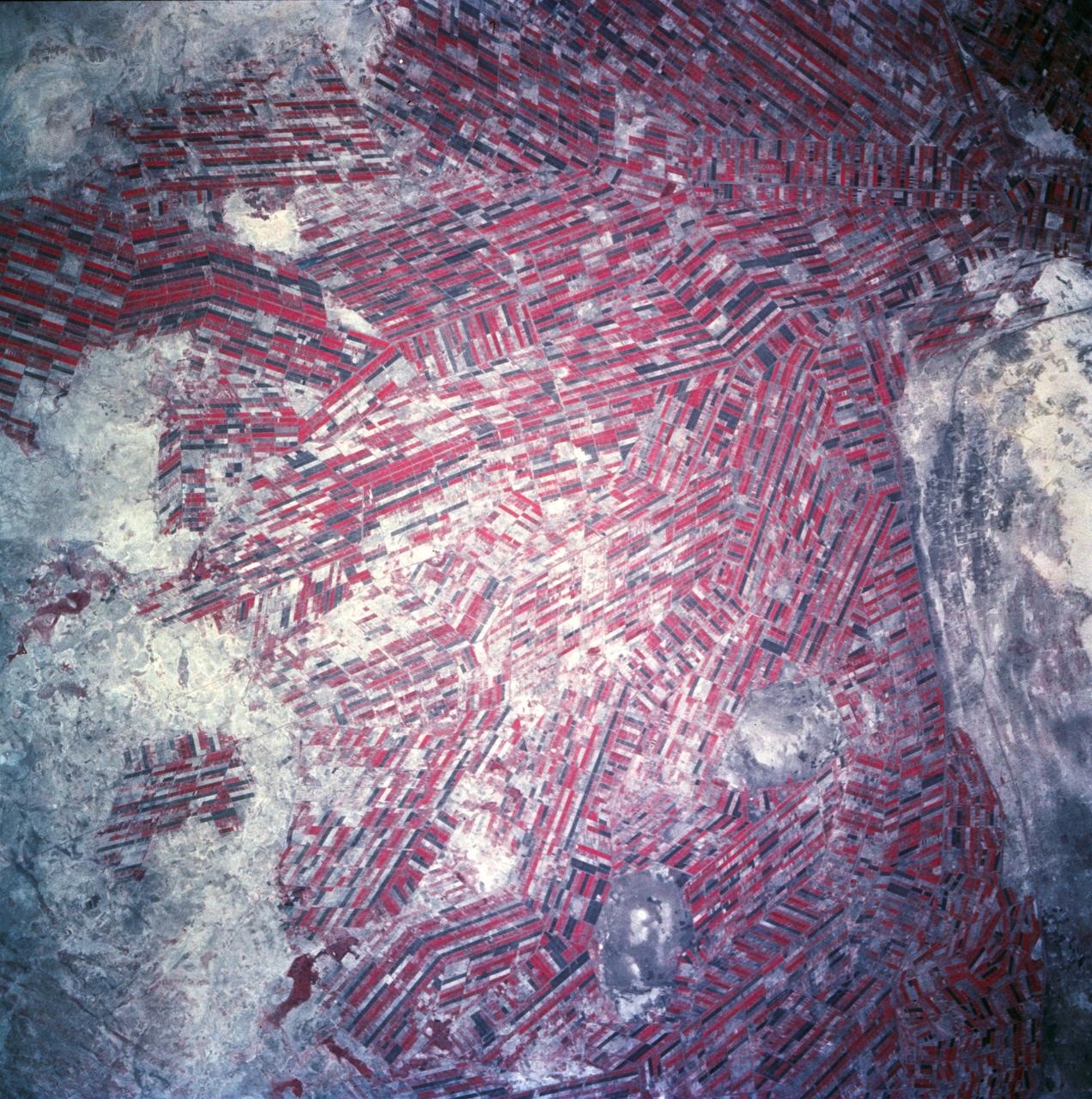
Agricultural patterns are distinctly visible in this near-vertical false color infrared photography taken in November 1994. The area depicted on the photograph is south of Khartoum between the White and Blue Nile Rivers. By far the most important irrigation project in sub-Saharan Africa, both large and small scale agricultural enterprises have been developed using water transported from the perennial Nile Rivers. Hundreds of small rectangular fields and water-filled canals can be seen in this photograph.

S94-41838 (Nov 1994) --- Wearing training versions of the orange partial pressure suit used for shuttle ascent and entry, five NASA astronauts and a Russian cosmonaut assemble for an STS-63 training session. The six are in the Johnson Space Center's (JSC) Shuttle mockup and integration laboratory. They are, left to right, astronauts James D. Wetherbee, mission commander; Eileen M. Collins, pilot; Bernard A. Harris Jr., payload commander; and C. Michael Foale, Janice E. Voss, and cosmonaut Vladimir G. Titov, all mission specialists.
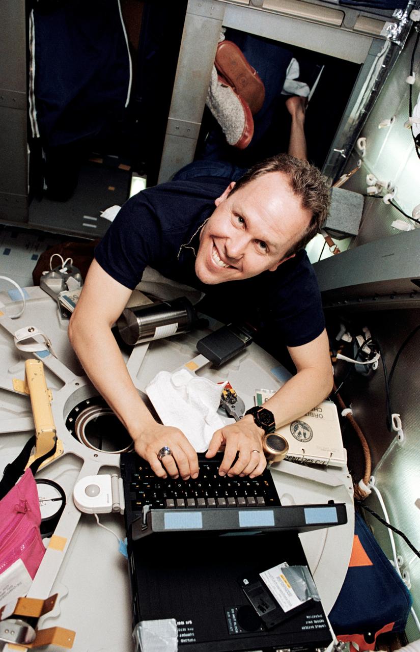
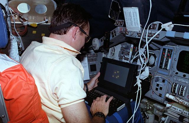
STS059-10-011 (9-20 April 1994) --- Astronaut Thomas D. Jones appears to have climbed out of bed right into his work in this onboard 35mm frame. Actually, Jones had anchored himself in the bunk facility while working on one of the onboard computers which transfered data to the ground via modem. The mission specialist was joined in space by five other NASA astronauts for a week and a half of support to the Space Radar Laboratory (SRL-1)/STS-59 mission.
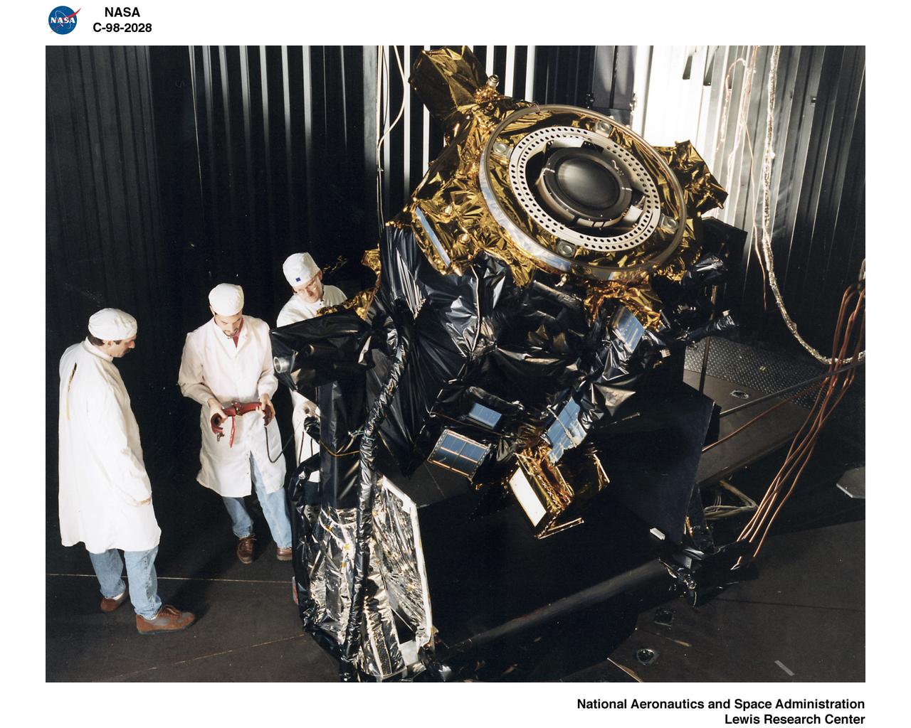
DEEP SPACE 1 SPACECRAFT
STS059-L09-162 (9-20 April 1994) --- Orient with the snow-covered mountains (Sierra Nevada of California) in the upper right corner. Then Owens Valley runs along the top of the photograph to Owens Lake playa at top center. The upper end of Death Valley extends from right to left in the foreground, with the drainage running down to a playa at Stovepipe Wells in the left foreground. Geologists are studying microwave signatures of the different playa surfaces, and the coatings on alluvial fans that extend from mountain masses, to try to sort out the history of different climates in this formerly wet but now hyperarid region.
N-213 Advanced Animal Habitat (AAH)
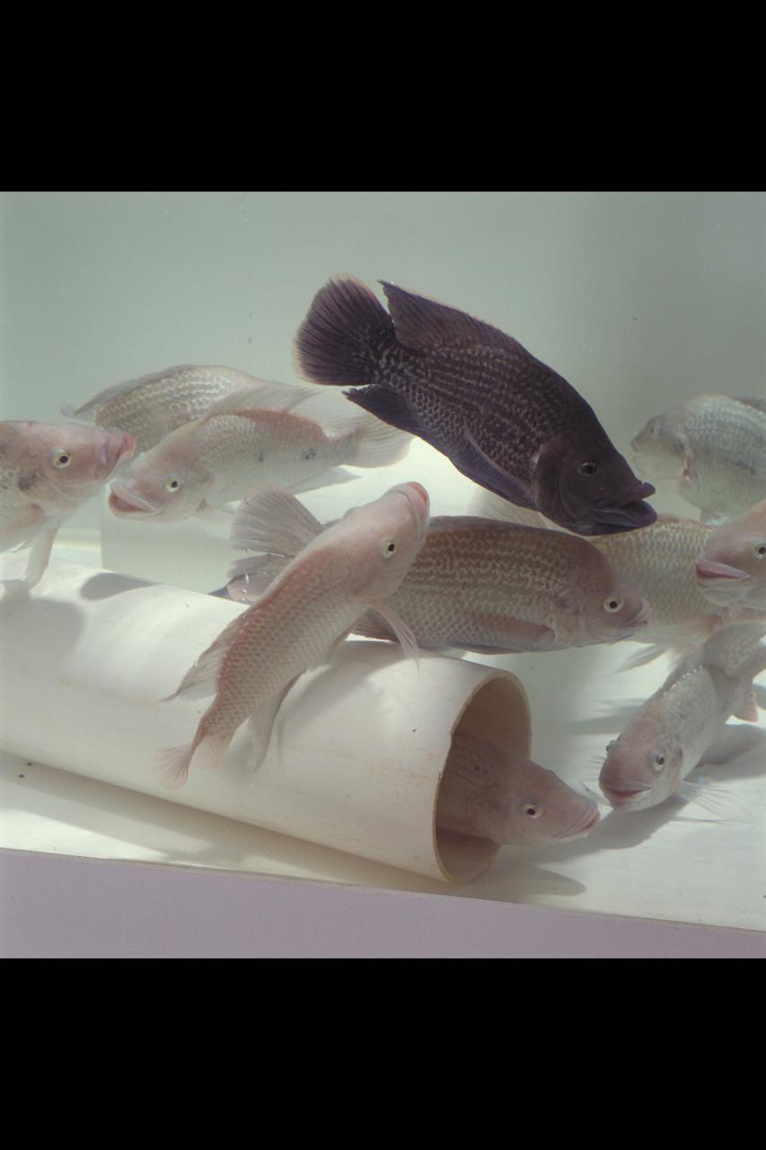
Ames Life Sciences Experiments: Tilapia fish Aquaculture
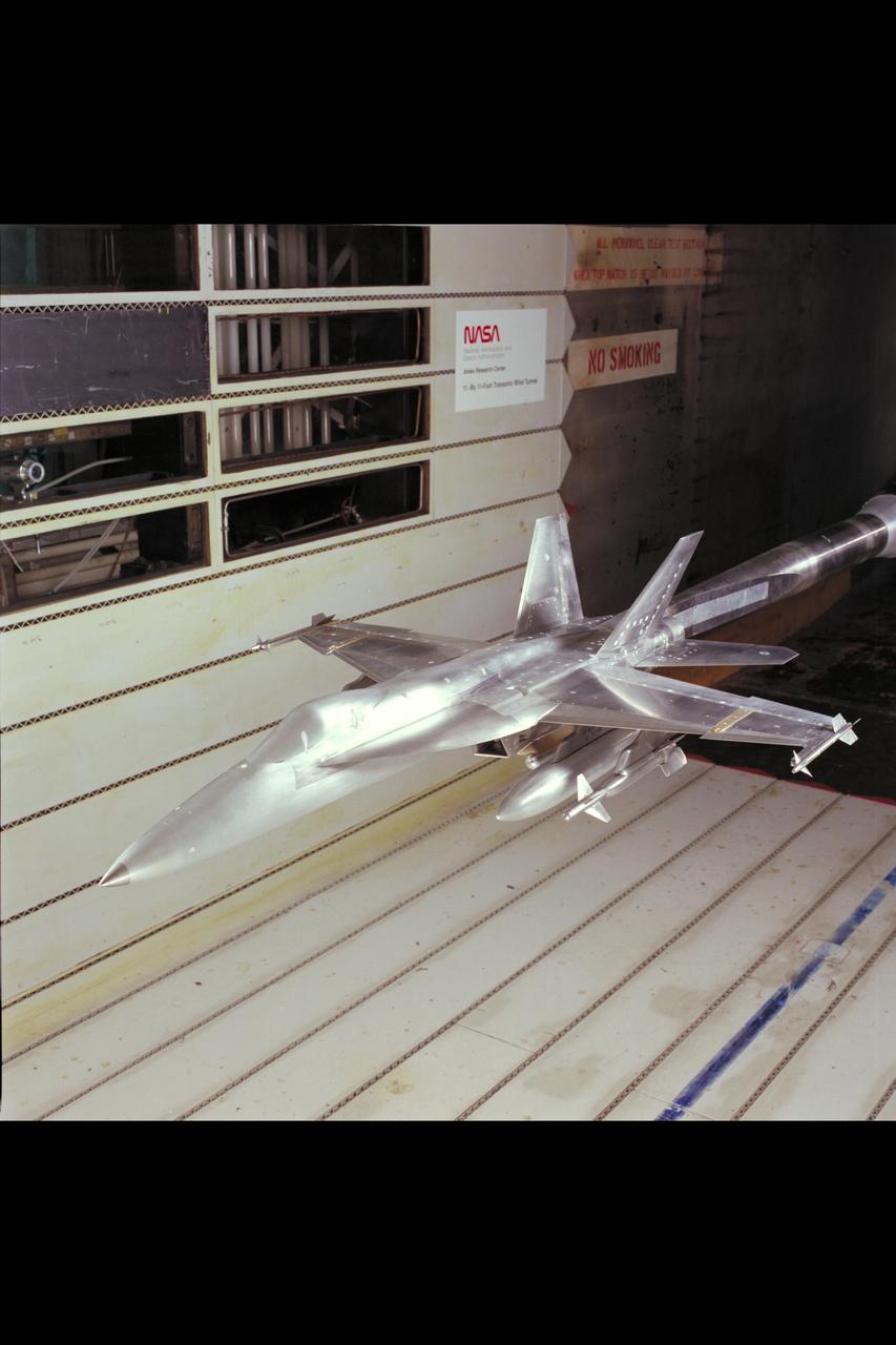
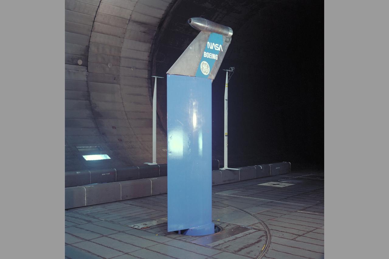
F/A-18 E/F Model: 11ft. W.T. Test #207-1-11 (February and March)
GAS SAMPLING PROBES
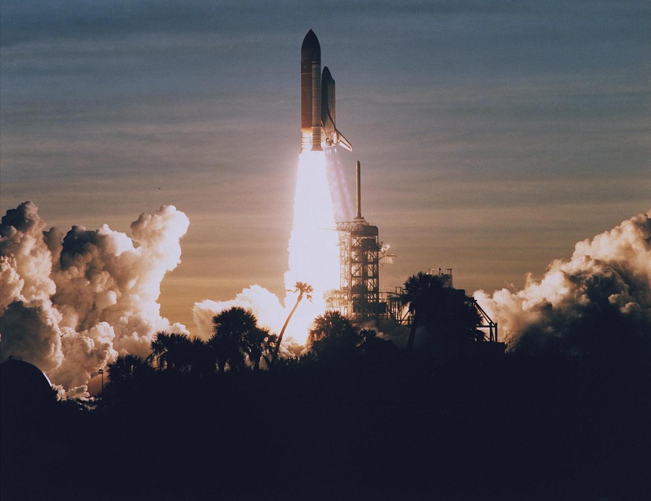
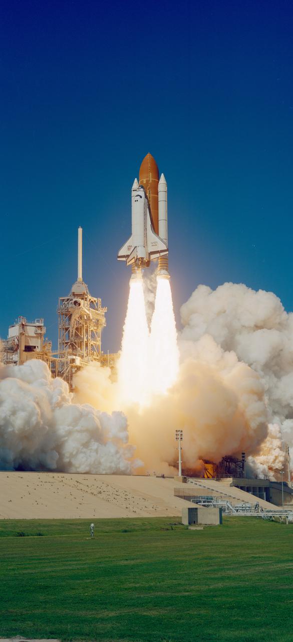
STS060-S-106 (3 Feb 1994) --- Palm trees are silhouetted in the foreground of this 70mm image as the Space Shuttle Discovery heads toward an eight-day mission in Earth orbit. Liftoff occurred as scheduled at 7:10 a.m. (EST), February 3, 1994. Aboard the spacecraft were astronauts Charles F. Bolden Jr., commander; Kenneth S. Reightler Jr., pilot; Franklin R. Chang-Diaz, payload commander; and N. Jan Davis and Ronald M. Sega, mission specialists, along with Russian cosmonaut Sergei K. Krikalev, also a mission specialist.
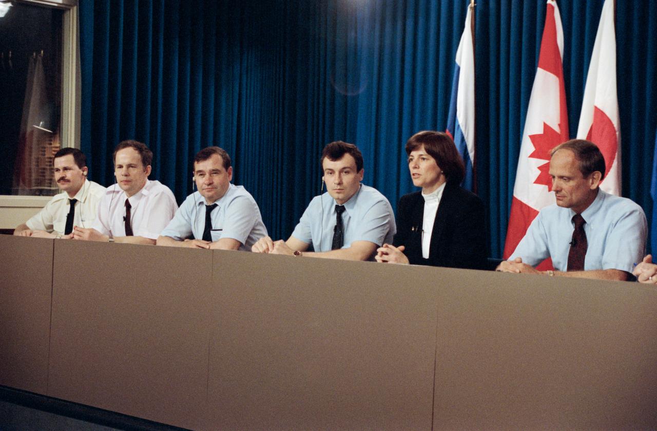
S94-34094 (16 June 1994) --- Crewmembers for the joint Space Shuttle/Mir missions meet the press at the Johnson Space Center (JSC). On the dais are, left to right, cosmonauts Nikolai M. Budarin, Anatoly Y. Solovyov, Gennady M. Strekalov and Vladimir N. Dezhurov, and astronauts Bonnie J. Dunbar and Norman E. Thagard. In a precedent-setting flight, Thagard will be launched with Dezhurov and Strekalov to Mir early next year for a three month mission, designated as Mir 18, on Russia's space station. Then in late May, as the assignment of STS-71, the space shuttle Atlantis will rendezvous with Mir to pick up the Mir 18 crew and transfer cosmonauts Solovyov and Budarin to the station for the Mir 19 mission. STS-71 mission specialist Dunbar is training as Thagard's backup.

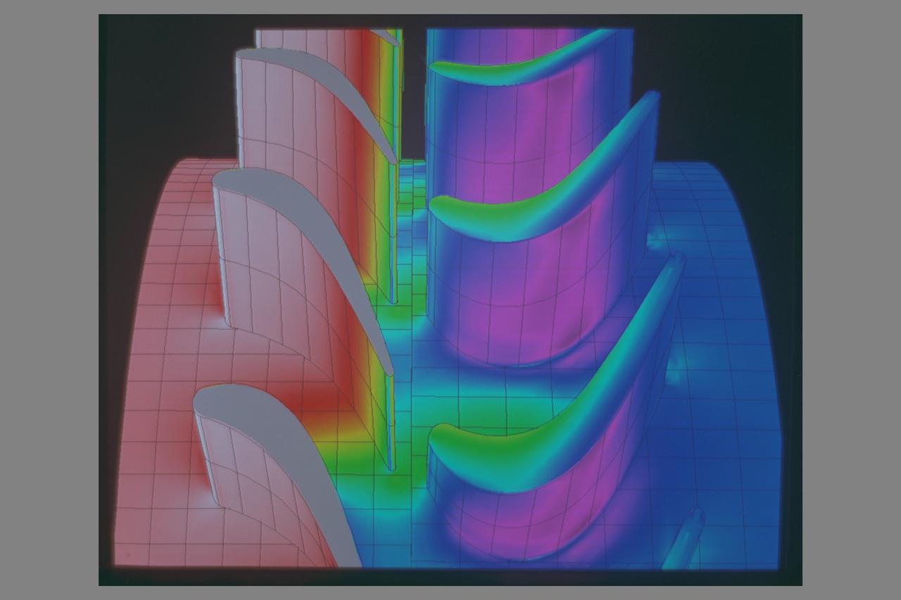
COMPRESSOR IMPELLER DAMAGE
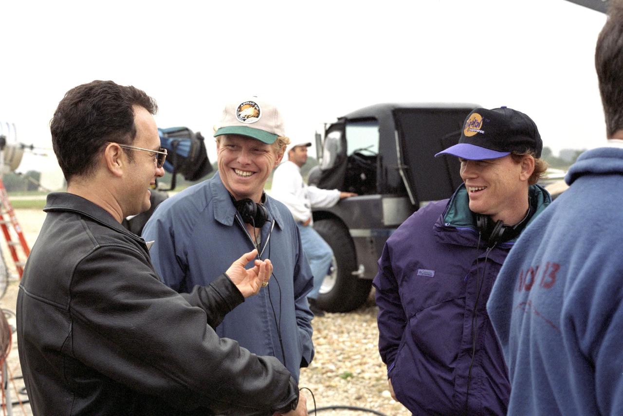
KENNEDY SPACE CENTER, FLA. -- Film director Ron Howard (right) and a production crew, along with actor Tom Hanks (left), are filming a number of scenes at KSC for an upcoming film about the Apollo 13 mission.
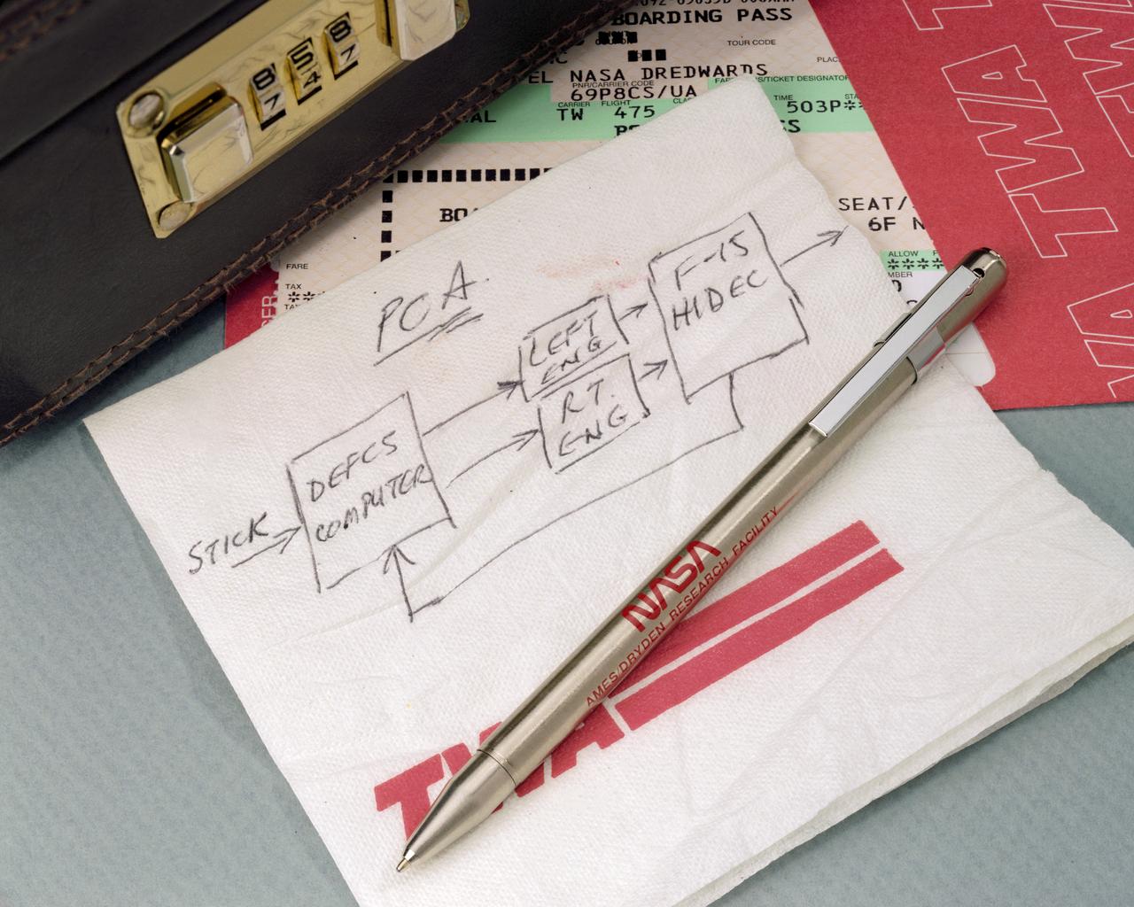
A simple sketch on a TWA napkin by NASA Dryden engineer Frank W. "Bill" Burcham led to development and validation of the Propulsion-Controlled Aircraft concept.
N-213 Advanced Animal Habitat (AAH)
S94-40082 (23 June 1994) --- Astronaut Joseph R. Tanner, mission specialist, checks his glove during a rehearsal for launch and entry phases of the scheduled November flight of STS-66. This rehearsal, held in the Crew Compartment Trainer (CCT) of the Johnson Space Center's (JSC) Shuttle Mockup and Integration Laboratory, was followed by a training session on emergency egress procedures. In November, Tanner will join four other NASA astronauts and a European mission specialist for a week and a half aboard the Space Shuttle Atlantis in Earth-orbit in support of the Atmospheric Laboratory for Applications and Science (ATLAS-3).

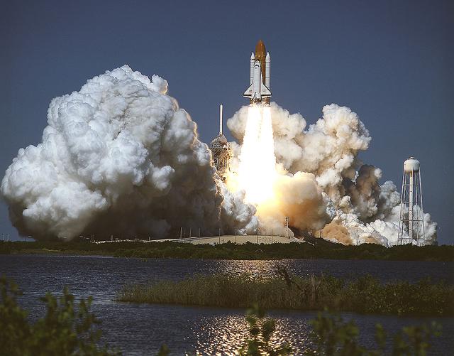
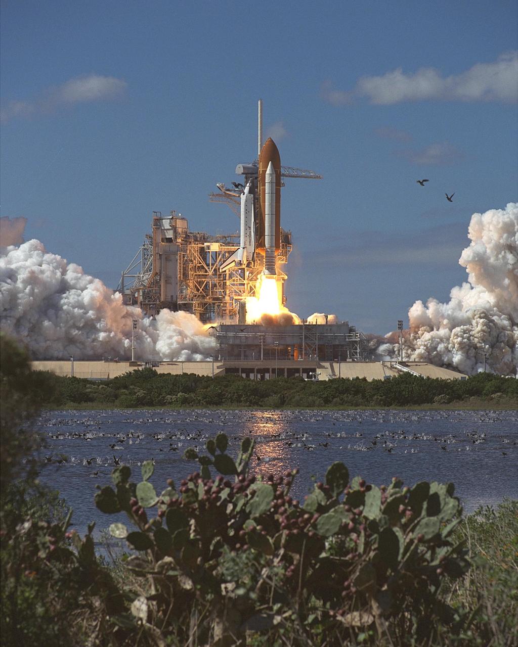
The Space Shuttle Discovery, mated to NASA's 747 Shuttle Carrier Aircraft (SCA), takes to the air for its ferry flight back to the Kennedy Space Center in Florida. The spacecraft, with a crew of six, was launched into a 57-degree high inclination orbit from the Kennedy Space Center, Florida, at 3:23 p.m., 9 September 1994. The mission featured the study of clouds and the atmosphere with a laser beaming system called Lidar In-Space Technology Experiment (LITE), and the first untethered space walk in ten years. A Spartan satellite was also deployed and later retrieved in the study of the sun's corona and solar wind. The mission was scheduled to end Sunday, 18 September, but was extended one day to continue science work. Bad weather at the Kennedy Space Center on 19 September, forced a one-day delay to September 20, with a weather divert that day to Edwards. Mission commander was Richard Richards, the pilot Blaine Hammond, while mission specialists were Jerry Linenger, Susan Helms, Carl Meade, and Mark Lee.
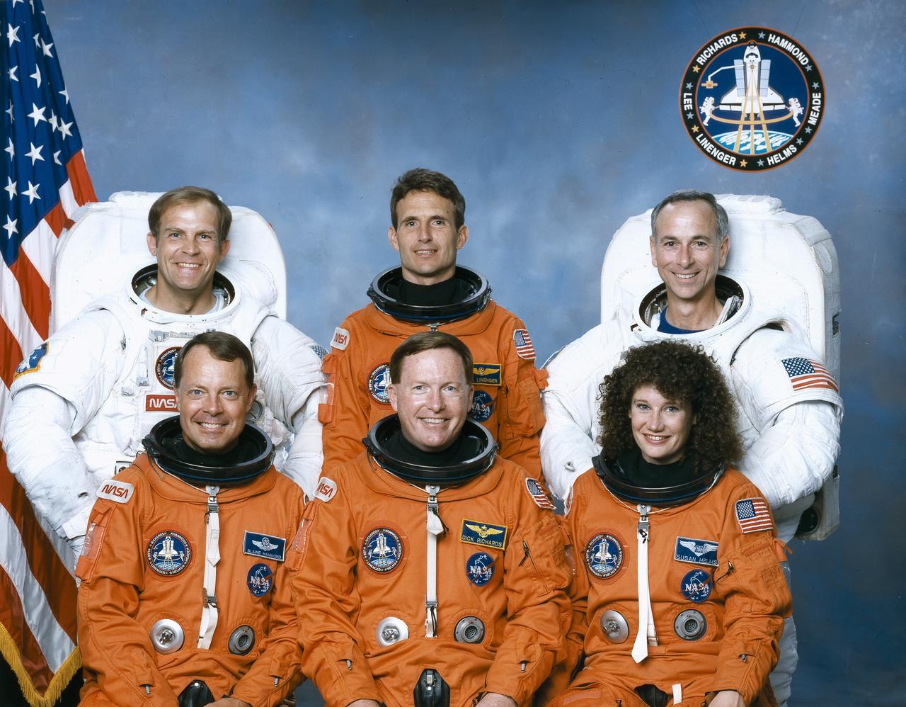
The crew assigned to the STS-64 mission included Richard N. Richards, commander (center front); L. Blaine Hammond Jr., pilot (front left); and Susan J. Helms, mission specialist (front right). On the back row, from left to right, are Mark C. Lee, Jerry M. Linenger, and Carl J. Meade, all mission specialists. Launched aboard the Space Shuttle Discovery on September 9, 1994 at 6:22:55 pm (EDT), the STS-64 mission marked the first flight of the Lidar In-Space Technology Experiment (LITE) and the first untethered Extravehicular Activity (EVA) in ten years.
S94-47079 (18 Oct 1994) --- Astronaut Robert L. Gibson, (arms folded, near center) STS-71 mission commander, joins several crew mates during a briefing preceding emergency egress training in the Systems Integration Facility at the Johnson Space Center (JSC). Astronauts Bonnie J. Dunbar and Gregory J. Harbaugh (partially obscured), along with cosmonaut Anatoliy Y. Solovyev, all mission specialists, are attired in training versions of the partial pressure launch and entry space suits. Astronaut Charles J. Precourt, pilot, is in center foreground, and Ellen S. Baker, mission specialist, is in left background.
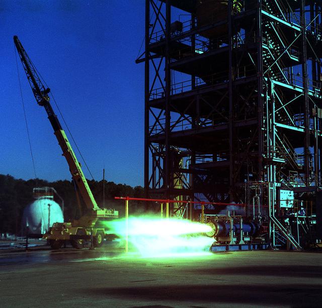
24 inch Hybrid motor test firing at Marshall's Test Stand 500. Liquid/gas are mixed with solid propellents to investigate materials, propellents, and nozzle stability characteristics.
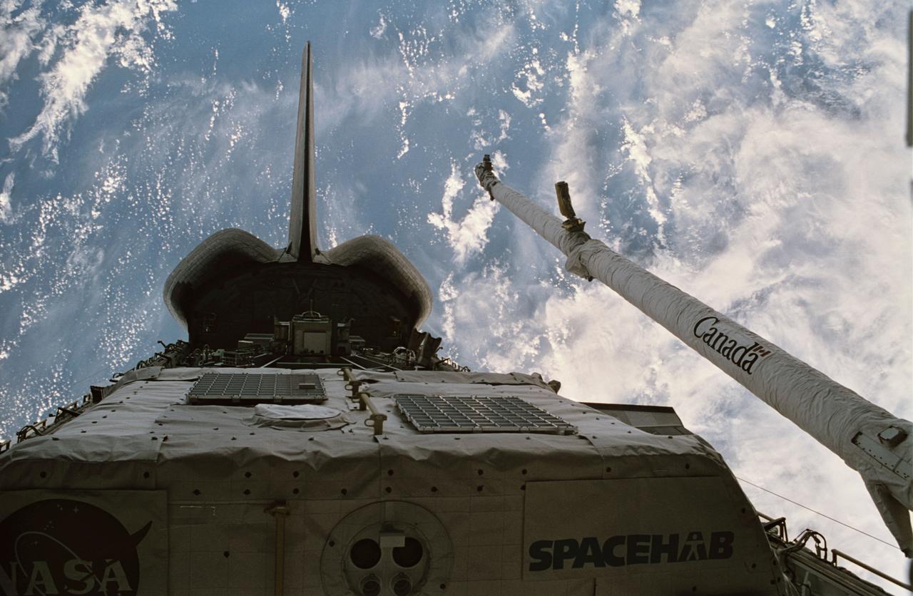
STS064-08-016 (9-20 Sept. 1994) --- Astronaut Mark C. Lee monitors the Lidar In-Space Technology Experiment (LITE) at work in the space shuttle Discovery's cargo bay. The mission specialist is surrounded by cameras which were used by the six NASA astronauts onboard for the almost 11-day mission. Near Lee's head is a 100mm lens which he used to collect data on a myriad of cloud formations which he observed on Earth, 130 nautical miles away. Photo credit: NASA or National Aeronautics and Space Administration EDITOR'S NOTE: In uncropped versions of this picture, astronaut Carl J. Meade is partially in frame at left.
N-213 Advanced Animal Habitat (AAH)
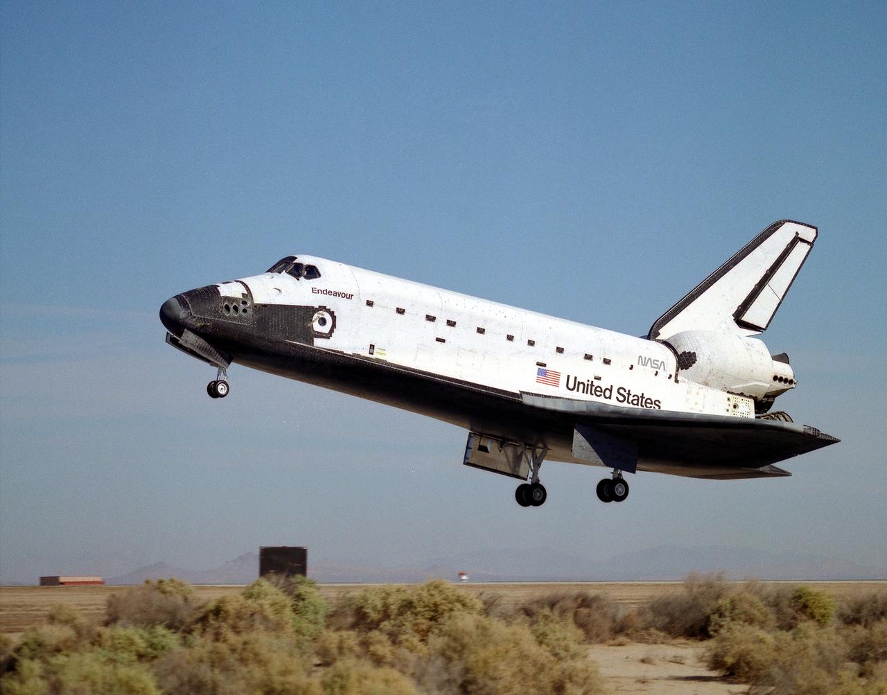
The space shuttle Endeavour glides to a landing on runway 22 at Edwards, California, to complete the highly successful STS-68 mission dedicated to radar imaging of the earth's surface as part of NASA's Mission To Planet Earth program. The landing was at 10:02 a.m. (PDT) 11 October 1994, after waiving off from the Kennedy Space Center, Florida, earlier that morning due to adverse weather at Kennedy. The Endeavour crew was originally scheduled to land at Kennedy the morning of October 10, but mission planners decided early in the flight to extend the mission by one day. Mission commander was Michael A. Baker, making his third flight, and the pilot was Terrence W. Wilcutt, on his first mission.
KENNEDY SPACE CENTER, FLA. -- STS-65: Columbia
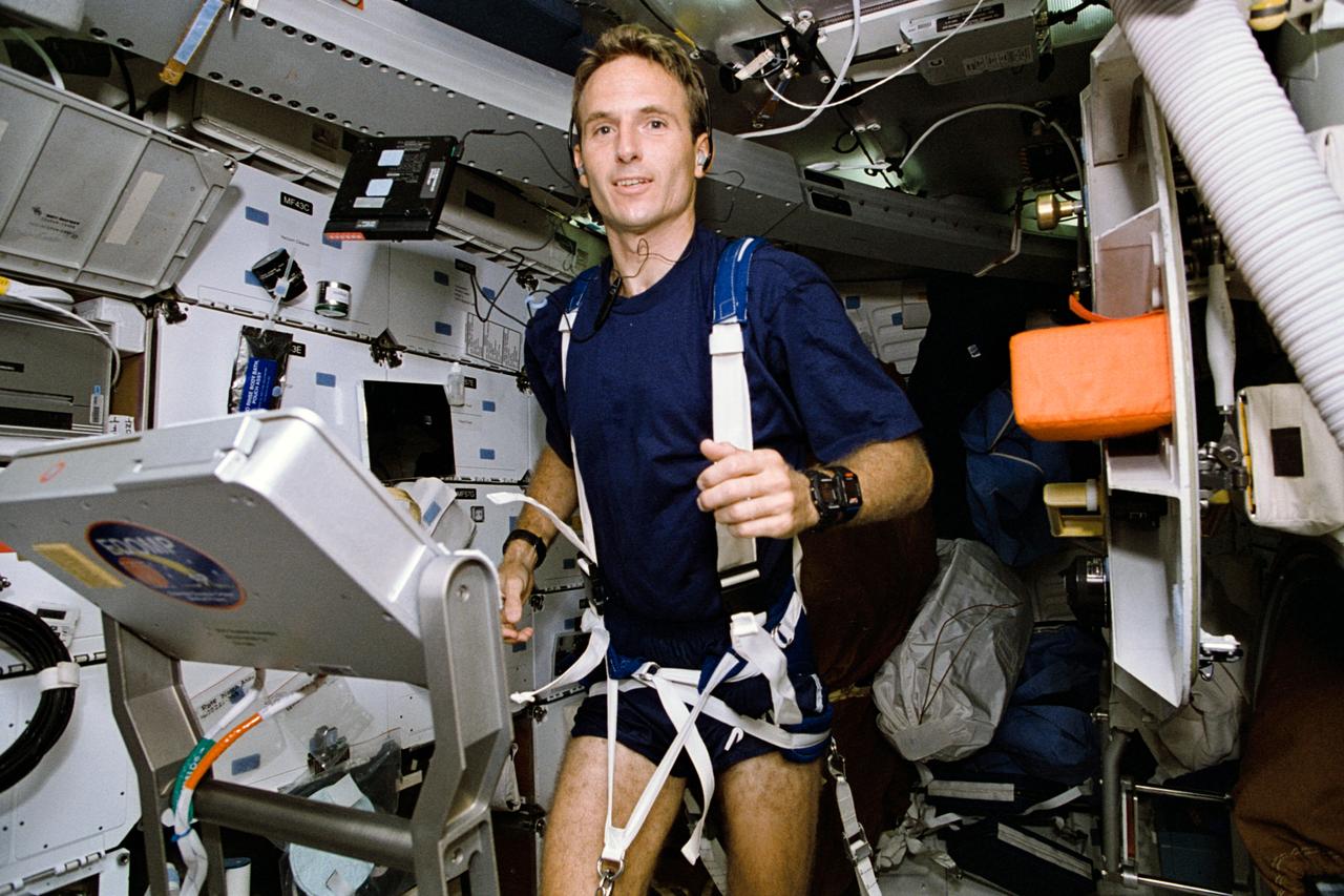
STS064-41-006 (9-20 Sept. 1994) --- Astronaut Jerry M. Linenger, STS-64 mission specialist, works out on the treadmill device on the space shuttle Discovery's middeck. "Running was a pleasure...just like being back on Earth," Linenger told a large audience of Johnson Space Center employees at the Crew Employee Presentation on Sept. 29, 1994. Linenger joined five other NASA astronauts for almost 11 days in Earth orbit aboard Discovery. Photo credit: NASA or National Aeronautics and Space Administration
SILICON CARBIDE GROWTH FACILITY - CLEAN ROOM FACILITY AND SURFACE ANALYTICAL LABS
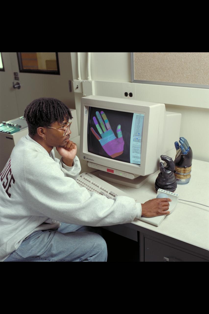
Ames Life Sciences Experiments: Cedi Snowden at Silicon Graphics with AX-5 spacesuit glove
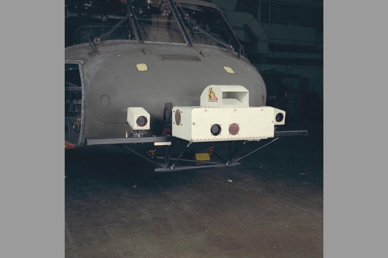
IR CAMERA & ASSOCIATED ELECTRONICS. UH-60 (NASA-750) Blackhawk Rascal helicopter
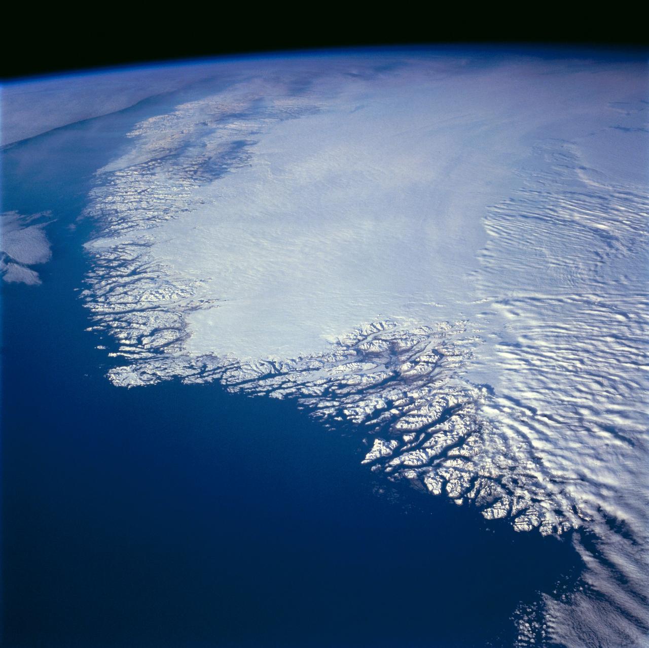
This north-looking view of southwestern Greenland was taken in November, 1994, and shows numerous indentations, many of which contain small settlements. These fjords were carved by the glaciers of the last ice age 10,000 years ago. Even today, the ice in the center of Greenland is nearly 3,500 meters (11,000 feet) thick and great rivers of ice continuously flow down toward the sea, where they melt or break off as icebergs. Some Icebergs exceed the size of small islands, weigh several million tons, and rise several hundred feet above the sea surface. Cape Farewell is visible toward the bottom right of the view. Julianehab Bay and the Bredev fjord can be seen toward the center of the photograph. Godthab, the main settlement on Greenland, is barely visible to the north of the Frederikeshabs Icefield near the left center of the view.
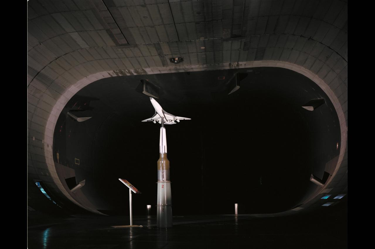
HSCT (High Speed Civil Transport) Ref-H Model test-594 in 40x80ft w.t.
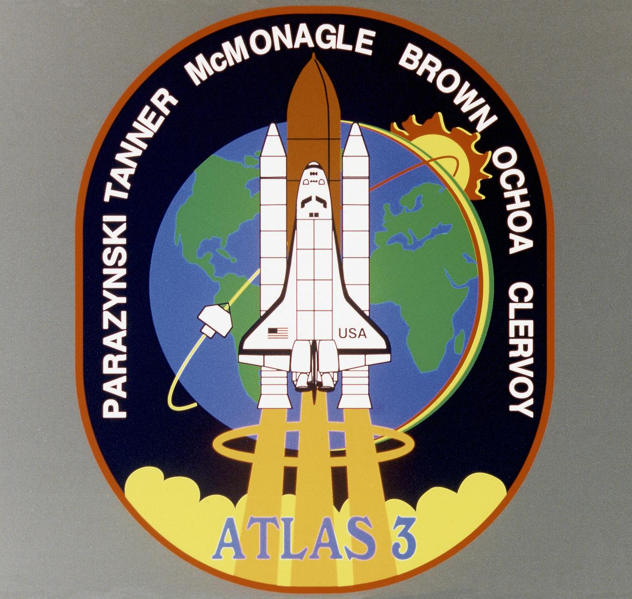
Designed by the mission crew members, the STS-66 emblem depicts the Space Shuttle Atlantis launching into Earth orbit to study global environmental change. The payload for the Atmospheric Laboratory for Applications and Science (ATLAS-3) and complementary experiments were part of a continuing study of the atmosphere and the Sun's influence on it. The Space Shuttle is trailed by gold plumes representing the astronaut symbol and is superimposed over Earth, much of which is visible from the flight's high inclination orbit. Sensitive instruments aboard the ATLAS pallet in the Shuttle payload bay and on the free-flying Cryogenic Infrared Spectrometers and Telescopes for the Atmospheric-Shuttle Pallet Satellite (CHRISTA-SPAS) that gazed down on Earth and toward the Sun, are illustrated by the stylized sunrise and visible spectrum.
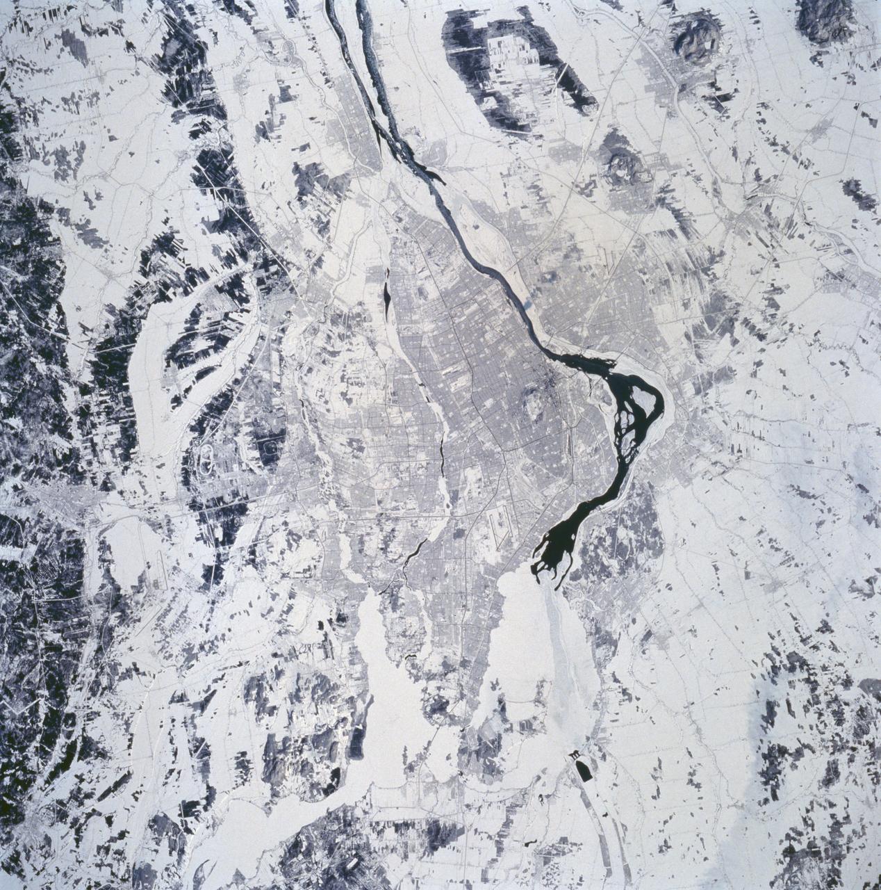
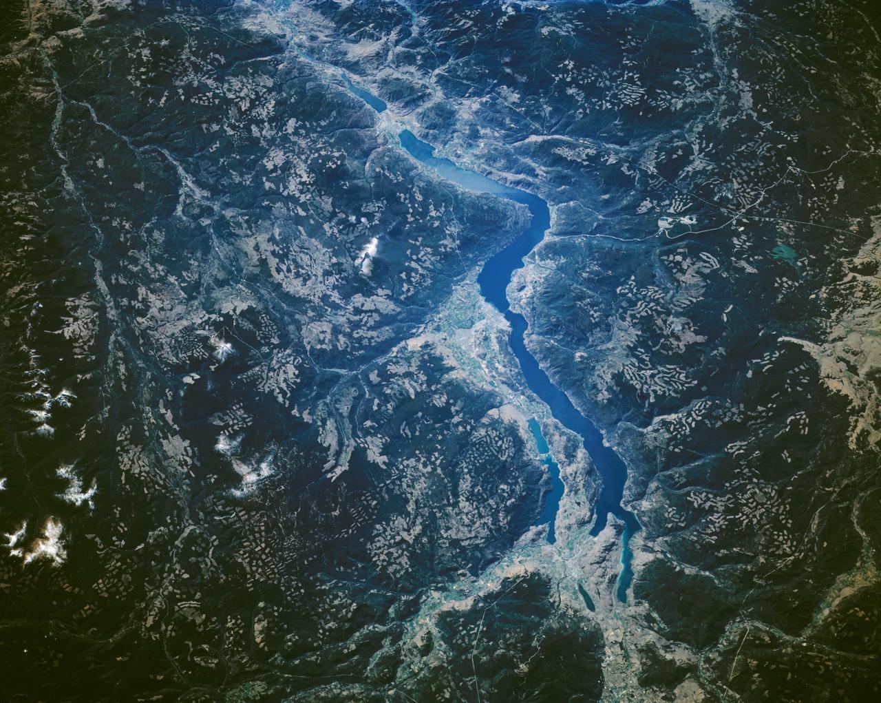
STS060-94-072 (3-11 Feb 1994) --- The city of Montreal is located on the island of Montreal at the confluence of the St. Lawrence and Ottawa Rivers. Despite its distance from the sea (1,000 miles) Montreal is a large inland port. It is also Canada's largest city and the second largest French speaking city in the world. This particular snow covered scene highlights the major highways and street patterns throughout the metropolitan Montreal area. The runways of the two large international airports of Mirabel (located 25 miles northwest of downtown Montreal) and Dorval (located approximately 8 miles west of the downtown area) are clearly visible on this photograph. Even the outline of Mount Royal Park, an imposing hilly feature near the downtown central business district, can be seen. Patches of open, ice-free (very dark areas) are detectable as the St. Lawrence River (Seaway) makes its way along the south and southeastern side of Montreal.
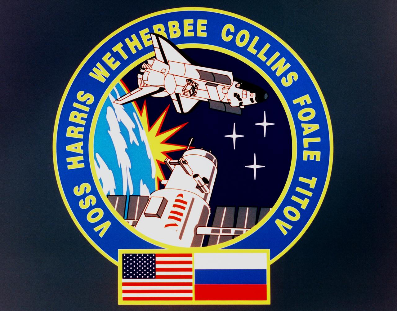
Designed by the crew members, the STS-63 crew patch depicts the orbiter maneuvering to rendezvous with Russia's Space Station Mir. The name is printed in Cyrillic on the side of the station. Visible in the Orbiter's payload bay are the commercial space laboratory Spacehab and the Shuttle Pointed Autonomous Research Tool for Astronomy (SPARTAN) satellite which are major payloads on the flight. The six points on the rising sun and the three stars are symbolic of the mission's Space Transportation System (STS) numerical designation. Flags of the United States and Russia at the bottom of the patch symbolize the cooperative operations of this mission.
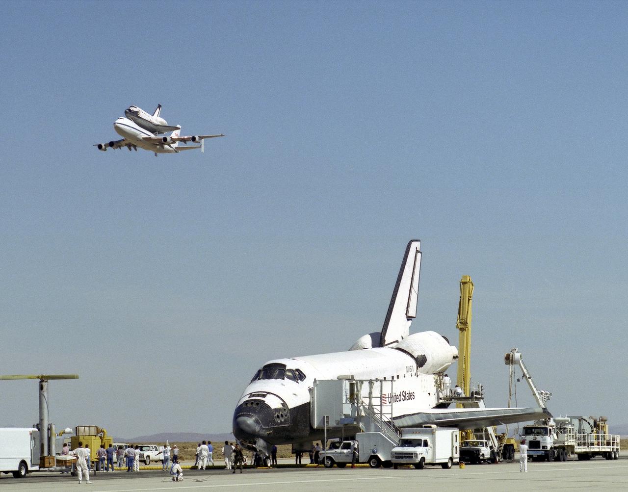
The space shuttle Endeavour receives a high-flying salute from its sister shuttle, Columbia, atop NASA's Shuttle Carrier Aircraft, shortly after Endeavor’s landing 11 October 1994, at Edwards, California, to complete mission STS-68. Columbia was being ferried from the Kennedy Space Center, Florida, to Air Force Plant 42, Palmdale, California, where it will undergo six months of inspections, modifications, and systems upgrades. The STS-68 11-day mission was devoted to radar imaging of Earth's geological features with the Space Radar Laboratory. The orbiter is surrounded by equipment and personnel that make up the ground support convoy that services the space vehicles as soon as they land.
STS059-S-026 (11 April 1994) --- This is an image of Death Valley, California, centered at 36.629 degrees north latitude, 117.069 degrees west longitude. The image shows Furnace Creek alluvial fan and Furnace Creek Ranch at the far right, and the sand dunes near Stove Pipe Wells at the center. The dark fork-shaped feature between Furnace Creek fan and the dunes is a smooth flood-plain which encloses Cottonball Basin. The SIR-C/X-SAR supersite is an area of extensive field investigations and has been visited by both Space Radar Lab astronaut crews. Elevations in the Valley range from 70 meters below sea level, the lowest in the United States, to more than 3300 meters above sea level. Scientists are using SIR-C/X-SAR data from Death Valley to help answer a number of different questions about the Earth's geology. One question concerns how alluvial fans are formed and change through time under the influence of climatic changes and earthquakes. Alluvial fans are gravel deposits that wash down from the mountains over time. They are visible in the image as circular, fan-shaped bright areas extending into the darker valley floor from the mountains. Information about the alluvial fans help scientists study Earth's ancient climate. Scientists know the fans are bulit up through climatic and tectonic processes and they will use the SIR-C/X-SAR data to understand the nature and rates of weathering processes on the fans, soil formation, and the transport of sand and dust by the wind. SIR-C/X-SAR's sensitivity to centimeter-scale (or inch-scale) roughness provides detailed maps of surface texture. Such information can be used to study the occurrence and movement of dust storms and sand dunes. the goal of these studies is to gain a better understanding of the record of past climatic changes and the effects of those changes on a sensitive environment. This may lead to a better ability to predict future response of the land to different potential global cimate-change scenarios. Death Valley is also one of the primary calibration sites for SIR-C/X-SAR. The bright dots near the center of the image are corner reflectors that have been set-up to calibrate the radar as the Shuttle passes overhead. Thirty triangular-shaped reflectors (they look like aluminum pyramids) have been deployed by the calibration team from JPL over a 40 kilometer by 40 kilometer area in and around Death Valley. The calibration team will also deploy transponders (electronic reflectors) and recievers to measure the radar signals from SIR-C/X-SAR on the ground. Spaceborne Imaging Radar-C and X-Synthetic Aperture Radar (SIR-C/X-SAR) is part of NASA's Mission to Planet Earth (MTPE). The radars illuminate Earth with microwaves allowing detailed observations at any time, regardless of weather or sunlight conditions. SIR-C/X-SAR uses three microwave wavelengths: L-Band (24 cm), C-Band (6 cm), and X-Band (3 cm). The multi-frequency data will be used by the international scientific community to better understand the global environment and how it is changing. The SIR-C/X-SAR data, complemented by aircraft and ground studies, will give scientists clearer insights into those environmental changes which are caused by nature and those changes which are induced by human activity. SIR-C was develpoed by NASA's Jet Propulsion Laboratory (JPL). X-SAR was developed by the Dornire and Alenia Spazio Companies for the German Space Agency, Deutsche Agentur fuer Raumfahrtangelegenheiten (DARA), and the Italian Space Agency, Agenzia Spaziale Italiana (ASI). JPL Photo ID: P-43883

STS060-301-003 (3-11 Feb 1994) --- Astronaut Kenneth S. Reightler, STS-60 pilot, processes biomedical samples in a centrifuge aboard the SPACEHAB module. Reightler joined four other NASA astronauts and a Russian cosmonaut for eight days of research aboard the Space Shuttle Discovery.
These Vapor Diffusion Apparatus (VDA) trays were first flown in the Thermal Enclosure System (TES) during the USMP-2 (STS-62) mission. Each tray can hold 20 protein crystal growth chambers. Each chamber contains a double-barrel syringe; one barrel holds protein crystal solution and the other holds precipitant agent solution. During the microgravity mission, a torque device is used to simultaneously retract the plugs in all 20 syringes. The two solutions in each chamber are then mixed. After mixing, droplets of the combined solutions are moved onto the syringe tips so vapor diffusion can begin. During the length of the mission, protein crystals are grown in the droplets. Shortly before the Shuttle's return to Earth, the experiment is deactivated by retracting the droplets containing protein crystals, back into the syringes.
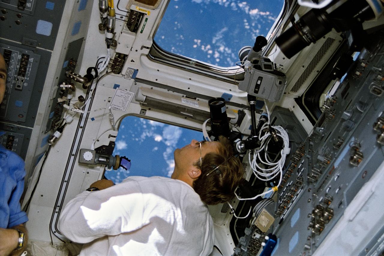
STS066-13-014 (3-14 Nov. 1994) --- On the space shuttle Atlantis' aft flight deck, astronaut Ellen Ochoa, payload commander, has just completed an operation at the controls for the Remote Manipulator System (RMS) arm while working in chorus with astronaut Donald R. McMonagle. McMonagle, mission commander, is seen here at his station on the forward flight deck. An RMS operations checklist floats in front of Ochoa. Photo credit: NASA
The 66th Space Shuttle flight began with a nearly on-time liftoff of the Orbiter Atlantis (STS-66) into the clear Florida skies. Atlantis returned to space after a nearly two year absence. The plarned 11-day flight will continue NASA's Mission to Planet Earth, a comprehensive international collaboration to study how Earth's environment is changing and how human beings affect that change. Primary payloads on this flight included the Atmospheric Laboratory for Applications and Science (ATLAS-3), making its third flight, and the German-built Cryogenic Infrared Spectrometers and Telescopes for the Atmosphere-Shuttle Pallet Satellite (CRISTA-SPAS), which was deployed and retrieved during the mission.
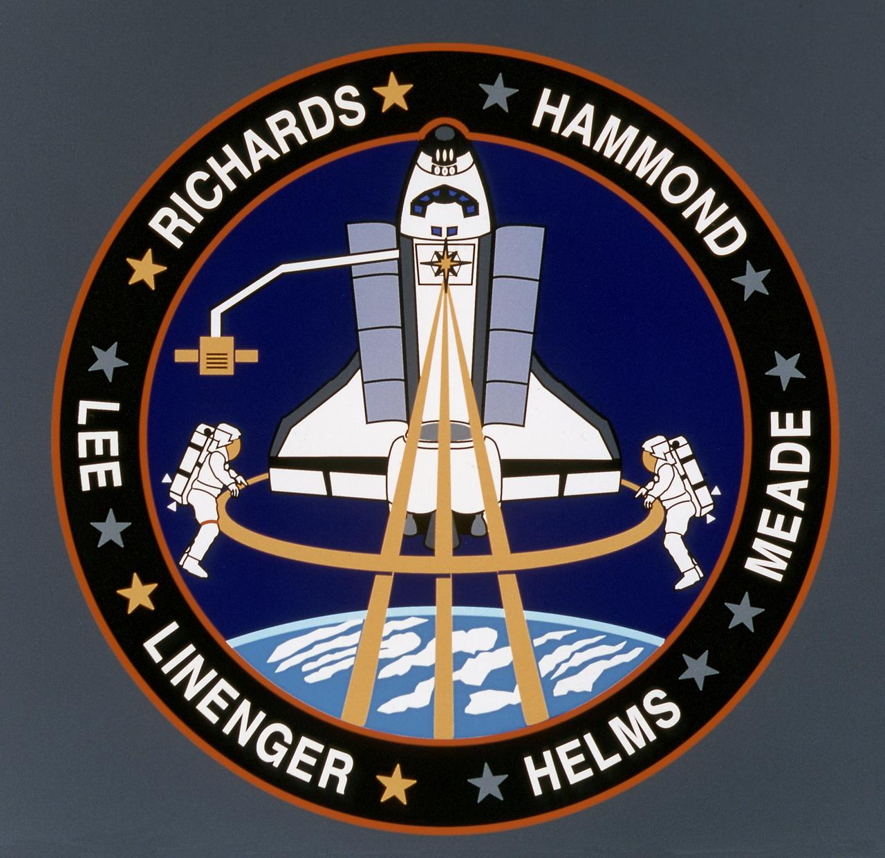
The STS-64 patch depicts the Space Shuttle Discovery in a payload-bay-to-Earth attitude with its primary payload, Lidar In-Space Technology Experiment (LITE-1) operating in support of Mission to Planet Earth. LITE-1 is a lidar system that uses a three-wavelength laser, symbolized by the three gold rays emanating from the star in the payload bay that form part of the astronaut symbol. The major objective of the LITE-1 is to gather data about the Earth's troposphere and stratosphere, represented by the clouds and dual-colored Earth limb. A secondary payload on STS-64 is the free-flier SPARTAN 201 satellite shown on the Remote Manipulator System (RMS) arm post-retrieval. The RMS also operated another payload, Shuttle Plume Impingement Flight Experiment (SPIFEX). A newly tested extravehicular activity (EVA) maneuvering device, Simplified Aid for EVA Rescue (SAFER), represented symbolically by the two small nozzles on the backpacks of the two untethered EVA crew men. The names of the crew members encircle the patch: Astronauts Richard N. Richards, L. Blaine Hammond, Jr., Jerry M. Linenger, Susan J. Helms, Carl J. Meade and Mark C. Lee. The gold or silver stars by each name represent that person's parent service.
STS060-15-003 (3-11 Feb 1994) --- This 35mm frame shows the major payloads of the Space Shuttle Discovery's STS-60 mission, backdropped against clouds over the Atlantic Ocean. In the foreground is the SPACEHAB module, with the Wake Shield Facility (WSF) partially visible in its berthed position near the Orbital Maneuvering System (OMS) pods and the vertical stabilizer. Television cameras on the Remote Manipulator System (RMS) were being used for a survey of the cargo. Five NASA astronauts and a Russian cosmonaut went on to spend eight days in Earth orbit in support of the mission.
N-213 Advanced Animal Habitat (AAH)
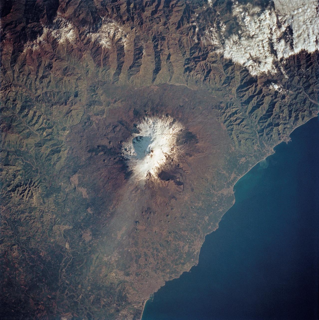
STS062-85-195 (4-18 March 1994) --- A thin plume of steam blows southward from the summit of Mt. Etna, the active volcano on the island of Sicily. The summit is capped with snow but the dark lava flow along the eastern flank (the 1991-93 flow) is clearly visible. The coastal city south of Etna is Catania.
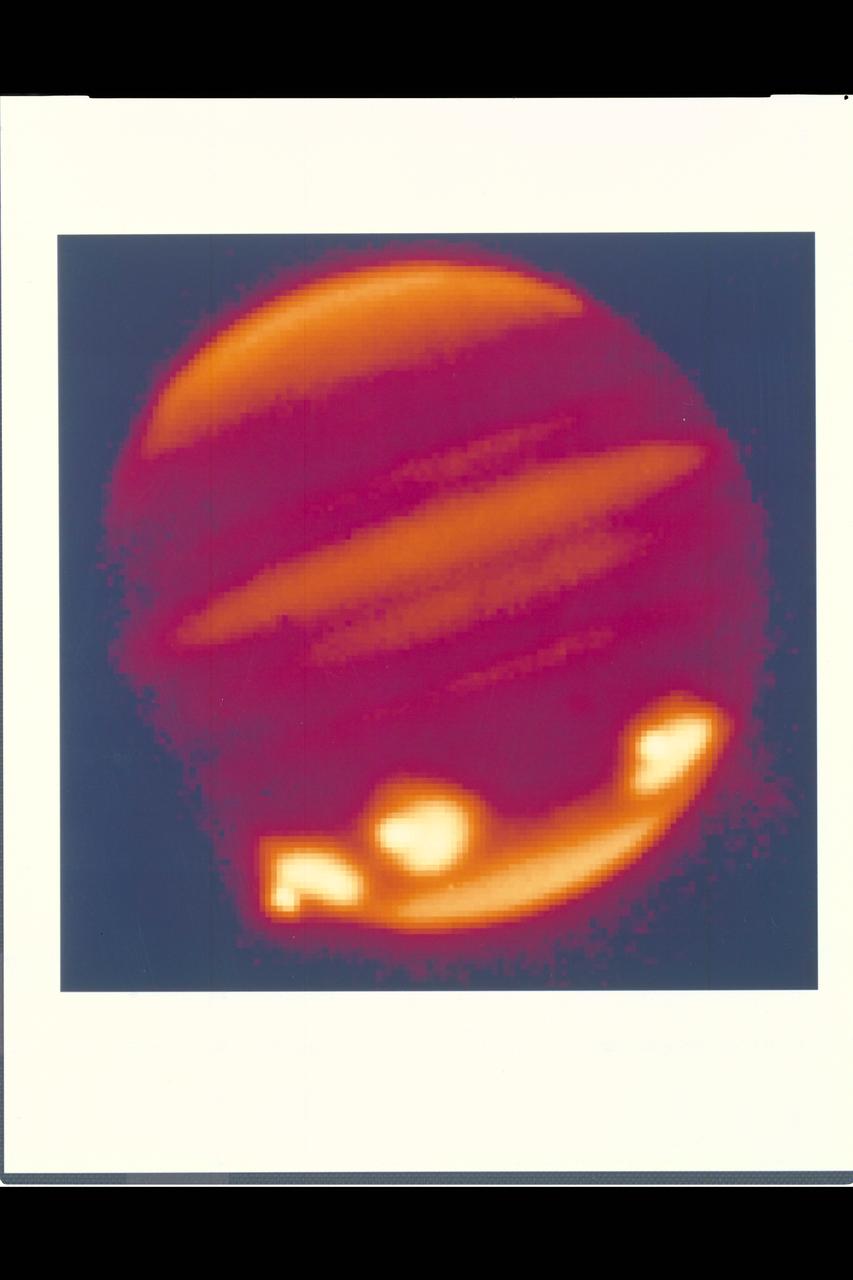
Credit: Calar Alto Observatory Spectacular first view of Fragment Q impacts on Jupiter. Infrared image in the 2.3m micron methane band taken using MAGIC on the 3.5m telescope, Calar Alto Observatory, Spain.
Advanced Life Support Division Equipment
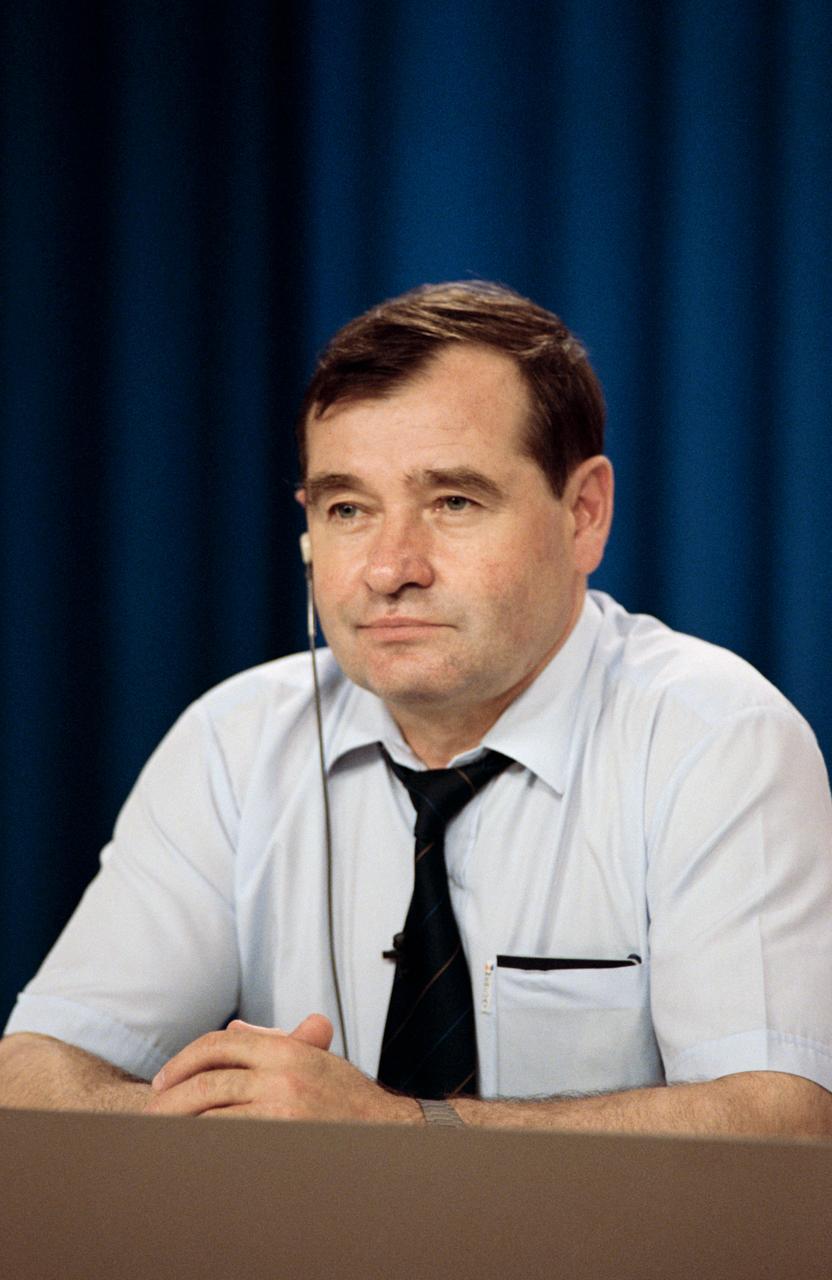
Cosmonaut Gennadiy M. Strekalov, flight engineer for the Mir-18 mission, listens to a question from a news media representative. Crew members for two of the joint Space Shuttle/Mir missions met the press at JSC.
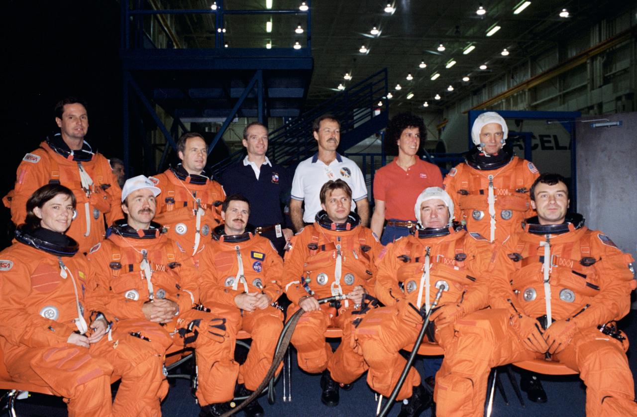
S94-47050 (28 Oct 1994) --- Crew members for the joint Space Shuttle/Russian Mir Space Station missions assemble for an informal portrait during a break in training in the Systems Integration Facility at the Johnson Space Center (JSC). In front (left to right) are astronaut Bonnie J. Dunbar; cosmonauts Aleksandr F. Poleshchuk, Yuriy I. Onufriyenko, Gennadiy M. Strekalov and Vladimir N. Dezhurov. In the rear are astronaut Gregory J. Harbaugh; cosmonaut Anatoliy Y. Solovyev, and astronauts Charles J. Precourt, Robert L. Gibson, Ellen S. Baker and Norman E. Thagard. In a precedent-setting flight, Thagard will be launched as a guest researcher along with Dezhurov, commander, and Strekalov, flight engineer, to Russia's Mir Space Station early next year for a three month mission, designated as Mir 18. Then in late spring, as the assignment of STS-71, the Space Shuttle Atlantis will rendezvous with Mir to pick up the Mir 18 crew and transfer cosmonauts Solovyov and Nikolai M. Budarin to the station for the Mir 19 mission. STS-71 mission specialist Dunbar is training as Thagard's backup.
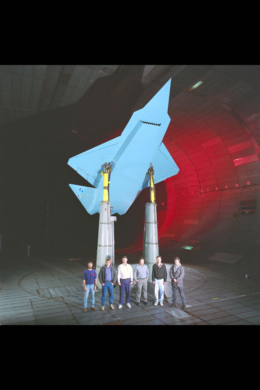
SOFIA (Stratospheric Observatory for Infrared Astronomy) with telescope postition to the rear model prepares for testing in the NASA Ames Research Center 14ft Transonic Wind Tunnel. Test-208-1-14

The Space Shuttle Endeavour, atop NASA's 747 Shuttle Carrier Aircraft (SCA), taking off for the Kennedy Space Center shortly after its landing on 11 October 1994, at Edwards, California, to complete mission STS-68. Endeavour was being ferried from the Kennedy Space Center, Florida, to Air Force Plant 42, Palmdale, California, where it will undergo six months of inspections, modifications, and systems upgrades. The STS-68 11-day mission was devoted to radar imaging of Earth's geological features with the Space Radar Laboratory.
KENNEDY SPACE CENTER, FLA. -- STS-66: Atlantis
STS059-213-009 (9-20 April 1994) --- San Francisco Bay. Orient with the sea up. The delta of the combined Sacramento and San Joaquin Rivers occupies the foreground, San Francisco Bay the middle distance, and the Pacific Ocean the rest. Variations in water color caused both by sediment load and by wind streaking strike the eye. Man-made features dominate this scene. The Lafayette/Concord complex is left of the bay head, Vallejo is to the right, the Berkeley/Oakland complex rims the shoreline of the main bay, and San Francisco fills the peninsula beyond. Salt-evaporation ponds contain differently-colored algae depending on salinity. The low altitude (less than 120 nautical miles) and unusually-clear air combine to provide unusually-strong green colors in this Spring scene. Hasselblad camera.
Ames Aircraft complement on Ramp in front of N-211 hangar: DC-8, C-141, C-130, ER-2, Lear Jet, YO-3A, T-38, AH-1G, AV-8B, UH-60
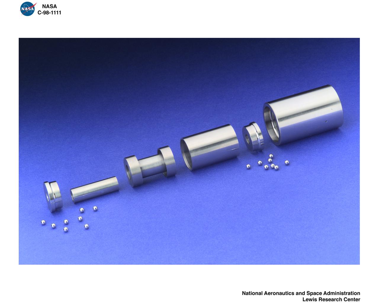
RETAINERLESS OOZE FLOW BEARING CARTRIDGE

In a ceremony honoring Dr. Wernher von Braun, who served as Marshall Space Flight Center Director from 1960 to 1970, Marshall officials renamed the 4200 Building Complex as the Wernher von Braun Office Complex and unveiled a bust of the former director. This photograph is a close-up of the bust in the courtyard. The sculptor of the bust is a MSFC employee, Jack Hood.

STS066-S-040 (14 November 1994) --- The main landing gear is on the ground and the nose gear is about to touch down as the Space Shuttle Atlantis heads toward a stop at Edwards Air Force Base in southern California, ending a successful 10 day, 22 hour and 34 minute space mission. Landing occurred at 7:34 a.m. (PST), November 14, 1994. Onboard were astronauts Donald R. McMonagle, commander; Curtis L. Brown, Jr., pilot; Ellen S. Ochoa, payload commander; Scott E. Parazynski and Joseph R. Tanner, both mission specialists, along with European Space Agency (ESA) mission specialist Jean-Francois Clervoy. The crew supported the Atmospheric Laboratory for Applications and Science (ATLAS-3) mission.
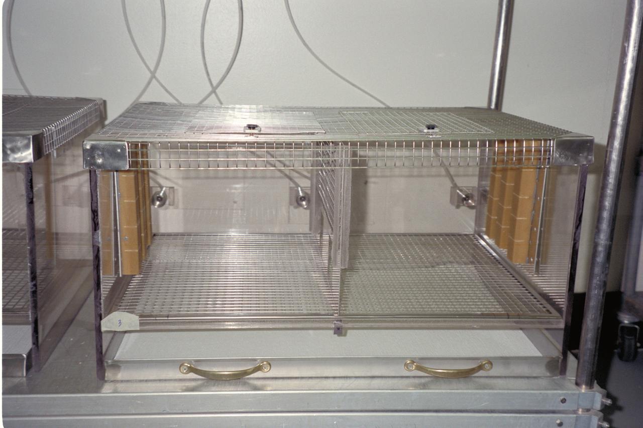
N-213 Advanced Animal Habitat (AAH)
In this photograph, astronaut Carl Walz performs the Performance Assessment Workstation (PAWS) experiment at the flight deck of the Space Shuttle Orbiter Columbia during the STS-65 mission. Present day astronauts are subject to a variety of stresses during spaceflight. These include microgravity, physical isolation, confinement, lack of privacy, fatigue, and changing work/rest cycles. The purpose of this experiment is to determine the effects of microgravity upon thinking skills critical to the success of operational tasks in space. The principle objective is to distinguish between the effects of microgravity on specific information-processing skills affecting performance and those of fatigue caused by long work periods. To measure these skills, the investigators use a set of computerized performance tests called the Performance Assessment Workstation, which is based on current theoretical models of human performance. The tests were selected by analyzing tasks related to space missions and their hypothesized sensitivity to microgravity. Multiple subjective measures of cumulative fatigue and changing mood states are also included for interpreting performance data.
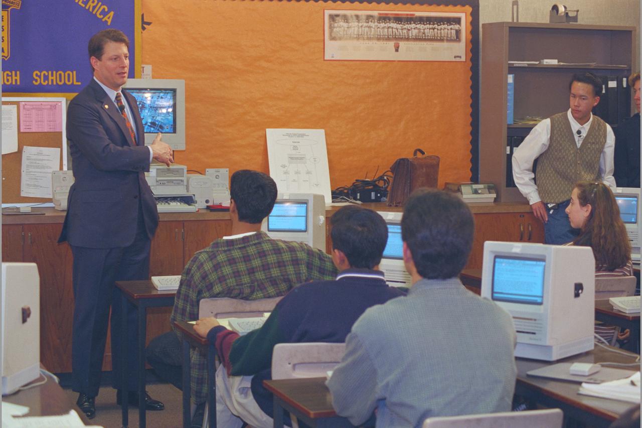
Vice President Al Gore Visits Bay Area & Monte Vista High School, Cupertino, California to promote communications superhighway.
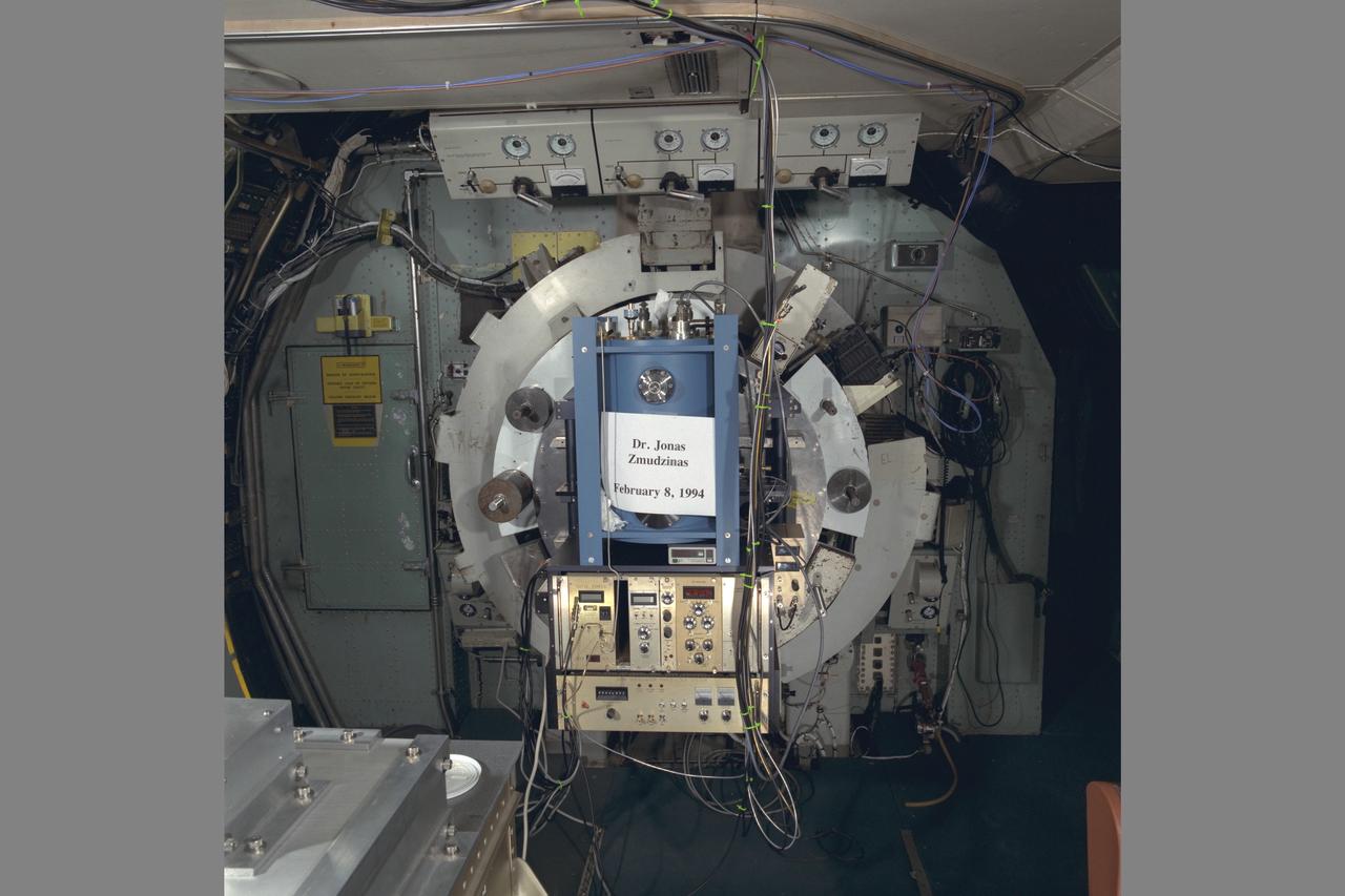
C-141 KAO (NASA-714) with Dr Jonas Zmudzinas Experiment onboard
PULSED PLASMA THRUSTER CAPACITOR OPTIONS
STS062-52-025 (4-18 March 1994) --- Astronaut Pierre J. Thuot, mission specialist, works with the Middeck 0-Gravity Dynamics Experiment (MODE) aboard the earth-orbiting Space Shuttle Columbia. The reusable test facility is designed to study the nonlinear, gravity-dependent behavior of two types of space hardware -- contained fluids and (as depicted here) large space structures -- planned for future spacecraft.

STS064-23-025 (9-20 Sept. 1994) --- With scissors in hand, astronaut Jerry M. Linenger, STS-64 mission specialist, prepares to cut off a lengthy sheet of correspondence from ground controllers. Called the Thermal Imaging Printing System (TIPS), the message center occupies a stowage locker on the space shuttle Discovery's middeck. Astronaut L. Blaine Hammond, pilot, retrieves a clothing item from a nearby locker. Photo credit: NASA or National Aeronautics and Space Administration
SILICON CARBIDE GROWTH FACILITY - CLEAN ROOM FACILITY AND SURFACE ANALYTICAL LABS
STS059-306-034 (9-20 April 1994) --- The radiating transportation pattern of this 20th-Century urban plan is nicely displayed in this high-resolution photograph. Light-toned spots in the desert mark oil well sites; along the south edge of the scene, some dark residue remains from the fires set during the recent Gulf War. Blown sand has nearly hidden the soot and thick oil that were deposited on the surface. Nikon photograph, 300mm lens.
Navy Disestablishment Ceremony (NAS Moffett Field) and the handing off to NASA/AMES Research Center Director Dr. Ken Munechika (Moffett Federal Airfield MFA)
S94-36123 (June 1994) --- Astronaut Gregory J. Harbaugh, STS-71 mission specialist, sits in the rear station of a NASA T-38 jet trainer at Ellington Field. Harbaugh is in training for the STS-71 mission scheduled aboard the space shuttle Atlantis next year.

NASA PLUM BROOK B-2 FACILITY WITH DELTA III 2ND STAGE
STS059-L14-170 (9-20 April 1994) --- Orient with the sea at the left. Then Subic Bay is at the lower left corner, and Clark Air Force Base (abandoned after the eruption) is to the lower right of the volcano. A turquoise lake occupies the caldera just below the center of the photograph. Mount Pinatubo erupted in June, 1991 after several hundred years of quiescence. Eruptive activity has nearly ceased, but every torrential rain in this monsoonal climate causes renewed mud flows of a viscous slurry composed of volcanic ash and pumice. Shuttle crews have been photographing the mountain at every opportunity, to add documentation to unmanned-satellite, aerial, and ground-based observations of changes. SRL scientists will use the excellent radar imagery obtained during STS-59 to help discriminate among different kinds of volcanic material, and to extend their observations to other volcanoes around the world using future, perhaps unmanned, radar satellites. Linhof photograph.
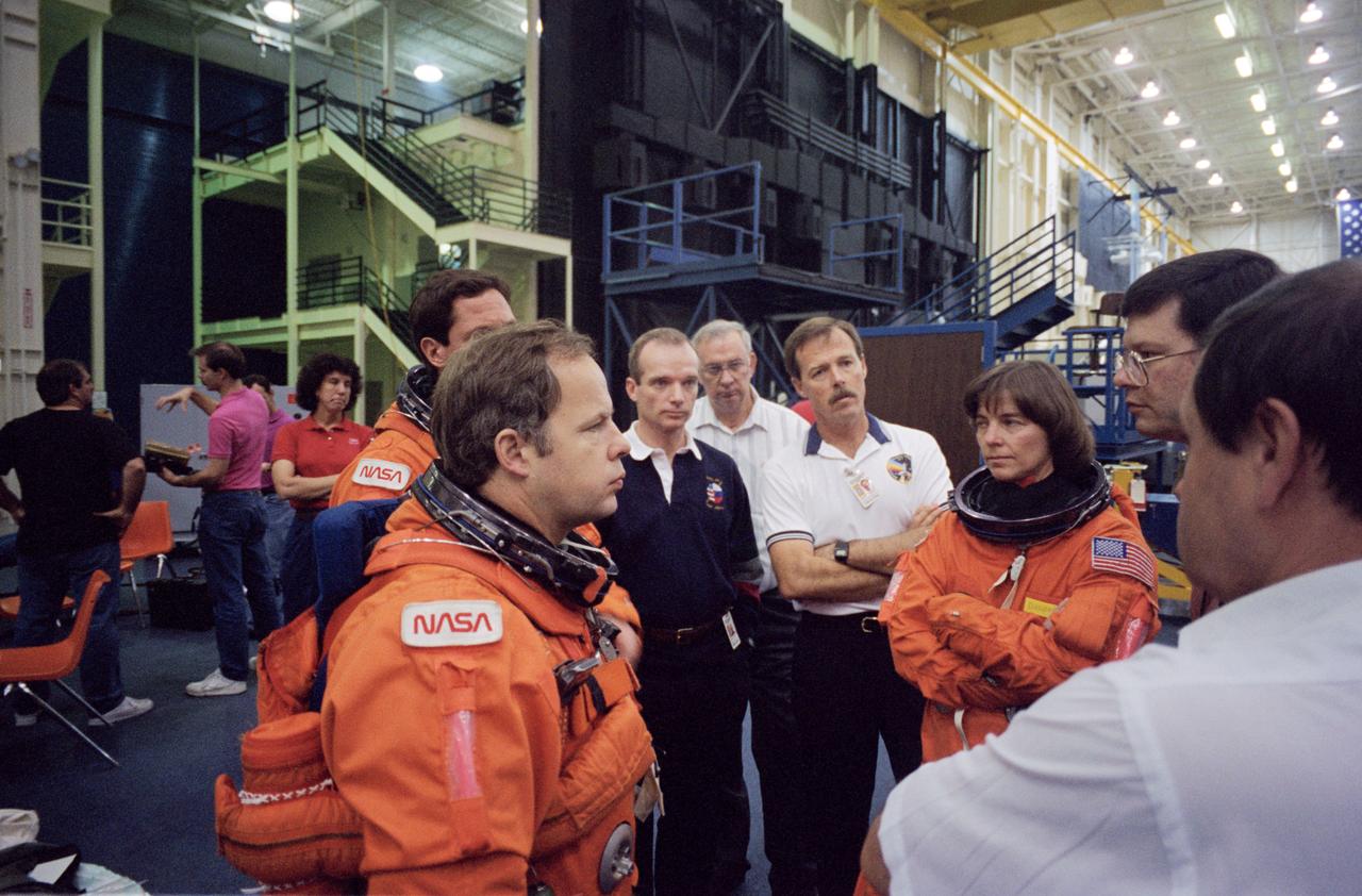
S94-47083 (14 Oct 1994) --- Cosmonaut Gennadiy M. Strekalov, Mir-18 flight engineer, who will return via the Space Shuttle Atlantis from a three-month mission aboard Russia's Mir Space Station, joins the STS-71 crew members during emergency egress training. The training took place in the systems integration facility at the Johnson Space Center (JSC). In a precedent-setting flight, NASA astronaut Norman E. Thagard will be launched with Vladimir N. Dezhurov and Strekalov to the Mir Space Station early next year for a three month mission. Then in late May, as the assignment of STS-71, the Space Shuttle Atlantis will rendezvous with Mir to pick up the Mir 18 crew and transfer two other cosmonauts to the station for the Mir 19 mission.
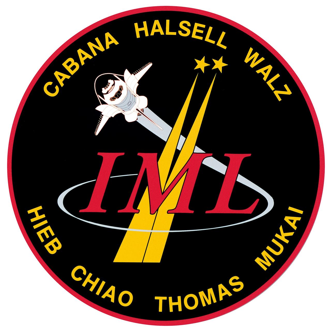
STS065-S-048 (8 July 1994) --- The Space Shuttle Columbia, with six NASA astronauts and a Japanese payload specialist aboard, heads toward Earth-orbit. A short time later, the crew began setting up the science module for two weeks of experimentation in support of the second International Microgravity Laboratory (IML-2). Launch occurred at 12:43 p.m. (EDT), July 8, 1994. Onboard were astronauts Robert D. Cabana, James D. Halsell, Jr., Richard J. Hieb, Carl E. Walz, Leroy Chiao, and Donald A. Thomas along with NASDA payload specialist Dr. Chiaki Mukai.
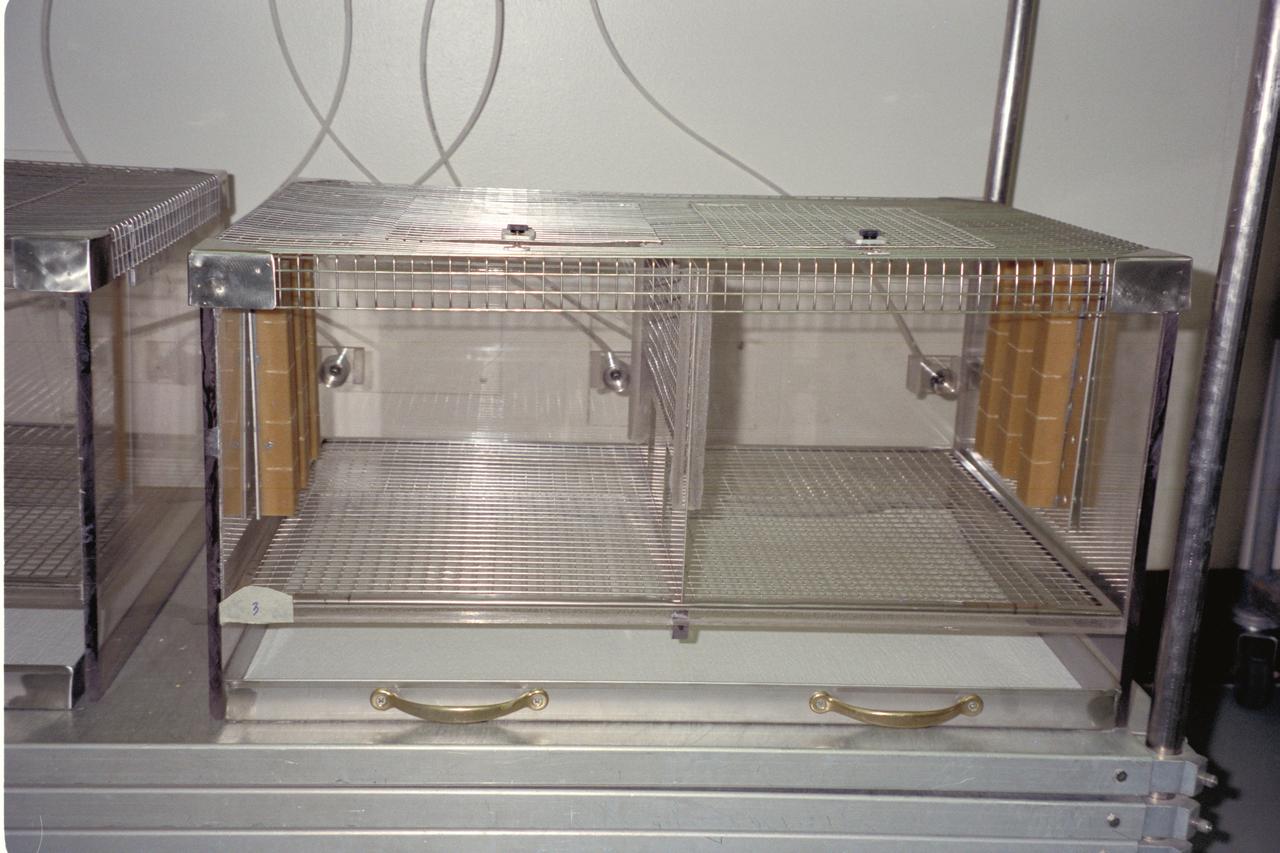
N-213 Advanced Animal Habitat (AAH)
Space Shuttle Columbia (STS-62) onboard photo of Astronaut Charles (Sam) Gemar talking to ground controllers while assisting astronaut Andrew M. Allen with a soak in the Lower Body Negative Pressure (LBNP) apparatus on the middeck.
On the Space Shuttle Atlantis' mid-deck, astronaut Joseph R. Tanner, mission specialist, works at area amidst several lockers onboard the Shuttle which support the Protein Crystal Growth (PCG) experiment. This particular section is called the Crystal Observation System, housed in the Thermal Enclosure System (COS/TES). Together with the Vapor Diffusion Apparatus (VDA), housed in a Single Locker Thermal Enclosure (SLTES) which is out of frame, the Cos/TES represents the continuing research into the structures of proteins and other macromolecules such as viruses.

A photograph of a tree near the N-260 Fluid Mechanics Laboratory building.
STS059-35-023 (9-20 April 1994) --- Astronaut Kevin P. Chilton, pilot, works with an advanced cell bioreactor, which incorporated the first ever videomicroscope, Space Tissue Loss (STL-B), on the Space Shuttle Endeavour's middeck. This experiment studied cell growth during the STS-59 mission. Chilton was joined in space by five other NASA astronauts for a week and a half of support to the Space Radar Laboratory (SRL-1) mission and other tasks.
LASER Velocimetry System for Flow Measurement. Advanced Short Takeoff and Vertical Landing, ASTOVL model n the 9x15 foot Low Speed Wind Tunnel, LSWT
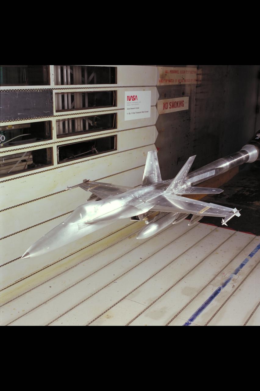
F/A-18 E/F Model: 11ft. W.T. Test #207-1-11 (February and March)
55% Sharc Model Test, 40 x 80 W.T. Test-597 (Subsonic High Alpha Res Concept) Moved from Model Shop to 40 x 80 W.T.
S94-29978 (8 March 1994) --- Astronaut Donald A. Thomas, mission specialist, prepares to be lowered into a 25-feet deep pool at the Johnson Space Center's (JSC) Weightless Environment Training Facility (WET-F). Astronauts Thomas and Leroy Chiao were about to be submerged and made to be neutrally buoyant in order to rehearse several contingency tasks that would require a spacewalk. No spacewalks are scheduled for the International Microgravity Laboratory (IML-2).
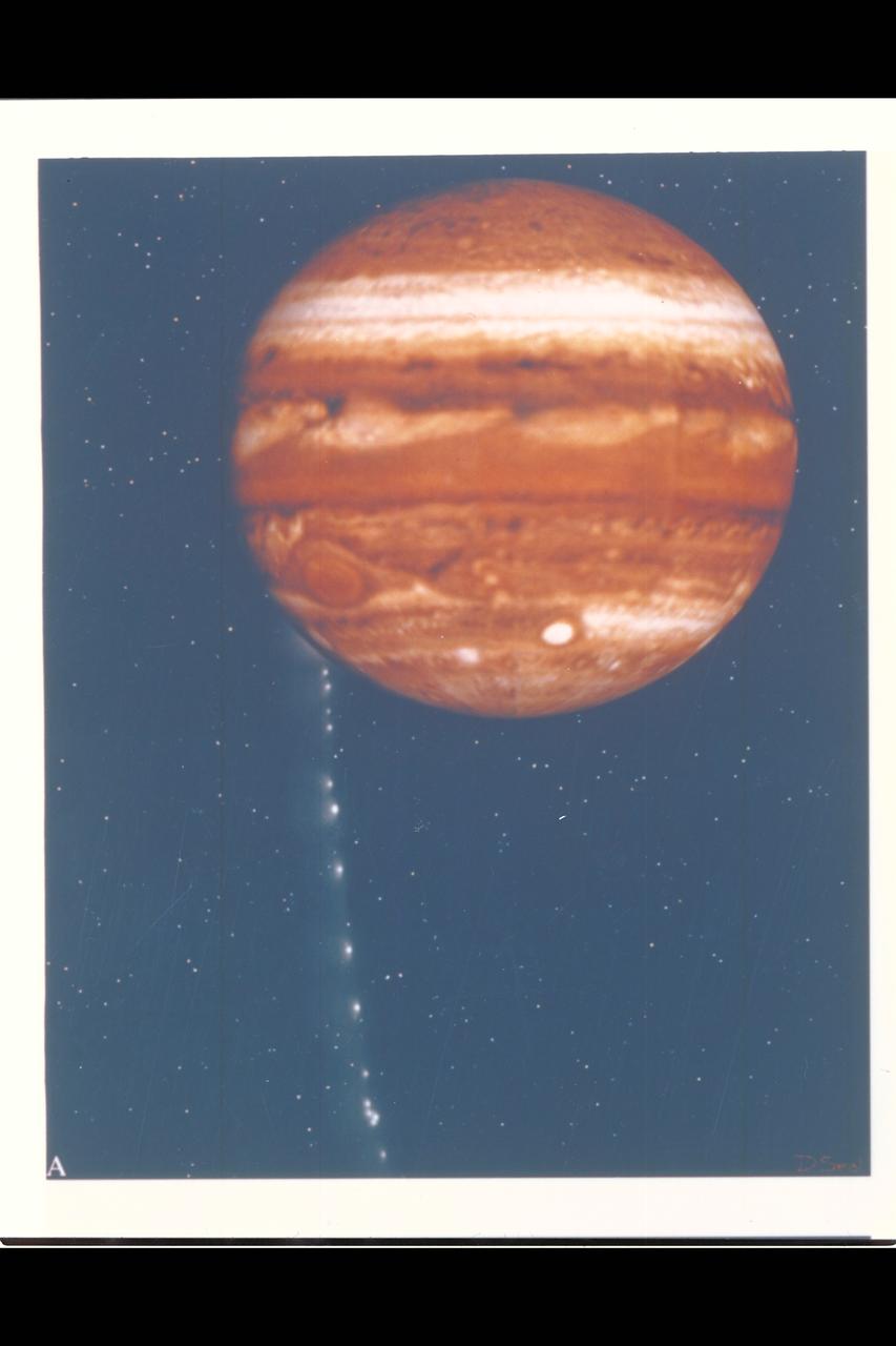
Photo Artwork composite by JPL This depiction of comet Shoemaker-Levy 9 impacting Jupiter is shown from several perspectives. IMAGE A is shown from the perspective of Earth based observers. For visual appeal, most of the large cometary fragments are shown close to one another in this image. At the time of Jupiter impact, the fragments will be separated from one another by serveral times the distances shown. This image was created by D.A. Seal of JPL's Mission Design Section using orbital computations provIded by P.W. Chodas and D.K. Yeomans of JPL's Navigation Section.
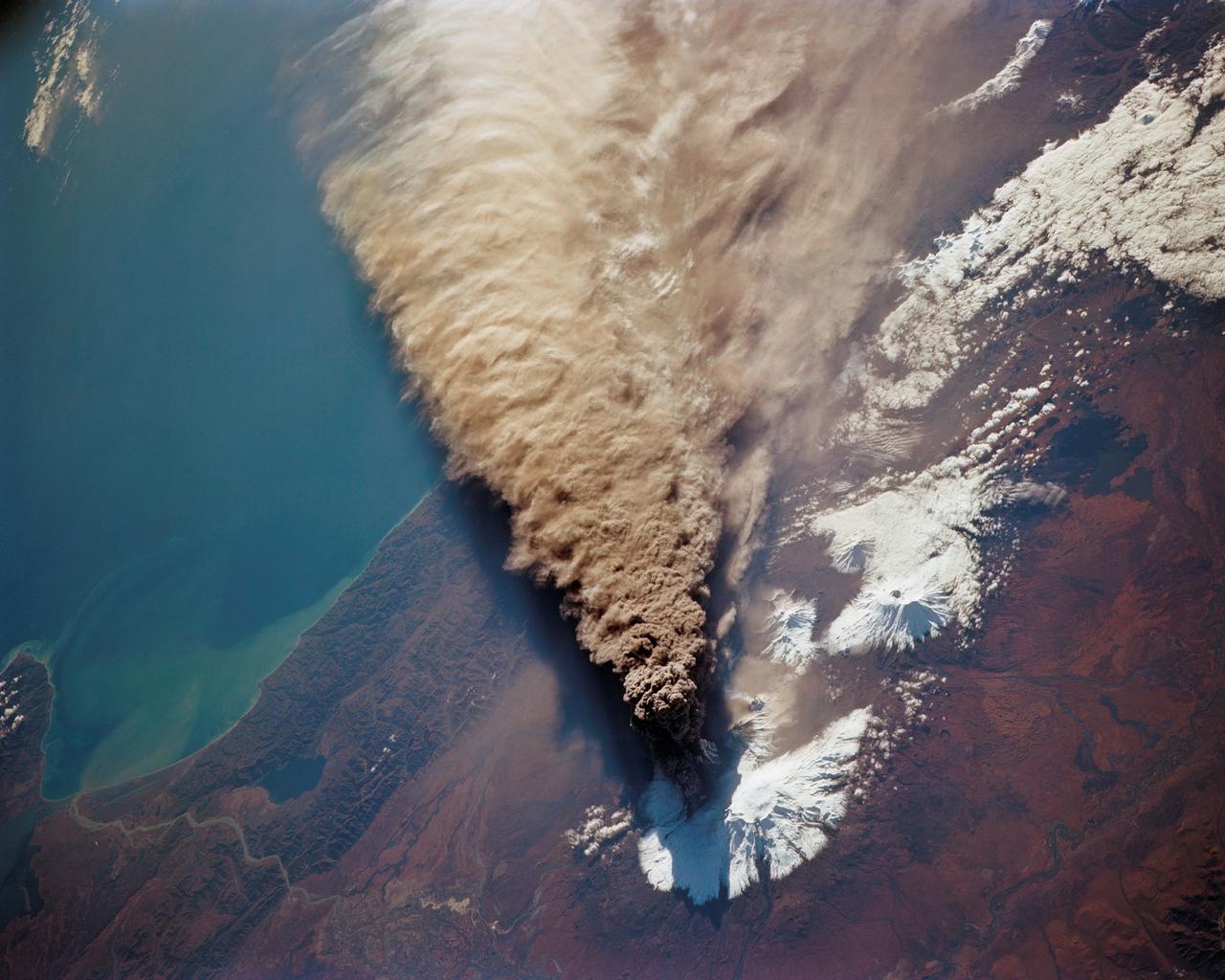
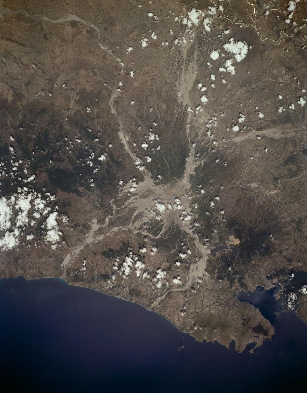
STS068-150-045 (30 September 1994) --- (Kliuchevskoi Volcano) The major eruption that began September 30, 1994 (launch day) got almost immediate coverage by the astronauts aboard the Space Shuttle Endeavour. The eruption cloud reached 60,000 feet above sea level, and the winds carried ash as far as 640 miles southeast from the volcano into the North Pacific air routes. This picture was made with a large format Linhof camera. While astronauts used handheld camera's to keep up with the Kamchatka event, instruments in the cargo bay of Endeavour recorded data to support the Space Radar Laboratory (SRL-2) mission.
STS065-S-001 (March 1994) --- Designed by the crew members, the STS-65 insignia features the International Microgravity Laboratory (IML-2) mission and its Spacehab module which will fly aboard the space shuttle Columbia. IML-2 is reflected in the emblem by two gold stars shooting toward the heavens behind the IML lettering. The space shuttle Columbia is depicted orbiting the logo and reaching into space, with Spacehab on an international quest for a better understanding of the effects of spaceflight on materials processing and life sciences. The NASA insignia design for space shuttle flights is reserved for use by the astronauts and for other official use as the NASA Administrator may authorize. Public availability has been approved only in the forms of illustrations by the various news media. When and if there is any change in this policy, which is not anticipated, the change will be publicly announced. Photo credit: NASA

STS064-16-031 (19-20 Sept. 1994) --- On the space shuttle Discovery's middeck, astronaut Carl J. Meade checks a hose associated with the new Simplified Aid for EVA Rescue (SAFER) system prior to a Extravehicular Activity (EVA) that tested SAFER. On the Sept. 16, 1994 EVA, astronauts Meade and Mark C. Lee took turns using the SAFER hardware. The test of SAFER is the first phase of a larger SAFER program whose objectives are to establish a common set of requirements for both space shuttle and space station program needs, develop a flight demonstration of SAFER, validate system performance and, finally, develop a production version of SAFER for the shuttle and station programs. Photo credit: NASA or National Aeronautics and Space Administration
High Speed Research (HSR) Source Noise Test-592, 40x80ft w.t.

A photograph of a tree near the N-260 Fluid Mechanics Laboratory building.
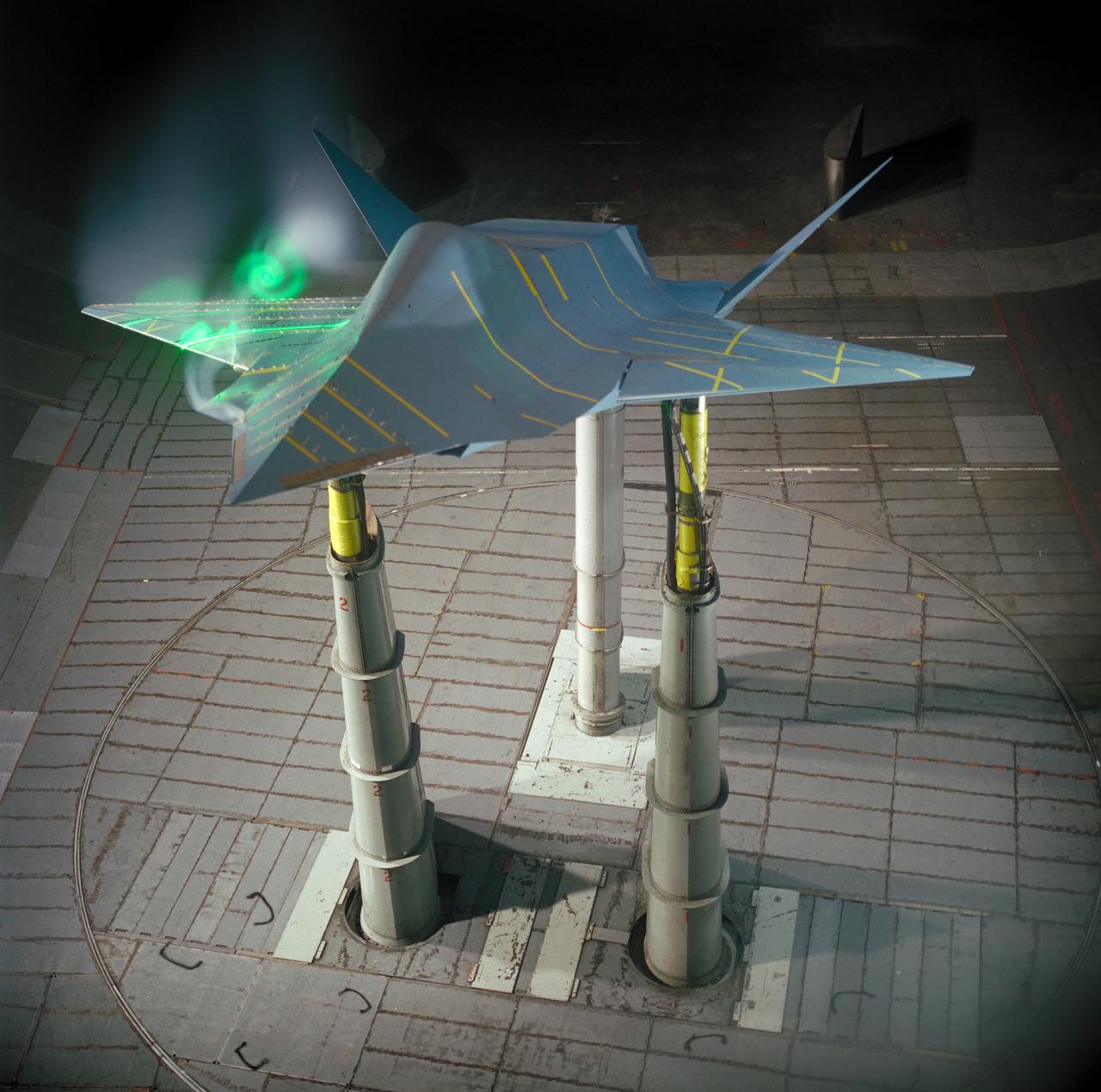
55% SHARC (Subsonic High Alpha Research Concept) Model test-597 in 40x80 ft. w.t. during laser sheet phase of testing with vortices forming
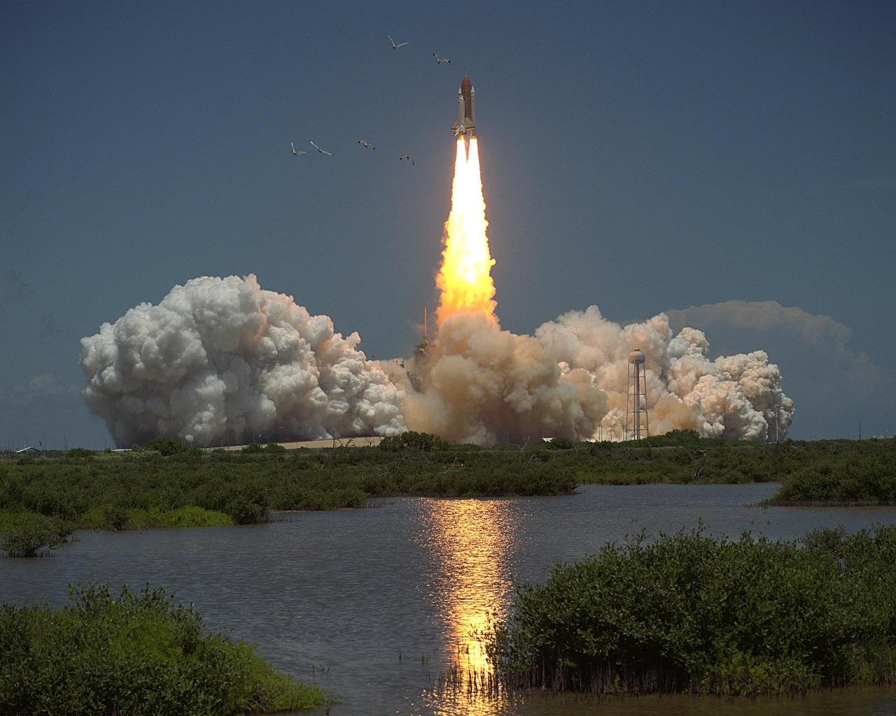
STS066-S-013 (3 November 1994) --- The Space Shuttle Atlantis returns to work after a refurbishing and a two-year layoff, as liftoff for the mission occurs at noon (EDT), November 3, 1994. Five NASA astronauts and a European mission specialist are onboard for the Atmospheric Laboratory for Applications and Science (ATLAS-3) mission. A 35mm camera was used to record the image. Onboard were astronauts Donald R. McMonagle, mission commander; Curtis L. Brown, Jr., pilot; Ellen Ochoa, payload commander; and Scott E. Parazynski, Joseph R. Tanner and Jean-Francois-Clervoy, all mission specialists. Clervoy represents the European Space Agency (ESA).
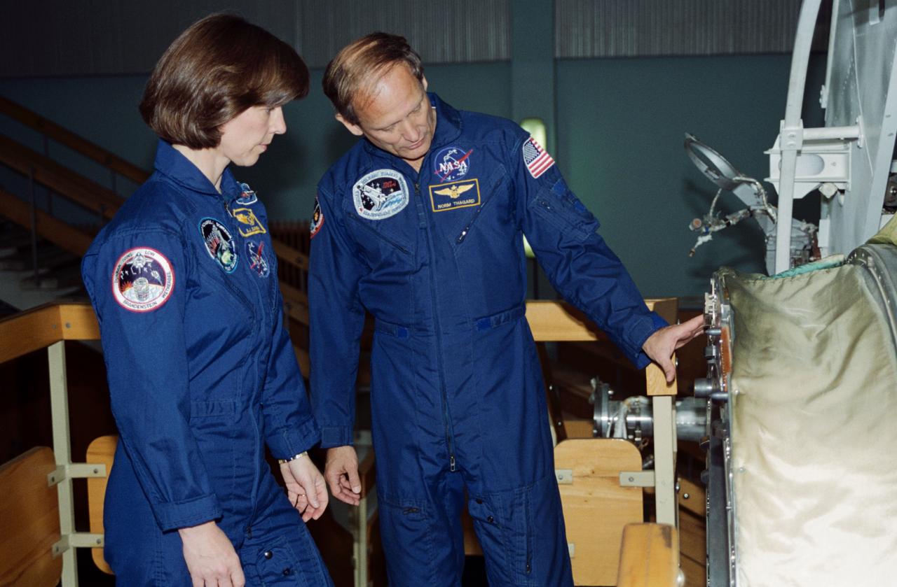
S94-45647 (20 Sept 1994) --- Astronaut's Norman E. Thagard and Bonnie J. Dunbar by the Mir Space Station simulator at the Gagarin Cosmonaut Training Center (Star City), near Moscow, Russia. In March 1995, astronaut Thagard is scheduled to be launched in a Russian Soyuz spacecraft with two cosmonauts to begin a three-month tour of duty on the Russian Mir Space Station. Thagard, along with his back-up, astronaut Dunbar, has been training in Russia since February 1994. During his stay on Mir, he will conduct a variety of life sciences experiments that will provide U.S. investigators with the first long-duration exposure data since Skylab in the late 1970's. Thagard's mission will end in late May or early June when the Space Shuttle Atlantis, carrying the newly installed docking mechanism, docks with Mir Space Station for the first United States - Russian docking operation since Apollo-Soyuz in 1975. The Orbiter will remain attached to Mir for five days of joint scientific operations before returning home with Thagard and his Russian crew mates and leaving behind two cosmonauts on Mir.
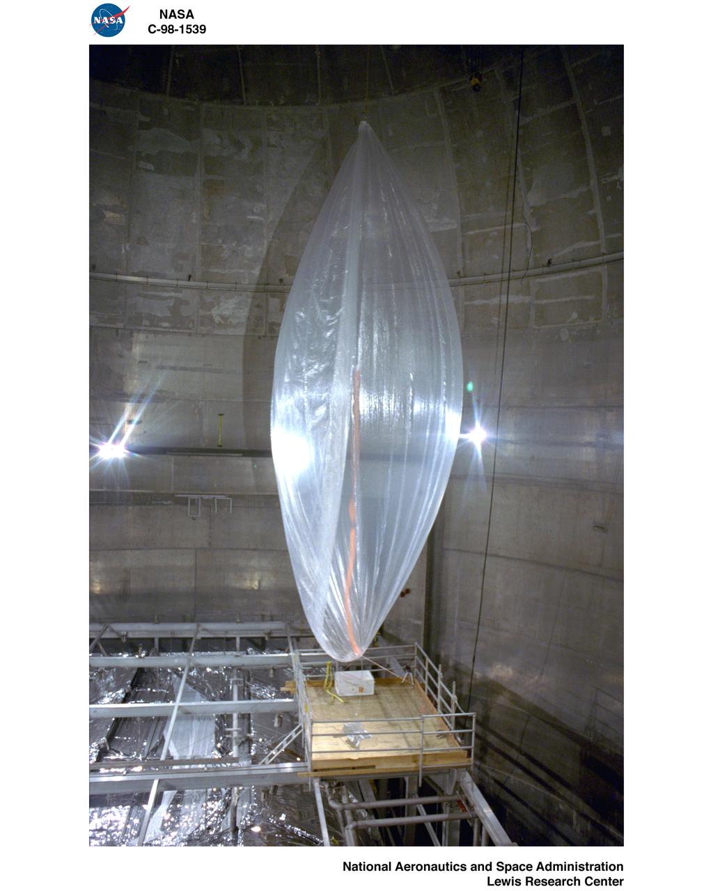
MARS BALLOON INFLATION TEST IN THE SPACE POWER FACILITY SPF AT NASA PLUM BROOK STATION
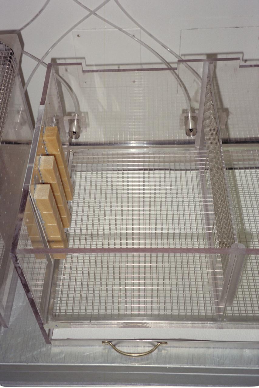
N-213 Advanced Animal Habitat (AAH)