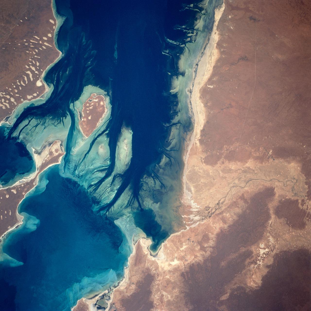
STS035-81-040 (2-10 Dec 1990) --- Numerous algae reefs are seen in Shark Bay, Western Australia, Australia (26.0S, 113.5E) especially in the southern portions of the bay. The south end is more saline because tidal flow in and out of the bay is restricted by sediment deposited at the north and central end of the bay opposite the mouth of the Wooramel River. This extremely arid region produces little sediment runoff so that the waters are very clear, saline and rich in algae.
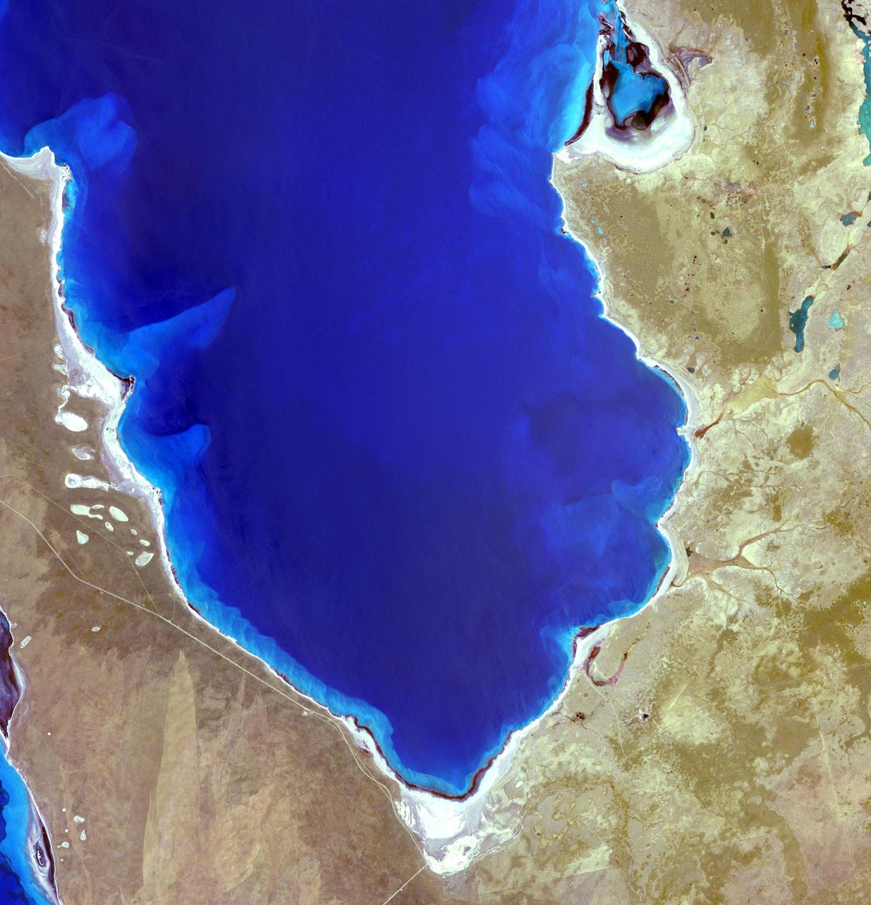
AST-16-1132 (20 July 1975) --- A vertical view of the eastern portion of the state of South Australia in Australia, as photographed from the Apollo spacecraft in Earth orbit during the joint U.S.-USSR Apollo-Soyuz Test Project mission. The highlands area is the Flinders Range. The light-colored body of water is Lake Blanche. The lake to the south is Callabonna. This picture was taken at an altitude of 224 kilometers (139 statute miles) with a 70mm Hasselblad camera using high-definition aerial Ektachrome SO-242 type film.
Lake Mackay is the largest of hundreds of ephemeral lakes scattered throughout Western Australia and the Northern Territory, and is the second largest lake in Australia. The darker areas indicate some form of desert vegetation or algae, moisture within the soils, and lowest elevations where water pools. The image was acquired on September 19, 2010 and covers an area of 27 x 41 km. With its 14 spectral bands from the visible to the thermal infrared wavelength region and its high spatial resolution of 15 to 90 meters (about 50 to 300 feet), ASTER images Earth to map and monitor the changing surface of our planet. ASTER is one of five Earth-observing instruments launched Dec. 18, 1999, on Terra. The instrument was built by Japan's Ministry of Economy, Trade and Industry. A joint U.S./Japan science team is responsible for validation and calibration of the instrument and data products. The broad spectral coverage and high spectral resolution of ASTER provides scientists in numerous disciplines with critical information for surface mapping and monitoring of dynamic conditions and temporal change. Example applications are: monitoring glacial advances and retreats; monitoring potentially active volcanoes; identifying crop stress; determining cloud morphology and physical properties; wetlands evaluation; thermal pollution monitoring; coral reef degradation; surface temperature mapping of soils and geology; and measuring surface heat balance. The U.S. science team is located at NASA's Jet Propulsion Laboratory, Pasadena, Calif. The Terra mission is part of NASA's Science Mission Directorate, Washington, D.C. More information about ASTER is available at <a href="http://asterweb.jpl.nasa.gov/" rel="nofollow">asterweb.jpl.nasa.gov/</a>. Image Credit: NASA/GSFC/METI/ERSDAC/JAROS, and U.S./Japan ASTER Science Team
AST-19-1550 (24 July 1975) --- A vertical view of the Lake Eyre Basin area in the state of South Australia in Australia, as photographed from the Apollo spacecraft in Earth orbit during the joint U.S.-USSR Apollo-Soyuz Test Project mission. The picture was taken at an altitude of 241 kilometers (150 statute miles) with a 70mm Hasselblad camera using medium-speed Ektachrome QX-807 type film.

In late July 2013, a low pressure system off Australia’s southeast coast and moist onshore winds combined to create unsettled weather across central Australia – and a striking image of a broad cloud band across the stark winter landscape. The Moderate Resolution Imaging Spectroradiometer (MODIS) aboard NASA’s Terra satellite captured this true-color image on July 22 at 01:05 UTC (10:35 a.m. Australian Central Standard Time). To the west of the low pressure trough the skies are clear and dry. To the east, the broad band of bright white clouds obscures the landscape. The system brought wind, precipitation and cooler temperatures to the region. The same day as MODIS captured this image, the Naval Research Lab (NRL) published an edition of the Global Storm Tracker (GST), which gave a world-wide view of the low-pressure systems across the world. This tracker shows the entire cloud band across Australia, as well as the location of the low pressure system. A good view of the Storm Tracker is provided by Red Orbit at: <a href="http://www.redorbit.com/media/uploads/2013/07/072213-weather-003-storm-tracker.jpg" rel="nofollow">www.redorbit.com/media/uploads/2013/07/072213-weather-003...</a> Credit: NASA/GSFC/Jeff Schmaltz/MODIS Land Rapid Response Team <b><a href="http://www.nasa.gov/audience/formedia/features/MP_Photo_Guidelines.html" rel="nofollow">NASA image use policy.</a></b> <b><a href="http://www.nasa.gov/centers/goddard/home/index.html" rel="nofollow">NASA Goddard Space Flight Center</a></b> enables NASA’s mission through four scientific endeavors: Earth Science, Heliophysics, Solar System Exploration, and Astrophysics. Goddard plays a leading role in NASA’s accomplishments by contributing compelling scientific knowledge to advance the Agency’s mission. <b>Follow us on <a href="http://twitter.com/NASA_GoddardPix" rel="nofollow">Twitter</a></b> <b>Like us on <a href="http://www.facebook.com/pages/Greenbelt-MD/NASA-Goddard/395013845897?ref=tsd" rel="nofollow">Facebook</a></b> <b>Find us on <a href="http://instagram.com/nasagoddard?vm=grid" rel="nofollow">Instagram</a></b>
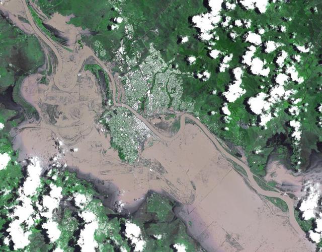
On Jan. 7, 2011, NASA Terra spacecraft captured this image of the inundated city of Rockhampton, Queensland, Australia. Torrential rains in NE Australia caused the Fitzroy River to overflow its banks and flood much of the city.

This image from NASA Terra spacecraft shows Lake Mackay, the largest of hundreds of ephemeral lakes scattered throughout Western Australia and the Northern Territory, and is the second largest lake in Australia.
Hamelin Pool Marine Nature Reserve is located in the Shark Bay World Heritage Site in Western Australia. It is one of the very few places in the world where living stromatolites can be found. These are the first living examples of structures built by cyanobacteria. These bacteria are direct descendants of the oldest form of photosynthetic life on earth, dating back 3,500 million years (Wikipedia). The image was acquired December 30, 2010, covers an area of 34 x 46 km, and is located at 26.4 degrees south latitude, 114.1 degrees east longitude. With its 14 spectral bands from the visible to the thermal infrared wavelength region and its high spatial resolution of 15 to 90 meters (about 50 to 300 feet), ASTER images Earth to map and monitor the changing surface of our planet. ASTER is one of five Earth-observing instruments launched Dec. 18, 1999, on Terra. The instrument was built by Japan's Ministry of Economy, Trade and Industry. A joint U.S./Japan science team is responsible for validation and calibration of the instrument and data products. The broad spectral coverage and high spectral resolution of ASTER provides scientists in numerous disciplines with critical information for surface mapping and monitoring of dynamic conditions and temporal change. Example applications are: monitoring glacial advances and retreats; monitoring potentially active volcanoes; identifying crop stress; determining cloud morphology and physical properties; wetlands evaluation; thermal pollution monitoring; coral reef degradation; surface temperature mapping of soils and geology; and measuring surface heat balance. The U.S. science team is located at NASA's Jet Propulsion Laboratory, Pasadena, Calif. The Terra mission is part of NASA's Science Mission Directorate, Washington, D.C. More information about ASTER is available at <a href="http://asterweb.jpl.nasa.gov/" rel="nofollow">asterweb.jpl.nasa.gov/</a>. Credit: NASA/GSFC/METI/ERSDAC/JAROS, and U.S./Japan ASTER Science Team Image Addition Date: 2013-03-15 <b><a href="http://www.nasa.gov/audience/formedia/features/MP_Photo_Guidelines.html" rel="nofollow">NASA image use policy.</a></b> <b><a href="http://www.nasa.gov/centers/goddard/home/index.html" rel="nofollow">NASA Goddard Space Flight Center</a></b> enables NASA’s mission through four scientific endeavors: Earth Science, Heliophysics, Solar System Exploration, and Astrophysics. Goddard plays a leading role in NASA’s accomplishments by contributing compelling scientific knowledge to advance the Agency’s mission. <b>Follow us on <a href="http://twitter.com/NASA_GoddardPix" rel="nofollow">Twitter</a></b> <b>Like us on <a href="http://www.facebook.com/pages/Greenbelt-MD/NASA-Goddard/395013845897?ref=tsd" rel="nofollow">Facebook</a></b> <b>Find us on <a href="http://instagram.com/nasagoddard?vm=grid" rel="nofollow">Instagram</a></b>
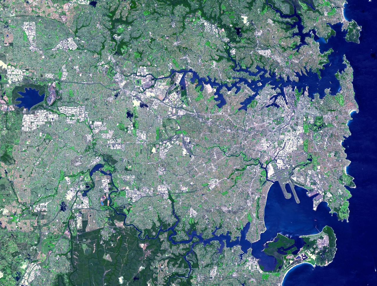
This spaceborne radar image is dominated by the metropolitan area of Australia largest city, Sydney.
The light corner of the image from NASA EarthKAM is Lake Torrens, an ephemeral salt lake in South Australia. The twisted strata visible here is part of a rocky desert area in the Australian Outback.
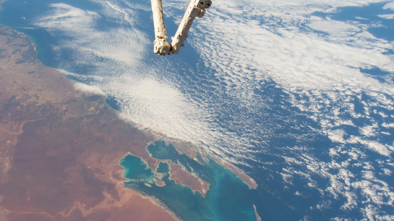
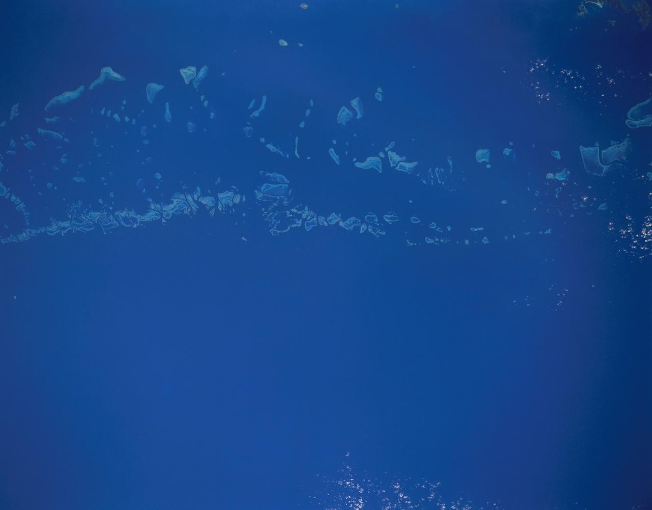
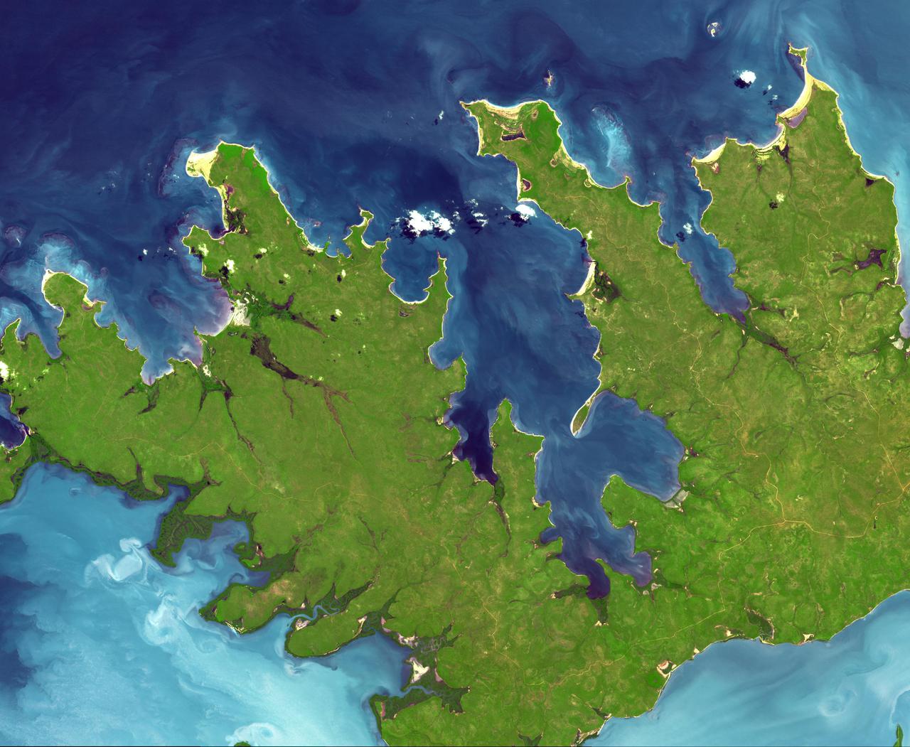
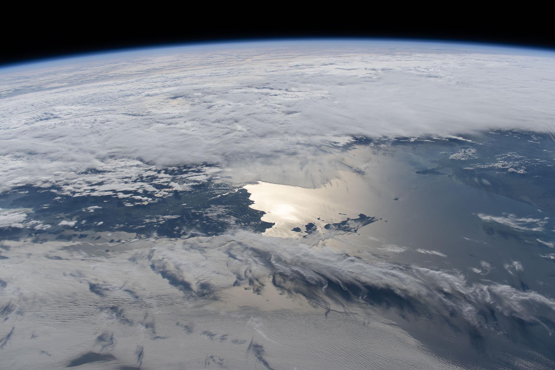
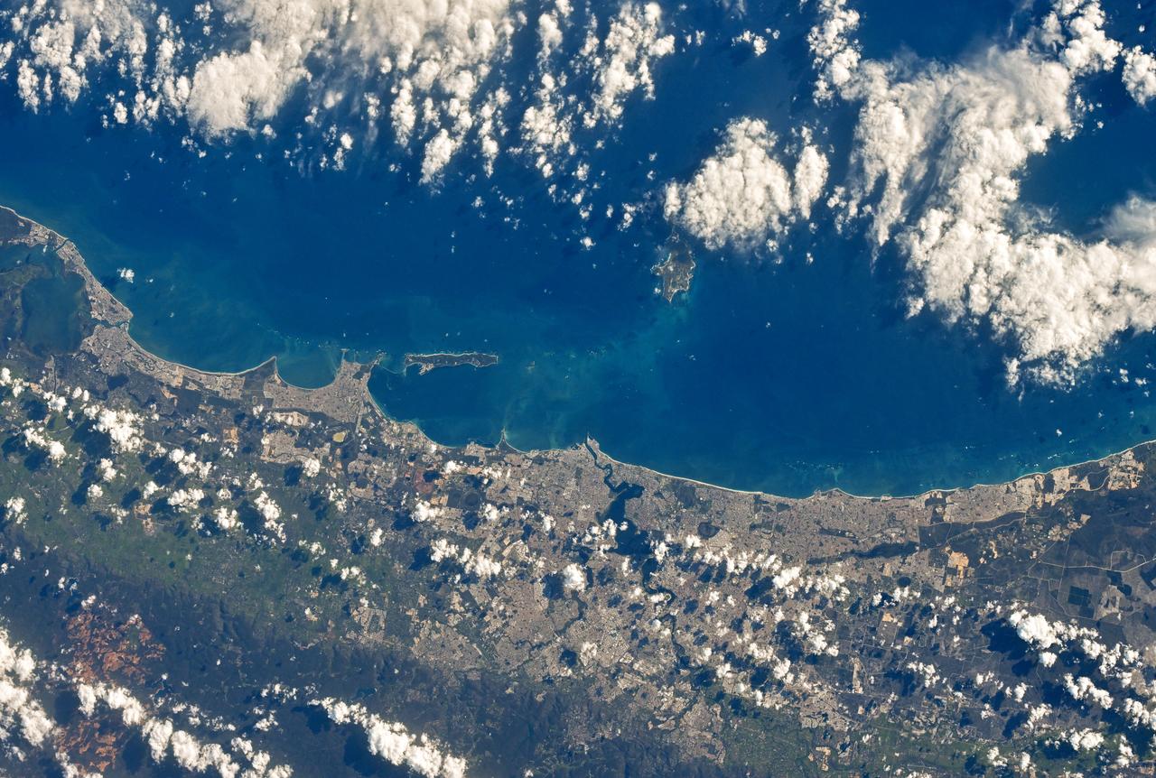
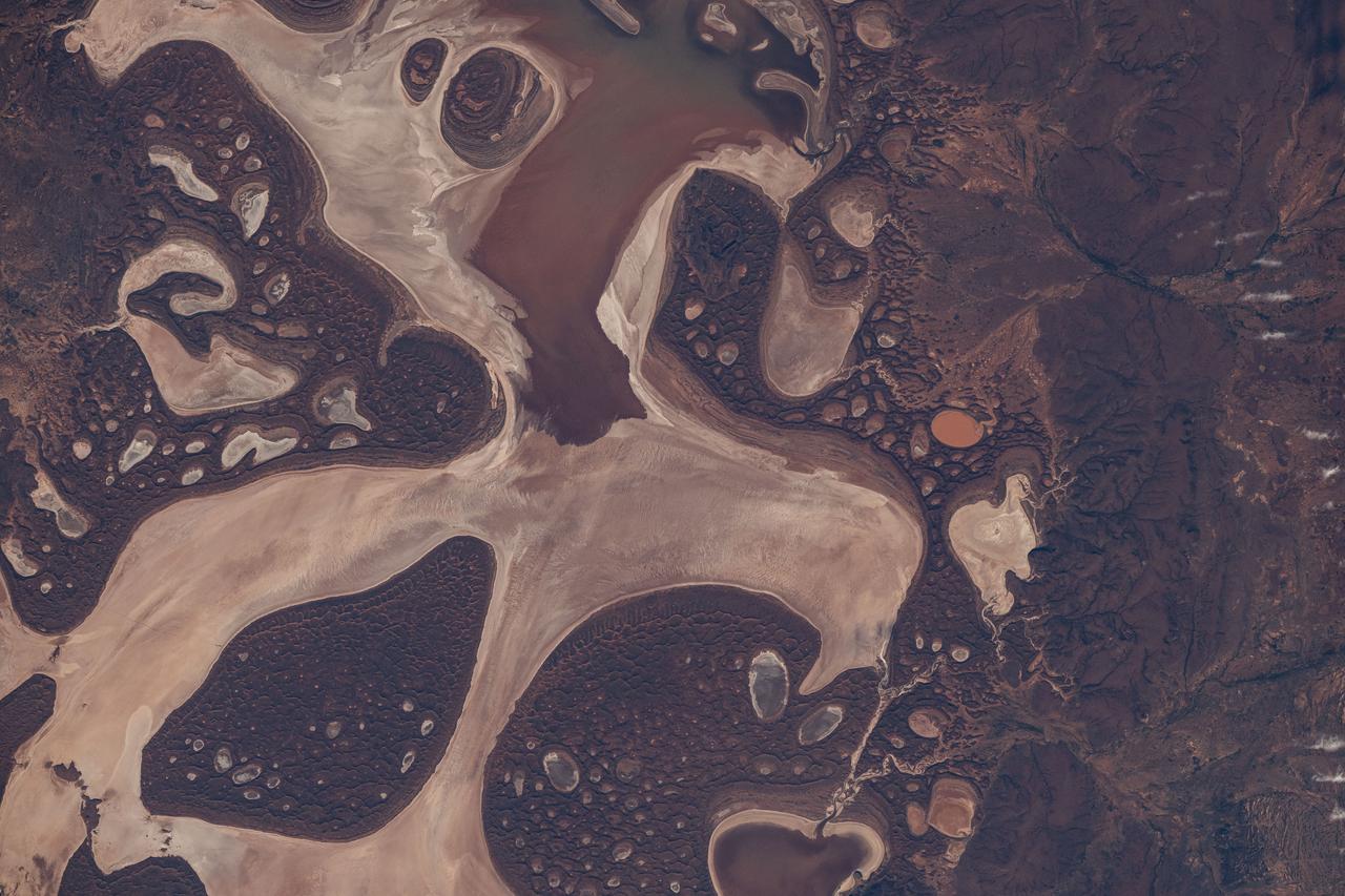
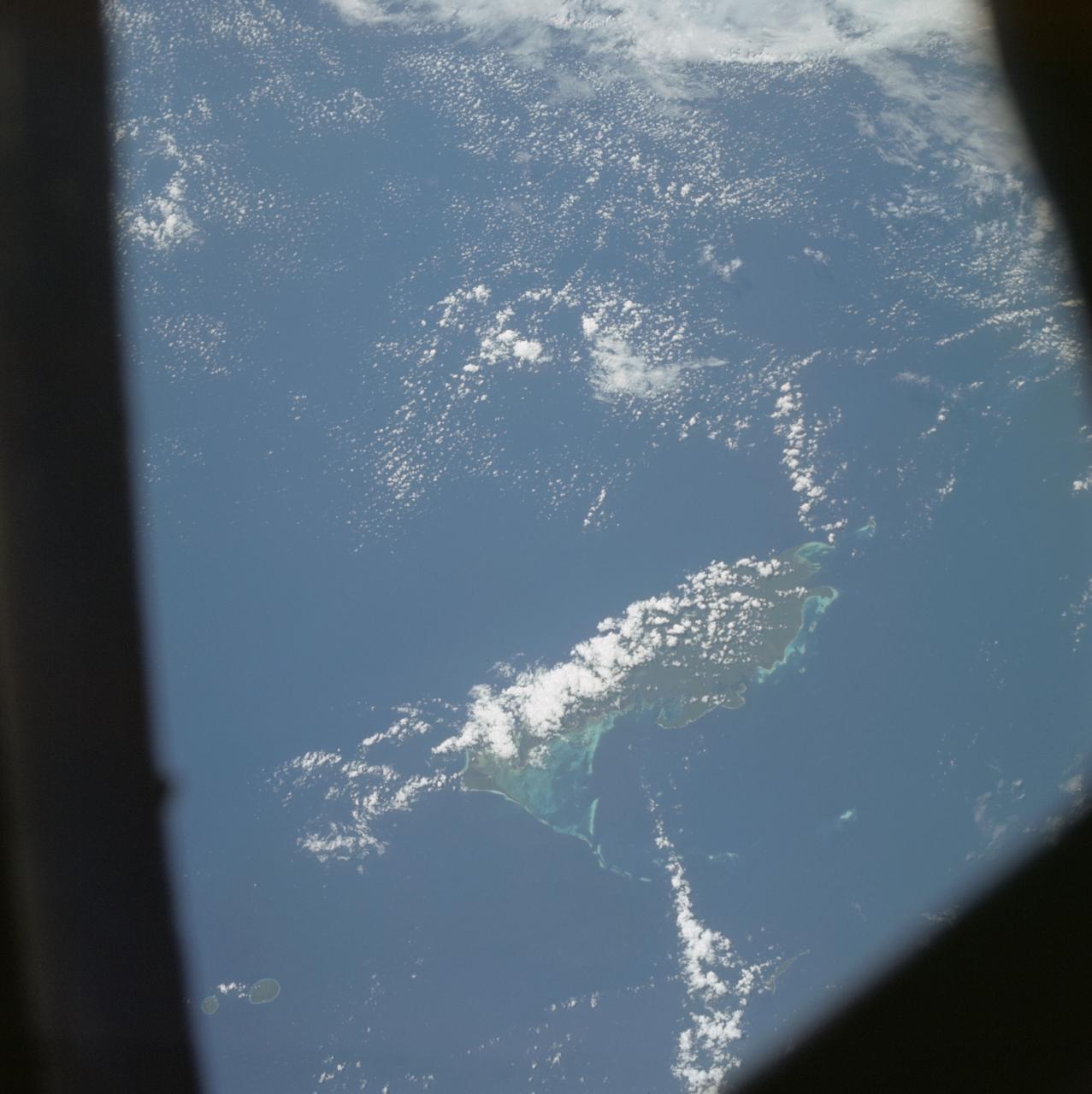
iss058e002638 (Jan. 14, 2019) --- Australia's Shark Bay, the Indian Ocean and the elbow of the Canadarm2 robotic arm are pictured as the International Space Station orbited nearly 256 miles above the state of Western Australia.
On Jan. 14, 2011, NASA Terra spacecraft captured this image of the inundated city of St. George, Queensland, Australia. Torrential rains in northeastern Australia caused the Balonne River to overflow its banks and flood much of the city.
This image acquired by NASA Terra spacecraft is of Kalgoorlie-Boulder, a city in the Goldfields-Esperance region of Western Australia.
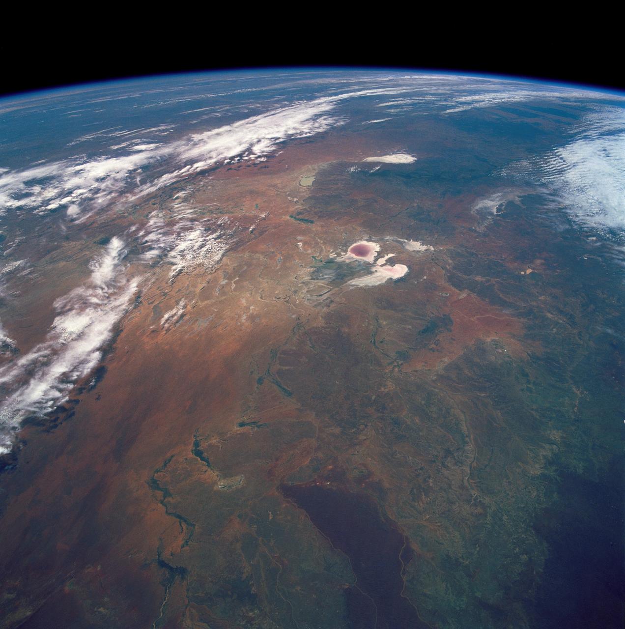
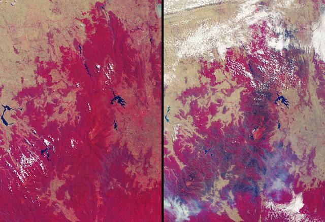
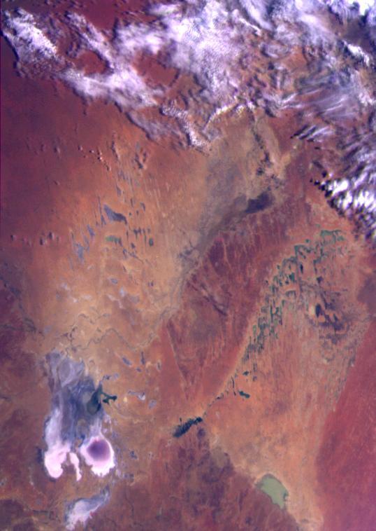
STS035-501-007 (2-10 Dec. 1990) --- The STS-35 crewmembers aboard the Earth-orbiting Space Shuttle Columbia photographed this view of the Arid Simpson Desert of Australia with a handheld Rolleiflex camera. Lake Eyre is normally dry; however, the STS-35 crew was able to recognize water in the lowest parts of the lake (dark pink area) and possibly in Lake Blanche east of Lake Eyre. Lake Frome lies in the distance separated from Lake Torrens (top right) by dark hills of Flinders Range. The Finke River (bottom left to middle) flows into the Eyre basin from the northwest. Although it is the largest river entering the basin, Finke's floods seldom reach Lake Eyre. The dark brown patch in the foreground is an area of ancient, brown lateritic soils partly covered by dunes.
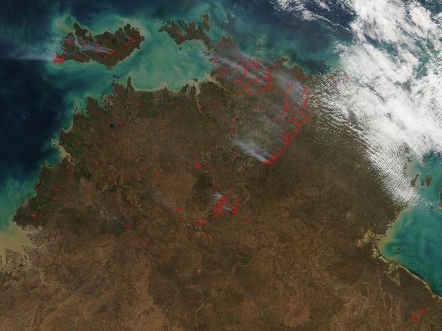
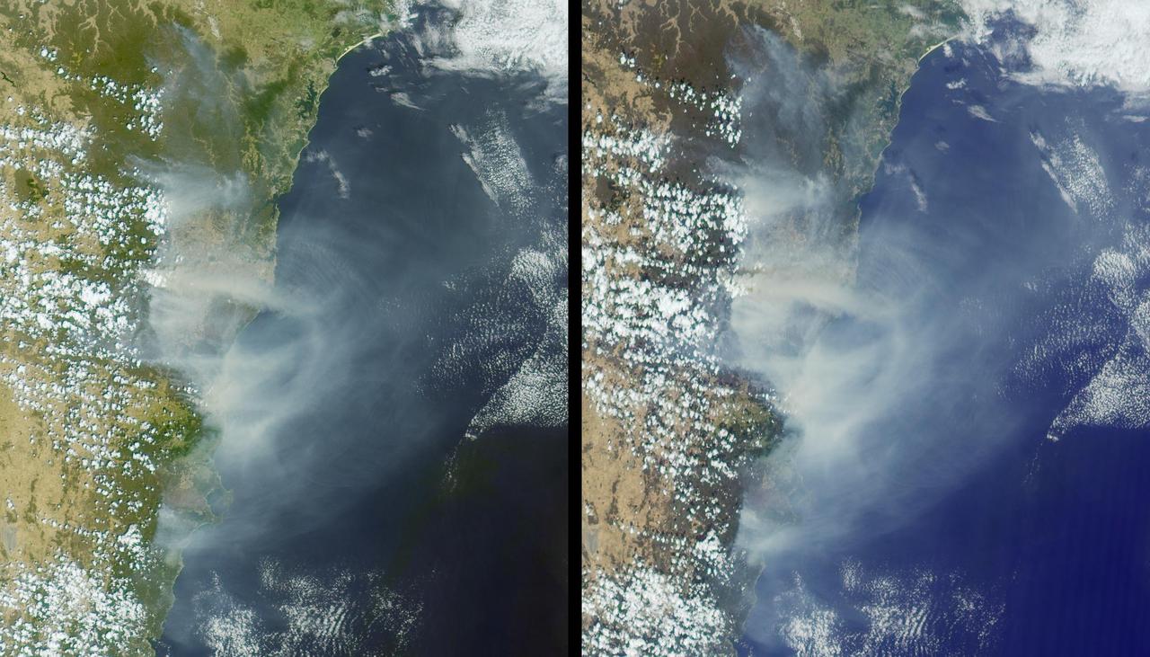
The Aqua satellite collected this natural-color image of fires in Australia with the Moderate Resolution Imaging Spectroradiometer (MODIS) instrument on June 30, 2017. The image looks at multiple fires and smoke from those fires burning in northern Australia and the island of Bathurst on June 30, 2017. The Northern Territory fire incident map does show some incidents of grass and shrub fires, in the past 24 hours, but it also shows areas of what are called "strategic fires" which are those set by fire experts to rid an area of overgrowth, brush, dead grass and shrubs to prevent fires from spreading in the event of a lightning strike. NASA image courtesy Jeff Schmaltz, MODIS Rapid Response Team <b><a href="http://www.nasa.gov/audience/formedia/features/MP_Photo_Guidelines.html" rel="nofollow">NASA image use policy.</a></b> <b><a href="http://www.nasa.gov/centers/goddard/home/index.html" rel="nofollow">NASA Goddard Space Flight Center</a></b> enables NASA’s mission through four scientific endeavors: Earth Science, Heliophysics, Solar System Exploration, and Astrophysics. Goddard plays a leading role in NASA’s accomplishments by contributing compelling scientific knowledge to advance the Agency’s mission. <b>Follow us on <a href="http://twitter.com/NASAGoddardPix" rel="nofollow">Twitter</a></b> <b>Like us on <a href="http://www.facebook.com/pages/Greenbelt-MD/NASA-Goddard/395013845897?ref=tsd" rel="nofollow">Facebook</a></b> <b>Find us on <a href="http://instagrid.me/nasagoddard/?vm=grid" rel="nofollow">Instagram</a></b>
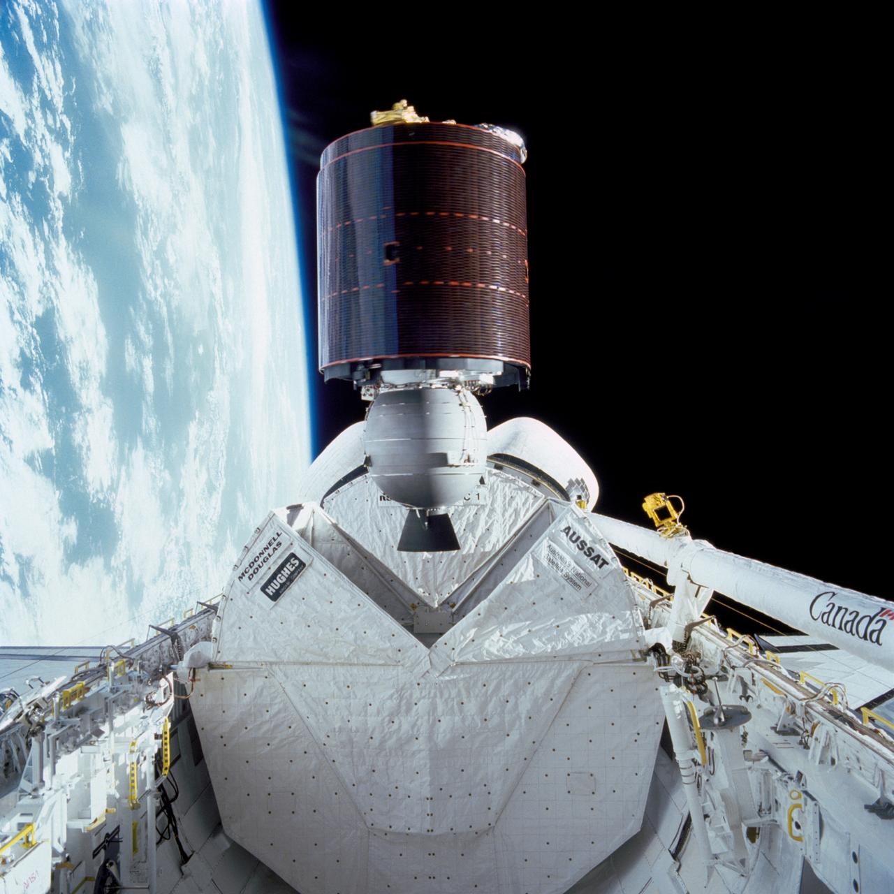
51I-32-023 (27 Aug. 1985) --- Australia's AUSSAT communications satellite is deployed from the payload bay of the space shuttle Discovery on flight day one. A portion of the cloudy surface of Earth can be seen to the left of the frame. Photo credit: NASA
Cairns and Townsville area, on the northeast coast of Queensland, Australia (17.0S, 146.0E) is one of the best sport diving localities in the world where divers can explore the rich and varied flora and fauna of the nearby Great Barrier Reef. Onshore, the timbered foothills of the Great Dividing Range, seen as dark green areas, separate the semi arid interior of Queensland.
Residents of the northeast coast of Queensland, Australia are facing high winds, dangerous tides and very heavy rain between Cape Melville and Cooktown. These hazards will migrate southward for the next few days as the center of the storm remains close to the coast. This image was taken by the Suomi NPP satellite's VIIRS instrument around 0335Z on April11, 2014. Credit: NASA/NOAA via <b><a href="www.nnvl.noaa.gov/" rel="nofollow"> NOAA Environmental Visualization Laboratory</a></b> <b><a href="http://www.nasa.gov/audience/formedia/features/MP_Photo_Guidelines.html" rel="nofollow">NASA image use policy.</a></b> <b><a href="http://www.nasa.gov/centers/goddard/home/index.html" rel="nofollow">NASA Goddard Space Flight Center</a></b> enables NASA’s mission through four scientific endeavors: Earth Science, Heliophysics, Solar System Exploration, and Astrophysics. Goddard plays a leading role in NASA’s accomplishments by contributing compelling scientific knowledge to advance the Agency’s mission. <b>Follow us on <a href="http://twitter.com/NASAGoddardPix" rel="nofollow">Twitter</a></b> <b>Like us on <a href="http://www.facebook.com/pages/Greenbelt-MD/NASA-Goddard/395013845897?ref=tsd" rel="nofollow">Facebook</a></b> <b>Find us on <a href="http://instagram.com/nasagoddard?vm=grid" rel="nofollow">Instagram</a></b>
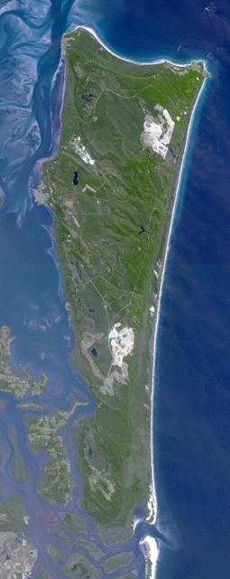
This image from NASA Terra spacecraft shows North Stradbroke Island, 30 km southeast of Brisbane, Australia, one of the largest sand islands in the world.

Acquired by NASA Terra spacecraft, this image shows Hamelin Pool Marine Nature Reserve, located in the Shark Bay World Heritage Site in Western Australia.
These images from NASA Terra satellite are of tropical northern Australia acquired on June 1, 2000 Terra orbit 2413 during the long dry season.
A major dust storm moved across the eastern and northeastern regions of Australia on Sept. 23, 2009, out towards the Pacific as seen by NASA Aqua satellite.
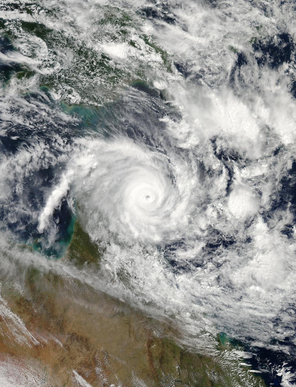
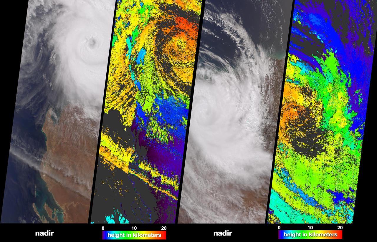
NASA image acquired January 30, 2011 at 23:20 UTC. Satellite: Terra <b> Click here to see the most recent image captured Feb. 1: <a href="http://www.flickr.com/photos/gsfc/5407540724/">www.flickr.com/photos/gsfc/5407540724/</a></b> Tropical Storm Anthony made landfall in Queensland, Australia this past weekend, and now the residents are watching a larger, more powerful cyclone headed their way. NASA's Terra satellite captured a visible image of the large Tropical Cyclone Yasi late yesterday as it makes its way west through the Coral Sea toward Queensland. The Moderate Resolution Imaging Spectroradiometer (MODIS) instrument that flies aboard NASA's Terra satellite captured an image of Cyclone Yasi on Jan. 30 at 23:20 UTC (6:20 p.m. EST/09:20 a.m., Monday, January 31 in Australia/Brisbane local time). Although the image did not reveal a visible eye, the storm appears to be well-formed and also appears to be strengthening. Warnings and watches are already in effect throughout the Coral Sea. The Solomon Islands currently have a Tropical Cyclone warning for the provinces of Temotu, Rennell & Bellona, Makira and Guadalcanal. The Australian Bureau of Meteorology has already posted a Tropical Cyclone Watch from Cooktown to Yeppoon and inland to between Georgetown and Moranbah in Queensland, Australia. The Australian Bureau of Meteorology expects damaging winds to develop in coastal and island communities between Cooktown and Yeppoon Wednesday morning, and inland areas on Wednesday afternoon. Updates from the Australian Bureau of Meteorology can be monitored at the Bureau's website at <a href="http://www.bom.gov.au" rel="nofollow">www.bom.gov.au</a>. On January 31 at 1500 UTC (10 a.m. EST/ 1:00 a.m. Tuesday February 1, 2011 in Australia/Brisbane local time), Tropical Cyclone Yasi had maximum sustained winds near 90 knots (103 mph/166 kmh). Yasi is a Category Two Cyclone on the Saffir-Simpson Scale. It was centered about 875 miles E of Cairns, Australia, near 13.4 South latitude and 160.4 East longitude. It was moving west near 19 knots (22 mph/35 kmh). Cyclone-force winds extend out to 30 miles (48 km) from the center. Animated infrared satellite imagery, such as that from the Atmospheric Infrared Sounder (AIRS) that flies on NASA's Aqua satellite, showed deep convective (thunderstorm) bands wrapping tighter into the low level circulation center. Wrapping bands of thunderstorms indicate strengthening. Yasi is forecast to move west then southwestward into an area of low vertical wind shear (strong wind shear can weaken a storm). Forecasters at the Joint Typhoon Warning Center (JTWC) expect Yasi to continue strengthening over the next 36 hours. JTWC forecasts a landfall just south of Cairns as a large 100-plus knot (115 mph/185 kmh)n system by Wednesday. Residents along the Queensland coast should now be making preparations now for the storm's arrival. Rob Gutro NASA's Goddard Space Flight Center Credit: NASA/GSFC/Jeff Schmaltz/MODIS Land Rapid Response Team Click here to see more images from <b><a href="http://rapidfire.sci.gsfc.nasa.gov/gallery/?latest" rel="nofollow">MODIS</a></b> <b><a href="http://www.nasa.gov/centers/goddard/home/index.html" rel="nofollow">NASA Goddard Space Flight Center</a></b> enables NASA’s mission through four scientific endeavors: Earth Science, Heliophysics, Solar System Exploration, and Astrophysics. Goddard plays a leading role in NASA’s accomplishments by contributing compelling scientific knowledge to advance the Agency’s mission. <b>Follow us on <a href="http://twitter.com/NASA_GoddardPix" rel="nofollow">Twitter</a></b> <b>Join us on <a href="http://www.facebook.com/pages/Greenbelt-MD/NASA-Goddard/395013845897?ref=tsd" rel="nofollow">Facebook</a></b>
STS048-151-250 (12-18 Sept. 1991) --- The Great Barrier Reef extends for roughly 2,000 kilometers along the northeast coast of Australia. The great Barrier Reef is made up of thousands of individual reefs which define the edge of the continental shelf. The southern part of the feature, called Swain Reef, is seen here. Water depths around the reefs are quite shallow (less than 1 meter to about 36 meters in depth), but only a few kilometers offshore, water depths are roughly 1,000 meters.
The Davenport Ranges of central Australia have been inferred to be among the oldest persisting landforms on Earth, founded on the belief that the interior of Australia has been tectonically stable for at least 700 million years.
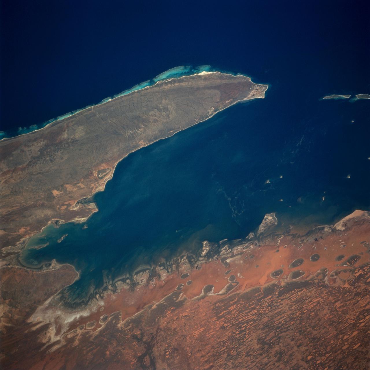
The Exmouth Gulf, western Australia, is bounded on the west by the Cape Ranges; near the base of the peninsula the Learmonth Airfield, site of a solar observatory, can be seen. Spit-accretion ridges formed on ancient beaches extend along the western edge of the peninsula, which today is lined by the Ningaloo Reef. Red mud carried by floodwaters, the result of Hurricane Bobby the previous week, cover flat coastal land along the eastern side of the gulf. The mud is mixing slowly with marine water as it filters through passes between mangrove-covered islands. A filamentous pattern in the gulf probably indicates a plankton bloom. Island paleodunes stretching from south to north cover the landscape.
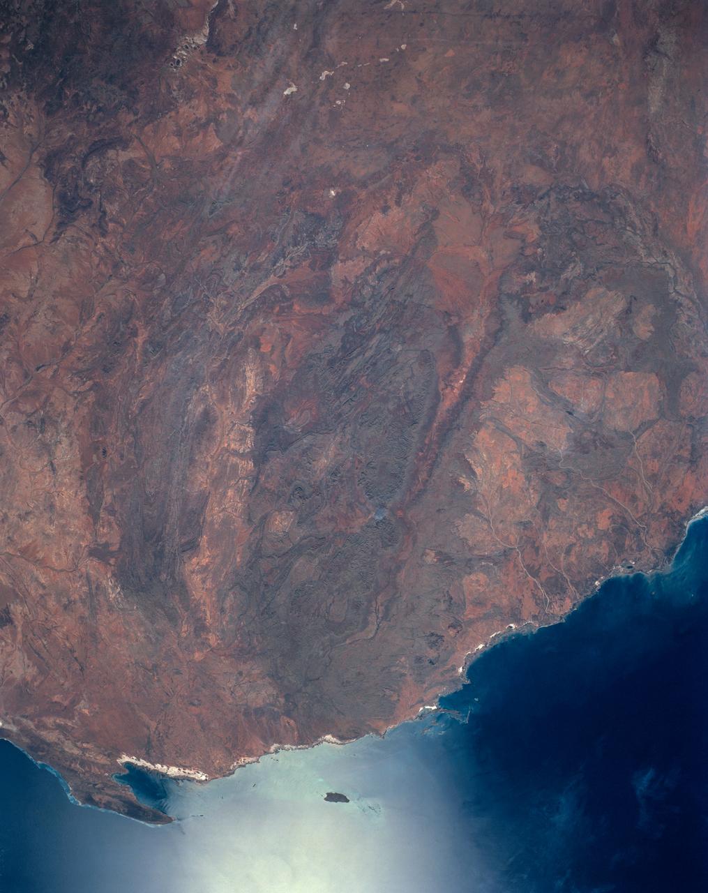
STS-56 Earth observation taken aboard Discovery, Orbiter Vehicle (OV) 103, is probably the best view of Perth in Western Australia. (For orientation purposes, note that the coastline runs north and south). The major feature on the coast is the large estuary of the Swan River. The large port city of Perth is situated on the north bank and the smaller city of Freemantle on the south bank by the sea. Smaller seaside towns trail off north and south of this center of urban life. Inland lies a prominent escarpment, more than 600 feet high, seen running down the middle of the view and dividing the lighter-colored coastal lowlands from the highlands where dark-colored tree savanna and desert scrub dominates the land. The Moore River can be seen entering the sea at the top of the frame. Rottnest Island is visible in the sea and Garden Island near bottom edge of the frame. Perth is the largest economic center in Western Australia. It receives natural gas from an offshore field hundreds of miles to the north. It lies 3,400 kilometers west of Sydney on the opposite side of this island continent.
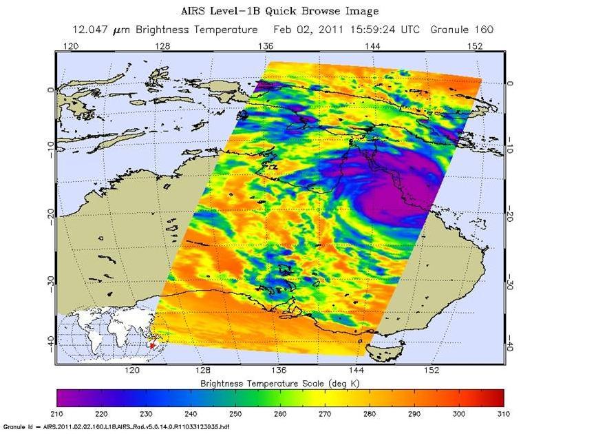
Powerful Tropical Cyclone Yasi fury rakes Northeastern Australia in February, 2011, as seen by the Atmospheric Infrared Sounder AIRS on NASA Aqua satellite.
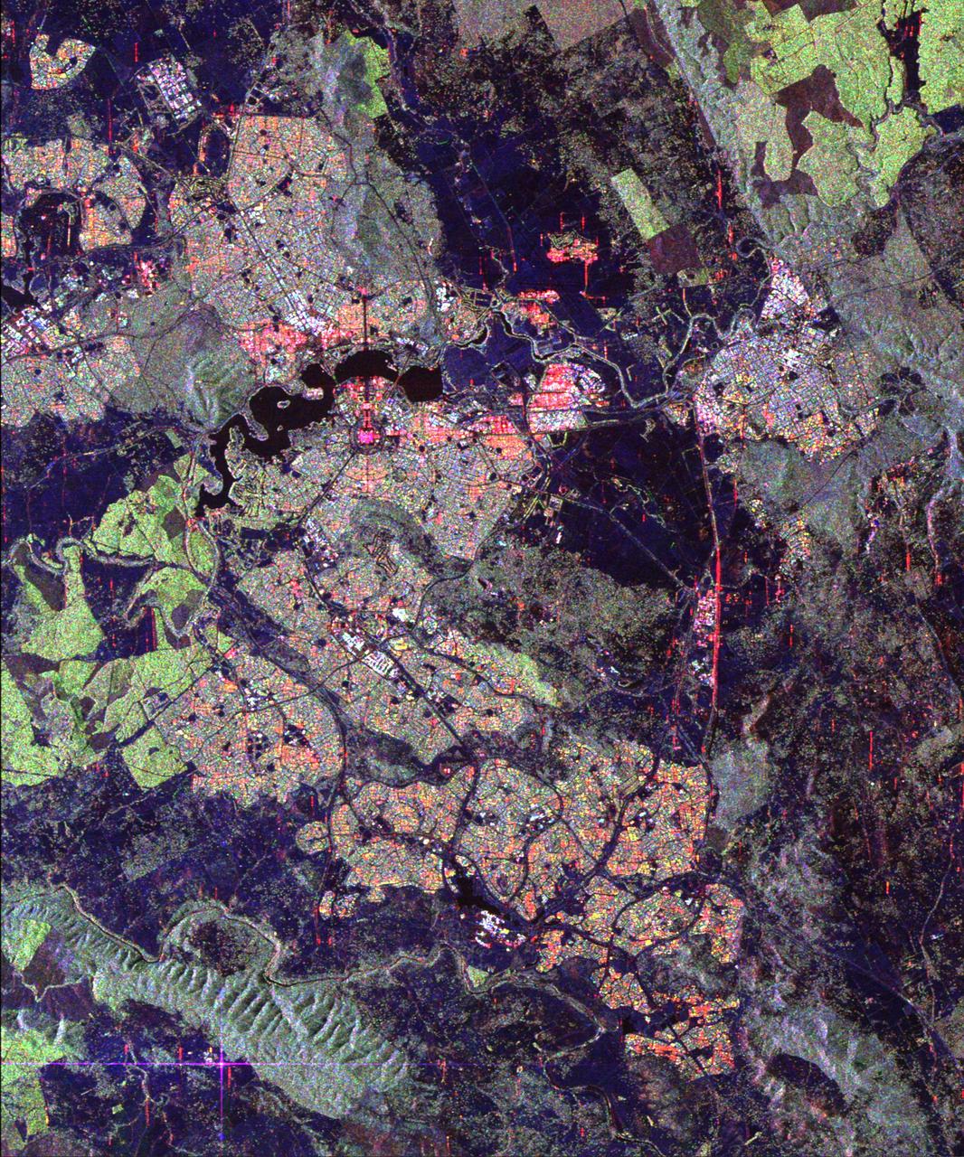
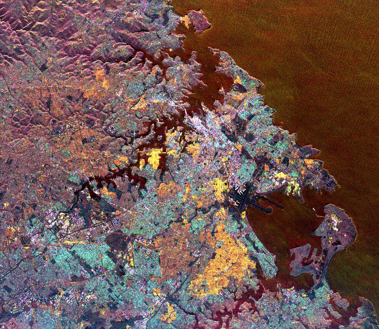
Australia capital city, Canberra, is shown in the center of this spaceborne radar image. Images like this can help urban planners assess land use patterns.
Australia is the world smallest, flattest, and after Antarctica driest continent, but at 7.7 million square kilometers 3.0 million square miles it is also the sixth largest country.
On February 17, 2009, NASA Terra satellite imaged bushfires burning in Victoria Australia.
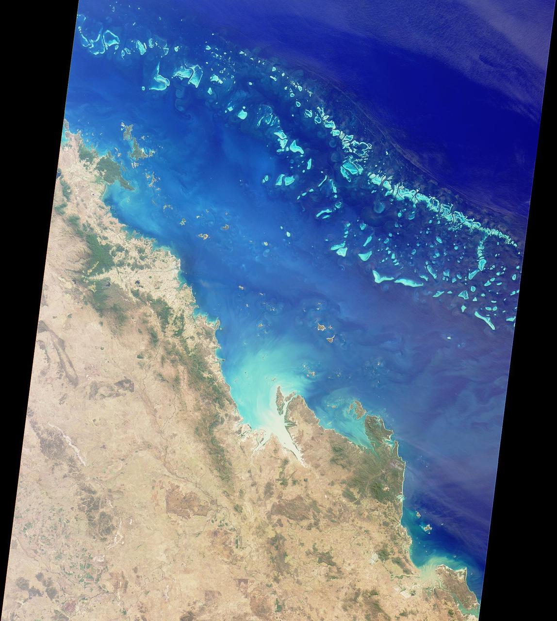
The Great Barrier Reef extends for 2,000 kilometers along the northeastern coast of Australia. It is not a single reef, but a vast maze of reefs, passages, and coral cays islands that are part of the reef.
This false color image of the Eastern Coast of Australia was obtained by NASA’s Galileo spacecraft at about 3:00 p.m. PST, Dec. 8, 1990, at a range of more than 35,000 miles. http://photojournal.jpl.nasa.gov/catalog/PIA00121
NASA's Aqua satellite passed over Tropical Cyclone Ita as it began making landfall on the Eastern Cape York Peninsula of Queensland, Australia, today, April 11, 2014. Ita officially made landfall at Cape Flattery about 9:00 p.m. local AEST time as a Category 4 storm according to reports from the Australian Broadcasting Corporation (ABC). The Moderate Resolution Imaging Spectroradiometer that flies aboard Aqua captured an image of the Category 4 storm on April 11 at 12:00 a.m. EDT (4 a.m. UTC). Satellite imagery indicates the eye is 9.2 miles wide (8 nautical miles, or 14.8 km). Warnings and watches remain in effect as the center of Ita is expected to remain at hurricane strength as it moves in a southerly direction, staying just west of Cairns over the next day. A tropical cyclone warning is in effect between Coen and Innisfail, including Cooktown, Port Douglas, Cairns, extending inland to Kalinga, Palmerville, Mareeba and Chillagoe. A tropical cyclone watch is in effect between Innisfail to Cardwell, extending inland. ABC reported that the strongest maximum sustained winds around the center of circulation were near 142.9 mph (124.2 knots, or 230 kph) and many trees have been downed and homes damaged. According to ABC, preliminary reports suggest that power may be out for a month in some areas. On April 11 at 5 a.m. EDT (9 a.m. UTC), Tropical Cyclone Ita had maximum sustained winds near 143.8 mph (125 knots, or 231.5 kph). It was centered near 14.8 degrees south latitude and 145.3 degrees east longitude, about 168 miles (146 nautical miles, or 288 km) north of Cairns, Australia, and has tracked south-southwestward at 10.3 mph (9 knots, or 16.6 kph). Ita is moving around a subtropical ridge (elongated area) of high pressure and the Joint Typhoon Warning Center expects Ita to start curving to the southeast around that ridge in the next day before heading back out into the Coral Sea. Credit: NASA/GSFC/Jeff Schmaltz/MODIS Land Rapid Response Team Rob Gutro, NASA's Goddard Space Flight Center, Greenbelt, Md. <b><a href="http://www.nasa.gov/audience/formedia/features/MP_Photo_Guidelines.html" rel="nofollow">NASA image use policy.</a></b> <b><a href="http://www.nasa.gov/centers/goddard/home/index.html" rel="nofollow">NASA Goddard Space Flight Center</a></b> enables NASA’s mission through four scientific endeavors: Earth Science, Heliophysics, Solar System Exploration, and Astrophysics. Goddard plays a leading role in NASA’s accomplishments by contributing compelling scientific knowledge to advance the Agency’s mission. <b>Follow us on <a href="http://twitter.com/NASAGoddardPix" rel="nofollow">Twitter</a></b> <b>Like us on <a href="http://www.facebook.com/pages/Greenbelt-MD/NASA-Goddard/395013845897?ref=tsd" rel="nofollow">Facebook</a></b> <b>Find us on <a href="http://instagram.com/nasagoddard?vm=grid" rel="nofollow">Instagram</a></b>
Indigenous Australian owners have been returned the Daintree National Park in northeast Australia, a UNESCO World Heritage Site. More than 160,000 hectares of the 130 million year old rainforest were returned to the Eastern Kuku Yalanji people, who have lived in the area for more than 50,000 years. The image was acquired September 3, 2018, covers an area of 29.6 by 30.3 km, and is located at 16.3 degrees south, 145.4 degrees east. https://photojournal.jpl.nasa.gov/catalog/PIA24869
This multispectral map of Australia and surrounding seas was obtained by NASA’s Galileo spacecraft Near Infrared Mapping Spectrometer shortly after closest approach on Dec. 8, 1990 from an altitude of about 50,000 miles. http://photojournal.jpl.nasa.gov/catalog/PIA00227
More than 2 million acres were consumed by hundreds of fires between December 2002 and February 2003 in southeastern Australia national parks, forests, foothills and city suburbs as seen by NASA Terra spacecraft.
Powerful winds and dry conditions caused a massive blanket of dust from Australia Outback to spread eastward across Queensland and New South Wales. This image was acquired on September 22, 2009 by NASA Terra spacecraft.
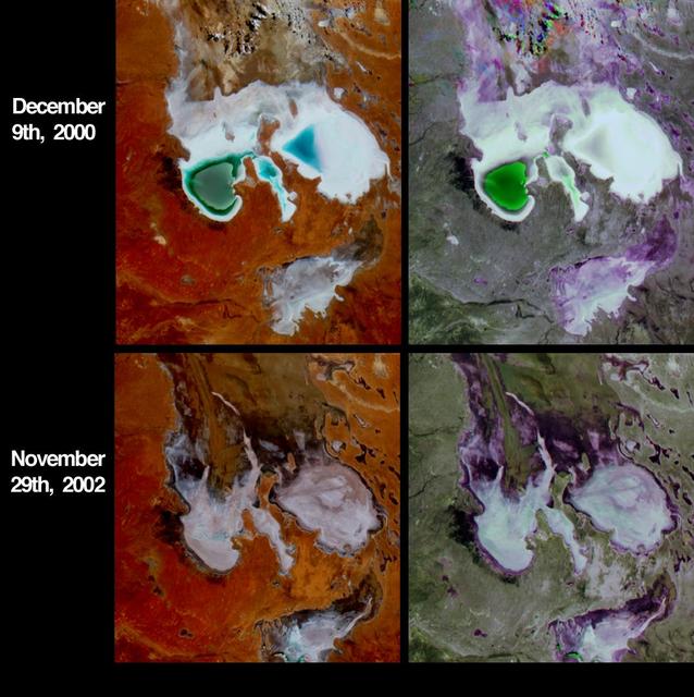
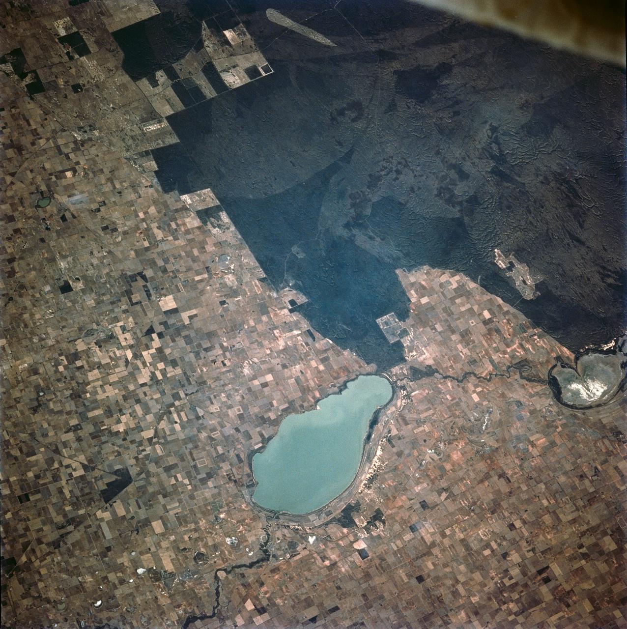
Lake Eyre is a large salt lake situated between two deserts in one of Australia driest regions. These four images from NASA Terra spacecraft austral summers of 2000 and 2002.
This color image of the Simpson Desert in Australia was obtained by NASA’s Galileo spacecraft at about 2:30 p.m. PST, Dec. 8, 1990, at a range of more than 35,000 miles. http://photojournal.jpl.nasa.gov/catalog/PIA00115
Phytoplankton bloom in the Great Australian Bight captured by the MODIS instrument on the Aqua satellite on December 30, 2013 at 6:05 UTC. The Great Australian Bight is a large bight, or open bay, off the central and western portions of the southern coastline of mainland Australia. Credit: NASA/GSFC/Jeff Schmaltz/MODIS Land Rapid Response Team <b><a href="http://www.nasa.gov/audience/formedia/features/MP_Photo_Guidelines.html" rel="nofollow">NASA image use policy.</a></b> <b><a href="http://www.nasa.gov/centers/goddard/home/index.html" rel="nofollow">NASA Goddard Space Flight Center</a></b> enables NASA’s mission through four scientific endeavors: Earth Science, Heliophysics, Solar System Exploration, and Astrophysics. Goddard plays a leading role in NASA’s accomplishments by contributing compelling scientific knowledge to advance the Agency’s mission. <b>Follow us on <a href="http://twitter.com/NASA_GoddardPix" rel="nofollow">Twitter</a></b> <b>Like us on <a href="http://www.facebook.com/pages/Greenbelt-MD/NASA-Goddard/395013845897?ref=tsd" rel="nofollow">Facebook</a></b> <b>Find us on <a href="http://instagram.com/nasagoddard?vm=grid" rel="nofollow">Instagram</a></b>
Queensland, Australia. This image, acquired on November 19, 2001 from NASA Terra satellite, is MISR Mystery Image Quiz #11.
This image acquired by NASA Terra spacecraft, shows the oldest material on Earth which has yet been dated by man is a zircon mineral of 4.4 billion years old from a sedimentary gneiss in the Jack Hills of the Narre Gneiss Terrane of Australia.
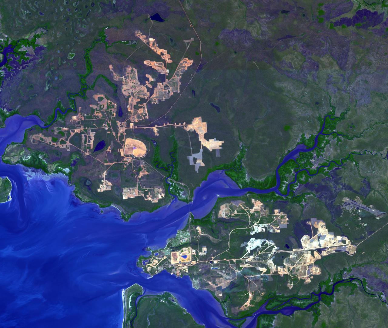
This image from NASA Terra spacecraft shows the world largest bauxite mine found near Weipa, Queensland, Australia. The rich aluminum deposits were first recognized on the end of the Cape York Peninsula in 1955, and mining began in 1960.
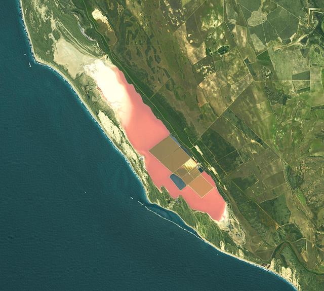
Hutt Lagoon is an elongate lake, located in a dune swale adjacent to the coast of the Indian Ocean, in the mid west region of Western Australia. Port Gregory is located between the ocean and the lake's southern shore. Hutt Lagoon is a pink lake, due to the presence of an algae that produces beta-carotene. A microalgae production plant is the world's largest. The image was acquired September 30, 2012, covers an area of 16.5 by 18.3 km, and is locate at 28.1 degrees south, 114.2 degrees east. https://photojournal.jpl.nasa.gov/catalog/PIA26510
STS062-106-042 (4-18 March 1994) --- This view of southern Australia about 100 miles northwest of Melbourne shows areas of protected reserves of natural forests in the midst of agricultural crop lands. The green patch seen here has been recently burned as indicated by the irregular large scar. The impact of winds on the scar is clearly visible. This nature preserve is reported to be the home to a large number of animals including the koala bears. Similar views were shot by the STS-60 crewmembers last month. These photographs will assist earth scientists in mapping the impact of forest fires and in moniotring the recovery of burned areas.
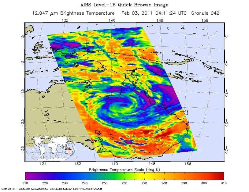
The Atmospheric Infrared Sounder AIRS instrument onboard NASA Aqua spacecraft captured this infrared image of Tropical Cyclone Yasi on Feb. 2, 2011 as the storm passed over Australia Great Dividing Range.
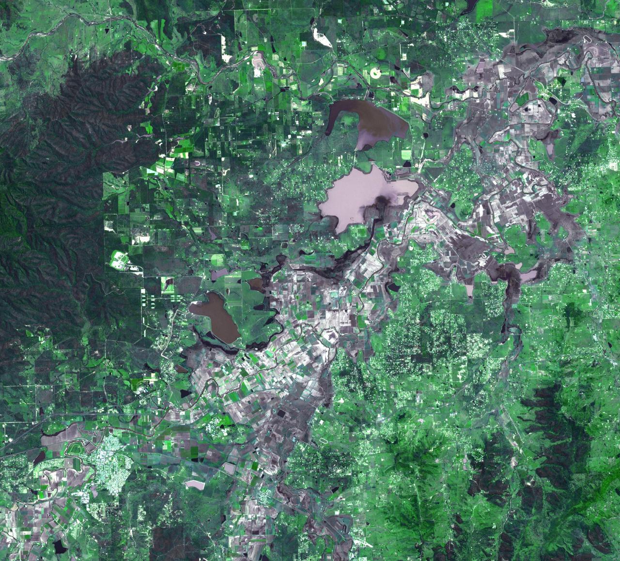
On January 17, 2011, the Advanced Spaceborne Thermal Emission and Reflection Radiometer ASTER instrument on NASA Terra spacecraft captured this image of the inundation west of Brisbane, Queensland, Australia.
Australia largest city of Sydney was clouded with smoke when more than 70 wildfires raged across the state of New South Wales when NASA Terra satellite captured this image the morning of December 30, 2001.
NASA Terra spacecraft acquired these natural color images and cloud top height measurements for Monty before and after the storm made landfall over the remote Pilbara region of Western Australia, on February 29 and March 2, 2004.

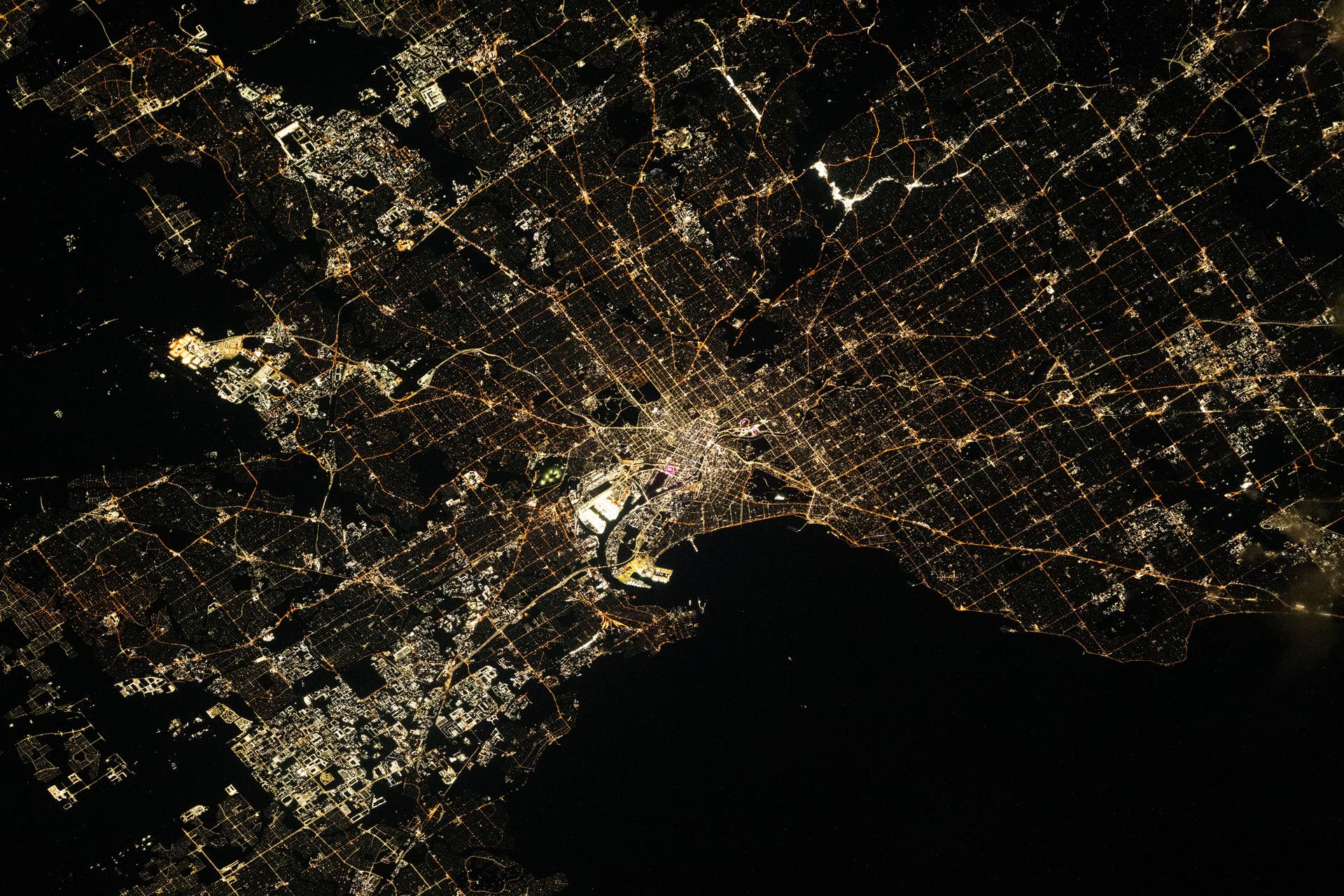
iss072e034554 (Oct. 9, 2024) --- The city lights of Melbourne on Port Phillip in Australia's state of Victoria are pictured from the International Space Station as it orbited 271 miles above.
The Pilbara in northwestern Australia exposes some of the oldest rocks on Earth, over 3.6 billion years old. The iron-rich rocks formed before the presence of atmospheric oxygen, and life itself. Found upon these rocks are 3.45 billion-year-old fossil stromatolites, colonies of microbial cyanobacteria. The image is a composite of ASTER bands 4-2-1 displayed in RGB. The image was acquired October 12, 2004, covers an area of 49.1 by 55.2 km, and is located at 22.8 degrees south, 117.6 degrees east. https://photojournal.jpl.nasa.gov/catalog/PIA25122
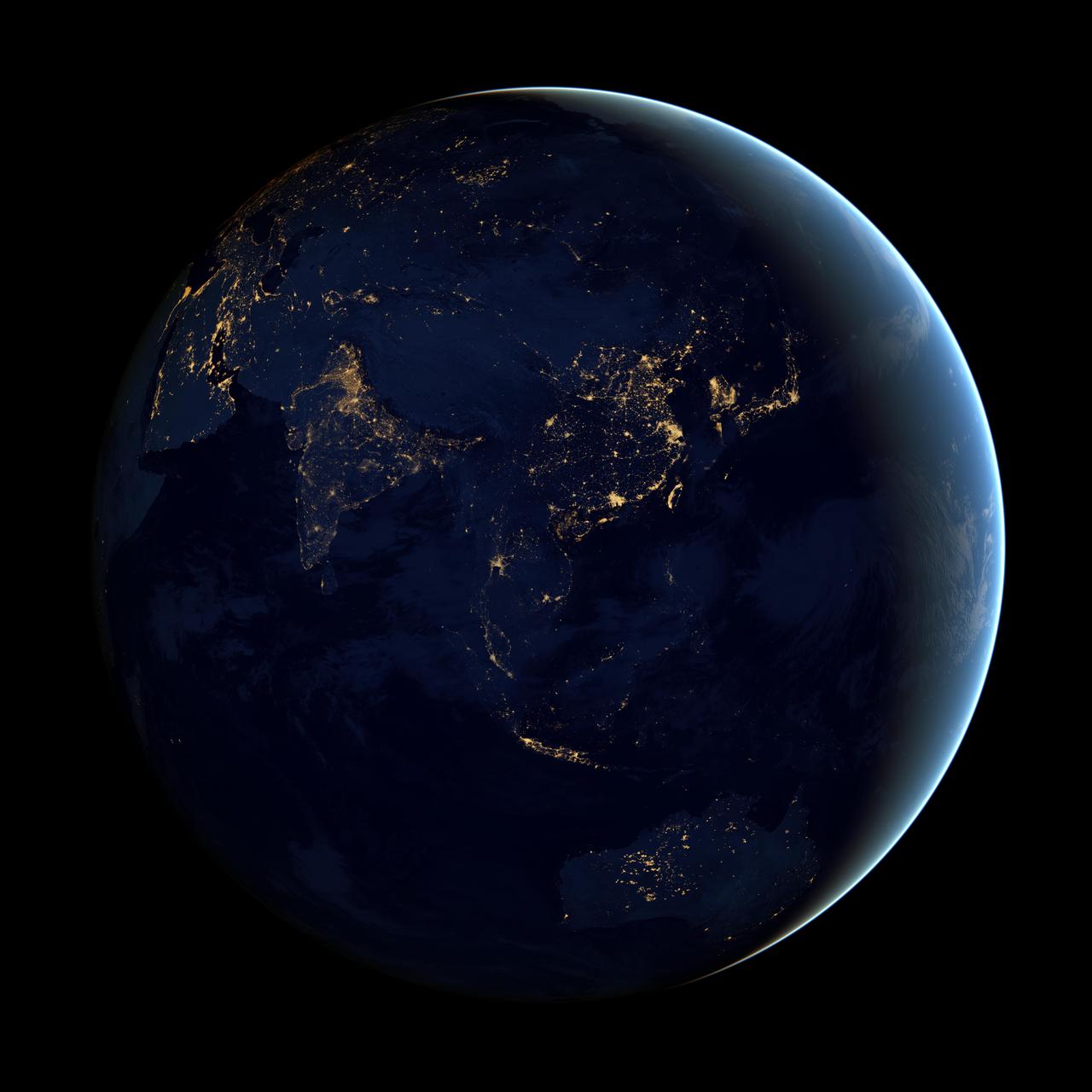
NASA image acquired April 18 - October 23, 2012 This image of Asia and Australia at night is a composite assembled from data acquired by the Suomi NPP satellite in April and October 2012. The new data was mapped over existing Blue Marble imagery of Earth to provide a realistic view of the planet. The nighttime view was made possible by the new satellite’s “day-night band” of the Visible Infrared Imaging Radiometer Suite. VIIRS detects light in a range of wavelengths from green to near-infrared and uses filtering techniques to observe dim signals such as city lights, gas flares, auroras, wildfires, and reflected moonlight. In this case, auroras, fires, and other stray light have been removed to emphasize the city lights. “Night time imagery provides an intuitively graspable view of our planet,” says William Stefanov, a scientist in NASA’s International Space Station program office who has worked with similar images from astronauts. “City lights are an excellent means to track urban and suburban growth, which feeds into planning for energy use and urban hazards, for studying urban heat islands, and for initializing climate models.” Named for satellite meteorology pioneer Verner Suomi, NPP flies over any given point on Earth's surface twice each day at roughly 1:30 a.m. and p.m. The polar-orbiting satellite flies 824 kilometers (512 miles) above the surface, sending its data once per orbit to a ground station in Svalbard, Norway, and continuously to local direct broadcast users distributed around the world. The mission is managed by NASA with operational support from NOAA and its Joint Polar Satellite System, which manages the satellite's ground system. NASA Earth Observatory image by Robert Simmon, using Suomi NPP VIIRS data provided courtesy of Chris Elvidge (NOAA National Geophysical Data Center). Suomi NPP is the result of a partnership between NASA, NOAA, and the Department of Defense. Caption by Mike Carlowicz. Instrument: Suomi NPP - VIIRS Credit: <b><a href="http://www.earthobservatory.nasa.gov/" rel="nofollow"> NASA Earth Observatory</a></b> <b>Click here to view all of the <a href="http://earthobservatory.nasa.gov/Features/NightLights/" rel="nofollow"> Earth at Night 2012 images </a></b> <b>Click here to <a href="http://earthobservatory.nasa.gov/NaturalHazards/view.php?id=79790" rel="nofollow"> read more </a> about this image </b> <b><a href="http://www.nasa.gov/audience/formedia/features/MP_Photo_Guidelines.html" rel="nofollow">NASA image use policy.</a></b> <b><a href="http://www.nasa.gov/centers/goddard/home/index.html" rel="nofollow">NASA Goddard Space Flight Center</a></b> enables NASA’s mission through four scientific endeavors: Earth Science, Heliophysics, Solar System Exploration, and Astrophysics. Goddard plays a leading role in NASA’s accomplishments by contributing compelling scientific knowledge to advance the Agency’s mission. <b>Follow us on <a href="http://twitter.com/NASAGoddardPix" rel="nofollow">Twitter</a></b> <b>Like us on <a href="http://www.facebook.com/pages/Greenbelt-MD/NASA-Goddard/395013845897?ref=tsd" rel="nofollow">Facebook</a></b> <b>Find us on <a href="http://instagram.com/nasagoddard?vm=grid" rel="nofollow">Instagram</a></b>
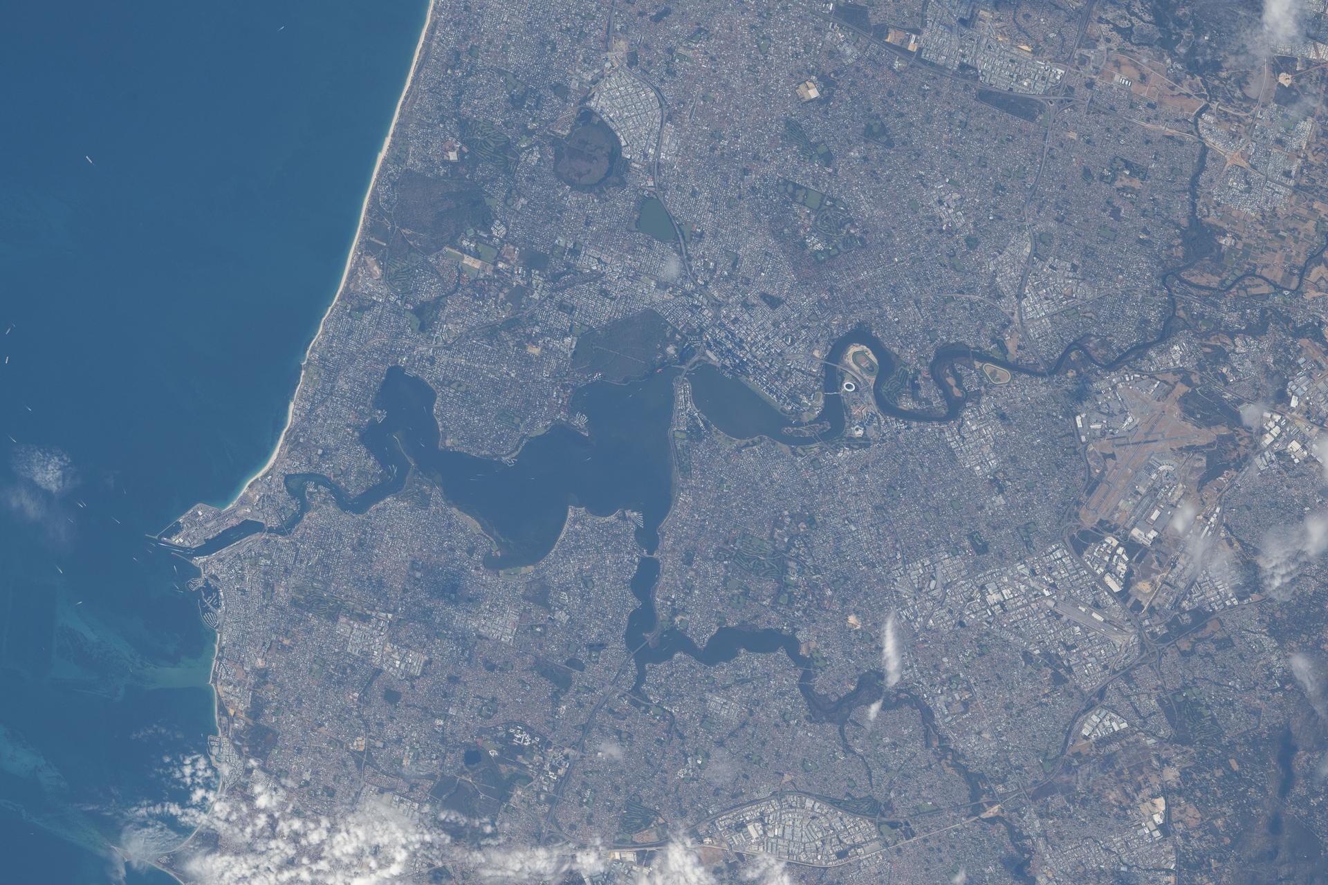
iss074e0376130 (March 26, 2026) --- Perth, Australia, located on the nation’s southwestern coast along the Indian Ocean and home to a metropolitan population of nearly 2.5 million, is pictured from the International Space Station as it orbited 269 miles above the province of Western Australia. The Swan River—popular for recreation and home to a diverse array of fish and migratory birds—splits the city and empties into the Indian Ocean. Credit: NASA/Chris Williams
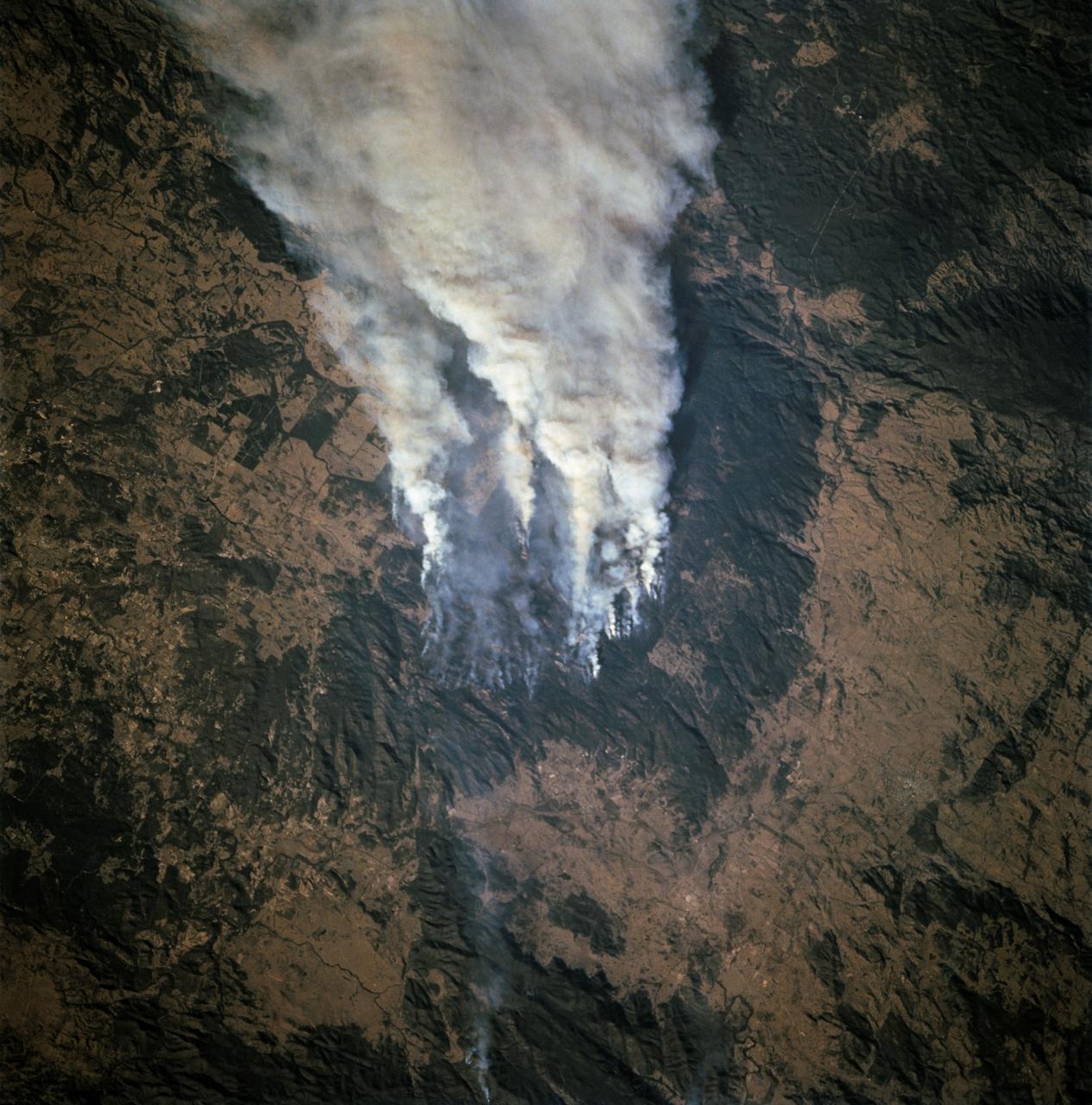
STS068-253-045 (30 September-11 October 1994) --- Forest fires in southeastern Queensland, Australia. The smoke is blowing to the east. This is the southeastern edge of the Darling Downs, a wheat-growing and sheep pasture region just west of the Great Dividing Range, southwest of Brisbane. An extensive summer drought made the forests of the range highly susceptible to wildfire.
NASA Terra spacecraft passed over the Blue Mountains to the west and north of Sydney, A mild winter and an extremely hot September in Australia have led to an early start to the fire season.
At the northern tip of Northern Territory, Australia, the Garig Gunak Barlu National Park spans the entire Cobourg Peninsula. Nearly the whole peninsula is Aboriginal land, and the park is managed as a sanctuary under the direction of traditional Aboriginal landowners. The first wetlands to be declared "Wetlands of International Importance" by the Ramsar Convention on Wetlands International Treaty are located in this park. The image was acquired April 12, 2016, covers an area of 48.2 by 58.6 km, and is located at 11.3 degrees south, 132.2 degrees east. https://photojournal.jpl.nasa.gov/catalog/PIA24732
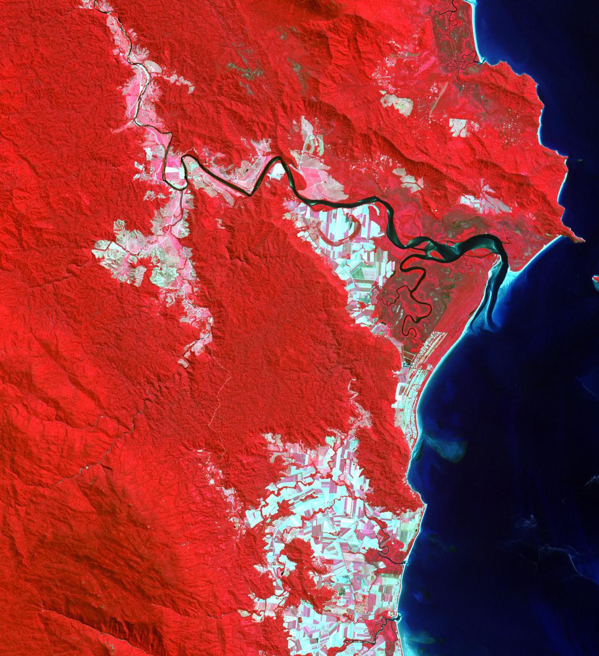
STS072-721-010 (11-20 Jan. 1996) --- Astronauts aboard the Space Shuttle Endeavour exposed this frame of Brisbane, the third largest city in Australia, as well as the capital of Queensland. The heart of the city is 12 miles from Moreton bay and is located on the Brisbane River. In the photograph this area is clearly visible due to the "W"-shaped bend in the river. Mount Coot-Na Park is the dark area on the upper edge of the frame. This area provides an overlook for the entire city. Moreton Island is the Exclamation shaped island protecting the harbor. Fraser Island is about 150 miles north of Brisbane. The international airport is directly above the river in this view.
iss072e769023 (March 10, 2025) --- A cloudy Indian Ocean southwest of Perth, Australia, is pictured from the International Space Station as it orbited 268 miles above.
On Jan. 21, 2011, the NASA Terra spacecraft captured this image of the flooding along the Balonne River and the town of Surat in southeastern Queensland, Australia.
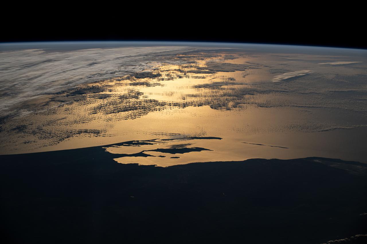
iss073e1047879 (Nov. 2, 2025) --- Clouds surround Australia's island state of Tasmania, highlighting its northern region as sunlight glints off the Bass Strait. The sun’s reflection also reveals the Tamar River, which leads to Launceston—one of Australia’s oldest cities—renowned for its vibrant food and wine culture and a metropolitan population of over 91,000.
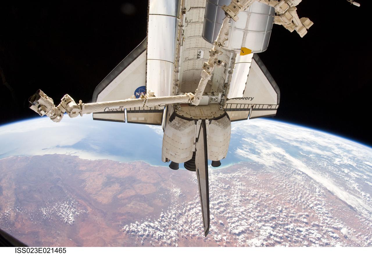
ISS023-E-021465 (10 April 2010) --- The aft section of the docked space shuttle Discovery and the station’s robotic Canadarm2 are featured in this image photographed by an Expedition 23 crew member on the International Space Station. The northwestern coast of Australia and the Indian Ocean, roughly from Carnarvon on the left to Broom (just before the clouds) on the right with the arc of Eighty Mile Beach obscured by the tail of Discovery are seen approximately 215 miles below.
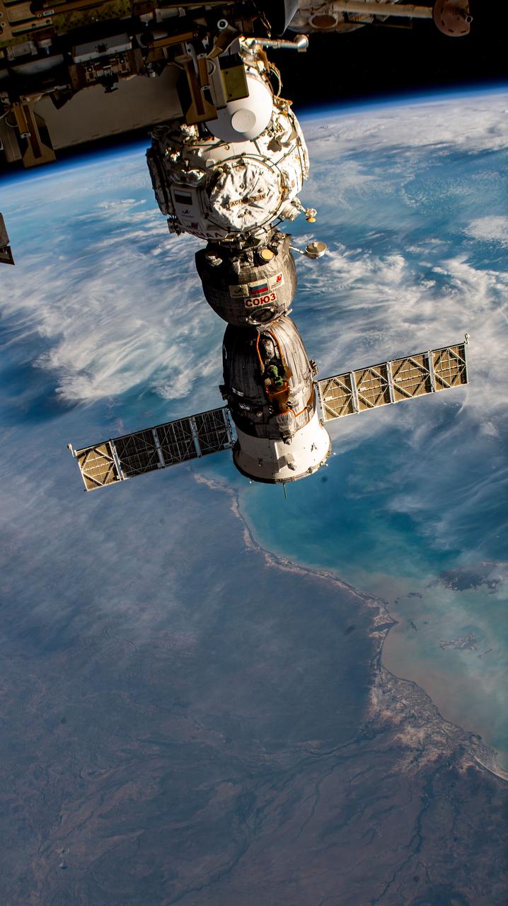
iss069e010174 (May 11, 2023) --- The Soyuz MS-23 crew ship is pictured docked to the Prichal docking module as the International Space Station orbited 264 miles above Queensland, Australia, near the coast of the Gulf of Carpentaria.
iss073e0078217 (May 22, 2025) --- The Kakadu waterway, with its fractal-like tributaries, in the savanna region of Australia's Northern Territory near Van Diemen Gulf is pictured from the International Space Station as it orbited 262 miles above.
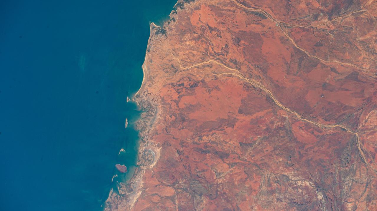
iss072e007019 (Oct. 1, 2024) --- The hot desert coast of Western Australia's sparsely-populated Pilbara region on the Indian Ocean is pictured from the International Space Station as it orbited 262 miles above.
iss072e398046 (Dec. 20, 2024) --- Wildfires are spotted in Mount Frankland National Park about 195 miles south of Perth, Western Australia, in this photograph from the International Space Station as it orbited 266 miles above the island continent.
iss071e615395 (Sept. 9, 2024) -- As the International Space Station orbited 260 miles above the Northern Territory of Australia, NASA astronaut Mike Barratt captured this photograph of Blue Mud Bay.
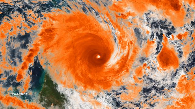
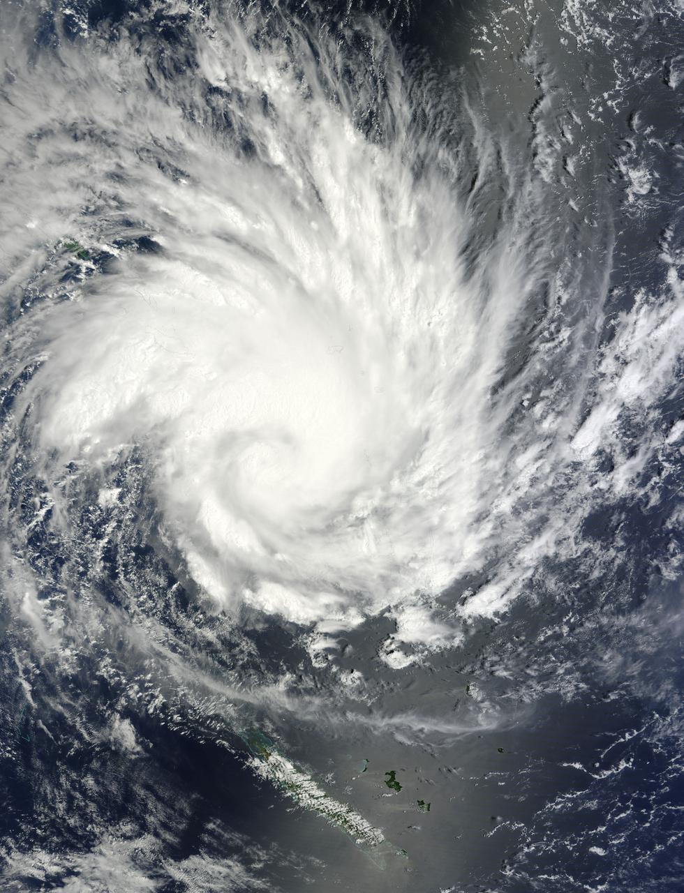
iss072e695137 (March 3, 2025) --- Cyclone Alfred nears the coast of Queensland, Australia, on the Coral Sea in this photograph from the International Space Station as it orbited 265 miles above the island continent.
iss073e0285020 (July 14, 2025) --- Perth, Australia, with a population of about 2.3 million on the island continent's Indian Ocean coast, is pictured from the International Space Station as it orbited 263 miles above. Credit: Roscosmos
iss073e0078403 (May 23, 2025) --- The sparsely populated, hot desert region of Western Australia near Neale Junction Nature Reserve is pictured from the International Space Station as it orbited 265 miles above the continental nation.
S66-54928 (14 Sept. 1966) --- Eighty-mile beach to Port Darwin in Northern Territory, Western Australia, as seen from the Gemini-11 spacecraft during its 26th revolution of Earth. Photo credit: NASA
Heron Island is located in Queensland, Australia, approximately 45 miles (72 kilometers) off the Australian mainland, to the northeast of Gladstone. Part of Australia's Great Barrier Reef, the island is an evergreen coral cay surrounded by Wistari coral reef. Although just 42 acres in size, the island is home to a large resort and the University of Queensland's Heron Island Research Station. The island is famous for diving and snorkeling and is a World Heritage-Listed Marine National Park. It is one of two locations on the Great Barrier Reef that are serving as bases for in-water validation activities for NASA's Coral Reef Airborne Laboratory (CORAL) mission, which is studying the condition and function of the Great Barrier Reef and selected reef systems worldwide using NASA's airborne Portable Remote Imaging Spectrometer (PRISM) instrument from an altitude of 28,000 feet (8,500 meters). The Advanced Spaceborne Thermal Emission and Reflection Radiometer (ASTER) instrument on NASA's Terra spacecraft acquired this image of Heron Island and its surroundings on December 22, 2001. The island appears at the left of the reef (Heron Reef) in the center of the image. Vegetation is red on the image. The image covers an area of 10.3 by 18.6 miles (16.5 by 30.0 kilometers), and is located at 23.5 degrees south, 151.9 degrees east. http://photojournal.jpl.nasa.gov/catalog/PIA20900

This image of abstract shapes is comprised numerous subparallel, very long, orange colored linear dunes and patchy grey dry lakes (playas). The dunes are aligned north to south in the great central basin of Astralia (27.0S, 138.0E). The regularity of the dunes is created by the winds blowing from the south. As the dunes advance, jaged edges on the south side of each dry lake are formed while the north side is eroded smooth by the wind and water.
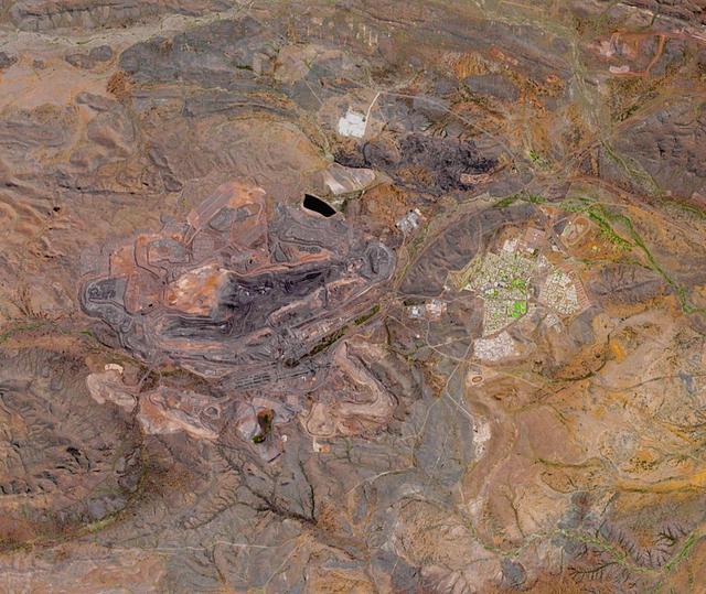
The Mount Whaleback open pit iron ore mine is located 6 km west of the town of Newman in the Pilbara region of Western Australia. It is currently the fifth largest iron mine in the world. The iron occurs in banded iron ore formations, created about 2.5 billion years ago when microorganisms first produced massive amounts of oxygen, oxidizing and precipitating the free iron in the oceans. The image was acquired October 2, 2017, covers an area of 14.4 by 17 km, and is located at 23.3 degrees south, 119.7 degrees east. https://photojournal.jpl.nasa.gov/catalog/PIA24016
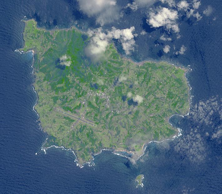
Situated 1670 km northeast of Sydney, Norfolk Island is an Australian Territory. It was permanently settled in 1856 by Pitcairn Islanders who were descendants of Tahitians and HMS Bounty mutineers. In 1979 Norfolk was granted limited self-government: the island elects a government that runs most of the island's affairs. In March, a local council replaced the local government, and the island was given closer financial ties to Australia. The image was acquired November 12, 2009, covers an area of 9 x 11 km, and is located at 29 degrees south, 168 degrees east. http://photojournal.jpl.nasa.gov/catalog/PIA19463
Australia is the only continent without any current volcanic activity, but it hosts one of the world largest extinct volcanoes, the Tweed Volcano. Rock dating methods indicate that eruptions here lasted about three million years.
iss072e145182 (Nov. 5, 2024) --- Western Australia's silhouetted coastline contrasts with the sun's golden-hued glint beaming off a partly cloudy Indian Ocean in this photograph from the International Space Station as it orbited 265 miles above the island continent during an orbital sunset.
iss071e615200 (Sept. 9, 2024) -- The ephemeral Lake Carnegie, one of Western Australia's largest lakes, displays its mixture of water and mud as the International Space Station orbited 263 miles above. The lake fills with water only during periods of heavy rainfall, while in dry years, the lake is mostly a muddy marsh.
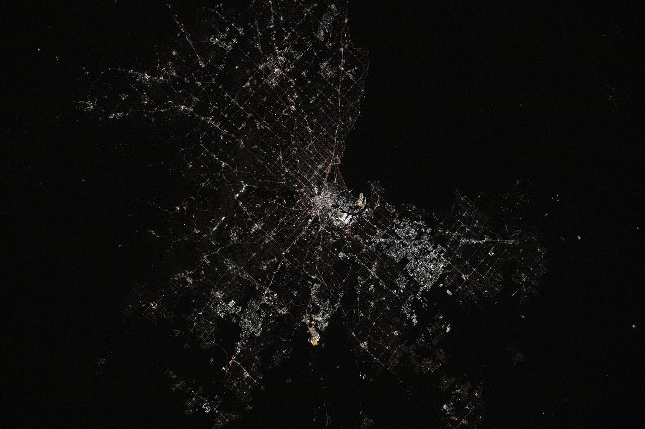
iss073e0000808 (April 23, 2025) --- Melbourne, the capital of Australia's state of Victoria with a population of about 5.2 million, is pictured at approximately 10:07 p.m. local time from the International Space Station as it orbited 267 miles above the continental nation.
The oval shaped basin of the sedimentary rocks of the Hammersley Range, northern Western Australia (23.0S, 119.0E) dominates the center of this near nadir view. The Fortescue River is the remarkably straight, fault controlled feature bordering the Hammersley on the north. Sand dunes are the main surface features in the northeast and southwest. Many dry lakebeds can be seen to the east as light grey colored patches along the watercourses.
NASA image acquired January 28, 2011 Tropical Cyclone Bianca continued moving southward along the coast of Western Australia on January 28, 2011. At 5:00 a.m. on January 28 local time (21:00 UTC on January 27), the U.S. Navy’s Joint Typhoon Warning Center (JTWC) reported that Bianca was located about 135 nautical miles (250 kilometers) west of Learmonth, Western Australia. The storm had maximum sustained winds of 90 knots (165 kilometers per hour) and gusts up to 110 knots (205 kilometers per hour), having intensified over the previous day. The Moderate Resolution Imaging Spectroradiometer (MODIS) on NASA’s Aqua satellite captured this natural-color image at 2:30 p.m. Western Australia time (6:30 UTC) on January 28, 2011. Bianca spans hundreds of kilometers, and the storm’s eye appears west-southwest of Learmonth. The JTWC forecast that Bianca would continue strengthening for about 12 more hours then begin to weaken, thanks to reduced sea surface temperatures and increased vertical wind shear. NASA image by Jeff Schmaltz, MODIS Rapid Response Team at NASA GSFC. Caption by Michon Scott. Instrument: Aqua - MODIS To view more images of this event go to: <a href="http://earthobservatory.nasa.gov/NaturalHazards/event.php?id=48914" rel="nofollow">earthobservatory.nasa.gov/NaturalHazards/event.php?id=48914</a> Credit: <b><a href="http://www.earthobservatory.nasa.gov/" rel="nofollow"> NASA Earth Observatory</a></b> <b><a href="http://www.nasa.gov/centers/goddard/home/index.html" rel="nofollow">NASA Goddard Space Flight Center</a></b> enables NASA’s mission through four scientific endeavors: Earth Science, Heliophysics, Solar System Exploration, and Astrophysics. Goddard plays a leading role in NASA’s accomplishments by contributing compelling scientific knowledge to advance the Agency’s mission. <b>Follow us on <a href="http://twitter.com/NASA_GoddardPix" rel="nofollow">Twitter</a></b> <b>Join us on <a href="http://www.facebook.com/pages/Greenbelt-MD/NASA-Goddard/395013845897?ref=tsd" rel="nofollow">Facebook</a></b>
AS07-04-1609 (21 Oct. 1968) --- Woodlark Island in the Solomon Sea, east of New Guinea and northeast of Australia, as seen from the Apollo 7 spacecraft during its 158th revolution of Earth. Photographed from an altitude of 140 nautical miles, at ground elapsed time of 251 hours and 21 minutes.

NASA image acquired January 28, 2011 High res file here: <a href="http://www.flickr.com/photos/gsfc/5400445475">www.flickr.com/photos/gsfc/5400445475</a> Tropical Cyclone Bianca continued moving southward along the coast of Western Australia on January 28, 2011. At 5:00 a.m. on January 28 local time (21:00 UTC on January 27), the U.S. Navy’s Joint Typhoon Warning Center (JTWC) reported that Bianca was located about 135 nautical miles (250 kilometers) west of Learmonth, Western Australia. The storm had maximum sustained winds of 90 knots (165 kilometers per hour) and gusts up to 110 knots (205 kilometers per hour), having intensified over the previous day. The Moderate Resolution Imaging Spectroradiometer (MODIS) on NASA’s Aqua satellite captured this natural-color image at 2:30 p.m. Western Australia time (6:30 UTC) on January 28, 2011. Bianca spans hundreds of kilometers, and the storm’s eye appears west-southwest of Learmonth. The JTWC forecast that Bianca would continue strengthening for about 12 more hours then begin to weaken, thanks to reduced sea surface temperatures and increased vertical wind shear. NASA image by Jeff Schmaltz, MODIS Rapid Response Team at NASA GSFC. Caption by Michon Scott. Instrument: Aqua - MODIS To view more images of this event go to: <a href="http://earthobservatory.nasa.gov/NaturalHazards/event.php?id=48914" rel="nofollow">earthobservatory.nasa.gov/NaturalHazards/event.php?id=48914</a> Credit: <b><a href="http://www.earthobservatory.nasa.gov/" rel="nofollow"> NASA Earth Observatory</a></b> <b><a href="http://www.nasa.gov/centers/goddard/home/index.html" rel="nofollow">NASA Goddard Space Flight Center</a></b> enables NASA’s mission through four scientific endeavors: Earth Science, Heliophysics, Solar System Exploration, and Astrophysics. Goddard plays a leading role in NASA’s accomplishments by contributing compelling scientific knowledge to advance the Agency’s mission. <b>Follow us on <a href="http://twitter.com/NASA_GoddardPix" rel="nofollow">Twitter</a></b> <b>Join us on <a href="http://www.facebook.com/pages/Greenbelt-MD/NASA-Goddard/395013845897?ref=tsd" rel="nofollow">Facebook</a></b>
iss074e0046183 (Jan. 4, 2025) --- Mount Conner, in the arid heart of Australia’s Northern Territory—also known as the Red Centre—is a flat-topped mesa and an erosional remnant whose distinct formation took shape approximately 100 million years ago. It resembles an impact crater because it sits on a broad, eroded plain with shallow depressions, while the surrounding terrain was shaped by millions of years of weathering and erosion. The International Space Station was orbiting 262 miles above the island continent when this photograph was taken. Credit: NASA/Chris Williams.
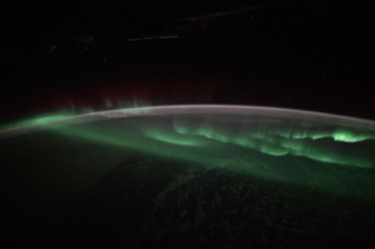
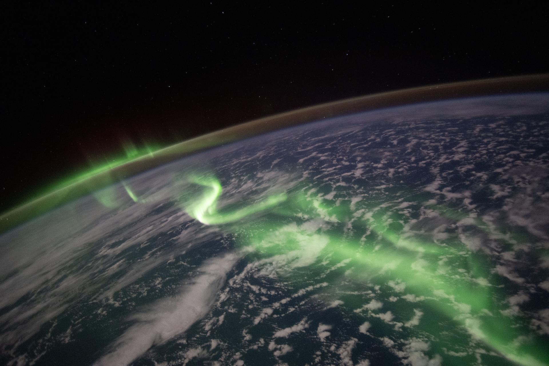
iss073e0426077 (July 26, 2025) --- The aurora australis appears to lap over the Earth like a tide washing ashore in this photograph taken at approximately 3:45 a.m. local time from the International Space Station as it orbited 269 miles above the Indian Ocean southwest of Australia.
iss074e0491784 (April 14, 2026) --- Melbourne, Australia—home to more than 5.4 million people and known for its highly changeable, continental‑style climate—is pictured at approximately 1:24 a.m. local time from the International Space Station as it orbited 265 miles above the island continent. Credit: NASA/Jessica Meir
iss074e0462550 (April 4, 2026) --- The aurora australis arcs across the Indian Ocean south of Perth, Australia, in this photograph taken at approximately 2:19 a.m. local time from the International Space Station as it orbited 270 miles above Earth. Credit: NASA/Jessica Meir
AS12-50-7362 (14 Nov. 1969) --- A view of one-third of Earth, with Australia on the horizon, as photographed by the three-man crew of Apollo 12. The Command and Service Modules, mated to the Lunar Module (yet to be removed and transpositioned for landing) were en route to the moon for man's second mission there. Onboard the spacecraft were astronauts Charles Conrad Jr., Richard F. Gordon Jr. and Alan L. Bean. Photo credit: NASA
This image was acquired on October 12, 2002 by the Advanced Spaceborne Thermal Emission and Reflection Radiometer (ASTER) on NASA's Terra satellite. With its 14 spectral bands from the visible to the thermal infrared wavelength region, and its high spatial resolution of 15 to 90 meters (about 50 to 300 feet), ASTER will image Earth for the next 6 years to map and monitor the changing surface of our planet. http://photojournal.jpl.nasa.gov/catalog/PIA03498
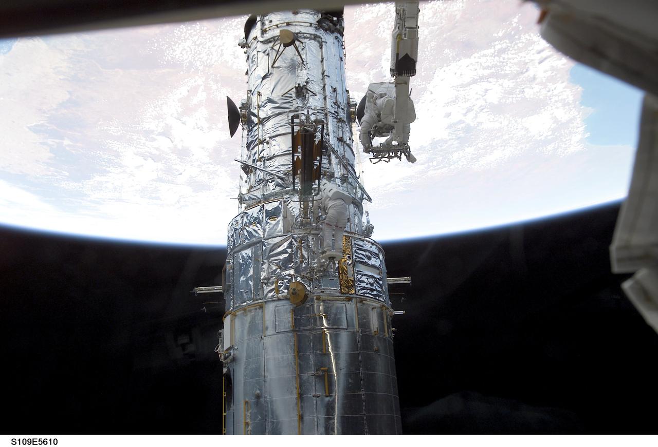
STS109-E-5610 (5 March 2002) --- Astronauts James H. Newman, attached to the Remote Manipulator System (RMS) arm of the Space Shuttle Columbia, and Michael J. Massimino (barely visible against the Hubble Space Telescope near center frame) work on the telescope as the shuttle flies over Australia. This day's space walk went on to see astronauts Newman and Massimino replace the port solar array on the Hubble. On the previous day astronauts John M. Grunsfeld and Richard M. Linnehan replaced the starboard solar array on the giant telescope. The image was recorded with a digital still camera.
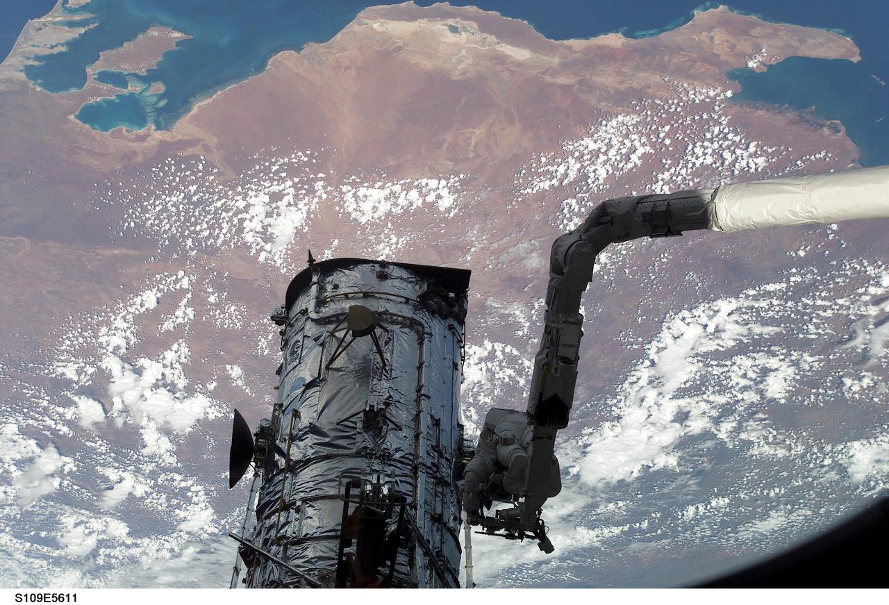
STS109-E-5611 (5 March 2002) --- Astronauts James H. Newman, attached to the Remote Manipulator System (RMS) arm of the Space Shuttle Columbia, and Michael J. Massimino (out of frame) work on the Hubble Space Telescope as the shuttle flies over Western Australia. This day's space walk went on to see astronauts Newman and Massimino replace the port solar array on the Hubble. On the previous day astronauts John M. Grunsfeld and Richard M. Linnehan replaced the starboard solar array on the giant telescope. The image was recorded with a digital still camera.
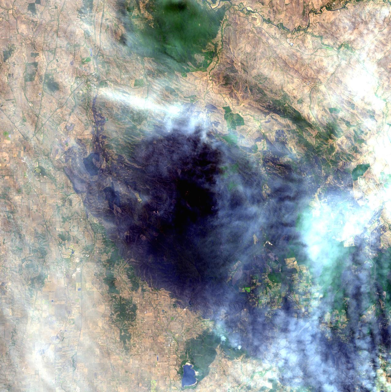
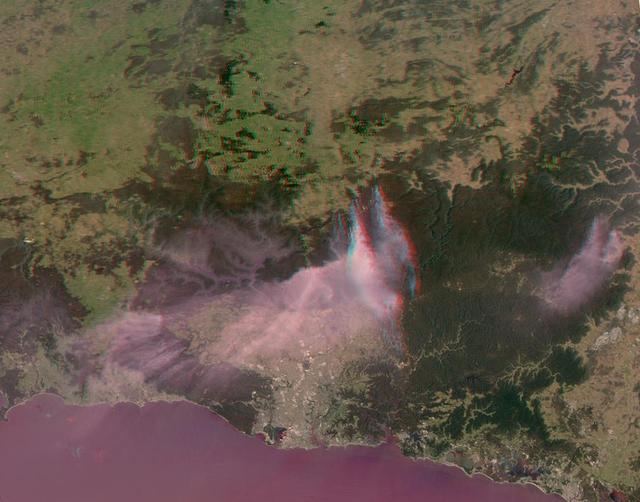
On Nov. 14, 2013, NASA Terra spacecraft spied a fire scar west of Wollongong, New South Wales, from the Hall Road fire in New South Wales, Australia. October 2013 brought the worst fires seen in Australia New South Wales in many decades.
S65-63136 (16 Dec. 1965) --- Shark Bay area on the western coast of Western Australia as seen from the Gemini-6 spacecraft during its 16th revolution of Earth. City of Carnarven, where NASA has a tracking station, is located near the bottom of picture in lower left corner, near mouth of stream. Indian Ocean is body of water at upper right. South is toward top of picture. Photo credit: NASA or National Aeronautics and Space Administration
A nearly vertical view of Disappointment Reach and surroundings. Ripple-like patterns extending at right angles to the tidal flow can be discerned on shoals. Relict sand dune patterns, crests unvegetated, are evident on the western side of the estuary. Red mud brought down the Mooramel River on the east side of the estuary does extend into the shallow water of the inter-tidal lagoons. Most of the light-colored water along the coast, represents shoals of lime sediment. Patterns of sediment distribution by tides, waves, streams, and wind combine to create a complex and colorful scene.
STS061-95-075 (6 Dec 1993) --- Astronauts Kathryn C. Thornton and Thomas D. Akers work to remove one of the solar arrays on the Hubble Space Telescope (HST) on the second of five extravehicular activity?s (EVA). The two space walkers later replaced both solar array panels. Part of Australia is in the background.
SL4-136-3501 (6 Dec. 1973) --- A vertical view of a portion of the State of Queensland, Australia, as photographed from the Skylab space station in Earth orbit by one of the Skylab 4 crewmen. The camera used was a hand-held 70mm Hasselblad, with SO-368 medium speed Ektachrome film. The body of water is the southeastern part of the Gulf of Carpentaria. This picture was taken in support studies of the north Australian drought region. The largest island seen is Mornington. The town of Normanton can also be seen. Of interest here is the sediment-laden waters at the perimeter of the Gulf showing how rains at the end of the drought are washing the top soil into the sea after the drought killed the covering vegetation. Also noted is that the vegetation patterns tend more toward those of other arid regions (i.e. they follow topographic and hydrographic patterns) rather than those in other parts of Australia (i.e. more convenient and easier to see, rectilinear patterns which are prevalent in less arid areas). Photo credit: NASA
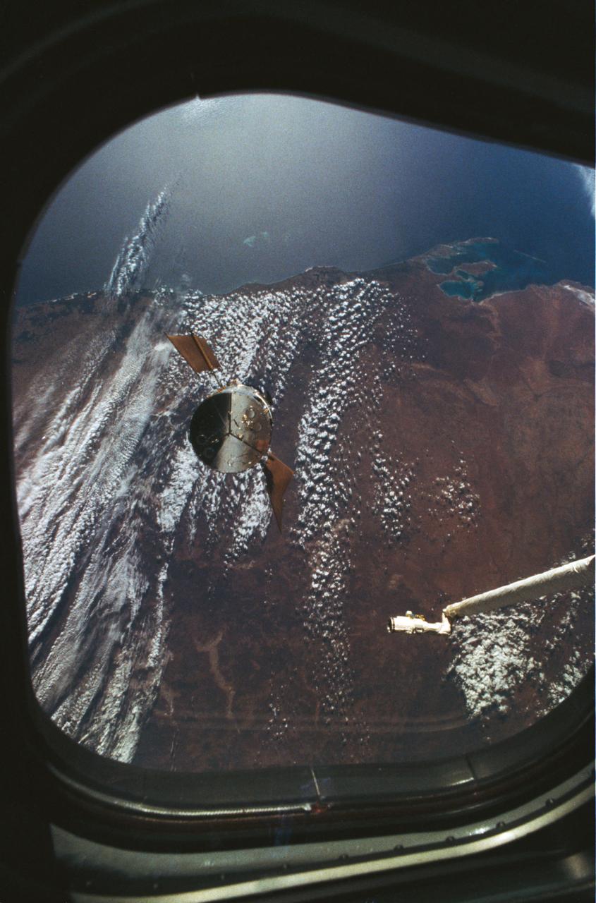
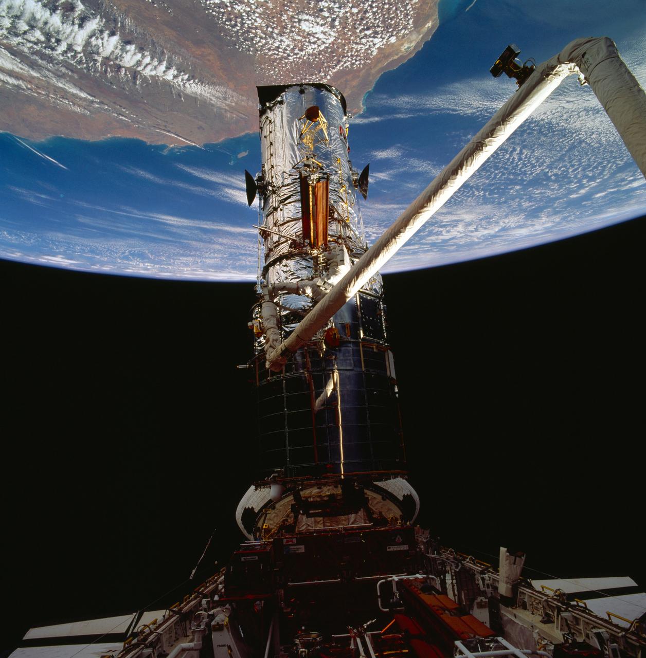
STS061-53-026 (4 Dec 1993) --- One of the Space Shuttle Endeavour's aft flight deck windows frames this view of the Hubble Space Telescope (HST) as it approaches the Endeavour. Backdropped against western Australia, the Remote Manipulator System (RMS) arm awaits the arrival of the telescope. Once berthed in Endeavour's cargo bay, HST underwent five days of servicing provided by four space walking crew members. Shark Bay (upper left) and Perth (lower left) are visible in the frame.

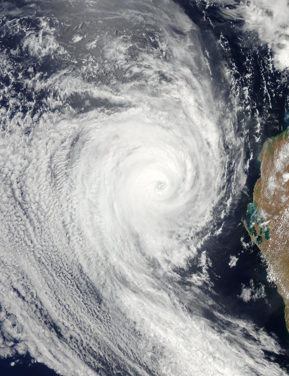
NASA image acquired March 18, 2010. Tropical Cyclone Ului persisted south of the Solomon Islands on March 18, 2010. A bulletin from the U.S. Navy’s Joint Typhoon Warning Center (JTWC) issued the same day reported that the cyclone had maximum sustained winds of 80 knots (150 kilometers per hour) and gusts up to 100 knots (185 kilometers per hour). Although still strong, the wind speeds had significantly diminished over the previous few days. The Moderate Resolution Imaging Spectroradiometer (MODIS) on NASA’s Terra satellite captured this true-color image of the storm on March 18, 2010. North of the storm lie the Solomon Islands (shown in the high-resolution image). Southeast of the storm is New Caledonia. Ului’s eye appears to span 100 kilometers (60 miles) and the whole storm spans several hundred kilometers. As of 15:00 UTC on March 18 (2:00 a.m. on March 19 in Sydney, Australia), Ului was roughly 670 nautical miles (1,240 kilometers) east of Cairns, Australia. The JTWC reported that Ului had been moving southward and was expected to turn west and accelerate toward Australia. The JTWC forecast that Ului would make landfall over the northeastern Queensland coast and diminish over land. NASA image courtesy Jeff Schmaltz, MODIS Rapid Response Team at NASA GSFC. Caption by Michon Scott. Instrument: Terra - MODIS To learn more about this image go to: <a href="http://earthobservatory.nasa.gov/NaturalHazards/view.php?id=43180" rel="nofollow">earthobservatory.nasa.gov/NaturalHazards/view.php?id=43180</a>

DSS43 is a 70-meter-wide (230-feet-wide) radio antenna at the Deep Space Network's Canberra facility in Australia. It is the only antenna that can send commands to the Voyager 2 spacecraft. https://photojournal.jpl.nasa.gov/catalog/PIA23682
This dramatic image of the Australian brushers was taken from orbit by one of the crew members aboard the International Space Station (ISS). Following the worst regional drought in 50 years, this summer's fire season has resulted in numerous large fires over much of the Great Dividing Range as well as the enormous smoke pall over New South Wales, Victoria, and the adjacent South Pacific Ocean.