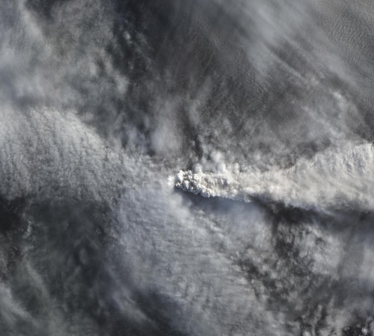
The natural color image below, acquired on April 25 by the Advanced Land Imager on NASA’s Earth Observing-1 satellite, shows Calbuco’s plume rising above the cloud deck over Chile.
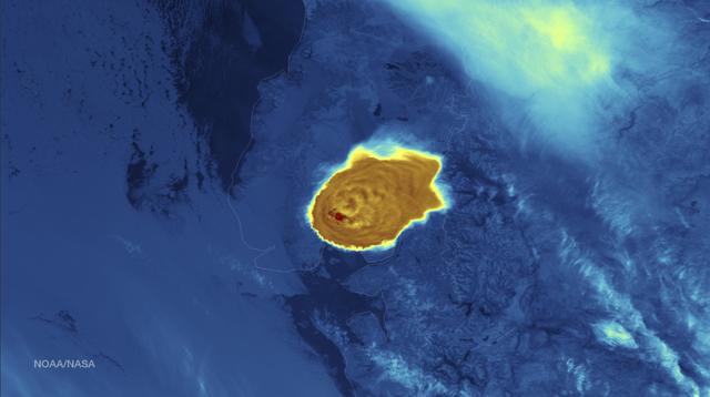
Calbuco Volcano in southern Chile has erupted for the first time since 1972, with the last major eruption occurring in 1961 that sent ash columns 12-15 kilometers high. This image was taken by the Suomi NPP satellite's VIIRS instrument in a high resolution infrared channel around 0515Z on April 23, 2015. Credit: NOAA/NASA/NPP/VIIRS

The natural color image below, acquired on April 25 by the Advanced Land Imager on NASA’s Earth Observing-1 satellite, shows Calbuco’s plume rising above the cloud deck over Chile. Read more here: <a href="http://earthobservatory.nasa.gov/IOTD/view.php?id=85791&eocn=home&eoci=iotd_title" rel="nofollow">earthobservatory.nasa.gov/IOTD/view.php?id=85791&eocn...</a> Credit: <b><a href="http://www.earthobservatory.nasa.gov/" rel="nofollow"> NASA Earth Observatory</a></b> <b><a href="http://www.nasa.gov/audience/formedia/features/MP_Photo_Guidelines.html" rel="nofollow">NASA image use policy.</a></b> <b><a href="http://www.nasa.gov/centers/goddard/home/index.html" rel="nofollow">NASA Goddard Space Flight Center</a></b> enables NASA’s mission through four scientific endeavors: Earth Science, Heliophysics, Solar System Exploration, and Astrophysics. Goddard plays a leading role in NASA’s accomplishments by contributing compelling scientific knowledge to advance the Agency’s mission. <b>Follow us on <a href="http://twitter.com/NASAGoddardPix" rel="nofollow">Twitter</a></b> <b>Like us on <a href="http://www.facebook.com/pages/Greenbelt-MD/NASA-Goddard/395013845897?ref=tsd" rel="nofollow">Facebook</a></b> <b>Find us on <a href="http://instagrid.me/nasagoddard/?vm=grid" rel="nofollow">Instagram</a></b>

Calbuco Volcano in southern Chile has erupted for the first time since 1972, with the last major eruption occurring in 1961 that sent ash columns 12-15 kilometers high. This image was taken by the Suomi NPP satellite's VIIRS instrument in a high resolution infrared channel around 0515Z on April 23, 2015. Credit: NOAA/NASA/NPP/VIIRS <b><a href="http://goes.gsfc.nasa.gov/" rel="nofollow">Credit: NOAA/NASA GOES Project</a></b> <b><a href="http://www.nasa.gov/audience/formedia/features/MP_Photo_Guidelines.html" rel="nofollow">NASA image use policy.</a></b> <b><a href="http://www.nasa.gov/centers/goddard/home/index.html" rel="nofollow">NASA Goddard Space Flight Center</a></b> enables NASA’s mission through four scientific endeavors: Earth Science, Heliophysics, Solar System Exploration, and Astrophysics. Goddard plays a leading role in NASA’s accomplishments by contributing compelling scientific knowledge to advance the Agency’s mission. <b>Follow us on <a href="http://twitter.com/NASAGoddardPix" rel="nofollow">Twitter</a></b> <b>Like us on <a href="http://www.facebook.com/pages/Greenbelt-MD/NASA-Goddard/395013845897?ref=tsd" rel="nofollow">Facebook</a></b> <b>Find us on <a href="http://instagrid.me/nasagoddard/?vm=grid" rel="nofollow">Instagram</a></b>
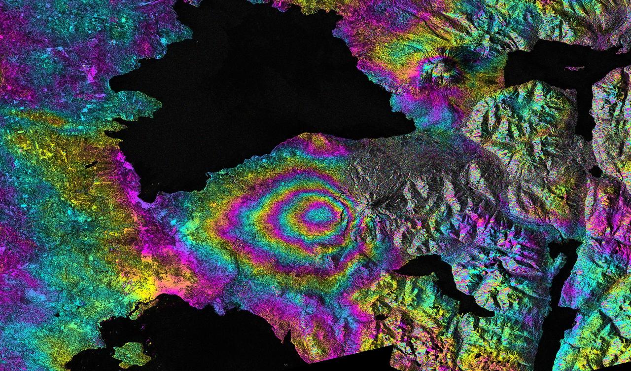
This satellite interferometric synthetic aperture radar image-pair shows relative deformation of the Earth surface when nn April 22-23, 2015, significant explosive eruptions occurred at Calbuco volcano, Chile.
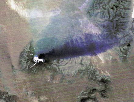
The April 18, 2015 eruption of Calbuco Volcano in Chile, as seen by NASA Terra spacecraft, led to the evacuation of thousands of citizens near the summit, blanketed nearby towns with a layer of ash, and disrupted air traffic. One week later, on April 26, the Advanced Spaceborne Thermal Emission and Reflection Radiometer (ASTER) instrument on NASA's Terra spacecraft acquired this nighttime thermal infrared image of Calbuco. Hot eruptive material at the summit appears in white (hot), with a purple plume streaming to the right, indicating that it is ash-laden. The image covers an area of 3.1 by 4.1 miles (5 by 6.6 kilometers), and is located at 41.3 degrees south, 72.5 degrees west. http://photojournal.jpl.nasa.gov/catalog/PIA19382
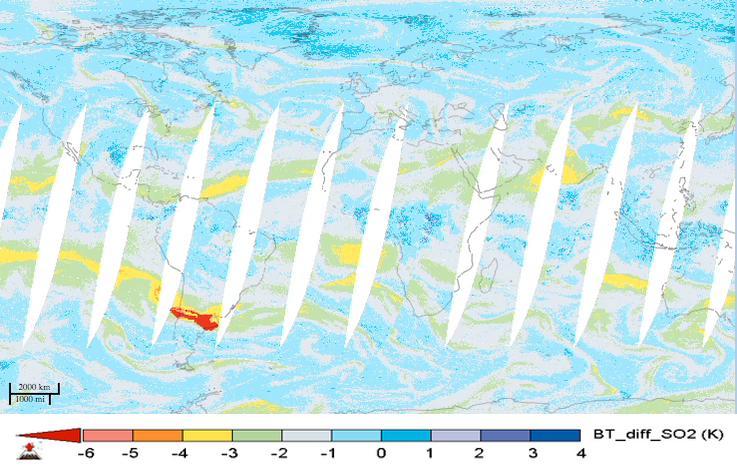
For the first time in 40 years, the Calbuco volcano in southern Chile erupted on April 22, 2015. The eruption caused airline flight cancellations in Chile, Argentina and Uruguay and the evacuation of approximately 4,000 people. This movie shows alternating day and nighttime views of the plume of sulfur dioxide gas emitted by Calbuco, as observed by NASA's Atmospheric Infrared Sounder (AIRS) instrument on NASA's Aqua spacecraft, from April 22 to May 5, 2015. Significant amounts of sulfur dioxide are shown in bright red. The largest plume is apparent over South America during the initial eruption on April 22. The plume is then carried by winds across the south Atlantic Ocean and southern Africa. A second large eruption on April 29 produced a smaller plume. Volcanic sulfur dioxide can be an important factor in climate. Some of it is carried into Earth's stratosphere, where it is transformed into highly reflective droplets of sulfuric acid. By reflecting sunlight, these droplets can cool Earth. Large eruptions, like Mt. Pinatubo in 1991, cool our planet and disrupt rainfall patterns. Though an impressive eruption, Calbuco is expected to have only a small impact on Earth's climate. http://photojournal.jpl.nasa.gov/catalog/PIA19385