
NASA image acquired September 2, 2011 To download the full high res go to: <a href="http://earthobservatory.nasa.gov/IOTD/view.php?id=52059" rel="nofollow">earthobservatory.nasa.gov/IOTD/view.php?id=52059</a> Nearly a week after Hurricane Irene drenched New England with rainfall in late August 2011, the Connecticut River was spewing muddy sediment into Long Island Sound and wrecking the region's farmland just before harvest. The Thematic Mapper on the Landsat 5 satellite acquired this true-color satellite image on September 2, 2011. With its headwaters near the Canadian border, the Connecticut River drains nearly 11,000 square miles (28,500 square kilometers) and receives water from at least 33 tributaries in Vermont, New Hampshire, Massachusetts, and Connecticut. The 410-mile river—New England's longest—enters Long Island Sound near Old Lyme, Connecticut, and is estimated to provide 70 percent of the fresh water entering the Sound. When Irene blew through the region on August 27-28, substantial portions of the Connecticut River watershed received more than 6 to 8 inches (15-20 centimeters) of rainfall, and several locations received more than 10 inches (25 centimeters). Whole towns were cut off from overland transportation—particularly upstream in Vermont, which suffered its worst flooding in 80 years. Thousands of people saw their homes flooded, if not washed off their foundations, at a time of year when rivers are usually at their lowest. Preliminary estimates of river flow at Thompsonville, Connecticut, (not shown in this image) reached 128,000 cubic feet per second (cfs) on August 30, nearly 64 times the usual flow (2,000 cfs) for early fall and the highest flow rate since May 1984. At the mouth of the river—where flow is tidal, and therefore not gauged—the peak water height reached 6.9 feet (2.1 meters) above sea level, almost a foot higher than at any time in the past 10 years. According to Suzanne O'Connell, an environmental scientist working along the Connecticut River at Wesleyan University, the torrent of water coursing through New England picked up silt and clay from the river valleys, giving it the tan color shown in the image above. At Essex, Connecticut, the turbidity (muddiness) of the water was 50 times higher than pre-Irene values. To the east, the Thames River appears to be carrying very little sediment at all on September 2. According to O'Connell, the Thames "drains glaciated terrain, so fine sediment was removed long ago." Most of the land surface in the Thames basin is "just bedrock, till, and glacial erratics." Unlike the Connecticut, areas within the Thames watershed only received 2 to 4 inches of rain in most locations. The flooding that occurred in the aftermath of Hurricane Irene inundated farmland in Massachusetts and Connecticut just before harvest time, the Associated Press noted. Crops were drowned under inches to feet of water. The substantial amounts of soil, sediment, and water deposited on land during the flood could also pose trouble for farmers in coming seasons. "It's notable that whole segments of river bank are just gone," said Andrew Fisk of the Connecticut River Watershed Council. "That's not just loss of sediment. That's land disappearing down river." <b>NASA Earth Observatory image by Robert Simmon, using Landsat 5 data from the U.S. Geological Survey Global Visualization Viewer. Caption by Michael Carlowicz, with interpretation help from Suzanne O'Connell, Wesleyan University, and Andrew Fisk, Connecticut River Watershed Council.</b> Instrument: Landsat 5 - TM Credit: <b><a href="http://www.earthobservatory.nasa.gov/" rel="nofollow"> NASA Earth Observatory</a></b> <b><a href="http://www.nasa.gov/centers/goddard/home/index.html" rel="nofollow">NASA Goddard Space Flight Center</a></b> enables NASA’s mission through four scientific endeavors: Earth Science, Heliophysics, Solar System Exploration, and Astrophysics. Goddard plays a leading role in NASA’s accomplishments by contributing compelling scientific knowledge to advance the Agency’s mission. <b>Follow us on <a href="http://twitter.com/NASA_GoddardPix" rel="nofollow">Twitter</a></b> <b>Like us on <a href="http://www.facebook.com/pages/Greenbelt-MD/NASA-Goddard/395013845897?ref=tsd" rel="nofollow">Facebook</a></b> <b>Find us on <a href="http://web.stagram.com/n/nasagoddard/?vm=grid" rel="nofollow">Instagram</a></b>

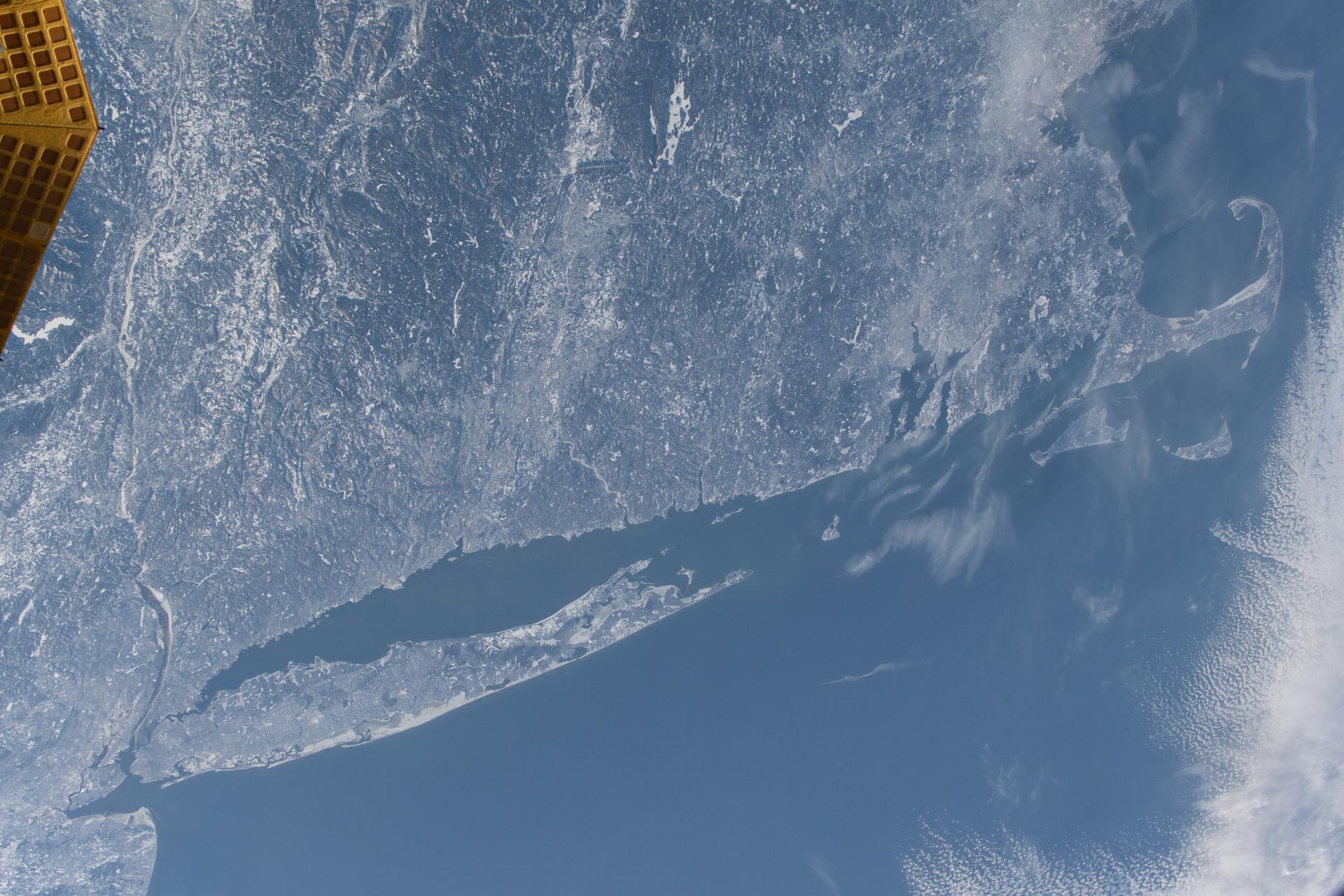
iss074e0209281 (Jan. 28, 2026) --- The wintry landscape of New Jersey, New York, and Connecticut is seen from the International Space Station as it orbited 259 miles above the Atlantic coast of the United States. Temperatures in New York City ranged from a low of about 14 degrees Fahrenheit to a high of around 23 degrees when this photograph was taken.
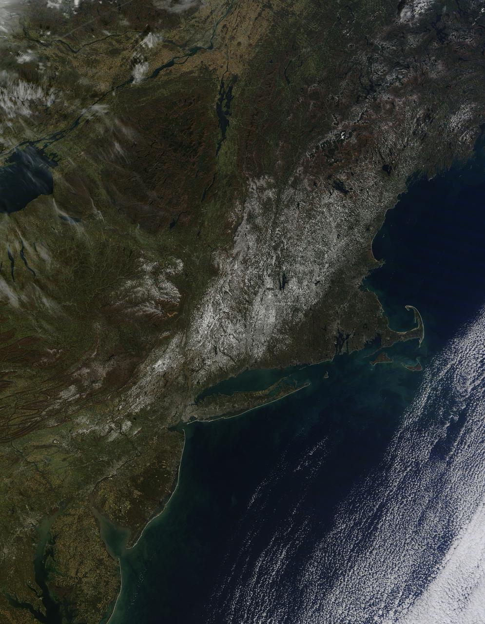
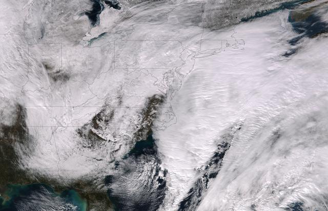
Last weekend's late October snow may have melted in Maryland, Delaware, parts of Pennsylvania and New Jersey, but residents in north central Connecticut are still dealing with the effects of the storm. According to Connecticut Light and Power, 430,868 residents were still without power today, Nov. 3, 2011. For estimated restoration times, visit their website at: <a href="http://www.cl-p.com/stormcenter/estimates/" rel="nofollow">www.cl-p.com/stormcenter/estimates/</a>. A late October snowstorm from a Nor'easter blanketed the eastern U.S. from West Virginia to Maine and broke records the weekend before Halloween Monday. NASA's Aqua satellite flew over the region on October 30 after the snow was ending in New England and captured the ghostly blanket of white. When NASA's Aqua satellite passed over the northeastern U.S. on November 2, 2011 at 2:00 p.m. EDT, the Moderate Resolution Imaging Spectroradiometer (MODIS) instrument captured a detailed image of the remaining snowfall. Snow still covers the ground in western and central Connecticut, southeastern New York, western and central Massachusetts, and parts of Vermont, New Hampshire and Maine. Over the Atlantic, cirrocumulus clouds create a diagonal border. The image was created at NASA's Goddard Space Flight Center in Greenbelt, Md. Image Credit: NASA Goddard MODIS Rapid Response Team; Caption: NASA Goddard, Rob Gutro <b><a href="http://www.nasa.gov/audience/formedia/features/MP_Photo_Guidelines.html" rel="nofollow">NASA image use policy.</a></b> <b><a href="http://www.nasa.gov/centers/goddard/home/index.html" rel="nofollow">NASA Goddard Space Flight Center</a></b> enables NASA’s mission through four scientific endeavors: Earth Science, Heliophysics, Solar System Exploration, and Astrophysics. Goddard plays a leading role in NASA’s accomplishments by contributing compelling scientific knowledge to advance the Agency’s mission. <b>Follow us on <a href="http://twitter.com/NASA_GoddardPix" rel="nofollow">Twitter</a></b> <b>Like us on <a href="http://www.facebook.com/pages/Greenbelt-MD/NASA-Goddard/395013845897?ref=tsd" rel="nofollow">Facebook</a></b> <b>Find us on <a href="http://instagrid.me/nasagoddard/?vm=grid" rel="nofollow">Instagram</a></b>

jsc2024e005966 (1/12/2024) --- The Compartment Cartilage Tissue Construct team includes Dr. Yupeng Chen (Associate Professor of Biomedical Engineering from University of Connecticut), Ian Sands (Ph.D. candidate from University of Connecticut) and Anne Yau (Ph.D. candidate from University of Connecticut). Image courtesy of the University of Connecticut.

jsc2024e005965 (1/12/2024) --- The Compartment Cartilage Tissue Construct team includes Dr. Yupeng Chen (Associate Professor of Biomedical Engineering from University of Connecticut), Ian Sands (Ph.D. candidate from University of Connecticut) and Anne Yau (Ph.D. candidate from University of Connecticut). Image courtesy of the University of Connecticut.
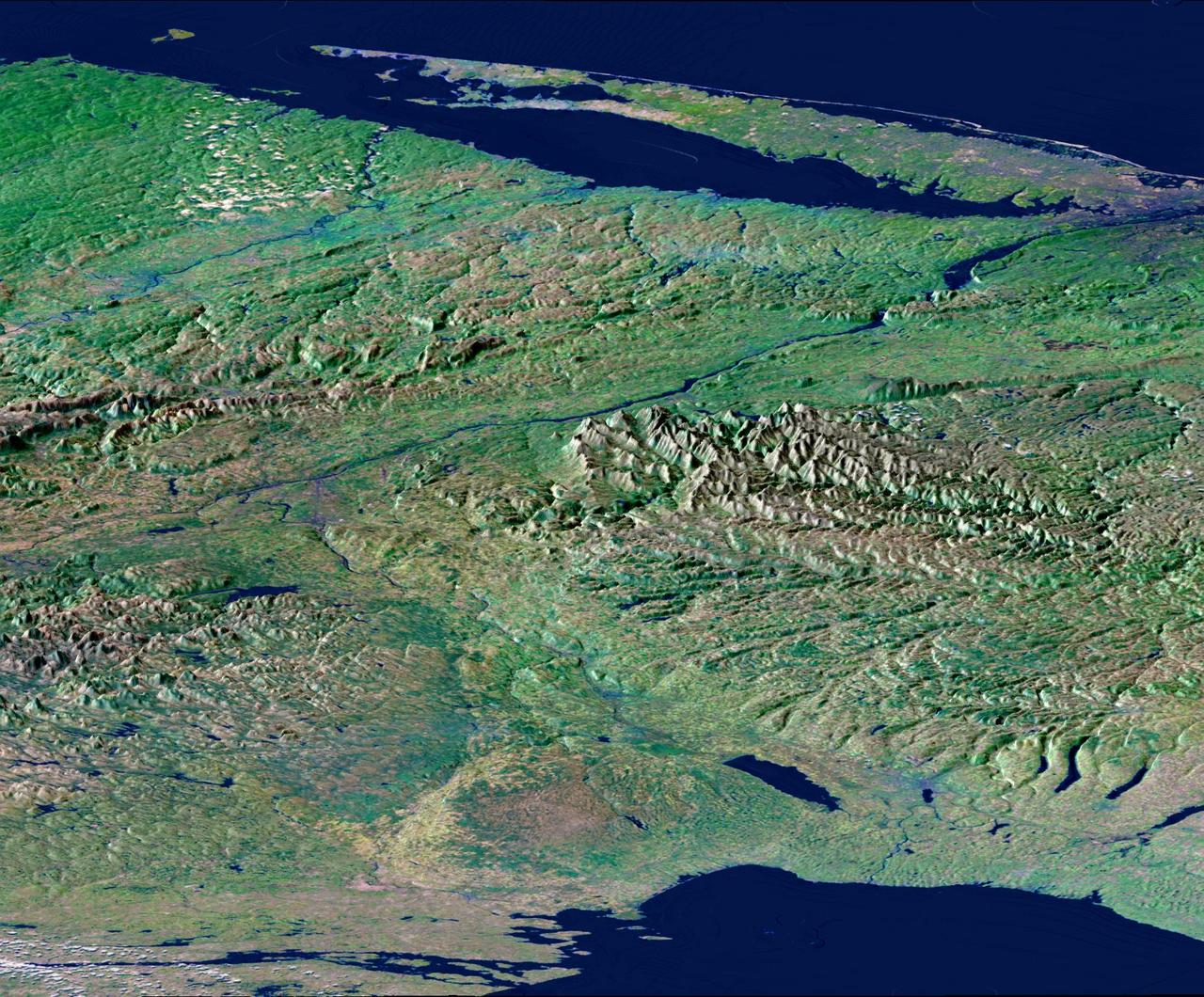
From Lake Ontario and the St. Lawrence River and extending to Long Island, this perspective view shows the varied topography of eastern New York State and parts of Massachusetts, Connecticut, Pennsylvania, New Jersey and Rhode Island.
From Lake Ontario and the St. Lawrence River at the top of the image and extending to Long Island at the bottom this image shows the varied topography of eastern New York State and parts of Massachusetts, Connecticut, Pennsylvania and New Jersey.

This is a version of one of the first images taken by a rear Hazard-Avoidance camera on NASA Curiosity rover and shows part of the rim of Gale Crater, which is a feature the size of Connecticut and Rhode Island combined.
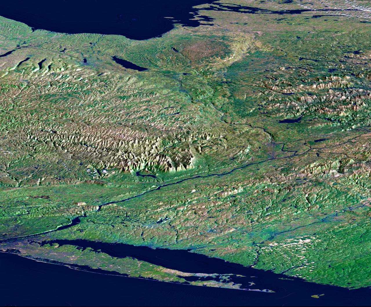
From Lake Ontario and the St. Lawrence River and extending to Long Island, this perspective view shows the varied topography of eastern New York State and parts of Massachusetts, Connecticut, Pennsylvania, New Jersey and Rhode Island.
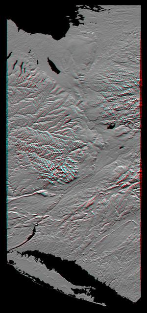
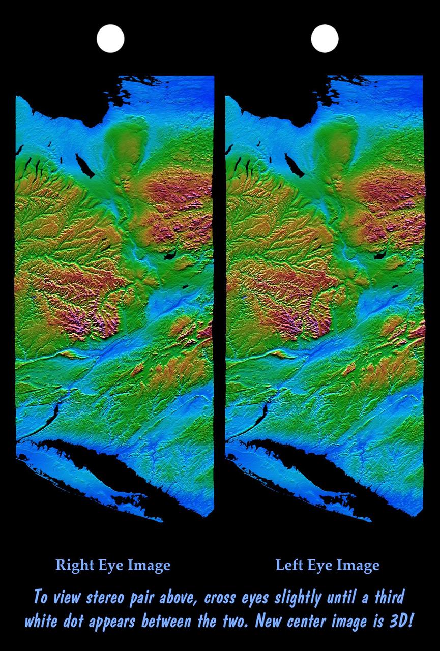
This anaglyph, from NASA Shuttle Radar Topography Mission, shows the varied topography of eastern New York State and parts of Massachusetts, Connecticut, Pennsylvania and New Jersey. 3D glasses are necessary.
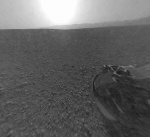
This is a version of one of the first images taken by a rear Hazard-Avoidance camera on NASA Curiosity rover and shows part of the rim of Gale Crater, which is a feature the size of Connecticut and Rhode Island combined.
![Earth observation taken by the Expedition 39 crew aboard the ISS. Image was released by astronaut on Twitter and downlinked in folder: CT [Connecticut].](https://images-assets.nasa.gov/image/iss039e002996/iss039e002996~medium.jpg)
Earth observation taken by the Expedition 39 crew aboard the ISS. Image was released by astronaut on Twitter and downlinked in folder: CT [Connecticut].
![Earth observation taken by the Expedition 39 crew aboard the ISS. View of Cape Cod, Massachusetts downlinked in folder: CT [Connecticut]. Image was released by astronaut on Twitter.](https://images-assets.nasa.gov/image/iss039e001739/iss039e001739~medium.jpg)
Earth observation taken by the Expedition 39 crew aboard the ISS. View of Cape Cod, Massachusetts downlinked in folder: CT [Connecticut]. Image was released by astronaut on Twitter.

iss064e016786 (Dec. 30, 2020) --- This night time photograph of Boston, Massachusetts, was taken from the International Space Station as it orbited 263 miles above Connecticut.
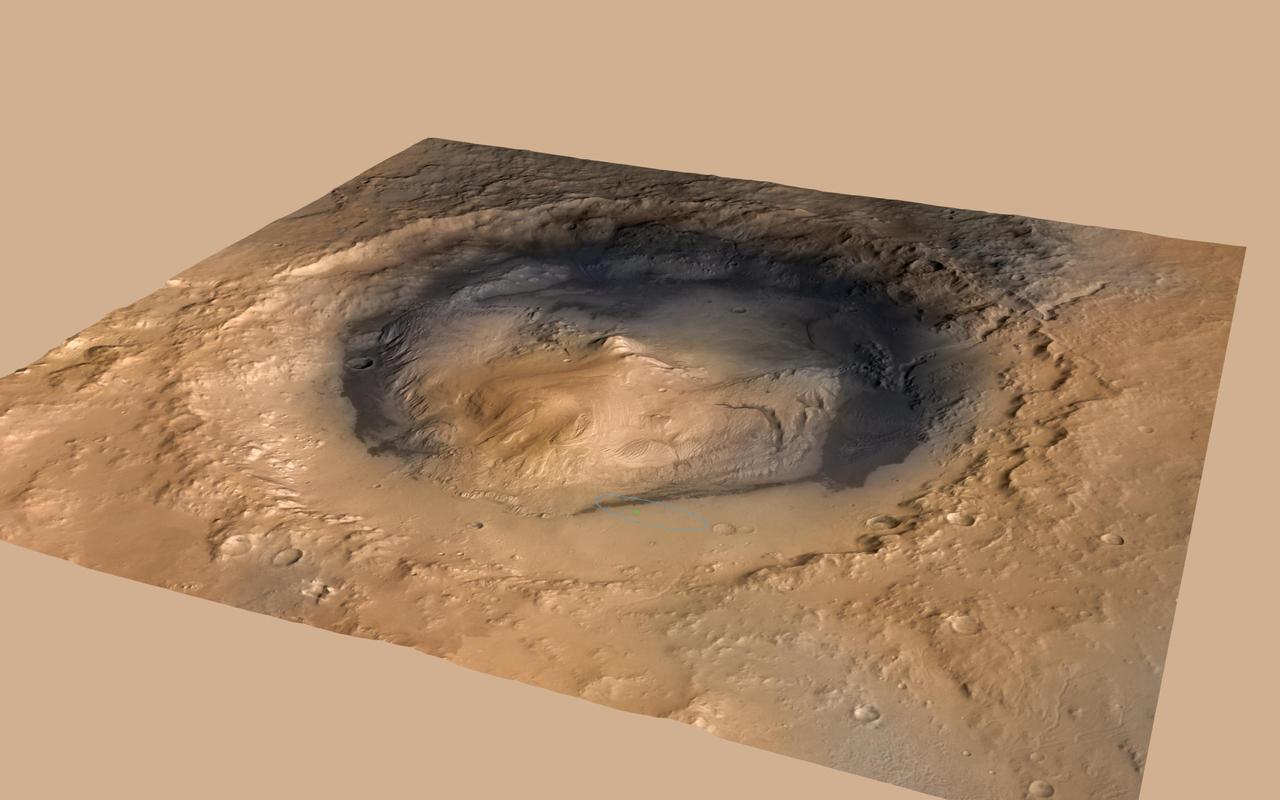
NASA Curiosity rover landed in the Martian crater known as Gale Crater, which is approximately the size of Connecticut and Rhode Island combined. A green dot shows where the rover landed, well within its targeted landing ellipse, outlined in blue.
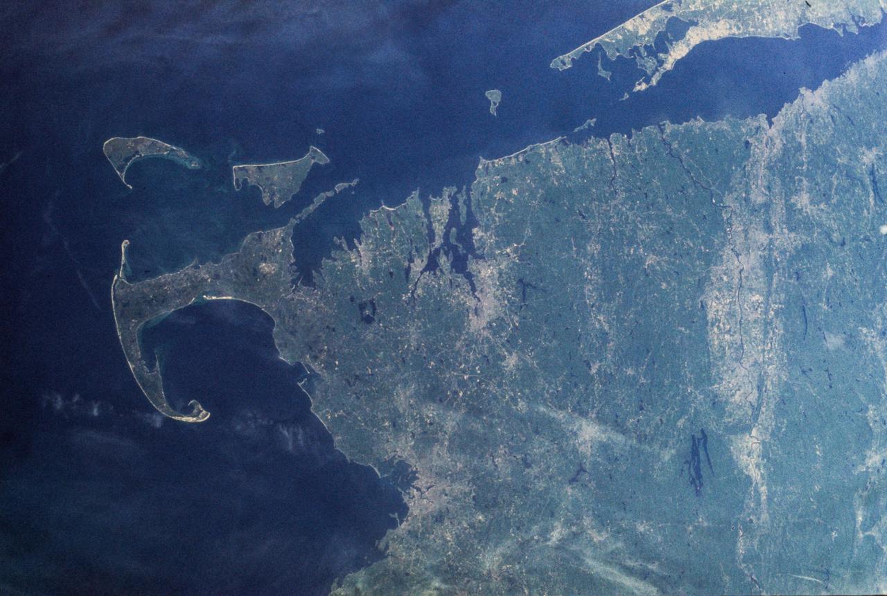
SL2-103-967 (22 June 1973) --- This view of lower New England, (41.5N, 72.0W) shows a rare cloud-free area stretching from northern Long Island across the states of Connecticut, Rhode Island and Massachusetts. The total area covered by this photo is more than 25,000 square miles and includes all of Rhode Island, most of Massachusetts and Connecticut, part of New York and the coastal waters of the Atlantic Ocean. Cape Cod, Boston and the offshore islands are distinctive features. Photo credit: NASA

ISS037-E-001802 (20 Sept. 2013) --- One of three Expedition 37 crew members aboard the International Space Station on Sept. 20 photographed this night image showing parts of the New Jersey-New York-Connecticut area of the Atlantic coast. Long Island, NY is a tell-tale identifier near right center as it juts out into the Atlantic, with Long Island Sound to its west. The New York metropolitan area is largely visible in the bottom center of the frame, with parts of New Jersey at left and parts of Connecticut at right.
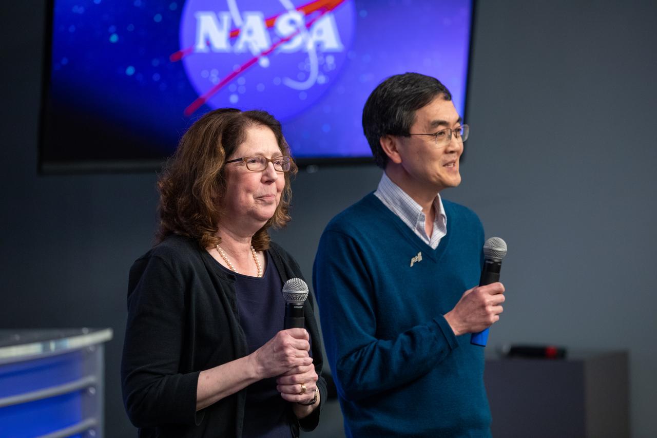
A What’s On Board Briefing for SpaceX’s 19th Commercial Resupply Services (CRS-19) mission for NASA to the International Space Station took place on Dec. 3, 2019, at the agency’s Kennedy Space Center in Florida. Se-Jin Lee (at right) professor at the Jackson Laboratory and University of Connecticut School of Medicine, and principal investigator of Rodent Research-19, and Emily Germain-Lee, professor at the University of Connecticut School of Medicine and chief of endocrinology and diabetes, Connecticut Children’s Medical Center, present their research to members of the media. They discussed the research on molecular signaling pathways that influence muscle degradation to prevent skeletal muscle and bone loss during spaceflight, and enhance recovery following return to Earth. The SpaceX Falcon 9 rocket and Dragon cargo module are scheduled to launch on Dec. 4, 2019, from Space Launch Complex 40 on Cape Canaveral Air Force Station in Florida.

iss055e023781 (April 14, 2018) --- New York state's Long Island and the Atlantic Ocean coasts of New Jersey, Connecticut and Rhode Island are pictured from the International Space Station as it orbited over the eastern coast of the United States.

iss055e023210 (April 14, 2018) --- Chesapeake Bay, Delaware Bay and the east coast of the United States from South Carolina to Connecticut were pictured as the International Space Station orbited 250 miles above the Atlantic Ocean.

A What’s On Board Briefing for SpaceX’s 19th Commercial Resupply Services (CRS-19) mission for NASA to the International Space Station took place on Dec. 3, 2019, at the agency’s Kennedy Space Center in Florida. Emily Germain-Lee, professor at the University of Connecticut School of Medicine and chief of endocrinology and diabetes, Connecticut Children’s Medical Center, discussed her on molecular signaling pathways that influence muscle degradation to prevent skeletal muscle and bone loss during spaceflight, and enhance recovery following return to Earth. The SpaceX Falcon 9 rocket and Dragon cargo module are scheduled to launch on Dec. 4, 2019, from Space Launch Complex 40 on Cape Canaveral Air Force Station in Florida.

iss054e009777 (Jan. 1, 2018) --- The northeastern United States and the well-lit coasts of New Jersey, New York and Connecticut as photographed by Expedition 54 crew members aboard the International Space Station in the wee hours of New Year’s Day.

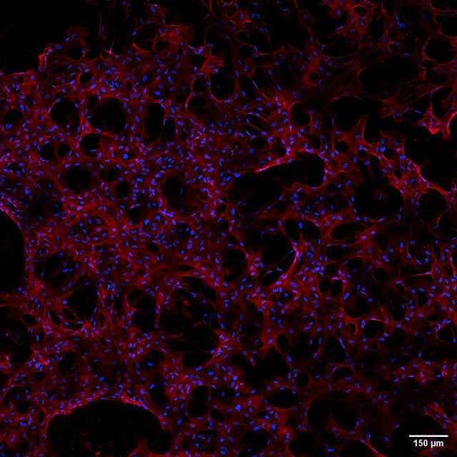
jsc2024e005963 (12/10/2023) --- A preflight image for the Compartment Cartilage Tissue Construct investigation shows that the Janus base nano-matrix (JBNm) aids in the anchorage and function of cartilage cells (indicated by red staining), facilitating the formation of the cartilage tissue matrix (indicated by green staining). Image courtesy of the University of Connecticut.

iss062e046805 (Feb. 22, 2020) --- This oblique view of the northeastern United States highlights the coasts (left to right) of Massachusetts, Rhode Island, Connecticut, New York and New Jersey. The International Space Station was orbiting 265 miles above the Atlantic Ocean when this photograph was taken by an Expedition 62 crewmember.

iss072e186812 (Nov. 14, 2024) --- The city lights along the New England coast of the United States including New Haven, Connecticut; Providence, Rhode Island; and Boston, Massachusetts, are pictured from the United States as it orbited 254 miles above the Atlantic Ocean.

Dr. Nicole Wagner president and CEO for LambdaVision Inc. in Farmington, Connecticut, speaks to members of the media in the Kennedy Space Center’s Press Site auditorium. The briefing focused on research planned for launch to the International Space Station. The scientific materials and supplies will be aboard a Dragon spacecraft scheduled for liftoff from Cape Canaveral Air Force Station's Space Launch Complex 40. The SpaceX Falcon 9 rocket will launch the company's 16th Commercial Resupply Services mission to the space station.

NASA pilot Scott Howe, left, and Sikorsky safety pilot Brent Davis, prepare to board Sikorsky’s SARA S-76B experimental aircraft at Sikorsky Memorial Airport, Bridgeport, Connecticut on Tuesday, Oct. 24, 2023. In addition to Sikorsky’s MATRIX autonomous flight technology, SARA is also outfitted with multiple NASA autonomous flight software systems the pilots and test team will evaluate during their flights over Long Island Sound.
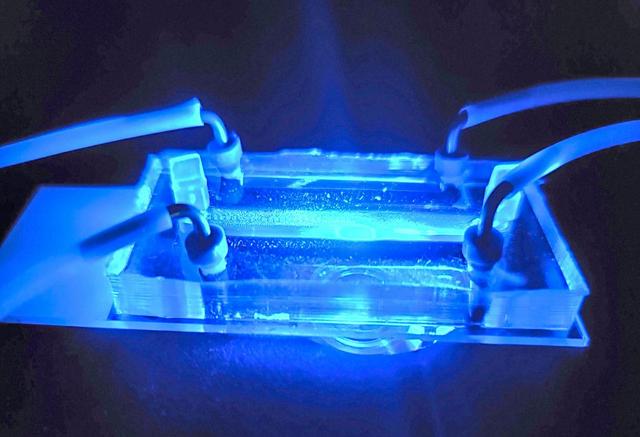
jsc2024e005964 (11/6/2023) --- A preflight image of the Janus base nano-matrix (JBNm) enabled cartilage tissue chip. The Compartment Cartilage Tissue Construct investigation uses biological materials that mimic DNA to develop a scaffold for regenerating cartilage tissues and tests the effect of a specific RNA on cartilage growth in space. Image courtesy of the University of Connecticut.

Jsc2025e036192 (4/4/2025) --- Stem cells grown along Janus Base Nanomaterial (JBNm) made on Earth. After four hours, the cells adhered to the scaffold. Biomimetic Fabrication of Multi-Functional DNA-Inspired Nanomaterials via Controlled Self-assembly in Space (DNA Nano Therapeutics-Mission 2) continues prior research on in-space manufacturing of nanomaterials that mimic DNA and have applications for vaccines and regenerative medicine. Image courtesy of University of Connecticut.

Jordan Greco, chief science officer for LambdaVision Inc. in Farmington, Connecticut, speaks to members of the media in the Kennedy Space Center’s Press Site auditorium. The briefing focused on research planned for launch to the International Space Station. The scientific materials and supplies will be aboard a Dragon spacecraft scheduled for liftoff from Cape Canaveral Air Force Station's Space Launch Complex 40. The SpaceX Falcon 9 rocket will launch the company's 16th Commercial Resupply Services mission to the space station.
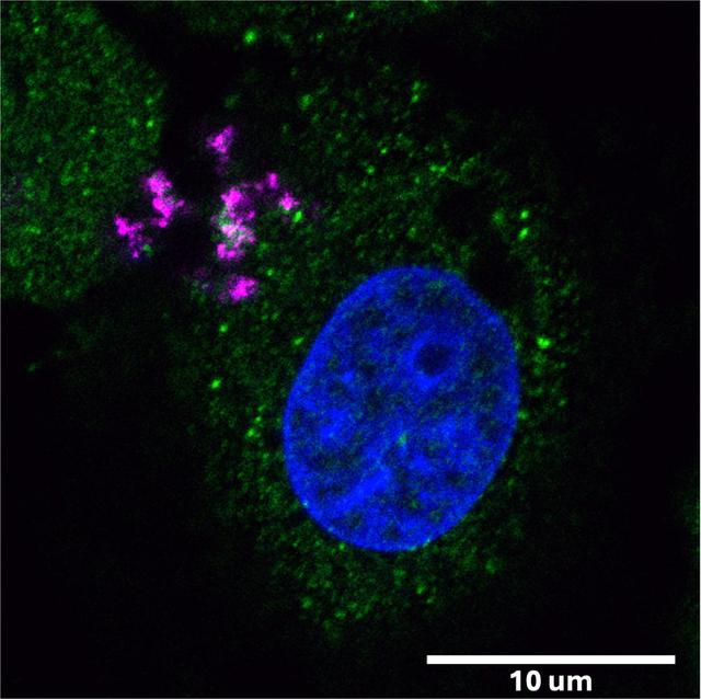
jsc2025e036195 (4/4/2025) --- A confocal microscope image shows a human cartilage cell, with its nucleus stained in blue, following delivery of Janus Base Nanoparticles (JBNp) and the subsequent release of bioactive mRNA (pink) that was translated into function protein (green). Biomimetic Fabrication of Multi-Functional DNA-Inspired Nanomaterials via Controlled Self-assembly in Space (DNA Nano Therapeutics-Mission 2) continues prior research on in-space manufacturing of nanomaterials that mimic DNA and have applications for vaccines and regenerative medicine. Image courtesy of University of Connecticut.

jsc2024e005962 (12/10/2023) --- A preflight image for the Compartment Cartilage Tissue Construct investigation shows that the Janus base Nanopieces (JBNps) delivered green fluorescence labeled therapeutic RNA into cartilage cells. Compartment Cartilage Tissue Construct uses biological materials that mimic DNA to develop a scaffold for regenerating cartilage tissues and tests the effect of a specific RNA on cartilage growth in space. Image courtesy of the University of Connecticut.

NASA pilots along with Sikorsky safety pilots take off in Sikorsky’s SARA S-76B, left, and Black Hawk Optionally Piloted Vehicle from Sikorsky Memorial Airport, Bridgeport, Connecticut on Tuesday, Oct. 24, 2023. NASA is using these experimental aircraft to test and evaluate multiple autonomous flight software systems designed for Advanced Air Mobility concepts.
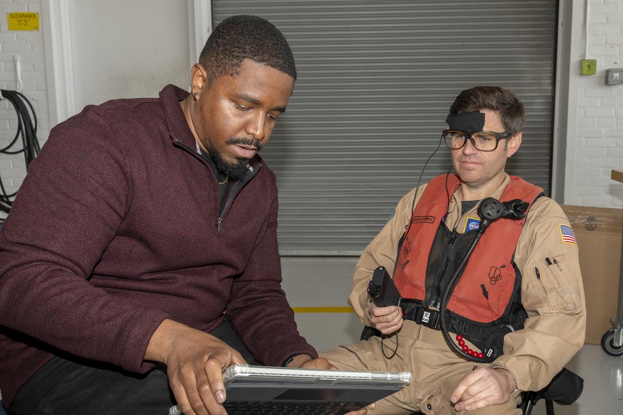
NASA human factors researcher Kevin J. Monk, left, and NASA pilot Scott Howe verify the connectivity and accuracy of the biometric sensors placed on Howe for test flight at Sikorsky Memorial Airport, Bridgeport, Connecticut on Tuesday, Oct. 24, 2023. These sensors will track various physiological responses sending the data to Monk’s computer as Howe engages with the autonomous flight software used to fly the aircraft.

NASA research pilot David Zahn, left, wearing a temporal sensor and pupil tracking glasses works with NASA human factors researcher Kevin J. Monk to calibrate the glasses for accuracy, Thursday, Oct. 26, 2023. The researchers will use the glasses for Advanced Air Mobility autonomous flight research at Sikorsky Memorial Airport in Bridgeport, Connecticut to evaluate the time a pilot spends looking at a navigation tablet along with their vision pattern while using the tablet.

iss074e0003055 (Dec. 20, 2025) --- The New York–Newark–Jersey City Metropolitan Statistical Area, which spans 23 counties across New York, New Jersey, and Connecticut and has a population of about 19.9 million, is pictured at approximately 3:29 a.m. local time from the International Space Station as it orbited 262 miles above the Atlantic coast.
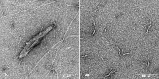
jsc2025e036194 (4/4/2025) --- Image of nanoparticles synthesized under 1g vs microgravity. Left: This transmission electron microscope image depicts the nano-scale structure of Janus Base Nanoparticles encapsulated with mRNA on ground. Right: This is a transmission electron microscope image of mRNA-encapsulated JBNp that was produced on ISS during the SpaceX CRS-31 mission. Here, you can see that the space-made JBNp is smaller and more uniform in size and shape with less background material, demonstrating the stark advantage that in-space manufacturing can provide JBNp: improved uniformity and drug loading. Image courtesy of University of Connecticut.

NASA Administrator Charles Bolden, left, NASA Associate Administrator for Small Business Programs Glenn A. Delgado, second from left, and NASA Deputy Administrator Lori Garver, right, pose for a photograph with Patricia Rice, Manager, Supplier Diversity, Small Business Liaison Officer & Supplier Development, Pratt & Whitney Rocketdyne, Inc. and Jim Maser, President of Pratt & Whitney Rocketdyne, Inc. of East Hartford, Connecticut after the company was awarded the Large Business Prime Contractor of the Year at NASA Headquarters, Tuesday, April 23, 2013 in Washington. Photo Credit: (NASA/Bill Ingalls)
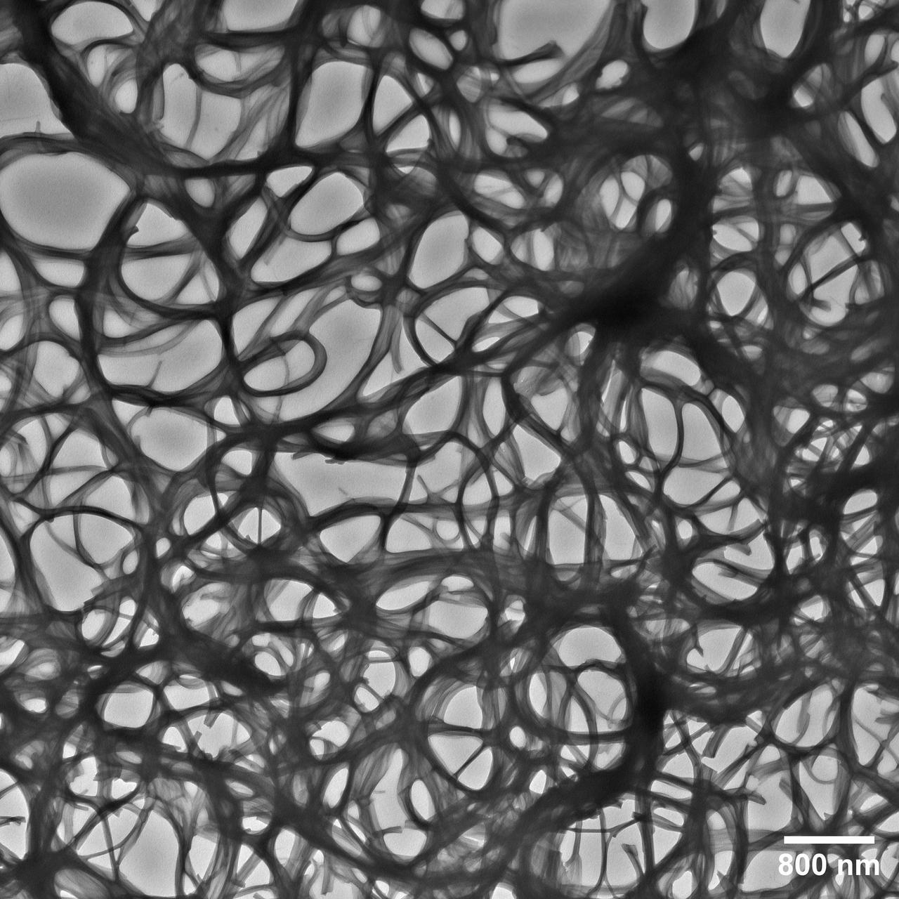
jsc2025e036191 (4/4/2025) --- An electron microscope image taken of a Janus Base Nanomaterial (JBNm) made on the International Space Station. The scale bar on the bottom represents 1/62500 the width of a human hair, making the JBNm bundles thick and interspersed, lead to better outcomes for cells. Biomimetic Fabrication of Multi-Functional DNA-Inspired Nanomaterials via Controlled Self-assembly in Space (DNA Nano Therapeutics-Mission 2) continues prior research on in-space manufacturing of nanomaterials that mimic DNA and have applications for vaccines and regenerative medicine. Image courtesy of University of Connecticut.
ISS035-E-034029 (2 May 2013) --- One of the Expedition 35 crew members aboard the International Space Station recorded this image featuring parts of the Northeast. Long Island, New York is the most conspicuous tell-tale feature, which juts out into the Atlantic Ocean. The entire length of Long Island is visible from Lower Bay to Block Island Sound. According to geologists, the origin and shape of Long Island are due to continental collision and glaciers that once dominated the landscape. The metropolitan area of New York City is complete within the photo, near frame center. Parts of Connecticut and New Jersey are also visible in the scene.

ISS024-E-016051 (27 Aug. 2010) --- This night time view captured by one of the Expedition 24 crew members aboard the International Space Station some 220 miles above Earth is looking down upon New York City. The actual nadir estimate is 39.1 degrees north latitude and 71.2 degrees west longitude or about 170 miles southeast of the city over the Atlantic. Philadelphia is also visible to the right. Long Island and the Connecticut coastal cities mark Long Island Sound. Atlantic City is that small bright spot in the upper right corner. The image was exposed in August and was physically brought back to Earth on a disk with the return of the Expedition 25 crew in November 2010.

jsc2025e036189 (4/4/2025) --- The UCONN lab team who all contributed to space research leading up to DNA Nano Therapeutics-Mission 2. Front: Maxwell Landolina. In back, from left to right: Annie Nguyen (Ph.D. Student), Qianyu Chen (Undergraduate Student), Jin Zhai (Ph.D. Student), Toan Dang (Ph.D. Student), Trystin Cote (Ph.D. Student), Dr. Yupeng Chen (Principal Investigator), Madelyn Pickett (Master's Student). Biomimetic Fabrication of Multi-Functional DNA-Inspired Nanomaterials via Controlled Self-assembly in Space (DNA Nano Therapeutics-Mission 2) continues prior research on in-space manufacturing of nanomaterials that mimic DNA and have applications for vaccines and regenerative medicine. Image courtesy of University of Connecticut.

A What’s On Board Briefing for SpaceX’s 19th Commercial Resupply Services (CRS-19) mission for NASA to the International Space Station took place on Dec. 3, 2019, at the agency’s Kennedy Space Center in Florida. Se-Jin Lee, professor at the Jackson Laboratory and University of Connecticut School of Medicine, and principal investigator of Rodent Research-19 presents his research to members of the media. He discussed the research on molecular signaling pathways that influence muscle degradation to prevent skeletal muscle and bone loss during spaceflight, and enhance recovery following return to Earth. The SpaceX Falcon 9 rocket and Dragon cargo module are scheduled to launch on Dec. 4, 2019, from Space Launch Complex 40 on Cape Canaveral Air Force Station in Florida.

STS102-336-035 (8-21 March 2001) --- One of the STS-102 astronauts aimed a 35mm camera through windows on the aft flight deck of the Space Shuttle Discovery to capture this synoptic southeast view of several New England states. The moderating influence of the Atlantic Ocean is visible along the coastline. The southern limit of the snow-covered landscape can be traced from southeast Massachusetts (left center) westward along the northern shore of Long Island Sound and includes the northern end of New Jersey (right center). In addition to Long Island (center), other prominent features on this image include: Cape Cod, Martha's Vineyard, Nantucket, and Block Islands; as well as the Hudson River (bottom center). Several southerly-draining river systems are discernible in Connecticut and extensive wetlands are observed along New York and New Jersey coastal areas.
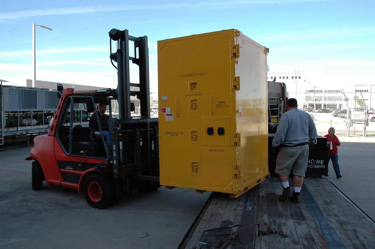
KENNEDY SPACE CENTER, FLA. — At NASA Kennedy Space Center, a new environmental control and life support system is offloaded from a truck. The life support system is part of the payload on the second return-to-flight test mission, STS-121, aboard space shuttle Discovery to the International Space Station. The system will add to the station’s oxygen-making capabilities and could provide enough oxygen for up to six people. Managed by Marshall Space Flight Center in Huntsville, the system was built by Hamilton Sundstrand Corp. in Connecticut. Discovery will carry more than two tons of equipment and supplies to the station. This second return-to-flight test mission is to carry on analysis of safety improvements that debuted on the first return-to-flight mission, STS-114, and build upon those tests. The launch is targeted for a date no earlier than May. Photo credit: NASA/Jack Pfaller
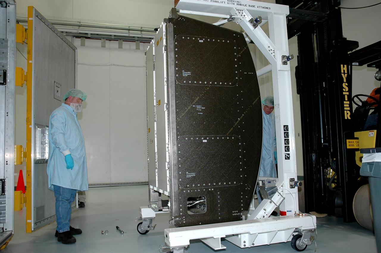
KENNEDY SPACE CENTER, FLA. — At NASA Kennedy Space Center, a new environmental control and life support system is moved into the Space Station Processing Facility. The life support system is part of the payload on the second return-to-flight test mission, STS-121, aboard space shuttle Discovery to the International Space Station. The system will add to the station’s oxygen-making capabilities and could provide enough oxygen for up to six people. Managed by Marshall Space Flight Center in Huntsville, the system was built by Hamilton Sundstrand Corp. in Connecticut. Discovery will carry more than two tons of equipment and supplies to the station. This second return-to-flight test mission is to carry on analysis of safety improvements that debuted on the first return-to-flight mission, STS-114, and build upon those tests. The launch is targeted for a date no earlier than May. Photo credit: NASA/Jack Pfaller
jsc2025e036190 (4/4/2025) --- Stem cells grown along the Janus Base Nanomaterial (JBNm) made aboard the International Space Station. After four hours, a significant increase in the number of these cells adhered to the scaffold, compared to the ground scaffold. This shows that structural improvements were obtained through in-space manufacturing and translated directly into biological improvements. The Flight JBNm is much better at stem cell recruitment, which could better stimulate cartilage regeneration. Biomimetic Fabrication of Multi-Functional DNA-Inspired Nanomaterials via Controlled Self-assembly in Space (DNA Nano Therapeutics-Mission 2) continues prior research on in-space manufacturing of nanomaterials that mimic DNA and have applications for vaccines and regenerative medicine. Image courtesy of University of Connecticut.
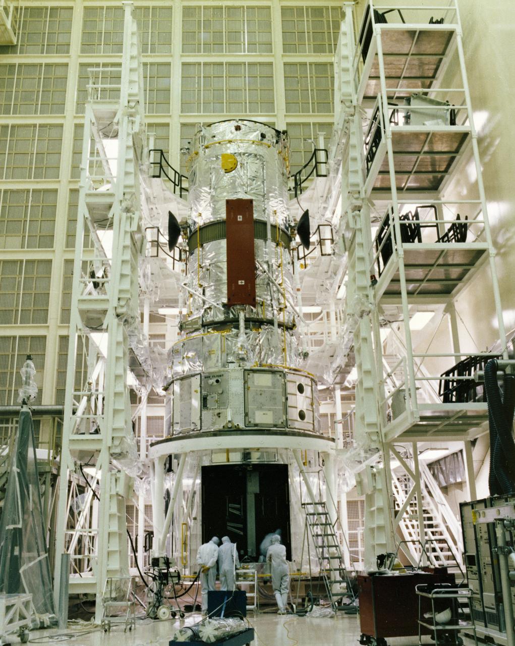
This photograph shows the Hubble Space Telescope (HST) flight article assembly with multilayer insulation, high gain anterna, and solar arrays in a clean room of the Lockheed Missile and Space Company. The HST is the first of NASA's great observatories and the most complex and sensitive optical telescope ever made. The purpose of the HST is to study the cosmos from a low-Earth orbit by placing the telescope in space, enabling astronomers to collect data that is free of the Earth's atmosphere. The HST was deployed from the Space Shuttle Discovery (STS-31 mission) into Earth orbit in April 1990. The Marshall Space Flight Center had overall responsibility for design, development, and construction of the HST. The Perkin-Elmer Corporation, in Danbury, Connecticut, developed the optical system and guidance sensors. The Lockheed Missile and Space Company, Sunnyvale, California, produced the protective outer shroud and spacecraft systems, and assembled and tested the finished telescope.
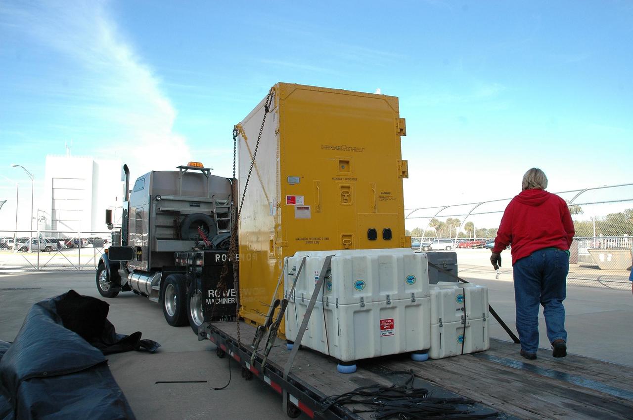
KENNEDY SPACE CENTER, FLA. — A truck arrives at NASA Kennedy Space Center carrying a new environmental control and life support system. The life support system is part of the payload on the second return-to-flight test mission, STS-121, aboard space shuttle Discovery to the International Space Station. The system will add to the station’s oxygen-making capabilities and could provide enough oxygen for up to six people. Managed by Marshall Space Flight Center in Huntsville, the system was built by Hamilton Sundstrand Corp. in Connecticut. Discovery will carry more than two tons of equipment and supplies to the station. This second return-to-flight test mission is to carry on analysis of safety improvements that debuted on the first return-to-flight mission, STS-114, and build upon those tests. The launch is targeted for a date no earlier than May. Photo credit: NASA/Jack Pfaller
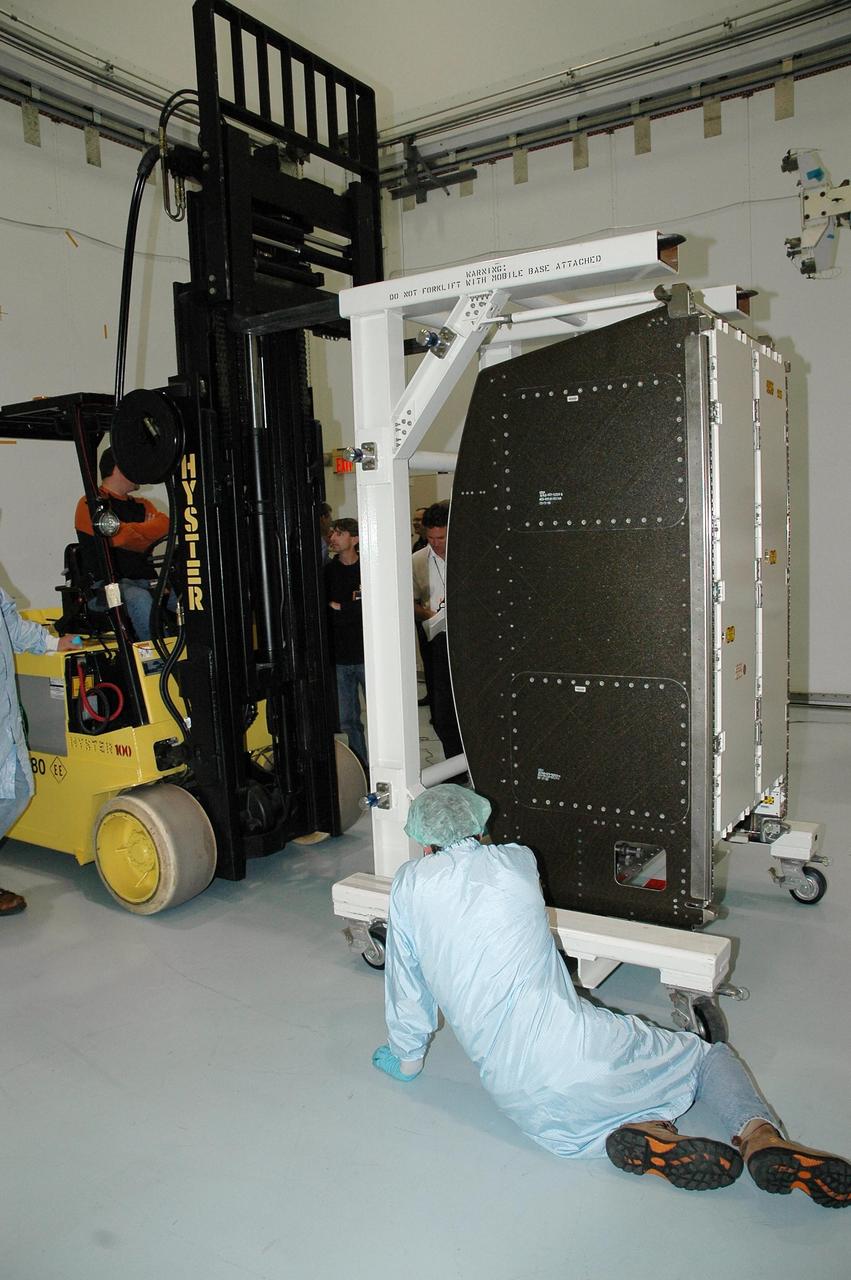
KENNEDY SPACE CENTER, FLA. — At NASA Kennedy Space Center, a new environmental control and life support system is moved into the Space Station Processing Facility after being removed from its shipping container. The life support system is part of the payload on the second return-to-flight test mission, STS-121, aboard space shuttle Discovery to the International Space Station. The system will add to the station’s oxygen-making capabilities and could provide enough oxygen for up to six people. Managed by Marshall Space Flight Center in Huntsville, the system was built by Hamilton Sundstrand Corp. in Connecticut. Discovery will carry more than two tons of equipment and supplies to the station. This second return-to-flight test mission is to carry on analysis of safety improvements that debuted on the first return-to-flight mission, STS-114, and build upon those tests. The launch is targeted for a date no earlier than May. Photo credit: NASA/Jack Pfaller
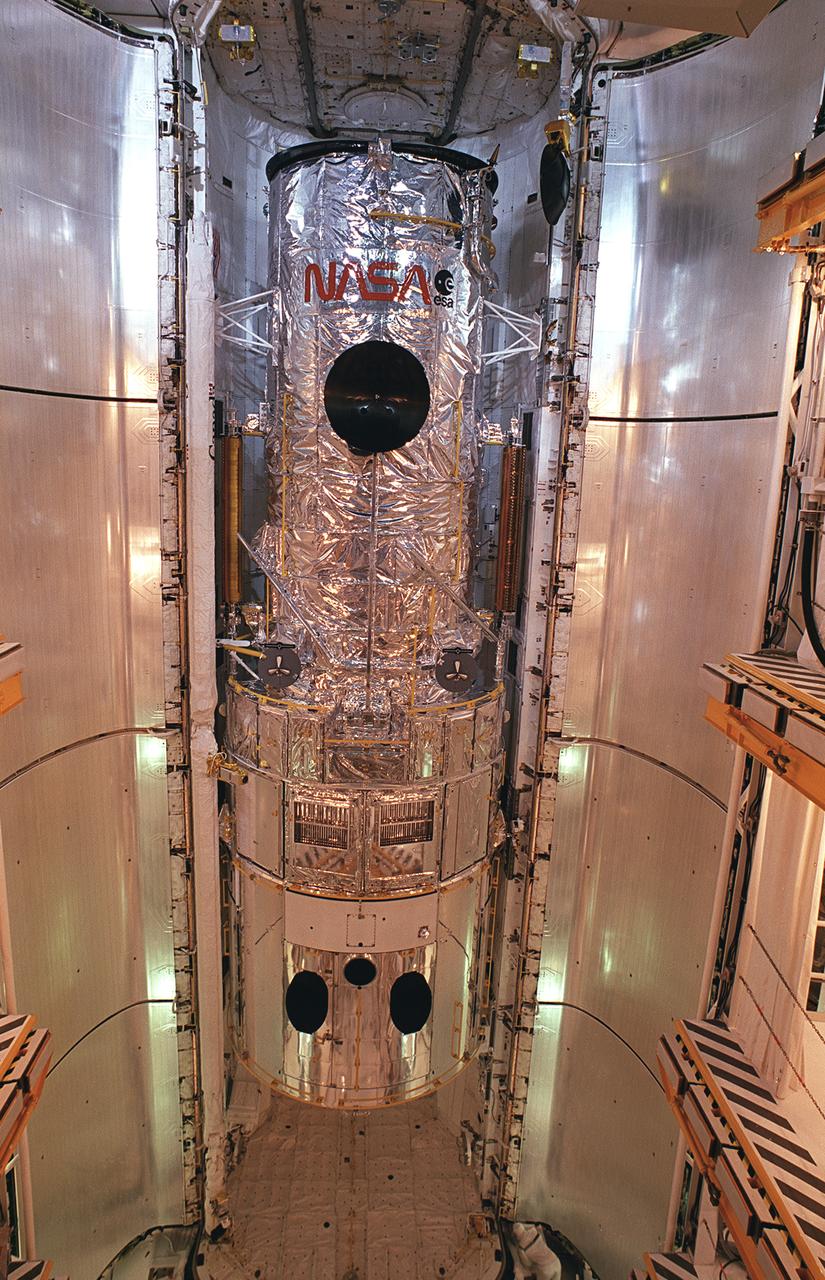
This photograph shows the Hubble Space Telescope (HST) installed in the cargo bay of the Space Shuttle Orbiter Discovery for the STS-31 Mission at The Kennedy Space Center prior to launch on April 24, 1990. The HST is the first of NASA's great observatories and the most complex and sensitive optical telescope ever made. The purpose of the HST is to study the cosmos from a low-Earth orbit by placing the telescope in space, enabling astronomers to collect data that is free of the Earth's atmosphere. The Marshall Space Flight Center had overall responsibility for design, development, and construction of the HST. The Perkin-Elmer Corporation, in Danbury, Connecticut, developed the optical system and guidance sensors. The Lockheed Missile and Space Company, Sunnyvale, California, produced the protective outer shroud and spacecraft systems, and assembled and tested the finished telescope.
iss074e0300237 (Feb. 2, 2026) --- The wintry landscape from New Jersey to Massachusetts is seen from the International Space Station as it orbited 262 miles above the northeastern United States. Temperatures in New York City (lower left) ranged from a low of about 18 degrees Fahrenheit to a high of around 30 degrees when this photograph was taken.

iss074e0209280 (Jan. 28, 2026) --- The wintry landscape from Delaware to Rhode Island is seen from the International Space Station as it orbited 259 miles above the Atlantic coast of the United States. Temperatures in New York City ranged from a low of about 14 degrees Fahrenheit to a high of around 23 degrees when this photograph was taken.
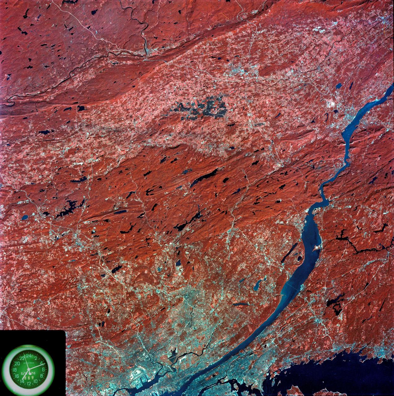
SL3-87-299 (July-September 1973) --- A vertical view of southeastern New York State is seen in this Skylab 3 Earth Resources Experiments Package S190-B (five-inch Earth terrain camera) infrared photograph taken from the Skylab space station in Earth orbit. An 18-inch, 450mm lens and type 2443 infrared Ektachrome film was used. This picture covers the northern part of New Jersey, a part of northwestern Pennsylvania, and the western tip of Connecticut. The body of water is Long Island Sound. The wide Hudson River flows southward across a corner of the photograph. The New York City metropolitan area occupies part of the picture. Federal agencies participating with NASA on the EREP project are the Departments of Agriculture, Commerce, Interior, the Environmental Protection Agency and the Corps of Engineers. All EREP photography is available to the public through the Department of Interior?s Earth Resources Observations Systems Data Center, Sioux Falls, South Dakota, 57198. Photo credit: NASA

ISS015-E-30526 (25 Sept. 2007) --- Fires in East Falkland Island in the South Atlantic Ocean are featured in this image photographed by an Expedition 15 crewmember on the International Space Station. The Falkland Islands are an overseas territory of the United Kingdom, referred to by Argentina (which also claims the islands) as the Islas Malvinas. The main islands of East Falkland and West Falkland are separated by Falkland Sound (12 kilometers) wide at the narrow point. Together they total about the same area as the State of Connecticut or Northern Ireland. The islands lie almost 500 kilometers from the Argentine coast and less than 1,000 kilometers from Antarctica. The first air links to these remote islands were only put in place in 1971. The capital city of Stanley lies on the eastern tip of East Falkland. The local inhabitants are mainly English speakers, and interestingly, the islands have become a center of English-language learning for students from South America. The windy and relatively dry climate has given rise to natural vegetation comprised of treeless grassland with scattered bogs. The grasslands are ideal for sheep rearing which was the dominant occupation until recent decades, when fishing (mainly squid to Spain) and tourism became the mainstay of the economy. These expanses of grassland provide ready fuel for fires, as indicated by the several long smoke plumes visible in this image.
STS098-382-0014 (7-20 February 2001) City Lights of the Northeastern Seaboard of the U.S. were captured with a 35mm camera by one of the STS-98 astronauts aboard the Space Shuttle Atlantis. The nighttime scene shows the bright lights of several major cities that span a distance from Connecticut (left middle) to states south of Virginia (right middle). Lights from both very large urban areas as well as smaller towns and cities are visible. The largest cluster of brightness emanates from the greater New York metropolitan area (left center) and then a series of bright spots progress southwesterly to include Philadelphia (PA), Baltimore (MD), Washington (D.C.), Richmond (VA), and finally ending with the Newport News/ Norfolk (VA) lights (top center). Many of the major ground transportation arteries can be seen as radial, linear features that radiate outward from the central business districts of the cities. Even the lights of smaller cities such as Allentown, Reading, Lancaster, York, and Harrisburg (PA) are visible (bottom center).
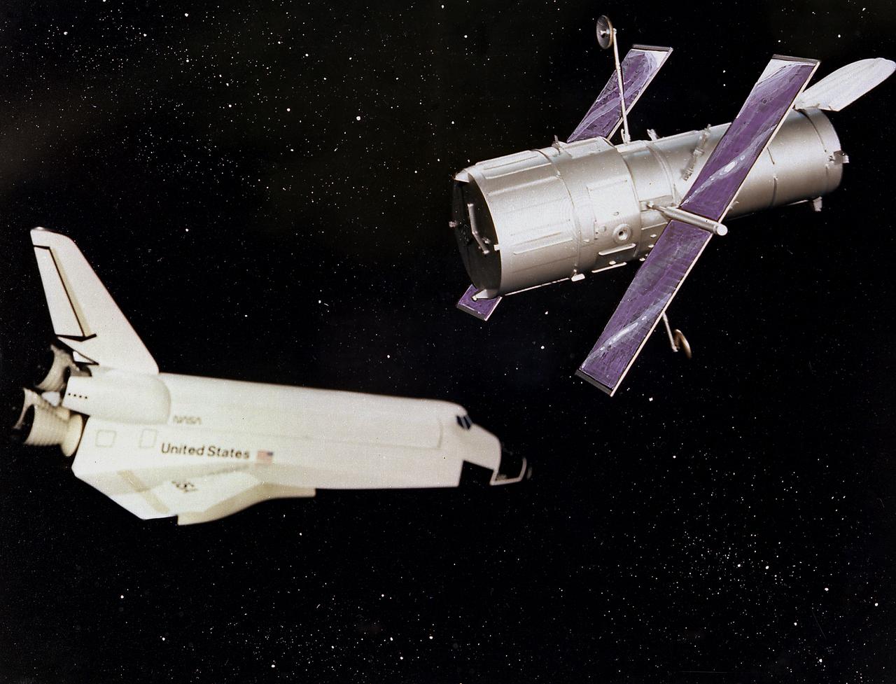
This artist's concept depicts the Hubble Space Telescope after being released into orbit, with the high gain anternas and solar arrays deployed and the aperture doors opened. The HST is the product of a partnership between NASA, European Space Agency Contractors, and the international community of astronomers. It is named after Edwin P. Hubble, an American Astronomer who discovered the expanding nature of the universe and was the first to realize the true nature of galaxies. The purpose of the HST, the most complex and sensitive optical telescope ever made, is to study the cosmos from a low-Earth orbit. By placing the telescope in space, astronomers are able to collect data that is free of the Earth's atmosphere. The HST detects objects 25 times fainter than the dimmest objects seen from Earth and provides astronomers with an observable universe 250 times larger than visible from ground-based telescopes, perhaps as far away as 14 billion light-years. The HST views galaxies, stars, planets, comets, possibly other solar systems, and even unusual phenomena such as quasars, with 10 times the clarity of ground-based telescopes. The major elements of the HST are the Optical Telescope Assembly (OTA), the Support System Module (SSM), and the Scientific Instruments (SI). The HST is 42.5-feet (13-meters) long and weighs about 25,000 pounds (11,600 kilograms). The HST was deployed from the Space Shuttle Discovery (STS-31 mission) into Earth orbit in April 1990. The Marshall Space Flight Center had responsibility for design, development, and construction of the HST. The Perkin-Elmer Corporation, in Danbury, Connecticut, developed the optical system and guidance sensors. The Lockheed Missile and Space Company of Sunnyvale, California produced the protective outer shroud and spacecraft systems, and assembled and tested the finished telescope.
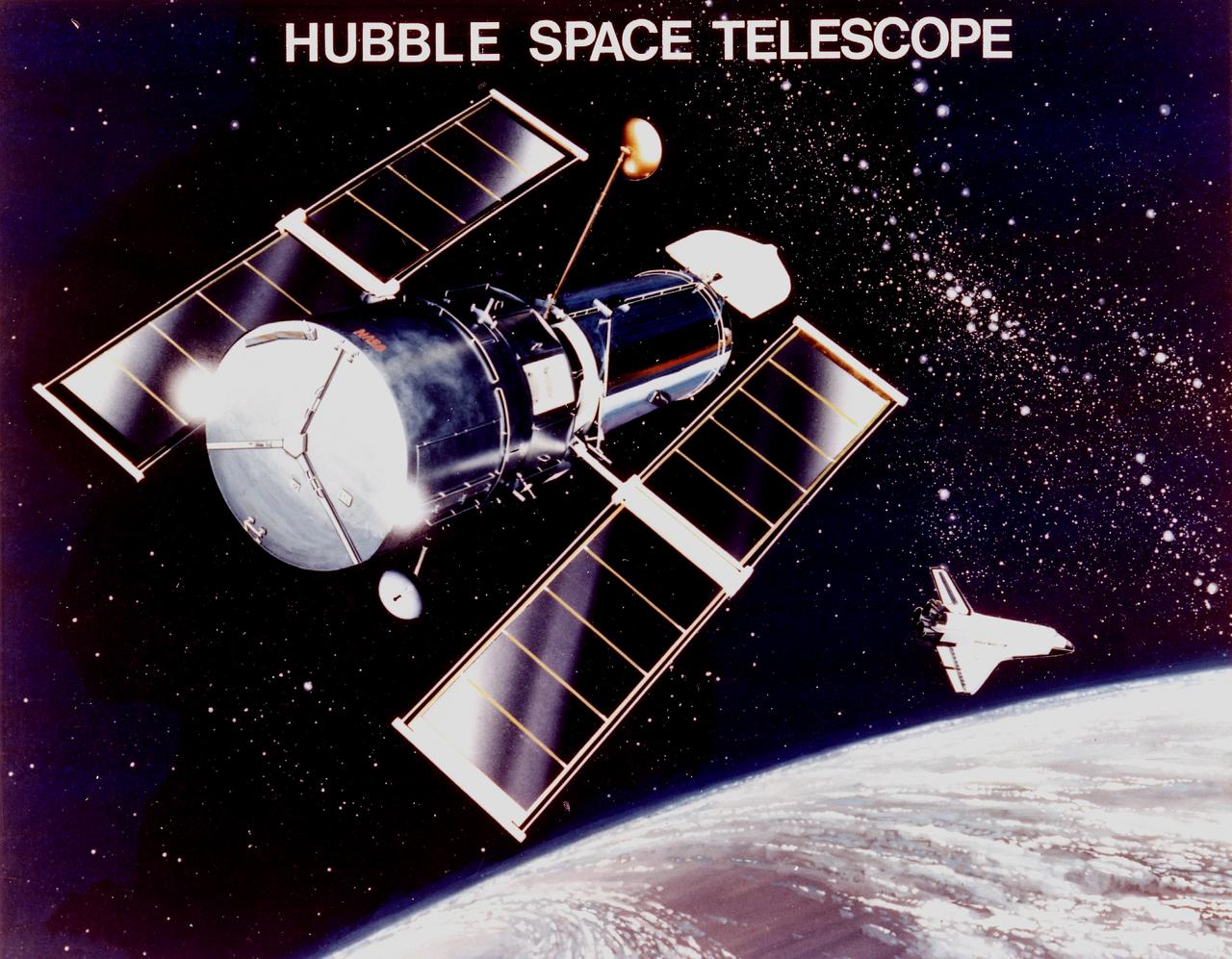
This is an artist's concept of the Hubble Space Telescope (HST). The HST is the product of a partnership between NASA, European Space Agency Contractors, and the international community of astronomers. It is named after Edwin P. Hubble, an American Astronomer who discovered the expanding nature of the universe and was the first to realize the true nature of galaxies. The purpose of the HST, the most complex and sensitive optical telescope ever made, is to study the cosmos from a low-Earth orbit. By placing the telescope in space, astronomers are able to collect data that is free of the Earth's atmosphere. The HST detects objects 25 times fainter than the dimmest objects seen from Earth and provides astronomers with an observable universe 250 times larger than is visible from ground-based telescopes, perhaps as far away as 14 billion light-years. The HST views galaxies, stars, planets, comets, possibly other solar systems, and even unusual phenomena such as quasars, with 10 times the clarity of ground-based telescopes. The major elements of the HST are the Optical Telescope Assembly (OTA), the Support System Module (SSM), and the Scientific Instruments (SI). The HST is approximately the size of a railroad car, with two cylinders joined together and wrapped in a silvery reflective heat shield blanket. Wing-like solar arrays extend horizontally from each side of these cylinders, and dish-shaped anternas extend above and below the body of the telescope. The HST was deployed from the Space Shuttle Discovery (STS-31 mission) into Earth orbit in April 1990. The Marshall Space Flight Center had responsibility for design, development, and construction of the HST. The Perkin-Elmer Corporation, in Danbury, Connecticut, developed the optical system and guidance sensors. The Lockheed Missile and Space Company of Sunnyvale, California produced the protective outer shroud and spacecraft systems, and assembled and tested the finished telescope.

This illustration depicts the design features of the Hubble Space Telescope's (HST's) Support Systems Module (SSM). The SSM is one of the three major elements of the HST and encloses the other two elements, the Optical Telescope Assembly (OTA) and the Scientific Instruments (SI's). The purpose of the HST, the most complex and sensitive optical telescope ever made, is to study the cosmos from a low-Earth orbit. By placing the telescope in space, astronomers are able to collect data that is free of the Earth's atmosphere. The HST detects objects 25 times fainter than the dimmest objects seen from Earth and provides astronomers with an observable universe 250 times larger than visible from ground-based telescopes, perhaps as far away as 14 billion light-years. The HST views galaxies, stars, planets, comets, possibly other solar systems, and even unusual phenomena such as quasars, with 10 times the clarity of ground-based telescopes. The spacecraft is 42.5-feet (13-meters) long and weighs 25,000 pounds (11,600 kilograms). Two communication anternas, two solar array panels that collect energy for the HST, and storage bays for electronic gear are on the outside. The HST was deployed from the Space Shuttle Discovery (STS-31 mission) into Earth orbit in April 1990. The Marshall Space Flight Center had responsibility for design, development, and construction of the HST. The Perkin-Elmer Corporation, in Danbury, Connecticut, developed the optical system and guidance sensors. The Lockheed Missile and Space Company of Sunnyvale, California produced the protective outer shroud and spacecraft systems, and assembled and tested the finished telescope.
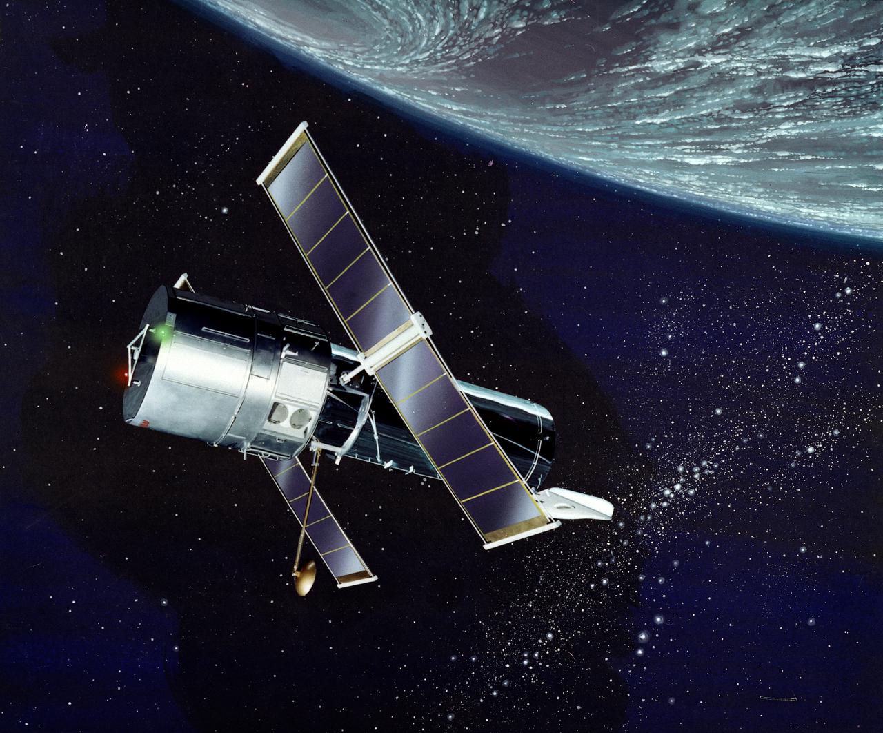
This illustration depicts a side view of the Hubble Space Telescope (HST). The HST is the product of a partnership between NASA, European Space Agency Contractors, and the international community of astronomers. It is named after Edwin P. Hubble, an American Astronomer who discovered the expanding nature of the universe and was the first to realize the true nature of galaxies. The purpose of the HST, the most complex and sensitive optical telescope ever made, is to study the cosmos from a low-Earth orbit. By placing the telescope in space, astronomers are able to collect data that is free of the Earth's atmosphere. The HST detects objects 25 times fainter than the dimmest objects seen from Earth and provides astronomers with an observable universe 250 times larger than visible from ground-based telescopes, perhaps as far away as 14 billion light-years. The HST views galaxies, stars, planets, comets, possibly other solar systems, and even unusual phenomena such as quasars, with 10 times the clarity of ground-based telescopes. The major elements of the HST are the Optical Telescope Assembly (OTA), the Support System Module (SSM), and the Scientific Instruments (SI). The HST is approximately the size of a railroad car, with two cylinders joined together and wrapped in a silvery reflective heat shield blanket. Wing-like solar arrays extend horizontally from each side of these cylinders, and dish-shaped anternas extend above and below the body of the telescope. The HST was deployed from the Space Shuttle Discovery (STS-31 mission) into Earth orbit in April 1990. The Marshall Space Flight Center had responsibility for design, development, and construction of the HST. The Perkin-Elmer Corporation, in Danbury, Connecticut, developed the optical system and guidance sensors. The Lockheed Missile and Space Company of Sunnyvale, California produced the protective outer shroud and spacecraft systems, and assembled and tested the finished telescope.
This image was taken by the Suomi NPP satellite's VIIRS instrument at 1825Z on January 26, 2015. A low pressure system currently forming off the mid-Atlantic coast will rapidly strengthen into a major nor'easter today and affect parts of the Northeast U.S. through early Wednesday. This system will be responsible for heavy to intense snowfall and strong winds, with blizzard conditions expected from eastern New Jersey to eastern Massachusetts where Blizzard Warnings are in effect. Accumulations will likely exceed one foot from eastern New Jersey through eastern Maine by late Tuesday. The heaviest snow accumulations, perhaps exceeding two feet, are forecast across portions of Connecticut, Rhode Island and Massachusetts, including the Boston area. Currently, New York City is forecast to receive 18-24 inches of snow, and Boston is forecast to receive 24-36 inches of snow. Wind gusts of 45 to 60 mph will be common from eastern New Jersey to eastern Massachusetts, leading to widespread blizzard conditions. Wind gusts up to 70 mph are possible in far eastern Massachusetts, including Cape Cod and Nantucket. Credit: NASA/NOAA/NPP/VIIRS Via: NASA/NOAA via <b><a href="www.nnvl.noaa.gov/" rel="nofollow"> NOAA Environmental Visualization Laboratory</a></b> <b><a href="http://www.nasa.gov/audience/formedia/features/MP_Photo_Guidelines.html" rel="nofollow">NASA image use policy.</a></b> <b><a href="http://www.nasa.gov/centers/goddard/home/index.html" rel="nofollow">NASA Goddard Space Flight Center</a></b> enables NASA’s mission through four scientific endeavors: Earth Science, Heliophysics, Solar System Exploration, and Astrophysics. Goddard plays a leading role in NASA’s accomplishments by contributing compelling scientific knowledge to advance the Agency’s mission. <b>Follow us on <a href="http://twitter.com/NASAGoddardPix" rel="nofollow">Twitter</a></b> <b>Like us on <a href="http://www.facebook.com/pages/Greenbelt-MD/NASA-Goddard/395013845897?ref=tsd" rel="nofollow">Facebook</a></b> <b>Find us on <a href="http://instagram.com/nasagoddard?vm=grid" rel="nofollow">Instagram</a></b>
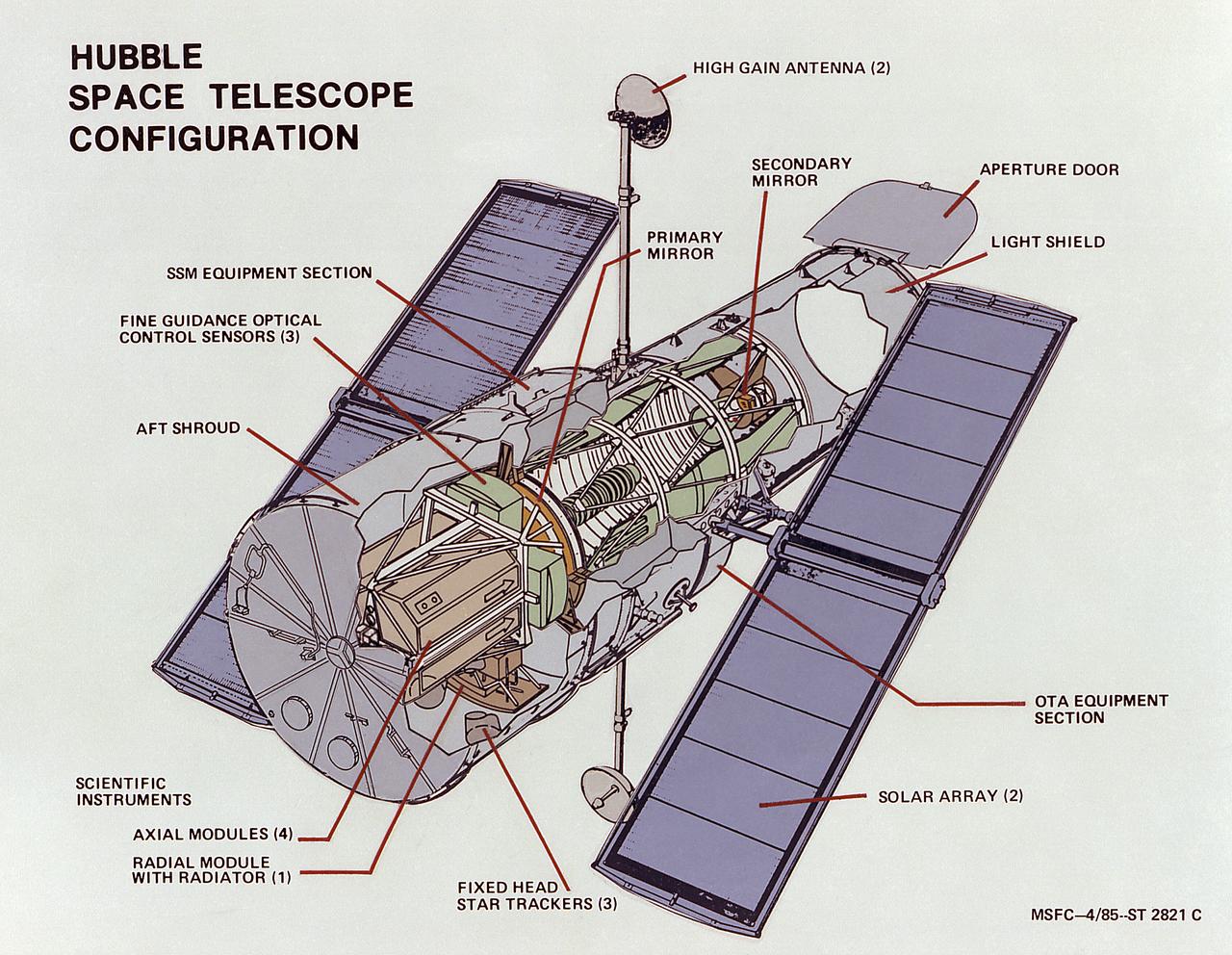
This image illustrates the overall Hubble Space Telescope (HST) configuration. The HST is the product of a partnership between NASA, European Space Agency Contractors, and the international community of astronomers. It is named after Edwin P. Hubble, an American Astronomer who discovered the expanding nature of the universe and was the first to realize the true nature of galaxies. The purpose of the HST, the most complex and sensitive optical telescope ever made, is to study the cosmos from a low-Earth orbit. By placing the telescope in space, astronomers are able to collect data that is free of the Earth's atmosphere. The HST detects objects 25 times fainter than the dimmest objects seen from Earth and provides astronomers with an observable universe 250 times larger than visible from ground-based telescopes, perhaps as far away as 14 billion light-years. The HST views galaxies, stars, planets, comets, possibly other solar systems, and even unusual phenomena such as quasars, with 10 times the clarity of ground-based telescopes. The major elements of the HST are the Optical Telescope Assembly (OTA), the Support System Module (SSM), and the Scientific Instruments (SI). The HST is approximately the size of a railroad car, with two cylinders joined together and wrapped in a silvery reflective heat shield blanket. Wing-like solar arrays extend horizontally from each side of these cylinders, and dish-shaped anternas extend above and below the body of the telescope. The HST was deployed from the Space Shuttle Discovery (STS-31 mission) into Earth orbit in April 1990. The Marshall Space Flight Center had responsibility for design, development, and construction of the HST. The Perkin-Elmer Corporation, in Danbury, Connecticut, developed the optical system and guidance sensors. The Lockheed Missile and Space Company of Sunnyvale, California produced the protective outer shroud and spacecraft systems, and assembled and tested the finished telescope.
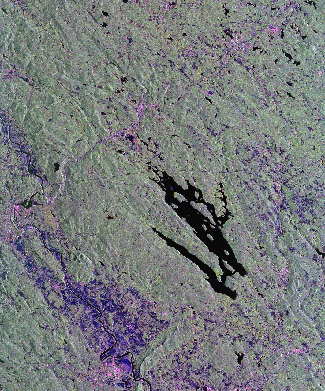
This is a radar image of the area surrounding the Harvard Forest in north-central Massachusetts that has been operated as a ecological research facility by Harvard University since 1907. At the center of the image is the Quabbin Reservoir, and the Connecticut River is at the lower left of the image. The Harvard Forest itself is just above the reservoir. Researchers are comparing the naturally occurring physical disturbances in the forest and the recent and projected chemical disturbances and their effects on the forest ecosystem. Agricultural land appears dark blue/purple, along with low shrub vegetation and some wetlands. Urban development is bright pink; the yellow to green tints are conifer-dominated vegetation with the pitch pine sand plain at the middle left edge of the image appearing very distinctive. The green tint may indicate pure pine plantation stands, and deciduous broadleaf trees appear gray/pink with perhaps wetter sites being pinker. This image was acquired by the Spaceborne Imaging Radar-C/X-Band Synthetic Aperture Radar (SIR-C/X-SAR) aboard the space shuttle Endeavour. SIR-C/X-SAR, a joint mission of the German, Italian and the United States space agencies, is part of NASA's Mission to Planet Earth. The image is centered at 42.50 degrees North latitude and 72.33 degrees West longitude and covers an area of 53 kilometers 63 by kilometers (33 miles by 39 miles). The colors in the image are assigned to different frequencies and polarizations of the radar as follows: red is L-band horizontally transmitted and horizontally received; green is L-band horizontally transmitted and vertically received; and blue is C-band horizontally transmitted and horizontally received. http://photojournal.jpl.nasa.gov/catalog/PIA01788

The U.S. National Weather Service called it a “a crippling and historic winter blizzard.” In late January 2015, transportation systems from Trenton to Portland were shut down, and more than 35 million people hunkered down for extreme snowfall and biting winds. For those in New England, it turned out to be a monstrous storm. For the Mid-Atlantic region, not so much. Vast swaths of Massachusetts, Connecticut, Rhode Island, New Hampshire, Maine, and Long Island (NY) were blanketed with 15 to 25 inches (40 to 60 centimeters) of snow as of midday on January 27, 2015, and snow was expected to continue into January 28. Sustained winds reached gale force, with hurricane-force gusts along the coastlines. Storm surges sent ice and water into the streets of Scituate and Nantucket, Massachusetts. Many New England towns, including the city of Boston, were expected to approach all-time snowfall records. The Visible Infrared Imaging Radiometer Suite on the Suomi NPP satellite acquired these nighttime images at 1:45 am US eastern standard time (06:45 Universal Time) on January 27, 2015. The top image, lit by moonlight and city lights, shows a nor'easter off the coast of the East Coast of the United States. City lights are blurred somewhat by the cloud cover. The second image shows the same scene in longwave infrared radiation, with brighter shades representing the colder temperatures of snow-producing clouds. NASA Earth Observatory image by Jesse Allen, using VIIRS data from the Suomi National Polar-orbiting Partnership. Read more: <a href="http://earthobservatory.nasa.gov/IOTD/view.php?id=85166&eocn=home&eoci=iotd_title" rel="nofollow">earthobservatory.nasa.gov/IOTD/view.php?id=85166&eocn...</a> Via: <b><a href="http://www.earthobservatory.nasa.gov/" rel="nofollow"> NASA Earth Observatory</a></b> <b><a href="http://www.nasa.gov/audience/formedia/features/MP_Photo_Guidelines.html" rel="nofollow">NASA image use policy.</a></b> <b><a href="http://www.nasa.gov/centers/goddard/home/index.html" rel="nofollow">NASA Goddard Space Flight Center</a></b> enables NASA’s mission through four scientific endeavors: Earth Science, Heliophysics, Solar System Exploration, and Astrophysics. Goddard plays a leading role in NASA’s accomplishments by contributing compelling scientific knowledge to advance the Agency’s mission. <b>Follow us on <a href="http://twitter.com/NASAGoddardPix" rel="nofollow">Twitter</a></b> <b>Like us on <a href="http://www.facebook.com/pages/Greenbelt-MD/NASA-Goddard/395013845897?ref=tsd" rel="nofollow">Facebook</a></b> <b>Find us on <a href="http://instagram.com/nasagoddard?vm=grid" rel="nofollow">Instagram</a></b>

The U.S. National Weather Service called it a “a crippling and historic winter blizzard.” In late January 2015, transportation systems from Trenton to Portland were shut down, and more than 35 million people hunkered down for extreme snowfall and biting winds. For those in New England, it turned out to be a monstrous storm. For the Mid-Atlantic region, not so much. Vast swaths of Massachusetts, Connecticut, Rhode Island, New Hampshire, Maine, and Long Island (NY) were blanketed with 15 to 25 inches (40 to 60 centimeters) of snow as of midday on January 27, 2015, and snow was expected to continue into January 28. Sustained winds reached gale force, with hurricane-force gusts along the coastlines. Storm surges sent ice and water into the streets of Scituate and Nantucket, Massachusetts. Many New England towns, including the city of Boston, were expected to approach all-time snowfall records. The Visible Infrared Imaging Radiometer Suite on the Suomi NPP satellite acquired these nighttime images at 1:45 am US eastern standard time (06:45 Universal Time) on January 27, 2015. The top image, lit by moonlight and city lights, shows a nor'easter off the coast of the East Coast of the United States. City lights are blurred somewhat by the cloud cover. The second image shows the same scene in longwave infrared radiation, with brighter shades representing the colder temperatures of snow-producing clouds. NASA Earth Observatory image by Jesse Allen, using VIIRS data from the Suomi National Polar-orbiting Partnership. Read more: <a href="http://earthobservatory.nasa.gov/IOTD/view.php?id=85166&eocn=home&eoci=iotd_title" rel="nofollow">earthobservatory.nasa.gov/IOTD/view.php?id=85166&eocn...</a> Via: <b><a href="http://www.earthobservatory.nasa.gov/" rel="nofollow"> NASA Earth Observatory</a></b> <b><a href="http://www.nasa.gov/audience/formedia/features/MP_Photo_Guidelines.html" rel="nofollow">NASA image use policy.</a></b> <b><a href="http://www.nasa.gov/centers/goddard/home/index.html" rel="nofollow">NASA Goddard Space Flight Center</a></b> enables NASA’s mission through four scientific endeavors: Earth Science, Heliophysics, Solar System Exploration, and Astrophysics. Goddard plays a leading role in NASA’s accomplishments by contributing compelling scientific knowledge to advance the Agency’s mission. <b>Follow us on <a href="http://twitter.com/NASAGoddardPix" rel="nofollow">Twitter</a></b> <b>Like us on <a href="http://www.facebook.com/pages/Greenbelt-MD/NASA-Goddard/395013845897?ref=tsd" rel="nofollow">Facebook</a></b> <b>Find us on <a href="http://instagram.com/nasagoddard?vm=grid" rel="nofollow">Instagram</a></b>