
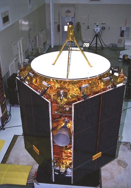
Workers at Launch Complex 17 Pad A, Kennedy Space Center (KSC) encapsulate the Geomagnetic Tail (GEOTAIL) spacecraft (upper) and attached payload Assist Module-D upper stage (lower) in the protective payload fairing. GEOTAIL project was designed to study the effects of Earth's magnetic field. The solar wind draws the Earth's magnetic field into a long tail on the night side of the Earth and stores energy in the stretched field lines of the magnetotail. During active periods, the tail couples with the near-Earth magnetosphere, sometimes releasing energy stored in the tail and activating auroras in the polar ionosphere. GEOTAIL measures the flow of energy and its transformation in the magnetotail and will help clarify the mechanisms that control the imput, transport, storage, release, and conversion of mass, momentum, and energy in the magnetotail.

Small Expendable Deployer System (SEDS) is a tethered date collecting satellite and is intended to demonstrate a versatile and economical way of delivering smaller payloads to higher orbits or downward toward Earth's atmosphere. 19th Navstar Global Positioning System Satellite mission joined with previously launched satellites used for navigational purposes and geodite studies. These satellites are used commercially as well as by the military.

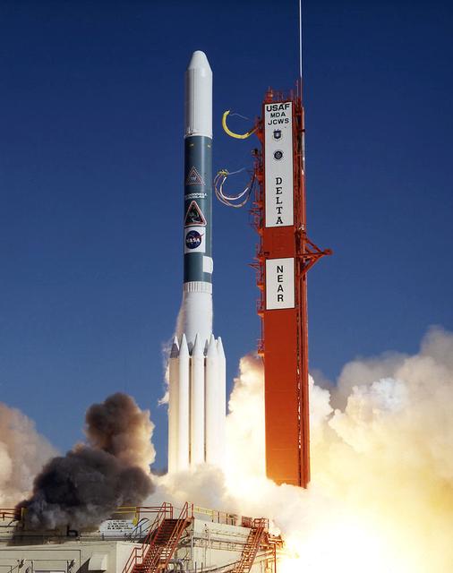
A Delta II rocket carrying the Geomagnetic Tail Lab (GEOTAIL) spacecraft lifts off at Launch Complex 17, Kennedy Space Center (KSC) into a cloud-dappled sky. This liftoff marks the first Delta launch under the medium expendable launch vehicle services contract between NASA and McDonnell Douglas Space Systems Co. The GEOTAIL mission, a joint US/Japanese project, is the first in a series of five satellites to study the interactions between the Sun, the Earth's magnetic field, and the Van Allen radiation belts.

“We like to say that Archean Earth is the most alien planet we have geochemical data for,” For astronomers trying to understand which distant planets might have habitable conditions, the role of atmospheric haze has been hazy. To help sort it out, a team of researchers has been looking to Earth – specifically Earth during the Archean era, an epic 1-1/2-billion-year period early in our planet’s history. Read more: <a href="http://go.nasa.gov/2kTBhPU" rel="nofollow">go.nasa.gov/2kTBhPU</a> Caption: When haze built up in the atmosphere of Archean Earth, the young planet might have looked like this artist's interpretation - a pale orange dot. A team led by Goddard scientists thinks the haze was self-limiting, cooling the surface by about 36 degrees Fahrenheit (20 Kelvins) – not enough to cause runaway glaciation. The team’s modeling suggests that atmospheric haze might be helpful for identifying earthlike exoplanets that could be habitable. Credits: NASA’s Goddard Space Flight Center/Francis Reddy
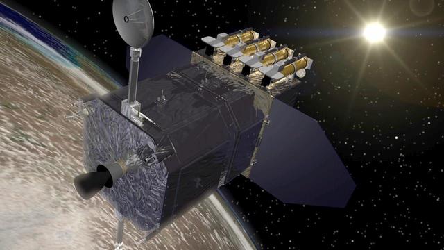
The Solar Dynamics Observatory SDO spacecraft, shown above the Earth as it faces toward the Sun. SDO is designed to study the influence of the Sun on the Earth and the inner solar system by studying the solar atmosphere. http://photojournal.jpl.nasa.gov/catalog/PIA18169
The reflection of the Atlas IIAS expendable launch vehicle with the Solar Heliospheric Observatory (SOHO) inside its payload fairing can be seen on the surface of a retention pond at Launch Pad 36B on Cape Canaveral Air Station just hours before liftoff. SOHO is a cooperative effort involving NASA and the European Space Agency (ESA) within the framework of the International Solar-Terrestrial Physics Program. During its 2-year mission, the SOHO spacecraft will gather data on the internal structure of the Sun, its extensive outer atmosphere and the origin of the solar wind.
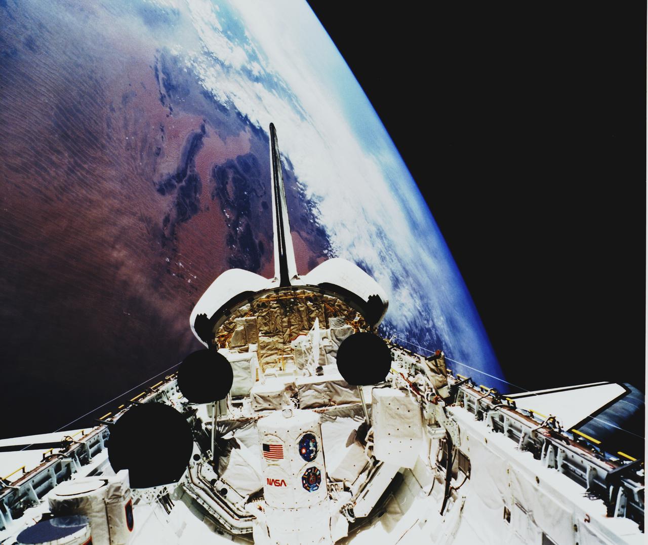
Space Shuttle Atlantis (STS-45) onboard photo of Atmospheric Laboratory for Applications and Science (Atlas-1) module in open cargo bay. Atlas-1 pallets are back dropped against the Atlas Mountains. Taken over Mali in the western Sahara, shows dunes in the Iguidi Dune Sea.
The Atlas-1 (AC-77) that will loft the Geostationary Operational Environmental Satellite-J (GOES-J) next-generation advanced technology weather satellite into space sits poised for takeoff during final countdown operations at Cape Canaveral Air Station, Kennedy Space Center (KSC). GOES-J is atop the expendable launch vehicle inside the rocket's payload fairing.
The Near Earth Asteroid Rendezvous (NEAR) spacecraft embarks on a journey that will culminate in a close encounter with an asteroid. The launch of NEAR inaugurates NASA's irnovative Discovery program of small-scale planetary missions with rapid, lower-cost development cycles and focused science objectives. NEAR will rendezvous in 1999 with the asteroid 433 Eros to begin the first long-term, close-up look at an asteroid's surface composition and physical properties. NEAR's science payload includes an x-ray/gamma ray spectrometer, an near-infrared spectrograph, a laser rangefinder, a magnetometer, a radio science experiment and a multi-spectral imager.

Workers at the Astrotech processing facility in Titusville prepared for a news media showing of the Geostationary Operational Environmental Satellite-1 (GOES-1). GOES-1 was the first in a new generation of weather satellites deployed above Earth. It was the first 3-axis, body-stabilized meteorological satellite to be used by the National Oceanic Atmospheric Administration (NOAA) and NASA. These features allowed GOES-1 to continuously monitor the Earth, rather than viewing it just five percent of the time as was the case with spin-stabilized meteorological satellites. GOES-1 also has independent imaging and sounding instruments which can operate simultaneously yet independently. As a result, observations provided by each instrument will not be interrupted. The imager produces visual and infrared images of the Earth's surface, oceans, cloud cover and severe storm development, while the prime sounding products include vertical temperature and moisture profiles, and layer mean moisture.
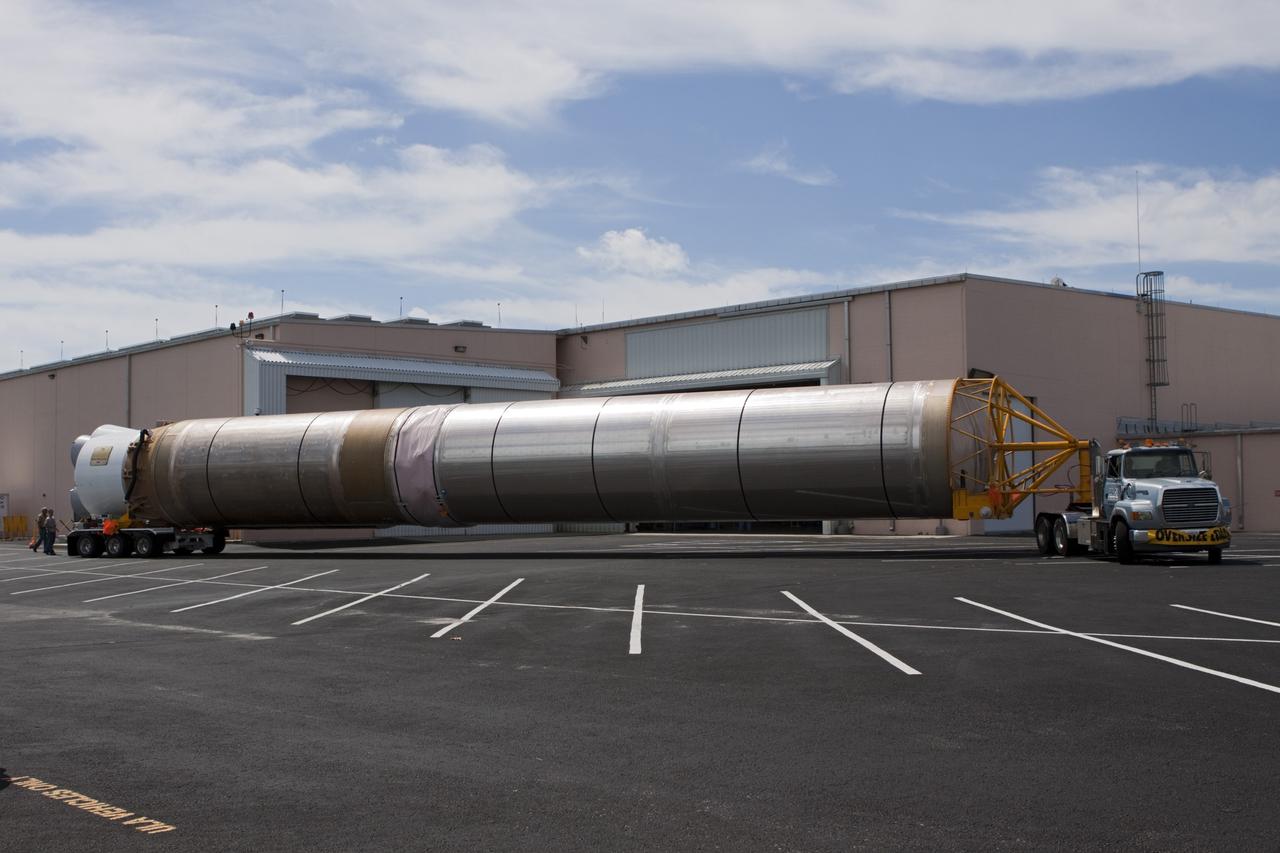
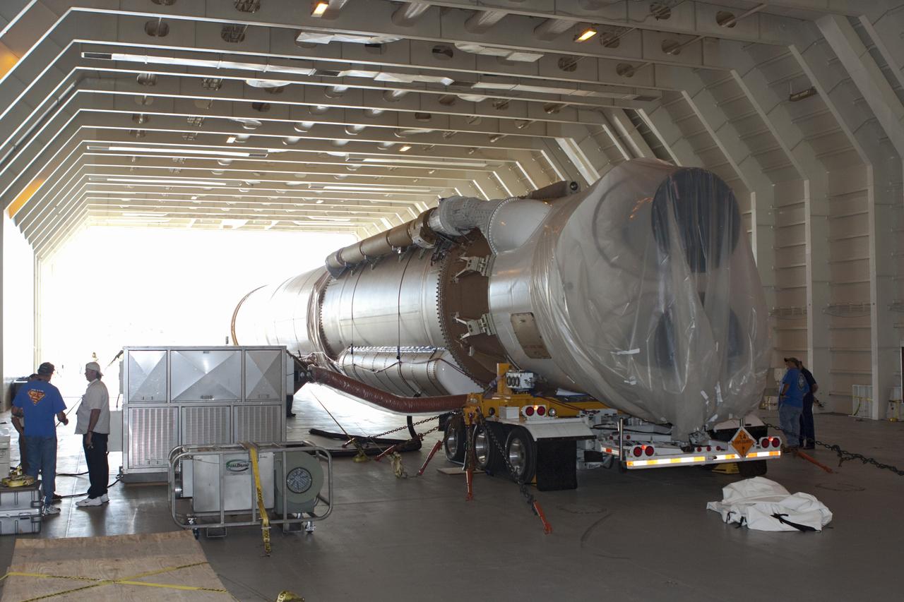
The Near Earth Asteroid Rendezvous (NEAR) spacecraft undergoing preflight preparation in the Spacecraft Assembly Encapsulation Facility-2 (SAEF-2) at Kennedy Space Center (KSC). NEAR will perform two critical mission events - Mathilde flyby and the Deep-Space maneuver. NEAR will fly-by Mathilde, a 38-mile (61-km) diameter C-type asteroid, making use of its imaging system to obtain useful optical navigation images. The primary science instrument will be the camera, but measurements of magnetic fields and mass also will be made. The Deep-Space Maneuver (DSM) will be executed about a week after the Mathilde fly-by. The DSM represents the first of two major burns during the NEAR mission of the 100-pound bi-propellant (Hydrazine/nitrogen tetroxide) thruster. This maneuver is necessary to lower the perihelion distance of NEAR's trajectory. The DSM will be conducted in two segments to minimize the possibility of an overburn situation.

The LAGEOS I (Laser Geodynamics Satellite) was developed and launched by the Marshall Space Flight Center on May 4, 1976 from Vandenberg Air Force Base, California . The two-foot diameter satellite orbited the Earth from pole to pole and measured the movements of the Earth's surface.

This artist concept depicts the Juno spacecraft which will launch from Earth in 2011 and will arrive at Jupiter in 2016 to study the giant planet from an elliptical, polar orbit.

This illustration shows Earth surrounded by filaments of dark matter called "hairs," which are proposed in a study in the Astrophysical Journal by Gary Prézeau of NASA's Jet Propulsion Laboratory, Pasadena, California. A hair is created when a stream of dark matter particles goes through the planet. According to simulations, the hair is densest at a point called the "root." When particles of a dark matter stream pass through the core of Earth, they form a hair whose root has a particle density about a billion times greater than average. The hairs in this illustration are not to scale. Simulations show that the roots of such hairs can be 600,000 miles (1 million kilometers) from Earth, while Earth's radius is only about 4,000 miles (6,400 kilometers). http://photojournal.jpl.nasa.gov/catalog/PIA20176
Scientists from NASA's Mars 2020 and ESA's ExoMars projects study stromatolites, the oldest confirmed fossilized lifeforms on Earth, in the Pilbara region of North West Australia. The image was taken on Aug. 19, 2019. https://photojournal.jpl.nasa.gov/catalog/PIA23551
This illustration shows Earth surrounded by filaments of dark matter called "hairs," which are proposed in a study in the Astrophysical Journal by Gary Prézeau of NASA's Jet Propulsion Laboratory, Pasadena, California. A hair is created when a stream of dark matter particles goes through the planet. According to simulations, the hair is densest at a point called the "root." When particles of a dark matter stream pass through the core of Earth, they form a hair whose root has a particle density about a billion times greater than average. The hairs in this illustration are not to scale. Simulations show that the roots of such hairs can be 600,000 miles (1 million kilometers) from Earth, while Earth's radius is only about 4,000 miles (6,400 kilometers). http://photojournal.jpl.nasa.gov/catalog/PIA20177
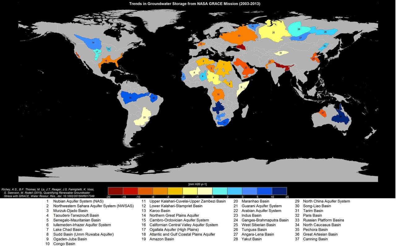
Groundwater storage trends for Earth's 37 largest aquifers from UCI-led study using NASA GRACE data (2003-2013). Of these, 21 have exceeded sustainability tipping points and are being depleted, with 13 considered significantly distressed, threatening regional water security and resilience. http://photojournal.jpl.nasa.gov/catalog/PIA19685
iss058e002448 (Jan. 9, 2019) --- Expedition 58 Commander Oleg Kononenko of Roscosmos is pictured inside the Pirs docking compartment during operations to install gear for the VIZIR earth observation experiment. The study tests the technology of automated coordinate referencing of images of the Earth’s surface, and space, taken by crew members using “free-floating” photography equipment in weightlessness. Credit: Roscosmos

This composite image shows one of the clusters, NGC 2024, which is found in the center of the so-called Flame Nebula about 1,400 light years from Earth. Astronomers have studied two star clusters using NASA Chandra and infrared telescopes.
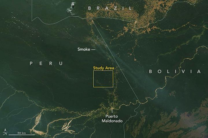
This satellite image, taken by NASA's Earth-observing Terra satellite on Aug. 18, 2019, shows the ECOSTRESS study area in the Amazon Basin and smoke from active fires in the rainforest. ECOSTRESS also captured an image of the Amazon rainforest, PIA23432, revealing water-stressed and non-stressed forest in the area. The water-stressed areas of the forest look as green and healthy as these cooler areas, making them invisible except to a radiometer that can measure thermal infrared energy from the surface. https://photojournal.jpl.nasa.gov/catalog/PIA23546
iss067e253397 (Dec. 2, 2024) --- ESA (European Space Agency) astronaut and Expedition 67 Flight Engineer Samantha Cristoforetti photographs and exchanges samples for the Fluids Science Laboratory Soft Matter Dynamics space physics experiment aboard the Intenational Space Station's Columbus laboratory module. The microgravity environment enables the observation of "wet" foams and the study of rearrangement phenomena, such as coarsening and coalescence, disentangled from drainage issues caused by Earth's gravity. Results may benefit Earth and space industries.
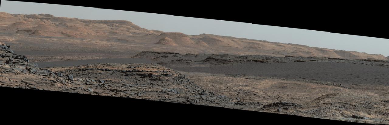
This view from the Mast Camera (Mastcam) on NASA's Curiosity Mars rover shows a dark sand dune in the middle distance. The rover's examination of dunes on the way toward higher layers of Mount Sharp will be the first in-place study of an active sand dune anywhere other than Earth. The scene combines several images taken on Sept. 25, 2015, during the 1,115th Martian day, or sol, of Curiosity's work on Mars. The images are from Mastcam's right-eye camera, which has a telephoto lens. The view is toward south-southwest. The dunes on Curiosity's route are part of a band of dunes called "Bagnold Dunes," along the northwestern edge of Mount Sharp. The informal naming recognizes British military engineer Ralph Bagnold (1896-1990), a pioneer in the study of how winds move sand particles of dunes on Earth. The dune field is evident as a dark band in orbital images of the area inside Gale Crater were Curiosity has been active since landing in 2012, such as a traverse map at PIA20162. Dunes are larger than wind-blown ripples of sand or dust that Curiosity and other rovers have visited previously. One dune that Curiosity will investigate in coming days is as tall as a two-story building and as broad as a football field. Ripples on the surface of these Martian dunes are larger than ripples on the surfaces of sand dunes on Earth. The scene is presented with a color adjustment that approximates white balancing, to resemble how the rocks and sand would appear under daytime lighting conditions on Earth. http://photojournal.jpl.nasa.gov/catalog/PIA19928
iss063e062018 (7/29/2020) --- Photo documentation of the Droplet Formation Study inside the U.S. Destiny laboratory module's Microgravity Science Glovebox (MSG) aboard the International Space Station (ISS). The Droplet Formation Study observes how microgravity shapes water droplets, possibly improving water conservation and water pressure techniques on Earth.

This concept illustrates Skylab Earth observation studies, an Earth Resources Experiment Package (EREP). EREP was designed to explore the use of the widest possible portion of the electromagnetic spectrum for Earth resource investigations with sensors that recorded data in the visible, infrared, and microwave spectral regions. Resources subject to this study included a capability of mapping Earth resources and land uses, crop and forestry cover, health of vegetation, types of soil, water storage in snow pack, surface or near-surface mineral deposits, sea surface temperature, and the location of likely feeding areas for fish, etc. A significant feature of EREP was the ability of man to operate the sensors in a laboratory fashion.
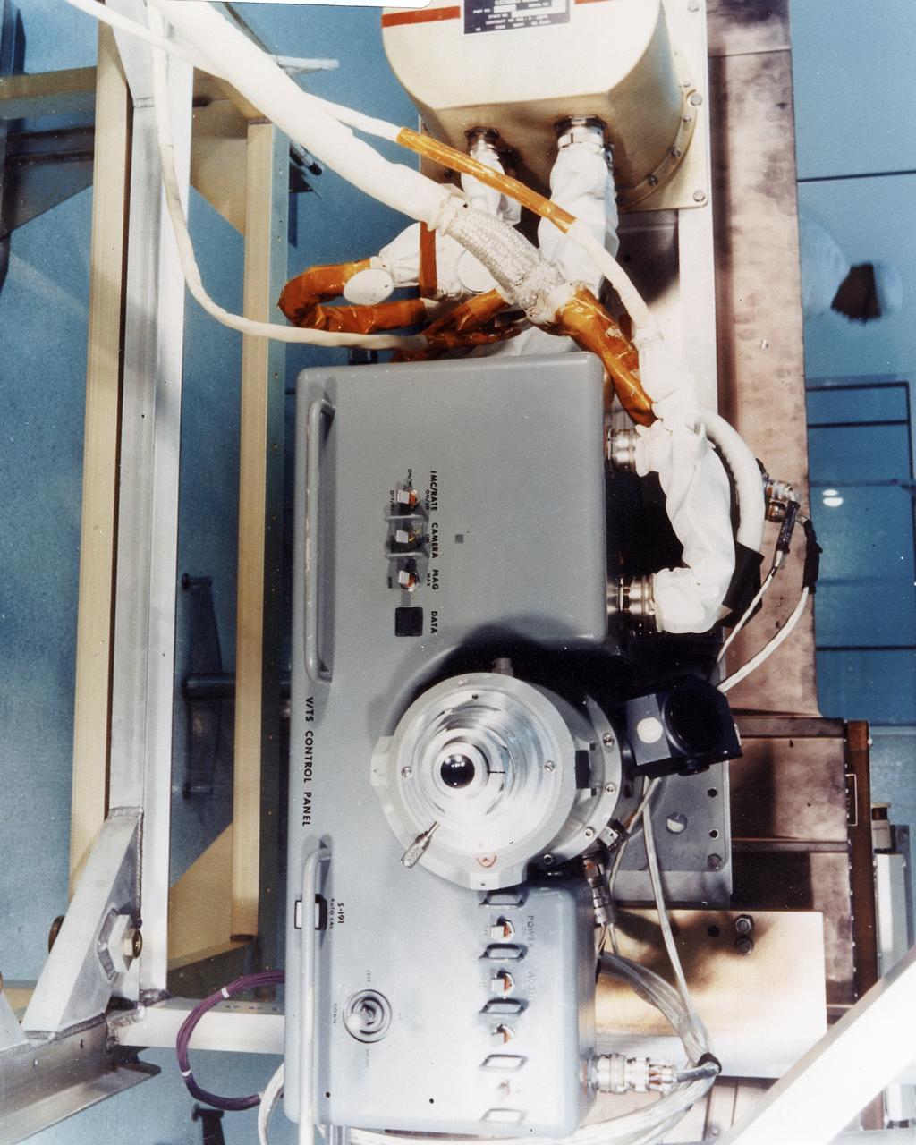
This 1970 photograph shows Skylab's Microwave Radiometer/Scatterometer and Altimeter, one of the major components for an Earth Resources Experiment Package (EREP). It was designed to study varying ocean surface, soil erosion, sea and lake ice, snow cover, seasonal vegetational changes, flooding, rainfall and soil types. The overall purpose of the EREP was to test the use of sensors that operated in the visible, infrared, and microwave portions of the electromagnetic spectrum to monitor and study Earth resources. The Marshall Space Flight Center had program management responsibility for the development of Skylab hardware and experiments.
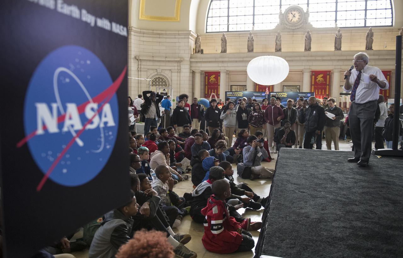
Dr. Michael Freilich, director, Earth Science Division, NASA Headquarters, speaks about the benefits of studying the Earth at NASA's Earth Day event on Thursday, April 19, 2018 at Union Station in Washington, D.C. Photo Credit: (NASA/Aubrey Gemignani)
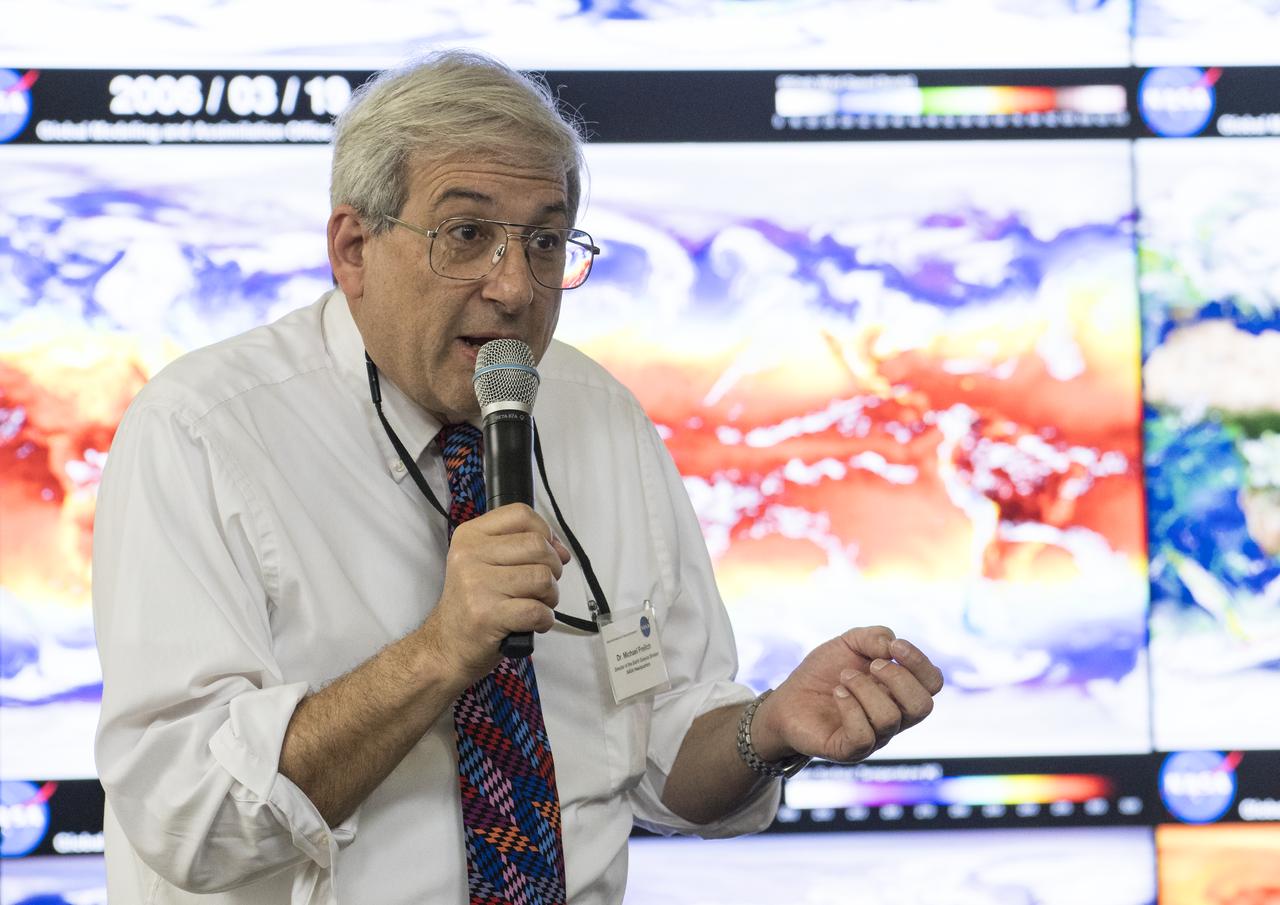
Dr. Michael Freilich, director, Earth Science Division, NASA Headquarters, speaks about the benefits of studying the Earth at NASA's Earth Day event on Thursday, April 19, 2018 at Union Station in Washington, D.C. Photo Credit: (NASA/Aubrey Gemignani)
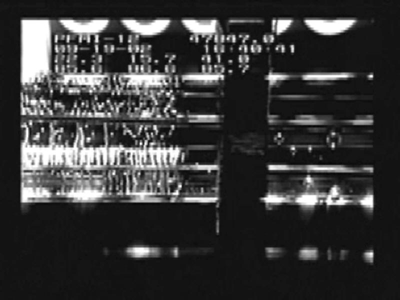
Video images sent to the ground allow scientists to watch the behavior of the bubbles as they control the melting and freezing of the material during the Pore Formation and Mobility Investigation (PFMI) in the Microgravity Science Glovebox aboard the International Space Station. While the investigation studies the way that metals behave at the microscopic scale on Earth -- and how voids form -- the experiment uses a transparent material called succinonitrile that behaves like a metal to study this problem. The bubbles do not float to the top of the material in microgravity, so they can study their interactions.
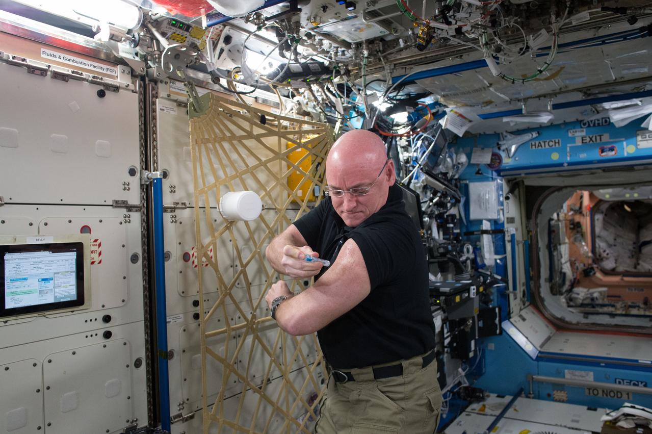
ISS045E028258 (09/24/2015) --- NASA astronaut Scott Kelly gives himself a flu shot for an ongoing study on the human immune system. The vaccination is part of NASA’s Twins Study, a compilation of multiple investigations that take advantage of a unique opportunity to study identical twin astronauts Scott and Mark Kelly, while Scott spends a year aboard the International Space Station and Mark remains on Earth.
Designed by the mission crew members, the STS-66 emblem depicts the Space Shuttle Atlantis launching into Earth orbit to study global environmental change. The payload for the Atmospheric Laboratory for Applications and Science (ATLAS-3) and complementary experiments were part of a continuing study of the atmosphere and the Sun's influence on it. The Space Shuttle is trailed by gold plumes representing the astronaut symbol and is superimposed over Earth, much of which is visible from the flight's high inclination orbit. Sensitive instruments aboard the ATLAS pallet in the Shuttle payload bay and on the free-flying Cryogenic Infrared Spectrometers and Telescopes for the Atmospheric-Shuttle Pallet Satellite (CHRISTA-SPAS) that gazed down on Earth and toward the Sun, are illustrated by the stylized sunrise and visible spectrum.
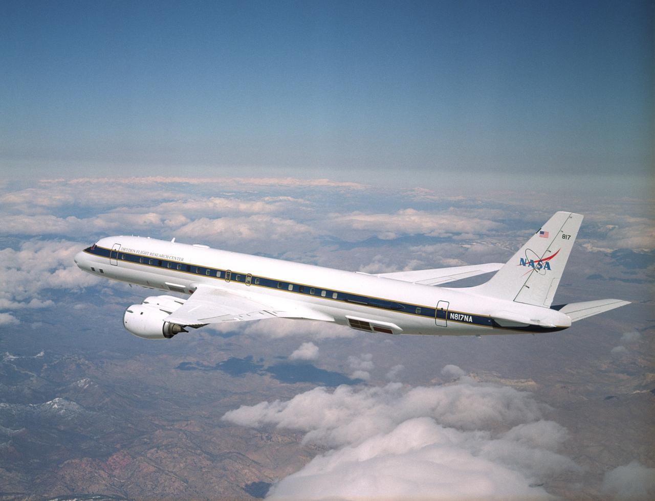
NASA's DC-8 Airborne Science research aircraft, in new colors and markings, in flight Feb. 24, 2004. Dark panels on lower fuselage are synthetic aperture radar antennas enabling sophisticated studies of Earth features.
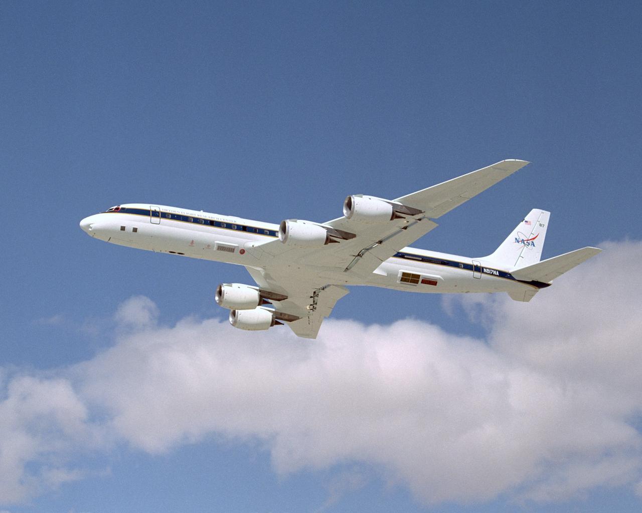
NASA's DC-8 Airborne Science research aircraft, in new colors and markings, takes off Feb. 24, 2004. Dark panels on lower fuselage are synthetic aperture radar antennas enabling sophisticated studies of Earth features.
Designed by the crewmembers assigned to the mission, the STS-35 crew patch symbolizes the Space Shuttle flying above Earth's atmosphere to better study the many celestial objects of the universe, represented by the constellation Orion.
iss066e087939 (12/9/2021) --- A view of the Fluids and Combustion Facility (FCF), used for the Flow Boiling and Condensation Experiment (FBCE) during Expedition 66. The study may improve thermal systems for Earth and other planetary environments.
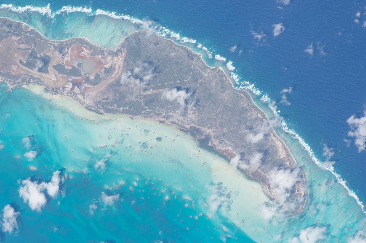
ISS047e005148 (03/10/2016) --- This image was taken by members of Expedition 47 on board the International Space Station as studies of the Earth continue using the perfect vantage point presented by the station.
iss066e088377 (Dec. 9, 2021) --- NASA astronauts Mark Vande Hei and Kayla Barron set up the Fluids Integrated Rack for a space physics study that may improve thermal systems for Earth and other planetary environments.
iss068e042077 (Jan. 22, 2023) --- Roscosmos cosmonaut and Expedition 68 Flight Engineer Anna Kikina points a camera outside a window inside the International Space Station's Zvezda service module and photographs landmarks for an Earth observation study.
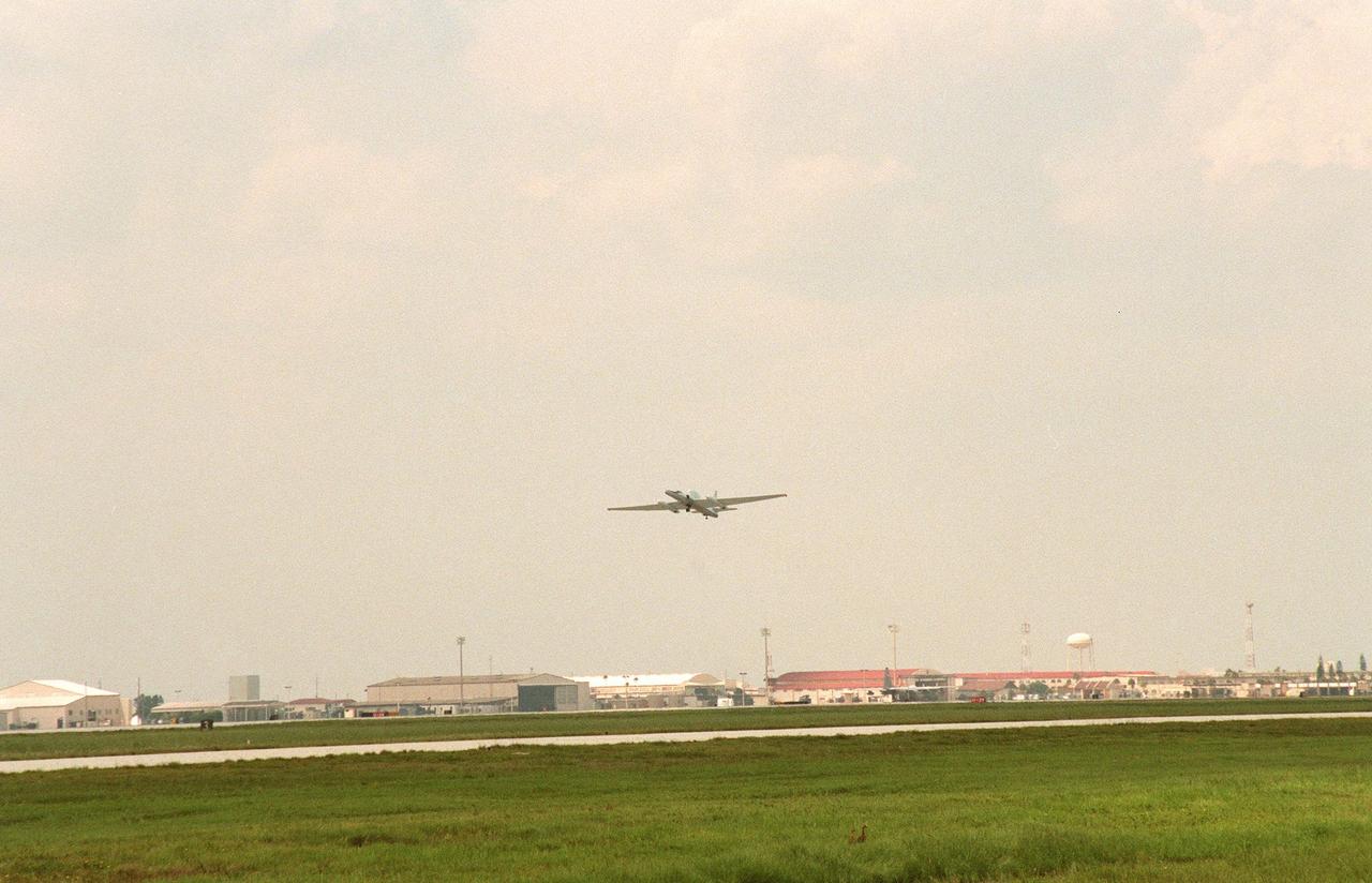
A specially equipped Dryden Flight Research Center ER-2 (a modified U-2) takes off from Patrick Air Force Base enroute to a hurricane in the Atlantic. The plane is part of the NASA-led Atmospheric Dynamics and Remote Sensing program that includes other government weather researchers and the university community in a study of Atlantic hurricanes and tropical storms. Soaring above 65,000 feet, the ER-2 will measure the structure of hurricanes and the surrounding atmosphere that steers the storm’s movement. The hurricane study, which lasts through September 1998, is part of NASA’s Earth Science enterprise to better understand the total Earth system and the effects of natural and human-induced changes on the global environment
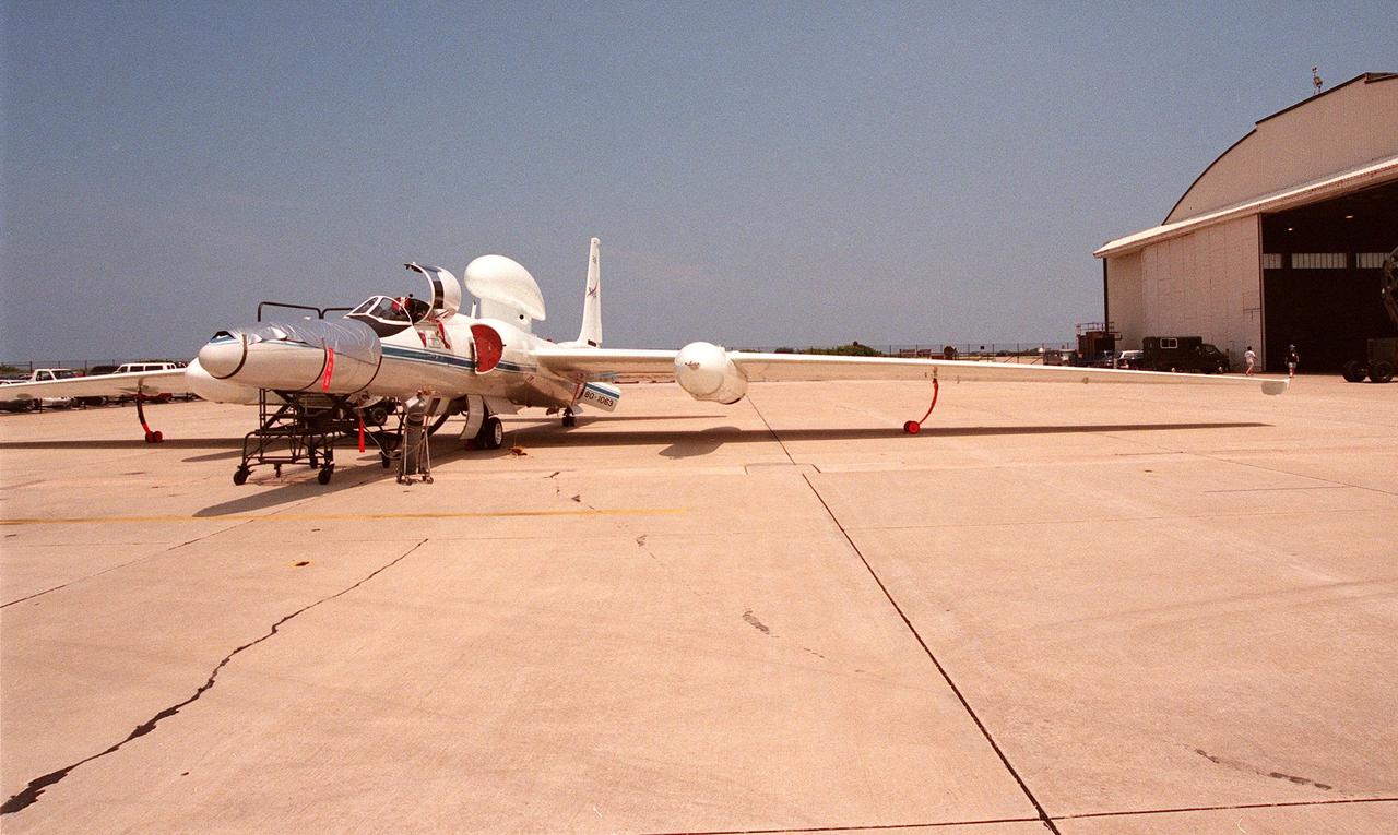
This high-altitude research plane, a specially equipped Dryden Flight Research Center ER-2 (a modified U-2), is readied at Patrick Air Force Base for flight into a hurricane in the Atlantic. The plane is part of the NASA-led Atmospheric Dynamics and Remote Sensing program that includes other government weather researchers and the university community in a study of Atlantic hurricanes and tropical storms. The ER-2, soaring above 65,000 feet, will measure the structure of hurricanes and the surrounding atmosphere that steers the storms’ movement. The hurricane study, which lasts through September 1998, is part of NASA’s Earth Science enterprise to better understand the total Earth system and the effects of natural and human-induced changes on the global environment
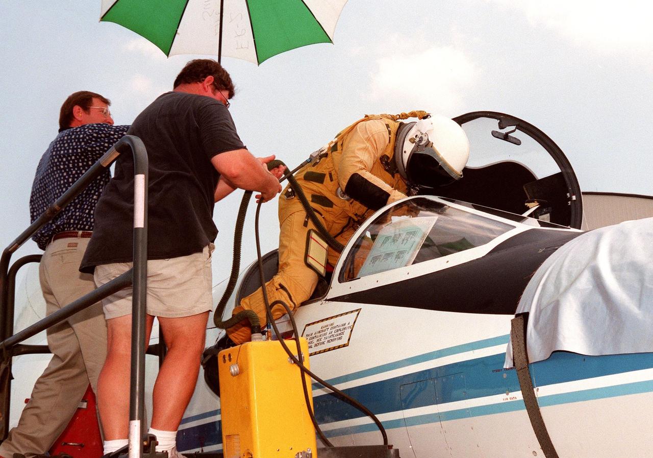
The pilot climbs into the cockpit of a high-altitude research plane, a specially equipped Dryden Flight Research Center ER-2 (a modified U-2), at Patrick Air Force Base. Soaring above 65,000 feet, the ER-2 will measure the structure of hurricanes and the surrounding atmosphere that steers the storm’s movement. The plane is part of the NASA-led Atmospheric Dynamics and Remote Sensing program that includes other government weather researchers and the university community in a study of Atlantic hurricanes and tropical storms. The hurricane study, which lasts through September 1998, is part of NASA’s Earth Science enterprise to better understand the total Earth system and the effects of natural and human-induced changes on the global environment

A specially equipped Dryden Flight Research Center ER-2 (a modified U-2) soars above Patrick Air Force Base enroute to a hurricane in the Atlantic. The plane is part of the NASA-led Atmospheric Dynamics and Remote Sensing program that includes other government weather researchers and the university community in a study of Atlantic hurricanes and tropical storms. Soaring above 65,000 feet, the ER-2 will measure the structure of hurricanes and the surrounding atmosphere that steers the storm’s movement. The hurricane study, which lasts through September 1998, is part of NASA’s Earth Science enterprise to better understand the total Earth system and the effects of natural and human-induced changes on the global environment
Pores and voids often form in metal castings on Earth (above) making them useless. A transparent material that behaves at a large scale in microgravity the way that metals behave at the microscopic scale on Earth, will help show how voids form and learn how to prevent them. Scientists are using the microgravity environment on the International Space Station to study how these bubbles form, move and interact. The Pore Formation and Mobility Investigation (PFMI) in the Microgravity Science Glovebox aboard the International Space Station uses a transparent material called succinonitrile that behaves like a metal to study this problem. Video images sent to the ground allow scientists to watch the behavior of the bubbles as they control the melting and freezing of the material. The bubbles do not float to the top of the material in microgravity, so they can study their interactions.
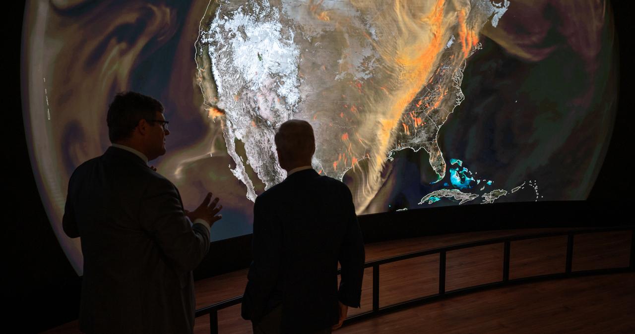
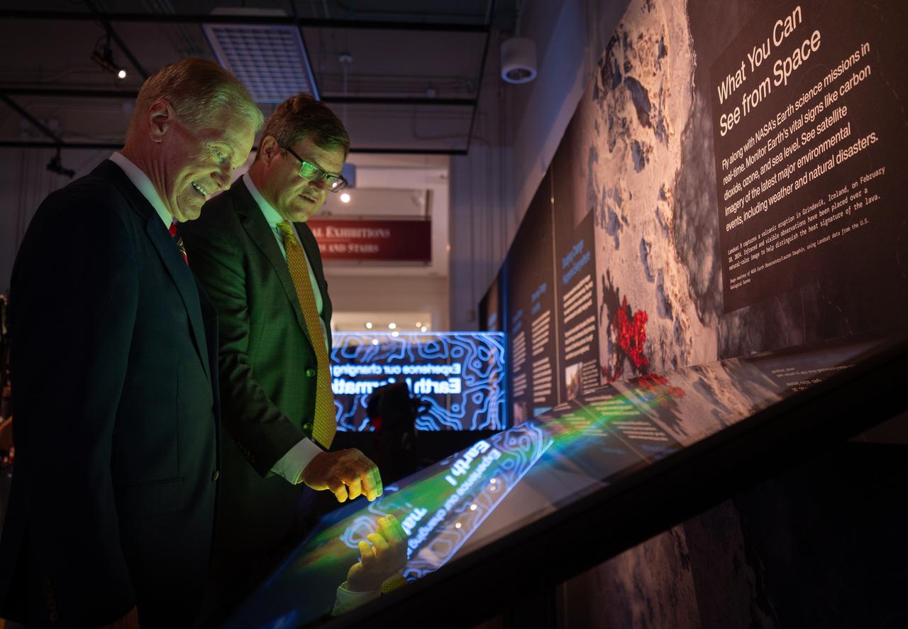
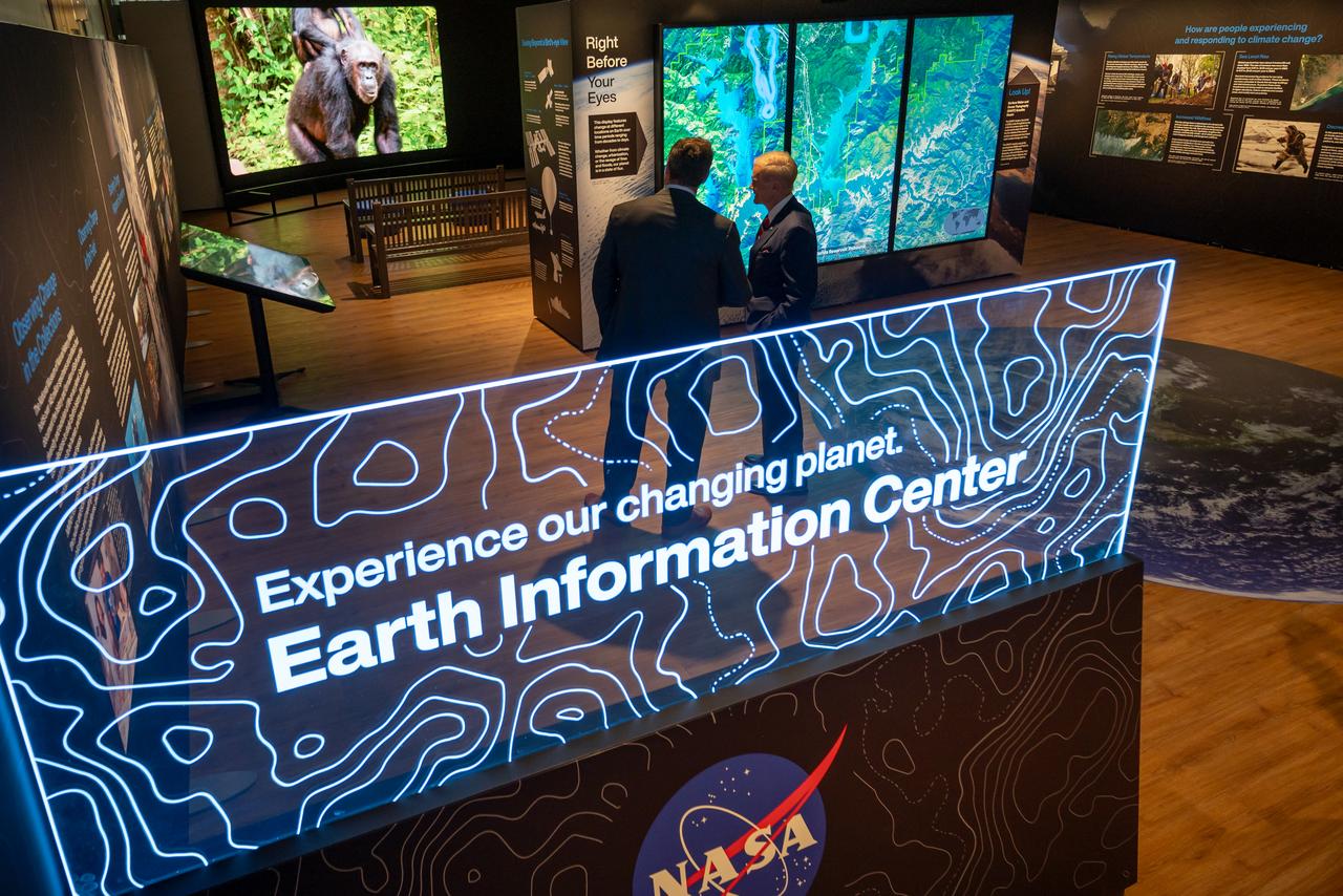
NASA Earth Sciences Division, Deputy Director, Julie Robinson, previews of the Earth Information Center at the Smithsonian National Museum of Natural History, in Washington, Monday, Oct. 7, 2024. The exhibit includes a video wall displaying Earth science data visualizations and videos, an interpretive panel showing Earth’s connected systems, information on our changing world, and an overview of how NASA and the Smithsonian study our home planet. Photo Credit: (NASA/Bill Ingalls)
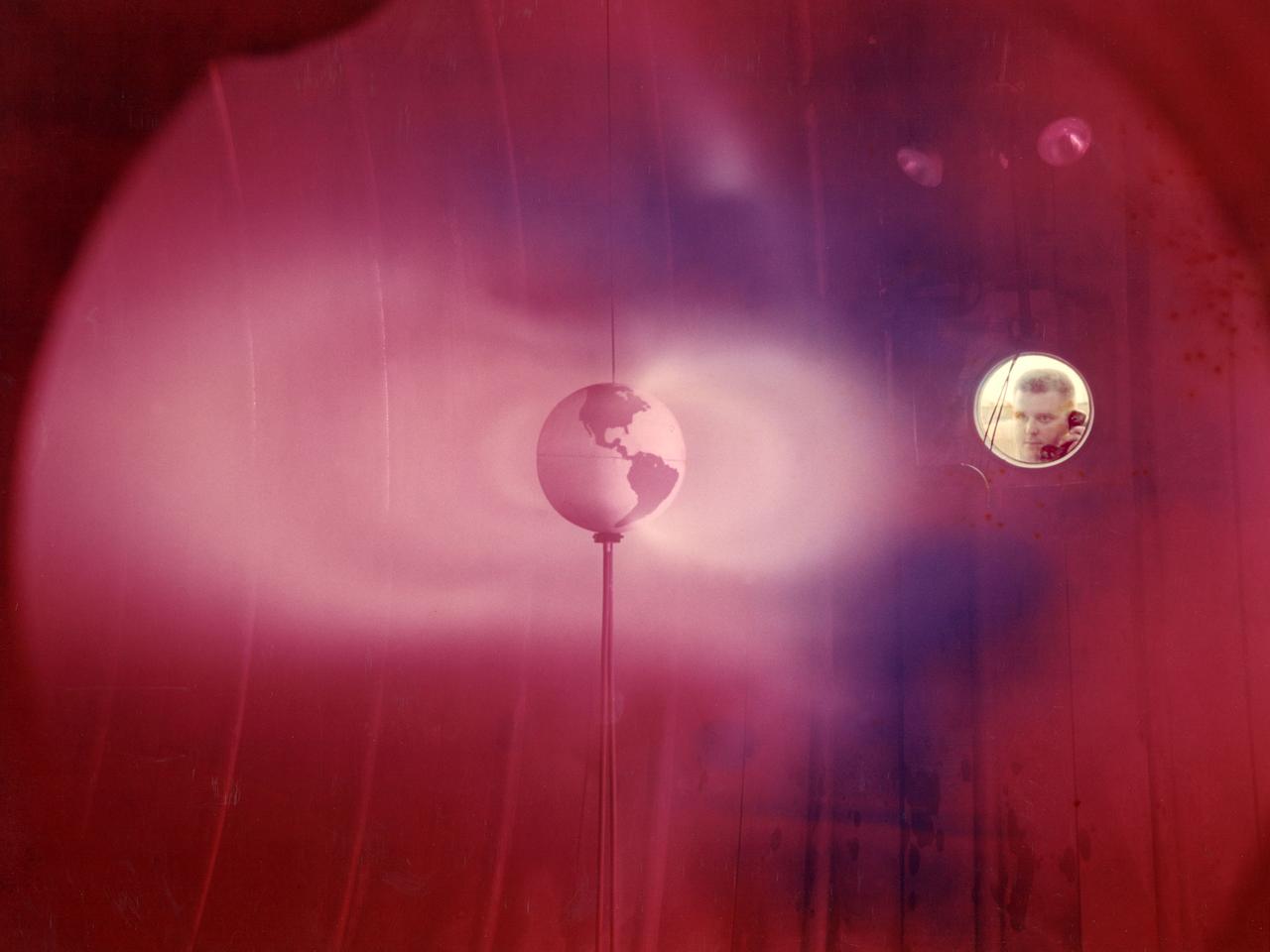
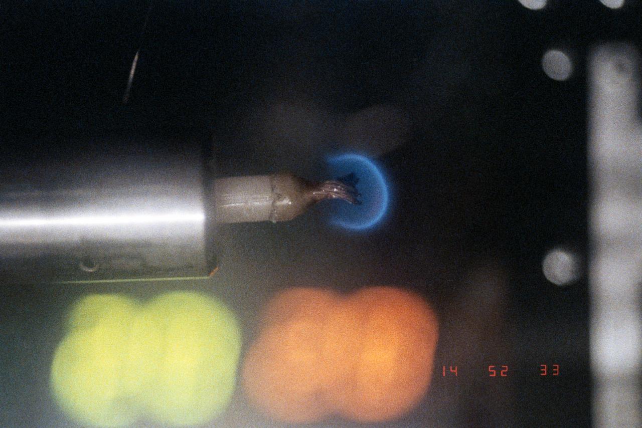
The model of the Earth housed inside Vacuum Tank 5 contained a coil which produced a magnetic field simulating that of the Earth. It was bombarded with a stream of ionized particles simulating the solar wind which impinges on the Earth's magnetic field. The bands or belts of luminous plasma seen in this image were suggestive of the Van Allen belts found around the Earth. Scientists at Lewis probed the plasma around the model and studied scaling laws in an attempt to find an explanation for the actual formation of the Van Allen belt.
The Space Shuttle Endeavour (STS-67) lands at Edwards Air Force Base in southern California after successfully completing NASA's longest plarned shuttle mission. The seven-member crew conducted round-the-clock observations with the ASTRO-2 observatory, a trio of telescopes designed to study the universe of ultraviolet astronomy. Because of Earth's protective ozone layer ultraviolet light from celestial objects does not reach gound-based telescopes, and such studies can only be conducted from space.
iss068e042034 (Jan. 26, 2023) --- NASA astronaut and Expedition 68 Flight Engineer Josh Cassada harvests thale cress plants housed inside the Advanced Plant Habitat for stowage and analysis on Earth. The space botany study takes place inside the International Space Station's Kibo laboratory module and studies genetic changes that take place in plants growing in microgravity
This is a single scene from a pair (frames 021 & 024) to study the effects of polarized light in Earth Observations. One scene was exposed with vertically polarized light, the other, horizontally. The subject in this study, is a lake behind Presa (dam) Don Martin (27.5N, 100.5W) on thge edge of the Rio Grande Plain near it's boundry with the Sierra Madre Oriental in Coahuila, Mexico.
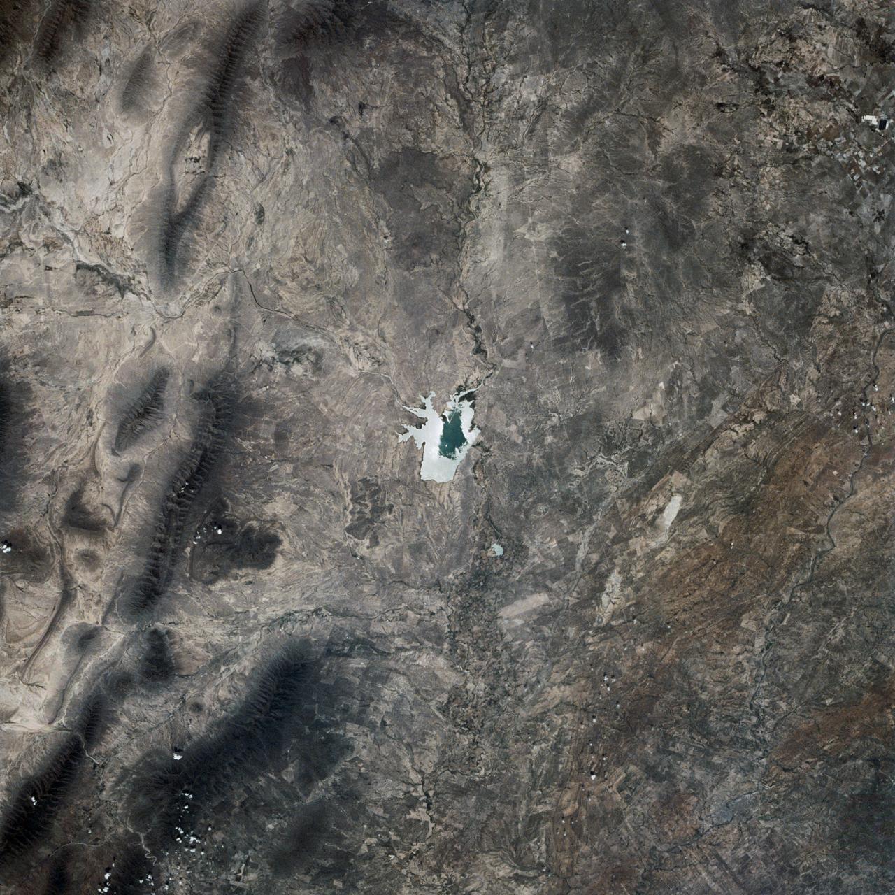
This is a single scene from a pair (frames 021 & 024) to study the effects of polarized light in Earth Observations. One scene was exposed with vertically polarized light, the other, horizontally. The subject in this study, is a lake behind Presa (dam) Don Martin (27.5N, 100.5W) on the edge of the Rio Grande Plain near it's boundry with the Sierra Madre Orientral in Coahuila, Mexico.
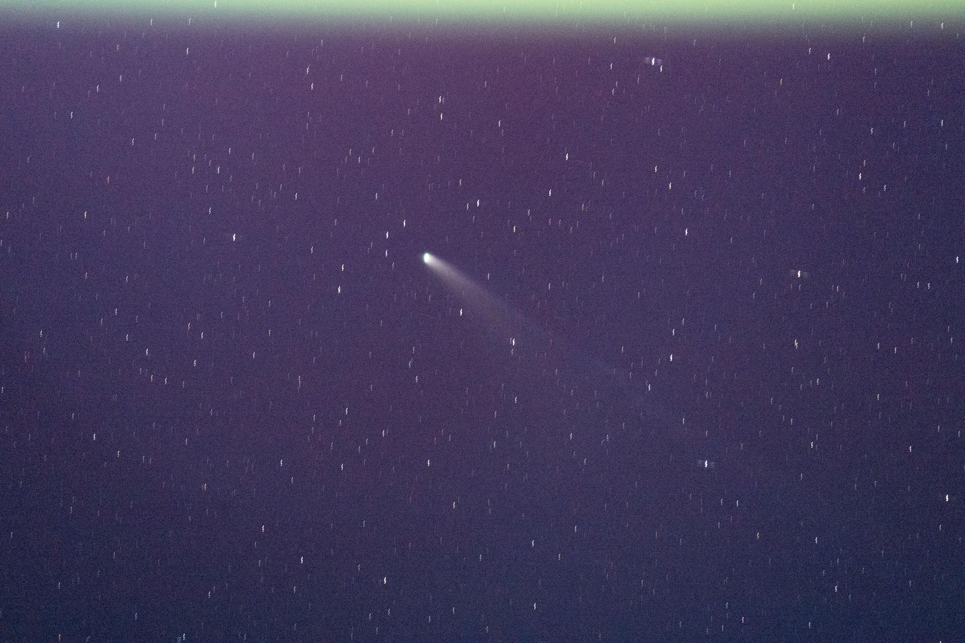
iss073e0982217 (Oct. 26, 2025) --- The International Space Station’s unique vantage point, orbiting 250 miles above Earth, is crucial for studying a wide range of cosmic phenomena. This image provides a rare view of a comet. Scientists use instruments mounted on the exterior of the station to also study black holes and dark matter. This vantage point allows researchers to make observations difficult to see from the ground, providing new insights into the fundamental nature of the universe.
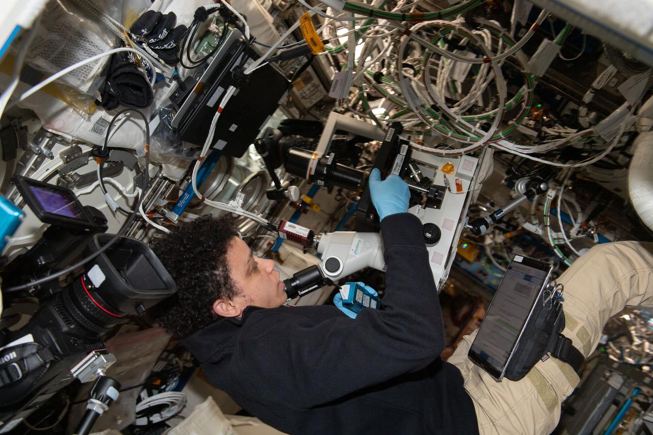
iss067e190689 (July 20, 2022) --- Expedition 67 Flight Engineer and NASA astronaut Jessica Watkins sets up cell samples for viewing in a microscope for the Immunosenescence space biology study. The investigation studies the immunological aging of cells that takes place in microgravity to learn how to keep astronauts healthy on long term missions and treat immunity conditions on Earth.

WASP-18b is an exoplanet located 325 light-years from Earth. The planet's mass is 10 times that of Jupiter, and it orbits its star once every 23 hours. A 2017 study found that this planet has a stratosphere that's loaded with carbon dioxide, but has no signs of water. A stratosphere is a layer of atmosphere in which temperature increases with higher altitudes. The study used NASA's Spitzer and Hubble space telescopes. https://photojournal.jpl.nasa.gov/catalog/PIA22087
iss064e022911 (Jan. 14, 2021) --- NASA astronaut and Expedition 64 Flight Engineer Kate Rubins sets up the ACME (Advanced Combustion via Microgravity Experiments) study inside the U.S. Destiny laboratory module's Combustion Integrated Rack. ACME is a set of six independent studies exploring ways to increase fuel efficiency, reduce pollutants and improve fire safety on Earth and in space.
Closeup view inside glovebox showing a candle flame. The Candle Flames in Microgravity experiment is carried onboard Columbia to examine whether candle flames can be sustained in space; to study the interaction and physical properties of diffusion flames. In space, where buoyancy-driven convection is reduced, the role diffusion plays in sustaining candle flames can be isolated. Results have implications for other diffusion flame studies. Diffusion flames are the most common type of flame on Earth.
iss065e369687 (Sept. 8, 2021) ----NASA astronaut and Expedition 65 Flight Engineer Mark Vande Hei replaces an igniter inside the U.S. Destiny laboratory module's Combustion Integrated Rack for the ACME series of space combustion studies. ACME, or the Advanced Combustion via Microgravity Experiments, is a set of six independent studies of gaseous flames that seeks to improve fuel efficiency and reduce pollutants on Earth, and improve spacecraft fire prevention by focusing on decreasing the flammability of materials.
A science instrument flying aboard the next delivery for NASA’s CLPS (Commercial Lunar Payload Services) initiative is planning to study how different materials react to the lunar environment. Regolith Adherence Characterization, or RAC, is one of 10 payloads set to be carried to the Moon by the Blue Ghost 1 lunar lander in 2025. Developed by Aegis Aerospace, RAC’s wheels feature a series of different sample materials, helping researchers to better understand how lunar dust repels or attaches to each. Investigations and demonstrations, such as RAC, launched on CLPS flights will help NASA study Earth’s nearest neighbor under Artemis and pave the way for future crewed missions on the Moon. NASA’s Marshall Space Flight Center in Huntsville, Alabama, manages the development for seven of the 10 CLPS payloads that will be carried on Firefly’s Blue Ghost lunar lander.
A science instrument flying aboard the next delivery for NASA’s CLPS (Commercial Lunar Payload Services) initiative is planning to study how different materials react to the lunar environment. Regolith Adherence Characterization, or RAC, is one of 10 payloads set to be carried to the Moon by the Blue Ghost 1 lunar lander in 2025. Developed by Aegis Aerospace, RAC’s wheels feature a series of different sample materials, helping researchers to better understand how lunar dust repels or attaches to each. Investigations and demonstrations, such as RAC, launched on CLPS flights will help NASA study Earth’s nearest neighbor under Artemis and pave the way for future crewed missions on the Moon. NASA’s Marshall Space Flight Center in Huntsville, Alabama, manages the development for seven of the 10 CLPS payloads that will be carried on Firefly’s Blue Ghost lunar lander.
A science instrument flying aboard the next delivery for NASA’s CLPS (Commercial Lunar Payload Services) initiative is planning to study how different materials react to the lunar environment. Regolith Adherence Characterization, or RAC, is one of 10 payloads set to be carried to the Moon by the Blue Ghost 1 lunar lander in 2025. Developed by Aegis Aerospace, RAC’s wheels feature a series of different sample materials, helping researchers to better understand how lunar dust repels or attaches to each. Investigations and demonstrations, such as RAC, launched on CLPS flights will help NASA study Earth’s nearest neighbor under Artemis and pave the way for future crewed missions on the Moon. NASA’s Marshall Space Flight Center in Huntsville, Alabama, manages the development for seven of the 10 CLPS payloads that will be carried on Firefly’s Blue Ghost lunar lander.
CAPE CANAVERAL, Fla. – The United Launch Alliance Atlas V first stage booster for NASA's Radiation Belt Storm Probes mission backs into the Atlas Spaceflight Operations Center, or ASOC, at Cape Canaveral Air Force Station in Florida. The Radiation Belt Storm Probes, or RBSP, mission will help us understand the sun’s influence on Earth and near-Earth space by studying the Earth’s radiation belts on various scales of space and time. For more information, visit http://www.nasa.gov/rbsp. Photo credit: NASA/Jim Grossmann
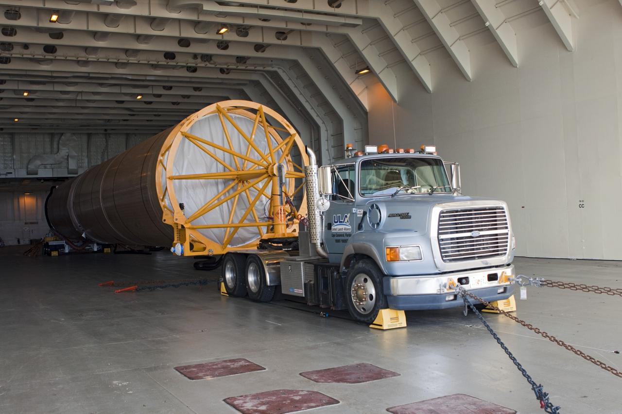
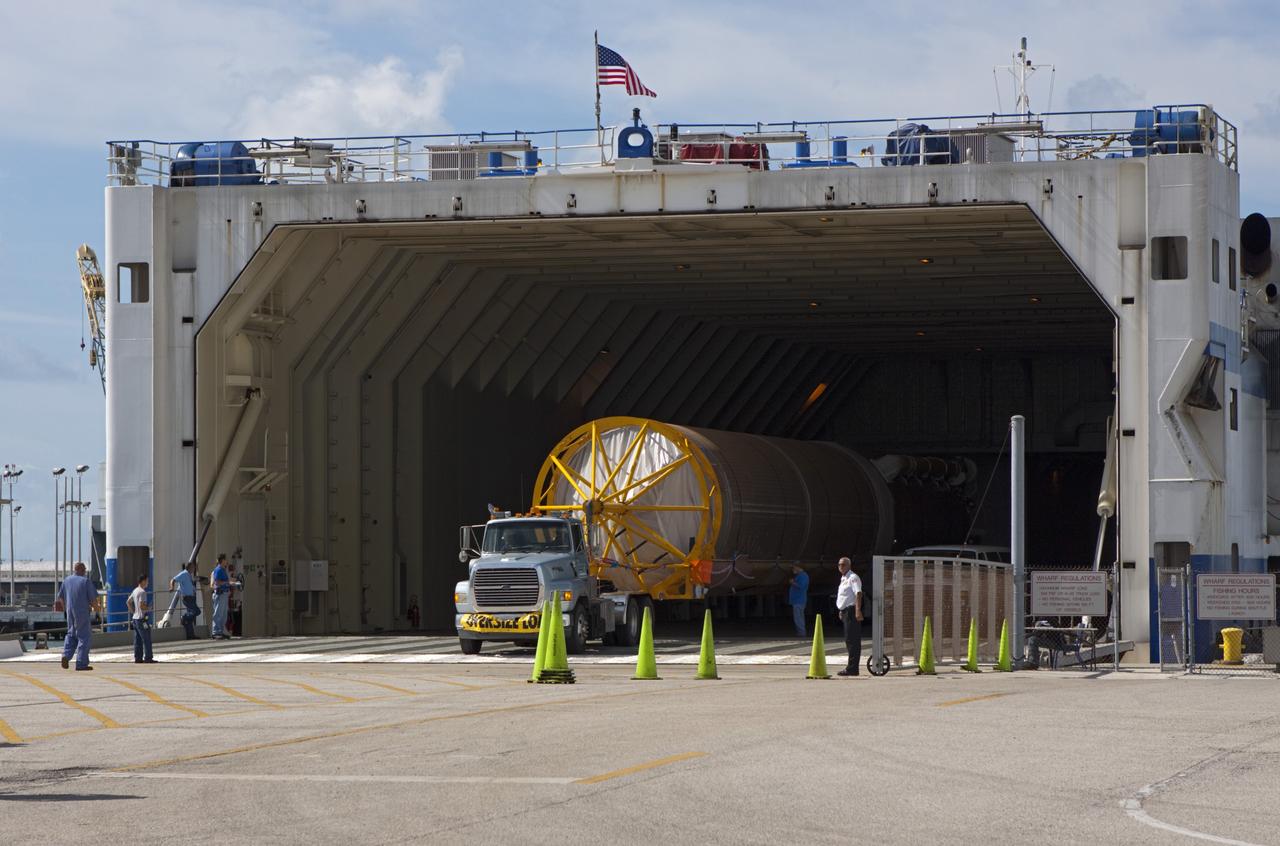
CAPE CANAVERAL, Fla. – The Atlas V first stage booster for NASA's Radiation Belt Storm Probes mission is towed away from the dock at Port Canaveral. The booster arrived on United Launch Alliance's barge, the Delta Mariner. The Radiation Belt Storm Probes, or RBSP, mission will help us understand the sun’s influence on Earth and near-Earth space by studying the Earth’s radiation belts on various scales of space and time. For more information, visit http://www.nasa.gov/rbsp. Photo credit: NASA/Jim Grossmann

The Smithsonian National Museum of Natural History in Washington is seen as the new Earth Information Center is previewed, Monday, Oct. 7, 2024. The exhibit includes a video wall displaying Earth science data visualizations and videos, an interpretive panel showing Earth’s connected systems, information on our changing world, and an overview of how NASA and the Smithsonian study our home planet. Photo Credit: (NASA/Bill Ingalls)
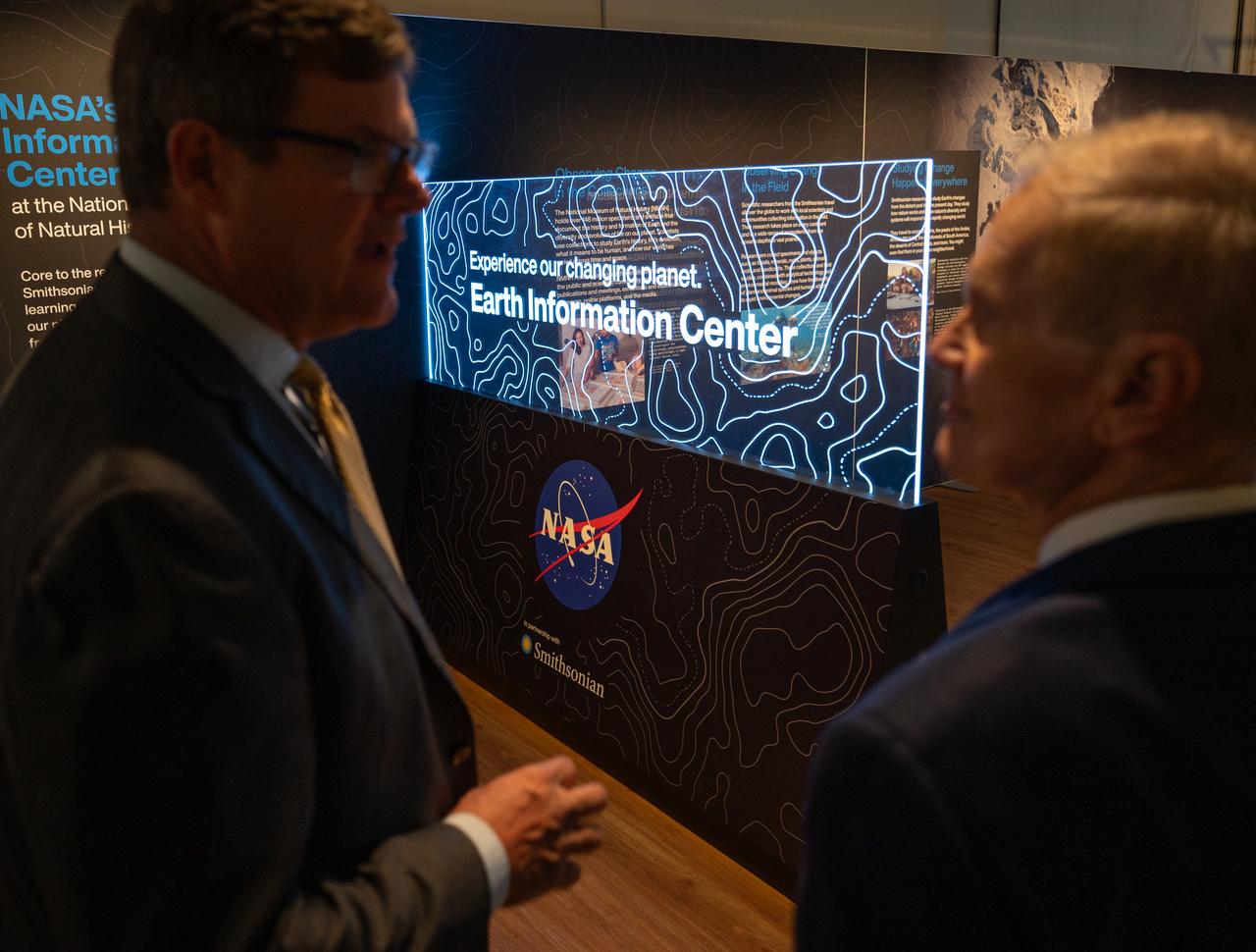
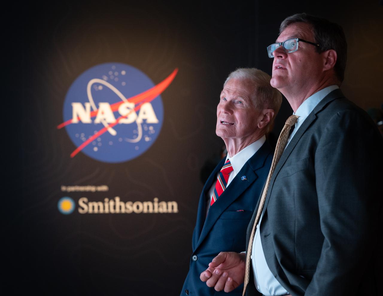
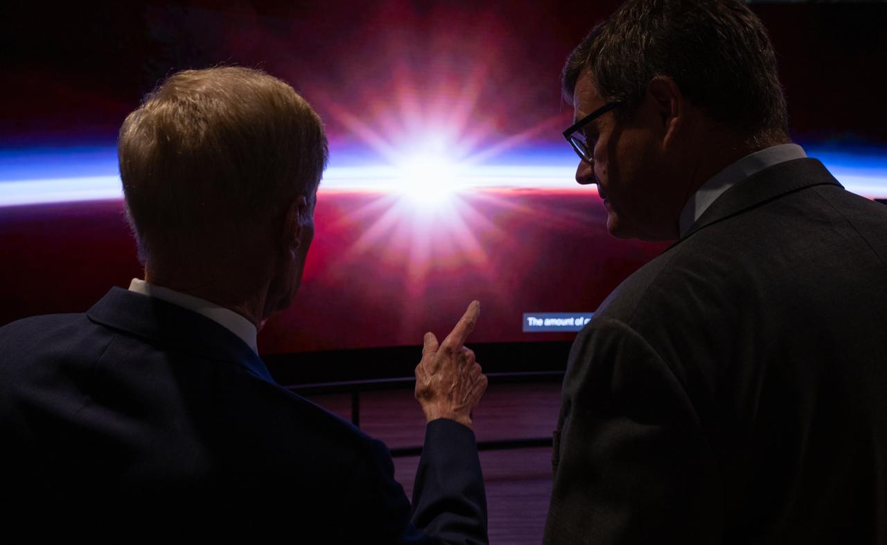
Smithsonian Museum of Natural History, Sant Director, Kirk Johnson, left, talks with NASA Administrator Bill Nelson, during a preview of the Earth Information Center at the Smithsonian National Museum of Natural History, in Washington, Monday, Oct. 7, 2024. The exhibit includes a video wall displaying Earth science data visualizations and videos, an interpretive panel showing Earth’s connected systems, information on our changing world, and an overview of how NASA and the Smithsonian study our home planet. Photo Credit: (NASA/Bill Ingalls)
CAPE CANAVERAL, Fla. – The United Launch Alliance Atlas V first stage booster for NASA's Radiation Belt Storm Probes mission arrives at the Atlas Spaceflight Operations Center, or ASOC, at Cape Canaveral Air Force Station in Florida. The Radiation Belt Storm Probes, or RBSP, mission will help us understand the sun’s influence on Earth and near-Earth space by studying the Earth’s radiation belts on various scales of space and time. For more information, visit http://www.nasa.gov/rbsp. Photo credit: NASA/Jim Grossmann
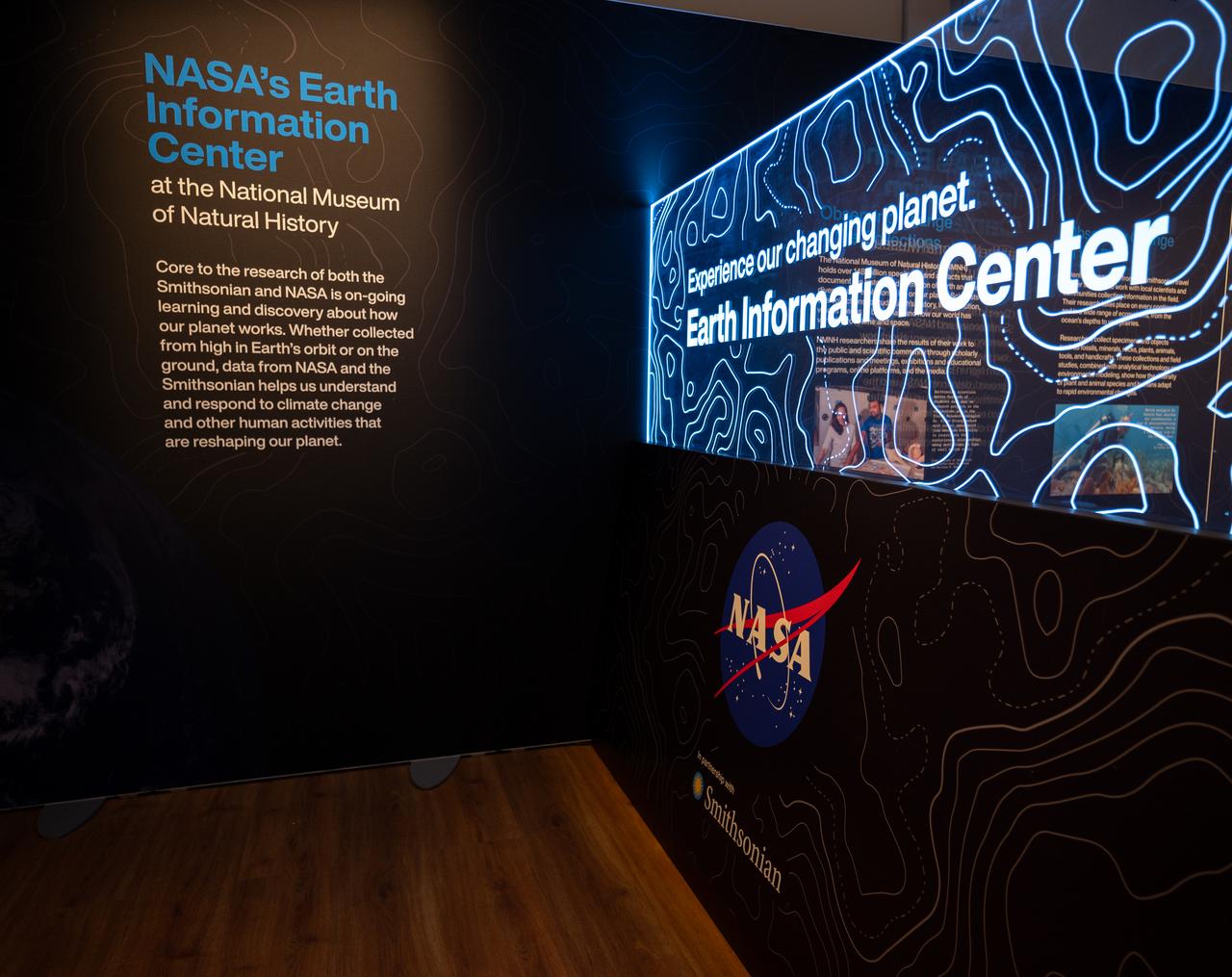
The Earth Information Center at the Smithsonian National Museum of Natural History, in Washington, is previewed, Monday, Oct. 7, 2024. The exhibit includes a video wall displaying Earth science data visualizations and videos, an interpretive panel showing Earth’s connected systems, information on our changing world, and an overview of how NASA and the Smithsonian study our home planet. Photo Credit: (NASA/Bill Ingalls)
CAPE CANAVERAL, Fla. – At Port Canaveral in Florida, the Atlas V first stage booster for NASA's Radiation Belt Storm Probes mission waits to be offloaded from United Launch Alliance's Delta Mariner barge. The Radiation Belt Storm Probes, or RBSP, mission will help us understand the sun’s influence on Earth and near-Earth space by studying the Earth’s radiation belts on various scales of space and time. For more information, visit http://www.nasa.gov/rbsp. Photo credit: NASA/Jim Grossmann

CAPE CANAVERAL, Fla. – The United Launch Alliance Atlas V first stage booster for NASA's Radiation Belt Storm Probes mission approaches the Atlas Spaceflight Operations Center, or ASOC, at Cape Canaveral Air Force Station in Florida. The Radiation Belt Storm Probes, or RBSP, mission will help us understand the sun’s influence on Earth and near-Earth space by studying the Earth’s radiation belts on various scales of space and time. For more information, visit http://www.nasa.gov/rbsp. Photo credit: NASA/Jim Grossmann
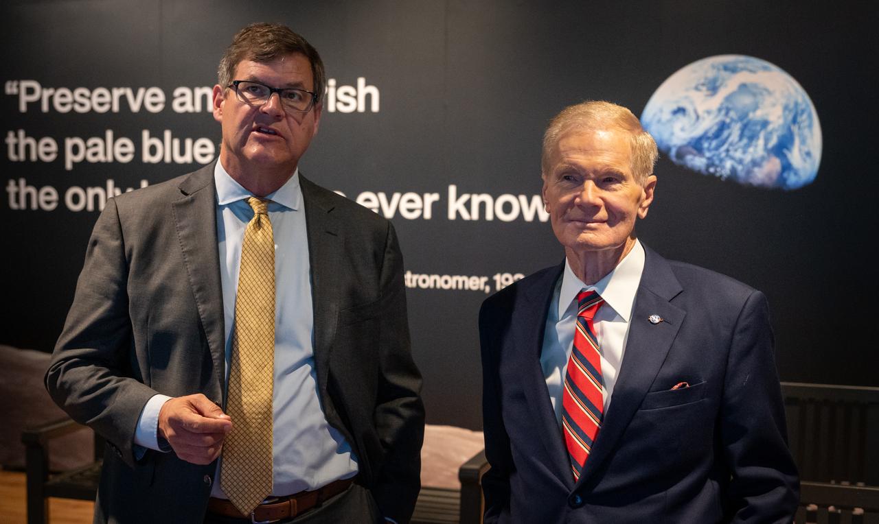
Smithsonian Museum of Natural History, Sant Director, Kirk Johnson, left, talks with NASA Administrator Bill Nelson, during a preview of the Earth Information Center at the Smithsonian National Museum of Natural History, in Washington, Monday, Oct. 7, 2024. The exhibit includes a video wall displaying Earth science data visualizations and videos, an interpretive panel showing Earth’s connected systems, information on our changing world, and an overview of how NASA and the Smithsonian study our home planet. Photo Credit: (NASA/Bill Ingalls)
This 1970 photograph shows Skylab's Infrared Spectrometer Viewfinder Tracking System, a major component of an Earth Resources Experiment Package (EREP). It was designed to evaluate Earth resources sensors for specific regions of the the visible and infrared spectra and assess the value of real time identification of ground sites. The overall purpose of the EREP was to test the use of sensors that operated in the visible, infrared, and microwave portions of the electromagnetic spectrum to monitor and study Earth resources. The Marshall Space Flight Center had program management responsibility for the development of Skylab hardware and experiments.
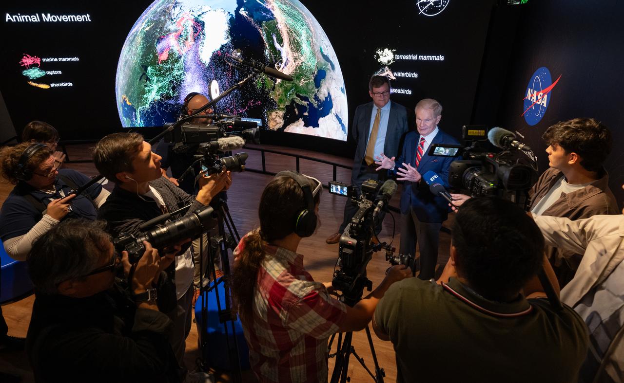
Smithsonian Museum of Natural History, Sant Director, Kirk Johnson, left, and NASA Administrator Bill Nelson, talk with media during a preview the Earth Information Center at the Smithsonian National Museum of Natural History, in Washington, Monday, Oct. 7, 2024. The exhibit includes a video wall displaying Earth science data visualizations and videos, an interpretive panel showing Earth’s connected systems, information on our changing world, and an overview of how NASA and the Smithsonian study our home planet. Photo Credit: (NASA/Bill Ingalls)
Smithsonian Museum of Natural History, Sant Director, Kirk Johnson, left, talks with NASA Administrator Bill Nelson, during a preview of the Earth Information Center at the Smithsonian National Museum of Natural History, in Washington, Monday, Oct. 7, 2024. The exhibit includes a video wall displaying Earth science data visualizations and videos, an interpretive panel showing Earth’s connected systems, information on our changing world, and an overview of how NASA and the Smithsonian study our home planet. Photo Credit: (NASA/Bill Ingalls)
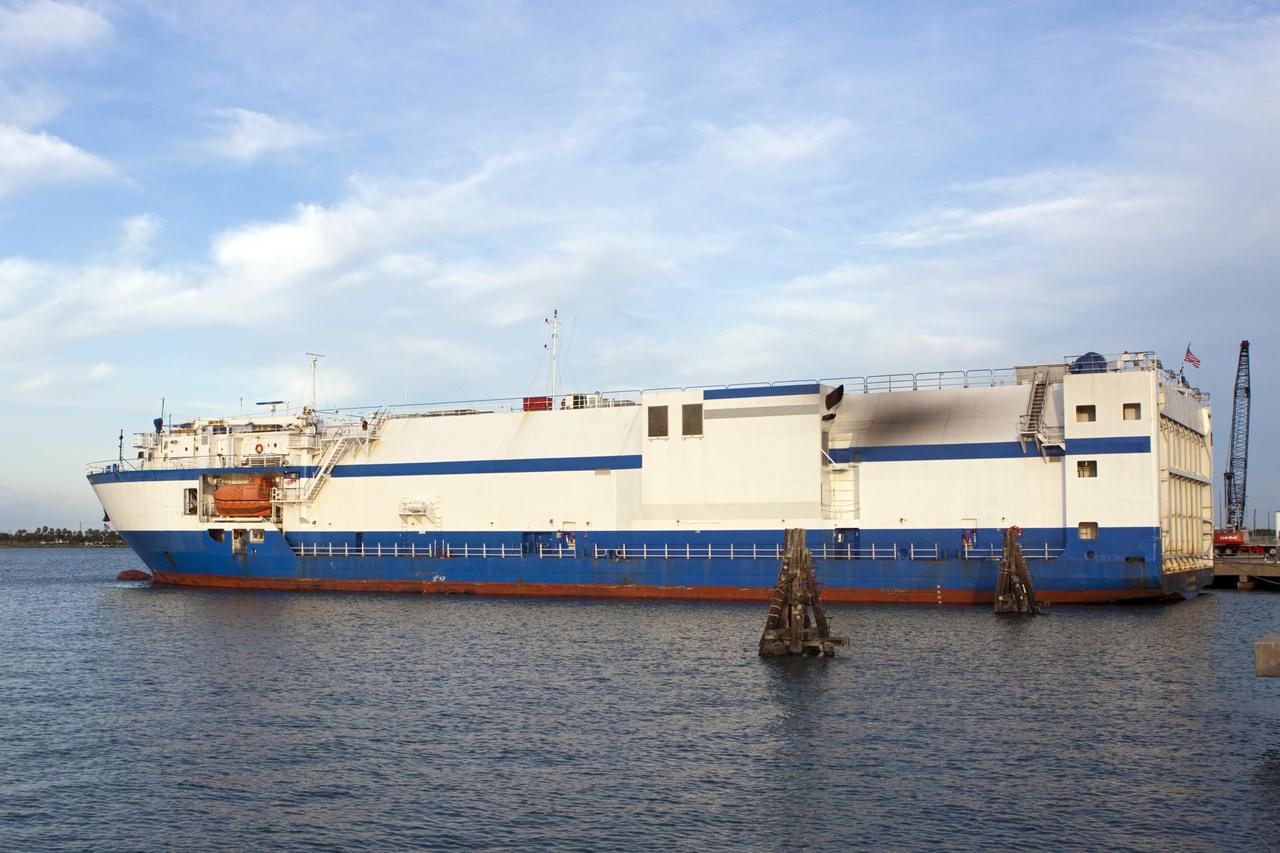
CAPE CANAVERAL, Fla. – United Launch Alliance's Delta Mariner barge arrives at Port Canaveral in Florida carrying the Atlas V first stage booster for NASA's Radiation Belt Storm Probes mission. The Radiation Belt Storm Probes, or RBSP, mission will help us understand the sun’s influence on Earth and near-Earth space by studying the Earth’s radiation belts on various scales of space and time. For more information, visit http://www.nasa.gov/rbsp. Photo credit: NASA/Jim Grossmann

The super-Earth exoplanet 55 Cancri e, depicted with its star in this artist's concept, likely has an atmosphere thicker than Earth's, with ingredients that could be similar to those of Earth's atmosphere, according to a 2017 study using data from NASA's Spitzer Space Telescope. Scientists say the planet may be entirely covered in lava. The planet is so close to its star that one face of the planet consistently faces the star, resulting in a dayside and a nightside. https://photojournal.jpl.nasa.gov/catalog/PIA22069
NASA Administrator Bill Nelson, left, and Smithsonian Museum of Natural History, Sant Director, Kirk Johnson, preview the Earth Information Center at the Smithsonian National Museum of Natural History, in Washington, Monday, Oct. 7, 2024. The exhibit includes a video wall displaying Earth science data visualizations and videos, an interpretive panel showing Earth’s connected systems, information on our changing world, and an overview of how NASA and the Smithsonian study our home planet. Photo Credit: (NASA/Bill Ingalls)
NASA Administrator Bill Nelson, left, and Smithsonian Museum of Natural History, Sant Director, Kirk Johnson, preview the Earth Information Center at the Smithsonian National Museum of Natural History, in Washington, Monday, Oct. 7, 2024. The exhibit includes a video wall displaying Earth science data visualizations and videos, an interpretive panel showing Earth’s connected systems, information on our changing world, and an overview of how NASA and the Smithsonian study our home planet. Photo Credit: (NASA/Bill Ingalls)
CAPE CANAVERAL, Fla. – The United Launch Alliance Atlas V first stage booster for NASA's Radiation Belt Storm Probes mission approaches the Atlas Spaceflight Operations Center, or ASOC, at Cape Canaveral Air Force Station in Florida. The Radiation Belt Storm Probes, or RBSP, mission will help us understand the sun’s influence on Earth and near-Earth space by studying the Earth’s radiation belts on various scales of space and time. For more information, visit http://www.nasa.gov/rbsp. Photo credit: NASA/Jim Grossmann
CAPE CANAVERAL, Fla. – The United Launch Alliance Atlas V first stage booster for NASA's Radiation Belt Storm Probes mission arrives at the Atlas Spaceflight Operations Center, or ASOC, at Cape Canaveral Air Force Station in Florida. The Radiation Belt Storm Probes, or RBSP, mission will help us understand the sun’s influence on Earth and near-Earth space by studying the Earth’s radiation belts on various scales of space and time. For more information, visit http://www.nasa.gov/rbsp. Photo credit: NASA/Jim Grossmann
NASA Administrator Bill Nelson, left, and Smithsonian Museum of Natural History, Sant Director, Kirk Johnson, preview the Earth Information Center at the Smithsonian National Museum of Natural History, in Washington, Monday, Oct. 7, 2024. The exhibit includes a video wall displaying Earth science data visualizations and videos, an interpretive panel showing Earth’s connected systems, information on our changing world, and an overview of how NASA and the Smithsonian study our home planet. Photo Credit: (NASA/Bill Ingalls)
CAPE CANAVERAL, Fla. – The Atlas V first stage booster for NASA's Radiation Belt Storm Probes mission is offloaded from United Launch Alliance's Delta Mariner barge at Port Canaveral in Florida. The Radiation Belt Storm Probes, or RBSP, mission will help us understand the sun’s influence on Earth and near-Earth space by studying the Earth’s radiation belts on various scales of space and time. For more information, visit http://www.nasa.gov/rbsp. Photo credit: NASA/Jim Grossmann
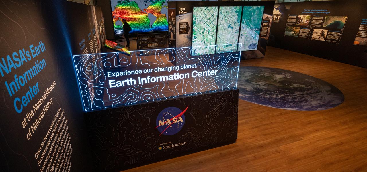
The Earth Information Center at the Smithsonian National Museum of Natural History, in Washington, is previewed, Monday, Oct. 7, 2024. The exhibit includes a video wall displaying Earth science data visualizations and videos, an interpretive panel showing Earth’s connected systems, information on our changing world, and an overview of how NASA and the Smithsonian study our home planet. Photo Credit: (NASA/Bill Ingalls)
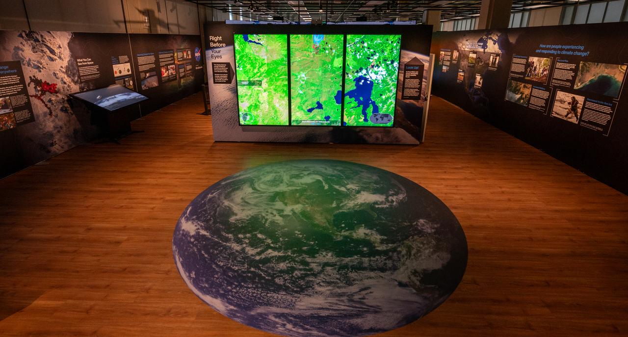
The Earth Information Center at the Smithsonian National Museum of Natural History, in Washington, is previewed, Monday, Oct. 7, 2024. The exhibit includes a video wall displaying Earth science data visualizations and videos, an interpretive panel showing Earth’s connected systems, information on our changing world, and an overview of how NASA and the Smithsonian study our home planet. Photo Credit: (NASA/Bill Ingalls)
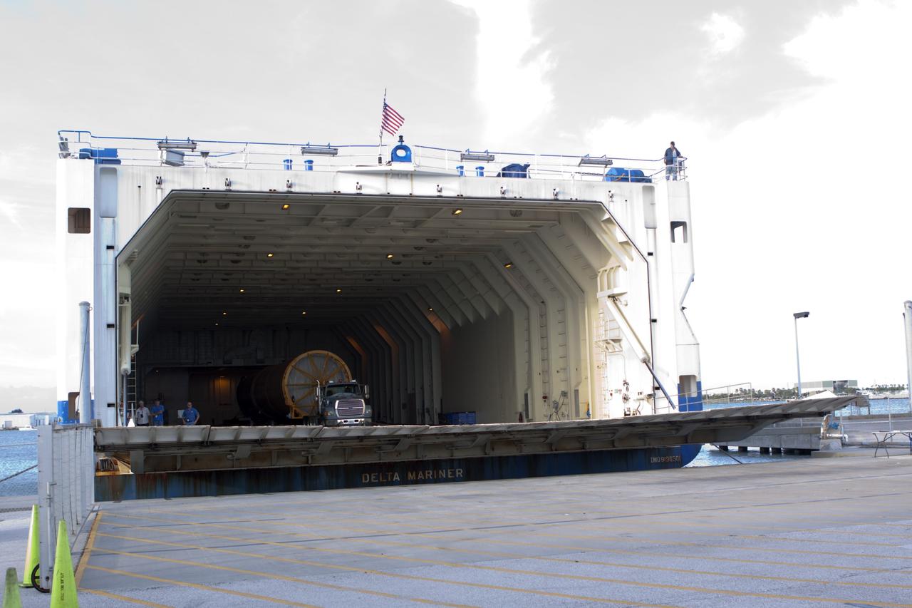
CAPE CANAVERAL, Fla. – The Atlas V first stage booster for NASA's Radiation Belt Storm Probes mission arrives at Port Canaveral in Florida aboard United Launch Alliance's Delta Mariner barge. The Radiation Belt Storm Probes, or RBSP, mission will help us understand the sun’s influence on Earth and near-Earth space by studying the Earth’s radiation belts on various scales of space and time. For more information, visit http://www.nasa.gov/rbsp. Photo credit: NASA/Jim Grossmann
CAPE CANAVERAL, Fla. – At Port Canaveral in Florida, the Atlas V first stage booster for NASA's Radiation Belt Storm Probes mission is attached to a truck for offloading from United Launch Alliance's Delta Mariner barge. The Radiation Belt Storm Probes, or RBSP, mission will help us understand the sun’s influence on Earth and near-Earth space by studying the Earth’s radiation belts on various scales of space and time. For more information, visit http://www.nasa.gov/rbsp. Photo credit: NASA/Jim Grossmann
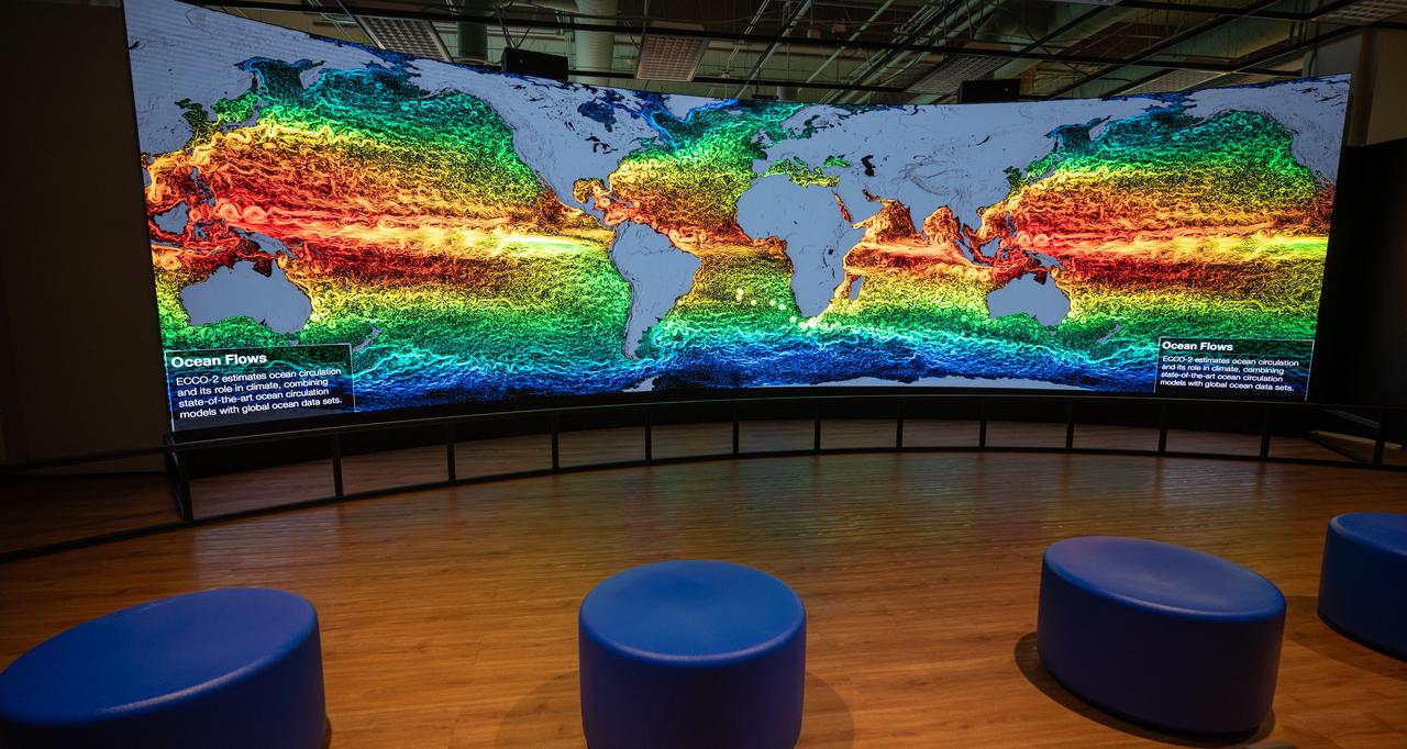
The Earth Information Center at the Smithsonian National Museum of Natural History, in Washington, is previewed, Monday, Oct. 7, 2024. The exhibit includes a video wall displaying Earth science data visualizations and videos, an interpretive panel showing Earth’s connected systems, information on our changing world, and an overview of how NASA and the Smithsonian study our home planet. Photo Credit: (NASA/Bill Ingalls)
CAPE CANAVERAL, Fla. – The Atlas V first stage booster for NASA's Radiation Belt Storm Probes mission emerges from United Launch Alliance's Delta Mariner barge at Port Canaveral in Florida. The Radiation Belt Storm Probes, or RBSP, mission will help us understand the sun’s influence on Earth and near-Earth space by studying the Earth’s radiation belts on various scales of space and time. For more information, visit http://www.nasa.gov/rbsp. Photo credit: NASA/Jim Grossmann
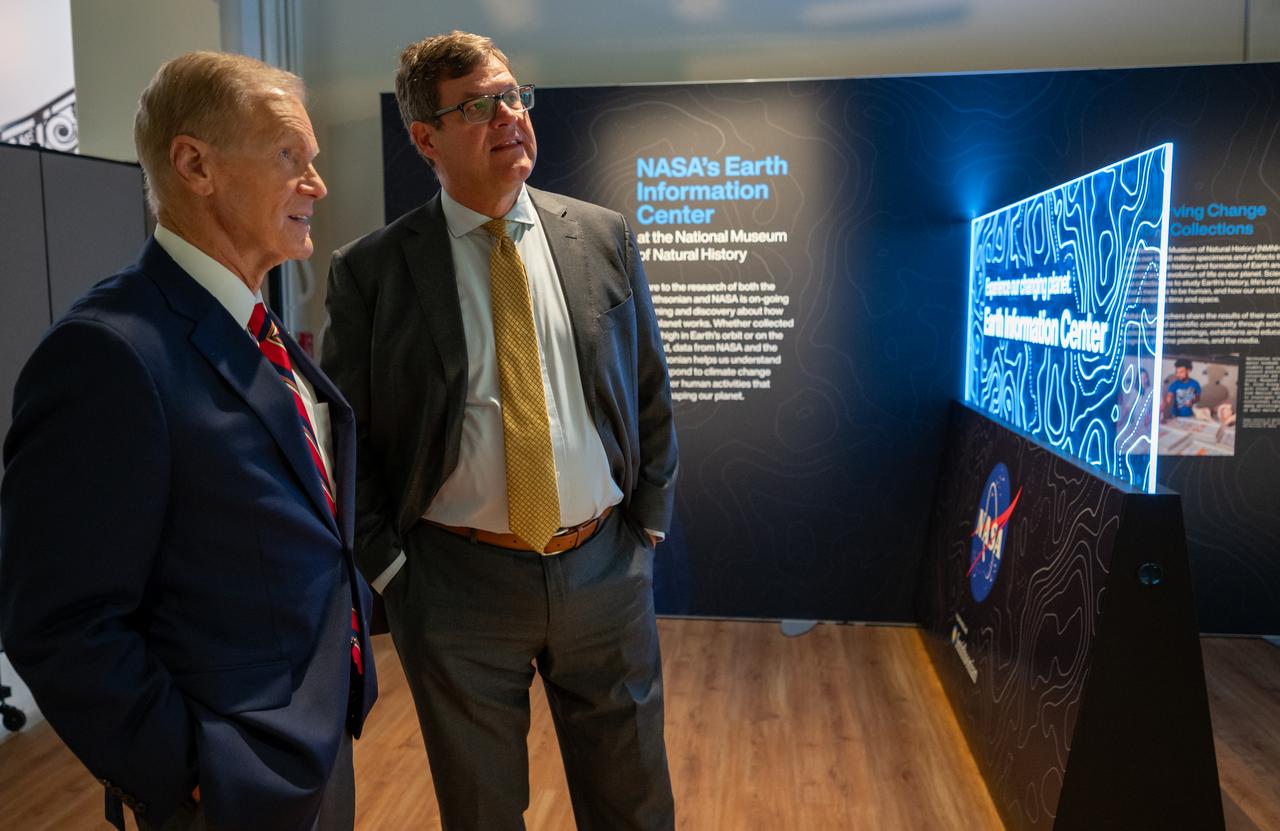
NASA Administrator Bill Nelson, left, talks with Smithsonian Museum of Natural History, Sant Director, Kirk Johnson, during a preview of the Earth Information Center at the Smithsonian National Museum of Natural History, in Washington, Monday, Oct. 7, 2024. The exhibit includes a video wall displaying Earth science data visualizations and videos, an interpretive panel showing Earth’s connected systems, information on our changing world, and an overview of how NASA and the Smithsonian study our home planet. Photo Credit: (NASA/Bill Ingalls)
CAPE CANAVERAL, Fla. – The Atlas V first stage booster for NASA's Radiation Belt Storm Probes mission approaches Cape Canaveral Air Force Station in Florida. The booster was delivered by barge to nearby Port Canaveral. The Radiation Belt Storm Probes, or RBSP, mission will help us understand the sun’s influence on Earth and near-Earth space by studying the Earth’s radiation belts on various scales of space and time. For more information, visit http://www.nasa.gov/rbsp. Photo credit: NASA/Jim Grossmann
CAPE CANAVERAL, Fla. – The United Launch Alliance Atlas V first stage booster for NASA's Radiation Belt Storm Probes mission begins moving into the Atlas Spaceflight Operations Center, or ASOC, at Cape Canaveral Air Force Station in Florida. The Radiation Belt Storm Probes, or RBSP, mission will help us understand the sun’s influence on Earth and near-Earth space by studying the Earth’s radiation belts on various scales of space and time. For more information, visit http://www.nasa.gov/rbsp. Photo credit: NASA/Jim Grossmann
CAPE CANAVERAL, Fla. – The Atlas V first stage booster for NASA's Radiation Belt Storm Probes mission is ready to be offloaded at Port Canaveral in Florida. The booster arrived on United Launch Alliance's barge, the Delta Mariner. The Radiation Belt Storm Probes, or RBSP, mission will help us understand the sun’s influence on Earth and near-Earth space by studying the Earth’s radiation belts on various scales of space and time. For more information, visit http://www.nasa.gov/rbsp. Photo credit: NASA/Jim Grossmann
Smithsonian Museum of Natural History, Sant Director, Kirk Johnson, left, talks with NASA Administrator Bill Nelson, during a preview of the Earth Information Center at the Smithsonian National Museum of Natural History, in Washington, Monday, Oct. 7, 2024. The exhibit includes a video wall displaying Earth science data visualizations and videos, an interpretive panel showing Earth’s connected systems, information on our changing world, and an overview of how NASA and the Smithsonian study our home planet. Photo Credit: (NASA/Bill Ingalls)
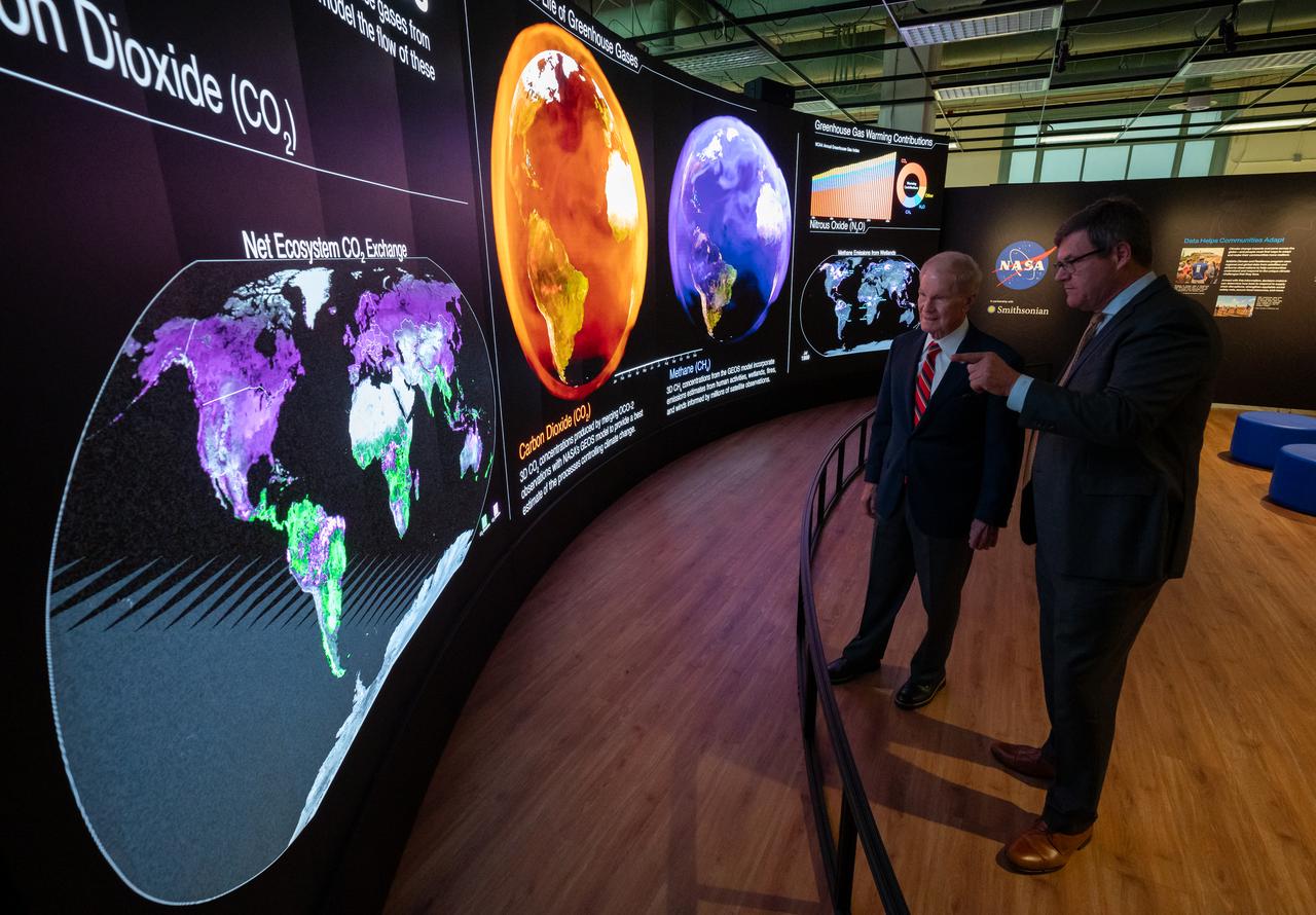
NASA Administrator Bill Nelson, left, and Smithsonian Museum of Natural History, Sant Director, Kirk Johnson, preview the Earth Information Center at the Smithsonian National Museum of Natural History, in Washington, Monday, Oct. 7, 2024. The exhibit includes a video wall displaying Earth science data visualizations and videos, an interpretive panel showing Earth’s connected systems, information on our changing world, and an overview of how NASA and the Smithsonian study our home planet. Photo Credit: (NASA/Bill Ingalls)
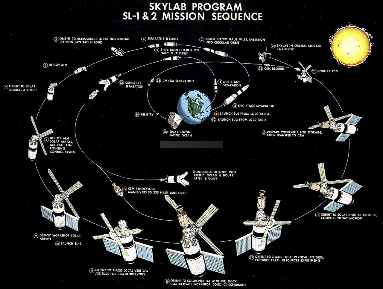
This illustration depicts the Skylab-1 and Skylab-2 mission sequence. The goals of the Skylab were to enrich our scientific knowledge of the Earth, the Sun, the stars, and cosmic space; to study the effects of weightlessness on living organisms, including man; to study the effects of the processing and manufacturing of materials utilizing the absence of gravity; and to conduct Earth resource observations. The Skylab also conducted 19 selected experiments submitted by high school students. Skylab's 3 different 3-man crews spent up to 84 days in Earth orbit. The Marshall Space Flight Center (MSFC) had responsibility for developing and integrating most of the major components of the Skylab: the Orbital Workshop (OWS), Airlock Module (AM), Multiple Docking Adapter (MDA), Apollo Telescope Mount (ATM), Payload Shroud (PS), and most of the experiments. MSFC was also responsible for providing the Saturn IB launch vehicles for three Apollo spacecraft and crews and a Saturn V launch vehicle for the Skylab.
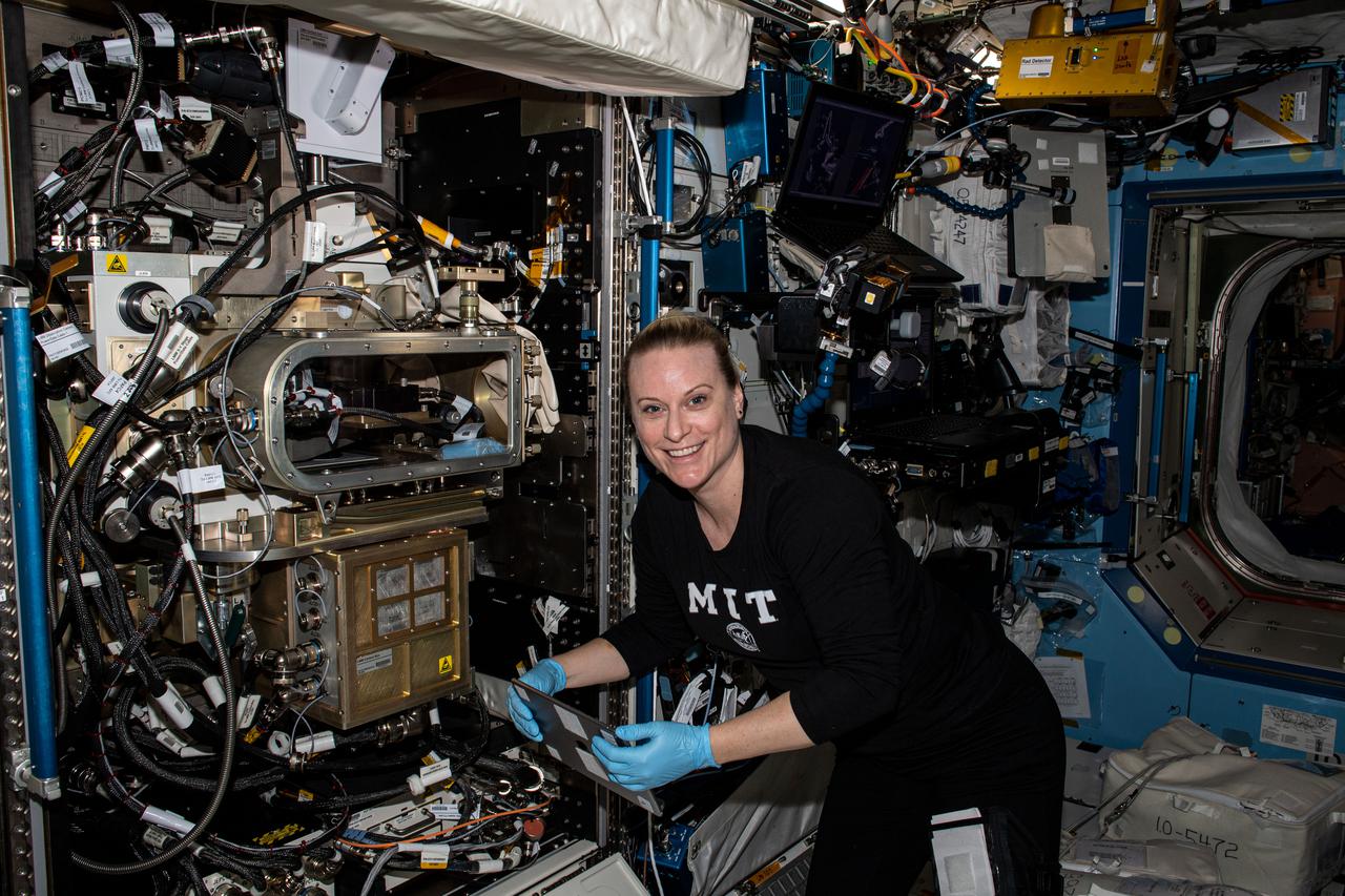
iss073e0134929 (6/9/2025) ---NASA astronaut Nichole Ayers sets up the station’s Ring Sheared Drop module. This system makes it possible to study liquid protein solutions without using containers, eliminating interactions between the solutions and container walls that can affect results. Ring Sheared Drop-IBP-2 studies the behavior of protein fluids in microgravity and tests computer models to predict that fluid’s behavior. Better models could help could advance manufacturing processes in space and on Earth for producing next-generation medicines for treating cancers and other diseases.NASA astronaut Nichole Ayers sets up the station’s Ring Sheared Drop module. This system makes it possible to study liquid protein solutions without using containers, eliminating interactions between the solutions and container walls that can affect results. Ring Sheared Drop-IBP-2 studies the behavior of protein fluids in microgravity and tests computer models to predict that fluid’s behavior. Better models could help could advance manufacturing processes in space and on Earth for producing next-generation medicines for treating cancers and other diseases.
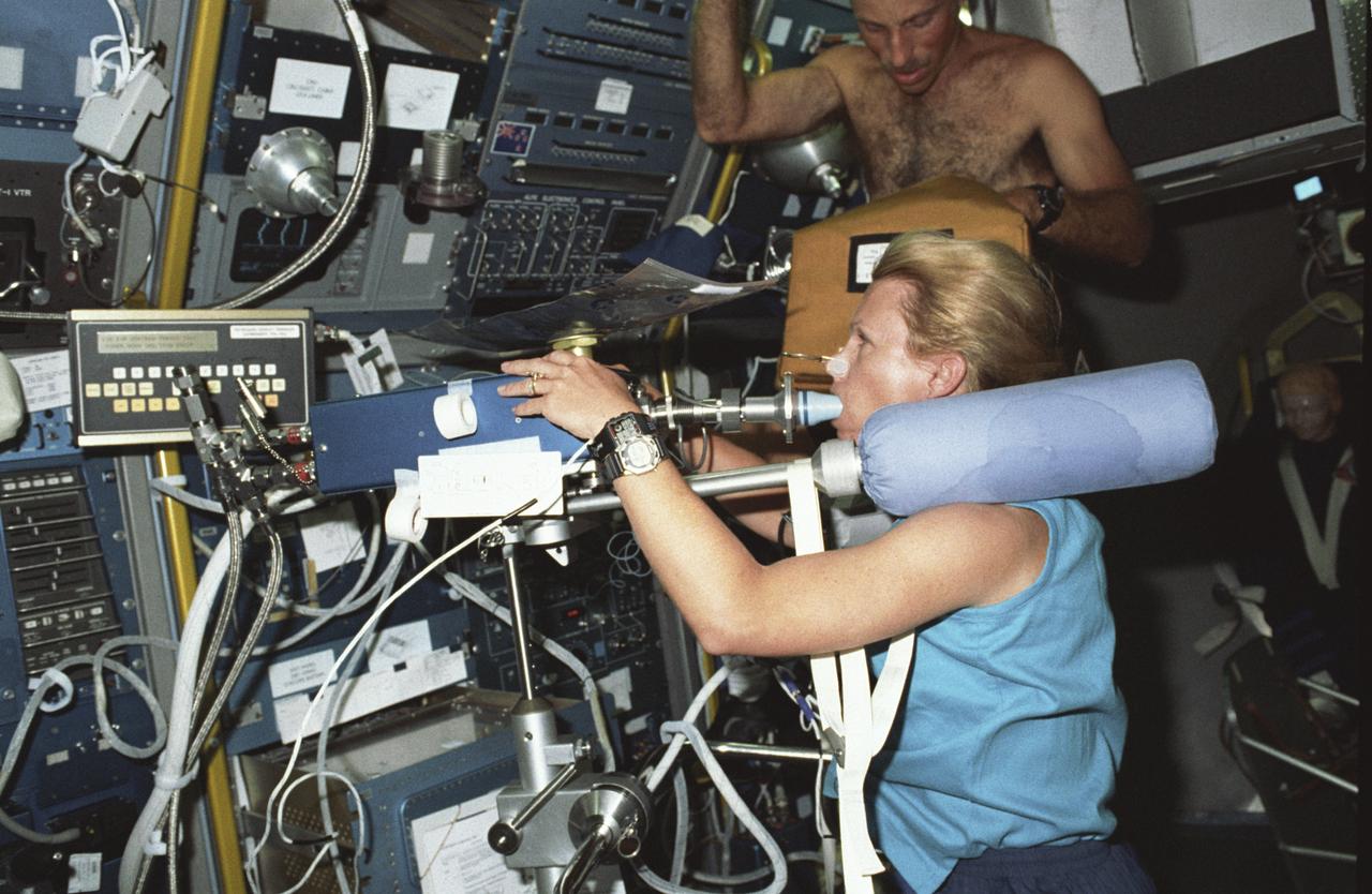
Spacelab Life Science -1 (SLS-1) was the first Spacelab mission dedicated solely to life sciences. The main purpose of the SLS-1 mission was to study the mechanisms, magnitudes, and time courses of certain physiological changes that occur during space flight, to investigate the consequences of the body's adaptation to microgravity and readjustment to Earth's gravity, and bring the benefits back home to Earth. The mission was designed to explore the responses of the heart, lungs, blood vessels, kidneys, and hormone-secreting glands to microgravity and related body fluid shifts; examine the causes of space motion sickness; and study changes in the muscles, bones, and cells. This photograph shows astronaut Rhea Seddon conducting an inflight study of the Cardiovascular Deconditioning experiment by breathing into the cardiovascular rebreathing unit. This experiment focused on the deconditioning of the heart and lungs and changes in cardiopulmonary function that occur upon return to Earth. By using noninvasive techniques of prolonged expiration and rebreathing, investigators can determine the amount of blood pumped out of the heart (cardiac output), the ease with which blood flows through all the vessels (total peripheral resistance), oxygen used and carbon dioxide released by the body, and lung function and volume changes. SLS-1 was launched aboard the Space Shuttle Orbiter Columbia (STS-40) on June 5, 1995.
iss073e0002477_alt (April 28, 2025) --- JAXA (Japan Aerospace Exploration Agency) astronaut and Expedition 73 Commander Takuya Onishi processes cassettes containing biological fluid samples for installation inside the Advanced Space Experiment Processor-4, a research facility that can be shipped back and forth from Earth to space, for a biotechnology study.
iss065e206774 (July 27, 2021) --- NASA astronaut and Expedition 65 Flight Engineer Megan McArthur works on the Plant Water Management space botany study that explores operating hydroponics in microgravity and may also improve watering systems on Earth.
iss053e047057 (Sept. 26, 2017) --- Flight Engineer Joe Acaba installs botany gear for the Veggie facility to demonstrate plant growth in space for the Veg-03 experiment. The botany study uses the Veggie plant growth facility to cultivate cabbage, lettuce and mizuna, which are harvested on-orbit with samples returned to Earth for testing.
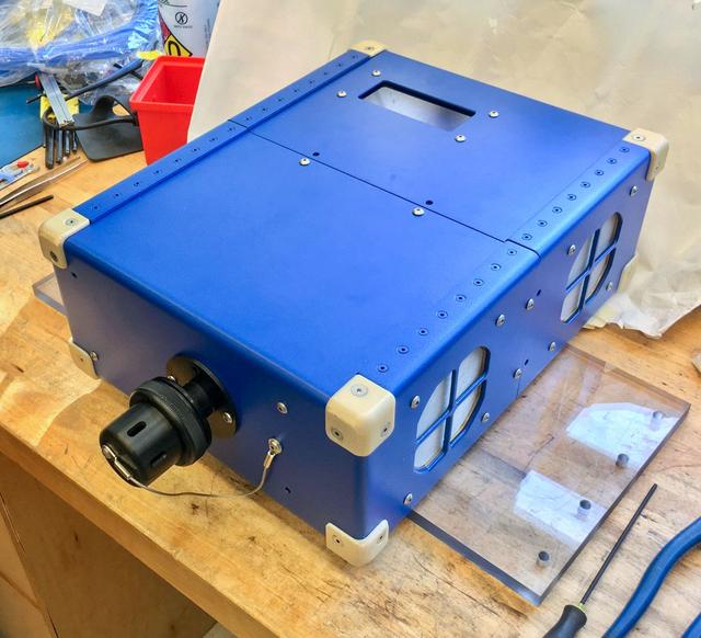
jsc2020e004941 (2/7/2020) --- A preflight view of the Airborne Particulate Monitor (APM) engineering unit. APM technology has applications in environmental monitoring and air pollution studies on Earth. Its combination of two instruments into one box offers a wider range of particle size measurement than other commercially available instruments.
ISS038-E-031992 (13 Jan. 2014) --- NASA astronaut Rick Mastracchio, Expedition 38 flight engineer, works with the Ant Forage Habitat Facility in the Destiny laboratory of the International Space Station. The study examines the behavior of ants by comparing groups living on Earth to those in space.
iss066e147338 (Feb. 21, 2022) --- NASA astronaut and Expedition 66 Flight Engineer Mark Vande Hei harvests plants growing for the Veggie PONDS experiment and collects samples for later analysis. The space agriculture study explores growing crops in space to sustain crews on missions beyond low-Earth orbit.
iss064e015256 (12/24/2020) --- NASA astronaut Kate Rubins works inside the Life Sciences Glovebox conducting research for the Cardinal Heart study. The biomedical research seeks to help scientists understand the aging and weakening of heart muscles to provide new treatments for humans on Earth and astronauts in space.
iss065e074538 (May 27, 2021) --- NASA astronaut and Expedition 65 Flight Engineer Shane Kimbrough conducts cylinder test operations for the Plant Water Management experiment. The space botany study explores hydroponics in microgravity and may also improve watering systems on Earth.