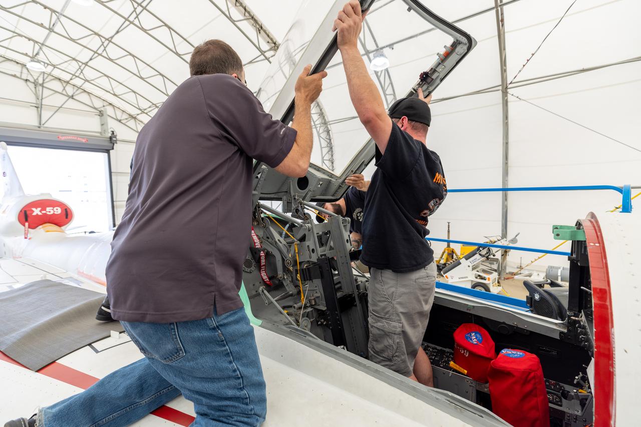
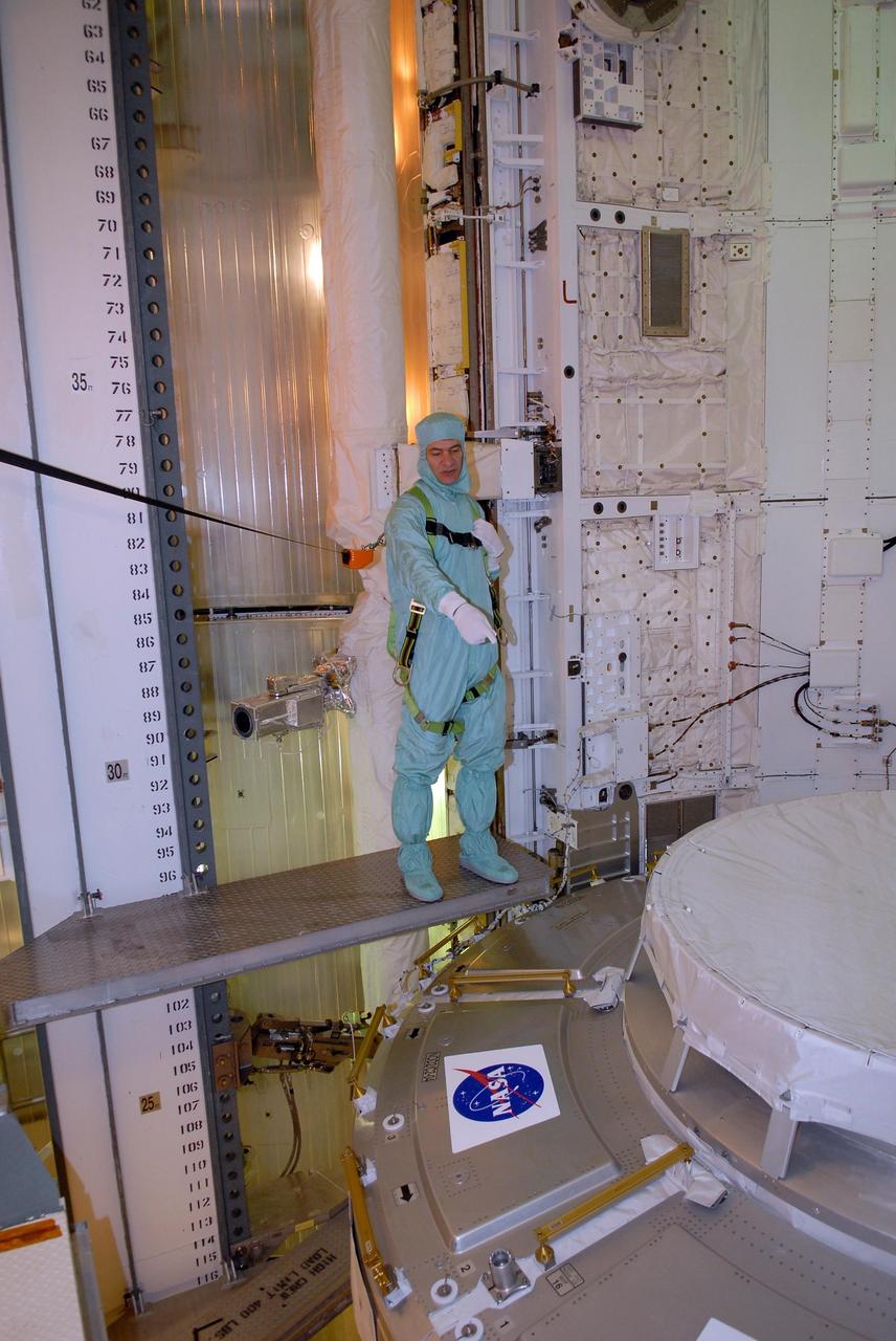
Lockheed Martin technicians temporarily remove the canopy from the X-59 in preparation for final installation of the ejection seat into the aircraft.
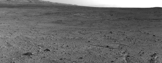
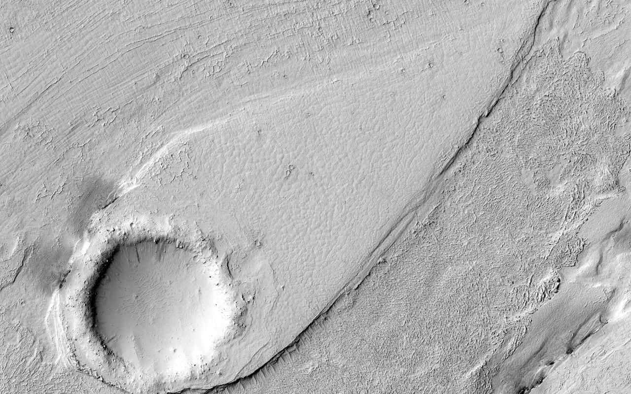
In the upper central portion of this image is a patch of ground paler than its surroundings as seen by NASA Mars rover Curiosity after reaching the top of a rise called Panorama Point.
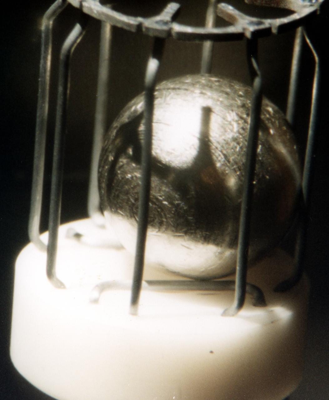
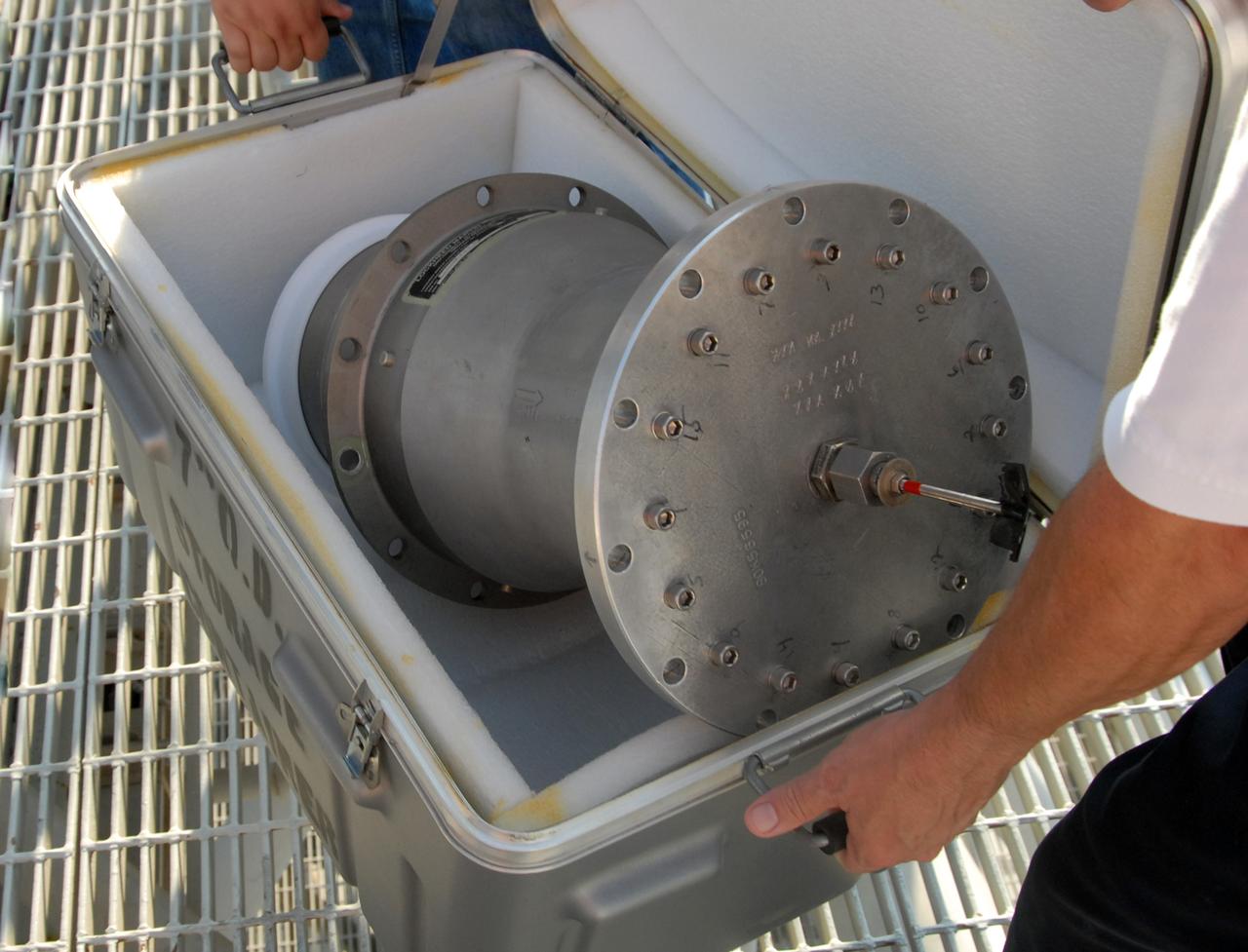
Typical metal sample that was processed by TEMPUS (Tiegelfreies Elektromagnetisches Prozessieren Unter Schwerelosigkeit), an electromagnetic levitation facility developed by German researchers and flown on the IML-2 and MSL-1 and 1R Spacelab missions. Electromagnetic levitation is used commonly in ground-based experiments to melt and then cool metallic melts below their freezing points without solidification occurring. Sample size is limited in ground-based experiments. Research with TEMPUS aboard Spacelab allowed scientists to study the viscosity, surface tension, and other properties of several metals and alloys while undercooled (i.e., cooled below their normal solidification points). The sample is about 1 cm (2/5 inch) in diameter.
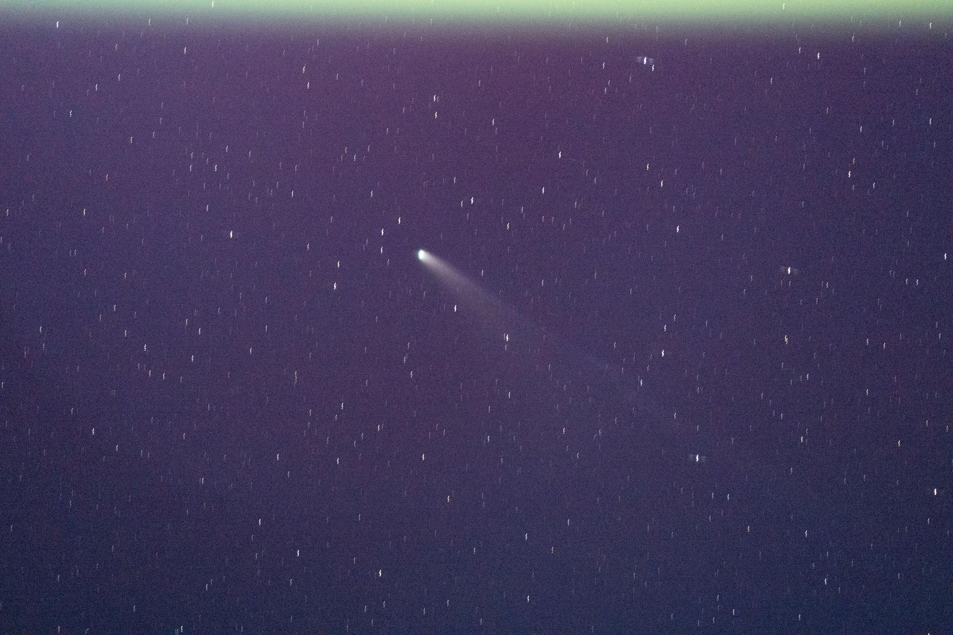
iss073e0982217 (Oct. 26, 2025) --- The International Space Station’s unique vantage point, orbiting 250 miles above Earth, is crucial for studying a wide range of cosmic phenomena. This image provides a rare view of a comet. Scientists use instruments mounted on the exterior of the station to also study black holes and dark matter. This vantage point allows researchers to make observations difficult to see from the ground, providing new insights into the fundamental nature of the universe.

Ground testing for the first confocal Light Microscopy Microscope (LMM) Experiment. Procter and Gamble is working with NASA Glenn scientists to prepare for a study that examines product stabilizers in a microgravity environment. The particles in the tube glow orange because they have been fluorescently tagged with a dye that reacts to green laser lights to allow construction of a 3D image point by point. The experiment, which will be sent to the ISS later this year, will help P&G develop improved product stabilizers to extend shelf life and develop more environmentally friendly packaging.
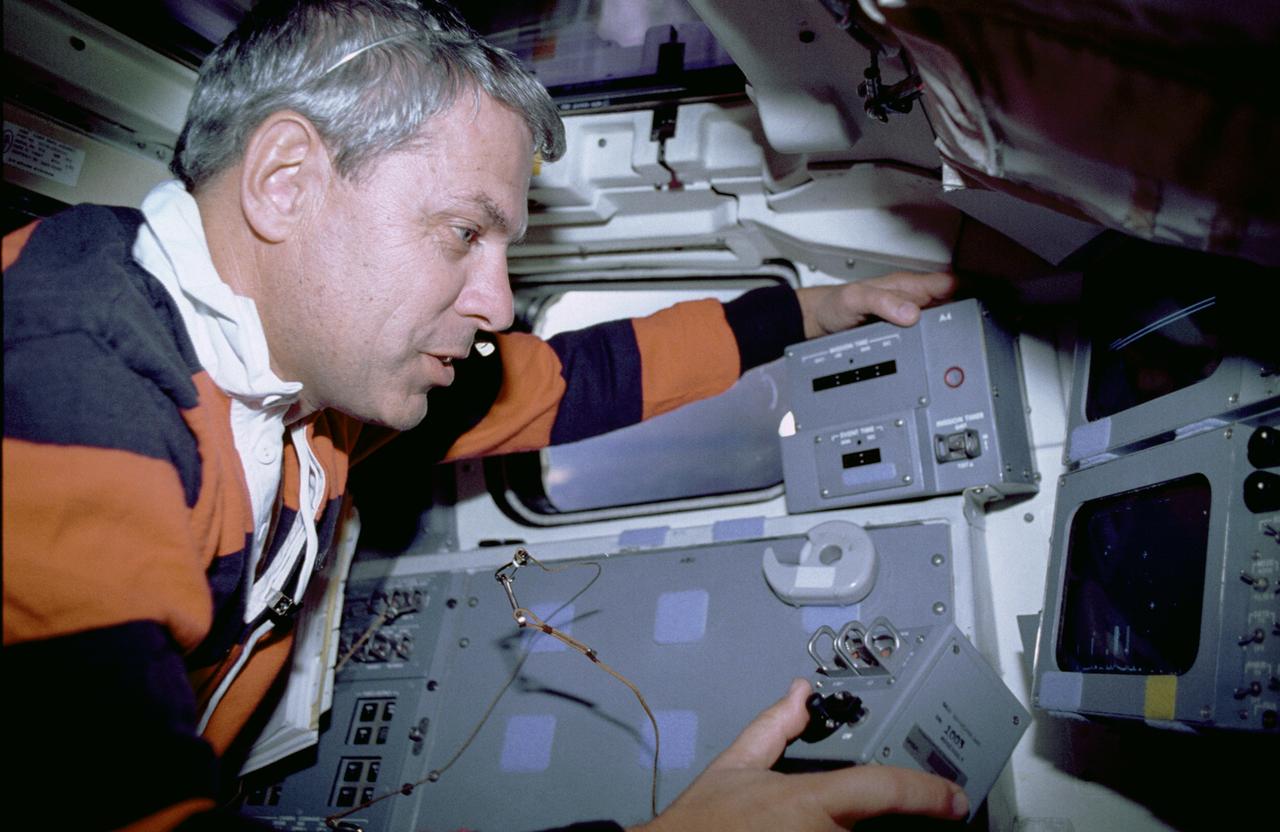
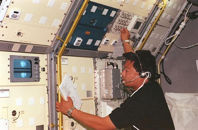
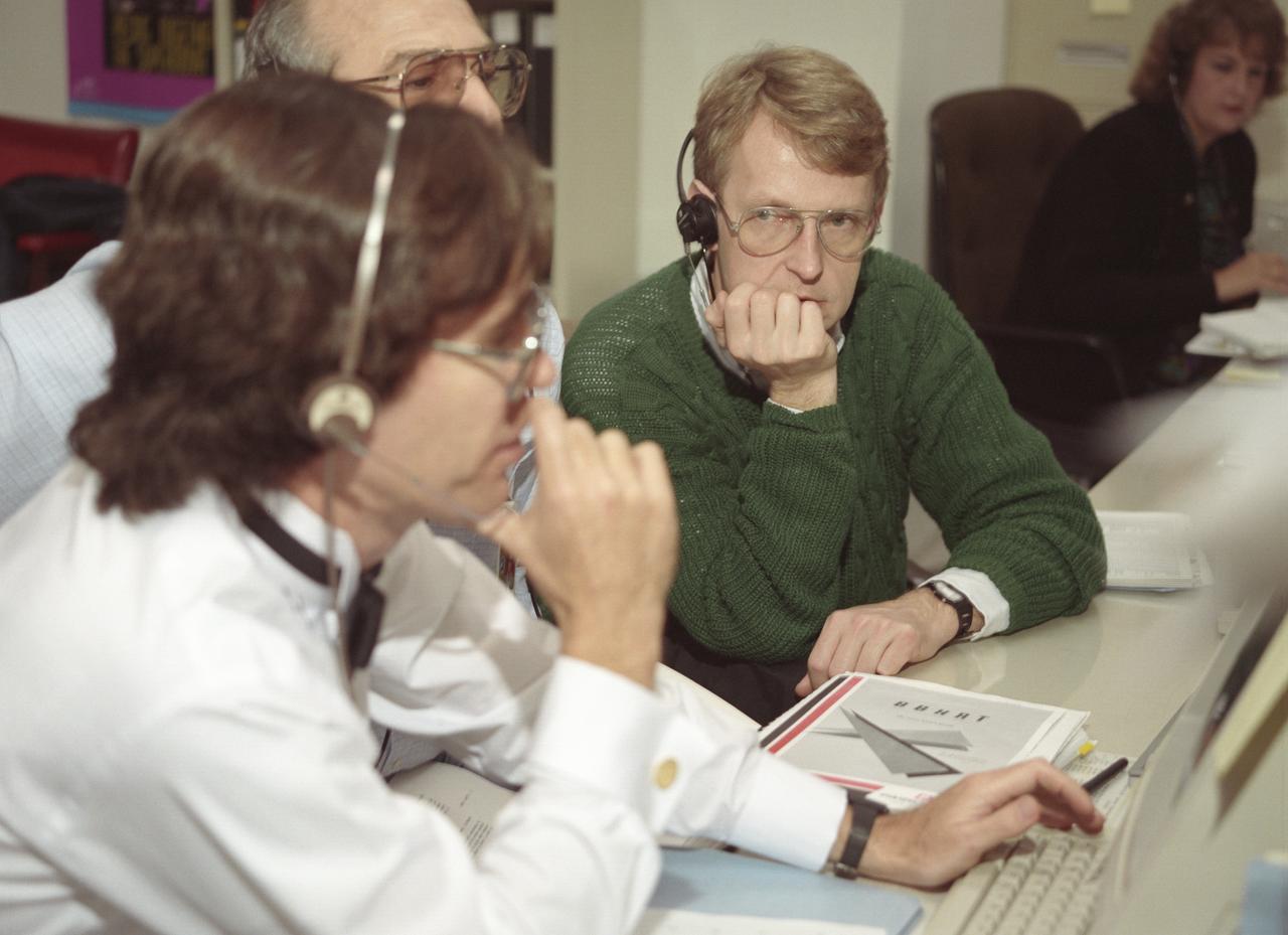
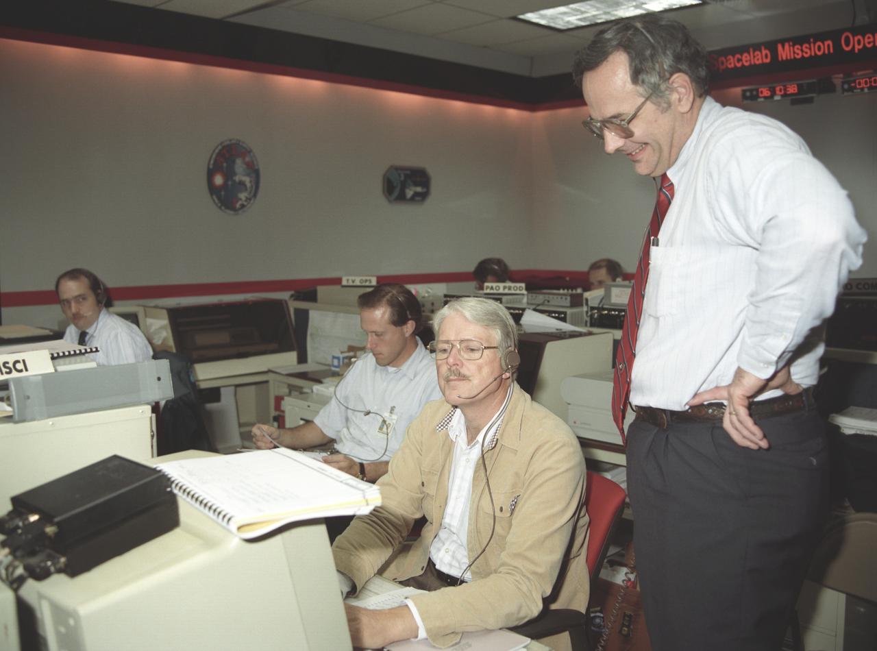
The primary objective of the STS-35 mission was round the clock observation of the celestial sphere in ultraviolet and X-Ray astronomy with the Astro-1 observatory which consisted of four telescopes: the Hopkins Ultraviolet Telescope (HUT); the Wisconsin Ultraviolet Photo-Polarimeter Experiment (WUPPE); the Ultraviolet Imaging Telescope (UIT); and the Broad Band X-Ray Telescope (BBXRT). The Huntsville Operations Support Center (HOSC) Spacelab Payload Operations Control Center (SL POCC) at the Marshall Space Flight Center (MSFC) was the air/ground communication channel used between the astronauts and ground control teams during the Spacelab missions. Teams of controllers and researchers directed on-orbit science operations, sent commands to the spacecraft, received data from experiments aboard the Space Shuttle, adjusted mission schedules to take advantage of unexpected science opportunities or unexpected results, and worked with crew members to resolve problems with their experiments. Due to loss of data used for pointing and operating the ultraviolet telescopes, MSFC ground teams were forced to aim the telescopes with fine tuning by the flight crew. Pictured onboard the shuttle is astronaut Robert Parker using a Manual Pointing Controller (MPC) for the ASTRO-1 mission Instrument Pointing System (IPS).
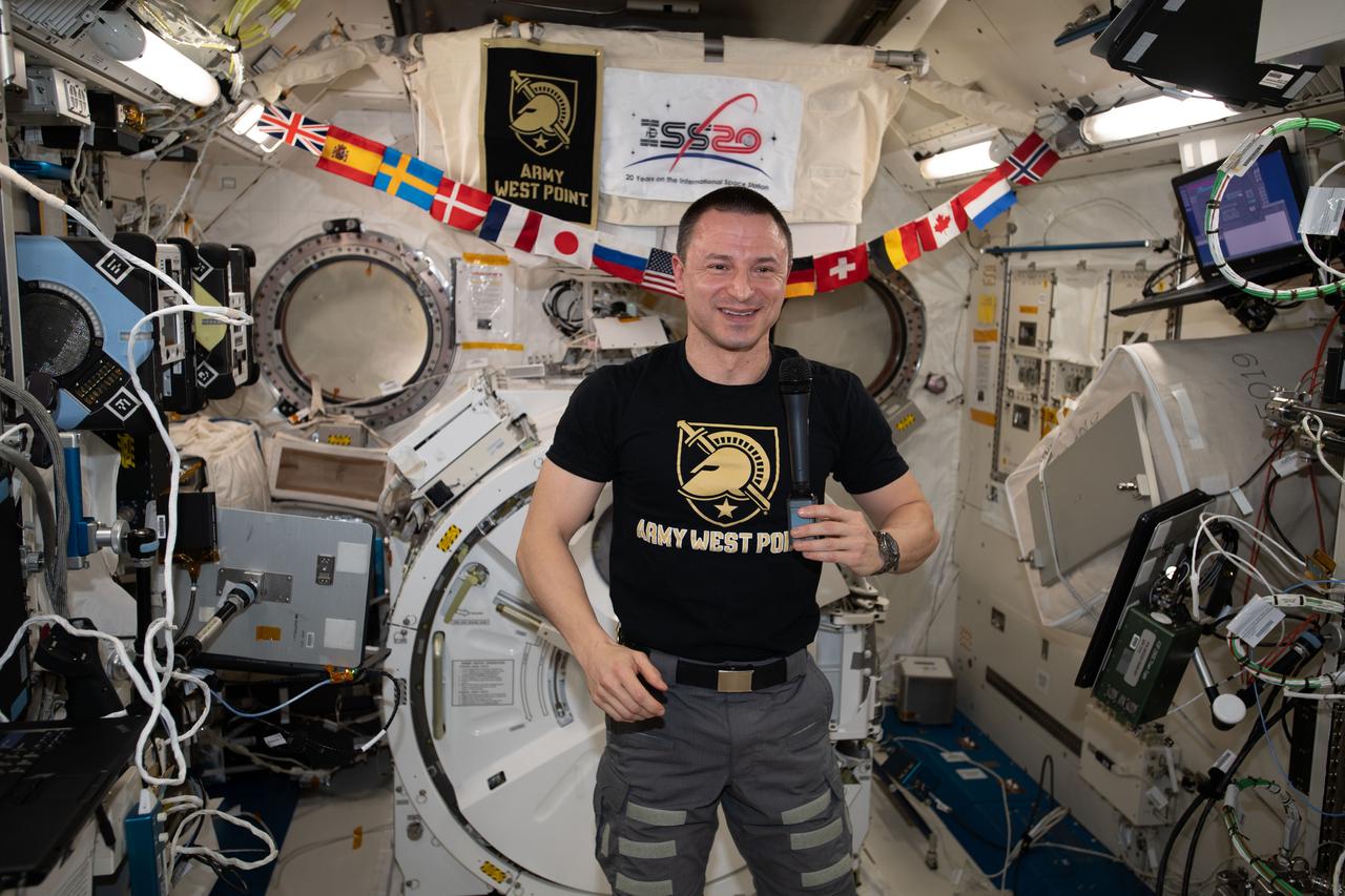
iss062e112559 (March 24, 2020) --- NASA astronaut and Expedition 62 Flight Engineer Andrew Morgan, a graduate of the U.S. Military Academy in West Point, New York, and the Uniformed Services University of the Health Sciences in Bethesda, Maryland, is pictured inside the Kibo laboratory module talking to personnel on the ground.
The bowtie-shaped antenna for the Radar Imager for Mars' Subsurface Experiment (RIMFAX) instrument has been mounted on the underside of the Perseverance rover. This antenna points down at the hard, frozen ground on Mars and sends the ground penetrating radar signal more than 30 feet (10 meters) below the surface of Mars. RIMFAX will enable scientists to learn about sources of briny water or ice below the surface. https://photojournal.jpl.nasa.gov/catalog/PIA24206

This illustration shows what the TRAPPIST-1 system might look like from a vantage point near planet TRAPPIST-1f (at right). The system has been revealed through observations from NASA's Spitzer Space Telescope and the ground-based TRAPPIST (TRAnsiting Planets and PlanetesImals Small Telescope) telescope, as well as other ground-based observatories. The system was named for the TRAPPIST telescope. The seven planets of TRAPPIST-1 are all Earth-sized and terrestrial, according to research published in 2017 in the journal Nature. TRAPPIST-1 is an ultra-cool dwarf star in the constellation Aquarius, and its planets orbit very close to it. They are likely all tidally locked, meaning the same face of the planet is always pointed at the star, as the same side of our moon is always pointed at Earth. This creates a perpetual night side and perpetual day side on each planet. TRAPPIST-1b and c receive the most light from the star and would be the warmest. TRAPPIST-1e, f and g all orbit in the habitable zone, the area where liquid water is most likely to be detected. But any of the planets could potentially harbor liquid water, depending on their compositions. https://photojournal.jpl.nasa.gov/catalog/PIA21751
This photograph shows the Instrument Pointing System (IPS) for Spacelab-2 being deployed in the cargo bay of the Space Shuttle Orbiter Challenger. The European Space Agency (ESA) developed this irnovative pointing system for the Spacelab program. Previously, instruments were pointed toward particular celestial objects or areas by maneuvering the Shuttle to an appropriate attitude. The IPS could aim instruments more accurately than the Shuttle and kept them fixed on a target as the Shuttle moved. On the first pallet, three solar instruments and one atmospheric instrument were mounted on the IPS. Spacelab-2 was the first pallet-only mission. One of the goals of the mission was to verify that the pallets' configuration was satisfactory for observations and research. Except for two biological experiments and an experiment that uses ground-based instruments, the Spacelab-2 scientific instruments needed direct exposure to space. The Spacelab-2 mission was designed to capitalize on the Shuttle-Spacelab capabilities to carry very large instruments, launch and retrieve satellites, and point several instruments independently with accuracy and stability. Spacelab-2 (STS-51F, 19th Shuttle mission) was launched on July 29, 1985 aboard the Space Shuttle Orbiter Challenger. The Marshall Space Flight Center had overall management responsibilities of the Spacelab missions.
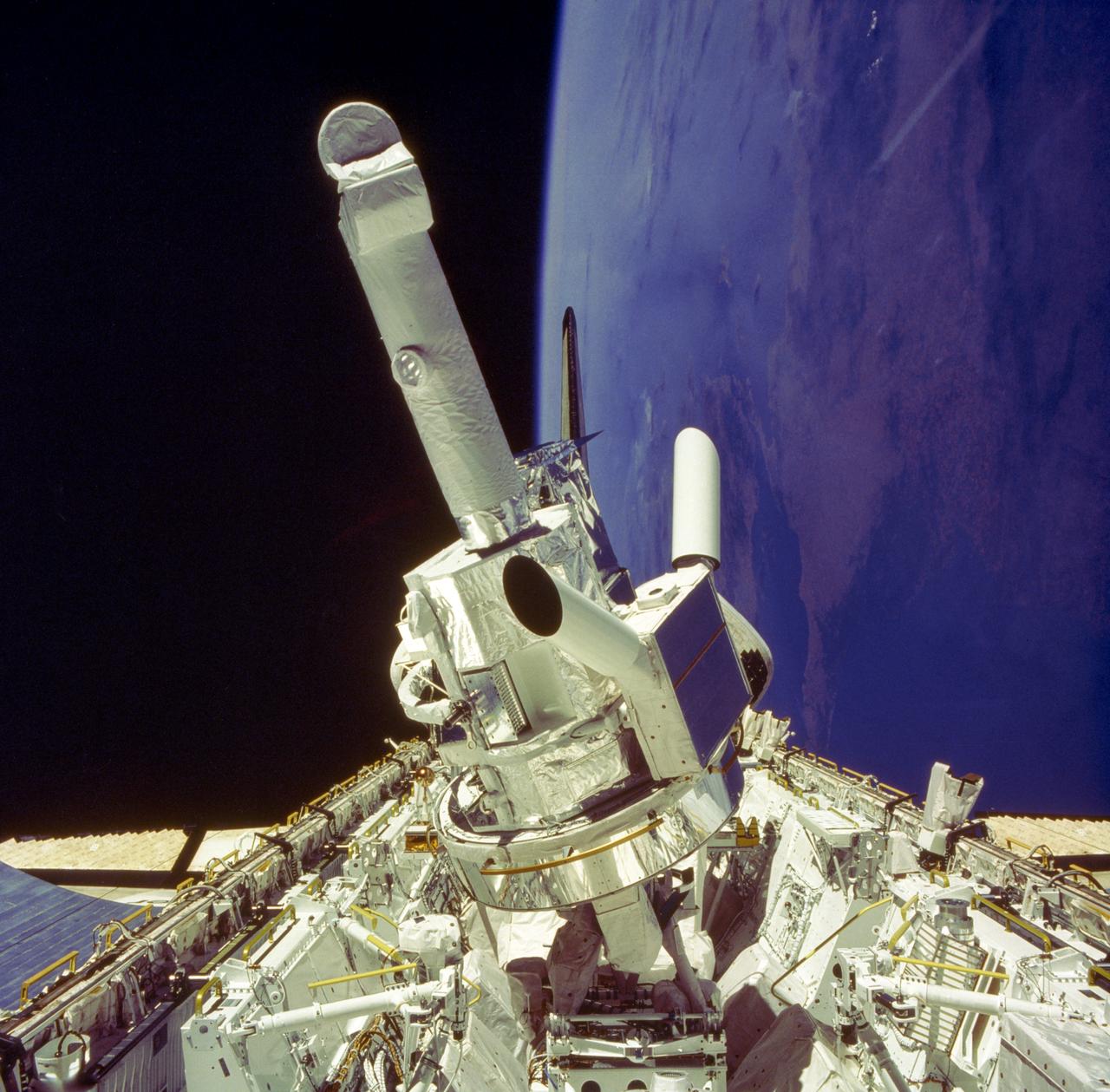
This photograph shows the Instrument Pointing System (IPS) for Spacelab-2 being deployed in the cargo bay of the Space Shuttle Orbiter Challenger. The European Space Agency (ESA) developed this irnovative pointing system for the Spacelab program. Previously, instruments were pointed toward particular celestial objects or areas by maneuvering the Shuttle to an appropriate attitude. The IPS could aim instruments more accurately than the Shuttle and kept them fixed on a target as the Shuttle moved. On the first pallet, three solar instruments and one atmospheric instrument were mounted on the IPS. Spacelab-2 was the first pallet-only mission. One of the goals of the mission was to verify that the pallets' configuration was satisfactory for observations and research. Except for two biological experiments and an experiment that used ground-based instruments, the Spacelab-2 scientific instruments needed direct exposure to space. The Spacelab-2 mission was designed to capitalize on the Shuttle-Spacelab capabilities to carry very large instruments, launch and retrieve satellites, and point several instruments independently with accuracy and stability. Spacelab-2 (STS-51F, 19th Shuttle mission) was launched on July 29, 1985 aboard the Space Shuttle Orbiter Challenger. The Marshall Space Flight Center had overall management responsibilities of the Spacelab missions.
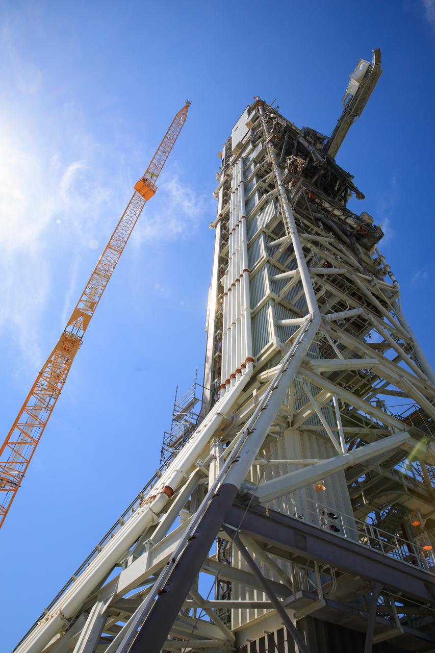
Teams with Exploration Ground Systems at NASA’s Kennedy Space Center in Florida continue to work the upgrades and repairs on mobile launcher 1 and Launch Pad 39B on June 13, 2023, ahead of the first critical ground testing for Artemis II. The crew access arm (CAA) has been extended in this view of the mobile launcher. The CAA is the entry and exit point astronauts will use for access to the Orion spacecraft. Tests will be conducted to ensure the arm and supporting mobile launcher systems are certified to support crewed missions. Artemis II will be the first Artemis mission flying crew aboard Orion.
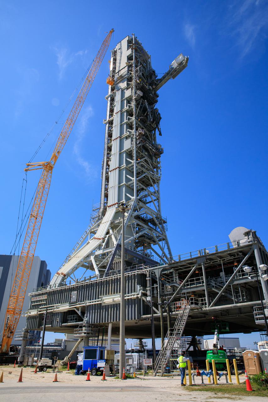
Teams with Exploration Ground Systems at NASA’s Kennedy Space Center in Florida continue to work the upgrades and repairs on mobile launcher 1 and Launch Pad 39B on June 13, 2023, ahead of the first critical ground testing for Artemis II. The crew access arm (CAA) has been extended in this view of the mobile launcher. The CAA is the entry and exit point astronauts will use for access to the Orion spacecraft. Tests will be conducted to ensure the arm and supporting mobile launcher systems are certified to support crewed missions. Artemis II will be the first Artemis mission flying crew aboard Orion.

NASA astronaut Jessica Watkins served as the Ground IV for the JETT 5 field test and was the sole point of communications to NASA astronauts Andre Douglas and Kate Rubins who performed simulated moonwalks in the Arizona desert. JETT 5 was a week-long field test in the lunar-like landscape of San Francisco Volcanic Field near Flagstaff, Arizona while a team of flight controllers and scientists at Johnson monitor and guide their activities. Credit: NASA/Robert Markowitz
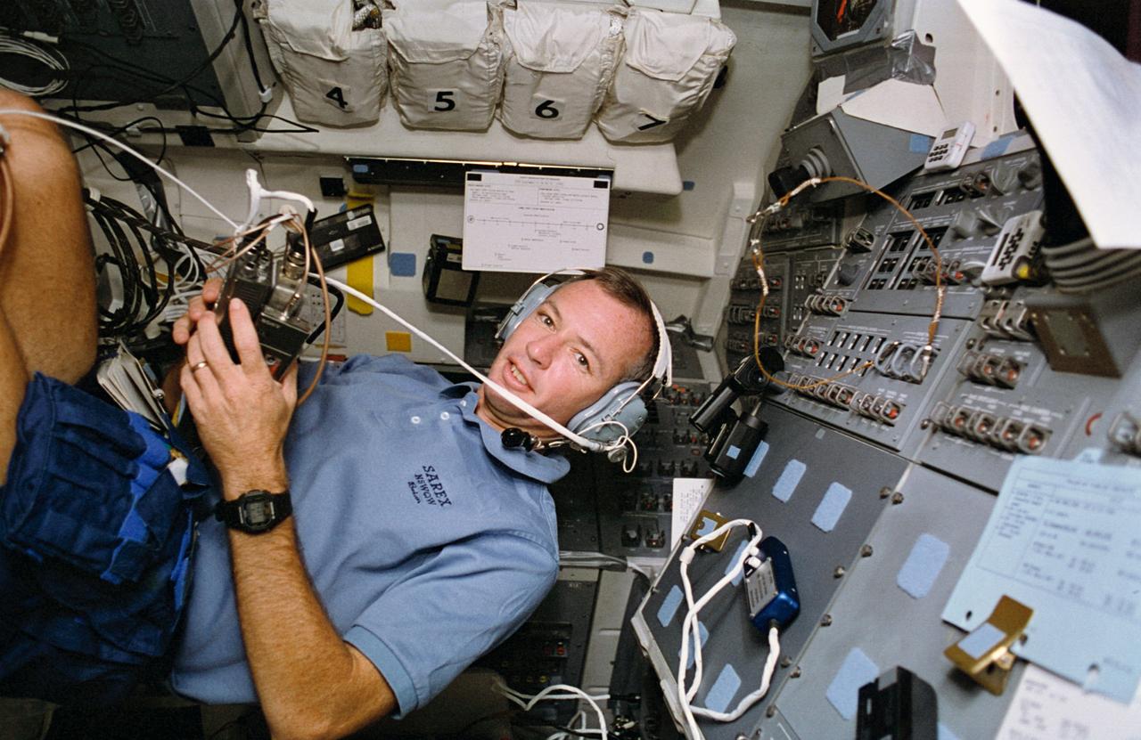
STS057-40-028 (21 June-1 July 1993) --- Astronaut Brian Duffy, pilot, talks to amateur radio operators on Earth from the flight deck of the Earth-orbiting Space Shuttle Endeavour. The space to Earth communications was part of the Shuttle amateur radio experiment (SAREX), which has been included on a number of Space Shuttle missions. Duffy, a licensed amateur radio operator using call letters N5WQW, was among crewmembers talking to students at various points on the ground.

iss071e046021 (April 27, 2024) -- Off the coast of Newfoundland, NASA astronaut Mike Barratt captured this image of sea ice as the International Space Station orbited 258 miles above the North Atlantic Ocean. The sea ice appears in swirls floating on the ocean's surface. From the orbiting laboratory's unique vantage point, astronauts can observe events on our home planet that are otherwise impossible to witness on the ground.
NASA astronaut Jessica Watkins served as the Ground IV for the JETT 5 field test and was the sole point of communications to NASA astronauts Andre Douglas and Kate Rubins who performed simulated moonwalks in the Arizona desert. JETT 5 was a week-long field test in the lunar-like landscape of San Francisco Volcanic Field near Flagstaff, Arizona while a team of flight controllers and scientists at Johnson monitor and guide their activities. Credit: NASA/Robert Markowitz

S81-39499 (13 Nov. 1981) --- President Ronald Reagan is briefed by JSC Director Christopher C. Kraft Jr., who points toward the orbiter spotter on the projection plotter in the front of the mission operations control room in the Johnson Space Center's Mission Control Center. This picture was taken just prior to a space-to-ground conversation between STS-2 crew members Joe H. Engle and Richard H. Truly, who were orbiting Earth in the space shuttle Columbia. Photo credit: NASA
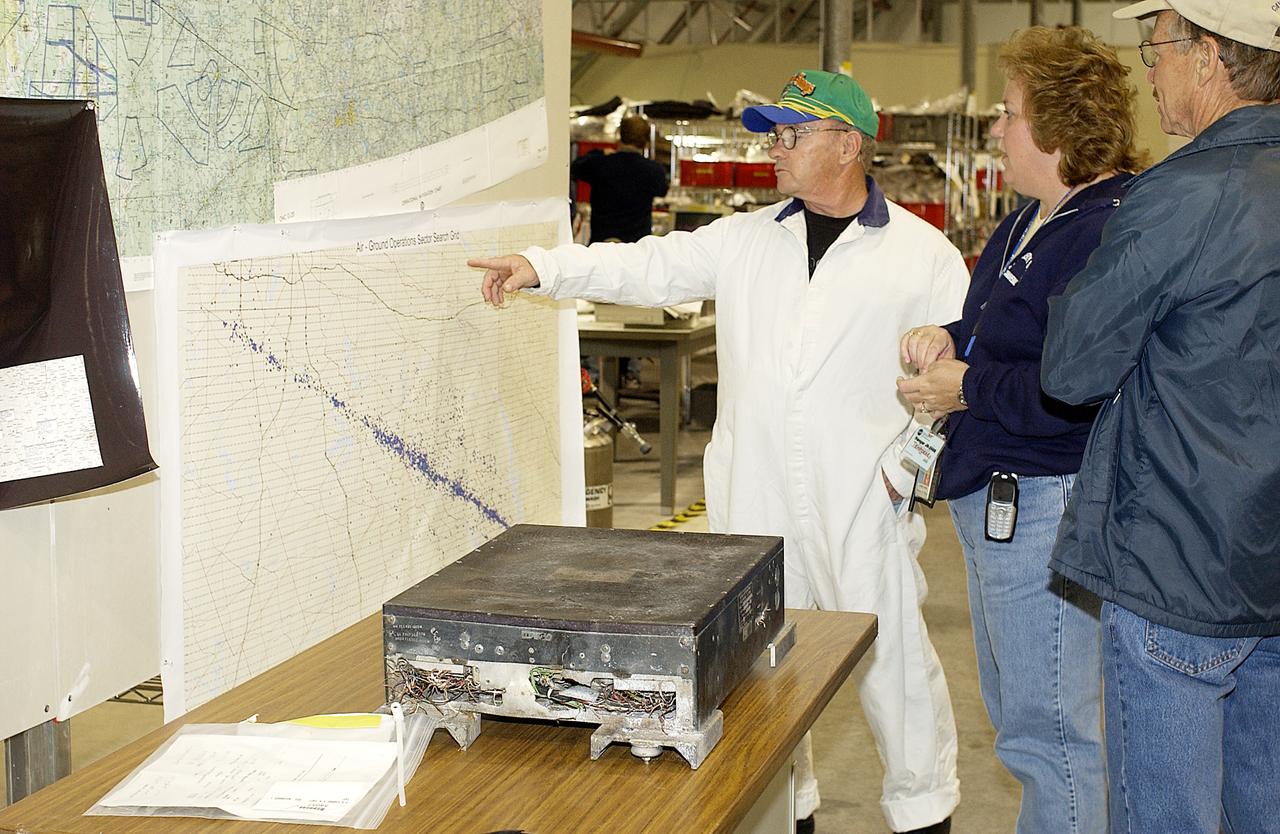
A member of the Columbia Reconstruction Project Team points to a search grid indicating locations where debris has been found. Approximately 4,500 ground searchers have covered approximately 56 percent of the planned 555,000-acre search area. About 28 percent of the Shuttle Columbia, by weight, has been delivered to the RLV Hangar to date.

ISS005-E-11203 (25 Aug. 2002) --- The Volga Delta, Russia is featured in this image photographed by an Expedition Five crewmember on the International Space Station. The Volga River drains much of western Russia's industrial region and travels southward to empty into the Caspian Sea. According to scientists, over thousands of years, the river has built out a tremendous delta that forms the northwestern shoreline of the Caspian Sea. The Volga Delta is many things: the delta channels provide transportation access between the heartland of Russia and the oil-rich Caspian Sea. The Volga's extensive distributaries harbor habitat and rich fishing grounds for Russia's famous beluga sturgeon -- better known as the source of beluga caviar. The delta's wetlands, parts of which are designated as the Astrakhanskiy Biosphere Reserve, are important stopping points and breeding grounds for migrating water birds.
TEMPUS, an electromagnetic levitation facility that allows containerless processing of metallic samples in microgravity, first flew on the IML-2 Spacelab mission. The principle of electromagnetic levitation is used commonly in ground-based experiments to melt and then cool metallic melts below their freezing points without solidification occurring. The TEMPUS operation is controlled by its own microprocessor system; although commands may be sent remotely from the ground and real time adjustments may be made by the crew. Two video cameras, a two-color pyrometer for measuring sample temperatures, and a fast infrared detector for monitoring solidification spikes, will be mounted to the process chamber to facilitate observation and analysis. In addition, a dedicated high-resolution video camera can be attached to the TEMPUS to measure the sample volume precisely.

For the first time, two space-based telescopes have teamed up with ground-based observatories to observe a microlensing event, a magnification of the light of a distant star due to the gravitational effects of an unseen object in the foreground. In this case, the cause of the microlensing event was a brown dwarf, dubbed OGLE-2015-BLG-1319, orbiting a star. In terms of mass, brown dwarfs fall somewhere between the size of the largest planets and the smallest stars. Curiously, scientists have found that, for stars roughly the mass of our sun, less than 1 percent have a brown dwarf orbiting within 3 AU (1 AU is the distance between Earth and the sun). This newly discovered brown dwarf may fall in that distance range. This microlensing event was observed by ground-based telescopes looking for these uncommon events, and subsequently seen by NASA's Spitzer and Swift space telescopes. As the diagram shows, Spitzer and Swift offer additional vantage points for viewing this chance alignment. While Swift orbits close to Earth, and saw (blue diamonds) essentially the same change in light that the ground-based telescopes measured (grey markers), Spitzer's location much farther away from Earth gave it a very different perspective on the event (red circles). In particular, Spitzer's vantage point resulted in a time lag in the microlensing event it observed, compared to what was seen by Swift and the ground-based telescope. This offset allowed astronomers to determine the distance to OGLE-2015-BLG-1319 as well as its mass: around 30-65 times that of Jupiter. http://photojournal.jpl.nasa.gov/catalog/PIA21077
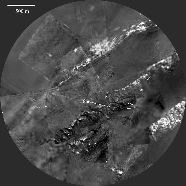
Images recorded by the European Space Agency's Huygens probe descent imager/spectral radiometer between 4 and 0.3 miles (7 and 0.5 kilometers) were assembled to produce this panoramic mosaic. The probe ground track is indicated as points in white. North is up. The ridge near the centre is cut by a dozen darker lanes or channels. The landing site is marked with an "X" near the continuation of one of the channels. The Huygens probe was delivered to Saturn's moon Titan by the Cassini spacecraft, which is managed by NASA's Jet Propulsion Laboratory, Pasadena, Calif. NASA supplied two instruments on the probe, the descent imager/spectral radiometer and the gas chromatograph mass spectrometer. http://photojournal.jpl.nasa.gov/catalog/PIA06439
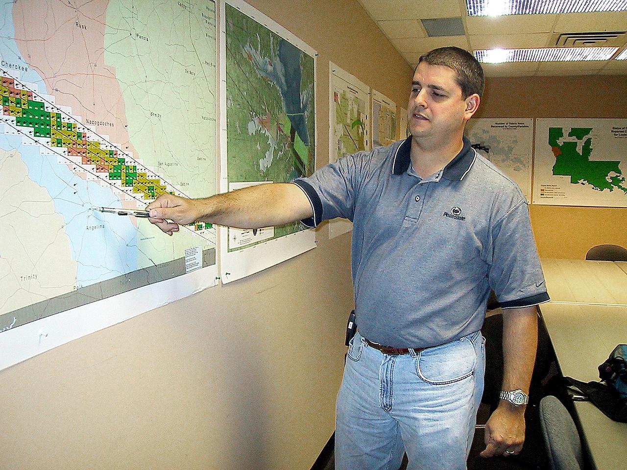
KENNEDY SPACE CENTER, FLA. -- Jeff Angermeier, assigned to lead the ground operations at the Lufkin Command Center, points out a town near the Columbia debris field. KSC workers are participating in the Columbia Recovery efforts at the Lufkin (Texas) Command Center, four field sites in East Texas, and the Barksdale, La., hangar site. KSC is working with representatives from other NASA Centers and with those from a number of federal, state and local agencies in the recovery effort. KSC provides vehicle technical expertise in the field to identify, collect and return Shuttle hardware to KSC.
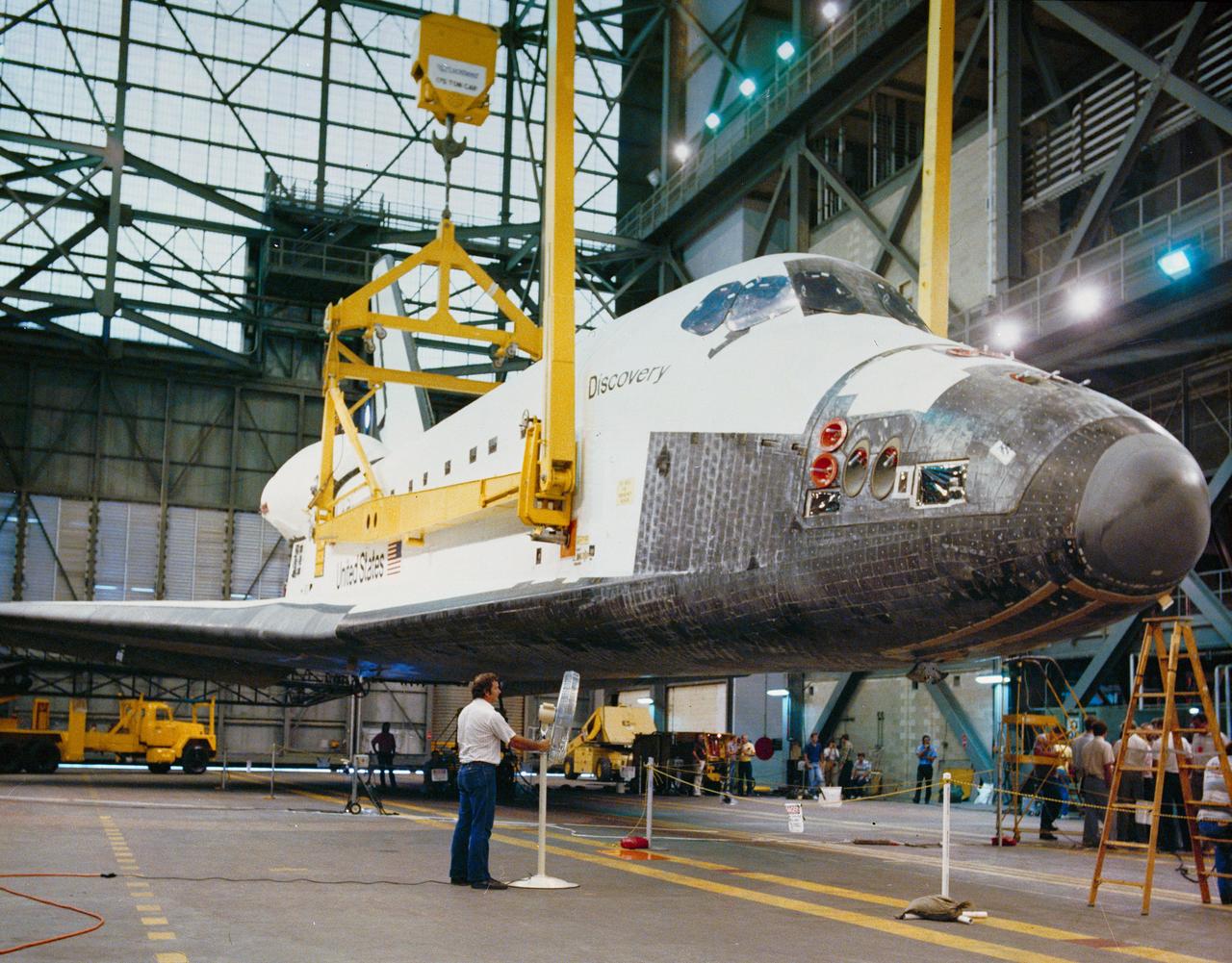
S88-41541 (7 July 1988) --- STS-26 Discovery, Orbiter Vehicle (OV) 103, is suspended by overhead crane and large frame attached to vehicle at four points. A ground-level view shows OV-103 during operations to accomplish its mating to two solid rocket boosters (SRBs) and an external fuel tank (ET) in the vehicle assembly building (VAB) at the Kennedy Space Center (KSC). From this step OV-103 will be lifted vertically and hoisted high inside the VAB for mating with the already connected ET and SRBs. In less than two weeks, the combined components will be rolled to Pad 39B atop a mobile launch platform.

STS040-614-066 (5-14 June 1991) --- St. Louis, Missouri-East St. Louis, Illinois and surrounding area were photographed by the STS 40 crewmembers aboard the Space Shuttle Columbia. The winding Mississippi River serves as a reference point for finding features of the area. Busch Stadium is clearly seen. NASA photo experts studying the STS 40 imagery claim photographs of this type aid in following demographic changes and in planning for development. The ground track of STS-40 and the existence of exceptionally clear skies during much of the nine-day flight permitted photographic acquisition of several cities not generally seen from the space flights flying at 28-degree inclinations to the Equator.

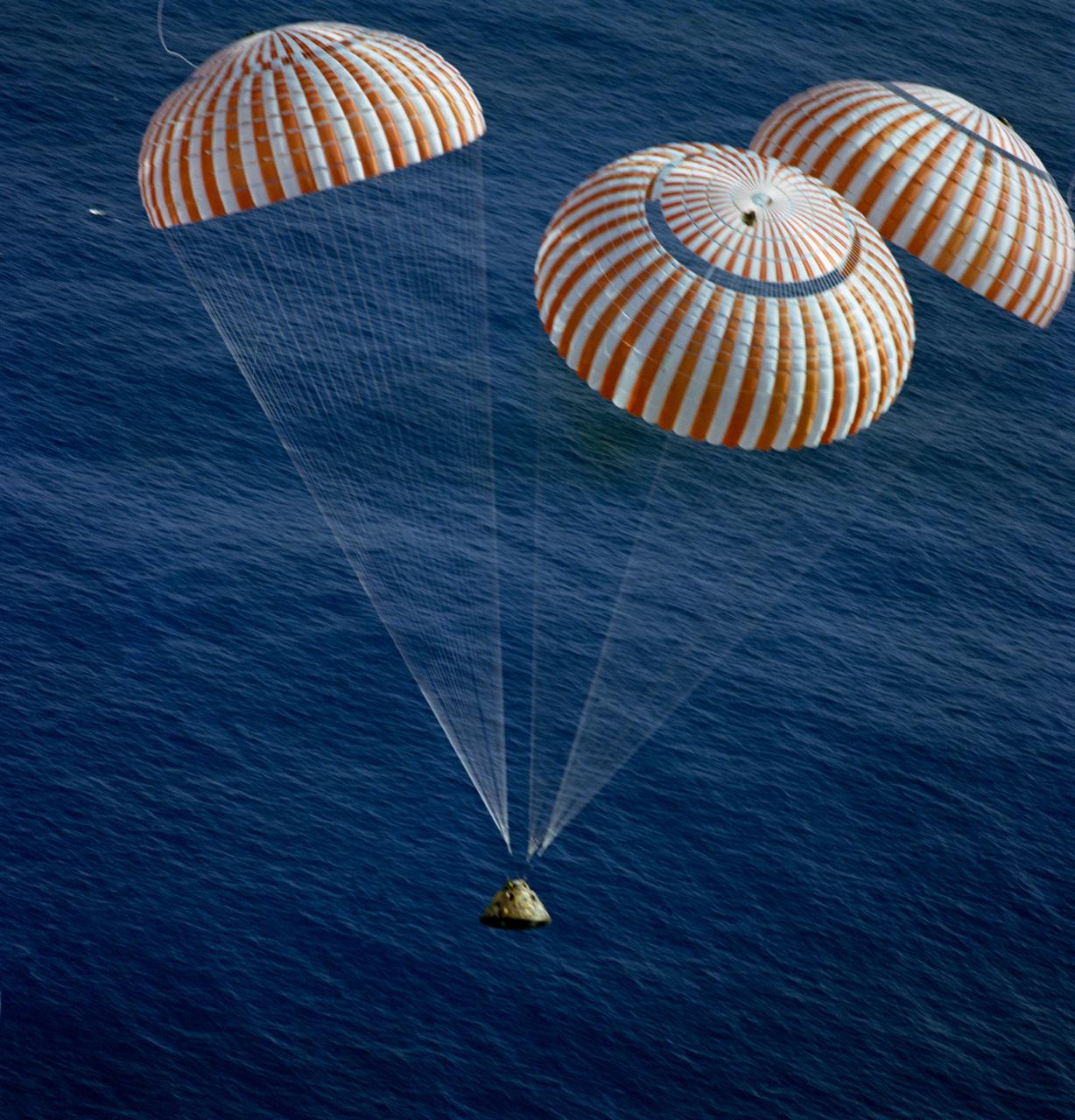
S72-36293 (27 April 1972) --- The Apollo 16 Command Module (CM), with astronauts John W. Young, Thomas K. Mattingly II, and Charles M. Duke Jr. aboard, splashed down in the central Pacific Ocean to successfully conclude their lunar landing mission. The splashdown occurred at 290:37:06 ground elapsed time, 1:45:06 p.m. (CST) Thursday, April 27, 1972, at coordinates of 00:43.2 degrees south latitude and 156:11.4 degrees west longitude. A point approximately 215 miles southeast of Christmas Island. Later the three crewmen were picked up by a helicopter from the prime recovery ship USS Ticonderoga.
CAPE CANAVERAL, Fla. – Seen in the photo is the Ground Umbilical Carrier Plate, or GUCP, on space shuttle Endeavour's external fuel tank. Workers have removed the 7-inch quick disconnect to change out seals in the internal connection points. A leak of hydrogen at the location during tanking June 12 for the STS-127 mission caused the mission to be scrubbed at 12:26 a.m. June 13. The GUCP is the overboard vent to the pad and the flare stack where the vented hydrogen is burned off. Endeavour is scheduled to launch on its STS-127 mission on June 17 at 5:40 a.m. EDT. Photo credit: NASA/Tim Jacobs

STS106-709-016 (19 September 2000) --- One of the STS-106 crew members on board the Space Shuttle Atlantis, 204 nautical miles above Earth, used a handheld 70mm camera to photograph this image of the shuttle's cargo bay, a broad band of clouds and a land scene featuring Lake Ontario. Center point coordinates of the ground area are 44 degrees north latitude and 77 degrees west longitude. The Spacehab module, which supports this mission to the International Space Station (ISS), can be seen at the back of the cargo bay. The Atlantis had earlier separated from the ISS after several days of being docked with the orbital outpost.
STS099-S-020 (10 February 2000) --- The Space Shuttle Endeavour awaits liftoff only hours away on Launch Pad 39A at the Kennedy Space Center (KSC). The point of view is from the Rotating Service Structure more than 225 feet above the ground. Abutting the side of Endeavour is the orbiter access arm with the environmental chamber known as the White Room at the end. The White Room provides access to the crew compartment. This flight represents the 97th in the Space Transportation System (STS) program and marks the 14th mission for the Space Shuttle Endeavour.
On May 3, 2018, a new eruption began at a fissure of the Kilauea volcano on the Island of Hawaii. Kilauea is the most active volcano in the world, having erupted almost continuously since 1983. Advancing lava and dangerous sulfur dioxide gas have forced thousands of residents in the neighborhood of Leilani Estates to evacuate. A number of homes have been destroyed, and no one can say how soon the eruption will abate and evacuees can return home. On May 6, 2018, at approximately 11 a.m. local time, the Multi-angle Imaging SpectroRadiometer (MISR) instrument on NASA's Terra satellite captured this view of the island as it passed overhead. Much of the island was shrouded by clouds, including the fissure on its eastern point. However, an eruption plume is visible streaming southwest over the ocean. The MISR instrument is unique in that it has nine cameras that view Earth at different angles: one pointing downward, four at various angles in the forward direction, and four in the backward direction. This image shows the view from one of MISR's forward-pointing cameras (60 degrees), which shows the plume more distinctly than the near-vertical views. The information from the images acquired at different view angles is used to calculate the height of the plume, results of which are superimposed on the right-hand image. The top of the plume near the fissure is at approximately 6,500 feet (2,000 meters) altitude, and the height of the plume decreases as it travels south and west. These relatively low altitudes mean that the ash and sulfur dioxide remained near the ground, which can cause health issues for people on the island downwind of the eruption. The "Ocean View" air quality monitor operated by the Clean Air Branch of the State of Hawaii Department of Health recorded a concentration of 18 μg/m3 of airborne particles less than 2.5 micrometers in diameter at 11 a.m. local time. This amount corresponds to an air quality rating of "moderate" and supports the MISR results indicating that ash was most likely present at ground level on this side of the island. These data were acquired during Terra orbit 97780. An annotated version is available at https://photojournal.jpl.nasa.gov/catalog/PIA22451
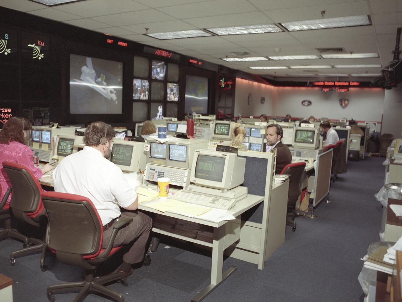
The primary objective of the STS-35 mission was round the clock observation of the celestial sphere in ultraviolet and X-Ray astronomy with the Astro-1 observatory which consisted of four telescopes: the Hopkins Ultraviolet Telescope (HUT); the Wisconsin Ultraviolet Photo-Polarimeter Experiment (WUPPE); the Ultraviolet Imaging Telescope (UIT); and the Broad Band X-Ray Telescope (BBXRT). The Huntsville Operations Support Center (HOSC) Spacelab Payload Operations Control Center (SL POCC) at the Marshall Space Flight Center (MSFC) was the air/ground communication channel used between the astronauts and ground control teams during the Spacelab missions. Teams of controllers and researchers directed on-orbit science operations, sent commands to the spacecraft, received data from experiments aboard the Space Shuttle, adjusted mission schedules to take advantage of unexpected science opportunities or unexpected results, and worked with crew members to resolve problems with their experiments. Due to loss of data used for pointing and operating the ultraviolet telescopes, MSFC ground teams were forced to aim the telescopes with fine tuning by the flight crew. This photo is an overview of the MSFC Payload Control Room (PCR).
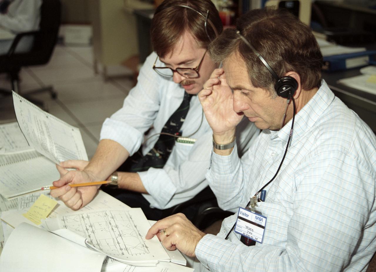
The primary objective of the STS-35 mission was round the clock observation of the celestial sphere in ultraviolet and X-Ray astronomy with the Astro-1 observatory which consisted of four telescopes: the Hopkins Ultraviolet Telescope (HUT); the Wisconsin Ultraviolet Photo-Polarimeter Experiment (WUPPE); the Ultraviolet Imaging Telescope (UIT); and the Broad Band X-Ray Telescope (BBXRT). The Huntsville Operations Support Center (HOSC) Spacelab Payload Operations Control Center (SL POCC) at the Marshall Space Flight Center (MSFC) was the air/ground communication channel used between the astronauts and ground control teams during the Spacelab missions. Teams of controllers and researchers directed on-orbit science operations, sent commands to the spacecraft, received data from experiments aboard the Space Shuttle, adjusted mission schedules to take advantage of unexpected science opportunities or unexpected results, and worked with crew members to resolve problems with their experiments. Due to loss of data used for pointing and operating the ultraviolet telescopes, MSFC ground teams were forced to aim the telescopes with fine tuning by the flight crew. This photo captures the activity of BBKRT data review in the Science Operations Area during the mission.

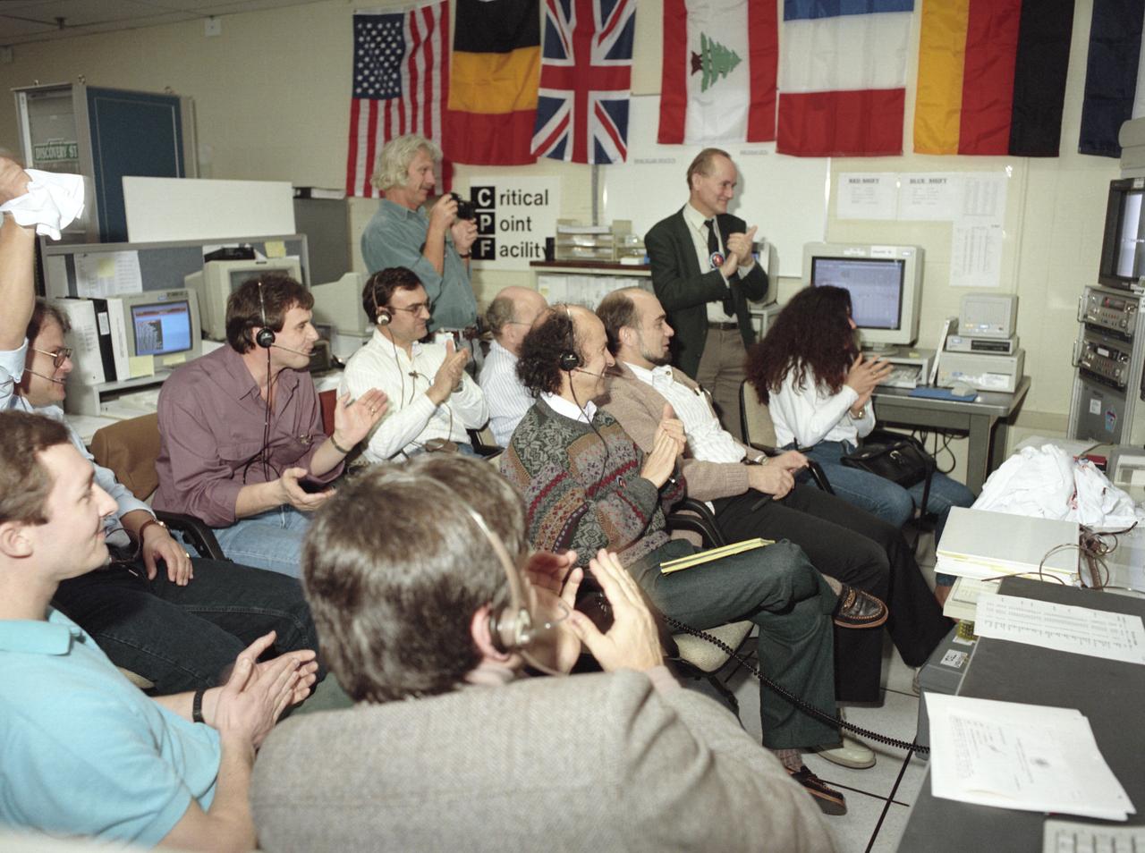
The primary objective of the STS-35 mission was round the clock observation of the celestial sphere in ultraviolet and X-Ray astronomy with the Astro-1 observatory which consisted of four telescopes: the Hopkins Ultraviolet Telescope (HUT); the Wisconsin Ultraviolet Photo-Polarimeter Experiment (WUPPE); the Ultraviolet Imaging Telescope (UIT); and the Broad Band X-Ray Telescope (BBXRT). The Huntsville Operations Support Center (HOSC) Spacelab Payload Operations Control Center (SL POCC) at the Marshall Space Flight Center (MSFC) was the air/ground communication channel used between the astronauts and ground control teams during the Spacelab missions. Teams of controllers and researchers directed on-orbit science operations, sent commands to the spacecraft, received data from experiments aboard the Space Shuttle, adjusted mission schedules to take advantage of unexpected science opportunities or unexpected results, and worked with crew members to resolve problems with their experiments. Due to loss of data used for pointing and operating the ultraviolet telescopes, MSFC ground teams were forced to aim the telescopes with fine tuning by the flight crew. This photo captures the activity at the Operations Control Facility during the mission as Dr. Urban and Paul Whitehouse give a “thumbs up”.
The primary objective of the STS-35 mission was round the clock observation of the celestial sphere in ultraviolet and X-Ray astronomy with the Astro-1 observatory which consisted of four telescopes: the Hopkins Ultraviolet Telescope (HUT); the Wisconsin Ultraviolet Photo-Polarimeter Experiment (WUPPE); the Ultraviolet Imaging Telescope (UIT); and the Broad Band X-Ray Telescope (BBXRT). The Huntsville Operations Support Center (HOSC) Spacelab Payload Operations Control Center (SL POCC) at the Marshall Space Flight Center (MSFC) was the air/ground communication channel used between the astronauts and ground control teams during the Spacelab missions. Teams of controllers and researchers directed on-orbit science operations, sent commands to the spacecraft, received data from experiments aboard the Space Shuttle, adjusted mission schedules to take advantage of unexpected science opportunities or unexpected results, and worked with crew members to resolve problems with their experiments. Due to loss of data used for pointing and operating the ultraviolet telescopes, MSFC ground teams were forced to aim the telescopes with fine tuning by the flight crew. This photo captures the activity of WUPPE data review at the Science Operations Area during the mission.
The primary objective of the STS-35 mission was round the clock observation of the celestial sphere in ultraviolet and X-Ray astronomy with the Astro-1 observatory which consisted of four telescopes: the Hopkins Ultraviolet Telescope (HUT); the Wisconsin Ultraviolet Photo-Polarimeter Experiment (WUPPE); the Ultraviolet Imaging Telescope (UIT); and the Broad Band X-Ray Telescope (BBXRT). The Huntsville Operations Support Center (HOSC) Spacelab Payload Operations Control Center (SL POCC) at the Marshall Space Flight Center (MSFC) was the air/ground communication channel used between the astronauts and ground control teams during the Spacelab missions. Teams of controllers and researchers directed on-orbit science operations, sent commands to the spacecraft, received data from experiments aboard the Space Shuttle, adjusted mission schedules to take advantage of unexpected science opportunities or unexpected results, and worked with crew members to resolve problems with their experiments. Due to loss of data used for pointing and operating the ultraviolet telescopes, MSFC ground teams were forced to aim the telescopes with fine tuning by the flight crew. This photo captures the activity of viewing HUT data in the Mission Manager Actions Room during the mission.
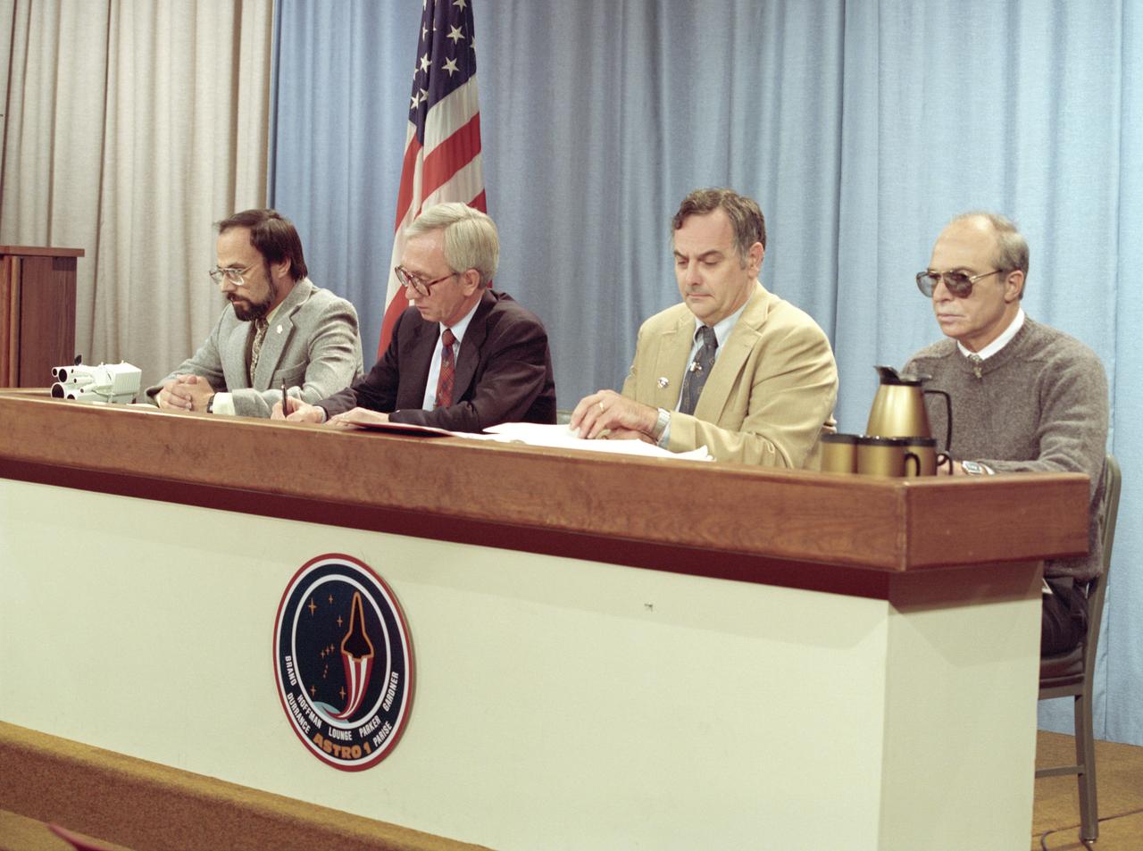
The primary objective of the STS-35 mission was round the clock observation of the celestial sphere in ultraviolet and X-Ray astronomy with the Astro-1 observatory which consisted of four telescopes: the Hopkins Ultraviolet Telescope (HUT); the Wisconsin Ultraviolet Photo-Polarimeter Experiment (WUPPE); the Ultraviolet Imaging Telescope (UIT); and the Broad Band X-Ray Telescope (BBXRT). The Huntsville Operations Support Center (HOSC) Spacelab Payload Operations Control Center (SL POCC) at the Marshall Space Flight Center (MSFC) was the air/ground communication channel used between the astronauts and ground control teams during the Spacelab missions. Teams of controllers and researchers directed on-orbit science operations, sent commands to the spacecraft, received data from experiments aboard the Space Shuttle, adjusted mission schedules to take advantage of unexpected science opportunities or unexpected results, and worked with crew members to resolve problems with their experiments. Due to loss of data used for pointing and operating the ultraviolet telescopes, MSFC ground teams were forced to aim the telescopes with fine tuning by the flight crew. This photo captures a press briefing at MSFC during STS-35, ASTRO-1 Mission.

The primary objective of the STS-35 mission was round the clock observation of the celestial sphere in ultraviolet and X-Ray astronomy with the Astro-1 observatory which consisted of four telescopes: the Hopkins Ultraviolet Telescope (HUT); the Wisconsin Ultraviolet Photo-Polarimeter Experiment (WUPPE); the Ultraviolet Imaging Telescope (UIT); and the Broad Band X-Ray Telescope (BBXRT). The Huntsville Operations Support Center (HOSC) Spacelab Payload Operations Control Center (SL POCC) at the Marshall Space Flight Center (MSFC) was the air/ground communication channel used between the astronauts and ground control teams during the Spacelab missions. Teams of controllers and researchers directed on-orbit science operations, sent commands to the spacecraft, received data from experiments aboard the Space Shuttle, adjusted mission schedules to take advantage of unexpected science opportunities or unexpected results, and worked with crew members to resolve problems with their experiments. Due to loss of data used for pointing and operating the ultraviolet telescopes, MSFC ground teams were forced to aim the telescopes with fine tuning by the flight crew. This photo captures the activities at the Mission Manager Actions Room during the mission.
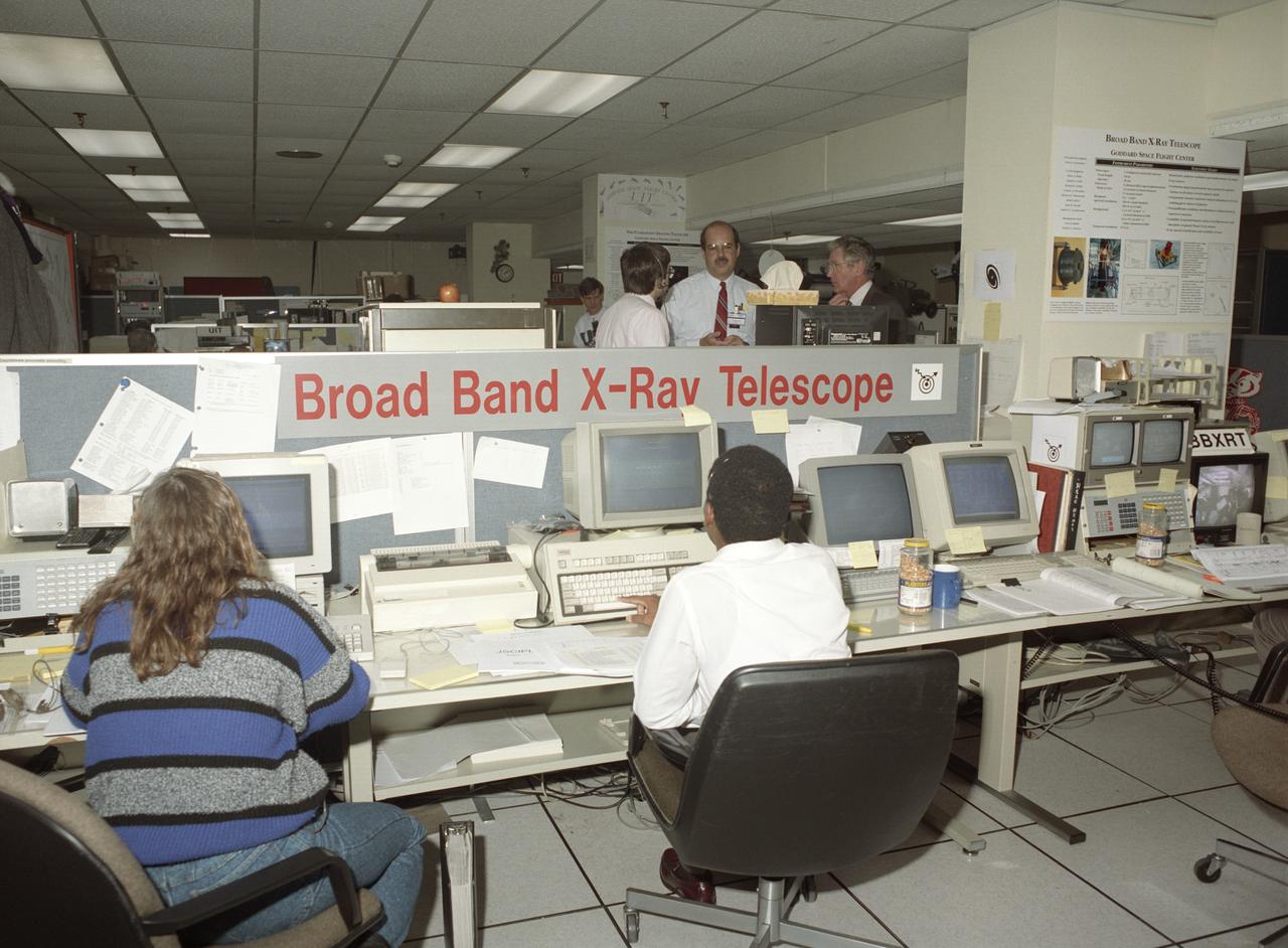
The primary objective of the STS-35 mission was round the clock observation of the celestial sphere in ultraviolet and X-Ray astronomy with the Astro-1 observatory which consisted of four telescopes: the Hopkins Ultraviolet Telescope (HUT); the Wisconsin Ultraviolet Photo-Polarimeter Experiment (WUPPE); the Ultraviolet Imaging Telescope (UIT); and the Broad Band X-Ray Telescope (BBXRT). The Huntsville Operations Support Center (HOSC) Spacelab Payload Operations Control Center (SL POCC) at the Marshall Space Flight Center (MSFC) was the air/ground communication channel used between the astronauts and ground control teams during the Spacelab missions. Teams of controllers and researchers directed on-orbit science operations, sent commands to the spacecraft, received data from experiments aboard the Space Shuttle, adjusted mission schedules to take advantage of unexpected science opportunities or unexpected results, and worked with crew members to resolve problems with their experiments. Due to loss of data used for pointing and operating the ultraviolet telescopes, MSFC ground teams were forced to aim the telescopes with fine tuning by the flight crew. This photo captures the activity of WUPPE (Wisconsin Ultraviolet Photo-Polarimeter Experiment) data review at the Science Operations Area during the mission. This image shows mission activities at the Broad Band X-Ray Telescope (BBXRT) Work Station in the Science Operations Area (SOA).
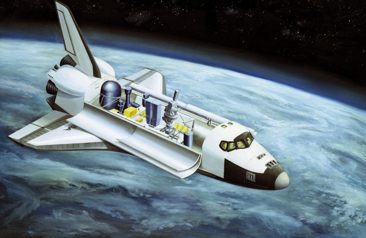
This illustration depicts the configuration of the Spacelab-2 in the cargo bay of the orbiter. Spacelab was a versatile laboratory carried in the Space Shuttle's cargo bay for scientific research flights. Each Spacelab mission had a unique design appropriate to the mission's goals. A number of Spacelab configurations could be assembled from pressurized habitation modules and exposed platforms called pallets. Spacelab-2 was the first pallet-only mission. One of the goals of the mission was to verify that the pallets' configuration was satisfactory for observations and research. Except for two biological experiments and an experiment that used ground-based instruments, the Spacelab-2 scientific instruments needed direct exposure to space. On the first pallet, three solar instruments and one atmospheric instrument were mounted on the Instrument Pointing System, which was being tested on its first flight. The second Spacelab pallet held a large double x-ray telescope and three plasma physics detectors. The last pallet supported an infrared telescope, a superfluid helium technology experiment, and a small plasma diagnostics satellite. The Spacelab-2 mission was designed to capitalize on the Shuttle-Spacelab capabilities, to launch and retrieve satellites, and to point several instruments independently with accuracy and stability. Spacelab-2 (STS-51F, 19th Shuttle mission) was launched aboard Space Shuttle Orbiter Challenger on July 29, 1985. The Marshall Space Flight Center had overall management responsibilities of the Spacelab missions.
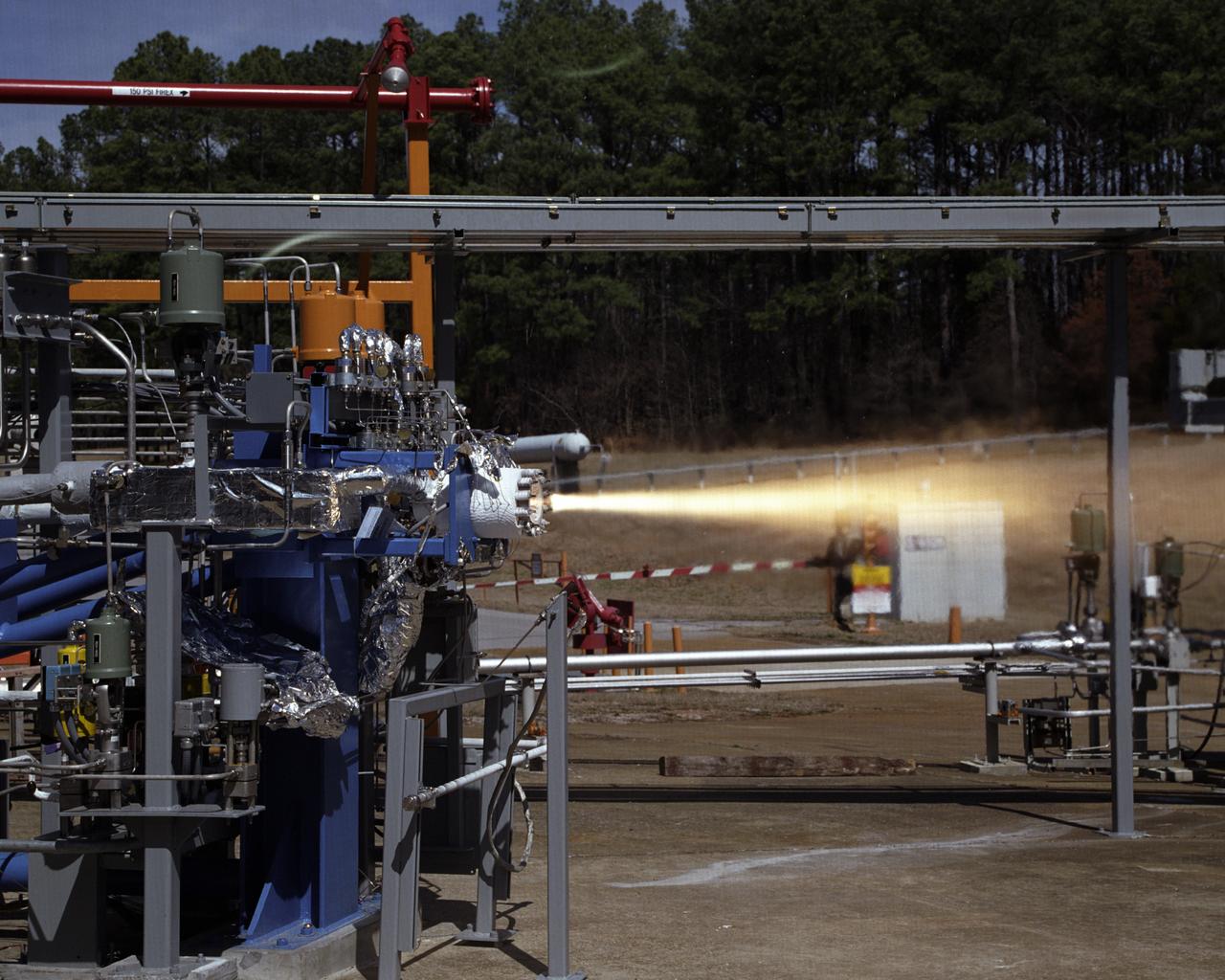
Engineers at the Marshall Space Flight Center (MSFC) have begun a series of engine tests on a new breed of space propulsion: a Reaction Control Engine developed for the Space Launch Initiative (SLI). The engine, developed by TRW Space and Electronics of Redondo Beach, California, is an auxiliary propulsion engine designed to maneuver vehicles in orbit. It is used for docking, reentry, attitude control, and fine-pointing while the vehicle is in orbit. The engine uses nontoxic chemicals as propellants, a feature that creates a safer environment for ground operators, lowers cost, and increases efficiency with less maintenance and quicker turnaround time between missions. Testing includes 30 hot-firings. This photograph shows the first engine test performed at MSFC that includes SLI technology. Another unique feature of the Reaction Control Engine is that it operates at dual thrust modes, combining two engine functions into one engine. The engine operates at both 25 and 1,000 pounds of force, reducing overall propulsion weight and allowing vehicles to easily maneuver in space. The low-level thrust of 25 pounds of force allows the vehicle to fine-point maneuver and dock while the high-level thrust of 1,000 pounds of force is used for reentry, orbit transfer, and coarse positioning. SLI is a NASA-wide research and development program, managed by the MSFC, designed to improve safety, reliability, and cost effectiveness of space travel for second generation reusable launch vehicles.
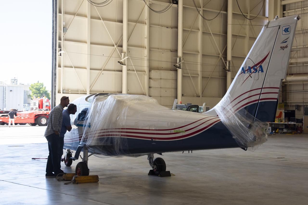
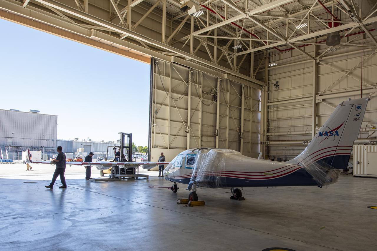
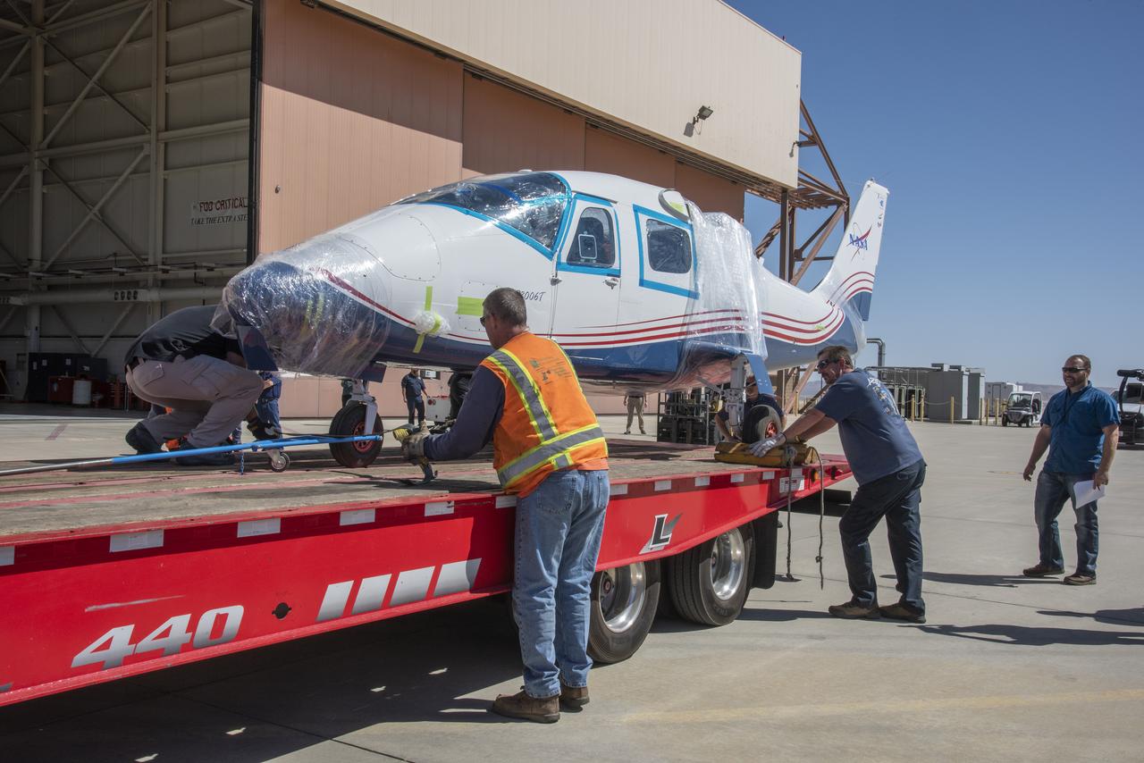
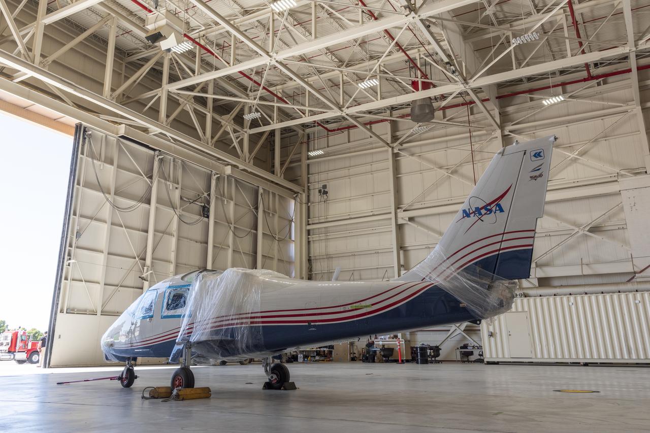
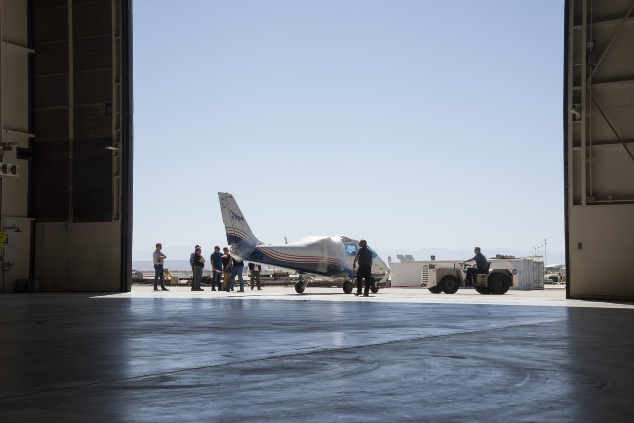
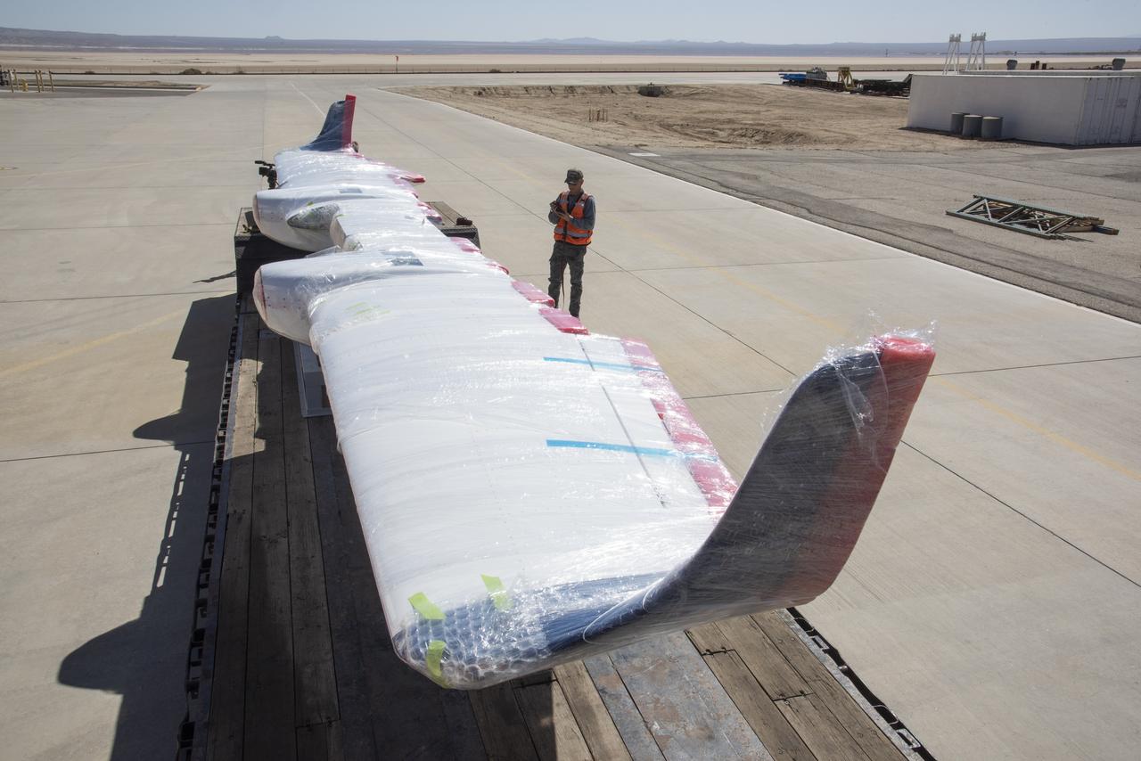
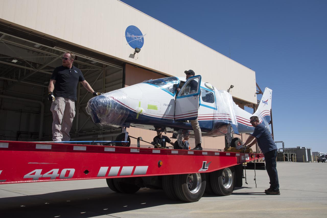
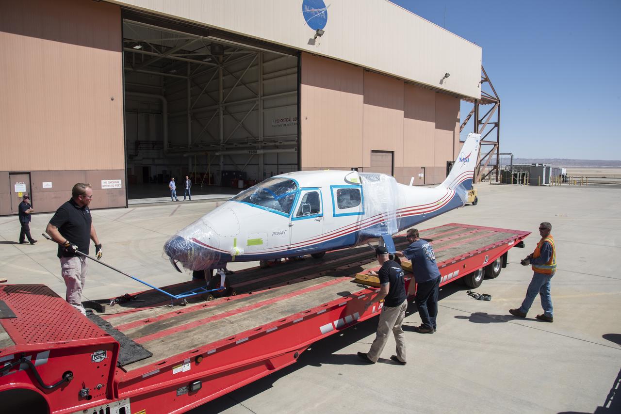
NASA’s X-57 Maxwell, the agency’s first all-electric X-plane and first crewed X-planed in two decades, is delivered to NASA’s Armstrong Flight Research Center in Edwards, California in its Mod II configuration. The first of three primary modifications for the project, Mod II involves testing of the aircraft’s cruise electric propulsion system. Delivery to NASA from prime contractor Empirical Systems Aerospace of San Luis Obispo, California, marks a major milestone for the project, at which point the vehicle is reintegrated for ground tests, to be followed by taxi tests, and eventually, flight tests. X-57’s goal is to further advance the design and airworthiness process for distributed electric propulsion technology for general aviation aircraft, which can provide multiple benefits to efficiency, emissions, and noise.
NASA's X-57 Maxwell, the agency's first all-electric X-plane and first crewed X-planed in two decades, is delivered to NASA's Armstrong Flight Research Center in Edwards, California in its Mod II configuration. The first of three primary modifications for the project, Mod II involves testing of the aircraft's cruise electric propulsion system. Delivery to NASA from prime contractor Empirical Systems Aerospace of San Luis Obispo, California, marks a major milestone for the project, at which point the vehicle is reintegrated for ground tests, to be followed by taxi tests, and eventually, flight tests. X-57's goal is to further advance the design and airworthiness process for distributed electric propulsion technology for general aviation aircraft, which can provide multiple benefits to efficiency, emissions, and noise.
NASA's X-57 Maxwell, the agency's first all-electric X-plane and first crewed X-planed in two decades, is delivered to NASA's Armstrong Flight Research Center in Edwards, California in its Mod II configuration. The first of three primary modifications for the project, Mod II involves testing of the aircraft's cruise electric propulsion system. Delivery to NASA from prime contractor Empirical Systems Aerospace of San Luis Obispo, California, marks a major milestone for the project, at which point the vehicle is reintegrated for ground tests, to be followed by taxi tests, and eventually, flight tests. X-57's goal is to further advance the design and airworthiness process for distributed electric propulsion technology for general aviation aircraft, which can provide multiple benefits to efficiency, emissions, and noise.
S72-55834 (19 Dec. 1972) --- The Apollo 17 Command Module (CM), with astronauts Eugene A. Cernan, Ronald E. Evans and Harrison H. Schmitt aboard, nears splashdown in the South Pacific Ocean to successfully concludes the final lunar landing mission in NASA's Apollo program. This overhead view was taken from a recovery aircraft seconds before the spacecraft hit the water. The splashdown occurred at 304:31:59 ground elapsed time, 1:24:59 p.m. (CST) Dec. 19, 1972, at coordinates of 166 degrees 8 minutes west longitude and 27 degrees 53 minutes south latitude, about 350 nautical miles southeast of the Samoan Islands. The splashdown was only .8 miles from the target point. Later, the three crewmen were picked up by a helicopter from the prime recovery ship, USS Ticonderoga.

NASA's X-57 Maxwell, the agency's first all-electric X-plane and first crewed X-planed in two decades, is delivered to NASA's Armstrong Flight Research Center in Edwards, California in its Mod II configuration. The first of three primary modifications for the project, Mod II involves testing of the aircraft's cruise electric propulsion system. Delivery to NASA from prime contractor Empirical Systems Aerospace of San Luis Obispo, California, marks a major milestone for the project, at which point the vehicle is reintegrated for ground tests, to be followed by taxi tests, and eventually, flight tests. X-57's goal is to further advance the design and airworthiness process for distributed electric propulsion technology for general aviation aircraft, which can provide multiple benefits to efficiency, emissions, and noise.
NASA's X-57 Maxwell, the agency's first all-electric X-plane and first crewed X-planed in two decades, is delivered to NASA's Armstrong Flight Research Center in Edwards, California in its Mod II configuration. The first of three primary modifications for the project, Mod II involves testing of the aircraft's cruise electric propulsion system. Delivery to NASA from prime contractor Empirical Systems Aerospace of San Luis Obispo, California, marks a major milestone for the project, at which point the vehicle is reintegrated for ground tests, to be followed by taxi tests, and eventually, flight tests. X-57's goal is to further advance the design and airworthiness process for distributed electric propulsion technology for general aviation aircraft, which can provide multiple benefits to efficiency, emissions, and noise.
NASA’s X-57 Maxwell, the agency’s first all-electric X-plane and first crewed X-planed in two decades, is delivered to NASA’s Armstrong Flight Research Center in Edwards, California in its Mod II configuration. The first of three primary modifications for the project, Mod II involves testing of the aircraft’s cruise electric propulsion system. Delivery to NASA from prime contractor Empirical Systems Aerospace of San Luis Obispo, California, marks a major milestone for the project, at which point the vehicle is reintegrated for ground tests, to be followed by taxi tests, and eventually, flight tests. X-57’s goal is to further advance the design and airworthiness process for distributed electric propulsion technology for general aviation aircraft, which can provide multiple benefits to efficiency, emissions, and noise.
CAPE CANAVERAL, Fla. – Seen in the photo is the 7-inch quick disconnect that will be repaired on the hydrogen vent line to the Ground Umbilical Carrier Plate on space shuttle Endeavour's external fuel tank on Launch Pad 39A at NASA's Kennedy Space Center in Florida. Teams are removing the hardware to change out seals in the internal connection points. A leak of hydrogen at the location during tanking June 12 for the STS-127 mission caused the mission to be scrubbed at 12:26 a.m. June 13. The GUCP is the overboard vent to the pad and the flare stack where the vented hydrogen is burned off. Endeavour is scheduled to launch on its STS-127 mission on June 17 at 5:40 a.m. EDT. Photo credit: NASA/Tim Jacobs
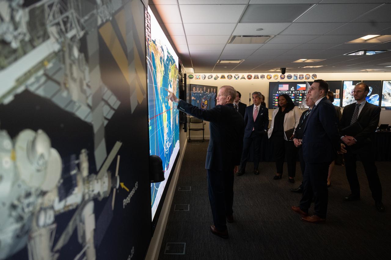
NASA Administrator Bill Nelson, left, points to a ground track map for the International Space Station in the Space Operations Center during a tour with Miloslav Stašek, Ambassador of the Czech Republic to the United States, Foreign Affairs Minister for the Czech Republic, Jan Lipavský, and Acting Assistant Secretary of State for Oceans and International Environmental and Scientific Affairs Jennifer R. Littlejohn, following the signing of the Artemis Accords, Wednesday, May 3, 2023, at The Mary W. Jackson NASA Headquarters building in Washington DC. The Czech Republic is the twenty fourth country to sign the Artemis Accords, which establish a practical set of principles to guide space exploration cooperation among nations participating in NASA’s Artemis program. Photo Credit: (NASA/Joel Kowsky)
KENNEDY SPACE CENTER, Fla. -- On Launch Pad 39A, Space Shuttle Endeavour is viewed late at night from a point on the Rotating Service Structure more than 225 feet from the ground. Abutting the side of Endeavour is the orbiter access arm with the environmental chamber known as the White Room at the end. The White Room provides access to the crew compartment. Endeavour waits for mission STS-99, known as the Shuttle Radar Topography Mission (SRTM), which will chart a new course to produce unrivaled 3-D images of the Earth's surface. The result of the SRTM could be close to 1 trillion measurements of the Earth's topography. The mission is expected to last 11days, with Endeavour landing at KSC Tuesday, Feb. 22, at 4:36 p.m. EST. This is the 97th Shuttle flight and 14th for Shuttle Endeavour
CAPE CANAVERAL, Fla. – On Launch Pad 39A at NASA's Kennedy Space Center in Florida, workers prepare to remove the 7-inch quick disconnect and flight seal from the Ground Umbilical Carrier Plate, or GUCP, on space shuttle Endeavour's external fuel tank. Teams are removing the hardware to change out seals in the internal connection points. A leak of hydrogen at the location during tanking June 12 for the STS-127 mission caused the mission to be scrubbed at 12:26 a.m. June 13. The GUCP is the overboard vent to the pad and the flare stack where the vented hydrogen is burned off. Endeavour is scheduled to launch on its STS-127 mission on June 17 at 5:40 a.m. EDT. Photo credit: NASA/Tim Jacobs
NASA's X-57 Maxwell, the agency's first all-electric X-plane and first crewed X-planed in two decades, is delivered to NASA's Armstrong Flight Research Center in Edwards, California in its Mod II configuration. The first of three primary modifications for the project, Mod II involves testing of the aircraft's cruise electric propulsion system. Delivery to NASA from prime contractor Empirical Systems Aerospace of San Luis Obispo, California, marks a major milestone for the project, at which point the vehicle is reintegrated for ground tests, to be followed by taxi tests, and eventually, flight tests. X-57's goal is to further advance the design and airworthiness process for distributed electric propulsion technology for general aviation aircraft, which can provide multiple benefits to efficiency, emissions, and noise.
KENNEDY SPACE CENTER, FLA. -- In space shuttle Discovery's payload bay, STS-120 crew members get a close look at the equipment and payloads. Seen here is Mission Specialist Paolo Nespoli, who represents the European Space Agency, pointing to the Italian-built U.S. Node 2, named Harmony. The TCDT provides astronauts and ground crews an opportunity to participate in various simulated countdown activities, including equipment familiarization and emergency training. The STS-120 mission will deliver the U.S. Node 2 module, named Harmony, aboard space shuttle Discovery to the International Space Station. Launch of Discovery on mission STS-120 is targeted for Oct. 23 at 11:38 a.m. EDT on a 14-day mission. Photo credit: NASA/Kim Shiflett
NASA's X-57 Maxwell, the agency's first all-electric X-plane and first crewed X-planed in two decades, is delivered to NASA's Armstrong Flight Research Center in Edwards, California in its Mod II configuration. The first of three primary modifications for the project, Mod II involves testing of the aircraft's cruise electric propulsion system. Delivery to NASA from prime contractor Empirical Systems Aerospace of San Luis Obispo, California, marks a major milestone for the project, at which point the vehicle is reintegrated for ground tests, to be followed by taxi tests, and eventually, flight tests. X-57's goal is to further advance the design and airworthiness process for distributed electric propulsion technology for general aviation aircraft, which can provide multiple benefits to efficiency, emissions, and noise.
NASA's X-57 Maxwell, the agency's first all-electric X-plane and first crewed X-planed in two decades, is delivered to NASA's Armstrong Flight Research Center in Edwards, California in its Mod II configuration. The first of three primary modifications for the project, Mod II involves testing of the aircraft's cruise electric propulsion system. Delivery to NASA from prime contractor Empirical Systems Aerospace of San Luis Obispo, California, marks a major milestone for the project, at which point the vehicle is reintegrated for ground tests, to be followed by taxi tests, and eventually, flight tests. X-57's goal is to further advance the design and airworthiness process for distributed electric propulsion technology for general aviation aircraft, which can provide multiple benefits to efficiency, emissions, and noise.
CAPE CANAVERAL, Fla. – Modifications continue on the Multi-Payload Processing Facility, or MPPF, at NASA's Kennedy Space Center in Florida. Inside the high bay, Skip Williams, Ground Systems Development and Operations, or GSDO, deputy project manager for the spacecraft offline element integration team, points out artist illustrations of how the MPPF's interior and exterior will look after modifications and upgrades have been completed. Kennedy's Center Operations Directorate is overseeing upgrades to the MPPF for GSDO Program. The extensive upgrades and modernizations will support processing of Orion spacecraft for NASA's exploration missions. The 19,647-square-foot building, originally constructed in 1995, primarily will be used for Orion hypergolic fueling, ammonia servicing and high-pressure gas servicing and checkout before being transported to the Vehicle Assembly Building for integration with the Space Launch System. Photo credit: NASA/Daniel Casper
CAPE CANAVERAL, Fla. – On Launch Pad 39A at NASA's Kennedy Space Center in Florida, a worker prepares to remove the 7-inch quick disconnect and flight seal from the Ground Umbilical Carrier Plate, or GUCP, on space shuttle Endeavour's external fuel tank. Teams are removing the hardware to change out seals in the internal connection points. A leak of hydrogen at the location during tanking June 12 for the STS-127 mission caused the mission to be scrubbed at 12:26 a.m. June 13. The GUCP is the overboard vent to the pad and the flare stack where the vented hydrogen is burned off. Endeavour is scheduled to launch on its STS-127 mission on June 17 at 5:40 a.m. EDT. Photo credit: NASA/Tim Jacobs
NASA's X-57 Maxwell, the agency's first all-electric X-plane and first crewed X-planed in two decades, is delivered to NASA's Armstrong Flight Research Center in Edwards, California in its Mod II configuration. The first of three primary modifications for the project, Mod II involves testing of the aircraft's cruise electric propulsion system. Delivery to NASA from prime contractor Empirical Systems Aerospace of San Luis Obispo, California, marks a major milestone for the project, at which point the vehicle is reintegrated for ground tests, to be followed by taxi tests, and eventually, flight tests. X-57's goal is to further advance the design and airworthiness process for distributed electric propulsion technology for general aviation aircraft, which can provide multiple benefits to efficiency, emissions, and noise.
NASA's X-57 Maxwell, the agency's first all-electric X-plane and first crewed X-planed in two decades, is delivered to NASA's Armstrong Flight Research Center in Edwards, California in its Mod II configuration. The first of three primary modifications for the project, Mod II involves testing of the aircraft's cruise electric propulsion system. Delivery to NASA from prime contractor Empirical Systems Aerospace of San Luis Obispo, California, marks a major milestone for the project, at which point the vehicle is reintegrated for ground tests, to be followed by taxi tests, and eventually, flight tests. X-57's goal is to further advance the design and airworthiness process for distributed electric propulsion technology for general aviation aircraft, which can provide multiple benefits to efficiency, emissions, and noise.
NASA's X-57 Maxwell, the agency's first all-electric X-plane and first crewed X-planed in two decades, is delivered to NASA's Armstrong Flight Research Center in Edwards, California in its Mod II configuration. The first of three primary modifications for the project, Mod II involves testing of the aircraft's cruise electric propulsion system. Delivery to NASA from prime contractor Empirical Systems Aerospace of San Luis Obispo, California, marks a major milestone for the project, at which point the vehicle is reintegrated for ground tests, to be followed by taxi tests, and eventually, flight tests. X-57's goal is to further advance the design and airworthiness process for distributed electric propulsion technology for general aviation aircraft, which can provide multiple benefits to efficiency, emissions, and noise.

ISS040-E-089959 (8 Aug. 2014) --- King Sound on the northwest coast of Australia is featured in this image photographed by an Expedition 40 crew member on the International Space Station. The Fitzroy River, one of Australia's largest, empties into the Sound, a large gulf in Western Australia (approximately 120 kilometers long). King Sound has the highest tides in Australia, in the range of 11-12 meters, the second highest in the world after the Bay of Fundy on the east coast of North America. The strong brown smudge at the head of the Sound contrasts with the clearer blue water along the rest of the coast. This is mud stirred up by the tides and also supplied by the Fitzroy River. The bright reflection point of the sun obscures the blue water of the Indian Ocean (top left). Just to the west of the Sound, thick plumes of wildfire smoke, driven by northeast winds, obscure the coastline. A wide field of “popcorn cumulus” clouds (right) is a common effect of daily heating of the ground surface.
NASA's X-57 Maxwell, the agency's first all-electric X-plane and first crewed X-planed in two decades, is delivered to NASA's Armstrong Flight Research Center in Edwards, California in its Mod II configuration. The first of three primary modifications for the project, Mod II involves testing of the aircraft's cruise electric propulsion system. Delivery to NASA from prime contractor Empirical Systems Aerospace of San Luis Obispo, California, marks a major milestone for the project, at which point the vehicle is reintegrated for ground tests, to be followed by taxi tests, and eventually, flight tests. X-57's goal is to further advance the design and airworthiness process for distributed electric propulsion technology for general aviation aircraft, which can provide multiple benefits to efficiency, emissions, and noise.
NASA’s X-57 Maxwell, the agency’s first all-electric X-plane and first crewed X-planed in two decades, is delivered to NASA’s Armstrong Flight Research Center in Edwards, California in its Mod II configuration. The first of three primary modifications for the project, Mod II involves testing of the aircraft’s cruise electric propulsion system. Delivery to NASA from prime contractor Empirical Systems Aerospace of San Luis Obispo, California, marks a major milestone for the project, at which point the vehicle is reintegrated for ground tests, to be followed by taxi tests, and eventually, flight tests. X-57’s goal is to further advance the design and airworthiness process for distributed electric propulsion technology for general aviation aircraft, which can provide multiple benefits to efficiency, emissions, and noise.
Robotics Software Engineer II Chris Rampolla (right) and Software Engineering intern Ashten Akemoto issue commands to Astrobotic’s CubeRover using the company’s ground software during mobility testing at NASA’s Kennedy Space Center in Florida on June 30, 2022. Astrobotic – a Pittsburgh-based space robotics company – is using the spaceport’s Swamp Works facility and the Granular Mechanics and Regolith Operations Laboratory to conduct mobility testing of their rover. The laboratory’s regolith bin, which holds approximately 120 tons of lunar regolith simulant, will help depict how the company’s CubeRover would perform on the Moon. NASA’s Small Business Innovation Research program provided the funding for initial development, and a $2 million Tipping Point award has provided additional funding for continued development into a more mature rover.
CAPE CANAVERAL, Fla. – On Launch Pad 39A at NASA's Kennedy Space Center in Florida, a worker has removed the 7-inch quick disconnect from the Ground Umbilical Carrier Plate, or GUCP, on space shuttle Endeavour's external fuel tank. Teams are removing the hardware to change out seals in the internal connection points. A leak of hydrogen at the location during tanking June 12 for the STS-127 mission caused the mission to be scrubbed at 12:26 a.m. June 13. The GUCP is the overboard vent to the pad and the flare stack where the vented hydrogen is burned off. Endeavour is scheduled to launch on its STS-127 mission on June 17 at 5:40 a.m. EDT. Photo credit: NASA/Tim Jacobs
NASA's X-57 Maxwell, the agency's first all-electric X-plane and first crewed X-planed in two decades, is delivered to NASA's Armstrong Flight Research Center in Edwards, California in its Mod II configuration. The first of three primary modifications for the project, Mod II involves testing of the aircraft's cruise electric propulsion system. Delivery to NASA from prime contractor Empirical Systems Aerospace of San Luis Obispo, California, marks a major milestone for the project, at which point the vehicle is reintegrated for ground tests, to be followed by taxi tests, and eventually, flight tests. X-57's goal is to further advance the design and airworthiness process for distributed electric propulsion technology for general aviation aircraft, which can provide multiple benefits to efficiency, emissions, and noise.
NASA's X-57 Maxwell, the agency's first all-electric X-plane and first crewed X-planed in two decades, is delivered to NASA's Armstrong Flight Research Center in Edwards, California in its Mod II configuration. The first of three primary modifications for the project, Mod II involves testing of the aircraft's cruise electric propulsion system. Delivery to NASA from prime contractor Empirical Systems Aerospace of San Luis Obispo, California, marks a major milestone for the project, at which point the vehicle is reintegrated for ground tests, to be followed by taxi tests, and eventually, flight tests. X-57's goal is to further advance the design and airworthiness process for distributed electric propulsion technology for general aviation aircraft, which can provide multiple benefits to efficiency, emissions, and noise.
NASA’s X-57 Maxwell, the agency’s first all-electric X-plane and first crewed X-planed in two decades, is delivered to NASA’s Armstrong Flight Research Center in Edwards, California in its Mod II configuration. The first of three primary modifications for the project, Mod II involves testing of the aircraft’s cruise electric propulsion system. Delivery to NASA from prime contractor Empirical Systems Aerospace of San Luis Obispo, California, marks a major milestone for the project, at which point the vehicle is reintegrated for ground tests, to be followed by taxi tests, and eventually, flight tests. X-57’s goal is to further advance the design and airworthiness process for distributed electric propulsion technology for general aviation aircraft, which can provide multiple benefits to efficiency, emissions, and noise.
NASA’s X-57 Maxwell, the agency’s first all-electric X-plane and first crewed X-planed in two decades, is delivered to NASA’s Armstrong Flight Research Center in Edwards, California in its Mod II configuration. The first of three primary modifications for the project, Mod II involves testing of the aircraft’s cruise electric propulsion system. Delivery to NASA from prime contractor Empirical Systems Aerospace of San Luis Obispo, California, marks a major milestone for the project, at which point the vehicle is reintegrated for ground tests, to be followed by taxi tests, and eventually, flight tests. X-57’s goal is to further advance the design and airworthiness process for distributed electric propulsion technology for general aviation aircraft, which can provide multiple benefits to efficiency, emissions, and noise.
NASA's X-57 Maxwell, the agency's first all-electric X-plane and first crewed X-planed in two decades, is delivered to NASA's Armstrong Flight Research Center in Edwards, California in its Mod II configuration. The first of three primary modifications for the project, Mod II involves testing of the aircraft's cruise electric propulsion system. Delivery to NASA from prime contractor Empirical Systems Aerospace of San Luis Obispo, California, marks a major milestone for the project, at which point the vehicle is reintegrated for ground tests, to be followed by taxi tests, and eventually, flight tests. X-57's goal is to further advance the design and airworthiness process for distributed electric propulsion technology for general aviation aircraft, which can provide multiple benefits to efficiency, emissions, and noise.
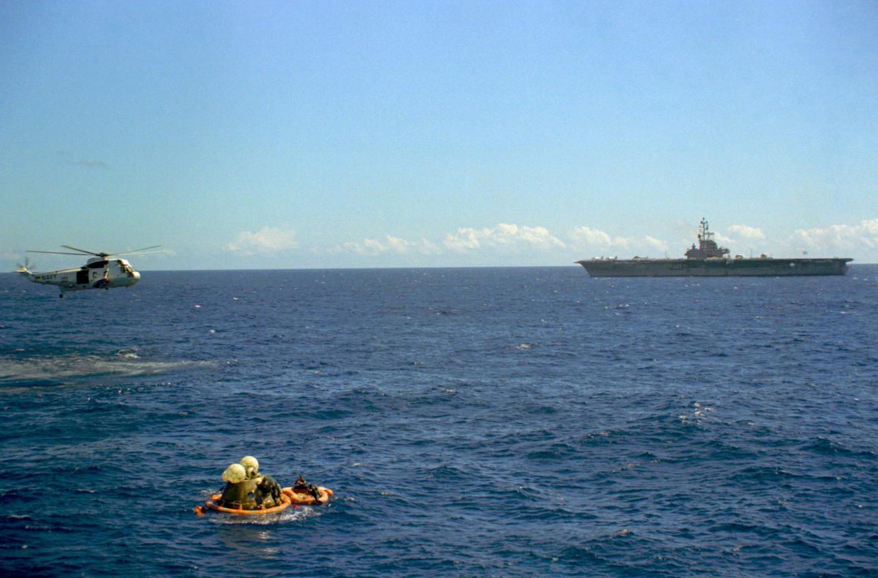
S72-36602 (27 April 1972) --- The Apollo 16 Command Module bobbles photographed in the waters of the central Pacific Ocean during recovery operations. The prime recovery ship, USS Ticonderoga, is in the background. A recovery helicopter hovers overhead. The Apollo 16 crew, astronauts John W. Young, Thomas K. Mattingly II, and Charles M. Duke Jr., were picked up by helicopter and flown to the deck of the ship. The splashdown occurred at 290:37:06 ground elapsed time, 1:45:06 p.m. (CST), Thursday, April 27, 1972, at coordinates of 00:45.2 degrees south latitude and 156:11.4 degrees west longitude, a point approximately 215 miles southeast of Christmas Island. A team of Earth Landing System swimmers assisted with the recovery operations.
Senior Software Engineer Taylor Whitaker (right) and Software Engineering intern Ashten Akemoto create a mobility routine for Astrobotic’s CubeRover – a lightweight, modular planetary rover – using the company’s ground software at NASA’s Kennedy Space Center in Florida on June 30, 2022. Astrobotic – a Pittsburgh-based space robotics company – is using the spaceport’s Swamp Works facility and the Granular Mechanics and Regolith Operations Laboratory to conduct mobility testing of their rover. The laboratory’s regolith bin, which holds approximately 120 tons of lunar regolith simulant, will help depict how the company’s CubeRover would perform on the Moon. NASA’s Small Business Innovation Research program provided the funding for initial development, and a $2 million Tipping Point award from the agency has provided additional funding for continued development into a more mature rover.

KENNEDY SPACE CENTER, Fla. -- On Launch Pad 39A, Space Shuttle Endeavour is viewed late at night from a point on the Rotating Service Structure more than 225 feet from the ground. Abutting the side of Endeavour is the orbiter access arm with the environmental chamber known as the White Room at the end. The White Room provides access to the crew compartment. Endeavour waits for mission STS-99, known as the Shuttle Radar Topography Mission (SRTM), which will chart a new course to produce unrivaled 3-D images of the Earth's surface. The result of the SRTM could be close to 1 trillion measurements of the Earth's topography. The mission is expected to last 11days, with Endeavour landing at KSC Tuesday, Feb. 22, at 4:36 p.m. EST. This is the 97th Shuttle flight and 14th for Shuttle Endeavour
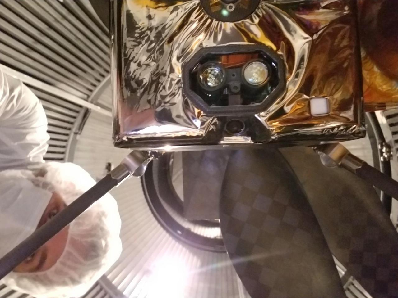
An Ingenuity team member inspects NASA's Ingenuity Mars Helicopter in one of the space simulation chambers at the agency's Jet Propulsion Laboratory in Southern California. The helicopter's two cameras are visible in this view of the underside of Ingenuity: one looking straight down and the other at an oblique angle. In the octagonal black frame, the black-and-white navigation camera is the thick circle appearing between and just below the two larger lenses (parts of the laser altimeter that measures the helicopter's height above the ground). The color camera is the circle that is inset from the edge of the fuselage, appearing below the octagonal frame. (An annotated version of the image points out the cameras.) To protect against dust, a clear borosilicate window covers the altimeter and navigation camera, and a clear sapphire window covers the color camera. Ingenuity will attempt the first powered, controlled flight at Mars. https://photojournal.jpl.nasa.gov/catalog/PIA23969
NASA’s X-57 Maxwell, the agency’s first all-electric X-plane and first crewed X-planed in two decades, is delivered to NASA’s Armstrong Flight Research Center in Edwards, California in its Mod II configuration. The first of three primary modifications for the project, Mod II involves testing of the aircraft’s cruise electric propulsion system. Delivery to NASA from prime contractor Empirical Systems Aerospace of San Luis Obispo, California, marks a major milestone for the project, at which point the vehicle is reintegrated for ground tests, to be followed by taxi tests, and eventually, flight tests. X-57’s goal is to further advance the design and airworthiness process for distributed electric propulsion technology for general aviation aircraft, which can provide multiple benefits to efficiency, emissions, and noise.
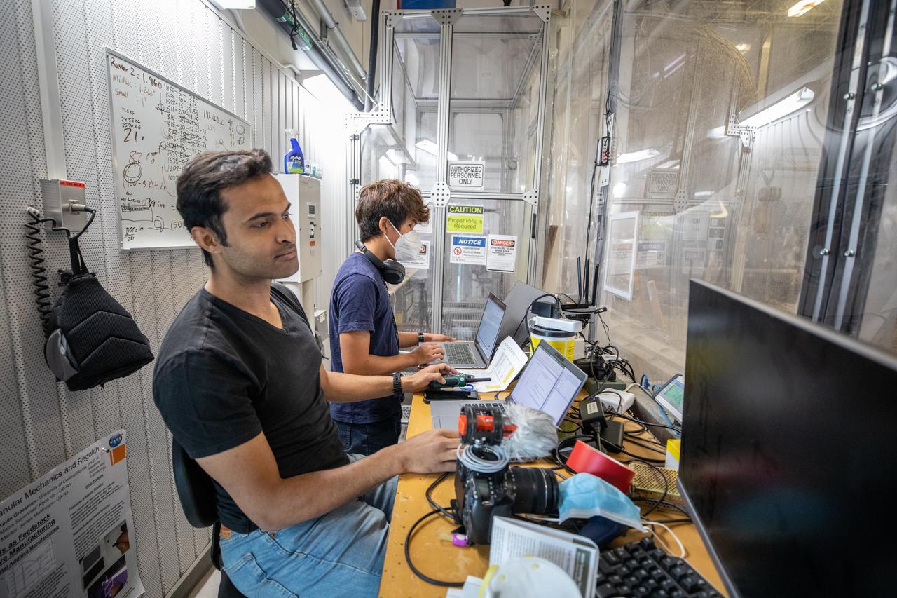
Senior Embedded Software Engineer Aamer Almujahed (left) and Software Engineering intern Ashten Akemoto run the ground software for Astrobotic’s CubeRover drawbar pull test inside the Granular Mechanics and Regolith Operations (GMRO) Laboratory’s regolith pit at NASA Kennedy Space Center’s Swamp Works facility on June 30, 2022. Astrobotic – a Pittsburgh-based space robotics company – is using the GMRO lab’s regolith bin, which holds approximately 120 tons of lunar regolith simulant, to depict how the company’s CubeRover would perform on the Moon. NASA’s Small Business Innovation Research program provided the funding for initial development, and a $2 million Tipping Point award from the agency has provided additional funding for continued development into a more mature rover.

The mid-latitudes of Mars are mostly covered with smooth material that scientists have suspected to be ice for some time. The ground is uniform and dusty and does not reveal many clues about what lies beneath the surface. However, sometimes a feature like a cliff cuts through the terrain and gives us a glimpse of this buried icy material. The cliff in this image is one example out of a few dozen that are known. The bright material on the cliff face is icy and is preserved only because the cliff points away from the equator, so it is shaded most of the time. Faint bands on the cliff might indicate layers in the ice that record different climate conditions. We do not know how much time this ice took to accumulate here, but studies elsewhere on Mars indicate that material like this is sometimes at least tens of millions of years old. https://photojournal.jpl.nasa.gov/catalog/PIA25505
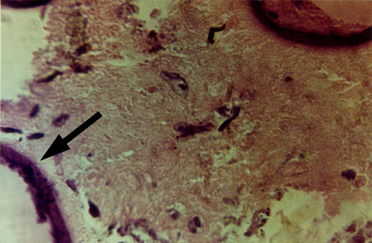
High magnification view of human primary breast tumor cells after 56 days of culture in a NASA Bioreactor. The arrow points to bead surface indicating breast cancer cells (as noted by the staining of tumor cell intermediate filaments). NASA's Marshall Space Flight Center (MSFC) is sponsoring research with Bioreactors, rotating wall vessels designed to grow tissue samples in space, to understand how breast cancer works. This ground-based work studies the growth and assembly of human mammary epithelial cell (HMEC) from breast cancer susceptible tissue. Radiation can make the cells cancerous, thus allowing better comparisons of healthy vs. tunorous tissue. Credit: Dr. Jearne Becker, University of South Florida
NASA’s X-57 Maxwell, the agency’s first all-electric X-plane and first crewed X-planed in two decades, is delivered to NASA’s Armstrong Flight Research Center in Edwards, California in its Mod II configuration. The first of three primary modifications for the project, Mod II involves testing of the aircraft’s cruise electric propulsion system. Delivery to NASA from prime contractor Empirical Systems Aerospace of San Luis Obispo, California, marks a major milestone for the project, at which point the vehicle is reintegrated for ground tests, to be followed by taxi tests, and eventually, flight tests. X-57’s goal is to further advance the design and airworthiness process for distributed electric propulsion technology for general aviation aircraft, which can provide multiple benefits to efficiency, emissions, and noise.
NASA's X-57 Maxwell, the agency's first all-electric X-plane and first crewed X-planed in two decades, is delivered to NASA's Armstrong Flight Research Center in Edwards, California in its Mod II configuration. The first of three primary modifications for the project, Mod II involves testing of the aircraft's cruise electric propulsion system. Delivery to NASA from prime contractor Empirical Systems Aerospace of San Luis Obispo, California, marks a major milestone for the project, at which point the vehicle is reintegrated for ground tests, to be followed by taxi tests, and eventually, flight tests. X-57's goal is to further advance the design and airworthiness process for distributed electric propulsion technology for general aviation aircraft, which can provide multiple benefits to efficiency, emissions, and noise.

ISS031-E-123071 (14 June 2012) --- The Great Lakes in sunglint are featured in this image photographed by an Expedition 31 crew member on the International Space Station. From the vantage point of the space station, crew members observe many spectacular phenomena including aurora, noctilucent clouds, airglow, and sunglint on Earth?s water bodies. Sunglint is light reflected off of a water surface towards the observer such that it creates the appearance of a mirror-like surface. If the viewing and lighting conditions are ideal, that mirror-like surface can extend over very large areas, such as the entire surface of Lake Ontario (approximately 18,960 square kilometers). This photograph was taken while the space station was located over a point to the southeast of Nova Scotia (approximately 1,200 kilometers ground distance from the center point of the image). Lake Ontario, Lake Huron, the Finger Lakes of upstate New York, and numerous other bodies of water appear brilliantly lit by sunglint. To the west, Lake Erie is also highlighted by sunglint, but less light is being reflected back towards the observer resulting in a duller appearance. Much of central Canada is obscured by extensive cloud cover in the image, whereas a smaller grouping of clouds obscures the Appalachian range and Pennsylvania (lower left). The blue envelope of Earth?s atmosphere is visible above the curved limb, or horizon line that extends across the upper third of the image. Such panoramic views of the planet are readily taken through space station viewing ports with handheld digital cameras which allow the crew to take advantage of the full range of viewing angles.
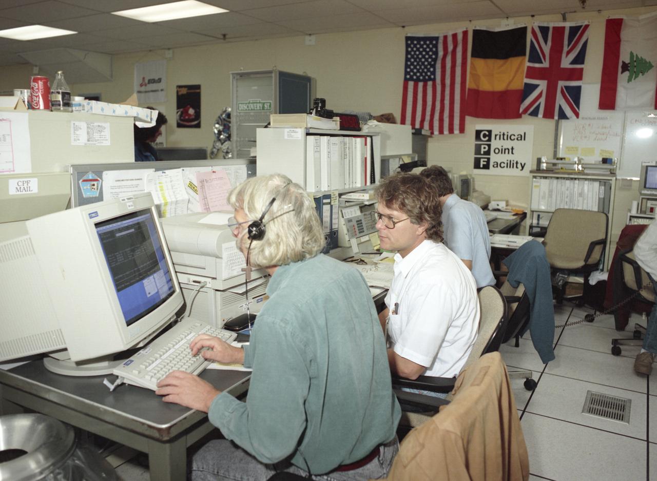
The primary payload for Space Shuttle Mission STS-42, launched January 22, 1992, was the International Microgravity Laboratory-1 (IML-1), a pressurized manned Spacelab module. The goal of IML-1 was to explore in depth the complex effects of weightlessness of living organisms and materials processing. Around-the-clock research was performed on the human nervous system's adaptation to low gravity and effects of microgravity on other life forms such as shrimp eggs, lentil seedlings, fruit fly eggs, and bacteria. Materials processing experiments were also conducted, including crystal growth from a variety of substances such as enzymes, mercury iodide, and a virus. The Huntsville Operations Support Center (HOSC) Spacelab Payload Operations Control Center (SL POCC) at the Marshall Space Flight Center (MSFC) was the air/ground communication channel used between the astronauts and ground control teams during the Spacelab missions. Featured is the Critical Point Facility (CPF) team in the SL POCC during the IML-1 mission.
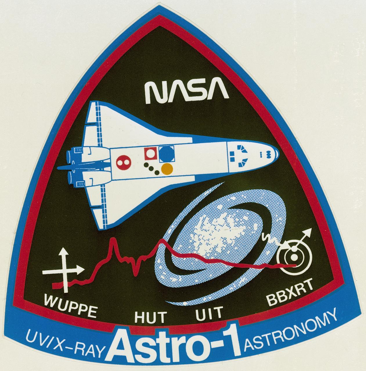
The primary payload for Space Shuttle Mission STS-35, launched December 2, 1990, was the ASTRO-1 Observatory. Designed for round the clock observation of the celestial sphere in ultraviolet and X-ray astronomy, ASTRO-1 featured a collection of four telescopes: the Hopkins Ultraviolet Telescope (HUT); the Wisconsin Ultraviolet Photo- Polarimeter Experiment (WUPPE); the Ultraviolet Imaging Telescope (UIT); and the Broad Band X-ray Telescope (BBXRT). Ultraviolet telescopes mounted on Spacelab elements in cargo bay were to be operated in shifts by flight crew. Loss of both data display units (used for pointing telescopes and operating experiments) during mission impacted crew-aiming procedures and forced ground teams at Marshall Space Flight Center to aim ultraviolet telescopes with fine-tuning by flight crew. BBXRT, also mounted in cargo bay, was directed from outset by ground-based operators at Goddard Space Flight Center. This is the logo or emblem that was designed to represent the ASTRO-1 payload.

This artist's concept allows us to imagine what it would be like to stand on the surface of the exoplanet TRAPPIST-1f, located in the TRAPPIST-1 system in the constellation Aquarius. Because this planet is thought to be tidally locked to its star, meaning the same face of the planet is always pointed at the star, there would be a region called the terminator that perpetually divides day and night. If the night side is icy, the day side might give way to liquid water in the area where sufficient starlight hits the surface. One of the unusual features of TRAPPIST-1 planets is how close they are to each other -- so close that other planets could be visible in the sky from the surface of each one. In this view, the planets in the sky correspond to TRAPPIST1e (top left crescent), d (middle crescent) and c (bright dot to the lower right of the crescents). TRAPPIST-1e would appear about the same size as the moon and TRAPPIST1-c is on the far side of the star. The star itself, an ultra-cool dwarf, would appear about three times larger than our own sun does in Earth's skies. The TRAPPIST-1 system has been revealed through observations from NASA's Spitzer Space Telescope and the ground-based TRAPPIST (TRAnsiting Planets and PlanetesImals Small Telescope) telescope, as well as other ground-based observatories. The system was named for the TRAPPIST telescope. http://photojournal.jpl.nasa.gov/catalog/PIA21423
The primary payload for Space Shuttle Mission STS-42, launched January 22, 1992, was the International Microgravity Laboratory-1 (IML-1), a pressurized manned Spacelab module. The goal of IML-1 was to explore in depth the complex effects of weightlessness of living organisms and materials processing. Around-the-clock research was performed on the human nervous system's adaptation to low gravity and effects of microgravity on other life forms such as shrimp eggs, lentil seedlings, fruit fly eggs, and bacteria. Materials processing experiments were also conducted, including crystal growth from a variety of substances such as enzymes, mercury iodide, and a virus. The Huntsville Operations Support Center (HOSC) Spacelab Payload Operations Control Center (SL POCC) at the Marshall Space Flight Center (MSFC) was the air/ground communication channel used between the astronauts and ground control teams during the Spacelab missions. Featured is the Critical Point Facility (CPE) group in the SL POCC during STS-42, IML-1 mission.
This image shows a portion of Lethe Vallis, an outflow channel that also transported lava. Another investigation of this area (Balme et al., 2011) discovered a repeat pattern of dune-like forms in the channel interpreted as fluvial dunes (or, giant current ripples) which are dunes formed by flowing water. This is one of only a few places on Mars where these pristine-appearing landforms have been identified. The channel formed by catastrophic floods, during which it produced the prominent crater-cored, teardroped-shaped island in the middle. The island has the blunter end pointing upstream and the long tail pointing downstream. Both the island and the fluvial dunes were formed by these extreme floods and their size is an indicator of the enormous discharges required to create them. The margins of the channel also show the terminal front of a pristine lava flow unit that inundated the channel from the south and the dunes show the remnants of another older lava flow. The top of the island displays polygonal patterned ground texture, which is a characteristic of periglacial processes in ice-rich ground. The dark materials from the channel and island walls are probably dark sand being eroded from an underlying horizontal basaltic (lava) layer. The crater at the core of the island has elongated dunes and reticulate dust ridges inside. This single image thus contains features formed by periglacial, volcanic, fluvial, impact, aeolian and mass wasting processes, all in one place. http://photojournal.jpl.nasa.gov/catalog/PIA21039

This artist's concept shows what the TRAPPIST-1 planetary system may look like, based on available data about the planets' diameters, masses and distances from the host star. The system has been revealed through observations from NASA's Spitzer Space Telescope and the ground-based TRAPPIST (TRAnsiting Planets and PlanetesImals Small Telescope) telescope, as well as other ground-based observatories. The system was named for the TRAPPIST telescope. The seven planets of TRAPPIST-1 are all Earth-sized and terrestrial, according to research published in 2017 in the journal Nature. TRAPPIST-1 is an ultra-cool dwarf star in the constellation Aquarius, and its planets orbit very close to it. They are likely all tidally locked, meaning the same face of the planet is always pointed at the star, as the same side of our moon is always pointed at Earth. This creates a perpetual night side and perpetual day side on each planet. TRAPPIST-1b and c receive the most light from the star and would be the warmest. TRAPPIST-1e, f and g all orbit in the habitable zone, the area where liquid water is most likely to be detected. But any of the planets could potentially harbor liquid water, depending on their compositions. In the imagined planets shown here, TRAPPIST-1b is shown as a larger analogue to Jupiter's moon Io. TRAPPIST-1d is depicted with a narrow band of water near the terminator, the divide between a hot, dry day and an ice-covered night side. TRAPPIST-1e and TRAPPIST-1f are both shown covered in water, but with progressively larger ice caps on the night side. TRAPPIST-1g is portrayed with an atmosphere like Neptune's, although it is still a rocky world. TRAPPIST-1h, the farthest from the star, would be the coldest. It is portrayed here as an icy world, similar to Jupiter's moon Europa, but the least is known about it. http://photojournal.jpl.nasa.gov/catalog/PIA21422

ISS036-E-011050 (22 June 2013) --- An Egyptian dust plume and the Red Sea are featured in this image photographed by an Expedition 36 crew member on the International Space Station. This photograph provides a panoramic view of most of the length of the Red Sea, with the northernmost end, the Gulf of Suez, just visible at top center—fully 1,900 kilometers (ground distance) from the space station. The River Nile snakes its way northward through the Sahara Desert at top left. Much closer to the camera—but still more than 550 kilometers distant from the ground point above which the space station is orbiting—is a prominent dust plume surging out over the clear water of the Red Sea (foreground), reaching most of the way to Saudi Arabia. The “point source” of this plume is the delta of the southern Egyptian river Khor Baraka. Images from the spacecraft have shown that this delta is a common source for dust plumes, mainly because it is a relatively large area of exposed, loose sand and clay, easily lofted into the air. But the river also cuts through a high range of hills in a narrow valley that channels the wind, making it blow faster. This dramatic view of the Red Sea shows the generally parallel margins of the opposing coastlines. According to scientists, the rift or depression which now holds the Red Sea has been opening slowly for about 30 million years, and is nearly 300 kilometers wide in the region of the dust plume. Scientists believe the depression only recently filled with seawater within the last approximately five million years.
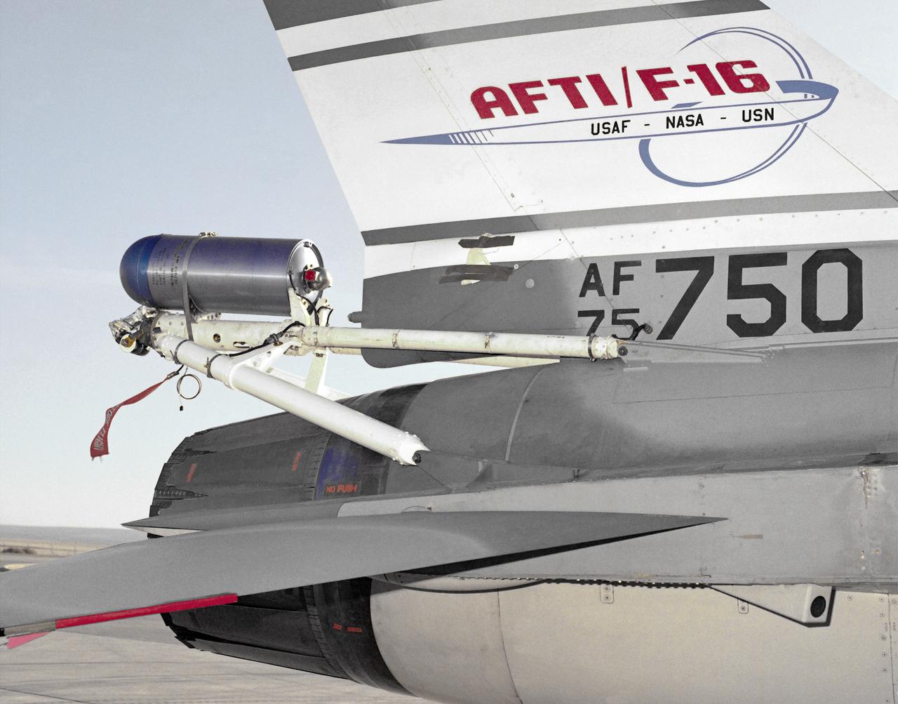
A close-up photo of the spin chute mounted on the rear fuselage of the AFTI F-16, a safety device designed to prevent the loss of aircraft in spin conditions. Under some circumstances, pilots cannot recover from spins using normal controls. It these instances, the spin chute is deployed, thus "breaking" the spin and enabling the pilot to recover. The spin chute is held in a metal cylinder attached to the AFTI F-16 by four tubes, a structure strong enough to withstand the shock of the spin chute opening. Unlike the air probe in the last photo, spin chutes are not standard equipment on research or prototype aircraft but are commonly attached expressly for actual spin tests.
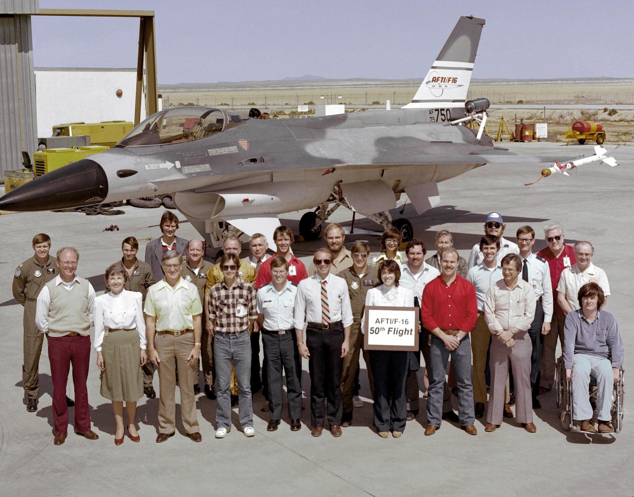
An early (1983) photograph of the AFTI F-16 team, commemorating the aircraft's 50th flight. It shows the initial configuration and paint finish of the AFTI F-16, as well as the forward mounted canards and the spin chute.
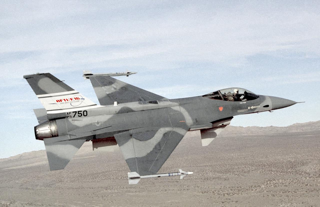
This photo depicts the AFTI F-16 in the configuration used midway through the program. The sensor pods were added to the fuselage, but the chin canards remained in place. Painted in non-standard gray tones, it carried Sidewinder air-to-air missles on its wingtips.
The AFTI F-16 flying at high angle of attack, shown in the final configuration and paint finish. Dummy Sidewinder air-to-air missles are attached to the wing tips. The white objects visible on the wing racks represent practice bomb dispensers, used in weapon tests.

This is a deformation map of the south flank of Kilauea volcano on the big island of Hawaii, centered at 19.5 degrees north latitude and 155.25 degrees west longitude. The map was created by combining interferometric radar data -- that is data acquired on different passes of the space shuttle which are then overlayed to obtain elevation information -- acquired by the Spaceborne Imaging Radar-C/X-band Synthetic Aperture Radar during its first flight in April 1994 and its second flight in October 1994. The area shown is approximately 40 kilometers by 80 kilometers (25 miles by 50 miles). North is toward the upper left of the image. The colors indicate the displacement of the surface in the direction that the radar instrument was pointed (toward the right of the image) in the six months between images. The analysis of ground movement is preliminary, but appears consistent with the motions detected by the Global Positioning System ground receivers that have been used over the past five years. The south flank of the Kilauea volcano is among the most rapidly deforming terrains on Earth. Several regions show motions over the six-month time period. Most obvious is at the base of Hilina Pali, where 10 centimeters (4 inches) or more of crustal deformation can be seen in a concentrated area near the coastline. On a more localized scale, the currently active Pu'u O'o summit also shows about 10 centimeters (4 inches) of change near the vent area. Finally, there are indications of additional movement along the upper southwest rift zone, just below the Kilauea caldera in the image. Deformation of the south flank is believed to be the result of movements along faults deep beneath the surface of the volcano, as well as injections of magma, or molten rock, into the volcano's "plumbing" system. Detection of ground motions from space has proven to be a unique capability of imaging radar technology. Scientists hope to use deformation data acquired by SIR-C/X-SAR and future imaging radar missions to help in better understanding the processes responsible for volcanic eruptions and earthquakes. http://photojournal.jpl.nasa.gov/catalog/PIA01758
On the morning of October 4, 2016, Hurricane Matthew passed over the island nation of Haiti. A Category 4 storm, it made landfall around 7 a.m. local time (5 a.m. PDT/8 a.m. EDT) with sustained winds over 145 mph. This is the strongest hurricane to hit Haiti in over 50 years. On October 4, at 10:30 a.m. local time (8:30 a.m. PDT/11:30 a.m. EDT), the Multi-angle Imaging SpectroRadiometer (MISR) instrument aboard NASA's Terra satellite passed over Hurricane Matthew. This animation was made from images taken by MISR's downward-pointing (nadir) camera is 235 miles (378 kilometers) across, which is much narrower than the massive diameter of Matthew, so only the hurricane's eye and a portion of the storm's right side are visible. Haiti is completely obscured by Matthew's clouds, but part of the Bahamas is visible to the north. Several hot towers are visible within the central part of the storm, and another at the top right of the image. Hot towers are enormous thunderheads that punch through the tropopause (the boundary between the lowest layer of the atmosphere, the troposphere, and the next level, the stratosphere). The rugged topography of Haiti causes uplift within the storm, generating these hot towers and fueling even more rain than Matthew would otherwise dump on the country. MISR has nine cameras fixed at different angles, which capture images of the same point on the ground within about seven minutes. This animation was created by blending images from these nine cameras. The change in angle between the images causes a much larger motion from south to north than actually exists, but the rotation of the storm is real motion. From this animation, you can get an idea of the incredible height of the hot towers, especially the one to the upper right. The counter-clockwise rotation of Matthew around its closed (cloudy) eye is also visible. These data were acquired during Terra orbit 89345. An animation is available at http://photojournal.jpl.nasa.gov/catalog/PIA21070

ISS030-E-162344 (15 March 2012) --- Ice floes along the Kamchatka coastline are featured in this image photographed by an Expedition 30 crew member on the International Space Station. The vantage point from orbit frequently affords the opportunity to observe processes that are impossible to see on the ground – or in this case the northeastern Pacific Ocean. The winter season blankets the Kamchatka Peninsula of Russia in snow, but significant amounts of sea ice can also form and collect along the coastline. As ice floes grind against each other, they produce smaller floes that can be moved by wind and water currents acting along the coastline. The irregular southeastern coastline of Kamchatka helps to produce large circular eddy currents from the main southwestward-flowing Kamchatka current. Three such eddies are clearly highlighted by surface ice floe patterns at center. The ice patterns are very difficult (and dangerous) to navigate in an ocean vessel – while the floes may look thin and delicate from the space station vantage point, even the smaller ice chunks are likely several meters across. White clouds at top right are distinguished from the sea ice and snow cover in the image by their high brightness and discontinuous nature. The Kamchatka Peninsula also hosts many currently and historically active stratovolcanoes. Kliuchevskoi Volcano, the highest in Kamchatka (summit elevation 4,835 meters) and one of the most active, had its most recent confirmed eruption in June of 2011, while Karymsky Volcano to the south likely produced ash plumes days before this image was taken; the snow cover near the volcano to the south and east of the summit is darkened, probably due to a cover of fresh ash, or melted away altogether (bottom center). In contrast, Kronotsky Volcano – a “textbook” symmetrical cone-shaped stratovolcano – last erupted in 1923.
VANDENBERG AIR FORCE BASE, Calif. — In the Orbital Sciences Building 836 at Vandenberg Air Force Base in California, technicians complete mating of the three micro-satellites on the payload support structure. The three satellites make up the Space Technology 5 spacecraft, called ST5, and will be launched by a Pegasus XL rocket. The satellites contain miniaturized redundant components and technologies. Each will validate New Millennium Program selected technologies, such as the Cold Gas Micro-Thruster and X-Band Transponder Communication System. After deployment from the Pegasus, the micro-satellites will be positioned in a “string of pearls” constellation that demonstrates the ability to position them to perform simultaneous multi-point measurements of the magnetic field using highly sensitive magnetometers. The data will help scientists understand and map the intensity and direction of the Earth’s magnetic field, its relation to space weather events, and affects on our planet. With such missions, NASA hopes to improve scientists’ ability to accurately forecast space weather and minimize its harmful effects on space- and ground-based systems. Launch of ST5 is scheduled for Feb. 28 from Vandenberg Air Force Base.
CAPE CANAVERAL, Fla. -- Space shuttle Discovery's STS-133 crew prepares to depart NASA's Kennedy Space Center in Florida in T-38 training jets. Mission Specialist Michael Barratt, left, Pilot Eric Boe and Mission Specialist Nicole Stott and their three crewmates will wait until at least Nov. 30 to launch to the International Space Station because a leak was detected at the Ground Umbilical Carrier Plate (GUCP) while Discovery's external fuel tank was being loaded for launch on Nov. 5. The GUCP is an attachment point between the external tank and a pipe that carries gaseous hydrogen safely away from the shuttle to the flare stack, where it is burned off. Engineers and managers also will evaluate a crack in the foam on the external tank. During the 11-day mission, STS-133 will deliver the Permanent Multipurpose Module, packed with supplies and critical spare parts, as well as Robonaut 2, to the orbiting laboratory. Discovery, which will fly its 39th mission, is scheduled to be retired following STS-133. This will be the 133rd Space Shuttle Program mission and the 35th shuttle voyage to the space station. For more information on STS-133, visit www.nasa.gov/mission_pages/shuttle/shuttlemissions/sts133/. Photo credit: NASA/Kim Shiflett

Cape Canaveral Air Force Station, Fla. -- The lantern room of the Cape Canaveral Lighthouse, with its modern first-order optic, takes on a warm glow as dawn breaks and a full moon still shines overhead. The Canaveral light is the only operating lighthouse owned by the U.S. Air Force. In 2000, the Coast Guard transferred ownership of the lighthouse structure and its grounds to the Air Force, which is now responsible for maintaining it. The U.S. Coast Guard continues to operate the beacon as an active navigational aid. The first lighthouse at Cape Canaveral was built near the tip of the Cape in 1848. The structure was only about 60 feet high with a rather dim light powered by whale oil. In 1859, work began nearby on a new, taller iron structure. Construction was halted during the Civil War, and the lighthouse finally was finished in 1868. The structure, with a brick lining inside its iron exterior, was painted with its "daymark" black and white horizontal bands in 1873 to make it easier to identify during the day as a navigation point. Between 1892 and 1894, the lighthouse was dismantled and moved to its new home about a mile from the coast, where it stands today. Photo credit: NASA/Ben Smegelsky
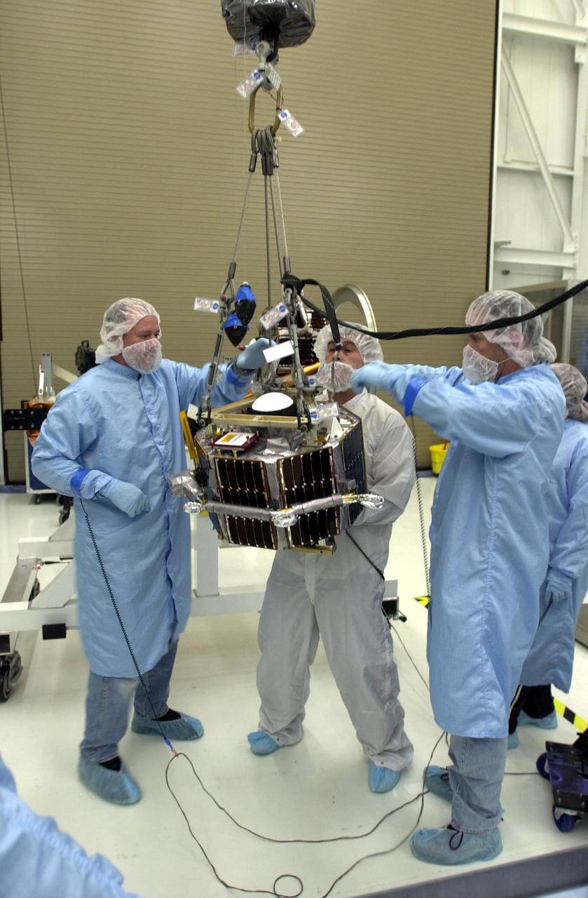
VANDENBERG AIR FORCE BASE, Calif. — In the Orbital Sciences Building 836 at Vandenberg Air Force Base in California, workers are maneuvering a second satellite suspended by an overhead crane. Three micro-satellites are being mounted on a payload support structure. The three satellites make up the Space Technology 5 spacecraft, called ST5, and will be launched by a Pegasus XL rocket. The satellites contain miniaturized redundant components and technologies. Each will validate New Millennium Program selected technologies, such as the Cold Gas Micro-Thruster and X-Band Transponder Communication System. After deployment from the Pegasus, the micro-satellites will be positioned in a “string of pearls” constellation that demonstrates the ability to position them to perform simultaneous multi-point measurements of the magnetic field using highly sensitive magnetometers. The data will help scientists understand and map the intensity and direction of the Earth’s magnetic field, its relation to space weather events, and affects on our planet. With such missions, NASA hopes to improve scientists’ ability to accurately forecast space weather and minimize its harmful effects on space- and ground-based systems. Launch of ST5 is scheduled for Feb. 28 from Vandenberg Air Force Base.