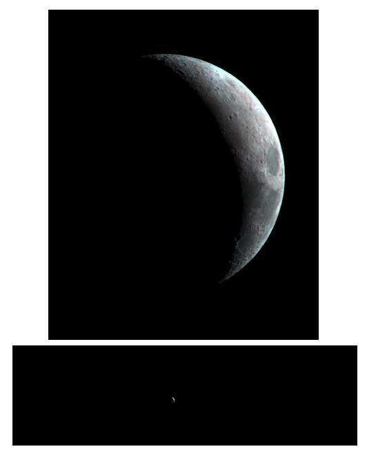
This crescent view of Earth Moon in infrared wavelengths comes from a camera test by NASA Mars Reconnaissance Orbiter spacecraft on its way to Mars. This image was taken by taken by the High Resolution Imaging Science Experiment camera Sept. 8, 2005.
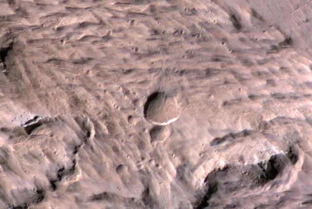
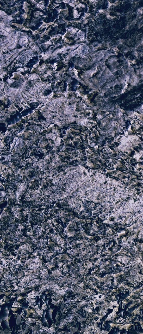
The High Resolution Imaging Science Experiment camera on NASA Mars Reconnaissance Orbiter excavates ice in a twelve-meter-wide crater.
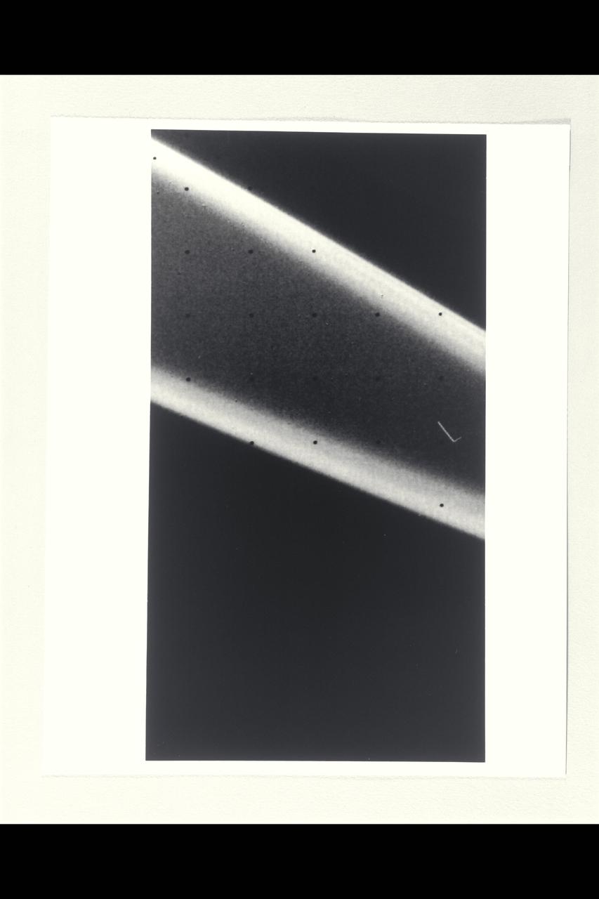
NASA Voyager 2 acquired this high-resolution image of the epsilon ring of Uranus on Jan. 23, 1986. This clear-filter image from Voyager narrow-angle camera has a resolution of about 10 km 6 mi.
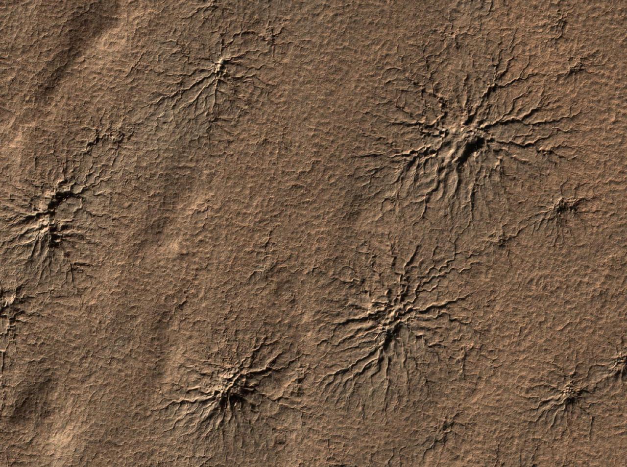
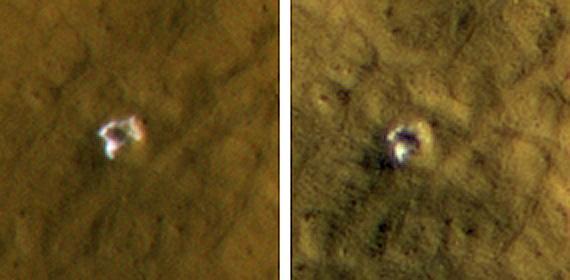
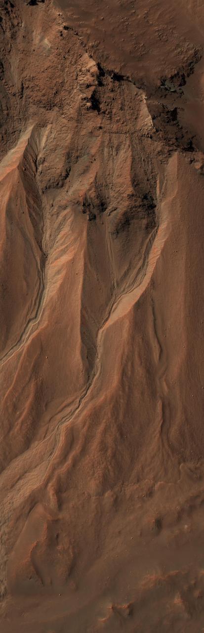
The High Resolution Imaging Science Experiment camera on NASA Mars Reconnaissance Orbiter captured this image of spider-shaped features on Mars, carved by vaporizing dry ice.
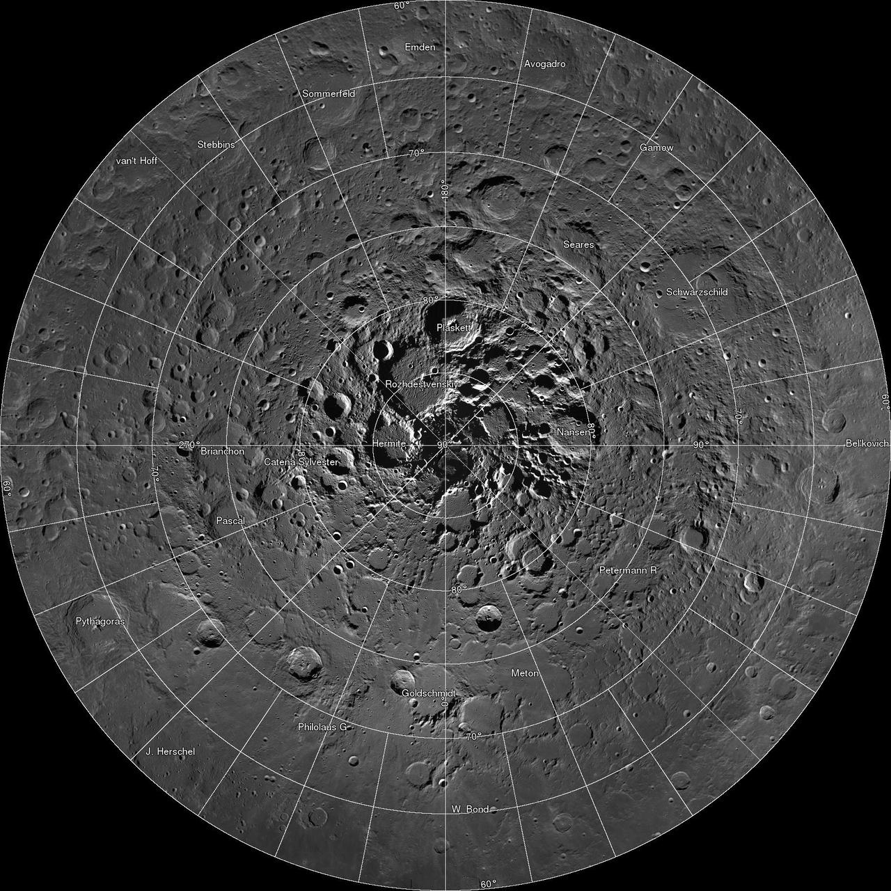
Scientists, using cameras aboard NASA Lunar Reconnaissance Orbiter LRO, have created the largest high resolution mosaic of our moon north polar region.
Each image on this High Resolution Stereo Camera Image Composite HRSC mosaic is of the same location observed by Dawn Framing Camera when it flew by Mars to complete the spacecraft gravity assist maneuver on February 17, 2009.
This is a screen shot from a high-definition simulated movie of Mojave Crater on Mars, based on images taken by the High Resolution Imaging Science Experiment HiRISE camera on NASA Mars Reconnaissance Orbiter.
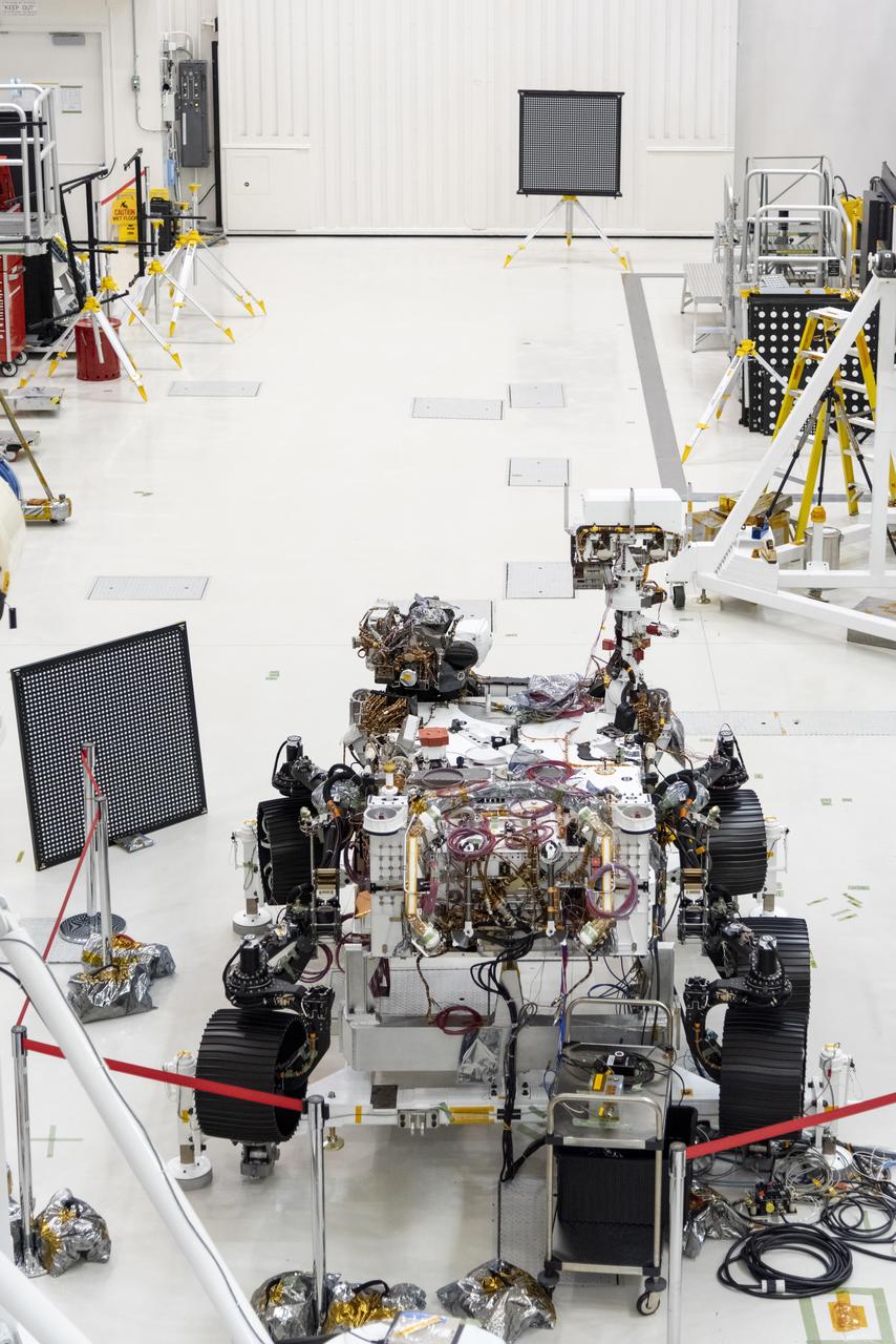
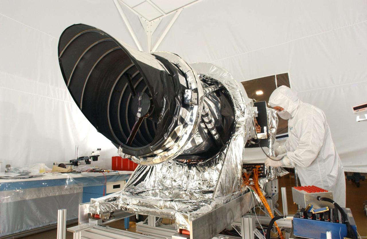
The Mars 2020 rover undergoes an "eye" exam after several cameras were installed. The rover carries everything from wide-angle landscape cameras to narrow-angle high-resolution zoom lens cameras. The image was taken on July 23, 2019, in the Spacecraft Assembly Facility's High Bay 1 at the Jet Propulsion Laboratory in Pasadena, California. https://photojournal.jpl.nasa.gov/catalog/PIA23315
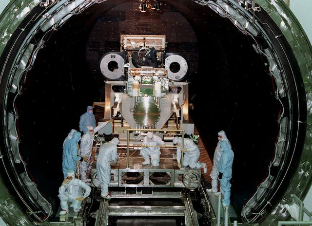
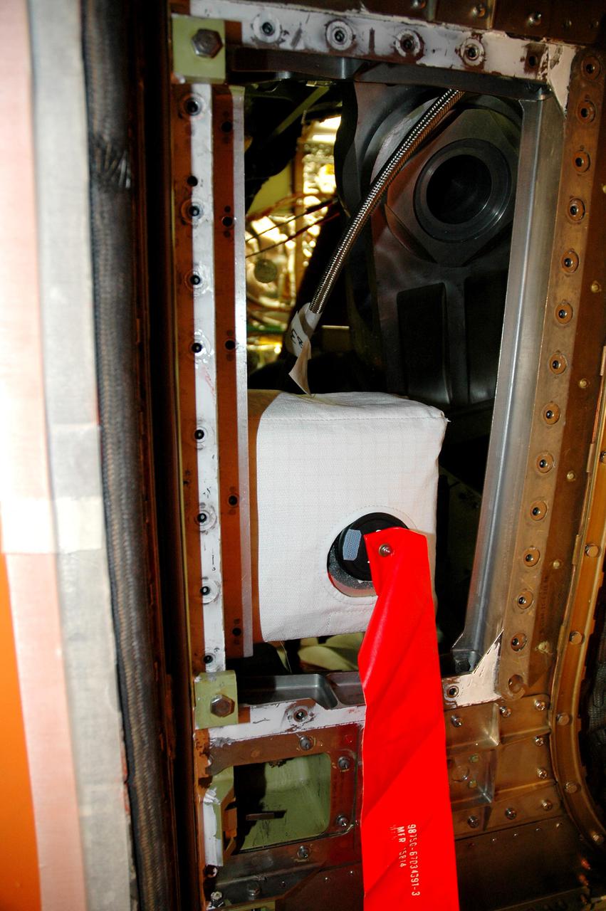
This photo shows the High Resolution Camera (HRC) for the Chandra X-Ray Observatory (CXO), formerly Advanced X-Ray Astrophysics Facility (AXAF), being integrated with the High Resolution Mirror Assembly (HRMA) in Marshall Space Flight Center's (MSFC's) 24-foot Vacuum Chamber at the X-Ray Calibration Facility (XRCF). The AXAF was renamed CXO in 1999. The CXO is the most sophisticated and the world's most powerful x-ray telescope ever built. It observes x-rays from high-energy regions of the universe, such as hot gas in the remnants of exploded stars. The HRC is one of the two instruments used at the focus of CXO, where it will detect x-rays reflected from an assembly of eight mirrors. The unique capabilities of the HRC stem from the close match of its imaging capability to the focusing of the mirrors. When used with CXO mirrors, the HRC makes images that reveal detail as small as one-half an arc second. This is equivalent to the ability to read a newspaper at a distance of 1 kilometer. MSFC's XRCF is the world's largest, most advanced laboratory for simulating x-ray emissions from distant celestial objects. It produces a space-like environment in which components related to x-ray telescope imaging are tested and the quality of their performances in space is predicted. TRW, Inc. was the prime contractor for the development of the CXO and NASA's MSFC was responsible for its project management. The Smithsonian Astrophysical Observatory controls science and flight operations of the CXO for NASA from Cambridge, Massachusetts. The CXO was launched July 22, 1999 aboard the Space Shuttle Columbia (STS-93).
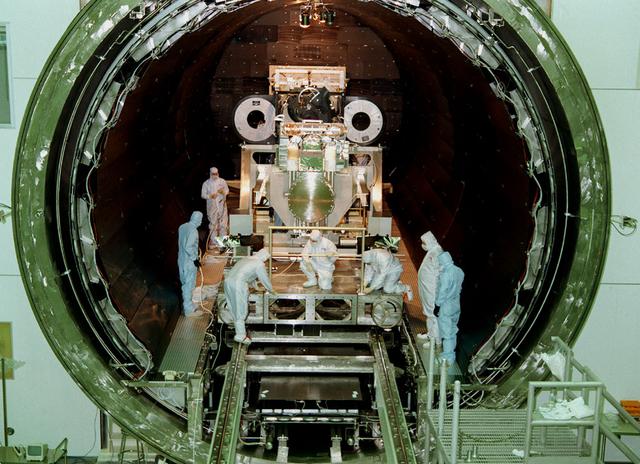
This photo shows the High Resolution Camera (HRC) for the Chandra X-Ray Observatory (CXO), formerly Advanced X-Ray Astrophysics Facility (AXAF), being integrated with the High Resolution Mirror Assembly (HRMA) in Marshall Space Flight Center's (MSFC's) 24-foot Vacuum Chamber at the X-Ray Calibration Facility (XRCF). The AXAF was renamed CXO in 1999. The CXO is the most sophisticated and the world's most poweful x-ray telescope ever built. It observes x-rays from high-energy regions of the universe, such as hot gas in the remnants of exploded stars. The HRC is one of the two instruments used at the focus of CXO, where it will detect x-rays reflected from an assembly of eight mirrors. The unique capabilities of the HRC stem from the close match of its imaging capability to the focusing of the mirrors. When used with CXO mirrors, the HRC makes images that reveal detail as small as one-half an arc second. This is equivalent to the ability to read a newspaper at a distance of 1 kilometer. MSFC's XRCF is the world's largest, most advanced laboratory for simulating x-ray emissions from distant celestial objects. It produces a space-like environment in which components relatedto x-ray telescope imaging are tested and the quality of their performances in space is predicted. TRW, Inc. was the prime contractor for the development of the CXO and NASA's MSFC was responsible for its project management. The Smithsonian Astrophysical Observatory controls science and flight operations of the CXO for NASA from Cambridge, Massachusetts. The CXO was launched July 22, 1999 aboard the Space Shuttle Columbia (STS-93).
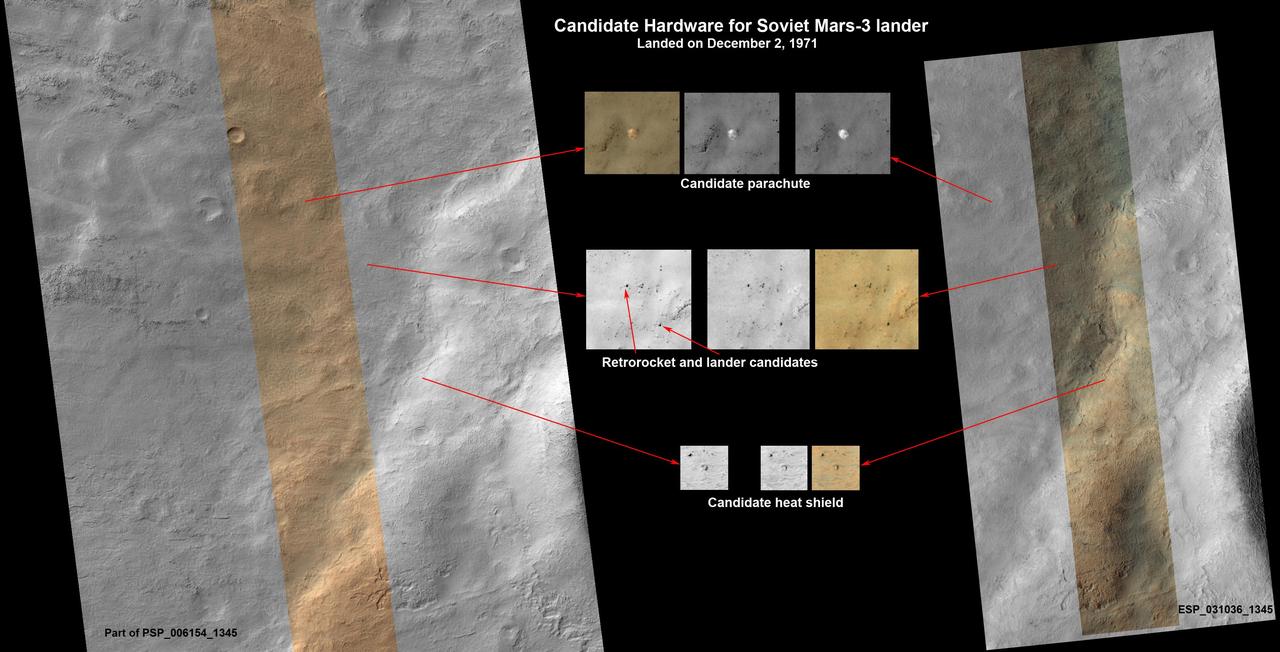
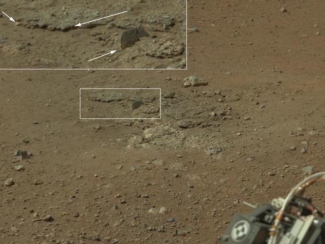
This set of images shows what might be hardware from the Soviet Union 1971 Mars 3 lander, seen in a pair of images from the High Resolution Imaging Science Experiment HiRISE camera on NASA Mars Reconnaissance Orbiter.
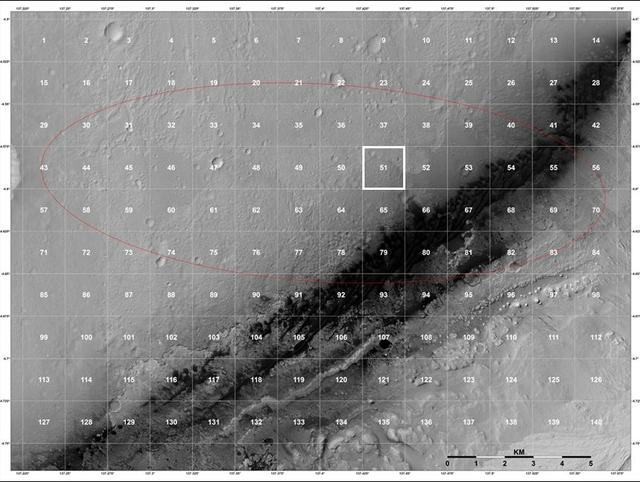
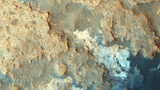
The geological context for the landing site of NASA Curiosity rover is visible in this image mosaic obtained by the High-Resolution Imaging Science Experiment HiRISE camera on NASA Mars Reconnaissance Orbiter.
NASA Curiosity Mars rover can be seen at the Pahrump Hills area of Gale Crater in this view from the High Resolution Imaging Science Experiment HiRISE camera on NASA Mars Reconnaissance Orbiter.
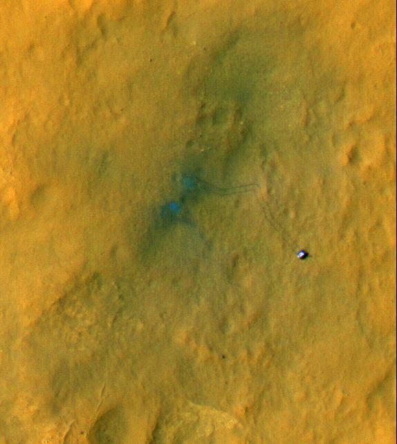
Tracks from the first drives of NASA Curiosity rover are visible in this image captured by the High-Resolution Imaging Science Experiment HiRISE camera on NASA Mars Reconnaissance Orbiter. The rover is seen where the tracks end.
This image shows the initial ejecta that resulted when NASA Deep Impact probe collided with comet Tempel 1 on July 3, 2005. It was taken by the spacecraft high-resolution camera 13 seconds after impact.
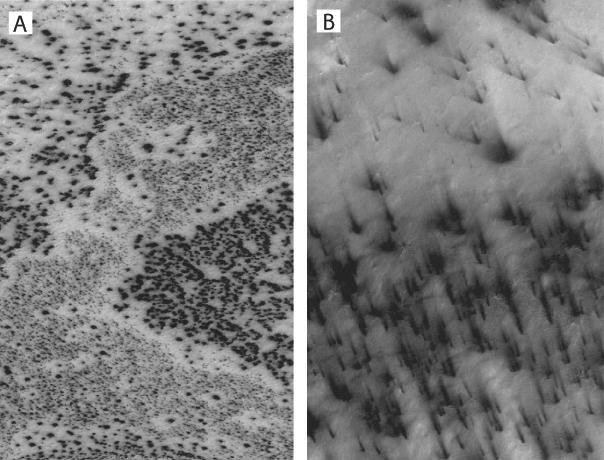
Dark spots left and fans appear to scribble dusty hieroglyphics on top of the Martian south polar cap in two high-resolution Mars Global Surveyor, Mars Orbiter Camera images taken in southern spring
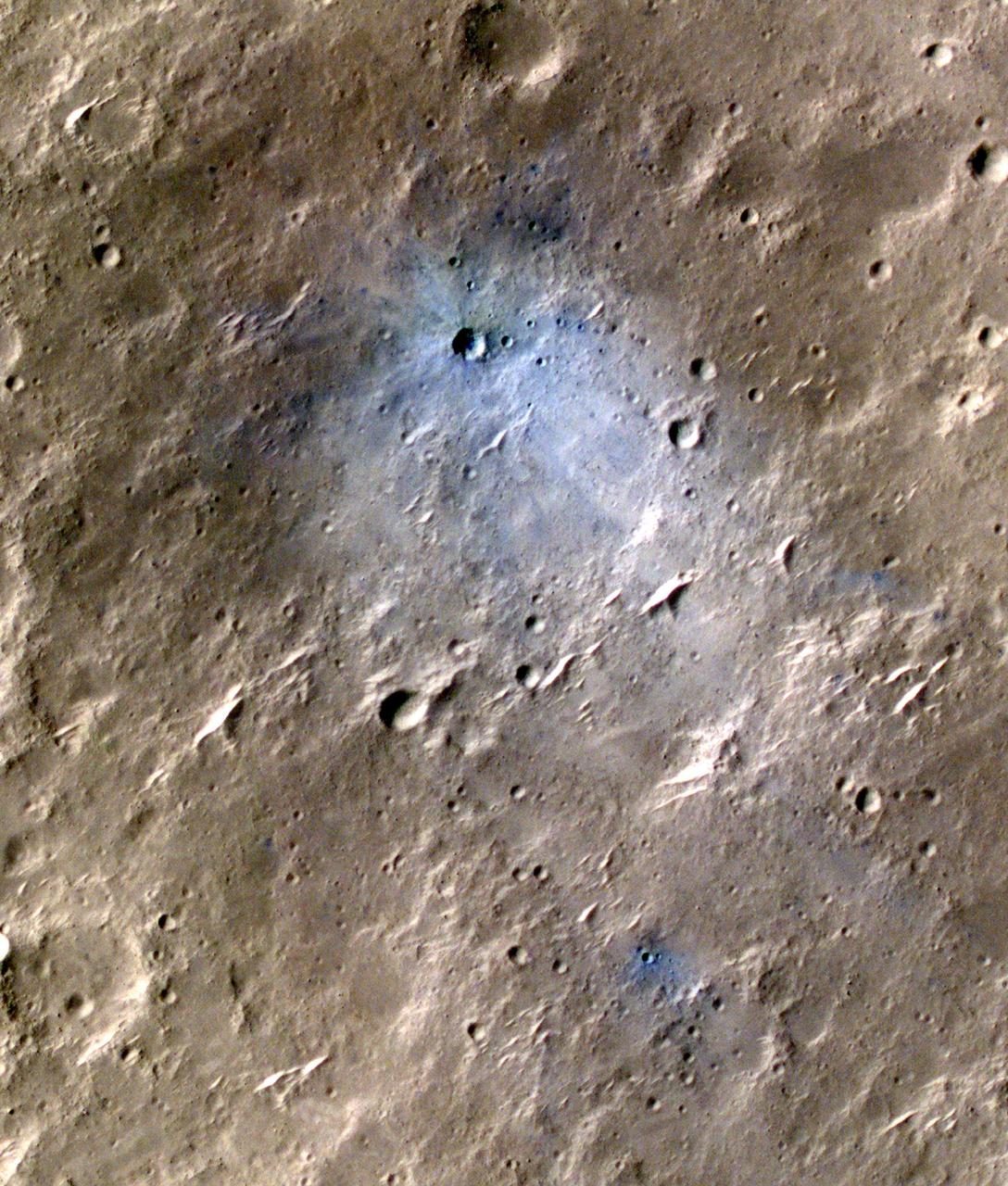
The largest crater associated with a March 2012 impact on Mars has many smaller craters around it, revealed in this image from the High Resolution Imaging Science Experiment HiRISE camera on NASA Mars Reconnaissance Orbiter.
This animation zooms in on the area on Mars where NASA Phoenix Mars Lander will touchdown on May 25, 2008. The image was taken by the High Resolution Imaging Science Experiment HiRISE camera on NASA Mars Reconnaissance Orbiter.
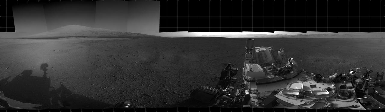
With the addition of four high-resolution Navigation Camera, or Navcam, images, taken on Aug. 18 Sol 12, Curiosity 360-degree landing-site panorama now includes the highest point on Mount Sharp visible from the rover.
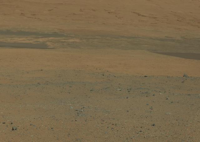
This color image from NASA Curiosity rover looks south of the rover landing site on Mars towards Mount Sharp. This is part of a larger, high-resolution color mosaic made from images obtained by Curiosity Mast Camera.
This image from the High Resolution Imaging Science Experiment camera on NASA Mars Reconnaissance Orbiter shows evidence for ancient fluid flow along fractures in Mars Meridiani Planum region
One of the great strengths of the HiRISE camera onboard NASA Mars Reconnaissance Orbiter is that its high resolution can help resolve interesting questions. Here, is the platy flow material younger than the yardang-forming material?
This is an enhanced-color image from Mars Reconnaissance Orbiter High Resolution Imaging Science Experiment HiRISE camera. It shows the NASA Mars Phoenix lander with its solar panels deployed on the Mars surface
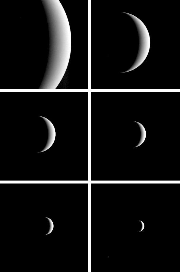
After acquiring hundreds of high-resolution images during close approach to Venus, NASA MESSENGER turned its wide-angle camera back to the planet and acquired a departure sequence.
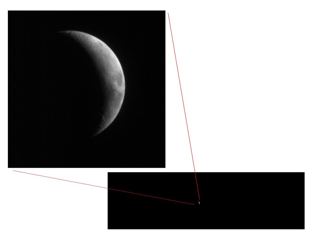
This pair of views shows how little of the full image frame was taken up by the Moon in test images taken Sept. 8, 2005, by the High Resolution Imaging Science Experiment HiRISE camera on NASA Mars Reconnaissance Orbiter.
The High Resolution Imaging Science Experiment camera on NASA Mars Reconnaissance Orbiter captured winter images of NASA Phoenix Mars Lander surrounded by dry-ice frost on Mars.
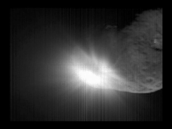
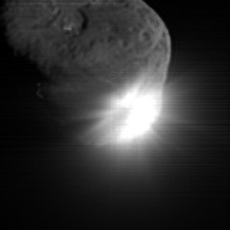
NASA Deep Impact flyby spacecraft shows the flash that occurred when comet Tempel 1 ran over the spacecraft probe taken by the high-resolution camera over a period of 40 seconds.
This image of Victoria Crater in the Meridiani Planum region of Mars was taken by the High Resolution Imaging Science Experiment HiRISE camera on NASA Mars Reconnaissance Orbiter at more of a sideways angle than earlier orbital images of this crater.
Amazingly, this image has captured at least four Martian avalanches, or debris falls, in action. It was taken on February 19, 2008, by the High Resolution Imaging Science Experiment HiRISE camera on NASA Mars Reconnaissance Orbiter.
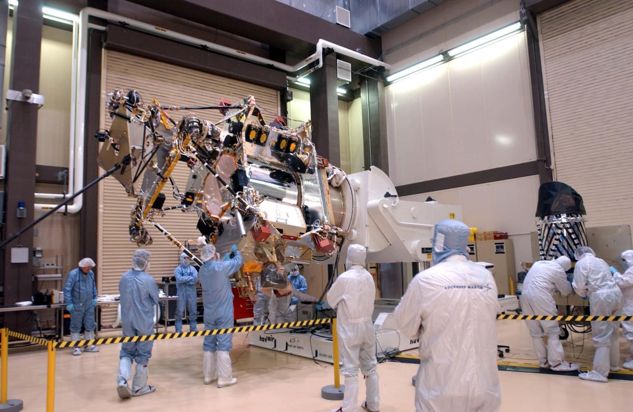
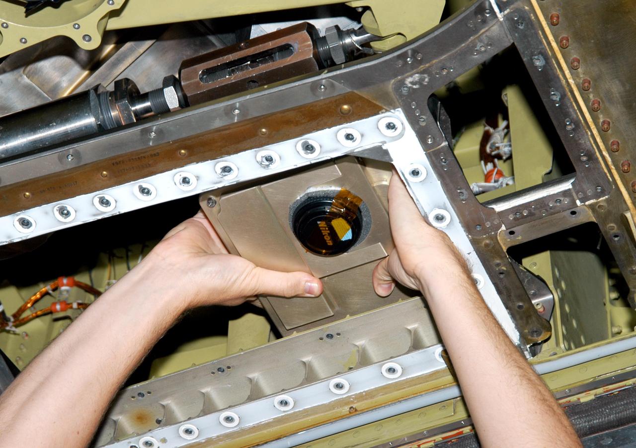
A telescopic camera called the High Resolution Imaging Science Experiment, or HiRISE, right was installed onto the main structure of NASA Mars Reconnaissance Orbiter left on Dec. 11, 2004 at Lockheed Martin Space Systems, Denver.

The High Resolution Imaging Science Experiment HiRISE camera on NASA Mars Reconnaissance Orbiter took two images of the larger of Mars two moons, Phobos, within 10 minutes of each other on March 23, 2008. This is the first.
NASA Curiosity Mars rover and tracks from its driving are visible in this view from orbit, acquired on April 11, 2014, by the High Resolution Imaging Science Experiment HiRISE camera on NASA Mars Reconnaissance Orbiter.
NASA Mars Reconnaissance Orbiter using the High Resolution Imaging Science Experiment HiRISE camera to take a picture of the Phoenix lander roughly 22 hours after landing.
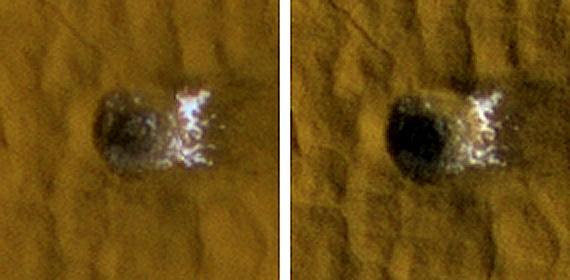
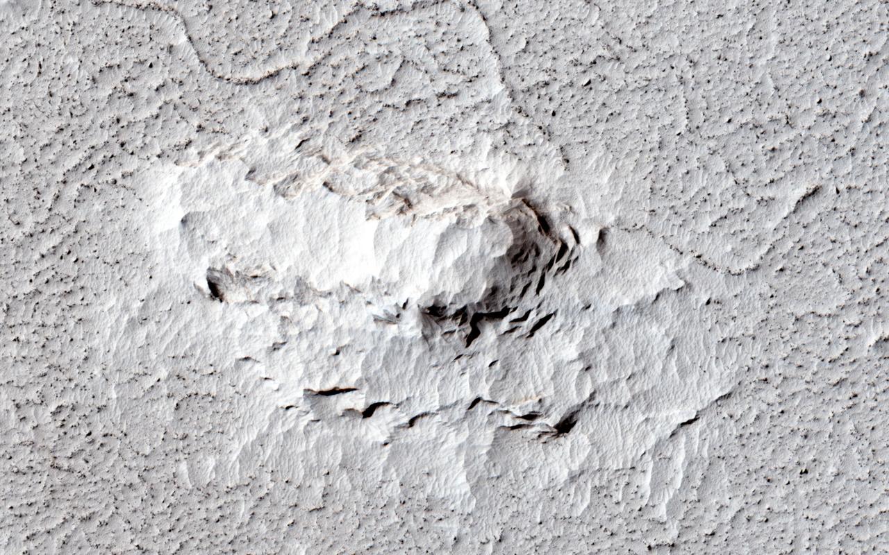
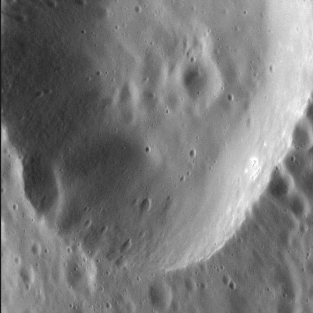
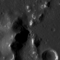
The High Resolution Imaging Science Experiment camera on NASA Mars Reconnaissance Orbiter reveals subsurface ice in a crater formed in 2008. The impact that dug the crater excavated water ice from beneath the surface.

This high-resolution image of Jupiter's main dust ring was collected by the Stellar Reference Unit (SRU) navigation camera aboard NASA's Juno spacecraft. The image was taken from inside the ring looking out as Juno flew between Jupiter and the radiation belts during the spacecraft's 36th close flyby on Sept. 2, 2021. The brightest thin dust bands are associated with the orbits of Jupiter's small moons, Metis and Adrastea. The image is at a resolution of nearly 20 miles (32 kilometers) per pixel. https://photojournal.jpl.nasa.gov/catalog/PIA25038

iss056e200804 (10/3/2018) --- NASA astronaut Ricky Arnold using the RED Helium Camera. The RED HELIUM 8K camera is a high-resolution cinema camera capable of 8K resolution.
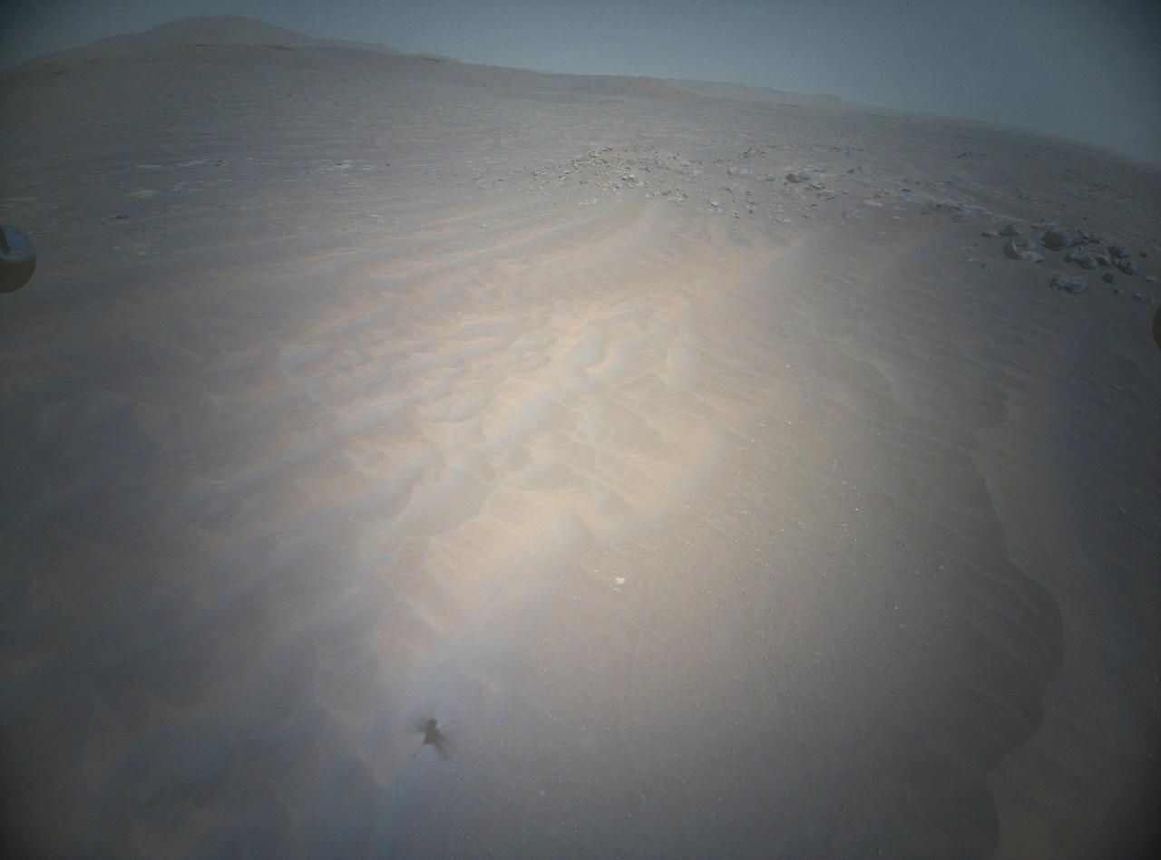
NASA's Ingenuity Mars Helicopter acquired this image in the northwest portion of a region of Mars known as "Séítah" using its high-resolution color camera during its 20th flight on Feb. 25, 2022. https://photojournal.jpl.nasa.gov/catalog/PIA25079
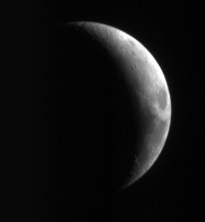
This crescent view of Earth Moon in infrared, blue-green, and red wavelengths comes from a camera test by NASA Mars Reconnaissance Orbiter spacecraft on its way to Mars.
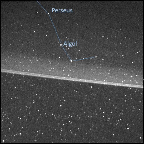
This annotated, high-resolution image of Jupiter's main dust ring was collected by the Stellar Reference Unit (SRU) navigation camera aboard NASA's Juno spacecraft. The image was taken from inside the ring looking out as Juno flew between Jupiter and the radiation belts during the spacecraft's 36th close flyby on Sept. 2, 2021. The brightest thin dust bands are associated with the orbits of Jupiter's small moons, Metis and Adrastea. The image also captured an arm of the Perseus constellation, as shown in the annotation. https://photojournal.jpl.nasa.gov/catalog/PIA25039
NASA Phoenix Mars Lander, its backshell and heatshield visible within this enhanced-color image of the Phoenix landing site taken on Jan. 6, 2010 by the High Resolution Imaging Science Experiment HiRISE camera on NASA Mars Reconnaissance Orbiter.
This color image from NASA Curiosity rover shows an area excavated by the blast of the Mars Science Laboratory descent stage rocket engines. This is part of a larger, high-resolution color mosaic made from images obtained by Curiosity Mast Camera.
This color image from NASA Curiosity rover shows part of the wall of Gale Crater, the location on Mars where the rover landed. This is part of a larger, high-resolution color mosaic made from images obtained by Curiosity Mast Camera.
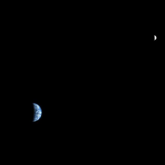
The High Resolution Imaging Science Experiment HiRISE camera would make a great backyard telescope for viewing Mars, and we can also use it at Mars to view other planets. This is an image of Earth and the moon, acquired on October 3, 2007.
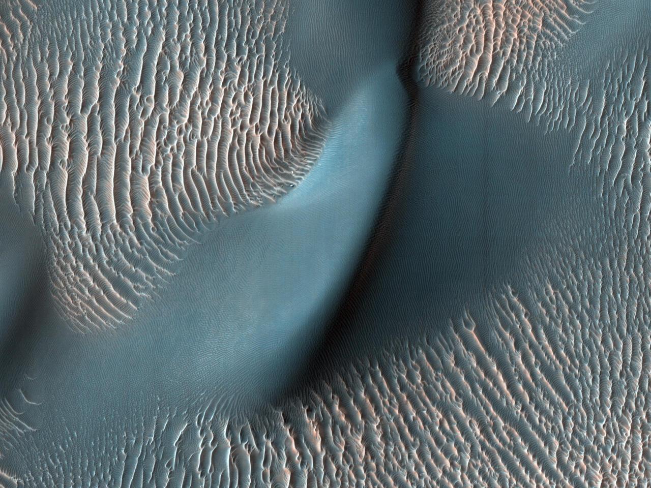
The High Resolution Imaging Science Experiment (HiRISE) camera aboard NASA's Mars Reconnaissance Orbiter captured these sand ripples and the large dune (at center) on Feb. 9, 2009. Color has been added to make textures easier to see. This area is in Proctor Crater at 47.8 degrees south latitude and 30.7 degrees east longitude. https://photojournal.jpl.nasa.gov/catalog/PIA24036
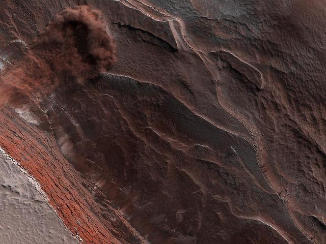
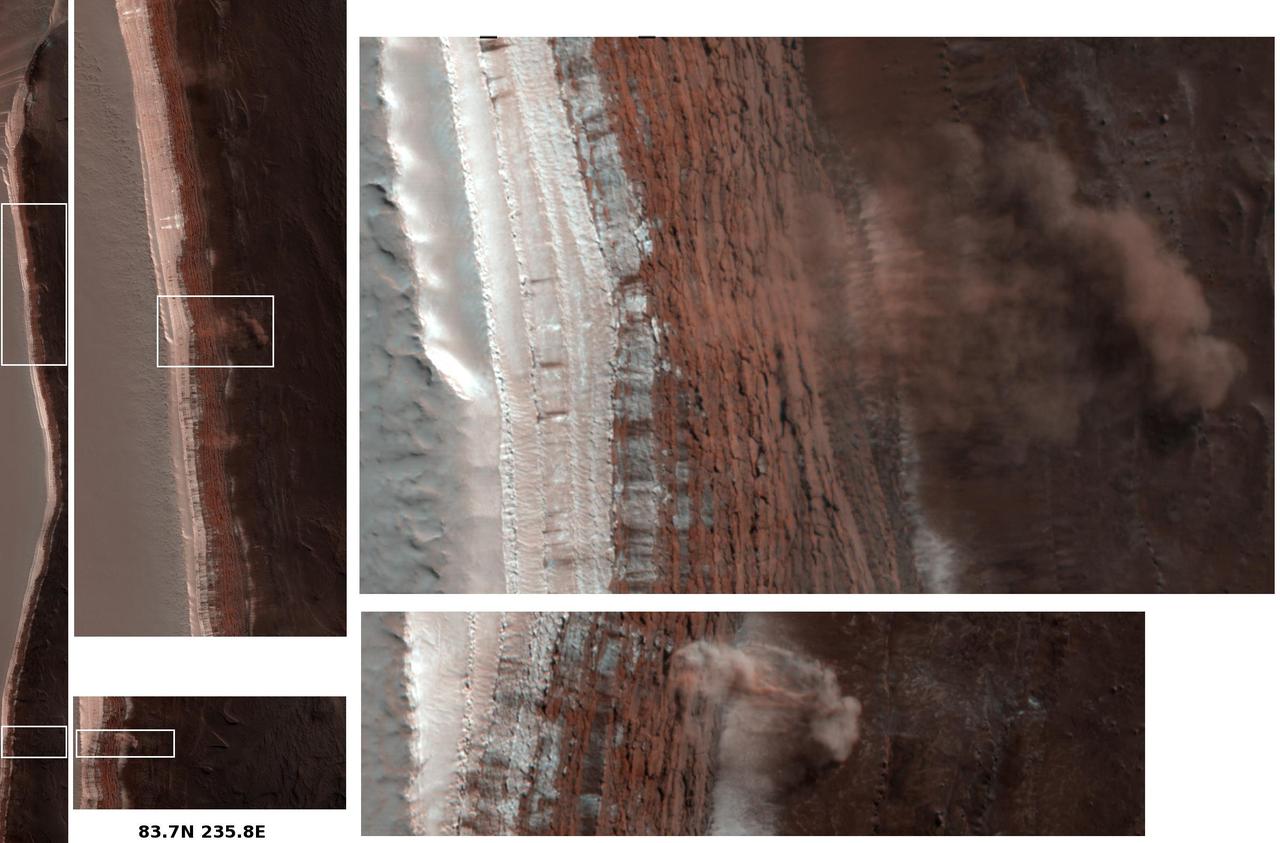
The High-Resolution Imaging Science Experiment (Hi-RISE) camera aboard NASA's Mars Reconnaissance Orbiter captured this avalanche plunging down a 1,640-foot-tall (500-meter-tall) cliff on May 29, 2019. The image also reveals layers at Mars' north pole during spring. As temperatures increase and vaporize ice, the destabilized ice blocks break loose and kick up dust. https://photojournal.jpl.nasa.gov/catalog/PIA24035

This image shows the remains of an ancient delta in Mars' Jezero Crater, which NASA's Perseverance Mars rover will explore for signs of fossilized microbial life. The image was taken by the High Resolution Stereo Camera aboard the ESA (European Space Agency) Mars Express orbiter. The European Space Operations Centre in Darmstadt, Germany, operates the ESA mission. The High Resolution Stereo Camera was developed by a group with leadership at the Freie Universitat Berlin. https://photojournal.jpl.nasa.gov/catalog/PIA24096
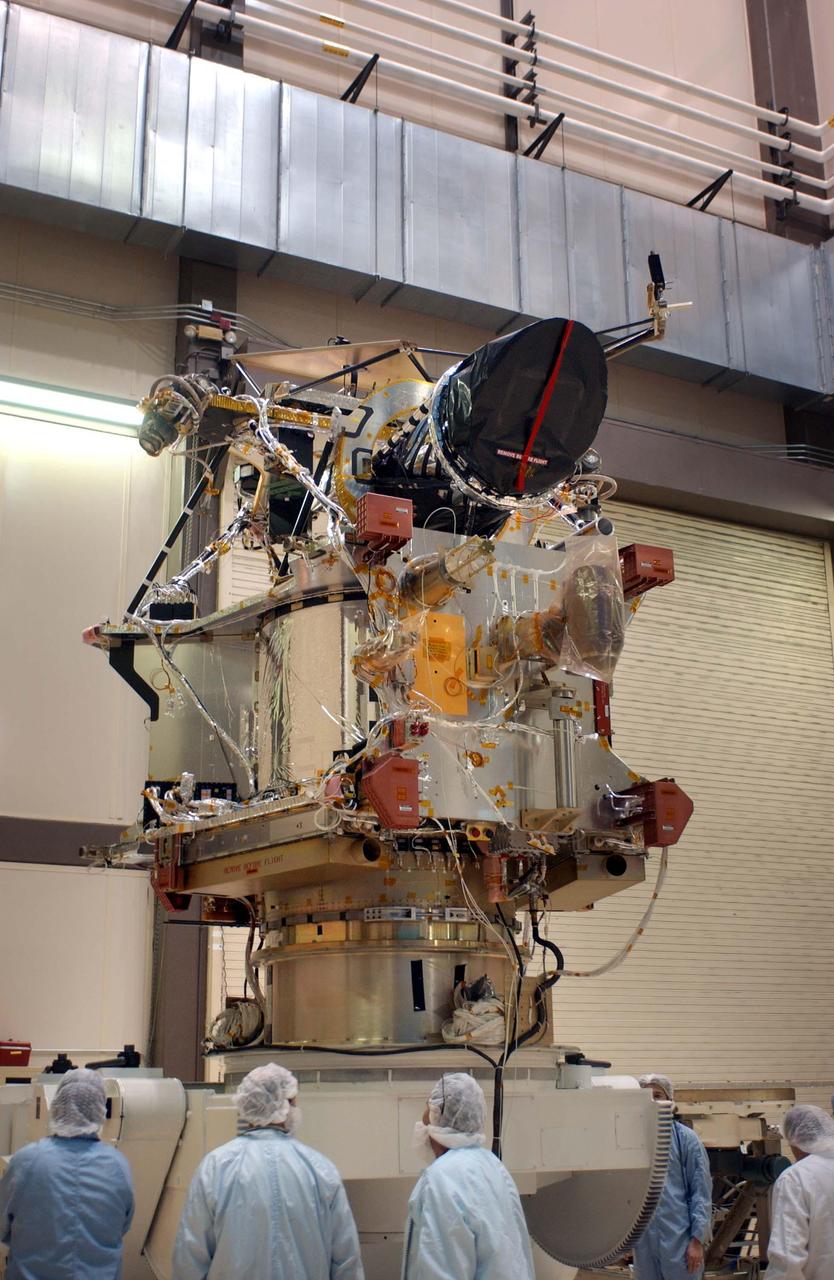
A telescopic camera called the High Resolution Imaging Science Experiment, or HiRISE, was installed onto the main structure of NASA Mars Reconnaissance Orbiter on Dec. 11, 2004 at Lockheed Martin Space Systems, Denver, Colo. HiRISE is at the top of the spacecraft in this image. Some other large components, including solar panels and the high-gain antenna, had not yet been installed. The orbiter is scheduled for launch in August 2005 carrying six science instruments. Ball Aerospace and Technology Corp., Boulder, Colo., built HiRISE for the University of Arizona, Tucson, to supply for the mission. http://photojournal.jpl.nasa.gov/catalog/PIA07210
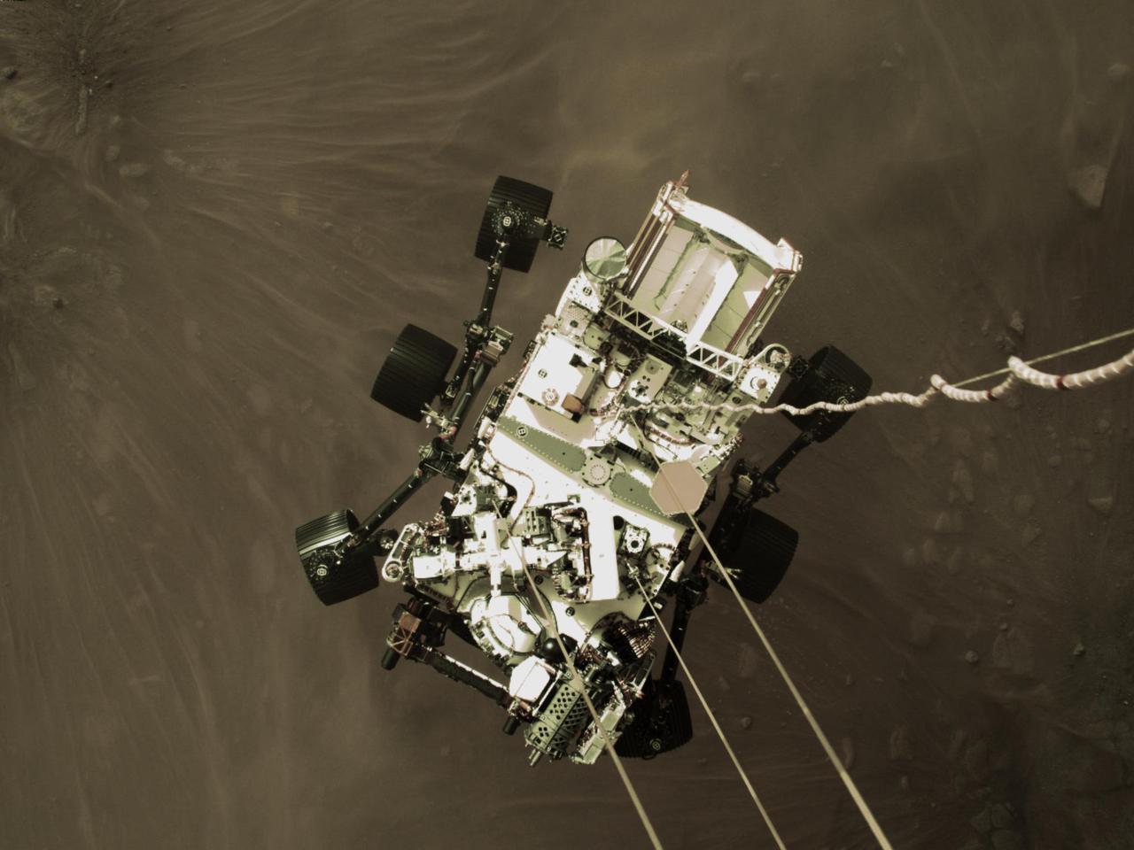
This high-resolution still image is part of a video taken by several cameras as NASA's Perseverance rover touched down on Mars on Feb. 18, 2021. A camera aboard the descent stage captured this shot. A key objective for Perseverance's mission on Mars is astrobiology, including the search for signs of ancient microbial life. The rover will characterize the planet's geology and past climate, pave the way for human exploration of the Red Planet, and be the first mission to collect and cache Martian rock and regolith (broken rock and dust). Subsequent NASA missions, in cooperation with ESA (the European Space Agency), would send spacecraft to Mars to collect these cached samples from the surface and return them to Earth for in-depth analysis. The Mars 2020 mission is part of a larger program that includes missions to the Moon as a way to prepare for human exploration of the Red Planet. https://photojournal.jpl.nasa.gov/catalog/PIA24428
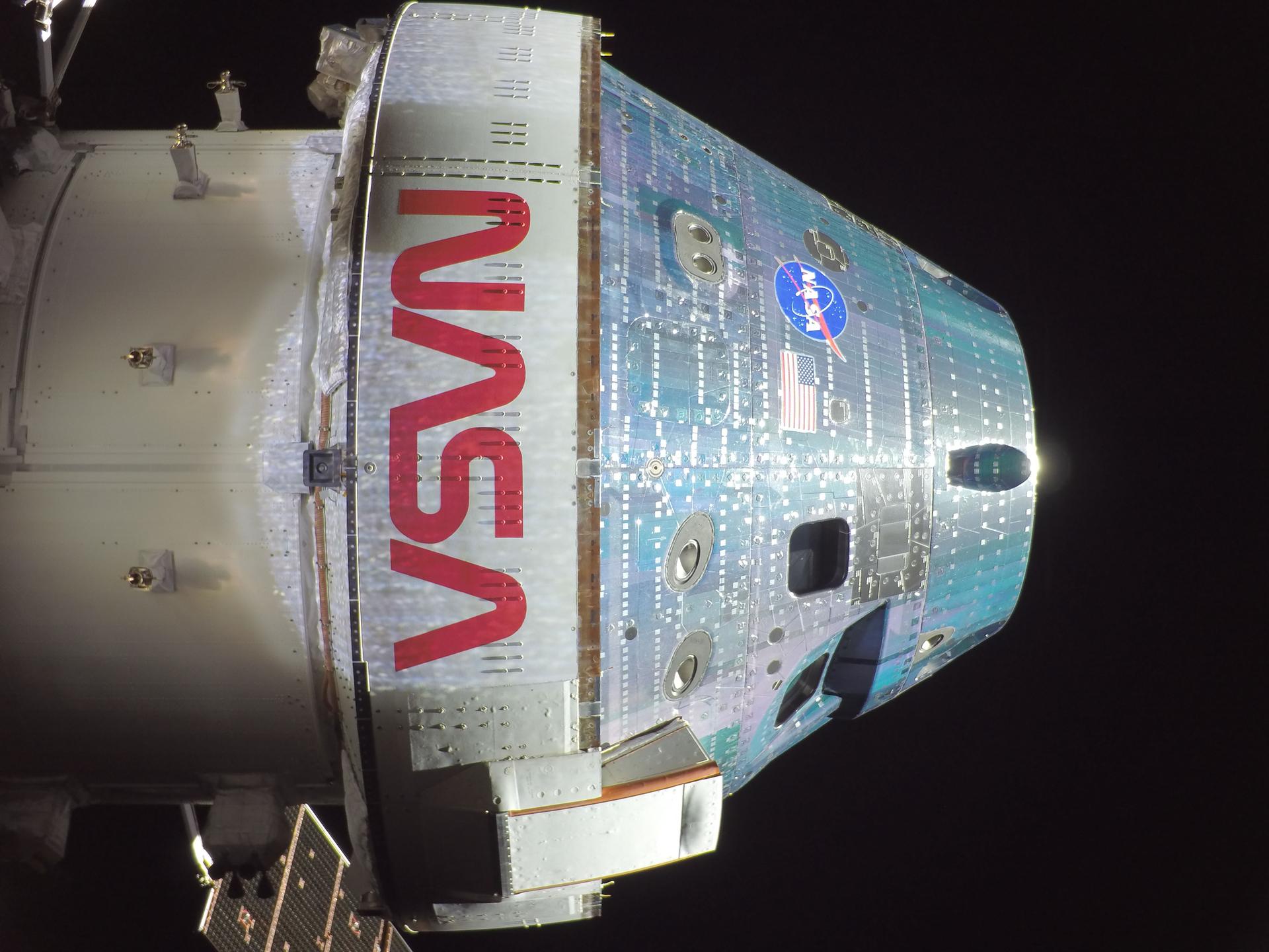
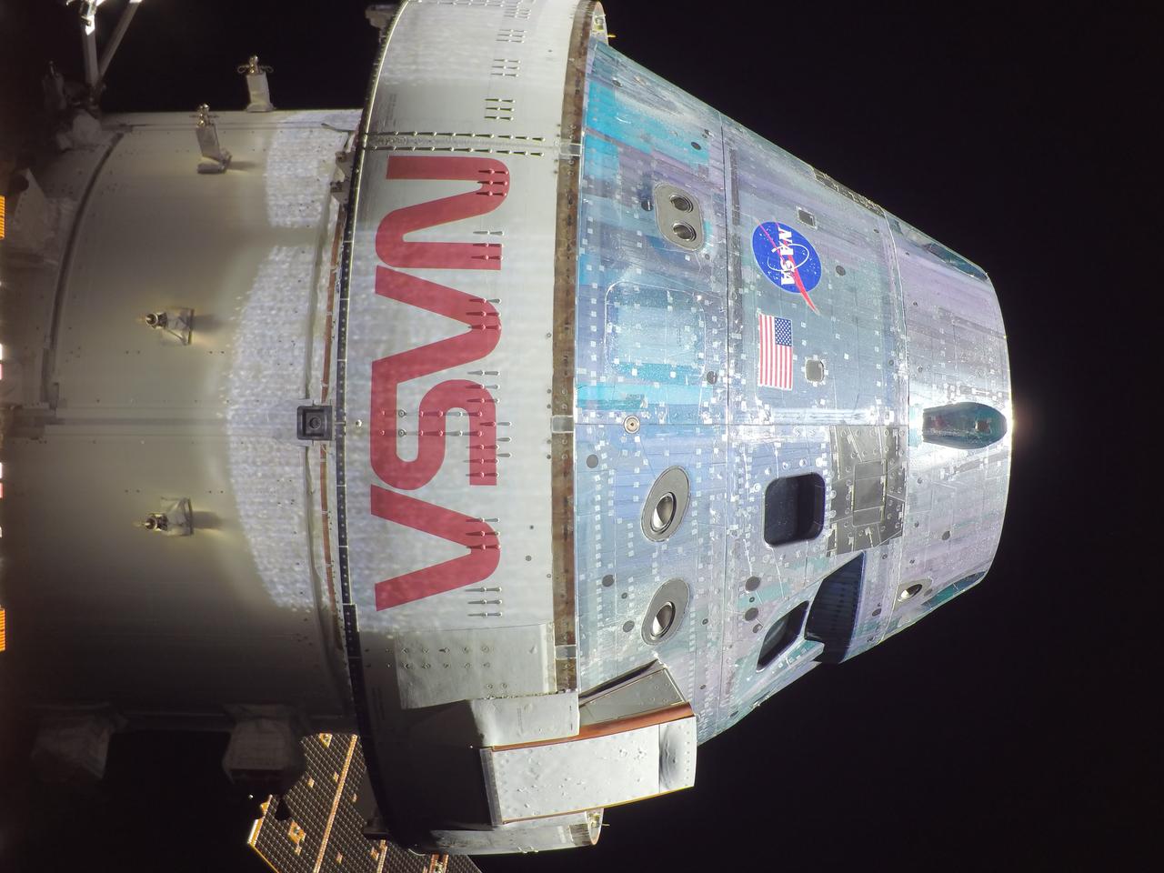
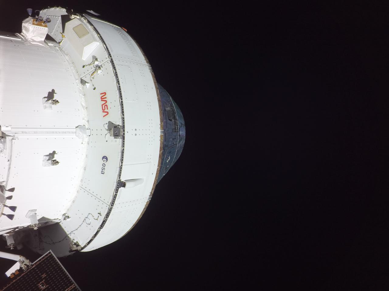
art002e004357 (April 3, 2026) - Orion snapped this high-resolution selfie in space with a camera mounted on one of its solar array wings during a routine external inspection of the spacecraft on the second day into the Artemis II mission.
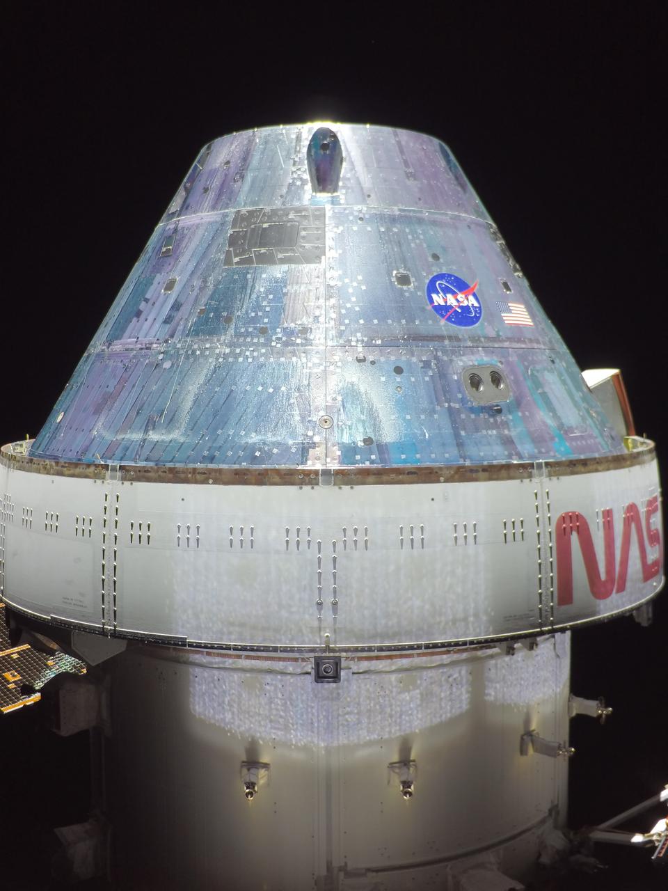
Orion snapped this high-resolution selfie in space with a camera mounted on its solar array wing during a routine external inspection of the spacecraft on the third day into the Artemis I mission.
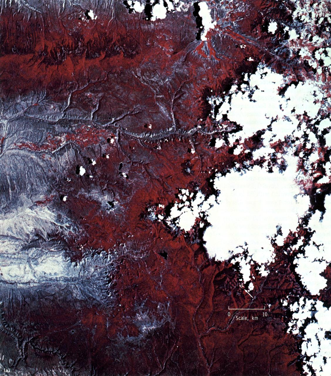
This high-resolution color infrared photograph of the Uncompahgre Plateau area of Colorado was taken by the Multi-spectral Photographic Camera (Skylab EREP Experiment S190A) of the Skylab's Multi-spectral Photographic Facility during the Skylab-3 mission.
Orion snapped this high-resolution selfie in space with a camera mounted on its solar array wing during a routine external inspection of the spacecraft on the third day into the Artemis I mission.
Orion snapped this high-resolution selfie in space with a camera mounted on its solar array wing during a routine external inspection of the spacecraft on the third day into the Artemis I mission.
This animation, constructed using stereo imaging data from the High Resolution Imaging Science Experiment (HiRISE) camera on NASA's Mars Reconnaissance Orbiter, provides an airborne perspective of the Mars 2020 landing site and its exploration area at Jezero Crater. Mars 2020 is expected to land to the southeast of an ancient river delta, a fan-shaped feature inside the northeast rim of Jezero Crater that provides solid evidence of a river and lake system active in and around the crater billions of years ago. The solid white line on the surface indicates a path the rover could take during its prime mission. Animation available at https://photojournal.jpl.nasa.gov/catalog/PIA22905
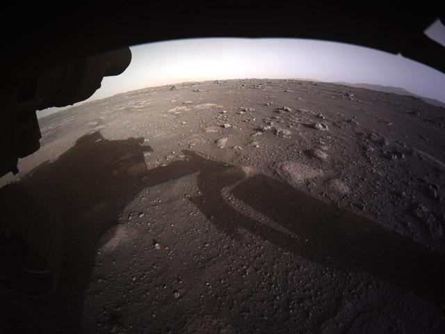
This is the first high-resolution, color image to be sent back by the Hazard Cameras (Hazcams) on the underside of NASA's Perseverance Mars rover after its landing on Feb. 18, 2021. A key objective for Perseverance's mission on Mars is astrobiology, including the search for signs of ancient microbial life. The rover will characterize the planet's geology and past climate, pave the way for human exploration of the Red Planet, and be the first mission to collect and cache Martian rock and regolith (broken rock and dust). Subsequent NASA missions, in cooperation with ESA (the European Space Agency), would send spacecraft to Mars to collect these cached samples from the surface and return them to Earth for in-depth analysis. https://photojournal.jpl.nasa.gov/catalog/PIA24430
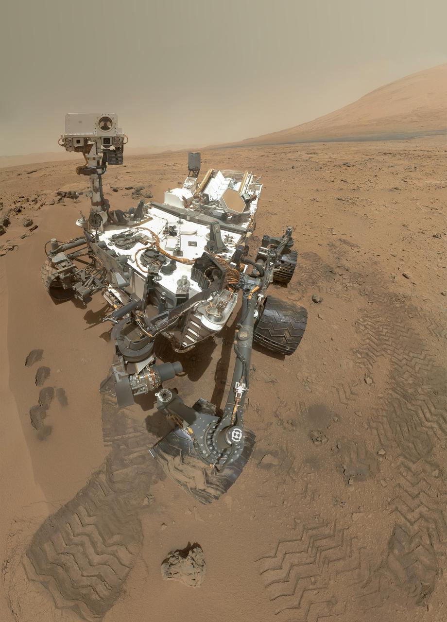
NASA Curiosity rover used its Mars Hand Lens Imager MAHLI to capture a set of 55 high-resolution images, which were stitched together to create a full-color self-portrait.
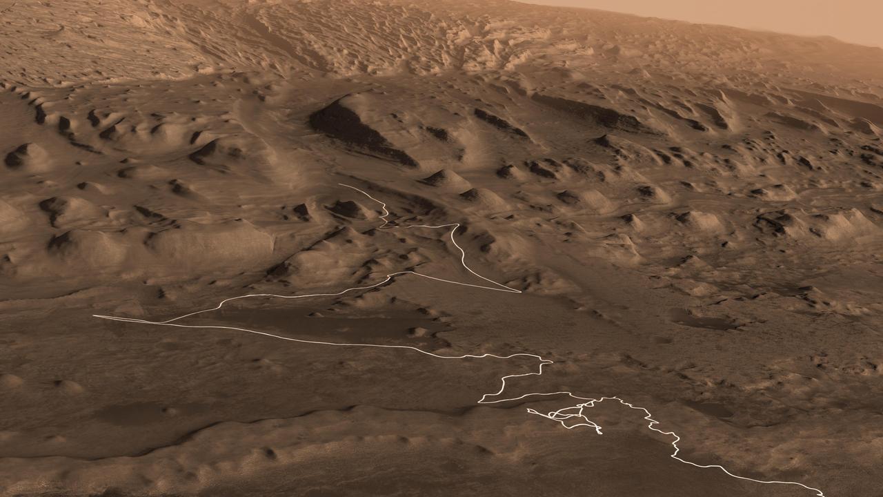
This animation shows a proposed route for NASA's Curiosity rover, which is climbing lower Mount Sharp on Mars. The annotated version of the map labels different regions that scientists working with the rover would like to explore in coming years. A flyover video explains them in more detail. Data used in creating this map came from several instruments on NASA's Mars Reconnaissance Orbiter (MRO), including the High Resolution Imaging Science Experiment (HiRISE), Compact Reconnaissance Imaging Spectrometer for Mars (CRISM) and the Context Camera (CTX). The High Resolution Stereo Camera (HRSC) instrument on the European Space Agency's Mars Express also contributed data. Animation available at https://photojournal.jpl.nasa.gov/catalog/PIA23179
jsc2024e016243 (2/14/2024) --- Close-up view of the final Multi-Resolution Scanning payload with its stereo vision cameras at left and right. The Multi-Resolution Scanning payload uses multiple different sensor types to generate high-resolution 3D data and more accurate trajectory data to understand how the Astrobee robot moves around in 3D space.

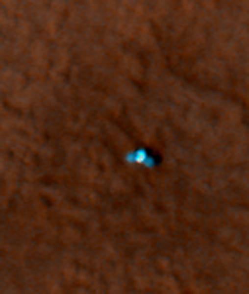
The tiny black speck in the lower left corner of this image within the red circle is a cluster of recently formed craters spotted on Mars using a new machine-learning algorithm. This image was taken by the Context Camera aboard NASA's Mars Reconnaissance Orbiter in a region called Noctis Fossae, located at latitude -3.213, longitude: 259.415. The medium-angle Context Camera can view hundreds of miles of terrain in low resolution; scientists then scan the image for interesting features and can request another MRO camera, the High-Resolution Imaging Science Experiment (HiRISE), to zoom in for a more detailed view. The HiRISE view of the black speck in this image can be seen in PIA24040. https://photojournal.jpl.nasa.gov/catalog/PIA24091

This first high-resolution image, taken on the first day of the Artemis I mission, was captured by a camera on the tip of one of Orion’s solar arrays. The spacecraft was 57,000 miles from Earth when the image was captured, and continues to distance itself from planet Earth as it approaches the Moon and distant retrograde orbit.
These dark streaks, also known as "slope streaks," on Mars resulted from dust avalanches. They were captured by NASA's Mars Reconnaissance Orbiter using its High-Resolution Imaging Science Experiment (HiRISE) camera on Dec. 26, 2017. https://photojournal.jpl.nasa.gov/catalog/PIA25235
These dark streaks, also known as "slope streaks," in an area of Mars called Acheron Fossae resulted from dust avalanches. The High-Resolution Imaging Science Experiment (HiRISE) camera aboard NASA's Mars Reconnaissance Orbiter captured them on Dec. 3, 2006. https://photojournal.jpl.nasa.gov/catalog/PIA25234

ISS045E028189 (09/24/2015 --- NASA astronaut Kjell Lindgren prepares to film with a RED Dragon camera, capable of capturing Ultra High-Definition (UHD) video. This new capability will allow researchers to acquire high resolution - high frame rate video to provide new insight into the vast array of experiments taking place every day. It will also bestow the most breathtaking views of planet Earth and space station activities ever acquired for consumption by those still dreaming of making the trip to outer space.
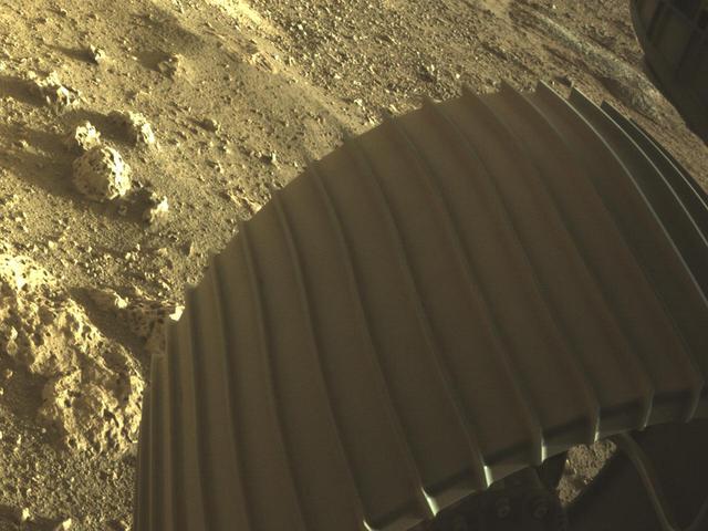
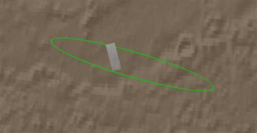
This high-resolution image shows one of the six wheels aboard NASA's Perseverance Mars rover, which landed on Feb. 18, 2021. The image was taken by one of Perseverance's color Hazard Cameras (Hazcams). A key objective for Perseverance's mission on Mars is astrobiology, including the search for signs of ancient microbial life. The rover will characterize the planet's geology and past climate, pave the way for human exploration of the Red Planet, and be the first mission to collect and cache Martian rock and regolith (broken rock and dust). Subsequent NASA missions, in cooperation with ESA (the European Space Agency), would send spacecraft to Mars to collect these cached samples from the surface and return them to Earth for in-depth analysis. https://photojournal.jpl.nasa.gov/catalog/PIA24429
This image is one of the highest-resolution MDIS observations to date! Many craters of varying degradation states are visible, as well as gentle terrain undulations. Very short exposure times are needed to make these low-altitude observations while the spacecraft is moving quickly over the surface; thus the images are slightly noisier than typical MDIS images. This image was acquired as a high-resolution targeted observation. Targeted observations are images of a small area on Mercury's surface at resolutions much higher than the 200-meter/pixel morphology base map. It is not possible to cover all of Mercury's surface at this high resolution, but typically several areas of high scientific interest are imaged in this mode each week. Date acquired: March 15, 2014 Image Mission Elapsed Time (MET): 37173522 Image ID: 5936740 Instrument: Narrow Angle Camera (NAC) of the Mercury Dual Imaging System (MDIS) Center Latitude: 71.91° Center Longitude: 232.7° E Resolution: 5 meters/pixel Scale: The image is approximately 8.3 km (5.2 mi.) across. Incidence Angle: 79.4° Emission Angle: 4.0° Phase Angle: 83.4° http://photojournal.jpl.nasa.gov/catalog/PIA18370
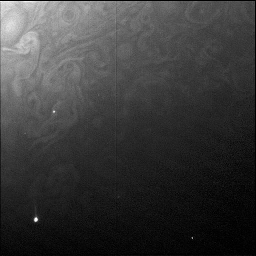
Juno's Radiation Monitoring Investigation used the Stellar Reference Unit (SRU) star camera to collect this high resolution image of the dark side of Jupiter during Perijove 11 on Feb. 7, 2018. The clouds are illuminated by moonlight from Jupiter's moon Io and the two bright spots are flashes of Jovian lightning. Juno was 41,000 miles (66,000 kilometers) from the cloud tops when this SRU image was collected. This is the closest view of Jupiter's lightning from a visible light camera to date. https://photojournal.jpl.nasa.gov/catalog/PIA22964
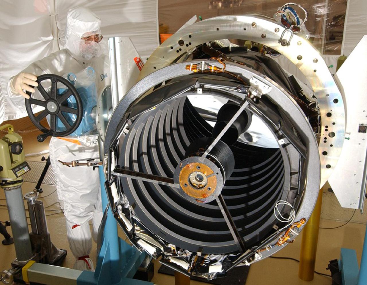
KENNEDY SPACE CENTER, FLA. - The High Resolution Imaging Science Experiment (HiRISE) camera is examined by a worker from Ball Aerospace and Technologies Corp. Scheduled to launch Aug. 10 aboard an Atlas V rocket from Launch Complex 41 at Cape Canaveral Air Force Station in Florida, HiRISE is designed to take high-resolution images of the surface of Mars from orbit provide unprecedented image quality, resolution and coverage at sub-meter scales. The MRO will search for evidence of water, study the climate record, and identify landing sites for future missions. The MRO is scheduled for launch aboard an Atlas V rocket from Launch Complex 41 at Cape Canaveral Air Force Station in Florida. The MRO is an important next step in fulfilling NASA’s vision of space exploration and ultimately sending human explorers to Mars and beyond.
KENNEDY SPACE CENTER, FLA. - A worker from Ball Aerospace and Technologies Corp. examines the High Resolution Imaging Science Experiment (HiRISE) camera that is launching on the Mars Reconnaissance Orbiter Aug. 10. HiRISE is designed to take high-resolution images of the surface of Mars from orbit provide unprecedented image quality, resolution and coverage at sub-meter scales. The MRO will search for evidence of water, study the climate record, and identify landing sites for future missions. The MRO is scheduled for launch aboard an Atlas V rocket from Launch Complex 41 at Cape Canaveral Air Force Station in Florida. The MRO is an important next step in fulfilling NASA’s vision of space exploration and ultimately sending human explorers to Mars and beyond.
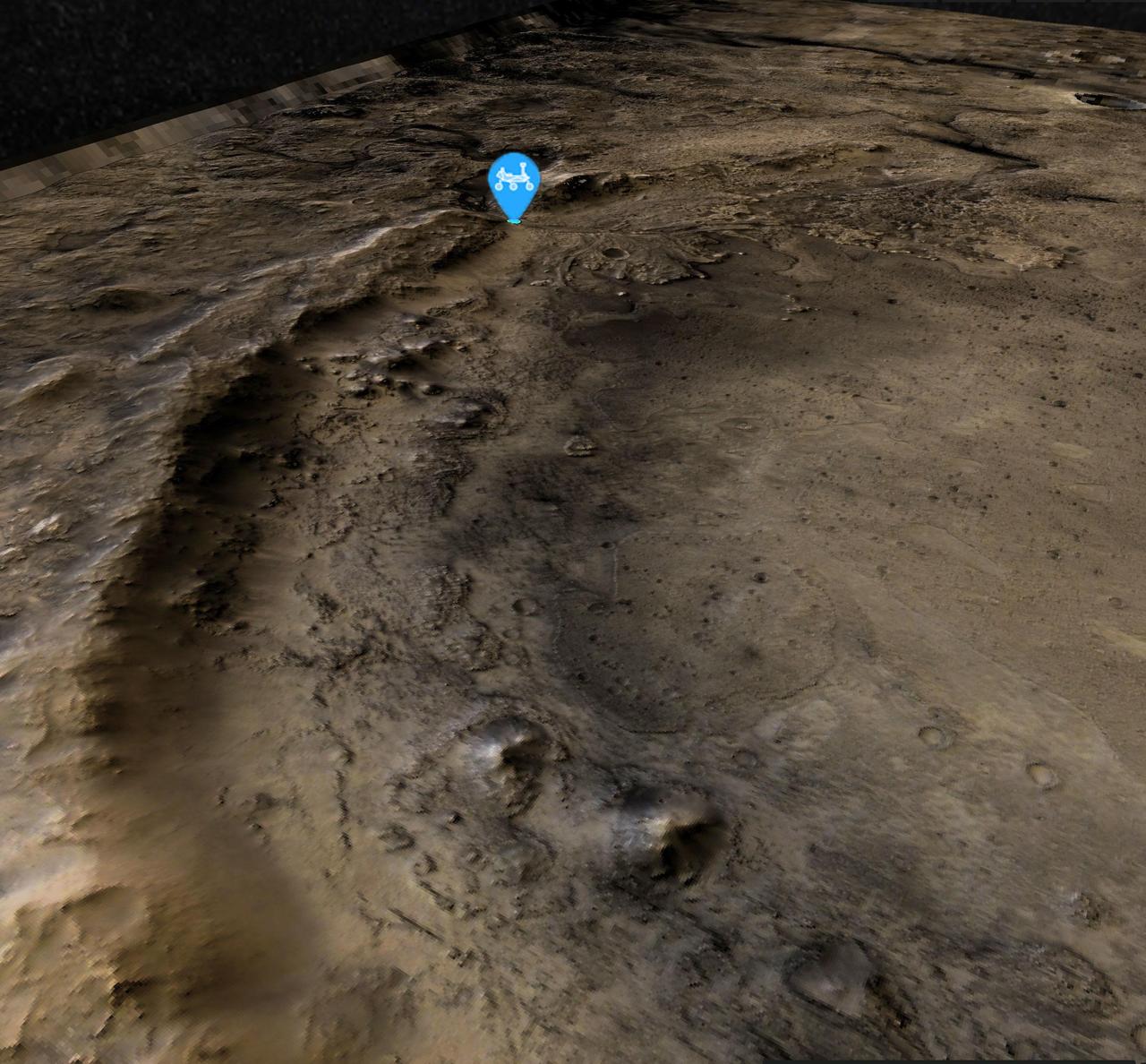
This view of the western edge of Mars' Jezero Crater shows the steep crater rim, which stands roughly 1,000 feet (300 meters) tall. The view looks northwest from the southern edge of the crater. A blue icon shows Perseverance's general location as of Aug. 14, 2024, the 1,238th Martian day, or sol, of the mission. The rover began its ascent of the crater rim on Aug. 27, 2024. Perseverance will encounter slopes of up to 23 degrees (rover drivers plan routes to avoid slopes that would tilt the rover more than 30 degrees) on its way to summit at a place nicknamed "Aurora Park." The high-resolution base map was created with images from the HiRISE (High-Resolution Imaging Science Experiment) camera on NASA's Mars Reconnaissance Orbiter, while the broader color base map is from the High-Resolution Stereo camera on ESA's (the European Space Agency's) Mars Express. Color processing has been applied to both maps to highlight surface features. https://photojournal.jpl.nasa.gov/catalog/PIA26402
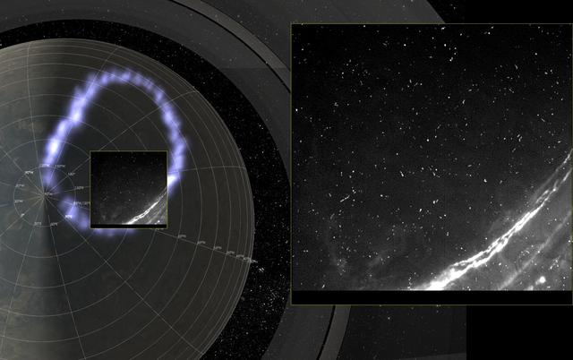
Juno's Radiation Monitoring Investigation used the Stellar Reference Unit (SRU) star camera to collect this high-resolution image Jupiter's northern auroral oval on May 24, 2018 (Perijove 13). Also present in the image are several small bright dots and streaks -- signatures of high energy relativistic electrons from polar beams that are penetrating the camera. The large bright dot in the lower right corner of the image is a flash of Jupiter's lightning. Juno was less than 37,000 miles (60,000 km) from the cloud tops when this SRU image was collected -- the closest view of Jupiter's aurora with a visible light imager. https://photojournal.jpl.nasa.gov/catalog/PIA22968
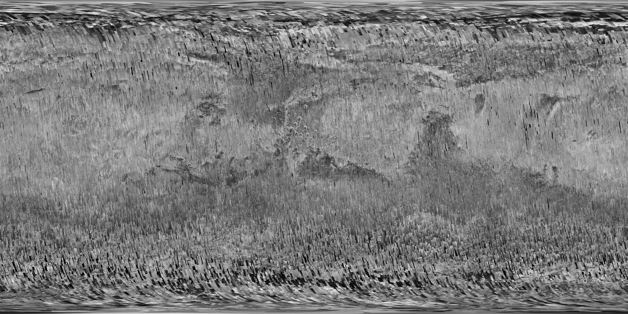
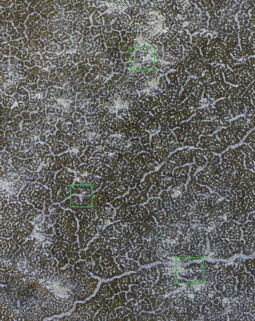
In early 2017, after more than a decade of observing Mars, the Context Camera (CTX) on NASA's Mars Reconnaissance Orbiter (MRO) surpassed 99 percent coverage of the entire planet. This mosaic shows that global coverage. No other camera has ever imaged so much of Mars in such high resolution. The mosaic offers a resolution that enables zooming in for more detail of any region of Mars. It is still far from the full resolution of individual CTX observations, which can reveal the shapes of features smaller than the size of a tennis court. As of March 2017, the Context Camera has taken about 90,000 images since the spacecraft began examining Mars from orbit in late 2006. In addition to covering 99.1 percent of the surface of Mars at least once, this camera has observed more than 60 percent of Mars more than once, checking for changes over time and providing stereo pairs for 3-D modeling of the surface. http://photojournal.jpl.nasa.gov/catalog/PIA21488
As MESSENGER passes progressively closer to Mercury, we see ever more resolved features in the images the spacecraft returns. Here, at a pixel scale of 9 meters, we see the eastern portion of an unnamed crater 13 km (8 mi.) in diameter. The wall of the crater is replete with smaller, superposed craters, some of which appear elongate possibly because they impacted on the larger crater's inclined wall. Interestingly, there are bright spots on the sunlight portion of this crater's wall -- which is where we might expect hollows to form. This image was acquired as a high-resolution targeted observation. Targeted observations are images of a small area on Mercury's surface at resolutions much higher than the 200-meter/pixel morphology base map. It is not possible to cover all of Mercury's surface at this high resolution, but typically several areas of high scientific interest are imaged in this mode each week. Date acquired: March 3, 2014 Image Mission Elapsed Time (MET): 36136338 Image ID: 5862963 Instrument: Narrow Angle Camera (NAC) of the Mercury Dual Imaging System (MDIS) Center Latitude: 56.3° Center Longitude: 301.6° E Resolution: 9 meters/pixel Scale: The field of view in this image is 11 km (7 mi.) across Incidence Angle: 59.3° Emission Angle: 43.0° Phase Angle: 102.3° North is to the right in this scene. http://photojournal.jpl.nasa.gov/catalog/PIA18372
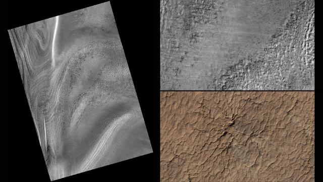
This series of images from NASA's Mars Reconnaissance Orbiter successively zooms into "spider" features -- or channels carved in the surface in radial patterns -- in the south polar region of Mars. In a new citizen-science project, volunteers will identify features like these using wide-scale images from the orbiter. Their input will then help mission planners decide where to point the orbiter's high-resolution camera for more detailed views of interesting terrain. Volunteers will start with images from the orbiter's Context Camera (CTX), which provides wide views of the Red Planet. The first two images in this series are from CTX; the top right image zooms into a portion of the image at left. The top right image highlights the geological spider features, which are carved into the terrain in the Martian spring when dry ice turns to gas. By identifying unusual features like these, volunteers will help the mission team choose targets for the orbiter's High Resolution Imaging Science Experiment (HiRISE) camera, which can reveal more detail than any other camera ever put into orbit around Mars. The final image is this series (bottom right) shows a HiRISE close-up of one of the spider features. http://photojournal.jpl.nasa.gov/catalog/PIA19823
KENNEDY SPACE CENTER, FLA. - In the Vehicle Assembly Building at NASA’s Kennedy Space Center, a worker mounts a digital still camera in the External Tank (ET) umbilical well on the aft end of Space Shuttle Discovery. The camera is being used to obtain and downlink high-resolution images of the disconnect point on the ET following the ET separation from the orbiter after launch. The Kodak camera will record 24 images, at one frame per 1.5 seconds, on a flash memory card. After orbital insertion, the crew will transfer the images from the memory card to a laptop computer. The files will then be downloaded through the Ku-band system to the Mission Control Center in Houston for analysis.
KENNEDY SPACE CENTER, FLA. - In the Vehicle Assembly Building at NASA’s Kennedy Space Center, workers check the digital still camera they will mount in the External Tank (ET) umbilical well on the aft end of Space Shuttle Discovery. The camera is being used to obtain and downlink high-resolution images of the disconnect point on the ET following the tank's separation from the orbiter after launch. The Kodak camera will record 24 images, at one frame per 1.5 seconds, on a flash memory card. After orbital insertion, the crew will transfer the images from the memory card to a laptop computer. The files will then be downloaded through the Ku-band system to the Mission Control Center in Houston for analysis.
KENNEDY SPACE CENTER, FLA. - In the Vehicle Assembly Building at NASA’s Kennedy Space Center, a digital still camera has been mounted in the External Tank (ET) umbilical well on the aft end of Space Shuttle Discovery. The camera is being used to obtain and downlink high-resolution images of the disconnect point on the ET following ET separation from the orbiter after launch. The Kodak camera will record 24 images, at one frame per 1.5 seconds, on a flash memory card. After orbital insertion, the crew will transfer the images from the memory card to a laptop computer. The files will then be downloaded through the Ku-band system to the Mission Control Center in Houston for analysis.
KENNEDY SPACE CENTER, FLA. - In the Orbiter Processing Facility, an External Tank (ET) digital still camera is positioned into the right-hand liquid oxygen umbilical well on Space Shuttle Atlantis to determine if it fits properly. NASA is pursuing use of the camera, beginning with the Shuttle’s Return To Flight, to obtain and downlink high-resolution images of the ET following separation of the ET from the orbiter after launch. The Kodak camera will record 24 images, at one frame per 1.5 seconds, on a flash memory card. After orbital insertion, the crew will transfer the images from the memory card to a laptop computer. The files will then be downloaded through the Ku-band system to the Mission Control Center in Houston for analysis.

KENNEDY SPACE CENTER, FLA. - In the Vehicle Assembly Building at NASA’s Kennedy Space Center, workers prepare a digital still camera they will mount in the External Tank (ET) umbilical well on the aft end of Space Shuttle Discovery. The camera is being used to obtain and downlink high-resolution images of the disconnect point on the ET following its separation from the orbiter after launch. The Kodak camera will record 24 images, at one frame per 1.5 seconds, on a flash memory card. After orbital insertion, the crew will transfer the images from the memory card to a laptop computer. The files will then be downloaded through the Ku-band system to the Mission Control Center in Houston for analysis.
KENNEDY SPACE CENTER, FLA. - In the Vehicle Assembly Building at NASA’s Kennedy Space Center, workers prepare a digital still camera they will mount in the External Tank (ET) umbilical well on the aft end of Space Shuttle Discovery. The camera is being used to obtain and downlink high-resolution images of the disconnect point on the ET following the ET separation from the orbiter after launch. The Kodak camera will record 24 images, at one frame per 1.5 seconds, on a flash memory card. After orbital insertion, the crew will transfer the images from the memory card to a laptop computer. The files will then be downloaded through the Ku-band system to the Mission Control Center in Houston for analysis.
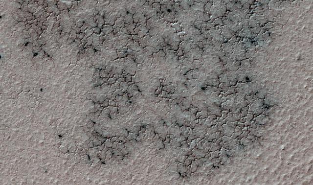
This image shows spidery channels eroded into Martian ground. It is an example from high-resolution observation of more than 20 places that were chosen in 2016 on the basis of about 10,000 volunteers' examination of lower-resolution images of larger areas near Mars' south pole. These sharper looks use the High Resolution Imaging Science Experiment (HiRISE) camera on NASA's Mars Reconnaissance Orbiter. The volunteers, through the Planet Four: Terrains website, categorize surface features in images from the same orbiter's Context Camera (CTX). This image is a portion of HiRISE observation ESP_047487_1005, taken on Sept. 12, 2016, of a site at 79.4 degrees south latitude, 18.8 degrees east longitude. The ground area shown is about half a mile (0.8 kilometer) wide. This terrain type, called spiders or "araneiform" (from the Latin word for spiders), appears in some areas of far-southern Mars that are covered by sheets of frozen carbon dioxide ("dry ice") during the winter. When the slab ice thaws from the underneath side in the spring, carbon dioxide gas trapped beneath the ice builds pressure until it rushes toward a fissure or vent where it bursts out. The venting gas carries dust and sand that it picks up as it carves these channels. At this location, the spiders are surrounded by ground called "basketball terrain" because of its texture. http://photojournal.jpl.nasa.gov/catalog/PIA21126
Inside the Space Station Processing Facility high bay at NASA's Kennedy Space Center in Florida, the Multiple User System for Earth Sensing, or MUSES, payload is being prepared for transfer out of the high bay. MUSES will be delivered to the International Space Station aboard the SpaceX Dragon cargo carrier on the company’s 11th commercial resupply services mission to the space station. MUSES, developed by Teledyne Brown, is part of the company's new commercial space-based digital imaging business. MUSES hosts earth-viewing instruments, such as high-resolution digital cameras, hyperspectral imagers, and provides precision pointing and other accommodations.
Inside the Space Station Processing Facility high bay at NASA's Kennedy Space Center in Florida, the Multiple User System for Earth Sensing, or MUSES, payload is being prepared for transfer out of the high bay. MUSES will be delivered to the International Space Station aboard the SpaceX Dragon cargo carrier on the company’s 11th commercial resupply services mission to the space station. MUSES, developed by Teledyne Brown, is part of the company's new commercial space-based digital imaging business. MUSES hosts earth-viewing instruments, such as high-resolution digital cameras, hyperspectral imagers, and provides precision pointing and other accommodations.
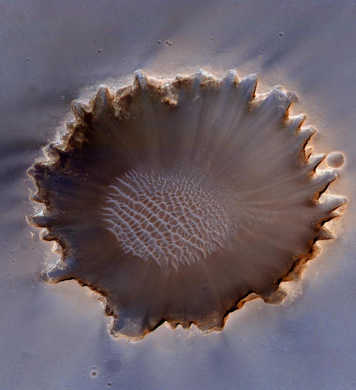
This image from the High Resolution Imaging Science Experiment (HiRISE) camera on NASA's Mars Reconnaissance Orbiter shows gullies near the edge of Hale crater on southern Mars. The view covers an area about 1 kilometer (0.6 mile) across and was taken on Aug. 3, 2009. Martian gullies carved into hill slopes and the walls of impact craters were discovered several years ago. Scientists are excited to study these features because, on Earth, they usually form through the action of liquid water -- long thought to be absent on the Martian surface. Whether liquid water carves gullies under today's cold and dry conditions on Mars is a major question that planetary scientists are trying to answer. The gullies pictured here are examples of what a typical Martian gully looks like. You can see wide V-shaped channels running downhill (from top to bottom) where the material that carved the gully flowed. At the bottom of the channel this material empties out onto a fan-shaped mound. The fans from each gully overlap one other in complicated ways. At the tops of the channels, large amphitheater-shaped alcoves are carved in the rock. The material removed from these alcoves likely flowed downhill to the aprons through the gullies. The terrain in this image is at 36.5 degrees south latitude, 322.7 degrees east longitude. Gullies at this site are especially interesting because scientists recently discovered actively changing examples at similar locations. Images separated by several years showed changes in the appearance of some of these gullies. Today, planetary scientists are using the HiRISE camera to examine gullies such as the one in this image for change that might provide a clue about whether liquid water occurs on the surface of Mars. http://photojournal.jpl.nasa.gov/catalog/PIA12194
One of the two pictures of Tempel 1 (see also PIA02101) taken by Deep Impact's medium-resolution camera is shown next to data of the comet taken by the spacecraft's infrared spectrometer. This instrument breaks apart light like a prism to reveal the "fingerprints," or signatures, of chemicals. Even though the spacecraft was over 10 days away from the comet when these data were acquired, it detected some of the molecules making up the comet's gas and dust envelope, or coma. The signatures of these molecules -- including water, hydrocarbons, carbon dioxide and carbon monoxide -- can be seen in the graph, or spectrum. Deep Impact's impactor spacecraft is scheduled to collide with Tempel 1 at 10:52 p.m. Pacific time on July 3 (1:52 a.m. Eastern time, July 4). The mission's flyby spacecraft will use its infrared spectrometer to sample the ejected material, providing the first look at the chemical composition of a comet's nucleus. These data were acquired from June 20 to 21, 2005. The picture of Tempel 1 was taken by the flyby spacecraft's medium-resolution instrument camera. The infrared spectrometer uses the same telescope as the high-resolution instrument camera. http://photojournal.jpl.nasa.gov/catalog/PIA02100
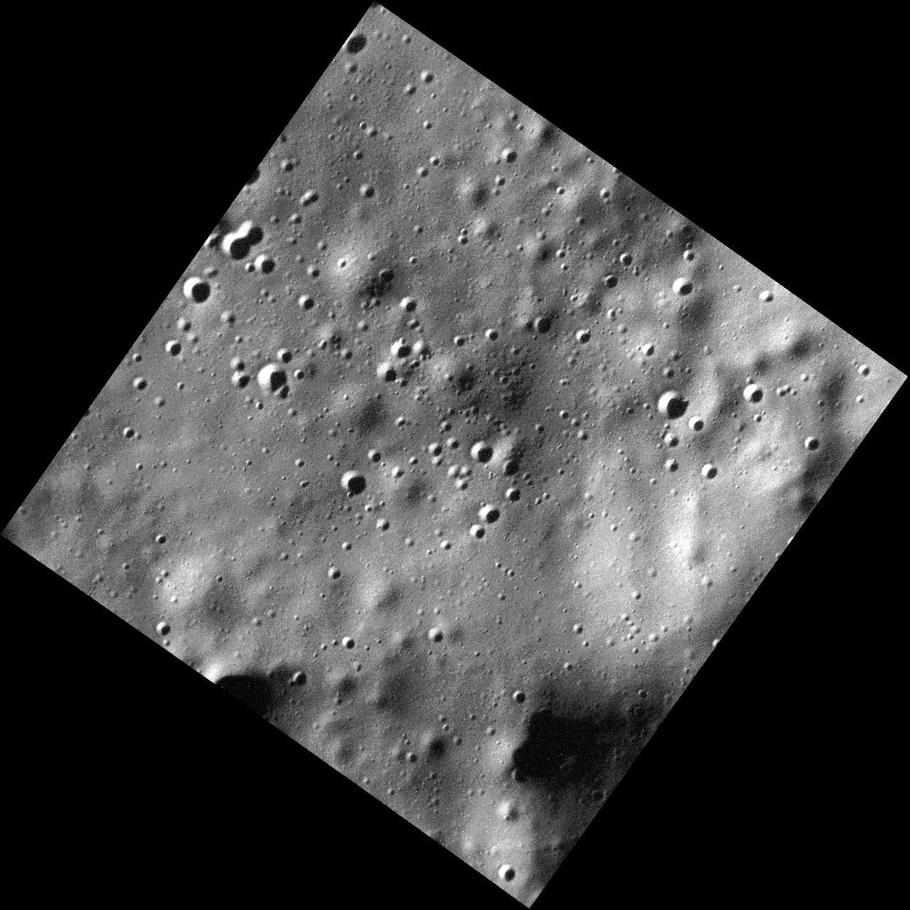
The surface shown here is located within a 73-km-diameter crater; the mounds are part of a larger central peak structure of the hosting crater. The resolution of this image resolves hollows on the central peaks, as seen in other craters such as Ahmad Baba, Mickiewicz, and others. The lower right also shows hollows that appear to form in one layer of a crater wall, such as has been viewed in other high-resolution images. This image was acquired as part of the NAC ride-along imaging campaign. When data volume is available and MDIS is not acquiring images for its other campaigns, high-resolution NAC images are obtained of the surface. These images are designed not to interfere with other instrument observations but take full advantage of periods during the mission when extra data volume is available. Date acquired: January 12, 2015 Image Mission Elapsed Time (MET): 63406030 Image ID: 7783973 Instrument: Narrow Angle Camera (NAC) of the Mercury Dual Imaging System (MDIS) Center Latitude: 59.57° Center Longitude: 319.14° E Resolution: 15 meters/pixel Scale: This image is roughly 15 km (9 miles) across Incidence Angle: 67.9° Emission Angle: 22.1° Phase Angle: 90.1° http://photojournal.jpl.nasa.gov/catalog/PIA19187
NASA's Mars Reconnaissance Orbiter captured this image of a meteoroid impact that was later associated with a seismic event detected by the agency's InSight lander using its seismometer. This crater was formed on May 27, 2020. MRO's Context Camera originally located the impact. Then, the spacecraft's High Resolution Imaging Science Experiment (HiRISE) camera captured this scene in color. The ground is not actually blue; this enhanced-color image highlights certain hues in the scene to make details more visible to the human eye – in this case, dust and soil disturbed by the impact. https://photojournal.jpl.nasa.gov/catalog/PIA25410
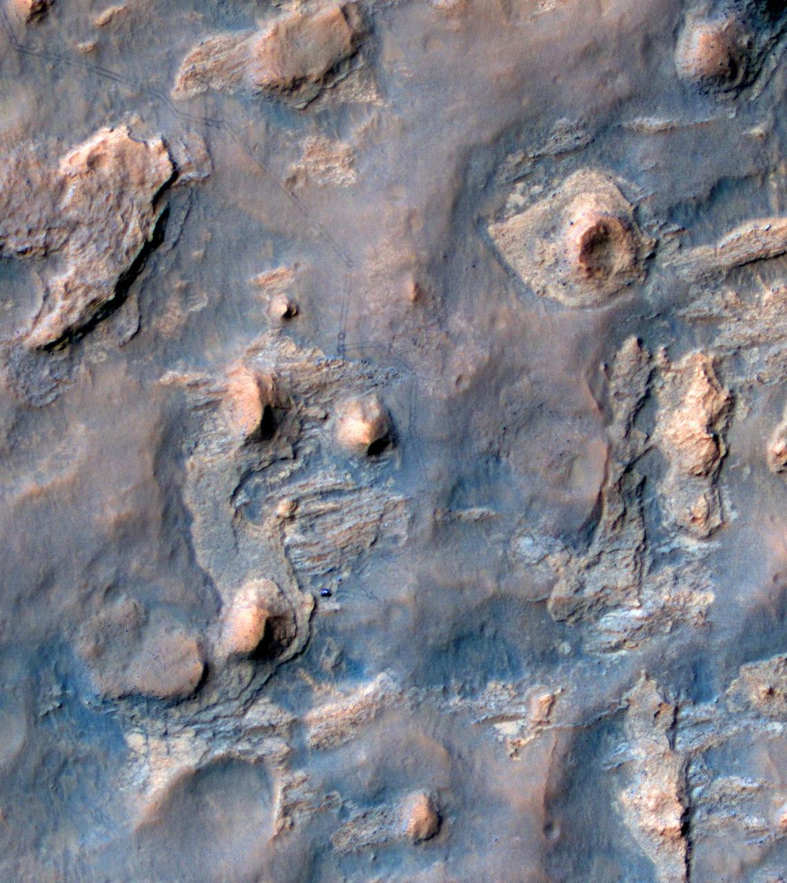
NASA's Curiosity Mars rover appears as a dark speck in this image captured from directly overhead by the agency's Mars Reconnaissance Orbiter, or MRO. The orbiter is equipped with a camera capable of viewing objects the size of a dinner table on the Red Planet's surface. The camera, called the High-Resolution Imaging Science Experiment (HiRISE), has viewed spacecraft on the surface many times before. Here, it captured Curiosity driving up a steep slope on Dec. 29, 2023, the 4,051st Martian day, or sol, of the rover's mission. Curiosity is seen in an area striped with alternating dark and light bands. Scientists are interested in learning what differentiated the materials on the surface to form these different bands. https://photojournal.jpl.nasa.gov/catalog/PIA26245
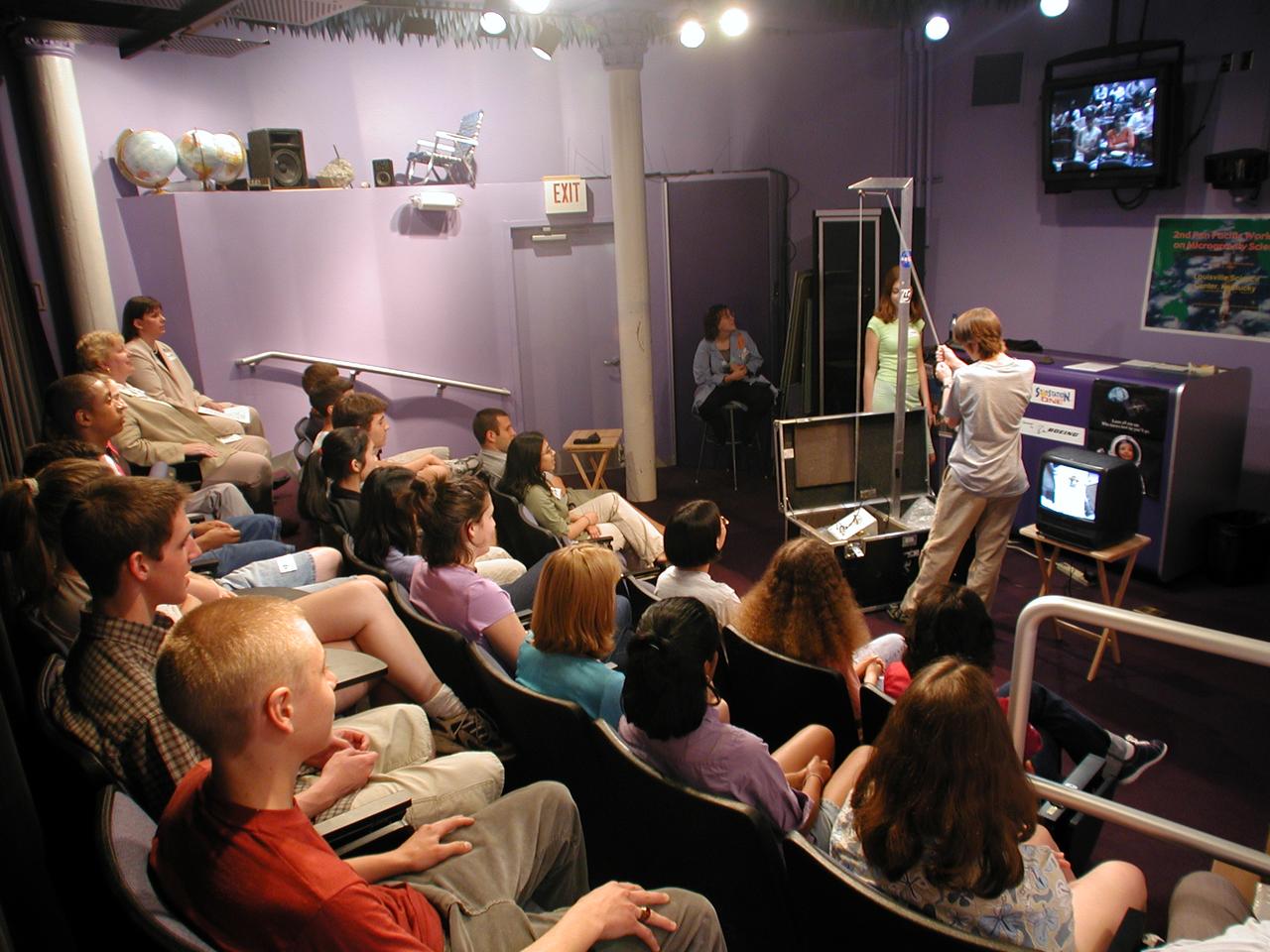
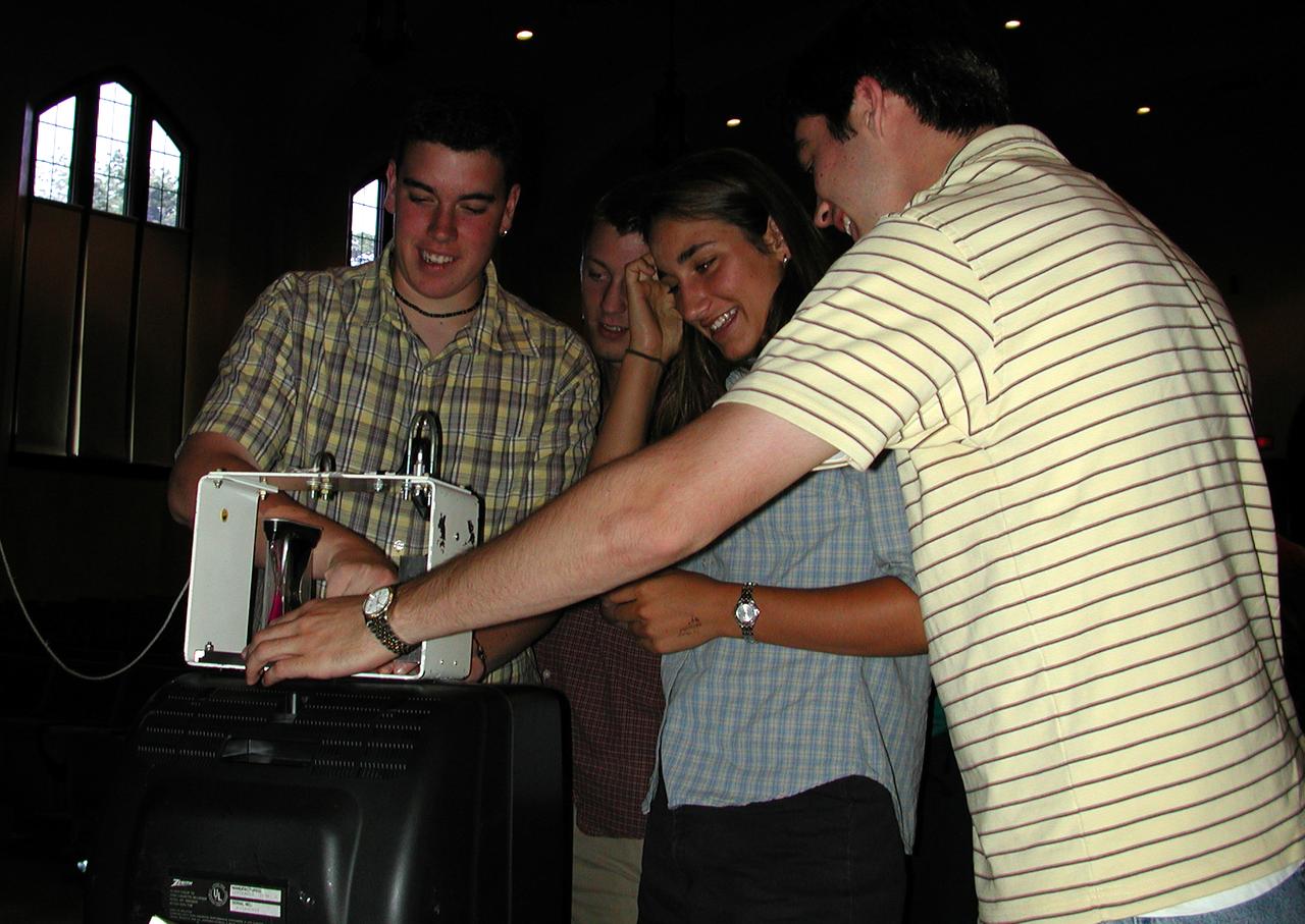
John Henson (grade 12) and Suzi Bryce (grade 10) from DuPont Manual High School in Louisville, Kentucky, conduct a drop with NASA's Microgravity Demonstrator. A camera and a TV/VCR unit let students play back recordings of how different physical devices behave differently during freefall as compared to 1-g. The activity was part of the education outreach segment of the Pan-Pacific Basin Workshop on Microgravity Sciences held in Pasadena, California. The event originated at the California Science Center in Los Angeles. The DuPont Manual students patched in to the event through the distance learning lab at the Louisville Science Center. This image is from a digital still camera; higher resolution is not available.
John Henson (grade 12) and Suzi Bryce (grade 10) conducted the drop from DuPont Manual High School in Louisville, Kentucky, conduct a drop with NASA's Microgravity Demonstrator. A camera and a TV/VCR unit let students play back recordings of how different physical devices behave differently during freefall as compared to 1-g. The activity was part of the education outreach segment of the Pan-Pacific Basin Workshop on Microgravity Sciences held in Pasadena, California. The event originated at the California Science Center in Los Angeles. The DuPont Manual students patched in to the event through the distance learning lab at the Louisville Science Center. This image is from a digital still camera; higher resolution is not available.

iss073e0981212 (Oct. 16, 2025) --- Roscosmos cosmonauts Sergey Ryzhikov (left) and Alexey Zubritsky (bottom right) work together to remove a high-resolution camera (HRC) monoblock during a six-hour and nine-minute spacewalk outside the International Space Station's Roscosmos segment. The HRC monoblock is part of a scientific optical telescope system designed to test compact radio-optical detectors for Earth observation, ecological monitoring, and emergency response.

Students from DuPont Manual High School in Louisville, Kentucky participated in a video-teleconference during the Pan-Pacific Basin Workshop on Microgravity Sciences held in Pasadena, California. The event originated at the California Science Center in Los Angeles. The DuPont Manual students patched in to the event through the distance learning lab at the Louisville Science Center. This image is from a digital still camera; higher resolution is not available.
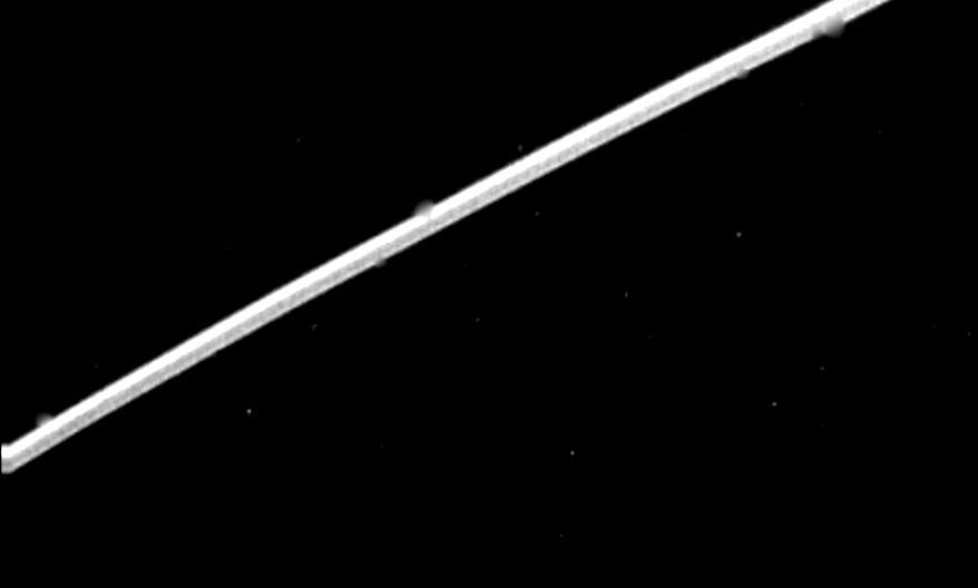
Range : 1.5 million km ( 930,000 miles ) This high resolution view of Jupitor's ring, part of a set obtained by Voyager 2 (A79-7101), suggests that it may be divided into several components, as are the rings of Saturn. The ring was unexpectedly bright, due to forward scattering of sunlight by small ring particles. The rings were discovered 4 months ago by Voyager 1. The 'V' shaped figure to the left is caused by a star image which was trailed out as the camera moved slightly during the long exposure.
Marshall Space Flight Center employees visited DuPont Manual High School in Louisville, Kentucky. NASA's Mini Drop Tower was used to demonstrate free fall and a presentation was given on microgravity and the science performed in a microgravity environment. The visit coincided with the Pan-Pacific Basin Workshop on Microgravity Sciences held in Pasadena, California. Students experiment with the mini-drop tower. This image is from a digital still camera; higher resolution is not available.
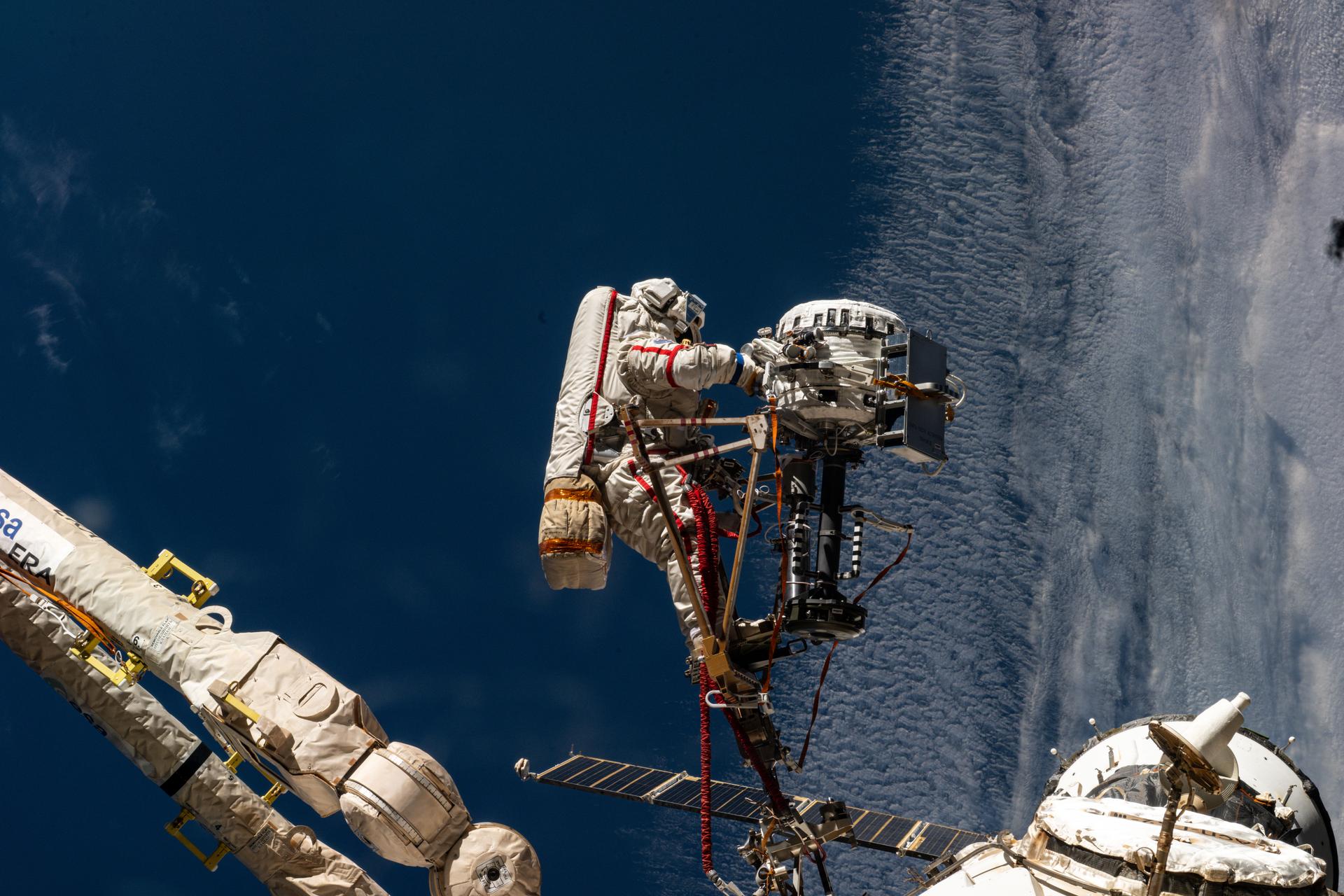
iss073e0981126 (Oct. 16, 2025) --- Roscosmos cosmonaut Sergey Ryzhikov is pictured attached to the end effector of the European robotic arm, holding the high-resolution camera (HRC) monoblock he removed during a six-hour and nine-minute spacewalk outside the International Space Station's Roscosmos segment. The HRC monoblock is part of a scientific optical telescope system designed to test compact radio-optical detectors for Earth observation, ecological monitoring, and emergency response.

One of NASA's newest education publications made its debut at the arnual National Council of Teachers of Mathematics (NCTM) conference held in Orlando, Florida April 5-7. How High Is It? An Educator's Guide with Activities Focused on Scale Models of Distances was presented by Carla Rosenberg of the National Center for Microgravity Research at Glenn Research Center. Rosenberg, an author of the Guide, led teachers in several hands-on activities from the Guide. This image is from a digital still camera; higher resolution is not available.

iss063e026090 (6/11/2020) --- A view during the Spectrum Facility installation into Expedite the Processing of Experiments to the Space Station (EXPRESS) Rack aboard the International space Station (ISS). Spectrum takes fluorescent images of biological specimens contained within a controlled environment. A high resolution, monochrome camera captures images of fluoresced proteins of plants within Petri plates.

iss073e0881098 (Oct. 16, 2025) --- Roscosmos cosmonauts Alexey Zubritsky (left) and Sergey Ryzhikov (right) are pictured during a six-hour and nine-minute spacewalk outside the International Space Station's Roscosmos segment. The duo installed a semiconductor materials experiment, removed a high-resolution camera monoblock, cleaned a window on the Zvezda service module, and removed a materials exposure experiment container.

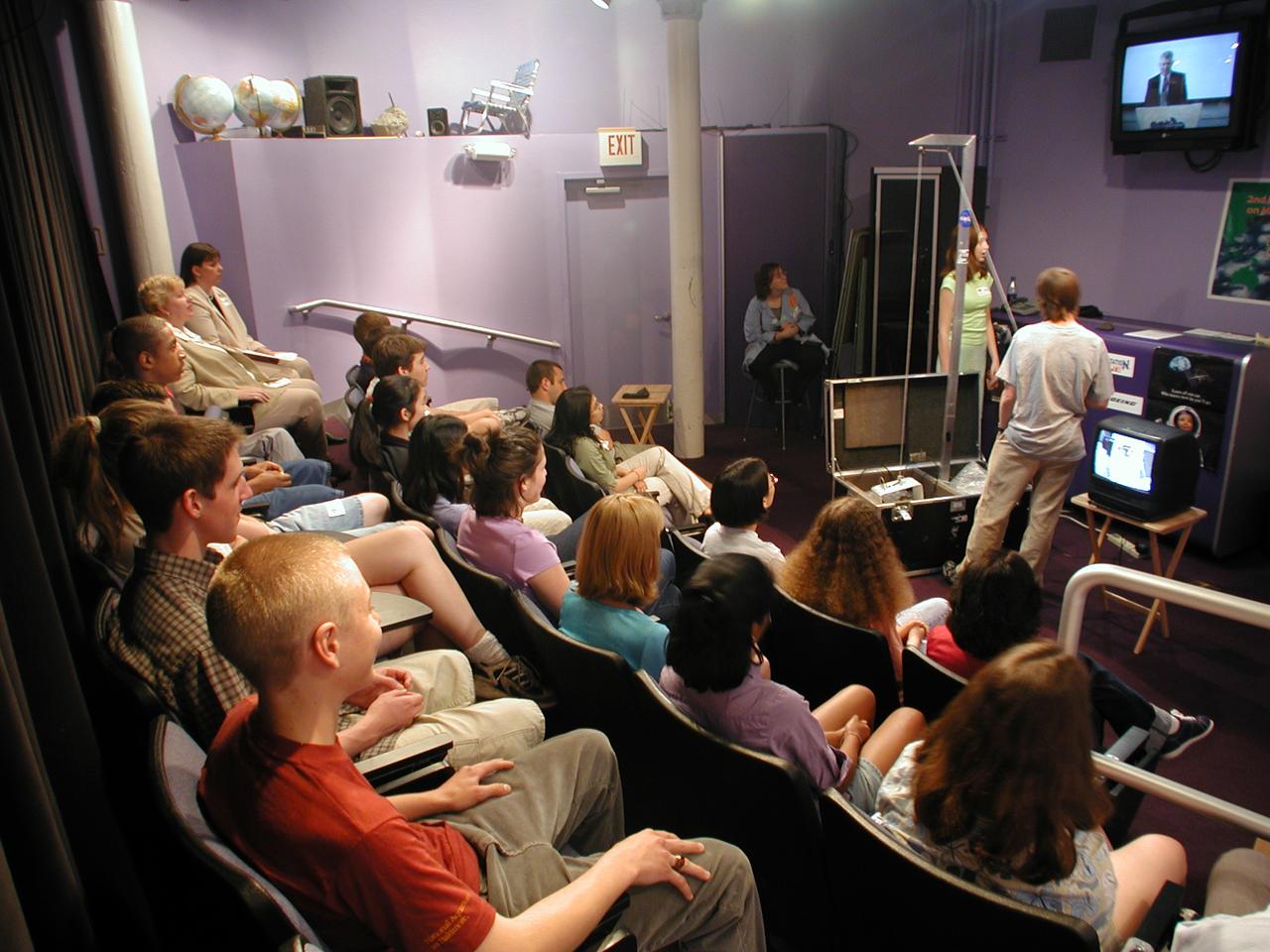
Suzarne Nichols (12th grade) from DuPont Manual High School in Louisville, Kentucky, asks a question of on of the on-line lecturers during the Pan-Pacific Basin Workshop on Microgravity Sciences held in Pasadena, California. The event originated at the California Science Center in Los Angeles. The DuPont Manual students patched in to the event through the distance learning lab at the Louisville Science Center. Jie Ma (grade 10, at right) waits her turn to ask a question. This image is from a digital still camera; higher resolution is not available.
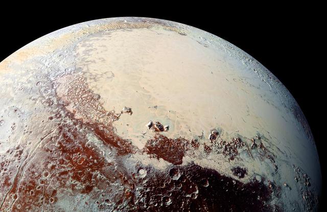
This high-resolution image captured by NASA's New Horizons spacecraft combines blue, red and infrared images taken by the Ralph/Multispectral Visual Imaging Camera (MVIC). The bright expanse is the western lobe of the "heart," informally called Sputnik Planum, which has been found to be rich in nitrogen, carbon monoxide and methane ices. http://photojournal.jpl.nasa.gov/catalog/PIA20007

One of NASA's newest education publications made its debut at the arnual National Council of Teachers of Mathematics (NCTM) conference held in Orlando, Florida April 5-7. How High Is It? An Educator's Guide with Activities Focused on Scale Models of Distances was presented by Carla Rosenberg of the National Center for Microgravity Research at Glenn Research Center. Rosenberg, an author of the Guide, led teachers in several hands-on activities from the Guide. This image is from a digital still camera; higher resolution is not available.